bim+gis integration methods for an infrastructure project ... · bim+gis integration methods for an...
TRANSCRIPT

1
BIM+GIS Integration methods for an Infrastructure Project in
Amsterdam
GeoDesign+BIM 2018, 01.11.2018 – 02.11.2018, Amsterdam

2
BIM+GIS Integration methods for an Infrastructure ProjectClient: ZUIDPLUS - Project realisation: HEIJMANS, FLUOR, HOCHTIEF
BIM + GIS
Infrastructure - Project
Location:
Amsterdam South
Highway A10, ca. 6 km
Shifting of Lanes,
Widening
Tunnel Constructions (2)
Bridges (2)
OVT (Railway Station)
Start of Construction 2019

3
BIM+GIS Integration methods for an Infrastructure Project
Objectives:
Recognizing and identifying at the present time, the dependencies that will occur in the future within
the project lifecycle. Solution > Integrate standardized - according to official rules - Information of
various disciplines (TEAM) into an entire model (WORK)
A better understanding of the relationships within the entire project.
(technical – temporal > Construction Method > Costs)
Public acceptance – the model features are linked to the production documents
The model is the result of numerous recursive processes (TEAM)
(WORK) depending on the level of detail, which have to be done (++) in order to create the precise
information model. In the construction phase, assumptions are confirmed or a redesign and
rescheduling has to be established. The changes will be incorporated into the model.
> The reason for the model change will be captured.
> Relevant documents will be linked to the object and stored into a DMS.
Reducing collisions (geometric, temporal, financial) already in Design and Planning phase

4
BIM+GIS Integration methods for Infrastructure Projects
Tender Information Design Information Time ScheduleBIM+GISStorage
Project DB for Infrastructure projects
CORRIDORDESIGN
STRUCTUREDESIGN
CONSTRUCTION
METHOD
International / National Standard – Design Requirements
OGC - GIS
IFC - BIM
Tender Projekt DB
CONSTRUCTION3D Features ++
TIME SCHEDULE4D
DBESTIMATION

5
Fundamental definitions and statements:
� Intention of all participants in the project (Client + Contractor)
to use BIM during project phases
� Target of BIM –> Holistic model of all trades, including time scheduling for realization
and the construction expenses for the project
Questions:
� Which BIM+GIS tools are used to reach the BIM targets? > IT Setup
� How GIS+BIM tools are used for project realization? – User Interface / On- or Offline
� Use Cases for (BIM + GIS) > Analysis of questionnaires
� Communication tools> IntraNet / Internet / Cloud
BIM+GIS Integration methods for an Infrastructure Project

6
BIM+GIS Integration methods for an Infrastructure Project
BIM - Project Execution Plan for Infrastructure Projects:
� General inherent Project description in relation to BIM
� Staff and Responsibilities
� Used Software and Interoperability in between the Software - Tools
� Containment of models (2D, 2.5D, 3D, materials, dimensions, quantities, etc.)
� Delivery objects (details and chronologic sequence, coordinate-system)
� BIM&GIS Rules and Standards – Quality checks (?) (building smart IFC)
� Definition of rules for interaction (rules, formats for data transfer / -exchange)

7
Etc...
Estimation
Time Schedule
BIM+GIS Integration methods for an Infrastructure ProjectBIM + GIS Project management / Data – Information Pool
Central Data Storage for Infrastructure Projects
Single source of truth repository
Tender Information Design Information Time Schedule BIM/GISDatabase
Transfer to Client As Built / Documentation Realisation ConstructionphaseBIM/GISDatabase
BIM/GIS
Projekt
Database

8
BIM+GIS Integration methods for an Infrastructure Project
BIM – Execution Plan
� Software to be used and Interoperability between the Tools (technical)
� Design Software for the trades
Versions and Releases (Fixing during entire project phase)
� All Software products which are relevant for realizing the project will be established. (Important is the protocol which software was used to generate the result)
� Software for Structural - Infrastructure, Special modules, geo-technical Module
� Definition of Interfaces between the tools (!data transfer without loss!)
� Usage of database systems (Access, Concept , Administration)
� Usage of Web Technologies (Access only from project stakeholders?)

9
BIM+GIS Integration methods for an Infrastructure Project
Representation of the IT infrastructure and Interfaces for the preparation phase (partly)
Anlaysis of demands
-> Number of Users, Software > Cost estimation for the entire IT setup
Example: MicroStation Mx, Revit, Civil3D,
MS-Office, SharePoint, ArcGIS, WebGIS, …..

10
BIM+GIS Integration methods for an Infrastructure Project
BIM – Project execution plan
� Content of model (2D, 3D, Material, Quantities, Dimensions, etc...)
� Objects to supply (details and time sequence)
� Accuracy information (LOD) – Quantity lists as well as status information for design
� Time Schedule for the delivery of the BIM – models
� Interval for updates (versions) of the BIM – models (and their parts)
� Modeling guidelines (project related Trade -Templates, Codes)
� Internal setup of models (Only 3D Objects, with quantity information
or parameter controlled models, Context > derive 2D Drawings from model)
11
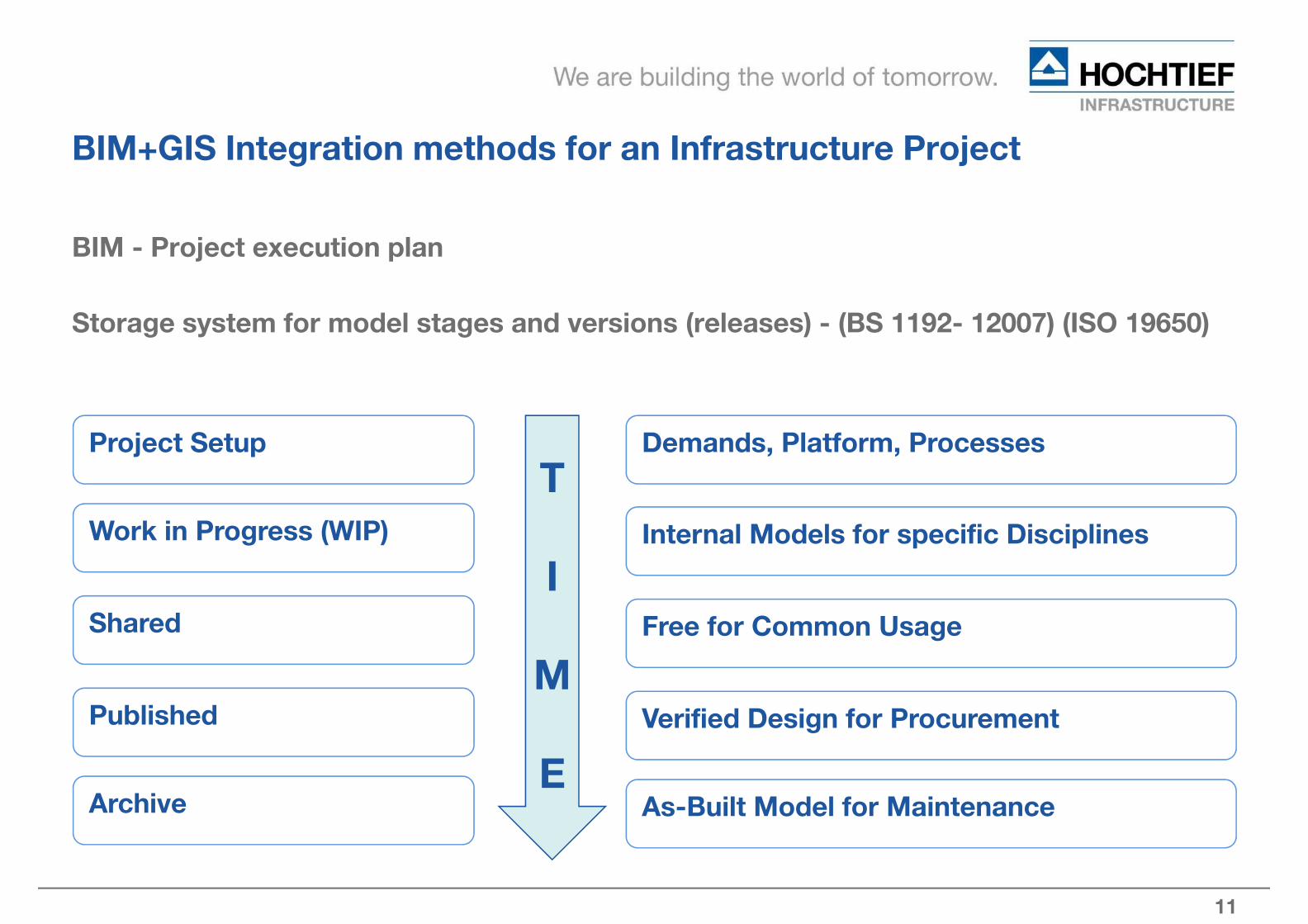
BIM+GIS Integration methods for an Infrastructure Project
BIM - Project execution plan
Storage system for model stages and versions (releases) - (BS 1192- 12007) (ISO 19650)
Project Setup
Work in Progress (WIP)
Shared
Published
Archive
Demands, Platform, Processes
Internal Models for specific Disciplines
Free for Common Usage
Verified Design for Procurement
As-Built Model for Maintenance
T
I
M
E

12
BIM+GIS Integration methods for an Infrastructure Project
BIM – Project execution plan
� BIM Rules, Definitions and Standards – Quality checks
� Interaction and Communication (Rules, Templates for Data transfer / Exchange)
CAD_XREFs
3D Models
Lists
Rules BIS DB
Spatial DB
Online
Plattform
Services
Navis
WorksClash
detection
Surveys
Monitoring
Sensors

13
BIM+GIS Integration methods for an Infrastructure Project
Communication tool Navisworks (14 - days Update with expiration date)

14
BIM+GIS Integration methods for an Infrastructure Project
Merging of Models from Trades – Clash detection
Update Interval 14 days – GIS Online Services 14 days.
CAD_XREFs
3D Models
Navis
Works(14 Days)
Entire
Model
Visualisations, Collisions,
Space + Time
Reports
Review:
-->Change required
Revision
unnecessary.
Elementes
consistent
(Consensus)
Published
Modell
Quantities
Procurement

15
BIM+GIS Integration methods for an Infrastructure Project
GIS as Online Portal – Cloud solution
Rules, definitions are tailored as “Use Cases”
by interviews focusing on demands in departments
CAD_XREFs
3D Models
Lists
Rules
++
Spatial DB
Online
Services
based on
„Use
Case“
Specific geometric
Conditions

16
BIM+GIS Integration methods for an Infrastructure Project
3D Building Information System (3D BIS)
Rapid data mining and dashboard overviews for project progress (design+construction)
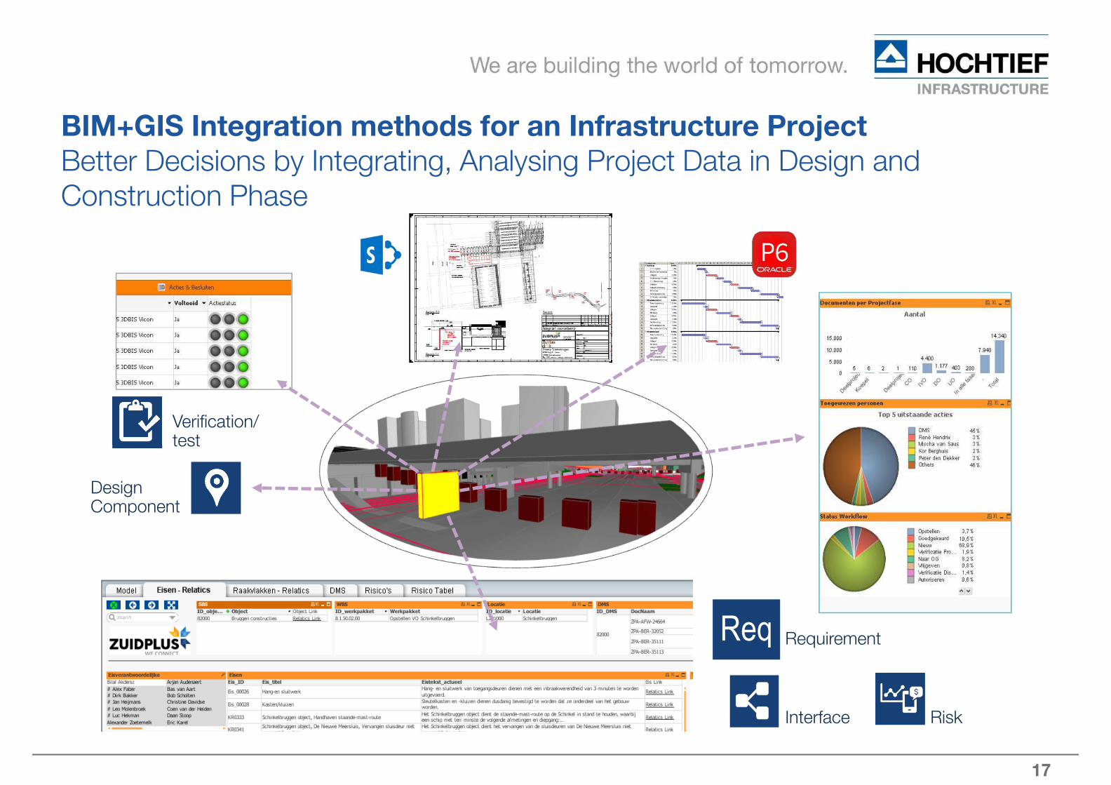
17
RequirementReq
Design Component
Verification/ test
RiskInterface
BIM+GIS Integration methods for an Infrastructure Project
Better Decisions by Integrating, Analysing Project Data in Design and
Construction Phase

18
GIS as Support Tool for BIM
Simple Example: (Use Case: Geologic investigation)
Task:
Which kind of soil classes are covered by the Tunnel
segments – create 3D Solids (+Attributes)
Data:
Geologic Investigation as Raster Data, BIM Model of Tunnel
Workflow: Raster data (GIS) to 3D Solid (BIM)
� Raster data Read and Classify
� Transform Raster to Vector data
� Transfer BIM via IFC to GIS
� Multiple Intersections by Vector data
� Volume Calculation based on tunnel-segments sorted
by Soil classes
� Presentation of Sections in MS-Excel ->
Geo Processing
� Transfer to Solids (BIM) 3D Solids with Attributes

19
BIM+GIS
Main Advantage: BIM+GIS
Setup a
Geo Processing Chain
Unique Identification
Export to common formats
> MS Excel, on demand
Transfer of defined Codes for
tunnel segments and soil classes
to the result
Volume calculation
Output: Soil Volumes by Construction Segments
Layout
3D Solids
Workflow
GeoProcess Tool

20
BIM+GIS Integration methods for an Infrastructure Project
USE CASE: Ecology
Trees and vegetation – habitats – rough time scheduling

21
BIM+GIS Integration methods for an Infrastructure Project
Simple Example Logistics
Information about general Logistics Items and Locations.

22
BIM+GIS Integration methods for an Infrastructure Project
Requirements
Education
� Personnel – Educate to handle both technologies -> BIM+GIS
� Knowledge of BIM+GIS for infrastructure projects (particulars)
� General Expertise in infrastructure – Design, Work preparation and Realization
� Collective Work (TEAM) into an integrated platform
Support of the Management for new Technology GIS/BIM (Geo-design)
� Generate better Understanding in Project Departments for BIM / GIS
� Recognition of Advantages by using the new technology BIM
Development of project tailored solutions
� Realization of project specific Workflows
� Usage of external expertise

23
BIM+GIS Integration methods for an Infrastructure Project
Summary:
In order to merge the "technical data" of a project it is important to set up common
rules in order to be able to integrate all trades into the overall model in a simple and
structured way.
Use cases for each area are to be discussed and their way of implementation
determined.
Standard templates for the software tools used must be created.
Layer, Object description
Employees must be trained. Software knowledge is a basic condition.
Target:
Cloud-based efficient WEB (BIM+GIS (3D ++)) with analysis functions for project
stakeholders.
24
Thanks
for your
attention
„Das Ganze ist mehr als die Summe seiner Bestandteile“
„The whole is more than the sum of its constituents“
„Het geheel is meer dan de som van zijn bestanddelen“
Questions are welcome !!!