beyond the “zone of workingmen’s homes” · pdf file1 beyond the “zone...
TRANSCRIPT

1
BEYOND THE “ZONE OF WORKINGMEN’S HOMES”
Judith Kenny, Deanna Benson and David Bump
University of Wisconsin – Milwaukee
In this paper we compare the well-known Burgess concentric zone model of
urban development with urban development in late-nineteenth and early-
twentieth-century Milwaukee. Specifically, we examine the role of
industrialization, investments in real estate and the political influence of business
leaders in the development of working-class housing. Our research challenges
the prevailing notion of a concentric commuter zone for middle and upper-
income households beyond the city's limits. Through an analysis of three
working-class neighborhoods in metropolitan Milwaukee, including 1) the Brady
Street neighborhood, 2) the industrial suburb of Cudahy, and 3) the industrial
suburb of West Allis, our research reveals a much more complex pattern of urban
development than that outlined in the concentric zone model. This research
contributes to our understanding of industrial suburbanization prior to the 1950s.
Introduction
Arguably the most famous diagram in the social sciences (Duncan 1996: 256), Ernest
Burgess’ concentric zone model can be found in almost every urban geography textbook.
Since its appearance in “The Growth of the City: An Introduction to a Research Project”
(Burgess 1925), the zonal model has become a significant and long-standing
representation of the North American city and a means of considering the physical
structure of modern urban conditions everywhere. Burgess’ bulls-eye pattern generalizes
not only the outward growth of the city away from the expanding business district and the
industrial center, but also represents social distance as physical distance and house form
as status and assimilation. In his city, one “progresses” outward from the residential
“zone of workingmen’s homes” (Zone III) to the “residential zone” (Zone IV) of single-
family houses and then to the bourgeois “commuters zone” (Zone V) on the periphery
(Burgess 1967: 55).1 The appealing simplicity of Burgess’ model may explain the
fascination that has gripped generations of geographers and other social scientists who
continue to contemplate concentric zones of land use despite numerous critiques of his
early-twentieth century evaluation of urban pattern and process. Whatever the appeal, its
vocabulary and metaphors contribute to an ongoing discussion of urban structure if only
to underscore the dramatic changes in both cities and the approach geographers take to
studying them (see Fyfe & Kenny 2005: 15-27).
As our title “the zone of workingmen’s homes” suggests, we return to the model in
this article to question its fit with conditions in late-nineteenth and early-twentieth-
century industrial Milwaukee and – perhaps more importantly – to consider the
appropriate framework for examining urban residential geographies. The title also
acknowledges the argument offered by geographers Richard Walker and Robert Lewis in
“Beyond the Crabgrass Frontier” (2001). Their analysis underscores the Chicago
School’s model’s failure to even explain early twentieth-century metropolitan areas by
noting the frequent occurrence of industrial suburbanization between 1850 and 1950.
2
In Manufacturing Suburbs (Lewis 2004), case studies of several metropolitan regions
including Chicago, Baltimore, Los Angeles, Detroit and Pittsburgh confirm the tendency
to multi-centered metropolitan formation before World War II. Furthermore, Walker and
Lewis argue that the dominance of the Chicago School and its emphasis on the city’s
social geography obscured the operation of the American city’s political economy in the
analysis of industrialization and, consequently, the early suburbanization of industry.
They urge looking beyond the dominant association of the suburbs with the aspirations of
middle-class homeowners, as in historian Kenneth Jackson’s classic work The Crabgrass
Frontier (1985; see also Fishman 1987), to consider the role of industrialization,
investments in real estate and the political influence of business leaders in the early
twentieth-century development of metropolitan areas.
It is this link between work and home for Milwaukee’s working class alongside the
development of the local residential real estate market that we explore below when
considering the growth of the city. In addition to challenging the prevailing notion of a
concentric commuter zone beyond the city’s limits, we evaluate the “zone of the
workingmen’s homes” within the city and consider the character of its residential
landscape. To this purpose, the following analysis focuses on the development of three
working-class neighborhoods in the Milwaukee metropolitan area, including: 1) the
Brady Street neighborhood on Milwaukee’s eastside, which was developed primarily in
the 1880s to house Polish tannery workers and their families; 2) the industrial suburb of
Cudahy, platted in the 1890s as the new site for the Cudahy meat-packing plant and its
workers; and, 3) the industrial suburb of West Allis, home to the Allis-Chalmers
Company from 1900 (see Figure 1). These case studies draw upon areas with different
experiences of turn of the twentieth century industrial development, suggesting a much
more complex pattern of growth than that outlined in the concentric zone model. Our
case studies reveal an array of economic actors, motivations, and scales of development.
We draw attention to the practices of actors as diverse as small Polish builders, up-start
industrialists, and wealthy real estate speculators. The landscape of worker housing
varies from the model as well, reflecting the time period in which it developed and to a
limited extent the physical and socio-economic place in which it developed. And, thus, a
micro-level analysis of the area’s urban historical geography allows for a closer
interrogation of trends in the social geography and political economy of the turn of the
twentieth century industrial city.
Industrialization and city-building
Given its character as an industrial city, Milwaukee provides an excellent opportunity
to examine industrial workers’ neighborhoods in the late nineteenth and early twentieth
century and the processes that developed them. By the 1880s, the city’s industrial
reputation solidified and Milwaukee’s transformation from a commercial trade center to a
manufacturing economy completed. Skilled and unskilled, immigrant laborers found
employment opportunities in riverfront tanneries and factories with prominent new
industrial development occurring along the Milwaukee River, in the Menomonee Valley,
and at the mouth of the Kinnickinnic River (see Figure 1). Over three decades the City of
Milwaukee’s population more than tripled, growing from 115,587 in 1880 to 373,857 in

3
1910. At the turn of the twentieth century, as shown in Figure 2, local boosters
enthusiastically claimed that Milwaukee “fed and supplied the world.” Chief icons of the
industrial age surround the idealized female Milwaukee. In addition to the precision
gear, pick ax and ax, steamers and locomotives radiate out from the city in every
direction. This romantic image of economic strength hints at the significance of the
worker in operating the city’s robust industrial economy.
Figure 1. “City of Milwaukee and Suburbs, circa 1900.” The map locates the
three case study working-class neighborhoods – the Brady Street neighborhood on
Milwaukee’s east side, the industrial suburb of Cudahy, and the industrial suburb
of West Allis. (Source: Knell’s Quarter Sectional Map, 1893; C. N. Caspar Co.,
1901; and Caspar, Krueger, Dory, Co., Publishers, 1930; American Geographical
Society Library, University of Wisconsin-Milwaukee).

4
Milwaukee’s claim to the title of “the Working Man’s City” in 1900 underscores its
social and economic climate. Although ranked twelfth in population size in 1910, it
ranked third among American cities based on the proportion of its work force in industry.
Only Detroit and Buffalo posed any serious challenge to Milwaukee’s working class title
(Still 1948: 325). The need for industrial laborers drew European immigrants in
increasing volume from the 1860s and 1870s through to World War I. Charles King, a
local booster, provided this image of the city’s subsequent cultural landscape when he
wrote in 1891:
The German and Polish population outnumbers the native probably three to
one, and in nine cases out of ten this might be a cause for alarm, but – not in
Milwaukee . . . There is not of its size in all America a city that contains a
population more self-respecting, more law-abiding, more cheerful and content
than Milwaukee, and you have only to ride or drive through these great
sections to see the reason – there isn’t a real tenement house in the town (King
1891: 554-557).
Making clear that his description addressed working-class, ethnic neighborhoods, he
concludes: “Almost every family has its own little home . . . no matter how humble it
may be, it is the home that makes the citizen who has the public interests at heart.” If, as
has been argued elsewhere, the history of America’s urban housing has been skewed by
an over-emphasis on the tenement house and the problems of Chicago’s and New York
City’s slums, the “Workingman’s City” – and “city of homeowners” as Milwaukee was
called – provides a useful means of adding balance to the record (Hubka & Kenny 2000).
Figure 2. “Milwaukee Feeds and Supplies the World.” This turn of the twentieth
century poster portrays Milwaukee as one of the world’s leading industrial centers.
(Source: City of Milwaukee Economic Development Office).

5
Work and home, or job opportunity and shelter, are key to our understanding of the
needs and decision-making of Milwaukee’s residents. We might note that three integral
pieces influence the growth of a city: people, money, and land. Anthony Orum
elaborates on this idea by stating that city-building depends on: 1) “an expansion in the
size of population”, 2) “an expansion in the amount of capital invested in a city”, and, 3)
“an expansion in the use of or amount of land or both” (1995: 14). Orum’s statements,
however obvious, call for deeper investigation of how the three pieces work together and
what elements each contains. The three elements provide a schematic framework for
considering first Burgess’ model of urban growth and then the experience within
Milwaukee.
“Zone of workingmen’s homes”
Sociologist Ernest Burgess focuses primary attention on the expansion in size of the
city’s population and changing social organization. The unit of analysis emphasizes the
city’s “natural units” – as he refers to the neighborhoods - with a secondary concern for
the consequences of the expansion of these neighborhoods on the use of land (Burgess
1967: 56). Only indirect attention is given to capital invested in the city, as implied by
the expansion of business and industry from the center of the city and the new
development of commuter suburbs. In this way, much like King’s comments thirty years
earlier, Burgess reveals his interest and concern for the social stability of the city
reflected in housing (more particularly “homes”), employment categories, and the
assimilation of various generations of immigrants. Burgess argues: “In the expansion of
the city a process of distribution takes place which shifts and sorts and relocates
individuals and groups by residence and occupation” (1967: 54). In Zone II, the Zone of
transition (also cited as the “zone of deterioration”), he finds “slums” and “bad lands” –
the rooming house district and the factory zone. Recently arrived immigrants would
reside in Zone II (1967: 54-55). Burgess goes on to state that, the “next zone is also
inhabited predominatingly (sic) by factory and shop workers, but skilled and thrifty. This
is an area of second immigrant settlement, generally of the second generation. It is the
region of escape from the slum . . . ” (1967: 56). He describes the house-type located in
Zone III as the “two flat area” – an area of duplexes, as we refer to them today. Burgess
underscores the desire for social mobility, however, by stating that: “ . . . the inhabitant of
this area in turn looks to the ‘Promised Land’ beyond, to its residential hotels, its
apartment-house region, its ‘satellite loops’, and its ‘bright light’ areas” – and, as he notes
on his detailed model, the single-family dwellings of Zone IV (1967: 56). Zone V, the
commuter zone and the bungalow section of the city, presumably provides housing
primarily to native-born Americans.
Despite noting their similar aspirations, he argues that this differentiation of the city
by zones reflects “natural economic and cultural groupings giv(ing) form and character to
the city” (1967: 56). Burgess explains how these “natural” groupings are produced by
stating:

6
The division of labor in the city likewise illustrates disorganization,
reorganization and increasing differentiation. The immigrant from rural
communities in Europe and America seldom brings with him economic skill
of any value in our industrial, commercial, or professional life. Yet
interestingly occupational selection has taken place by nationality, explainable
more by racial temperament or circumstance than by old-world economic
backgrounds as Irish policemen, Greek ice-cream parlors, Chinese laundries,
Negro porters . . . (1967: 56-57).
Today we recognize the racism associated with the “racial temperament(s)” that
Burgess presents as part of a “natural” process influencing occupational selection. He
and his contemporaries accepted such categories as obvious and linked by environmental
determinism rather than the prejudice and stereotype that produced a restrictive labor
hierarchy. Historian Gerd Korman’s work on Milwaukee’s industrial and immigration
history demonstrates that early employment practices shaped occupational patterns along
ethnic lines, especially for Polish immigrants. As a result of their language skills, Poles
from the German-controlled area of Poland received some initial benefit from the
managerial positions of Germans and German Americans in Milwaukee’s labor
hierarchy. Advancement above the rank of foreman, however, was difficult to achieve as
they became “typed” as common laborers and unskilled and semiskilled industrial
workers. In a 1911 study of living conditions in American towns, almost forty years after
the initial wave of Polish immigration, they were described as best fitted for “dirty tasks”
and jobs that required strength (United Kingdom Board of Trade: 258).
The urban social map inscribed in the concentric zone model assumes social and
spatial segregation between economic and cultural groupings. While the categories of
economic and ethnic/racial segregation differ, our current experience of the real estate
market conforms to this assumption of social and spatial separation by income and race.
The following case study of a neighborhood occupied by Polish unskilled workers at the
end of the nineteenth and beginning of the twentieth century, however, allows us to
examine the contemporary social and spatial validity of the model while considering the
operation of the local land economy and the provision of housing for the working-class
residents as well as the city’s social geography.
Brady Street neighborhood: constructing a working-class neighborhood
Located just north of the downtown, Milwaukee’s Brady Street neighborhood
recently acquired a new name and designation. In 2003, the “East Village” received
historic district status in recognition of its “once vibrant ethnic community” and the
working-class heritage that characterized this once primarily Polish settlement (see Mikos
2003). It is the first historic district in Milwaukee to gain preservation status based on its
homogenous collection of late-nineteenth century worker housing. The district provides
an interesting contrast to Milwaukee’s larger and better-known Polish community south

7
of the Menomonee Valley because of its proximity to the city’s center. In this regard it
promises greater conformity to Burgess’ model whereas the Polish South Side developed
and grew on the city’s southern periphery (see Kenny 1994; Kenny 1999; and, Gurda
1974). Despite these locational differences, the two Polish areas developed
simultaneously during rapid industrialization and reflect the benefits to the workers of
acquiring shelter within walking distance of industrial jobs. Subdivision began in the
Brady Street neighborhood during the late 1860s. As suggested in Figure 3, streetcar
development already extended the opportunity for middle-and upper-income housing
construction out from the downtown to the east of parcels A through F. That working-
class housing developed in the area at all had a great deal to do with the natural
topography for two reasons. First, those parcels were bypassed initially because they
covered a ravine unsuitable for the wealthier households being developed on the bluff to
the east along Prospect Avenue and the middle-income housing constructed between the
ravine and those larger houses on the high ground. The second topographic influence
involved the new tanneries opened along the river down slope from the ravine.
Overlooked in earlier development, this land became valuable in light of the demand for
worker housing close to new industry on the river.
Figure 3. “Brady Street Area, City of Milwaukee, circa 1900 ” Streetcar lines
encouraged middle-and upper-income housing development to the northeast of
parcels A through F. The streetcar lines are depicted as dashed lines in the center of
the streets. (Source: Map of the City of Milwaukee, Wisconsin, Alfred G. Wright,
1887; American Geographical Society Library, University of Wisconsin-Milwaukee)
8
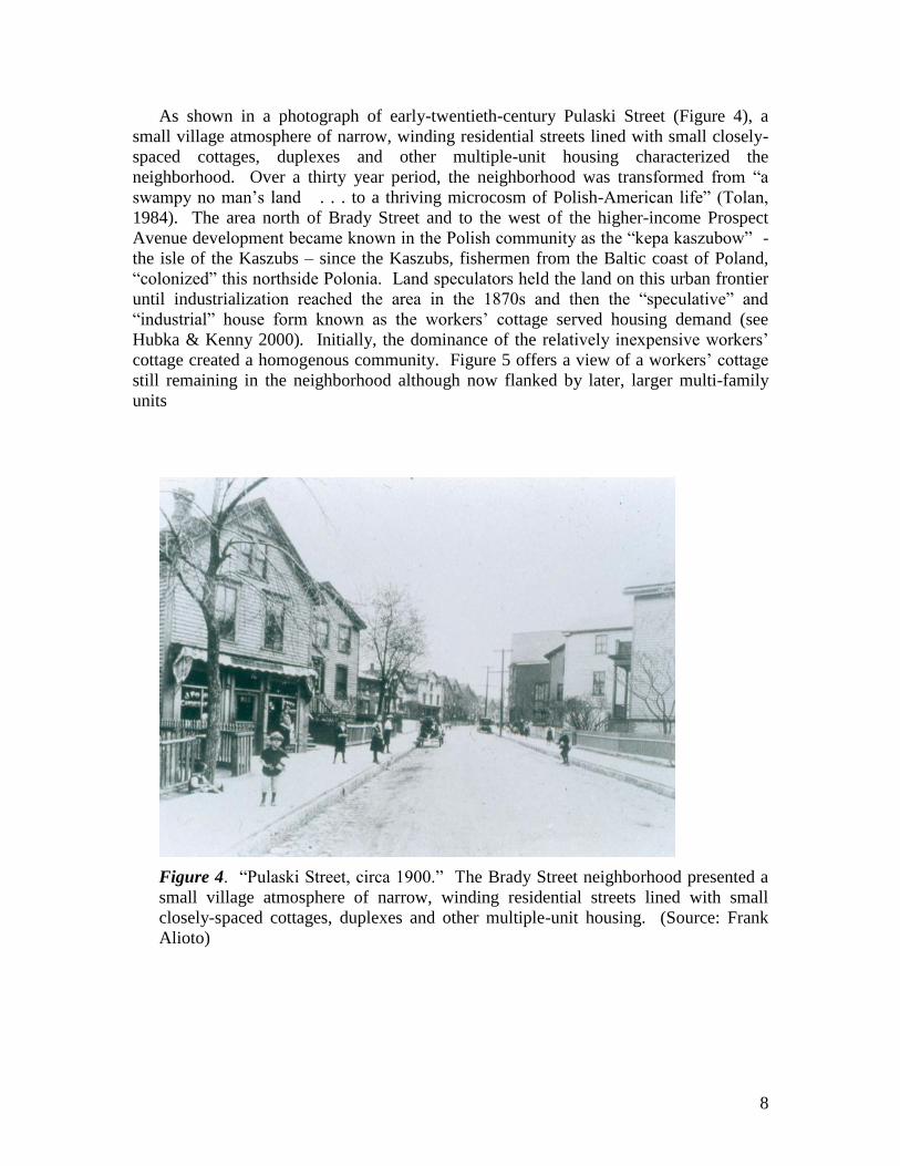
As shown in a photograph of early-twentieth-century Pulaski Street (Figure 4), a
small village atmosphere of narrow, winding residential streets lined with small closely-
spaced cottages, duplexes and other multiple-unit housing characterized the
neighborhood. Over a thirty year period, the neighborhood was transformed from “a
swampy no man’s land . . . to a thriving microcosm of Polish-American life” (Tolan,
1984). The area north of Brady Street and to the west of the higher-income Prospect
Avenue development became known in the Polish community as the “kepa kaszubow” -
the isle of the Kaszubs – since the Kaszubs, fishermen from the Baltic coast of Poland,
“colonized” this northside Polonia. Land speculators held the land on this urban frontier
until industrialization reached the area in the 1870s and then the “speculative” and
“industrial” house form known as the workers’ cottage served housing demand (see
Hubka & Kenny 2000). Initially, the dominance of the relatively inexpensive workers’
cottage created a homogenous community. Figure 5 offers a view of a workers’ cottage
still remaining in the neighborhood although now flanked by later, larger multi-family
units
Figure 4. “Pulaski Street, circa 1900.” The Brady Street neighborhood presented a
small village atmosphere of narrow, winding residential streets lined with small
closely-spaced cottages, duplexes and other multiple-unit housing. (Source: Frank
Alioto)

9
Figure 5. “Pulaski Street, 2005.” With few changes noticeable, Pulaski Street
exemplifies the working-class residential landscape of industrial Milwaukee with its
closely spaced multi-family structures flanking workers’ cottages. (Source: Judith
Kenny)
Over time, the housing landscape became more diverse as represented by the
incrementally built duplexes known locally as a “Polish flat” and more prosperous,
architect designed duplexes (see Hubka & Kenny 2000). This landscape conforms to
Burgess’ “two flat” zone of working men’s homes (1967: 55). What does not conform,
however, was the tendency for many of Milwaukee’s Polish Americans to stay within
their ethnic community even after acquiring the means to move elsewhere. The presence
of architect-designed homes surrounded by modest ones reflects the choice of ethnic
segregation rather than separation by economic categories. As summarized in John
Gurda’s study of Milwaukee’s Polish community, the persistence of Polish
neighborhoods until after World War II reflects both discrimination from outside the
ethnic community and affinity within it.
Demand for additional housing in the neighborhood provided an opportunity for local
entrepreneurs to become landlords and builders, and the smaller cottage was replaced in
many instances by flats. These local builders correspond to Olivier Zunz’s description of
the informal housing market that operated in Detroit’s two-tier real estate market during
the late-nineteenth century (1982). Zunz calls the two parts the formal and informal
housing markets (161). The formal market “operated through professionals from their
downtown offices.” It produced expensive homes for the native white American
community. In contrast, the informal market was “highly localized, controlled from
within the ethnic communities and designed to fit their means” (161). This second,

10
informal market also operated in Milwaukee’s ethnic communities and produced the
owner-occupied cottages and rental multi-family structures of the working class. From
the 1880s and ‘90s through the continuing period of significant Polish immigration
during the first decade of the twentieth century, small contractors and builders within the
Polish community contributed to the neighborhood’s local economy as well as its on-
going growth.
Figure 6. “A Portion of the 1910 Sanborn Insurance Map of the Brady Street Area.”
Note the long, narrow lots with multiple structures that characterized the
neighborhood’s development. (Source: Sanborn Insurance Maps of Milwaukee,
Wisconsin, 1910; American Geographical Society Library, University of Wisconsin-
Milwaukee)

11
The 1910 Sanborn Insurance map shown in Figure 6 illustrates the dense living
conditions resulting from this building activity. Reflecting the Polish character of the
neighborhood, Sobieski and Pulaski streets (located in land section D, see Figure 3) stood
out in contrast to surrounding streets with Anglo-sounding names such as Franklin,
Hamilton and Warren. Named in 1875, Pulaski Street paid tribute to a Polish general
who fought for American independence as it epitomized the ethnic qualities of the new
working-class immigrant neighborhood. There is a degree of irony in the selection of
such a prestigious name since the street followed the ravine that earlier had made the
property a poor prospect for development. As it built out, Pulaski Street would become
synonymous with over-crowded “slum” living conditions. Because the street warranted
attention in public health studies, we give particular attention to its development over a
twenty-year period by examining city building permits, Sanborn Insurance maps, and the
census. The 1880 census indicates that thirty-six families lived in twenty-four houses on
the two block long street with a resulting population of approximately 170 individuals.
A handful of tanners are registered as household heads but the overwhelming
occupational category was laborer. By 1900, the census revealed a population of sixty-
two households residing on the eastside of Pulaski Street alone. A population of over 360
individuals lived in the approximately forty dwellings that lined the east side of the block.
In many instances, the one, one and a half and two story residences were stacked several
deep in the shoestring-shaped lot common to Milwaukee’s working class neighborhoods
regardless of ethnicity. The “shoestring” lot was 30 wide x 120 feet deep and, to achieve
maximum use of land, a rear house was typical. There were many instances on Pulaski
Street when three or four dwelling units occupied the same lot. Of the sixty-two
households, renters outnumbered owners at a rate of over three to one. Given the income
of unskilled workers, it is impressive that the ratio was this low.
Records suggest that ownership was supported in many instances by income from
rental units and work in local construction. This was the case of Frank Dombrowski of
Sobieski Street, who appears as the owner/builder on several Pulaski Street building
permits. John Tuszkiewicz listed his house moving business in the city directory from
the 1880s and his name appears on numerous building permits as the individual
responsible for moving cottages from one site within the neighborhood to infill the lots
on Pulaski Street (City Directory: 1880 & 1900). Occasionally architects’ names appear
with builders on permits for this increasingly dense street of two-storey (frame) rental
units. In the majority of cases, however, residential construction drew upon the expertise
of a growing number of carpenters, masons and builders from within the Polish
community.
Growing density within the “isle of Kaszubs” promoted construction in a new
neighborhood to the north and west of Brady Street – the area known today as Riverwest.
On first inspection, this pattern might suggest a fit with Burgess’ model since it presents
an image of progressive and inevitable improvement as inner city residents move outward
from the zones of transition and workingmen’s homes to successive zones of better
environmental conditions. The consensual imagery of the mobility and the agency of city
residents fit the “melting-pot” metaphor of American popular culture. However, while
the “move” from the Brady Street neighborhood to Riverwest allowed an improvement in
environment, it did not substantially change the cultural landscape. For several
generations, the tightly bound economic and ethnic categories persisted in the working
12
class neighborhoods of Milwaukee as experienced by the workers in the Brady Street
area and Riverwest. Further challenging Burgess’ model, remarkably similar landscapes
could be found beyond the city limits in the Milwaukee area industrial suburbs.
Manufacturing Suburbs
As early as the 1890s, Milwaukee’s industrial expansion sent signals to industrialists
and real estate developers alike that pressures within the city might be escaped by moving
beyond the urban frontier. Richard Harris has discussed the development of Chicago’s
industrial suburbs during the same period highlighting the benefits that companies
enjoyed in these new settlements centered on industry (1990). A similar pattern of
development took place in the Milwaukee area as newly incorporated suburbs drew
industry as well as commuters out beyond the city limits. When faced with the number
of similar examples from other metropolitan areas, one wonders how this part of the
historical record could go unrecognized, as it is, in much of the literature of urban studies.
For our purposes, to contemplate the record requires a choice of which of the many
industrial suburbs to consider.
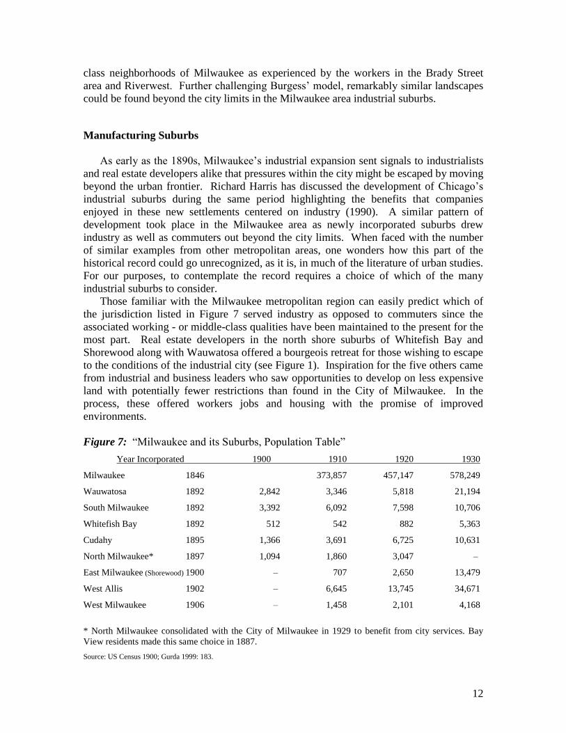
Those familiar with the Milwaukee metropolitan region can easily predict which of
the jurisdiction listed in Figure 7 served industry as opposed to commuters since the
associated working - or middle-class qualities have been maintained to the present for the
most part. Real estate developers in the north shore suburbs of Whitefish Bay and
Shorewood along with Wauwatosa offered a bourgeois retreat for those wishing to escape
to the conditions of the industrial city (see Figure 1). Inspiration for the five others came
from industrial and business leaders who saw opportunities to develop on less expensive
land with potentially fewer restrictions than found in the City of Milwaukee. In the
process, these offered workers jobs and housing with the promise of improved
environments.
Figure 7: “Milwaukee and its Suburbs, Population Table”
Year Incorporated 1900 1910 1920 1930
Milwaukee 1846 373,857 457,147 578,249
Wauwatosa 1892 2,842 3,346 5,818 21,194
South Milwaukee 1892 3,392 6,092 7,598 10,706
Whitefish Bay 1892 512 542 882 5,363
Cudahy 1895 1,366 3,691 6,725 10,631
North Milwaukee* 1897 1,094 1,860 3,047 –
East Milwaukee (Shorewood) 1900 – 707 2,650 13,479
West Allis 1902 – 6,645 13,745 34,671
West Milwaukee 1906 – 1,458 2,101 4,168
* North Milwaukee consolidated with the City of Milwaukee in 1929 to benefit from city services. Bay
View residents made this same choice in 1887.
Source: US Census 1900; Gurda 1999: 183.

13
Cudahy: envisioning Milwaukee’s packingtown
In 1893, Patrick and John Cudahy built a state of the art meat packing plant on a rural
site south of Milwaukee. The plant and surrounding real estate formed the core of the
city of Cudahy. While this might appear to be the story of a company town similar to
Pullman, Illinois or Kohler, Wisconsin, Cudahy does not fit this category. Patrick
Cudahy, the primary influence in the town’s development noted in his autobiography
(1912) that his influence on local decision-making was limited after the town’s
incorporation in 1895. The growth of Cudahy from a tiny rural settlement to one of
Milwaukee’s industrial suburbs instead highlights both the roles of industrialists and real
estate speculators in the city-building process and an informal real estate market in the
construction of the workers’ housing.
Prior to playing prominent roles in the development of an industrial suburb, the
Cudahy brothers established themselves in Milwaukee’s meat packing industry. Under
the wings of John Plankinton, Milwaukee’s leading meat packer, they acquired
experience and wealth. Plankinton’s firms controlled the majority of Milwaukee’s meat
business in the 1870s and 1880s when Milwaukee was the fourth- or fifth-largest packing
center in the nation (Gurda 1999). When Plankinton retired in 1888, Patrick with his
brother John took over as lessors of the plant. After the death of John Plankinton in
1891, two years prior to the end of the lease in 1893, the Cudahys and Plankinton’s heir
irreconcilably disagreed over plant management (Olson 1987). In response to the
situation, Patrick Cudahy began building his own modern meat packing plant with vast
public stock yards outside the city.
Cudahy selected the site for the new plant and stock yards about two miles south of
the city limits on the Chicago & North Western (C & NW) Railroad right-of-way near a
small rural settlement (Cudahy 1912). H.J. Mabbett of the real estate firm Mabbett &
Jefferson quietly secured options on approximately 700-acres of farmland for the Cudahy
brothers on both sides of the C & NW Railroad. With confirmation that the C & NW
would extend a spur to the proposed packing plant, nearby property rapidly increased in
value. The future City of Cudahy became a site of rampant real estate speculation during
1892 and early 1893. The periodical, Realty and Building Record, published a special
issue on August 27, 1892 promoting Cudahy as the next major city between Chicago and
Milwaukee. The authors wrote:
The prospects for the development and growth of Cudahy are so
exceedingly bright that there are people who predict that within three
years this place will have a population of 5,000; that it will have the finest
and most complete, if not the largest pork and beef packing establishment
in the United States; and that, though it will by virtue of its location be a
suburb of Milwaukee, it will have an independent existence and will have
its own great manufacturing establishments, hotels, banks, business
houses, schools, churches, and residences (Realty and Building Record:
Special Cudahy Number 1892).
The authors also published a dramatic bird’s eye view of the proposed city (see
Figure 8.)

14
This view anchors the vast new Cudahy plant in the foreground, promising significant
profits for industrialists and real estate developers. In the distance, the City of
Milwaukee’s Lake Michigan shoreline is depicted at an easily traversed distance. This
illustration, designed to attract investment, underscores the roles of industrialists and real
estate developers in urban development. As Richard Walker and Robert Lewis (2001)
note, the search for profits in land speculation by industrialists, property investors,
developers, and financial institutions stimulated such suburban growth.
To further boost the new suburb’s success, Patrick Cudahy led a vigorous campaign
to persuade other Milwaukee meat packers to relocate to establish a public stock yards
similar to that of the Union Stock Yards of Chicago offering to sell land at cost to
Milwaukee’s packers. Cudahy also sought to increase the certainty of his real estate
vision through the elimination of competition. With the support of Milwaukee’s mayor
and key aldermen, he promoted an ordinance that would prohibit the operation of
slaughtering plants within the city. Endorsing the ordinance as an endeavor to clean up
urban pollution, Patrick Cudahy believed residents near Milwaukee’s packing plants
would be his strongest supporters. Instead, residents, many of whom were employed in
the existing packing plants, opposed the ordinance along with their employers and the St.
Paul Railroad. On April 16, 1892, when the common council considered the ordinance in
a special session they heard the packers describe their substantial capital investments in
their Milwaukee operations (City of Milwaukee Common Council 1891-1892). They
argued the Cudahys could easily move to the suburbs as a lessee, but as owners of the
plants they would be forced to abandon significant capital investments and perhaps be
forced out of business if the ordinance passed. The last source of opposition, the St. Paul
Railroad, holding a near monopoly over Milwaukee’s packing industry, transported
livestock to and from the stockyards. If the packers moved, the St. Paul would lose
business to the C & NW Railroad. This united opposition mounted such a strong attack
against the ordinance that the common council never voted on the controversial ordinance
and instead tabled the ordinance indefinitely (City of Milwaukee Common Council 1891-
1892).
Cudahy, though defeated, continued to promote the new suburb. He sought to attract
industries other than packers to diversify the local economy. The turn of the twentieth
century meat packing industry fluctuated seasonally. The most active months were
November through February with employment at seasonal highs. During the spring
months, packers frequently decreased employment by approximately one-half. Business
picked up in May, but the spring months left many workers unemployed. Patrick Cudahy
actively worked to attract other industries to support his seasonally idle workers when his
plant didn’t operate at full capacity. Du Pont established a branch chemical plant at the
lakeshore in the 1890s (Cudahy Business and Advancement Association [CBAA] 1927:
Schmid 1942). Cudahy sold land to the Federal Rubber Company to build their plant in
1904 (CBBA 1927; Cudahy 1912; Paul 2002). Three prominent Allis-Chalmers
employees, who resigned to organize a new company, were lured to Cudahy when
Patrick bought stock in the new company and sold them land (Cudahy 1912). By the
1910s, the city’s largest employers included Cudahy’s packinghouse, the George J.
Meyer bottling company, a foundry and machine shops.
Key to the development of a new industrial suburb was the availability of labor.
Consequently, Patrick Cudahy’s promotional activities included the sale of commercial

15
and residential lots and the construction of workers’ cottages through the Cudahy Bros.
Land Department ("Cudahy & Sons, Inc., Memoir and Accounting, October 1, 1888-May
10, 1971" 1972). The company held the first land sale on September 17, 1892 attracting
a large crowd of spectators and speculators. The promotional bird’s eye view mentioned
above depicted the prosperous future city (see Figure 8). The C & NW Railroad parallels
the lakeshore, dividing the suburb. This furnishes “a pleasant place for residence and at
the same time supply[ing] suitable sites for extensive manufacturing and business
establishments” (Realty and Building Record: Special Cudahy Number 1892). The
packing plant, stock yards and railroad yards lie in the lower portion of the sketch.
Beyond the railroad tracks spread the workers’ residential lots. This suburban setting of
scattered homes on tree-lined streets contrasts with the densely built urban landscape of
Milwaukee depicted in the upper left. Befitting the town’s inspiration, city founders
named the streets after other meat packers including: Philip Danforth Amour, George
Henry Hammond, Thomas Kingan, John Peter Squire, and John Plankinton. Patrick’s
own namesake street can be seen in the middle of the sketch. This enticing image of an
industrial garden suburb likely stimulated land speculation. Initial land sales were
profitable until the Panic of 1893. The panic became one of the longest and most severe
depressions of the nineteenth century (Gurda 1999:168). The promotional boast of 5,000
residents in three years failed to materialize. Nevertheless, Cudahy incorporated as a
village in 1895 with 771 residents. In 1906, Cudahy became a city with 2,556 residents
(Olson 1987:40).
Figure 8. “Bird’s Eye Sketch of the Proposed Suburb of Cudahy.” This illustration,
published in the Realty and Building Record, August 27, 1892, sought to attract
investment and real estate development. (Source: Realty and Building Record:
Special Cudahy Number, August 27, 1892, Vol. II, No. 25)

16
Figure 9. “Cudahy Duplex, 3000 Block of Barnard Avenue”. This duplex represents
the typical workers’ housing in Cudahy. The raised basement could be used for
additional living space or storage. (Source: Deanna Benson)
While failing to become a booming city with vast public stockyards, Cudahy in 1910
shared some characteristics with the Back-of-the-Yards,1 an immigrant working-class
residential community built next to the Chicago’s Union Stock Yards. Cudahy workers
were paid such low wages that they could not afford to live far from their employer. Like
the Back-of-the-Yards, recent European immigrants constituted the majority of residents
(Pudup 2004). Many arrived from Eastern Europe after 1900. The 3600 block of
Barnard Avenue illustrates the typical ethnic and occupational makeup of Cudahy in
1910.2 In the 12 houses on the block, 116 persons lived within 22 households. Six of the
homes housed 28 boarders attesting to the low wages and lack of housing in Cudahy
during the first decades of the twentieth century. Approximately 75% of the block’s
population had immigrated from the Austro-Hungarian Empire after 1900. They
included Magyars, Croats, Slovenes, Slovaks, Bohemians, and Moravians. A small
number of Germans and Poles called this block home as well. Approximately 30 persons
were born in the United States, but the majority of these were under ten years of age and
the children of immigrant parents. Most residents worked in one of three industries: the
packinghouse, foundry, or machine shop. Approximately seventeen men worked in the
Cudahy Brothers packing plant as butchers or general laborers.
The 3600 block of Barnard Avenue, also, illustrates the typical development of
workers’ housing in Cudahy. Like Brady Street, the lots are commonly 120 feet deep and
only a bit wider at 30 feet (Sanborn Map 1910). In contrast to the densely settled Brady
1 The Back-of-the-Yards developed beside the Union Stock Yards and a concentration of packing plants known as
Packingtown. The Union Stock Yards and Packingtown consolidated the meat packing industry at Chicago’s
periphery during the second half of the nineteenth century. 2 In contrast to the street names in Figure 8, Hammond Avenue became Barnard when actually platted.

17
Street, the majority of lots had just one house or cottage. This suggests that the cheaper
suburban land prices allowed for lower rents and housing costs and, thus, resulted in a
relative lack of pressure to develop additional housing units on individual lots. Of the
block’s thirty lots, just 14 were built upon by 1910, including one store, and one saloon
as well as the twelve residences. The workers’ cottage, although present, is less
dominant in this early-twentieth-century suburban neighborhood. Nearly all the
residences were 1-1/2- or 2-story wood framed structures including seven duplexes. By
this time, the duplex had grown in popularity to become the dominant house-type in
Milwaukee as well (Hubka & Kenny 2000). The duplex at 3643 and 3643A represent the
typical residence (See Figure 9). The raised basement was common and likely used for
additional living and storage space. The 1910 Census lists the owner 3643-A as Anton
Peto, a Magyar who immigrated from Austro-Hungary in 1905. He lived in one
apartment with his wife, two children, and three boarders. All were recent Magyar
immigrants except the youngest child, who was born in Wisconsin. Peto rented the
second apartment to recent Magyar immigrants, Nikolas Borros and his wife. The
Borros’ shared the apartment with seven boarders. Most of the men worked as molders
in the foundry. Thus, the Barnard Avenue landscape single-family and duplex homes
resembled Burgess’ “zone of workingmen’s homes” with its predominance of “two flats”,
but the social characteristics of boarders and recent immigrants shares more in common
with Burgess’ “zone in transition”.
The builders of this common working-class landscape are less clear. As noted above,
Patrick Cudahy took an active role in lot sales and home building through the Cudahy
Bros. Land Department, but his role appears to be limited. While we lack building
permits and city directories from this era, the relative silence of the Cudahy Brothers
Company in the historical record on this topic suggests Patrick Cudahy did little to shape
the specific character and form of the suburb in comparison to the well-documented
influence of George Pullman and John Michael Kohler in shaping the environmental
qualities of their respective company towns (see Buder 1967). In fact, it is unlikely that
Cudahy’s role even approximated the thousands of lots sold and homes built by
contemporary real estate developers such as S. E. Gross in Chicago (Clark 1998). What
we do know is that tracts of land that became the city of Cudahy were owned by at least
ten different real estate companies in the 1890s. The Sivyer & Betz firm was one of the
earliest speculators in Cudahy, offering lots for sale at the same time as the Cudahy Bros.
Land Department sale. Other companies owning Cudahy tracts, such as the Buckhorn
Land & Investment Co. and the South Point Park Co., had well known records in
residential platting and lot sales in the Milwaukee area (Realty and Building Record:
Special Cudahy Number 1892). While more research is needed, it appears that a mix of
real estate developers and the small builders associated with an informal real estate
market built Cudahy’s housing – certainly not one major industrialist.
West Allis: residential to industrial suburb
Along with Cudahy, the second working-class suburb discussed in this paper, draws
upon the name of a major local employer to announce its industrial character. Much like
Cudahy, middle-class, West Allis was not a company town. Real estate interests in the

18
area first flirted with residential development that would result in a Victorian-era
commuter suburb but instead chose to attract industrial development. West Allis offers
an interesting contrast to the common expectation that a commuter suburb would
naturally develop at the periphery of the early-twentieth-century city. In fact, by the
1890s, both railroads and streetcars served the area and the Milwaukee Journal
announced that North Greenfield, as the original agricultural community of Honey Creek
had been renamed, was “one of the very prettiest and most convenient of Milwaukee’s
many residence suburbs” (MJ 1893: 9). However, industrial decentralization held its
appeal as Milwaukee lacked space for industrial expansion.
When the Edward P. Allis Company made clear its need for expansion in 1900, real
estate interests lured the company to its new home only four miles west of Milwaukee.
One of the major real estate men behind the development of West Allis showed Charles
Allis, president of the E. P. Allis Company, a large tract of land on what is now the
northeast corner of the city. Within a week the company decided to purchase the 100-
acre tract of land for its new factory. While the new plant was under construction in 1901,
the company merged with three other companies becoming Allis-Chalmers, one of the
largest manufacturers of heavy machinery in the world at the time (Gurda 1999). Almost
immediately afterwards, the plant employed 10,000 skilled and unskilled workers,
quickly becoming the largest employer in the newly incorporated (and renamed) West
Allis (see Bump 1999). The company would remain vitally important to the success and
image of the city for nearly eighty years. At the time, the Allis-Chalmers Company was
the prize catch for the ambitious real estate promoters of this industrial suburb assuring
the developers’ financial rewards and the future growth of the city of West Allis.
In addition to convincing one of the industrial giants of Milwaukee to relocate to
West Allis the real estate developers of the city played other important roles. They
promoted the area to prospective residents, sold lots to them, and in some cases built
homes. The Central Improvement Company was responsible for the majority of land
sales that took place from 1902-1912, but other major firms contributed to the industrial
suburb’s growth as well. Certainly, the efforts of these men and their companies to bring
residents to the area were only partially completed by luring industry to the area. They
also found it necessary to portray West Allis as a desirable place to live. This first step
required making it easy and inexpensive to leave the central city. Forming streetcar
companies to bring prospective residents to the area and using promotional literature to
highlight their community’s amenities accomplished this. As shown in Figure 10, the
Central Improvement Company recommended the comforts of home ownership to its
prospective clients. They offered lots while inspiring hopes of domestic comfort and
financial stability. If this advertisement looks familiar, it is similar to ads run in the
Chicago market. One might also think of its message as similar to the modern freeway
billboard the displays the message – “If you lived here you would be home.” Other
handbills encouraged prospective residents to consider the combined benefits of Allis-
Chalmer jobs and the health benefits of living in the suburbs (West Allis Historical
Society clipping file).

19
Figure 10. “Advertisement for the Central Improvement Company, West Allis.”
The company advertised its residential lots by suggesting homeownership would
bring security and prosperity in a suburban landscape. (Source: West Allis Historical
Society, West Allis, Wisconsin)

20
Figure 11. “Gross’ West Allis Subdivision.” In this 1903 advertisement, the
Chicago-based developer S. E. Gross advertised lots and homes. Given the proximity
to railroad lines and industrial land, the advertisement was intended to attract
workers. (Source: West Allis Historical Society, West Allis, Wisconsin)

21
In a 1903 advertisement (Figure 11), the Chicago-based developer S. E. Gross in his
advertising noted that “the rapid growth of West Allis will make the purchaser large
profits.” Furthermore, his handbills offered lots in “a Restricted Neighborhood Which
Guarantees the High Character and Value of the Property.” If one is tempted to assume
from the images and language of the ads that West Allis real estate was intended to attract
primarily middle-class clients, a closer inspection of the Gross handbill reminds us that
the properties were adjacent to railroad lines and industrial land. Empty lots in S. E.
Gross’ subdivision sold for $275 - $650 with prices increasing with distance away from
the factories. Lots with homes already on them sold for between $1,600 and $2,850 with
prices increasing with distance from the factories. Although S.E. Gross contributed
significantly to the residential landscape of Chicago, his subdivision and residential
development scheme failed in West Allis during its first year. After initiating the project
in 1903, severe winter weather and the resulting poor building season prevented Gross
from meeting his financial obligations. The man known in Chicago as the “friend of the
workingman” went into bankruptcy before he could have a similar impact on the
Milwaukee area real estate market (Clark 1992).
Instead, it is apparent that new residents hired private contractors for the majority of
the construction. Advertisements for construction companies were plentiful in the West
Allis city directories. Additionally, the Milwaukee Sentinel cited Alexander McMicken,
the manager of the Central Improvement Company, on New Year’s Day, 1909 who said
that: “225 homes built, practically all built by private individuals, none of the large real
estate companies having built extensively during the year” (1909). We use two blocks to
illustrate the development process during West Allis’ first decade given their proximity to
the new suburb’s commercial center and industrial jobs. Referring again to the S.E.
Gross map, the 1500 block of South 72nd
Street is located one block south of the city’s
major commercial street, Greenfield Avenue. The second is the 1300 block of South 63rd
Street, two blocks east of the Allis-Chalmers factory. On the 1500 South 72nd
Street
block face there were 16 houses when the census was taken in 1910 (Sanborn 1910; U.S.
Census 1910). Although the Sanborn map indicates that these lots had the same
dimensions as those on Brady Street, fewer homes and single-family units resulted in less
lot coverage and less crowded conditions. Twenty households occupied the block’s
sixteen dwellings. Eighty-six people lived on the block. If the impression created is one
of a more prosperous population, this is supported by census information indicating that
household heads were a mix of professionals, skilled workers and laborers – and either
native-born Americans or Western European immigrants (U.S. Census 1910). Two story
and one and one-half story wood frame structures dominate the residential landscape, and
in many instances, these were duplexes.
Closer to the factory buildings, the 1300 South 63rd
Street block face was less
developed at the end of the suburb’s first decade with only seven houses listed in the
1910 census. The relative proximity of West Allis to south side neighborhoods also
allowed many workers to commute by streetcar from established neighborhoods in
Milwaukee. This may explain the slower development of the less desirable blocks near
the factory. Thirteen households resided on the street for a total population of seventy-
five. The street’s dominant house form on the street as indicated on the Sanborn-Perris
fire insurance map was the one and one-half story worker cottage as shown in Figure 12.
A few cottages and two-story residences made up the remaining dwellings. As might be

22
expected given the location near the factory, the heads of the family on this block were
almost exclusively laborers and Eastern European immigrants.
This perspective on the growth of West Allis suggests the advantages of the industrial
suburb for immigrants, including both skilled and unskilled workers. Lower land costs
and less pressure from competing land uses resulted in less expensive housing with
relatively better environmental conditions. The example of West Allis raises additional
questions about the social and spatial distance between suburban residents of various
cultural and economic backgrounds. Although the examples provided do not represent
great differences in income levels, differences did exist, and these differences are worthy
of further examination in order to better evaluate the social geography of the industrial
suburbs including the decision-making which determined industrial location and real
estate development.
Figure 12. “West Allis House, 1300 Block of South 63
rd Street.” This one and one-
half story worker cottage was the dominant house form on blocks near the factories.
(Source: David Bump)

23
Conclusion
For urban studies specialists, the association of house form with assimilated social
status and domestic comfort is well-encoded in the Chicago School’s model of urban
growth to such an extent that even the concept of suburbanization tends to be defined by
our image of the early- to mid-twentieth century middle-class, commuter suburb. Urban
geographers also tend to find heuristic value in Burgess’ description of an early-twentieth
century internal structure of the city, and blinded to the intellectual assumptions
underpinning Burgess’ model, they disregarded evidence in the historical record. The
case studies provided in this paper suggest geographies of urban growth with greater
complexity than is generally assumed. They certainly support the recent scholarship that
challenges the partial version of urban history, which overlooks the record of industrial
suburbanization prior to the 1950s (Lewis 2004).
Why much of our historical understanding of the North American city has been
blinded by a focus on the bourgeois housing market is another question worthy of
consideration. Whether in company towns or on the developing fringe of the central city,
landscapes of worker cottages and other frame structures sprang up in response to a
demand for housing that was met primarily by small scale contractors and developers.
Home ownership aspirations of a largely immigrant industrial labor force further fueled
the growth of these industrial suburbs. The congestion of the industrial city and
relatively inexpensive land markets in various parts of the metropolitan area drew
workers as well as industrialists to peripheral areas. Here real estate developers
understood the opportunities associated with building work and home to accommodate
both. The concept of a “zone of workingmen’s homes” suggests segregation on a new
scale within the city but by naturalizing that segregation fails to untangle aspects of an
evolving social geography and urban political economy.
Acknowledgements
We wish to acknowledge the constructive comments offered by Tom Hubka as well as
the anonymous reviewers.
Literature Cited
Becker, M., & Hauenstein, D. (1998) Patrick Cudahy: Celebrating 110 Years of
Goodness, 1888-1998. Cudahy, WI: Patrick Cudahy.
Buder, S. (1967) Pullman: an experiment in industrial order and community planning,
1880-1930. New York: Oxford University Press.
Bump, D. (1999) West Allis, Wisconsin: A Case Study of An Industrial Suburb.
Unpublished Honors Thesis, University of Wisconsin- Milwaukee.
Burbach, J. (1912) West Allis: A City of Marvellous Growth in a Decade. West Allis:
privately printed.

24
Burbach, J. (1927) Historical Review of West Allis. West Allis: privately printed.
Burgess, E. (1925; 1967) “The Growth of the City,” in R. Parks, ed. The City. Chicago:
University of Chicago Press.
City of Milwaukee Common Council. (1891-1892). Proceedings of the Common Council
1891-1892 City of Milwaukee. Milwaukee: Ed. Keogh, Printer.
Clark, E. & Ashley, P. (1992) “ The Merchant Prince of Cornville”, Chicago History.
21(3): 4-19, Chicago: Chicago Historical Society.
Cudahy & Sons, Inc., Memoir and Accounting, October 1, 1888-May 10,1971. (1972).
Cudahy, WI: Cudahy & Sons, Inc.
Cudahy Business and Advancement Association. (1927). Souvenir Program of Cudahy
Booster Carnival, September 14, 15, 16, 17, 1927. Cudahy, WI: Cudahy Business and
Advancement Association.
Cudahy, P. (1912) Patrick Cudahy: His Life. Milwaukee, Wisconsin: Patrick Cudahy.
Fishman, R. (1987) Bourgeois Utopias: The Rise and Fall of Suburbia. New York: Basic
Books.
Fyfe, N. & Kenny, J. (2005) The Urban Geography Reader. London: Routledge.
Gurda, J. (1999) The Making of Milwaukee. Milwaukee, WI: Milwaukee County
Historical Society.
Gurda, J. (1974) A Separate Settlement: A Study of Milwaukee’s Old South Side.
Milwaukee.
Harris, R. (1990) “Chicago’s other suburbs”, Geographical Review 84(4): 394-410. New
York: American Geographical Society.
Hubka, T. & J. Kenny (2000) “The Workers’ Cottage in Milwaukee’s Polish Community:
Housing and the Process of Americanization, 1870-1920” in S. McMurray & A. Adams
eds., Perspectives in Vernacular Architecture, Knoxville: University of Tennessee Press.
pp. 33-52.
Jackson, K. (1985) Beyond the Crabgrass Frontier: The Suburbanization of the United
States. New York: Oxford University Press.

25
Kenny, J. “Polish Routes to Americanization: House form and landscape on
Milwaukee’s Polish South Side” in R. Ostergren & T. Vale eds., Wisconsin Land and
Life, Madison: University of Wisconsin Press. 197-220.
King, C. (1891) “The Cream City”, Cosmopolitan X(5), March 1891. pp. 554-557.
Korman, G. (1967) Industrialization, Immigrants and Americanizers: The View from
Milwaukee, 1866-1921. Madison: University of Wisconsin Press.
Lewis, R. (2004) Manufacturing Suburbs: Building work and home on the metropolitan
fringe. Philadelphia: Temple University Press.
McShane, C. (1974) Technology and Reform: Street Railways and the Growth of
Milwaukee, 1887-1900. Madison, WI: The Department of History, University of
Wisconsin.
Milwaukee Sentinel (1892) “Need Not Leave Town - The Packing Ordinance Did Not
Pass” (1892, April 17).
Milwaukee Sentinel (1920) “New Homes Since Jan. 1, Only 487”.
Olson, F. (1987) “City Expansion and Suburban Spread: Settlements and Governments
in Milwaukee County.” In R. M. Aderman (Ed.), Trading Post to Metropolis: Milwaukee
County's First 150 Years, (pp. 1-90). Milwaukee, WI: Milwaukee County Historical
Society.
Orum, A. (1995) City-building in America. Boulder, CO: Westview Press.
Paul, J. (2002) Images of America: Cudahy Wisconsin, Generation of Pride. Chicago:
Arcadia.
Pudup, M. (2004) “Model City?: Industry and Urban Structure in Chicago”, in R. Lewis,
ed., Manufacturing Suburbs: Building work and home on the metropolitan fringe,
Philadelphia: Temple University Press. pp. 76-91.
Realty and Building Record: Special Cudahy Number. (Vol. II)(1892). Milwaukee:
Commercial Printing and Publishing Co.
Sanborn Map Company (1894; 1919) Insurance Maps of Milwaukee, Wisconsin. New
York: Sanborn Map.

26
Schmid, G. C. (1942) Of Sixty Years and Sixty Centuries: A History of the Red Star Yeast
and Products Company and A Story of Yeast. Milwaukee, WI: Red Star Yeast and
Products Co.
Simon, R. (1978) “The City-Building Process: Housing and Services in New Milwaukee
Neighborhoods 1880-1910”, Transactions of the American Philosophical Society, vol.
68, part 5.
Still, B. (1948) Milwaukee: The History of a City. Madison: University of Wisconsin
Press.
United Kingdom Board of Trade (1911) Cost of Living in American Towns. London: UK
Government Press.
United States Bureau of Census (1900) Population Schedules of the twelfth census of the
United States of America. Washington DC: National Archives and Record Service, 1978.
Walker, R., & Lewis, R. (2001) “Beyond the Crabgrass Frontier: Industry and the Spread
of North American Cities, 1850-1950,”Journal of Historical Geography, 27(1), 3-19.