bessemer city downtown historic district west virginia avenue
TRANSCRIPT

NORTH CAROLINA STATE HISTORIC PRESERVATION OFFICEOffice of Archives and HistoryDepartment of Cultural Resources
NATIONAL REGISTER OF HISTORIC PLACES
Bessemer City Downtown Historic DistrictBessemer City, Gaston County, GS1572, Listed 05/19/2014Nomination by Laura A. W. PhillipsPhotographs by Laura A. W. Phillips, April 2013
West Virginia Avenue, looking northeast
East Virginia Avenue, looking northwest

Southern Cotton Mills – Osage Manufacturing Company201 South Twelfth Street, looking northeast
Historic District Map

NPS Form 10-900 OMB No. 1024-0018(Rev. 10-90)
United States Department of the InteriorNational Park Service
NATIONAL REGISTER OF HISTORIC PLACESREGISTRATION FORM
This form is for use in nominating or requesting determinations for individual properties and districts. See instructions in How to Complete the NationalRegister of Historic Places Registration Form (National Register Bulletin 16A). Complete each item by marking "x" in the appropriate box or by enteringthe information requested. If any item does not apply to the property being documented, enter "N/A" for "not applicable." For functions, architecturalclassification, materials, and areas of significance, enter only categories and subcategories from the instructions. Place additional entries and narrativeitems on continuation sheets (NPS Form 10-900a). Use a typewriter, word processor, or computer, to complete all items.
_________________________________________________________________________________________________1. Name of property________________________________________________________________________________
historic name __Bessemer City Downtown Historic District________________________________
other names/site number _ _______________________________________________
_________________________________________________________________________________________________2. Location_______________________________________________________________________________________
street & number _Roughly bounded by Thirteenth Street on the west, East and West Virginia Avenue on the north, 205East Alabama Street on the east, and East Alabama Avenue and West Pennsylvania Avenue on the south
not for publication _N/A_
city or town __Bessemer City ______________________________________ vicinity _N/A _
state _North Carolina________ code _NC_ county _Gaston_ __ code _071 _ zip code _28016___________________________________________________________________________________________________3. State/Federal Agency Certification_________________________________________________________________
As the designated authority under the National Historic Preservation Act of 1986, as amended, I hereby certify that this _X_ nomination____ request for determination of eligibility meets the documentation standards for registering properties in the National Register of HistoricPlaces and meets the procedural and professional requirements set forth in 36 CFR Part 60. In my opinion, the property_X___ meets ____ does not meet the National Register Criteria. I recommend that this property be considered significant
___ nationally ___ statewide _X_ locally. (___ See continuation sheet for additional comments.)
________________________________________________ _______________________Signature of certifying official Date
North Carolina Department of Cultural Resources ______________________________________________________State or Federal agency and bureau
In my opinion, the property ____ meets ____ does not meet the National Register criteria. ( ___ See continuation sheet for additionalcomments.)
________________________________________________ _______________________Signature of commenting or other official Date
________________________________________________________________________State or Federal agency and bureau
_________________________________________________________________________________________________________________________
4. National Park Service Certification_________________________________________________________________
I, hereby certify that this property is: Signature of the Keeper Date of Action
____ entered in the National Register ______________________________________________________________________________ See continuation sheet.
____ determined eligible for the ___________________________________________________________________________National Register
___ See continuation sheet.____ determined not eligible for the ___________________________________________________________________________
National Register____ removed from the National Register _______________________________________________________________________________ other (explain): _________________
_____________________________________________________________________________________________________________

Bessemer City Downtown Historic District Gaston County, NCName of Property County and State
_________________________________________________________________________________________________________________________
5. Classification___________________________________________________________________________________
Ownership of Property Category of Property Number of Resources within Property(Check as many boxes as apply) (Check only one box) (Do not include previously listed resources in the count)
_x_ private ___ building(s) Contributing Noncontributing
_x_ public-local _x_ district ____23____ __5_________ buildings
___ public-State ___ site ____ 0____ __0_________ sites
___ public-Federal ___ structure ____10____ __6_________ structures
___ object _____0____ __1_________ objects
____33____ _ 12 ________Total
Name of related multiple property listing Number of contributing resources previously(Enter "N/A" if property is not part of a multiple property listing.) listed in the National Register
___________N/A_____________________________ ________N/A_________________________________________________________________________________________________________________6. Function or Use________________________________________________________________________________
Historic Functions(Enter categories from instructions)
Cat: __COMMERCE______________ Sub: _department store ____________
__COMMERCE _____________ _specialty store ______________
__COMMERCE______________ _financial institution __________
__COMMERCE______________ _restaurant__________________
__INDUSTRY________________ manufacturing facility_________
__SOCIAL___________________ _meeting hall_________________
__TRANSPORTATION________ rail-related__________________
__RECREATION AND CULTURE _theater _____________________
Current Functions(Enter categories from instructions)
Cat: _ COMMERCE______________ Sub: _specialty store ______________
__COMMERCE______________ _restaurant __________________
__INDUSTRY________________ manufacturing facility_________
__GOVERNMENT____________ city hall_____________________
__SOCIAL___________________ meeting hall ________________
_ TRANSPORTATION ________ rail-related__________________
_ LANDSCAPE_______________ park_______________________
_ VACANT/NOT IN USE_______ ____________________________
_________________________________________________________________________________________________7. Description_____________________________________________________________________________________Architectural Classification (Enter categories from instructions)
_Commercial Style ________________________
_No Style ______________________________
_Other: Heavy Timber Mill Construction______
Materials (Enter categories from instructions)
foundation _BRICK________________________
roof ____ SYNTHETICS _________________
walls _____ BRICK ________________________
_____ CONCRETE___________________
other _____METAL_______________________
_____GLASS_______________________
Narrative Description(Describe the historic and current condition of the property on one or more continuation sheets.)

Bessemer City Downtown Historic District Gaston County, NCName of Property County and State
_________________________________________________________________________________________________8. Statement of Significance_________________________________________________________________________Applicable National Register Criteria(Mark "x" in one or more boxes for the criteria qualifying the propertyfor National Register listing)
_x__ A Property is associated with events that havemade a significant contribution to the broad patterns ofour history.
____ B Property is associated with the lives ofpersons significant in our past.
____ C Property embodies the distinctivecharacteristics of a type, period, or method ofconstruction or represents the work of a master, orpossesses high artistic values, or represents asignificant and distinguishable entity whose componentslack individual distinction.
____ D Property has yielded, or is likely to yieldinformation important in prehistory or history.
Criteria Considerations(Mark "X" in all the boxes that apply.)
____ A owned by a religious institution or used forreligious purposes.
____ B removed from its original location.
____ C a birthplace or a grave.
____ D a cemetery.
____ E a reconstructed building, object, or structure.
____ F a commemorative property.
____ G less than 50 years of age or achievedsignificance within the past 50 years.
Areas of Significance(Enter categories from instructions)
_ Commerce_______________________________
_ Industry__________________________________ _____________________________________________________________________________________________________________________________________________________________________________________________________________________________________________
Period of Significance
__1895-1964_________________ _________________________________________
Significant Dates
__1896______________________ ____________________
___________________________
Significant Person(Complete if Criterion B is marked above)
___N/A__________________________
Cultural Affiliation
___N/A__________________________________________________________________________________________
Architect/Builder
___Unknown___________________________________________________________
Narrative Statement of Significance(Explain the significance of the property on one or more continuation sheets.)
_________________________________________________________________________________________________9. Major Bibliographical References__________________________________________________________________Bibliography(Cite the books, articles, and other sources used in preparing this form on one or more continuation sheets.)
Previous documentation on file (NPS)___ preliminary determination of individual listing (36 CFR 67) has been requested.___ previously listed in the National Register___ previously determined eligible by the National Register___ designated a National Historic Landmark___ recorded by Historic American Buildings Survey # _____________ recorded by Historic American Engineering Record # __________
Primary Location of Additional Data
_x_ State Historic Preservation Office___ Other State agency___ Federal agency___ Local government___ University___ OtherName of repository: ___________________________________

Bessemer City Downtown Historic District Gaston County, NCName of Property County and State
_________________________________________________________________________________________________10. Geographical Data______________________________________________________________________________
Acreage of Property _Approx. 23____
UTM References (Place additional UTM references on a continuation sheet)
Zone Easting Northing Zone Easting Northing
1 17 473810 3904500 3 17 474520 39043602 17 474160 3904590 4 17 474480 3904160
_x_ See continuation sheet.
Verbal Boundary Description(Describe the boundaries of the property on a continuation sheet.)
Boundary Justification(Explain why the boundaries were selected on a continuation sheet.)
_________________________________________________________________________________________________11. Form Prepared By______________________________________________________________________________
name/title__Laura A. W. Phillips, Architectural Historian_________________________________
organization_Consultant to City of Bessemer City___________ date__December 21, 2013
street & number_637 North Spring Street____________ telephone_336-727-1968__
city or town__Winston-Salem_________________ state_NC_ zip code _27101_____________________________________________________________________________________________________12. Additional Documentation_______________________________________________________________________Submit the following items with the completed form:
Continuation Sheets
MapsA USGS map (7.5 or 15 minute series) indicating the property's location.A sketch map for historic districts and properties having large acreage or numerous resources.
PhotographsRepresentative black and white photographs of the property.
Additional items (Check with the SHPO or FPO for any additional items)_________________________________________________________________________________________________Property Owner __________________________________________________________________________________(Complete this item at the request of the SHPO or FPO.)
name _______________________________________________________________
street & number_______________________________________________________ telephone_________________
city or town____ ________________________ state______ zip code ___________________________________________________________________________________________________________Paperwork Reduction Act Statement: This information is being collected for applications to the National Register of Historic Places to nominateproperties for listing or determine eligibility for listing, to list properties, and to amend existing listings. Response to this request is required to obtain abenefit in accordance with the National Historic Preservation Act, as amended(16 U.S.C. 470 et seq.).Estimated Burden Statement: Public reporting burden for this form is estimated to average 18.1 hours per response including the time for reviewinginstructions, gathering and maintaining data, and completing and reviewing the form. Direct comments regarding this burden estimate or any aspect ofthis form to the Chief, Administrative Services Division, National Park Service, P.0. Box 37127, Washington, DC 20013-7127; and the Office ofManagement and Budget, Paperwork Reductions Project (1024-0018), Washington, DC 20503.

NPS Form 10-900-a OMB Approval No. 1024-0018(8-86)
United States Department of the InteriorNational Park Service
National Register of Historic PlacesContinuation Sheet
Bessemer City Downtown Historic DistrictSection Number 7 Page 1 Gaston County, North Carolina______________________________________________________________________
FUNCTION OR USE
Historic Functions
GOVERNMENT/post office
DESCRIPTION
Materials
Roof: METALOther: CLOTH
Summary
The Bessemer City Downtown Historic District is a mixed-use area of commercialbuildings, two textile mills, railroad resources, and City Hall. The historic district is located inthe center of Bessemer City, a small city (2010 population – 5,340) in the western part of GastonCounty in North Carolina’s southwestern Piedmont. Its forty-five resources include twenty-eightbuildings, sixteen structures, and one object. There is only one vacant lot, at 116 West VirginiaAvenue, and since 1992 it has served as Centennial Park.
Bessemer City is laid out in a grid plan with the streets running northwest-southeast andnortheast-southwest. The Norfolk Southern Railroad tracks run roughly through the center oftown, following a straight northwest-southeast line between Eleventh and Thirteenth streets anda curving path east and west of that section.
The historic district covers approximately twenty-three acres on parts of six city blocks.Its linear layout runs northwest-southeast with commercial streets running parallel to the NorfolkSouthern Railroad right-of-way. The intersection of Twelfth Street and the railroad is the centerpoint, and addresses are East and West and North and South from that point.
Virginia and Pennsylvania avenues are the main commercial streets, with the largestconcentration of commercial buildings located in contiguous rows along the north side of Eastand West Virginia Avenue. The 1992 City Hall is located on West Virginia Avenue in the midstof that row of commercial buildings. A single commercial property is located at the southwestcorner of West Virginia Avenue and Thirteenth Street, and the three remaining commercialbuildings stand on the south side of West Pennsylvania Avenue near its intersection with TwelfthStreet. Pennsylvania Avenue west of those buildings is not included in the historic districtbecause its buildings are either completely remodeled or are of more recent construction.

NPS Form 10-900-a OMB Approval No. 1024-0018(8-86)
United States Department of the InteriorNational Park Service
National Register of Historic PlacesContinuation Sheet
Bessemer City Downtown Historic DistrictSection Number 7 Page 2 Gaston County, North Carolina______________________________________________________________________
Almost all the commercial lots measure 25 feet wide and 140 feet deep, although some of thelots are doubled in width to 50 feet.
In contrast to the tight arrangement of the district’s relatively small one-and two-storycommercial buildings, the two textile mill complexes are large and sprawling, each filling mostof a city block east of Twelfth Street and south of the railroad right-of-way. The larger of thetwo, Southern Cotton Mills-Osage Manufacturing Company, is bounded by South TwelfthStreet, South Eleventh Street, the railroad right-of-way, and East Alabama Avenue. TheWhetstone Cotton Mills-Huss Manufacturing Company-Algodon Manufacturing Division ofPyramid Mills (hereafter referred as Whetstone Cotton Mills) is located at the northeast corner ofEast Alabama Avenue and South Eleventh Street and consumes the majority of the blockbounded by those streets, the railroad right-of-way and South Tenth Street. The district’sremaining historic resources include the railroad right-of-way and the railroad underpasses atEleventh and Thirteenth streets.
The district’s topography is largely flat, with a slight hill rising from both East VirginiaAvenue and West Virginia Avenue toward North Twelfth Street. However, in contrast to thenatural topography, much the railroad right-of-way has been built up to form a raised bed onwhich the tracks run, with the land on either side sloping – in some places steeply – down to thenatural land elevations. Between Twelfth and Thirteenth streets, the right-of-way is an openlawn. On the south side, a line of young trees has been planted along the south edge of the lawn.A linear paved parking lot runs two thirds of the block between the trees and West PennsylvaniaAvenue. The north side, along West Virginia Avenue, is a park with a variety of mature trees,including oaks, cedars, dogwoods, hemlocks, and maples. Other areas of the right-of-way westof Thirteenth Street and around and east of Eleventh Street within the district are largely wooded.Vegetation along the commercial Virginia Avenue is urban in character, with several concrete-bordered areas planted with trees, shrubbery, and flowering plants that divide up the diagonalparking strips. The district’s streets are two-lane, and all have sidewalks.
The district’s buildings follow construction patterns typical of urban areas during theirtimes of construction. The mills are located along the railroad and are sprawling one-and-two-story brick buildings with multiple additions built over time in response to the increasing needsof the individual industries. Typical of automobile service stations, the Kincaid Service Stationand Pontiac Dealership at 201-203 West Virginia Avenue is located on a corner lot andconsumes a larger space than the other commercial buildings. The rest of the commercialbuildings, along East and West Virginia avenues and West Pennsylvania Avenue, follow thepattern of historic commercial areas by having lots that are narrow but deep (25 by 140 feet, butsometimes doubled in width by the joining of two lots) and contiguous buildings that fill thewidth of the lots while varying in depth. Within the district’s rows of buildings, seventeen areone-story in height, while only seven are two stories. Most are brick or brick veneered, although

NPS Form 10-900-a OMB Approval No. 1024-0018(8-86)
United States Department of the InteriorNational Park Service
National Register of Historic PlacesContinuation Sheet
Bessemer City Downtown Historic DistrictSection Number 7 Page 3 Gaston County, North Carolina______________________________________________________________________
four have concrete-block construction that has been brick-veneered, and one, at 102 WestVirginia Avenue, has rusticated concrete-block facing.
The building at 102 West Virginia Avenue is both one of the oldest commercial buildings(ca. 1905) in the district and one of the most decorative with three types of rusticated concreteblocks covering its façade and east wall. The rest of the commercial buildings are more modestin design. Some one- and two-story buildings from the 1920s to ca. 1950 have plain brickfacades except for soldier-course bricks used as window lintels or to define the top edge of thestorefront. The buildings at 101 (ca. 1945), 103 (ca. 1920), and 105 (ca. 1950) East VirginiaAvenue exemplify this. Plain brick façade parapets are most common, with side parapets, wherethey can be seen, of descending steps. Second-story windows tend to be multi-paned metal-frame windows that are either casements or have a central section that can tilt open. Somebuildings, such as those at 106-108 (ca. 1945) and 120 (ca. 1926) West Virginia Avenue, have aslightly recessed, plain brick panel with a brick border in the upper façade. Other buildings, suchas those at 113 East Virginia Avenue (ca. 1935) and 104 (ca. 1920) and 124 (ca. 1927) WestVirginia Avenue exhibit upper-façade panels of basket-weave laid bricks. A surprising numberof original storefronts – that area most commonly altered on commercial buildings – remainlargely intact regardless of their period of construction. Some have deeply recessed entranceswith single or double-leaf doors and flanking glass store windows set on brick or tile bases.Good examples of this include the buildings at 102 (ca. 1905), 104 (ca. 1920), and 134 (ca. 1935)West Virginia Avenue. The one-story building at 120 West Virginia Avenue (ca. 1926) does nothave a recessed entrance, yet its flush storefront is remarkably intact with a pair of central,mirror-image, wood-framed glass doors with transoms, flanking plate-glass windows set on abrick base, and a prism-glass transom that runs the width of the storefront. Some storefronts arecompletely recessed, while others are completely flush with the facade. A more modernstorefront (ca. 1960) is seen on the building at 105 West Pennsylvania Avenue. The recess of itsstorefront is on an angle, with the metal-framed glass door at the east end the most inset and theadjacent windows running westward and forward at an angle to the western edge of the façade.The most typical changes to a few of the district’s commercial buildings are heavily alteredstorefronts largely infilled with out-of-character materials – such as wood, brick, and stone – andinappropriately small windows. Examples of this are the storefronts at 110 (last quartertwentieth century) and 114 (ca. 1980) West Virginia Avenue.
The Kincaid Service Station (1932) at 201West Virginia Avenue is different from theother commercial buildings in the district. Not only was it built as a free-standing structure, butwith its brick walls, metal Spanish-tile pent eave and crenellated brick parapet, it represents Essoservice stations built in the early 1930s. The ca. 1960 concrete-block service bays added to thesouth side of the original building are characteristic of those found on mid-twentieth-centuryautomobile service stations.

NPS Form 10-900-a OMB Approval No. 1024-0018(8-86)
United States Department of the InteriorNational Park Service
National Register of Historic PlacesContinuation Sheet
Bessemer City Downtown Historic DistrictSection Number 7 Page 4 Gaston County, North Carolina______________________________________________________________________
The district’s two mills follow the patterns established for textile-mill architecture of theearly twentieth century with their heavy-timber mill construction and use of round- andsegmental-arched windows and monitor roofs. The mills also include later brick additions withrectangular windows, as well as some sections from the mid-twentieth century that are totallybrick-veneered or of concrete block construction.
The Bessemer City Downtown Historic District is distinguishable from its surroundingsdue largely to changes in land use, the presence of more recent development outside the district,and to substantial alterations to some older commercial buildings just outside the district. Northof the district on North Twelfth Street are several attached, one-story commercial buildingsdating to the period of significance. The fenestration of these buildings has been enclosed orotherwise altered, and they do not retain enough physical integrity for inclusion in the district.The next street to the north, Washington Avenue, is filled with dwellings and churches. East ofthe district on East Virginia Avenue are modern construction, vacant land, and houses. South ofthe district are houses and other residential buildings, churches, a modern post office, and vacantland. The remainder of the West Pennsylvania Avenue block consists of commercial buildingswest of the historic district that were either built after the district’s period of significance or havebeen completely modernized. West of the district along West Virginia Avenue are moderncommercial buildings and dwellings.
Integrity
As a tightly knit group of historic commercial and industrial buildings that flank theNorfolk Southern Railroad, the Bessemer City Downtown Historic District has a high degree ofintegrity in terms of location, setting, design, materials, workmanship, feeling, and associationfrom its period of significance, 1895-1964. Surrounding buildings that post-date 1964 or thathave been heavily altered were not included in the district. No resources within the district havebeen moved. The district retains its commercial, industrial, and railroad setting. Few buildingshave been lost. Most of those were late-nineteenth- or early-twentieth-century frame buildingson West Virginia Avenue that were replaced with brick buildings by the mid-twentieth centuryor buildings that burned along East Virginia Avenue in 1944 and were rebuilt by ca. 1950.However, three historically significant buildings – the 1900 Southern Railway Depot, the 1922City Hall on West Virginia Avenue and the early-twentieth-century Hotel Carroll on EastVirginia Avenue have been lost. The depot was dismantled in 1961. The 1922 City Hallsuffered a serious fire in the late 1940s, was renovated soon thereafter, enlarged in 1977, andreplaced by the present City Hall on the same site in 1992. The Hotel Carroll burned in 1944,but its surviving walls were reused in the construction of the present two-story brick building at105 East Virginia Avenue erected ca. 1950. Despite these losses, the district retains its strong

NPS Form 10-900-a OMB Approval No. 1024-0018(8-86)
United States Department of the InteriorNational Park Service
National Register of Historic PlacesContinuation Sheet
Bessemer City Downtown Historic DistrictSection Number 7 Page 5 Gaston County, North Carolina______________________________________________________________________
historic association with Bessemer City’s commercial and industrial center. Taken together,through their design, materials, and workmanship, the district’s buildings continue to convey thefeeling of an historic downtown with close industrial ties. Few buildings in the district havebeen altered post-1964 to the point of losing their historic character. Overall, the buildings are ingood condition. Of the district’s forty-five resources, thirty-three (seventy-three percent)contribute to its historic character, and twelve (twenty-seven percent) are noncontributing.
Inventory List
The following inventory list provides basic information on all properties in the BessemerCity Downtown Historic District. Each entry includes the property’s name, address,approximate date of construction, contributing or noncontributing status, and a summary of theproperty’s physical appearance and known history. Property addresses and the contributing ornoncontributing status of the district’s primary resources are keyed to the accompanying districtmap.
Inventory entries are based on on-site recording and research conducted by Laura A. W.Phillips during the spring of 2013. A chronology of the district’s buildings and structures istentative, because although the dates of construction for some of the resources are certain, thedates for many of the commercial buildings are not and can only be approximated. A variety oftools for dating the commercial buildings was used. Sanborn maps for Bessemer City from1922, 1930, and 1939 allowed for close approximations of some building dates. The BessemerCity Centennial 1893-1993 book provided other historical information and photographs thatwere helpful, and a series of photographs taken by photographer Ben Shahn in 1946 providedadditional clues to building dates. Oral history was of assistance and, finally, an understandingof the architectural history of commercial buildings in North Carolina was key understanding thebuilding chronology.
Buildings, structures, or objects that add to the historic associations or historicarchitectural qualities for which the district is significant, were present during the district’speriod of significance, relate to the documented significance of the district, and possess historicintegrity are contributing resources. Buildings, structures, or objects that do not add to thehistoric associations or historic architectural qualities for which the district is significant, werenot present during the district’s period of significance, or do not possess sufficient historicintegrity are noncontributing resources. Loss of historic integrity occurs when alterations,additions, or the loss of historic materials hinder a building from conveying a strong sense of itsappearance during the period when it contributed to the district’s history. Vacant lots are listedin the inventory but are not counted as either contributing or noncontributing resources.

NPS Form 10-900-a OMB Approval No. 1024-0018(8-86)
United States Department of the InteriorNational Park Service
National Register of Historic PlacesContinuation Sheet
Bessemer City Downtown Historic DistrictSection Number 7 Page 6 Gaston County, North Carolina______________________________________________________________________
Survey files containing photo proofs, survey data entry forms, maps, and other physicalor historical information on the district’s resources are maintained in Raleigh by the StateHistoric Preservation Office.
In the following inventory, the railroad-related resources are listed first. The remainingresources are arranged alphabetically by street name. Within each street, property addresses arelisted in ascending order.
Note: Unless otherwise stated, roofs on commercial buildings are of built-up compositionand slope slightly from the front to the rear with a standard commercial parapet across the frontand stepped parapets down the sides (when visible). Building foundations are not visible.
RAILROAD-RELATED PROPERTIES
Railroad Right-of-Way Contributing structureRailroad track and land to the north and south of it between Virginia and Pennsylvania avenuesextending from just west of 201-203 West Virginia Avenue and to just east of 205 East AlabamaAvenue1872
In 1872 the Richmond and Danville Railroad, which became part of the SouthernRailway in 1894 and is now part of the Norfolk Southern line, ran a single track through the areathat would become Bessemer City. Initially the stop was known as Wooten Station. When thetown boundaries were described in the 1893 charter establishing Bessemer City, the small framebuilding that served as the depot was used as the center point from which boundarymeasurements were defined. A ca. 1914 photograph shows the track on a rise of land throughtown with land sloping downward on each side. In 1900, the first depot was replaced by alarger, more attractive one that followed one of the stock plans for depots used by SouthernRailway. That one-story, frame, combination passenger and freight depot stood on the west sideof Twelfth Street between West Virginia Avenue and West Pennsylvania Avenue immediatelynorth of the tracks. It had a gable-on-hip roof with decorative stick work in the gable ends andwidely overhanging braced eaves. During World War I, a second track was laid through town,but it was removed after World War II. Today there is only one track. The 1900 depot servedfor more than half a century until 1961, when it was dismantled and replaced by a smallconcrete-block station. By that time passenger service had ceased, and the rail line carried onlyfreight. After 100 years of serving the community, Southern Railway discontinued scheduled

NPS Form 10-900-a OMB Approval No. 1024-0018(8-86)
United States Department of the InteriorNational Park Service
National Register of Historic PlacesContinuation Sheet
Bessemer City Downtown Historic DistrictSection Number 7 Page 7 Gaston County, North Carolina______________________________________________________________________
stops in Bessemer City in 1972 and turned the concrete-block freight building over to the city,which moved it to another location to be used as storage.1
The railroad track runs on a raised track bed that slopes downward on either side. Themodern track is attached to wood crossties set on a bed of coarse gravel. West of the ThirteenthStreet Underpass, the right-of-way is wooded land. On the south side of the track betweenTwelfth and Thirteenth streets, the right-of-way is a lawn with a line of young trees plantedalong the south edge, between the sloping right-of-way and a city parking lot. On the north sideof the track between Twelfth and Thirteenth streets the right-of-way has been developed as apark, a center-city green space. The area is primarily a grassy lawn with a variety of mature treesscattered about. There is also shrubbery, a flagpole, a landscaped heart – the city’s symbol – alow brick retaining wall with plantings along one stretch, a bike rack, a marker for a timecapsule, several park benches, a picnic table, and several trash receptacles. At the southeastcorner of Twelfth Street and East Virginia Avenue is a small parking lot. For the remainder ofthe block between Twelfth and Eleventh streets, the railroad right-of-way on the north side of thetrack is made up of a grassy lawn and a wooded area. South of the track between Twelfth andEleventh streets is a linear parking lot for the Southern Cotton Mills-Osage ManufacturingCompany complex. East of Eleventh Street, a wooded area forms the right-of-way.
Commemorative Marker Noncontributing object2008
Near the center of the park on the north side of the track is a large, rugged rock,presumably whetstone, with a bronze marker that reads, “In honor of John and SarahKiser. Bessemer City Image Committee. Dedicated 2008.” The rock is surrounded bywhite gravel within a circle of two layers of scalloped, aggregate-concrete blocks.Shrubbery surrounds the circle.
Gazebo Noncontributing structure2004
Near the east end of the park on the north side of the track is a small, octagonal,white-painted, frame gazebo. It has a wood floor, benches around the inner perimeter,wood posts with carved brackets, a plain balustrade and frieze, and a metal roof withoverhanging boxed eaves. Rising from the center of the primary roof is a small, oblongroof like the main roof, with a wood frieze that serves as a ventilator.
1Bessemer City Centennial, 2, 6-7, 10, 21, 67; Bessemer City Record, August 18, 1966 and January 14, 1981.

NPS Form 10-900-a OMB Approval No. 1024-0018(8-86)
United States Department of the InteriorNational Park Service
National Register of Historic PlacesContinuation Sheet
Bessemer City Downtown Historic DistrictSection Number 7 Page 8 Gaston County, North Carolina______________________________________________________________________
City Bulletin Board Noncontributing structure2008
At the southeast corner of East Virginia Avenue and North Twelfth Street withinthe railroad right-of-way is Bessemer City’s electronic bulletin board. The metal bulletinboard is set on a river rock base with tapered brick posts at either end.
Eleventh Street Railroad Underpass Contributing structureEleventh Street beneath railroad tracks1913
According to Bessemer City Town Commission minutes of August 21, 1912, SouthernRailway had proposed to build an underpass beneath the track at Eleventh Street if the townwould provide drainage and construct a sidewalk. The commission agreed to this. The minutesof the April 1913 commissioners’ meeting relate that the underpass at Eleventh Street wasnearing completion.2 The underpass is constructed of reinforced concrete with battered sides thatslope outward to the north and south from the top. The narrow underpass has room for only onetraffic lane, and the passage is only nine feet four inches tall.
Thirteenth Street Railroad Underpass Contributing structureThirteenth Street beneath railroad tracksCa. 1918
The minutes of the August 2, 1917, meeting of the Bessemer City Town Commissionnote that the board had agreed that Southern Railway would build a thirty-nine-foot-wideunderpass at Thirteenth Street.3 Considerably larger than the one at Eleventh Street, thisunderpass is wide enough for two lanes of traffic as well as a poured concrete sidewalk and isfourteen feet one inch tall. Like the Eleventh Street underpass, it is constructed of reinforcedconcrete and has battered side walls that slope outward to the north and south from the railroadbed. However, because of the width of the track bed supported by the underpass, there are alsoarched supports separating the sidewalk from the lower road bed. The sidewalk, which has ametal-pipe guardrail, runs between the supports and wall on the east side of the underpass andcontinues onward to West Virginia Avenue on the north and West Pennsylvania Avenue on the
2Bessemer City Centennial, 56, 74.
3Bessemer City Centennial, 74.

NPS Form 10-900-a OMB Approval No. 1024-0018(8-86)
United States Department of the InteriorNational Park Service
National Register of Historic PlacesContinuation Sheet
Bessemer City Downtown Historic DistrictSection Number 7 Page 9 Gaston County, North Carolina______________________________________________________________________
south. Across the top of the underpass, a metal pipe railing forms a guard rail along the eitherside of the track bed.
EAST ALABAMA AVENUE
Whetstone Cotton Mills-Huss Manufacturing Company-Algodon Manufacturing Divisionof Pyramid Mills Contributing building205 East Alabama Avenue1903, 1909, ca. 1960
On June 23, 1903, Whetstone Cotton Mills was incorporated, becoming the third textilemill established in Bessemer City. Stonewall Jackson Durham, son-in-law of Concordindustrialist John M. Odell and a Bessemer City attorney, became its first president. At the time,Durham was also an officer of Southern Cotton Mills. Capital stock was authorized at $100,000,but at the time of incorporation, the company had only around $30,000. A one-story mill waserected just east of South Eleventh Street and Southern Cotton Mills. With forty-eight broadlooms powered by steam and twenty-eight employees, the mill produced cotton damasks.Spinning equipment was not necessary, because the company purchased its yarn from othermanufacturers. Like Southern Cotton Mills, Whetstone Cotton Mills was inadequately financedand operated, and with the national panic of 1907 and the ensuing depression the following year,it suffered. When Southern Cotton Mills failed in 1908, with some of the same financial backersWhetstone Cotton Mills also failed.4
Soon, C. Judson Huss, Averitt A. McLean, and their Gastonia associates purchasedWhetstone Cotton Mills, and on March 9, 1909, they incorporated as Huss ManufacturingCompany. The authorized capital was $100,000, though initially only a quarter of that wassubscribed. Labe Jenkins, who was president of Gastonia’s First National Bank, was electedpresident of the new company, and Judson Huss was made secretary and treasurer. In 1909, thenew company built an addition to the mill measuring 42 by 140 feet. In a change of direction,the company installed 2,500 spindles and seven cards for the production of carded yarn to beused on the forty-eight looms already in operation. After the addition was built, seventy-fiveemployees produced table damask and duck cloth. In 1915, the mill’s equipment increased to6,000 spindles and 166 broad looms. A. A. McLean, who had become the major stockholder,became president of the company, and A. A. McLean Jr. became secretary, treasurer, andmanager. In 1918, the company’s capital stock was raised to $175,000 with authority to increaseto $250,000 and to issue $75,000 in preferred stock. As a result, the mill’s machinery increased
4Ragan, 114-115.

NPS Form 10-900-a OMB Approval No. 1024-0018(8-86)
United States Department of the InteriorNational Park Service
National Register of Historic PlacesContinuation Sheet
Bessemer City Downtown Historic DistrictSection Number 7 Page 10 Gaston County, North Carolina______________________________________________________________________
dramatically to 10,000 spindles and 136 looms for making mercerized and plain damask tablecloth. On March 1, 1920, McLean Manufacturing Company was incorporated and took over theassets and business of Huss Manufacturing Company. After five years of operation as McLeanManufacturing Company, business declined and the mill was sold to Robert, Frank, and MaxGoldberg, immigrants from Russian Latvia who arrived in Bessemer City in 1914. In 1925, theGoldberg brothers incorporated American Cotton Mills, Inc. No. 2 and, with Frank Goldberg aspresident, acquired the mill, equipment, and other assets of McLean Manufacturing Company.The authorized capital remained at $250,000. In 1925, the mill was reported to have 117employees, and its estimated yearly output was $1.2 million. Nevertheless, with the Depressionseveral years later, troubles came. Despite drastic cost cuts, including cutting wages by thirtypercent, American Cotton Mills did not survive the Depression and foreclosed in 1935. On April15, 1936, Algodon Manufacturing Company was incorporated, with Frank Goldberg, C. ClydeArmstrong, and Robert Goldberg as incorporators. Under a court-approved reorganization, thenew corporation purchased American Cotton Mills No. 1 and No. 2. In 1937, Mill No. 2 of theAlgodon Manufacturing Company was liquidated. It then operated as a plant of Pyramid Mills,Algodon Manufacturing Division for nearly thirty years until that company was liquidated in1963. Henry P. Moore, the current owner, purchased the property in 1977 and operates DawnProcessing Company there. It produces decorative tassels for use with fabrics.5
A comparison of Sanborn maps with a recent aerial photograph shows that the basic formof the mill remains intact from at least 1922 (the first Sanborn map for Bessemer City), althoughthere have been several small additions, some built between 1922 and 1930 and others built after1939. According to textile mill historian Robert Ragan, an addition measuring 42 by 140 feetwas built in 1909, but the architectural features of the various wings appear identical and thiswriter was unable to determine which part of the mill was added at that time.6
The mill is a one-story-with-basement, common-bond brick structure with a long east-west section (referred to as the main mill) and two north-south wings – the east wing that runssouthward from the center of the main mill (referred to as the east wing) and the west wing thatruns southward from the west end of the main mill (referred to as the west wing). The main millwas used for weaving. Carding was in the basement of the east wing and spinning on the firstfloor. Slashing was in the west wing. Twisting took place in a narrow addition to the east sideof the west wing, but that wing does not survive. The machine shop was located in a narrowextension along the north half of the east side of the east wing. In 1922 the picker room wasattached to the west side of the south end of the east wing, but by 1930 it had moved to anaddition built between 1922 and 1930 to the south end of the west wing. The power house was
5Ragan, 115-116; Department of Labor and Printing, Annual Reports, 1910 and 1925-1926; Deed Book 1220, p.
501.6
Sanborn Maps, 1922, 1930, 1939; Ragan, 115.

NPS Form 10-900-a OMB Approval No. 1024-0018(8-86)
United States Department of the InteriorNational Park Service
National Register of Historic PlacesContinuation Sheet
Bessemer City Downtown Historic DistrictSection Number 7 Page 11 Gaston County, North Carolina______________________________________________________________________
located at the west end of the main mill. A small reservoir, a 10,000-gallon water tank, anopener room, and a cotton warehouse, all west of the mill, are shown on the 1930 Sanborn mapbut are no longer extant.7
A photograph in a 1919 publication shows that originally the mill had red brick walls andcontrasting white trim consisting of string courses and window lintels.8 However, the entire millhas been painted white, date unknown, making the details and changes more difficult to observe.The main mill and the two wings all have a nearly flat gable roof with exposed, heavy-timberrafter ends. A monitor roof rises above the west half of the main mill.
Most of the mill’s windows were filled in with concrete blocks, probably ca. 1960. Thischange was consistent with the treatment of mills, largely during the late 1950s and early 1960s,when air conditioning was introduced. However, the outlines of the windows are still visiblealong with the string courses and lintels. The 1919 photograph fills in the details of the originalappearance of the windows. The basement-level windows – where there was enough exposedwall above ground for them – consisted of fifteen-over-fifteen sash windows with a segmental-arched brick lintel. Because of the topography, in many areas the basement windows arereduced to a metal-grilled opening beneath a segmental-arch lintel. A string course carriesacross the walls at the base of the windows. A second string course is at the base of the first-floor windows. These windows were multi-paned, but with an outward tilting upper sash and amulti-paned, round-arched transom. A slightly projecting brick string course runs between thewindows at the base of the round-arched lintels around the window transoms. Some windowtransoms remain intact on the west side of the west wing above an attached brick shed, andseveral windows remain intact on the east side of the north end of the east wing. Several originaldoors remain. They consist of paneled double leaves with a round-arched, multi-pane transom.
Several additions have been made to the mill since 1939, and most probably occurred bythe mid-1960s. They are described in order from east to west along the south side of the mainmill. There are no additions to the north side.
A concrete ramp at the east end of the main mill leads to an opening that has beenroughly cut into the south wall. An exterior area at the southeast junction of the main mill andthe east wing has been has been covered by a one-story flat roof supported by metal posts.Immediately southwest of the east wing is a small, one-story, common-bond brick structure thatis missing its roof. A hole punched in the south side shows a below-grade, concrete borderedbasin. On the 1930 and 1939 Sanborn maps, the structure is labeled “Dust,” but its formerfunction is not understood. Attached to the west side of this structure and the south end of thepicker room – shown on the Sanborn maps as early as 1922 – is a one-story infill addition of
7Sanborn Maps, 1922, 1930, 1939.
8Southern Textile Bulletin, 168.

NPS Form 10-900-a OMB Approval No. 1024-0018(8-86)
United States Department of the InteriorNational Park Service
National Register of Historic PlacesContinuation Sheet
Bessemer City Downtown Historic DistrictSection Number 7 Page 12 Gaston County, North Carolina______________________________________________________________________
concrete-block construction. At the north end of the former picker room, which had beenenlarged by 1930, is a taller but not nearly as wide metal and frame addition with a vehicularopening. A concrete-block loading dock runs along a portion of the south side of the main millbetween the two wings. Large loading entrances open from the dock to the main mill and theeast wing. The second picker room, built between 1922 and 1930, is attached to the south end ofthe west wing and extends to the west beyond the west wing. It is brick and has a gable roofwhose west slope is much longer than the east slope. Near the north end of the west side of thewest wing is a concrete-block addition with a shed roof. North of it is a taller addition ofconcrete-block construction but no roof.9
Only a small area of the interior of the mill was accessible to this writer. A section of thebasement floor at the center of the main mill has a concrete floor, brick walls, and heavy-timberbeams.
Hydrant Houses Three noncontributing structuresCa. 1909
Around the perimeter of the mill are three small, brick, hydrant houses locatednorth of the main mill, west of the west wing, and west of the east wing. Originally therewas a fourth, located east of the east wing, but it no longer stands. Each of the littlebuildings, constructed solely to protect the mill’s fire hydrants, had three brick sides anda wood door on the fourth side. Both the doors and the roofs are missing from each, andall are overgrown with vines.
WEST PENNSYLVANIA AVENUE
Commercial Building Noncontributing building101-103 West Pennsylvania AvenueCa. 1906; ca. 1970
According to local tradition, the Southern Cotton Mills constructed this building to serveas their company store. Ernest Froneberger operated the store for the mill. As more stores werebuilt in Bessemer City, the need for a company store diminished, so Ernest and John Fronebergerpurchased the building and continued to operated it as a private store. The 1922 Sanborn mapshows that there were two halves to the building and that a hardware store occupied the east half,while a grocery was in the west half. In later years, the building housed a grocery and a shoe
9Sanborn Maps, 1922, 1930, 1939.

NPS Form 10-900-a OMB Approval No. 1024-0018(8-86)
United States Department of the InteriorNational Park Service
National Register of Historic PlacesContinuation Sheet
Bessemer City Downtown Historic DistrictSection Number 7 Page 13 Gaston County, North Carolina______________________________________________________________________
shop. Today, Wise Insurance occupies the east half and Edward Jones Investments occupies thewest half.10
The one-story brick building has no historic integrity. Its modernization has replaced orcovered the historic fabric on both the façade and the east wall, leaving only the corbelled eastedge of the façade parapet, low-pitched gable roof, and exposed rafter ends along the east side tosuggest its age. Now the building has modern tan and brown brick-veneer walls, a six-bayfaçade, and a flat-roofed metal canopy. The façade is broken into two identical storefronts, eachwith a central glass-and-aluminum entrance flanked by large aluminum-framed glass windows.A concrete-block rear addition with a shed roof doubles the length of the building.
Commercial Building Contributing building105 West Pennsylvania AvenueCa. 1920; ca. 1960
Sanborn maps indicate that in 1922, this plain, one-bay wide, one-story brick buildingwas a furniture store. Throughout the 1930s, it housed a cleaning and pressing business. It laterhoused other commercial establishments, and today stands vacant.11 Around 1960, the façadewas modernized in a manner popular at that time by the installation of an asymmetricalstorefront with plate-glass windows and door that follow a plane that angles inward from west toeast. At the east end is an aluminum-framed glass entrance. From the east side of the entranceto the front plane of the building is a wall sheathed in ribbed aluminum panels. West of theentrance are three large aluminum-framed plate-glass windows with a skirt sheathed with ribbedaluminum panels.
The plain brick upper façade, now painted to achieve visual unity, suggests two phases ofconstruction. Although the dates of construction are not certain, the top half of the upper façademay date from the ca. 1960 remodeling of the storefront, while the lower half may date from theoriginal ca. 1920 construction of the building. The top half of the upper façade is sheathed withstretcher-bond brickwork, capped by a brick soldier course at the cornice line. The lower halfhas six-to-one common bond brickwork. Regularly-spaced holes in the brickwork indicate thatthe façade at one time had either a wide, attached, name plate or an awning.
Whetstone Masonic Lodge Contributing building107 West Pennsylvania Avenue1906-1907, ca. 1930, 1990
10Bessemer City Centennial, 47; 1922 Sanborn Map; Bill Kincaid Interview.
11Sanborn Maps, 1922, 1930, 1939; Bill Kincaid Interview.

NPS Form 10-900-a OMB Approval No. 1024-0018(8-86)
United States Department of the InteriorNational Park Service
National Register of Historic PlacesContinuation Sheet
Bessemer City Downtown Historic DistrictSection Number 7 Page 14 Gaston County, North Carolina______________________________________________________________________
Although most of the façade of the Whetstone Masonic Lodge appears to date from ca.1930, likely the result of a remodeling, and the first-story shop front dates from a 1990remodeling, it is among the oldest commercial buildings in the downtown area. Chartered in1901, the Masons first met in a rented room in a frame hotel located at the southeast corner ofTwelfth Street and Virginia Avenue, but in 1906-1907, they built their own two-story buildingon West Pennsylvania Avenue. Rufus M. Kiser was the contractor. John Dameron of BessemerCity helped manufacture the concrete blocks for the building’s construction at his job in Shelby.Bricks for the façade were made at a brick yard on East Alabama Avenue south of the SouthernCotton Mills. The Masons met in rooms on the second floor. The second floor also housed theoffice of Dr. W. S. Matthews and the telephone exchange. During the building’s early years, thefront section of the first floor was home to the Bessemer City Bank, and later the post office waslocated there. Over time, other occupants of the building included a salvage store, a cloth store,the Boy Scouts, a florist, and printer W. A. Westmoreland, who published the Bessemer CityJournal. In 1990, the Masons installed new doors and windows, and perhaps the central brickpier, on the building’s façade.12
The concrete-block sides and rear of the building are stuccoed. The four-bay façade has aveneer of stretcher-bond brick. A central brick pilaster separates plate-glass windows on the firststory. A plate-glass door in an asymmetrical setting of glass panels and anodized metal framingfills each outer bay. The second story features twenty-four-light windows that appear to havecenter sections that tilt outward. The brickwork beneath the windows suggests that they mayoriginally have been longer. The name of the lodge – Whetstone Masonic Lodge 515 AF & AMEastern Star Chapter 263 – is attached in white letters to the upper portion of the façade.
SOUTH TWELFTH STREET
Southern Cotton Mills-Osage Manufacturing Company Contributing building201 South Twelfth Street1895, 1896, ca. 1905, ca. 1935, ca. 1960
In 1895, John A. Smith and his partner, J. A. Pinchback, began the construction of acotton mill in Bessemer City where foundry shops had stood previously. They completed thecard and spinning rooms, but before they could finish the weave room and build the power plant,much less equip the mill with the necessary machinery, they ran out of money. As a result, theproposed mill was sold at a public bankruptcy auction in late 1895. A newly organized company
12Bessemer City Centennial, 26, 181; Sanborn Maps, 1922, 1930, 1939; Bill Kincaid Interview.

NPS Form 10-900-a OMB Approval No. 1024-0018(8-86)
United States Department of the InteriorNational Park Service
National Register of Historic PlacesContinuation Sheet
Bessemer City Downtown Historic DistrictSection Number 7 Page 15 Gaston County, North Carolina______________________________________________________________________
was chartered on December 10, 1895, by J. M. Odell, W. R. Odell, W. H. Branson, and D. B.Coltrane of Concord, North Carolina. They completed construction of the mill in 1896 andequipped it with 8,000 spindles and 362 looms. Southern Cotton Mills, as it was called, took itsplace as the first of several textile mills established in Bessemer City and the eighteenth intextile-rich Gaston County. John M. Odell was the company’s first president and his son-in-law,Stonewall Jackson Durham, was secretary, treasurer, and manager. The initial capital stock was$125,000, but in 1905, it was increased to $275,000. With its expanded capital, the companyenlarged the mill, increasing its capacity to 16,272 spindles and 400 looms and employing morethan 400 workers. Nevertheless, when the Odell manufacturing interests in Concord failed as aresult of the national panic of 1907 and the ensuing depression, like a domino, Southern CottonMills followed in 1908. The next year the property was again sold at public auction.13
On February 8, 1909, Slater Manufacturing Company was established for the purpose ofpurchasing the Southern Cotton Mills property. The officers and directors were experiencedcotton manufacturers from across North Carolina. D. B. Coltrane of Concord was electedpresident and manager. With capital stock of $300,000, 15, 216 spindles, 401 looms, and 200employees, the company manufactured yarn and madras cloth. The corporate name changed toOsage Manufacturing Company on August 19, 1909, but the incorporators remained the same.Although in the following years there were changes in ownership, the Osage name remainedwith the mill for the next eighty-six years. In 1913, C. Judson Huss, an officer of anotherBessemer City mill, the Huss Manufacturing Company (formerly the Whetstone Cotton Mills),purchased the Osage mill. At that time the mill was producing cotton drills and jeans fabric. In1925-1926, with $350,000 in capital stock, 16, 272 spindles, 388 looms, and 286 employees, themill produced $800,000 in sheeting cloth. In 1928, Huss and his associates sold the mill toReeves Brothers, Inc., a New York textile firm whose founders, John M. and M. R. Reeves, hadNorth Carolina connections. The mill was operated as a wholly-owned subsidiary of ReevesBrothers, Inc. until 1955, when it was fully absorbed into the company. For sixty-seven years,Reeves Brothers successfully operated the Osage Manufacturing Company, later known as theOsage Plant. During its ownership, Reeves Brothers continued to upgrade and expand theBessemer City facility. However, in 1995, after a century of providing employment to residentsof Bessemer City and the surrounding area, the mill closed. Today, part of the mill complex –approximately 26,000 out of 80,000 square feet – is used by DreamCrafters Custom Cabinetry.14
The Southern Cotton Mills-Osage Manufacturing Company takes up an entire blockbounded by South Twelfth Street, the Norfolk-Southern Railroad right-of-way, South EleventhStreet, and East Alabama Avenue. The L-shaped complex consists of one major east-west linear
13Ragan, 72-73.
14Ragan, 73-74; Department of Labor and Printing, Annual Reports, 1910 and 1925-1926.

NPS Form 10-900-a OMB Approval No. 1024-0018(8-86)
United States Department of the InteriorNational Park Service
National Register of Historic PlacesContinuation Sheet
Bessemer City Downtown Historic DistrictSection Number 7 Page 16 Gaston County, North Carolina______________________________________________________________________
block with large additions extending southward from the west end of the mill. Sanborn mapsshow that the first of these, attached to the south wall of the original mill, was built between1930 and 1939. Two cotton warehouses, one possibly dating from between 1922 and 1930,extend eastward along East Alabama Avenue from the southwest corner of the mill. There arealso many, mostly smaller, additions built to all sides of the mill since 1939. No dates areavailable for these additions, but judging by appearance, it is likely that most were constructedduring the third quarter of the twentieth century.
Photographs of the mill taken in the mid-1940s as well as an earlier photograph, perhapsdating from the 1920s, give an image of the mill’s appearance during those decades. The millfaced north toward the railroad. The north façade of the two-story section of the brick mill(1895-1896) was approximately twenty-three bays long. Attached to its east end was asomewhat longer one-story-with-basement section (1905). Roofs were nearly flat with exposed,heavy-timber rafter ends. The tall, multi-paned windows had segment-arched lintels. At thecenter of each of these two primary sections of the mill was a projecting entrance tower – three-and-a-half stories for the two-story section of the mill and two-and-a-half stories for the one-story section of the mill. The towers were one of the most distinctive features of the mill, butthey did not survive multiple expansions of the mill over time. Each tower had segmental-archeddoors and windows and was capped by a steeply pitched bell-cast roof with a truncated peak anda gabled dormer on each of the four sides. The top level of the taller tower held a 9,500-gallonwater tank.15
Sanborn maps show that the two-story western section of the mill was used for cardingand ropeing (sic) on the first floor and spinning, spooling, and slubbers on the second floor. Thewest end of the two-story section had pickers on the first floor and carding on the second.Attached to the south side of the west end were the opening room and the office. The one-storyeast section of the mill was dedicated to weaving. A two-story rear ell, shown on the 1922Sanborn map, extended from the south side of the mill near its center and housed the warpingoperation. At the south end of this ell was a one-story boiler room with round-arched openings.Adjacent to it on the west was the ninety-foot smoke stack – with the loss of the mill’s towers,the most distinctive surviving feature.
The stack is square in section. Its massive base consists of a battered concrete foot,pilastered walls, and a concrete band at the top that slopes outward. Above the base, the stack’sshaft tapers as it rises. Beneath the concrete cap, additional brick courses have been added tocreate a larger area for decorative treatment. Ornamentation that includes a band of three
15Shahn photographs; Sanborn Maps, 1922, 1939.

NPS Form 10-900-a OMB Approval No. 1024-0018(8-86)
United States Department of the InteriorNational Park Service
National Register of Historic PlacesContinuation Sheet
Bessemer City Downtown Historic DistrictSection Number 7 Page 17 Gaston County, North Carolina______________________________________________________________________
recessed squares per side and brick corbelling that forms a large V on each side results in anunexpected level of refinement for such a utilitarian structure.
Numerous additions have been built to all sides of the mill, indicating the mill’scontinued growth and success during the last two thirds of the twentieth century. The firstaddition was built ca. 1935 to the south side of the mill from its western edge to the west side ofthe central south ell. Its windows, some of which have not been bricked up, are rectangular,twenty-four-light windows with a four-light tilt section in the bottom half. At the time of thisaddition, a monitor roof was added above the joining of the ca. 1935 addition and the original1895-1896 mill. Dates of construction for later additions are not known, although most wereprobably built during the 1950s and 1960s. A two-story addition was built to the north side ofthe mill from the west end eastward to about halfway along the original two-story section of themill. Since its square windows are bricked up, it was probably built in the 1950s prior to theintroduction of air conditioning at the mill. In the late 1950s, the west end of the mill was brick-veneered from the northwest corner southward to, but not including, the ca. 1935 addition, and amodern stair tower with the Osage name and two concrete bands near the top was added to thewest side. Several small one- and two-story additions, some of which appear to have housed air-conditioning equipment, project along the original north side of the mill. An electrical powerstation surrounded by a chain link is also located on the north side of the mill near the east end ofthe two-story section.
One-story-with-basement additions with rectangular windows (now bricked in), exposedheavy rafter ends and a molded wood cornice were built along the south side of the 1905 milladdition, eastward from the south center ell, and along the north side eastward eight bays fromthe end of the 1905 addition. These additions probably date from the late 1940s or early 1950s.Buttresses (or half pilasters) were built along the lower walls on both the south and north sides.Brick parapets mark and east end of the south addition and the east end wall of the northaddition. A rectangular, one-story-with-basement, brick addition with several small windowsand a loading dock on the south side fills the space between the east end of the just-describedsouth addition and east end of the just-described north addition. It may date from the late 1960sor early 1970s.
A metal-roofed open ramp runs along part of the south side of the mill. A one-story, flat-roofed, fourteen-bay addition with twelve-light metal rectangular windows with central tiltsections runs from the west end of the covered ramp to the east side of the boiler room. A shed-roofed addition with a brick lower level and a synthetic-sided upper level is attached to the southside of the ca. 1935 addition. The dates of these additions are not known.
At the southwest corner of the property is a large, one-story, brick-veneered addition witha flat roof that projects slightly westward from the west plane of the original mill. Attached to itsnorth side is another one-story brick addition that continues northward to the ca. 1935 addition.

NPS Form 10-900-a OMB Approval No. 1024-0018(8-86)
United States Department of the InteriorNational Park Service
National Register of Historic PlacesContinuation Sheet
Bessemer City Downtown Historic DistrictSection Number 7 Page 18 Gaston County, North Carolina______________________________________________________________________
It has a flat roof, is ten bays long, has rectangular, boarded-up windows, and a metal canopy thatruns its length. This section of the mill may incorporate the frame cotton warehouse and openerroom shown on the 1922, 1930, and 1939 Sanborn maps. Heading eastward from this addition isa large, roughly T-shaped, concrete-block addition with a flat roof that may date from the 1950sor 1960s.
Running eastward from the southwest corner addition is a building that likelyincorporates the large cotton warehouse shown on the 1930s Sanborn maps. It has board-and-batten siding and a shed roof that, with the addition of more warehouse space on its north side, isnow a low, asymmetrical gable. A brick fire wall at the east end of the cotton warehouse dividesit from its added double to the east. It, too, has board-and-batten siding, except for a northeastadded section that is sheathed with ribbed metal.
With the numerous additions to all sides of the mill, many built within the period ofsignificance, there are no areas where an entire side of the original 1895-1896 mill can be seen.However, there are several places on both the north and south sides where sections of theoriginal mill, with its brickwork, arched windows, and heavy-timber rafter ends can be seen.There is also the interior of the mill. This writer was able to access the two floors of the westend of the original mill and the ca. 1935 addition, and these areas remain largely intact. Theymake use of standard mill construction of the period. The floors are hardwood. The first floor ofthe original mill has round wood posts, heavy-timber beams, and wood ceiling boards above thebeams. The original brick walls with segmental-arched doors and windows (mostly bricked up)separate the original section of the mill from the ca. 1935 section. The ca. 1935 section hasheavy-timber posts and what may be concrete beams. The second floor has round posts andheavy-timber beams in the original mill and square posts and timber beams in the ca. 1935section. The doors in the brick walls between the two sections are open and the segmental-arched windows are half open. Between the original and ca. 1935 sections, the roof has beenraised to create a monitor roof.
Sanborn maps reveal that up through at least 1939, there were other, smaller, buildingsand structures on the site with the mill. All were one-story, but they varied in materials fromframe to iron-clad frame to concrete block depending on their use. In addition to the cottonwarehouse-opener room at the west end of the property and the larger cotton warehouse on thesouth edge of the property – both previously discussed – which may be incorporated into thepresent mill complex, there were other support buildings which have not survived. At thesouthwest corner of the property was a small office. At the approximate location of the presentwater tower was a three-bay garage. Northeast of it was a waste house. Immediately northeastof the waste house was a cotton shed with an open northwest side. A railroad spur ransouthwestward from the main track across the Whetstone Cotton Mills property and onto theproperty of the Southern Cotton Mills-Osage Manufacturing Company running alongside the

NPS Form 10-900-a OMB Approval No. 1024-0018(8-86)
United States Department of the InteriorNational Park Service
National Register of Historic PlacesContinuation Sheet
Bessemer City Downtown Historic DistrictSection Number 7 Page 19 Gaston County, North Carolina______________________________________________________________________
cotton shed and on to the cotton warehouse. The last portion of the track also had a coal trestle,because it was located just south of the boiler room and smoke stack. Between the track and the1905 eastern section of the mill was a machine shop. Immediately northwest of the machineshop was a small well and pump. In the southeast corner formed by the joining of the 1905section and the south ell was a reservoir with a 125,000-gallon capacity. Although exact datesare not known, it is likely that at least some of these secondary structures were demolished priorto the 1964 end of the period of significance.
Other secondary structures essential to the functioning of the mill do survive. Theseinclude a group of hydrant houses, a water tower, a water reservoir, and two small buildings ofunknown use.
Hydrant Houses Four contributing structuresCa. 1905
Around the perimeter of the mill are five of the eight original hydrant houses thatthat held both a fire hydrant and a hose. All are small brick structures, and four have thesame square form. Three of these are located on the north side of the mill, and the fourthis on the south side of the 1905 section of the mill. Each has a low pyramidal roof and,with the exception of the hydrant house on the north side of the mill near its west end,each has a double-leaf wood door that consumes nearly all of one side. The doors on thealtered hydrant house have been removed and an open shed extends eastward from it forthe storage of cut wood.
Hydrant House Contributing structureCa. 1905
The fifth hydrant house, located along South Twelfth Street at the west end of themill, differs from the others in that it is somewhat smaller than the other four and is in theform of a rectangle rather than a square. Rather than a pyramidal roof, it has a combinedhipped and gable roof with the gable on the west façade and the remainder of the roofhipped. It retains its double-leaf entrance on the west side.
Neither the water tower nor the water reservoir is shown on the 1939 Sanborn map, andthe water tower cannot be seen in photographs taken in 1946. Both probably date from the1950s, and both are located within the east half of the property near its southern edge.

NPS Form 10-900-a OMB Approval No. 1024-0018(8-86)
United States Department of the InteriorNational Park Service
National Register of Historic PlacesContinuation Sheet
Bessemer City Downtown Historic DistrictSection Number 7 Page 20 Gaston County, North Carolina______________________________________________________________________
Water Tower Contributing structure1950s
A metal label on the bottom of the elevated metal water tower indicates that it wasbuilt during the Reeves ownership of the mill, which began in 1928 and continued untilthe mill closed in 1995. The water tower has a large central pipe that rises from aconcrete pad on the ground to the bulbous base of the tank. Four steel support columnsset in concrete surround the base of the vertical pipe and rise at an angle to theouter edge of the tank base. Three sets of four horizontal beams connect the four verticalcolumns at different heights. Wires criss-cross between multiple points along the verticalcolumns for added support. A steel ladder rises with the northwest column to a metal-railed walkway at the bottom of the metal tank cylinder, and from there, a ladder rises upthe side of the tank to the top. The steel cylinder is covered by a metal conical roof witha metal ball at the top.16
Water Reservoir Contributing structure1950s
East of the water tower at the southeast corner of the mill property is an open-airwater reservoir. The rectangular poured concrete structure has a cap at the top that flaresoutward, concrete buttresses on the north and south sides, and an inner lining of rubbersheeting. Because of the sloping topography, the walls rise from around four feet toaround eight feet above ground. The depth of the reservoir is not known. Attached to thenortheast corner of the reservoir is a small, one-story concrete building with a concretefoundation, brick walls, a flat roof with overhanging eaves, a door on the north side and afour-light window on the west side.
Outbuilding Contributing structure1950s
Along the south edge of the property west of the water tower is a small, one-storystructure that houses a large tank. The rectangular structure has a concrete-block lower
16Sanborn Map, 1939; Shahn photographs.

NPS Form 10-900-a OMB Approval No. 1024-0018(8-86)
United States Department of the InteriorNational Park Service
National Register of Historic PlacesContinuation Sheet
Bessemer City Downtown Historic DistrictSection Number 7 Page 21 Gaston County, North Carolina______________________________________________________________________
half, a screened upper half with wood corner posts, and an east-west gable roof. A metalpipe extends from the tank to the outside of the structure and from there to the ground.
Outbuilding Noncontributing buildingDate unknown, possibly third quarter of twentieth century
Neither the date nor use of this small, one-story building is known. Because a firehydrant stands just west of it, it may replace an earlier hydrant house and be used to storea fire hose. The structure has vertical board or metal siding, a narrow double-leaf door onthe west side, and a nearly flat gable roof of standing-seam metal.
EAST VIRGINIA AVENUE
Gamble Hardware Contributing building101 East Virginia AvenueCa. 1945
A 1946 photograph shows that this plain, two-story, brick-veneered building has changedlittle since that time. The stretcher-bond walls have brick soldier courses used as the second-story window lintels and the header across the storefront. Terra cotta coping caps the walls,which step downward from front to rear on the sides. Originally, a vertical sign was attached tothe center of the façade. Other than the storefront, the façade has only two sash windows,originally vertical casements, illuminating the second floor. They have cloth canopies. Thefocal point of the building is the storefront, which consists of a stone base, originally brick, largeplate-glass windows divided by vertical wood strips into three sections on either side of thecentral entrance, and a recessed entrance with a pair of replacement faux-Victorian doors. Amulti-section glass transom carries across the entire storefront. Separated only by a brick cornerpost, the storefront continues one bay’s depth down the west side of the building. The first-floorinterior is one large space supported by metal columns down the center. Decorative featuresinclude a pressed-metal ceiling in a coffered pattern and a classically inspired pressed-metalcoved cornice. Attached to the rear of the building is one-story, corrugated-metal, flat-roofedwarehouse with loading doors on the side and rear. It was probably added during the thirdquarter of the twentieth century.
Gamble Hardware occupied the building starting in 1952 and continued for more thanforty years. It replaced a two-story concrete-block Froneberger and Company Building that had

NPS Form 10-900-a OMB Approval No. 1024-0018(8-86)
United States Department of the InteriorNational Park Service
National Register of Historic PlacesContinuation Sheet
Bessemer City Downtown Historic DistrictSection Number 7 Page 22 Gaston County, North Carolina______________________________________________________________________
burned. That building had a dry goods and grocery business on the first floor and the town’scivic center, with a stage where a variety of events were held, on the second floor.17
Commercial Building Contributing building103 East Virginia AvenueCa. 1945
The 1922 Sanborn map shows that a miniscule one-story, one-bay wide building waslocated in the narrow space between 101 and 105 East Virginia Avenue. In 1922 the buildingwas used as a pressing business; in later years it housed a variety of small businesses.Presumably, like the buildings on either side of it (101, 105, and 113 East Virginia Avenue), thisbuilding suffered significant damage in a ca. 1944 fire and was then rebuilt soon thereafter. Thepresent one-story brick structure has a stretcher-bond brick façade with a small plate-glasswindow and a recessed metal-framed glass door. Photographs dating from 1946 show that thedoor was not recessed at that time and that there was a sign hanging from near the top of thefaçade. Today a sign hangs from lower on the façade.18
Commercial Building Contributing building105 East Virginia AvenueCa. 1950
The Hotel Carroll was the first building at this location. Dating from the first decade ofthe twentieth century, it catered primarily to mill employees, drummers, and families needingtemporary housing. The two-story brick hotel burned in 1944, but its walls remained partiallystanding and were reused in the construction of the present two-story brick building, which hashad a variety of commercial uses.19
The two-story building’s façade is very plain, with stretcher-bond brickwork. Thestorefront is recessed behind two round metal poles near the center. At the center of the façade isa double-leaf aluminum-framed glass entrance flanked by plate-glass windows resting on a skirtof lighter brick than the overall façade. A false transom runs across the top of the storefront, andit is headed by a brick soldier course. The second floor has two symmetrically positioned,twenty-light metal-framed windows, each with a six-light tilting section in the center. Smallfabric canopies shade the windows. Though now bricked up, the shapes of window openingsfrom the Hotel Carroll can be seen running along the second floor on each side of the building.
17Bessemer City Centennial, 45, 135; Sanborn Maps, 1922, 1930, 1939; Bill Kincaid Interview.
18Sanborn Maps, 1922, 1930, 1939; Shahn photographs.
19Bessemer City Centennial, 45-46; Shahn photographs.

NPS Form 10-900-a OMB Approval No. 1024-0018(8-86)
United States Department of the InteriorNational Park Service
National Register of Historic PlacesContinuation Sheet
Bessemer City Downtown Historic DistrictSection Number 7 Page 23 Gaston County, North Carolina______________________________________________________________________
Commercial Building Contributing building113 East Virginia AvenueCa. 1925; ca. 1950
Sanborn maps show that a one-story brick building was erected at this site between 1922and 1930. It was Matthews Grocery. When the building suffered damage from the same firethat severely damaged the buildings to its west, it was rebuilt within several years, utilizing theoriginal fabric that remained, by Walt Heatherington, who operated a Western Auto store there.
Judging from 1946 photographs, the façade of the present building looks much as it didthen, except that the storefront has been recessed, probably the depth of the original shopwindows. The façade’s original stretcher-bond brickwork remains, along with a basketweave-brick panel in the upper façade and a slightly stepped parapet. However, the storefront has lostits original prism-glass transom. Two sets of aluminum-framed, double-leaf doors provideaccess to the building, and the remainder of the storefront is consumed by plate-glass windowsset on black tile skirts. A red-tile floor fills the space between the present recessed façade andthe plane of the former shop windows.20
Commercial Building Contributing building115 East Virginia AvenueCa. 1935
Sanborn maps reveal that this one-story brick building was erected between 1930 and1939. The façade is sheathed with stretcher-bond brickwork, and the storefront is positionedbetween two slightly projecting pilasters at the east and west ends of the building. A recessed,metal-framed entrance is at the center of the façade, and – like the adjacent 113 East VirginiaAvenue – a black-tile skirt runs beneath the flanking plate-glass windows. A fabric canopyshelters the entrance and windows.21
Commercial Building Contributing building117 East Virginia AvenueCa. 1950
This one-story brick building is very deep and extends back to the rear alley. The façadehas stretcher-bond brickwork, and terra cotta coping caps the façade and continues down the
20Sanborn Maps, 1922, 1930, 1939; Shahn photographs; Bill Kincaid Interview.
21Sanborn Maps, 1930, 1939; Shahn photograph.

NPS Form 10-900-a OMB Approval No. 1024-0018(8-86)
United States Department of the InteriorNational Park Service
National Register of Historic PlacesContinuation Sheet
Bessemer City Downtown Historic DistrictSection Number 7 Page 24 Gaston County, North Carolina______________________________________________________________________
length of the east elevation’s stepped parapet. The storefront has a central, recessed, aluminum-framed glass, single-leaf entrance with sidelights. The flanking shop windows are each dividedinto six large panes by an aluminum frame whose center stile is wider than the other dividers.They are probably replacements of the original large shop windows. A fabric awning carriesacross the entrance and flanking windows. In the 1960s, the building was occupied by Helen’sRestaurant, a popular eatery that drew customers not only from Bessemer City, but fromsurrounding communities.22
WEST VIRGINIA AVENUE
Curtis Pharmacy Contributing building102 West Virginia AvenueCa. 1905
The one-story concrete-block building at the corner of West Virginia Avenue and NorthTwelfth Street is one of the oldest commercial buildings in Bessemer City. According to localhistory, it was built by Caleb J. Robbins, a native of New York state who was Bessemer City’sfirst policeman. His use of the building is not known, but by 1922 a drug store occupied thebuilding, according to the Sanborn map for that year. In 1932, druggist Richard Curtis and hiswife, Nelle, moved to Bessemer City. He opened the Curtis Pharmacy in the building, and it isby this name that the building is best known. Curtis retired in 1965, and the pharmacypresumably closed at that time. Still, he continued to work part time in several other area drugstores until his death at age eighty-two.23
The building makes excellent use of decorative concrete-block construction, which cameinto use and rapidly gained popularity immediately after the turn of the twentieth century. Themajority of the exterior is covered in rusticated, or rock-faced, blocks, but smooth ashlar-formedblocks create corner quoins, and several courses of vermiculated blocks form a horizontal bandthat runs along the top of the east elevation. Also on that side of the building, smooth-cut blocksform a water table at the base and a belt course near the top. Three small windows, now boardedup, are evenly spaced on the upper portion of the east elevation, and a secondary door is locatednear the north end of the east elevation. The storefront is typical of its early-twentieth-centuryconstruction date. At the center is a recessed, glass-and-wood-paneled, double-leaf entrance.Shop windows angle outward on either side of the entrance and then follow the plane of the
22Bill Kincaid Interview.
23Bessemer City Centennial, 45, 90; Sanborn Maps, 1922, 1930; Bill Kincaid Interview.

NPS Form 10-900-a OMB Approval No. 1024-0018(8-86)
United States Department of the InteriorNational Park Service
National Register of Historic PlacesContinuation Sheet
Bessemer City Downtown Historic DistrictSection Number 7 Page 25 Gaston County, North Carolina______________________________________________________________________
façade. A glass transom may have originally carried across the top of the storefront, but thisspace is now paneled with vertical boards. A metal canopy shelters the storefront.
Commercial Building Contributing building104 West Virginia AvenueCa. 1920, ca. 1940
The 1922 Sanborn map shows a one-story brick grocery at this location. According to hisson, Ira Kincaid purchased the building around 1940 and remodeled it with a new brick façade.Kincaid used the building for more than a decade for his dry cleaning business, KincaidCleaners. Later it was used as a barber shop.24
The painted façade features stretcher-bond brickwork with a basketweave brick bandbetween the storefront and the cornice. A sheet-metal band at the top of the façade may havebeen the location of store signage. The wood-bordered glass door with narrow sidelights isdeeply recessed. It is flanked by plate-glass windows that angle slightly outward from the doorto the front edge of the building. From there, plate-glass windows set on a brick base follow thefront plane of the building. A glass transom may once have headed the storefront, but it is nowfilled in with vertical wood boards. A metal canopy carries across the entrance and flankingshop windows.
Commercial Building Contributing building106-108 West Virginia AvenueCa. 1945
Up through 1939, Sanborn maps show that only a small, one-story frame buildingoccupied part of this location. The rest of the land was vacant. The one-story brick building thatnow comprises 106 and 108 West Virginia Avenue may have started as separate buildings, butnow a seamless brick façade, probably dating from ca. 1945, unites the two. It is composed ofstretcher-bond bricks with a long, slightly recessed brick panel above each storefront. The twostorefronts are different. Number 106 has a broad, angled recess to the central, single-leafentrance. Both the glass door and the large windows are aluminum-framed. The storefront of108 is set back at right angles from the front plane of the building. Its double-leaf glass entranceand flanking plate-glass windows are framed in aluminum. Each side of the building has its ownmetal canopy. According to nonagenarian resident Bill Kincaid, 106 was the R. J. Bullard Café
24Sanborn Map, 1922; Bill Kincaid Interview.

NPS Form 10-900-a OMB Approval No. 1024-0018(8-86)
United States Department of the InteriorNational Park Service
National Register of Historic PlacesContinuation Sheet
Bessemer City Downtown Historic DistrictSection Number 7 Page 26 Gaston County, North Carolina______________________________________________________________________
and later the Bullard Appliance Store. Number 108, which replaced a small frame building onthe site, was initially a five and dime store and had a variety of subsequent uses.25
Rex Theatre Contributing building110 West Virginia AvenueCa. 1950, last quarter twentieth century
For many years, this was the Rex Theatre, one of Bessemer City’s several movie houses.The two-story brick building has a stretcher-bond brick façade. Three rectangular brick blocks –one at the center and one at each end – rise from the roofline. Immediately above the storefrontis a pair of sixteen-light, side-casement, metal-frame, second-floor windows. During the timethat the building was used as a theater, a marquee projected from the façade. Now a fabriccanopy shelters the shop front, which has been largely enclosed. Sheathed with stained-woodvertical boards, it has a left-of-center glass door with two small, square windows on either side.A second glass door at the east edge of the storefront opens to stairs to the second floor.26
Central Drug Store Contributing building112 West Virginia Avenue1927, 1960s
One of the best-known downtown buildings is Central Drug Store, which has been apharmacy for eighty-six years. O. R. Black, a chemist and pharmacist, built the two-story brickbuilding to serve a variety of uses. A drug store has always occupied the first floor, butprofessional offices were on the second floor, including those of dentist Dan Froneberger andphysicians Ed Pruett, George Patrick, Dr. Tuttle, and Dr. Weitters. A barber shop was in thebasement. During his ownership, Mr. Black developed an orangeade drink that remains popularwith Bessemer City residents. Ambrose Cloninger purchased the drug store from Mr. Black in1939 and operated it until 1947, when he sold it to pharmacist Cossie Williams. In 1960pharmacist Jessie V. Putnam bought Central Drug, and his family has operated it for more thanhalf a century.27
The building is constructed of common-bond brickwork but has tan, rather than red, facebricks. On the second story, three one-over-one sash (replacement) windows each have asoldier-course brick lintel and a projecting brick sill. A metal canopy shelters the storefront, andabove the canopy is a hanging store sign. The storefront, which is a replacement probably dating
25Bill Kincaid Interview; Sanborn Maps, 1922, 1930, 1939.
26Bill Kincaid Interview.
27Bessemer City Centennial, 87; Bill Kincaid Interview; Sanborn Maps, 1922, 1930, 1939.
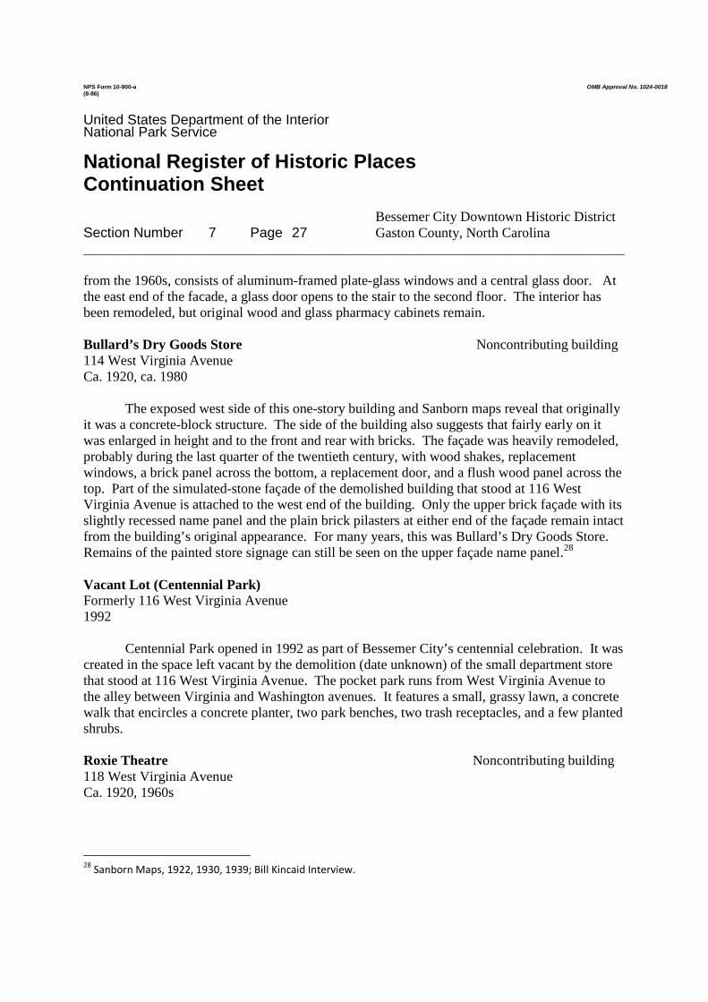
NPS Form 10-900-a OMB Approval No. 1024-0018(8-86)
United States Department of the InteriorNational Park Service
National Register of Historic PlacesContinuation Sheet
Bessemer City Downtown Historic DistrictSection Number 7 Page 27 Gaston County, North Carolina______________________________________________________________________
from the 1960s, consists of aluminum-framed plate-glass windows and a central glass door. Atthe east end of the facade, a glass door opens to the stair to the second floor. The interior hasbeen remodeled, but original wood and glass pharmacy cabinets remain.
Bullard’s Dry Goods Store Noncontributing building114 West Virginia AvenueCa. 1920, ca. 1980
The exposed west side of this one-story building and Sanborn maps reveal that originallyit was a concrete-block structure. The side of the building also suggests that fairly early on itwas enlarged in height and to the front and rear with bricks. The façade was heavily remodeled,probably during the last quarter of the twentieth century, with wood shakes, replacementwindows, a brick panel across the bottom, a replacement door, and a flush wood panel across thetop. Part of the simulated-stone façade of the demolished building that stood at 116 WestVirginia Avenue is attached to the west end of the building. Only the upper brick façade with itsslightly recessed name panel and the plain brick pilasters at either end of the façade remain intactfrom the building’s original appearance. For many years, this was Bullard’s Dry Goods Store.Remains of the painted store signage can still be seen on the upper façade name panel.28
Vacant Lot (Centennial Park)Formerly 116 West Virginia Avenue1992
Centennial Park opened in 1992 as part of Bessemer City’s centennial celebration. It wascreated in the space left vacant by the demolition (date unknown) of the small department storethat stood at 116 West Virginia Avenue. The pocket park runs from West Virginia Avenue tothe alley between Virginia and Washington avenues. It features a small, grassy lawn, a concretewalk that encircles a concrete planter, two park benches, two trash receptacles, and a few plantedshrubs.
Roxie Theatre Noncontributing building118 West Virginia AvenueCa. 1920, 1960s
28Sanborn Maps, 1922, 1930, 1939; Bill Kincaid Interview.

NPS Form 10-900-a OMB Approval No. 1024-0018(8-86)
United States Department of the InteriorNational Park Service
National Register of Historic PlacesContinuation Sheet
Bessemer City Downtown Historic DistrictSection Number 7 Page 28 Gaston County, North Carolina______________________________________________________________________
As early as 1922, according to the Sanborn map for that year, this one-story brickbuilding was being used for “moving pictures.” A 1946 photograph shows it as the RoxieTheatre, one of several movie houses in Bessemer City. It had a brick façade that wascontinuous with the adjacent building to the east (116), at that time the Home Store. In thephotograph, the theater appears to have a broad, deeply recessed entry area, except for theenclosed ticket booth by the sidewalk. A flat metal canopy studded with lights along the bottomedge extended across the ticket booth and entrance, and above it was a sign with the name of thetheater painted directly on the brick. Probably in the late 1960s, when the building ceased to beused as a theater, the brick façade was covered with simulated stone, which also covered thefaçade of the adjacent Home Store (116), now demolished. The storefront remains recessed, buta double-leaf entrance and plate-glass windows have been installed.29
Winn-Dixie Grocery Contributing building120 West Virginia AvenueCa. 1926
According to nonagenarian resident Bill Kincaid, this one-story brick building wasinitially the Winn-Dixie grocery. It remained that for a number of years, after which othersoperated grocery stores here. Except for a metal canopy that has replaced an earlier clothcanopy, the exterior of the building remains largely intact.30
The storefront has a pair of wood-framed glass doors, each with a glass transom. Oneither side of the pair of doors are large, single-pane glass shop windows. An intact prism-glasstransom carries across the entire storefront above the doors and windows. The upper façade hasa narrow, recessed panel near the base of the dark-red, stretcher-bond brick wall surface.
Lewis Grocery Store Contributing building122 West Virginia AvenueCa. 1920, third quarter twentieth century
Like several other commercial buildings along West Virginia Avenue, this one was builtwith side and rear concrete block walls and a brick façade. In its early years, it was used as theLewis Grocery Store. Its storefront was modernized, likely during the third quarter of thetwentieth century, with modern aluminum-framed plate-glass windows, a recessed entrance ofthe same materials at the east end, and solid panels above where there was probably a glass
29Sanborn Maps, 1922, 1930, 1939; Shahn photograph.
30Bill Kincaid Interview; Sanborn Maps, 1922, 1930, 1939; Shahn photograph.

NPS Form 10-900-a OMB Approval No. 1024-0018(8-86)
United States Department of the InteriorNational Park Service
National Register of Historic PlacesContinuation Sheet
Bessemer City Downtown Historic DistrictSection Number 7 Page 29 Gaston County, North Carolina______________________________________________________________________
transom. A soldier-course brick band borders the top of the storefront, and a cloth canopyshelters it. The painted brick upper façade has a projecting brick string course about halfway up,beneath which is a slightly recessed brick name panel.
First State Bank and Trust Company Noncontributing building124 West Virginia AvenueCa. 1927, last quarter twentieth century
For most of its existence, this one-story, painted-brick building was a bank. Initially, theeastern two bays of the three-bay building were used as the First State Bank and Trust Company,which after the mid-twentieth century became part of First Union Bank. The eastern two baysare defined by full-height brick pilasters, and the upper half of each bay is decorated withslightly recessed panels of basketweave bricks. The west-end bay was originally a shorter,separate building that was used in the 1930s as the Western Union office and at other times as abarber shop. In the last quarter of the twentieth century, its height was raised to the cornice levelof the eastern two bays, its upper façade was remodeled with a basketweave brick panel to matchthe detailing of the eastern two bays, and the once-separate building became part of the bank.Painting the brick helped unify the appearance of the three bays. Probably at the same time thebuildings were combined, their storefronts were completely remodeled. Originally, the east twobays had a tall doorway in one bay and a tall window in the other. These have been replacedwith a shorter modern door and a modern, horizontal replacement window. The entrance to thewest bay has been removed and replaced by a long horizontal window like that in the east bay.31
Commercial Building Contributing building128-130 West Virginia AvenueCa. 1930, ca. 1960
Although this building contains two businesses, it reads as one building due to itsunifying façade of yellow, stretcher-bond bricks. The eastern half of the building served as thepost office during the 1930s. At other times it was a men’s clothing store and a restaurant. Itsstorefront, which is flush to the façade, has two bays, with an aluminum-framed glass entrance inthe east bay and a large, plate-glass window framed in aluminum in the west bay. A fabriccanopy carries across the whole. The west half of the building was a restaurant and later was theoffice of Duke Power Company. Based on photographs from 1946 and 1974, its storefront wasmodernized between those years, probably ca. 1960, with a flat metal canopy, an inset, angled
31Bill Kincaid Interview; Sanborn Maps, 1922, 1930, 1939; Shahn photograph; Gastonia Gazette, April 27, 1974.

NPS Form 10-900-a OMB Approval No. 1024-0018(8-86)
United States Department of the InteriorNational Park Service
National Register of Historic PlacesContinuation Sheet
Bessemer City Downtown Historic DistrictSection Number 7 Page 30 Gaston County, North Carolina______________________________________________________________________
façade with a glass-and-aluminum framed entrance at the most deeply inset west end andaluminum-framed plate-glass windows across the rest of the storefront. Red Roman bricks forma skirt beneath the windows and a wall at the west end of the recess. The storefront floor is laidwith broken red tiles.32
City Hall Noncontributing building132 West Virginia Avenue1992
In 1922, Bessemer City built the most architecturally impressive building in itsdowntown – the City Hall. The building, which housed the police and fire departments, thecommissioners’ room, and the recorder’s court, was a two-story brick structure with tripartitewindows – two with balconies, a classical entrance with a round-arched window above it on thesecond floor, and a two-part modillioned cornice with a parapet above. The most strikingfeature, however, was the Baroque cupola with its surrounding, balustraded walkway that rosefrom the roof. The building suffered a fire in the late 1940s that caused extensive damage, but itwas renovated thereafter and then enlarged in 1977.33
In 1992, the present City Hall was built to replace the earlier one. The large, two-storybrick building has a glass and brick façade that is set back from a two-level brick arcade and amock standing-seam metal roof. The primary entrance is at the southeast corner of the building.
Froneberger Hardware Store Contributing building134 West Virginia AvenueCa. 1935
Sanborn maps show that this building was erected between 1930 and 1939. During itsearly years, it was the Froneberger Hardware Store.34
The façade of the two-story brick building appears to be remarkably unaltered from itsappearance when built. The front of the building is faced with multi-colored tapestry brick andis three bays wide, bordered on each end by a plain brick pilaster. The storefront has a center-bay recessed entrance composed of a single wood-framed glass door with a narrow glasstransom. Metal-framed plate-glass windows angle outward from the door and then follow theplane of the façade to the outer edges of the building. Square red tiles form a base to thewindows and a floor in front of the entrance. A three-part transom runs across the façade above
32Bill Kincaid Interview; Sanborn Maps, 1930, 1939; Shahn photographs; Gastonia Gazette, April 27, 1974.
33Bessemer City Centennial, 86, 180; Sanborn Maps, 1922, 1930; Shahn photograph.
34Sanborn Maps, 1930, 1939; Bill Kincaid Interview.

NPS Form 10-900-a OMB Approval No. 1024-0018(8-86)
United States Department of the InteriorNational Park Service
National Register of Historic PlacesContinuation Sheet
Bessemer City Downtown Historic DistrictSection Number 7 Page 31 Gaston County, North Carolina______________________________________________________________________
the entrance and windows, and a fabric canopy shelters the whole. The interior of the first floorhas a hardwood floor and a decorative pressed-metal ceiling and cornice. The façade’s secondstory is illuminated by three casement windows, each with a projecting brick sill and a soldier-course lintel. All three windows have casements with two leaves of eight lights each. A four-light transom tops the side windows, while the larger center window has an extra column of fourlights on the east and west sides of the casement and a six-light transom.
Shulman’s Department Store Contributing building136 West Virginia AvenueCa. 1920; ca. 1940; ca. 1960
During the 1920s and 1930s, this building was an auto repair shop operated by HenryHolden. The front and rear had openings large enough for a vehicle to drive through. Around1940 the Shulman family converted the building for use as Shulman’s Department Store, a well-known fixture in downtown Bessemer for many years. The present storefront appears to be a ca.1960 remodeling.
The one-story building is constructed of brick-faced concrete blocks. A flat metal canopyshades the recessed storefront with its central glass entrance, plate-glass windows, and brickbase. Above the canopy is a glass transom, which is partially covered with corrugated metal andis headed by a band of soldier-course bricks. The building’s upper façade is sheathed withstretcher-bond bricks except for three evenly spaced blocks composed of three soldier-laid brickseach. Above the storefront, the name of the department store was painted directly on the bricks.Although painted over, it can still be read.
Kincaid Service Station and Pontiac Dealership Two contributing buildings201-203 West Virginia Avenue1932, ca. 1937, ca. 1960
In 1922, A. F. Briggs Sr. built a frame gas station, the Mountain View Station, on thesouthwest corner of Virginia Avenue and Thirteenth Street. He had to obtain a lease fromSouthern Railway, since the property was downhill from the tracks within the railroad right-of-way. Sanborn maps show that Briggs’s station stood diagonally to face the corner. In 1932, IraKincaid and Grady Patterson purchased the business and replaced the frame building with a brickone – the current building – that faced Thirteenth Street. The new station (one contributingbuilding) sold Esso gasoline and other products. Two open work bays were attached to the southside of the service station, and a small, detached garage (one contributing building) was builtimmediately behind (west of) the station. Later, the narrow gap between the two was infilled

NPS Form 10-900-a OMB Approval No. 1024-0018(8-86)
United States Department of the InteriorNational Park Service
National Register of Historic PlacesContinuation Sheet
Bessemer City Downtown Historic DistrictSection Number 7 Page 32 Gaston County, North Carolina______________________________________________________________________
with bricks. In 1937, Ira Kincaid became a Pontiac dealer and built a showroom and servicecenter behind and attached to the station’s garage on West Virginia Avenue. When the Pontiacdealership moved to the north side of West Virginia Avenue around 1950, the former showroombecame the dealership’s parts department. In 1955, Ira Kincaid retired and his son, Bob, tookover the service station. He replaced the two open work bays on the south side of the stationwith two modern brick-faced service bays between 1955 and 1967. No longer owned by theKincaid family, the service station is now an auto repair business called Virginia Ave. Auto. Theformer dealership and garage behind the service station now make up the Bessemer CityMotorcycle Shop.35
All sections of the building are one-story in height. Set back from Thirteenth Street, the1932 service station is a painted- brick building with stretcher-bond walls. Doors are glass-and-wood paneled or just wood paneled, and windows are four-over-one sash. Windows have asoldier-course brick lintel and a projecting brick sill. Those on the front have metal awnings.The most distinguishing feature of the building is its metal Spanish-tile-covered pent eave, abovewhich rises a parapeted cornice which is crenelated on the north side. Originally, Esso gas tanksstood in an island in front of the service station, sheltered by a metal Spanish-tile-covered hippedroof supported by a brick post at either end. The island does not survive. The ca. 1960 servicebays on the south side of the original building are concrete block, faced with white-painted brick,and “Happy Motoring!” is painted on the brick across the top. The sections of the complexbehind the service station face West Virginia Avenue and are all faced in dark reddish-brownbrick. The first, and smallest, section, originally used as a garage, is lower in height than theother sections. It has three windows. One has been boarded up, but the other two are twelve-light metal windows. Exposed rafter ends project across the top from the sloped roof. The 1937Pontiac showroom and service center is constructed of concrete blocks and sheets of vertically-set standing-seam metal over a frame structural system. The roof slopes gradually from front torear. The plain brick facade has a parapeted cornice with a small rectangular rise at either end.The east half of this section of the complex, the service center, has a large vehicular opening inthe center. Immediately east of the opening is a glass-and-wood-paneled door with a transom(now covered). West of the vehicular opening is a one-over-one sash window. The formershowroom at the west end of the complex has two bays. The east bay has a door with windowattached to its west side, the whole now enclosed with plywood. The west bay has a largewindow, the right half of which is enclosed with plywood.
35Sanborn Maps, 1930, 1939; Bill Kincaid Interview; Bessemer City Centennial, 102-103.

NPS Form 10-900-a OMB Approval No. 1024-0018(8-86)
United States Department of the InteriorNational Park Service
National Register of Historic PlacesContinuation Sheet
Bessemer City Downtown Historic DistrictSection Number 8 Page 33 Gaston County, North Carolina______________________________________________________________________
Summary
In 1872, the Atlanta and Charlotte Division of the Richmond and Danville Railroadcompleted a track through the area of Gaston County, North Carolina, that would become thetown of Bessemer City. The area was rich in Bessemer-grade iron ore and timber, which hadbeen exploited for some time, but it was not until the late nineteenth century that entrepreneursorganized to take advantage of the opportunities for improved industry and commerce that railservice afforded. In 1891, the Bessemer City Mining and Manufacturing Company wasincorporated by a group of investors who had purchased nearly 2,000 acres and had an ambitiousplan for developing the area. Not all of their efforts succeeded, but their work did lead to theestablishment of a new town. On March 6, 1893, the North Carolina General Assembly ratifiedan act to incorporate the town of Bessemer City. The layout of the town was two-and-a-halfmiles long and one-and-a-quarter miles wide, with the railroad running lengthwise through thecenter and the depot serving as the center point.
Begun in 1895 and completed the following year, Southern Cotton Mills took its place asthe first textile mill established in Bessemer City. In 1909, the ownership and corporate namechanged to Osage Manufacturing Company. When Reeves Brothers, Inc., a New York textilefirm, purchased the mill in 1928, it retained the Osage name and continued to operate the mill forthe next sixty-seven years. After a century of supporting the local economy by providingemployment to many residents of Bessemer City and the surrounding area, the mill closed in1995. Across Eleventh Street from the first mill, Whetstone Cotton Mills was established in1903 to produce cotton damask cloth. It was a smaller operation than the Southern Cotton Mills-Osage Manufacturing Company, but under various names and ownerships, the mill continued tooperate until 1963. The Southern Cotton Mills-Osage Manufacturing Company and theWhetstone Cotton Mills are both significant for their role in driving Bessemer City’s economyover a period of many years. They are two of only three surviving mill complexes in the town,which once was home to five mills of some duration. The establishment of Bessemer City’stextile mills brought about an increase in the town’s population as the need for a largerworkforce grew.
With the development of the town’s textile industry, Bessemer City’s commercial centerbegan to take shape as the establishment of retail stores, a bank, and a post office becamenecessary to help provide for the needs of the town’s inhabitants. Despite being only six milesfrom the bustling county seat, Gastonia, which had numerous mills and a much larger downtown,Bessemer City developed as and remained an independent community with its own commercialcenter. A wide variety of commercial establishments were built along East and West VirginiaAvenue and West Pennsylvania Avenue facing directly onto the railroad. The buildings erectedduring the first half of the twentieth century in Bessemer City’s downtown and that survive are
NPS Form 10-900-a OMB Approval No. 1024-0018(8-86)
United States Department of the InteriorNational Park Service
National Register of Historic PlacesContinuation Sheet
Bessemer City Downtown Historic DistrictSection Number 8 Page 34 Gaston County, North Carolina______________________________________________________________________
primarily of brick construction, but several were built with concrete blocks, a building materialthat became highly popular right after the turn of the twentieth century. All the commercialbuildings are either one or two stories, and most are of simple design. Of the twenty-fivecommercial buildings in the historic district, ten date from the first quarter of the twentiethcentury and fifteen from the second quarter. Only the 1992 City Hall post-dates the end of theperiod of significance. The mostly well-preserved and compact character of the contiguouscommercial buildings forms a cohesive whole that reflects the district’s period of significance.
For a century after the railroad’s 1872 arrival in the area that was to become BessemerCity, it played an important role in the development and continued life of the community. As thetwentieth century progressed, both rail and automobile traffic in Bessemer City increased,necessitating the creation of safer ways for automobiles to cross the railroad tracks. The crossingremained at grade on Twelfth Street because the depot was at that location, but underpasses wereadded at Eleventh Street in 1913 and Thirteenth Street around 1918, providing for improvedaccess between Bessemer City’s two areas of downtown commercial development on either sideof the tracks. Both concrete underpasses remain in use.
The Bessemer City Downtown Historic District is a mixed-use area of forty-fiveresources, seventy-three percent of which contribute to the historic character of the district. Thedistrict’s resources include twenty-five commercial buildings, two textile mills, three railroadresources, and fifteen secondary resources – mostly small buildings and structures and mostlyassociated with the mills. The district meets National Register Criterion A, and it is locallysignificant in the areas of commerce and industry. The district’s period of significance extendsfrom 1895, when the first textile mill was begun, to 1964, fifty years ago when the commercialdowntown was still thriving and the Osage mill was still going strong.
Historical Background and Commerce and Industry Contexts
As with many towns established in North Carolina in the late nineteenth and earlytwentieth centuries, Bessemer City’s story is one of economic opportunities afforded by thecoming of rail service and of entrepreneurs who took advantage of those opportunities byestablishing a town and developing local industry and commerce.
Well before Bessemer City was established, the area was a center for the mining of highquality Bessemer-grade iron ore and, to a lesser extent, gold during the eighteenth and nineteenthcenturies. Iron ore that had been extracted from the mines was converted to pig iron in furnacessuch as the local Ormand Furnace. In addition, the area’s virgin forests of pine, oak, maple, andhickory had attracted timber companies interested in logging.36
36Bessemer City Centennial, 2-3, 21; Ragan, 72.

NPS Form 10-900-a OMB Approval No. 1024-0018(8-86)
United States Department of the InteriorNational Park Service
National Register of Historic PlacesContinuation Sheet
Bessemer City Downtown Historic DistrictSection Number 8 Page 35 Gaston County, North Carolina______________________________________________________________________
In 1872, the Atlanta and Charlotte Division of the Richmond and Danville Railroad laid asingle track through the area that would become Bessemer City. To do so, they had to cutthrough a hill located southwest of today’s downtown Bessemer City that they discovered wascomposed largely of whetstone, a hard, fine-grained stone used for sharpening tools. Making thecut took a year and was considered an engineering feat because of its difficulty. Thereafter, thehill was known as Whetstone Mountain, a name that became closely associated with BessemerCity. The train stop at the place was first known as Wooten Station, named for the engineer incharge of cutting through the rock, John Francis Wooten.37
The community at Wooten Station developed slowly until the early 1890s, when a groupof entrepreneurial investors joined together to take advantage of the railroad and the local miningopportunities. As it turned out, their mining efforts did not succeed, because their undertakingbegan at the very time the area’s iron ore was becoming rapidly depleted. Nevertheless, theirendeavors led to the formal establishment of a new town, Bessemer City.
In 1891, the Bessemer City Mining and Manufacturing Company was incorporated withauthorized capital stock of $5,000,000, subscribed stock of $650,000, and paid-in stock totaling$457,000. The elected officers and directors brought professional knowledge from various fieldsintended to provide the necessary skills for accomplishing a range of undertakings. EdwinMickley, an iron manufacturer from Pennsylvania and Alabama, was president of the newcompany. Julian S. Carr, a tobacco manufacturer and banker from Durham, was vice-president.John Askew Smith, a tobacco manufacturer and specialist in minerals from Reidsville then livingin Bessemer City, was secretary and treasurer. Serving with these three as directors were J. A.Carroll, a banker and cotton manufacturer from Gaffney City, South Carolina; Dr. B. F. Dixon,president of Greensboro Female College in Greensboro; J. A. Pinchback of Bessemer City,Smith’s brother-in-law and a specialist in real estate and minerals; and William D. Rice ofInsurance and Loan Association, Richmond, Virginia. Of these, only Smith and Pinchback livedin Bessemer City, and it was they who oversaw the on-site planning and operations of thecompany38
The company’s prospectus laid out a bold, if over-glorified, plan for developing andprofiting from the nearly 2,000 acres in its ownership. Central to the plan was to mine and shipBessemer iron ore and to build iron and steel works to manufacture the ore into finishedproducts. The company also planned to build a 200-room hotel at a cost of $150,000, a cottonmill capitalized at $100,000, two saw and planing mills, a sash, door, and blind factory, a shoefactory, several other manufactories, and a bank. The hotel was under construction at the timethe prospectus was released and was situated 125 feet above the railroad track at the top of
37Bessemer City Centennial, 6-7.
38Prospectus of the Bessemer City Mining and Manufacturing Company.

NPS Form 10-900-a OMB Approval No. 1024-0018(8-86)
United States Department of the InteriorNational Park Service
National Register of Historic PlacesContinuation Sheet
Bessemer City Downtown Historic DistrictSection Number 8 Page 36 Gaston County, North Carolina______________________________________________________________________
Whetstone Mountain. With these endeavors promised, the company planned to have a sale inNovember 1891 of 9,600 business and residential lots. Most residential lots measured 50 by 140feet and the business lots measured 25 by 140 feet. All lots were to have a twenty-foot alley atthe rear. The town-lot property of 1,778 acres ran two-and-a-quarter miles long, with therailroad running the long way through the center of the property. Avenues named for states raneast and west, while numbered streets starting at the east end of town ran north and south. W. R.Richardson, a civil engineer from Greensboro, surveyed and laid out the proposed town.39
On March 6, 1893, the North Carolina General Assembly ratified an act to incorporatethe town of Bessemer City. Following the plan of the Bessemer City Mining and ManufacturingCompany, the corporate limits were defined as two-and-a-half miles long and one-and-a-quartermiles wide with the passenger depot of the Atlanta and Charlotte division of the Richmond andDanville Railroad serving as the center point. Until the next regular election was held, J. A.Pinchback was named mayor and John A. Smith was one of five commissioners.40
The other plans of the Bessemer City Mining and Manufacturing Company were not assuccessful as the establishment of the new town. The iron ore business did not prosper asexpected. When John A. Smith, the company’s principal operator, completed the Mountain ParkHotel atop Whetstone Mountain in 1892, it had sixty-five rooms instead of the projected 200. Itremained in operation through the first decade of the twentieth century, and although it failed toattract the tourists Smith had hoped for, it provided many entertainments for the local people. In1912, C. B. Armstrong of Gastonia foreclosed on a mortgage he held from a loan Smith hadtaken to finance his Bessemer City Cotton Mills, and the hotel was soon dismantled and hauledaway for the materials.41
The company’s textile endeavors did not fare much better. In 1895, John A. Smith and J.A. Pinchback began construction on a cotton mill where foundry shops had stood previously.They completed the card and spinning rooms, but before they could finish the weave room andbuild the power plant, much less equip the mill with the necessary machinery, they ran out ofmoney. As a result, the proposed mill was sold at a public bankruptcy auction in late 1895. Anewly-organized company was chartered as Southern Cotton Mills on December 10, 1895, by J.M. Odell, W. R. Odell, W. H. Branson, and D. B. Coltrane of Concord, North Carolina. Theycompleted construction of the mill in 1896, equipped it with 8,000 spindles and 362 looms, andbegan operation. Southern Cotton Mills took its place as the first textile mill established inBessemer City and the eighteenth in textile-rich Gaston County. John M. Odell was thecompany’s first president and his son-in-law, Stonewall Jackson Durham, was secretary,treasurer, and manager. The initial capital stock was $125,000, but in 1905, it was increased to
39Prospectus of the Bessemer City Mining and Manufacturing Company; Bessemer City Centennial, 7.
40Private Laws of the State of North Carolina, 577-578.
41Bessemer City Centennial, 2, 7, 45, 54.

NPS Form 10-900-a OMB Approval No. 1024-0018(8-86)
United States Department of the InteriorNational Park Service
National Register of Historic PlacesContinuation Sheet
Bessemer City Downtown Historic DistrictSection Number 8 Page 37 Gaston County, North Carolina______________________________________________________________________
$275,000. With its expanded capital, the company enlarged the mill, increasing its capacity to16,272 spindles and 400 looms and employing more than 400 workers. Nevertheless, when theOdell textile manufacturing interests in Concord failed as a result of the national economic panicof 1907 and the ensuing depression, like a domino, Southern Cotton Mills followed in 1908. Thenext year the property was again sold at public auction.42
On February 8, 1909, Slater Manufacturing Company was established for the purpose ofpurchasing the Southern Cotton Mills property. The officers and directors were experiencedcotton manufacturers from across North Carolina. D. B. Coltrane of Concord, who had been oneof the organizers of Southern Cotton Mills, was elected president and manager. With capitalstock of $300,000, 15, 216 spindles, 401 looms, and 200 employees, the new companymanufactured yarn and madras cloth.43 The corporate name changed to Osage ManufacturingCompany on August 19, 1909, but the incorporators remained the same. Although in subsequentyears the mill ownership changed several times, the Osage name remained intact for the nexteighty-six years. In 1913, C. Judson Huss, an officer of the Huss Manufacturing Company,another Bessemer City textile mill, purchased the Osage mill. At that time the mill wasproducing cotton drills – a sturdy fabric used for uniforms and work clothes – and jeans fabric.In 1925-1926, with $350,000 in capital stock, 16, 272 spindles (back to the number in 1905), 388looms, and 286 employees, the mill produced $800,000 worth of sheeting cloth. In 1928, Hussand his associates sold the mill to Reeves Brothers, Inc., a New York textile firm whosefounders, John M. and M. R. Reeves, had North Carolina connections. The mill was operated asa wholly-owned subsidiary of Reeves Brothers, Inc. until 1955, when it was fully absorbed intothe company. For sixty-seven years, Reeves Brothers successfully operated the OsageManufacturing Company, later known as the Osage Plant. During its ownership, ReevesBrothers continued to upgrade and expand the Bessemer City facility. However, in 1995, after acentury of supporting the local economy by providing employment to residents of Bessemer Cityand the surrounding area, the mill closed.44
With the Southern Cotton Mills established in 1895, other mills followed. AcrossEleventh Street from that first mill, Whetstone Cotton Mills, a smaller, one-story brick structure,was erected in 1903. It was incorporated on June 23, 1903, with Bessemer City attorneyStonewall Jackson Durham serving as its first president. At the time, Durham was also an officerof Southern Cotton Mills. Capital stock for Whetstone Cotton Mills was authorized at $100,000,but at the time of incorporation, the company had only around $30,000. With forty-eight broadlooms and twenty-eight employees, the mill produced cotton damasks. Spinning equipment was
42Ragan, 72-73; Bessemer City Centennial, 8.
43Why the reported number of spindles was more than 1,000 less than the number in 1905, and the number of
employees was only half the number in 1905 is not known.44
Ragan, 73-74; Department of Labor and Printing, Annual Reports,1910 and 1925-1926.

NPS Form 10-900-a OMB Approval No. 1024-0018(8-86)
United States Department of the InteriorNational Park Service
National Register of Historic PlacesContinuation Sheet
Bessemer City Downtown Historic DistrictSection Number 8 Page 38 Gaston County, North Carolina______________________________________________________________________
not necessary, because the company purchased its yarn from other manufacturers. Like SouthernCotton Mills, Whetstone Cotton Mills was inadequately financed and operated, and with thepanic of 1907 and the depression that followed, it suffered. When Southern Cotton Mills failedin 1908, Whetstone Cotton Mills, with some of the same financial backers as the earlier mill,also failed.45
However, C. Judson Huss, Averitt A. McLean, and their Gastonia associates soonpurchased Whetstone Cotton Mills and on March 9, 1909, they incorporated as HussManufacturing Company. The authorized capital was $100,000, though initially only a quarterof that was subscribed. Labe Jenkins, who was president of Gastonia’s First National Bank, waselected president of the new company, and Judson Huss was made secretary and treasurer. In1909, the new company built an addition to the mill measuring 42 by 140 feet. In a change ofdirection, the company installed 2,500 spindles and seven cards for the production of carded yarnto be used on the forty-eight looms already in operation. After the addition was built, seventy-five employees produced table damask and duck cloth. In 1915, the mill’s equipment increasedto 6,000 spindles and 166 broad looms. A. A. McLean, who had become the major stockholder,then became president of the company, and A. A. McLean Jr. became secretary, treasurer, andmanager. In 1918, the company’s capital stock was raised to $175,000 with authority to increaseto $250,000 and to issue $75,000 in preferred stock. As a result, the mill’s machinery increaseddramatically to 10,000 spindles and 136 looms for making both mercerized and plain damasktable cloth. On March 1, 1920, McLean Manufacturing Company was incorporated and tookover the assets and business of Huss Manufacturing Company. After five years of operation asMcLean Manufacturing Company, business declined and the mill was sold to Robert, Frank, andMax Goldberg, immigrants from Russian Latvia who arrived in Bessemer City in 1914. In 1925,the Goldberg brothers incorporated American Cotton Mills, Inc. No. 2 and, with Frank Goldbergas president, acquired the mill, equipment, and other assets of the McLean ManufacturingCompany. That year, the mill reported having 117 employees, and its estimated yearly output oftire fabric and sheeting was valued at an impressive $1.2 million. Nevertheless, with the arrivalof the Great Depression several years later, troubles beset the mill. Despite drastic cost cuts,including cutting wages by thirty percent, American Cotton Mills No. 2 did not survive theDepression and foreclosed in 1935. On April 15, 1936, Algodon Manufacturing Company wasincorporated, with Frank Goldberg, C. Clyde Armstrong, and Robert Goldberg as incorporators.Under a court-approved reorganization, the new corporation purchased American Cotton MillsNo. 2, but in 1937, the mill’s assets were liquidated. The mill then became the AlgodonManufacturing Division of Pyramid Mills and operated as such for nearly thirty years until that
45Ragan, 114-115.

NPS Form 10-900-a OMB Approval No. 1024-0018(8-86)
United States Department of the InteriorNational Park Service
National Register of Historic PlacesContinuation Sheet
Bessemer City Downtown Historic DistrictSection Number 8 Page 39 Gaston County, North Carolina______________________________________________________________________
company was liquidated in 1963. In 1977, current owner Henry P. Moore purchased the mill forhis Dawn Processing Company. It produces decorative tassels for use with fabrics.46
As both of these mills, and especially Osage, expanded over the years, changes weremade to their physical plants. These changes – some of which are historic, dating prior to 1964 –covered some of the earlier sections of the mills. At both mills, most of the windows werebricked or blocked up during the late 1950s or early 1960s when air conditioning was installed.All these changes were consistent with those typically made at successful textile mills thatcontinued operating throughout the twentieth century. At both mills, the early periods ofconstruction and the later changes that came with expansion are apparent.
The Southern Cotton Mills-Osage Manufacturing Company and the Whetstone CottonMills-Huss Manufacturing Company-Algodon Manufacturing Division of Pyramid Mills areboth significant for their role in Bessemer City’s economy over a period of many years. Theother mills established in Bessemer City, including three of some duration – experienced manyof the same financial problems as did these two. According to Gaston County textile historianRobert Ragan, all of Bessemer City’s mills, at least in their early years, suffered both fromundercapitalization and from having principals who lacked familiarity with the technical aspectsof manufacturing and with the financial and marketing knowledge needed to successfully operatea textile mill.47
The Bessemer City Cotton Mills was incorporated in 1897, but the mill was not built orput into operation until 1901-1902. It constituted the second try at textile manufacturingundertaken by J. A. Smith and J. A. Pinchback, whose previous attempt with the mill thatbecame Southern Cotton Mills had so quickly ended in bankruptcy. The mill produced madras,other cloth weaves, yarn, and wide sheeting. The Bessemer Cotton Mills failed in 1908, but by1914, the Gambrill and Melville Mills Company had purchased the mill and operated it until1963. It eventually had 200-225 workers. Located on the south side of East Virginia Avenuebetween Ninth and Tenth Streets, the 125,000 square-foot mill was a two-story brick buildingwith an impressive four-story tower. It was demolished in recent years.48
Chartered in 1905, Vermont Mills, Inc. was the fourth textile mill built in Bessemer City.For many of its years, the mill’s ownership followed a parallel history with that of WhetstoneCotton Mills. With related ownership, when Southern Cotton Mills and Whetstone Cotton Millsfailed in 1908, so did Vermont Mills. The mill changed both ownership and names multipletimes. Later incarnations included the Akron Manufacturing Company, the Atlas ManufacturingCompany, American Cotton Mills, Inc. (No. 1), and the Algodon Manufacturing Company. As
46Ragan, 115-116; Department of Labor and Printing, Annual Reports, 1910 and 1925-1926; Deed Book 1220, p.
501.47
Ragan, 134.48
Ragan, 108-109.

NPS Form 10-900-a OMB Approval No. 1024-0018(8-86)
United States Department of the InteriorNational Park Service
National Register of Historic PlacesContinuation Sheet
Bessemer City Downtown Historic DistrictSection Number 8 Page 40 Gaston County, North Carolina______________________________________________________________________
the Atlas Manufacturing Company, the mill produced coarse cotton yarns for the manufacture ofgas masks and cartridge belts for the military. At one time the mill had as many as 300 workers.The one-story-with-basement brick building of 153,000 square feet has had many alterations, butit remains standing on East Alabama Avenue, several blocks east of the Whetstone CottonMills.49
In 1906, J. A. Smith and J. A. Pinchback made their third and final attempt at establishinga successful textile mill in Bessemer City when they incorporated the Smith Cotton MillsCompany. Located next to the Bessemer City Cotton Mills on East Virginia Avenue, the one-story brick mill began operations in 1907. Unfortunately, like its predecessors, Smith CottonMills was undercapitalized, and soon Smith and Pinchback were in financial trouble. The millchanged ownership twice before being bought, along with Bessemer City Cotton Mills, byGambrill and Melville Mills Company in 1914. Thereafter, the two mills shared a commonhistory, including being demolished in recent years.50
Other attempts at textile manufacturing in Bessemer City included: Crescent Mills,incorporated in 1906 but never built; George Cotton Mills, incorporated in 1919 but liquidatedbefore it could start operating; and the Brison Manufacturing Company, organized in 1919 butsold in 1921, becoming the Buffalo Mills. Nothing else is known of this mill, including where itwas located and how long it remained in operation.51
Bessemer City’s population increased as the town’s textile mills required more and moreworkers. Local tradition claims that when the town was incorporated in 1893, there were onlysix families living in the community. By 1900, however, that number had grown dramatically tonearly 600 residents. By 1912, population had nearly doubled, to 1,100.52 With the growingpopulation, houses, churches, and schools were built. For many years, at least five boardinghouses were located in the 100 block of East Virginia Avenue, where they were in walkingdistance of the mills.53 A ca. 1914 photograph shows a rather barren landscape with the railroadtrack on raised land, plain one- and two-story frame houses on the north side of the track, WestSchool on the hillside, and the long Mountain View Hotel with its two-tier porches still standingat the top of Whetstone Mountain and dominating the landscape.54
As the early years of the twentieth century progressed, both rail and automobile trafficincreased, necessitating improved vehicular access between the areas of development on eitherside of the tracks. Twelfth Street continued to cross the track at grade, because the depot was
49Ragan, 123.
50Ragan, 134-135.
51Bessemer City Centennial, 49; Ragan, 167-177, 422.
52Bessemer City Centennial, 22, 56.
53Bessemer City Centennial, 26.
54Bessemer City Centennial, 21.

NPS Form 10-900-a OMB Approval No. 1024-0018(8-86)
United States Department of the InteriorNational Park Service
National Register of Historic PlacesContinuation Sheet
Bessemer City Downtown Historic DistrictSection Number 8 Page 41 Gaston County, North Carolina______________________________________________________________________
there, but underpasses at Eleventh Street – between the Osage and Whetstone mills – and atThirteenth Street were built in 1913 and ca. 1918, respectively.55 From 1872 to around 1918,only one railroad track ran through Bessemer City, but at that point, Southern Railway laid asecond, parallel track. This was part of a much larger project undertaken by the railroad from1901 to 1919 to lay double tracks all the way from Washington, D.C. to Atlanta. The doubletracks remained until after World War II, when one was taken up, leaving the single track thatremains today.56
With the development of the town’s textile industry, even with its fits and starts,Bessemer City’s commercial center began to take shape as the establishment of commercialenterprises, a bank, a post office, and, eventually, a city hall became necessary to provide for theneeds of the town’s inhabitants. Despite being only six miles from the bustling county seat,Gastonia, which had numerous mills and a much larger downtown, Bessemer City developed asand remained a separate community with its own commercial center.
The development of Bessemer City’s infrastructure encouraged the growth of the town asa whole, but particularly its commercial center. Telephone lines were laid in 1904. Whenelectric lines came in 1909, street lights were installed that same year. Between 1912 and 1914,water and sewer lines were laid and ten blocks of sidewalks on multiple avenues and streets werepoured. Paved streets followed a decade later, in 1924.57
Still, business directories for 1903 and 1915 and Sanborn maps for 1922, 1930, and 1939– when compared with Bessemer City’s downtown today – suggest that the growth of the town’scommercial center was relatively slow. In 1903, there were three doctors, one lawyer, onenewspaper, two sales and livery stables, and six general merchants. More than a decade later, in1915, there was still one lawyer and one newspaper, but only two doctors. The town had oneadditional livery stable, and there were several general merchants. In addition, one druggist, onebank, and four hotels and boarding houses had been added to the mix.58 Sanborn maps providemore visual clues to the development of the town’s commercial center, but only during thedecades of the 1920s and 1930s when the maps were made for Bessemer City. In 1922,downtown Bessemer City had nineteen commercial buildings on East and West Virginia Avenueand West Pennsylvania Avenue. Four of those were frame, and there were still numerous vacantlots and several one- and two-story frame houses. In 1930, several dwellings still stood on thecommercial streets, but ten additional commercial buildings had filled in many of the vacant lots,
55Bessemer City Centennial, 56, 74.
56Bessemer City Centennial, 74; Andrew Thomas email.
57Bessemer City Centennial, 25, 45, 52.
58The North Carolina Year Book and Business Directory, 1903, 1915.

NPS Form 10-900-a OMB Approval No. 1024-0018(8-86)
United States Department of the InteriorNational Park Service
National Register of Historic PlacesContinuation Sheet
Bessemer City Downtown Historic DistrictSection Number 8 Page 42 Gaston County, North Carolina______________________________________________________________________
especially on West Virginia Avenue. By 1939, probably due to the Depression, only twocommercial buildings had been added to the local streetscape.59
A wide variety of commercial establishments took their place along the streets that facedthe railroad right-of-way – East and West Virginia Avenue and West Pennsylvania Avenue.Among these were Gamble Hardware at 101 East Virginia Avenue beginning in 1952 andFroneberger Hardware (built ca. 1935) at 134 West Virginia Avenue; Central Drug Store (built1927) at 112 West Virginia Avenue and Curtis Pharmacy at 102 West Virginia Avenuebeginning in 1932; grocery stores at 113 East Virginia Avenue in late 1920s, and at 104 (built ca.1920), 120 (built ca. 1926), and 122 (built ca. 1920) West Virginia Avenue; cafes and restaurantsat 117 East Virginia Avenue (built ca. 1950) and at 106 (built ca. 1945) and 130 (built ca. 1930)West Virginia Avenue; as well as numerous dry goods, clothing, and department stores. TheBessemer City Bank, beginning in 1912 at 107 West Pennsylvania Avenue and the First StateBank and Trust Company (later First Union Bank) beginning ca. 1927 at 124 West VirginiaAvenue attended to the banking needs of local residents. The Roxie Theatre at 118 WestVirginia Avenue (built ca. 1920) and the Rex Theatre at 110 West Virginia Avenue (built ca.1950) provided entertainment. As automobiles took on a more important role in the lives ofmany Americans, Henry Holden operated an auto repair shop in the 1920s and 1930s at 136West Virginia Avenue, Ira Kincaid built an Esso service station at 201 West Virginia Avenue in1932 and a Pontiac dealership in 1937 at 203 West Virginia Avenue, and a Western Auto storewas built at 113 East Virginia Avenue around 1950. The buildings that housed these businessesall survive in the historic district, and they, along with other businesses, provided residents ofBessemer City with most of their commercial needs for many years.
Initially, the commercial buildings were primarily of frame construction, but as the yearspassed and prosperity grew, more permanent masonry buildings were constructed.60 SouthernCotton Mills built one of the earliest brick stores in town for its employees. Located across fromthe mill at the southwest corner of West Pennsylvania Avenue and South Twelfth Street, the one-story brick building remains standing but has been completely modernized.61
Two lots west of the mill store, the Whetstone Masons constructed a two-story masonrybuilding for their lodge in 1906-1907 that was an early example of concrete block construction.While the Masons met on the second floor, they leased other rooms to a variety of businesses andprofessionals. Among the many occupants of the building at one time or another were Dr. W. S.Matthews, the telephone exchange – lines had been laid in 1904 – and the printer W. A.Westmoreland, who published the Bessemer City Journal. During the building’s early years, thefront section of the first floor was occupied by the Bessemer City Bank, which had been
59Sanborn Map, 1922, 1930, 1939.
60Sanborn Map, 1922, 1930, 1939.
61Bessemer City Centennial, 47; Sanborn Map, 1922; Kincaid Interview.

NPS Form 10-900-a OMB Approval No. 1024-0018(8-86)
United States Department of the InteriorNational Park Service
National Register of Historic PlacesContinuation Sheet
Bessemer City Downtown Historic DistrictSection Number 8 Page 43 Gaston County, North Carolina______________________________________________________________________
chartered by 1912, and later the town’s post office was housed in the building for a time. Otheroccupants included a cloth store, a salvage store, a florist, and the Boy Scouts.62 By 1930, othercommercial buildings lined West Pennsylvania Avenue between the Whetstone Masonic Lodgeand Thirteenth Street. However, most of those either were constructed after 1964 or were greatlymodernized from the mid-1960s to the early 1980s.63 Thus, that portion of the street is notincluded in the historic district.
Of the twenty-five commercial buildings in Bessemer City’s Downtown Historic District,ten date from the first quarter of the twentieth century and fifteen from the second quarter. Theoldest commercial buildings were erected during the first decade of the twentieth century. Theyinclude the buildings at 102 West Virginia Avenue (ca. 1905), 101 West Pennsylvania Avenue(1906) and 107 West Pennsylvania Avenue (1907), although the latter two were remodeled inlater years. The 1910s saw the construction of the two railroad underpasses – the one at EleventhStreet in 1913 and the one at Thirteenth Street ca. 1918. Some commercial buildings may alsohave been erected during this decade. However, without knowing for sure, they are dated ca.1920. They all appear on the 1922 Sanborn map. These include the buildings at 105 WestPennsylvania Avenue, which was remodeled ca. 1960, and 104, 114, 118, 122, and 136 WestVirginia Avenue, some of which were later remodeled. Judging from a comparison of the 1922and 1930 Sanborn maps, 113 East Virginia Avenue and 112, 120, and 124 West Virginia Avenuewere all built in the 1920s. Likewise, using the 1930 and 1939 Sanborn maps, it appears that 115East Virginia Avenue and 128-130, 134, and 201-203 West Virginia Avenue were constructedduring the 1930s. Only 101 East Virginia Avenue and 106-108 West Virginia Avenue arethought to date from the 1940s, the decade when construction was limited due to the lack ofmaterials during World War II. The buildings at 105 and 117 East Virginia Avenue and 110 and138 West Virginia Avenue appear to have been built around 1950. Remodeling of some of thebuildings was undertaken from the 1960s through the 1980s, and the Whetstone Masonic Lodge(107 West Pennsylvania Avenue) was remodeled in 1990. The last building constructed in thedistrict is City Hall (132 West Virginia Avenue), which was built in 1992 to replace an earlierCity Hall on the same site. The year 1992 also saw the creation of Centennial Park at 116 WestVirginia Avenue. An analysis of these dates suggests that the development of the districtprogressed at a fairly even pace during the first half of the twentieth century.
The overall well-preserved and compact character of the commercial buildings forms acohesive whole that reflects well the district’s 1895-1964 period of significance in an economygoverned in large part by the successes and failures of the town’s textile mills over a period ofmore than half a century.
62Bessemer City Centennial, 25-26, 181; Sanborn Map, 1922, 1930; Kincaid Interview; The Dispatch, March 8, 1912.
63Sanborn Map, 1922, 1930; Bessemer City Centennial, 117.

NPS Form 10-900-a OMB Approval No. 1024-0018(8-86)
United States Department of the InteriorNational Park Service
National Register of Historic PlacesContinuation Sheet
Bessemer City Downtown Historic DistrictSection Number 8 Page 44 Gaston County, North Carolina______________________________________________________________________
For nearly a century after 1872, when the railroad first arrived in the area that was tobecome Bessemer City, it played an important role in the development and continued life of thecommunity. While freight service supported local industry and commerce, passenger serviceprovided the town’s residents with easy access to other places, both for work and pleasure.However, the train’s role in Bessemer City life began to change after the mid-twentieth century.In 1961, the depot that had been built in 1900 was dismantled and replaced with a small,concrete-block freight station. A decade later, in 1972, Southern Railway discontinuedscheduled train stops in Bessemer City and turned the depot over to the city. The following year,the city dismantled the concrete-block depot and moved it from its site on Twelfth Streetbetween Virginia and Pennsylvania Avenues to the city’s maintenance headquarters. Knowingthe importance of the Twelfth Street location as the historic heart of Bessemer City, the CityCouncil extended the downtown park to include the site.64 Today, although trains no longer stopin Bessemer City, they still fly through town several times a day, and the downtown park thatextends along the north side of the railroad right-of-way between Twelfth and Thirteenth Streetsserves as a central gathering place for Bessemer City residents.
64Bessemer City Centennial, 10, 167.

NPS Form 10-900-a OMB Approval No. 1024-0018(8-86)
United States Department of the InteriorNational Park Service
National Register of Historic PlacesContinuation Sheet
Bessemer City Downtown Historic DistrictSection Number 9 Page 45 Gaston County, North Carolina______________________________________________________________________
BIBLIOGRAPHY
Bessemer City Record.August 16, 1966.January 14, 1981.
Crawford, Charlotte, et. al. Bessemer City Centennial 1893-1993. Charlotte: WalsworthPublishing Company through Herb Eaton Historical Publications, 1993.
The (Bessemer City) Dispatch. March 8, 1912.
Gaston County, North Carolina Records (Deeds), Register of Deeds Online Records System.www.gastongov.com/departments/register-of-deeds. Accessed July 18, 2013.
Gastonia Gazette. April 27, 1974.
The North Carolina Year Book. Raleigh: The News and Observer, 1935.
The North Carolina Year Book and Business Directory. Raleigh: The News and Observer, 1903,1915.
Phillips, Laura A. W. Interview with Bill Kincaid (Bessemer City resident since 1922).Bessemer City, North Carolina, April 25, 2013.
Private Laws of the State of North Carolina passed by the General Assembly at its Session of1893, begun and held in the City of Raleigh on Wednesday, the Fourth Day of January,A. S. 1893. Raleigh: Josephus Daniels, State Printer and Binder, 1893.
Prospectus of the Bessemer City Mining and Manufacturing Company, Bessemer City, N. C.
Ragan, Robert Allison. The Textile Heritage of Gaston County North Carolina 1848-2000.Charlotte: R. A. Ragan and Company, 2001.
Sanborn Map Company. Insurance maps for Bessemer City, North Carolina, 1922, 1930, 1939.
Shahn, Ben. Photographs of Bessemer City, North Carolina, 1946. Harvard Art Museums/FoggMuseum, Gift of Bernarda Bryson Shahn.

NPS Form 10-900-a OMB Approval No. 1024-0018(8-86)
United States Department of the InteriorNational Park Service
National Register of Historic PlacesContinuation Sheet
Bessemer City Downtown Historic DistrictSection Number 9 Page 46 Gaston County, North Carolina______________________________________________________________________
Simpson, Pamela H. Cheap, Quick, & Easy: Imitative Architectural Materials, 1870-1930.Knoxville: The University of Tennessee Press, 1999.
Southern Textile Bulletin. Vol. XVIII, No. 17. Charlotte, N. C., December 25, 1919.
Thirtieth Annual Report of the Department of Labor and Printing of the State of North Carolina,1916. Raleigh: Edwards and Broughton Printing Company, State Printers and Binders,1916.
Thirty-Fifth Report of the Department of Labor and Printing of the State of North Carolina,1925-1926. Raleigh: Mitchell Printing Company, State Printers, 1926.
Thomas, Andrew R. (Rail Division, North Carolina Department of Transportation). Email toLaura A. W. Phillips, July 18, 2013.
Twenty-Fourth Annual Report of the Department of Labor and Printing of the State of NorthCarolina, 1910. Raleigh: Edwards and Broughton Printing Company, State Printers andBinders, 1910.
Ward, Ralph. Southern Railway Depots. Vol. 2. Asheboro, N. C.: Ralph Ward, 1994.

NPS Form 10-900-a OMB Approval No. 1024-0018(8-86)
United States Department of the InteriorNational Park Service
National Register of Historic PlacesContinuation Sheet
Bessemer City Downtown Historic DistrictSection Number 10 Page 47 Gaston County, North Carolina______________________________________________________________________
GEOGRAPHICAL DATA
UTM References
5) 17 474080 3904250
Verbal Boundary Description
The boundary of the Bessemer City Downtown Historic District is shown by the heavy black lineon the accompanying district map, drawn to a scale of 1” = 200’.
Boundary Justification
The boundary of the Bessemer City Downtown Historic District is drawn to include the intacthistoric downtown commercial buildings, the two surviving historic textile mills adjacent to thecommercial downtown, and the Norfolk Southern Railroad right-of-way with its tracks and twounderpasses . The built environment within the historic district is distinguished from that whichlies outside the district due to changes in land use, the presence of more recent development,and/or the condition of or alterations to buildings in the surrounding area.

NPS Form 10-900-a OMB Approval No. 1024-0018(8-86)
United States Department of the InteriorNational Park Service
National Register of Historic PlacesContinuation Sheet
Bessemer City Downtown Historic DistrictSection Number Photos Page 48 Gaston County, North Carolina______________________________________________________________________
PHOTOGRAPHS
The following information for #1-5 applies to all nomination photographs:
1) Bessemer City Downtown Historic District2) Bessemer City, Gaston County, North Carolina3) Laura A. W. Phillips4) April 20135) CD: NCHPO, Raleigh, North Carolina6-7) 1: Streetscape, 100 block West Virginia Avenue, view to northeast
2: Streetscape, 100 block East Virginia Avenue, view to northwest3: Streetscape, 132-136 West Virginia Avenue, view to north4: Streetscape, 101-107 West Pennsylvania Avenue, view to southwest5: Kincaid Service Station and Pontiac Dealership, 201-203 West Virginia Avenue,
view to southwest6: Curtis Pharmacy, 102 West Virginia Avenue, view to northwest7: Southern Cotton Mills-Osage Manufacturing Company, 201 South Twelfth Street,
view to northeast8: Southern Cotton Mills-Osage Manufacturing Company, 201 South Twelfth Street,
water reservoir with water tower and cotton warehouse in background, view towest
9: Whetstone Cotton Mills-Huss Manufacturing Company-Algodon ManufacturingDivision of Pyramid Mills, 205 East Alabama Avenue, view to northeast
10: Thirteenth Street Railroad Underpass, view to southwest11: North side, railroad right-of-way between Twelfth and Thirteenth streets, view to east