berry petroleum company - utah · berry petroleum company drilling program ute tribal 3-28d-55...
TRANSCRIPT

Berry Petroleum CompanyBrundage Canyon Field
pte ber 7, 2007 4000 South 4028 WestRoute 2 Box 7735
State of UtahRoosevelt, UT 84066
Department of Natural Resources Ph. (435) 722-1325
Division of Oil, Gas, and Mining Fax: (435) 722-1321
1594 West North Temple, Suite 1210 www.bry.com
Box 145801Salt Lake City, Utah 84114-5801
Re: Oil and Gas Conservation General RulesR649-3-3 Exception to Location and Siting of Wells.Ute Tribal No. 3-28D-55
Gentlemen:
Berry Petroleum Company is proposing to drill a development well in the Brundage CanyonField, Duchesne County, Utah. The well is located on lands within the Uintah and Ouray UteIndian Reservation. A copy of the Federal Application for Permit to Drill (APD) is attached foryour review. This APD has been submitted to the Bureau of Land Management (BLM) inVernal and the Bureau of Indian Affairs (BIA) at Ft. Duchesne.
As shown on the attached staking plat, the 3-28D-55 well is a directional well in which only theupper part of the objective section (uppermost Douglas Creek) falls outside of the allowedstandard well spacing (R649-3-2). Berry is requesting an exception to the spacing requirementper regulation R649-3-3 since Berry was unable to locate the proposed well within the allowedspacing "window" due to topographic constraints. To maintain orderly 40 acre spacing andefficient well drainage the well had to be drilled as a directional well. The rather long reachrequired of the well forced only the uppermost part of the Douglas Creek objective section to beplaced outside of the spacing "window".
In accordance with R649-3-3, Berry is providing a copy of the staking plat showing the proposedlocation in relation to the allowed spacing "window" and all tracts contacted by a circle with aradius of 460'. A second plat is also attached showing the actual or recently proposed locationfor all direct or diagonal offsetting wells. As to the 460' radius circle, Berry is also the owner ofthe adjacent SESW of Section 21.
Berry is requesting approval of this excepted location as proposed. If additional information isrequired, please contact Dan Anderson at (303) 825-3344.
RECEIVEDOCT1 5 2007
Shelley E. CrozierDN.0FOIL,GAS&MINING
Regulatory & Permitting Specialist
enclosures
Corporate Headquarters - 5201 Truxtun Ave., Ste. 300 • Bakersfield, CA 93309-0640 •

mr
di
BERRY PETROLEUM COMPANY
Brundage Canyon Project
UTE TRIBAL 3-280-55
Exception Locarton PlatBee 26 TSS REW - Duchesna Co UT
.
16
WELLFE
BOLSe Canopius1 LocaubnA APDWlOSFA- Wlo onmiee APD-WKisurvey
GocWogioPrognosisPesonred20 Ado P(Op Ldoaden01WallLocadan OngDriited2007
soma atinnm o m9A

TSS, R5W, U.S.B.&M. BERRY PETROLEUMCOMPANYWell location, UTETRIBAL//3-28D-55, locatedNSP°55'27"W
~
os shown in the NE 1/4 NW 1/4 of Section 28,. Set Morked Stone §22), 82' (NOOS.T5S, R5W, U.S.B.&M., Duchesne County, Utah.Set Marked Stone
UŒ TR/BÆ/J-28Ü-55 BASIS OF ELEVATIONv. Ungraded Ground = 7354' BENCHMARK (M67) LOCATEDIN THE SW 1/4 OF SECTION
9, T5S, R4W, U.S.B.&M., TAKEN FROM THE DUCHESNE SE2214, (_) QUADRANGLE,UTAH, DUCHESNECOUNTY,7.5 MINUTEQUAD.Bot m (TCPOGRAPHICMAP) PUBUSHEDBY THE UNITEDSTATESH DEPARTMENT OF THE INTERIOR,GEOLOGICALSURVEY. SAIDELEVATIONIS MARKEDON CAP AS BEING 6097 FEET.
BASIS OF BEARINGSBASIS OF BEARINGSIS A G.P.S. OBSERVATION.UNE TABLE
UNE BEARING LENGTHL1 SO6'48'39"E 702.46'
28 N
o o - o
I I SCALECERTIFICATEglitilflity
THISIS TO CERTIFYTHATTHEAB báAf D FROMFIELDNOTESOF ACTUALSURVE MYSUPERVISION ANDTHATTHES TRUEAND TO THEBEST OF MY KNOWLEDGEAND
, 1 31 -
GIS RED SUR ORIS TION NO. 16 9
Set StoneSet Stone
Sss&·5730"w- 5295.32' (Meos.)
UINTAH ENGINEERING Ec I.aAND URVEYlNG(NAD 83) as soUTH 200 FAST - VERNAL, UTAH 84078
LEGEND: LATITUDE= 40'01'28.89" (40.024692) (435) 789-1017LONGITUDE= 110°2714.95"
(110.454153) SCAL€ DATESURVEYED: DATEDRAWN:= 90' SYMBOL 1 = 10DO' 01-17-07 02-06-07(NAD 27)PARTY REFERENCESO - PRoPOSED WELL HEAD- LATlTUDE = 40°01'29.03"
(40.024731) S.H. T.P. P.M. G.LO. PLATA = SECTIONCORNERSLOCATED. LONGITUDE= 110'2712.40" (110.453444) WEATHER FILECOLD BERRYPETROLEUM

O OSTATE OF UTAH FORM 3
DEPARTMENT OF NATURALRESOURCESDIVISION OF OIL, GAS AND MINING AMENDED REPORT
(highlight changes)
APPLICATION FOR PERMIT TO DRILL 5. MI4N-E20A-LEA-S5EN10 6. SURFANCE:IAN
7. IF 1NDIAN,ALLOTTEE OR TRIBE NAME:1A TYPE OF WORK: DRILL REENTER DEEPEN O UTE
8. UNITor CA AGREEMENT NAME:B TYPE OF WELL: OIL GAS OTHER SINGLE ZONE MULTIPLEZONE
2 NAME OF OPERATOR: 9. WELL NAME and NUMBER:BERRY PETROLEUM COMPANY UTE TRIBAL 3-28D-55
3 ADDRESS OF OPERATOR: PHONE NUMBER: 10. FIELD AND POOL, OR WILDCAT:RT. 2 BOX 7735 CITY ROOSEVELT STATE UTAHZIP 84066 (435)722-1325 BRUNDAGE CANYON
4 LOCATION OF WE L FOOGTAES 11. QMER/QTARSECTION, TOWNSHIP, RANGE,
AT SU AC 62' FNL, 21 7' FWL NAD 27 (NEINW)(g/p 022
.0Žgg//
~/lÛ fo 40.024731 LAT SEC.28,T.5S.,R.5W.AT PROPOSED PRODUCING ZO E: 759' FNL 2214' FWL 110.453444 LONG U.S.B.&M.
14. DlSTANCE IN MlLES AND DIRECTION FROM NEAREST TOWN OR POST OFFlCE: 12. COUNTY: 13. STATE:
34.5 MILES FROM MYTON, UTAH DUCHESNE UTAH15. DISTANCE TO NEAREST PROPERTY OR LEASE LINE (FEET) 16. NUMBER OF ACRES 1NLEASE: 17. NLMBER OF ACRES ASSIGNED TO THIS WELL:
62' 640 4018. DISTANCE TO NEAREST WELL (DRILLING,COMPLETED, OR 19. PROPOSED DEPTH: 20. BOND DESCRIPTION:
APPLIED FOR) ON THIS LEASE (FEET)
1200' 6030' RLBOOO565121. ELEVATlONS (SHOW WHETHER DF, RT, GR, ETC.): 22. APPROXIMATE DATEWORK WILL START: 23. ESTIMATED DURATION:
7352' GR REFER TO BPC SOP PLAN REFER TO BPC SOP PLAN
24. PROPOSED CASING AND CEMENTING PROGRAMSIZE OF HOLE CASING SIZE, GRADE, AND WEIGHT PER FOOT SETTING DEPTH CEMENT TYPE, QUANTITY, YIELD,AND SLURRY WEIGHT
I I iI I iI I iI I i
I I i
REFER TO BERRY PETROLEUM COMPANY SOP'S DRILLING PROGRAMICASING DESIGN
25. ATTACHMENTS
VERIFY THE FOLLOWING ARE ATTACHED IN ACCORDANCE WITH THE UTAH OIL AND GAS CONSERVATION GENERAL RULES:
WELL PLAT OR MAP PREPARED BY LICENSED SURVEYOR OR ENGINEER COMPLETE DRILLINGPLAN (BPC SOP ON FILE WITH STATE)
EVIDENCE OF DIVISION OF WATER RIGHTS APPROVAL FOR USE OF WATER FORM 5, IF OPERATOR IS PERSON OR COMPANY OTHER THAN THE LEASE OWNER
SNAME(PULREEASEPRINT) E Y C TfTLEE REGULATORY & PEROMITTINGSPECIALIST
(This space for State use only) Appf0vedby theUtahDivisionof RECEIVED
API NUMBER ASSIGNED: 7/2 J-'; ò Oll,4mAgnd Mining OCT1 5

T5S, R5 W, U.S. B. &M BERRY PETROLEUM COMPANYWell location, UTE TRIBAL#3-28D-55, located -NB9°55'27"W
-
as shown in the NE 1/4 NW 1/4 of Section 28,. set vori<eastone 522182' (Meas.) T5S, R5W, U.S.B.&M., Duchesne County, Utah.set vori<easton.BASIS OF ELEVATIONU TE TR/BÆ ý'J-28D-55
E/ev. Ungraded Ground = 7354' BENCH MARK (M67) LOCATED IN THE SW 1/4 OF SECTION9, T5S, R4W, U.S.B.&M., TAKEN FROM THE DUCHESNE SEQUADRANGLE,UTAH, DUCHESNE COUNTY, 7.5 MINUTE QUAD.2214' Bottom (TOPOGRAPHIC MAP) PUBLISHED BY THE UNITED STATESHole DEPARTMENT OF THE INTERIOR, GEOLOGICALSURVEY. SAIDELEVATIONIS MARKED ON CAP AS BEING 6097 FEET.
BASIS OF BEARINGSBASIS OF BEARINGS IS A G.P.S. OBSERVATION.LINETABLE
LINE BEARING LENGTHL1 SO6°48'39"E 702.46'
28 NI
SCALECERTlFICATE
THIS IS TO CERTIFYTHAT THE ABOVE PLA PARED FROMFIELD NOTES OF ACTUALSURVEYS MA R MYSUPERVISIONAND THAT THE SAME TO THEBEST OF MY KNOWLEDGEANDBE $ #
IS TION 1 1319SetStone
SetStoneS USB9°57'JO"W
-- 5295. J2' (Meas.)
UINTAH ENGINEERING & NG86 SOUTH 200 EAST - V£RNAL, UTAH 84078(NAD 83)
LEGEND: LATlTUDE= 40°01'28.89"(40.024692) (435) 789-1017
LONGITUDE= 110°2714.95"(110.454153) SCALE DATE SURVEYED: DATE DRAWN:=
90° SYMBOL(NAD 27) 1 = 1000 01-17-07 02-06-07
PARTY REFERENCESe = PROPOSED WELL HEAD. LATlTUDE= 40°01'29.03"(40.024731) S.H. T.P. P.M. G.L.O. PLATA = SECTION CORNERS LOCATED. LONGITUDE= 110°2712.40"
(110.453444) WEATHER FILECOLD BERRYPETROLEUM

O O
SELF-CERTIFICATION STATEMENT
The following self -certification statement is provided per federal requirements dated May 7, 2007.
Please be advised that Berry Petroleum Company is considered to be the operator of the following well.
Ute Tribal 3-28D-55NE 1/4, NW 1/4, 62' FNL 2117' FWL, Section 28, T. 5 S., R. 5 W., U.S.B.& M.
BHL: NE ¼, NW ¼, 759' FNL 2214' FWLLease BIA 14-20-H62-5019Duchesne, County, Utah
Berry Petroleum Company is responsible under the terms of the lease for the operations conducted upon thelease lands.
Shelley E. CrozierRegulatory & Permitting SpecialistBerry Petroleum Company4000 South 4028 WestRoute 2, Box 7735Roosevelt, Utah 84066

O O
BERRY PETROLEUM COMPANYUte Tribal 3-28D-55
Surface location: NE 1/4, NW 1/4, 62' FNL 2117' FWL, Section 28, T. 5 S., R. 5 W., U.S.B.& M.BHL: NE ¼, NW ¼, 759' FNL 2214' FWL
Duchesne County, Utah
ONSHORE ORDER NO. 1
DRILLING PROGRAM
1,2 Estimated Tops of Geological Markers and Formations Expected to Contain Water, Oil andGas and Other Minerals
Formation Depth@BHL Depth®,SHLUinta On Surface On SurfaceGreen River 1,442' 1,444'Green River Upper Marker 2,005' 2,018'Mahogany 2,608' 2,613'Tgr3 Marker 3,627' 3,642'Douglas Creek 4,385' 4,401'*Black Shale 5,022' 5,029'*Castle Peak 5,297' 5,305'Uteland Butte Ls. 5,699' 5,717'Wasatch 5,900' 5,928'TD 6,000' 6,030'
Base of Moderately Saline 7,321' 7,372'
*PROSPECTIVE PAY
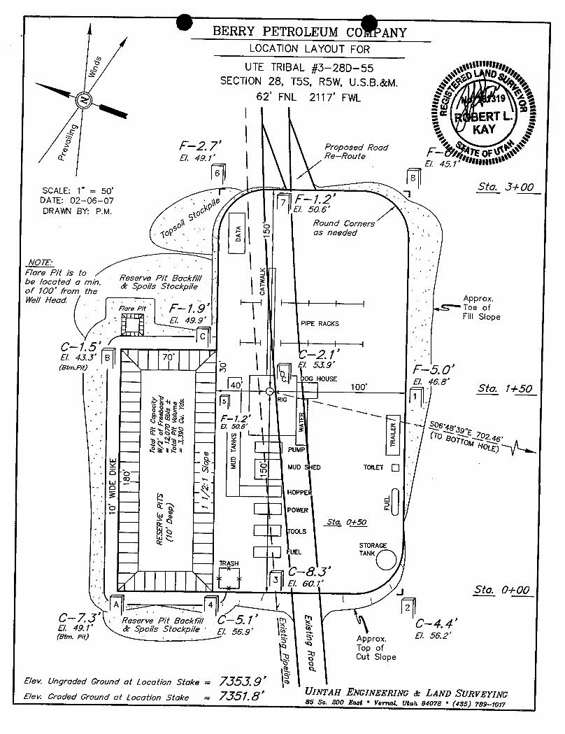
Berry is locating the well at the surface location and directionally drillingfrom this location to minimize surface disturbance and Berry will be able toutilize the existing road and pipelines in the area.
Furthermore, Berry hereby certifies that it is the sole working interest ownerwith 460 feet of the entire directional well bore and the remainder of the UteTribal section.
3 Pressure Control Equipment
PLEASE REFER TO BERRY PETROLEUM COMPANY STANDARD OPERATINGPROCEDURE (SOP VERSION: SEPTEMBER 21, 2006).
4 Proposed Casing and Cementing Program
PLEASE REFER TO BERRY PETROLEUM COMPANY STANDARD OPERATINGPROCEDURE (SOP VERSION: SEPTEMBER 21,

O OBerry Petroleum CompanyDrilling ProgramUte Tribal 3-28D-55Duchesne County, UtahPage Two
5 Drilling Fluids Program
PLEASE REFER TO BERRY PETROLEUM COMPANY STANDARD OPERATINGPROCEDURE (SOP VERSION: SEPTEMBER 21, 2006).
6 Evaluation Program
PLEASE REFER TO BERRY PETROLEUM COMPANY STANDARD OPERATINGPROCEDURE (SOP VERSION: SEPTEMBER 21, 2006).
7 Abnormal Conditions
PLEASE REFER TO BERRY PETROLEUM COMPANY STANDARD OPERATINGPROCEDURE (SOP VERSION: SEPTEMBER 21, 2006).
8 Anticipated Starting Dates and Notification of Operations
PLEASE REFER TO BERRY PETROLEUM COMPANY STANDARD OPERATINGPROCEDURE (SOP VERSION: SEPTEMBER 21, 2006).
9 Other information
PLEASE REFER TO BERRY PETROLEUM COMPANY STANDARD OPERATINGPROCEDURE (SOP VERSION: SEPTEMBER 21,

O O
BERRY PETROLEUM COMPANYUte Tribal 3-28D-55
Surface location NE 1/4, NW 1/4, 62' FNL 2117' FWL, Section 28, T. 5 S., R. 5 W., U.S.B.& M.BHL: NE ¼, NW ¼, 759' FNL 2214' FWL
Duchesne County, Utah
ONSHORE ORDER NO. 1
MULTI POINT SURFACE USE & OPERATIONS PLAN
1 Existing Roads
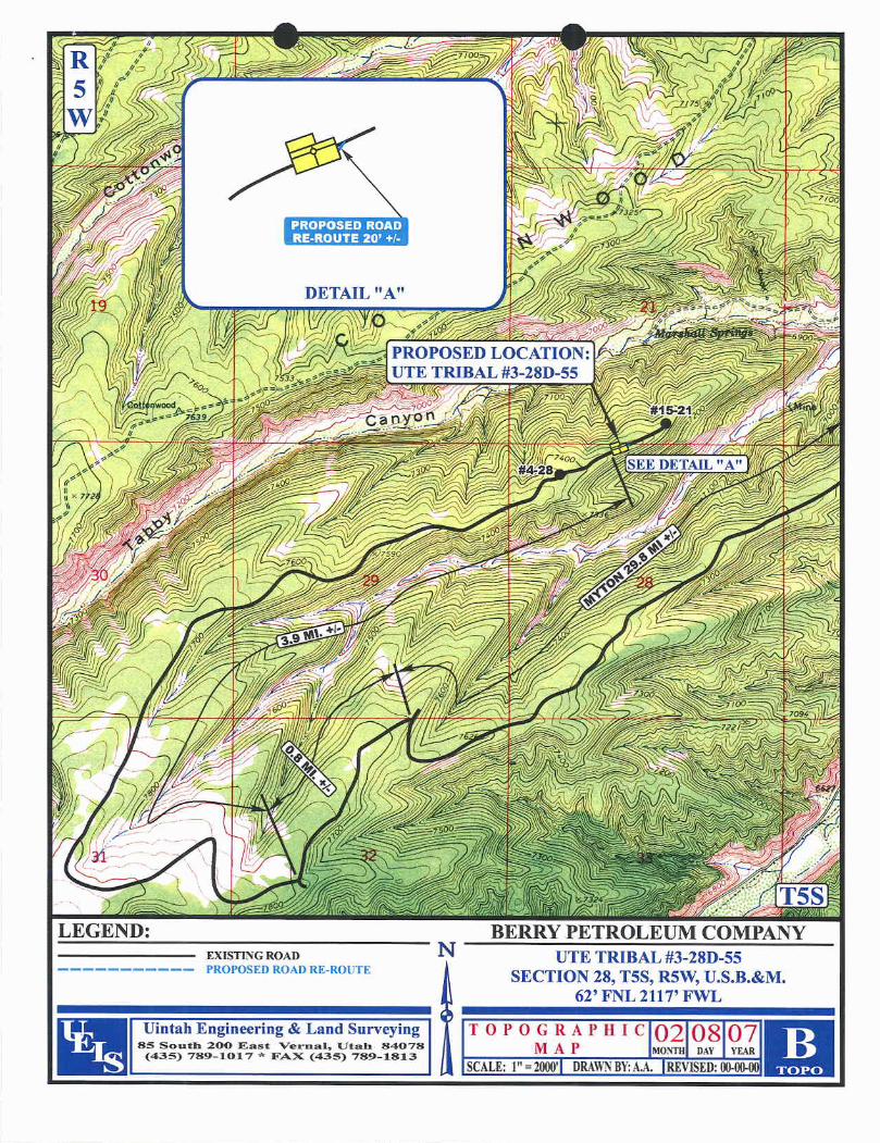
To reach the Berry Petroleum Company well, Ute Tribal 3-28D-55 location, in Section 28-T5S-R5W:
Start in Myton, Utah. Proceed west on US Highway40, 8.6 miles to the Antelope Creek/SowersCanyon Road at the Bridgeland turnoff. Turn southwest and proceed 16.5 miles. Continuesouthwest then north 4.7 miles. Turn southwest 0.8 miles, then north and northeast 3.9 miles tothe Ute Tribal 3-28D-55 location.
The existing oilfield service road may need some surface material to prevent or repair holes in theroad due to heavy truck traffic during the drilling and completion operation. If repairs are made theoperator will secure material from private sources.
Please see the attached map for additional details.
2 Planned Access Road
See Topographic Map "B" for the location of the proposed access road.
3 Location of Existing Wells
See Topographic Map "C" for the location of existing wells within a 1 mile radius.
4 Location of Tank Batteries, Production Facilities and Production Gathering and ServiceLines
PLEASE REFER TO BERRY PETROLEUM COMPANY STANDARD OPERATINGPROCEDURE (SOP VERSION: SEPTEMBER 21,

O O
Berry Petroleum CompanyMulti Point Surface Use & Operations PlanUte Tribal 3-28D-55Duchesne County, UtahPage Two
5 Location and Type of Water Supply
Water for the drilling and completion will be pumped or trucked from the Berry source wellslocated in Sec. 23, T5S, R5W or Sec. 24, T5S, R5W, permit # 43-11041, or from Duchesne CityCulinary Water Dock located in Sec. 1, T4S, RSW or from East Duchesne Water, Arcadia Feedlot,Sec. 28, T3S, R3W or Myton (Moon) Pit, SE/NE Sec. 27, T3S, R2W or from PetroglyphOperating Company 08-04 Waterplant, Sec. 8, T5S, R3W or from Kenneth V. & Barbara U.Richens source well located in Sec. 34, T3S, R2W, permit #43-1723 or Brundage Canyon Fieldproduced water or Leo Foy source well located in Sec. 34, T5S, R5W, permit #43-11324. Awater use agreement is also in place with the Ute Tribe.
6 Source of Construction Materials
PLEASE REFER TO BERRY PETROLEUM COMPANY STANDARD OPERATINGPROCEDURE (SOP VERSION: SEPTEMBER 21, 2006).
7 Methods of Handling Waste Materials
PLEASE REFER TO BERRY PETROLEUM COMPANY STANDARD OPERATINGPROCEDURE (SOP VERSION: SEPTEMBER 21, 2006).
8 Ancillary Facilities
PLEASE REFER TO BERRY PETROLEUM COMPANY STANDARD OPERATINGPROCEDURE (SOP VERSION: SEPTEMBER 21, 2006).
9 Wellsite Layout
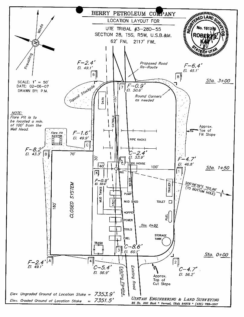
The attached Location Layout diagram describes drill pad cross-sections, cuts and fills, andlocations of the mud tanks, reserve pit, pipe racks, trailer parking, spoil dirt stockpile(s) andsurface material stockpile(s)
10 Plans for Restoration of the Surface
PLEASE REFER TO BERRY PETROLEUM COMPANY STANDARD OPERATINGPROCEDURE (SOP VERSION: SEPTEMBER 21, 2006). If an Archaeological Study ispreformed, all seed mixture will match Archaeological recommendation.
11 Surface Ownership
Ute Indian Tribe
12 Other information
PLEASE REFER TO BERRY PETROLEUM COMPANY STANDARD OPERATINGPROCEDURE (SOP VERSION: SEPTEMBER 21,
O OBerry Petroleum CompanyMulti Point Surface Use & Operations PlanUte Tribal 3-28D-55Duchesne County, UtahPage Three
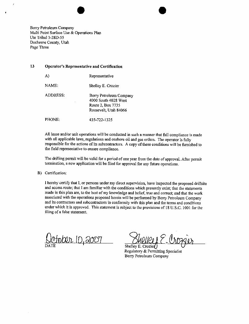
13 Operator's Representative and Certification
A) Representative
NAME: Shelley E. Crozier
ADDRESS: Berry Petroleum Company4000 South 4028 WestRoute 2, Box 7735Roosevelt, Utah 84066
PHONE: 435-722-1325
All lease and/or unit operations will be conducted in such a manner that full compliance is madewith all applicable laws, regulations and onshore oil and gas orders. The operator is fullyresponsible for the actions of its subcontractors. A copy of these conditions will be furnished tothe field representative to ensure compliance.
The drilling permit will be valid for a period of one year from the date of approval. After permittermination, a new application will be filed for approval for any future operations.
B) Certification:
I hereby certify that I, or persons under my direct supervision, have inspected the proposed drillsiteand access route; that I am familiar with the conditions which presently exist; that the statementsmade in this plan are, to the best of my knowledge and belief, true and correct; and that the workassociated with the operations proposed herein will be performed by Berry Petroleum Companyand its contractors and subcontractors in conformity with this plan and the terms and conditionsunder which it is approved. This statement is subject to the provisions of 18 U.S.C. 1001 for thefiling of a false statement.
DATE Shelley E. Crozie¶Regulatory & Permitting SpecialistBerry Petroleum

O
APPLICATION FOR GRANT OF CORRIDOR RIGHT-OF-WAY
BERRY PETROLEUM COMPANY. having a resident or principal place of business at Route 2 Box 7735,
Roosevelt, Utah, 84066, hereby files an application with the Bureau of Indian Affairs, pursuant to the terms and
provisions of the Act of February 5, 1948 (62 Stat. 17; 25 U.S.C. 323), and to the regulations of the Department of the
Interior contained in Title 25, Code of Federal Regulations, Part 169, for the grant of a Right-of-Way for the following
purposes and reasons:
To construct a Corridor Right-of-Way for the UTE TRIBAL #3-28D-55
Across the following described Indian Lands SE 1/4 SW 1/4 OF SECTION 21 & THE NE 1/4 NW 1/4 OF SECTION.
28, T5S, R5W, U.S.B.&M.
Drill Site = 1.993 Ac.
Corridor R-O-W = N/A Ac. Total Acreage = 1.993 Acres(Access Road & Pipeline)
4" to 6" SDR-11 POLY PIPELINESaid Right-of-Way to be approxirnately N/A feet in length, 30 feet in width, and N/A Acres, and
more particularly described and shown on the map of definite location to be attached and made a part hereof.
The applicant understands and hereby expressly agrees to the following stipulations:
(a) To construct and maintain the Right-of-Way in a workmanlike manner.
(b) To pay promptly all damages and compensation, in addition to the deposit madepursuant to 169.4 determined by the Secretary to be due the landowners andauthorized users and occupants of the land on account of the survey, granting,construction and maintenance of the Right-of-Way.
(c) To indemnify the landowners and authorized users and occupants against anyliability for loss of life, personal injury and property damage arising from theconstruction, maintenance, occupancy or use of the lands by the applicant, hisemployees, contractors and their employees or subcontractors and their employees.
(d) To restore the lands as nearly as may be possible to their original condition uponthe completion of the construction to the extent compatible with the purpose forwhich the Right-of-Way was granted.
(e) To clear and keep clear the lands within the Right-of-Way to the extent compatiblewith the purpose of the Right-of-Way; and to dispose of all vegetative and othermaterial cut, uprooted, or otherwise accumulated during the construction andmaintenance of the project.
(f) To take soil and resource conservation and protection measures, including weedcontrol, on the land covered by the

(g) To do everything reasonable within its power to prevent and suppress fires on ornear the lands to be occupied under the Right-of-Way.
(h) To build and repair such roads, fences, and trails as may be destroyed or injured byconstruction work and to build and maintain necessary and suitable crossings for allroads and trails that intersect the works constructed, maintained, or operated underthe Right-of-Way.
(I) That upon revocation or termination of the Right-of-Way, the applicant shall, sofar as is reasonably possible, restore the land to its original condition.
(j) To at all times keep the Secretary informed of its address, and in case ofcorporations of the address of its principal officers.
(k) That the applicant will not interfere with the use of the lands by or under theauthority of the landowners for any purpose not inconsistent with the primarypurpose for which the Right-of-Way is granted.
IN WITNESS THEREOF, BERRY PETROLEUM COMPANY. has caused this instrument to
be executed this day of , , 2007 .
BERRY PETROLEUM COMPANYWITNESS APPLICANT
W S Ed Courtright/Produc n ForemanRoute 2 Box 7735Roosevelt, Utah 84066Phone:(435)722-1325
SUPPORTING DOCUMENTS:
( ) Written consent of the landowners.( ) Evidence of good faith and financial responsibility.(x) 1)_asper the terms of the Exploration and Development Agreement (14-20-H62-4728)( ) State certified copy of corporate charter or articles of corporation.( ) Certified copy of resolution or bylaws of the corporation authorizing the filing of the stipulation( ) State certification that the applicant is authorized to do business in the State where the land is
located.( ) Certified copy of the articles of partnership or association.(x) Map of definite location.( )

BERRY RETROLEUMCOMPANYUTE TRIBAL/J-28D-55
ÐAMAGEAREA & CORR/Ð0RR/GHT-0F-WAY
SECTIONS 21 & 28, TSS, R5W U.S.B.&M.
TOTAL CORRIDORRIGHT-OF-WAY ON UTE TRIBAL LANDSCORRIDOR RIGHT-OF-WAY IS CONTAINED WITHINTHE DAMAGE AREA.
ENGINEER'S.AFFIDAVIT
STATE OF UTAH )SS
COUNTY OF UINTAH
ROBERT L. KAY, BEING FiRST DULY SWORN DEPOSES AND STATES THAT HE iS THE REGiSTERED LAND SURVEYOR,FOR BERRY PETROLEUM COMPANY, THAT THESE SURVEYS WERE MADE BY HIM (OR UNDER PERVISION): THATHE HAS EXAMINEDTHE FIELD NOTES OF THE SURVEYS OF THE DAMAGE AREA AND C OF-WAY ASDESCRIBED AND SHOWN ON THIS MAP, THAT THIS MAP WAS PREPARED UNDER HIS D FlELD
EPSEEA DTHAT SAID RIGHT-OF-WAY, BEGINNINGAND ENDING AS SHOWN ON IS A Y
ACKNOWLEDGEMENT
suBSCRIBED AND SWORN BEFORE ME THIS DAY OF 200 .
MY COMMISSIONEXPIRES >or o ary u icNþ ICTRACYD.NENLINEi
. 3379 East 5000Southse t..) e Vernal,Utah84078
I MyCommissionExpires y..• August 17, 2010 gL
'"" State of UtahAPPUCANT'S CERTIFICATE ---------
I, ED COURTRIGHT, DO HEREBY CERT1FYTHAT I AM THE AGENT FOR BERRY PETROLEUM COMPANY, HEREINAFTERDEStGNATEDTHE APPUCANT; THAT ROBERT L. KAY WHO SUBSCRIBEDTO THE FOREGOING AFFtDAVIT, tS EMPLOYED BYTHE APPUCANT AS A LAND SURVEYOR AND THAT HE WAS DIRECTEDBY THE APPLICANT TO SURVEY THE LOCATIONOF THIS DAMAGE AREA AND CORRIDOR RIGHT-OF-WAY,BEGINNINGAND ENDING AS SHOWN ON THIS MAP, THAT SAIDDAMAGE AREA AND CORRlOOR RlGHT-OF-WAY ARE ACCURATELYREPRESENTED ON THIS MAP; THAT SUCH SURVEYAS REPRESENTEDON THIS MAP NAS BEEN ADOPTED BY THE APPUCANT AS THE DEFINITELOCATlON OF THERIGHT-OF-WAY THEREBY SHOWN; AND THAT THE MAP HAS BEEN PREPARED TO BE FILED WITH THE SECRETARY OFTHE INTERIOR OR HIS DULY AUTHORIZED REPRESENTATIVE AS PART OF THE APPUCATION FOR SAID RIGHT-OF-WAYTO BE GRANTED THE APPLICANT, ITS SUCCESSORS AND ASSIGNS, WITH THE RIGHT TO CONSTRUCT, MAINTAIN,ANDREPAIR IMPROVEMENTS, THEREON AND THEREOVER, FOR SUCH PURPOSES, AND WITH THE FURTHER RIGHT IN THEAPPUCANT, ITS SUCCESSORS AND ASSIGNS TO TRANSFER THIS RIGHT-OF-WAY BY ASSIGNMENT, GRANT, OROTHERWISE.
APPUCANT
PRODUCTION SUPERVISOR

' I• si•«
g g Sec. 21 g BERRY OLEUM COMPANY
LOCATION ÐAMAGEAREA &SW 1/4--- vmacean une
SE 1/4 CORRIDOR RIGHT-OF-WAYON UTE TRIBAL LANDS
(For UTE TRIBAL #3--28D-55)LOCATED IN
SECTIONS 21 & 28, T5S, R5W, U.S.B.&M.,Ute DUCHESNE COUNTY, UTAH
Tribal
N
CORRIDORRIGHT-OF-WAY DESCRIPTIONCORRIDOR RIGHT-OF-WAY IS CONTAINEDWITHINTHE DAMAGE AREA. y -
o e , o
SCALEPoint of Beginning
NB955'27"W - DAMAGEAREA ÐESCRIPTIONSet M&ked Stoe NA9°50'0TE À9¾.JU' 1 PÍNL p
5223.82' (Meas.) BEGINNINGAT A POINT IN THE SE 1/4 SW 1/4 OF SECTION 21,klion Lkte uit T5S, RSW, U.S.B.&M., WHICH SEARS MS9°50'O3"E 1906.30° FROMExist. Pipe/ine \ "NE Gw. Soc. 24 THE SOUTHWEST CORNER OF SAID SECTION 21, THENCEset Mama stme N70'47'48"E 230.00'; THENŒ $78'56'50"E 138.93'; THENCE"
St9't2'18"E 80.94' TO A POINT ON THE SOUTH UNE OF THEL-"SE 1/4 SW 1/4 OF SAID SECTION 21, WHICH BEARS S89'55'27"EUNE TABLE2279.89' FROM THE SOUTHWEST CORNER OF SAID SECTION 21,LINE BEARING LENGTH THENCE S19°12'16°E
129.06'; THENCE S70'47'48"W 350.00';L1 N70°4748"E 230.00' ""THENCE N19'12'16"W 251,49' TO A POINT ON THE NORTH LINE
.$ L2 S78°56'50"E 138.93' OF THE NE 1/4 NW 1/4 OF SECTION 28, T5S, R5W, U.S.B.&M.,L3 S19'12°16"E 60.94' DAMAGEAREA WHICHBEARS SS9°55'27"E 1909.10' FROM THE NORTHWESTL4 S19'12'16"E 129.06' U1E TRIBAL/J-28D-55 CORNEROF SAID SECTION 28, THENCEN1912'18"W 8.51' TO THEL5 S70°4748"W 350.00' e POINT OF BEGINNING. BASIS OF BEARINGS IS A G.P.S.L6 N19'12'16"W 251.49' .$
Contains 1.99J Acres .8 OBSERVATION. CONTAINS 1.993 ACRES MOREOR LESS.L7 N1912'16"W 8.51°
Ute CERTIFIC Ulf;
TNbd I"'" 'S TO CERTIFY THAT THE FROMRELD NOTES OF ACTUALSUR BY ME OR YSUPERVISONAND THAT THES ME¶gg THENOTE:BEST OF MY KNOREDGE AND
P.O.S.L #1 BEARS SS9 55'27"E 2279.89'FROM THE SOUTHWEST CORNER OFSECTION 21, TSS, R5W, U.S.B.&M. BASIS OF BEARINGS LAND SU Y
BASIS OF BEARENGSIS A G.P.S. OBSERVATION. svA IOFP.O.S.L. #2 BEARS SS9°55'27"E 1909.10' Elengg;FROMTHE NORTHWEST CORNER OFSECTION 28, T5S, R5W, U.S.B.&M. UnrfAH ENGNEERWG a LAND Svava m
85 SOUTH - 200 EAST • (435) 78Ð-1017
VERNAI. UTAH - 840784 1/rs sectionLine
NE 1/4 SCALE DATE1" = 300' 02-06-07
PARTY REFERENŒSA = SECTION CORNERS LOCATED. S.H. T.P. P.M. G.L.O. PLAT
s,«- s- 24 Sec 28 MR RLEset stone * COLD 4 8 2 3

9 eWest - East (ft)0 - -
-100 0 100 200 300 400 500
250 _ _100
KOP, 2.50°/100' BuildKOP, 2.50°/100' liuild Hold 8,00° Inc
500 _ _840,00' MD, 840.00' TVD 00.00° Inc, 172.10° Azm / Green River0.00' N, 0.00' E
750 - -
« Hold 8.00° Inc -100 Green River Upper Marker1159.85' MD, 1158.81' TVD
1000 ¯ ¯ 8.00° Inc, 172.10° Azm22.0T S, 3.0ð' E -200
Mahogany
1250 -
Green River
..C -300
1500 - - Tgr3 Marker
1750 - -
-400
Green River Upper Marker Douglas Creek2000 -
-- -
O -500 Black ShaleCastle Peak
2250 - -
-600 Uteland Butte l a2500 _
Mahogany WasatchPBHL
-700
2750 - -
3000 ---800
.. 150' Target Radius
o- 3250 - -
3500 Tgr3 Marker
3750 - -
L..I-4000 - -
ny4250 - - Douglas Creek
Company4500 -
Company: Berry PetroleumWell: Ute Tribal 3-28D-554750 -
Location: Duchesne CountyBlack Shale State: Utah5000 -
Rig: Frontier 5Correction:
5250 -
Castle Peak North: Referenced to True NorthSubject Prop Rev 0
5500 File Name: PO7048r0.dwgteland &&e i s Date: 01/30/2007asatch Drawn By: AIIen Slack
5750 - -
Planning: (93ð) 442-2455606H1L10'MD, 6012.41' TVD Fax: (936) 441-6ð20
6000 - - 8.00° inc, 172.10° Azm Operations: (936) 441-6630Fax: (936) 539-1075
697.40' S, 96.80' E6250
0 250 500 750 1000 1250 1500Vertical Section (ft) 172.10° Azm VVWW.MULT)-SHOTLLC.COM
The customer should only rely on this document after independently verifying all paths, targets, oordinates, lease and hard linesrepresented. Any decisions made or wells drilled utilizingthis or any other information supplied by MJIti-Shot,.LLC are at the sole risk and
responsibility of the customer. Multi-Shot, LLCis not responsible for the accuracy of this schematic or the iriformation contained

Job Number: PO7-048 StatelCountry: Utah
Company: Berry Petroleum Declination:
LeaselWell: Ute Tribal 3-28D-55 Grid: Referenced to True NorthBREMMMMEREMBRMEMMMMBRMMM
HU\Sm Location: Duchesne County File name: F:\WELLPL-1\2007\PO7040'S\PO7048\07048.SVY
Rig Name: Frontier 5 DatelTime: 30-Jan-07 I 16:23MRRWW MmmwWW-ammWM-a Emm
RKB: 14' Curve Name: Prop Rev 0G.L. or M.S.L.: 7354'
WINSERVE SURVEY CALCULATIONSMinimum Curvature Method
Vertical Section Plane 172.10Vertical Section Referenced to Wellhead
Rectangular Coordinates Referenced to Wellhead
Measured IncI Drift True Vertical CLOSURE DoglegDepth Angle Direction Vertical N-S E-W Section Distance Direction Severity
FT Deg Deg Depth FT FT FT FT Deg Deg/100
KOP, 2.50°l100' Build
840.00 .00 172.10 840.00 .00 .00 .00 .00 .00 .00
940.00 2.50 172.10 939.97 -2.16
.30 2.18 2.18 172.10 2.501040.00 5.00 172.10 1039.75 -8.64 1.20 8.72 8.72 172.10 2.501140.00 7.50 172.10 1139.14 -19.42 2.70 19.61 19.61 172.10 2.50
Hold 8.00° Inc
1159.85 8.00 172.10 1158.81 -22.07 3.06 22.28 22.28 172.10 2.50
Green River
1446.92 8.00 172.10 1443.09 -61.63 8.55 62.22 62.22 172.10 .00
Green River Upper Marker2023.99 8.00 172.10 2014.55 -141.14 19.59 142.49 142.49 172.10 .00
Mahogany
2623.62 8.00 172.10 2608.35 -223.76 31.06 225.91 225.91 172.10 .00
Tgr3 Marker
3658.76 8.00 172.10 3633.43 -366.39 50.85 369.90 369.90 172.10 .00
Douglas Creek
4423.19 8.00 172.10 4390.42 -471.72 65.47 476.24 476.24 172.10 .00
Black Shale
5051.92 8.00 172.10 5013.04 -558.35 77.50 563.70 563.70 172.10 .00
Castle Peak5339.68 8.00 172.10 5298.00 -598.00 83.00 603.73 603.73 172.10 .00Page
Measured Incl Drift True Vertical CLOSURE DoglegDepth Angle Direction Vertical N-S E-W Section Distance Direction Severity
FT Deg Deg Depth FT FT FT FT Deg Deg/100
Uteland Butte Ls.
5748.73 8.00 172.10 5703.08 -654.36 90.82 660.64 660.64 172.10 .00
Wasatch
5960.81 8.00 172.10 5913.09 -683.58 94.88 690.14 690.14 172.10 .00
PBHL
6061.10 8.00 172.10 6012.41 -697.40 96.80 704.09 704.09 172.10 .00
Page 2Prop Rev 0 File:
e
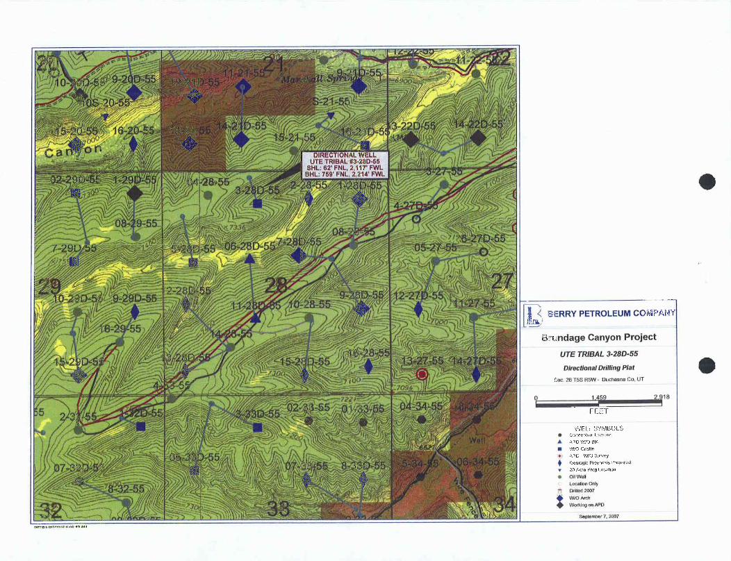
BERRY PETROLEUM COMPAf
Brundage Canyon Project
UTE TRIBAL 3-28D-55
Directionai DriffingPlat
Sec 28 TSS RSW Ot mannaCo, UT
e co e aOLS
A APowtosA
il WlO Onsito
APD -WlO SurveyGeologic Prognosis Prepared20 Acre Prog Location
e od WellLocathn OnlyDniled2007Wto Arch
.
Worki ogr MW
op:Tomarte womo

TSS, R5W, U.S.B.&M. BERRY PETROLEUMCOMPANYWell location, UTE TRIBAL#3-28D-55, locatedN89°55'27"W
~
os shown in the NE 1/4 NW 1/4 of Section 28,. set workedstone 5223.82' (Meas.)T5S, RSW, U.S.B.&M., Duchesne County, Utah.Set Marked Stone
UE TR/BÆ/J-28Ü-SS BASIS OF ELEVATIONc El . Ungraded Ground = 7354' BENCH MARK(M67) LOCATEDIN THE SW 1/4 OF SECTION
9, TSS, R4W, U.S.B.&M., TAKENFROMTHEDUCHESNESE2214, . QUADRANGLE,UTAH, DUCHESNECOUNTY,7.5 MINUTEQUAD.Bot m (TOPOGRAPHICMAP) PUBUSHEDBY THE UNITEDSTATESH DEPARTMENT OF THE INTERIOR,GEOLOGICALSURVEY, SAIDELEVATIONIS MARKEDON CAP AS BEING 6097 FEET.
BASIS OF BEARINGSBASIS OF BEARINGSIS A G.P.S. OBSERVATION.UNE TABLE
UNE BEARING LENGTHL1 | SO6'48'39"E | 702.46'
28 N
o o o
SCALECERTIFICATE
THISIS TO CERTIFY THATTHEAB $ÀAf D FROMFIELDNOTESOF ACTUAL SURVE MY
::sta: ¿NNODATE AEND Ei 30 0 THE
CIS EDMSUR ORset stoneSet Stone IS 710N NO. 16 9
SB9 57'JO"W - 5295.32' (Meas.)
UINTAH ENGINEERING & LAND URVEYING85 SOUTH 200 EAST - VERNAL, UTAH 84078(NAD 83)
LEGEND: LATlTUDE= 40°01'28.89"(40.024692) (435) 789-1017
LONGITUDE= 110°27'14.95" (110.454153) SCALE DATESURVEYED: DATEDRAWN:=90° SYMBOL NO 27 1 = 1000 01-17-07 02-06-07( A ) PARTY REFERENCES= PROPOSEDWELLHEAD· LATlTUDE= 40°01'29.03"
(40.024731) S.H. T.P. P.M. C.LO. PLATA = SECTIONCORNERS LOCATED. LONGITUDE= 110'27'12.40" (110.453444) WEATHER FILECOLD BERRYPETROLEUM
O O
Berry Petroleum Company,Ute Tribal #3-28D-55 well:
A Cultural Resource Inventory for a well pad,its access and pipeline,
Uintah-Ouray Ute Reservation,Duchesne County , Utah
By
James A. Truesdale
James A. TruesdalePrinciple Investigator
Prepared ForBerry Petroleum Co.
3846 South Highway 40Route 2 , Box 7735
Roosevelt, Utah84066
Prepared ByAN INDEPENDENT ARCHAEOLOGIST
P.O.Box 153Laramie , Wyoming
82073
Utah Project # U-07-AY-946 (i)
August 23,

O OTable of Contents
Table of Contents - - - - - - - - - - - - - - - - - - - i
List of Figures - - - - - - - - - - - - - - - - - - - - ii
Introduction - - - - - - - - - - - - - - - - - - - - 1
File Search - - - - - - - - - - - - - - - - - - - - 1
Environment - - - - - - - - - - - - - - - - - - - - 3
Ute Tribal #3-28D-55 - - - - - - - - - - - - - - - - - 4
Field Methods - - - - - - - - - - - - - - - - - - - - 5
Results - - - - - - - - - - - - - - - - - - - - - - - - 6
Recommendations - - - - - - - - - - - - - - - - - - - - 6
References Cited - - - - - - - - - - - - - - - - - - - 7

O OList of Figures
Figure1.Location of the Berry Petroleum Co.'s proposedUteTribal #3-28D-55 well, its access and pipeline on7 . 5 ' /1964 USGS quadrangle map Duchesne SW, DuchesneCounty, Utah. --------------------2
Figure 2 . View to north at the proposed Ute Tribal #3-28D-55centerstake and well pad area.- - - - - - - - - - - - 4

O OIntroduction
An Independent Archaeologist (AIA) was contacted by arepresentative of Berry Petroleum Co., to conduct a culturalresources investigation of the proposed Ute Tribal #7-28D-55 well,its access and pipeline. The location of the project area is inthe NE/NE 1/4 of Section 28, T58, REW, Duchesne County, Utah(Figure 1).
The proposed Ute Tribal #3-28D-55 well's centerstake(Alternate #1) footage is 62' FNL, 2117 FWL. The Universal
Transverse Mercator (UTM) centroid coordinate for the proposed UteTribal #3-28D-55 well centerstake is Zone 12, North American Datum(IBU) 83, 5/46/579.29 mE 44/30/647.19 mN +5m.
The Ute Tribal #3-28D-55 well's proposed access and pipelineis an existing oil and gas field service road and pipelinelocated adjacent Lonediately west of the well centerstake.
The land surface is administered by the United States, Bureauof Indian Affairs, Phoenix Area Office, Uintah-Ouray Agency, andthe Uintah-Ouray Ute tribe, Fort Duchesne, Utah. A total of 10.0acres (10 block, O linear) was surveyed. Fieldwork was authorizedthrough an access permit issued by the Energy and MineralsResource Division of the Uintah-Ouray Ute tribe. The fieldworkwas conducted on August 9, 2006 by AIA archaeologists JamesTruesdale and CJ Truesdale, and accompanied by Leroy Cesspooch(technician, Energy and Minerals Resource Division, Uintah-Ouray
Ute tribe . All the field notes and maps are located in the AIAoffice in Laramie, Wyoming.
File Search
A GIS file search was conducted at the Utah Division of StateHistory (UDSH), Antiquities Section, Records Division on August 7,2007. In addition, AIA's USGS quadrangle Duchesne SW base map wasupdated from UDSH Records division Duchesne SN base map inNovember of 2003 and again on February 2, 2004. The UDSH SHPO GISfile search reported four previous projects (U-02-AY-139, U-02-AY-614, U-04-AY-399, U-05-AY-1136) had been conducted in the generalarea (Section 28, T5S RSW).
AIA records and maps indicate that five additional projects(U-04-AY-621, U-07-AY-945, U-07-AY-947, U-07-AY-948, U-07-AY-949)
were conducted by AIA in Section 28 of T5S R5W. No culturalmaterials were recorded during these past projects. No additionalprojects and/or cultural materials (sites, isolates) have beenpreviously recorded in the immediate project area.

Figure 1. Location of the proposed Berry Petroleum Co.'s Ute Tribal #3-28D-55 well on 1964 7.5'USGS QuadrangleMap Duchesne SW, Duchesne County,

Environment
Physiographically, the project is located in the Uinta Basin,approximately 25 miles southwest of Myton, Utah. The Uinta Basinis structurally the lowest part of the Colorado Plateaugeographical province (Thornbury 1965:425). The Uinta Basin is alarge, relatively flat, bowl shaped, east-west asymmetricalsyncline near the base of the Uinta Mountains (Stokes 1986:231).The topography is characteristic of sloping surfaces that inclinenorthward and are mainly dip slopes on the harder layers of GreenRiver and Uinta Formations. The terrain is characterized ashaving steep ridges and/or buttes of Uintah Formation sandstonesand clays dissected by seasonal drainages and washes with wideflat alluvial plains. The basin contains a thick section of morethan 9000 feet (2743.9 m) of early Tertiary rocks (Childs 1950).These rocks are mainly Paleocene and Eocene in age and consist ofsandstone, clay and shale lacustrine, fluviatile, and deltaiccontinental deposits, most famous of which are the lacustrineGreen River Beds.
The project area is located along a large broad southwest tonortheast trending ridge whose slopes are located west of SowersCanyon. The large broad ridge is part of a much larger ridgesystem that is located between the Sowers Canyon to the southeastand Tabby Canyon to the northwest. Portions of the desert hardpanand bedrock in the project area are covered with aeolian sand thatmay reach a depth of over 50 to 100 centimeters in areas .
Brundage Canyon drainage trends northeast approximately 4 1/2miles to Sowers Canyon, which trends northeast 3 miles to AntelopeCreek and then 10 miles north to the Duchesne River.
Vegetation in the project area is characteristic of aPinon/Juniper community. Species observed in the project areainclude; Pinyon pine (Pinus Edulis), juniper (JuniperusOsteosperma), curl-leaf mountain mahogany (Cercocarpusledifolius), shadscale (Atriplex confertifolia), sand sage,(Artemesia filifolia), saltbush (Atriplex nuttallii), rabbitbrush(Chrysothamnus viscidiflorus), winterfat (Eurotia lanata),
greasewood (Sarcobatus baileyi), Indian ricegrass (Oryzopsishymenoides), desert needlegrass (Stipa speciosa), wild buckwheatEriogonum ovalifolium), silky lupine (Lupinus sericeus), desertglobemallow (Bromus tectorum), sky rocket (Gilia aggregata),Tansy leaved evening primrose (Oenothena tanacetifolia),Rydberg's Penstemon (Penstemon rydbergi), Stemless Hymenoxys(Hynenoxys acaulis), Sego Lily (Calochortus nuttallii),
peppergrass (Lepidium perfoliatum), Russian thistle (Salsolakali), Simpson's Hedgehog cactus (Pediocactus simpsonii) andprickly pear cactus (Opuntia spp.).

O O
Ute Tribal #3-28D-55
The proposed Ute Tribal #3-280-55 well is situated on the topof a large narrow southwest to northeast trending ridge adjacentimmediately west of a existing oil and gas field service road.This ridge is part of a much larger ridge system that is locatedbetween Sowers and Tabby Canyons. Sedernants are colluvial innature . These colluvial deposits consists of shallow (<5 cm) ,poorly sorted, loosely compacted, tan to light brown sandy clayloam mixed with small to medium sized flat angular pieces ofsandstone. The vegetation on the well location is darn9 mmted by aPinion/juniper forest with an understory of mountain mahogany, bigsagebrush, budsage, buckwheat, yucca, prickly pear cactus andbunchgrasses (wheatgrass, Indian rice grass) . A low sagebrushcommunity consisting of sagebrush, saltbush, rabbitbrush,bunchgrasses and prickly pear cactus can be found in the openareas along the broad open flats on top of the ridge. Theelevation is 7358 feet (2243.2 m) AMSL.
Figure 2 . View to north at the proposed Ute Tribal #3-28D-55 centersta'and well pad area .
The Ute Tribal #3-28D-55 well' s access and pipeline is anexisting oil and gas field service road and pipeline that trendssouthwest to northeast through the proposed well pad. Sediments

(il lik
along the access and pipeline have been previously disturbed byroad and pipeline construction and road cyclic maintenance.However, undisturbed sediments along the access and pipelineconsist of shallow (<5 to 10 cm), poorly sorted, looselycompacted, tan to light brown, sandy clay loam, mixed with smallto medium sized flat angular pieces of Uinta formation sandstone,clay and shale. Exposures of sandstone, clay and shale bedrockcan be found eroding from the ridge's talus slopes. Vegetationalong the access and pipeline is dominated by Pinion and junipertrees with an understory of mountain mahogany, low sage, yucca andprickly pear cactus.
The surrounding landscape exhibits exposures relatively thickledges of sandstone with thinner layers of clay and shale. Thesurrounding vegetation is dominated by a Pinion/3uniper communitywith a understory of mountain mahogany, low sagebrush, yucca,bunchgrasses along the hill and ridge slopes, and low sagebrushcommunity in the ridge top flats and open parks.
Field Methods
A total of 10 acres was surveyed around the centerstake ofthe proposed Ute Tribal #3-28D-55 well location to allow forrelocation of the pad if necessary. The survey was accomplishedby walking transects spaced no more than 15 meters apart. Theproposed access and pipeline is an existing oil and gas fieldservice road and pipeline that is adjacent immediately east of theproposed well centerstake. Therefore, existing road and pipelineare located within the 10 acre area surveyed around the proposedwell centerstake. Thus, O linear acres was surveyed.
Geologic landforms (rock shelters, alcoves, ridge tops andsaddles) and areas of subsurface exposure (ant hills, blowouts,rodent holes and burrow, eroding slopes and cut banks) wereexamined with special care in order to locate cultural resources(sites, isolates) and possibly help assess a site's sedimentaryintegrity and potential for the presence and/or absence of buriedintact cultural deposits. The entire surface area of ridge topswas covered. All exposures of sandstone cliff faces, alcoves orrockshelter, and talus slopes were surveyed.
When cultural materials are discovered, a more thoroughsurvey of the immediate vicinity is conducted in order to locateany associated artifacts and to determine the horizontal extent(surface area) of the site. If no other artifacts are locatedduring the search then the initial artifact was recorded as anisolated find. At times, isolated formal tools (typical endscrapers, projectile points) were drawn and measured. The isolatewas then described and its location plotted on a U.S.G.S.topographic map and UTM coordinates are recorded.

O O
When sites are found an Intermountain Antiquities ComputerSystem (IMACS) forn was used to record the site. At all sites,selected topographic features, site boundaries, stone tools andcultural features (hearths, foundations, trash dumps and trails)are mapped. Sites were mapped with a Brunton compass and pacingoff distances from a mapping station (datum) . All debitage isinventoried using standard recording techniques (Truesdale et al1995:7) according to material type, basic flake type, and so on.Selected (mostly complete) stone tools and projectile points aredrawn and measured. All features (rock art panel (s) , hearths,foundations, trash dumps and trails) are measured and described,while selected features are either drawn or photographed.
Site location data is recorded by a GARMIN Global PositioningSystem (GPS III Plus) and/or an E-Trex GPS. Site elevation andUniversal Transverse Mercator (UTM) grid data, its EstimatedPosition Error (EPE) and Dilution of Precision (DOP) wererecorded. Using the GPS data, the site location was then placedon a USGS 7.5' quadrangle map.
Results
A total of 10.0 acres (10 block, O linear) were surveyed forcultural resources within and around the proposed Berry PetroleumCo. Ute Tribal #3-28D-55, and along its access and pipeline. Nocultural resources (sites, isolates) were recorded during thesurvey.
Modern trash (plastic soda pop, oil and antifreeze bottles,clear, green, and brown bottle glass, foam insulation and sanitaryfood cans) can be found throughout the Brundage Canyon, NuttersCanyon, Sowers Canyon and Antelope Canyon oil and gas fields,especially along the service roads.
Recommendations
A total of 10 acres (10 block, 0 linear) were surveyed forcultural resources within and around the proposed Berry PetroleumCo. Ute Tribal #3-28D-55 and along its access and pipeline. Nocultural resources (sites, isolates) were recorded during thesurvey.
Sediments on the proposed well pad and along its access andpipeline are shallow (<5 cm). Therefore, the possibility ofburied and intact cultural materials located on the proposed wellpad or along its, access and pipeline is low. Thus, no additionalarchaeological work is necessary and clearance is recommended forthe construction of the proposed Ute Tribal #3-28D-55 well pad,its access and pipeline.

(ik lik
REFERENCES CITED
Childs, 0.E.1950 Geologic history of the Uinta Basin, Utah Geological
and Mineralogical Survey. Guidebook to the Geology ofUtah, No. 5:49-59.
Stokes, William Lee1986 Geology of Utah. Contributions by Utah Museum of
Natural History, and the Utah Geological and MineralSurvey Department of Natural Resources. Utah Museum ofNatural History, Occasional Papers, Number 6.
Thornbury, William D.1965 Regional Geomorphology of the United States. John
Wiley & Sons, Inc.
Truesdale, James A., Kathleen E. Hiatt, and Clifford Duncan1995 Cultural Resource Inventory of the Proposed Ouray
Gravel Pit Location, Uintah-Ouray Ute Reservation,Uintah County, Utah. Report prepared for U & WConstruction, Ft. Duchesne, Utah by AIA, Laramie,Wyoming.

O OBERRY PETROLEUM COMPANY
UTE TRIBAL #3-28D-55LOCATED IN DUCHESNE COUNTY, UTAH
SECTION 28, T5S, R5W, U.S.B.&M.
PHOTO: VIEW OF LOCATION STAKE CAMERA ANGLE: SOUTHEASTERLY
I
PHOTO: VIEW FROM BEGINNING OF PROPOSED ACCESS CAMERA ANGLE: NORTHEASTERLY
Uintah Engineering & Land Surveying |TOPOGR A PH I C 02 0 8 0 7 PHOTO85 South200 East Vemal, Utah 84078 M A P MONTH DAY YEAR
se ú4. 435-789-1017 [email protected] TAKENBY:S.H. DRAWNBY:A.A.
BERRY PETROLEUM CO ANYLOCATIONLAYOUT FOR
UTE TRIBAL#3-28D-55SECTION 28, T5S, R5W, U.S.B.&M.
62' FNL 2117' FWL 19
Proposed Road
Sta. J+00SCALE: 1" = 50'. ]
DATE: 02-06-07 7 •
DRAWN BY: P.M. E/. 50.6Round Corners
* 10 as needed '
NO7EFlore Pit is to
. Re ervÃPit Backfi//be located a mm Spoils Stockpileof 100' from theApprox.We// Head I I I lF S peE/. 49.9' PIPE RACKS
C
E 4 JL 5 9 E-5.0'OG HOUSE (f. gg g'I4 '
100' - Sta. 1+50--- RG
PUMP
MUD ENED TOILET
HOPP
POWER
OOLS
STORAGEUEL TANK
--- TR SH- 8. J'
E/. 60.1' Sta. 0+00
C- Z J' Reserve Pit Backfi//.
C-5.1' T. C-4.4'B. 49.1' & Spoi/s Stockpile E/. 56.9' B. 56.2'(stm. Pit) , , , Approx.
Top ofCut Slope
Bev. Ungraded Ground at Location Stoke = 7JSJ.9' i» IIINTAH ENGINEERING & LAND SURVEYINGE/ev. Graded Ground at Location Stoke = 7JS1.8 , ,,

BERRY PETROLEUM COM ANYTYPICALCROSS SECTIONS FOR
Hil;×-section UTE TRIBAL#3-28D-55 LA
scale SECTION 28, T5S, R5W, U.S.B.&M.62' FNL 2117' FWL -
N . g1" = 50'
40' 100' VDATE: 02-06-07DRAWN BY: P.M
Finished GradeOF
Preconstruction F/LLGrade
¯¯
¯¯'---
/LL
SM. J+00
10 70' 40' 100'
LOCAT/ON STAKE
E/LL.
----- CUT.. Slope = 1 1/2:1
'll cur SM. 1+50
10 70' 40' 100'
.....---
~~'
CUT \
120' 100'
SM. 0+00NOTE:Topsoil should not be * NOTE:Stripped Below Finished E/LL QUANT/TY/NCLUDESGrade on Substructure Area. 5X FOR COMPACT/ON
APPROXIMATEYARDAGES EXCESS MATERIAL = 4,410 Cu. Yds.Topsoil & Pit Backfill = 4, 410 Cu. Yds.CUT (1/2 Pit voi.)(12") Topsoil Stripping = 2,710 Cu. Yds.EXCESS UNBALANCE = 0 Cu.Yds.Remaining Location = 5,550 Cu. Yds(After Interim Rehabilitation)
TOTAL CUT = 8,260 CU.YDS.IIINTAH ENCINEERING & LAND SURVEYINGFILL = J,850 CU.YDS· ss so. zoo sose • vernaz.Utax evove • (4ss)
BERRY PETROLEUM CO ANY """
LOCATION LAYOUTFOR
UTE TRIBAL #3-28D--55 No.1613SECTION628FNL5S,21
7 FS.B.&M. E ROB E
-2.4' PT Posed Road F-6.4'8. 49.1 Re--Route
S. 45.1'
Sta. J+00SCALE: 1" = 50' ', 1DATE: 02-06-07 e - E-0.9
DRAWN BY: P.M. o S. 50.6Round Cornersas needed
NOTEFlare Pit is tobe /ocated a rnin.
--
of 100' frorn the Approx.Wel/ Head I l I I Toe of
- Flore pit - Fill Slope49.9' PIPE RACKS
F-8.2_2.4'B. 4J. J' 70
/. 5J.9 E-4.7r-, DOG HOUSE B. 46.8'I '
100' Sta. 1+50RIG
6
(r) oO MUD HED TOILET OL
00
HOPPER
POWER
Sta. 0+50OOLS
STORAGEFUEL TANK
TR SH C-8.6'B. 60.1'
Sta. 0+00F-2. 4'E/. 49.1' C-5.4' p 2 C-4.7'
B. 56. 9' B. 56.2'Approx.Top ofCut Slope
Bev. Ungraded Ground at Location Stoke = 7353.9' PUINTAH ENGINEERING & LAND SURVEYINGElev. Graded Ground of Location Stoke =

BERRY PETROLEUM COM NYTYPICAL CROSS SECTIONSFOR ur!
×-section UTE TRIBAL #3-28D-55 t.ANDscale SECTION 28, T5S, R5W, U.S.B.&M.
62' FNL 2117' FWL .
'1" = so' E RTL. m
DATE: 02-06-07 40' 100'
DRAWN BY: P.M.-Finished Grade
Preconstruction /L
SM. J+00
110' 100'
LOCAT/ON STAKE
...---- CUT S/ pe - 1 1/2. 1
STAI. 1+50
110 100'
....
'CUTN
110' 100
srA. ovooNOTE:Topsoil should not be * NOTE:Stripped Below Finished E/LL QUANT/TY/NCLUDESGrade on Substructure Areo. 5X FOR COk/PACTION
APPROXIMATE YARDAGES EXCESS MATERJAL = 2,460 Cu. Yds.Topsoil = 2,460 Cu. Yds.CUT
(12") Topsoil Stripping = 2,460 Cu. Yds.EXCESS UNBALANCE = 0 Cu. Yds.Remaining Location = J,600 Cu. Yds. (After Interim Rehabilitation)
TOTAL CUT = 6,060 CU.YDS.UINTAH ENGINEERING & I,AND SURVEYINGFILL = J,600 CU.YDS· es so. zoo rest • vemet. utais esove •<<ss)

E AIL '
LEGEND: BERRY PETROLEUM COMPANYEXISTING ROAD N UTE TRIBAL #3-28D-55
----------- PROPOSED ROAD RE-ROUTF SECTION 28, T5S, RSW, U.S.B.&M.62' FNL 2117' FWL
M Uintah Engineeringd¯¯ud
Surveying TOPOGR A PH i c 02 08 0785 South 200 E.mst Vernam, IJtah 84078 M A P MONTH DAY YEAR(435) 789-1017 * FAX (435) 789-1813
SCALE:1"= 2000' DRAWNBY:AA REVISED:

LEGEND: BERRY PETROLEUM COMPANYg DISPOSAL WELLS WATER WELLs N UTE TRIBAL #3-28D-55e PRODUCING WELLS ABANDONED WELLs SECTION 28, T5S, R5W, U.S.B.&M.
SHUT IN WELLS TEMPORARILY ABANDONED 62' FNL 2117'

ING PIPELINE )
00
APPROXIMATE TOTAL PIPELINE DISTANCE = 23' +/-
LEGEND: BERRY PETROLEUM COMPANYPROPOSED ROAD RE-ROUTE N UTE TRIBAL #3-28D-55
---------- EXISTING PIPELINE SECTION 28, T5S, R5W, U.S.B.&M.----------- PROPOSED PIPELINE
-62' FNL 2117' FWL
Uintah Engineering & Land Surveying TOPOGR A PH I c 02 08 07 |85 South 200 East Vernal, Utah 84078 M A P MONTN DAY YEAR ¡(435) 789-1017 * FAX (435) 789-1813SCALE:1"=1000' DRAWNBY:A.A.

WORKSHEETAPPLICATION FOR PERMIT TO DRILL
APD RECEIVED: 10/15/2007 API NO. ASSIGNED: 43-013-33790
WELL NAME: UTE TRIBAL 3-28D-55
OPERATOR: BERRY PETROLEUM COMPANY ( N2480 ) PHONE NUMBER: 435-722-1325
CONTACT: SHELLEY CROZIER
PROPOSED LOCATION: INSPECT LOCATN BY: / /NENW 28 050S 050W . -Tech Review Initials DateSURFACE: 0062 FNL 2117 FWL
BOTTOM: 0759 FNL 2214 FWL Engineering
COUNTY: DUCHESNE GeologyLATITUDE: 40.02473 LONGITUDE: -110.4538
UTM SURF EASTINGS:546611 NORTHINGS: 4430435 Surface
FIELD NAME: BRUNDAGE CANYON ( 72 )
LEASE TYPE: 2 - Indian
LEASE NUMBER: 14-20-H62-5019 PROPOSED FORMATION: GRRV
SURFACE OWNER: 2 - Indian COALBED METHANE WELL? NO
RECEIVED AND/OR REVIEWED: LOCATION AND SITING:
Plat R649-2-3.
Bond: Fed[] Ind[2] Sta[] Fee[].Unit:
(No. RLBOOO5651 )Potash (Y/N) R649-3-2. General
Oil Shale 190-5 (B) or 190-3 or 190-13 Siting:460 From Qtr/Qtr & 920' Between Wells
Water Permit ¾#"'R649-3-3. Exception(No.43-11041 )
Drilling UnitRDCC Review (Y/N)
Board Cause No:(Date: )Eff Date:
Fee Surf Agreement (Y/N) Siting:
Intent to Commingle (Y/N) .R649-3-11. Directional Drill
COMMENTS: yp ,

UTE TRIBAL12-22-55 E-22-55
BK (ITE TRIBAL 5-22D-55 •
BHL 9-20D 55 EEo ss g n-2 ss
UTE HIBAL 16 2tD-55UTE TRIBALS-21-55
BEIL BHL
UTE RIBAL f62tD 55 UFE TREAL B-22D-55TSS M uss maal. m22n-ss
LirE TRIBAL800 BHL UFE TRIBAL
I 3 18D $5 UTETRIBAL1 11 55 D 3-2FS5 *
HTE1RIBAL Liff I 28 D| s-2soss
i
à UFE
RIB 29D-UTE TR L AL
28D 55 UTE TRIBAL5-27-55
BHL UTE TR[BAL 7-2BD-55 eBHL UTE TRBAL 9-28D-557-29D-55
29 211
BHLBER, 12 D 55 UTE TRIBAL H-27D-55
D•SSUTE TREAL 15-28D-55 ,fR 2UTI TRlB L 10-28-55
BHL
UTE TRIBAL I
UIE TRIBAL 10-29D-5g 16-29-55
urE RIBAL 15-29D55 ETRIBAL 12 ISD 55trreinteue-2soss
LTIF TRIBAL H-28 55
a n.O fi BF[L Ë BHLLTISO SE 14-27D-55
e BHL 3 D 55
UTE TRIBAL WIE UTE TRIBAL3 SSD·S5
BHL I-32D-55 TRIBAI. UIE TRIBAL 5-35D·55i 55 + 33 55
HIETRIBAL2 32 55
BRUNDAGE CANYON FIFIDBHL5 33D-55
UTE TRIBAL8-32 55
OPERATOR: BERRY PETRO CO (N2480)UTAH
SEC:28 T.5S R.5W DNRFIELD: BRUNDAGE CANYON (72)
COUNTY: DUCHESNEWells Status
SPACING: R649-3-11/ DIRECTIONAL DRILLING y GAS INJECTIONg GAS STORAGE OIL, GAS & MININGx LOCATION ABANDONED
NEW LOCATION NField Status Unit Status PLUGGED &cABANDONEDABANDONED EXPLORATORY PRODUCING GASGAS STORAGE PRODUCING OILACTIVE NF PP OIL
-g SHUT-IN GASCOMBINED NF SECONDARY+ SHUT-IN OIL W E
INACTIVE PENDING)s( TEMP. ABANDONED
PROPOSEDPP GAS o TEST WELL
TED PP GEOTHERML & WATER INJECTION SPP OIL g WATER SUPPLY PREPAREDBY:DIANA MASONSECONDARY g WATER DISPOSAL DATE:16-OCTOBERR-2007TERMINATED

State UtahDEPARTMENT OF NATURAL RESOURCES
MICHAEL R. STYLERExecutiveDirector
JON M. HUNTSMAN, JR.Division of Oil Gas and Mining
Governor JOHN R. BAZA
CARY R. HERBERT/>ivision Director October l 6, 2007
Lieutenant Governor
Berry Petroleum CompanyRt. 2, Box 7735Roosevelt, UT 84066
Re: Ute Tribal 3-28D-55 Well, Surface Location 62' FNL, 2117' FWL, NE NW, Sec. 28T. 5 South, R. 5 West, Bottom Location 759' FNL, 2214' FWL, NE NW, Sec. 28,T. 5 South, R. 5 West, Duchesne County, Utah
Gentlemen:
Pursuant to the provisions and requirements of Utah Code Ann.§ 40-6-1 et seq., UtahAdministrative Code R649-3-l et seq., and the attached Conditions of Approval, approval to drillthe referenced well is granted.
Appropriate information has been submitted to DOGM and administrative approval ofthe requested exception location is hereby granted.
This approval shall expire one year from the above date unless substantial and continuousoperation is underway, or a request for extension is made prior to the expiration date. The APIidentification number assigned to this well is 43-013-33790.
Sincerely,
Gil HuntAssociate Director
pabEnclosures
cc: Duchesne County AssessorBureau of Land Management, Vernal Office
UTAH
DNR
1594 West North Temple, Suite 1210, PO Box 145801, Salt Lake City, UT 84114-5801telephone (801) 538-5340 • facsimile (801) 359-3940 • TTY (801) 538-7458 • wwwogm.utah.goy OIL, GAS &

O O
Operator: Berry Petroleum CompanyWell Name & Number Ute Tribal 3-28D-55
API Number: 43-013-33790Lease: 14-20-H62-5019
Surface Location: NE NW Sec. 28 T. 5 South R. 5 WestBottom Location: NE NW Sec. 28 T. 5 South R. 5 West
Conditions of Approval
1. GeneralCompliance with the requirements of Utah Admin. R. 649-1 et seq., the Oil and GasConservation General Rules, and the applicable terms and provisions of the approvedApplication for permit to drill.
2. Notification RequirementsNotify the Division within 24 hours of spudding the well.• Contact Carol Daniels at (801) 538-5284
Notify the Division prior to commencing operations to plug and abandon the well.• Contact Dustin Doucet at work (801) 538-5281 home (801) 733-0983
3. Reporting RequirementsAll required reports, forms and submittals will be promptly filed with the Division,including but not limited to the Entity Action Form (Form 6), Report of WaterEncountered During Drilling (Form 7), Weekly Progress Reports for drilling andcompletion operations, and Sundry Notices and Reports on Wells requesting approval ofchange of plans or other operational actions.
4. State approval of this well does not supersede the required federal approval, which must beobtained prior to drilling.
5. In accordance with Utah Admin. R.649-3-11, Directional Drilling, the operator shall submita complete angular deviation and directional survey report to the Division within 30 daysfollowing completion of the well.
6. This proposed well is located in an area for which drilling units (well spacing patterns) havenot been established through an order of the Board of Oil, Gas and Mining (the "Board").In order to avoid the possibility of waste or injury to correlative rights, the operator isrequested, once the well has been drilled, completed, and has produced, to analyzegeological and engineering data generated therefrom, as well as any similar data fromsurrounding areas if available. As soon as is practicable after completion of its analysis,and if the analysis suggests an area larger than the quarter-quarter section upon which thewell is located is being drained, the operator is requested to seek an appropriate orderfrom the Board establishing drilling and spacing units in conformance with such analysisby filing a Request for Agency Action with the
FORM9,
STATE OF UTAHDIVISION OF OIL, GAS, AND MINING
5. Lense Designation and Serial Number:
14-20-H62-5019
SUNDRY NOTICES AND REPORTS ON WELLS 6.lfindian,AllotteeorTribeName:
UTE TRIBEDo not use this form for proposals to drill new wells, deepen existing wells, or to re-enter plugged and abandoned wells. 7. Unit Agreement Name:
Use APPLICATIONFOR PERMITTO DRILLOR DEEPEN form forsuch proposals.8. Well Name and Number:
1. Type of Well: OIL GAS OTHER:
UTE TRIBAL 3-28D-552. Name of Operator: 9. API Well Number:
BERRY PETROLEUM COMPANY 43-013-337903. Address and Telephone Number: 10. Field and Pool, or Wildcat:
4000 SOUTH 4028 WEST, RT. 2 BOX 7735 ROOSEVELT, UTAH 84066 (435) 722-1325 BRUNDAGE CANYON4. Location of Well:
Footages: 62' FNL, 2117' FWL BHL BHL: 759' FNL, 2214' FWL County: DUCHESNE,
QQ, Sec., T., R., M.: NEINW SEC. 28, TSS, R5W USB&M state: UTAH
CHECK APPROPRIATE BOXES TO INDICATE NATURE OF NOTICE, REPORT, OR OTHER DATA
NOTICE OF INTENT SUBSEQUENT REPORT
(Submit in Duplicate) (Submit Original Form Only)
Abandon New Construction Abandon New Construction
Repair Casing Pull or Alter Casing Repair Casing Pull or Alter CasingChange of Plans Recomplete Change of Plans Reperforate
Convert to Injection Reperforate Convert to Injection Vent or Flare
Fracture Treat or Acidize Vent or Flare Fracture Treat or Acidize Water Shut-Off
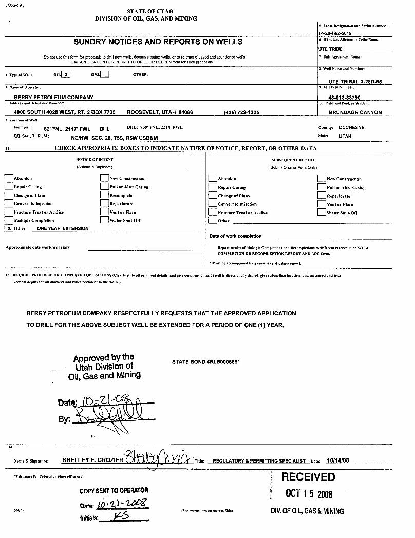
Multiple Completion Water Shut-Off OtherOther ONE YEAR EXTENSION
Date of work completion
Approximate date work will start Report results of Multiple Completions and Recompletions to different reservoirs on WELLCOMPLETION OR RECOMLEPTION REPORT AND LOG form.
* Must be accompanied by a cement verification report.
12. DESCRIBE PROPOSED OR COMPLETED OPERATIONS (Clearly state all pertinent details, and give pertinent dates. If well is directionally drilled, givesubsurface locations and measured and truevertical depths for all markers and zones pertinent to this work.)
BERRY PETROEUM COMPANYRESPECTFULLY REQUESTS THAT THE APPROVED APPLICATION
TO DRILL FOR THE ABOVE SUBJECT WELL BE EXTENDED FOR A PERIOD OF ONE (1) YEAR.
Approvedby theUtah Divisionof STATE BOND#RLBOOO5651
Oil,Gas and Mining
Date:
13
Name & Signature: SHELLEY E. CROZIER Title: REGULATORY& PERMITTINGSPECIALIST Date: 10/14/08
(This space for Federal or State office use) RECE IVEDCOPYSENTTOOPERAT 0CT15 2008
(4/94) (See instructionson reverse Side) DIV.OFOIL,GAS&

Application for Permit to DrillRequest for Permit Extension
Validation(this form should accompany the Sundry Notice requesting permit extension)
API: 43-08-33790Well Name: UTE TRIBAL 3-28D-55Location: (NE/NW) 62' FNL, 2117' FWL, SEC. 28-T5S-R5WCompany Permit Issued to: BERRY PETROLEUM COMPANYDate Original Permit Issued: 10/16/2007
The undersigned as owner with legal rights to drill on the property as permittedabove, hereby verifies thatthe information as submitted in the previouslyapproved application to drill, remains valid and does not require revision.
Following is a checklist of some items related to the application, which should beverified.
If located on private land, has the ownership changed, if so, has the surfaceagreement been updated? Yes O NoO
Have any wells been drilled in thevicinityof the proposed well which would affectthe spacing or siting requirements for thislocation? YesO Nom
Has there been any unit or other agreements put in place that could affectthepermitting or operationof thisproposed well? YesO No2
Have there been any changes to the access route including ownership, or right-of-way, which could affect the proposed location? YesO No2
Has the approved source of water for drilling changed? YesO No2
Have there been any physical changes to the surface location or access routewhich will require a change in plans from what was discussed at the onsiteevaluation? YesO NoT
is bonding still in place, which covers this proposed well? YesŒNoO
10/14/2008
Signature Date
Title: Regulatory & Permitting Specialist
Representing: Berry Petroleum Company
RECEIVEDOCf15 2008
DIV.0FOIL,GAS&

O STATE OF UTAH FORM 9DEPARTMENTOF NATURAL RESOURCES
DIVISION OF OIL, GAS AND MINING 5. LEASEDESIGNATIONANDSERIALNUMBER:14-20-H62-5019
6. IF INDlAN,ALLOTTEEOR TRIBE NAME:SUNDRY NOTICES AND REPORTS ON WELLS UTE
7. UN]Tor CA AGREEMENTNAME:Do not use this form for proposals to drillnew wells, significantly deepen existing wells below current bottom-hole depth, reenter plugged wells, or t° N/Adrillhorizontal laterals. Use APPLICAflON FOR PERMIT TO DRILLform for such proposals.
1. TYPE OF WELL 8. WELLNAMEand NUMBER:OILWELL GAS WELL OTHER UTE TRIBAL 3-28D-55
2. NAMEOF OPERATOR: 9. API NUMBER:
BERRY PETROLEUM COMPANŸ 43013337903. ADDRESS OF OPERATOR: PHONE NUMBER: 10. FIELDAND POOL, OR WILDCAT:4000 S. 4028 W. Roosevelt UT z,784066 (435) 722-1325 BRUNDAGECANYON
4. LOCATIONÒF WELL
FOOTAGESATSURFACE: AfŠN 2Ì1T FWL SHL: 759' FNL, 2214' FWL g COUNTY: DUCHESNE
QTR/QTR, SECTION, TOWNSHIP, RANGE, MERIDIAN: NENW 28 TSS RSW STATE:UTAH
CHECK APPROPRIATE BOXES TO INDICATENATURE OF NOTICE, REPORT, OR OTHER DATATYPE OF SUBMISSION TYPE OF ACTION
O ACIDIZE DEEPEN REPERFORATE CURRENT FORMATIONNOTICE OF INTENT
(Submit in Duplicate) ALTER CASING FRACTURETREAT SIDETRACKTO REPAIR WELL
Approximate date work willstart: CASlNG REPAIR NEW CONSTRUCTlON TEMPORARILYABANDON
CHANGETO PREVIOUS PLANS OPERATOR CHANGE TUBINGREPAIR
CHANGETUBING PLUG ANDABANDON VENT OR FLARE
SUBSEQUENT REPORT CHANGEWELLNAME PLUG BACK WATER DISPOSAL(Submit Original Form Only)
CHANGE WELLSTATUS PRODUCTION(START/RESUME) WATER SHUT-OFFDate of work completion:
COMMINGLEPRODUCING FORM'ATIONS RECLAMATlONOF WELLSITE OTHER: 1 YEAR EXTENSIONCONVERT WELLTYPE RECOMPLETE - DIFFERENT FORMATlON
12. DESCRIBE PROPOSED OR COMPLETED OPERATIONS. Clearly show all pertinent details including dates, depths, volumes, etc.
BERRY PETROLEUM COMPANY REPSECTFULLY REQUESTS THAT THE APPROVED APPLICATIONTO DRILL FOR THE ABOVE SUBJECT WELL BE EXTENDED FOR E O E YEAR.
UtahDivisionofOil,Gas and Mining
STATE BOND#RLBOOO5651
COPYSENTTOOPERATOR- 2. (- Q
NAME(PLEASEPRINT) SHELLEYE. CROZIER TITLE REGULATORY & PERMITTINGSPECIALIST
SIGNATURE DATE 10/19/2009
(This space for State use only)
RECEIVED0CT2O2009
(5/2000) (See Instructions on Reverse Side) DIV.0FOIL,GAS&

Application for Permit to DrillRequest for Permit Extension
Validation(thisform should accompany theSundry Notice requestingpermit extension)
API: 43-0 13-33790
Well Name: UTE TRIBAL 3-28D-55
Location: (NE/NW) 62' FNL, 2117' FWL, SEC. 28-T5S-R5W
Company Permit Issued to: BERRY PETROLEUM COMPANYDate Original Permit Issued: 10/16/2007
The undersigned as owner with legal rights to drillon the property as permittedabove, hereby verifies that the information as submitted in the previouslyapproved application to drill, remains valid and does not require revision.
Followinq is a checklist of some items related to the application, which should beverified.
If located on private land, has the ownership changed, if so, has the surfaceagreement been updated? YesO Nom
Have any wells been drilled in thevicinityof the proposed well which would affectthe spacing or siting requirements for thislocation? YesO NoO
Has therebeen any unitor other agreements put in place thatcould affect thepermitting or operation of thisproposed well? YesO Nom
Have there been any changes to the access route including ownership, or right-of-way, which could affect the proposed location? YesO No 21
Has the approved source of water for drillingchanged? YesO No1ZI
Have there been any physical changes to the surface location or access routewhich willrequire a change in plans from what was discussed at the onsiteevaluation? YesO NolZI
Is bonding still in place, which covers this proposed well? YesŒNoO
10/19/2009
Signature Date
Title: Regulatory & Permitting Specialist
Representing: Berry Petroleum Company RECEIVEDOCT2O2009 *

API Well No: 43013337900000
STATE OF UTAHDEPARTMENT OF NATURAL RESOURCES
DIVISION OF OIL, GAS, AND MINING
FORM 9
5.LEASE DESIGNATION AND SERIAL NUMBER: 14-20-H62-5019
SUNDRY NOTICES AND REPORTS ON WELLSDo not use this form for proposals to drill new wells, significantly deepen existing wells below currentbottom-hole depth, reenter plugged wells, or to drill horizontal laterals. Use APPLICATION FOR PERMIT TODRILL form for such proposals.
6. IF INDIAN, ALLOTTEE OR TRIBE NAME: UTE
7.UNIT or CA AGREEMENT NAME:
1. TYPE OF WELL Oil Well
8. WELL NAME and NUMBER: UTE TRIBAL 3-28D-55
2. NAME OF OPERATOR: BERRY PETROLEUM COMPANY
9. API NUMBER: 43013337900000
3. ADDRESS OF OPERATOR: PHONE NUMBER: 4000 South 4028 West Rt 2 Box 7735 , Roosevelt, UT, 84066 303 999-4044 Ext
9. FIELD and POOL or WILDCAT: BRUNDAGE CANYON
4. LOCATION OF WELL FOOTAGES AT SURFACE: 0062 FNL 2117 FWL QTR/QTR, SECTION, TOWNSHIP, RANGE, MERIDIAN: Qtr/Qtr: NENW Section: 28 Township: 05.0S Range: 05.0W Meridian: U
COUNTY: DUCHESNE
STATE: UTAH
11.
CHECK APPROPRIATE BOXES TO INDICATE NATURE OF NOTICE, REPORT, OR OTHER DATA
TYPE OF SUBMISSION TYPE OF ACTION
NOTICE OF INTENTApproximate date work will start:
10/16/2010
SUBSEQUENT REPORTDate of Work Completion:
SPUD REPORTDate of Spud:
DRILLING REPORTReport Date:
ACIDIZE ALTER CASING CASING REPAIR
CHANGE TO PREVIOUS PLANS CHANGE TUBING CHANGE WELL NAME
CHANGE WELL STATUS COMMINGLE PRODUCING FORMATIONS CONVERT WELL TYPE
DEEPEN FRACTURE TREAT NEW CONSTRUCTION
OPERATOR CHANGE PLUG AND ABANDON PLUG BACK
PRODUCTION START OR RESUME RECLAMATION OF WELL SITE RECOMPLETE DIFFERENT FORMATION
REPERFORATE CURRENT FORMATION SIDETRACK TO REPAIR WELL TEMPORARY ABANDON
TUBING REPAIR VENT OR FLARE WATER DISPOSAL
WATER SHUTOFF SI TA STATUS EXTENSION APD EXTENSION
WILDCAT WELL DETERMINATION OTHER OTHER:
12. DESCRIBE PROPOSED OR COMPLETED OPERATIONS. Clearly show all pertinent details including dates, depths, volumes, etc.
BERRY PETROLEUM RESPECTFULLY REQUESTS THAT THE APPROVEDAPPLICATION TO DRILL FOR THE ABOVE SUBJECT WELL BE EXTENDED FOR
THE PERIOD OF ONE (1) YEAR.
NAME (PLEASE PRINT) PHONE NUMBER Kathy K. Fieldsted 435 722-1325
TITLE Sr. Regulatory & Permitting Tech.
SIGNATURE N/A
DATE 9/13/2010
September 13, 2010
September 20, 2010
iPI Well No: 43013337900000
FORM 9
STATE OF UTAHDEPARTMENT OF NATURAL RESOURCES
DIVISION OF OIL, GAS, AND MINING 4E DE2sI50N1A9TIONAND SERIAL NUMBER:
SUNDRY NOTICES AND REPORTS ON WELLS FEINDIAN,ALLOTTEEORTRIBENAME:
Do not use this form for proposals to drill new wells, significantly deepen e×isting wells below currentbottom-hole depth, reenter plugged wells, or to drill horizontal laterals. Use APPLICATION FOR PERMIT TO 7.UNIT or CA AGREEMENT NAME:
DRILL form for such proposals.
1. TYPE OF WELL 8. WELL NAME and NUMBER:Oil Well UTE TRIBAL 3-28D-55
2. NAME OF OPERATOR: 9. API NUMBER:BERRY PETROLEUM COMPANY 43013337900000
3. ADDRESS OF OPERATOR: PHONE NUMBER: 9. FIELD and POOL or WILDCAT:4000 South 4028 West Rt 2 Box 7735 , Roosevelt, UT, 84066 303 999-4044 Ext BRUNDAGE CANYON
4.LOCATIONOFWELL COUNTY:FOOTAGES AT SURFACE: DUCHESNE
0062 FNL 2117 FWLQTR/QTR, SECTION, TOWNSHIP, RANGE, MERIDIAN: STATE:
Qtr/Qtr: NENW Section: 28 Township: 05.05 Range: 05.0W Meridian: U UTAH
11.CHECK APPROPRIATE BOXES TO INDICATE NATURE OF NOTICE, REPORT, OR OTHER DATA
TYPE OF SUBMISSION TYPE OF ACTION
ACIDIZE ALTER CASING CASING REPAIR
NOTICE OF INTENTApproximate date work will start: CHANGE TO PREVIOUS PLANS CHANGE TUBING CHANGE WELL NAME
10/16/2010CHANGE WELL STATUS COMMINGLE PRODUCING FORMATIONS CONVERT WELL TYPE
SUBSEQUENT REPORT DEEPEN FRACTURE TREAT NEW CONSTRUCTIONDate of Work Completion:
OPERATOR CHANGE PLUG AND ABANDON PLUG BACK
PRODUCTION START OR RESUME RECLAMATION OF WELL SITE RECOMPLETE DIFFERENT FORMATION
O SPUD REPORTDate of Spud: REPERFORATE CURRENT FORMATION SIDETRACK TO REPAIR WELL TEMPORARY ABANDON
TUBING REPAIR VENT OR FLARE WATER DISPOSAL
DRILLING REPORT WATER SHUTOFF SI TA STATUS EXTENSION APD EXTENSIONReport Date:
WILDCAT WELL DETERMINATION OTHER OTHER:
12. DESCRIBE PROPOSED OR CC MPLETED OPERATIONS. Clearly show all pertinent details including dates, depths, volumes, etc.
BERRY PETROLEUM RESPECTFULLY REQUESTS THAT THE APPROVEDAPPLICATION TO DRILL FOR THE ABOVE SUBJECT WELL BE EXTENDED FOR Approved by the
THE PERIOD OF ONE (1) YEAR. Utah Division ofOil, Gas and Mining
Date: September 20, 2010
By:
NAME (PLEASE PRINT) PHONE NUMBER TITLEKathy K. Fieldsted 435 722-1325 Sr. Regulatory & Permitting Tech.
SIGNATURE DATEN/A 9/13/2010
RECEIVED September 13,

The Utah Division of Oil, Gas, and Mining
- State of Utah- Department of Natural Resources
Electronic Permitting System - Sundry Notices
Request for Permit Extension Validation Well Number 43013337900000
API: 43013337900000Well Name: UTE TRIBAL 3-28D-55
Location: 0062 FNL 2117 FWL QTR NENW SEC 28 TWNP 050S RNG 050W MER UCompany Permit Issued to: BERRY PETROLEUM COMPANY
Date Original Permit Issued: 10/16/2007
The undersigned as owner with legal rights to drill on the property as permitted above, hereby verifies thatthe information as submitted in the previously approved application to drill, remains valid and does notrequire revision. Following is a checklist of some items related to the application, which should be verified.
If located on private land, has the ownership changed, if so, has the surface agreement beenupdated? Yes No
Have any wells been drilled in the vicinity of the proposed well which would affect the spacing orsiting requirements for this location? Yes No
Has there been any unit or other agreements put in place that could affect the permitting or operationof this proposed well? Yes No
Have there been any changes to the access route including ownership, or rightof- way, which couldaffect the proposed location? Yes No
Has the approved source of water for drilling changed? Yes No
Have there been any physical changes to the surface location or access route which will require achange in plans from what was discussed at the onsite evaluation? Yes No
Is bonding still in place, which covers this proposed well? Yes No
Signature: Kathy K. Fieldsted Date: 9/13/2010
Title: Sr. Regulatory & Permitting Tech. Representing: BERRY PETROLEUM COMPANY
September 13, 2010September 13, 2010
September 20, 2010
UTAH
DNR The Utah Division of Oil, Gas, and Mining'
- State of Utah- Department of Natural ResourcesElectronic Permitting System - Sundry Notices
OTI GAS MlNTNG
Request for Permit Extension Validation Well Number 43013337900000
API: 43013337900000Well Name: UTE TRIBAL 3-28D-55
Location: 0062 FNL 2117 FWL QTR NENW SEC 28 TWNP 0505 RNG 050W MER UCompany Permit Issued to: BERRY PETROLEUM COMPANY
Date Original Permit Issued: 10/16/2007
The undersigned as owner with legal rights to drill on the property as permitted above, hereby verifies thatthe information as submitted in the previously approved application to drill, remains valid and does notrequire revision. Following is a checklist of some items related to the application, which should be verified.
•If located o_nprivate_land, has the ownership changed, if so, has the surface agreement beenupdated? I
_
i Yes igi No
• Have any wells been drilled in the vicinity of the_proposed well which would affect the spacing orsiting requirements for this location? :__I Yes g:I No
• Has there been any unit or other agreements put in place that could affect the permitting or operationof this proposed well? I:_:I Yes IÏiÏ:I No
• Have there been any changes to the access route including ownership, or rightof- way, which couldaffect the proposed location? I___I Yes igi No
• Has the approved source of water for drilling changed? I_
I Yes IÎiÏI No
• Have there been any physical changes to the surface location or access route which will require achange in plans from what was discussed at the onsite evaluation? __:I Yes ig:I No
Approved by the•Is bonding still in place, which covers this proposed well? liiil Yes i i No Utah Division of
Oil, Gas and MiningSignature: Kathy K. Fieldsted Date: 9/13/2010
Title: Sr. Regulatory & Permitting Tech. Representing: BERRY PETROLEURANY September 20, 2010
By:
RECEIVED September 13,

Sta of UtahDEPARTMENT OF NATURAL RESOURCES
MICHAEL R. STYLER
GARY R.HERBERT ExecutiveDirector
covernr Division of Oil, Gas and MiningGREGORY S. BELL JOHN R. BAZALieutenant Governor Division Director
June 27, 2011
Kathy FieldstedBerry Petroleum Company O' SSRt. 2, Box 7735 g iRoosevelt, UT 84066
Re: APDs Rescinded for Berry Petroleum CompanyDuchesne County
Dear Ms. Fieldsted:
Enclosed find the list of APDs that are being rescinded per your request to BerryPetroleum Company. No drilling activity at these locations has been reported tothe division. Therefore, approval to drill these wells is hereby rescinded, effectiveJune 22, 2011.
A new APD must be filed with this office for approval prior to thecommencement of any future work on the subject location.
If any previously unreported operations have been performed on this welllocation, it is imperative that you notify the Division immediately.
Sincerely,
Di a MasonEnvironmental Scientist
ec: Well FileBureau of Land Management, Vernal
UTAH
DNR
1594 West North Temple, Suite 1210, PO Box 145801, Salt Lake City, UT 84114 -5801
telephone (801)538-5340 • facsimile (801)359-3940 •TTY (80!) 538-7458 •wwwogntutah.goV OIL, GAS &

Ute Tribal 15-29D-55 43-013-33704
Ute Tribal 10-20D-55 43-013-33705
Berry Tribal 6-34D-54 43-013-33727
Ute Tribal 15-16D-55 43-013-33766
Ute Tribal 9-16D-55 43-013-33767
Ute Tribal 5-28D-55 43-013-33789
Ute Tribal 3-28D-55

United States Department of the Interior
BUREAU OF LAND MANAGEMENTGreen River District-Vernal Field Office
170 South 500 East TAKE PRIDE*Vernal, UT 84078 INAMERICA
(435) 781-4400 Fax: (435) 781-4410http://www.blm.gov/ut/st/en/fo/vernal.html
JUL1 1 2011IN REPLY REFER TO:3160 (UTGO11)
Kathy FieldstedBerry Petroleum CompanyRoute 2, Box 7735Roosevelt, UT 84066
Re: Request to Return APDWell No. Ute Tribal 3-28D-55NENW, Sec. 28, T5S, R5WDuchesne County, UtahLease No. 14-20-H62-5019
Dear Ms. Fieldsted:
The Application for Permit to Drill (APD) for the above referenced well received in this office onOctober 12, 2007 is being returned unapproved per your request to this office in an emailmessage to Chuck Macdonald received on May 19, 2011. Ifyou intend to drill at this location ata future date, a new APD must be submitted.
Ifyou have any questions regarding APD processing, please contact Cindy Severson at (435)781-4455.
Sincerely,
erry KenczkaAssistant Field ManagerLands & Mineral Resources
Enclosures
cc: UDOGM
RECEIVEDJUL2 O2011
DIV.0F01L,GAS&