benthic protection areas: best practices and...
TRANSCRIPT

© Sustainable Fisheries Partnership 2012 www.sustainablefish.org | p1
Sustainable Fisheries
Partnership Report
By: Braddock Spear and Jim Cannon © April 2012
Benthic Protection Areas: Best Practices and Recommendations
Photograph Credit: Mountains in the Sea 2004. NOAA Office of Ocean Exploration; Dr. Les Watling, Chief Scientist, University of Maine

p2 | www.sustainablefish.org © Sustainable Fisheries Partnership 2012Photograph Credit: Gulf of Alaska 2004. NOAA Office of Ocean Exploration

© Sustainable Fisheries Partnership 2012 www.sustainablefish.org | p3
ContentsExecutive Summary 4
Introduction 6
Benthic Protection Areas – General Background and Theory 7
Benefits and Costs 8 Ecological 8 Social and Economic 8 Management 8 Broad Considerations for Designing BPAs 8 Governance and Laws 9 Society and Economics 10 Biology and Ecology 10
Using Gap Analysis to Design Protected Area Networks 11
Benthic Protected Area Case Studies 15
Alaska Bering Sea and Aleutian Islands 15 Governance Framework 16 Development Process 16 Protected Area Design Methods 17 Commercial Seafood Industry Views 17 Conservation NGO Views 18Florida Keys National Marine Sanctuary/Tortugas Ecological Reserve 19 Governance Framework 19 Development Process 20 Protected Area Design Methods 20 Commercial Seafood Industry Views 21 Conservation NGO Views 21New Zealand EEZ 22 Governance Framework 22 Development Process 23 Protected Area Design Methods 24 Commercial Seafood Industry Views 25 Conservation NGO Views 25
Best Practices to Develop and Implement BPAs Recommended by SFP 26
Practical Actions Recommended by SFP to Seafood Suppliers and Buyers 30
References 32
Attachment A: 35

p4 | www.sustainablefish.org © Sustainable Fisheries Partnership 2012
Executive SummaryNearly 13 percent of land on our planet is afforded some level of formal protection. A mere 1.2 percent of our ocean area is protected as formal marine protected areas (MPAs). Generally, Sustainable Fisheries Partnership (SFP) views any form of spatial marine conservation as an MPA. An MPA is “a clearly defined geographical space, recognized, dedicated, and managed, through legal or other effective means, to achieve the long-term conservation of nature with associated ecosystem services and cultural values.” This report focuses on benthic protection areas (BPAs), a type of MPA. Generally, BPAs afford habitat protection by limiting or eliminating direct fishing impacts to benthic habitats.
While bottom fishing is known to have impacts, this mode of operation and the associated gears will likely continue to be used. Most forms of food production result in some degree of environmental change or modification, and fishing is no exception. To expect fishing to be free from all impacts is unrealistic. However, a balance can be struck. Benthic biodiversity, habitats, and ecological roles can be maintained by managing some benthic areas for food production (i.e., maintaining sustainable fish populations and reasonable commercial access to them by the harvest sector) and protecting other areas for the conservation and biodiversity values. Depending on the protection needs, the types of fishing that are permitted as well as the size of the areas set aside will vary.
Protected areas, both on land and at sea, have typically been created through an ad hoc process. A scientific discovery or some research identifies an area as being a rare habitat, or important for an endangered species, and efforts start to protect it. If the area overlaps with other uses, such as forestry, agriculture, mining, roads, urban development, or – in the oceans – fishing, then there is industry opposition. The process often ends up in heated public debate, and is sometimes resolved through decisions by the established resource management agencies, but often by lawsuits, or decisions by political leaders (e.g., in the United States, Presidents have protected significant areas as National Monuments). The whole process is repeated every time another area
is newly identified as ecologically important, and the controversy and conflict between environmentalists and industry continues.
Conservation biology science has long advocated a more systematic process, called protected area network design. The aim of such an approach is to systematically map habitats, species, and ecological functions, as well as resource use, and then use a participatory approach to identify how to protect a representative sample of habitats, while minimizing the impact on economic uses.
Such an approach has been used in New Zealand, led by the fishing industry, resulting in the protection of 30 percent of their EEZ, with minimal impact on the catch sector. As new areas are identified as important by researchers, the debate over further protection needs should be less controversial, due to: (1) the existence of similar areas already under protection, (2) a pre-existing agreement between opposing stakeholders over a clear set of ecosystem-management objectives, and (3) an established framework for using scientific information. The process was not perfect in New Zealand, and controversy over the results continues, but the stage is set for diverse stakeholders to work together cooperatively to find long-term solutions.
SFP views protecting habitat as a widely accepted and essential component of ecosystem-based fisheries management. Adopting a holistic BPA network approach could be a valuable and less confrontational way to formalize protection of habitat from bottom trawling and dredging. SFP recognizes that gear modifications can be another important method to reduce or eliminate effects of fishing on benthic habitats. These innovations should be considered along with BPA networks as tools to protect and conserve habitat while maintaining a fishery.
The purpose of this report is to review some of the leading marine habitat protection efforts to date worldwide and identify lessons learned and best practices. On the basis of those lessons and best practices, this report provides a variety of stakeholders with practical guidance for leading and engaging in the process of exploring and establishing BPAs.

© Sustainable Fisheries Partnership 2012 www.sustainablefish.org | p5
Various factors must be considered when developing a BPA. Many costs of establishing BPAs are incurred in the short term, while benefits are often realized in the future. In fact, benefits may not be seen until future generations. There are ecological, social, and economic benefits and costs associated with BPAs. BPAs are highly site specific. During the design phase, they must be put into the proper legal, socio-economical, and environmental contexts to be successful.
Various standards and methodologies have been used to design protected areas on land and in marine environments. This report reviews available literature to obtain a sense of best practices that have been theorized and employed. To further identify best practices, this report also analyzes three case studies from around the world (i.e., Alaska Bering Sea and Aleutian Islands, New Zealand deepwater, and Florida Keys National Marine Sanctuary/Tortugas Ecological Reserve) where BPAs have been implemented. The three case studies represent some of most successful benthic protection efforts to date and, therefore, form a basis for extracting best practices. Area protected to date:
• New Zealand – approximately 1.1 million square kilometers of benthic habitat protected within its approximately 4 million square kilometer EEZ (Helson et al. 2010)
• Alaska – nearly 1.5 million square kilometers of benthic habitat protected (Witherell and Woodby 2005) within the roughly 3.5 million square kilometers of federal and state waters off Alaska
• Florida Tortugas Ecological Reserve – a 520 square kilometer addition to the nearly 10,000 square kilometers of existing protected area of the Florida Keys National Marine Sanctuary network (NOAA 2000)
Other efforts to implement benthic habitat protection exist but are not included in the report. Australia is implementing its National Representative System of Marine Protected Areas in order to meet international goals by 2012. The key objective for the creation of MPAs includes
conserving biodiversity and contributing to the “representativeness, comprehensiveness, or adequacy of the national system.” However, outside of the formal reserve system, there are large marine areas protected from trawling via spatial closures, including a closure on trawls at depths beyond 700 meters.
Also, Norway, the first country in Europe to implement protections for cold-water corals, continues to build a protected area network as more information is collected. Norway’s Marine Resources Act gives fisheries management authorities the ability to close areas and prohibit certain gear types to protect benthic habitat. Its seabed mapping program, called MAREANO, is ongoing.
The recommendations we compile for establishing BPAs do not reflect a comprehensive list that will apply to every situation. However, considering the best practices we identify will increase the chances of establishing effective long-term benthic protection while allowing commercial fisheries to coexist.
Seafood companies looking to be more responsible should adopt policies to ensure they are sourcing from fisheries that are not impacting important bottom habitat or from fisheries that have taken steps to manage the effects of fishing on bottom habitats such as those examples discussed herein. In addition, companies should encourage and drive improvements in areas where damage to benthic habitat from fishing gear remains a problem. While SFP provides assistance in developing and implementing Fishery Improvement Projects (FIPs) to improve stock status and management of specific fisheries, here we encourage carrying out Ecosystem Improvement Projects (EIPs), where appropriate, to improve specific ecosystems or habitats. EIPs could involve the creation of partnerships and improvement workplans with a goal of positive physical change to benthic habitats. The report concludes with practical actions for protecting benthic habitat and monitoring improvement.

p6 | www.sustainablefish.org © Sustainable Fisheries Partnership 2012
IntroductionNearly 13 percent of land on our planet is afforded some level of formal protection (Jenkins and Joppa 2009). A mere 1.2 percent of our ocean area is protected as formal marine protected areas (MPAs), according a report published by International Union for Conservation of Nature (IUCN) (Toropova et al. 2010; note that this figure was miscalculated and will be corrected and published as 1.3 percent). Recent internationally agreed upon targets for marine conservation include protecting 10 percent of each of the world’s marine ecological regions within areas under national jurisdiction by 2010 (Convention on Biological Diversity (CBD), 2006; Decision VIII/15, Annex IV) and strictly protecting at least 20–30 percent of each marine habitat by 2012 (IUCN World Parks Congress 2003; Recommendation V.23). The 2010 target was not met. At the 2010 CBD meeting in Nagoya, the 10-percent target was retained but the timeline for reaching it was extended to 2020.
However, globally, the total area protected from trawling as formal conservation reserves is far smaller than the area protected under fishery laws. The latter includes vast areas of ocean managed by regional fishery management organizations (RFMOs), closures at a variety of spatial scales within state waters (some countries have banned trawling as a gear type), and specific areas closed to mobile gear. Many of these areas may have banned trawling for the purpose of stock management (e.g., protection of juveniles or bycatch) or allocation, and thus habitat protection is incidental. However, such incidental benefits should not be downplayed. Conservation bodies often do not recognize these areas, even though they achieve the desired outcome of protecting benthic habitat from significant impact from mobile gear.
SFP takes the view that the protection of benthic habitats for either biodiversity conservation or fishery protection purposes can be effected via dedicated conservation legislation or via fishing closures established under fisheries laws. We term these areas benthic protection areas (BPAs) irrespective of whether the area established meets formal definitions for marine protected areas (MPAs).
An MPA is “a clearly defined geographical space, recognized, dedicated and managed, through legal or other effective means, to achieve the long-term conservation of nature with associated ecosystem services and cultural values” (Dudley 2008). MPAs are established to achieve various objectives ranging from absolute resource preservation (usually called “marine reserves”) to protection combined with managed mixed use of resources. While MPAs are a valuable tool, the most effective protection is realized when a holistic MPA network is established, especially for species that rely on different types of habitats at different stages of their lifecycle.
Developing a holistic protected area network involves systematically mapping habitats, species, ecological functions, as well as resource use, and then using a participatory approach to identify how to protect a representative sample of habitats, while minimizing the impact on economic uses. Generally, BPAs afford protection by limiting or eliminating fishing impacts to benthic habitats. BPAs are usually not established to directly manage or protect fish populations, though BPAs can have a positive effect on fish populations by maintaining and enhancing healthy habitat that is important during fishes’ life cycles.
The effects of fishing gear on benthic habitat have been studied worldwide. Although the degree of impact depends on many factors, including the type of benthic habitat, the type of gear, and the frequency and intensity of using that gear, the destruction of seafloor habitats has been identified as a factor in the decline of some fishing populations in heavily trawled areas (Watling and Norse 1998). Structurally complex habitats (e.g., seagrass beds, coral reefs) and habitats that are relatively free from natural disturbances (e.g., deepwater mud) are more heavily impacted by fishing than loose sediment habitats found in shallow coastal waters (Kaiser et al. 2003). One study estimates that between 30 and 50 percent of deepwater coral reef areas in Norwegian waters have been damaged by bottom trawling and other fishing techniques (Fossa et al. 2002). Fishermen report lower catch rates in these impacted areas (Fossa et al. 2002).
While bottom fishing is known to have impacts, this mode of operation and the associated gears

© Sustainable Fisheries Partnership 2012 www.sustainablefish.org | p7
will likely continue to be used. Most forms of food production result in some degree of environmental change or modification, and fishing is no exception. To expect fishing to be free from all impacts is unrealistic. However, a balance can be struck. Benthic biodiversity, habitats, and ecological roles can be maintained by managing some benthic areas for food production (i.e., maintaining sustainable fish populations and reasonable commercial access to them by the harvest sector) and protecting other areas for the conservation and biodiversity values.
Protecting habitat is a widely accepted and essential component of ecosystem-based fisheries management. The United Nations General Assembly (UNGA) has passed resolutions calling upon fishery management organizations to regulate bottom trawling with the intent of protecting benthic habitat (UNGA 61/105 and 64/72). Adopting BPAs could be an effective and valuable way to simplify and formalize protection of habitat from mobile fishing methods that contact the seabed, including bottom trawling, seining, and dredging. SFP recognizes that gear modifications can be another important method to reduce or eliminate effects of fishing on benthic habitats. These innovations should be considered along with BPA networks as tools to protect and conserve habitat while maintaining a fishery.
The purpose of this report is to provide a variety of stakeholders with practical guidance for leading and engaging in the process of exploring and establishing BPAs. We review the benefits and costs of establishing BPAs, broad considerations for designing BPAs, and commonly used principles and methods for area identification and selection. In addition, we profile successful case studies from around the world to draw out best practices for designing and implementing BPAs. The report concludes with practical actions that seafood suppliers and buyers can take to drive improvements and monitor progress.
Benthic Protection Areas – General Background and TheoryBPAs have been established to protect benthic habitats from modification by fishing activities while allowing for fishing activities that do not impact on benthic habitats and communities within these areas. In their most basic form, BPAs simply exclude seabed-impacting mobile fishing gear such as bottom trawls and dredges from a specified area. BPAs have not been used to provide protection from the impacts of non-fishing activities, such as energy and mineral exploration and exploitation, but the restrictions and permitted uses could be extended to do so. Some trawling closures have been adopted to protect inshore nursery grounds. For example, Thailand prohibits trawling within 3 kilometers of shore in order to not only protect benthic habitats but also protect juvenile fish. Also, BPAs have been proposed to afford protection to vulnerable marine ecosystems (VMEs), or areas where the benthic habitats and communities have a high conservation value. For example, the industry group Southern Indian Ocean Deepsea Fishers Association (SIODFA) has voluntarily implemented BPAs since 2006 and recommends that RFMOs evaluate biodiversity data to protect VMEs in the high seas (FAO 2008).
BPAs can be an important tool for planning and managing benthic habitat protection. They can complement fishery management measures already in place for fisheries around the world to ensure healthy marine ecosystems. Their establishment can bring together interested parties, each with its own set of objectives. A well-defined framework for creating and implementing BPAs increases the chances for maximizing benefits of marine conservation. These benefits may be realized by the environment, resource users, and the public at large through long-term ecological function and production.
Many international institutions have written guides for establishing MPAs, including the International Union for Conservation of Nature (IUCN 2008), Convention on Biological Diversity (CBD 2004), United Nations Environment Programme (UNEP-WCMC 2008), and World Bank (2006). Several

p8 | www.sustainablefish.org © Sustainable Fisheries Partnership 2012
institutions and researchers have written about the benefits, and to a lesser degree on the costs, of implementing the broader category of MPAs (e.g., Sanchirico 2000, WWF 2009, FAO 2007). Very little information that focuses on BPAs is available in the published literature. The sections below on benefits and costs and broad principles contain information from MPA literature that could be relevant to BPAs.
Benefits and CostsMany costs of establishing BPAs are incurred in the short term, while benefits are often realized in the longer term. In fact, benefits of habitat protection may not be seen until future generations. Therefore, managers can implement protection measures today to promote intergenerational equity by balancing short-term considerations (i.e., exploitation) with long-term considerations (i.e., ensuring resources are available for future generations) (Sanchirico 2000).
EcologicalIf important habitat is preserved, BPAs can provide benefits by helping maintain ecosystem health and productivity. A bottom ecosystem with benthic invertebrates as habitat serves as food and habitat for higher trophic level species, many of which are commercially harvested. For example, Stone (2006) found through submersible transects around the Aleutian Islands that commercially important fish species (such as rockfish) and juveniles were very frequently closely associated (within one body length) of protruding benthic features (e.g., corals and sponges).
There are also potential biological costs. Negative biological consequences of creating BPAs could result from changes in fishermen’s behavior, for instance if fishing effort increases on other vulnerable habitats that are not protected.
Social and Economic Social and economic costs of establishing MPAs include reduction in fishable waters and the resulting displacement of fishing effort (Sanchirico 2000). BPAs may allow fishing in an area but vessels using bottom gear could be displaced. Fishermen may incur additional costs associated with increased search time for different fishing grounds. They may experience increased congestion in non-protected fishing grounds. These costs are not trivial. However, with proper BPA planning and siting, they can be minimized.
MPAs can disproportionately affect different stakeholders or stakeholder groups, and the same is likely true for BPAs. Therefore, embedded in the policy debate is the perceived transfer of resource access from one group to another (Sanchirico 2000). Displaced effort can be bought out in the form of government subsidies. The process of developing MPAs can provide a structured framework for conflict resolution (FAO 2007). This can also be the case when developing BPAs. A deliberate and inclusive process can allow stakeholder concerns to be heard and addressed as the BPA is designed.
ManagementAs noted previously, BPAs can be an effective tool for managers to protect habitat and can help managers deal with uncertainty in science and management of bottom habitat. If the importance of an area of benthic habitat is unknown, managers can take a precautionary approach and protect it while collecting data.
Costs associated with their development include funding needed to pay for personnel time for stakeholder groups that wish to be involved, production of outreach materials and reports, and meeting space. Additionally, costs to administer BPAs include funding for management, enforcement, and any new activities or technology that is needed.

© Sustainable Fisheries Partnership 2012 www.sustainablefish.org | p9
Broad Considerations for Designing BPAsWhile there is little information available on the effectiveness of BPAs and the factors that contribute to effectiveness, parallels can be drawn from MPAs, for which there is an extensive literature. MPAs and BPAs are highly site specific. During the design phase, MPAs must be put into the proper legal, socioeconomical, and environmental contexts to be successful (IUCN 2008). Understanding the relevant laws, regulations, and decision-making processes is essential for establishing BPAs. Failure to consider social and economic factors in the design and implementation of protected areas can dramatically reduce stakeholder support and compliance, and therefore, diminish the effectiveness of marine protection (NOAA 2005). Lastly, incorporating the most up-to-date biological and ecosystem information from the areas under consideration is critical during planning, siting, and evaluation of BPAs.
Considering social, economic, and environmental factors for a proposed BPA is much like preparing an environmental impact assessment (EIA), or something similar, that is required for many government-regulated industries, including fishing. The purpose of an EIA is to collect information relevant for deciding whether a proposed action should be allowed, modified, or disallowed. For example in the United States, the National Environmental Policy Act (NEPA) requires EIAs to be conducted when major fisheries management measures are being proposed. A similar approach could be employed for the declaration of BPAs even if the formality of an EIA process was deemed unsuitable.
Governance and LawsA clear governance and legal framework establishes a system of authority and accountability. Adequate regulatory authority and enforcement are vital to maintaining the cooperation of affected stakeholders (NOAA 2005). However, because every area of the world is unique, no single approach to BPA governance can be applied universally (IUCN 2008).
Few countries have in place a strategic legislative and institutional framework for establishing BPAs. However, many countries have fishery management laws that allow fishing closures or can impose special license conditions to achieve benthic protection. Some countries have a special law in place that enables the creation of MPAs or BPAs. Some countries use multiple pieces of legislation to do this, with each regulating a particular activity (FAO 2007). It is possible that more than one agency may be involved in designing and implementing BPAs. In some cases for MPAs, special authorities must be created to synchronize overlapping and complex jurisdictional layers (IUCN 2008). Additionally, consideration must be given to other legislation that addresses human impacts to benthic habitat. For example, government minerals and energy agencies may have the ability to issue permits for exploration and exploitation of petrochemicals and minerals from areas within an MPA or BPA.
Much of the time, ecosystems and fish species are distributed across political boundaries. Therefore, cooperation among jurisdictions (e.g., state, region, country) is required. These cases often involve high-level political intervention by governments and regional bodies or third-party involvement by NGOs, academia, or international conventions (IUCN 2008).
Regardless of the governance and legal framework or frameworks under which BPAs are designed and implemented, several conditions must be considered. Clear processes for disseminating information (i.e., transparency) and for making decisions are key components of institutional structures when creating MPAs (FAO 2007) or BPAs. Furthermore, if more than one agency has authority, coordination and consultative mechanisms should be formally laid out (FAO 2007). When regulations for the BPA are being crafted, they should be as simple as possible. And once regulations are set, frequent changes should be avoided (NOAA 2005).
Another critical component of governance is enforcement. Effective design of protected areas offers the opportunity to reduce enforcement challenges (FAO 2007). For example, a large area is easier to monitor and enforce for compliance than a series of smaller ones (NOAA 2005).

p10 | www.sustainablefish.org © Sustainable Fisheries Partnership 2012
Simple boundaries that provide ease of navigation are easier for mariners to avoid crossing in error (e.g., boundaries along lines of latitude or longitude rather than those that follow depth contours, curves, or radii). In addition, building into regulations requirements to use certain technologies (e.g., the use of GPS and digital plotters for on-board navigation, and the use of satellite-based vessel monitoring systems for land-based surveillance) can aid in enforcement and, therefore, governance.
Society and EconomicsSocial and economic issues must be considered when designing and implementing BPAs. Doing so can maximize positive benefits by helping resolve stakeholder conflicts and ensuring efficient use of resources (IUCN 2008). However, as with political and legal considerations, these issues will vary greatly from one case to another.
International guidelines suggest all stakeholders likely to be affected by fisheries management regulations, including MPAs, must be consulted and engaged throughout the creation and implementation process (FAO 2007; IUCN 2008). Involving affected stakeholders from the start of the process increases the chance of buy-in and cooperation. It is important for stakeholders to recognize and agree to the need for a broader approach to ecosystem conservation and fisheries management (FAO 2007). Also, this discussion or debate should occur openly to avoid distrust and political manipulation (Kaiser 2004). Interaction among scientists, managers, and stakeholders is important to build trust and establish working relationships (FAO 2007).
Compliance with protected area regulations must be considered during the design phase. When stakeholders, particularly harvesters, are involved in the design and monitoring of MPAs, they are more likely to comply with the regulations, which reduces enforcement challenges and cost (FAO 2007). We believe this will be the case with BPAs. Compliance is a direct reflection of three main elements: “anticipated payoff from a violation, likelihood of detection, and severity of penalties” (NOAA 2005). However, peer pressure and the perceived validity of authorities and regulations also contribute to compliance (NOAA 2005).
Another key element to consider when creating and maintaining BPAs is secured funding through a single source or multiple sources. Three of the main sources used to fund protected areas are government, donors, and self-generating activities (FAO 2007). Because donors rarely fund programs indefinitely, their funding may most appropriately be used to initiate or further BPA development by carrying out specific projects (e.g., stakeholder meetings, data collection). Given the proper commitment from government, its funding can satisfy the design and long-term needs of implementing BPAs. Revenue generation from the BPA can also provide financial stability. It can come in the form of fishing levies, cost sharing among stakeholders, and other user fees (FAO 2007). Regardless of the source or sources, funding should be identified and put in place prior to implementation.
Biology and EcologyProtected areas on land are sometimes designed to reduce environmental impacts and protect use values (e.g., watershed protection, recreation, hunting). However, in many cases protected areas exist only to protect conservation values (e.g., nature reserves, sites of special scientific interest). The same logic applies in a marine setting, where a BPA may help conserve habitat of importance to commercially valuable fish stocks, or simply to reduce environmental impacts on endangered species or high conservation value habitats.
A BPA network designed to conserve benthic biodiversity and maintain the functional roles of benthic habitats must be based on the best available data as well as functional importance. From the perspective of the fishing industry, the biology of fish and habitat and their ecological interactions in the areas under consideration are fundamental to selecting the site and boundaries of BPAs. Data compilation (or collection, if possible) prior to establishing a BPA to map benthic biodiversity and important and representative habitats is critical. Incorporating information on the functional role of different benthic habitats enables BPA network design to provide protection to these habitats and nursery areas of important fishery species. Many species migrate to certain habitat structures or areas in large numbers to spawn (FAO 2007). Protecting these sites can be important in

© Sustainable Fisheries Partnership 2012 www.sustainablefish.org | p11
sustaining fish populations, particularly if they are relatively territorial and stay close to the bottom habitat of a BPA.
In addition, BPA designers must consider spatial and temporal issues that can affect marine ecosystems. MPAs may need to account for the extent of human impact on marine resources as well as the broader oceanographic and climatic context (IUCN 2008). BPA design may also need to factor in the impacts of activities outside area boundaries, such as those on land and in nearby waters.
Even though it makes logical sense that healthy habitats benefit fisheries, it is often difficult to quantify this (Sweeting and Polunin 2005). Measuring the effects of BPAs after they are established is essential. Data collection and science in the form monitoring fish species and habitat can produce evidence to show their value (NOAA 2005).
Another key issue to consider and address is the concept of “shifting baselines” (Pauly 1995). Insufficient protection may result if stakeholders and decision makers fail to recognize changes to ocean ecosystems that are measured against previous baselines, which may not reflect the original state (IUCN 2008). If areas under consideration for protection have been degraded, they should be designed to increase ecosystem productivity and diversity and not to simply maintain status quo (IUCN 2008). BPA objectives should be placed in the appropriate historical context.
Using Gap Analysis to Design Protected Area NetworksVarious standards and methodologies have been used to design protected areas on land and in marine environments. Establishing an ecologically representative protected area or network of areas requires an approach that is based more on science than politics or chance. The Convention on Biological Diversity (CBD) proposes that governments and their partners use a gap analysis
as a basis to set protection targets, assess protection needs, and agree on a strategy for taking action (Dudley and Parish 2006). In this section we provide an in-depth review of guidelines and steps for designing protected area networks. Later in the report we provide a brief summary of best practices and specific actions that can be taken to design and implement benthic protection.
In its most basic form, gap analysis entails comparing distribution of biodiversity with distribution of protected areas and identifying where species, habitats, and ecosystems of interest are left under-protected or not protected. The principles and methods described by CBD apply generally to biodiversity protection on land and in the marine environment. Many countries have adopted these guidelines to design protected areas and area networks. However, not everything in this section applies to each situation where BPAs have been or are being planned, designed, and implemented.
CBD identifies six guiding principles for gap analysis (Dudley and Parish 2006):
1. Ensure full representation – have representative species, habitats, species assemblages, and ecosystems within the protected area or areas. This increases the chances that ecosystem function and its species will persist long term.
2. Aim for redundancy – ensure there are enough species, habitats, and ecosystems covered to maintain genetic variation. This helps protect against losses of species and habitats elsewhere.
3. Design for resilience – design protected areas to withstand stresses and changes. This helps buffer against the effects of climate change and natural or manmade disasters.
4. Consider different types of gaps – analyze representation gaps (i.e., species, habitats, ecosystems that are missed entirely), ecological gaps (i.e., biodiversity that may be protected but not sufficiently), and management gaps (i.e., areas that are protected but either poorly or under the wrong objectives). Considering all three types helps lead to successful design and planning.
5. Use a participatory approach – involve key stakeholders in the planning and decision-making phases. This approach, if used properly, aims to find a solution that fully

p12 | www.sustainablefish.org © Sustainable Fisheries Partnership 2012
meets the objectives and has the greatest political, social, and economic chances of being implemented and enforced.
6. Make protected areas design an iterative process – revisit and further develop the gap analysis as more information becomes available. This allows the analysis and resulting protection to occur relatively quickly with an ongoing commitment to improvement.
CBD also recommends six key steps to conduct protected area gap analysis:
Source: Dudley and Parish 2006
Step 1: Establish conservation targets for biodiversity of interest
The representative subset of biodiversity chosen is the group of species, habitats, and ecosystems to be evaluated in the gap analysis. Dudley and Parish (2006) identify three types of targets:
• Area targets – setting an overall quantity or percentage of area to be protected. This is likely the simplest target to implement. However, when used alone, it risks resulting in an area without representative biodiversity.
• Coarse filter targets – agreeing on goals to protect a portion of specific ecosystems (e.g., seamounts). This requires sufficient information to identify and measure the ecosystems of interest.
• Fine filter targets – focusing protection on particular fish species, habitat, or species assemblage. This also requires sufficient information including fish and habitat distribution and fish species life history and movement.
Biodiversity measured across a spatial scale is frequently described using three terms: alpha, beta, and gamma diversity (Whittaker 1972). Targets can also be defined by achieving desired levels of alpha, beta, and gamma diversity. Alpha diversity refers to the diversity within a particular area or ecosystem and is often expressed by the number of species or habitat types in the area of interest. Beta diversity refers to comparing diversity between two or more areas by measuring the total number of unique species or habitat types found in each area. Gamma diversity represents the overall diversity across different ecosystems within the total area of interest. These different scales of biodiversity can be monitored over time and compared with targets. For a review of equations used to calculate diversity, see Jost (2007).
Ideally, targets should include specifics about desired quantity and distribution. In many cases, the targets relate directly to the indicators chosen for the gap analysis. For marine protection, setting a combination of more than one of the target types above is recommended to ensure biodiversity is represented within multiple scales.
Step 2: Evaluate biodiversity distribution and status
This first phase of the assessment entails compiling information and data on the biodiversity of interest. Often, little information is available or little time is available to collect all the necessary information. Therefore, indicators or surrogates (e.g., individual species or benthic habitat features) that are representative of the ecosystem type are used in the gap analysis. Choosing surrogates can be difficult in the absence of solid science. As a result, this choice can be influenced by social, political, and economic factors. As noted above, these indicators or surrogates usually refer back to the targets established. Using a combination of indicators to describe biodiversity in an area can strengthen the gap analysis.
Predictive habitat modeling has potential to be a
© Sustainable Fisheries Partnership 2012 www.sustainablefish.org | p13
powerful method for carrying out this step (Davies and Guinotte 2011). An international cadre of scientists is developing and refining models that use widely available data to predict high-value benthic habitats (deepwater and shallow). The modeling is being tested and verified with observations in several marine areas around the world, including Alaska, Australia, and the South Pacific Ocean. Peer-reviewed results and published papers are expected soon.
Step 3: Analyze distribution of existing protected area and status*
The next phase of the assessment is gathering information on existing protected areas within the broader area where new protections are being considered. It is important to know the location and boundaries of all protected areas. It is also helpful to identify the management objectives of these areas. And last, indication on the effectiveness of management of these areas will help inform the analysis. Governments, international bodies, and NGOs have developed several tools to evaluate the management effectiveness of protected areas.
[*Some ocean zones within which new areas are being considered for protection do not contain existing protected areas. In this case, Steps 1 and 2 are carried out as described above. Step 3 is omitted. Steps 4 and 5 are conducted such that needs (instead of gaps) are identified and prioritized based on the targets established and current distribution and status of biodiversity. Step 6 remains the same.]
Step 4: Identify gaps
This is the part of the analysis where the information collected for Step 2 is compared with the information compiled in Step 3. Identifying gaps can be done easily and effectively using maps. Overlaying maps containing information on fish species or habitat distribution with maps of existing protected areas can provide a visual indication of the gaps in protection. If maps are unavailable, a very basic but still useful form of gap analysis is simply listing species, habitats, or ecosystems of interest that are not sufficiently represented in the protected areas. In more sophisticated analyses, maps can be used in combination with software where such expertise and resources exist. Protected area selection programs and systematic, algorithm approaches are available. Regardless
of which method or tools are used in the gap analysis, it is important to determine the type or types of gaps (e.g., representational, ecological, and management). It is also useful to capture the extent of the gaps. This information will help lay the groundwork for deciding how to fill the gaps.
Step 5: Prioritize gaps to be filled
Once gaps have been identified, they need to be prioritized to determine which gaps should be filled first. This part of the assessment involves reconciling the inadequacies of and opportunities for protection with other interests of the stakeholders. In many cases, this will involve consultation or negotiation among the stakeholders. For example, in the Florida Keys Tortugas Ecological Reserve case study presented later in this report, stakeholders drew proposed boundary lines that were then evaluated for how they met conservation objectives. Several elements should be considered when prioritizing gaps:
• Natural and manmade threats to existing protected areas and unprotected areas
• Opportunities for new protected areas (because particular species or areas might be covered by certain laws, making them easier to protect, or because protecting specific areas might open access to funding)
• Capacity (e.g., expertise, funding, governance framework, partners) to implement protected areas.
Prioritization can be carried out using software programs and/or workshops with experts and stakeholders.
Step 6: Agree on a strategy and take action
At this point, the gap analysis is complete. A strategy for implementation includes specific actions to be carried out by the responsible parties within a set timeframe. Much of this depends on the governance framework under which the new protected areas are established. More specific guidance to carry out this step is provided in the Best Practices and Practical Actions sections near the end of this report.

p14 | www.sustainablefish.org © Sustainable Fisheries Partnership 2012
Benthic Protected Area Case Studies
Photograph Credit: Gulf of Alaska 2004. NOAA Office of Ocean Exploration

© Sustainable Fisheries Partnership 2012 www.sustainablefish.org | p15
Benthic Protected Area Case StudiesThe three case studies below represent a range of examples from around the world where BPAs have been implemented. Two of the case studies (Alaska and New Zealand) focus specifically on BPAs, while, in the third, the BPAs were incorporated into protected areas that had wider goals. All three were chosen because they are high profile and represent significant advancement in marine protection (simply based on coverage alone). Each case study includes background information, a governance framework, the development processes, design methods, and stakeholder views on process and outcomes. Information gleaned from these experiences has been analyzed and used as a basis for the Best Practices section of this report.
Protected area proposals are often controversial, polarizing fishers and NGOs. Stakeholders who disagree with the final decision often feel their inputs were ignored, and criticize the management or consultation process. Others reject that criticism, argue all stakeholders were given a fair hearing, and acknowledge managers made an informed and balanced decision. The case studies reported here feature management systems that have a strong stakeholder consultation process, relative to global practices. It is difficult to determine whether particular arguments were given a fair hearing or not, and in this report SFP simply reports how different stakeholders viewed the process.
Alaska Bering Sea and Aleutian IslandsThis case study illustrates the use of fisheries management legislation as the primary tool used to achieve the protection of benthic habitats. The primary reason for the protection measures in most of this region is to protect habitats believed to be of value to the lifecycle of fish species. Protecting representative biodiversity and habitat was not the motivating objective.
Waters of the Bering Sea and Aleutian Islands off Alaska support one of the largest fisheries in the
world. In recent years, total catches of groundfish (i.e., pollock, cod, sablefish, and various flatfish) from the Bering Sea and Aleutian Islands are more than 1.5 million metric tons and 100,000 metric tons, respectively. Approximately 300 permitted vessels land groundfish from these areas totaling an ex-vessel value of nearly $700 million (Hiatt et al. 2009). Pollock accounts for the largest majority in terms of metric tons and value. Trawl (mid-water and bottom), hook-and-line (including longline and jigs), and pots are the primary gears used to harvest groundfish. The fishery is managed with total allowable catch limits, time and area closures, and gear restrictions.
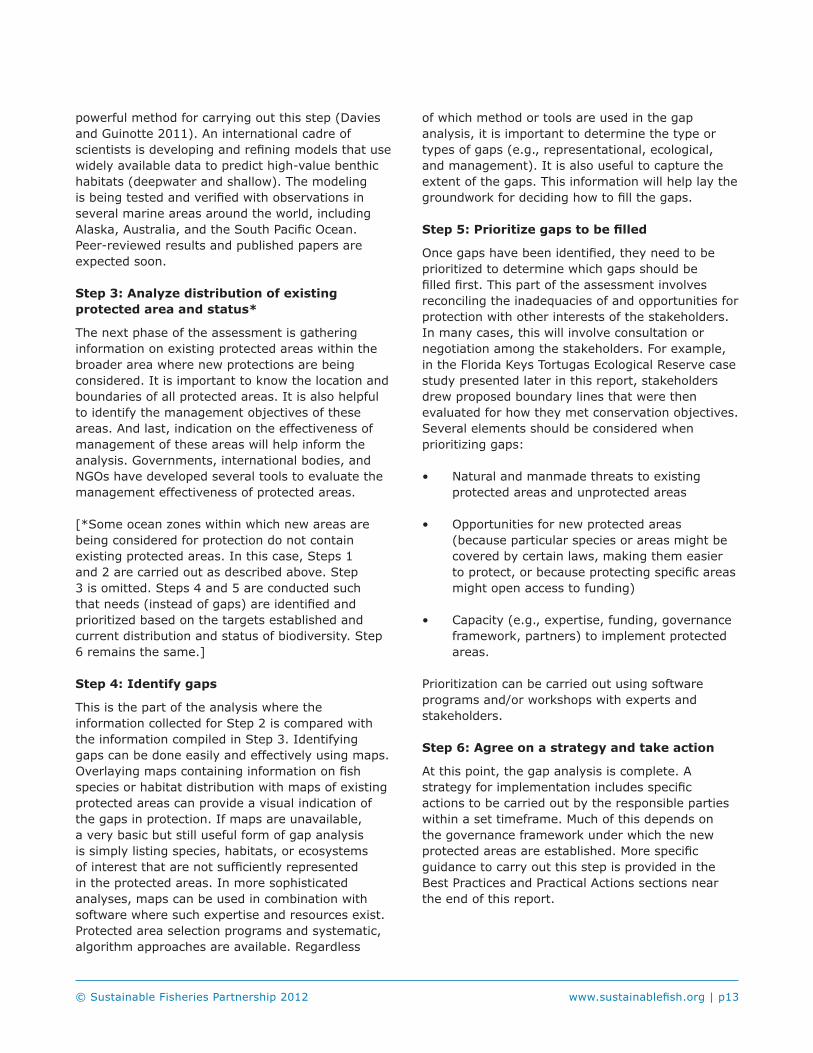
The Bering Sea covers over 1.4 million square miles of ocean waters. Waters surrounding the Aleutian Islands total nearly 300,000 square miles. Benthic substrate in these areas is largely characterized as soft bottom, with a few areas of highly concentrated coral and sponge communities. Starting in 1999, the use of bottom trawl gear for directed pollock fishing was prohibited in the federal ocean waters of the Bering Sea and off the Aleutian Islands. However, this measure was implemented mainly to reduce bycatch of halibut and crabs, not to reduce negative effects off gear on benthic habitat. Since then, more bottom gear restrictions have been put in place in these areas for essential fish habitat protection and to protect unique benthic structures and organisms. Approximately 90 percent of the protected Aleutian Islands Habitat Conservation Area covers bottom habitat that is deeper than trawl depths where vessels have fished (J. Guinotte, personal communication 2010) (figure 1). Also, National Marine Fisheries Service (NMFS) estimated that the pelagic trawl gear permitted to catch pollock in Aleutian Island waters come in contact with the bottom 44 percent of the time (NMFS 2005).
While the industry, North Pacific Fishery Management Council (NPFMC), and NMFS have taken significant conservation steps to protect benthic habitat throughout Alaska’s EEZ, this case study focuses on regulatory action taken within the Bering Sea and Aleutian Islands management areas.
p16 | www.sustainablefish.org © Sustainable Fisheries Partnership 2012
Figure 1: Map of MPAs in waters off Alaska (For a higher resolution view of the map, visit http://www.mpa.gov/helpful_resources/inventoryfiles/AK_Map_090831_final.pdf)
Governance FrameworkThe political landscape under which bottom fishing prohibitions have been created in the EEZ of Alaska is relatively simple. Management authorities are outlined in the federal Magnuson Stevens Fishery Conservation and Management Act of 1976 and habitat protection mandates are included in the 1996 reauthorization of the act (collectively referred to as the Magnuson Stevens Act, or MSA). The North Pacific Fishery Management Council (NPFMC or “the Council”) recommends management measures and NOAA’s National Marine Fisheries Service (NMFS) adopts them through the federal rulemaking process.
The MSA requires NMFS and the Councils, including NPFMC to describe and identify essential fish habitat (EFH) in their fishery management plans (FMPs). EFH is defined by the MSA as “those waters and substrate necessary to fish for spawning, breeding, feeding, or growth to maturity.” The federal government must minimize to the extent practicable negative effects of fishing on EFH. In addition, within EFHs, the Council and government can identify and provide added protection to habitat areas of particular concern (HAPC). These areas often contain unique habitat features that are important to the long-term productivity of managed fish stocks.
Development Process Federal rules require the NPFMC and NMFS to review the EFH components of their management plans every 5 years. However, these reviews can be conducted at any time if sufficient information is presented. Using the best science available, they determine whether or not to amend the FMPs to change habitat protection measures.
Five-year reviews were conducted in 2005 and 2010 for the Bering Sea and Aleutian Islands (BSAI) Groundfish FMP (NPFMC/NMFS 2010). Resulting from the 2005 review, the NPFMC adopted several new closed areas to address concerns about the impacts of bottom trawling on benthic habitat (particularly coral communities) in the Aleutian Islands. All bottom trawling was prohibited throughout the Aleutians, except in small open areas where bottom trawls are still allowed. Over 95 percent of the management area (277,100 square miles) was closed to this gear. The pelagic, or mid-water, gear permitted to catch pollock in these areas can be fished very close to or even on the bottom, though fishermen have incentive to keep their gear off hard bottom to avoid damaging gear. The restrictions for the Bering Sea and Aleutian Islands do not prohibit damage to or contact with the bottom; they simply prohibit use of bottom trawling gear. Other bottom fishing gears (e.g., pots, long lines) can be used in these areas.
In addition, the NPFMC adopted new HAPCs, where most fishing gear types that contact the bottom (e.g., long lines, pots, bottom trawls) were prohibited. Pelagic trawls are permitted. These areas of high-density coral and sponge habitat total more than 5,200 square miles of the EEZ. To aid in enforcement and monitoring, all vessels fishing in the Aleutian management area are required to use a vessel monitoring system (VMS).
In 2007, the NPFMC took action to limit bottom trawling to occur only in those areas that have been recently trawled in the Bering Sea. This bottom trawl prohibition established two new benthic protection areas totaling over 130,000 square miles, including a Northern Bering Sea Research Area. Then, in 2009, the NPFMC adopted a requirement for any vessel targeting flatfish with non-pelagic (i.e., bottom, not mid-water) trawl gear to use elevating devices on their trawl sweeps. Scheduled for implementation in 2011, this
© Sustainable Fisheries Partnership 2012 www.sustainablefish.org | p17
measure is expected to protect benthic habitat and invertebrates such as various crab species (NPFMC/NOAA 2010).
In order to adopt the measures that are designed to protect EFH, the NPFMC must conduct an EIA and write an environmental impact statement (EIS) as required by the National Environmental Policy Act (NEPA). EISs must contain alternative actions and analyses evaluating each alternative. Then the NPFMC solicits public comment to aid in development of alternatives.
Protected Area Design MethodsThe primary objective of protecting EFH is to minimize or eliminate the impact of fishing on habitat that is important to fish species throughout their life cycles. Alaska’s protected area network has not been designed with an explicit goal of conserving a representative sample of high conservation value benthic habitats or to protect a certain level of biodiversity. However, this is not to say a representative sample of benthic habitats have not been protected through existing protections; it is unknown at this time.
The EFH EIS considered impacts to important habitat for all species under management by the NPFMC (NMFS 2005). Models were developed and used to estimate the cumulative effects of all fishing on benthic habitat. This long-term effect index (LEI) was then apportioned to certain fisheries/gear types based on where the fisheries occur and at what rate they damage habitat. The analysis drew on estimates of fishing intensity, sensitivity of habitat features, and habitat recovery rates to result in proportions of the original abundance of each habitat feature remaining at equilibrium. However, the EIS (NMFS 2005) states, “because this pristine amount is not known for the features and areas studied, the LEIs could not be used to calculate the actual amount of a feature remaining in an area. Instead, they represent the ability of fishing to reduce however much of each feature was present in an area as a proportional reduction.”
The final analyses indicated that no fishing activities have more than minimal and temporary effects on EFH for any species under the Council’s authority. The evaluations use several broad assumptions about distribution of habitat, habitat use, and
habitat recovery rates. Also, inadequacies in assessment models and limited available data may have resulted in an incomplete analysis of fishing effects on EFH (Rice et al. 2010). For example, no data from direct observation are available to identify the resulting effect of Alaska pollock pelagic gear from contact with hard or soft bottom habitats. The EIS analysis conclusion that this gear does not affect complex habitats on hard bottoms is based on the assumption that the gear’s unprotected footrope “effectively precludes the use of these nets on rocky or hard substrates” (NMFS 2005). The analysis of pollock fishing gear effect on soft bottoms drew from two studies (Nephrops trawl in the Irish Sea and whiting trawl in the Bay of Maine) to represent the effects of pelagic trawl footropes on soft bottom habitats and infaunal prey of groundfish. However, it is not clear whether the effects of pollock gear are directly comparable to other gears included in the other studies (NMFS 2005). Additionally, it is unclear at this time whether the NPFMC or NMFS is undertaking research to better understand the distribution of benthic habitats and the impacts of fishing on those habitats.
Commercial Seafood Industry ViewsThe views of the commercial industry on benthic protection vary by fishery and even within a fishery. However, the industry as a whole is supportive of the NPFMC process. Some believe more can be done to protect bottom habitat in the Bering Sea. And a large portion of the industry believes that, given the current state of knowledge, the protections in place are adequate and may even go above what is required by the law – a message they say needs to be more clearly communicated to stakeholders and interested parties. Specifically, industry argues that protection measures in Alaska through the EFH/HAPC and FMP processes have gone beyond regulatory requirements to protect areas that have high biodiversity value (e.g., Arctic Fisheries Management Plan, Skate nursery HAPC), even if they are not of high importance for major commercial seafood species.
Seafood industry representatives note that the NPFMC is a robust stakeholder consultation process, and that NGOs have been given a fair hearing. They point to several instances where

p18 | www.sustainablefish.org © Sustainable Fisheries Partnership 2012
NGO proposals for habitat protection measures were adopted by the Council, including Oceana’s 2002 proposal (Alternative 5B) that was put into regulations in 2006. They argue that just because some HAPC proposals were rejected does not mean the NGOs were ignored, or that the Council arbitrarily rejected individual proposals. Instead, they argue, some proposals were rejected due to inadequate information. They also argue that nationally, agencies take great care, and therefore great time, in carrying out NEPA impact assessment requirements, because they wish to avoid lawsuits brought by NGOs arguing that the assessments were inadequate. They note that some parts of the industry often disagree with, or are unhappy about, a HAPC or NEPA decision, and that this indicates the balanced approach taken by the NPFMC.
Generally, the fishermen using bottom trawls in areas where it is permitted understand the potential impacts of their gear on benthic habitats. Many in the bottom trawl industry off Alaska have voluntarily adopted modified gears that are less impactful to benthic habitat. They continue to invest in research including laboratory studies and experiments in the water to identify gear improvements that can be made. In addition, the North Pacific groundfish industry continues to fund the nation’s oldest and largest observer program, which collects information on benthic habitat (e.g., corals and sponges) bycatch.
The pollock fishing industry is prohibited from using bottom trawl gear. It acknowledges that the pelagic trawl gear that is used to harvest pollock comes in contact with the sea bottom. However, the industry believes this to occur only on soft bottoms and only some of the time.
Industry also points out that the Aleutian Islands Fishery Ecosystem Plan, annual ecosystem evaluations, and other actions by the NPFMC that account for impacts on the ecosystem indicate the commitment of NPFMC to continuous improvement and to look at wider ocean ecosystem issues.
Conservation NGO ViewsAt the national level in the United States and not specific to Alaska, the conservation community became increasingly frustrated with NMFS’ and the
eight regional fishery management councils’ (FMCs) implementation of the EFH and NEPA requirements. NEPA requirements (EIAs and EISs) often take very long to accomplish, thereby delaying action. In addition, NGOs sometimes disagree with the final outcomes of the NEPA process. Failing to influence the normal fisheries management process, a coalition of conservation NGOs filed suit against the Secretary of Commerce alleging inadequacy in carrying out the law. While the FMCs, including the NPFMC, identified EHF, none adopted measures to protect habitat from gear impacts. The judge in the case (American Oceans Campaign v. Daley; 183 F. Supp. 2d 1, 5 [D. DC 2000]) decided that the environmental assessments (EAs) conducted by the FMCs failed to comply with the law. The judge found the FMCs had not used the “best science available.” As a result, FMCs had to revisit their EFH determinations and recommended alternatives for action.
Specific to Alaska, The Ocean Conservancy formally proposed to the NPFMC in 2004 the protection of the Pribiolof and Zhemchug Canyons as a HAPC. The canyons were not included in the final list of protections that were implemented during this round of EFH considerations.
While an independent research body found that “NGOs played a valuable and distinct role by consistently participating in Council processes; providing data; and supporting local communities” during the Council’s Arctic fisheries management development (ORS 2011), some conservation NGOs continue to be frustrated. They are discontent with the process under which gear restrictions and habitat protections are established throughout the Bering Sea and around the Aleutian Islands. NGOs note they are given minimal opportunity to effect change in Council policy through public comment processes when actions are being proposed. They are faced with a high burden of proof to show why benthic protection is needed, and data are limited (J. Warrenchuk, personal communication 2010).
Some in the conservation community believe areas where bottom trawls are prohibited are still negatively affected. One group argues that even though a small percentage of the Aleutian Islands are open, that area is high conservation value benthic habitat. As noted previously, mid-water trawl gear is believed to be fished on or near the bottom in some areas. Evidence comes from

© Sustainable Fisheries Partnership 2012 www.sustainablefish.org | p19
bycatch in the gear of sponges, corals, and crabs. Conservation groups recommend requirements to use net sensors that report depth to monitor where in the water column mid-water trawls are fishing.
Conservation groups recommend transitioning from any gear that impacts the bottom to gears with less impact, as the Alaska bottom trawling industry has. However, there is little emphasis and little incentive to do so through the FMC process. For example, the reauthorized MSA includes language requiring FMCs to map deep sea coral areas and report progress on protecting them. But, as the law falls short of requiring FMCs to act, little progress has been made public.
Florida Keys National Marine Sanctuary/Tortugas Ecological ReserveThis case study illustrates an approach whereby habitat protection is included as part of a suite of conservation measures aimed at protecting an area of high biological diversity in a formal MPA established under conservation legislation.
The Florida Keys National Marine Sanctuary (FKNMS) supports a thriving recreational industry including fishing, boating, and SCUBA diving. The Florida Keys is also home to one of the ten most valuable commercial fishing ports in the United States. Approximately 360 federally registered vessels annually land nearly 20 million pounds of fish and shellfish with an ex-vessel value of over $50 million. The most important commercially harvested species include spiny lobster, stone crab, shrimp, kingfish, snapper, and grouper. Fisheries are managed with a variety of tools including quotas, size limits, and closed seasons.
The FKNMS (an MPA, not a BPA) covers approximately 2,900 square nautical miles of territorial sea and EEZ waters off the southern tip of Florida. Most of the benthic environment types within the sanctuary are coral reefs and sandy bottoms. This ecosystem supports one of the most
ecologically rich assemblages of plants and animals in North America.
The FKNMS Final Management Plan and Environmental Impact Statement was completed in 1996. In 1997, 23 no-take marine reserves were established throughout the Keys. These reserves are small in size and focus on previously fished or acutely damaged areas. In the early 1990s, an attempt was made to create a broader series of larger reserves, but it failed. It was not until 2001, when the Tortugas Ecological Reserve (TER) was established, that significant protection of fish and habitat was adopted. Wholly within the EEZ, the TER comprises two sections (figure 2): Tortugas North (90 square nautical miles) and Tortugas South (60 square nautical miles). This case study focuses on the experience of designing and implementing the TER.
Governance FrameworkThe political framework under which the TER was created is quite complex. The Florida Keys National Marine Sanctuary and Protection Act, signed into law in 1990, created the sanctuary and set the stage for developing its management plan and adding future protections, such as the TER. The purpose of the act was to protect resources within the sanctuary boundaries and educate the public about the marine environment. Following its passage, state and federal agencies entered into a memorandum of agreement (MOA) to establish joint management responsibilities for activities within the sanctuary. Stemming from this agreement, the Governor of Florida and the Florida Fish and Wildlife Commission (FL FWC) each have management authority. In addition, the federal National Park Service (NPS) and NOAA have authority. And because the FKNMS stretches into the EEZ and affects fishing activity, two federal regulatory advisory committees, the Gulf of Mexico and South Atlantic Fisheries Management Councils (GMFMC and SAFMC), also share management responsibilities. Fisheries management authority comes from the Magnuson Stevens Fisheries Conservation and Management Act (MSA) of 1976 and several reauthorizations.

p20 | www.sustainablefish.org © Sustainable Fisheries Partnership 2012
Figure 2. Tortugas Ecological Reserve North and South (NOAA; http://ccma.nos.noaa.gov/ecosystems/coralreef/tortugas_rca.html)
Development Process Development of the TER was initiated by the sanctuary staff (i.e., federal government) and was called Tortugas 2000. The primary objective was to protect coral reef ecosystems, important fish spawning areas, and deep-water fish habitats.
In contrast to the failed attempt at marine protection in the early 1990s, Tortugas 2000 involved stakeholders from the first step. Learning from the earlier experience, where government scientists drew protected area boundaries on a map and then asked for public input, sanctuary staff approached the public with blank maps. Stakeholders were given the opportunity to mark areas of high ecological value to protect and to highlight areas of use to exclude from protection. Sanctuary staff made overlays of the input received to begin identifying where the boundaries of the marine reserve should be.
During the design phase, a high-profile commercial fisherman noticed an omission from the proposed reserve area. He highlighted the need to protect Riley’s Hump, a spawning ground for snapper and grouper. This is an area where fisherman would target the fish, especially on full moons when the spawners came to aggregate. Ultimately, this led to expansion of the proposed boundaries to the area now called Tortugas South.
The Sanctuary Advisory Committee (SAC) was a key body in establishing the TER. Composed of scientists and representatives of stakeholder groups, including conservation organizations and fishermen, the SAC advised sanctuary staff and the state of Florida in drafting the final management plan for the TER.
The final proposed boundaries of the TER were a result of horse trading among stakeholders, largely held behind the scenes. However, once these proposed boundaries were set, a deliberate and open public review process was conducted. Eleven public hearings were held to gather input. Written public comment was collected; 97 percent of the responses were in favor of the reserve as proposed. The SAC unanimously supported the reserve.
The reserves were designated through operation of the FKNMS management plan (NOAA 2000). Official establishment of the TER required approval from seven state and federal entities: FL FWC, the Governor of Florida, NOAA, NPS, FKNMS, GMFMC, and SAFMC. Eventually, the proposed reserve was approved by all entities, resulting in significant advancement in protection. Both Tortugas North and South are no-take marine reserves, meaning no harvest of marine life or damage to benthic habitat is allowed. The process from inception of proposal to plan a marine reserve to adoption of the TER took about 3 years.
After nearly 10 years of implementation, the TER achieved its goal of protection and appears to be producing benefits. Science and monitoring, funded through the National Marine Sanctuary program, is showing more and bigger fish in the surrounding areas. Commercial fishermen confirm seeing larger and more abundant fish in areas where fishing is permitted, and stakeholders view this as an indicator of the reserve’s success.
Protected Area Design MethodsThe federal government commissioned an ecological site characterization including of three sections: physical oceanography and recruitment; fish, fisheries, and essential fish habitat; and benthic communities. Due to the relatively shallow depths of the areas under consideration for protection, many data are available to inform the last section. In fact, analyses included a comparison of coverage
© Sustainable Fisheries Partnership 2012 www.sustainablefish.org | p21
of coral reef types using data collected in 1883 with data collected in 1983. The government also collected social and economic data on the commercial and recreational fishing industries around the Dry Tortugas.
Information collected through the various studies and analyses was used to create geographic information system (GIS) maps, including maps that showed fishing intensity. A key step in creating the GIS maps was using a consistent scale and the same grid cell framework (NOAA 2000). Comparisons could be made between maps, collection and analysis of data was simplified, and the creation of boundary alternatives was made easier. Ultimately, the proposed boundaries were a result of negotiations among the various stakeholders using the GIS maps as their basis for discussions.
Commercial Seafood Industry ViewsAs mentioned previously, an attempt at establishing a large marine reserve in the early 1990s failed. Fishermen were not involved in the design and planning of the reserve and strongly opposed the proposal. Significant commercial industry support for the Tortugas 2000 initiative can be traced back to its involvement from the beginning. A select few representatives from the commercial industry took responsibility for gathering support from the rest of the industry for the process and the concept of marine reserves. Many fishermen joined the process under the expectation that the government would create a marine reserve that protected the ecosystem and allowed for fishing to continue in some areas only if they participated in the process. In other words, commercial fishermen got involved to ensure balance of conservation and use of the sanctuary resources. Both government and some industry members wanted to achieve the same objective of sustainable fisheries. These fishermen understood the potential conservation benefit and that they would not lose too many fishing opportunities. However, there were a number of fishermen who remained strongly opposed to the proposed TER because of the belief that their business would be significantly harmed.
The commercial fishermen involved felt they were
treated with respect and as experts with knowledge of the marine ecosystems near the Dry Tortugas. Those who have been on the water for many years are not subject to “shifting baselines.” They saw the average size of fish in their catch decreasing. As a result, they supported the conservation biology argument that protecting spawning fish (particularly the more fecund, bigger fish) and their habitat will result in increased genetic diversity and ultimately healthier, more abundant fish stocks. The FKNMS staff maintained that the proposed reserve was more about protecting ecological function and less about fisheries management. The industry agreed with this position.
Support from the industry was necessary to ensure approval from the GMFMC and SAFMC. Now, after 10 years of implementation, many fishermen are even more supportive of the TER. Even though they were pushed from some of their traditional fishing grounds, they can still reap benefits of the closure. Fisheries are thriving around the edges of the TER due to the spillover effect.
Conservation NGO ViewsConservation groups have held a strong interest in the Florida Keys marine ecosystems for a long time. They played key roles in establishing the congressional mandates for marine zoning and water quality standards as part of the Florida Keys National Marine Sanctuary and Protection Act. Even though they were supportive of the protection goals in the early 1990s initiative, they recognize the process was flawed. The NGOs tried to play rough the first time the TER was proposed and failed. During the second time that concluded in 2001, the NGOs participated in a more consultative fashion and the MPA was established to most organizations’ satisfaction.
Conservation NGOs were involved in the process at various levels. Representatives held seats on the SAC. The groups started email campaigns to support the proposed TER and dominated the public comment process. They believe when campaigns or petitions support what the government wants to do, it is a clear mandate to take action. Also, part of the reason so few people opposed the proposed protected areas is the location of the areas. The proposed TER was about 70 miles from the nearest boat ramp. Not many people had a personal

p22 | www.sustainablefish.org © Sustainable Fisheries Partnership 2012
connection to this area.
Ultimately, the conservation NGOs and their members supported establishment of the TER. However, they identify shortfalls from a conservation point of view. As part of the horse trading, some heavily fished areas remain unprotected. But the conservation groups also recognize this as a practical reality.
New Zealand EEZThis case study illustrates the use of fisheries management legislation in order to protect seabed areas from mobile gear. Biodiversity protection was explicitly considered in the development of BPAs.
New Zealand annually harvests about 450,000 tons of fish from its territorial sea and EEZ. This amounts to an export value of up to NZ$1.4 billion (~US$1 billion) per year (2009). The commercial fishing industry targets over 100 species in New Zealand waters, with 10 deepwater species making up about 75 percent (by volume) of the total catch. The main deepwater fisheries include hoki, ling, hake, orange roughy, squid, and southern blue whiting. New Zealand manages almost all of its commercial fisheries, including all the major deepwater species, through individual transferable quotas (ITQs). The interests of 95 percent of the deepwater and middle-depth fisheries quota owners are represented by the Deepwater Group Ltd (DWG), a non-profit organization focused on sustainable fisheries management practices in partnership with the Ministry of Fisheries.
New Zealand’s territorial sea and EEZ, the fourth largest in the world, covers more than 4 million km2. The benthos largely is characterized by a large, relatively shallow continental shelf punctuated by seamounts and deep basins.
The first significant benthic protection action occurred in 2001, when over 90,000 km2 of New Zealand’s EEZ was closed to all trawling (figure 3). This closure largely focused on protection of 22 selected underwater hills, knolls and seamounts and their associated benthic ecosystems. In addition, New Zealand’s territorial seas contain 34 marine reserves that prohibit all resource extraction. While these reserves protect 7.6 percent of the territorial
sea, 99 percent of the protection comes from two marine reserves around island groups far from the mainland (Helson et al. 2010).
In 2007, New Zealand established BPAs covering over 1.2 million km2 of its EEZ. In other words, approximately 30 percent of its off shore waters are closed to bottom trawling and dredging. This case study focuses on the process used to plan, design, and implement these BPAs.
Governance Framework The political landscape in New Zealand is relatively straightforward. It has only one level of government, a unicameral Parliament. The combination of this simplicity and the small size of the country create openness in government where stakeholders have more access to senior government officials than in most countries (Helson et al. 2010).
The Marine Reserves Act of 1971 is New Zealand’s primary law for establishing marine protection. However, it applies only within the 12-nautical-mile territorial sea, not to EEZ waters and habitats that extend from 12 to 200 nautical miles offshore. Authority and guidance for marine protection beyond the territorial sea stem from other laws and policies. The Fisheries Act of 1996 is in place primarily to enable fisheries resources to be utilized sustainably but also permits the creation of BPAs to control fishing in the EEZ. In addition, adopted in 2000, the New Zealand Biodiversity Strategy calls for protection of 10 percent of the country’s marine environment by 2010 and the establishment of a Marine Protected Areas Policy (MPA Policy). Completed in 2008, the MPA Policy and Implementation Plan seek to conserve marine biodiversity by establishing a network of MPAs. The Marine Reserves Act and Fisheries Act are used to protect a range of representative marine habitats and ecosystems.

© Sustainable Fisheries Partnership 2012 www.sustainablefish.org | p23
Figure 3. BPAs and seamount closure in New Zealand’s EEZ (Copyright: Seabed Mapping International Ltd 2009)
Development Process In 2005, the seafood industry, through DWG, proposed that the government establish a series of BPAs that would prohibit bottom trawling and dredging across a broad range of deepwater benthic habitats. The objective was to preserve unfished or relatively unfished (i.e., mostly pristine) areas of representative deepwater benthic habitats while allowing fishing to occur in other areas or within the BPAs without impacting on the bottom habitats. In large part, the DWG proposed the BPAs to get out in front of growing international and domestic pressure to restrict the adverse effects of bottom trawling on benthic communities. DWG commissioned a spatial analysis of the location of bottom trawl grounds within the NZ EEZ, based on the swept areas of trawl tows (NZ law requires vessel masters to log start and end positions for
all tows and the swept areas were calculated from door spread assessed from known trawl gear parameters).
The initial proposal from DWG sought to establish 14 BPAs closing approximately 31 percent of New Zealand’s EEZ to bottom trawling. In addition, the industry asked the government for an undertaking that the proposed BPAs were sufficient to fulfill the marine protection requirements of the Fisheries Act and MPA Policy for an agreed period of time. The government agreed to place a moratorium on further MPAs in the EEZ until 2013, unless new information came to light during this period, and to collect further information during this period to inform future management decisions.
Using guidance from the Minister of Fisheries, DWG revised its proposal to increase representativeness across benthic habitat types and latitude and longitude. The Ministry then sent the revised proposal out for public review. Based on feedback from interested parties, the proposal was expanded to include three more BPAs protecting various important benthic features (e.g., hydrothermal vents and seamounts).
In New Zealand, quota owners are levied to meet the costs of research and information required to inform sustainable management decisions. In the case of determining whether or not fishing is causing any adverse effects on the marine environment, the costs of research are shared between government (public good) and industry (private good). Given the public interest in assessing the range and diversity of benthic habitats in the New Zealand EEZ and the need for further research to investigate the effects of bottom trawling on these benthic habitats, the government has agreed to fund two thirds of these costs.
The four main selection criteria used to identify BPAs included size, history of bottom fishing, boundaries, and representativeness. As little is known about the nature and extent of benthic habitats and the size of areas needed to maintain “intact” and functioning ecosystems, the government and industry designed most of the BPAs to cover large areas, the average size being nearly 67,000 km2 (Helson et al. 2010). An independent analysis showed that around 8.5 percent of New Zealand’s EEZ has been contacted once or more by bottom trawling (Wood 2006). BPAs were chosen

p24 | www.sustainablefish.org © Sustainable Fisheries Partnership 2012
to cover areas that have remained unfished or relatively unfished. A majority of the areas are too deep to fish given current technology and practices. Simple boundaries were sought to delineate BPAs to make it easier for fisherman compliance and enforcement. Lastly, BPAs were selected to be representative of the various benthic habitats based on the Ministry for the Environment’s Marine Environment Classification scheme (NZ MinEnv 2005).
The entire process from initiation to implementation of the BPAs was completed in less than 2 years. This included the passing of new regulations to legally establish the BPAs and associated rules. While no bottom trawling is permitted in the BPAs, mid-water trawling is allowed provided two government observers are onboard and electronic net monitoring systems are being used. Both requirements are funded by the industry. The net monitoring systems are used to ensure trawls do not encounter the bottom or the two buffer zones extending 50 meters and 100 meters up from the bottom. Severe penalties apply if trawl nets enter either of these buffer zones including, but not limited to, confiscation of vessel.
Since the implementation of the BPAs, the government formed a working group to define a benthic impact standard. This standard will help the government apply the benthic protection requirements laid out in its law. The working group is composed of a range of stakeholders including the commercial industry, conservation NGOs, and academia. However, the Ministry of Fisheries has paused this work while it reconsiders how to proceed with benthic protection. It appears work of the group has been stalled; no clear indication of a workplan and timelines has yet been provided.
Protected Area Design MethodsTo aid in determining representativeness, the industry and government used the Marine Environment Classification (MEC) completed in 2005 (NZ MinEnv 2005), knowledge from research and commercial trawls, and assessment of the WWF-NZ report Shining the Spotlight on the Biodiversity of the New Zealand Marine Ecoregion (Arnold 2004). The MEC was accepted as the most comprehensive and the best available habitat classification system at the time. Developed through a multi-
party approach and informed by the government research institute, National Institute of Water and Atmospheric Research (NIWA), the MEC primarily uses physical oceanographic, substrate, and depth attributes to subdivide New Zealand’s waters into units with similar characteristics.
The BPAs protect at least 10 percent of each of the nine MEC oceanic classes, each class has not less than two BPAs, and these BPAs are distributed from north to south (i.e., across the oceanographic range from subtropical to sub-Antarctic waters) and from east to west (i.e., across the geologic range of the two tectonic plates that characterize the New Zealand maritime region) (Helson et al. 2010). In an analysis to assess the combined protection of specific benthic features, Helson et al. (2010) found that BPAs combined with existing seamount closures protect 52 percent of known seamounts and 88 percent of known active hydrothermal vents within the EEZ. Helson et al. (2010) also concluded that the BPAs cover nine of 15 biodiversity hotspots identified in Shining the Spotlight on the Biodiversity of the New Zealand Marine Ecoregion. Of these hotspots, six protect at least 10 percent of the areas mapped in the report.
In proposing closure of these specific areas to benthic trawling, the industry selected the areas based on the four main selection criteria mentioned above and with the knowledge that the protection of virtually pristine (i.e., unmodified) bottom habitats is more favorable than protecting and restoring grounds that have been bottom trawled.
Since the BPAs have been established, efforts are being made to better characterize the benthic environment of New Zealand’s EEZ. One such initiative is a modeling exercise, the Benthic Optimized Marine Environment Classification (BOMEC), which builds on the MEC by including more biological information to correlate particular habitat types with fish and invertebrate species. The BOMEC assessment will be used to evaluate the current BPAs and to determine if the BPAs adequately protect the range of benthic habitats and biodiversity or if additional measures might be appropriate.
Alternative methods have been proposed for designing and evaluating the effectiveness of MPAs in the New Zealand EEZ. Leathwick et al. (2008) obtained fish distribution data (from
© Sustainable Fisheries Partnership 2012 www.sustainablefish.org | p25
commercial catches and fisheries-independent trawl surveys) and compared these with selected oceanographic parameters. They identified the best correlations between these parameters (i.e., depth, temperature, and salinity) for predicting the distributions of selected fish species. Using protected-area selection software, they modeled a range of potential MPA configurations and compared these against the current BPAs. The report concluded that MPAs could deliver nearly 2.5 times greater conservation benefits for fish species than those from equivalent-sized benthic protection areas and at lower cost (Leathwick et al. 2008). However, the objectives of this modeling exercise (i.e., an assessment of protection for fish species) and the objectives of BPAs (i.e., protection of the biodiversity of benthic communities in a representative range of benthic habitats) are different. In New Zealand, the conservation of fish species is secured under the fisheries management processes, including the Quota Management System. The Leathwick et al. methodology used could be applied to future iterations of designing BPAs. In addition, it is a tool that could be useful to undertake objective analyses of the effectiveness of MPAs in protecting biodiversity of invertebrates and of benthic communities.
Commercial Seafood Industry ViewsThe commercial fishing interests that are affected by the establishment of BPAs in New Zealand EEZ waters collectively initiated the process. One of the drivers of this was to address the criticism that bottom trawling is widespread and that its impacts on benthic habitats is not being managed. On establishing that 92 percent of the New Zealand EEZ has never been touched by human activities, it became straightforward to identify and to close some 30 percent of the total area to preclude modification by trawling for the future. Having been involved from the start, the seafood industry is strongly supportive of the processes and outcomes. Quota owners, through DWG, have worked very closely and cooperatively with the government throughout the design and implementation of these BPAs. Consequently, the views of the industry and government of the conservation benefits form this initiative are very closely aligned.
The DWG chose not to get input on their proposal from interest groups before directly seeking consideration by government in the interest of moving through the process to implementation as quickly as possible. Industry believes that consultation on the objectives, selection of areas, and determination of what might be deemed to be “representative” will inevitably become a lengthy and expensive process. And, it feels, while NGO involvement is useful, it is not essential in a situation where good science is the basis of the proposed BPAs. Criticism of the BPA initiative included the observations that they did not include any of the main fishing grounds nor did they serve to conserve fish. In future, the benefits of consulting with NGOs and other interest groups on such a broad scale conservation measures are that this might lead to better understanding of the objectives of BPAs and of the merits in protecting a range of largely pristine benthic communities and their intrinsic biodiversity.
Quota owners remain committed to assisting the government to design, implement, and fund the collection of more information to assess the nature, variety, and extent of benthic ecosystems in New Zealand’s EEZ. They believe this additional information will be critical in determining future management options to ensure seafood production in New Zealand, including the use of bottom trawling, remains sustainable and that a broad range of representative benthic ecosystems remain intact and functioning (G. Clement, personal communication 2010).
Conservation NGO ViewsThe views of conservation NGOs generally fall into two categories. One camp is fundamentally opposed to the BPAs as established in New Zealand. One of these groups has referred to BPAs as “bogus protection areas.” A few factors drive this perception. First, because the BPA proposal came from the seafood industry and the conservation NGO community was excluded from the design process, there was no opportunity to understand and influence the proposal. Second is the philosophical belief that if BPAs do little to nothing to restrict fishing, they are not meaningful. Third, some groups feel that all bottom trawling should be banned in all areas.

p26 | www.sustainablefish.org © Sustainable Fisheries Partnership 2012
The second camp holds the view that the New Zealand environment is better off with the current BPAs in place than it was before their implementation. They are open to a reality where some bottom trawling will continue under appropriate management. They see merits in the philosophy that representative pristine benthic habitats should be protected rather than remaining open to access and therefore potentially to being modified by trawling. However, these groups were not completely satisfied with the process of establishing New Zealand’s BPAs. They viewed the process as task focused rather than people focused. Their view is that the design phase would have benefited from a more interactive and cooperative process involving conservation NGO groups. They believe this would have led to more stakeholder buy-in and, ultimately, a better result.
The latter group of conservation NGOs is also not completely content with the outcome of the New Zealand BPA process. While they agree that the best science available at the time was used to inform the selection of areas (i.e., the MEC and WWF’s Shining the Spotlight report) was used, they believe it could have been used more effectively. They contend that industry and government could have protected more important and representative benthic habitats using the same percentage of the EEZ coverage (see Leathwich et al. 2008). These NGOs believe that the tradeoffs made when considering other selection criteria were at the expense of this improved protection.
Most NGOs have concerns with other shortfalls of the outcomes and the followup since the BPAs were implemented. They are not happy that the Minister of Fisheries has agreed to defer consideration of further MPAs in the EEZ until 2013 and many feel the seafood industry continues to overstate the conservation value of BPAs. For example, at least one NGO believes that BPAs do not sufficiently address their concerns with the hoki fishery’s MSC certification, despite the auditors’ assessment of them to meet the concerns.
Moving forward, most NGOs see some progress has been made. They wish to be directly involved in the development phase of the next round of discussions about the future of New Zealand BPAs. Also, they believe the outcomes from the BOMEC analyses should lead to improved information and so to better-informed protection decisions in the future.
Best Practices to Develop and Implement BPAs Recommended by SFPThe best practices we compile in this section do not reflect a comprehensive list that will apply to every situation. The recommendations here are key components to think about when initiating, designing, and implementing BPAs. We believe considering these guidelines will increase the chances of establishing effective long-term benthic protection while allowing commercial fisheries to coexist.
The case studies reviewed for this report contain best practices that should be applied to future BPA network development processes. However, none of the cases is perfect. In the Alaska Bering Sea, while protecting representative benthic habitat was not the primary objective, protections through the EFH process may be above and beyond what is needed. In the absence of a holistic plan with protection objectives and a gap analysis, whether existing protections are sufficient is simply unknown. The FKNMS case used an inclusive stakeholder consultative process to achieve protection objectives. However, the process involved two main iterations and took nearly 10 years to resolve itself. The New Zealand case achieved clear benthic protection objectives, but during its first round did not use a consultative design process that involved key stakeholders.
1. Bring representative stakeholders to the table from the beginning
Involving individuals from the commercial seafood industry and the conservation community during the proposal and design phases can create buy-in from the wider groups they represent. We learned from the TER experience in the Florida Keys this was the key element in explaining why they failed in the early 1990s and then succeeded in the 2000 effort. In Alaska, it appears the conservation NGO groups are not offered opportunities for meaningful

© Sustainable Fisheries Partnership 2012 www.sustainablefish.org | p27
participation in a process that is driven largely by commercial interests and the government. This has built a sense of resentment that will perpetuate an “us versus them” mentality that stresses time and resources for both sides.
In New Zealand, the commercial industry initiated the BPA development process and deliberately excluded other interested parties, including those in the conservation community from the development stages. As in Alaska, this too created resentment and fundamental opposition to the process and outcome. The New Zealand government, seafood industry, and NGO community have all expressed interest in undergoing an evaluation of its BPA system to determine if adjustments or additions should be made. The commercial industry recognizes that conservation group representatives may add value to the process. If new or different benthic areas will be considered for protection, we recommend reaching out to selected stakeholders to form a partnership moving forward.
The conscious decision by the commercial industry in New Zealand to design a BPA system without stakeholder input at the early stages warrants further discussion. This decision was considered and made in part as a tradeoff to move the process more quickly. While we strongly recommend a more inclusive process, we also recognize the drawbacks of inviting every potential stakeholder or interested party to participate. Regardless of who is initiating the BPA process, we recommend carefully selecting a limited group of representative stakeholders who demonstrate a willingness to collaborate toward commonly agreed objectives and outcomes within agreed timelines. However, the importance of limiting the stakeholders involved in the initial process is not justification to exclude significant players. The key is to convene a group of dedicated leaders from each sector that will remain focused on habitat protection, and then task them with selling the objectives and processes to their constituencies, as was the case in the Florida Keys.
2. Establish objectives that balance protection with a sustainable commercial fishery, and set measurable targets for protection
Objectives and targets must be agreed upon by the representative stakeholder group before the process
can continue. They can always be revisited in the future, but must be adopted before discussing which areas to protect.
BPAs should not be used as a way to eliminate fishing or control fishing effort. Other fishery management tools (e.g., quotas, size limits, gear restrictions) should be employed to ensure a sustainable fishery. Establishing BPAs is way to protect habitat with the goal of maintaining or enhancing ecosystem biodiversity and integrity. This is the stage when beginning an EIA can help the decision-making process of selecting holistic network of areas to protect. An EIA would lay out the social, economic, and environmental factors that are involved in a proposed BPA or BPA network.
There is merit in the philosophy the commercial industry applied in the New Zealand case study that pristine deepwater areas should be protected, while previously fished or degraded areas should be left open for exploitation. However, the end goal is to protect important habitat types that are representative of the broader ecosystem. Oftentimes with terrestrial “biodiversity hotspots,” the focus is typically on rapidly protecting the few remaining relatively pristine areas, while promoting restoration in key connecting habitats in “conservation corridors” (Langhammer et al. 2007). In the world’s few remaining terrestrial “wilderness areas,” the focus is also on protecting pristine areas, especially those that form large contiguous blocks (Mittermeier et al. 2002).
In terrestrial hotspots or wilderness areas, the focus is not on stopping farming or mining, for instance, in areas where those activities have been going on for years. However, some significantly degraded areas may still have much importance for conservation that they remain priorities for protection.
Leading marine biodiversity scientists also call for the protection of the remaining most pristine and high-biodiversity areas worldwide, for example coral protection in the central Pacific Ocean (e.g., Sandin et al. 2006 re. the central Pacific Ocean). However, the philosophy of protecting pristine areas needs to recognize that some fished areas may represent unique and important benthic habitats that should be protected and restored. This happened in the Florida Keys case when the TER boundaries encompassed a heavily fished area that was found

p28 | www.sustainablefish.org © Sustainable Fisheries Partnership 2012
to contain important habitat where spawning was concentrated for commercially important species. Also, it is important to note that benthic habitats perceived to be of lesser value (i.e., bottoms with soft sediments and no corals or other benthic macrofauna) may serve important ecological function for a particular area. Again, the key is to focus on protecting important and representative habitat.
In situations where sufficient information is available, fine filter targets can be used. For example, a government can set a goal to protect a particular habitat or percentage of habitat such as coral. Protection targets should be measurable and as specific as possible. We recommend setting multiple targets that cover different scales of biodiversity. Targets can be defined using alpha, beta, and gamma diversity to account for diversity within, between, and across all areas, respectively, being considered for protection. However, these kinds of targets require significant amounts of data to measure progress against and generally such data are expensive to acquire.
In situations where this level of data is not available, we recommend setting broader targets. An area target can be set where a specific quantity or percentage of area should be protected. For example, a nation can aim to protect 30 percent of benthic habitat within its EEZ from fishing activities, as was the target set by the New Zealand government and commercial industry. Furthermore, targets can be established using coarse filters. For example, a region could choose to commit to protecting all known seamounts in its waters.
Regardless of which targets are used, they should include specifics about desired quantity and distribution. We recommend choosing targets that can be used as indicators in the gap analysis and revisited through adaptive management (see recommendation #5 below).
3. Conduct a gap analysis and select sites using the best available information
A gap analysis is a powerful method for selecting benthic areas to protect. When carried out correctly, it is a deliberate and transparent process that involves stakeholders. None of the case studies examined explicitly used this process to design their
protected areas. However, each one used various elements of a gap analysis.
The first analysis is evaluating biodiversity distribution within the total area under consideration for benthic protection. All three case studies reviewed in this report conducted different yet helpful evaluations to inform decisions on site selection. For baseline information, New Zealand primarily used the MEC and WWF’s Shining a Spotlight report, FKNMS used data collected through commissioned studies, and the NPFMC and NMFS analyzed data collected through the EFH EIS process. New Zealand and the Alaska participants used broad indicators (e.g., depth, tidal current, sediment type) and unique benthic features (e.g., seamounts) to characterize the areas that could be protected. The huge size of the areas under consideration and the lack of fine-scale data from these areas precluded more refined indicators. FKNMS used relatively comprehensive information on biodiversity from the possible areas for protection. More detailed indicators were available here because benthic habitat is at a much shallower depth and the area under consideration was smaller than in the other two case studies.
Regardless of the water depth and area coverage for potential BPAs, predictive modeling can be a powerful tool (i.e., relatively inexpensive and fast) that uses widely available oceanic and environmental inputs to estimate where high-value benthic habitats are likely to exist. Peer-reviewed papers with more information about this type of modeling are expected soon. In addition, Greene et al. (2008) has initiated thoughtful analysis and discussion into how best to classify marine benthic habitat in Alaska waters.
The second analysis compiles the distribution of existing protected areas. This step will be skipped if no protected areas exist in the area under consideration. It is important to know the location, description, objectives, and management effectiveness of area protection already in place. In all three case studies, marine protection had previously been established and location and description were taken into account. We did not find evidence that effectiveness of protected area management (i.e., setting objectives and adhering to those objectives) was explicitly evaluated. We recommend conducting at least some form of preliminary management effectiveness analysis

© Sustainable Fisheries Partnership 2012 www.sustainablefish.org | p29
to inform whether the existing protected areas and other fishery management measures are contributing to benthic protection.
The third analysis is to compare the biodiversity distribution information with the protected area distribution information. We believe an efficient and effective way to do this is to create a series of maps that show spatial distribution of data of interest such as the indicators mentioned above. These maps can be made using geographic information systems (GIS) and should be in the same scale. New Zealand and the FKNMS both used GIS maps to overlay various levels of information. Gaps can be identified visually by looking at maps and deciding where protection is needed. Gaps and the need for protection can also be determined using software programs (e.g., Leathwick et al. 2008).
The fourth and final analysis is prioritizing the gaps and needs for protection. Again, software programs can aid in this step. We strongly recommend this analysis be carried out in the form of an objective analysis. Decisions to protect certain areas should relate back to and achieve the objectives and targets established earlier in the process. In the FKNMS case study, negotiations were held among the stakeholders and objectives were achieved. In Alaska and New Zealand, selection and prioritization of areas to be protected was largely conducted by the government and industry, but allowed for public comment on the proposals. The New Zealand commercial industry achieved its target of protecting 30 percent of the EEZ benthic habitat from trawling and dredging.
4. Implement clear regulations and boundaries for the BPA in a timely manner
BPA regulations should be written as clearly as possible, including details of what activities are prohibited and permitted within the area. The boundaries of the BPA should be simple to aid in enforcement and to make it easier for fisherman to be compliant. If GPS units are widely used in the fishery, we recommend defining boundaries using latitude and longitude coordinates or radial distances from defined points such as islands. Implementation of regulations should occur as quickly as possible once the final BPA boundaries and management measures are determined. This process must not get bogged down in government
bureaucracy or stakeholder stonewalling, a risk that will be reduced by an open and consultative process.
We recommend modeling benthic protection regulations after those adopted by New Zealand, if the intent is to allow mid-water trawling within a BPA. The New Zealand approach named each BPA within the network and identified exact coordinates of their boundaries. Prohibited and permitted gears were noted. New Zealand allows mid-water trawling in BPAs, but requires vessels to report their intent before they do. In an effort to ensure mid-water trawl gear does not impact the benthic environment, New Zealand adopted two buffer zones directly above the bottom. If trawl nets enter the buffer zones in BPAs, significant penalties are available to apply to any party that infringes the regulations. All vessels mid-water trawling within a BPA are required to use electronic net sensors that monitor depth in the water column and latitude and longitude and to have on board at least two government-approved observers.
5. Commit to an iterative process that includes data collection, evaluation, and adaptive management
Once BPAs are implemented, the stakeholders must commit to continued data collection and analysis to measure effectiveness of protection and to determine if other protection is warranted. Important data to collect includes fish species abundance inside and outside the BPA and the trawl footprint of the industry. It is also useful to continue surveying and characterizing benthic habitats at a finer scale within areas of interest or to cover broader areas of unknown habitat types. Data collection is expensive and time-consuming and, therefore, not every site or area will be sampled. Funding sources and responsible parties to carry out the research must be identified prior to implementation. Stakeholders should agree on a general review cycle to revisit prior decisions and determine if changes in protection are needed. This requires repeating the gap analysis steps and implementing new regulations if necessary.
We strongly recommend a continuing cooperative approach between industry, scientists, government, and NGOs. All stakeholders with relevant information should contribute to the process.

p30 | www.sustainablefish.org © Sustainable Fisheries Partnership 2012
Industry data and involvement is very important, as is the case in New Zealand. NGOs also play an important role in research and analysis. For example, Greenpeace’s work with NOAA ecologist Bob Stone using submersibles to survey Bering Sea canyons off Alaska can be used to inform future benthic protection decisions. In addition, WWF’s Shining a Spotlight report on marine biodiversity was used as an input into the New Zealand BPAs.
The FKNMS continues its data collection program through funding appropriated each year by the US Congress. However, there is no clear schedule for revisiting prior protection decisions. The NPFMC and NMFS continue to collect observer bycatch data and are required by law to revisit their EHF regulations every 5 years. However, it is unclear whether research into benthic habitat characterization/mapping and measuring protected area effectiveness is being conducted or planned. Again, we turn to New Zealand to highlight use of best practices. The NZ government does not collect royalties from the harvest of fish. As a result, the industry is required to assist the government in funding fish and habitat research. Government and industry are sharing costs of conducting research. The MEC is now being improved with new data to result in the BOMEC. This new, more detailed classification and marine habitat will inform the next of analysis to determine if the BPAs should be adjusted or expanded.
Practical Actions Recommended by SFP to Seafood Suppliers and BuyersSeafood companies looking to be more responsible should adopt policies to ensure they are sourcing from fisheries that are not impacting important bottom habitat or from fisheries that have taken steps to manage the effects of fishing on bottom habitats. In addition, companies should drive improvements in areas where damage to benthic habitat from fishing gear remains a problem.
While SFP provides assistance in developing and
implementing Fishery Improvement Projects (FIPs) to improve stock status and management of specific fisheries, here we encourage carrying out Ecosystem Improvement Projects (EIPs), where appropriate, to improve specific ecosystems or habitats. EIPs could involve the creation of partnerships and improvement workplans with a goal of positive physical change to benthic habitats. EIPs are not meant to replace, but rather work within and complement, existing management processes and jurisdictional authorities.
Seafood companies committed to protecting benthic habitat and biodiversity should monitor improvement progress at three levels:
1. Improvement processes are underway, as indicated by measures such as:
a. Publication of new information and maps on benthic habitat, biodiversity, and trawl footprint
b. Convening industry, NGOs, government, and scientists in dialogue and consultation over benthic protection measures
c. Statements of support from all parties, indicating dialogue is open and constructive (as was the case of the Dry Tortugas).
2. Improvement impacts are being delivered, as indicated by measures such as:
a. Freezing the trawl footprintb. Protecting important and representative
benthic habitat outside of the trawl footprint [This is seen as an impact rather than an outcome because protecting previously unfished areas does not result in physical changes in the water/seabed.]
c. Formal proposals of protection for habitats either currently fished, or being threatened by fishing
d. Changes of gear to less impactful technologies inside BPAs
e. Observers on fishing vesselsf. Electronic net monitoring systems on pelagic
trawl gear.
3. Improvement outcomes (defined as “physical changes in the water/seabed”) are being delivered, as indicated by:

© Sustainable Fisheries Partnership 2012 www.sustainablefish.org | p31
a. Formal protection of currently fished or threatened areas, as well as demonstrated effective compliance
b. Enhanced benthic habitat demonstrated through research and monitoring.
Industry leaders not mentioned in the case studies above have also taken steps toward improving benthic habitat. For example, the European seafood supplier Young’s publicly displays its bottom trawl policy on the Internet. See Attachment A for a copy of the policy and background information.

p32 | www.sustainablefish.org © Sustainable Fisheries Partnership 2012
References• Arnold, A. (ed.) 2004. Shining a Spotlight on
the Biodiversity of New Zealand’s Marine Ecoregion: Experts workshop on marine biodiversity, 27-28 May 2003, Wellington, New Zealand. WWF-New Zealand, Wellington.
• Bernstein, B., S. Iudicello, and C. Stringer. 2004. Lessons Learned from Recent Marine Protected Area Designations in the United States. The National Fisheries Convention Center, Ojai, CA.
• Clement, G. 2010. Chief Executive Officer, Deepwater Group Ltd., Nelson, New Zealand. Personal communication.
• Convention on Biological Diversity (CBD). 2004. Technical Advice on the Establishment and Management of a National System of Marine and Coastal Protected Areas. Secretariat of the Convention on Biological Diversity, Montreal, Technical Series no. 13.
• CBD. 2006. Decision Adopted by the Conference of the Parties to the Convention on Biological Diversity at its Eighth Meeting. Decision VIII/15, Annex IV.
• Davies, A. J., and J. M. Guinotte. 2011. Global Habitat Suitability for Framework-Forming Cold-Water Corals. PLoS ONE 6(4): 1-15.
• Dudley, N. (ed.). 2008. Guidelines for Applying Protected Area Management Categories. Gland, Switzerland: IUCN.
• Dudley, N., and J. Parish. 2006. Closing the Gap. Creating Ecologically Representative Protected Area Systems: A Guide to Conducting the Gap Assessments of Protected Area Systems for the Convention on Biological Diversity. Secretariat of the Convention on Biological Diversity, Montreal, Technical Series no. 24.
• Food and Agriculture Organization of the United Nations (FAO). 2007. Expert Workshop on Marine Protected Areas and Fisheries Management: Review of Issues and Considerations, June 12-14, 2006. UN Food and Agriculture Organization, Rome, Italy, FAO Fisheries Report No. 825.
• FAO. 2008. Deep-sea Fisheries in the High Seas: A Trawl Industry Perspective on the International Guidelines for the Management of Deep-sea Fisheries in the High Seas. UN Food and Agriculture Organization, Rome, Italy, FAO Fisheries and Aquaculture Circular No. 1036.
• FAO. 2010. MPAs - Web Site. Marine protected areas in the high seas. In: FAO Fisheries and Aquaculture Department [online, http://www.fao.org/fishery/topic/16204/en]. Rome, Italy. Updated 26 April 2007.
• Fosså, J. H., P. B. Mortensen, and D. M. Furevik. 2002. The deep-water coral Lophelia pertusa in Norwegian waters: distribution and fishery impacts. Hydrobiologia 471: 1–12.
• Greene, HG, V O’Connell, CK Brylinsky, and JR Reynolds. 2008. Marine Benthic Habitat Classification: What’s Best for Alaska? In J. R. Reynolds and H. G. Greene (eds.), Marine Habitat Mapping Technology for Alaska. Alaska Sea Grant College Program, University of Alaska Fairbanks (Fairbanks, AK), pp. 169-184.
• Guinotte, J. 2010. Marine Biogeographer, Marine Conservation Biology Institute, Bellevue, WA. Personal communication.
• Helson, J., S. Leslie, G. Clement, R. Wells, and R. Wood. 2010. Private rights, public benefits: Industry-driven seabed protection. Marine Policy: 34: 557 –566.
• Hiatt, T., M. Dalton, R. Felthoven, B. Garber-Yonts, A. Haynie, S. Kasperski, D. Lew, C. Package, L. Pfeiffer, J. Sepez, and C. Seung. 2009. Stock Assessment and Fishery Evaluation (SAFE) Report for the Groundfish Fisheries of the Gulf of Alaska and Bering Sea/Aleutian Islands Area: Economic Status of the Groundfish Fisheries off Alaska, 2008. North Pacific Fisheries Management Council, Anchorage, AK.
• International Union for Conservation of Nature (IUCN). 1988. Resolution 17.38 of the 17th General Assembly of the IUCN. Gland, Switzerland, and Cambridge, UK, IUCN.

© Sustainable Fisheries Partnership 2012 www.sustainablefish.org | p33
• IUCN, World Parks Congress. 2003. Recommendation V.23. Durban, South Africa.
• IUCN. 2008. Establishing Marine Protected Area Networks – Making it Happen. Washington, DC: IUCN- World Commission on Protected Areas, National Oceanic and Atmospheric Administration and The Nature Conservancy.
• Jenkins, C. N., and L. Joppa. 2009. Expansion of the global terrestrial protected area system. Biological Conservation 142(10): 2166–2174.
• Jost, L. 2007. Partitioning diversity into independent alpha and beta components. Ecology 88: 2427–2439.
• Kaiser, M. J., J. S. Collie, S. J. Hall, S. Jennings, and I. R. Pioner. 2003. Impacts of fishing gear on marine benthic habitats. In M Sinclair and G Valdimarsson (eds.). Responsible Fisheries in the Marine Ecosystem. FAO, Rome, Italy.
• Kaiser, M. J. 2004. Marine Protected Areas: The importance of being earnest. Aquatic Conservation: Marine & Freshwater Ecosystems 14: 635–638.
• Langhammer, P. F., M. I. Bakarr, L. A. Bennun, T. M. Brooks, R. P. Clay, W. Darwall, N. De Silva, G. J. Edgar, G. Eken, L. D. C. Fishpool, G. A. B. da Fonseca, M. N. Foster, D. H. Knox, P. Matiku, E. A. Radford, A. S. L. Rodrigues, P. Salaman, W. Sechrest, and A. W. Tordoff. 2007. Identification and Gap Analysis of Key Biodiversity Areas: Targets for Comprehensive Protected Area Systems. Gland, Switzerland: IUCN.
• Leathwick, J., A. Moilanen, M. Francis, J. Elith, P. Taylor, K. Julian, T. Hastie, and C. Duffy. 2008. Novel methods for the design and evaluation of marine protected areas in offshore waters. Conservation Letters 1: 91–102.
• Mittermeier, R. A., C. G. Mittermeier, P. Robles Gil, J. Pilgrim, G. Fonseca, W. R. Konstant, and T. Brooks. 2002. Wilderness: Earth’s Last Wild Places. Monterrey, Mexico, CEMEX.
• National Marine Fisheries Service (NMFS). 2005. Final Environmental Impact Statement for Essential Fish Habitat Identification and Conservation in Alaska. U.S. Department of Commerce, National Oceanic and Atmospheric Administration, NMFS Regional Office, Juneau, AK.
• National Oceanic and Atmospheric Administration (NOAA). 2000. Florida Keys National Marine Sanctuary: Final Supplemental Environmental Impact Statement/Final Supplemental Management Plan. U.S. Department of Commerce, National Oceanic and Atmospheric Administration, Office of National Marine Sanctuaries, Silver Spring, MD.
• NOAA. 2005. Enforcing U.S. Marine Protected Areas: Synthesis Report. National Marine Protected Areas Center, National Oceanic and Atmospheric Administration Coastal Services Center, Washington, DC.
• New Zealand Ministry for the Environment (NZ MinEnv). 2005. The New Zealand Marine Environment Classification. NZ Ministry for the Environment, Wellington.
• North Pacific Fisheries Management Council (NPFMC). 2009. Fishery Management Plan for Groundfish of the Bering Sea and Aleutian Islands Management Area. NPFMC, Anchorage, AK.
• North Pacific Fisheries Management Council/National Marine Fisheries Service (NPFMC/NMFS). 2010. Essential Fish Habitat: 5-year Review for 2010 Summary Report. U.S. Department of Commerce, National Oceanic and Atmospheric Administration, NMFS Regional Office, Juneau, AK.
• Organizational Research Services (ORS). 2011. Using Precaution in Arctic Fisheries Management: Key Findings from an Assessment of Packard Foundation Grantmaking in Alaska, 2007-2010. Seattle, WA.

p34 | www.sustainablefish.org © Sustainable Fisheries Partnership 2012
• Pauly, D. 1995. Anecdotes and the shifting baseline syndrome of fisheries. Trends in Ecology and Evolution 10 (10): 1.
• Rice, J., D. Bowen, S. Hanna, R. Blyth-Skyrme, P. Knapman, and A. Hough. 2010. MSC Final Report for the Bering Sea/Aleutian Islands Pollock (Theragra chalcogramma) Fishery. Moody Marine Ltd, Dartmouth, Nova Scotia.
• Sanchirico, J. N. 2000. Marine Protected Areas as Fishery Policy: A Discussion of Potential Costs and Benefits. Resources for the Future, Washington. DC, Discussion Paper 00–23.
• Sandin, S. A., E. Sala, E. E. DeMartini, E. A. Dinsdale, R. A. Edwards, A. M. Friedlander, J. B. Jackson, N. Knowlton, M. C. Malay, J. E. Maragos, D. O. Obura, O. Pantos, G. Paulay, F. Rohwer, J. E. Smith, and S. P. Smriga. 2006. Coral Reef Time Machine: Reef Communities From Disturbed to Pristine in the Northern Line Islands. EOS, Transactions, American Geophysical Union: 87 (36), suppl.
• Shivlani, M., V. R. Leeworthy, T. J. Murray, D. O. Suman, and F. Tonioli. 2008. Knowledge, Attitudes and Perceptions of Management Strategies and Regulations of the Florida Keys National Marine Sanctuaries by Commercial Fishers, Dive Operators, and Environmental Group Members: A Baseline Characterization and 10-year Comparison. Marine Sanctuaries Conservation Series ONMS-08-06. U.S. Department of Commerce, National Oceanic and Atmospheric Administration, Office of National Marine Sanctuaries, Silver Spring, MD.
• Stone, R. P. 2006. Coral habitat in the Aleutian Islands of Alaska: depth distribution, fine-scale species associations, and fisheries interactions. Coral Reefs 25: 229–238.
• Sweeting, C. J. and N. V. C. Polunin. 2005. Marine Protected Areas for Management of Temperate North Atlantic Fisheries – lessons learned in MPA use for sustainable fisheries exploitation and stock recovery. A report to DEFRA.
• Toropova, C., I. Meliane, D. Laffoley, E. Matthews, and M. Spalding, M. (eds.). 2010. Global Ocean Protection: Present Status and Future Possibilities. Brest, France, Agence des aires marines protégées; Gland, Switzerland, Washington, DC, and New York, NY - IUCN WCPA; Cambridge, UK - UNEP-WCMC; Arlington, VA - TNC; Tokyo, Japan - UNU; New York, NY - WCS.
• United Nations Environment Programme – World Conservation Monitoring Centre (UNEP-WCMC). 2008. National and Regional Networks of Marine Protected Areas: A Review of Progress. UNEP-WCMC, Cambridge, UK.
• United Nations General Assembly (UNGA). 2007. Resolution adopted by the General Assembly, 61/105.
• UNGA. 2009. Resolution adopted by the General Assembly, 64/72
• Warrenchuck, J. 2010. Ocean Scientist, Oceana, Juneau, AK. Personal communication.
• Watling, L. and E. A. Norse. 1998. Disturbance of the seabed by mobile fishing gear: a comparison to forest clearcutting. Conservation Biology 12(6): 1180–1197.
• Whittaker, R. H. 1972. Evolution and measurement of species diversity. Taxon 21, 213–251.
• Witherell, D. and D. Woodby. 2005. Application of marine protected areas for sustainable production and marine biodiversity off Alaska. Marine Review 67(1): 1-27.
• Wood, R. 2006. Trawl footprint of New Zealand’s deep-water fishing industry. GNS Science Consultancy Report 2006/71.
• The World Bank. 2006. Scaling Up Marine Management: The Role of Marine Protected Areas. The World Bank, Washington, DC, Report No. 36635 – GLB.
• World Wildlife Fund (WWF). 2009. Future Seas: Scenario Planning and the Establishment of a Marine Reserve Network. WWF-New Zealand, Wellington.

© Sustainable Fisheries Partnership 2012 www.sustainablefish.org | p35
Attachment A: Young’s Seafood Bottom Trawl Statement

p36 | www.sustainablefish.org © Sustainable Fisheries Partnership 2012
Attachment A: Young’s Seafood Bottom Trawl Statement