beit hanina al balad en fin - applied research institute
TRANSCRIPT

Beit Hanina al Balad Village Profile
Prepared by
The Applied Research Institute – Jerusalem
Funded by
Spanish Cooperation
2012

Palestinian Localities Study Jerusalem Governorate
1
Acknowledgments
ARIJ hereby expresses its deep gratitude to the Spanish agency for International Cooperation for Development (AECID) for their funding of this project. ARIJ is grateful to the Palestinian officials in the ministries, municipalities, joint services councils, village committees and councils, and the Palestinian Central Bureau of Statistics (PCBS) for their assistance and cooperation with the project team members during the data collection process. ARIJ also thanks all the staff who worked throughout the past couple of years towards the accomplishment of this work.

Palestinian Localities Study Jerusalem Governorate
2
Background This report is part of a series of booklets, which contain compiled information about each city, village, and town in the Jerusalem Governorate. These booklets came as a result of a comprehensive study of all villages in Jerusalem Governorate, which aims at depicting the overall living conditions in the governorate and presenting developmental plans to assist in developing the livelihood of the population in the area. It was accomplished through the "Village Profiles and Needs Assessment;" the project funded by the Spanish Agency for International Cooperation for Development (AECID). The "Village Profiles and Needs Assessment" was designed to study, investigate, analyze and document the socio-economic conditions and the needed programs and activities to mitigate the impact of the current unsecure political, economic and social conditions in the Jerusalem Governorate.
The project's objectives are to survey, analyze, and document the available natural, human, socioeconomic and environmental resources, and the existing limitations and needs assessment for the development of the rural and marginalized areas in the Jerusalem Governorate. In addition, the project aims at preparing strategic developmental programs and activities to mitigate the impact of the current political, social, and economic instability with the focus on the agricultural sector. All village profiles in Arabic and English are available online at http://vprofile.arij.org.

Palestinian Localities Study Jerusalem Governorate
3
Table of Content
Location and Physical Characteristics .............................................................................. 4
History ......................................................................................................................................... 5
Religious and Archaeological Sites .................................................................................... 6
Population .................................................................................................................................. 7
Education .................................................................................................................................... 7
Health Status ............................................................................................................................. 8
Economic Activities ................................................................................................................. 9
Agricultural Sector ................................................................................................................ 10
Institutions and Services ..................................................................................................... 13
Infrastructure and Natural Resources ............................................................................ 13
Impact of the Israeli Occupation ....................................................................................... 16
Development Plans and Projects ...................................................................................... 20
Village Development Priorities and Needs ................................................................... 21
References ................................................................................................................................ 22

Palestinian Localities Study Jerusalem Governorate
4
Beit Hanina al Balad Village Profile
Location and Physical Characteristics Beit Hanina al Balad is a Palestinian village in Jerusalem Governorate located (horizontally) 6.15km north-west of Jerusalem City. It is bordered by Beit Hanina to the east, Bir Nabala to the north, An Nabi Samwil village and Beit Iksa lands to the west, and Shu'fat to the south (ARIJ-GIS Unit, 2012) (See map 1).
Map 1: Beit Hanina al Balad location and borders
Source: ARIJ - GIS Unit, 2012
Beit Hanina al Balad is located at an altitude of 695m above sea level with a mean annual rainfall of 594.8mm. The average annual temperature is 16 oC and the average annual humidity is approximately 60% (ARIJ-GIS Unit, 2012). Since 1999, Beit Hanina al Balad has been governed by a village council which is currently administrated by 9 members appointed by the Palestinian National Authority in addition to 2 permanent
Palestinian Localities Study Jerusalem Governorate
5
employees. The Village Council rents a permanent headquarters, but does not own a vehicle for the collection of solid waste (Beit Hanina al Balad Village Council, 2010). It is the responsibility of the Village Council to provide a number of services to the residents of Beit Hanina al Balad, including (Beit Hanina al Balad Village Council, 2010):
Establishing and maintaining the drinking water network. Providing an electricity network or generators. Collecting solid waste, rehabilitating, constructing, and paving roads, and providing social
development services. Providing a sewage network. Providing and managing kindergartens.
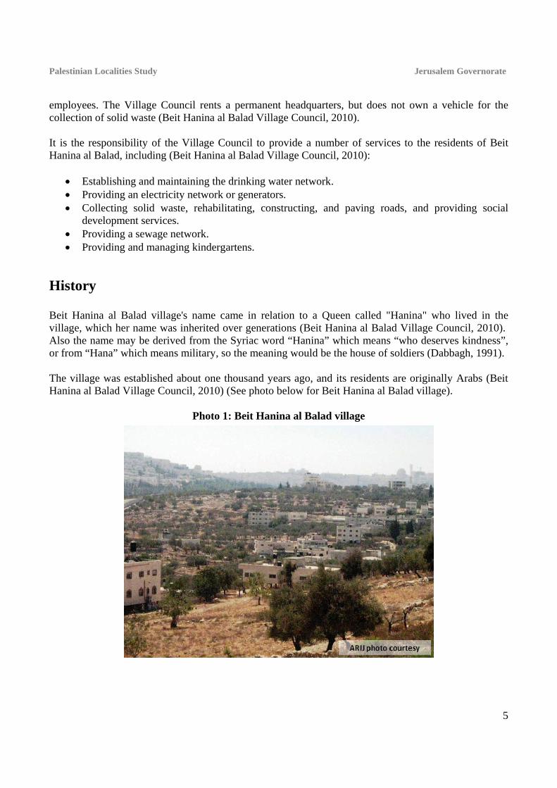
History Beit Hanina al Balad village's name came in relation to a Queen called "Hanina" who lived in the village, which her name was inherited over generations (Beit Hanina al Balad Village Council, 2010). Also the name may be derived from the Syriac word “Hanina” which means “who deserves kindness”, or from “Hana” which means military, so the meaning would be the house of soldiers (Dabbagh, 1991). The village was established about one thousand years ago, and its residents are originally Arabs (Beit Hanina al Balad Village Council, 2010) (See photo below for Beit Hanina al Balad village).
Photo 1: Beit Hanina al Balad village

Palestinian Localities Study Jerusalem Governorate
6
Religious and Archaeological Sites There is one mosque in the village, Ibrahim ben Adham Mosque. The Ash Sheikh Muhammad Shrine is of some archaeological interest (Beit Hanina al Balad Village Council, 2010). Additionally, there are some ruins (Khirab), including: Khirbet al Bayar, Khirbet ash Shomarah, Khirbet Kalilya and Khirbet al Hazoor (Al Dabbagh, 1991) (See Map 2).
Map 2: Main locations in Beit Hanina al Balad Village
Source: ARIJ - GIS Unit, 2012.

Palestinian Localities Study Jerusalem Governorate
7
Population According to the Palestinian Central Bureau of Statistics (PCBS), the total population of Beit Hanina al Balad in 2007 was 966, of whom 496 were male and 470 female. There were 181 households living in 409 housing units.
Age Groups and Gender The General Census of Population and Housing carried out by PCBS in 2007 showed the distribution of age groups in Beit Hanina al Balad was as follows: 37.8% were less than 15 years old, 48.1% were between the ages of 15 - 64, and 3.7% were 65 years of age or older. Data additionally showed that the sex ratio of males to females in the village is 105.5:100, meaning that males and females constituted 51.3% and 48.7% of the population respectively.
Families Beit Hanina al Balad residents are from several families, mainly the Abu Hamdah, Suleiman, Najjar, 'Ibdah and Abu Zahriya families (Beit Hanina al Balad Village Council, 2010).
Education According to the results of the PCBS Population, Housing and Establishment Census (2007), the illiteracy rate amongst the population of Beit Hanina al Balad was approximately 10.5%, of whom 80.3% were females. Concerning the literate population, 18.2% could only read and write with no formal education, 33.2% had elementary education, 24.1% had preparatory education, 9.6% had secondary education, and 4.3% completed higher education. Table 1 shows the educational level in the village of Beit Hanina al Balad by sex and educational attainment in 2007.
Table 1: Beit Hanina al Balad population (10 years of age and older) by sex and educational attainment, 2007
S E x
Illite-rate
Can read
& write
Elem-entary
Prepa-ratory
Second-ary
Associate Diploma
Bach-elor
Higher Diploma
Master PhD Un-
known Total
M 13 63 121 75 30 6 5 - 1 1 - 315
F 53 51 87 76 30 5 9 - - - 1 312
T 66 114 208 151 60 11 14 - 1 1 1 627
Source: PCBS, 2009. There are two public schools in the village run by the Palestinian Ministry of Education and Higher Education (MoEHE) (see Table 2) (Directorate of Education in Jerusalem, 2011).

Palestinian Localities Study Jerusalem Governorate
8
Table 2: The Schools in Beit Hanina al Balad by name, stage, sex, and supervising authority
School Name Supervising Authority Sex
Beit Hanina al Balad Girls High School Government
Female Al Adhamiya Co-educated Elementary School Mixed Source: Directorate of Education in Jerusalem, 2011
In the village there are 178 students, 26 teachers, and 14 classes (Directorate of Education in Jerusalem, 2011). The average number of students per teacher in the school is nearly 7, and the average number of students per class is approximately 13 (Directorate of Education in Jerusalem, 2011). There is one local kindergarten, Beit Hanina al Balad kindergarten, which is run by a private body, attended by 24 children in 2011 (Directorate of Education in Jerusalem, 2011). In case of the absence of any educational levels in the village, students of Beit Hanina al Balad attend neighboring villages' schools, including Bir Nabala Girls High School in Bir Nabala and Ibn Khaldoon Boys Elementary School in Al Jib, each about 2km from the village (Beit Hanina al Balad Village Council, 2010). The village faces some obstacles in the educational sector, primarily (Beit Hanina al Balad Village Council, 2010):
The lack of classrooms. The lack of computers and information technology equipment. The lack of health services provided by schools.
Health Status There is one governmental health center in Beit Hanina al Balad. In the absence of required health services in the village or in emergencies, residents of Beit Hanina al Balad go to Al Maqasid Charitable Society in Bir Nabala, Al Carmel Center in Biddu, or Ramallah Governmental Hospital in Ramallah city, 2km, 4km, and 9km from the locality respectively (Beit Hanina al Balad Village Council, 2010). The health sector in the village faces many obstacles and problems, including (Beit Hanina al Balad Village Council, 2010):
1. The lack of an ambulance in the village. 2. The restricted opening hours of the health centre. 3. The long shifts worked by healthcare staff. 4. The lack of medicine. 5. The lack of development or government interest in the health sector.
Palestinian Localities Study Jerusalem Governorate
9
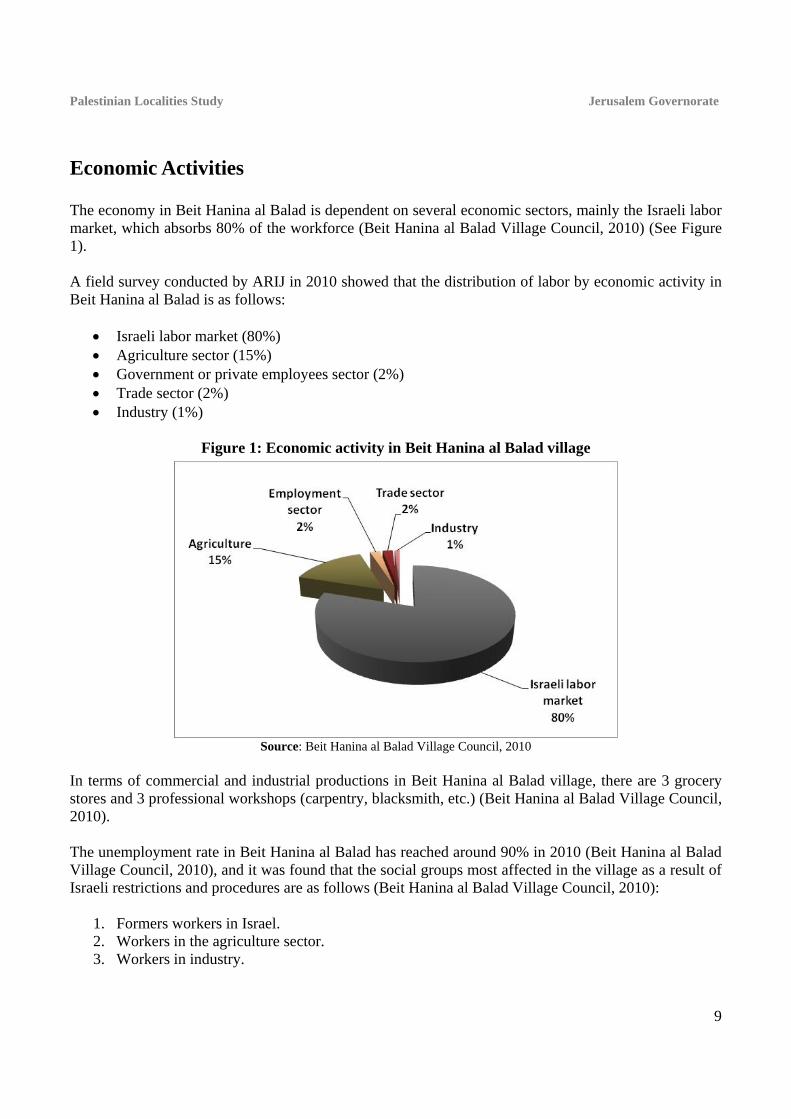
Economic Activities The economy in Beit Hanina al Balad is dependent on several economic sectors, mainly the Israeli labor market, which absorbs 80% of the workforce (Beit Hanina al Balad Village Council, 2010) (See Figure 1). A field survey conducted by ARIJ in 2010 showed that the distribution of labor by economic activity in Beit Hanina al Balad is as follows:
Israeli labor market (80%) Agriculture sector (15%) Government or private employees sector (2%) Trade sector (2%) Industry (1%)
Figure 1: Economic activity in Beit Hanina al Balad village
Source: Beit Hanina al Balad Village Council, 2010
In terms of commercial and industrial productions in Beit Hanina al Balad village, there are 3 grocery stores and 3 professional workshops (carpentry, blacksmith, etc.) (Beit Hanina al Balad Village Council, 2010). The unemployment rate in Beit Hanina al Balad has reached around 90% in 2010 (Beit Hanina al Balad Village Council, 2010), and it was found that the social groups most affected in the village as a result of Israeli restrictions and procedures are as follows (Beit Hanina al Balad Village Council, 2010):
1. Formers workers in Israel. 2. Workers in the agriculture sector. 3. Workers in industry.

Palestinian Localities Study Jerusalem Governorate
10
Labor Force According to the PCBS Population, Housing and Establishment Census (2007), 33.3% of Beit Hanina al Balad’s labor force was economically active, of whom 66% were employed, and 66% were not economically active, of whom 46.4% were students and 41.5% were housekeepers (See Table 3).
Table 3: Beit Hanina al Balad population (10 years and above) by sex and employment status-2007
S E X
Economically Active Not Economically Active
Un-known
Total
Emp-loyed
Currently Un-
employed
Un-employed
(Never worked)
Total Stud-ents
House- keeping
Unable to work
Not working & Not looking
for work
Other Total
M 126 8 61 195 89 1 21 2 3 116 4 315
F 12 - 2 14 103 171 24 - - 298 - 312
T 138 8 63 209 192 172 45 2 3 414 4 627
Source: PCBS, 2009.
Agricultural Sector Beit Hanina al Balad has a total area of around 4,186 dunums of which 1,629 are considered ‘arable’ land and 250 dunums are registered as ‘residential’ (See Table 4 and Map 3).
Table 4: Land use and land cover in Beit Hanina al Balad village in 2010 (area in dunums)
Total Area
Built up
Area
Agricultural area (1,629)
Inland water
Forests Open
Spaces
Area of Industrial,
Commercial & Transport Unit
Area of Settlements,
Military Bases &
Wall Zone Permanent
Crops Green-houses
Range-lands
Arable lands
4,186 250 954 0 303 372 0 40 1,884 121 262 Source: ARIJ – GIS Unit, 2012.

Palestinian Localities Study Jerusalem Governorate
11
Map 3: Land use/land cover in Beit Hanina al Balad village
Source: ARIJ - GIS Unit, 2012.
Table 5 shows the different types of fruit trees planted in the area. Beit Hanina al Balad is known for the cultivation of olives; there are 480 dunums of land cultivated with olive trees.
Table 5: Total area of fruit and olive trees in Beit Hanina al Balad (dunums)
Fruit trees Rainfed Irrigated Olives 480 0 Citrus 0 0 Stone-fruits 5 0 Pome fruits 0 0 Nuts 3 0 Other fruits 4 0 Total Area 492 0 Source: Palestinian Ministry of Agriculture - Jerusalem, 2010
In terms of field crops and forage in Beit Hanina al Balad, only cereals, particularly barley, are being cultivated covering an area of about 5 dunums (Palestinian Ministry of Agriculture - Jerusalem, 2010).
Palestinian Localities Study Jerusalem Governorate
12
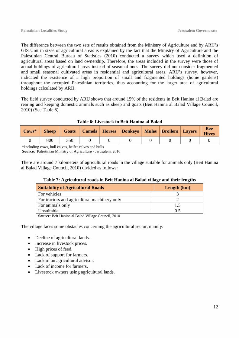
The difference between the two sets of results obtained from the Ministry of Agriculture and by ARIJ’s GIS Unit in sizes of agricultural areas is explained by the fact that the Ministry of Agriculture and the Palestinian Central Bureau of Statistics (2010) conducted a survey which used a definition of agricultural areas based on land ownership. Therefore, the areas included in the survey were those of actual holdings of agricultural areas instead of seasonal ones. The survey did not consider fragmented and small seasonal cultivated areas in residential and agricultural areas. ARIJ’s survey, however, indicated the existence of a high proportion of small and fragmented holdings (home gardens) throughout the occupied Palestinian territories, thus accounting for the larger area of agricultural holdings calculated by ARIJ. The field survey conducted by ARIJ shows that around 15% of the residents in Beit Hanina al Balad are rearing and keeping domestic animals such as sheep and goats (Beit Hanina al Balad Village Council, 2010) (See Table 6).
Table 6: Livestock in Beit Hanina al Balad
Cows* Sheep Goats Camels Horses Donkeys Mules Broilers Layers Bee
Hives 0 800 350 0 0 0 0 0 0 0
*Including cows, bull calves, heifer calves and bulls Source: Palestinian Ministry of Agriculture - Jerusalem, 2010
There are around 7 kilometers of agricultural roads in the village suitable for animals only (Beit Hanina al Balad Village Council, 2010) divided as follows:
Table 7: Agricultural roads in Beit Hanina al Balad village and their lengths
Suitability of Agricultural Roads Length (km)
For vehicles 3 For tractors and agricultural machinery only 2 For animals only 1.5 Unsuitable 0.5 Source: Beit Hanina al Balad Village Council, 2010
The village faces some obstacles concerning the agricultural sector, mainly:
Decline of agricultural lands. Increase in livestock prices. High prices of feed. Lack of support for farmers. Lack of an agricultural advisor. Lack of income for farmers. Livestock owners using agricultural lands.

Palestinian Localities Study Jerusalem Governorate
13
Institutions and Services Beit Hanina al Balad village has no governmental institutions. The village has one local institution providing services to the residents, the Beit Hanina al Balad Village Council, which was founded in 1999 by the Ministry of Local Government and aims to solve issues in the village and provide various services to its population.
Infrastructure and Natural Resources
Electricity and Telecommunication Services Beit Hanina al Balad has been connected to a public electricity network since 1968. It is served by Jerusalem Electricity Company, which is the main source of electricity in the village. Approximately 95% of the housing units in the village are connected to this network (Beit Hanina al Balad Village Council, 2010). Beit Hanina al Balad is connected to a telecommunication network and approximately 50% of the housing units within the village boundaries are connected to phone lines (Beit Hanina al Balad Village Council, 2010).
Transportation Services 8 illegal/unlicensed cars are the main means of transportation in Beit Hanina al Balad village (Beit Hanina al Balad Village Council, 2010). There are 0.8km of designated ‘main’ paved and in good condition roads and 5km of ‘secondary’ paved but in bad condition roads (Beit Hanina al Balad Village Council, 2010).
Water Resources Beit Hanina al Balad is provided with water by Jerusalem Water Authority through the public water network established in 1980. Approximately 100% of the housing units are connected to this network (Beit Hanina al Balad Village Council, 2010). The quantity of water supplied to Beit Hanina al Balad in 2009 was approximately 30,952 cubic meters/ year. Therefore, the average rate of water supply per capita in Beit Hanina al Balad is 79 liters per day. However no Beit Hanina al Balad citizen consumes this amount of water due to water losses, which are recorded at around 26.5%. These losses happen at the main source, major transport lines, in the distribution network, and at the household level. Therefore the rate of water consumption per capita in Beit Hanina al Balad is 58 liters per day. The rate experienced by Beit Hanina al Balad residents is low compared with the minimum quantity of 100 liters per capita per day proposed by the World Health Organization. However, the village also has 50 rainwater harvesting cisterns as an alternative source of water (Beit Hanina al Balad Village Council, 2010).

Palestinian Localities Study Jerusalem Governorate
14
To determine water costs the water authority has adopted an upward rate whereby the price of water increases in tandem with increases in consumption. Table 8 shows the price of water by category of consumption.
Table 8: Water tariffs of Jerusalem Water Authority adopted since 01.01.2012 (one month bill cycle)
Consumption Category (m³)
Domestic (NIS/m³)
Industrial (NIS/m³)
Tourist (NIS/m³)
Commercial (NIS/m³)
Public Institutions
(NIS/m³) 0 – 5 4.5 5.6 5.6 5.6 5.4
5.1 – 10 4.5 5.6 5.6 5.6 4.5 10.1 – 20 5.6 6.8 6.8 6.8 5.6 20.1 – 30 6.8 8.1 8.1 8.1 6.8
30.1+ 9 9.9 10.8 9 9 Source: Jerusalem Water Authority, 2012
Sanitation Beit Hanina al Balad has a public sewerage network established in 2000 (Beit Hanina al Balad Village Council, 2010). According to the results of the community survey conducted by the Applied Research Institute Jerusalem (ARIJ) in 2010 as part of the project ‘A Proposed Environmentally Sound Wastewater Management System for the West Bank’, the majority of Beit Hanina al Balad housing units (80%) use the sewage network as a primary means for wastewater disposal, while the rest of housing units (20%) use cesspits (ARIJ & CENTA, 2010). Based on the estimated daily per capita water consumption, the estimated amount of wastewater generated per day is approximately 50 cubic meters, or 18,200 cubic meters annually. At the individual level in the village, it is estimated that the per capita wastewater generation is 47 liters per day, depending on the consumption rate. The wastewater collected through the sewerage network and by cesspits is discharged by wastewater tankers directly to open areas or nearby valleys with no regard for the environment. There is no wastewater treatment either at the source or at the disposal sites and this poses a serious threat to both environmental and public health (ARIJ-WERU, 2012).
Solid Waste Management Beit Hanina al Balad Village Council is the official body responsible for managing the collection and disposal of solid waste generated by the citizens and establishments in the village. As the process of solid waste management is costly, a monthly fee has been charged to the population served by domestic solid waste collection and transportation services. However, only 45% of these fees are collected from the citizens (Beit Hanina al Balad Village Council, 2010). Most of the population in Beit Hanina al Balad benefit from the solid waste services, whereby waste is collected from households, institutions, shops, and public squares in plastic bags and then transferred to 15 containers1 distributed throughout the village. The Village Council collects the solid waste once a 1 Each with a medium sized capacity

Palestinian Localities Study Jerusalem Governorate
15
week, then transports it using a waste vehicle to a dumping site shared with neighboring localities located 2km from the village, where it is buried (Beit Hanina al Balad Village Council, 2010). The daily per capita rate of solid waste production in Beit Hanina al Balad is 0.7kg. Thus the estimated amount of solid waste produced per day from Beit Hanina al Balad residents is nearly 0.7 tons, or 274 tons per year (ARIJ-WERU, 2012).
Environmental Conditions Like other villages and camps in the Governorate, Beit Hanina al Balad experiences several environmental problems which must be addressed and solved. These problems are identified by Beit Hanina al Balad Village Council as follows: Water Crisis
Water is cut off by Jerusalem Water Authority for long periods of time in summer in several neighborhoods of the village. In addition to failing to supply the village residents with the required quantity of water; the rate of water consumption per capita is low and does not meet the individuals' daily water needs.
High rate of water losses, because the water network is old and in need of rehabilitation and renovation.
There is no public reservoir in the village to cover the residents’ water needs during water cut-offs.
Wastewater Management
The absence of a public sewage network in some neighborhoods (20%) forces the residents to use unhygienic cesspits for the disposal of wastewater, and/or discharge wastewater in the streets. This is particularly common in winter, as citizens cannot afford the high cost of sewage tankers during this period. These methods facilitate environmental damage, health problems, and the spread of epidemics and diseases in the village. This wastewater also contaminates the groundwater because most cesspits are built without lining, allowing wastewater to enter into the ground and avoiding the need to use sewage tankers. The untreated wastewater collected from cesspits by sewage tankers is disposed of in open areas without concern for the damage it causes to the environment and to residents' health.
Solid Waste Management:
The lack of a central sanitary landfill to serve Beit Hanina al Balad and other neighboring communities in the governorate is due mainly to the obstacles created by the Israeli authorities for local and national institutions in granting licenses to establish such a landfill, because the appropriate land is within Area C and under Israeli control. Additionally, the implementation of such projects depends on funding from donor countries. The lack of a sanitary landfill is a source of pollution to the groundwater and soil through the leachate produced from the solid waste, and produces bad odors and distortion of the landscape.
Palestinian Localities Study Jerusalem Governorate
16
There is no system in the village or the governorate to separate hazardous waste from non-hazardous waste, so hazardous and industrial solid waste are collected with non-hazardous waste and transported to landfill for disposal by burning or burial.
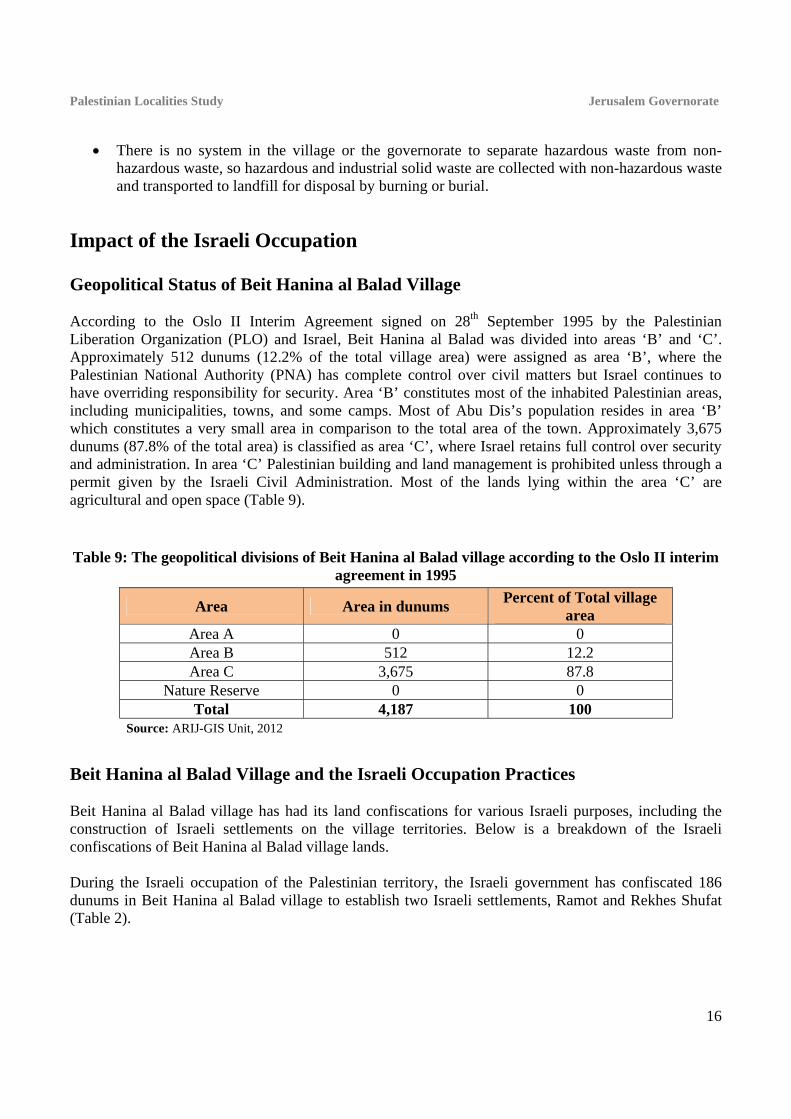
Impact of the Israeli Occupation Geopolitical Status of Beit Hanina al Balad Village According to the Oslo II Interim Agreement signed on 28th September 1995 by the Palestinian Liberation Organization (PLO) and Israel, Beit Hanina al Balad was divided into areas ‘B’ and ‘C’. Approximately 512 dunums (12.2% of the total village area) were assigned as area ‘B’, where the Palestinian National Authority (PNA) has complete control over civil matters but Israel continues to have overriding responsibility for security. Area ‘B’ constitutes most of the inhabited Palestinian areas, including municipalities, towns, and some camps. Most of Abu Dis’s population resides in area ‘B’ which constitutes a very small area in comparison to the total area of the town. Approximately 3,675 dunums (87.8% of the total area) is classified as area ‘C’, where Israel retains full control over security and administration. In area ‘C’ Palestinian building and land management is prohibited unless through a permit given by the Israeli Civil Administration. Most of the lands lying within the area ‘C’ are agricultural and open space (Table 9).
Table 9: The geopolitical divisions of Beit Hanina al Balad village according to the Oslo II interim agreement in 1995
Percent of Total village area
Area in dunums Area
0 0 Area A 12.2 512 Area B 87.8 3,675 Area C
0 0 Nature Reserve 100 4,187 Total
Source: ARIJ-GIS Unit, 2012
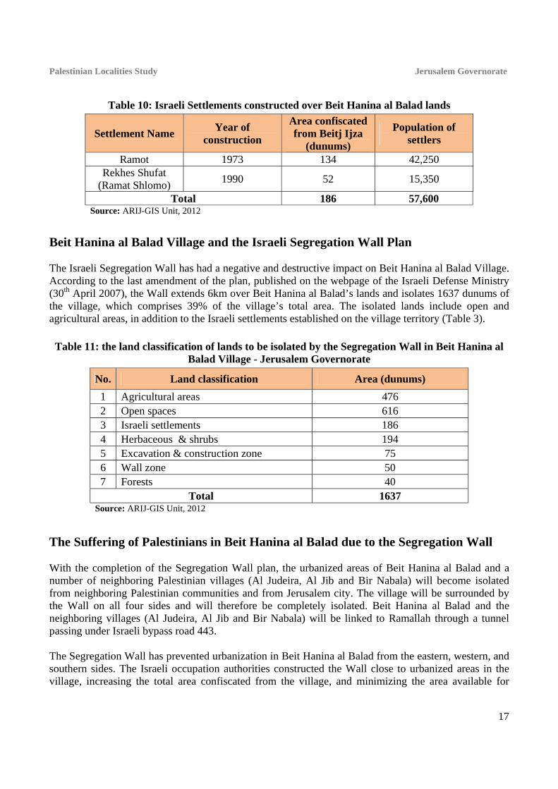
Beit Hanina al Balad Village and the Israeli Occupation Practices Beit Hanina al Balad village has had its land confiscations for various Israeli purposes, including the construction of Israeli settlements on the village territories. Below is a breakdown of the Israeli confiscations of Beit Hanina al Balad village lands. During the Israeli occupation of the Palestinian territory, the Israeli government has confiscated 186 dunums in Beit Hanina al Balad village to establish two Israeli settlements, Ramot and Rekhes Shufat (Table 2).
Palestinian Localities Study Jerusalem Governorate
17
Table 10: Israeli Settlements constructed over Beit Hanina al Balad lands
Settlement Name Year of
construction
Area confiscated from Beitj Ijza
(dunums)
Population of settlers
Ramot 1973 134 42,250 Rekhes Shufat
(Ramat Shlomo) 1990 52 15,350
Total 186 57,600 Source: ARIJ-GIS Unit, 2012
Beit Hanina al Balad Village and the Israeli Segregation Wall Plan The Israeli Segregation Wall has had a negative and destructive impact on Beit Hanina al Balad Village. According to the last amendment of the plan, published on the webpage of the Israeli Defense Ministry (30th April 2007), the Wall extends 6km over Beit Hanina al Balad’s lands and isolates 1637 dunums of the village, which comprises 39% of the village’s total area. The isolated lands include open and agricultural areas, in addition to the Israeli settlements established on the village territory (Table 3).
Table 11: the land classification of lands to be isolated by the Segregation Wall in Beit Hanina al Balad Village - Jerusalem Governorate
No. Land classification Area (dunums)
1 Agricultural areas 476 2 Open spaces 616 3 Israeli settlements 186 4 Herbaceous & shrubs 194 5 Excavation & construction zone 75 6 Wall zone 50 7 Forests 40
Total 1637 Source: ARIJ-GIS Unit, 2012
The Suffering of Palestinians in Beit Hanina al Balad due to the Segregation Wall With the completion of the Segregation Wall plan, the urbanized areas of Beit Hanina al Balad and a number of neighboring Palestinian villages (Al Judeira, Al Jib and Bir Nabala) will become isolated from neighboring Palestinian communities and from Jerusalem city. The village will be surrounded by the Wall on all four sides and will therefore be completely isolated. Beit Hanina al Balad and the neighboring villages (Al Judeira, Al Jib and Bir Nabala) will be linked to Ramallah through a tunnel passing under Israeli bypass road 443. The Segregation Wall has prevented urbanization in Beit Hanina al Balad from the eastern, western, and southern sides. The Israeli occupation authorities constructed the Wall close to urbanized areas in the village, increasing the total area confiscated from the village, and minimizing the area available for
Palestinian Localities Study Jerusalem Governorate
18
future urban expansion. This move will create a new socio-geographic reality, as it will further increase the high population and urbanization density in the village due to the lack of land for construction and expansion. The Segregation Wall has separated Beit Hanina al Balad village from the ‘mother locality’ of Beit Hanina, cutting the social, geographical, and historical connections between the two localities and separating some families from each other. The construction of the Wall has also caused the migration of many residents to areas that remain within the boundaries of Jerusalem Municipality, since many Palestinian residents of Beit Hanina al Balad hold Jerusalem IDs and do not wish to be deprived of their rights to reside within the city boundaries or to undergo long and difficult travel when accessing healthcare, employment, and education.
Ramallah City as a Substitute for Jerusalem City Since the outbreak of the Second Intifada in 2000, Palestinians living in Beit Hanina al Balad and other villages have lost their link with Jerusalem City, previously the primary source of employment, educational, and health services. Residents of Beit Hanina al Balad have therefore started using Ramallah City to fulfill these needs.
Long Tunnel to Connect the North with the North-west of Jerusalem With the construction of the Segregation Wall around the city of Jerusalem, many of the surrounding Palestinian communities have been separated from the city itself. Additionally, the Wall separates Palestinian villages north of Jerusalem from those in the north-west through the annexation of the Giv'at Ze'ev settlement bloc. For this reason, the Israeli occupation authorities have established an underground tunnel of 1.5 kilometers in length to connect the villages north of Jerusalem (about six villages) through Al Jib village with the north-west villages of Jerusalem (about nine) through Biddu town. Palestinians must travel through this tunnel to reach Ramallah city and areas north of Jerusalem (map 4).
Israeli Military Orders Issued in Beit Hanina al Balad Village The Israeli occupation authorities have issued a set of military orders to confiscate lands in Beit Hanina al Balad village for various military purposes. These include Israeli military order 21/06/T, issued in January 2006 to confiscate 129 dunums in Beit Hanina al Balad and Bir Nabala for the construction of the Wall.

Map 4: Long Tunnel to Connect the North with the North-west of Jerusalem
Source: ARIJ - GIS Unit, 2012.

Development Plans and Projects
Implemented Projects Beit Hanina al Balad Village Council has implemented few development projects in Beit Hanina al Balad during the past five years (See Table 12).
Table 12: Implemented development plans and projects in Beit Hanina al Balad during the last five years
Name of the Project Type Year Donor
Beit Hanina al Balad water project Infrastructure 2008 KFW Pavement of the village entrance Infrastructure 2009 Ministry of Local Government Source: Beit Hanina al Balad Village Council, 2010
Proposed Projects Beit Hanina al Balad Village Council, in cooperation with the civil society organizations in the village and the village residents, hopes to implement several projects in the coming years. The project ideas were developed during the PRA workshop conducted by ARIJ staff in the village. The projects are as follows, in order of priority from the perspectives of the participants in the workshop:
1. Constructing agricultural roads, establishing agricultural wells, and reclaiming lands. 2. Supporting farmers. 3. Finishing the sports club building. 4. Supporting small projects and providing families with sheep, layer chickens, and beehives. 5. Establishing a women’s center. 6. Restoring old houses of archaeological interest. 7. Establishing a public park. 8. Establishing a football field.

Palestinian Localities Study Jerusalem Governorate
21
Village Development Priorities and Needs
Beit Hanina al Balad suffers from a significant shortage of infrastructure and services. Table 13 shows the development priorities and needs in the village, according to the village council’s feedback (Beit Hanina al Balad Village Council, 2010).
Table 13: Development priorities and needs in Beit Hanina al Balad
No. Sector Strongly Needed
Needed Not a
Priority Notes
Infrastructural Needs 1 Opening and Pavement of Roads * 9km 2 Rehabilitation of Old Water Networks * 3 Extending the Water Network to Cover New Built up
Areas *
4 Construction of New Water Networks * 5 Rehabilitation/ Construction of New Wells or Springs * 6 Construction of Water Reservoirs * 2000 cubic meters 7 Construction of a Sewage Disposal Network * 8 Construction of a New Electricity Network * 9 Providing Containers for Solid Waste Collection * 30 containers 10 Providing Vehicles for Collecting Solid Waste * 11 Providing a Sanitary Landfill *
Health Needs 1 Building of New Clinics or Health Care Centres * 2 Rehabilitation of Old Clinics or Health Care Centres * one health center 3 Purchasing of Medical Equipment and Tools *
Educational Needs 1 Building of New Schools * 2 Rehabilitation of Old Schools
* preparatory &
secondary levels 3 Purchasing of New Equipment for Schools *
Agriculture Needs 1 Rehabilitation of Agricultural Lands * 200 dunums 2 Building Rainwater Harvesting Cisterns * 15 cisterns 3 Construction of Barracks for Livestock * 4 Veterinary Services * 5 Seeds and Hay for Animals * 6 Construction of New Greenhouses * 15 greenhouses 7 Rehabilitation of Greenhouses * 8 Field Crops Seeds * 9 Plants and Agricultural Supplies * 4km are main roads and 5km are agricultural.
Source: Beit Hanina al Balad Village Council, 2010

Palestinian Localities Study Jerusalem Governorate
22
References Al Dabbagh, M 1991. Our Country, Palestine; Chapter 8, Part Two. Kafr Qari' – Palestine. Dar al
Huda Press. Applied Research Institute - Jerusalem (ARIJ), 2012. Geographic Information Systems and
Remote Sensing Unit Database. Bethlehem - Palestine. Applied Research Institute - Jerusalem (ARIJ), 2012. Geographic Information Systems and
Remote Sensing Unit; Land Use Analysis (2010) – Half Meter High Accuracy. Bethlehem - Palestine.
Applied Research Institute - Jerusalem (ARIJ). 2012. Water & Environment Research Unit Database (WERU). Bethlehem - Palestine.
Beit Hanina al Balad Village Council, 2010. Ministry of Education & Higher Education (MOHE) - Jerusalem, 2011. Directorate of Education;
A database of schools (2010/2011). Jerusalem – Palestine. Palestinian Central Bureau of Statistics. 2009. Jerusalem, Palestine: General Census of Population
and Housing Censuses, 2007. Palestinian Ministry of Agriculture (MOA), 2010. Directorate of Agriculture data (2009/2010).
Jerusalem - Palestine. Jerusalem Water Authority (2012). Jerusalem Water Authority's Website; Data Retrieved on the
first of March. http://www.jwu.org/newweb/atemplate.php?id=87. Applied Research Institute - Jerusalem (ARIJ) & Spanish Centre of New Water Technologies
(CENTA) (2010). A Proposed Environmentally Sound Wastewater Management System for the West Bank. 2010. Bethlehem – Palestine.