behavior and identification of ephemeral sand dunes at … · the beach morphology is identified...
TRANSCRIPT
An Acad Bras Cienc (2016) 88 (3)
Anais da Academia Brasileira de Ciências (2016) 88(3): 1357-1369(Annals of the Brazilian Academy of Sciences)Printed version ISSN 0001-3765 / Online version ISSN 1678-2690http://dx.doi.org/10.1590/0001-3765201620150656www.scielo.br/aabc
Behavior and identification of ephemeral sand dunes at the backshore zone using video images
PEDRO V. GUIMARÃES1,*, PEDRO S. PEREIRA2, LAURO J. CALLIARI1 and JEAN T. ELLIS3
1Laboratório de Oceanografia Geológica, Instituto de Oceanografia, Universidade Federal do Rio Grande, Av. Itália, Km 8, Caixa Postal 474, 96201-900 Rio Grande, RS, Brasil
2Laboratório de Oceanografia Geológica, Departamento de Oceanografia, Universidade Federal de Pernambuco, Av. Arquitetura, s/n, Cidade Universitária, 50740-550 Recife, PE, Brasil
3Department of Geography and Marine Science Program, University of South Carolina, Columbia, SC, 29208, USA
Manuscript received on October 5, 2015; accepted for publication on April 25, 2016
ABSTRACTThe backshore zone is transitional environment strongly affected by ocean, air and sand movements. On dissipative beaches, the formation of ephemeral dunes over the backshore zone plays significant contribution in the beach morphodynamics and sediment budget. The aim of this work is to describe a novel method to identify ephemeral dunes in the backshore region and to discuss their morphodynamic behavior. The beach morphology is identified using Argus video imagery, which reveals the behavior of morphologies at Cassino Beach, Rio Grande do Sul, Brasil. Daily images from 2005 to 2007, topographic profiles, meteorological data, and sedimentological parameters were used to determine the frequency and pervasiveness of these features on the backshore. Results indicated that coastline orientation relative to the dominant NE and E winds and the dissipative morphological beach state favored aeolian sand transport towards the backshore. Prevailing NE winds increase sand transportation to the backshore, resulting in the formation of barchans, transverse, and barchanoid-linguiod dunes. Precipitation inhibits aeolian transport and ephemeral dune formation and maintains the existing morphologies during strong SE and SW winds, provided the storm surge is not too high.Key words: aeolian sand transport, Argus, beach processes, incipient dunes, remote sensing.
Correspondence to: Pedro Veras Guimarães *Present address: LHEEA lab, UMR6598, Ecole Centrale de Nantes, France and Univ. Brest, CNRS, IRD, Ifremer, Laboratoire d’Océanographie Physique et Spatiale (LOPS), IUEM, Brest, France E-mail: [email protected]
INTRODUCTION
Coastal sand dunes are common geomorphological features on sandy beaches resulting from the dynamic interaction between sand and wind and ultimately the deposition and accumulation of sand.
Dunes create a transitional environment between marine and terrestrial ecosystems, which express multiple purposes, such as protection to natural ecosystems and urban occupation and shoreline maintenance.
Dunes may initiate by the migration of wind ripples under conditions of net deposition that give rise to bedform climbing (Rubin and Hunter 1982). In conditions where wind shear stress decreases downwind, the transport capacity of the wind

An Acad Bras Cienc (2016) 88 (3)
1358 PEDRO V. GUIMARÃES, PEDRO S. PEREIRA, LAURO J. CALLIARI and JEAN T. ELLIS
declines and the sediment excess is deposited or transferred to the bed, producing wind ripple laminae. As a result, their sediments provide a record of dune accumulation and can therefore provide important information on the processes of dune formation and development. The transport of sediment by the wind involves interactions between the wind and the ground surface. The gradual development of the surface landform causes a disturbance in the wind field that aids in sediment deposition. This process usually accelerates the dune’s formation and is responsible for the defining the dune morphology.
The outline of dune formation depends on the onshore wind capability of moving the sand over the surface. If wind velocity exceeds a critical value then sediments also will begin to move (Bagnold 1941). The fluid forces of lift and drag operate to move sand grains upward and downward, respectively. However, to start the movement, the lift forces must exceed the forces opposing the motion, which basically are the gravity and any cohesive agent (e.g., surface moisture) (Middleton and Southard 1984).
Once grains have initiated motion, the mass transport rate can be estimated using models. Many models are based on the cube of shear velocity (e.g., Bagnold 1937, Owen 1964, Hsu 1971, Lettau and Lettau 1978), were formulated in laboratory conditions, and assume ideal conditions (c.f., Ellis and Sherman 2013). However, it was been well documented that ideal conditions (dry, flat surface, uniform grain size, no vegetation) are not obtainable in natural conditions, and thus the models are unable to accurately predict in situ wind-blown sand transport rates (e.g., Sherman et al. 1998, 2013, Dong et al. 2003). Furthermore, coastal dunes systems are complicated because the morphodynamics result from interactions in the natural environment that operate over multiple time scales (Sherman and Bauer 1993).
Dissipative beaches are characterized by fine sand, a large backshore area, low slope, and adequate
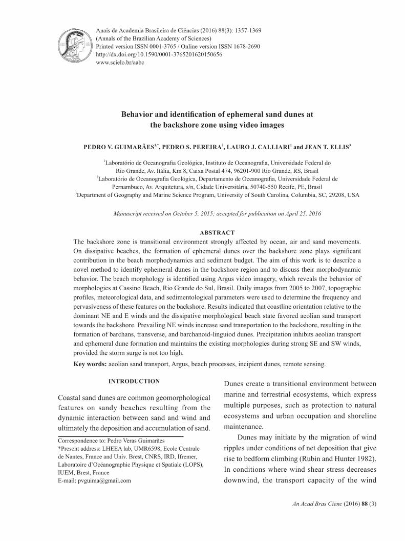
sediment supply (Wright and Short 1984). These natural characteristics of dissipative sand beaches support the development of sand dunes from the direct airflow over the backshore zone (Short and Hesp 1982). These unanchored structures over the backshore zone can be named ephemeral dunes. Over the backshore zone, this morphologies are not affixed or established by the vegetation, thus can be easily transported or eroded, so being an important part of sediment budget network in the sand beaches. Figure 1 exemplifies the occurrence of ephemeral dunes on Cassino’s Beach backshore.
Ephemeral dunes can be classified as uncon-solidated landforms deposited on the beach back-shore (Fig. 1). These dunes play an important part of sediment budget in the beach because their sand supply can rapidly change from fluctuating prevail-ing winds. Due to their temporary nature, little is known of their formation, mobility or the specifics of their interaction with beach surface character-istics (Nield et al. 2011). Different of embryonary dunes, formed on the toe of established foredunes (Hesp 2002). However, it is understood that ephem-eral dune morphology responds quickly to changes in the local wind field speed and direction.
According to the Livingstone and Warren (1996) dune classification system, the free dunes are: transverse, transverse, barchans, dome, reversing. Some dune morphologies can be highly dynamic structures, and quickly responsive to fluctuating wind conditions.
Delgado-Fernandez et al. (2009) used cameras to investigate aeolian processes at a beach-dune system over meso-temporal scales. Montreuil et al. (2013) used Digital Elevation Models (DEMs) and satellite images to classify the seasonal cycle of ephemeral and embryonic dunes. Nield et al. (2011) employed a terrestrial laser scanner to monitor beach surface moisture variability on the ephemeral dune morphodynamics before and after a rain event. The proceeding studies demonstrated the efficacy of investigating dune morphdynamics
An Acad Bras Cienc (2016) 88 (3)
OBSERVATION AND BEHAVIOR OF EPHEMERAL SAND DUNES 1359
and process in a natural field environment using remote sensing technologies. In this study we propose the utilization of an Argus system for a long-term analysis with a high sample frequency, a temporal scale not previously investigated.
The Argus cameras network consists of video cameras installed over high land areas or in tow-ers that captures images from the beach and surf zone, at many locations around the globe (Holman and Stanley 2007). With these images, it is pos-sible to study nearshore processes (Holman et al. 1991) and to identify and describe important geo-morphological features that are found at the beach, such as sandbars morphologies (Holland and Hol-man 1997, Lippmann and Holman 1990), intertidal beach profiles (Plant and Holman 1997), subaerial beach profiles (Holman et al. 1991), and beach cusps (Holland 1998). This paper will use Argus
image for the first time to track and monitor ephem-eral dune changes over space and time. Therefore, the aim of this study is to present a novel method to identify the occurrence and understand the morpho-dynamic behavior of the ephemeral dunes along the backshore, through a remote video imagery system installed at Cassino Beach, southern Brazil.
Regional Setting
Cassino Beach is located in the southernmost part of Brazil in Rio Grande do Sul (RS). It is 220 km long and bounded by the Patos Lagoon inlet to the north and the Chuy Stream, which is the border with Uruguay, to the south. This study was executed at Querência Beach, which is a portion of Cassino Beach. It was focused on a 300 m section of the backshore zone that is between the high swash mark and vegetated foreduens directly onshore of
Figure 1 - Image of Cassino Beach showing ephemeral dunes in the backshore.

An Acad Bras Cienc (2016) 88 (3)
1360 PEDRO V. GUIMARÃES, PEDRO S. PEREIRA, LAURO J. CALLIARI and JEAN T. ELLIS
the Marine Aquaculture Station (Estação Marinha de Aquacultura, EMA). The Argus video station is installed at the EMA (Figure 2). Aeolian processes dominate the study area except during severe storm events when waves are the dominant geomorphic process.
Querência Beach is a dissipative sandy beach composed of fine and very fine sands with an average grain size of 0.18 mm (Calliari and Klein 1993). Tozzi and Calliari (2000) characterized the beach as a microtidal, wave dominated environment. The average wave heights and periods are 1-1.5 m and 6-8 s, respectively; however, during storms the waves can exceed 2.5 m in shallow water with a 14 s peak wave period (Guimarães et al. 2014). The
minor influence of the astronomical tide is offset by meteorological tide influences, which causes rapid sea level fluctuations approximating 2 m (Calliari et al. 1998). The storm surges are responsible for the highest water level oscillations on the beach and occur when a low pressure system is over at the adjacent ocean and a high pressure system is over the continent (Marrone and Camargo 1994). The storm surge waves can reach the foredune and cause erosion.
Wind patterns are controlled by seasonal anticyclones: the South Atlantic Tropical Anticyclone (SATA) and Polar Migratory Anti-cyclone (PMA) (Nimer 1989, Tomazelli 1990). The SATA is a high-pressure center comprising
Figure 2 - Study area centered around the Argus station on Querência Beach, which is within Cassino Beach. The Pilot Station where the metrological data were collected is shown. The background image is from Landsat TM (2006). The two insets show (top) the country of Brazil with the RS state highlighted; and (bottom) RS with the study area marked as a square.

An Acad Bras Cienc (2016) 88 (3)
OBSERVATION AND BEHAVIOR OF EPHEMERAL SAND DUNES 1361
warm and wet air with winds mainly from the E-NE (Zhou and Lau 1998) that prevails during the spring and summer months (September to March). The PMA prevails in the fall and winter in the southern hemisphere and is a high-pressure center fed by cold air masses from Antarctica. The PMA is more active, and consequently, the resultant S and SW cyclonic winds prevail during the colder months (Krusche et al. 2002).
MATERIALS AND METHODS
Field-BaSed data
Meteorological data was acquired from the Rio Grande Pilots Station located on the southwest side of the Rio Grande navigation channel (Fig. 2). The instruments collect hourly averages of wind speed and direction at 22 m above the surface.
Beach profiles were conducted from March 2005 to February 2007 by the Geological Ocean-ography Laboratory (LOG) research group at the Federal University of Rio Grande (FURG). One hundred fifty seven profiles were acquired using
a total station and an optic prism. The total sta-tion was positioned over a benchmark located in front of the Argus video cameras. The benchmark was assigned as the local coordinate system origin (0,0). The profiles were performed by recording the morphological difference along the line and then interpolated to have a regular spacing between points of 1 m along the cross-shore direction.
aRguS data
The Cassino Beach Argus station has four video cameras installed on a 14 m high tower. The station has been operational since March 2005 and continues to capture images during the daylight hours (current as of 01/2016). Similar to others Argus stations, the three main data products are: 1) snapshot images; 2) a 10-minute time-exposure image; and 3) a 10-minute variance image (Holman and Stanley 2007). The snapshot is a single video frame: the first of a ten-minute video recorded by the system. The time-exposure image, or timex, is an average of all 600 video frames collected
Figure 3 - a) Example timex products from each Argus camera (C1, C2, C3, and C4) at Cassino Beach; b) Rectified and merged timex images from the four cameras shown in (a). The backshore zone identified in the image exemplifies the study area.
An Acad Bras Cienc (2016) 88 (3)
1362 PEDRO V. GUIMARÃES, PEDRO S. PEREIRA, LAURO J. CALLIARI and JEAN T. ELLIS
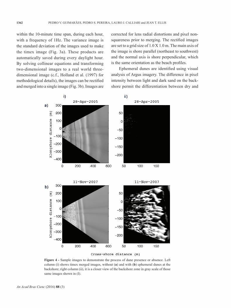
within the 10-minute time span, during each hour, with a frequency of 1Hz. The variance image is the standard deviation of the images used to make the timex image (Fig. 3a). These products are automatically saved during every daylight hour. By solving collinear equations and transforming two-dimensional images to a real world three-dimensional image (c.f., Holland et al. (1997) for methodological details), the images can be rectified and merged into a single image (Fig. 3b). Images are
corrected for lens radial distortions and pixel non-squareness prior to merging. The rectified images are set to a grid size of 1.0 X 1.0 m. The main axis of the image is shore parallel (northeast to southwest) and the normal axis is shore perpendicular, which is the same orientation as the beach profiles.
Ephemeral dunes are identified using visual analysis of Argus imagery. The difference in pixel intensity between light and dark sand on the back-shore permit the differentiation between dry and
Figure 4 - Sample images to demonstrate the process of dune presence or absence. Left column (i) shows timex merged images, without (a) and with (b) ephemeral dunes at the backshore; right column (ii), it is a closer view of the backshore zone in gray scale of those same images shown in (I).

An Acad Bras Cienc (2016) 88 (3)
OBSERVATION AND BEHAVIOR OF EPHEMERAL SAND DUNES 1363
wet sand, respectively. Figure 4 is an example of such separation. Applying a filter to extract the higher portions of the image intensity spectrum, in gray scale, assists with the visual identification of ephemeral dunes along the beackshore (Fig.4.ii.b).
RESULTS
BackShoRe duneS
A total of 8707 Argus images, collected between March 31 2005 and November 17 2007 were obtained and analyzed. Ephemeral dunes were identified on the backshore on 1879 images, which corresponds to 241 days (or 21.6% of the available images). The 1879 images were compared with the beach profiles (Fig. 5). The comparative analysis between the beach profiles and the Argus images, which have the same coordinate system origin, allow for the identification of the presence
of ephemeral dunes. Therefore, by identifying morphologies in the image and in the profile, it was possible to determine the height on a point within in the picture, so morphology changes on the image are compared with the altimetric variations of the terrain to estimate morphology height.
Of the 157 beach profiles surveyed, only 16 had a temporally corresponding Argus image. From the analysis of the 16 profiles, the topographic features have an average height of 0.7 m, with a range of 0.3 m to 1.0 m.
The identification process was hindered by the presence of rain. Rainfall blurs the image prohibit-ing the differentiation between dry and wet sand (the entire backshore is wet). Gaps in the image time series make it difficult to track dune develop-ment; and sometimes, the large variation of solar radiation during the day and across seasons make it
Figure 5 - In the left Sample Argus image with dunes at the backshore zone and the corresponding beach profile. On the right, surveyed at the same time as the Argus images were captured.

An Acad Bras Cienc (2016) 88 (3)
1364 PEDRO V. GUIMARÃES, PEDRO S. PEREIRA, LAURO J. CALLIARI and JEAN T. ELLIS
difficult to create a generic computational algorithm to perform an automatized dune identification.
tempoRal analySiS oF ephemeRal duneS
Using the 8707 Argus images, patterns of the occurrence of ephemeral dunes, their depositional and erosional cycles, as well as, the identification of the key agents responsible for their morphological changes were determined. Figure 6 displays their occurrence in time, with the black lines and the
blank spaces representing the presence and absence, respectively, of ephemeral dunes on the backshore.
Fig. 7 shows the number ephemeral dunes iden-tified in the backshore zone by month, axis (a), the axis (b) shows normalized data in percentage. The percentage is determined by comparing the number of images with dunes during each month with the total number of images collected that month.
The dune presence/absence time series (Fig. 7a) indicates higher dune occurrence during September, October and November, which is during
Figure 6 - Ephemeral dunes occurrence. The lines represent images where dunes could be visually identified at the backshore. The time series began on March 3 of 2005 and ended on November 17 of 2007.
Figure 7 - Dunes occurrence per month at the backshore zone during the years of 2005, 2006 and 2007. The (b) axis show a Normalized data from axis (a), showing number of images with dunes during each month compared to the total number of images collected that month, as a percentage.

An Acad Bras Cienc (2016) 88 (3)
OBSERVATION AND BEHAVIOR OF EPHEMERAL SAND DUNES 1365
the spring season. This time of year is dominated by strong E-NE winds, (Krusche et al. 2002) and SATA. According to Tomazelli (1993) and Calliari et al. (2005) the E and NE winds are the prevailing winds that build the dunes at the upper foreshore and backshore zones.
The highest number of ephemeral sand dunes identified in the spring is mainly due to the large number of occurrences in 2006. Of the 1879 images with dunes, 918 were in 2006, compared to 388 in 2005 and 573 in 2007. However, 2006 was the only complete year of data collection with January-March and November-December having only two of three years of data.
DISCUSSION
Changes in slope along the beach profile can ac-celerate or decelerate wind speed, thereby affect-ing sand transport potential. Generally, dissipative beaches have low slopes. Rather, higher slopes tend bifurcate the flow, increasing the effect of gravity, thus potentially reducing rates of sediment trans-port (Hesp 1999). Figueiredo and Calliari (2006) report that Querência Beach has a high percentage of fine and very fine sand that contributes to a dissi-pative beach with low beach mobility, wide profile, gentle slope and absence of bumps and a impercep-tible berm. Therefore, these beach characteristics lead to a high potential for sand to be transported toward the backshore.
The extent and magnitude of beach moisture at this site is variable and depends on precipitation, storm surge, salt spray, and solar radiation. Precipitation dampens the sediment without modifying its morphological structure; salt spray moistens the most superficial layers of sand and is quickly evaporated by solar radiation. Storm surges cause sea level rise and wave action over the backshore causing erosion of the berm and backshore that destroys (flattens) any morphological structure and leaves the area inundated.
A cross-shore moisture horizontal gradient is frequently observed at our study site. The swash zone presents high levels of moisture due to frequent wave action, while the beach berm and backshore are only wet during storm surge events, precipitation and salt spray. However at this site, strong NE winds induce negative storm surges that can lower the water level. The combination of a wider beach and dry sand increases the fetch and the potential for sand transport towards the backshore, especially when the wind blows at an oblique angle (Saraiva et al. 2003). Increasing the backshore area exposed to wind stress also increases the fetch area. These characteristics significantly favor an alongshore ephemeral dune migration.
Figure 7 shows there are a high number of ephemeral dunes in September-December of 2006, which is during the spring season. The directional variability of the wind measured at the Pilot station during spring 2006 is shown in Figure 8. The performed relatively high frequency of winds exceeding 10 m/s suggest a high potential for transport; over 30% of Querência comprises very fine sand (Calliari and Klein 1993).
The spring winds in 2006 were predominantly from the NE and E quadrants (oblique landward and alongshore orientation). According to Hesp (2002), different wind orientations can result in oblique transport towards the coast, and oblique or shore parallel winds increase or decrease the potential for foredune formation, respectively. The same approach was used by Calliari et al. (2005).
Figure 9 shows details of the atmospheric data for the spring of 2006 to better understand the driving mechanisms for ephemeral dune destruction. Note that the circles on panels a and b indicate dunes are present in the Argus images. These data show that winds from NE and E, with velocities between 5 and 15 m/s, were primarily responsible for the incipient dunes formation at the backshore zone, while the winds with speeds exceeding 15 m/s from the SE and SW erode these

An Acad Bras Cienc (2016) 88 (3)
1366 PEDRO V. GUIMARÃES, PEDRO S. PEREIRA, LAURO J. CALLIARI and JEAN T. ELLIS
Figure 9 - Atmospheric data from the spring of 2006 collected from the Pilot Station (a, b, c) and the FURG meteorological station (d). The circles (a, b) show when ephemeral dunes were identified. (a) Wind direction. (b) Wind speed. (c) Wind direction, where north is a line pointing down (d) represents the rainfall accumulated per hour at the 2006 spring.
Figure 8 - Wind intensity frequency during the spring of 2006 from the Pilot Station.

An Acad Bras Cienc (2016) 88 (3)
OBSERVATION AND BEHAVIOR OF EPHEMERAL SAND DUNES 1367
features. Precipitation had a negative effect on the dunes identification because of the sand has no contrasting color. Once the dunes were formed, the precipitation has a positive effect on dune maintenance at the backshore, especially during SW and W strong winds.
Winds that blow from the SW to SE quadrant strongly affect the backshore morphology, normally eroding this zone. In general, they are associated with a low cyclonic pressure center and are able to generate storm surges on the coast. Figure 10 demonstrates one of these events where the incipient dunes were washed out by the surge.
Regarding the ephemeral dune shape, the photogrammetry transformations necessary to create the mosaic distort the aerial portions of the image and make difficult to classify dune morphology. However, from field observations (e.g., Fig. 1) it is possible to categorize the dunes within the transverse group, specifically transverse, barchan, and barchanoid-lingoid (using Livingston and Warren 1996).
CONCLUSIONS
Ephemeral dunes were identified as high transitory features identified over the backshore zone. This paper presented a new method to study ephemeral dunes in field conditions. This analysis is only possible by high frequency image analysis over a long time series. This work spatially expands the use of the Argus system to extend behind the swash zone to the dunes system.
As result of the analysis of beach profiles, video images, and meteorological data it was possible to determine the absence and presence of ephemeral dunes along the backshore of Cassino Beach. More specifically, the presence of these features were frequently distributed throughout the year, more often during the spring months. Using a time series of images collected between 2005 and 2007, we identified that the majority of the ephemeral dunes were found in 2006 (48.73%).
The data suggest that winds exceeding 10 m/s from NE and E were primarily responsible for the formation of ephemeral dunes at the backshore. The prevailing winds from NE during the spring of
Figure 10 - At the left image it is possible to observe sand dunes at the backshore; at the right is an image captured on the day after the one in the left with the water and waves overtopping the ephemeral dunes, and consequently eroding them.

An Acad Bras Cienc (2016) 88 (3)
1368 PEDRO V. GUIMARÃES, PEDRO S. PEREIRA, LAURO J. CALLIARI and JEAN T. ELLIS
2006 resulted in a large amount of sand transported to the backshore forming transverse dune types. Winds exceeding 15 m/s from the SE and SW di-rection erode the ephemeral features. Also, storm surges and the accompanying sea level rise result in wave action over the backshore, causing erosion of the berm and backshore that destroys any mor-phological structure and leaves the area inundated.
Precipitation hinders the dune identification process. However, precipitation has a positive effect in maintaining dune morphologies during strong SE and SW winds. Else, provided that storm surges, the main erosion agent is not too high.
ACKNOWLEDGMENTS
Special thanks to Nisia Krusche, who helped with the meteorological data processing. We would like also to thanks Renato Espirito Santo, Rafael Guedes, Claudia Parise and Natan Maia for shar-ing the profiles data. The first author would like to express his gratitude to Fundação de Amparo à Pes-quisa do Estado do Rio Grande do Sul (FAPERGS) for the scientific initiation scholarship and for the Rio Grande Pilot’s Station for making wind data available through a collaborative effort with the LocFis/FURG. JTE acknowledges the Fulbright Scholars Program.
REFERENCES
BAGNOLD RA. 1937. The transport of sand by wind. Geogr J 89: 409-438.
BAGNOLD RA. 1941. The physics of blown sand and desert dunes. Dover P., 320 p.
CALLIARI LJ AND KLEIN AH. 1993. Características Morfodinâmicas e Sedimentológicas das Praias Oceânicas Entre Rio Grande e Chuí, RS. Pesq Geo UFRGS 20(1): 48-56.
CALLIARI LJ, TOZZI HAM AND KLEIN AHF. 1998. Beach morphology and Coastline Erosion Associated with Storm Surge in Southern Brazil- Rio Grande to Chuí, RS. An Acad Bras Cienc 70(2): 231-247.
CALLIARI LR, PEREIRA PS, OLIVEIRA AO AND FIGUEIREDO SA. 2005. Variabilidade das Dunas Frontais no Litoral Norte e Médio do Rio Grande do Sul, Brasil. Gravel 3: 15-30.
DELGADO-FERNANDEZ I, DAVIDSON-ARNOTT R AND OLLERHEAD J. 2009. Application of a Remote Sensing Technique to the Study of Coastal Dunes. J Coast Res 25(5): 1160-1167.
DONG Z, LIU X, WANG H AND WANG X. 2003. Aeolian sand transport: A wind tunnel model. Sediment Geo 161: 71-83.
ELLIS JT AND SHERMAN DJ. 2013. Fundamentals of aeolian sediment transport: Wind blown sand, Treatise on Geomorphology. Academic Press, San Diego, CA, vol. 11, Aeolian Geo, p. 85-108.
FIGUEIREDO SA AND CALLIARI LJ. 2006. Sedimentologia e suas Implicações na Morfodinâmica das Praias Adjacentes às Desembocaduras da Linha de Costa do Rio Grande do Sul. Gravel 4: 73-87.
GUIMARÃES PV, FARINA L AND TOLDO Jr EE. 2014. Analysis of extreme wave events on the southern coast of Brazil. Nat Hazards Earth Syst Sci 14: 3195-3205.
HESP PA. 1999. The Beach Backshore and Beyond. J Wiley & Sons Ltd, Chiester, p. 145-270.
HESP PA. 2002. Foredunes and Blowouts: initiation, geomor-phology and dynamics. Geomorphology 48: 245-268.
HOLLAND K AND HOLMAN R. 1997. Video estimation of foreshore topography using trinocular stereo. Coast Res 13: 81-87.
HOLLAND K, HOLMAN R, LIPPMANN T, STANLEY J AND PLANT N. 1997. Practical use of video imagery in nearshore oceanographic field studies. IEEE J Oceanic Eng 22(1): 81-92.
HOLLAND KT. 1998. Beach cusp formation and spacings at Duck, USA. Cont Shelf Res 18(10): 1081-1098.
HOLMAN R AND STANLEY J. 2007. The history and techni-cal capabilities of Argus. Coastal Eng 54(6-7): 477-491.
HOLMAN RA, LIPPMANN TC, O’NEILL PV AND HATHAWAY K. 1991. Video estimation of subaerial beach profiles. Marine Geo 97(1-2): 225-231.
HSU SA. 1971. Wind stress criteria in eolian sand transport. J Geo Res 76: 8684-8686.
KRUSCHE N, SARAIVA JMB AND REBOITA M. 2002. Normais Climatológicas Provisórias de 1991 a 2000 para Rio Grande, RS, 1ª ed., UFSM, Santa Maria, 84 p.
LETTAU K AND LETTAU HH. 1978. Experimental and micrometeorological field studies of dune migration. In: Exploring the World’s Driest Climate, Lettau HH and Lettau K (Eds), University of Wisconsin-Madison: Madison, WI, p. 110-147.
LIPPMANN TC AND HOLMAN R. 1990. The Spatial and Temporal Variability of Sand Bar Morphology. J Geo Res 95: 11575-11590.
LIVINGSTONE I AND WARREN A. 1996. Aeolian geomor-phology: an introduction. Harlow: Longman, 212 p.
MARONE E AND CAMARGO R. 1994. Maré Meteorológica no Litoral do Estado do Paraná: O evento de 18 de 1993. Nerítica 8: 73-85.

An Acad Bras Cienc (2016) 88 (3)
OBSERVATION AND BEHAVIOR OF EPHEMERAL SAND DUNES 1369
MIDDLETON GV AND SOUTHARD JB. 1984. Mechanics of Sediment Movement. S.E.P.M. Short Course Number 3, 2nd edition, 1 p.
MONTREUIL ALM, BULLARD JE, CHANDLER JH AND MILLETT J. 2013. Decadal and seasonal development of embryo dunes on an accreting macrotidal beach: North Lincolnshire, UK, Earth Surface Processes and Landforms 38: 1851-1868.
NIELD JM, WIGGS GFS AND SQUIRRELL RS. 2011. Aeolian sand strip mobility and protodune development on a drying beach: examining surface moisture and surface roughness patterns measured by terrestrial laser scanning. E Surf Proc Land 36: 513-522.
NIMER E. 1989. Climatologia do Brasil. IBGE-DERNA, Rio de Janeiro, 1 p.
OWEN PR. 1964. Saltation of uniform grains in air. J Fluid Mec 20: 225-242.
PLANT NG AND HOLMAN RA. 1997. Intertidal beach profile estimation using video images. Marine Geo 140(1-2): 1-24.
RUBIN DM AND HUNTER RE. 1982. Bedform climbing in theory and nature. Sedimentology 29: 121-138.
SARAIVA JMB, BEDRAN C AND CARNEIRO C. 2003. Monitoring of Storm Surges at Cassino Beach. J Coast Res, p. 323-331.
SHERMAN DJ AND BAUER BO. 1993. Dynamics of beach-dune systems. Prog Physical Geogr 17(4): 413-447.
SHERMAN DJ, JACKSON DWT, NAMIKAS SL AND WANG J. 1998. Wind-blown sand on beaches: An evaluation of models. Geomorphology 22: 113-133.
SHERMAN DJ, LI B, ELLIS JT, FARRELL EJ, MAIA LP AND GRANJA H. 2013. Recalibrating aeolian sand transport models. E Surf Proc Land 38: 169-178.
SHORT AD AND HESP PA. 1982. Wave, beach and dune interactions in southeastern Australia. Marine Geo 48(3): 259-284.
TOMAZELLI LJ. 1990. Contribuição ao Estudo dos Sistemas Deposicionais Holocênicos do Nordeste da Provìncia Cos-teira do Rio Grande do Sul, com Ênfase no Sistema Eólico. PhD thesis, Universidade Federal do Rio Grande do Sul.
TOMAZELLI LJ. 1993. O Regime de Ventos e a Taxa de Migração das Dunas Eólicas Costeiras do Rio Grande do Sul. IG 20: 18-26.
TOZZI HAM AND CALLIARI LJ. 2000. Morfodinâmica da Praia do Cassino, RS. Pesq Geo 27(1): 29-42.
WRIGHT LD AND SHORT AD. 1984. Morphodybamic variability of surf zones and beaches: a synthesis. Marine Geo 56: 93-118.
ZHOU J AND LAU K. 1998. Does a Monsoon Climate Exist over South America? J Climate 11(1971): 1020-1040.