before the board of county commissioners martin …
TRANSCRIPT
Article 4, Sec. 4:19. Roadway Design.
/data/public/ords/adopted/ord.561.aw Page 1 of 48
BEFORE THE BOARD OF COUNTY COMMISSIONERSMARTIN COUNTY
ORDINANCE NUMBER 561
AN ORDINANCE ADOPTING SECTION 4.19, ROADWAY DESIGN OF ARTICLE 4, SITE DEVELOPMENT STANDARDS, OF THE MARTIN COUNTY LAND DEVELOPMENT REGULATIONS; PROVIDING FOR A TABLE OF CONTENTS, PURPOSE AND INTENT, APPLICABILITY, AND A GLOSSARY; PROVIDING FOR ROADWAY CLASSIFICATION, ROADWAY DESIGN AND CONSTRUCTION, RIGHT-OF-WAY REQUIRE-MENTS, LANE AND BUFFER WIDTHS, UTILITIES AND DRAINAGE, RADIUS AT STREET INTERSECTIONS, SIGHT TRIANGLES AT INTER-SECTIONS, SIDEWALKS AND BICYCLE PATHS, TRAFFIC CONTROLS, SIGNAGE AND PAVEMENT MARKINGS, PRIVATE STREETS AND NONCONFORMING STREETS; PROVIDING FOR MOBILITY AND CON-NECTIVITY GENERALLY, CONNECTIVITY WITH SURROUNDING STREETS, BICYCLE AND PEDESTRIAN ACCESS, AND EQUESTRIAN FACILITIES; PROVIDING FOR ACCESS MANAGEMENT GENERAL RE-QUIREMENTS, ACCESS CLASSIFICATION SYSTEM AND STANDARDS, CORNER CLEARANCE, JOINT AND CROSS ACCESS, REQUIREMENTS FOR UNIFIED ACCESS AND CIRCULATION, ACCESS TO HOMES AND SUBDIVISIONS, DRIVEWAY LOCATION AND DESIGN, REDEVELOP-MENT REQUIREMENTS, REVIEW OF SITE ACCESS AND CIRCULA-TION PLANS AND CORRIDOR ACCESS MANAGEMENT OVERLAY ZONES; PROVIDING FOR ON-STREET AND OFF-STREET PARKING; PROVIDING FOR TRADITIONAL NEIGHBORHOOD STREET DESIGN PROCEDURES, STREET DESIGN AND LAYOUT; PROVIDING FOR TRAFFIC CALMING, NEIGHBORHOOD TRAFFIC STUDIES AND PRO-CEDURES, PUBLIC NOTIFICATION, PRIORITY RANKING, TEST IN-STALLATION AND EVALUATION, TRAFFIC CALMING ON THOR-OUGHFARES; PROVIDING FOR DESIGNATION OF COUNTY SCENIC CORRIDORS AND SCENIC CORRIDORS ON THE STATE HIGHWAY SYSTEM; PROVIDING FOR THE REPEAL OF CERTAIN PROVISIONS OF THE CODE OF LAW AND ORDINANCES OF MARTIN COUNTY, FLORIDA; PROVIDING FOR CONFLICTING PROVISIONS, SEVER-ABILITY AND APPLICABILITY; PROVIDING FOR FILING WITH THE DEPARTMENT OF STATE, CODIFICATION, AND AN EFFECTIVE DATE.

Article 4, Sec. 4:19. Roadway Design.
/data/public/ords/adopted/ord.561.aw Page 2 of 48
WHEREAS, the Board of County Commissioners has adopted the Martin County Comprehensive Growth Management Plan within which are included goals, objectives and policies related to the adoption of land development regula-tions; and
WHEREAS, Section 163.3202, Florida Statutes, requires the adoption of land development regulations which are consistent with and implement the Comprehensive Growth Management Plan; and
WHEREAS, the Board of County Commissioners has directed that road-way design regulations be incorporated into Section 4.19 of Article 4 of the Mar-tin County Land Development Regulations; and
WHEREAS, the proposed Section 4.19 of Article 4 has received public hearings before the Local Planning Agency and the Board of County Commis-sioners.
NOW, THEREFORE, BE IT ORDAINED BY THE BOARD OF COUNTY COMMISSIONERS, MARTIN COUNTY, FLORIDA, THAT:
PART I: ADOPTION OF ARTICLE 4, SECTION 4.19, ROADWAY DE-SIGN, OF THE MARTIN COUNTY LAND DEVELOPMENT REGULA-TIONS:
Section 4.19 is hereby adopted as follows:
Article 4, Section 4.19. Roadway Design. Sec. 4.19.0. Table of contents.
/data/public/ords/adopted/ord.561.aw Page 3 of 48
Section 4.19.0. Table of Contents. Page
Section 4.19.0. Table of Contents.. . . . . . . . . . . . . . . . . . . . . . . . . . . . . . . . . . 3Section 4.19.1. General. . . . . . . . . . . . . . . . . . . . . . . . . . . . . . . . . . . . . . . . . . . . 4
A. Purpose and Intent. . . . . . . . . . . . . . . . . . . . . . . . . . . . . . . . . . . . . . . . . . . . 4B. Applicability. . . . . . . . . . . . . . . . . . . . . . . . . . . . . . . . . . . . . . . . . . . . . . . . . . 5C. Glossary. . . . . . . . . . . . . . . . . . . . . . . . . . . . . . . . . . . . . . . . . . . . . . . . . . . . . 6
Section 4.19.2. Roadway Classification.. . . . . . . . . . . . . . . . . . . . . . . . . . . . 10Section 4.19.3. Roadway Design and Right-of-way. . . . . . . . . . . . . . . . . . 11
A. Roadway Design and Construction.. . . . . . . . . . . . . . . . . . . . . . . . . . . . . . 11B. Right-of-Way Requirements. . . . . . . . . . . . . . . . . . . . . . . . . . . . . . . . . . . . 11C. Lane and Buffer Widths. . . . . . . . . . . . . . . . . . . . . . . . . . . . . . . . . . . . . . . 13D. Utilities and Drainage.. . . . . . . . . . . . . . . . . . . . . . . . . . . . . . . . . . . . . . . . 13E. Radius at Street Intersections. . . . . . . . . . . . . . . . . . . . . . . . . . . . . . . . . . 14F. Sight Triangles at Intersections. . . . . . . . . . . . . . . . . . . . . . . . . . . . . . . . . 14G. Sidewalks. . . . . . . . . . . . . . . . . . . . . . . . . . . . . . . . . . . . . . . . . . . . . . . . . . . 15H. Traffic Controls, Signage, and Pavement Markings. . . . . . . . . . . . . . . . . 15I. Private Streets. . . . . . . . . . . . . . . . . . . . . . . . . . . . . . . . . . . . . . . . . . . . . . . 16J. County Road Maintenance.. . . . . . . . . . . . . . . . . . . . . . . . . . . . . . . . . . . . . 16
Section 4.19.4. Mobility and Connectivity. . . . . . . . . . . . . . . . . . . . . . . . . . 16A. Connectivity with Surrounding Streets. . . . . . . . . . . . . . . . . . . . . . . . . . 17B. Bicycle and Pedestrian Access. . . . . . . . . . . . . . . . . . . . . . . . . . . . . . . . . . 17C. Equestrian Facilities. . . . . . . . . . . . . . . . . . . . . . . . . . . . . . . . . . . . . . . . . . 19
Section 4.19.5. Access Management. . . . . . . . . . . . . . . . . . . . . . . . . . . . . . . . 19A. General Requirements.. . . . . . . . . . . . . . . . . . . . . . . . . . . . . . . . . . . . . . . . 19B. Access Classification System and Standards.. . . . . . . . . . . . . . . . . . . . . . 19C. Corner Clearance. . . . . . . . . . . . . . . . . . . . . . . . . . . . . . . . . . . . . . . . . . . . . 23D. Joint and Cross Access. . . . . . . . . . . . . . . . . . . . . . . . . . . . . . . . . . . . . . . . 23E. Requirements for Unified Access and Circulation.. . . . . . . . . . . . . . . . . . 23F. Access to Homes and Subdivisions. . . . . . . . . . . . . . . . . . . . . . . . . . . . . . . 24G. Driveway location and design. . . . . . . . . . . . . . . . . . . . . . . . . . . . . . . . . . . 24H. Redevelopment Requirements. . . . . . . . . . . . . . . . . . . . . . . . . . . . . . . . . . 28I. Corridor Access Management Overlay Zones. . . . . . . . . . . . . . . . . . . . . . 29
Section 4.19.6. Parking. . . . . . . . . . . . . . . . . . . . . . . . . . . . . . . . . . . . . . . . . . . 29A. On-Street Parking. . . . . . . . . . . . . . . . . . . . . . . . . . . . . . . . . . . . . . . . . . . . 29B. Off-Street Parking. . . . . . . . . . . . . . . . . . . . . . . . . . . . . . . . . . . . . . . . . . . . 29
Section 4.19.7. Traditional Neighborhood Street Design. . . . . . . . . . . . . 30A. Traditional Neighborhood Street Design Encouraged. . . . . . . . . . . . . . . 30B. Procedure for TND Street Design. . . . . . . . . . . . . . . . . . . . . . . . . . . . . . . . 31C. TND Street Design and Layout. . . . . . . . . . . . . . . . . . . . . . . . . . . . . . . . . 31
Article 4, Section 4.19. Roadway Design. Sec. 4.19.0. Table of contents.
/data/public/ords/adopted/ord.561.aw Page 4 of 48
Section 4.19.8. Traffic Calming. . . . . . . . . . . . . . . . . . . . . . . . . . . . . . . . . . . . 34A. Neighborhood Traffic Studies. . . . . . . . . . . . . . . . . . . . . . . . . . . . . . . . . . . 34B. Study Procedures. . . . . . . . . . . . . . . . . . . . . . . . . . . . . . . . . . . . . . . . . . . . . 34C. Public notification. . . . . . . . . . . . . . . . . . . . . . . . . . . . . . . . . . . . . . . . . . . . 35D. Priority Ranking for Implementation. . . . . . . . . . . . . . . . . . . . . . . . . . . . 35E. Test Installation and Evaluation. . . . . . . . . . . . . . . . . . . . . . . . . . . . . . . . 36F. Traffic Calming on Thoroughfares. . . . . . . . . . . . . . . . . . . . . . . . . . . . . . . 36
Section 4.19.9. Scenic Corridors. . . . . . . . . . . . . . . . . . . . . . . . . . . . . . . . . . . 37A. County scenic corridors. . . . . . . . . . . . . . . . . . . . . . . . . . . . . . . . . . . . . . . . 37B. Scenic corridors on the state highway system. . . . . . . . . . . . . . . . . . . . . . 38
Section 4.19.1. General.
A. Purpose and Intent.
The purpose of Section 4.19 is to assure a safe, efficient, maintainable and balanced transportation system that preserves community character and pro-vides for all modes of transportation. Section 4.19 establishes minimum stan-dards for the design of the transportation network, including roadways, side-walks, pedestrian walkways, bicycle lanes and equestrian paths; policies and procedures for traffic calming; and regulations to manage the location, design and operation of access to County roadways. The traffic calming provisions of Section 4.19 provide for the application of roadway design elements and traf-fic control devices to promote safe and pleasant conditions for motorists, bicy-clists, and pedestrians on neighborhood streets. Access management regula-tions protect the safety and capacity of the County’s major roadways by re-ducing conflicts between moving vehicles, parked vehicles, and pedestrians or bicyclists. The intent of Section 4.19 is to balance the right of reasonable ac-cess to private property with the right of the citizens of Martin County to safe and efficient travel by all modes of transportation.
B. Applicability.
1. Except as specifically provided elsewhere in Section 4.19, Section 4.19 shall apply to all roadways which are under the jurisdiction of Martin County whether located within the unincorporated or incorporated areas of Martin County.
Article 4, Section 4.19. Roadway Design. Sec. 4.19.1. General.
/data/public/ords/adopted/ord.561.aw Page 5 of 48
2. Section 4.19 shall not be interpreted to require roadways existing on the effective date of Section 4.19 to comply with the requirements of Section 4.19 except as provided for in Section 4.19.5.H. Any modifications to road-ways existing on the effective date of Section 4.19 shall be required to comply with Section 4.19 to the extent possible.
3. Section 4.19 shall apply to all roadways which have not been constructed
as of the effective date of Section 4.19 except:
a. When a development project within which a roadway is located has re-ceived final site plan approval prior to the effective date of Section 4.19; or when the final site for a development project within which a roadway is located has received a recommendation of approval from the Development Review Committee or the Planning and Zoning Com-mission prior to the effective date of Section 4.19; or when staff has is-sued a written staff report regarding the proposed final site plan find-ing compliance with roadway requirements; and no modifications are made to the final site plan.
b. If a project within which a roadway is located has received master plan approval prior to the effective date of Section 4.19 and the ap-proval is still valid and clearly establishes compliance with roadway design requirements existing at the time of master plan approval, the project may proceed forward consistent with the approved master plan so long as there is no modification to the master plan.
c. For Martin County road projects included within the Capital Improve-
ment Plan which have been designed and permitted prior to the effec-tive date of Section 4.19.
4. The Board of County Commissioners may establish alternate design stan-dards and requirements for roadways located within a designated Com-munity Redevelopment Area.
5. The access classification system and associated standards of the Florida
Department of Transportation shall apply to all roadways on the state highway system.
C. Glossary.
For purposes of Section 4.19, the following words, terms and phrases shall have the meanings set forth below:

Article 4, Section 4.19. Roadway Design. Sec. 4.19.1. General.
/data/public/ords/adopted/ord.561.aw Page 6 of 48
Access classification means a system for assigning the appropriate degree of access control to roadways, based upon roadway function, traffic characteris-tics, and community development objectives.
Access connection means any driveway, street, turnout or other means of pro-viding for the movement of vehicles to or from the public roadway system.
Access management means the process of providing and managing access to land development, while preserving the safety and efficiency of travel on the surrounding roadway system.
Access management plan means a plan establishing the preferred location and design of access for properties along a parkway or major arterial roadway or in the area around an interchange for the purpose of access management.
Alley means a service roadway that is designed to provide access to properties
abutting another street and that is not intended for general traffic circula-tion.
Bike Lane means a portion of roadway which has been designated for the pref-erential or exclusive use by bicyclists.
Bikeway means any road, path, or route which in some manner is specifically designated as open to bicycle travel.
Chicane means a traffic control measure that reduces the speed of vehicles by providing a narrowed vehicle travel path for a section of roadway.
Corner clearance means the distance from an intersection of a public or pri-vate road to the nearest access connection, measured from the closest edge of the pavement of the intersecting road to the closest edge of the pavement of the connection along the traveled way.
Corridor overlay zones provide special requirements added on to the underly-ing land development regulations along portions of a public roadway.
Cross access means an easement or service drive providing vehicular access be-tween two or more contiguous sites.
Cul-de-sac means a dead end street with a circular turnaround at the end.
Article 4, Section 4.19. Roadway Design. Sec. 4.19.1. General.
/data/public/ords/adopted/ord.561.aw Page 7 of 48
Cut-through traffic means traffic passing through a specific residential area without stopping or without at least one trip end within the area.
Decisionmaking Body means the Development Review Committee (DRC) for minor developments and the Board of County Commissioners for major devel-opments.
Directional median opening means an opening in a restrictive median that provides for specific movements and physically restricts other movements. Directional median openings for two opposing left or "U-turn" movements along a road segment are considered one directional median opening.
Driveway flare means a triangular pavement surface at the intersection of a driveway with a public street that facilitates turning movements and is used to replicate turning radius in areas with curb and gutter construction.
Driveway return radius means a circular pavement transition at the intersection of a driveway with a street that facilitates turning movements to and from the driveway.
Driveway spacing means the distance between driveways as measured from the closest edge of pavement of the first driveway to the closest edge of pave-ment of the second driveway along the same side of a roadway.
Easement means a grant of one or more property rights by a property owner to
or for use by the public, or another person or entity.
Full median opening means an opening in a raised median that allows all turning movements from the roadway and the intersecting road or access connection.
Functional area (intersection) means that area beyond the physical intersec-tion that comprises decision and maneuver distance, plus any required ve-hicle storage length, and is protected through corner clearance standards and driveway spacing standards.
Island means an area within the roadway not for vehicular movement, which is designed to control and direct specific movements of traffic and which may be defined by paint, raised bars, curbs, or other devices.
Joint access (or shared access) means a driveway connecting two or more contiguous sites to the public street system.
Article 4, Section 4.19. Roadway Design. Sec. 4.19.1. General.
/data/public/ords/adopted/ord.561.aw Page 8 of 48
Median means that portion of a roadway separating the opposing traffic flows. Medians can be depressed, raised or flush.
Outparcel means a lot adjacent to a roadway that interrupts the frontage of another lot.
Raised median means a physical barrier in the roadway that separates traffic traveling in opposite directions, such as a concrete barrier or landscaped is-land.
Reasonable access means the minimum number of access connections, direct or indirect, necessary to provide safe access to and from a road consistent with the purpose and intent of Section 4.19.
Right-of-way (transportation) means a strip of land in which the state, a county, or a municipality owns the fee simple title or has an easement dedi-cated or required for a transportation use.
Road, roadway means a way open to travel by the public, including, but not limited to, a street, highway, or alley.
Roadway classification means a system used to group roadways into classes according to their purpose in moving vehicles and providing access.
Service road means a public or private road, auxiliary to a controlled access fa-cility, that maintains local road continuity and provides access to properties adjacent to a controlled access facility.
Sidewalk means a paved area for general pedestrian use.
Sight distance means the distance of unobstructed view for the driver of a ve-hicle, as measured along the normal travel path of a roadway to a specified height above the roadway.
Sight triangle means an area of unobstructed sight distance along both ap-proaches of an access connection.
Stub-out (stub street) means a portion of a street or cross access drive used as an extension to an abutting property that may be developed in the future.

Article 4, Section 4.19. Roadway Design. Sec. 4.19.1. General.
/data/public/ords/adopted/ord.561.aw Page 9 of 48
Swale means a shallow gently sloped channel for conveyance and infiltration of stormwater.
Traffic calming means the combination of design and policy measures that re-duce traffic speed and volumes, alter driver behavior, improve conditions for pedestrians and bicyclists, and generally enhance the livability of an area.
Traffic calming measures means the design elements in or along a street or intersections that advance traffic calming objectives. Techniques include roundabouts, diverters, partial-diverters, chicanes, speed humps, raised pe-destrian crosswalks, and other devices erected or constructed within a road-way to slow vehicular speeds or reduce cut through traffic, but not restrict ac-cess to a street.
Traffic control devices means signs, signals, and markings designed to regu-late, warn, guide and provide information for motorists.
Throat length means the distance parallel to the centerline of a driveway to the first on-site location at which a driver can make a right turn or a left turn. On roadways with curb and gutter, the throat length shall be mea-sured from the face of the curb. On roadways without a curb and gutter, the throat length shall be measured from the edge of the paved shoulder.
Throat width means the distance edge-to-edge of a driveway measured at the right-of-way line.
Undivided roadway means a roadway having full access on both sides of the travel lanes including a roadway with a center two-way turn lane.
Section 4.19.2. Roadway Classification.
All roadways under the jurisdiction of Martin County shall be classified in ac-cordance with Section 4.19.2. The appropriate classification shall be deter-mined by the Board of County Commissioners based upon the Comprehensive Plan and the appropriate function of the roadway in relation to the surrounding roadway network.
Limited Access Highways. Major highways providing no direct property ac-cess that are designed primarily for through traffic. Interstate highways (I-

Article 4, Section 4.19. Roadway Design. Sec. 4.19.2. Roadway Classification.
/data/public/ords/adopted/ord.561.aw Page 10 of 48
95), the Florida Turnpike, freeways, and some parkways are considered lim-ited access highways.
Parkway. Major controlled access roadways with nicely landscaped buffers, designed to move high traffic volumes while providing a pleasing view from the road. Parkways are subject to highly restrictive access control require-ments and more landscaping than other major roadways.
Major Arterial. Arterials are roadways of regional importance intended to serve moderate to high volumes of traffic travelling relatively long distances. A major arterial is intended primarily to serve through traffic where access is carefully controlled.
Minor Arterials. A roadway that is similar in function to major arterials, but operates under lower traffic volumes, over shorter distances, and provides a higher degree of property access than major arterials.
Major Collector. A roadway that provides for traffic movement between arte-rials and local streets and carries moderate traffic volumes over moderate distances. Collectors may also provide direct access to abutting properties.
Minor Collector. A roadway similar in function to a major collector but which carries lower traffic volumes over shorter distances and provides a higher de-gree of property access.
Local Street. A street intended to provide access to abutting properties, which tends to accommodate lower traffic volumes and serves to provide mobility within that neighborhood.
Section 4.19.3. Roadway Design and Right-of-way.
A. Roadway Design and Construction.
1. In the absence of specific criteria in Section 4.19, the documents listed in Section 4.19.3.A.2 shall be used as guides for the design of roadways, bridges, pavements and bicycle and pedestrian paths within Martin County, but shall not be utilized where site specific conditions require independent analysis and design. Requirements of the Americans with Disabilities Act (ADA) shall be incorporated into the design and review criteria. Approval by the County Engineer is required on the design and

Art. 4, Sec. 4.19. Roadway Design. Sec. 4.19.3. Roadway Design and Right-of-way.
/data/public/ords/adopted/ord.561.aw Page 11 of 48
construction of all roadways, bridges, pavements and bicycle and pedestrian paths.
2. The following are adopted by reference for use in Martin County:
a. AASHTO Policy on Geometric Design of Highways and Streetsb. The Manual of Uniform Traffic Control Devicesc. The FDOT Roundabout Design Guided. FDOT Manual on Uniform Minimum Standards for Design, Con-
struction & Maintenance for Street and Highways; e. FDOT Roadway and Traffic Design Standards for Design, Construc-
tion, Maintenance and Utility Operations for Streets and Highways on State Maintained Systems;
f. FDOT Flexible Pavement Design Manual for New Construction & Pavement Rehabilitation;
g. FDOT Standard Specifications for Road & Bridge Construction; h. Florida Bicycle Facilities Planning and Design Handbook;i. Martin County Bicycle & Pedestrian Plan;j. Guidelines for the Development of Bicycle Facilities; k. Florida Pedestrian Planning and Design Handbook:l. Best Development Practices;m. Design for Livable Communities; andn. Pedestrian and Transit Friendly Design.
Sustainability guidelines and other documents available after the effective date of Section 4.19 may also be utilized.
B. Right-of-Way Requirements.
1. Minimum right-of-way (ROW) widths for each roadway classification are provided in Table 4.19.1. Additional width may be necessary as determined by the County Engineer depending upon the approved roadway cross section, design elements within the right-of-way, and drainage requirements for the area. Applicants are encouraged to incorporate Traditional Neighborhood street design in redevelopment and new development projects. Variances from the minimum ROW widths for the purposes of developing a Traditional Neighborhood street design may be granted pursuant to Section 4.19.7.
2. Variances may be granted Board of County Commissioners for right-of-ways within plats that were recorded prior to 1972 where the previously acquired right-of-way is less than the required minimum right-of-way.

Art. 4, Sec. 4.19. Roadway Design. Sec. 4.19.3. Roadway Design and Right-of-way.
/data/public/ords/adopted/ord.561.aw Page 12 of 48
Table 4.19.1Minimum Mid-Block Right-of-Way
Minimum ROW Requirement
Roadway Swale Drainage Curb & Gutter
Parkway (1)
4-lane divided6-lane divided
Major Arterial (1)
4-lane divided6-lane divided
Minor Arterial (1)
Major Collector (1) Minor CollectorLocalAlleyCul-de-sac
190’215’
180’200’130’100’100’60’30’
70’ radius circle
150’175’
130’160’115’ 80’80’50’
20’, no curb and gutter60’ radius circle
(1) An additional 12 ft. is required where a right-turn lane is to be provided at an access connection, including roadway intersections.
3. Right-of-way requirements may be adjusted by the County Engineer for specific roadways involving intersection right-of-way improvements or re-strictions of Martin County or the FDOT.
4. Intersection fillets shall provide a minimum 25 ft. radius or an equivalent chord connecting the rights-of-way of the intersecting roads.
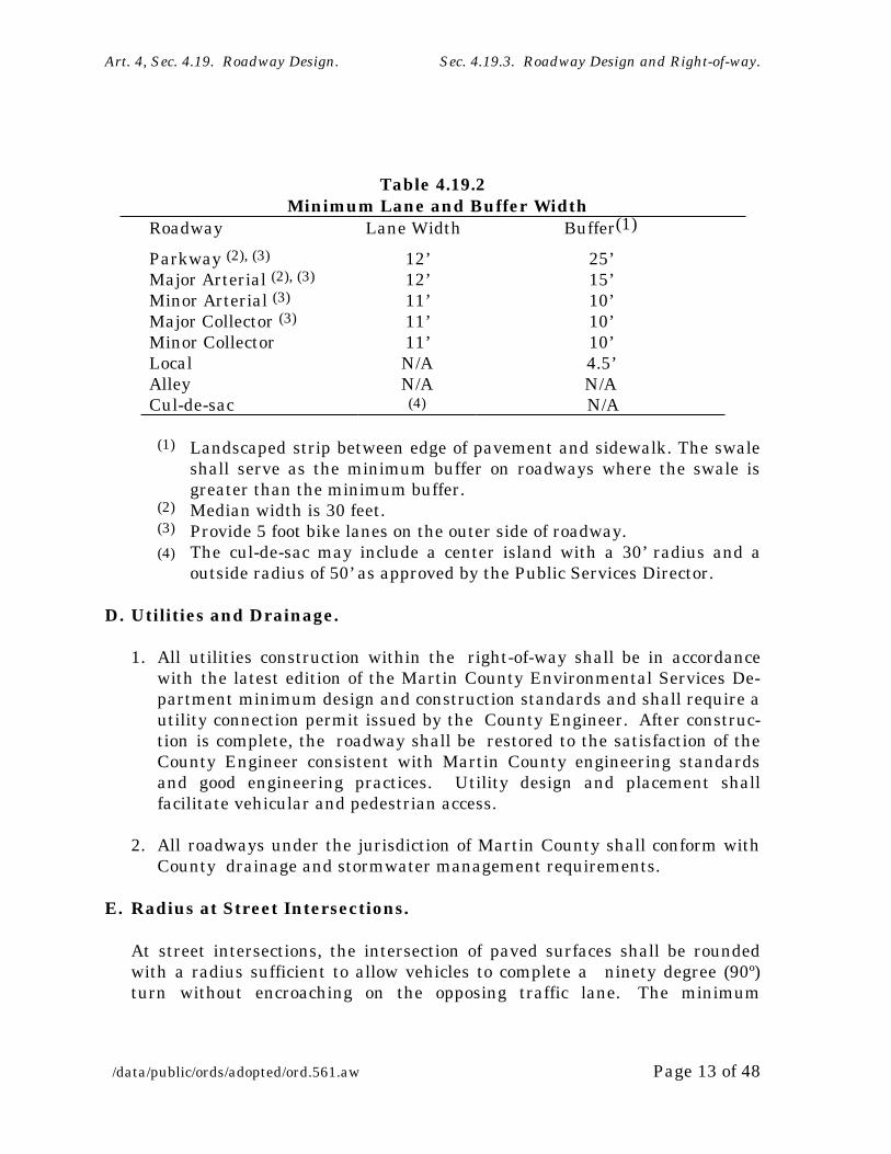
C. Lane and Buffer Widths.
Minimum lane and buffer widths for each roadway classification are estab-lished in Table 4.19.2. Areas designated as Traditional Neighborhood Devel-opments (TND) or Community Redevelopment Areas (CRA) may vary these standards with the approval of the Board of County Commissioners. Recom-mended guidelines for TND streets appear in Table 4.19.9.
Art. 4, Sec. 4.19. Roadway Design. Sec. 4.19.3. Roadway Design and Right-of-way.
/data/public/ords/adopted/ord.561.aw Page 13 of 48
Table 4.19.2 Minimum Lane and Buffer Width
Roadway Lane Width Buffer(1)
Parkway (2), (3)
Major Arterial (2), (3)
Minor Arterial (3)
Major Collector (3)
Minor CollectorLocalAlleyCul-de-sac
12’12’11’11’11’N/AN/A(4)
25’15’10’10’10’4.5’N/A N/A
(1) Landscaped strip between edge of pavement and sidewalk. The swale shall serve as the minimum buffer on roadways where the swale is greater than the minimum buffer.
(2) Median width is 30 feet.(3) Provide 5 foot bike lanes on the outer side of roadway.(4) The cul-de-sac may include a center island with a 30’ radius and a
outside radius of 50’ as approved by the Public Services Director.
D. Utilities and Drainage.
1. All utilities construction within the right-of-way shall be in accordance with the latest edition of the Martin County Environmental Services De-partment minimum design and construction standards and shall require a utility connection permit issued by the County Engineer. After construc-tion is complete, the roadway shall be restored to the satisfaction of the County Engineer consistent with Martin County engineering standards and good engineering practices. Utility design and placement shall facilitate vehicular and pedestrian access.
2. All roadways under the jurisdiction of Martin County shall conform with County drainage and stormwater management requirements.
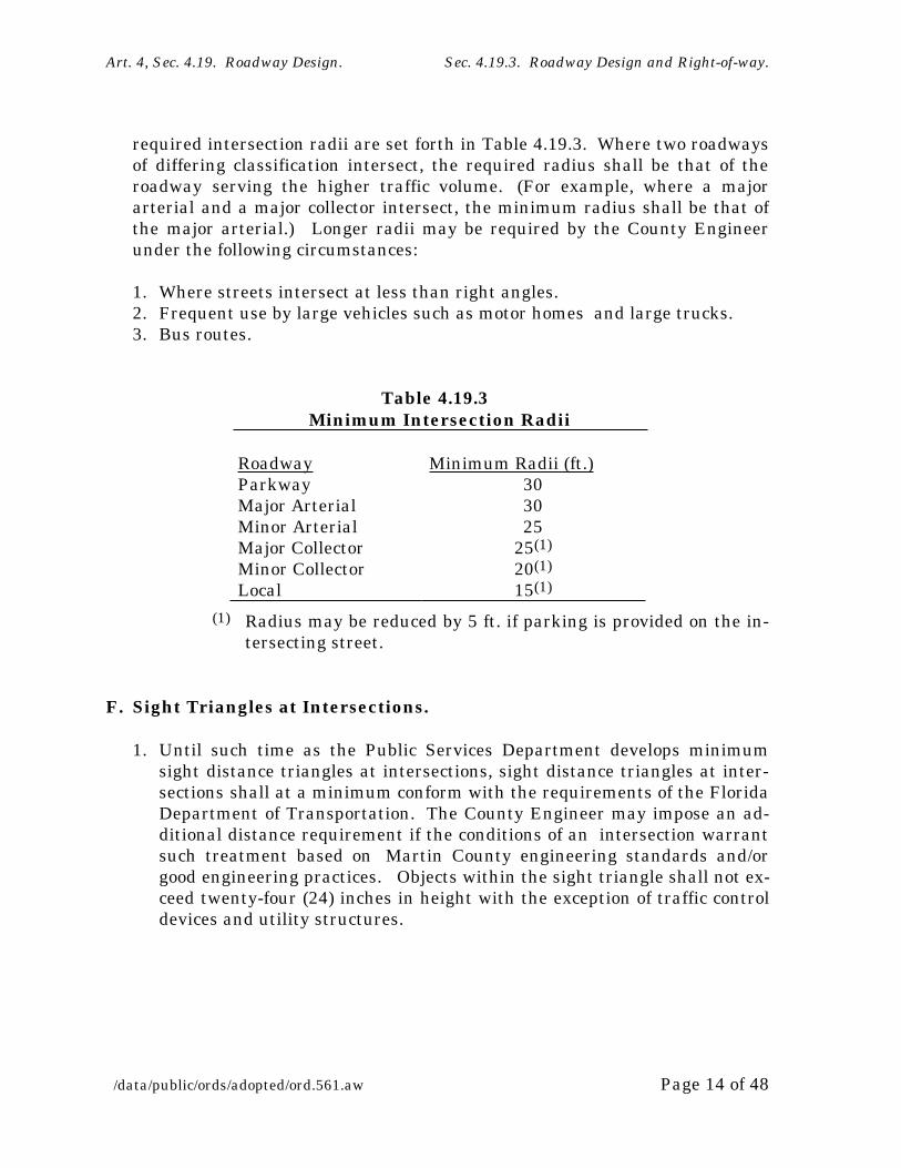
E. Radius at Street Intersections.
At street intersections, the intersection of paved surfaces shall be rounded with a radius sufficient to allow vehicles to complete a ninety degree (90º) turn without encroaching on the opposing traffic lane. The minimum
Art. 4, Sec. 4.19. Roadway Design. Sec. 4.19.3. Roadway Design and Right-of-way.
/data/public/ords/adopted/ord.561.aw Page 14 of 48
required intersection radii are set forth in Table 4.19.3. Where two roadways of differing classification intersect, the required radius shall be that of the roadway serving the higher traffic volume. (For example, where a major arterial and a major collector intersect, the minimum radius shall be that of the major arterial.) Longer radii may be required by the County Engineer under the following circumstances:
1. Where streets intersect at less than right angles.2. Frequent use by large vehicles such as motor homes and large trucks.3. Bus routes.
Table 4.19.3 Minimum Intersection Radii
Roadway Minimum Radii (ft.)ParkwayMajor ArterialMinor ArterialMajor CollectorMinor CollectorLocal
303025
25(1)
20(1)
15(1)
(1) Radius may be reduced by 5 ft. if parking is provided on the in-tersecting street.
F. Sight Triangles at Intersections.
1. Until such time as the Public Services Department develops minimum sight distance triangles at intersections, sight distance triangles at inter-sections shall at a minimum conform with the requirements of the Florida Department of Transportation. The County Engineer may impose an ad-ditional distance requirement if the conditions of an intersection warrant such treatment based on Martin County engineering standards and/or good engineering practices. Objects within the sight triangle shall not ex-ceed twenty-four (24) inches in height with the exception of traffic control devices and utility structures.

Art. 4, Sec. 4.19. Roadway Design. Sec. 4.19.3. Roadway Design and Right-of-way.
/data/public/ords/adopted/ord.561.aw Page 15 of 48
G. Sidewalks.
1. New sidewalks must be a minimum of 6 feet wide and are required on both sides of all roadways, except that sidewalks are required on only one side of roadways classified as local streets. All new sidewalks shall be constructed of concrete and shall be located at least one (1) foot from the outside edge of the right-of-way.
2. The County Engineer may authorize a modification in sidewalk width to
protect existing trees or to accommodate existing utilities. Sidewalks are not required to be constructed around the perimeter circle of a cul-de-sac.
3. The decisionmaking body (Development Review Committee for minor de-velopments; Board of County Commissioners for major developments) may modify or waive sidewalk requirements where a single pathway forming an integrated bicycle and pedestrian system is provided.
4. The maintenance of bicycle paths and pedestrian sidewalks not located within the public right-of-way and of sidewalks abutting private streets shall be the responsibility of the developer or property/homeowners as-sociation. The maintenance obligation shall be established on a plat or by a separate instrument approved by the County Attorney and recorded in the public records of Martin County.
5. Pedestrian sidewalks may be maintained and/or replaced with the exist-ing width and surface type as approved by the County Engineer and dis-trict commissioner.
H. Traffic Controls, Signage, and Pavement Markings.
All traffic controls, signage, and pavement markings shall be designed and installed in accordance with the Manual of Uniform Traffic Control Devices (MUTCD).
I. Private Streets.
No new private streets shall be created unless the applicant establishes a road maintenance agreement or other means satisfactory to the County At-torney to provide for proper maintenance. The parties to such agreement shall be responsible for construction, maintenance, and control of such road-ways.

Art. 4, Sec. 4.19. Roadway Design. Sec. 4.19.3. Roadway Design and Right-of-way.
/data/public/ords/adopted/ord.561.aw Page 16 of 48
J. County Road Maintenance.
1. Streets that do not meet the requirements of Section 4.19 shall not be ac-cepted into the County maintenance system or for public ownership after the effective date of Section 4.19.
2. The minimum right-of-way requirements of Table 4.19.1 may be reduced for the purpose of paving maintained dirt roads that were established prior to 1972 upon the approval of the County Engineer and Stormwater Administrator and in accordance with the following conditions:
a. The roadway is classified as a minor collector or local street and is not expected to be upgraded to a higher roadway classification;
b. Sufficient right-of-way is available, given existing topography and soil conditions, to provide for adequate drainage and water quality; and
c. The available right-of-way provides an adequate shoulder and buffer area.
Section 4.19.4. Mobility and Connectivity.
The purpose of Section 4.19.4 is to discourage the use of local streets for cut-through traffic while maintaining the overall connectivity of the roadway sys-tem. Section 4.19.4 also provides for bicycle/pedestrian connections between neighborhoods under certain circumstances. The provisions of Section 4.19.4 are intended to improve the safety and convenience of walking and bicycling; facili-tate emergency access; reduce vehicle miles traveled; help preserve the use of major roadways for through traffic by providing alternative routes for short local trips and reduce the need for continued road widening which divides neighbor-hoods with wide expanses of pavement that are difficult and hazardous to cross. In addition it is expected that these provisions will reduce environmental dam-age by allowing more compact layouts of streets and lots.
A. Connectivity with Surrounding Streets.
All new developments shall be designed to discourage the use of local streets by cut-through traffic while maintaining the overall connectivity with the surrounding system of roadways. This may be accomplished through the use of modified grid systems, T-intersections, roadway jogs, or other appropriate
Article 4, Section 4.19. Roadway Design. Sec. 4.19.4. Mobility and connectivity.
/data/public/ords/adopted/ord.561.aw Page 17 of 48
traffic calming measures within the development. The following are also en-couraged:
1. Coordination of the street system of a proposed subdivision with existing, proposed and anticipated streets surrounding the subdivision.
2. The extension of proposed streets to the boundary lines of the develop-ment where such an extension would connect with streets in an existing, platted or planned development. The extension or connection should be based upon traffic circulation or public safety issues and compatibility of adjacent land uses.
3. When a proposed development abuts unplatted land or a future develop-ment phase of the same development, stub streets should be provided to provide access to abutting properties or to logically extend the street sys-tem into the surrounding areas. All street stubs should be provided with a temporary turn-around or cul-de-sac, and the restoration and extension of the street should be the responsibility of any future developer of the abutting land.
B. Bicycle and Pedestrian Access.
1. Opportunities for bicycle/pedestrian mobility should be enhanced through site design strategies and bicycle/pedestrian access ways that seek to shorten walking distances and increase accessibility between neighbor-hoods, schools, recreation areas, community centers, shopping areas or employment center as follows:
a. Sidewalks connecting residential developments to the sidewalk system of surrounding roadways.
b. An accessible route within the boundary of a site shall be provided to meet the requirements of the Americans with Disabilities Act.
c. Bicycle/pedestrian ways connecting residential developments and or nearby schools, neighborhood community centers, churches, parks, commercial and office developments, or other compatible land uses.
2. Where the decision making body (Development Review Committee for mi-nor projects; Board of County Commissioners for major projects) deter-mines that a bicycle/pedestrian connection is desirable from a subdivision to schools, parks, playgrounds, or other roads or facilities and that such

Article 4, Section 4.19. Roadway Design. Sec. 4.19.4. Mobility and connectivity.
/data/public/ords/adopted/ord.561.aw Page 18 of 48
access is not conveniently provided by sidewalks adjacent to the streets, the developer may be required to reserve an unobstructed easement to provide such access.
3. Commercial development should be designed to support bicycle and pedes-trian mobility in accordance with the following:
a. Safe and convenient pedestrian ways should be provided between parking areas and from the building entrance to surrounding streets, external sidewalks and development outparcels. Pedestrian ways may be constructed of paver blocks, concrete, or other suitable materials. Pedestrian ways that traverse parking areas should include reflective striping.
b. Pedestrian circulation should be provided between abutting com-mercial properties through the use of walkways and similar pedestrian-oriented facilities.
c. Pedestrian facilities may be incorporated into the required landscape buffer.
4. Bicycle and pedestrian amenities, such as benches, water fountains, or bi-cycle racks, should be provided for commercial developments of 10,000 square feet or more of gross floor area in accordance with the following schedule:
Gross Floor Area of Project
Required Bicycle or Pedestrian Amenity
10,000-50,000 square feet One bike rack, one bench50,001-100,000 square feet Two bike racks, two benches
100,001+ square feet Four bike racks, four benches, outdoor water fountain
a. Bicycle racks should be of the inverted "u" type.b. Bicycle racks should be located within fifty (50) feet of the main en-
trance of the primary building.
Article 4, Section 4.19. Roadway Design. Sec. 4.19.4. Mobility and connectivity.
/data/public/ords/adopted/ord.561.aw Page 19 of 48
C. Equestrian Facilities.
1. Opportunities for equestrian paths should be enhanced through site de-sign strategies and equestrian path connections that seek to provide equestrian access from new developments where equestrian facilities are permitted to the County’s existing or proposed greenways.
2. Where the decision making body finds that an equestrian path is desirable from a proposed development to an existing or proposed greenway and that such access is not conveniently provided by local streets, the devel-oper may be required to reserve an unobstructed easement to provide such access.
Section 4.19.5. Access Management.
A. General Requirements.
1. No person shall construct or modify any access connection to a County roadway without a connection permit from the County Engineer. An ac-cess connection to a state highway requires a connection permit from the Florida Department of Transportation (FDOT). FDOT will notify Martin County of all requests for access connections on state roadways.
2. A Notice of Intent to Permit an access connection to a state highway from the Florida Department of Transportation is not a final connection permit and does not constitute approval from Martin County. The County may require modifications to property access during development review in ac-cordance with County policies and regulations governing land develop-ment and interparcel circulation.
3. Access connections initiated by Martin County will be constructed by the County.
B. Access Classification System and Standards.
1. Separation between access points on all state highways shall be in ac-cordance with Florida Department of Transportation Access Classification System & Standards, Rules 14-96 and 14-97, Florida Administrative Code.
Article 4, Section 4.19. Roadway Design. Sec. 4.19.5. Access management.
/data/public/ords/adopted/ord.561.aw Page 20 of 48
2. Roadways under the jurisdiction of Martin County shall be classified for the purposes of access management as provided in Table 4.19.4. Road-ways or roadway segments shall be assigned an access classification by the Board of County Commissioners. The factors to be considered in as-signing an access classification shall include, but not be limited to, the current and planned functional classification of the roadway, existing and projected traffic volumes, drainage requirements, growth management ob-jectives, and location within a TND or CRA.
3. The separation between access points on roadways shall meet or exceed the minimum standards for that classification as set forth in Table 4.19.4.

Article 4, Section 4.19. Roadway Design. Sec. 4.19.5. Access management.
/data/public/ords/adopted/ord.561.aw Page 21 of 48
Table 4.19.4Martin County Access Classification System & Standards
AccessClass
Restrictive Median*
ConnectionSpacing
(feet)
MedianOpening Spacing
(feet)
SignalSpacing
(feet)>45 mph
<45 mph
Direc-tional
Full
2 Yes 1320 660 1,320 2,640 2,640
3 Yes 660 440 1,320 2,640 2,640
4 No 660 440 2,640
5 Yes 440 245 660 2,640/1,320
2,640/1,320
6 No 440 245 1,320
7 All road types 125 330 660 1,320
* A ‘‘restrictive’’ median physically prevents vehicle crossing. A ‘‘non-restrictive’’ median allows turns across any point.

Article 4, Section 4.19. Roadway Design. Sec. 4.19.5. Access management.
/data/public/ords/adopted/ord.561.aw Page 22 of 48
4. Deviation from access spacing standards may be permitted as follows:
a. Deviations up to 10% of the allowable spacing standard or 100 feet, whichever is less, may be authorized by the County Engineer where a property is otherwise unable to meet the minimum driveway spacing standards and where this deviation would not create a safety problem on the public road.
b. Other deviations shall require the approval of the decisionmaking body. A traffic impact study shall be required at the expense of the ap-plicant to assist the County in these determinations, except as pro-vided in Section 4.19.5(A)(5) below.
5. Where the existing configuration of properties and driveways in the vicin-ity of the subject site precludes spacing of an access point in accordance with Section 4.19.5, the County Engineer shall be authorized to waive the spacing requirement if all of the following conditions have been met:
a. A joint use driveway will be established to serve two abutting building sites with cross access easements provided in accordance with Section 4.19.5.D;
b. The building site is designed to provide cross access and unified circu-lation
with abutting sites; and
c. The property owner agrees to close any pre-existing curb-cuts that do not meet the requirements of Section 4.19 after the construction of both sides of the joint use driveway.
6. A development that cannot meet the access requirements of Section 4.19 and has no reasonable alternative means of access to the public road sys-tem shall be issued a temporary connection permit. When adjoining par-cels develop which can provide joint or cross access, the temporary permit shall be rescinded and an application for a connection permit consistent with the requirements of Section 4.19 shall be required. Conditions may be included in the temporary permit including, but not limited to, a limi-tation on development intensity on the site until adjoining parcels develop which can provide the joint and/or cross access consistent with the re-quirements of Section 4.19.

Article 4, Section 4.19. Roadway Design. Sec. 4.19.5. Access management.
/data/public/ords/adopted/ord.561.aw Page 23 of 48
C. Corner Clearance.
1. Access connections shall not be permitted within the functional area of an intersection, as established by the minimum connection spacing for each roadway, unless:
a. No other reasonable access to the property is available, including joint and cross access with adjacent properties, and
b. The connection does not create a potential safety or operational prob-lem as determined by the County Engineer upon review of a site spe-cific study of the proposed connection prepared by the applicant’s regis-tered engineer.
2. Where no other alternatives exist, construction of an access connection along the property line farthest from the intersection may be allowed by the County Engineer. In such cases, directional connections may be re-quired (right-in/out only) and only one driveway shall be permitted along the roadway having the lower functional classification unless such connec-tion would create a safety or operational problem.
D. Joint and Cross Access.
Adjacent commercial or office properties and major traffic generators (i.e. shopping plazas, office parks) shall provide a cross access drive and pedes-trian access way to allow circulation between sites. This requirement shall also apply to a building site that abuts an existing developed property unless the decisionmaking body finds that this would be impractical. Property own-ers shall:
1. Record an easement in the public records of Martin County allowing cross access to and from the adjacent properties;
2. Agree that any pre-existing driveways provided for access in the interim shall be closed and eliminated after construction of the joint use driveway; and
3. Record a joint maintenance agreement in the public records of Martin County defining maintenance responsibilities of property owners that share the joint use driveway and cross access system.
Article 4, Section 4.19. Roadway Design. Sec. 4.19.5. Access management.
/data/public/ords/adopted/ord.561.aw Page 24 of 48
E. Requirements for Unified Access and Circulation.
1. In the interest of promoting unified access and circulation systems, devel-opment sites under the same ownership or consolidated for the purposes of development and comprised of more than one building site shall be con-sidered unified parcels for the purposes of Section 4.19. This shall also ap-ply to phased development plans. Accordingly, the following requirements shall apply:
a. The number of connections permitted shall be the minimum number necessary to provide reasonable access to the overall site and not the maximum available for that frontage.
b. All easements and agreements required under Section 4.19.5.D shall be provided.
c. Access to outparcels shall be internalized using the shared circulation system and designed to avoid excessive movement across parking aisles or queuing across surrounding parking and driving aisles.
2. Where abutting properties are in different ownership and not part of an overall development plan, cooperation between the various owners in de-velopment of a unified access and circulation system is encouraged. Only the building site(s) under consideration for development approval shall be subject to the requirements of Section 4.19. Abutting properties shall not be required to provide unified access and circulation until they are devel-oped or are redeveloped.
F. Access to Homes and Subdivisions.
When a residential development is proposed that would abut an arterial or major collector roadway, it shall be designed to provide lots abutting the roadway with access from an interior local road or frontage road. Direct driveway access to individual one and two family dwellings from arterial and major collector roadways shall be avoided. All other reasonable access alternatives shall be investigated and judged unacceptable by the County Engineer before direct residential driveway access on an arterial or major collector is permitted.
Article 4, Section 4.19. Roadway Design. Sec. 4.19.5. Access management.
/data/public/ords/adopted/ord.561.aw Page 25 of 48
G. Driveway location and design.
1. Driveway approaches shall be located and designed to provide adequate sight distance as determined by the County Engineer. Until such time as the Public Services Department develops sight distance standards, Florida Department of Transportation (FDOT) standards for sight dis-tance shall apply.
2. The County Engineer may require auxiliary lanes where deemed neces-sary due to traffic volumes or where a safety or operational problem ex-ists. The design of left turn and right turn lanes shall conform to FDOT design standards until such time as the Public Services Department de-velops design standards.
3. Construction of driveways along acceleration or deceleration lanes and tapers is prohibited unless no other access to the property is available.
4. Driveways across from median openings shall be consolidated wherever feasible to coordinate access at the median opening.
5. To reduce left turn conflicts, new driveways on undivided roadways shall be aligned with those across the roadway if possible. If alignment is not possible, driveways on opposite sides of undivided roadways shall be offset to minimize jog maneuvers, overlapping left turns and other maneuvers that may result in safety hazards or operational problems. Guidelines for minimum offset distances are provided in Table 4.19.5. Longer offsets may be required by the County Engineer depending on the expected inbound left turn volumes of the driveways.

Article 4, Section 4.19. Roadway Design. Sec. 4.19.5. Access management.
/data/public/ords/adopted/ord.561.aw Page 26 of 48
Table 4.19.5Minimum Offset Distance Between Driveways or
Intersections on Opposite Sides of Undivided Roadways
Roadway Classification
Minimum Offset(1)
(feet)Major ArterialMinor ArterialMajor CollectorMinor Collector
600(2) 300(3)
220200150
(1) Measured centerline-to-centerline of opposing drive-ways on intersections
(2) Posted speed 45 mph or greater(3) Posted speed 40 mph or less
6. Driveway width and return radius or flare shall be adequate to serve the volume of traffic and provide for efficient movement of vehicles onto and off of the major thoroughfare. However, the width of driveways shall not be so excessive as to pose safety hazards for pedestrians and bicycles. Guidelines for driveway design for passenger cars are provided in Tables 4.19.6 and 4.19.7. The County Engineer may require longer radii and/or wider throats where deemed necessary to accommodate trucks.
7. Driveways with more than one entry and one exit lane shall incorporate channelization features to separate the entry and exit sides of the drive-way. Double yellow lines may be considered instead of medians where truck off-tracking is a problem.
8. Driveways shall be designed with adequate on-site storage for entering and exiting vehicles to reduce unsafe conflicts with through traffic or on-site traffic and to avoid congestion at the entrance. Guidelines for drive-way throat length are provided in Tables 4.19.6 and 4.19.7. Shorter throat lengths may be permitted by the County Engineer for driveways that are considered as service entrances not considered as primary access points to the site.

Article 4, Section 4.19. Roadway Design. Sec. 4.19.5. Access management.
/data/public/ords/adopted/ord.561.aw Page 27 of 48
Table 4.19.6Guidelines for Driveway Throat Length, Throat Width and
Return Radius for Signalized or Divided Driveways(1)
No. of Lanes Entry Exit
Enter Exit Divider
Min. Throat Length(feet)
Radius(feet)
Width(2)(feet)
Radius(feet)
Width(2)
(feet)
1
1
2
2
2
2
3(5)
4(5)
not landscaped(3)
landscaped(4)
landscaped(4)
landscaped(4)
75
75
200
275
25
30
30
30
14
16
26
26
25
30
30
30
24
24
36
48
(1) Divided driveways apply primarily to Parkways and Major Arterials.(2) Width face-to-face of curbs, or face of divider to edge of driveway pavement.(3) Driveway medians (dividers) that are not landscaped shall have a surface color that con-
trasts with the driveway pavement surface; the surface of such a median (divider) shall not be more than 3 inches above the driveway pavement surface. The median (divider) shall be outlined with a 4" wide solid yellow line.
(4) Landscaped medians shall be at least 10 ft. wide, face-to-face of curb. The length shall be equal to the throat length. A mountable type curb shall be used, preferably 4 inches in height but not to exceed 6 inches. A more liberal design is needed with a landscaped divider because an entering vehicle cannot encroach on the exit side of the drive.
(5) Includes a separate right-turn lane.

Article 4, Section 4.19. Roadway Design. Sec. 4.19.5. Access management.
/data/public/ords/adopted/ord.561.aw Page 28 of 48
Table 4.19.7Guidelines for Driveway Throat Length, Throat Width
and Return Radius for Undivided Driveways(1)
Number ofLanes Entry Side Exit Side
Total Throa-
t Width(feet)
Mini-mum Total
Throat Length(feet)
RoadwayClass
Enter Exit Radius(feet)
Width(feet)
Radius(feet)
Width(feet)
Parkway
Major Arterial
Minor Arterial or Major Collec-tor
Minor Collector
Local Street
11
11
11
na(4)
na
1(2)2(3)
1(1)2(3)
1(1)2(3)
na(4)
na
3030
2525
2020
15
5
1414
1414
1414
--
--
3030
2525
2020
15
5
1224
1224
1224
--
--
2638
2638
2638
26
15 - 25
5050
5050
3030
25
20
(1) Combinations of throat width and return radii are for passenger cars; wider throat widths and/or longer return radii may be required where large volumes of trucks are ex-pected.
(2) Entry and exit sides of the driveway shall be separated by a 4-inch solid yellow line. (3) Entry and exit sides of the driveway shall be separated by 4-inch double solid yellow
lines; exit lanes shall be separated by a 4-inch solid white line. Paint lines shall extend the full length of the driveway throat. (4) Entry and exit lanes are not normally defined.

Article 4, Section 4.19. Roadway Design. Sec. 4.19.5. Access management.
/data/public/ords/adopted/ord.561.aw Page 29 of 48
9. The maximum change in grade between the pavement cross-slope of the roadway and the driveway grade are provided in Table 4.19.8.
Table 4.19.8Guidelines for Change in Driveway Grade
Roadway ClassMaximum
Changein Grade
ParkwayMajor ArterialMinor ArterialMajor CollectorMinor CollectorResidential drive-way*
4%5%6%8%8%10%
*A change in grade in excess of 8% shall be permitted only where the driveway of a single family residence connects with a local street.
H. Redevelopment Requirements.
1. Properties with access connections which do not meet the requirements of Section 4.19 shall be brought into compliance with Section 4.19 to the ex-tent possible when modifications to the roadway are made or when a change in use results in one or more of the following conditions:
a. When a connection permit is required.b. When site plan review is required.c. When a site experiences an increase of twenty percent (20%) or greater
in peak hour trips or 100 vehicles per hour in the peak hour, whichever is less, as determined by one of the following methods:
(1) An estimation based on the ITE Trip Generation Manual (latest edition) for typical land uses, or
(2) Traffic counts made at similar traffic generators located in Martin County, or
(3) Actual traffic monitoring conducted during the peak hour of the adjacent roadway traffic for the property.
Article 4, Section 4.19. Roadway Design. Sec. 4.19.5. Access management.
/data/public/ords/adopted/ord.561.aw Page 30 of 48
2. If the principal activity on a parcel with access connections which do not meet the regulations of Section 4.19 is discontinued for a period of one year or more, then that parcel must comply with all applicable access re-quirements of Section 4.19 to the extent possible.
I. Corridor Access Management Overlay Zones.
Martin County may designate segments of a roadway corridor for the purpose of developing corridor access management plans that apply special access management requirements to the corridor. The purpose of this designation is to develop a specific plan for the roadway system, including, but not limited to, median openings, signal location, access connections and cross access and joint access requirements for adjacent developments that reduces access problems on major thoroughfares and advances sustainable development pat-terns in conformance with the desired character of the County and the Com-prehensive Plan. Corridor access management overlay zones do not super-cede underlying land use and zoning provisions, but provide additional re-quirements for designated areas. Corridor access management overlay zones shall be designated in accordance with the public hearing provisions of Ar-ticle 10 of the Land Development Regulations. Corridor access management plans for state maintained highways shall be developed in accordance with the procedural requirements of Rule 14-97.004(5), Florida Administrative Code, for corridor access management plans.
Section 4.19.6. Parking.
The purpose and intent of Section 4.19.6 is to ensure the provision of adequate off-street parking, loading, queuing, and on-site circulation facilities and to pro-vide for on-street parking in certain circumstances.
A. On-Street Parking.
On-street parking shall be allowed within Traditional Neighborhood Develop-ments or in designated Community Redevelopment Areas as approved by the Board of County Commissioners.
B. Off-Street Parking.
1. The off-street parking requirements of Section 4.19.6 apply to all new de-velopment and to modifications to development existing on the effective date of Section 4.19.6 which require site plan approval.
Article 4, Section 4.19. Roadway Design. Sec. 4.19.6. Parking.
/data/public/ords/adopted/ord.561.aw Page 31 of 48
2. All non-residential development and all residential development except for single-family homes and duplexes shall provide adequate off-street parking and facilities for on-site back-up and turn-around movements. The number of required off-street parking spaces shall be determined pur-suant to applicable provisions of the Code and the LDR.
3. Parking areas, driveways, and internal circulation of vehicles shall be lo-cated, designed, and controlled to provide safe and convenient circulation within the site and safe and convenient access from adjoining roadways.
4. Parking areas and driveways shall be clearly identified and separated from principal pedestrian routes and recreation areas by curbs, pavement markings, planting areas, fences, or similar features designed to promote pedestrian safety.
5. The number of required off-street parking spaces in Traditional Neighbor-hood Developments and Community Redevelopment Areas may be re-duced by the decisionmaking body pursuant to a shared parking agree-ment among adjacent property owners and/or in relation to the avail-ability of on-street parking spaces.
6. A reduction in the required number of parking spaces for mixed-use devel-opments may be approved by the decisionmaking body, where it is demon-strated that adjacent uses have variable peak hour demands and have agreed to share parking.
7. Any applicant requesting a reduction in the number of required off-street parking spaces must provide:
a. A shared parking justification that describes the variable nature of parking demand and the adequacy of shared parking for the area.
b. A written agreement acceptable to the County Attorney that includes, but is not limited to:
(1) Location and description of parking areas designated and reserved for shared parking.
(2) Assurance of continued availability of the spaces for joint use for all future users.

Article 4, Section 4.19. Roadway Design. Sec. 4.19.6. Parking.
/data/public/ords/adopted/ord.561.aw Page 32 of 48
Section 4.19.7. Traditional Neighborhood Street Design.
A. Traditional Neighborhood Street Design Encouraged.
Applicants are encouraged to incorporate Traditional Neighborhood street de-sign into redevelopment and new development projects for the purpose of de-veloping a Traditional Neighborhood Development (TND) pattern. TND street design reduces traffic congestion and expands options for vehicular, pe-destrian and bicycle access through an integrated network of narrow road-ways. It results in a reduction in linear streets, incorporates traffic calming resources and allows on-street parking
B. Procedure for TND Street Design.
Applicants seeking a variance from the requirements of Section 4.19 stan-dards for the purpose of developing a TND street design shall submit such a request in conjunction with the submittal of a development application pur-suant to the provisions of Article 10 of the Land Development Regulations. In addition to the requirements of Article 10, the application shall include a brief description of the proposed development and surrounding area, connec-tions to surrounding streets, environmental amenities, proposed transporta-tion system, and proposed land uses (including square footage and acreage). The plan shall also include regulatory and design standards for transporta-tion and land development and an explanation of any variations from Martin County standards.
C. TND Street Design and Layout.
1. Traditional Neighborhood Developments seeking a variance from the re-quirements of Section 4.19 shall incorporate the following street layout principles:
a. Street layout should exhibit a high degree of overall connectivity, with some allowances for topographic or wetlands conditions.
b. Cul-de-sacs are generally discouraged, but may be used in moderation.c. Maximum block length in the TND should not exceed 1,320 linear feet.d. Trees should be planted within the street rights-of-way between the
sidewalk and the street curb.e. Provision should be made for on-street parking.
2. General guidelines for TND street designs are provided in Table 4.19.9.

Article 4, Section 4.19. Roadway Design. Sec. 4.19.7. Traditional neighborhood street design.
/data/public/ords/adopted/ord.561.aw Page 33 of 48
Table 4.19.9: Guidelines for TND Streets
Traffic LanesStreet Type Number Width Sidewalk(1) Buffer Bike
LaneParking(2) Paved
Sect.(3)ROW
Village Center: Boulevard(4) 2
111’11’
10’ both sides10’ both sides
10’10’
5’5’
7’7’
38’27’
118’96’
Major Street, 2-wayMajor Street, 1-way
21
11’11’
8’ both sides8’ both sides
10’10’
5’ both sides5’ one side
7’ both sides7’ one side
50’27’
88’65’
Minor Street, 2-wayMinor Street, 1-way
21
10’10’
6’ both sides6’ both sides
10’10’
5’ both sides5’ one side
7’ both sides7’ one side
48’26’
82’60’
Local Street, 2-wayLocal Street, 1-way
21
10’10’
6’ both sides6’ both sides
8’8’
NoNo
7’ both sides7’ one side
48’26’
78’56’
Alley, 2-wayAlley, 1-way
N/AN/A
N/AN/A
N/AN/A
N/AN/A
N/AN/A
N/AN/A
20’12’
25’20’
Residential: Boulevard(4) 2
111’11’
6’ both sides6’ both sides
10’10’
5’5’
7’7’
38’27’
72’61’
Major Street, 2-way 2 11’ 6’ both sides 10’ 5’ both sides 7’ both sides 50’ 84’Minor Street orLocal Street (5)
6’ both sides6’ both sides
8’8’
NoNo
7’ both sides7’ one side
29’ (6)21’ (7)
59’51’
Alley N/A N/A N/A N/A N/A N/A 14’ 20’(1)Edge of sidewalk located 1’ from right-of-way line(2)Parallel parking(3)Paved section back-to-back of curbs; 2’ curb and gutter section(4)Divided roadways separated by a raised median at least 18 ft. wide(5)Traffic lanes are not designated by striping or lane lines(6)Only during periods where vehicles are parked on both sides. One vehicle at a time may pass.(7)Only during periods where vehicles are parked on one side.
Article 4, Section 4.19. Roadway Design. Sec. 4.19.8. Traffic calming.
/data/public/ords/adopted/ord.561.aw Page 34 of 48
Section 4.19.8. Traffic Calming.
This section provides a procedure and guidelines for evaluating the need for traf-fic calming and traffic control devices in new developments and in neighborhoods affected by cut-through or high-speed traffic, and to guide the provision of such devices on County roadways. The intent of Section 4.19.8 is as follows:
1. To improve the livability of neighborhoods by reducing adverse traffic im-pacts on residential neighborhoods.
2. To promote safe and pleasant conditions for motorists, bicyclists, and pe-
destrians on neighborhood streets. 3. To provide meaningful citizen involvement in all phases of neighborhood
traffic management; 4. To make efficient use of County resources by screening and prioritizing re-
quests for traffic calming.
A. Neighborhood Traffic Studies.
1. Prior to implementing neighborhood traffic control devices or traffic calm-ing measures on local streets or minor arterials, a neighborhood traffic study will be conducted to document the extent to which cut-through traf-fic or high-speed traffic is negatively impacting the area. The study may be initiated by the Board of County Commissioners, by residents or prop-erty owners in the affected neighborhood, or by County staff.
2. The Public Services Department shall process requests for neighborhood traffic studies in accordance with the procedures of Section 4.19.8 and within the limits of available resources. To aid in screening and prioritiz-ing requests for traffic studies, the County may request a demonstration of interest and support from neighborhood residents in the form of a peti-tion signed by the majority of residents on the affected street(s). The peti-tion must specify the area under consideration, the nature of the problem (speed, traffic volume, cut-through traffic) and the objectives being sought through the study (reduce speeds, lower volumes, eliminate through-traffic, etc.).

Article 4, Section 4.19. Roadway Design. Sec. 4.19.8. Traffic calming.
/data/public/ords/adopted/ord.561.aw Page 35 of 48
B. Study Procedures.
When it is determined that a neighborhood traffic study should be conducted, appropriate data shall be collected upon which to base the decisions for implementation of traffic control devices and/or traffic calming measures. Considerations for data collection may include, but are not limited to:
1. Traffic volumes2. Speed3. Safety4. Intersection volumes5. Extent of bicycle and pedestrian activity.
Upon completion, the study shall be submitted to the Board of County Com-missioners.
C. Public notification.
1. When a neighborhood traffic study results in a determination by the Board of County Commissioners that traffic control devices or traffic calm-ing measures may be warranted in the study area, a public notification process will be undertaken by the Public Services Department to inform property owners, residents, and business owners. The public notification process will seek input, address concerns, and discuss alternative solu-tions.
2. A neighborhood workshop will be held and a neighborhood team may be formed to discuss problems, current conditions and to review the results of the traffic study. As recommended strategies are devised, follow-up meet-ings will be held with neighborhood residents as needed to reach consen-sus on a recommended approach.
3. Final recommendations and a plan for carrying out the recommendations
will be presented to the Board of County Commissioners for final action.
D. Priority Ranking for Implementation.
The Public Services Department may prioritize the implementation of traffic control devices and/or traffic calming measures in neighborhoods with a com-pleted traffic study by establishing a priority ranking. Criteria, not listed in order of priority, to determine the priority for implementation may include:
Article 4, Section 4.19. Roadway Design. Sec. 4.19.8. Traffic calming.
/data/public/ords/adopted/ord.561.aw Page 36 of 48
1. Traffic volumes 2. Traffic speeds 3. Number of crashes and injuries4. Number of schools in proximity to the residential area 5. Number of pedestrian generators 6. Existence of sidewalks versus no sidewalks 7. Number of residents adversely affected
E. Test Installation and Evaluation.
The County Engineer may require a test prior to permanent installation to assure that no unforeseen hazard is created by a traffic control device or traf-fic calming measure.If the evaluation indicates that the installation poses a hazard or has not met the objectives as set forth in the studies, then the County shall conduct additional neighborhood workshops to develop new alternatives.
F. Traffic Calming on Thoroughfares.
1. Traffic calming measures may be considered on selected segments of thor-oughfares as they pass through areas with a higher intensity of com-munity activity for the purpose of reducing travel speeds, increasing driver deference to pedestrian activity, and supporting walking and bicy-cling in these areas. Areas that may considered for such treatments in-clude dense settlements along rural roadways, pedestrian oriented shop-ping districts, and school crossing zones or others as deemed appropriate by the Board of County Commissioners.
2. The need for traffic calming along a thoroughfare and appropriate treat-ments will be evaluated on a case by case basis by the Board of County Commissioners. Approaches to solving traffic problems on selected thor-oughfare segments shall include, but not be limited to:
a. Targeted enforcement for limited durations to slow traffic.
b. Traffic control devices or entry treatments to permanently slow traffic.
c. Education to raise awareness of the negative effects that speeding and excessive vehicle volumes have on pedestrian safety and the livability of affected areas.
Article 4, Section 4.19. Roadway Design. Sec. 4.19.8. Traffic calming.
/data/public/ords/adopted/ord.561.aw Page 37 of 48
3. Treatments that may be appropriate for thoroughfares include entry or gateway treatments, raised medians, roundabouts, raised crosswalks, tex-tured pavement, bulbouts (neckdowns) at intersections, or other treat-ments deemed appropriate by the County Engineer. In determining ap-propriate treatments for such areas, the following factors shall be consid-ered:
a. Traffic control devices shall not inappropriately restrict buses, emer-gency vehicles, and trucks from providing normal and necessary ser-vices to the affected area.
b. Devices shall be well illuminated, visible and include appropriate markings and signage.
c. Devices shall allow the traffic stream to maintain a consistent speed that is appropriate for the area.
d. Devices or treatments shall not pose a hazard to bicycles or pedestri-ans, or impede people with disabilities.
e. In no case shall any treatment be approved where it is found by the County Engineer to pose a potential safety hazard.
4. Should a traffic calming study be desired on the state highway system, it shall be conducted in coordination with the Florida Department of Trans-portation and traffic calming measures shall be consistent with FDOT policy 000-625-060-a Transportation Design for Livable Communities.
Section 4.19.9. Scenic Corridors.
Some roadways, due to their cultural, historic, or environmental amenities, may warrant special protection. Examples may include canopy roads or roadways with special scenic or historic qualities. The purpose of Section 4.19.9 is to pro-vide for the designation and protection of such roadways or roadway segments in Martin County as historic or scenic corridors.
A. County scenic corridors.
The Board of County Commissioners may designate segments of County maintained roadways as scenic corridors through the use of a corridor overlay zone. Such designation shall extend for a specified distance on either side of
Article 4, Section 4.19. Roadway Design. Sec. 4.19.9. Scenic corridors.
/data/public/ords/adopted/ord.561.aw Page 38 of 48
the roadway and allow for the adoption of special corridor overlay regulations to preserve, maintain, protect, or enhance the intrinsic character of the cor-ridor.
B. Scenic corridors on the state highway system.
Any citizen, group of citizens, or local government wishing to designate a cor-ridor on the state highway system as a scenic corridor may do so in ac-cordance with the procedures of the Florida Scenic Highways Program (FSHP). All potential applicants are directed to reference the Florida Scenic Highways Program Manual, available through the local FDOT District Scenic Highways Coordinator.
PART II: REPEAL OF CERTAIN PROVISIONS OF THE CODE OF LAWS AND ORDINANCES OF MARTIN COUNTY FLORIDA
Section 30½- 43 of the Code of Laws and Ordinances is hereby amended as follows (added language is underlined, deleted language is stricken through):
Section 30½-43. Minimum standards.
(I) BLOCK, STREET AND LOT REQUIREMENTS.
(A)_ Scope. A complete street and lot plan shall be provided.
The proposed street system shall recognize and extend the plan and profile of suitable existing streets and shall make possible the future extension of streets into adjacent undeveloped land where feasible.
The location and width of all arterial streets shall conform to the Martin County Comprehensive Road Plan.
(A)(B) Layout design criteria.
(1) Blocks.
(a) Block lengths shall not exceed one thousand five hundred (1,500) feet, unless special approval is given by the county planning director.

Article 4, Section 4.19. Roadway Design
/data/public/ords/adopted/ord.561.aw Page 39 of 48
(b) Within two thousand (2,000) feet of public schools and playgrounds, sidewalk plans and right-of-way shall be required to provide access on all arterial, collector, commercial and industrial streets.
(2) Streets.
(a) Right-of-way requirements shall be as follows:
1. Arterial streets shall have a minimum one hundred (100) feet of right-of-way and meet the requirements established in zoning regulations or Florida State Road Department Specifications.
Commercial or industrial streets shall have eighty (80) feet of right-of-way.
Collector streets shall have sixty (60) feet of right-of-way.
Residential streets shall have sixty (600) feet of right-of-way when constructed with swale drainage, or fifty (50) feet of right-of-way when constructed with swale drainage with a ten (10) foot temporary construction easement each side enforced until accepted by governmental body.
Residential streets shall have fifty (500) feet of right-of-way when constructed with curb and gutter drainage.
6. Culs-de-sac shall have fifty (50) feet of right- of-way approach to a ninety-foot diameter turn-around circle when constructed with curb and gutter.

Article 4, Section 4.19. Roadway Design
/data/public/ords/adopted/ord.561.aw Page 40 of 48
7. Culs-de-sac shall have sixty (60) feet of right- of-way approach to a one hundred (100) foot diameter turnaround circle when constructed with swale drainage, or fifty (50) feet of right-of-way when constructed with swale drainage with a ten-foot temporary construction easement each side enforced until accepted by govern-mental body.
(b) Subdivisions bounded by an arterial street shall be planned with widely spaced collector streets as main subdivision entryways from the arterial street. Residential subdivision streets, other than collector streets, shall avoid intersection with arterial streets where possible.
(c) Residential subdivision streets shall be planned so that residential lots will not have driveways entering directly onto arterial streets, except where such a restriction does not allow reasonable use of land.
(d) Culs-de-sac shall have a maximum length of six hundred (600) feet except when written authorization of the county planning director permits a longer cul-de-sac.
(e) Alleys shall be permitted only by written authoriza-tion of the county engineer.
(f) collector streets shall have a minimum centerline curve radius based on a thirty (30) miles per hour design speed.
(g) The radii of the returns on all intersections shall be at least twenty-five (25) feet.
Article 4, Section 4.19. Roadway Design
/data/public/ords/adopted/ord.561.aw Page 41 of 48
(h) Intersections shall be substantially right angles to arterial and collector streets and desirable on other streets.
(i) In residential areas, ‘‘T’’ intersections are preferable to four-way intersections.
(2)(3) Lots. In addition to the following minimum design criteria all lot requirements of Martin County Zoning Regulations shall be adhered to.
(a) Corner lots shall have an additional width to meet the required zoning regulations.
(b) Restricted easements and restricted vehicular ingress and egress contiguous to all arterial streets.
(c) Side lot lines shall be substantially at right angles or radial to street lines.
(d) Adequate drainage and utility easements shall be provided.
(B) (C) Design standards.
(1) Pavement width.
(a) Arterial streets, twenty-four (24) feet.
(b) Commercial or industrial streets, twenty-four (24) feet.
(c) Collector or residential streets, twenty (20) feet.
(d) Culs-de-sac, twenty (20) feet with sixty-foot diameter turn-around.

Article 4, Section 4.19. Roadway Design
/data/public/ords/adopted/ord.561.aw Page 42 of 48
(e) Alleys, commercial, industrial or public service, twenty (20) feet.
(f) Alleys, residential, sixteen (16) feet.
(1) (2) Bases for arterial, commercial or industrial streets shall be a minimum of six and one-half (6½) inches compacted limerock, or cemented coquina shell material as specified by the Florida Department of Transportation’s current standard specifications for road construction, or five-inch, one thousand two hundred-pound Hubbard Field Stability hot plant mix sand asphalt base. All other bases shall be six (6) inches compacted limerock or cemented coqina shell material as specified by the Florida Depart-ment of Transportation’s current standard specifica-tions for road construction or four-inch one thousand two hundred-pound Hubbard Field Stability hot plant mix sand asphalt base.
(2) (3) Surfaces for all streets shall be one-inch FSRD Type I asphaltic concrete, or double surface bituminous treatment Type II FSRD construction standards.
(3) (4) Pavement crown shall be one-fourth (¼) inch per foot or greater with no inverted crowns permitted. Finish pavement shall be from one-fourth (¼) inch to one-half (½) inch higher than the lip of any concrete gutter.
(4) (5) Ground slope from back of curb to right-of-way shall be one-half (0.5) per cent minimum.
(5) (6) Lots under two (2) acres shall slope toward streets or other adequate outfalls.
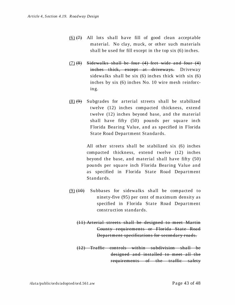
Article 4, Section 4.19. Roadway Design
/data/public/ords/adopted/ord.561.aw Page 43 of 48
(6) (7) All lots shall have fill of good clean acceptable material. No clay, muck, or other such materials shall be used for fill except in the top six (6) inches.
(7) (8) Sidewalks shall be four (4) feet wide and four (4) inches thick, except at driveways. Driveway sidewalks shall be six (6) inches thick with six (6) inches by six (6) inches No. 10 wire mesh reinforc-ing.
(8) (9) Subgrades for arterial streets shall be stabilized twelve (12) inches compacted thickness, extend twelve (12) inches beyond base, and the material shall have fifty (50) pounds per square inch Florida Bearing Value, and as specified in Florida State Road Department Standards.
All other streets shall be stabilized six (6) inches compacted thickness, extend twelve (12) inches beyond the base, and material shall have fifty (50) pounds per square inch Florida Bearing Value and as specified in Florida State Road Department Standards.
(9) (10) Subbases for sidewalks shall be compacted to ninety-five (95) per cent of maximum density as specified in Florida State Road Department construction standards.
(11) Arterial streets shall be designed to meet Martin County requirements or Florida State Road Department specifications for secondary roads.
(12) Traffic controls within subdivision shall be designed and installed to meet all the requirements of the traffic safety

1 To be increased where traffic and loading warrants same.
Article 4, Section 4.19. Roadway Design
/data/public/ords/adopted/ord.561.aw Page 44 of 48
committee of the board of county commissioners.
(10) (13) Stabilization shall extend six (6) inches back of curb where applicable.
(11) (14) Street names shall be approved by the engineer-ing department prior to final plat approval.
(12) (15) Street signs shall be placed at each intersection to meet the requirements of Martin County Standards.
(13) (16) Concrete specification shall be an acceptable alternative to the asphalt, base and subgrade requirements as listed under section 30½-43 for private roads and parking areas only. Concrete pavement specification shall be based on the following minimum requirements:
(a) Joints: Width of joints formed or sawed to be one- eighth (?) inch to one-fourth (¼) inch or with prior review and approval other widths may be used. Depth of sawed joint to be approximately one-fourth (¼) of slab thickness. Spacing of joints to be fifteen (15) to eighteen (18) feet except for special joint patterns in areas of radius, corners, etc., including expansion joints where required.
(b) Surface: Minimum thickness of five and one-half (5½) inches1 of nonreinforced concrete having a twenty- eight-day compressive strength of three thousand (3,000) pounds per square inch.
(c) Subgrade: Minimum thickness of six (6) inches compacted to ninety-five (95) per cent of

Article 4, Section 4.19. Roadway Design
/data/public/ords/adopted/ord.561.aw Page 45 of 48
maximum density per AASTHO T-180 and stabilized to a minimum Florida Bearing Value of Fifty (50). The subgrade is to be finished graded with a maximum of one-half-inch tolerance in very limited areas. The subgrade shall be moist immediately prior to placement of concrete.
(d) Finish and curing: All surfaces shall be broom finished with a coarse broom providing a nonskid surface. No steel towel or other tools will be used to develop a slick surface. All surfaces shall have an approved colored curing compound applied in accordance with the manufacturer’s recommenda-tion.
(VI) CONSTRUCTION REQUIREMENTS.
Construction standards shall be as specified in these Regulations or the current Florida State Road Department specifications.
(1) For all roads and streets, the entire width of right-of-way shall be cleared of all trees, vegetation and other obstacles, except such trees and shrubbery outside the limits of actual construction which are of value as landscaping and which do not interfere with drainage.
(1) (2) Within the areas cleared, aAll stumps shall be removed, and all roots shall be removed to a depth of at least twelve (12) inches below the finished grading line.
(2) (3) Ditches shall be cleared and grubbed to lines three (3) feet outside the top of black slope.

Article 4, Section 4.19. Roadway Design
/data/public/ords/adopted/ord.561.aw Page 46 of 48
(3) (4) Where poor foundation material for the roadbed or for any structure exist it shall be excavated and backfilled with suitable material.
(4) (5) Embankments shall be placed in successive layers, approximately eight (8) inches in thickness, for the entire width of the embankment. Any material deposited in water shall be dumped successively in uniformly distributed areas until the fill is thick enough to support the hauling equipment while subsequent layers are placed.
(5) (6) Compaction shall be as specified in the state road department standard specifications.
(6) (7) All areas shall be stabilized to Florida Bearing Value in accordance with he requirements of the standard specifications of the state road department, to a bearing value of at least fifty (50) pounds, to a depth as specified below the bottom of the proposed base, and extending twelve (12) inches beyond the proposed edge of pavement.
(7) (8) Any areas subject to erosion, shall be sodded, grassed or mulched in accordance with Florida State Road Department Standards, and a suitable stand of grass shall be assured.
(8) (9) On slopes or ditches which are too steep for the use of grassing, suitable erosion protection shall be provided by ditch or slope pavement, adequate for permanent protection. In no case will any area which is subject to detrimental erosion be accept-able unless such protection is provided.

Article 4, Section 4.19. Roadway Design
/data/public/ords/adopted/ord.561.aw Page 47 of 48
PART III: CONFLICTING PROVISIONS
To the extent that this Ordinance conflicts with the requirements of any other provision of the Martin County Land Development Regulations or the Code of Laws and Ordinances of Martin County, the more restrictive requirement shall govern.
PART IV: SEVERABILITY
If any portion of this Ordinance is for any reason held or declared to be unconsti-tutional, inoperative or void, such holding shall not affect the remaining portions of this Ordinance. If this Ordinance or any provision thereof shall be held to be inapplicable to any person, property or circumstance, such holding shall not af-fect its applicability to any other person, property or circumstance.
PART V: APPLICABILITY OF ORDINANCE
This Ordinance shall be applicable throughout the unincorporated area of Mar-tin County.
PART VI: FILING WITH THE DEPARTMENT OF STATE
The Clerk be and hereby is directed forthwith to send a certified copy of this Or-dinance to the Department of State, Bureau of Administrative Codes, The Elliot Building, 401 S. Monroe Street, Tallahassee, Florida 32399-0250.
PART VII: EFFECTIVE DATE
This Ordinance shall take effect upon filing with the Department of State.
PART VIII: CODIFICATION
Provisions of this Ordinance shall be incorporated into the Martin County Land Development Regulations and the word ‘‘Ordinance’’ may be changed to ‘‘Sec-tion’’, ‘‘Article’’ or other word, and the sections of this Ordinance may be renum-bered or relettered to accomplish such intention; provided, however, that Parts II through VIII shall not be codified.
Article 4, Section 4.19. Roadway Design
/data/public/ords/adopted/ord.561.aw Page 48 of 48
DULY PASSED AND ADOPTED THIS ____________ DAY OF ___________, 1999.
ATTEST: BOARD OF COUNTY COMMISSIONERSMARTIN COUNTY, FLORIDA
____________________________ ______________________________________MARSHA STILLER, CLERK DENNIS H. ARMSTRONG
VICE-CHAIRMAN
APPROVED AS TO FORM AND CORRECTNESS
______________________________________GARY K. OLDEHOFFCOUNTY ATTORNEY