bcdc permit application form
TRANSCRIPT

I I
San Francisco Bay Conservation and Development Commission 375 Beale Street, Suite 510, San Francisco, California 94105 tel 415 352 3600 fax 888 348 5190
State of California | Gavin Newsom – Governor | [email protected] | www.bcdc.ca.gov
BCDC Application Form For BCDC Use Only
Application number:
Fee:
Checklist of Application Requirements (For Applicant’s Use)
Major Permit Administrative Permit
Regionwide Permit
One fully completed and signed originaland seven copies
One fully completedand signed original
Application Form One fully completedand signed original
Large Scale Project Site Plan One copy One copy One copy
8.5"x11" Project Site Plan Seven copies One copy One copy
8.5"x11" Public Access and Open Space Plan Seven copies One copy None
8.5"x11" Vicinity Map Seven copies One copy One copy
Proof of Legal Property Interest One copy One copy One copy
Local Government Discretionary Approval One copy One copy None
Environmental Documentation
One copy ofenvironmental
determination and EIR or EIS Summary
One copy ofenvironmental determination
None
One copy, if applicable One copy, if applicable One copy, if applicable
One copy, if applicable One copy, if applicable One copy, if applicable
One copy, if applicable One copy, if applicable Not applicable
As specified inCommission regulations,
Appendix M
As specified in Commission regulations,
Appendix M
Water Quality Certification/Waiver
Dept. of Toxic Substances Control Approval
Biological Opinion/Take Authorization from state and federal agencies
Application Processing Fee As specified in
Commission regulations,Appendix M
Notice of Application* Posted at project site Posted at project site Posted at project site
One signed originalreturned to BCDC
One signed originalreturned to BCDC
One signed original returned to BCDC
Certification of Posting the Notice of Application*
*BCDC staff will provide the forms for posting the Notice of application and the Certification.
Authority: Reference:
Sections 66632, Government Code; and Section 29201(e), Public Resources Code. Sections 65940-65942, 66605, 66632(b) and (f) and 84308, Government Code; Sections 2770, 2774, 21080.5, 21082, 21160 and 29520, Public Resources Code; and the San Francisco Bay Plan.

❏ ❏ ❏ ❏
❏
❏ ❏ ❏ ❏
❏
❏ ❏
Box 1 Property Ownership and Applicant Information (must be completed by all applicants)
a. APPLICANT:
Owns Leases Homeowner Other Property Rights: project project Association site site owns/will own
APPLICANT’S REPRESENTATIVE: None Name/Title: Name/Title: Address: Address: City, State, Zip: City, State, Zip:
Telephone : Fax: Telephone: Fax: Email: Email: I hereby authorizeto act as my representative and bind me in all matters concerning this application.
Signature of Applicant Print Name
b. CO-APPLICANT:
Owns project site
Leases project site
Homeowner Association owns/will own
Name/Title:
Address: City, State, Zip: City, State, Zip:
Telephone: Fax: Telephone: Fax: Email: Email:
Date (mm/dd/yyyy)
Other Property Rights:
CO-APPLICANT’S REPRESENTATIVE: None
Name/ Title: Address:
I hereby authorizeto act as my representative and bind me in all matters concerning this application.
Signature of Co-Applicant Print Name Date (mm/dd/yyyy)
c. PROPERTY OWNER: Same As Applicant or Co-Applicant OWNER’S REPRESENTATIVE: None Name/Title: Name/Title: Address: Address: City, State, Zip: City, State, Zip: Telephone: Fax: Telephone: Fax: Email: Email: I hereby authorize to act as my representative and bind me in all matters concerning this application.
Signature of Owner Print Name Date ( mm/dd/yyyy) BCDC Application Form Page 1

❏
__
__
__
__
(Box 1, Property Ownership and Applicant Information, continued)
d. Provide documentation of property interests, such as a copy of a grant deed, lease or easement, and Conditions Covenants and Restrictions, for a homeownerʼs association, that demonstrates that the owner or applicant has adequate legal interest in the property to undertake the proposed project. See Commission regulations Appendix F for complete details.
e. DISCLOSURE OF CAMPAIGN CONTRIBUTIONS:
The following contributions of more than $250 were made by the applicant or applicantʼs representative to a BCDC commissioner or commissionerʼs alternate in the preceding twelve months to support the commissionerʼs or alternateʼs campaign for election to a local, state or federal office.
Contribution Made To: Contribution Made By: Date of Contribution:
No such contributions have been made.
f. CERTIFICATION OF ACCURACY OF INFORMATION AND AUTHORIZATION TO INSPECT:
I hereby certify under penalty of perjury that to the best of my knowledge the information in this application and all attached exhibits is full, complete, and correct, and I understand that any misstatement or omission of the requested information or of any information subsequently requested shall be grounds for denying the permit, for suspending or revoking a permit issued on the basis of these or subsequent representations, or for the seeking of such other and further relief as may seem proper to the Commission. I further agree that the Commission staff may, with 24 hours notice, inspect the project site while this application is pending.
■
Signature of Applicant or Applicantʼs Representative Date ( mm/dd/yyyy)
■
Signature of Co-applicant or Co-applicantʼs Representative Date ( mm/dd/yyyy)
■
Signature of Co-applicant or Co-applicantʼs Representative Date( mm/dd/yyyy)
■
Signature of Co-applicant or Co-applicantʼs Representative Date ( mm/dd/yyyy)
BCDC Application Form Page 2
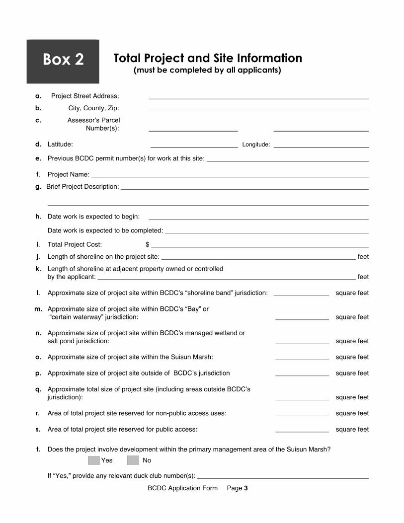
Box 2 Total Project and Site Information (must be completed by all applicants)
a. Project Street Address:
b. City, County, Zip:
c. Assessorʼs Parcel Number(s):
d. Latitude: Longitude:
e. Previous BCDC permit number(s) for work at this site:
f. Project Name:
g. Brief Project Description:
h. Date work is expected to begin:
Date work is expected to be completed:
i. Total Project Cost: $
j. Length of shoreline on the project site: feet
k. Length of shoreline at adjacent property owned or controlledby the applicant: feet
l. Approximate size of project site within BCDCʼs “shoreline band” jurisdiction: square feet
m. Approximate size of project site within BCDCʼs “Bay” or “certain waterway” jurisdiction: square feet
n. Approximate size of project site within BCDCʼs managed wetland or salt pond jurisdiction: square feet
o. Approximate size of project site within the Suisun Marsh: square feet
p. Approximate size of project site outside of BCDCʼs jurisdiction square feet
q. Approximate total size of project site (including areas outside BCDCʼs jurisdiction): square feet
r. Area of total project site reserved for non-public access uses: square feet
s. Area of total project site reserved for public access: square feet
t. Does the project involve development within the primary management area of the Suisun Marsh? Yes No
If “Yes,” provide any relevant duck club number(s):
BCDC Application Form Page 3

(Box 2, Total Project and Site Information, continued)
u. Project Details. Complete all that apply.
Proposed Elements of the Project
In BCDC’s Bay, Certain Waterway, Managed Wetlands or Suisun Marsh Jurisdiction*
In BCDC’s Shoreline Band jurisdiction
Outside BCDC’s jurisdiction Totals
1. Structures sq.ft. sq.ft. sq.ft. sq.ft.
2. All Roads, Parking,Pathways, Sidewalks sq.ft. sq.ft. sq.ft. sq.ft.
3. Number of ParkingSpaces:
4. All Landscaping sq.ft. sq.ft. sq.ft. sq.ft.
5. Left undeveloped sq.ft. sq.ft. sq.ft. sq.ft.
6. Shoreline Protection sq.ft. sq.ft. sq.ft. sq.ft.
7. Piers, docks and other marine-related purposes sq.ft. sq. ft. sq.ft. sq.ft.
8. Areas used for other purposes (specify) sq.ft. sq.ft. sq.ft. sq.ft.
sq.ft. Totals: sq.ft. sq.ft. sq.ft.
* If project will occur in more than one of these jurisdictions, provide the requested information for each area separately.
BCDC Application Form Page 4
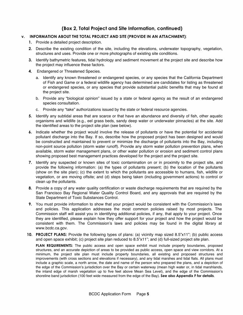
(Box 2, Total Project and Site Information, continued)
v. INFORMATION ABOUT THE TOTAL PROJECT AND SITE (PROVIDE IN AN ATTACHMENT): 1. Provide a detailed project description. 2. Describe the existing condition of the site, including the elevations, underwater topography, vegetation,
structures and uses. Provide one or more photographs of existing site conditions. 3. Identify bathymetric features, tidal hydrology and sediment movement at the project site and describe how
the project may influence these factors. 4. Endangered or Threatened Species.
a. Identify any known threatened or endangered species, or any species that the California Department of Fish and Game or a federal wildlife agency has determined are candidates for listing as threatened or endangered species, or any species that provide substantial public benefits that may be found at the project site.
b. Provide any “biological opinion” issued by a state or federal agency as the result of an endangered species consultation.
c. Provide any “take” authorizations issued by the state or federal resource agencies. 5. Identify any subtidal areas that are scarce or that have an abundance and diversity of fish, other aquatic
organisms and wildlife (e.g., eel grass beds, sandy deep water or underwater pinnacles) at the site. Add the identified areas to the project site plan (see below).
6. Indicate whether the project would involve the release of pollutants or have the potential for accidental pollutant discharge into the Bay. If so, describe how the proposed project has been designed and would be constructed and maintained to prevent or minimize the discharge of pollutants into the Bay, including non-point source pollution (storm water runoff). Provide any storm water pollution prevention plans, when available, storm water management plans, or other water pollution or erosion and sediment control plans showing proposed best management practices developed for the project and the project site.
7. Identify any suspected or known sites of toxic contamination on or in proximity to the project site, and provide the following information: (a) the types of pollutants present; (b) the location of the pollutants (show on the site plan); (c) the extent to which the pollutants are accessible to humans, fish, wildlife or vegetation, or are moving offsite; and (d) steps being taken (including government actions) to control or clean up the pollutants.
8. Provide a copy of any water quality certification or waste discharge requirements that are required by the San Francisco Bay Regional Water Quality Control Board, and any approvals that are required by the State Department of Toxic Substances Control.
9. You must provide information to show that your project would be consistent with the Commissionʼs laws and policies. This application addresses the most common policies raised by most projects. The Commission staff will assist you in identifying additional policies, if any, that apply to your project. Once they are identified, please explain how they offer support for your project and how the project would be consistent with them. The Commissionʼs laws and policies may be found in the digital library at www.bcdc.ca.gov.
10. PROJECT PLANS: Provide the following types of plans: (a) vicinity map sized 8.5”x11”; (b) public access and open space exhibit; (c) project site plan reduced to 8.5”x11”; and (d) full-sized project site plan. PLAN REQUIREMENTS: The public access and open space exhibit must include property boundaries, proposed structures, and an accurate depiction of areas to be provided as public access, open space and view corridors. At a minimum, the project site plan must include property boundaries, all existing and proposed structures and improvements (with cross sections and elevations if necessary), and any tidal marshes and tidal flats. All plans must include a graphic scale, a north arrow, the date and name of the person who prepared the plans, and a depiction of the edge of the Commissionʼs jurisdiction over the Bay or certain waterway (mean high water or, in tidal marshlands, the inland edge of marsh vegetation up to five feet above Mean Sea Level), and the edge of the Commissionʼs shoreline band jurisdiction (100 feet wide measured from the edge of the Bay). See also Appendix F for details.
BCDC Application Form Page 5

Box 3 Fill Information (“Fill” means earth or any other substance or material, including pilings or structures placed on pilings, and structures floating at some or all times and moored for extended periods, such ashouseboats and floating docks. Gov. Code Section 66632(a))
a. Complete this box if fill would be placed in any of these areas (check all those that apply):
San Francisco Bay Salt pond Managed wetland “Certain waterway”
Primary management area of the Suisun Marsh Other: ______________
b. Surface area of tidal and subtidal property to be covered with fill: square feet
c. Total volume of solid fill to be placed in tidal and subtidal areas: cubic yards
d. Type of Fill. Surface area of proposed:
Solid fill: square feet
Floating fill: square feet
Pile-supported fill: square feet
Cantilevered fill: square feet
Total area to be filled: square feet
e. Types of Areas to be Filled. Of the total area to be filled, what is the footprint of fill that would be placed in:
Open water: square feet
Tidal marsh: square feet
Tidal flat: ______________ square feet
Salt pond: square feet
Managed wetlands in the primary management area of the of the Suisun Marsh: square feet
Other managed wetlands: square feet
f. Area on new fill to be reserved for:
Private, commercial, or other non-public-access uses: square feet
Public access: square feet
BCDC Application Form Page 6

(Box 3, Fill Information, continued)
g. INFORMATION REGARDING FILL (PROVIDE IN AN ATTACHMENT): 1. Provide dimensions of portions of all structures to be built on new fill, including length, width, area, height
and number of stories.
2. Provide one or more photographs of existing shoreline conditions.
3. Explain the purpose of fill in the Bay, salt pond, managed wetland, certain waterway, or Suisun Marsh considering that the Commission can approve new fill for only five purposes: (a) accommodating a water-oriented use; (b) minor fill for improving shoreline appearance; (c) minor fill for providing new public access to the Bay; (d) accommodating a project that is necessary to the health, safety, or welfare of the public in the entire Bay Area; and (e) accommodating a project in the Suisun Marsh that is consistent with either: (1) the Suisun Marsh Preservation Act and the Suisun Marsh Protection Plan; or (2) the Suisun Marsh Local Protection Program.
4. Explain: (a) what possible impacts the fill would have on the Bay Area, including impacts on: (1) the volume of Bay
waters, on Bay surface area, or on the circulation of Bay water; (2) water quality; (3) the fertility of marshes or fish or wildlife resources; and (4) other physical conditions that exist within the area, including land, air, water, minerals, flora, fauna, noise, or objects of historic or aesthetic significance; and
(b) how the nature, location, and extent of the fill would minimize possible harmful conditions or effects to the Bay.
5. For projects in subtidal areas that have an abundance and diversity of fish, other aquatic organisms and wildlife, or are scarce such as eelgrass beds and sandy deep water, identify feasible alternatives and public benefits associated with the project.
6. Explain: (a) why the fill would be the minimum amount necessary; and (b) why there is no alternative upland location for the project that would avoid the need for Bay fill.
7. If the fill is to be used for improving shoreline appearance or providing new public access to the Bay, explain why it is physically impossible or economically infeasible to accomplish these goals without filling the Bay.
8. Explain how the fill would result in a stable and permanent shoreline.
9. Explain the steps that would be taken to assure that the project will provide reasonable protection to persons and property against hazards of unstable geologic or soil conditions, of sea level rise, or of flood or storm waters.
10. Provide the names, addresses, and telephone numbers of any licensed geologists, engineers, or architects involved in the project design who can provide technical information and certify the safety of the project.
11. Describe in detail the anticipated impacts of the fill on the tidal and subtidal environment, and describe how these impacts would be addressed or mitigated, and explain how the public benefits of the project would clearly exceed the public detriment from the loss of water area, tidal marsh or tidal flats.
12. For marina projects, indicate how many berths, if any, are to be made available for live-aboard boats and explain how these live-aboard boats would contribute to public trust purposes.
13. For tidal, subtidal and other wetland restoration projects, including mitigation projects: (a) identify specific long-term and short-term biological and physical goals; (b) identify success criteria; (c) provide a monitoring program intended to assess the success and sustainability of the project; (d) include an adaptive management plan with corrective measures, if needed, to achieve success and sustainability; and (e) identify the provisions for long-term maintenance, as required by the Bay Plan policies on Mitigation, Tidal and Subtidal Areas. The Commissionʼs laws and policies may be found at www.bcdc.ca.gov in the digital library.
BCDC Application Form Page 7

Box 4 Shoreline Band Information (“Shoreline band” means the land area lying between the Bay shoreline and a line drawn parallel toand 100 feet from the Bay shoreline. The Bay shoreline is the Mean High Water Line, or five feet above Mean Sea Level in marshlands.)
a. Does the project involve development within the 100-foot shoreline band around San Francisco Bay? Yes No
If “Yes,” complete this box.
b. Types of activities to be undertaken or fill, materials or structures to be placed within the shoreline band:
c. Would the project be located within a priority use area designated in the San Francisco Bay Plan? Yes No
The Bay Plan and Maps that depict priority use areas can be viewed in the digital library at www.bcdc.ca.gov. If “No,” go to section (d). If “Yes,” please indicate which priority use the area is reserved for:
Would the project use be consistent with the priority use for which the site is reserved? Yes No
If “Yes,” go to section (d). If “No,” attach an explanation of how the project can be approved despite this inconsistency.
d. Total shoreline band area: Within project site: square feet
To be reserved for private, non-public access uses: square feet
To be reserved for public access: square feet
e. INFORMATION ABOUT WORK PROPOSED IN THE SHORELINE BAND (PROVIDE IN AN ATTACHMENT): 1. Provide dimensions of portions of all structures to be built within the shoreline band, including length,
width, area, height, and number of stories. 2. Provide one or more photographs of existing conditions within the 100-foot shoreline band.
BCDC Application Form Page 8

Box 5 Public Access Information (must be completed by all applicants)
a. PUBLIC ACCESS DETAILS:
1. Does public access to the shoreline or do views to the Bay presently exist at the project site, at a contiguous property, or from nearby roads or public access areas?
Yes No
If “Yes” attach a description of the existing public access and views at these areas.
If “No,” explain what is preventing public access to, or views of, the shoreline.
2. Describe how the project would or would not adversely impact present and future public access and views to the Bay. If so, describe how the proposed public access would offset the impact.
3. For most large projects, identify: (1) the existing number of people or employees using the site; and (2) the existing number of cars, bicycles, and pedestrians visiting the site and the level of service of all nearby roads leading to the site. Describe how the project would change these factors.
4. Identify the publicʼs use of existing nearby parks, public access, public parking and other recreational areas on the shoreline and the roads leading to the site and describe the impact the project is expected to have on that use.
5. Do public safety considerations or significant use conflicts make it infeasible to provide new public access to the shoreline on the project site?
Yes No
If “Yes,” describe the public safety considerations or significant use conflicts that make it infeasible to provide public access at the project site and either: (1) identify an offsite area where public access to the shoreline is proposed as part of the project and describe the proposed public access area and improvements at that location; or (2) explain why no offsite public access is proposed as part of the project.
BCDC Application Form Page 9

(Box 5, Public Access, continued)
6. Dimensions of the public access areas: None Proposed
Existing Proposed Total public access area including areas outside the Commission’s jurisdiction: square feet square feet
Public access within Commission’s shoreline band jurisdiction: square feet square feet
linear feet linear feet average width average width
Public access pathways, sidewalks in the shoreline band: square feet ______________ square feet
linear feet linear feet average width average width
Public access area, landscaping in the shoreline band: square feet square feet
Public access on fill within Commission’s Bay, certain waterway, and managed wetlands jurisdiction: square feet square feet
linear feet linear feet average width average width
Public access on piers or decks over water/wetlands: ___________ square feet square feet
linear feet linear feet average width average width
View Corridor(s): square feet square feet linear feet linear feet average width average width
Public Access Parking: ___________ stalls stalls
b. ADDITIONAL PUBLIC ACCESS INFORMATION (PROVIDE IN AN ATTACHMENT): 1. Describe the existing and proposed public access improvements, both on-site and off-site, including
decks, piers, pathways, sidewalks, signs, benches, landscaping, parking, and any other proposed publicimprovements.
2. Describe how the public access area and facilities would be accessible to disabled persons. 3. Describe the proposed connections to existing public streets or offsite public pathways. 4. Specify how the public access areas would be permanently guaranteed (e.g., dedication, deed
restriction, etc.) and how the areas and improvements would be maintained. 5. Describe the species present, wildlife use, and habitat conditions in and adjacent to the proposed public
access areas and the likely type and degree of human use of the site (i.e., bicycling, dog walking, birding, frequency of use, etc.). Describe how any potential adverse effects on wildlife from public access would be avoided or minimized through the siting, design and management of the public access being proposed at the site.
BCDC Application Form Page 10

Box 6 Dredging and Mining Information
a. Complete this box if the project involves mining, dredging or the disposal of dredged material in any of the following areas.
San Francisco Bay Salt pond Managed wetland ”Certain waterway”
Primary management area of the Suisun Marsh Other: ______________
b. Are you submitting a separate application to the Dredged Material Management Office (DMMO)?
Yes No
If “Yes,” attach a copy of that application; it is not necessary to complete this Box. If “No,” complete this box.
c. Type of activity: Maintenance Dredging New Dredging Mining
d. Method of dredging or mining:
e. Total volume and area of material to be dredged or mined from:
Open waters: cubic yards
Tidal marshes: cubic yards
Tidal flats: ______________ cubic yards
Salt ponds: ______________ cubic yards Managed wetlands in the primary management area of the Suisun Marsh:
cubic yards
Other managed wetlands: ______________ cubic yards
Subtidal areas that are scarce or have an abundance and diversity of fish,other aquatic organisms and wildlife, such as eelgrass beds and sandy deep water:
______________ cubic yards
Other (specify): ______________ cubic yards
f. Are knockdowns proposed as part of the dredging project?
Yes No
Number of knockdowns: ______________
Volume per knockdown event: ______________ cubic yards
square feet
square feet
square feet
square feet
square feet
square feet
square feet
square feet
BCDC Application Form Page 11
Box 8 (Box 6,Dredging and Mining Information, continued)
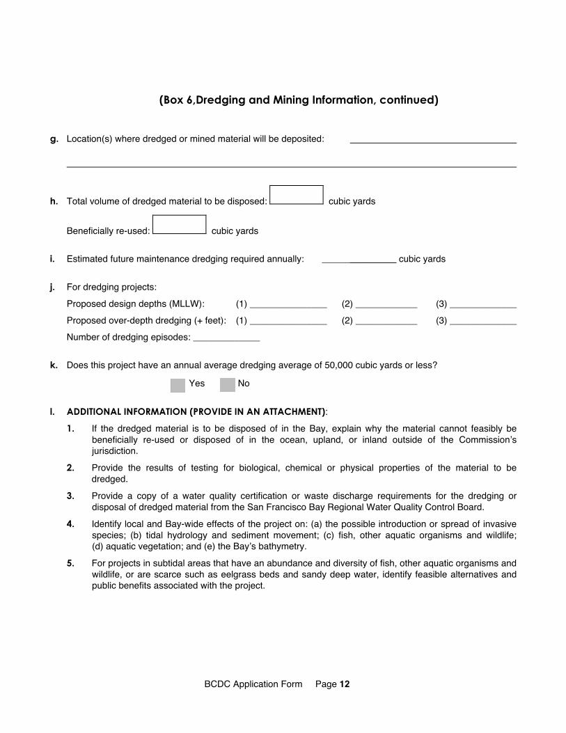
g. Location(s) where dredged or mined material will be deposited:
h. Total volume of dredged material to be disposed: cubic yards
Beneficially re-used: cubic yards
i. Estimated future maintenance dredging required annually: _________ cubic yards
j. For dredging projects:
Proposed design depths (MLLW): (1) _______________ (2) ____________ (3) _____________ Proposed over-depth dredging (+ feet): (1) _______________ (2) ____________ (3) _____________ Number of dredging episodes: _____________
k. Does this project have an annual average dredging average of 50,000 cubic yards or less?
Yes No
l. ADDITIONAL INFORMATION (PROVIDE IN AN ATTACHMENT):
1. If the dredged material is to be disposed of in the Bay, explain why the material cannot feasibly be beneficially re-used or disposed of in the ocean, upland, or inland outside of the Commissionʼs jurisdiction.
2. Provide the results of testing for biological, chemical or physical properties of the material to be dredged.
3. Provide a copy of a water quality certification or waste discharge requirements for the dredging or disposal of dredged material from the San Francisco Bay Regional Water Quality Control Board.
4. Identify local and Bay-wide effects of the project on: (a) the possible introduction or spread of invasive species; (b) tidal hydrology and sediment movement; (c) fish, other aquatic organisms and wildlife; (d) aquatic vegetation; and (e) the Bayʼs bathymetry.
5. For projects in subtidal areas that have an abundance and diversity of fish, other aquatic organisms andwildlife, or are scarce such as eelgrass beds and sandy deep water, identify feasible alternatives and public benefits associated with the project.
BCDC Application Form Page 12

Box 7 Information on Government Approvals (must be completed by all applicants)
Required Type of Date Approval Agency Contact YES NO Approval Expected/Received and Phone Number
Local Government Discretionary Approval(s):
State Lands Commission:
Regional Water Quality Control Board:
California Dept. of Toxic Substances Control:
California Department of Fish and Game
Streambed Alteration Permit:
DF&G Take Authorization:
Other DF&G Permit:
U.S. Army Corps Of Engineers:
U.S. Fish and Wildlife Service:
Take Authorization
Biological Opinion:
NOAA Fisheries Service: Take Authorization
Biological Opinion
U.S. Coast Guard:
Federal Funding:
Other Approval (Specify):
❏ Yes No
❏ Yes No
❏ Yes No
Regional Board Number:
❏ Yes No
❏ Yes No
❏ Yes No
❏ Yes No
❏ Yes No
Public Notice Number:
❏ Yes No
Yes No
Yes No
❏ Yes No
Yes No
Yes No
BCDC Application Form Page 13
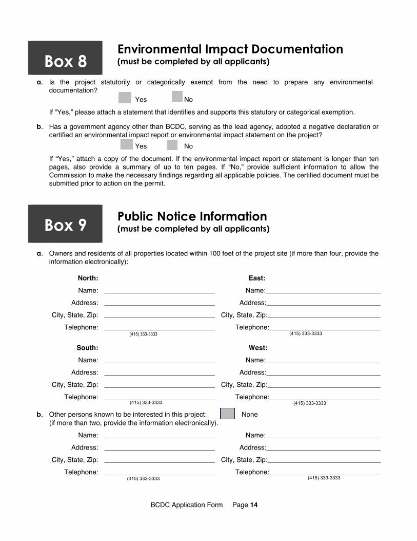
Box 8 Environmental Impact Documentation (must be completed by all applicants)
a. Is the project statutorily or categorically exempt from the need to prepare any environmental documentation?
Yes No
If “Yes,” please attach a statement that identifies and supports this statutory or categorical exemption.
b. Has a government agency other than BCDC, serving as the lead agency, adopted a negative declaration or certified an environmental impact report or environmental impact statement on the project?
Yes No
If “Yes,” attach a copy of the document. If the environmental impact report or statement is longer than ten pages, also provide a summary of up to ten pages. If “No,” provide sufficient information to allow the Commission to make the necessary findings regarding all applicable policies. The certified document must be submitted prior to action on the permit.
Box 9 Public Notice Information (must be completed by all applicants)
a. Owners and residents of all properties located within 100 feet of the project site (if more than four, provide the information electronically):
North: East: Name: Name:
Address: Address: City, State, Zip: City, State, Zip:
Telephone: Telephone: (415) 333-3333 (415) 333-3333
South: West: Name: Name:
Address: Address: City, State, Zip: City, State, Zip:
Telephone: Telephone: (415) 333-3333 (415) 333-3333
b. Other persons known to be interested in this project: None (if more than two, provide the information electronically).
Name: Name: Address: Address:
City, State, Zip: City, State, Zip: Telephone: Telephone:
(415) 333-3333 (415) 333-3333
BCDC Application Form Page 14