bass coast shire council 5€¦ · bass coast shire council civic centre, ... amendment c115 –...
TRANSCRIPT
28 July 2010 - Minutes for Ordinary Meeting
Bass Coast Shire Council
Civic Centre, Baillieu Street, Wonthaggi 5.00pm
1. These minutes are due to be confirmed on 18 August 2010.
2. Any decision included in these minutes is subject to change resulting from a rescission motion passed by Council.
Minutes of Ordinary Meeting - 28 July 2010 Bass Coast Shire Council
Page 2
TABLE OF CONTENTS
A Present and Apologies ................................................................................................. 4
B Community Question Time........................................................................................ 5
B.1 Beth Banks, Wonthaggi - Library........................................................................... 5 B.2 Beryl Farr, Wonthaggi – New Principal Library .................................................... 5 B.3 Helen & Steven Peterson, Inverloch - 59 Williams Street two dwellings............. 5 B.4 Maurice Schinkel, Cowes - Tunnel Spoil from Desalination project................... 6 B.5 Maurice Schinkel, Cowes – Flag of Convenience vessel for Desalination
project ..................................................................................................................... 6 B.6 Maurice Schinkel, Cowes - Cypress Trees in Thompson Avenue......................... 6 B.7 Rosa Scarlto, Cowes – Car Ferry............................................................................ 7 B.8 Sue Frew, Cowes – Vehicle Ferry............................................................................ 7 B.9 Phillip Becker, Cowes - Car Ferry .......................................................................... 7 B.10 Roger Thorrowgood, Inverloch - Cape Patterson Eco Village.............................. 8
C Reports Requiring Council Decision........................................................................... 8
C.1 Agenda Item I.2 - Amendment C115 – Stony Point – Cowes Vehicular Ferry, Cowes Transport Terminal .......................................................................... 8
C.2 Agenda Item I.1 - Amendment C53: Cape Paterson Ecovillage - Post Panel Hearing Report...........................................................................................33
D Acknowledgements.................................................................................................... 48
D.1 Mayor & Councillor from Wellington Shire - Cr Peter Paul ..............................48 D.2 Local Sport Volunteers - Cr Phil Wright ..............................................................48 D.3 Passing of Lew Arthur - Cr John Duscher ............................................................48 D.4 Passing of Margaret Langley - Cr Ross Smith .....................................................48
E Confirmation of Minutes............................................................................................ 48
E.1 Ordinary Meeting held on 16 June 2010 .............................................................48 E.2 Closed Ordinary Meeting held on 16 June 2010.................................................48
F Petitions and Deputations ......................................................................................... 49
F.1 No.45 Petition – White Road Wonthaggi ..........................................................49
G Notices of Motion....................................................................................................... 50
G.1 47/10 Genetically Engineered Seeds..................................................................50
H Committees and Delegates Reports ........................................................................ 51
H.1 Place Names Committee......................................................................................51 H.2 Phillip Island Nature Park Update ......................................................................53 H.3 Gippsland Regional Waste Management Group................................................55 H.4 Bass Coast Shire Municipal Emergency Management Planning
Committee.............................................................................................................57 H.5 Bass Coast Shire Council Municipal Fire Prevention Committee......................58
I Performance Monitoring Reports............................................................................. 60
I.1 Contracts Awarded Report ..................................................................................60 I.2 Building Stats June 2010.......................................................................................62 I.3 Planning Permits Issued Under Delegation - June 2010 .....................................63 I.4 Planning Permit Approval Statistics ....................................................................66
J Watching Bass Coast ................................................................................................. 68
J.1 Cost Saving Report - Agenda Preparation Process.............................................68 J.2 Local Government Inspectorate Investigation into Rezoning of land in
Minutes of Ordinary Meeting - 28 July 2010 Bass Coast Shire Council
Page 3
San Remo ..............................................................................................................70
K Reports Requiring Council Decision......................................................................... 74
K.1 Adoption of the 2010/11 budget ..........................................................................74 K.2 Declaration of 2010/11 rates and garbage charge .............................................77 K.3 Amendment C112 - Land west of Tulloch Street, Dalyston: Post
Exhibition Report..................................................................................................94 K.4 Amendment C98: Post Panel Report - Significant Landscape Overlays .........110 K.5 070357 - Use and develop two dwellings at 59 Williams Street,
Inverloch..............................................................................................................129 K.6 080684 - Use of the land for an outdoor recreation facility (clay target
range) at 2105 Bass Highway, Glen Forbes.......................................................149 K.7 100101 - Develop an aged care facility, alter existing motel and
remove vegetation from 192 - 198 Thompson Avenue, Cowes........................165 K.8 Webb Drive Special Charge Scheme No.32 ......................................................202 K.9 Land Acquisition - Tenby Point Area Special Charge Scheme No.55 .............210 K.10 Proposed exchange of land between Council and Country Fire
Authority - Wonthaggi........................................................................................216 K.11 Proposed discontinuance of roads and exchange of land - Vicars
Avenue, North Wonthaggi..................................................................................224 K.12 Recreation Reserve at 16 Wallace Avenue, Inverloch ......................................228 K.13 Daisy Avenue Reserve (Pioneer Bay) Development .........................................236 K.14 Petition - Review parking in front of Newsagency/Post Office, San
Remo....................................................................................................................244 K.14 Petition - Maintenance of roads in the Bass Township ...................................247 K.16 Influenza Pandemic Plan....................................................................................250 K.17 Neighbourhood Safer Places in Bass Coast Shire .............................................253
L Items Closed to the Public ...................................................................................... 262
L.1 Contractual matter.............................................................................................262 L.2 Contractual matter.............................................................................................262 L.3 Contractual matter.............................................................................................262

Minutes of Ordinary Meeting - 28 July 2010 Bass Coast Shire Council
Page 4
A Present and Apologies
Councillors: Cr Peter Paul (Chair), Thompson Ward
Cr John Duscher, Hovell Ward
Cr Gareth Barlow, Anderson Ward
Cr Veronica Dowman, Leadbeater Ward
Cr Jane Dore Daly, McHaffie Ward
Cr Phil Wright, Churchill Ward
Cr Ross Smith, Townsend Ward
Officers: Mr Danny Luna, Acting CEO (Corporate Services Director)
Ms Patti Wenn, Community and Economic Development Services Director
Mr Steve Piasente, Infrastructure Director
Ms Hannah Duncan-Jones, Planning & Environment Director
Ms Karly Simpson, Governance Administration Officer
Apologies: Mr Allan Bawden, Chief Executive Officer
Prayer: Cr Smith read the prayer.
Acknowledgement: Cr Wright read the acknowledgement.
Statement: Cr Duscher read the Councillor statement.
Meeting Commenced
The meeting commenced at 5.05pm.

Minutes of Ordinary Meeting - 28 July 2010 Bass Coast Shire Council
Page 5
B Community Question Time
B.1 Beth Banks, Wonthaggi - Library
Where are we up to in the quest for a regional library?
Ms Wenn responded; Education providers from across Bass Coast signed a partnership agreement with Bass Coast Shire Council and the Department of Education and Early Childhood Development on 21 July 2010 to commit to being a part of the planning for the Bass Coast Education and Learning Precinct.
Organisations who have agreed to be involved with the planning of the site include Wonthaggi Secondary College, Newhaven College, Bass Coast Specialist School, Chisholm TAFE, Apprenticeships Group Australia, Bass Coast Adult Education Centre, Monash University, Phillip Island Nature Park and Education Centre Gippsland.
The Precinct site includes 19 hectares of Crown land in McKenzie Street, Wonthaggi, where the Specialist School has been built.
The Precinct would enable the community to maximise post compulsory education and learning outcomes. Consultant, Peter Hanley, will meet with partners over the next four months in preparation of a Business Case, and in conjunction with architects, Clarke Hopkins Clarke, will develop the Precinct’s Master Plan.
Once completed, the Business Case and Master Plan will be submitted to the Department for an investment decision. Further decisions regarding the future use of the present Wonthaggi Secondary College Senior Campus site will be dependent on the State Government’s investment decision for the Precinct and at this stage the timing is unknown.
B.2 Beryl Farr, Wonthaggi – New Principal Library
We believe that Council is proposing a new community hub in the present Wonthaggi Secondary College Senior Campus once the college is relocated to the McKenzie street site.
Will provision be made for a new Principal Library in this hub and how long is this likely to take?
The Mayor responded that this question was addressed in the response provided to Ms Banks.
B.3 Helen & Steven Peterson, Inverloch - 59 Williams Street two dwellings
We spoke to John Ciavarella about rear dwelling at 59 Williams Street reference no; 070357, we are concerned about a rear balcony be allowed to be built at the rear unit in the future due to 10 years of objecting to one. We are asking the question on the question can council make it a condition on the permit that there will never to be a permit issued for a rear balcony to be erected due to 10 years of objecting to protect our privacy and noise issues.
Ms Duncan-Jones advised that there were no policies, provisions or standards within the Bass Coast Planning Scheme that provide support for the inclusion of the

Minutes of Ordinary Meeting - 28 July 2010 Bass Coast Shire Council
Page 6
condition. On this basis the inclusion of the condition is not supported.
B.4 Maurice Schinkel, Cowes - Tunnel Spoil from Desalination project
As the Environment Management Plan for the Victorian Desalination Project has in relation to “Tunnel Spoil”, invoked EPA publication 788, October 2001, “Best Practice Environmental Management – Siting, Design, Operation and Rehabilitation of Landfills” is Council aware if ‘tunnel spoil’ from the VDP is being or is proposed to be, disposed of in local landfills and is Council aware of the consultants and composition of the ‘tunnel spoil’?
Mr Luna responded that this question will be referred the Community Liaison Group for a response.
B.5 Maurice Schinkel, Cowes – Flag of Convenience vessel for Desalination
project
Is Council concerned at the imminent presence off Bass Coast beaches of the Flag of Convenience vessel UOS Discovery, to be used for the Victorian Desalination Project, considering that the UOS Discovery flies the Flag of Convenience of the Underperforming Flag State of Antigua and Barbuda, and that Antigua and Barbuda are “Targeted for special enforcement” by the US Coast Guard, and that Antigua and Barbuda have not signed the 1976 Treaty ILO 147, and that Antigua and Barbuda are listed adversely in the US Central Intelligence Agency World Fact book and Transportation?
Mr Luna responded that this question will be referred the Community Liaison Group for a response.
B.6 Maurice Schinkel, Cowes - Cypress Trees in Thompson Avenue
Further to my letter of 8 July to the Chief Executive (attached) regarding the proposal in the 2010/11 Budget for the, “Replacement of 10 cypress tress in Thompson Avenue, Cowes….” what is the exact location of the 10 cypress trees?
Mr Piasente responded, that the Council has budgeted for the replacement of the cypress trees as part of its adopted maintenance and replacement strategy. The trees are located at various sites along Thompson Avenue and are in a poor state of health and have serious decay. Council is in the process of engaging an arborist to review the health of the trees. Subject to the outcome of the arborist report, Council will be undertaking community consultation and also applying for a Planning Permit for the replacement of the trees . Council has already consulted with the Friends of the Golden Cypress and has purchased the same species of trees as part of the replacement strategy.
Minutes of Ordinary Meeting - 28 July 2010 Bass Coast Shire Council
Page 7
B.7 Rosa Scarlto, Cowes – Car Ferry
Question to Allan Bawden;
When was the last time you came to Phillip Island to admire the beautiful beach on the Cowes foreshore that they want to destroy by erecting a ferry Terminal?
Question to all Councillors;
Before you make a rash decision, think seriously about the impact and don’t make a mistake. Consider the future of your grandkids. Why would you want to turn the centre of the Cowes shopping precinct into an Industrial Ferry Terminal like the Port Albert and Queenscliff terminals in Victoria and Devonport in Tasmania? Not very aesthetic are they.
Ms Wenn replied that this will be covered in the report and discussion to be had tonight.
B.8 Sue Frew, Cowes – Vehicle Ferry
1995 Studies nominated Erehwon Point as the most suitable site for a vehicle ferry over Cowes Jetty, Justice Road and Anderson Street boat ramp.
In 2003 a study changed this suitability to Cowes Jetty – Right in the heart of the business street of Cowes on the most frequented beach on Phillip Island for families, why has this changed?
How can putting an Industrial Ferry Terminal in the heart of a pristine area be more environmental ‘friendly’ than Erehwon Point or Anderson’s boat ramp?
I have no objection to a Stony Point / Cowes Vehicle ferry but I do strongly object to the location selected in the 2003 study.
Ms Wenn responded; given the environmental concerns of the other sites nominated for the proposed ferry terminal and the fact that the Cowes jetty triangle already facilitated commercial vessel used for tourism, an existing passenger ferry service, tenders for large cruise ships, small marine craft and featured an existing bitumen car park on the foreshore, the Community Reference Group and Council determined that this site would be selected for further investigation.
Anderson’s boast ramp would require dredging and Erehwon Point was deemed a less disturbed or dramatically altered site when compared to the Cowes jetty triangle.
B.9 Phillip Becker, Cowes - Car Ferry
I would like to ask Ms how she arrived at her assumption that because people didn’t voice their opposition they must automatically be in favour of the car ferry proposal.
Ms Wenn responded that this relates to an article that was published in the Advertiser and relates to a conversation that was had with VFAG representatives that was taken out of context. As with any social research it is well known that there will

Minutes of Ordinary Meeting - 28 July 2010 Bass Coast Shire Council
Page 8
be objectors and also those who support the proposed projects.
NOTE: Mr Thorrowgood’s question was asked later in the meeting, due to the original question being misplaced. B.10 Roger Thorrowgood, Inverloch - Cape Patterson Eco Village
Is the Council aware that members of the Victorian Coastal Council are concerned that the Victorian Coastal strategy is being interpreted in ways contrary to the intentions of the authors?
The Mayor responded that Council was not aware.
Motion
Moved: Cr. Gareth Barlow / Seconded: Cr. Ross Smith
That agenda item I.2 to be brought forward.
CARRIED Note: The Mayor sought leave from the Council to vacate the Chair in order to enter debate.
Motion
Moved: Cr. Ross Smith / Seconded: Cr. John Duscher
That the Mayor be granted leave to vacate the Chair and Deputy Mayor Cr Veronica Dowman take position in the Chair for this item.
CARRIED
C Reports Requiring Council Decision
C.1 Agenda Item I.2 - Amendment C115 – Stony Point – Cowes Vehicular Ferry, Cowes Transport Terminal
File No: CM10/154 Department: Community and Economic
Development Council Plan Strategic Objective: Cohesive Communities
We will improve lifestyle opportunities and options by managing the built environment and encouraging cohesive communities.
Declaration
The reporting officer does not have a direct or indirect interest in this matter.
Summary
Minutes of Ordinary Meeting - 28 July 2010 Bass Coast Shire Council
Page 9
Bass Coast and Mornington Peninsula Shire Councils and various State Government departments have been working towards the establishment of a vehicular ferry between Stony Point and Cowes for many years.
At the October 2008 Ordinary Meeting, Council resolved that it “commit to contributing 50% to the funding of the planning process for the Stony Point to Cowes Car Ferry Project, which is estimated to not exceed $235,000, payable over two financial years”. Mornington Peninsula Shire Council also committed to contribute $235,000, while Tourism Victorian and Regional Development Victoria agreed to provide $100,000 funding each for the concept design and statutory planning phase of the project.
Bass Coast Shire Council, on behalf of the Project Team, conducted a tender process and selected a consultant team, led by Meinhardt Infrastructure & Environment Pty Ltd (Meinhardt), to prepare concept plans for the vehicular ferry (and related infrastructure) at nominated locations at Stony Point and Cowes as well as the necessary statutory planning and referral documents. This phase of the proposed Stony Point to Cowes vehicular ferry project has now progressed through community and stakeholder consultation, preliminary technical investigation and concept design to the development of Draft Concept Plans for the project. It has also led to the preparation of preliminary technical studies, draft Planning Scheme Amendment documentation, draft environmental referrals under the Environment Effects Act (1978) and Environment Protection and Biodiversity Conservation Act (1999) and a preliminary application for Coastal Management Act Consent.
The Draft Concept Plans have been prepared collaboratively by State and Local Government, with input from community members and various stakeholders. The Draft Concept Plans have been placed on public exhibition in both Shires and are supported by technical analysis. It is now recommended that Councillors endorse the Draft Concept Plans; submit the environmental referrals; authorise officers to request the Minister for Planning to Prepare and Exhibit an Amendment to the Bass Coast Planning Scheme to provide the Draft Concept Plans with statutory weight; and seek in principle Coastal Management Act consent.
Introduction
The two sites selected for further investigation in the Stony Point to Cowes Vehicular Ferry Project are:
• Stony Point - the area around the Stony Point jetty, including a portion of the land currently leased to Toll Western Port, which forms part of the Port of Hastings.
• Cowes - existing jetty and adjoining foreshore (centered primarily in and around the Jetty Triangle) and town centre.
Refer to Attachment 1 for the study area at both locations.
Background and Context
To assist in developing the vehicular ferry proposal, the consultant team was provided with the following elements as a starting point:
• Nominated sites at Stony Point and Cowes.
• Base concept plans for both sites.
• Operational requirements for the vehicular ferry.

Minutes of Ordinary Meeting - 28 July 2010 Bass Coast Shire Council
Page 10
Each of these elements set an important base framework and shaped the way in which studies and investigations have been undertaken.
Nominated Sites
The previous strategic work that has been undertaken has provided the foundation for this current study.
The two sites were selected following a preliminary assessment of various sites undertaken as part of two previous studies - Phillip Island Car Ferry Feasibility Study (1995) prepared by Bass Coast Shire Council and Cowes to Stony Point Pre-Feasibility Study (2003) prepared by Arup Consultants.
Minutes of Ordinary Meeting - 28 July 2010 Bass Coast Shire Council
Page 11
The 1995 study examined four potential sites for terminal facilities on Phillip Island (Erehwon Point, Cowes Jetty, Justice Road and Anderson Street), while three sites were considered at Stony Point (two within the port precinct using the existing reclaimed area at the foot of Stony Point jetty for access and the third site was adjacent to the existing boat ramp). This study recommended the site north of the existing pier at Stony Point, and Erehwon Point on Phillip Island.
The 2003 study focused on four sites on Phillip Island (Anderson Street, Cowes Jetty, Erehwon Point and Rhyll) and nominated Cowes Jetty as the preferred location. This study did not include options for Stony Point as this site was determined through the 1995 study. It also did not consider the Justice Road site as it was not seen as a cost effective option and was eliminated.
Consideration of the potential environmental impacts associated with the other sites was a key factor in selecting Cowes Jetty for further consideration/investigation.
Base Concept Plans
The Cowes to Stony Point Pre-Feasibility Study 2003 outlined a number of potential concepts for the vehicular ferry at the two nominated sites. These concepts were referred by both Shires to the former Minister for Planning, the Honourable Rob Hulls, in 2006.
Refer to Attachment 2 for the preferred base concepts outlined in the 2003 Arup study.
Operational Parameters of the Vehicular Ferry
The following operational parameters for the ferry were provided to the consultant team as a starting point:
• The vehicular ferry is to have a capacity of up to 50 standard vehicles (or equivalent).
• The vessel is to sail directly from Stony Point to Cowes.
• The voyages are to be hourly point to point (resulting in a two hour return trip).
• There is to be a maximum of ten sailings per day (five each way).
These parameters were endorsed by the then Minister for Planning, the Honourable Rob Hulls, in his letter (dated June 2006), which states that an Environment Effects Statement is not required based on the concepts outlined in Attachment 2 and parameters outlined above.
Strategic Support for Project
The Stony Point to Cowes Vehicular Ferry offers the opportunity to create a world class tourism route linking the Great Ocean Road, Mornington Peninsula, Phillip Island/Bass Coast, Wilsons Promontory, Gippsland Lakes and Sydney-Melbourne Coastal Drive.
The ferry route is a strategic linkage that completes the route. It can be expected that significant economic and social benefits will arise through the completion of this link. There are a number of regional and State policies and reports that support the development of the vehicular ferry, including:
Minutes of Ordinary Meeting - 28 July 2010 Bass Coast Shire Council
Page 12
The Victorian Transport Plan (2008)
Ferry transport in Victoria plays an important role for coastal communities and visitors. Established ferry services include the successful passenger and car service between Sorrento and Queenscliff and the French Island/Cowes Ferry. These services provide important connections across Port Phillip Bay and between the Victorian mainland and populated islands and are used by residents, tourists and for light freight purposes as part of the local transport network.
The Victorian Government, through the Bays and Maritime Initiative, is developing a long term plan to renew maritime infrastructure and revitalise key harbour precincts around Port Phillip Bay and Western Port. This will enable greater public access to and enjoyment of popular coastal and beach destinations.
Boating Coastal Action Plan (2007)
Stony Point and Cowes are located in Area 8 (North West Western Port) and Area 9 (South East Western Port) respectively. The Plan notes that the potential to establish a vehicular ferry between Stony Point and Cowes is being investigated.
Regional Tourism Action Plan (2009-2012)
The Regional Plan is supported by the Regional Marketing and Development Plan 2009-2010 – Mornington Peninsula and Regional Marketing and Development Plan 2009-2010 – Phillip Island, Tourism Victoria
The vehicular ferry project is included in the key actions for 2009 – 2012 for the Mornington Peninsula and Phillip Island regions, under the Investment and Infrastructure section of the Regional Tourism Action Plan.
This long-term project will ensure the Phillip Island region is well placed to further leverage its proximity to Melbourne with the project creating an important access link to the Island.
Gippsland Regional Plan (2010)
The Gippsland Regional Plan has been developed by the Gippsland Local Government Network, with involvement from relevant Government Departments in Gippsland as well as the newly created Gippsland Board of Regional Development Australia. The Plan will position the Gippsland region to take advantage of regional opportunities through the State Government Regional Blueprint. The Stony Point - Cowes Vehicular Ferry is listed as a high priority project under this Plan and the Destination Gippsland Strategic Plan.
Process Undertaken in Current Study
Concept Plan Development – Preliminary Draft
Preliminary Draft Concept Plans for the nominated sites at Cowes and Stony Point were prepared for community feedback, these plans sought to address the objectives developed through the first round of consultation and the brief provided by local and State government. The Plans provide an indication for how the buildings and facilities required to support the ferry service in Cowes and Stony Point could be developed. The Preliminary Draft Concept Plans also aimed to show the maximum level/type of development envisaged.
A copy of the Preliminary Draft Concept Plans placed on exhibition is provided in Attachment 3.

Minutes of Ordinary Meeting - 28 July 2010 Bass Coast Shire Council
Page 13
Stakeholders / Consultation
Consultation research has been undertaken to ensure that the investigation of the options for the vehicular ferry is well informed by community views and concerns. The consultation and research process was undertaken at three key points in the study.
First Consultation Round
The first round of consultation was undertaken between July to September 2009, prior to the development of concept plans for the identified sites at Stony Point and Cowes. To ensure a rigorous and representative approach to the community consultation and research, a program was designed to facilitate broad based community input at this early stage in the study and to target key agencies and stakeholders representing the environmental, social and economic dimensions of the project. The consultation and research process included:
• A workshop with a Community Reference Group established by the Shires to facilitate community feedback at key project stages;
• Distribution of an information bulletin and feedback sheet to just over 19,000 residents and non-resident ratepayers in the Bass Coast Shire and to residents of Bittern, Crib Point and Stony Point (2,400 households) in the Mornington Peninsula Shire;
• A telephone survey of a random sample (400 responses) of residents and non-resident ratepayers in both Shires;
• Four focus group discussions with randomly recruited residents; and
• Three roundtable discussions with invited government and community agencies.
Approximately 620 responses were received in response to the opportunity to provide written feedback regarding the proposed vehicular ferry.
A number of key issues and opportunities were identified through the first round of consultation. These included:
• A high level of in-principle support for the project;
• Concern about the siting, scale and impact of facilities;
• Strong interest in the potential economic benefits that might result from the project;
• Enthusiasm for the opportunity to explore new tourism markets and cultural opportunities;
• Support for improvements to local infrastructure, amenity and safety;
• Concern about the economic viability of the project and any potential burden on rate payers;
• Concern about any social or environmental impacts that might result from the project; and
• A desire to see the project address the wider precinct issues, such as parking and traffic management.

Minutes of Ordinary Meeting - 28 July 2010 Bass Coast Shire Council
Page 14
A report titled Stony Point – Cowes Vehicular Ferry Project Consultation and Research Summary (Issues & Opportunities) September 2009 documents the consultation research that was undertaken.
Refer to Attachment 4 for a copy of the Consultation and Research Summary.
Second Consultation Round
In December 2009, a community and stakeholder workshop (Design Charette) was also held to inform the design principles for the Cowes Concept Plan.
A number of project objectives were developed by community and stakeholder representatives to inform the development of the Draft Concept Plans. These objectives reflect the issues raised in the consultation process:
Social and Cultural Objectives
• Protect and enhance existing recreational uses and functions.
• Maintain the social and recreational value of the beach frontage
• Preserve and enhance the heritage values
• Improve foreshore amenities, access and safety for residents and visitors
• Enhance the role of the foreshore as a social/meeting and event space
• Minimise conflict/optimise shared benefits between visitor and resident functions
• Support community confidence through an open and inclusive process
Economic Objectives
• Optimise opportunities for exiting and new businesses
• Optimise economic viability of ferry service and return on public investment
• Extend seasonal demand with a world class coastal touring route
• Enhance functionality of foreshore
Environmental Objectives
• Protect the unique amenity of the north facing beach at Cowes
• Protect marine environment Minimise traffic and parking impacts
• Minimise impact on flora and fauna
• Deliver best practice in environmental design
• Improve landscape and foreshore qualities
Other Objectives
• Create a safe harbour for all
• Protect and enhance the unique character of the precinct
These objectives informed the development of draft concept plans for the nominated sites at Cowes and Stony Point.
Third Consultation Round

Minutes of Ordinary Meeting - 28 July 2010 Bass Coast Shire Council
Page 15
The third round of consultation was undertaken during the public exhibition of Draft Concept Plans (during March/April 2010) and involved:
• A launch of the Draft Concept Plans to a joint meeting of Councillors and officers from both Shires with the Community Reference Group on Monday 22nd of March 2010.
• Two community information displays at the following locations:
- Bass Coast Shire Council – Chapel St, Cowes (outside Coles supermarket) on Friday 26 March between 3.00 pm and 6.00 pm.
- Mornington Peninsula Shire Council – Hastings Hall on Saturday 27 March between 10.00 am and 1.00 pm.
• Displays were set up in the following locations within Mornington Peninsula Shire Council:
• Pelican Park Aquatic Centre
• Crib Point Community House
• Stony Point Caravan Park and boat ramp
• Council offices (Hastings, Mornington, Rosebud); and
• Mornington Peninsula Libraries (Hastings, Mornington, Rosebud and Mobile Library).
• Displays were set up in the following locations within Bass Coast Shire Council;
• Phillip Island RSL,
• Customer Service Centres (Cowes, Wonthaggi, Grantville & Inverloch);
• Bass Coast Libraries (Cowes, Wonthaggi, Inverloch) and Newhaven Visitor Information Centre.
A community bulletin and feedback sheet was prepared and mailed out to a project mailing list of approximately 650 interested people. The project information was also available at key community venues and on Bass Coast Shire and Mornington Peninsula Shire websites.
Following exhibition of the Draft Concept Plans, a total of 898 written responses and two petitions were received. Almost two-thirds of the respondents to the Draft Concept Designs were from the Bass Coast Shire, with approximately half of the total responses coming from residents of Cowes. The breakdown of responses by municipality was as follows:
• Bass Coast Shire – 576 submissions.
• Mornington Peninsula Shire – 54 submissions.
• Non-residents – 268 submissions.
The petitions received comprised a petition in support of the concept (1243 signatures) and a petition opposing the proposed location and design at Cowes (835 signatures).
Of the 898 written responses, approximately 100 responses simply stated ‘wrong location’ and provided no feedback in relation to the design.
Minutes of Ordinary Meeting - 28 July 2010 Bass Coast Shire Council
Page 16
Design based suggestions/comments are outlined below in the section titled “Refinement of Draft Concept Plans”.
Refer to Attachment 5 for a copy of the Stony Point – Cowes Vehicular Ferry Project Feedback on Draft Concept Design June 2010.
Technical Studies
Following the preparation of Draft Concept Plans for each site, a number of preliminary technical investigations were undertaken. The following technical studies have examined the Draft Concept Design with regard to possible Environmental, Economic and Social impacts:
• Terrestrial Ecology (flora and fauna) – refer Attachment 6.
• Marine Ecology (flora and fauna) – refer Attachment 7.
• Indigenous Cultural Heritage – refer Attachment 8.
• Non Indigenous Cultural Heritage – refer Attachment 9.
• Traffic and Parking Management Plan – refer Attachment 10.
• Coastal Process/Coastal Engineering – refer Attachment 11.
• Economic Impact Assessment – refer Attachment 12.
• Social Impact Assessment – refer Attachment 13.
The technical studies are also required to support the preparation of planning scheme amendment documentation. As indicated in each report, more detailed studies may be required to be prepared following the preparation of detailed designs for each site.
Refinement of Draft Concept Plans
Following the receipt of community feedback and preliminary technical studies, the Project Steering Committee met to consider the information and opportunities to modify the Draft Concept Plans in response to the feedback received.
Attachment 14 provides a summary of the design based issues raised in the feedback and the Steering Committee’s response to each issue. The recommended changes, which have subsequently been made to the Draft Concept Plans, are shown in bold.
Refer to Attachment 15 for a copy of the revised Draft Concept Plans.
In response to stakeholder feedback requesting 3D drawings of the Draft Concept Plans, a number of watercolour perspectives have been prepared for Cowes (3 perspectives) and Stony Point (1 perspective).
Refer to Attachment 16 for a copy of the watercolour perspectives prepared for Cowes and Stony Point.
Minutes of Ordinary Meeting - 28 July 2010 Bass Coast Shire Council
Page 17
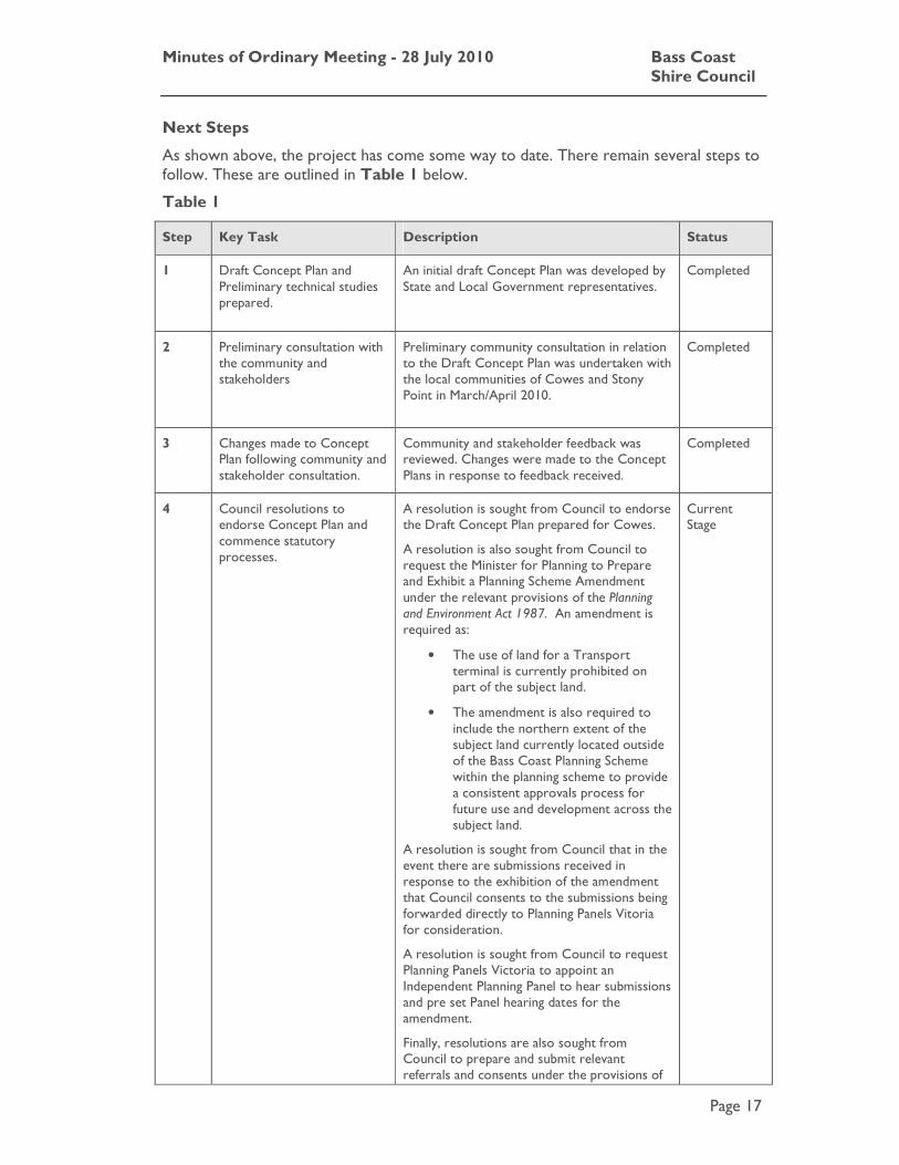
Next Steps
As shown above, the project has come some way to date. There remain several steps to follow. These are outlined in Table 1 below.
Table 1
Step Key Task Description Status
1 Draft Concept Plan and Preliminary technical studies prepared.
An initial draft Concept Plan was developed by State and Local Government representatives.
Completed
2 Preliminary consultation with the community and stakeholders
Preliminary community consultation in relation to the Draft Concept Plan was undertaken with the local communities of Cowes and Stony Point in March/April 2010.
Completed
3 Changes made to Concept Plan following community and stakeholder consultation.
Community and stakeholder feedback was reviewed. Changes were made to the Concept Plans in response to feedback received.
Completed
4 Council resolutions to endorse Concept Plan and commence statutory processes.
A resolution is sought from Council to endorse the Draft Concept Plan prepared for Cowes.
A resolution is also sought from Council to request the Minister for Planning to Prepare and Exhibit a Planning Scheme Amendment under the relevant provisions of the Planning and Environment Act 1987. An amendment is required as:
• The use of land for a Transport terminal is currently prohibited on part of the subject land.
• The amendment is also required to include the northern extent of the subject land currently located outside of the Bass Coast Planning Scheme within the planning scheme to provide a consistent approvals process for future use and development across the subject land.
A resolution is sought from Council that in the event there are submissions received in response to the exhibition of the amendment that Council consents to the submissions being forwarded directly to Planning Panels Vitoria for consideration.
A resolution is sought from Council to request Planning Panels Victoria to appoint an Independent Planning Panel to hear submissions and pre set Panel hearing dates for the amendment.
Finally, resolutions are also sought from Council to prepare and submit relevant referrals and consents under the provisions of
Current Stage
Minutes of Ordinary Meeting - 28 July 2010 Bass Coast Shire Council
Page 18
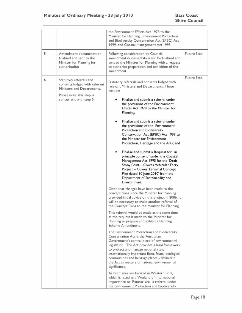
the Environment Effects Act 1978 to the Minister for Planning; Environment Protection and Biodiversity Conservation Act (EPBC) Act 1999, and Coastal Management Act 1995.
5 Amendment documentation finalised and sent to the Minister for Planning for authorisation
Following consideration by Council, amendment documentation will be finalised and sent to the Minister for Planning with a request to authorise preparation and exhibition of the amendment.
Future Step
6 Statutory referrals and consents lodged with relevant Ministers and Departments.
Please note: this step is concurrent with step 5
Statutory referrals and consents lodged with relevant Ministers and Departments. These include:
• Finalise and submit a referral under the provisions of the Environment Effects Act 1978 to the Minister for Planning;
• Finalise and submit a referral under the provisions of the Environment Protection and Biodiversity Conservation Act (EPBC) Act 1999 to the Minister for Environment Protection, Heritage and the Arts; and
• Finalise and submit a Request for “in principle consent” under the Coastal Management Act 1995 for the ‘Draft Stony Point – Cowes Vehicular Ferry Project – Cowes Terminal Concept Plan dated 30 June 2010’ from the Department of Sustainability and Environment.
Given that changes have been made to the concept plans since the Minister for Planning provided initial advice on this project in 2006, it will be necessary to make another referral of the Concept Plans to the Minister for Planning.
This referral would be made at the same time as the request is made to the Minister for Planning to prepare and exhibit a Planning Scheme Amendment.
The Environment Protection and Biodiversity Conservation Act is the Australian Government’s central piece of environmental legislation. The Act provides a legal framework to protect and manage nationally and internationally important flora, fauna, ecological communities and heritage places - defined in the Act as matters of national environmental significance.
As both sites are located in Western Port, which is listed as a Wetland of International Importance or ‘Ramsar site’, a referral under the Environment Protection and Biodiversity
Future Step
Minutes of Ordinary Meeting - 28 July 2010 Bass Coast Shire Council
Page 19
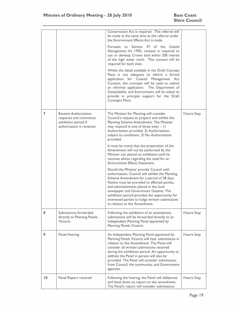
Conservation Act is required. This referral will be made at the same time as the referral under the Environment Effects Act is made.
Pursuant to Section 37 of the Coastal Management Act 1995, consent is required to use or develop Crown land within 200 metres of the high water mark. This consent will be required for both sites.
Whilst the detail available in the Draft Concept Plans is not adequate to inform a formal application for Coastal Management Act Consent, the concepts will be used to submit an informal application. The Department of Sustainability and Environment will be asked to provide in principle support for the Draft Concepts Plans.
7 Receive Authorisation response and commence exhibition period if authorisation is received.
The Minister for Planning will consider Council’s request to prepare and exhibit the Planning Scheme Amendment. The Minister may respond in one of three ways – 1) Authorisation provided, 2) Authorisation, subject to conditions, 3) No Authorisation provided.
It must be noted that the preparation of the Amendment will not be authorised by the Minister nor placed on exhibition until he receives advice regarding the need for an Environment Effects Statement.
Should the Minister provide Council with authorisation, Council will exhibit the Planning Scheme Amendment for a period of 28 days. Notice must be provided to affected parties, and advertisements placed in the local newspaper and Government Gazette. The exhibition period provides the opportunity for interested parties to lodge written submissions in relation to the Amendment.
Future Step
8 Submissions forwarded directly to Planning Panels Victoria
Following the exhibition of an amendment, submissions will be forwarded directly to an Independent Planning Panel appointed by Planning Panels Victoria.
Future Step
9 Panel Hearing An Independent Planning Panel appointed by Planning Panels Victoria will hear submissions in relation to the Amendment. The Panel will consider all written submissions received during the exhibition period. An opportunity to address the Panel in person will also be provided. The Panel will consider submissions from Council, the community, and Government agencies.
Future Step
10 Panel Report received Following the hearing, the Panel will deliberate and hand down its report on the amendment. The Panel’s report will consider submissions
Future Step

Minutes of Ordinary Meeting - 28 July 2010 Bass Coast Shire Council
Page 20
received in relation to the amendment and will identify any recommended changes (if required) to the amendment material.
11 Council meeting to consider the Panel’s recommendations. A Council resolution required to adopt the amendment.
Council will meet to consider the Panel’s report. Council may choose to approve, approve with changes, or abandon amendment based on its review of the Panel’s report.
Future Step
12 Forward adopted amendment to the Minister for Planning for final approval and gazettal.
Should Council resolve to adopt the amendment, adopted amendment documentation will be forward to the Minister for Planning for approval. The Minister for Planning will consider Council’s request for approval.
Future Step
13 Gazettal of amendment Should the Minister approve the amendment, notice of approval will be given in the Government Gazette.
At this point, Council will inform submitters to the amendment of the Minister’s decision.
Future Step
Planning Scheme Amendment
The proposed planning scheme amendment seeks to ensure that a consistent statutory framework is in place within the Bass Coast and Mornington Peninsula Planning Schemes prior to preparation of detailed plans and proposals.
• The amendment rezones the subject land at Cowes from part Mixed Use Zone and part Public Park and Recreation Zone to a Special Use Zone (SUZ). A new Schedule 6 to the SUZ is added to the Bass Coast Planning Scheme.
• The amendment deletes the Mixed Use Zone, Public Park and Recreation Zone, and Vegetation Protection Overlay (VPO) from the subject land.
• The amendment makes changes to Clause 61.02 to include the full extent of the subject land as within the Bass Coast Planning Scheme.
• The amendment retains Heritage Overlay’s HO42, and HO43 which currently apply to the subject land in recognition of their local heritage significance.
An Explanatory Report, new Schedule to the Special Use Zone – Schedule 6(SUZ6), an amended Clause 61.02 and new planning scheme map showing the whole site as within the SUZ6 is provided in Attachment 17.
Strategic Basis
State Planning Policy Framework
The Special Use Zone allows tailored provisions to be applied to facilitate specific planning outcomes such as the Cowes Transport Terminal. The use on the subject land has a strong strategic justification within the State Planning Policy Framework and accords with the following relevant policy objectives:

Minutes of Ordinary Meeting - 28 July 2010 Bass Coast Shire Council
Page 21
Clause 12.05 - A great place to be
With regard to “Urban design”, objectives of this clause seek to create urban environments that are of better quality, safer and more functional, provide more open space and an easily recognisable sense of place and cultural identity. Strategies require development to respond to its context in terms of urban character, cultural heritage, natural features, surrounding landscape and climate.
With regard to “Maritime precincts”, strategies seek to develop a network of maritime precincts around Port Phillip and Western Port Bay that serve both local communities and visitors; and maintain and expand boating and recreational infrastructure around the bays in maritime precincts including Stony Point/Cowes.
Clause 15.08 – Coastal Areas:
This clause identifies that significant environmental features and natural coastal resources should be protected and maintained. The Clause further identifies that land use and development planning should be coordinated with the requirements of the Coastal Management Act 1995, while decision-making by planning authorities and responsible authorities should apply the hierarchy of principles for coastal planning and management as set out in the Victorian Coastal Strategy 2008.
Clause 17.04 – Tourism:
Objectives of this clause seek to encourage tourism development to maximise the employment and long-term economic, social and cultural benefits of developing the State as a competitive domestic and international tourist destination. Strategies seek to encourage the development of a range of well designed and sited tourist facilities.
Clause 19.03 – Particular Uses and Development:
Identifies that development must take into account the natural, cultural and strategic context of its location; and that landmarks, views and vistas should be protected and enhanced or, where appropriate, created by new additions to the built environment
Local Planning Policy Framework
The amendment introduces a Special Use Zone Schedule 6 into the Bass Coast Planning Scheme to facilitate the development and operation of the Stony Point – Cowes Vehicular Ferry service and associated infrastructure. This approach accords with the following Local Planning Policy Framework objectives:
Clause 21.04 – Vision
The purpose of this clause is to promote; year-round services and commercial opportunities; quality tourist development which is responsive to tourism market demand; and the protection of ecology and biodiversity.
Clause 21.07 - Environment
This clause seeks to identify the coastline as significant. Strategies seek to protect the Shire’s sensitive coastline from environmental degradation and inappropriate development.
Clause 21.08 - Landscape and Built Form
This clause can be applied to coastal landscapes for their social value to the community and importance to the Shire as a tourist feature. Strategies seek to protect coastal landscapes from inappropriate development.

Minutes of Ordinary Meeting - 28 July 2010 Bass Coast Shire Council
Page 22
Clause 21.06-4- Tourism
This clause seeks to encourage new tourist development in appropriate locations by supporting defined tourist areas, including the subject land. The Clause identifies the importance of tourism in the Shire, and the need to ensure a balance between tourist development and protection of the Shires’ natural resources. Strategies seek to encourage new tourist development to minimise its impact on the natural environment, and to provide the necessary infrastructure needed to host major sporting and cultural events.
Clause 21.09-1 - Transport
This clause seeks to provide adequate car parking facilities in proximity to tourist attractions, recreation destinations, the coastline, and commercial activity centres.
Clause 21.10-5 - Cowes
This Clause establishes that the “Cowes Structure Plan” is to provide direction for the future physical form of Cowes and the foreshore precinct.
Strategies seek to ensure that the future land use, built form, landscape and infrastructure requirements of the Cowes Township are considered at the planning proposal stage.
Clause 21.11 - Implementation
This clause includes direction for “Applying Special Use Zone”. The Clause seeks to apply the SUZ where there is the potential to accommodate large-scale private recreational/tourist developments in accordance with Council’s adopted strategies.
The proposed amendment responds to the LPPF by introducing a planning framework for the subject land which balances the facilitation of new tourism opportunities in a designated tourist location with the protection of natural and man made features. The amendment also responds to the LPPF by identifying the necessary traffic and car parking provisions to support the future development of the site as a Transport terminal.
Council Adopted Strategies
The establishment of the vehicular ferry is supported by two strategic planning documents prepared by Bass Coast Shire, the Cowes, Silverleaves, Ventnor and Wimbledon Heights Structure Plan and The Phillip Island and San Remo Design Framework.
Cowes, Silverleaves, Ventnor and Wimbledon Heights Structure Plan
The Cowes, Silverleaves, Ventnor and Wimbledon Heights Structure Plan was adopted by Council on 10 February 2010 and is the subject of Planning Scheme Amendment C88 to the Bass Coast Planning Scheme. The Structure Plan was developed in response to the following underpinning themes:
• Creating resilient and sustainable settlements;
• Managing the rural and urban interface;
• Protecting the character of the individual settlements; and
• Managing the pressure on existing services and infrastructure.
Minutes of Ordinary Meeting - 28 July 2010 Bass Coast Shire Council
Page 23
The purpose of the Structure Plan was three-fold, being:
• Firstly, to identify the key strategic influences and drivers of change within the Structure Plan area;
• Secondly, to articulate the agreed vision for the future of the Structure Plan area to 2030; and
• Thirdly, to establish a framework of principles and corresponding strategies that direct future land use and development decisions towards achieving the agreed vision.
The Structure Plan states that the State and Local Government are committed to determine the feasibility of creating a viable car ferry service, linking Cowes to the mainland.
Phillip Island and San Remo Design Framework 2003 (The Framework)
The Framework is a policy document adopted by Council and identified as a reference document in Clause 22.06.
The Framework establishes a vision, strategies and guidelines that will help shape the structure, function and appearance of Phillip Island and San Remo over the next 20 years. The Framework recognises that the population of Phillip Island and San Remo is expected to continue to increase and promotes urban consolidation to accommodate the additional population.
The Framework includes the vehicular ferry connection between Cowes and Mornington Peninsula into the vision for movement and location, links and destinations within the Framework. It is also included in the Short Term Plan of general actions within this Framework, which recommends that this opportunity be investigated.
Finances
In October 2008 Council resolved to commit to $235,000 to the funding of the planning process for the Stony Point to Cowes Vehicular Ferry Project, spread over two financial years. Mornington Peninsula Shire Council has also contributed $235,000, while Tourism Victoria and Regional Development Victoria have each contributed $100,000. The total cost of this stage of the project has been budgeted at $670,000.
Stakeholders
The Planning and Environment Act 1987 sets out the requirements for planning scheme amendments. Key stakeholders in this process include Council, State Government Departments, referral agencies, and the surrounding community.
Statutory Requirements/Codes/Standards/Policies
The Planning Scheme Amendment process (and any subsequent process in considering a development plan or planning permit application), are undertaken under the provisions of the Planning and Environment Act 1987.
If Council resolves to prepare an amendment, a request must be sent to the Minister for Planning to authorise the amendment prior to it being exhibited. The requirements to exhibit the amendment are also prescribed under the Planning and
Minutes of Ordinary Meeting - 28 July 2010 Bass Coast Shire Council
Page 24
Environment Act 1987 and involve written notice being provided to adjoining and nearby landowners, advertisements being included within newspapers, the Government Gazette and to Prescribed Ministers/statutory authorities. The exhibition of an amendment is a statutory process and ensures that all interested parties are provided with the opportunity to view and make a submission to the amendment and to be heard before an independent Panel.
Other Options
There are three options available to Council:
Option One
The first option, as recommended by the report is to endorse the concept plan and request authorisation from the Minister for Planning to prepare and exhibit an amendment to the Bass Coast Planning Scheme.
Implications
Endorsing the concept plan does not mean that the vehicular ferry project will go ahead at the site selected. Endorsing the concept plan and agreeing to proceed with an amendment to the planning scheme (in the form proposed in this report), opens the way for a formal public exhibition process and opportunity for those opposed to the vehicular ferry to make a submission to an independent planning panel appointed by the Minister for Planning.
At this point in time both Shire Councils and other members of the Project Steering Committee (Tourism Victoria, Regional Development Victoria, Parks Victoria, Department of Sustainability and Environment, and Department of Planning and Community Development) have had the benefit of independent advice. It is considered that the only way that Council can ensure the community is fully informed is to undertake the planning scheme amendment process.
Agreeing to commence this formal statutory planning stage also enables Council to put very specific and comprehensive development controls in place, and in accordance with the community’s objectives for the project. The State Government would have to abide by these controls in submitting their detailed development plans. Council would also be implementing policy directions set within the Cowes, Silverleaves, Ventnor and Wimbledon Heights Structure Plan and The Phillip Island and San Remo Design Framework.
Option Two
The second option would be to not endorse the revised concept plan and not proceed with a planning scheme amendment.
Implications
By not endorsing the Concept Plan, Council’s preferred concept for the site would remain unclear. This would not provide sufficient certainty and an adequate strategic basis by which to request Ministerial authorisation to prepare and exhibit an amendment to the Bass Coast Planning Scheme. This would in affect “kill” the project, not only for Cowes but also at Stony Point until such time as government funding could be secured for further technical investigations and plans could be endorsed at both locations.

Minutes of Ordinary Meeting - 28 July 2010 Bass Coast Shire Council
Page 25
Council and State Government positions on adopted policies and strategies would also remain unclear and could attract added criticism from community members who support the project and the sites selected, and object to rates revenue being spent with little or no benefit in return.
While a small minority in the community (representing less than 10 percent of the Phillip Island population and 2 percent of the total Bass Coast Shire population) have voiced their opposition to the proposed siting of the vehicular ferry infrastructure at the Cowes jetty triangle site, it is important to note that community members have been advocating for many years for a vehicular ferry service to link communities across Western Port Bay.
Option Three
The third option would be to defer a decision on endorsement of the concept plan and commencement of a planning scheme amendment in order to: further exhibit the revised concept plans, 3D artist impressions, and findings of the technical studies; and ask all Bass Coast residents, ratepayers and businesses, via a project bulletin, to list their site preferences based on information collected from pre-feasibility studies and current investigations. Survey feedback would be assessed independently by the Gippsland Research Office, Monash University.
Implications
Through this additional step in the process the community would have access to all the technical studies, community feedback to the draft concepts, revised concepts and 3D artist impressions, which would enable them to make informed choices when determining their site preferences.
Full release of this factual information will dispel much of the misinformation that has been circulated in the media, and will also assist community members in preparing formal submissions as part of the planning scheme amendment process.
Strategic Assessment Guidelines for Planning Scheme Amendments
Minister’s Direction No. 11 requires a planning authority to evaluate and discuss how an amendment addresses a number of strategic considerations.
The Strategic Assessment Guidelines provide a consistent framework for preparing and evaluating a proposed planning scheme amendment and its outcomes.
1. Why is an amendment required?
It is proposed that the subject land will become a key area for the interchange of passengers and vehicles for the Cowes - Stony Point Vehicular Passenger Ferry. The amendment is required to facilitate the redevelopment of the subject land in accordance with the Cowes Transport Terminal Concept Plan.
The amendment introduces a planning framework to assist future decision making, having regard to future uses and development that may be required through the ongoing development and operation of the Cowes Transport Terminal and ferry service. It is necessary to ensure that planning provisions do not compromise the long term operations of the subject land as a key tourism facility in the region, but also recognise the existing attributes which are required to be protected and managed in future.

Minutes of Ordinary Meeting - 28 July 2010 Bass Coast Shire Council
Page 26
At present, the subject land at Cowes is contained within different zones – the Mixed Use Zone, and the Public Park and Recreation Zone. The Mixed Use Zone allows a wide variety of uses but is not tailored to suit the land use requirements of a Transport Terminal. In addition, the use of land for a Transport Terminal is prohibited in the Public Park and Recreation Zone.
To assist in facilitating the project, the amendment applies the Special Use Zone across the full extent of the subject land to apply a consistent zoning across the site, and includes a new Schedule to the Special Use Zone to identify an appropriate range of potential future uses, and an appropriate level of information required to support the development of the subject land. The introduction of the Special Use Zone is required to provide certainty in terms of a broad planning framework, while providing flexibility during detailed design.
The amendment is also required to include the northern extent of the subject land currently located outside of the Bass Coast Planning Scheme as within the planning scheme to provide a consistent approvals process for future use and development across the subject land.
Overall, the amendment will apply a consistent planning framework to both the Cowes and Stony Point sites to ensure a common and consistent approvals process at each ferry destination.
2. Does the amendment implement the objectives of planning and any environmental, social and economic effects?
The amendment seeks to ensure that the Cowes Transport Terminal is designed and operates in a manner that does not adversely affect the safety and amenity of the local community and minimises impacts on environmental, cultural, and heritage assets. Technical investigations have been undertaken to determine any immediate environmental, social or economic effects. The key findings of each report are outlined below:
Environmental Effects
A Terrestrial Ecology assessment has been undertaken. The report identifies the location of revegetation beds on the foreshore west of the existing jetty. While small and degraded, these areas are remnant, and would be subject to an offset requirement should they be impacted. No significant or threatened species were identified. The report recommends that a Flora and Fauna Management Plan be prepared for inclusion within the Construction Environmental Management.
A Marine Ecology assessment has been undertaken. The assessment included a survey of marine habitat in the vicinity of the Cowes Jetty. The assessment found that the proposed alignment of the Transport terminal would avoid protected seagrass areas. Species protected under the Flora and Fauna Guarantee Act are unlikely to be found in the vicinity of the subject land. The report also found that the Environment Protection and Biodiversity Conservation Act listed marine threatened or migratory species are unlikely to be at risk. The report acknowledges that further consideration of marine invertebrates and fish listed in the Flora and Fauna Guarantee Act is required at the detailed design phase of the project.

Minutes of Ordinary Meeting - 28 July 2010 Bass Coast Shire Council
Page 27
A Coastal Processes assessment has been undertaken. The report recommends that provided the location of the proposed transport terminal does not extend significantly beyond the existing jetty, a new transport terminal is unlikely to have significant influence on coastal processes.
Desktop and Standard Cultural Heritage assessment has been undertaken to determine potential for sites of Indigenous heritage significance. The report states that a number of areas within the subject land have been subject to previous significant ground disturbance. Two previously recorded Aboriginal Cultural Heritage places have been identified while several artefact scatters are present. The report recommends that a Cultural Heritage Management Plan complex assessment is required once detailed designs have been prepared.
A non-indigenous heritage assessment has been undertaken. Two previously recorded sites were identified – Jetty Shed and Cowes Foreshore. Several additional features were identified during the survey, although none constitute an archaeological site.
Social Effects
A preliminary assessment of possible social impacts of the Draft Concept Plans and amendment has been undertaken. The Transport terminal and new ferry service will provide additional business and employment opportunities. The proposed improvements to the jetty, foreshore and plaza areas including urban design and landscaping works, will provide a much more attractive, safe and useable environment for the local community, and increasing number of tourist visitors.
A Traffic and Parking Assessment has been prepared to asses the impact of potentials uses and development on the existing road network. The report identifies that there is available car parking within the vicinity of the subject land. The report recommends traffic management changes and confirms that the subject land and surrounding area can accommodate anticipated additional traffic volumes and car parking numbers. The report identifies that a more detailed Traffic Management Plan is required to be prepared as part of a design response.
Economic Effects
The rezoning of the land will facilitate a development that provides opportunity for economic benefits associated with additional tourism, and tourism based industries and employment. The construction of the transport terminal and associated infrastructure will result in additional direct and indirect employment benefits during the construction phase. The economic impact assessment concludes that there will be positive economic impacts associated with the outcomes of the amendment.
Overall, the amendment will facilitate the upgrading of the physical and functional aspects of the subject land which will lead to social and economic benefits. The amendment establishes that where more detailed technical studies are required to address constraints; this information will be provided at a later stage as part of a development plan, and prior to the commencement of buildings and works.
3. Does the amendment comply with all the relevant Minister’s Directions?
The amendment is consistent with the Ministerial Direction on the Form and Content of Planning Schemes under section 7(5) of the Act.

Minutes of Ordinary Meeting - 28 July 2010 Bass Coast Shire Council
Page 28
The proximity of the subject land adjacent to the coastline and within the marine environment requires the consideration of Ministerial Direction 13 - Managing Coastal Hazards and the Coastal Impacts of Climate Change. The Ministerial direction applies to any planning scheme amendment that provides for the rezoning of non-urban land for urban use and applies to development of all land abutting the coastline or a coastal reserve.
While the proposed amendment seeks to rezone land from part Mixed Use Zone and Public Park and Recreation Zone to Special Use Zone. The subject land is located within the Urban Growth Boundary and is zoned for urban development. The amendment does not bring additional land to within the Urban Growth Boundary. Ministerial Direction 13 does therefore not apply.
4. Does the amendment support or implement the State Planning Policy Framework?
The Special Use Zone allows tailored provisions to be applied to facilitate specific planning outcomes such as the Cowes Transport Terminal. The use on the subject land has a strong strategic justification within the State Planning Policy Framework and accords with the following relevant policy objectives:
Clause 12.05 - A great place to be
• With regard to “Urban design”, objectives seek to create urban environments that are of better quality, safer and more functional, provide more open space and an easily recognisable sense of place and cultural identity. Strategies require development to respond to its context in terms of urban character, cultural heritage, natural features, surrounding landscape and climate.
• With regard to “Maritime precincts”, strategies seek to develop a network of maritime precincts around Port Phillip and Western Port Bay that serve both local communities and visitors; and maintain and expand boating and recreational infrastructure around the bays in maritime precincts including Stony Point/Cowes.
• With regard to “Tourism”, objectives seek to maintain and develop Metropolitan Melbourne as a desirable tourist destination.
Clause 15.08 – Coastal Areas:
Identifies that significant environmental features and natural coastal resources should be protected and maintained. The Clause further identifies that land use and development planning should be coordinated with the requirements of the Coastal Management Act 1995, while decision-making by planning authorities and responsible authorities should apply the hierarchy of principles for coastal planning and management as set out in the Victorian Coastal Strategy 2008.
Clause 17.04 – Tourism:
Objectives seek to encourage tourism development to maximise the employment and long-term economic, social and cultural benefits of developing the State as a competitive domestic and international tourist destination. Strategies seek to should encourage the development of a range of well designed and sited tourist facilities.
Minutes of Ordinary Meeting - 28 July 2010 Bass Coast Shire Council
Page 29
Clause 19.03 – Particular Uses and Development:
Identifies that development must take into account the natural, cultural and strategic context of its location; and that landmarks, views and vistas should be protected and enhanced or, where appropriate, created by new additions to the built environment
The current zoning constrains the promotion of the subject land for the Cowes to Stony Point Vehicular Ferry. The proposed Schedule 6 to the Special Use Zone applies each of these objectives to a local context. The proposed amendment will allow a zone that is consistent with the above objectives and will facilitate tourism within the subject land and its surrounds. The provisions of the zone have been developed having regard to technical investigations, including an assessment of the impact on the coastal environment. Where required, more detailed technical investigations will be undertaken through the preparation of a development plan for the subject land.
5. How does the amendment support or implement the Local Planning Policy Framework and, specifically, the Municipal Strategic Statement?
The amendment introduces a Special Use Zone Schedule 6 into the Bass Coast Planning Scheme to facilitate the development and operation of the Cowes to Stony Point Vehicular Ferry service and associated infrastructure. This approach accords with the following LPPF objectives:
Clause 21.04 – Vision
This clause seeks to promote year-round services and commercial opportunities; quality tourist development which is responsive to tourism market demand; and the protection of ecology and biodiversity.
Clause 21.06-4- Tourism
This clause seeks to encourage new tourist development in appropriate locations by supporting defined tourist areas, including the subject land. The Clause identifies the importance of tourism in the Shire, and the need to ensure a balance between tourist development and protection of the Shires’ natural resources. Strategies seek to encourage new tourist development to minimise its impact on the natural environment, and to provide the necessary infrastructure needed to host major sporting and cultural events.
Clause 21.09-1 - Transport
This clause seeks to provide adequate car parking facilities in proximity to tourist attractions, recreation destinations, the coastline, and commercial activity centres.
Clause 21.11 - Implementation
“Applying Special Use Zone” provides strategic direction for the application of the Special Use Zone within Bass Coast Shire. The Clause seeks to apply the Special Use Zone where there is the potential to accommodate large-scale private recreational/tourist developments in accordance with Council’s adopted strategies.
The proposed amendment responds to the Local Planning Policy Framework by introducing a planning framework for the subject land which balances the facilitation of new tourism opportunities in a designated tourist location with the protection of natural and man made features. The amendment also responds to the Local Planning

Minutes of Ordinary Meeting - 28 July 2010 Bass Coast Shire Council
Page 30
Policy Framework by identifying the necessary traffic and car parking provisions to support the future development of the site as a Transport Terminal.
6. Does the amendment make proper use of the Victoria Planning Provisions?
This amendment makes proper use of the Victorian Planning Provisions and relevant Practice Note “Applying the Special Use Zone”. This amendment proposes to insert a new Schedule 6 - Cowes Transport Terminal to the Special Use Zone (Clause 37.01). The Schedule is consistent with the Victorian Planning Provisions Practice Note on the appropriate use of the Special Use Zone as:
- The complexity of planning requirements is reduced by keeping the number of zones and overlays used to a minimum;
- An appropriate combination of the other available zones, overlays and local policies cannot give effect to the desired objectives or requirements; and
- The Special Use Zone facilitates a large redevelopment project that needs to have certainty in terms of a broad planning framework and flexibility during detailed design.
7. How does the amendment address the views of relevant agencies?
The Amendment has been prepared in consultation with Council and State Government representatives.
8. What impact will the new planning provisions have on the administrative costs of the responsible authority?
The Amendment will not create further resource and administrative demands on the responsible authority.
Officer’s Comments/Conclusion
The Draft Concept Plan has been prepared collaboratively by State and Local Government. The Concept Plan is an appropriate design response taking into account existing conditions and future needs. The plan has undergone community consultation and is supported by technical analysis.
At present, the zoning of the subject land at Cowes constrains the promotion of the Stony Point – Cowes Vehicular Ferry service. An amended statutory framework is required to allow for this use and introduce a concept plan for the site into the Bass Coast Planning Scheme.
The proposed amendment will introduce a planning framework having regard to necessary technical investigations, including an assessment of the impact on the coastal environment. More detailed technical investigations will be undertaken, where required, through the preparation of a development plan for the subject land. This is an appropriate way forward to balance significant tourism opportunities with appropriate conservation and management practices.
The Planning Scheme Amendment process will provide the opportunity for interested and affected parties to make submissions and be heard by an Independent Panel.
It is recommended that Council endorse the Concept Plan without further changes and authorise officers to request the Minister for Planning to prepare and exhibit an amendment to the Bass Coast Planning Scheme to establish an appropriate statutory framework to guide the preparation of more detailed plans for the subject land.

Minutes of Ordinary Meeting - 28 July 2010 Bass Coast Shire Council
Page 31
Recommendation
That Council:
1. Having undertaken preliminary consultation with the community and stakeholders, resolve to exhibit a draft Concept Plan for the development of infrastructure to enable a vehicular ferry service between Cowes and Stony Point combined with an amendment to the Planning Scheme to incorporate the Concept Plan and zoning and policy changes;
2. Endorse the ‘Draft Stony Point – Cowes Vehicular Ferry Project – Cowes Terminal - Concept Plan 1 of 2 Lower Level dated 30 June 2010’ and ‘Draft Stony Point – Cowes Vehicular Ferry Project – Cowes Terminal - Concept Plan 2 of 2 Upper Level dated 30 June 2010’;
3. Seek the authorisation from the Victorian Minister for Planning to prepare and exhibit an amendment generally in accordance with draft Planning Scheme Amendment No. C115 to the Bass Coast Planning Scheme to:
• Rezone land generally at the entrance to and surrounding Cowes jetty from part Mixed Use Zone and part Public Park and Recreation Zone to a Special Use Zone ;
• Include a new Schedule 6 to the Special Use Zone;
• Delete the Vegetation Protection Overlay from the subject land;
• Amend Clause 61.02 of the Bass Coast Planning Scheme to include the full extent of the subject land within the Bass Coast Planning Scheme;
4. In the event that there are submissions received in response to the exhibition of the amendment, Council consents to the submissions being forwarded directly to Planning Panels Victoria for consideration;
5. Request Planning Panels Victoria to pre set Panel Hearing dates for the amendment;
6. Prepare and submit a referral under the provisions of the Environment Effects Act 1978 to the Minister for Planning;
7. Prepare and submit a referral under the provisions of the Environment Protection and Biodiversity Conservation Act (EPBC) Act 1999 to the Federal Minister for Environment Protection, Heritage and the Arts; and
8. Request “in principle consent” under the Coastal Management Act 1995 for the ‘Draft Stony Point – Cowes Vehicular Ferry Project – Cowes Terminal Concept Plan dated 30 June 2010’ from the Victorian Department of Sustainability and Environment.
Attachments
AT-1 Cowes Study Area Maps AT-2 Preferred Base Concepts prepared by Arup
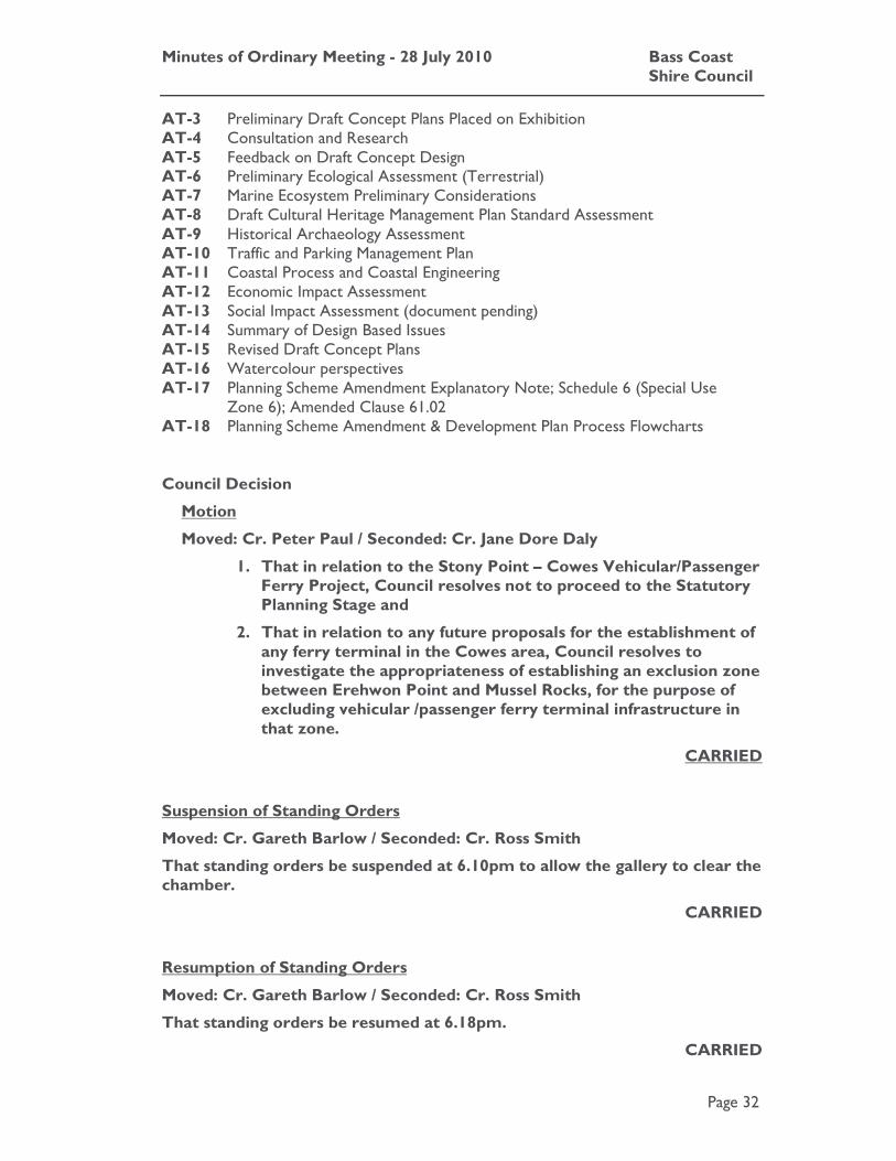
Minutes of Ordinary Meeting - 28 July 2010 Bass Coast Shire Council
Page 32
AT-3 Preliminary Draft Concept Plans Placed on Exhibition AT-4 Consultation and Research AT-5 Feedback on Draft Concept Design AT-6 Preliminary Ecological Assessment (Terrestrial) AT-7 Marine Ecosystem Preliminary Considerations AT-8 Draft Cultural Heritage Management Plan Standard Assessment AT-9 Historical Archaeology Assessment AT-10 Traffic and Parking Management Plan AT-11 Coastal Process and Coastal Engineering AT-12 Economic Impact Assessment AT-13 Social Impact Assessment (document pending) AT-14 Summary of Design Based Issues AT-15 Revised Draft Concept Plans AT-16 Watercolour perspectives AT-17 Planning Scheme Amendment Explanatory Note; Schedule 6 (Special Use
Zone 6); Amended Clause 61.02
AT-18 Planning Scheme Amendment & Development Plan Process Flowcharts Council Decision
Motion
Moved: Cr. Peter Paul / Seconded: Cr. Jane Dore Daly
1. That in relation to the Stony Point – Cowes Vehicular/Passenger Ferry Project, Council resolves not to proceed to the Statutory Planning Stage and
2. That in relation to any future proposals for the establishment of any ferry terminal in the Cowes area, Council resolves to investigate the appropriateness of establishing an exclusion zone between Erehwon Point and Mussel Rocks, for the purpose of excluding vehicular /passenger ferry terminal infrastructure in that zone.
CARRIED
Suspension of Standing Orders
Moved: Cr. Gareth Barlow / Seconded: Cr. Ross Smith
That standing orders be suspended at 6.10pm to allow the gallery to clear the chamber.
CARRIED
Resumption of Standing Orders
Moved: Cr. Gareth Barlow / Seconded: Cr. Ross Smith
That standing orders be resumed at 6.18pm.
CARRIED

Minutes of Ordinary Meeting - 28 July 2010 Bass Coast Shire Council
Page 33
Motion
Moved: Cr. Gareth Barlow / Seconded: Cr. Ross Smith
That agenda item I.1 be brought forward.
CARRIED
C.2 Agenda Item I.1 - Amendment C53: Cape Paterson Ecovillage - Post Panel Hearing Report
File No: CM10/298 Department: Planning and Environment Council Plan Strategic Objective: Cohesive Communities
We will improve lifestyle opportunities and options by managing the built environment and encouraging cohesive communities.
Previous Items: SR6/09 - Cape Paterson West Rezoning - Amendment C53 -
Post Exhibition Report - Council - 22 April 2009 BR1/10 - Amendment C93 & C98: Coastal Planning Policy -
Briefing Session - 2 June 2010
Declaration
The author has no direct or indirect interest in relation to this issue.
Summary
Amendment C53 seeks to re-zone the land on the corner of Seaward Drive and Wilsons Road west of the existing Cape Paterson township. The amendment proposed to change the zoning from the Farming Zone to the Comprehensive Development Zone.
The amendment also proposed to introduce the following elements:
• Introduce the Comprehensive Development Zone - Schedule 1 Cape Paterson Ecovillage into the Bass Coast Planning Scheme; and
• Incorporate the Cape Paterson Ecovillage Comprehensive Development Plan into the Bass Coast Planning Scheme.
The Planning Scheme Amendment was required to facilitate the use and development of the land for the Cape Paterson Ecovillage.
On 8 July 2008, Council received Authorisation from the Minister for Planning to prepare the proposed planning scheme amendment.
Council placed the proposed Amendment on exhibition on the 4 December 2008.
The exhibition period extended until 30 January 2009.
At the completion of the exhibition period Council had received 403 submissions.

Minutes of Ordinary Meeting - 28 July 2010 Bass Coast Shire Council
Page 34
At the Ordinary Council Meeting on 22 April 2009 Council considered the submissions and made the following resolution:
1. That Council, having considered all submissions in accordance with Section 22(1) of the Planning and Environment Act 1987, resolve to refer Amendment C53 and all submissions to a Panel to be appointed by the Minister for Planning in accordance with Section 153 of the Planning and Environment Act 1987; and
2. That Council request the Minister for Planning to combine the Panel
hearing for this amendment with the Panel hearing for Amendment C93 (Implementation of the Coastal Planning Framework).
A Planning Panel Directions Hearing was held on 29 September 2009 at the Bass Coast Civic Centre Council Chamber at Wonthaggi.
The nine day Panel hearing was held from 2 to 16 December 2009.
The Planning Panel recommendations report was received by Council on 14 April 2010. The Panel Report is included here at Attachment 1.
This Council report has been prepared to provide:
• An overview of the Independent Planning Panel recommendations; and
• A recommendation that Council abandon Amendment C53 in accordance with the recommendation of the Independent Planning Panel.
Introduction
Panel Hearing
The Minster for Planning supported Council’s request for a combined Panel Hearing that would consider Amendment C93 in conjunction with Amendment C53. This provided the Panel with an opportunity to consider Amendment C53 in the context of the planning policy objectives underpinning the Bass Coast Strategic Planning Coastal Framework. Amendment C93 proposed to incorporate the strategic framework plan for Cape Paterson, adopted in the Bass Coast Strategic Planning Coastal Framework, into the Bass Coast Planning Scheme.
It also provided an opportunity for the Panel to consider the objectives of the Bass Coast Strategic Planning Coastal Framework in the context of State Planning Policy, in particular the objectives of the Victorian Coastal Strategy 2008, and Clause 15.08 of the Bass Coast Planning Scheme.
The Council submission to the Independent Panel for Amendment C53 supported this approach:
Council submits that subject to the adoption and approval of amendment C93 that Amendment C53 should be supported for the following reasons:
• It is consistent with the relevant strategies and objectives of the Bass Coast Planning Scheme,
• It is consistent with the recommendations of the Bass Coast Strategic Coastal Planning Framework 2008.
At the Panel Hearing submissions were made by a number of parties including:

Minutes of Ordinary Meeting - 28 July 2010 Bass Coast Shire Council
Page 35
• Local Community members who made submissions on Amendment C93 and Amendment C53. These submissions generally argued that the extension of the settlement boundary and subsequent rezoning of the land to facilitate the Ecovillage would have a significant impact on the coastal environment, the character of Cape Paterson, and was not supported by the strategic objectives of the Victorian Coastal Strategy 2008.
• Local Community members who made submissions on Amendment C53, who supported the concept and proposed design outcomes of the proposed Ecovillage. These submissions emphasised the sustainability credentials of the development, and the commitment to regenerating the ecology of the site and surrounds.
Advocates for the proponent made a comprehensive submission, backed by a number of expert witnesses who presented evidence in support of the Ecovillage, concerning:
• Provision of infrastructure services;
• Ecological rehabilitation;
• Impact on the local ecology;
• Residential supply and demand;
• Benefits for local economy;
• Impacts on agriculture;
• Traffic engineering; and
• Planning.
Panel Report for C53
The Panel has approached the assessment of Amendment C53 in two distinct parts. The Panel initially considered whether planning policy supported the urban expansion of Cape Paterson. The Panel’s assessment for Amendment C53 uses the strategic planning direction established in its consideration of Amendment C93:
The assessment has taken into account the demand for residential expansion, and has considered the siting of new urban development in the context of coastal, environmental and population growth policies, Ministerial Direction 13 relating to sea level rise and coastal hazards and the VPP Practice Note relating to delineating coastal settlement boundaries.
Referring to the recommendations it made for Amendment C93 the Panel concludes that:
…in the context of these considerations alone, the proposal to expand Cape Paterson to the west of the existing township… is inappropriate.
The second element of the Panel assessment of Amendment C53 is an evaluation of the special characteristics of the Ecovillage development.
The key question for Panel was, when considering:
The special character of the Ecovillage and the proposals … for offsite environmental improvements …

Minutes of Ordinary Meeting - 28 July 2010 Bass Coast Shire Council
Page 36
Do these factors alter the balance of policy considerations related to urban development on the land west of the township?
The Panel makes the following conclusion in relation to this question:
On balance the special sustainability features of this project are insufficient to set aside the disadvantages of the development of this site on the western side of the township abutting the coastal reserve.
Having made this assessment the Panel recommends that Amendment C53 be abandoned.
Strategic Basis
State Planning Policy Framework
The State Planning Policy Framework informs planning authorities of the State policy to be taken into account when making decisions. Sections of the State Planning Policy Framework considered relevant to an assessment of Amendment C53 include:
Clause 11.01 describes the approach that should be taken when applying the State Planning Policy Framework:
It is the State Government's expectation that planning and responsible authorities will endeavour to integrate the range of policies relevant to the issues to be determined and balance conflicting objectives in favour of net community benefit and sustainable development.
Clause 14 Settlement has the following objective for urban settlements:
To ensure a sufficient supply of land is available for residential, commercial, industrial, recreational, institutional and other public uses.
To facilitate the orderly development of urban areas.
Clause 15 sets out the environment policy and includes the following:
Clause 15.01 Protection of catchments, waterways and groundwater has the following objective:
To assist the protection and, where possible, restoration of catchments, waterways, water bodies, groundwater, and the marine environment.
Clause 15.08 Coastal areas has the following objective:
In coastal areas, to protect and enhance the natural ecosystems and landscapes of the coastal and marine environment, ensure sustainable use of natural coastal resources and achieve development that provides an environmental, social and economic benefit enhancing the community’s value of the coast.
Clause 15.09 Conservation of native flora and fauna has the objective:
To assist the protection and conservation of biodiversity, including native vegetation retention and provision of habitats for native plants and animals and control of pest plants and animals.
Clause 15.10 Open space has the objective:
To assist creation of a diverse and integrated network of public open space commensurate with the needs of urban communities and rural areas.

Minutes of Ordinary Meeting - 28 July 2010 Bass Coast Shire Council
Page 37
Clause 15.11 Heritage has the objective:
To assist the conservation of places that have natural, environmental, aesthetic, historic, cultural, scientific or social significance or other special value important for scientific and research purposes, as a means of understanding our past, as well as maintaining and enhancing Victoria’s image and making a contribution to the economic and cultural growth of the State.
Clause 15.12 Energy efficiency has the objective:
To encourage land use and development that is consistent with the efficient use of energy and the minimisation of greenhouse gas emissions.
Clause 16 Housing includes at 16.01 the following objective for residential development for single dwellings:
To encourage:
• Subdivisions in locations with access to physical and community infrastructure and providing a range of lot sizes, a convenient and safe road network, appropriate pedestrian and cycle paths, sufficient useable public open space and low vulnerability to fire.
• Residential development that is cost-effective in infrastructure provision and use, energy efficient, incorporates water-sensitive design principles and encourages public transport use.
• Opportunities for increased residential densities to help consolidate urban areas.
Clause 17 Economic development includes the following objectives:
17.04 Tourism
To encourage tourism development to maximise the employment and long-term economic, social and cultural benefits of developing the State as a competitive domestic and international tourist destination.
17.05 Agriculture
To ensure that the State’s agricultural base is protected from the unplanned loss of productive agricultural land due to permanent changes of land use and to enable protection of productive farmland which is of strategic significance in the local or regional context.
Clause 19 Particular provisions includes at Clause 19.03 the following objective for design and built form:
To achieve high quality urban design and architecture that:
• Reflects the particular characteristics, aspirations and cultural identity of the community.
• Enhances liveability, diversity, amenity and safety of the public realm.
• Promotes attractiveness of towns and cities within broader strategic contexts.
Minutes of Ordinary Meeting - 28 July 2010 Bass Coast Shire Council
Page 38
Local Planning Policy Framework
Municipal Strategic Statement
The Municipal Strategic Statement provides a vision for the future development of the Shire. It sets out the key strategies that provide clear directions for land use and development within the municipality for the next 15 years.
The Municipal Strategic Statement is consistent with State Policy and recognises key issues that influence land use and development in certain areas of the Shire.
Sections of the Local Planning Policy Framework and the Municipal Strategic Statement considered relevant to an assessment of Amendment C53 are detailed below.
Clause 21.03
Key issues
• Managing the implications of being a premier tourist destination.
Environment
• Halting the decline and fragmentation of indigenous vegetation.
• Conserving and enhancing of the municipality’s biodiversity.
• Balancing the competing interests of protecting existing habitat and development pressures.
Landscape and built form
• Maintaining individual settlement identity.
Clause 21.04
Vision
Settlement
• Residential development and related urban land uses contained to existing activity nodes.
• A quality urban environment and well functioning towns that benefit both residents and visitors.
Environment
• A high quality built environment enhancing the surrounding natural environment and landscape values.
Clause 21.05
Settlement
21.05.1 Growth of Towns
Objective 3 To encourage sustainable development, minimise impacts on the natural systems, increase natural reserves and vegetation in urban areas and improve the quality of life for the community.
Minutes of Ordinary Meeting - 28 July 2010 Bass Coast Shire Council
Page 39
Strategy 3.1 Minimise the impact on significant environmental features within identified settlement boundaries, and address these impacts through the rezoning or development planning process.
Objective 4 To discourage urban development that encroaches or impacts on significant environmental features and in areas affected by future climate change impacts.
Strategy 4.1 Ensure that urban growth and development enhances significant environmental features by identifying and protecting these areas during the preparation of Structure Plans.
Strategy 4.2 Manage climate change impacts by:
� Identifying areas subject to future impacts of climate change.
� Preparing a strategy to deal with the possible impacts of climate change for developments located within existing urban boundaries.
� Avoiding development in areas outside of town boundaries where there are possible impacts as a result of climate change.
Strategy 4.3 Ensure that development is set back from the coast to accommodate coastal features, vegetation and climate change impacts.
Clause 21.07
Environment
21.07-4 Climate Change
Objective 1 To protect and conserve existing water reserves and prevent degradation of water catchment areas.
Strategy 1.1 Maintain and improve indigenous vegetation and land management practices within Proclaimed Water Catchment Areas.
21.09-3 Open Space and Recreation
Objective 2 To provide a variety of tracks for pedestrians and cyclists that offers recreational opportunities as well as direct paths of travel.
Strategy 2.1 Link recreation areas by pedestrian and cycle networks within, and between, towns.
Strategy 2.2 Establish pedestrian and bicycle networks along the coastline, as well as linking the coast to other areas of natural beauty and interest, open space areas, sites of cultural significance, and the rural hinterland. These track networks should provide shade and seating opportunities at regular intervals.
Finances
The payment for consideration of this amendment request will be solely the applicant’s responsibility. Other costs to Council principally involve officer time.

Minutes of Ordinary Meeting - 28 July 2010 Bass Coast Shire Council
Page 40
Stakeholders
Stakeholders include residents, ratepayers, community groups, and visitors to Cape Paterson. Stakeholders also include relevant government agencies.
Consultation for the proposed Ecovillage development has been extensive. The community has been aware of the proposal since 2005. The proponent has undertaken specific engagement projects, including mail drops and the establishment of a website.
Council has also undertaken consultation with the community about the proposed extension of the existing Cape Paterson settlement boundary. This consultation was held in conjunction with the preparation of the original and recent review of the Bass Coast Strategic Coastal Planning Framework. The subject site was identified and included in the proposed Cape Paterson settlement boundary originally adopted by Council in April 2005.
The Department of Planning and Community Development (formerly Department of Sustainability and Environment) has been involved in Amendment C53 since the initial request for authorisation to prepare the amendment was submitted to the Minister for Planning.
Statutory Requirements/Codes/Standards/Policies
An amendment to the Planning Scheme is subject to the Provisions of the Planning and Environment Act 1987 which stipulates the process Council must follow when preparing an amendment.
Other Options
There are two options available to Council.
Option One
The first, as recommended by this report, would be to abandon Amendment C53 in accordance with the recommendations of the Independent Planning Panel report.
Implications
There are no negative implications for Council if it chooses to support this option.
Option Two
The second option would be to defer a decision on Amendment C53 until Council has considered the Planning Panel recommendations for Amendment C93 and in particular the recommendations regarding the settlement boundary for Cape Paterson.
Implications
Deferring the decision would provide Council with an opportunity to consider the amendment in conjunction with any future Council consideration of Amendment C93. As this report details, there are clear policy and strategic planning links between Amendment C53 and Amendment C93.
Aspects of Amendment C93 are subject to an Victorian Civil and Administrative Tribunal appeal which may result in the Planning Panel been reconvened to re-consider questions of coastal planning policy. There is a possibility that issue of linear coastal development could be re-interpreted.
Minutes of Ordinary Meeting - 28 July 2010 Bass Coast Shire Council
Page 41
Officer’s Comments/Conclusion
Strategic Planning
Amendment C53 and the Ecovillage proposal are inextricably linked to the strategic planning objectives of the Bass Coast Strategic Coastal Planning Framework.
The decision by Council to request that Amendment C53 be considered by an Independent Panel in conjunction with Amendment C93 reflects this.
The submissions made by the majority of objectors to Amendment C53 also reflect this.
It could be argued then, that any consideration of Amendment C53 is firstly guided by the consideration of Amendment C93 and an assessment of the Bass Coast Strategic Coastal Planning Framework against State Planning Policy and the objectives of the Victorian Coastal Strategy 2008.
This was the approach taken by the Panel.
This ensured that a there would be a consistent, policy based, assessment of the strategic framework plans for all of the coastal settlements included in the Bass Coast Strategic Coastal Planning Framework.
Expansion of Coastal Settlements: Amendment C93 & Cape Paterson.
The Panel states the key issues to be considered in an assessment of the proposed strategic frameworks are:
• Consistency with coastal planning strategies;
• Climate change impacts on Western Port Bay;
• Demographic forecasts and demand for new dwellings; and
• Allocation of growth capacity between settlements.
The Panel acknowledged that the coastal settlements will continue to absorb a proportion of the projected population growth in Bass Coast.
In this context, the distribution of growth between settlements becomes an important consideration. The Panel supported the underpinning principles for the allocation of growth set out in the Bass Coast Strategic Coastal Planning Framework. This principle was for planned variable growth in selected settlements.
The Panel asserts that this approach indicated a preference for growth in settlements which had a ‘predominance of low environmental impacts, and a high Infrastructure Capacity rating’.
The Panel acknowledged that Cape Paterson has the capacity to accommodate growth. It is in close proximity to Wonthaggi, a regional centre with higher order goods and services, employment opportunities, hospital and medical facilities, primary and secondary schools and a TAFE facility.

Minutes of Ordinary Meeting - 28 July 2010 Bass Coast Shire Council
Page 42
The Panel concluded that proximity of Cape Paterson to urban services in Wonthaggi:
…mean that it is more appropriate for growth than the more isolated settlements, and likely to be more sustainable as a community in the longer term.
In the Panel’s view, it is appropriate for Cape Paterson to expand to absorb a percentage of the anticipated growth.
However, the two proposed extension areas still need to be separately evaluated against coastal planning strategies and potential environmental impacts.
Expansion of Cape Paterson to the West
The Panel shared the concern expressed by a number of submitters that an extension to the western boundary of Cape Paterson would promote urban growth adjacent to the coastal reserve rather than inland, and was therefore broadly inconsistent with coastal planning strategies.
The Panel refers to the particular policy objective included in Clause 15.08 of the State Planning Policy, directly translated from the Victorian Coastal Strategy 2008, which states, ‘avoid linear development along the coastal edge…’
The Panel observes:
The proposed extension area has a frontage of over 900m to the coastal reserve, and while it could be argued that a coastal reserve is not strictly speaking ‘along the coastal edge’, it would have to be said that development inland is to be preferred where suitable land is available.
Importantly, the Panel also refers to the Coastal Spaces Recommendations April 2006 which contends that:
…a conscious change is required to ensure that future subdivision and development approvals actually achieve this…
Environmental Impacts
The Panel was also concerned about potential adverse environmental impacts on the endangered Hooded Plover and the adjoining coastal reserve.
In particular the Panel notes that there was potential:
…that the additional population at the Ecovillage would threaten the continued use of the beach on either side of the Wilsons Road beach access track by two breeding pairs of Hooded Plovers (Thinornis rubricollis) which nest on the sand just above high tide mark. These are two of the four breeding pairs which are found on the beach between Cape Paterson and Harmers Haven.
This species is listed on the Migratory and Marine-overfly Schedules of the Commonwealth Environment and Biodiversity Conservation Act 1999 and as a threatened taxon under the Victorian Flora and Fauna Guarantee Act 1988. The species has low reproductive success.
The Panel also refers to the evidence provided by Dr Grainne Maguire, an ornithologist of Birds Australia who expressed concern about increased beach usage by Ecovillage residents on what she described as currently a relatively remote section of beach.

Minutes of Ordinary Meeting - 28 July 2010 Bass Coast Shire Council
Page 43
Amendment C93 Conclusions: Cape Paterson
Having established that Cape Paterson was capable of accommodating some growth, and then discussing the potential constraints on the proposed expansion of the boundary to the west the Panel makes the following conclusions about the proposed strategic framework plan for Cape Paterson:
• The 40 ha extension to the west is inconsistent with coastal policies. There are also potential adverse environmental impacts on the endangered hooded plover and potential wildfire risks; and
• Given the above evaluation of the land to the west, it would be inappropriate to adopt both extension areas (Land to the north), and would represent a significant oversupply in the planning period.
Amendment C53
Referring to the recommendations it made for Amendment C93 the Panel begins the Panel Report for Amendment C53 by stating:
…in the context of these considerations alone, the proposal to expand Cape Paterson to the west of the existing township… is inappropriate.
Having established a clear strategic planning position the Panel Report for Amendment C53 concentrates on investigating the question of whether:
…the special character of the Ecovillage and the proposals by the proponent of Amendment C53 for offsite environmental improvements … alter the balance of policy considerations related to urban development on the land west of the township…
And provide a context in which to support the proposed planning scheme amendment to facilitate the Ecovillage development.
The Panel report proceeds to address the question by addressing the following key issues:
• The Proposed Design and the Sustainability outcomes;
• Demand for Ecovillage style of housing;
• Impacts on the adjoining coastal reserve and Hooded Plover;
• Integration with the existing township;
• Wildfire;
• Beach safety;
• Loss of farming land; and
• Statutory guarantees.
The Panel generally concludes there are concerns about a number of these issues:
In particular, the Panel is concerned that the proposal would have adverse off-site environmental effects, it would be subject to high fire risk, poorly integrated with the existing township, and would inappropriately fragment commercial and servicing facilities in the centre of Cape Paterson.
Further, there are uncertainties about whether the planned project would be implemented in the manner described.
Minutes of Ordinary Meeting - 28 July 2010 Bass Coast Shire Council
Page 44
The last point above reflects consideration of the issues raised by the conditional support provided by the Country Fire Authority. There are a number of requirements from the Country Fire Authority that throw doubt on the ability to realise the core principles of the Ecovillage concept.
In particular the Country Fire Authority requires the inclusion of the following conditions:
• Ensure any building located within the development will not be exposed to a fire intensity of greater than 40Kw/m2 resulting from a fire in the Coastal Reserve, surrounding property or through the re-vegetation of the site, the methodology and parameters used to determine the fire intensity must be approved by CFA.
• Emergency access to all lots will be necessary - meeting standards set out in the October 2006 version of the CFA Guideline ‘Requirements for Water Supplies and Access for Subdivisions in Residential 1 and 2 and Township Zones’.
• Maintenance of a 30 metre buffer around dwellings with reduced fuel loads.
In light of these requirements the Panel considers that there are significant implications for the proposed layout and proposed revegetation of the site. The Panel makes the following observations:
In all the Panel is not satisfied that it is appropriate to deal with the unknown fire hazard issue by simply imposing the CFA requirements given the uncertainty of whether they can be achieved, and, at the least, the potential for significant redesign of any development on the site especially its planned vegetated character.
The issue for the Panel is that they are trying to assess whether the special characteristics of the Ecovillage concept should ‘alter the balance’ of planning policy considerations. The conditions required by the Country Fire Authority call into question whether these ‘characteristics’, in particular the significant re-vegetation and proposed design outcome, are achievable on this site.
Amendment C53: Panel Conclusions
It is interesting to note that the Panel refers to a letter to Council from the Department of Planning and Community Development, April 2007. The letter is a response to additional strategic justification supplied by Council about the decision to expand settlement boundaries against the recommendations of the Bass Coast Strategic Coastal Planning Framework Steering Committee. In the letter, the Department of Planning and Community Development states that in relation to the proposed strategic framework plans for the Coastal settlements, that:
the ‘town specific options’ are ‘considered to be interim solutions’ and ‘particularly in respect of Cape Paterson, the amendments are likely to be subject to intensive scrutiny by the community and a Planning Panel in respect of strategic and policy justification’.
It would be fair to say that the Panel Hearing for Amendment C93 and Amendment C53 provided the ‘intensive scrutiny’ predicted by the Department of Planning and Community Development.
The Panel was presented with well researched, intelligent, and articulate submissions from all parties. The submissions went to the very principles of coastal planning policy, and the sustainability aspirations of State Planning Policy.

Minutes of Ordinary Meeting - 28 July 2010 Bass Coast Shire Council
Page 45
In response to these submissions and the Panel’s own assessment of the planning policy objectives that affect Amendment C53, the Panel concluded:
…that on balance the special sustainability features of this project are insufficient to set aside the disadvantages of the development of this site on the western side of the township abutting the coastal reserve.
Post Panel
Following the release of the Panel Report, Council has received additional submissions from a number of parties involved in the amendment process, and letters of support for the Ecovillage concept from newly interested parties.
Many submissions note the sustainability and environmental credentials of the Ecovillage. An equal number support the Panel position with regard to coastal planning policy.
This interest continues the investment and long term engagement by the Cape Paterson community in the development of the strategic framework plan for Cape Paterson. These submissions also reinforce the fundamental difference of the positions discussed during the Panel Hearing:
• The merits of Amendment C53 should be assessed against coastal planning policy, and the objectives of the Victorian Coastal Strategy 2008; and
• The merits of Amendment C53 should be assessed against the quality and credentials of the Ecovillage concept and development.
These are the matters addressed by the Panel and during the Panel Hearing.
The Panel has correctly taken the approach that the fundamental question to be addressed is whether coastal planning policy objectives support the proposal to extend the Cape Paterson settlement boundary.
The recommendations of the Panel essentially provide an analysis of coastal planning policy. The recommendations provide clear direction about the intent and application of a cumulative body of policy development undertaken by the Victorian Coastal Council, which seeks to protect coastal environments from the ongoing pressure of development.
It has been put to Council that by concentrating the assessment of proposed strategic framework plans around the objectives of coastal planning policy, the Panel has provided a narrow interpretation of State Planning Policy. The case put to Council, suggests that it is not clear that other sections of the State Planning Policy Framework preclude development on the Ecovillage site.
However, it is clear in the way that the State Planning Policy Framework is structured, that it is intended that strategic planning for Coastal Areas is assessed with an understanding of the distinctive social, economic and environmental pressures that apply to particular coastal environments.
Clause 15.08 Coastal Areas, provides guidance about managing growth, it recognises that growth will occur where demand necessitates it, and integrates the general principles for assessing the strategic merits of development applications found in other sections of the State Planning Policy Framework.

Minutes of Ordinary Meeting - 28 July 2010 Bass Coast Shire Council
Page 46
The Panel has concentrated on coastal planning policy because it is the most appropriate foundation for assessing planning issues that will impact on the coastal areas of Bass Coast.
The importance of supporting the Panel’s recommended implementation of coastal policy should not be underestimated. It provides Council and the community with a clear, objective, framework for understanding the decision making process and the assessment criteria for coastal development.
As the Panel reflected in the Panel Report, ‘a conscious change’ is required.
Conclusions
It should be acknowledged that the Panel recommendation is contrary to the position of Council which has generally supported the Ecovillage development through the preparation of Amendment C53 and Amendment C93. However, a planning scheme amendment is a process, which leads to a decision by Council.
Council has now received independent analysis and ‘intensive scrutiny’ of the strategic planning objectives of Amendment C53 which should be taken into account before a decision is made.
It should also be acknowledged that the Ecovillage development presents a commendable concept that is not necessarily site dependent, but needs an appropriate site to make it work. The Panel's assessment of the application suggests that the site under consideration is not the appropriate site.
For the reasons set in this report, it is recommended that Council support the recommendations of the Independent Planning Panel.
Recommendation
1. That Council resolves to abandon Amendment C53.
2. That Council informs the Minister for Planning of its decision.
3. That Council notes that the Panel Report for Amendment C93 (Bass Coast Strategic Coastal Planning Framework) is currently subject to a Section 39 appeal at the Victorian Civil and Administrative Tribunal. Council notes that the appeal questions the Panel’s interpretation of Coastal Policy, however in reaching a decision to abandon C53 Council also notes that the Panel found that the amendment failed on a number of criteria not just Coastal Policy.
Attachments
AT-1 C53, C93 & C98 Panel Report 245 Pages

Minutes of Ordinary Meeting - 28 July 2010 Bass Coast Shire Council
Page 47
Council Decision
Moved: Cr. Veronica Dowman / Seconded: Cr. Gareth Barlow
1. That Council resolves to abandon Amendment C53.
2. That Council informs the Minister for Planning of its decision.
3. That Council notes that the Panel Report for Amendment C93 (Bass Coast Strategic Coastal Planning Framework) is currently subject to a Section 39 appeal at the Victorian Civil and Administrative Tribunal. Council notes that the appeal questions the Panel’s interpretation of Coastal Policy, however in reaching a decision to abandon C53 Council also notes that the Panel found that the amendment failed on a number of criteria not just Coastal Policy.
CARRIED
Cr Duscher called for a division
For Against
Cr Barlow Cr Duscher
Cr Daly
Cr Smith
Cr Wright
Cr Paul
Cr Dowman
CARRIED
Suspension of Standing Orders
Moved: Cr. John Duscher / Seconded: Cr. Gareth Barlow
That standing orders be suspended at 7.00pm to allow the gallery to clear the chamber.
CARRIED
Resumption of Standing Orders
Moved: Cr. Gareth Barlow / Seconded: Cr. Ross Smith
That standing orders be resumed at 7.10pm.
CARRIED
Minutes of Ordinary Meeting - 28 July 2010 Bass Coast Shire Council
Page 48
D Acknowledgements
D.1 Mayor & Councillor from Wellington Shire - Cr Peter Paul
Cr Paul acknowledged the presence of the Mayor of Wellington Shire Cr Scott Rossetti, and Cr Jeff Amos.
D.2 Local Sport Volunteers - Cr Phil Wright
Cr Wright acknowledged the support and contribution of all involved in local sport. D.3 Passing of Lew Arthur - Cr John Duscher
Cr Duscher acknowledged the pass of Mr Lew Arthur, a fantastic person who has left a legacy in the Human Powered Vehicle Event, held every year in Wonthaggi. Our condolences to Lew’s family.
D.4 Passing of Margaret Langley - Cr Ross Smith
Cr Smith acknowledged the passing of Ms Margaret Langley, who was the Officer in charge of Occupational Therapy for 30 years. Our condolences to Margaret’s family.
E Confirmation of Minutes
E.1 Ordinary Meeting held on 16 June 2010
Council Decision
Moved: Cr. Gareth Barlow / Seconded: Cr. Jane Dore Daly That the minutes of the Ordinary Meeting held on 16 June 2010 be confirmed.
CARRIED
E.2 Closed Ordinary Meeting held on 16 June 2010
Council Decision
Moved: Cr. Gareth Barlow / Seconded: Cr. Ross Smith That the minutes of the Closed Ordinary Meeting held on 16 June 2010 be confirmed.
CARRIED

Minutes of Ordinary Meeting - 28 July 2010 Bass Coast Shire Council
Page 49
F Petitions and Deputations
F.1 No.45 Petition – White Road Wonthaggi
File No: CM10/252 Department: Infrastructure Council Plan Strategic Objective: Good Governance
We will manage our resources effectively, keep the community engaged, listen to our communities' concerns to create positive outcomes.
A joint letter representing the businesses located along White Road, Wonthaggi, and containing 13 signatures was received by Council on 26 July 2010. There was also a covering letter accompanying this.
The joint letter states in part:
1. A review of the ‘No Parking” signs on the highway side of the service road.
2. an immediate and specific review of the ‘No Parking’ signs around South Gippsland LPG & Mechanical – 305 White Road.
3. A review of the ‘no turning’ signs into the two middle entrances to the service road, especially the no left turn side exiting Wonthaggi.
Meeting Procedure Local Law 2009 states that:
“A petition or joint letter presented to Council must lay on the table until the next ordinary meeting of Council and no motion, other than to receive the petition or joint letter may be accepted by the Chairperson, unless the Council agrees to deal with it earlier.”
Recommendation
That the petition be received and lie on the table until the next ordinary meeting of Council.
Attachments
AT-1 CONFIDENTIAL - Joint letter and covering letter 4 Pages Council Decision
Moved: Cr. Gareth Barlow / Seconded: Cr. Ross Smith That the petition be received and lie on the table until the next ordinary meeting of Council.
CARRIED

Minutes of Ordinary Meeting - 28 July 2010 Bass Coast Shire Council
Bass Coast Shire Council Page 50
G Notices of Motion
G.1 47/10 Genetically Engineered Seeds
I, Cr Gareth Barlow, hereby give notice that I intend to move a motion at the Ordinary Meeting on 28 July 2010, which reads as follows:
GENETICALLY ENGINEERED SEEDS
Motion
That Council resolves to refer the sale of genetically engineered seeds to the Federal Environment Minister as an action which should be declared a controlled action under the EPBC Act. Council also requests that a full environmental impact assessment of the sale of GE seeds on all matters of national environmental significance be undertaken by those undertaking that action.
………………………………………….. Cr Gareth Barlow Dated: 28 July 2010
Background
Internationally there is a significant body of peer reviewed literature demonstrating that genetically engineered plants can and do cause environmental harm. In Australia there is almost no peer reviewed literature examining the impacts of GE on Australian ecosystems, flora and fauna.
Council recognises that this information is critical in order to enable decision makers, including Local Governments, to make informed decisions regarding genetically engineered plants. The best available mechanism for assessing those impacts is through the Environment Protection Biodiversity Conservation Act.
CEO Comment
A resolution was adopted at the Ordinary Meeting, which declared Bass Coast Shire a Genetically Modified Organism (GMO) Free Zone, and undertook a number of measures to support and give effect to this resolution.
AT-1 GE Peer Review Analysis 51 Pages
Council Decision
Moved: Cr. Gareth Barlow / Seconded: Cr. Phil Wright
CARRIED
Minutes of Ordinary Meeting - 28 July 2010 Bass Coast Shire Council
Bass Coast Shire Council Page 51
H Committees and Delegates Reports
H.1 Place Names Committee
File No: CM10/299 Department: Infrastructure Council Plan Strategic Objective: We will manage our resources
effectively, keep the community engaged, listen to our communities' concerns to create positive outcomes.
Good Governance
Declaration
The author of this report has no direct or indirect interests in relation to these issues.
Summary
Attached are the minutes of the Place Names Committee meeting held on Monday, 28 June 2010 for information.
The committee has considered issues in relation to renaming of the following roads and localities before a decision is made. Further details are provided in the attached minutes:
• naming of an unnamed lane in Newhaven
• suggested re-naming of sections of Beach Avenue, Inverloch
• potential re-naming of the southern section of Norman Road, Inverloch
• duplicated road name (Phillip Street) in Cowes
• potential re-naming of a section of Fuller Rd, Wonthaggi
• suggested naming of lane in Wonthaggi (off McKenzie St – alongside the Salvation Army)
• proposed renaming of southern (residential) section of Woolamai Beach Rd, Cape Woolamai
• Doherty Road, Grantville and Doherty Rd, Woodleigh / Loch / Lang Lang
• Ridgeway Rd, Kilcunda
• Milne Rd, Ryanston
• Paul St and Paul Rd, Grantville
Recommendation
That the report be received.
Attachments
AT-1 Minutes - Place Names Committee - 28 June 2010 7 Pages

Minutes of Ordinary Meeting - 28 July 2010 Bass Coast Shire Council
Bass Coast Shire Council Page 52
NOTE: This item was moved as part of a block, please refer to page 66.

Minutes of Ordinary Meeting - 28 July 2010 Bass Coast Shire Council
Bass Coast Shire Council Page 53
H.2 Phillip Island Nature Park Update
File No: CM10/313 Department: Chief Executive Officer Council Plan Strategic Objective: Environmental Sustainability
We will ensure the natural assets at Bass Coast are promoted and managed in a sustainable manner so they can be enjoyed now and by future generations.
Declaration
The reporting officer has no direct or indirect interests in this matter.
Summary
Attached is Phillip Island Nature Park Update, which includes information regarding;
Phillip Island Nature Park is governed under the Crown Land (Reserves) Act 1978. The regulations which attached to this act have expired and new ones came into effect on 17 May 2010. These regulations stem from the Phillip Island Nature Park Management Plan 2006-2011 (which was prepared after extensive public consultation) and aim to provide safe and sustainable use of the Nature Park for community and visitors, and protect our flora and fauna for future generations
• Regulation 9(2): No access to the following areas:
1. Summerland Peninsula cliffs and rock platforms west of Cowries Beach
access track to Phelans Bluff
2. Rhyll Inlet including Observation Point sand spit - 1800m east of
Silverleaves access track.
• Regulation 9(3): No access to Oswin Roberts reserve on days declared ‘code
red’ by the CFA.
• Regulation 13(2): Dogs will now be required to be “on a leash” in seasonal
dog walking areas, rather than “under effective control”.
• Regulation 43(1): No possession or consumption of liquor in the Nature
Park, including beaches, beach access tracks and car parks.
• Regulation 43(2): No glass bottles, glass containers or glass utensils allowed
at all Nature Park beaches, beach access tracks and car parks.
Minutes of Ordinary Meeting - 28 July 2010 Bass Coast Shire Council
Bass Coast Shire Council Page 54
Recommendation
That the report be received.
Attachments
AT-1 PINP Update 4 Pages NOTE: This item was moved as part of a block, please refer to page 66.

Minutes of Ordinary Meeting - 28 July 2010 Bass Coast Shire Council
Bass Coast Shire Council Page 55
H.3 Gippsland Regional Waste Management Group
File No: CM10/316 Department: Chief Executive Officer Council Plan Strategic Objective: Environmental Sustainability
We will ensure the natural assets at Bass Coast are promoted and managed in a sustainable manner so they can be enjoyed now and by future generations.
Declaration
The reporting officer does not have any direct or indirect interests in this matter.
Summary
Attached are the minutes of the Gippsland Regional Waste Management Group meeting held on Thursday 8 April 2010, for information.
• Public Affairs and Communications Activities
• Financial Report
• Committee Reports
1. Executive Committee
2. Audit Committee
3. Educational Steering Committee
4. Industry Advisory Group
5. Technical Advisory Committee
• Staff and Agency Reports
• Council Reports
• General Business
1. Fitness Challenge
2. Wash against Waste trailer
3. Amalgamation of RWMG
4. Landfill Levy
Minutes of Ordinary Meeting - 28 July 2010 Bass Coast Shire Council
Bass Coast Shire Council Page 56
Recommendation
That the minutes of the Gippsland Regional Waste Management Group meeting held on Thursday 8 April 2010, be received.
Attachments
AT-1 Gippsland Regional Waste Management Group Minutes 6 Pages NOTE: This item was moved as part of a block, please refer to page 66.

Minutes of Ordinary Meeting - 28 July 2010 Bass Coast Shire Council
Bass Coast Shire Council Page 57
H.4 Bass Coast Shire Municipal Emergency Management Planning Committee
File No: CM10/341 Department: Chief Executive Officer Council Plan Strategic Objective: Good Governance
We will manage our resources effectively, keep the community engaged, listen to our communities' concerns to create positive outcomes.
Declaration
The reporting officer does not have any direct or indirect interests in this matter.
Summary
Attached are the minutes of the Bass Coast Shire Municipal Emergency Management Planning Committee meeting held on Monday 7 June 2010. Items on the agenda include the following;
• Agreement to the use of Interim Standard Operating Procedure for the establishment of Relief Centres and Standard Operating Procedure for the establishment of MECC in Bass Coast Shire.
• Formation of a Recovery Sub Committee to review Council recovery Plan.
• Discussion regarding provision of Heat wave Plan for Bass Coast Shire.
• Support for Identified NSP’s in identified locations across Bass Coast Shire.
Recommendation
That the report be received.
Attachments
AT-1 Municipal Emergency Management Planning Committee 12 Pages NOTE: This item was moved as part of a block, please refer to page 66.

Minutes of Ordinary Meeting - 28 July 2010 Bass Coast Shire Council
Bass Coast Shire Council Page 58
H.5 Bass Coast Shire Council Municipal Fire Prevention Committee
File No: CM10/344 Department: Chief Executive Officer Council Plan Strategic Objective: Good Governance
We will manage our resources effectively, keep the community engaged, listen to our communities' concerns to create positive outcomes.
Declaration
The reporting officer does not have any direct or indirect interests in this matter.
Summary
Attached are the minutes of the Bass Coast Shire Council Municipal Fire Prevention Committee meeting held on Monday 20 May 2010. Items on the agenda include the following;
• Discussion surrounding CFA brigades identifying areas of roadside causing concerns in their brigade areas for assessment.
• Update of FARRS application process (Fire Access Roads Grant Scheme).
• Update on NSP location across Bass Coast Shire. Request for help to communicate Home Fire Safety issues to non resident ratepayers.
Recommendation
That the report be received.
Attachments
AT-1 Municipal Fire Prevention Committee 8 Pages NOTE: This item was moved as part of a block, please refer to page 66.

Minutes of Ordinary Meeting - 28 July 2010 Bass Coast Shire Council
Bass Coast Shire Council Page 59
Performance Monitoring Reports

Minutes of Ordinary Meeting - 28 July 2010 Bass Coast Shire Council
Bass Coast Shire Council Page 60
I Performance Monitoring Reports
I.1 Contracts Awarded Report
File No: CM10/295 Department: Corporate Services Council Plan Strategic Objective: Cohesive Communities
We will improve lifestyle opportunities and options by managing the built environment and encouraging cohesive communities.
Declaration
Declaration of any direct or indirect interests you may have in relation to the issue.
Summary
01/06/2010 to 30/06/2010
Since the May report, the following contracts have been formed under the instrument of delegation resolved at the Council Meeting of 8 December 2008.
Contract No.
Description Contractor Contract Sum
10002 Renewal of Brook St, Wonthaggi Terrafirma Excavation Pty Ltd.
$268,277.90 GST Inclusive
10003 Drainage Improvement works in Cuttriss Street Inverloch
Terrafirma Excavation Pty Ltd.
$176,617.01 GST Inclusive
10007 Asset Insurance JMAPP
$184,257.00 GST Inclusive
10008 Construction of Rhyll Foreshore Car Park - Beach Rd, Rhyll
ADA Construction Services Pty Ltd
$134,532.70 GST Inclusive
10009 Bass Coast Education & Learning Precinct - Business Case & Master plan
Hanley Consultancy
$67,100.00 GST Inclusive
10014 Supply of Plant & Labour for the Reconstruction of Glen Alvie Rd - Stage 1
Terrafirma Excavation Pty Ltd.
Approximately $180,000 - $220,000 excluding GST based on the schedule of rates submitted.
10015 Provision of Loan Funds National Australia Bank Ltd $430,470.57
Minutes of Ordinary Meeting - 28 July 2010 Bass Coast Shire Council
Bass Coast Shire Council Page 61
GST exclusive over 10 yrs (interest only)
Contracts Awarded by Council
Since the May report, the following contracts have been accepted and contract formed by specific resolution of the Council. Contract No.
Description Contractor
Contract Sum
NIL
Recommendation
That the report be received.
Attachments
AT-1 10002 AT-2 10003 AT-3 10007 AT-4 10008 AT-5 10009 AT-6 10014 AT-7 10015 NOTE: This item was moved as part of a block, please refer to page 66.

Minutes of Ordinary Meeting - 28 July 2010 Bass Coast Shire Council
Bass Coast Shire Council Page 62
I.2 Building Stats June 2010
File No: CM10/300 Department: Planning and Environment Council Plan Strategic Objective: Cohesive Communities
We will improve lifestyle opportunities and options by managing the built environment and encouraging cohesive communities.
Summary Attached is the report detailing the Building statistics for the month of June 2010.
Recommendation
That the report be received.
Attachments
AT-1 Building Stats June 2010 2 Pages NOTE: This item was moved as part of a block, please refer to page 66.
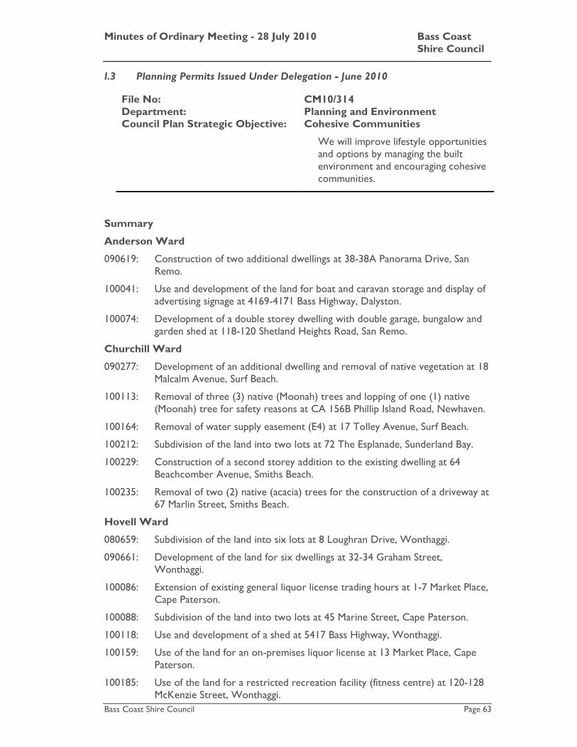
Minutes of Ordinary Meeting - 28 July 2010 Bass Coast Shire Council
Bass Coast Shire Council Page 63
I.3 Planning Permits Issued Under Delegation - June 2010
File No: CM10/314 Department: Planning and Environment Council Plan Strategic Objective: Cohesive Communities
We will improve lifestyle opportunities and options by managing the built environment and encouraging cohesive communities.
Summary
Anderson Ward
090619: Construction of two additional dwellings at 38-38A Panorama Drive, San Remo.
100041: Use and development of the land for boat and caravan storage and display of advertising signage at 4169-4171 Bass Highway, Dalyston.
100074: Development of a double storey dwelling with double garage, bungalow and garden shed at 118-120 Shetland Heights Road, San Remo.
Churchill Ward
090277: Development of an additional dwelling and removal of native vegetation at 18 Malcalm Avenue, Surf Beach.
100113: Removal of three (3) native (Moonah) trees and lopping of one (1) native (Moonah) tree for safety reasons at CA 156B Phillip Island Road, Newhaven.
100164: Removal of water supply easement (E4) at 17 Tolley Avenue, Surf Beach.
100212: Subdivision of the land into two lots at 72 The Esplanade, Sunderland Bay.
100229: Construction of a second storey addition to the existing dwelling at 64 Beachcomber Avenue, Smiths Beach.
100235: Removal of two (2) native (acacia) trees for the construction of a driveway at 67 Marlin Street, Smiths Beach.
Hovell Ward
080659: Subdivision of the land into six lots at 8 Loughran Drive, Wonthaggi.
090661: Development of the land for six dwellings at 32-34 Graham Street, Wonthaggi.
100086: Extension of existing general liquor license trading hours at 1-7 Market Place, Cape Paterson.
100088: Subdivision of the land into two lots at 45 Marine Street, Cape Paterson.
100118: Use and development of a shed at 5417 Bass Highway, Wonthaggi.
100159: Use of the land for an on-premises liquor license at 13 Market Place, Cape Paterson.
100185: Use of the land for a restricted recreation facility (fitness centre) at 120-128 McKenzie Street, Wonthaggi.

Minutes of Ordinary Meeting - 28 July 2010 Bass Coast Shire Council
Bass Coast Shire Council Page 64
100204: Subdivision of the land into four lots at 7 Fahey Street, Wonthaggi.
100209: Subdivision of the land into two lots at 121-123 Wentworth Road, North Wonthaggi.
100227: Subdivision of the land into three lots at 7 Court Street, Wonthaggi.
100241: Painting of the exterior of an existing dwelling at 53 Campbell Street, Wonthaggi.
Leadbeater Ward
100059: Subdivision of the land into two lots at 10 Palmer Street, Corinella.
100114: Development of a dwelling at Lot 7A PS601811 Acacia Road, Grantville.
100123: Use and development of a dwelling and shed at Lot 1 LP441699 Glen Alvie Road, Glen Alvie.
100192: Construction of a dwelling and associated outbuilding at 32 Hurdy Gurdy Lane, The Gurdies.
100211: Use and development of the land for a dwelling and farm shed at Lot 1 PS604744 Dunbabbin Road, The Gurdies.
100216: Development of a dwelling at 3 Hamelin Close, Corinella.
100260: Construction of a shed at 46 Smythe Street, Corinella.
McHaffie Ward
090583: Subdivision of the land into two lots and the removal of an easement at 14 Lock Road, Rhyll.
100119: Development of the land for a garage at 7 Glamis Road, Ventnor.
100173: Variation of the existing building envelope at 36 Cadogan Avenue, Ventnor.
100219: Removal of one (1) native (silky oak) tree and lopping of one (1) native (manna gum) tree for safety reasons at 22 Reid Street, Rhyll.
100220: Subdivision of the land into two lots at 6-8 Nareeb Court, Ventnor.
100244: Lopping of one (1) native tree for safety reasons at 34 Pall Mall, Ventnor.
Thompson Ward
090230: Subdivision of the land into two lots at 29 McKenzie Road, Cowes.
090631: Development of three dwellings and associated removal of vegetation at 6 Baker Street, Cowes.
090637: Construction of additions and alterations to the existing dwelling at 4 Walpole Street, Cowes.
100079: Subdivision of the land into four lots at 8 Vaughan Street, Cowes.
100124: Construction of two dwellings, removal of four (4) native trees and variation of an easement at 15 West Court, Cowes.
100198: Removal of one (1) native tree for safety reasons at 95 Teddy Bear Lane, Cowes.

Minutes of Ordinary Meeting - 28 July 2010 Bass Coast Shire Council
Bass Coast Shire Council Page 65
Townsend Ward
080785: Development of two dwellings and subdivision of the land into two lots at 30 Halford Street, Inverloch.
090640: Development of the land for two double storey dwellings at 7 Scarborough Street, Inverloch.
100218: Removal of fifteen (15) native trees in poor health at 121 Tamara Crescent, Inverloch.
Recommendation
That the report be received.
Attachments
There are no attachments for this report. NOTE: This item was moved as part of a block, please refer to page 66.

Minutes of Ordinary Meeting - 28 July 2010 Bass Coast Shire Council
Bass Coast Shire Council Page 66
I.4 Planning Permit Approval Statistics
File No: CM10/315 Department: Planning and Environment Council Plan Strategic Objective: Cohesive Communities
We will improve lifestyle opportunities and options by managing the built environment and encouraging cohesive communities.
Summary Attached is the report detailing the Planning Permit Approval Statistics for the month of June 2010.
Recommendation
That the report be received.
Attachments
AT-1 Planning Permit Stats - June 2010 2 Pages AT-2 Planning townstats - June 2010 1 Page Council Decision
Moved: Cr. Veronica Dowman / Seconded: Cr. Ross Smith That agenda items Committees and Delegates Reports F.1, F.2, F.3, F.4, F.5, and Performance Monitoring Reports G.1, G.2, G.3 and G.4 be moved as a block.
CARRIED

Minutes of Ordinary Meeting - 28 July 2010 Bass Coast Shire Council
Bass Coast Shire Council Page 67
Watching Bass Coast
Minutes of Ordinary Meeting - 28 July 2010 Bass Coast Shire Council
Bass Coast Shire Council Page 68
J Watching Bass Coast
J.1 Cost Saving Report - Agenda Preparation Process
File No: CM10/330 Department: Chief Executive Officer Council Plan Strategic Objective: Good Governance
We will manage our resources effectively, keep the community engaged, listen to our communities' concerns to create positive outcomes.
Declaration
The reporting officer does not have any direct or indirect interests in relation this matter.
Summary
The following Notice of Motion (22/05) was adopted by Council at the meeting on 21 December 2005:
“That the Chief Executive Officer, at every Special Meeting of Council, prepare a short report for Council, outlining where and how savings are being made in Council’s operations budget.”
Council has an ongoing improvement process for identifying and implementing costs savings and operational efficiencies.
The Councillors requested they receive their Council Meeting Agenda’s delivered on the Wednesday prior to the meeting, giving Councillors seven days to review reports. The Council Meeting Agenda is currently delivered on the Friday prior to a meeting.
Introduction
Councillors are asked to consider quite complex and varied topics which are covered on the Council Meeting Agenda. The current process allows five days for the Councillors to read the agenda and conduct any necessary research, inspections or seek clarification on any items listed. Councillors have always grappled with this enormous task and have requested additional time to consider the Council Agenda.
Councillors will now receive their Council Meeting Agenda on the Wednesday prior the Council Meeting on the following Wednesday, this will provide them seven days to consider each agenda item.
Strategic Basis
The Local Government Act prescribed the types of meetings a Council can conduct. Bass Coast Shire Council has developed Local Law Number 12 (Meeting Procedure) that dictates the format of the Council Meeting Agenda.

Minutes of Ordinary Meeting - 28 July 2010 Bass Coast Shire Council
Bass Coast Shire Council Page 69
Finances
The early delivery of the Council Meeting Agenda will mean that agendas can be collected from the Council Office whilst Councillors are conducting other Council business, resulting in the associated costs of agenda delivery being cancelled.
Officer’s Comments/Conclusion
The changes to the delivery of Council Meeting Agendas will decrease associated costs by approximately $132.00 per meeting and allow more time for Councillors to consider agenda items and conduct any necessary research prior to the Council Meeting.
Recommendation
That the report be received.
Attachments
There are no attachments for this report. Council Decision
Moved: Cr. Veronica Dowman / Seconded: Cr. Gareth Barlow That the report be received.
CARRIED

Minutes of Ordinary Meeting - 28 July 2010 Bass Coast Shire Council
Bass Coast Shire Council Page 70
J.2 Local Government Inspectorate Investigation into Rezoning of land in San Remo
File No: CM10/343 Department: Chief Executive Officer Council Plan Strategic Objective: Good Governance
We will manage our resources effectively, keep the community engaged, listen to our communities' concerns to create positive outcomes.
Declaration
The author has no direct or indirect interest in this matter, but was interviewed as a witness during the investigation.
Summary
The Local Government Investigations and Compliance Inspectorate has completed a comprehensive investigation into matters relating to the rezoning of land in San Remo that was referred to the Local Government Inspectorate in September 2009.
The Local Government Inspectorate has concluded that there is no evidence to support any of the following allegations:
• A developer was provided with confidential information about certain land in San Remo that was to be rezoned so that it could be purchased at a reduced cost.
• Once rezoned the developer could then sell the land at a far greater price and reap significant profit.
• The developer offered bribes and inducements to some councillors to support the rezoning.
The Local Government Inspectorate found that the allegations were based on misleading innuendo and rumour.
Introduction
The investigation was commissioned by the Minister for Local Government at the request of the Council in May 2009 following the publication of allegations in the South Gippsland Sentinel Times newspaper. The allegations had been made during the preparation of the San Remo/Newhaven/Cape Woolamai Structure Plan. The Structure Plan was ultimately incorporated into the Bass Coast Planning Scheme through Amendment C90.
Minutes of Ordinary Meeting - 28 July 2010 Bass Coast Shire Council
Bass Coast Shire Council Page 71
Strategic Basis
One of the Councils primary roles is to plan for the orderly development of the Shire. The Council has undertaken substantial land use planning throughout the Shire over the past decade resulting in the development of structure plans being prepared for all urban centres. Structure plans outline the way in which townships will develop, provide an adequate supply of land for up to 15 years and establish town boundaries.
Finances
The direct cost of the investigation was met by the Local Government Inspectorate.
Stakeholders
Councillors, staff, residents and ratepayers all share an interest in the Shire being governed with integrity in compliance with the law.
Statutory Requirements/Codes/Standards/Policies
The preparation of the San Remo/Newhaven/Cape Woolamai Structure Plan involved the Council exercising its powers as a planning authority under the Planning and Environment Act. The conduct of Councillors is governed under the Local Government Act. The Local Government Inspectorate has broad powers to investigate complaints made about Councillors.
Other Options
As the advice of the Inspectorate brings this matter to a conclusion, no other options are relevant.
Officer’s Comments/Conclusion
The allegations at the heart of this investigation were damaging to the integrity of the planning process followed to develop the Structure Plan. They also had the potential to damage the reputation of those Councillors implicated in the allegations. In the absence of any evidence to support the allegations when first reported in the media, the Council requested the Minister for Local Government to investigate the claims. The Local Government Inspectorate interviewed all Councillors, relevant staff, property owners, journalists and anyone else identified in media reports in the course of examining the allegations. The Local Government Investigations and Compliance Inspectorate found that the allegations were based on misleading innuendo and rumour. The Inspectorate did identify some areas of record keeping that could be improved in relation to the maintenance of registers of interest returns. Improvements to the process around administering the register of interests for Councillors and nominated staff have been made and reviewed by the Municipal Inspector who was satisfied that the Council had taken appropriate steps to introduce systems and procedures to avoid breaches of the Local Government Act. The Inspector also recommended that Councillors be provided with additional information and training to ensure an adequate knowledge of the provisions governing conflicts of interest and interests that must be registered.

Minutes of Ordinary Meeting - 28 July 2010 Bass Coast Shire Council
Bass Coast Shire Council Page 72
Recommendation
That the report be received.
Attachments
There are no attachments for this report. Council Decision
Moved: Cr. Gareth Barlow / Seconded: Cr. Veronica Dowman That the report be received.
CARRIED
Minutes of Ordinary Meeting - 28 July 2010 Bass Coast Shire Council
Bass Coast Shire Council Page 73
Reports Requiring Council Decision

Minutes of Ordinary Meeting - 28 July 2010 Bass Coast Shire Council
Bass Coast Shire Council Page 74
K Reports Requiring Council Decision
K.1 Adoption of the 2010/11 budget
File No: CM10/293 Department: Corporate Services Council Plan Strategic Objective: Good Governance
We will manage our resources effectively, keep the community engaged, listen to our communities' concerns to create positive outcomes.
Summary
This report recommends that Council consider any submissions received regarding the proposed 2010/11 budget, and if appropriate, to adopt the budget.
Introduction
On 16 June 2010, Council resolved to formally prepare the 2010/11 budget and give public notice of this action in the local press. Copies of the proposed budget have been made available for public inspection at each Customer Service Centre and submissions have been called for under the provisions of section 223 of the Local Government Act 1989
Strategic Basis
The adoption of the 2010/11 budget within legislative provisions is required under the Council Plan.
Finances
All financial data relevant to the 2010/11 budget is included in the standard statements.
Stakeholders
Council must formally consider the submissions under section 223 of the Local Government Act 1989. A public notice has been placed in the local press inviting submissions on any proposal contained in the proposed budget. The submission period closed at 5.00 p.m. on Tuesday 20 July 2010.
Council has resolved that a committee of Councillors will consider all submissions received by the closing date. The committee will meet on Wednesday 28 July 2010 to consider any submissions received and to hear any person that wishes to be heard in support of their submission and report to Council on the outcome of the consideration of any submissions received. After considering such report, the Council will need to resolve to adopt the budget in the proposed form or in an altered form.

Minutes of Ordinary Meeting - 28 July 2010 Bass Coast Shire Council
Bass Coast Shire Council Page 75
Statutory Requirements/Codes/Standards/Policies
Statutory notices of the preparation of the proposed budget have appeared in the local press as required under section 129 of the Act.
All information required to be made available to the public has been made available for inspection.
Council now needs to:
• Receive advice from its appointed committee regarding any possible changes to the budget resulting from any submission received;
• Adopt the budget in its proposed form or with changes; and
• Give public notice of its actions.
Council is required to adopt the budget by 31 August each year.
Other Options
Not applicable.
Officer’s Comments/Conclusion
Council must consider advice from its appointed committee regarding any possible changes to the budget resulting from any submission received on the proposed budget and then adopt the budget with or without modifications.
Recommendation
1. That Council receives advice from its appointed committee regarding any possible changes to the budget resulting from any submission received, in relation to the proposed 2010/11 budget.
2. Council (after having regard to all submissions made to it under Sections 129 and 223 of the Local Government Act 1989), resolve to adopt the budget as prepared by Council on 16 June 2010.
3. That the Chief Executive Officer be authorised to give public notice of this decision to adopt such budget in accordance with the Local Government Act 1989.
Attachments
There are no attachments for this report.

Minutes of Ordinary Meeting - 28 July 2010 Bass Coast Shire Council
Bass Coast Shire Council Page 76
Council Decision
Moved: Cr. Veronica Dowman / Seconded: Cr. Phil Wright
1. That Council receives advice from its appointed committee regarding any possible changes to the budget resulting from any submission received, in relation to the proposed 2010/11 budget.
2. Council (after having regard to all submissions made to it under Sections 129 and 223 of the Local Government Act 1989), resolve to adopt the budget as prepared by Council on 16 June 2010.
3. That the Chief Executive Officer be authorised to give public notice of this decision to adopt such budget in accordance with the Local Government Act 1989.
CARRIED

Minutes of Ordinary Meeting - 28 July 2010 Bass Coast Shire Council
Bass Coast Shire Council Page 77
K.2 Declaration of 2010/11 rates and garbage charge
File No: CM10/289 Department: Corporate Services Council Plan Strategic Objective: We will manage our resources
effectively, keep the community engaged, listen to our communities' concerns to create positive outcomes.
Good Governance
Summary
This report recommends the formal declaration of the 2010/11 rates and garbage charge for the Bass Coast Shire Council, based upon the 2010/11 budget.
Introduction
The budget includes the following rates and charges for 2010/11.
• Developed Land Rate of 0.26893 cents in the dollar;
• Farm Land Rate of 0.26893 cents in the dollar;
• Vacant Land Rate of 0.40340 cents in the dollar;
• Cultural and Recreation Land Rate of 0.16136 cents in the dollar;
• Public Housing Land Rate of 0.13447 cents in the dollar; and
• Garbage Charge of $271.00 on each tenement on which such charge can be levied.
It is proposed that these rates and garbage charge be applied to levy $33,827,895 in rates and garbage charge revenue for 2010/11 (excluding supplementary rates and garbage charge revenue for 2010/11).
Strategic Basis
The declaration and levying of rates and charges is consistent with the Council Plan objective of providing the financial resources needed by Council to meet its responsibilities.
Finances
The rating structure proposed in the budget will yield the following estimated revenue for 2010/11, (excluding supplementary rates and charges and net of the rural land rate rebate):
General Rates $27,753,972
Garbage Charge $ 6,073,923
TOTAL $33,827,895

Minutes of Ordinary Meeting - 28 July 2010 Bass Coast Shire Council
Bass Coast Shire Council Page 78
Stakeholders
Details of the proposed rates and charges have been included in the budget documents, which have been open for public inspection for 28 days. The Council must consider any submissions received in relation to the budget before the budget is adopted.
Statutory Requirements/Codes/Standards/Policies
The Local Government Act requires Council to declare the 2010/11 Rates and Charges by 31 August 2009. The Act gives Council power to declare differential rates and service charges.
The public has the right to make submissions to Council under section 223 of the Local Government Act 1989, regarding the proposed budget including the proposed rates and charges
Council can formally declare the 2010/11 rates and charges after it has adopted the budget.
Officer’s Comments/Conclusion
The 2010/11 budget documents include rates and garbage charge revenue (excluding revenue from supplementary assessments) of $33,827,895. The formal declaration of the rates and charges will allow Council to levy the various rates and the garbage charge and collect the revenue included in the budget.
Recommendation
DECLARATION OF RATES AND CHARGES
1. Amount Intended to be Raised: An amount of $33,827,895 (or such other amount as is lawfully levied as a consequence of this Recommendation being adopted), be declared as the amount which Council intends to raise by general rates and the annual service charge (described later in this Recommendation), which amount is calculated as follows: General Rates $27,753,972 (After allowing for the rural land rate rebate) Annual Service (Garbage) Charge $ 6,073,923
2. General Rates
a. A general rate be declared in respect of the 2010/11 Financial Year.
b. It be further declared that the general rate be raised by the application of differential rates.
c. A differential rate be respectively declared for rateable land having the respective characteristics specified below, which characteristics will form the criteria for each differential rate so declared:
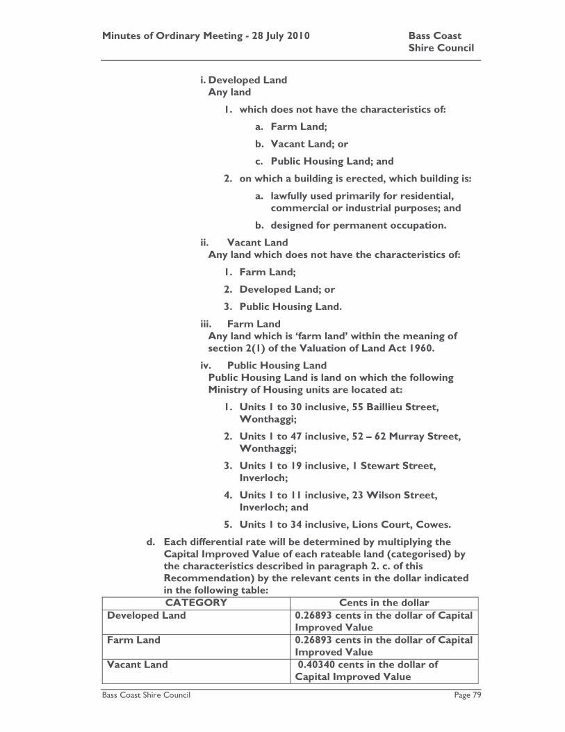
Minutes of Ordinary Meeting - 28 July 2010 Bass Coast Shire Council
Bass Coast Shire Council Page 79
i. Developed Land Any land
1. which does not have the characteristics of:
a. Farm Land;
b. Vacant Land; or
c. Public Housing Land; and
2. on which a building is erected, which building is:
a. lawfully used primarily for residential, commercial or industrial purposes; and
b. designed for permanent occupation.
ii. Vacant Land Any land which does not have the characteristics of:
1. Farm Land;
2. Developed Land; or
3. Public Housing Land.
iii. Farm Land Any land which is ‘farm land’ within the meaning of section 2(1) of the Valuation of Land Act 1960.
iv. Public Housing Land Public Housing Land is land on which the following Ministry of Housing units are located at:
1. Units 1 to 30 inclusive, 55 Baillieu Street, Wonthaggi;
2. Units 1 to 47 inclusive, 52 – 62 Murray Street, Wonthaggi;
3. Units 1 to 19 inclusive, 1 Stewart Street, Inverloch;
4. Units 1 to 11 inclusive, 23 Wilson Street, Inverloch; and
5. Units 1 to 34 inclusive, Lions Court, Cowes.
d. Each differential rate will be determined by multiplying the Capital Improved Value of each rateable land (categorised) by the characteristics described in paragraph 2. c. of this Recommendation) by the relevant cents in the dollar indicated in the following table: CATEGORY Cents in the dollar
Developed Land 0.26893 cents in the dollar of Capital Improved Value
Farm Land 0.26893 cents in the dollar of Capital Improved Value
Vacant Land 0.40340 cents in the dollar of Capital Improved Value
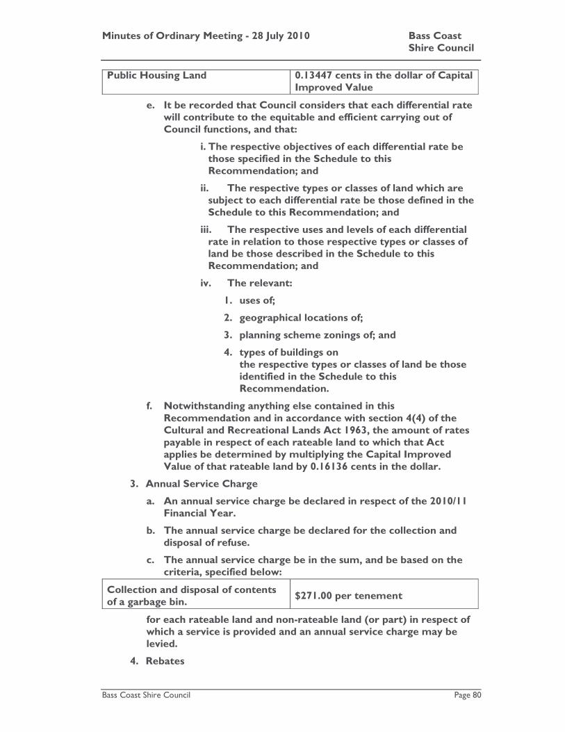
Minutes of Ordinary Meeting - 28 July 2010 Bass Coast Shire Council
Bass Coast Shire Council Page 80
Public Housing Land 0.13447 cents in the dollar of Capital Improved Value
e. It be recorded that Council considers that each differential rate will contribute to the equitable and efficient carrying out of Council functions, and that:
i. The respective objectives of each differential rate be those specified in the Schedule to this Recommendation; and
ii. The respective types or classes of land which are subject to each differential rate be those defined in the Schedule to this Recommendation; and
iii. The respective uses and levels of each differential rate in relation to those respective types or classes of land be those described in the Schedule to this Recommendation; and
iv. The relevant:
1. uses of;
2. geographical locations of;
3. planning scheme zonings of; and
4. types of buildings on the respective types or classes of land be those identified in the Schedule to this Recommendation.
f. Notwithstanding anything else contained in this Recommendation and in accordance with section 4(4) of the Cultural and Recreational Lands Act 1963, the amount of rates payable in respect of each rateable land to which that Act applies be determined by multiplying the Capital Improved Value of that rateable land by 0.16136 cents in the dollar.
3. Annual Service Charge
a. An annual service charge be declared in respect of the 2010/11 Financial Year.
b. The annual service charge be declared for the collection and disposal of refuse.
c. The annual service charge be in the sum, and be based on the criteria, specified below:
Collection and disposal of contents of a garbage bin.
$271.00 per tenement
for each rateable land and non-rateable land (or part) in respect of which a service is provided and an annual service charge may be levied.
4. Rebates

Minutes of Ordinary Meeting - 28 July 2010 Bass Coast Shire Council
Bass Coast Shire Council Page 81
land identified be the Assessment number specified in Appendix 1 to this Recommendation the respective rebate set out opposite the Assessment number in that appendix.
b. The rebate be granted to:
i. Assist the proper development of the municipal district;
ii. Preserve places within the municipal district which are of environmental interest; and
iii. Restore or maintain places of environmental importance within the municipal district.
And, more generally, to promote the aims described in the Rural Land Rebate Scheme Policy adopted by Council on 19 December 2001 (‘the policy’). The Rebate provides benefit to the community as a whole as it is an integral part of the Policy, which is aimed at improving the natural environment of the Shire.
c. The rebate be granted on the following terms:
i. The owner of each rateable land identified by the Assessment number specified in Appendix 1 to this Recommendation (‘land’) must have, on or before 30 April 2009, completed and submitted to Council:
1. A “Proposed Works Application Form” made available by Council; and
2. Such accompanying photographic and/or other evidence as the Environment Manager (‘the Officer’) requires.
ii. Where the Owner of each land (‘the Owner’) has completed and submitted to Council a Works Proposed Form made available by Council and such accompanying photographic and/or other evidence as the Policy requires, and the Officer is satisfied that works proposed by or on behalf of the Owner are consistent with the Policy, that Owner must, on or before 30 April 2010, complete and submit to Council:
1. A ‘Works Completed Form’ made available by Council; and
2. Such accompanying photographic and/or other evidence as the Officer requires, and generally satisfy the Officer that works have been carried out on the land which are consistent with the Policy.
iii. The Owner must complete and submit to Council within such periods as are specified by the Officer all such other forms made available by Council as the Officer requires to be completed and submitted.

Minutes of Ordinary Meeting - 28 July 2010 Bass Coast Shire Council
Bass Coast Shire Council Page 82
reasonable notice of Council’s desire to conduct an inspection, make his or her land available for inspection by the Officer (and/or such other person as is or other persons as are authorised by Council) at all reasonable times, for the purpose of allowing the Officer to:
1. Determine whether the works proposed to be carried out on the land are consistent with the Policy;
2. Determine whether the works carried out on the land are consistent with the Policy; and
3. Undertake mapping and data collection activities.
v. The Owner must comply with all such directions and requests given by the Officer which are consistent with the Policy.
d. Council grant to each owner of land specified in Appendix 2 of this Recommendation the rebate set out in that Appendix.
e. The rebate referred to in paragraph 4. d. be granted to assist the proper development of the municipal district.
f. It be recorded that the rebate referred to in paragraph 4. d. will provide benefit to the community as a whole, by restoring equity between ratepayers through as acknowledgement that the owners of the relevant land are precluded from developing the land.
5. Incentives No incentive be declared for early payment of the general rates and annual service charge previously declared.
6. Payment options A person may:
a. Pay the rates and charges previously declared by four instalments on the dates fixed for such purpose by the Minister; or
b. Pay the rates and charges previously declared in a lump sum.
7. Consequential
a. It be recorded that Council requires any person to pay interest in any amounts of rates and charges which:
i. That person is liable to pay; and
ii. Have not been paid by the date specified for their payment. Such interest to be calculated in accordance with section 172 (2) of the Local Government Act 1989.
8. The Corporate Services Director be authorised to levy and recover
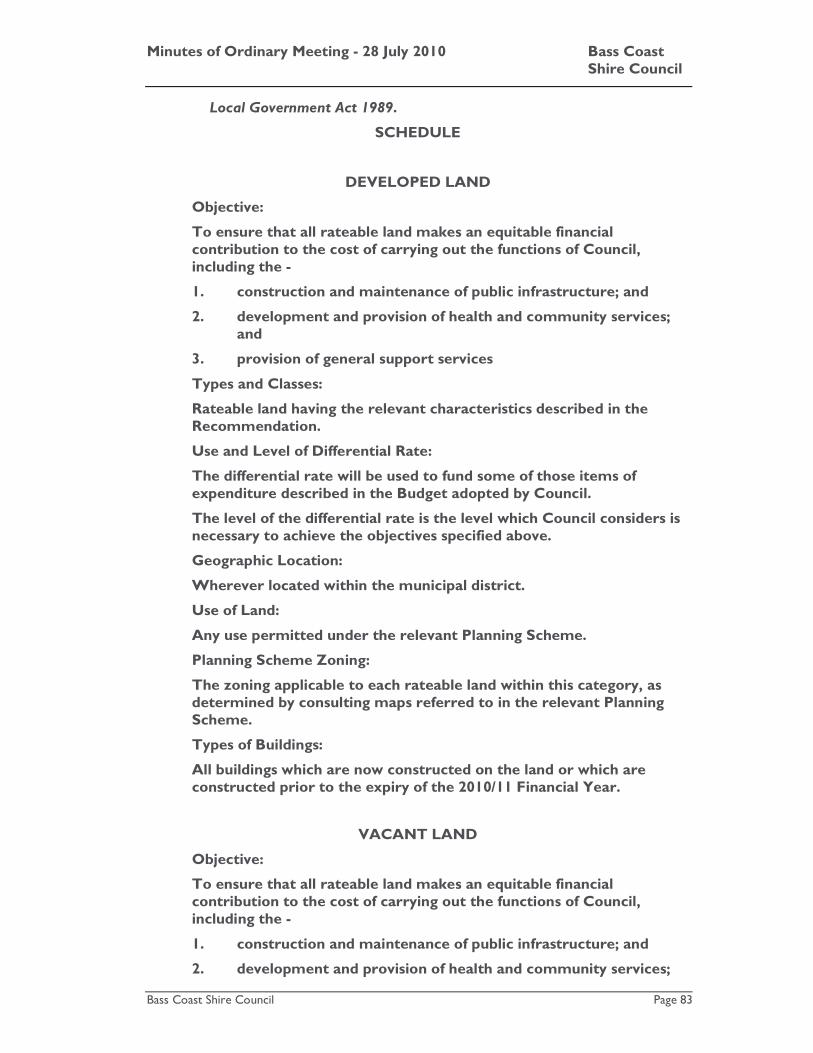
Minutes of Ordinary Meeting - 28 July 2010 Bass Coast Shire Council
Bass Coast Shire Council Page 83
Local Government Act 1989.
SCHEDULE
DEVELOPED LAND
Objective:
To ensure that all rateable land makes an equitable financial contribution to the cost of carrying out the functions of Council, including the -
1. construction and maintenance of public infrastructure; and
2. development and provision of health and community services; and
3. provision of general support services
Types and Classes:
Rateable land having the relevant characteristics described in the Recommendation.
Use and Level of Differential Rate:
The differential rate will be used to fund some of those items of expenditure described in the Budget adopted by Council.
The level of the differential rate is the level which Council considers is necessary to achieve the objectives specified above.
Geographic Location:
Wherever located within the municipal district.
Use of Land:
Any use permitted under the relevant Planning Scheme.
Planning Scheme Zoning:
The zoning applicable to each rateable land within this category, as determined by consulting maps referred to in the relevant Planning Scheme.
Types of Buildings:
All buildings which are now constructed on the land or which are constructed prior to the expiry of the 2010/11 Financial Year.
VACANT LAND
Objective:
To ensure that all rateable land makes an equitable financial contribution to the cost of carrying out the functions of Council, including the -
1. construction and maintenance of public infrastructure; and
2. development and provision of health and community services;
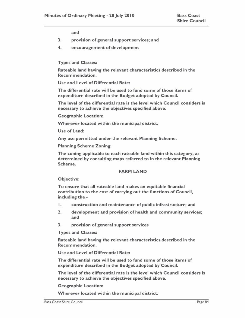
Minutes of Ordinary Meeting - 28 July 2010 Bass Coast Shire Council
Bass Coast Shire Council Page 84
and
3. provision of general support services; and
4. encouragement of development
Types and Classes:
Rateable land having the relevant characteristics described in the Recommendation.
Use and Level of Differential Rate:
The differential rate will be used to fund some of those items of expenditure described in the Budget adopted by Council.
The level of the differential rate is the level which Council considers is necessary to achieve the objectives specified above.
Geographic Location:
Wherever located within the municipal district.
Use of Land:
Any use permitted under the relevant Planning Scheme.
Planning Scheme Zoning:
The zoning applicable to each rateable land within this category, as determined by consulting maps referred to in the relevant Planning Scheme.
FARM LAND
Objective:
To ensure that all rateable land makes an equitable financial contribution to the cost of carrying out the functions of Council, including the -
1. construction and maintenance of public infrastructure; and
2. development and provision of health and community services; and
3. provision of general support services
Types and Classes:
Rateable land having the relevant characteristics described in the Recommendation.
Use and Level of Differential Rate:
The differential rate will be used to fund some of those items of expenditure described in the Budget adopted by Council.
The level of the differential rate is the level which Council considers is necessary to achieve the objectives specified above.
Geographic Location:
Wherever located within the municipal district.
Minutes of Ordinary Meeting - 28 July 2010 Bass Coast Shire Council
Bass Coast Shire Council Page 85
Use of Land:
Any use permitted under the relevant Planning Scheme.
Planning Scheme Zoning:
The zoning applicable to each rateable land within this category, as determined by consulting maps referred to in the relevant Planning Scheme.
Types of Buildings:
All buildings which are now constructed on the land or which are constructed prior to the expiry of the 2010/11 Financial Year.
PUBLIC HOUSING LAND
Objective:
To ensure that all rateable land makes an equitable financial contribution to the cost of carrying out the functions of Council, including the -
1. construction and maintenance of public infrastructure; and
2. development and provision of health and community services; and
3. provision of general support services
Types and Classes:
Rateable land having the relevant characteristics described in the Recommendation.
Use and Level of Differential Rate:
The differential rate will be used to fund some of those items of expenditure described in the Budget adopted by Council.
The level of the differential rate is the level which Council considers is necessary to achieve the objectives specified above.
Geographic Location:
Wherever located within the municipal district.
Use of Land:
Any use permitted under the relevant Planning Scheme.
Planning Scheme Zoning:
The zoning applicable to each rateable land within this category, as determined by consulting maps referred to in the relevant Planning Scheme.
Types of Buildings:
All buildings which are now constructed on the land or which are constructed prior to the expiry of the 2010/11 Financial Year.
Minutes of Ordinary Meeting - 28 July 2010 Bass Coast Shire Council
Bass Coast Shire Council Page 86
Attachments
AT-1 Appendix 1: Rural Land Rate Rebate 9 Pages AT-2 Appendix 2: Summerlands Rebate 1 Page Council Decision
Moved: Cr. John Duscher / Seconded: Cr. Gareth Barlow DECLARATION OF RATES AND CHARGES
1. Amount Intended to be Raised: An amount of $33,827,895 (or such other amount as is lawfully levied as a consequence of this Recommendation being adopted), be declared as the amount which Council intends to raise by general rates and the annual service charge (described later in this Recommendation), which amount is calculated as follows: General Rates $27,753,972 (After allowing for the rural land rate rebate) Annual Service (Garbage) Charge $ 6,073,923
2. General Rates
a. A general rate be declared in respect of the 2010/11 Financial Year.
b. It be further declared that the general rate be raised by the application of differential rates.
c. A differential rate be respectively declared for rateable land having the respective characteristics specified below, which characteristics will form the criteria for each differential rate so declared:
i. Developed Land Any land
1. which does not have the characteristics of:
a. Farm Land;
b. Vacant Land; or
c. Public Housing Land; and
2. on which a building is erected, which building is:
a. lawfully used primarily for residential, commercial or industrial purposes; and
b. designed for permanent occupation.
ii. Vacant Land Any land which does not have the characteristics of:
1. Farm Land;
2. Developed Land; or

Minutes of Ordinary Meeting - 28 July 2010 Bass Coast Shire Council
Bass Coast Shire Council Page 87
3. Public Housing Land.
iii. Farm Land Any land which is ‘farm land’ within the meaning of section 2(1) of the Valuation of Land Act 1960.
iv. Public Housing Land Public Housing Land is land on which the following Ministry of Housing units are located at:
1. Units 1 to 30 inclusive, 55 Baillieu Street, Wonthaggi;
2. Units 1 to 47 inclusive, 52 – 62 Murray Street, Wonthaggi;
3. Units 1 to 19 inclusive, 1 Stewart Street, Inverloch;
4. Units 1 to 11 inclusive, 23 Wilson Street, Inverloch; and
5. Units 1 to 34 inclusive, Lions Court, Cowes.
d. Each differential rate will be determined by multiplying the Capital Improved Value of each rateable land (categorised) by the characteristics described in paragraph 2. c. of this Recommendation) by the relevant cents in the dollar indicated in the following table: CATEGORY Cents in the dollar
Developed Land 0.26893 cents in the dollar of Capital Improved Value
Farm Land 0.26893 cents in the dollar of Capital Improved Value
Vacant Land 0.40340 cents in the dollar of Capital Improved Value
Public Housing Land 0.13447 cents in the dollar of Capital Improved Value
e. It be recorded that Council considers that each differential rate will contribute to the equitable and efficient carrying out of Council functions, and that:
i. The respective objectives of each differential rate be those specified in the Schedule to this Recommendation; and
ii. The respective types or classes of land which are subject to each differential rate be those defined in the Schedule to this Recommendation; and
iii. The respective uses and levels of each differential rate in relation to those respective types or classes of land be those described in the Schedule to this Recommendation; and
iv. The relevant:

Minutes of Ordinary Meeting - 28 July 2010 Bass Coast Shire Council
Bass Coast Shire Council Page 88
1. uses of;
2. geographical locations of;
3. planning scheme zonings of; and
4. types of buildings on the respective types or classes of land be those identified in the Schedule to this Recommendation.
f. Notwithstanding anything else contained in this Recommendation and in accordance with section 4(4) of the Cultural and Recreational Lands Act 1963, the amount of rates payable in respect of each rateable land to which that Act applies be determined by multiplying the Capital Improved Value of that rateable land by 0.16136 cents in the dollar.
3. Annual Service Charge
a. An annual service charge be declared in respect of the 2010/11 Financial Year.
b. The annual service charge be declared for the collection and disposal of refuse.
c. The annual service charge be in the sum, and be based on the criteria, specified below:
Collection and disposal of contents of a garbage bin.
$271.00 per tenement
for each rateable land and non-rateable land (or part) in respect of which a service is provided and an annual service charge may be levied.
4. Rebates
a. It be recorded that Council grants to each owner of rateable land identified be the Assessment number specified in Appendix 1 to this Recommendation the respective rebate set out opposite the Assessment number in that appendix.
b. The rebate be granted to:
i. Assist the proper development of the municipal district;
ii. Preserve places within the municipal district which are of environmental interest; and
iii. Restore or maintain places of environmental importance within the municipal district.
And, more generally, to promote the aims described in the Rural Land Rebate Scheme Policy adopted by Council on 19 December 2001 (‘the policy’). The Rebate provides benefit to the community as a whole as it is an integral part of the Policy, which is aimed at improving the natural environment of the Shire.
Minutes of Ordinary Meeting - 28 July 2010 Bass Coast Shire Council
Bass Coast Shire Council Page 89
c. The rebate be granted on the following terms:
i. The owner of each rateable land identified by the Assessment number specified in Appendix 1 to this Recommendation (‘land’) must have, on or before 30 April 2009, completed and submitted to Council:
1. A “Proposed Works Application Form” made available by Council; and
2. Such accompanying photographic and/or other evidence as the Environment Manager (‘the Officer’) requires.
ii. Where the Owner of each land (‘the Owner’) has completed and submitted to Council a Works Proposed Form made available by Council and such accompanying photographic and/or other evidence as the Policy requires, and the Officer is satisfied that works proposed by or on behalf of the Owner are consistent with the Policy, that Owner must, on or before 30 April 2010, complete and submit to Council:
1. A ‘Works Completed Form’ made available by Council; and
2. Such accompanying photographic and/or other evidence as the Officer requires, and generally satisfy the Officer that works have been carried out on the land which are consistent with the Policy.
iii. The Owner must complete and submit to Council within such periods as are specified by the Officer all such other forms made available by Council as the Officer requires to be completed and submitted.
iv. The Owner must, following the receipt of reasonable notice of Council’s desire to conduct an inspection, make his or her land available for inspection by the Officer (and/or such other person as is or other persons as are authorised by Council) at all reasonable times, for the purpose of allowing the Officer to:
1. Determine whether the works proposed to be carried out on the land are consistent with the Policy;
2. Determine whether the works carried out on the land are consistent with the Policy; and
3. Undertake mapping and data collection activities.
v. The Owner must comply with all such directions and requests given by the Officer which are consistent with the Policy.

Minutes of Ordinary Meeting - 28 July 2010 Bass Coast Shire Council
Bass Coast Shire Council Page 90
d. Council grant to each owner of land specified in Appendix 2 of this Recommendation the rebate set out in that Appendix.
e. The rebate referred to in paragraph 4. d. be granted to assist the proper development of the municipal district.
f. It be recorded that the rebate referred to in paragraph 4. d. will provide benefit to the community as a whole, by restoring equity between ratepayers through as acknowledgement that the owners of the relevant land are precluded from developing the land.
5. Incentives No incentive be declared for early payment of the general rates and annual service charge previously declared.
6. Payment options A person may:
a. Pay the rates and charges previously declared by four instalments on the dates fixed for such purpose by the Minister; or
b. Pay the rates and charges previously declared in a lump sum.
7. Consequential
a. It be recorded that Council requires any person to pay interest in any amounts of rates and charges which:
i. That person is liable to pay; and
ii. Have not been paid by the date specified for their payment. Such interest to be calculated in accordance with section 172 (2) of the Local Government Act 1989.
8. The Corporate Services Director be authorised to levy and recover the general rates and annual service charge in accordance with the Local Government Act 1989.
SCHEDULE
DEVELOPED LAND
Objective:
To ensure that all rateable land makes an equitable financial contribution to the cost of carrying out the functions of Council, including the -
1. construction and maintenance of public infrastructure; and
2. development and provision of health and community services; and
3. provision of general support services

Minutes of Ordinary Meeting - 28 July 2010 Bass Coast Shire Council
Bass Coast Shire Council Page 91
Types and Classes:
Rateable land having the relevant characteristics described in the Recommendation.
Use and Level of Differential Rate:
The differential rate will be used to fund some of those items of expenditure described in the Budget adopted by Council.
The level of the differential rate is the level which Council considers is necessary to achieve the objectives specified above.
Geographic Location:
Wherever located within the municipal district.
Use of Land:
Any use permitted under the relevant Planning Scheme.
Planning Scheme Zoning:
The zoning applicable to each rateable land within this category, as determined by consulting maps referred to in the relevant Planning Scheme.
Types of Buildings:
All buildings which are now constructed on the land or which are constructed prior to the expiry of the 2010/11 Financial Year.
VACANT LAND
Objective:
To ensure that all rateable land makes an equitable financial contribution to the cost of carrying out the functions of Council, including the -
1. construction and maintenance of public infrastructure; and
2. development and provision of health and community services; and
3. provision of general support services; and
4. encouragement of development
Types and Classes:
Rateable land having the relevant characteristics described in the Recommendation.
Use and Level of Differential Rate:
The differential rate will be used to fund some of those items of expenditure described in the Budget adopted by Council.
The level of the differential rate is the level which Council considers is necessary to achieve the objectives specified above.

Minutes of Ordinary Meeting - 28 July 2010 Bass Coast Shire Council
Bass Coast Shire Council Page 92
Geographic Location:
Wherever located within the municipal district.
Use of Land:
Any use permitted under the relevant Planning Scheme.
Planning Scheme Zoning:
The zoning applicable to each rateable land within this category, as determined by consulting maps referred to in the relevant Planning Scheme.
FARM LAND
Objective:
To ensure that all rateable land makes an equitable financial contribution to the cost of carrying out the functions of Council, including the -
1. construction and maintenance of public infrastructure; and
2. development and provision of health and community services; and
3. provision of general support services
Types and Classes:
Rateable land having the relevant characteristics described in the Recommendation.
Use and Level of Differential Rate:
The differential rate will be used to fund some of those items of expenditure described in the Budget adopted by Council.
The level of the differential rate is the level which Council considers is necessary to achieve the objectives specified above.
Geographic Location:
Wherever located within the municipal district.
Use of Land:
Any use permitted under the relevant Planning Scheme.
Planning Scheme Zoning:
The zoning applicable to each rateable land within this category, as determined by consulting maps referred to in the relevant Planning Scheme.
Types of Buildings:
All buildings which are now constructed on the land or which are constructed prior to the expiry of the 2010/11 Financial Year.

Minutes of Ordinary Meeting - 28 July 2010 Bass Coast Shire Council
Bass Coast Shire Council Page 93
PUBLIC HOUSING LAND
Objective:
To ensure that all rateable land makes an equitable financial contribution to the cost of carrying out the functions of Council, including the -
1. construction and maintenance of public infrastructure; and
2. development and provision of health and community services; and
3. provision of general support services
Types and Classes:
Rateable land having the relevant characteristics described in the Recommendation.
Use and Level of Differential Rate:
The differential rate will be used to fund some of those items of expenditure described in the Budget adopted by Council.
The level of the differential rate is the level which Council considers is necessary to achieve the objectives specified above.
Geographic Location:
Wherever located within the municipal district.
Use of Land:
Any use permitted under the relevant Planning Scheme.
Planning Scheme Zoning:
The zoning applicable to each rateable land within this category, as determined by consulting maps referred to in the relevant Planning Scheme.
Types of Buildings:
All buildings which are now constructed on the land or which are constructed prior to the expiry of the 2010/11 Financial Year.
CARRIED

Minutes of Ordinary Meeting - 28 July 2010 Bass Coast Shire Council
Bass Coast Shire Council Page 94
K.3 Amendment C112 - Land west of Tulloch Street, Dalyston: Post Exhibition Report
File No: CM10/311 Department: Planning and Environment Council Plan Strategic Objective: Cohesive Communities
We will improve lifestyle opportunities and options by managing the built environment and encouraging cohesive communities.
Previous Items: SR1/09 - Request to rezone and subdivide land west of Tulloch
Street, Dalyston - Council - 21 October 2009
Declaration
The author has no direct or indirect interest in this issue.
Summary
Council has received a Planning Scheme Amendment request seeking to rezone land to the west of Tulloch Street, Dalyston from its current Farming Zone to the Township Zone and Public Park and Recreation Zone and decided to proceed with the amendment process at the Ordinary Council Meeting on 21 October 2009. The proposed amendment also included a planning permit application to subdivide the land into approximately 140 allotments.
At the Ordinary Council Meeting on 21 October 2009, Council made the following resolution:
1. That Council seek authorisation from the Minister for Planning to prepare an amendment to the Bass Coast Planning Scheme. That Council advise the Minister that the proposed amendment is consistent with the State and Local Planning Policy.
2. Subject to authorisation from the Minister for Planning, that Council prepare and exhibit an amendment to the Bass Coast Planning Scheme that seeks the following changes:
• Rezone land contained within Lot 4 on Plan of Subdivision 421379 and Lot 1 on TP80176 from the Farming Zone to the Township Zone on Map 56 of the Bass Coast Planning Scheme; and includes the following provisions:
� Enter into a Section 173 Agreement with the applicant to secure the provision of infrastructure associated with the development;
� Exhibit the proposed planning permit for the subdivision of the land;
� Exhibit the proposed subdivision plan that will apply to the land; and

Minutes of Ordinary Meeting - 28 July 2010 Bass Coast Shire Council
Bass Coast Shire Council Page 95
� Exhibit the proposed Section 173 Agreement that will apply to the land.
3. That if there are submissions received in response to the exhibition of the amendment that Council consents to the submissions being forwarded directly to Planning Panels Victoria for consideration.
Council received authorisation to prepare Amendment C112 to the Bass Coast Planning Scheme, from the Minister for Planning on 18 December 2009, with the following condition:
• The introduction of the Wonthaggi Dalyston Structure Plan in the Bass Coast Planning Scheme must occur prior to the approval of this amendment.
Council placed the proposed Amendment on exhibition on the 14 January 2010.
The exhibition period extended until 15 February 2010.
At the completion of the exhibition period Council had received six submissions;
• 3 submissions from surrounding property owners; and
• 3 submissions from Referral authorities.
Council also received internal advice from:
• Community and Economic Development Directorate
• Infrastructure Directorate
This Council report has been prepared to provide:
• An overview of the submissions.
• A discussion about the subsequent changes to the exhibited documentation.
• A recommendation that Council adopts Amendment C112, and when the Wonthaggi Dalyston Structure Plan has been introduced to the Bass Coast Planning Scheme, sends Amendment C112 to the Minister for approval.
Introduction
Planning Scheme Amendment
The proposed amendment applies to land contained within Lot 4 on Plan of Subdivision 421379 and Lot 1 on TP80176. This land is located west of Tulloch Street and north of the Bass Highway, Dalyston.
The Amendment proposes to include the land in the Township Zone to enable it to be subdivided and used for residential purposes. The Amendment also proposes to subdivide the site into 144 standard residential lots and provides for public open space within a 400 metre radius of all lots within the subdivision.
The site is identified in the Wonthaggi Dalyston Structure Plan as an area that should accommodate residential growth.
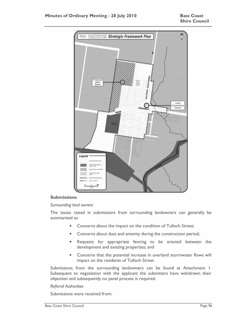
Minutes of Ordinary Meeting - 28 July 2010 Bass Coast Shire Council
Bass Coast Shire Council Page 96
Submissions
Surrounding land owners
The issues raised in submissions from surrounding landowners can generally be summarised as:
• Concerns about the impact on the condition of Tulloch Street;
• Concerns about dust and amenity during the construction period;
• Requests for appropriate fencing to be erected between the development and existing properties; and
• Concerns that the potential increase in overland stormwater flows will impact on the residents of Tulloch Street.
Submissions from the surrounding landowners can be found at Attachment 1. Subsequent to negotiation with the applicant the submitters have withdrawn their objection and subsequently no panel process is required.
Referral Authorities
Submissions were received from:

Minutes of Ordinary Meeting - 28 July 2010 Bass Coast Shire Council
Bass Coast Shire Council Page 97
• West Gippsland Catchment Management Authority
• Country Fire Authority; and
• VicRoads.
The referral authorities had no objection to the planning scheme amendment and proposed subdivision.
Each of the Referral Authorities submitted conditions to be included on any planning permit to be issued for the proposed subdivision. The submissions from the Referral Authorities can be found at Attachment 2.
Internal Referrals
The Infrastructure Directorate provided 'in principle' support for the rezoning of the land, but expressed a number of concerns about elements of the proposed subdivision, including:
• Management of stormwater flows from the surrounding farming land;
• The proximity of lots to the Bass Highway road reserve; and
• The ongoing access and management of the unmade laneway backing on to the Tulloch Street properties.
The Community and Economic Development Directorate expressed concerns about the lack of community infrastructure in Dalyston, to service a growing population.
The Community and Economic Development Directorate also recommended a number of conditions for inclusion on the planning permit for the subdivision. The recommended conditions are:
• A requirement for junior playground in the public open space in accordance with standards set out in the Bass Coast Playground Plan; and
• Public art provision within the public open space.
Post-exhibition
Council officers have worked with all parties to resolve the issues raised in the submissions.
The draft planning permit conditions have been updated to reflect the requirements of the Referral Authorities, and to include where appropriate conditions that address the concerns of surrounding land owners.
Council officers have prepared a draft S173 agreement in negotiation with the proponent to secure off-site and community infrastructure requested by the Council Directorates.
Detailed discussion of the preferred Council response to the submissions has been included in the 'Officers Comments' below.
Strategic Basis
State Planning Policy Framework
The State Planning Policy Framework informs planning authorities of the State policy to be taken into account when making decisions. The following clauses should be considered in the assessment of the proposed amendment:

Minutes of Ordinary Meeting - 28 July 2010 Bass Coast Shire Council
Bass Coast Shire Council Page 98
Clause 11.03-1 Settlement
Planning is to anticipate and respond to the needs of existing and future communities through the provision of zoned and serviced land for housing, employment, recreation and open space, commercial and community facilities and infrastructure.
Clause 11.03-2 Environment
Planning is to contribute to the protection of air, land and water quality and the conservation of natural ecosystems, resources, energy and cultural heritage.
Clause 11.03-3 Management of resources
Planning is to assist in the conservation and wise use of natural resources including energy, water, land, flora, fauna and minerals to support both environmental quality and sustainable development over the long term through judicious decisions on the location, pattern and timing of development.
Clause 11.03-4 Infrastructure
Planning for development of urban physical and community infrastructure should enable it to be provided in a way that is efficient, equitable, accessible and timely. Growth and redevelopment of settlements should be planned in manner that allows for the logical and efficient provision and maintenance of infrastructure.
Strategic planning should facilitate efficient use of existing urban infrastructure and human services. Providers of urban infrastructure, whether public or private bodies, are to be guided by planning policies and should assist strategic land use planning. Planning authorities are to consider the use of development contributions (levies) in the funding of infrastructure.
Clause 14.01-2 Settlement
Planning authorities should plan to accommodate projected population growth over at least a 10 year period, taking account of opportunities for redevelopment and intensification of existing urban areas as well as the limits of land capability and natural hazards, environmental quality and the costs of providing infrastructure.
Clause 15.01-2 Protection of catchments, waterways and groundwater
Planning and responsible authorities should ensure that land use activities potentially discharging contaminated run off or wastes to waterways are sited and managed to minimise such discharges and to protect the quality of surface water and ground water resources, rivers, streams, wetlands, estuaries and marine environments.
Clause 15.10-2 Open Space
Planning and responsible authorities should ensure that land is set aside and developed in residential areas for local recreational use and to create pedestrian and bicycle links to commercial and community facilities.
Clause 15.12-2 Energy Efficiency
Planning and responsible authorise should:
• Promote consolidation of urban development and integration of land use and transport.

Minutes of Ordinary Meeting - 28 July 2010 Bass Coast Shire Council
Bass Coast Shire Council Page 99
Clause 16.01-1 Housing
The objective of this clause is to encourage subdivisions in locations with access to physical and community infrastructure and providing a range of lot sizes, a convenient and safe road network, appropriate pedestrian and cycle paths, sufficient useable public open space and low vulnerability to fire.
Clause 18.01-2 Declared highways, railways and tramways
New uses or development of land near an existing or proposed transport route should be planned or regulated to avoid detriment to, and where possible enhance, the service, safety and amenity desirable for that transport route in the short and long terms.
Clause 18.09-2 Water supply, sewerage and drainage
Planning and responsible authorities should ensure that water quality in water supply catchments is protected from possible contamination by urban, industrial and agricultural land uses.
Clause 19.01-2 Subdivision
In the development of new residential areas and in the redevelopment of existing areas, subdivision should be designed to create liveable and sustainable communities by:
• Creating compact neighbourhoods that have walkable distances between activities and where neighbourhood centres provide access to services and facilities to meet day to day needs;
• Creating a range of open spaces to meet a variety of needs with links to open space networks and regional parks where possible;
• Providing a range of lot sizes to suit a variety of dwellings and household types to meet the needs and aspirations of different groups of people; and
• Contributing to environmentally sustainable development by designing energy efficient lots, incorporating water conservation, stormwater management and waste water treatment techniques and promoting waste reduction and reduced air pollution.
Local Planning Policy Framework
Municipal Strategic Statement
The Municipal Strategic Statement provides a vision for the future development of the Shire. It sets out the key strategies that provide clear directions for land use and development within the municipality for the next 15 years.
The Municipal Strategic Statement is consistent with State Policy and recognises key issues that influence land use and development in certain areas of the Shire. The Municipal Strategic Statement specifies that settlement patterns in the Shire indicate a need to accommodate approximately 4,400 additional dwellings by 2011.
The following sections of the Local Planning Policy Framework should be considered when making an assessment of the proposed amendment.
Minutes of Ordinary Meeting - 28 July 2010 Bass Coast Shire Council
Bass Coast Shire Council Page 100
Clause 21.03 Key issues
The key issues for the Shire, relevant to this amendment include:
Clause 21.03-1 Settlement:
• Managing expectations regarding future residential or rural residential development of rural land, and promote sustainable rural land use;
• Managing significant pressure from population growth and visitors; and
• Avoiding development in inappropriate locations.
Clause 21.03-2 Land uses (population and housing)
• Providing housing to the meet the demands of a changing demographic profile; and
• Providing affordable housing in the municipality.
Clause 21.03-2 Land uses (Rural)
• Protecting productive agricultural land;
Clause 21.03-4 Landscape and Built Form
• Maintaining individual settlement identity; and
• Seeking high quality design outcomes that incorporate environmentally Sustainable Design Principles.
Clause 21.03-5 Infrastructure
• Providing cycling and walking tracks.
Clause 21.04 Vision
This clause details Council’s vision with respect to land use planning, the relevant aspects of that vision for this application are:
Settlement
• Communities with their own identity; and
• A quality urban environment and well-functioning towns that benefit both residents and visitors.
Housing
• Diverse housing options and types for all ages meeting changing household characteristics.
Environment
• A high quality built environment enhancing the surrounding natural environment and landscape values.
Landscape and Built Form
• New developments designed and sited to complement the specific context in which they sit and take account of existing land form, vegetation and urban character.

Minutes of Ordinary Meeting - 28 July 2010 Bass Coast Shire Council
Bass Coast Shire Council Page 101
Infrastructure
• Effective and efficient road, pedestrian, cycling and drainage networks provided throughout the Shire; and
• Water sensitive urban design, stormwater management and improved stormwater quality throughout the municipality.
Clause 21.05-1 Settlement
The objectives and strategies of this clause include:
Objective 1: To identify towns that are suitable for urban growth and to provide for sufficient land in these towns for growth until 2030.
Objective 2: To ensure that residential development and related urban uses are restricted to existing or identified settlements.
Objective 3: To enhance the sense of identity for each community.
Strategy 5.1: Ensure that new urban development contains high quality infrastructure, community services and facilities.
Clause 21.06-1 Land Uses (Housing)
The objectives of this clause include:
Objective 2: Provide a diversity of housing types and lot sizes to meet the needs of all residents and visitors to the municipality.
Objective 3: Provide more affordable housing options in the municipality.
Objective 4: Ensure new residential development contributes to the new and upgraded infrastructure.
Clause 21.07-2 Environment (Catchment Management)
The objectives and strategies of this clause include:
Objective 2: To ensure new use or development does not cause water pollution, land degradation or pose a threat to the sustainable productive capacity of the Shire’s major economic base.
Strategy 2.2: Improve water quality by better management of urban stormwater flows.
Clause 21.08-3 Landscape and Built Form (New Urban Subdivisions)
The objectives and strategies of this clause include:
Objective 1: Encourage new residential subdivision estates to integrate with the existing community.
Strategy 1.1: Ensure new residential subdivision estates recognise the surrounding context and township character.
Strategy 1.2: Ensure that new subdivisions maintain and enhance traditional street patterns of the locality.
Strategy 1.3: In addition to networks within subdivision estates, ensure that new residential subdivision estates improve wider pedestrian, bicycle and vehicular networks, and encourage safe pedestrian movements through urban areas.
Minutes of Ordinary Meeting - 28 July 2010 Bass Coast Shire Council
Bass Coast Shire Council Page 102
Strategy 1.6: Avoid gated communities.
Clause 21.09-3 Infrastructure (Open Space and Recreation)
The objectives and strategies of this clause include:
Strategy 1.3: Provide recreational facilities and activities that are compatible with the size, role, character and appearance of the town in which they are located.
Strategy 2.1: Link recreation areas by pedestrian and cycle networks within, and between, towns.
Objective 4: Provide local open spaces that cater for a range of users and age groups.
Clause 21.11 Implementation (Zones and Overlays)
This clause seeks to:
• Apply the Township Zone to identified growth areas adjacent to existing Township Zone;
• Apply the Public Park and Recreation Zone over all public land used for public open space and recreation areas; and
• Apply the Development Plan Overlay to identified growth areas.
Clause 22.01 Stormwater Management Policy
Council’s Municipal Strategic Statement identifies stormwater drainage as a concern in urban areas where there is inadequate street drainage infrastructure. The objectives of this clause include:
• To incorporate stormwater management considerations in the decision making for the use and development of land;
• To maintain and enhance stormwater quality introduced to the drainage and waterway environment of the Shire; and
• To maximise the effectiveness of stormwater infrastructure in protecting the waters of Bass Coast Shire.
Council Adopted Strategies
Wonthaggi Dalyston Structure Plan
The Wonthaggi Dalyston Structure Plan was originally adopted by Council in 2006. The Structure Plan has principally been driven by the unprecedented level of residential and commercial growth in recent years within Wonthaggi / Dalyston, and the emerging role of Wonthaggi as the major urban centre in the South West Gippsland region.
A revised Wonthaggi Dalyston Structure Plan was adopted by Council in September 2008. The revised Structure Plan recommended that only minimal changes be made to the original recommendations of the document. The 2008 Structure Plan was updated to reflect:
• The potential economic and social impacts of the proposed Desalination Plant on Wonthaggi and Dalyston;
• The population and demographic data from the 2006 ABS Census;

Minutes of Ordinary Meeting - 28 July 2010 Bass Coast Shire Council
Bass Coast Shire Council Page 103
• The impact of new development subsequent to the adoption of the Wonthaggi Dalyston Structure Plan;
• The role of Wonthaggi as a regional centre in the context of growth throughout the Shire and South West Gippsland; and
• The opportunities for preserving remnant vegetation and creating significant environmental areas in and around Wonthaggi.
The objectives of the Wonthaggi Dalyston Structure Plan are consistent with Clause 14 of the State Planning Policy – Settlement. The objectives of the Wonthaggi Dalyston Structure Plan are to:
• Facilitate the orderly development of developing urban areas;
• Provide for the development of sustainable and liveable urban areas in an integrated manner;
• Facilitate the development of walkable neighbourhoods; and
• Facilitate the logical and efficient provision of infrastructure.
The subject site has been identified in the Wonthaggi Dalyston Structure Plan as a recommended residential growth area. The Structure Plan also recommends the location of public open space in the northern half of the subject site.
Finances
The cost of preparing the planning scheme amendment and assessing the planning permit application are the responsibility of the proponent.
Other costs principally involve Council officer time.
Stakeholders
Stakeholders for this amendment include:
• The Bass Coast community;
• The surrounding landowners;
• The applicant; and
• Bass Coast Shire Council.
Statutory Requirements/Codes/Standards/Policies
The proposed amendment makes proper use of the Victoria Planning Provisions, in particular the objectives of Planning in Victoria as set out in Section 4(1) of the Planning and Environment Act 1987.
An amendment to the Planning Scheme is subject to the provisions of the Planning and Environment Act 1987 which stipulates the process Council must follow when preparing an amendment.
Other Options
Option 1 – Adopt Amendment C112, and issue a planning permit for planning permit application 090658 in accordance with the draft planning permit attached to this report.

Minutes of Ordinary Meeting - 28 July 2010 Bass Coast Shire Council
Bass Coast Shire Council Page 104
Implications – there are no negative implications for Council if it adopts this option. The process of negotiation after the exhibition means that the concerns of submitters have been addressed and the provision of an appropriate level of off-site infrastructure has been secured.
Option 2 – Adopt Amendment C112, and issue a planning permit for planning permit application 090658 with some additional changes.
Implications – If the proposed changes were minor changes, or technical in nature, Council would need to provide supporting material to the Minister for Planning, justifying the changes. If the changes were substantial Council may be required to re-exhibit the combined planning scheme amendment and planning permit application. This would mean that Council incurs some additional costs for the process of re-exhibition.
Option 3 – Council has an option to abandon Amendment C112.
Implications - The effect of this is twofold; Council would have to refuse the planning permit application 090658. Council would also be sending a confusing message to the community and development industry by abandoning a planning scheme amendment supported by Council policy and adopted strategic planning.
Officer’s Comments/Conclusion
Submissions
Surrounding land owners
Council has worked with the proponent and the submitters to resolve the issues raised in the submissions. This has primarily been achieved through the inclusion of additional conditions in the planning permit. The specific response to the issues and actions are set out below.
Concerns about the impact on the condition of Tulloch Street.
The submissions on this issue were concerned about the existing state of Tulloch Street paving and seal, and the potential damage caused by additional traffic and construction vehicles during the constructions stages of the development.
Council is not in a position to require the full construction of Tulloch Street by the developer. The anticipated increase in traffic in Tulloch Street does not provide a level of traffic that would allow Council to reasonably require and upgrade of the current road construction.
However, it is reasonable to expect that any damage caused to Tulloch Street during the construction stage should be rectified by the developer.
Accordingly, working with the proponent the following condition is proposed to be included in the planning permit to be issued:
Prior to the commencement of subdivision works, an assessment of the existing condition of Tulloch Street will be undertaken by a suitably qualified person or firm and submitted to the Responsible Authority. The assessment shall be relied upon to establish the extent of any damage caused to Tulloch Street through the use of the road by construction traffic associated with the subdivision. In the event that the damage is attributable to the subdivision works, the road will be repaired at the developers cost
Minutes of Ordinary Meeting - 28 July 2010 Bass Coast Shire Council
Bass Coast Shire Council Page 105
Concerns about dust and amenity during the construction period.
Council has a standard permit condition for developments works which requires the proponent submit a Construction Management Plan before works commence. Working with the submitter it has been proposed to include some specific requirements for inclusion in the Construction Management Plan. These include:
• Detailing actions that will minimise dust transfer to adjoining sites; and
• The circumstances when a water tanker will be utilised to damp down the construction site and suppress dust.
Requests for appropriate fencing to be erected between the development and existing properties.
The proposed planning permit conditions have been amended to include the following requirements:
(f) details of boundary fencing treatments including provision for:
� A 2.1 metre high paling fence with hardwood posts to be erected on the eastern boundary of the site between Bent Street and Bass Highway.
Concerns that the potential increase in overland stormwater flows will affect the residents of Tulloch Street.
The management of stormwater and the current impact of overland flow have been addressed in the proposed subdivision design. Stormwater management for any new development requires that stormwater leaving the site remains at pre-development flow levels. The proposed development will also have the effect of diverting the existing flows from the farm land to the north which impact on Tulloch to the west of the proposed development. It is anticipated that stormwater flow in Tulloch Street will be decreased.
The proposed planning permit includes the standard condition which requires that the development is designed to:
• Comply with the Best Practice Environmental Management Guidelines for Urban Stormwater and Bass Coast Shire Stormwater Management Plan (2003);
• Comply with the Best Practice for Rural Stormwater treatments and on-site dispersion of collected flows;
• Ensure that any quality treatment proposed in accordance with these Guidelines; and
• Ensure that there is a drainage retardation system on the subject land serving each lot allowing an unrestricted flow path for 1 in 100 year extreme event storm flows. The drainage retardation system must discharge to the existing underground system/legal point of discharge and be maintained to the satisfaction of the Responsible Authority.
The surrounding landowners were contacted about the proposed changes and letters were sent setting out further details about standard conditions.

Minutes of Ordinary Meeting - 28 July 2010 Bass Coast Shire Council
Bass Coast Shire Council Page 106
Council has now received correspondence from each of the submitters indicating that as a result of the proposed changes that they withdraw their objections. These letters have been included at Attachment 3.
Referral Authorities
The conditions required by the referral authorities have been included in the planning permit.
Internal Referrals
The Infrastructure Directorate has continued to work closely with the proponent and the Council officers from the Strategic Planning team to resolve issues with elements of the subdivision design.
There are still concerns with the proposed management of off-site stormwater flows from surrounding rural properties. The designs for the stormwater management systems will need to be submitted to Council for approval. It is anticipated the resolution of this component of subdivision design will occur when detailed engineering design has taken place.
In the meantime, the permit condition requiring compliance with best practice for Rural Stormwater treatments and on-site dispersion of collected flows will ensure that the issue is addressed before construction commences.
The Community and Economic Development Directorate have requested a number of conditions for inclusion on the planning permit. A response to each of the proposed conditions is provided below.
A requirement for junior playground in the public open space in accordance with standards set out in the Bass Coast Playground Plan.
Council officers have worked with the proponent to include this requirement as an off-site community infrastructure contribution to be included in the proposed S173 agreement between Council and the proponent.
Public art provision within the public open space.
Council officers relayed to the proponent, the desire for Public art to be provided in the public open space. The proponent did not agree that the public art was required.
Because there is no statutory requirement and minimal policy objectives for the provision of public art within the Bass Coast Planning Scheme, it is difficult to secure public art without the goodwill of the proponent.
Council officers continue to work toward the implementation of the Arts and Culture Policy, and in particular the incorporation of Public Art Policy in the Bass Coast Planning Scheme. This will give the Council a stronger negotiating position when working with development applications.
However, in this case it is not considered appropriate to require public art.

Minutes of Ordinary Meeting - 28 July 2010 Bass Coast Shire Council
Bass Coast Shire Council Page 107
Proposed S173 Agreement
Council officers have worked with the proponent to prepare S173 agreement to provide off-site infrastructure. The proposed agreement includes the provision of the following items:
• On the west side of Tulloch Street, north of Bent Street, design and construction of road pavement with kerb and channel along the length of the subject site frontage together with a shoulder on the opposite (east) side. The works to include an appropriately located intersection treatment splitter island and pedestrian refuge.
• Design and construction of a 1.5 metre wide concrete path from the public open space within the subdivision, along Bent Street to Dalyston–Glen Forbes Road, then south to connect with the existing footpath in Dalyston–Glen Forbes Road.
• Design and construction of a 2.0 metre wide concrete path from the subject site, along the north side of Bass Highway, to Daly Street.
• Payment of $50,000 to the Responsible Authority for the provision of a Local Playground within the public open space reserve detailed within the subdivision. The Local Playground will accord with the facility detailed within the ‘Bass Coast Playground Plan’ (March 2010).
These items will provide significant improvements to the level of community infrastructure in Dalyston. In particular, the provision of footpaths that link the site to the primary school, the local shops and the V-line bus stop, contribute to providing good, accessible, community connections throughout Dalyston.
Clause 56 Assessment
Council officers have reviewed the Clause 56 assessment undertaken by the proponent and submitted as part of the planning scheme amendment and subdivision permit application material.
The proposed subdivision layout generally meets the objectives and standards of Clause 56 of the Bass Coast Planning Scheme.
Full details about urban run-off management, in response to Clause 56.07.4 will be provided in as a requirement of the planning permit conditions requiring compliance with the Best Practice Environmental Management Guidelines for Urban Stormwater and Bass Coast Shire Stormwater Management Plan (2003).
Planning Permit Conditions
It is proposed to make some changes to the exhibited planning permit conditions.
The majority of changes to the exhibited planning permit have been discussed with submitters, and the relevant officers within Council.
The proposed changes are:
• Amend Condition 3 in the following way, by adding:
(f) details of boundary fencing treatments including provision for;
� A 2.1 metre high paling fence with hardwood posts to be erected on the eastern boundary of the site between Bent Street and Bass Highway.

Minutes of Ordinary Meeting - 28 July 2010 Bass Coast Shire Council
Bass Coast Shire Council Page 108
• Amend Condition 7 in the following way, add by adding:
(c) Detail of actions that will minimise dust transfer to adjoining sites.
• Include a new condition, Condition 9, in the following form:
Prior to the commencement of subdivision works, an assessment of the existing condition of Tulloch Street will be undertaken by a suitably qualified person or firm and submitted to the Responsible Authority. The assessment shall be relied upon to establish the extent of any damage caused to Tulloch Street through the use of the road by construction traffic associated with the subdivision. In the event that damage is attributable to the subdivision works, the road will be repaired at the developer’s cost.
The referral authority conditions have been translated directly into the proposed planning permit.
It is also proposed to change the expiry condition to recognise that the subdivision will be constructed in stages.
• Amend Condition 22 to read:
This permit will expire if:
(a) the plan of subdivision for the first stage is not certified within two (2) years of the date of this permit; or
(b) the plan of subdivision for any subsequent stage is not certified within two (2) years of the date of certification of the previous stage of the subdivision; or
(c) the registration of any stage of the subdivision is not completed within five (5) years of the date of certification of the plans of subdivision.
The changes recognise that the construction process and timelines will vary in a staged development, and reduces the administrative burden on Council by minimising the need to extend the permit on regular basis.
A copy of the proposed planning permit is included here at Attachment 4.
Conclusion
As Bass Coast Shire grows, it is important that Council anticipates and responds to the needs of existing and future communities through provision of zoned and serviced land for housing, employment, recreation, and open space, commercial and community facilities and infrastructure. The proposed rezoning of the subject site to the Township Zone is consistent with the strategic vision of Council and supports the continued consolidation of urban areas within the Shire. The proposed rezoning of land west of Tulloch Street is a logical extension of the Dalyston settlement and can be easily integrated with the existing neighbourhood.
The subject site can adequately support residential development and Council officers have worked with the proponent to ensure that on-site and off-site infrastructure contributes to the management and enhancement of Dalyston.
The concerns of the surrounding landowners who submitted to the process have been addressed, and the original objections have been withdrawn.
Minutes of Ordinary Meeting - 28 July 2010 Bass Coast Shire Council
Bass Coast Shire Council Page 109
The subdivision proposal is generally in accordance with the requirements of Clause 56 of the Bass Coast Planning Scheme and is consistent with objectives and strategies of the Bass Coast Planning Scheme.
The amendment and development is broadly justified by the State Planning Policy Framework and the Local Planning Policy Framework.
Recommendation
1. That Council resolve to adopt Amendment C112 to the Bass Coast Planning Scheme in accordance with Section 29(1) of the Planning and Environment Act 1987.
2. That Council forward Amendment C112 to the Minister for Planning for approval in accordance with Section 11(4) (b) of the Planning and Environment Act 1987.
3. That Council send the Planning Permit 090658 for the subdivision of land contained within Lot 4 on Plan of Subdivision 421379 and Lot 1 on TP80176 into 144 residential lots, to the Minister for Planning for approval
Attachments
AT-1 CONFIDENTIAL - Community Submissions 5 Pages AT-2 Referral Authority Submissions 7 Pages AT-3 CONFIDENTIAL - Withdrawn objections 3 Pages AT-4 Proposed Planning Permit 090658 10 Pages Council Decision
Lost Motion
Moved: Cr. Gareth Barlow / Seconded: Cr. Veronica Dowman
That the recommendation not be adopted.
Moved: Cr. John Duscher / Seconded: Cr. Ross Smith
1. That Council resolve to adopt Amendment C112 to the Bass Coast Planning Scheme in accordance with Section 29(1) of the Planning and Environment Act 1987.
2. That Council forward Amendment C112 to the Minister for Planning for approval in accordance with Section 11(4) (b) of the Planning and Environment Act 1987.
3. That Council send the Planning Permit 090658 for the subdivision of land contained within Lot 4 on Plan of Subdivision 421379 and Lot 1 on TP80176 into 144 residential lots, to the Minister for Planning for approval
CARRIED
Minutes of Ordinary Meeting - 28 July 2010 Bass Coast Shire Council
Bass Coast Shire Council Page 110
K.4 Amendment C98: Post Panel Report - Significant Landscape Overlays
File No: CM10/327 Department: Planning and Environment Council Plan Strategic Objective: Cohesive Communities
We will improve lifestyle opportunities and options by managing the built environment and encouraging cohesive communities.
Previous Items: SR5/09 - Amendment C98 - Significant Landscape Overlays -
Council - 19 August 2009 SR1/09 - Implementation of the Coastal Spaces Landscape
Assessment Study - Council - 28 January 2009
Declaration
The author has no direct or indirect interest in relation to this issue.
Summary
The amendment to the Bass Coast Planning Scheme has been prepared to implement the Coastal Spaces Landscape Assessment Study.
The amendment is required to give statutory effect to the recommendations of this strategic study to assist Council in its decision making in relation to future land use and development in the Shire’s coastal settlements and non-urban coastal landscapes.
The amendment proposes to make changes to the content of the Municipal Strategic Statement in order to include objectives and strategies that will enhance, protect, and manage the significant coastal amenity of the municipality.
The amendment proposes to include new schedules in the Significant Landscape Overlay. These will provide the appropriate planning control and decision making guidelines to support the implementation of the objectives and strategies set out in the Municipal Strategic Statement.
Council considered the proposed amendment at the Ordinary Council Meeting of 28 January 2009.
Council made the following resolution:
1. That Council seek authorisation from the Minister for Planning to prepare an amendment to the Bass Coast Planning Scheme for the following:
a) Implement the recommendations of the Coastal Spaces Landscape Assessment Study as they relate to Bass Coast Shire Council.
2. Subject to authorisation from the Minister for Planning, prepare and exhibit the amendment to make following changes to the Bass Coast Planning Scheme;
� Amend Clause 21.02 Municipal Profile to introduce new policy objectives that support the protection, and recognise the importance, of significant coastal landscapes;

Minutes of Ordinary Meeting - 28 July 2010 Bass Coast Shire Council
Bass Coast Shire Council Page 111
� Amend Clause 21.05-2 Environment to a new sub clause Coastal Landscape Character and Significance, which includes strategies and objectives that support the recommendations of the Coastal Spaces Landscape Assessment Study;
� Amend Clause 21.07 Reference Documents to include the Coastal Spaces Landscape Assessment Study as a reference document;
� Introduce new schedules to Significant Landscape Overlay in the Bass Coast Planning Scheme which would apply planning controls to areas nominated in the Coastal Spaces Landscape Assessment Study as areas having high visual and scenic values; and
� Introduce new Planning Scheme maps that indicate the location and extent of the proposed Significant Landscape Overlays.
3. That if there are submissions received in response to the exhibition of the amendment, that Council consents to the submissions being forwarded directly to Planning Panels Victoria for consideration.
Council received authorisation to prepare the amendment from the Minister for Planning on 12 February 2009, with the Authorisation number A01288.
The exhibition of the amendment commenced on Thursday 9 April 2009.
The exhibition period concluded on 12 May 2009.
At the completion of the exhibition period Council had received 31submissions from landowners, and five submissions from Relevant Agencies.
After reading the submissions, Council officers thought that a number of changes could be made to the proposed amendment. It was considered that these changes would address:
� A number of concerns raised in submissions; and
� A number of mapping errors.
Before undertaking to request a Planning Panel, Council officers thought that it was appropriate that these changes were viewed and confirmed by Council; subsequently a report was prepared and considered at the Ordinary Council meeting held on 19 August 2009.
Council made the following resolution:
1. That Council, having considered all submissions in accordance with Section 22(1) of the Planning and Environment Act 1987, resolve to refer Amendment C98 and all submissions to a Panel to be appointed by the Minister for Planning in accordance with Section 153 of the Planning and Environment Act 1987.
2. That Council advise the Independent Panel that it supports Amendment C98 with the following changes in response to submissions:
a. Amend the Significant Landscape Overlay 2 to reflect the permit exemptions in the Significant Landscape Overlay 3, 4 and 5.
b. Amend the Significant Landscape Overlay 2 to remove reference to 500 metres being a sufficient distance from the coast in the decision guidelines.
c. Amend the Significant Landscape Overlay 2 to remove statements that are not relevant to landscapes.
Minutes of Ordinary Meeting - 28 July 2010 Bass Coast Shire Council
Bass Coast Shire Council Page 112
d. Delete the Significant Landscape Overlay 2 from all properties in the Low Density Residential Zone in Sunderland Bay.
e. Delete the Significant Landscape Overlay 2 from the Special Use Zone of the Phillip Island Grand Prix Circuit.
f. Delete the majority of objectives and strategies exhibited as part of the Municipal Strategic Statement changes, and ensure that the final changes are consistent with the adopted Amendment C85.
A Planning Panel Directions Hearing was held on 29 September 2009 at the Bass Coast Civic Centre Council Chamber at Wonthaggi.
The nine day Panel hearing was held from 2 to 16 December 2009.
The Planning Panel recommendations report was received by Council on 14 April 2010. The Panel Report is included here at Attachment 1.
This Council report has been prepared to provide:
• An overview of the Independent Planning Panel recommendations; and
• A recommendation that Council adopt Amendment C98 in accordance with the recommendations of the Independent Planning Panel.
Introduction
Amendment C98 applies to land adjacent to the Phillip Island Coast and the Bass Strait Coast. The overlay has been applied to areas of archetypal landscape character in the areas described in the figure below. In particular, the significant landscape overlays will be applied to:
• 1.2 Phillip Island Northern Coast
• 2.1 Phillip Island Southern Coast
• 1.3 Bunurong Coast and Hinterland

Minutes of Ordinary Meeting - 28 July 2010 Bass Coast Shire Council
Bass Coast Shire Council Page 113
These areas were subject to extensive assessment as part of the Coastal Spaces Landscape Assessment Study. The Coastal Spaces Landscape Assessment Study was commissioned in December 2004 as part of the Coastal Spaces Initiative. The Report was developed by Planisphere in association with the Department of Sustainability and Environment, and representatives from the relevant coastal Councils (including representatives from Bass Coast Shire Council).
The Study identified landscapes of State, regional and local significance. The Study recommends that the Significant Landscape Overlay is the most appropriate tool for protecting and managing the character of landscapes.
The Significant Landscape Overlay is recommended to be applied to landscapes of regional and State significance. The purpose of the Coastal Spaces Landscape Assessment Study was to:
• map and provide an assessment of the existing distinctive landscape elements, features, characteristics, character, quality and extent of the landscape within specific coastal areas, and outline their value or importance;
• assess the adequacy of current planning strategies and measures for managing and protecting landscapes along the Victorian coast and immediate hinterland; and

Minutes of Ordinary Meeting - 28 July 2010 Bass Coast Shire Council
Bass Coast Shire Council Page 114
• identify landscape types in all coastal regions and provide planning scheme provisions for retaining and/or respecting landscape values, and managing development in non-urban coastal landscapes.
Amendment C98 incorporates the policy direction and strategic objectives developed in the Coastal Spaces Landscape Assessment Study.
Submissions
At the completion of the exhibition period Council had received 31submissions from landowners, and five submissions from Relevant Agencies. The issues raised in the submissions are summarised into the following general issues and discussion topics:
Community and Affected Landowners
• Council should wait until the Rural Strategy is finalised before undertaking this amendment;
• There will be a detrimental impact on working farms;
• There has been an arbitrary application of overlays;
• There are omissions of Crown land from the Significant Landscape Overlays;
• The proposed Significant Landscape Overlays will cause property devaluation and financial impacts;
• The Significant Landscape Overlays impose too many restrictions and prescriptive controls;
• Why are the Significant Landscape Overlays required when existing controls are adequate?
• Vegetation controls are too strict;
• Consultation process is insufficient;
• Multiple amendments are confusing; and
• Objections against the overlay over specific properties.
Relevant Agencies
Five submissions were received from relevant agencies.
• Melbourne Water advised that they have general support for the amendment.
• The Environment Protection Authority does not object to the amendment.
• Westernport Water have no objection to the amendment, however, raised a concern about Clause 21.02-6 of the Municipal Strategic Statement that states that sewerage is not available at Tenby Point and Rennison Road (on Phillip Island) where it is now available.
• The Country Fire Authority originally offered no objection to the amendment. In a second submission, however, they requested that the same permit exemptions be included in the Significant Landscape Overlay than what is currently included in Clause 52.17 of the planning scheme (Native Vegetation).

Minutes of Ordinary Meeting - 28 July 2010 Bass Coast Shire Council
Bass Coast Shire Council Page 115
• The National Trust supports the amendment, however, have provided some comments to enhance protection of the coastal landscape.
Council Submission to Panel
At the Ordinary Council meeting held on 19 August 2009, Council resolved to request the Minister for Planning to appoint an independent Planning Panel to consider the submissions. Council also resolved to advise the Independent Panel that it supports Amendment C98
At the Panel, Council submitted that the Significant Landscape Overlay is the most appropriate planning tool to protect landscapes from inappropriate development. In addition, Council submitted;
The application of the Significant Landscape Overlay across significant landscapes in Bass Coast Shire implements Council and State policies in the Planning Scheme.
Council submits that subject to changes that reflect the format of the revised Municipal Strategic Statement that Amendment C98 be supported for the following reasons:
• It is consistent with the relevant strategies and objectives of the Bass Coast Planning Scheme.
• It furthers the objectives of the State Planning Policy Framework.
• It furthers the objectives of the Victorian Coastal Strategy 2008.
• It provides a strategic planning foundation for managing growth in a growth environment.
• It provides a strategic planning foundation for managing growth in a sensitive coastal environment.
Strategic Basis
State Planning Policy Framework
The State Planning Policy Framework informs planning authorities of the State policy to be taken into account when making decisions. The following clauses should be considered in relation to this amendment.
Clause 15.08 - Coastal Areas
Clause 15.08 sets out the State policy in relation to Coastal areas. The objectives of this Clause are to protect and enhance the natural ecosystems and landscapes of the coastal and marine environment, ensure sustainable use of natural coastal resources and achieve development that provides an environmental, social and economic benefit, enhancing the community’s value of the coast.
An objective under this Clause is to protect and enhance the natural ecosystems and landscapes of the coastal estuarine and marine environment. Strategies for this clause are provided under the following four main principles, as outlined in the Victorian Coastal Strategy.
• Integrated planning for the future;
• Managing coastal hazards and the coastal impacts of climate change;
• Population growth and sustainable development; and
• Sustainable use, protection and management of environmental and cultural values.
Minutes of Ordinary Meeting - 28 July 2010 Bass Coast Shire Council
Bass Coast Shire Council Page 116
Clause 17.04 - Tourism
This clause encourages tourist development to maximise employment and long-term economic, social and cultural benefits of developing the State as a competitive domestic and international tourist destination. Facilities should have access to suitable transport and be compatible with and build upon the assets and qualities of surrounding urban or rural activities and cultural and natural attractions.
Clause 17.05 - Agriculture
The objective of this clause is to ensure that the State’s agricultural base is protected from the unplanned loss of productive agricultural land due to permanent changes of land use, and to enable protection of productive farmland, which is of strategic significance in the local or regional context.
Other State Planning Policy
Coastal Spaces Recommendations Report
The 'Coastal Spaces Recommendations Report' was released by the Victorian Coastal Council in 2006, under the auspice of the Department of Sustainability and Environment.
The Coastal Spaces Recommendations Report provides a coastal settlement framework, setting out the preferred role and function of towns along the coast. It also provides a spatial growth management plan that sets out a hierarchy for township growth.
The Coastal Spaces Recommendations Report seeks to protect non-urban areas from inappropriate development. It states that:
“The coastal non-urban landscape provides important environmental, social and economic benefits at a local, regional and state level. The many visually significant landscapes along the coast, in both an individual and collective sense, contribute to the overall coastal experience and image portrayed to Australia and the world.”
The Coastal Spaces Recommendations Report is to be used in conjunction with the Coastal Spaces Landscape Assessment Study.
Victorian Coastal Strategy 2008
Clause 15.08 of the State Planning Policy Framework was amended in December 2008 to incorporate the updated Victorian Coastal Strategy principles. This has been discussed under the State Planning Policy Framework section of this report.
Local Planning Policy Framework & Municipal strategic Statement
The amendment seeks to implement the Municipal Strategic Statement and is consistent with Councils strategic direction and objectives to ensure that the coastal and hinterland areas between activity nodes remain as areas with views, landscape, environmental or rural values.
The proposed amendment is consistent with the strategic direction within the Municipal Strategic Statement. The relevant provisions of the Municipal Strategic Statement and Council’s comments are outlined below.

Minutes of Ordinary Meeting - 28 July 2010 Bass Coast Shire Council
Bass Coast Shire Council Page 117
Clause 21.03 (Key issues)
Landscape and built form
• Protecting coastal and hinterland landscapes and views.
• Managing the pressures to develop land in locations of high scenic value.
Clause 21.04 (Vision)
Environment
• The coastal and hinterland areas between activity nodes remaining as areas with views, landscape, environmental or rural values.
Clause 21.08 (Landscape and Built Form)
Landscape
Overview
The coastal landscapes and hinterlands are highly valued by the community and an important tourist feature. Many residents have been attracted to this region due to the rolling hills leading down to the coast. The landscapes and views of the municipality need protection from inappropriate development.
Objectives and Strategies
Objective 1 To ensure that development is subordinate to the natural, visual and environmental landscape character and significance.
Strategy 1.1 Ensure that coastal related development responds appropriately to the landscape setting, character, and desired future character directions.
Strategy 1.2 Strongly discourage development that is unsympathetic to significant landscape areas.
Strategy 1.3 Avoid linear coastal development beyond urban boundaries.
Objective 2 To protect locally significant views and vistas that contribute to the character of the coastal and coastal hinterland region.
Strategy 2.1 Strongly discourage development from locating on hilltops and ridgelines.
Strategy 2.2 Ensure that development does not impact on existing walking trails, and that it enhances views to and from these walking trails.
Other Local Planning Policy
Bass Coast Strategic Coastal Planning Framework 2008
The Bass Coast Strategic Coastal Planning Framework was adopted by Council in 2008. It sets out strategies and guidelines for managing future growth and development for 10 coastal towns in the municipality. In addition, the Coastal Framework provides recommendations for areas between activity nodes, and allocated land uses for these areas.
Minutes of Ordinary Meeting - 28 July 2010 Bass Coast Shire Council
Bass Coast Shire Council Page 118
Policy statements relevant to Amendment C98 are:
• Residential development and related urban land uses are restricted to existing activity nodes. The remaining coastal areas are considered to have significant coastal, rural, environmental and landscape values and should remain as areas with views, scenic or rural values separating activity nodes, and should remain in private ownership and be used for rural purposes.
• Quality environmental and landscape features should continue to contribute significantly to the tourism values of the area.
• The development of large-scale residential, rural residential, tourism, or recreation in the areas with views, scenic or rural values is not considered appropriate. These developments, subject to local environmental and strategic assessment, are most appropriately located in conjunction with existing activity nodes identified for additional development.
The Bass Coast Strategic Coastal Planning Framework is subject to implementation through Bass Coast Amendment C93.
Phillip Island and San Remo Design Framework
The Phillip Island and San Remo Design Framework was adopted by Council on 5 November 2003. The amendment to include Phillip Island and San Remo Design Framework as a reference document into the Bass Coast Planning Scheme was gazetted on 17 April 2008. The Phillip Island and San Remo Design Framework establishes the vision, strategies, and guidelines that will help shape the structure, function, and appearance of Phillip Island and San Remo over the next 20 years.
The following statement in Section 5 of the Phillip Island and San Remo Design Framework is representative of the strategic position established in the document in relation to Coastal Landscapes:
Views are important to people’s perceptions of the landscape, helping them understand the environment around them. Phillip Island and San Remo have several national trust listed landscapes, and it is these and other significant views that give the area its sense of place.
The proposed implementation of the Significant Landscape Overlays is consistent with the following recommendations in the Phillip Island and San Remo Design Framework:
• Important coastal views should be protected and incremental development along the coast prevented.
• Ensure that development does not block views to rural and coastal areas and is not highly visible from vantage points to and from the sea.
Finances
Council set aside $30,000 in the 07/08 budget. In addition, Council received funding from the Department of Planning and Community Development for $40,000. This money was used to prepare the amendment documentation, undertake consultation, and carry out the amendment process.

Minutes of Ordinary Meeting - 28 July 2010 Bass Coast Shire Council
Bass Coast Shire Council Page 119
Stakeholders
The provisions of the Planning and Environment Act 1987 require that when an amendment is prepared, it be formally exhibited. This involves the sending of letters to adjoining and nearby property affected landowners, and placing an advertisement in the local newspapers.
In this case, notice of the amendment was given to all landowners that are directly affected by the proposed changes. In addition, notice was given to community and environment groups, and the development industry. Other stakeholders include ratepayers and visitors to Bass Coast Shire. As required, notice was also given to relevant government agencies.
Statutory Requirements/Codes/Standards/Policies
Section 25of the Planning and Environment Act 1987 states that the report by Panel:
(1) The panel must report its findings to the planning authority.
(2) In its report, the panel may make any recommendation it thinks fit.
Council has a number of options once it receives the report. It can adopt the Panel’s Recommendations, it can make changes to the Panel’s recommendations, or it can ignore the Panel’s recommendations. However, Council must tell the Minister why it disagreed with the Panel - and why changes were made.
Other Options
Option 1 – Adopt Amendment C98, generally as recommended by the Panel.
Implications – There are no negative implications of proceeding to adopt the amendment as recommended by the Panel.
Option 2 – Adopt Amendment C98 with some additional changes.
Implications - Depending on the changes, it is likely that Council would be asked to re-exhibit the amendment and therefore there would be another Panel process. This will be a significant cost to Council and the community, and will mean that Council will continue to use the outdated policies to inform decision making in the meantime.
Option 3 – Council has an option to abandon Amendment C98.
Implications – Council would not be supporting their adopted policy and this may result in poor built form outcomes on our coast line.
Officer’s Comments/Conclusion
The Panel generally agreed with the Council submission that Amendment C98 should be supported, stating;
The introduction of new planning policy and Significant Landscape Overlays relating to conservation of coastal landscapes has a sound strategic justification under both State and local planning policy. In particular, the Significant Landscape Overlays support the outcomes sought by the Victorian Coastal Strategy and are a logical means of implementing the recommendations from the Coastal Spaces Landscape Assessment Study.

Minutes of Ordinary Meeting - 28 July 2010 Bass Coast Shire Council
Bass Coast Shire Council Page 120
In response to the main concerns raised by submitters, the Panel provided the following;
In the Panel’s view, the introduction of the Significant Landscape Overlays will not unduly interfere with the ability to continue to farm land along the coast and will integrate well with other planning tools such as Environmental Significance Overlay – Schedule 1 to protect the environmental, biodiversity and visual significance of the coastal landscapes of both Phillip Island and the mainland.
However, the Panel did think that the amendment documentation could be refined to better reflect farming practices and to strengthen the policy foundation for the Significant Landscape Overlays. In particular, the Panel recommended the following improvements to the exhibited documents;
• Planning policy should better reflect the landscape character area descriptions and future character directions;
• Additional exemptions should be included for native vegetation removal and buildings and works permissions particularly where they are linked to agricultural activity and where it is clear that there will be no or insignificant impacts on landscape significance; and
• Adjustments should be made to decision guidelines and the consistency of permit requirements across all four of the proposed Significant Landscape Overlays.
Proposed Changes
Policy
In order to strengthen the policy foundation, the Panel recommends that planning policy at Clause 21.08-1 – ‘Landscape’ should be amended to include, under ‘Overview’, the Landscape Character Area Descriptions and Future Character Directions for each landscape character area listed in Appendix 2 – Character Area Analysis Papers of the Coastal Spaces Landscape Assessment Study Bass Coast Municipal Reference Document.
An example of this is;
� Phillip Island Southern Coast
The southern coast of Phillip Island between Cape Woolamai and McHaffie Point at Ventnor consists of volcanic landforms shaped by the high seas and winds of Bass Strait. A rugged and varied landscape valued by the community for undeveloped, rocky headlands, high sand dunes and beaches has resulted including regionally significant landforms such as Cape Woolamai, Pyramid Rock and The Nobbies. Open vistas along the coast to are available from numerous access points. Several townships have been developed along the coastal edge in the eastern half of the island (with substantial undeveloped breaks between) while inland rolling pastoral landscapes are contiguous with the Northern Coast Character Area. The landscape features in this Character Area are attracting growing demand for residential dwellings within and outside settlements sited to take advantage of views.
Future Character Directions
This Character Area will be characterised by contained coastal settlements set amongst indigenous vegetation, separated by extensive open rural landscapes and areas of native vegetation providing a wild and natural character at the coastal edge. Rural breaks between settlements which provide a landscape of undeveloped

Minutes of Ordinary Meeting - 28 July 2010 Bass Coast Shire Council
Bass Coast Shire Council Page 121
coastal cliffs and headlands will be strictly maintained, and become increasingly vegetated with appropriate indigenous coastal species. West of Smiths Beach will be an open, undeveloped and increasingly vegetated rural landscape with a scattering of built elements set long distances back from the coast on lower slopes of inland topography and amongst substantial landscaping.
This text including similar descriptors for each landscape type would be inserted into Clause 21.08-1 Landscape. The revised version of Clause 21.08 Coastal Areas is included here at Attachment 2.
Significant Landscape Overlay – Schedules
Planning Controls
The panel recommended that each of the Significant Landscape Overlay Schedules 2, 3, 4 and 5 should be amended.
The Panel recommends that the ‘permit requirement’ section of schedules be amended to include the following;
• Revise the existing permit exemptions for native vegetation removal by including exemptions for;
Dead Vegetation
Vegetation that is dead
Fences
The minimum extent of vegetation necessary for:
The construction of a fence on a boundary between properties in different ownership; or
operation or maintenance of an existing fence.
Lopping or pruning for maintenance
The native vegetation is to be pruned or lopped for maintenance only and no more than 1/3 of the foliage is removed from any individual plant.
This exemption does not apply to:
Pruning or lopping of the trunk of a tree or shrub.
Native vegetation within a road or railway reservation.
Grasses
The native vegetation is a grass and is to be mown or slashed for maintenance only.
Under this exemption the grass must be:
Located within a lawn, garden or other planted area; or
Maintained at a height of at least 100 millimetres above ground level.
Regrowth
The native vegetation is regrowth which has naturally established or regenerated on land lawfully cleared of naturally established native vegetation and is:
Less than ten years old at the time of approval of a relevant Farm Management Plan where it is certified regrowth and the area affected is shown on the Plan as intended for use for cultivation or pasture during the life of the Plan.
Planted vegetation

Minutes of Ordinary Meeting - 28 July 2010 Bass Coast Shire Council
Bass Coast Shire Council Page 122
The native vegetation is a tree or shrub within a garden area.
Existing and approved buildings
The native vegetation is to be removed, destroyed or lopped to enable the:
Construction of a building approved by a planning permit granted under this planning scheme or by building permit granted under Building Act 1993, before 15 September 2008.
Use and maintenance of a building constructed or approved by a planning permit granted under this planning scheme or by building permit granted under Building Act 1993, before 15 September 2008.
This exemption does not apply to:
Native vegetation to be removed, destroyed or lopped to enable the operation or maintenance of a fence.
Native vegetation located more than 10 metres from a building.
Existing buildings and works in the Farming Zone and Rural Activity Zone
The native vegetation is to be removed, destroyed or lopped to enable the use or maintenance of a building or works used for Agricultural production, including a dam, utility service, bore, horticultural trellising and accessway, in the Farming Zone or the Rural Activity Zone.
This exemption does not apply to:
Native vegetation to be removed, destroyed or lopped to enable the use or maintenance of a Dwelling.
Native vegetation to be removed, destroyed or lopped to enable the operation or maintenance of a fence.
Native vegetation located more than 10 metres from a building or works.
To native vegetation to be removed, destroyed or lopped to enable the construction or operation of a pivot irrigation system or horticultural trellising.
Where there is a practical opportunity to site the building or works to avoid the removal, destruction or lopping of native vegetation.
Vehicle access from public roads
The native vegetation is to be removed, destroyed or lopped to enable the construction or maintenance of a vehicle access[sic -way] across a road reserve from a property boundary to a public road, subject to authorisation from the relevant public land manager.
This exemption only applies to properties which share a common boundary with the road reserve.
The maximum total width of native vegetation permitted to be removed, destroyed, or lopped under this exemption is 6 metres.
This exemption does not apply where there is a practical opportunity to site the accessway to avoid the removal, destruction or lopping of native vegetation.
Personal Use
Minutes of Ordinary Meeting - 28 July 2010 Bass Coast Shire Council
Bass Coast Shire Council Page 123
The native vegetation is to be removed, destroyed or lopped by cutting only to obtain reasonable amounts of wood for personal use by the owner or occupier of the land. Personal use includes wood used for firewood, the construction of fences and buildings on the same land, and hobbies such as craft.
This exemption does not apply to:
Standing living and dead trees with a trunk diameter of 40 centimetres or more at a height of 1.3 metres above ground level.
Living native vegetation on contiguous land in the same ownership with an area less than 10 hectares.
Stock movement along roads
The native vegetation is removed, destroyed or lopped as a result of moving stock along a road.
This exemption does not apply to the removal, destruction or lopping of native vegetation as a result of holding stock in a temporary fence (including an electric fence) on a roadside for the purpose of feeding.
• Revise the buildings and works exemptions to facilitate farming operations and limit agricultural building extensions. These exemptions would apply to farms. The additional exemptions would include;
Capture stockyards;
Fenced off unroofed working enclosures; and
Open sided hay sheds
The proposed limits to the floor area of agricultural buildings could be worded in the following way;
This exemption does not apply to works with a total footprint area of greater than 200 square metres
The Panel recommends that the ‘decision guidelines’ section of schedules be amended, in order to provide a clearer link to the strategies and policy of the Municipal Strategic Statement by including additional considerations following the lead statement; ‘Before deciding on an application, the responsible authority must consider’
The Panel recommends including the following decision guidelines;
(Consider) The key objectives and strategies at Clause 21.08-1 Landscape.
(Consider) Whether the proposed development is an extension or alteration to an existing development on the land.
The Panel also recommends including a new section in the decision guidelines which will incorporate specific consideration of native vegetation removal;
These include;
The impact of the vegetation removal on the character and significance of the landscape.
The species of vegetation, its age, health and growth characteristics.
Whether the vegetation is isolated or part of a vegetation patch.
The availability of sufficient unencumbered land to provide for any offset planting.

Minutes of Ordinary Meeting - 28 July 2010 Bass Coast Shire Council
Bass Coast Shire Council Page 124
The impact of buildings and works maintenance activities on the retained vegetation.
The impact of the vegetation on the structural integrity of existing or future buildings, including foundations.
Vegetation management requirements to reduce fire hazard, prevent erosion and maintain flood control measures.
A copy of the revised schedules has been included here at Attachment 3
Specific Recommendations for SLO Schedules
The Panel has made a number of specific recommendations for the respective Significant Landscape Overlay schedules and associated maps.
The majority of these recommendations proposed eth removal of particular land parcels from an overlay.
• Significant Landscape Overlay – Schedule 2
Planning Scheme Map 37SLO should be amended to delete an area north of Watts Road at Kitty Miller Bay from the Significant Landscape Overlay 2 and to add an area south of the central area of Watts Road. A map has been included at Attachment 4 to show the full extent of the changes.
Planning Scheme Map 38SLO should be amended to delete the area of the Phillip Island Grand Prix Circuit zoned Special Use from the Significant Landscape Overlay 2.
Planning Scheme Map 40SLO should be amended to delete all of the area of land zoned Low Density Residential located at Sunderland Bay including the land located at Lot 2, Rowena Road, and 1 Zephyr Court, Sunderland Bay from the Significant Landscape Overlay 2.
• Significant Landscape Overlay – Schedule 4
The Significant Landscape Overlay 4 should be deleted from the RACV Resort land located west of Inverloch.
The Panel also recommended that Council give consideration to the following changes;
Consideration should be given to amending proposed Planning Scheme Map 59SLO to delete the Victorian Desalination Plant site from the Significant Landscape Overlay 4.
Consideration should be given to amending Planning Scheme Maps 59SLO and 65SLO to delete the land zoned Township and Low Density Residential at Harmers Haven from the Significant Landscape Overlay 4.
Panel was of the opinion that if it were decided to proceed with either of the above changes to the exhibited Amendment, consideration should be given to the need for further public notice.
There is probably no need to give notice for the deletion of Significant Landscape Overlay – Schedule 4 from the Victorian Desalination Plant. Council is not the Responsible Planning Authority for the site, the impact of the Victorian Desalination Plant is clear, and the community is well aware that this coastal area will no longer retain the characteristics formerly attributed to the site.

Minutes of Ordinary Meeting - 28 July 2010 Bass Coast Shire Council
Bass Coast Shire Council Page 125
Amending the Harmers Haven maps presents a different scenario. The Significant Landscape Overlay was only intended to apply to rural zones, so technically this is a mapping error. However, the community there may have an expectation that the Significant Landscape Overlay will contribute to the protection of the amenity of Harmers Haven.
It is recommended that Council send notice of the intention to delete the Significant Landscape Overlay from the land zoned Township and Low Density Residential at Harmers Haven. It is also recommended that Council consents to the Director of Planning and Environment assessing any submissions received in relation to this issue and making a decision about the appropriate Council response.
Conclusions
The changes recommended by the Panel generally refine and improve the amendment documentation for Amendment C98. The changes also give greater strength to the planning objectives incorporated in the Significant Landscape Overlay, but also minimise the burden of bureaucratic processes for legitimate farming businesses.
The panel generally supported the submission by Council that Amendment C98 should be adopted because;
• It is consistent with the relevant strategies and objectives of the Bass Coast Planning Scheme;
• It furthers the objectives of the State Planning Policy Framework;
• It furthers the objectives of the Victorian Coastal Strategy 2008;
• It provides a strategic planning foundation for managing growth in a growth environment; and
• It provides a strategic planning foundation for managing growth in a sensitive coastal environment.
The Panel recommends that:
1. The MSS planning policy at Clause 21.08-1 – ‘Landscape’ should be amended to include under ‘Overview’ the Landscape Character Area Descriptions and Future Character Directions for each landscape character area listed in Appendix 2 – Character Area Analysis Papers of the Coastal Spaces Landscape Assessment Study Bass Coast Municipal Reference Document.
2. Each of the Significant Landscape Overlay Schedules 2, 3, 4 and 5 should be amended by the following changes:
� In Clause 3.0 – ‘Permit requirement’
o Revise the existing permit exemptions for native vegetation removal in accordance with the recommendations made in Table 3.1 of the Panel report.
o Revise the buildings and works exemptions to facilitate farming operations and limit agricultural building extensions as discussed in Section 3.5.5 of the Panel report.
� In Clause 4.0 – ‘Decision guidelines’:
o Add the words ‘where appropriate’ after ‘consider’ in the first sentence.

Minutes of Ordinary Meeting - 28 July 2010 Bass Coast Shire Council
Bass Coast Shire Council Page 126
o Add two new dot points:
– The key objectives and strategies at Clause 21.08-1 Landscape.
– Whether the proposed development is an extension or alteration to an existing development on the land.
o Add a new heading – ‘Native Vegetation’ and new considerations relevant to native vegetation removal generally as follows:
– The impact of the vegetation removal on the character and significance of the landscape.
– The species of vegetation, its age, health and growth characteristics.
– Whether the vegetation is isolated or part of a vegetation patch.
– The availability of sufficient unencumbered land to provide for any offset planting.
– The impact of buildings and works maintenance activities on the retained vegetation.
– The impact of the vegetation on the structural integrity of existing or future buildings, including foundations.
– Vegetation management requirements to reduce fire hazard, prevent erosion and maintain flood control measures.
3. Planning Scheme Map 37SLO should be amended to delete an area north of Watts Road at Kitty Miller Bay from the Significant Landscape Overlay 2 and to add an area south of the central area of Watts Road as shown in Figure 3.9 of the Panel report on Amendment C98.
4. Planning Scheme Map 38SLO should be amended to delete the area of the Phillip Island Grand Prix Circuit zoned Special Use from the Significant Landscape Overlay 2.
5. Planning Scheme Map 40SLO should be amended to delete all of the area of land zoned Low Density Residential located at Sunderland Bay including the land located at Lot 2, Rowena Road, and 1 Zephyr Court, Sunderland Bay from the Significant Landscape Overlay 2.
6. Consideration should be given to amending proposed Planning Scheme Map 59SLO to delete the Victorian Desalination Plant site from the Significant Landscape Overlay 4.
7. Consideration be given to amending Planning Scheme Maps 59SLO and 65SLO to delete the land zoned Township and Low Density Residential at Harmers Haven from the Significant Landscape Overlay 4.
8. If it were decided to proceed with either of the above changes to the exhibited Amendment, consideration should be given to the need for further public notice.
9. The Significant Landscape Overlay 4 should be deleted from the RACV Resort land located west of Inverloch.

Minutes of Ordinary Meeting - 28 July 2010 Bass Coast Shire Council
Bass Coast Shire Council Page 127
Council officers support the recommendations proposed by the Panel, and concur with the conclusion that Amendment C98 should be adopted subject to changes.
Recommendation
1. That Council, having complied with Sections 22, 23 & 27 of the Planning and Environment Act 1987, resolve to adopt, in accordance with Section 29(1) of the Planning and Environment Act 1987, Amendment C98 to the Bass Coast Planning Scheme in accordance with the recommendations of the independent Panel;
2. That Council notify affected landowners in Harmers Haven of the intention to delete the Significant Landscape Overlay – Schedule 4 from land zoned Township and Low Density Residential;
3. The Council consent to the Planning & Environment Director addressing the submissions from the affected landowners in Harmers Haven and making a decision whether to;
• Delete the Significant Landscape Overlay from land zoned Township and Low Density Residential; or
• Retain the Significant Landscape Overlay from land zoned Township and Low Density Residential;
4. The Planning & Environment Director notify Council of the decision; and that having been informed of the decision;
5. That Council forward Amendment C98 to the Minister for Planning for approval in accordance with Section 31(1) of the Planning and Environment Act 1987.
Attachments
AT-1 C98 Panel Report 245 Pages AT-2 Revised Clause 21.08 8 Pages AT-3 Revised SLO Map 1 Page AT-4 SLO Schedules 22 Pages Council Decision
Moved: Cr. Veronica Dowman / Seconded: Cr. Gareth Barlow
1. That Council, having complied with Sections 22, 23 & 27 of the Planning and Environment Act 1987, resolve to adopt, in accordance with Section 29(1) of the Planning and Environment Act 1987, Amendment C98 to the Bass Coast Planning Scheme in accordance with the recommendations of the independent Panel;
2. That Council notify affected landowners in Harmers Haven of the intention to delete the Significant Landscape Overlay – Schedule 4 from land zoned Township and Low Density Residential;
3. The Council consent to the Planning & Environment Director addressing the submissions from the affected landowners in Harmers
Minutes of Ordinary Meeting - 28 July 2010 Bass Coast Shire Council
Bass Coast Shire Council Page 128
Haven and making a decision whether to;
• Delete the Significant Landscape Overlay from land zoned Township and Low Density Residential; or
• Retain the Significant Landscape Overlay from land zoned Township and Low Density Residential;
4. The Planning & Environment Director notify Council of the decision; and that having been informed of the decision;
5. That Council forward Amendment C98 to the Minister for Planning for approval in accordance with Section 31(1) of the Planning and Environment Act 1987.
CARRIED
Minutes of Ordinary Meeting - 28 July 2010 Bass Coast Shire Council
Bass Coast Shire Council Page 129
K.5 070357 - Use and develop two dwellings at 59 Williams Street, Inverloch
File No: CM10/253 Department: Planning and Environment Council Plan Strategic Objective: Environmental Sustainability
We will ensure the natural assets at Bass Coast are promoted and managed in a sustainable manner so they can be enjoyed now and by future generations.
Previous Items: PR7/08 - 070357 - Use and develop two dwellings at 59
Williams Street, Inverloch - Council - 15 October 2008
Application Details
Use/Development Sought: Use and develop two dwellings
The Land: 59 (Lot 163 LP57665) Williams Street, Inverloch
Planning Scheme: Bass Coast
Zoning: Residential 1 Zone
Overlays: Vegetation Protection Overlay - Schedule 3
Locality Plan: (refer attached)
Declaration
The author has no direct or indirect interest in this issue.
Summary of application
Following this summary is the Council report originally drafted in respect of the above application for two dwellings at 59 Williams Street, Inverloch. At the Council meeting on 15 October 2008, a number of questions were asked with regard to this application in regard to the rear balcony of the rear dwelling and the line of trees along the southern boundary of the site. Council was not satisfied that these issues had been properly addressed and accordingly a decision was deferred at its meeting on 15 October 2008 pending a meeting between all parties to facilitate an outcome amenable to both objectors and the Permit Applicant.
Since this meeting, Council officers have been in close contact with the Applicant and objectors to forge an outcome which ultimately paves the way for the issue of this permit. To resolve a matter which has been outstanding for a long period of time, Council officers took a pragmatic rather than technical approach. The outcome has not been a consensus across all parties however those parties most affected by the application have been reasonably considered.
In relation to the balcony, Council officers consider that to protect the amenity of surrounding landowners that the balcony be removed. Initially, Council officers pursued a timber slat privacy screen to be placed over the window that would

Minutes of Ordinary Meeting - 28 July 2010 Bass Coast Shire Council
Bass Coast Shire Council Page 130
otherwise have faced the balcony. The objectors were of the opinion that the screen would not alleviate their concerns in relation to protection of privacy as the screen would have spacings between each timber slat thereby still allowing views into the backyards of neighbouring properties. Council officers have listened to these comments and have in-principle agreement from a number of objectors that a highlight window with a sill height of 1.7 metres above first floor level would be an amenable alternative without disrupting the opportunities for sunlight access to the living area of the rear dwelling.
In relation to vegetation, the original design and layout of the proposal sought approval for a carport to the rear dwelling against the southern boundary. Along this boundary are four Manna Gums. All four trees are physically located on the adjoining lot to the south (57 Williams Street) however an Arboricultural report written by Mr. Rod Hall of Tree Notion and commissioned by an objector found these trees would be affected if the proposed development was approved with building coverage against the southern boundary.
Subsequently, the Permit Applicant was requested to supply an arboricultural assessment of these four trees. The report, undertaken by Ms. Alison Jasper of Greenwood Consulting, considered these trees, other trees on the site and nearby trees within four metres of the site. The report found that Trees 2 and 4 (part of the line of four Manna Gums) are of either poor health and/or structure and have a short life expectancy. Whilst the report states that the further decline of these two trees is likely, the trees are located on the adjacent site and therefore measures to ensure their protection should be implemented. Mr. Hall’s report is consistent with this assessment.
Ms. Jasper’s arboricultural report outlines two components to be considered for protection of the trees – the optimum proximities and the critical proximities. These two areas ultimately refer to the critical root zone (critical proximities) of the trees and the canopy breadth of the trees (optimum proximities). The canopy breadth of the trees varies between 7.1 and 9.5 metres from the centre of the tree whilst the critical root zone of the trees varies between 2.5 and 3 metres. Mr. Hall’s assessment recommends that a tree protection zone should be established which locates any development outside the optimum proximity for each tree. Following this recommendation would render half the width of the site unavailable for development and this is considered unreasonable given the site is in a Residential 1 Zone.
Ms. Jasper’s report suggests that the trees could tolerate encroachments but suggests modifications to the current proposal are required. The report recommends that the proposed dwelling be moved at least 2 metres away from the southern boundary and the carport (nearest part of the building to the trees) should consist of post and beam construction with a porous base rather than an impenetrable base such as concrete. On this basis, Ms. Jasper believes the retention of the trees is likely.
The revised plans have relocated the carport 2.5 metres from the southern boundary and incorporated a crushed gravel pavement for the base of the carport which follows the recommendations in Ms. Jasper’s Arboricultural report.
In summary, the questions posed by objectors have been responded to and changes requested by objectors have been made. Council officers are of the opinion that this proposal is a fair and reasonable outcome which has taken into account the salient comments made by objectors in relation to protection of privacy and protection of existing vegetation whilst defending the ability of the site to accommodate

Minutes of Ordinary Meeting - 28 July 2010 Bass Coast Shire Council
Bass Coast Shire Council Page 131
development and assist in achieving the urban consolidation objectives in the Bass Coast Planning Scheme.
As the Applicant has submitted plans that incorporate those changes referred to in Ms. Jasper’s Arboricultural report, the only additional change not factored into the original recommendation has been added at condition 1(a). This relates to the changes required to the west facing upper level window. Condition 1(d) and 9 have been removed to accord with the recommendations in the Arboricultural report prepared by Alison Jasper, Greenwood Consulting dated July 2009.
Proposed Use & Development
The application proposes to develop the site with two double storey dwellings.
Each dwelling will comprise at ground floor, a central entry area, two bedrooms, a laundry and a bathroom over a floor area of approximately 60 square metres. The upper level will comprise of an open plan kitchen, living and dining room and toilet room over an area of 59.1 square metres. A north-west facing balcony is accessed via the living room. A single carport is situated to the north of Dwelling 2 and to the south of Dwelling 1.
Dwelling 2 proposes a front setback of 4.55 metres to Williams Street and Dwelling 1 proposes a minimum setback of 5.1 metres to the rear north-west boundary. The maximum height of the dwellings is 6.44 metres.
Areas of private open space have been provided to each dwelling that exceed the minimum required area and provide good opportunities for landscaping with canopy trees.
The dwellings are contemporary in their styling and will be constructed from a variety of materials including oiled finish natural grain marine plywood feature walls with black mastic inserts. Marine plywood secondary walls and horizontal corrugated Colorbond wall cladding.
The roof will be constructed in corrugated iron with a roof pitch varying between 5 and 10 degrees. Steel cable balustrades will be constructed to surround the balconies in stainless steel. The north-west elevation of each balcony is proposed to feature a 1.6 metre high plywood wall.
Access to the site is via the service road. Two access points are proposed to the site providing separate access to each dwelling. Both driveways are to be constructed of compacted Fish Creek gravel.
Background
Subject Site
The subject site is located at 59 Williams Street, Inverloch and is more particularly described as Lot 136 on Lodged Plan 057665, Township of Inverloch.
The site abuts William Street along its eastern boundary with a street frontage of 15.24 metres. The northern boundary measures 46.91 metres, the southern boundary measures 44.47 metres and the site has a total area of 696 square metres.
The site is vacant of buildings and contains a small number of trees and shrubs located adjacent to the northern boundary. The north and west boundaries feature timber paling fences with the remaining boundaries unfenced.

Minutes of Ordinary Meeting - 28 July 2010 Bass Coast Shire Council
Bass Coast Shire Council Page 132
The site is relatively flat with a slight grade to the north.
Surrounds
The site is located within an established part of Inverloch approximately 800 metres to the north of the commercial core of Inverloch. The surrounds features a mixture of single and multi-dwelling developments both single and double storey constructions. Dwellings in the area are constructed of a variety of materials including brick, hardiplank, cement sheet and weatherboard materials.
Front fences are mixed in style and type with timber, both horizontal and vertical forms, and wire mesh. Some properties are unfenced.
Williams Street is a sealed road. A service road extends along both sides of the street and is constructed of concrete kerb and channel. There are a number of trees located on nature strips within the service road and also within the median strip between the service road and main road.
Notice
Notice of the application was undertaken in accordance with Section 52 of the Planning and Environment Act 1987 as it was deemed the application could cause material detriment to any person. The application was advertised by:
• Forwarding a copy of the notice to 18 adjoining and nearby land owners.
• Placing a sign on the land concerned.
Submissions
In response to notice of the application seven submissions, objecting to the proposal have been received. The grounds of objection raised in the submissions may be summarised as follows:
• The proposed balcony at the rear of each dwelling will overlook adjoining and nearby properties and should be relocated to the front of the dwelling;
• The proposal will result in a reduction in property values;
• Noise levels will be increased particularly at night;
• The proposal does not provide for good solar access to the balconies as they will only get hot afternoon sun in summer;
• Dwelling 2 will affect the health of neighbouring manna gums;
• Two bifold doors that open up to the rear deck will create a noise problem; and
• The design of the dwellings is not consistent with the neighbourhood character of the area.
Referrals
The application required a referral to VicRoads given Williams Street is a Road Zone, Category 1. VicRoads had no objection to the proposal nor any conditions to be placed on a permit.

Minutes of Ordinary Meeting - 28 July 2010 Bass Coast Shire Council
Bass Coast Shire Council Page 133
Internal Advice
Internal advice was sought from Council’s Infrastructure and Property Management (IPM) and Building teams.
IPM advised that they had no objections to the application, subject to the inclusion of standard conditions on any permit issued.
Building commented that any walls on boundaries must be fire rated and not exceed an average of three metres in height and treatment to prevent overlooking would be required.
Relevant Strategies
State Planning Policy Framework (SPPF)
It is a State Planning Policy that urban consolidation should be encouraged whilst ensuring that neighbourhood character is respected (Clause 14.01-2).
Planning Authorities are directed to accommodate projected population growth over at least a ten year period, taking into account opportunities for redevelopment and intensification of existing urban areas, as well as the limits of land capability and natural hazards, environmental quality and the costs of providing infrastructure (Clause 14.01).
Clause 15.08 deals with Coastal Areas. Relevant objectives of this clause are to protect and enhance the natural ecosystems and landscapes of the coastal and marine environment and to achieve development that provides an environmental, social and economic balance. Planning for coastal areas should ensure development respects the character of coastal settlements, ensure development is sensitively sited and designed and protect identified visually significant landscapes, views and vistas in coastal areas.
Clause 16.02 relates to medium density housing. This policy encourages the development of well designed medium density housing which respects the neighbourhood character, improves housing choice, makes better use of existing infrastructure and improves energy efficient housing.
Clause 19.03 relates to design and built form. The objective of this clause is to achieve high quality urban design and architecture that reflects the particular characteristics, aspirations and cultural identity of the community, enhances liveability, diversity, amenity and safety of the public realm and promotes attractiveness of towns and cities within broader strategic contexts.
Siting and Design Guidelines for Structures on the Victorian Coast
The design guidelines have been developed by the Victorian Coastal Council to assist Local Government and other stakeholders to implement the Victorian Coastal Strategy by ‘ensuring sympathetic development which compliments the surrounding landscape and results in excellent in design and achieving sensitive design and development along the Victorian Coast’.
Minutes of Ordinary Meeting - 28 July 2010 Bass Coast Shire Council
Bass Coast Shire Council Page 134
Council Policy
Local Planning Policy Framework (LPPF)
Municipal Strategic Statement
The Municipal Strategic Statement (MSS) is consistent with State Planning policy on the matter of urban consolidation and reiterates that urban consolidation is an objective to be encouraged. The MSS indicates that Council has a strong commitment to urban consolidation and will continue to generally resist encroachment of urban areas into the surrounding rural lands, which is important to maximising infrastructure use and protecting the Shire’s natural resources.
Clause 21.05-1 of the planning scheme sets out Council’s policy in relation to urban settlement. The objectives of this Clause are to consolidate urban development within existing urban boundaries separated by rural land and to maximise the use of infrastructure. Another objective is to have development that is energy efficient and responsive to, and interactive with the surrounding diverse natural environment.
Strategies of this Clause are to encourage the subdivision of existing lots provided the natural environment and the local community is not adversely affected and to actively promote infill development of area already zoned for residential use in all towns. The expansion of urban areas into rural land that separates townships is strongly discouraged.
Clause 21.05-1 also provides Council’s policy in relation to township character. The objectives are to enhance the appearance of each town reflecting its role, function and relationship to its culture and the natural environment and to have new development that contributes positively to local urban character.
Clause 21.05-2 relates to natural resources. The objectives are to effectively manage the Shire’s biologically diverse natural environment as an ecologically sustainable resource for present and future generations and to facilitate development, which does not impact or conflict with the quality and sensitivity of the natural environment.
Clause 21.05-3 sets out Council’s policy in relation to residential development. This Clause recognises that the Shire’s population is expected to continue ageing over the next 15 years, with a real increase in population numbers. Households will gradually become smaller but more numerous.
The objectives of this Clause are to provide a range of housing types and lot sizes to suit the diverse needs of the community, and to increase residential densities. Strategies of this Clause are to encourage the subdivision of existing lots and increase residential densities in all urban areas to reduce pressure on outward expansion of towns and to maximise use of existing infrastructure.
Local Planning Policies – Clause 22.06
This local policy applies to the development of land within the Inverloch Township and environs. The vision for Inverloch is for a ‘consolidated and sustainable coastal village that optimises the existing natural assets and character and, services the lifestyle and recreational needs of residents and visitors’.
Minutes of Ordinary Meeting - 28 July 2010 Bass Coast Shire Council
Bass Coast Shire Council Page 135
It is policy (where relevant) that:
Built form and future development
• Development be consolidated within the defined town boundaries, with a mix of densities to accommodate population growth without compromising the coastal village character.
• Medium density development be located within the defined within the defined precinct of Sandy Mount Avenue, Venus Street, Dixon Street, Ramsey Boulevard and on both sides of Clerk Crescent as detailed in the Inverloch Design Framework Overview Plan. It is noted that the subject site is not located within this precinct.
Environment
• Ensure that new development incorporates indigenous trees and vegetation into landscaping of both the public and private space.
The Inverloch Design Framework Plan (IDF) is a reference document to this policy. The IDF provides for the creation of precincts based on density, site coverage and extent of vegetation. The subject site is situated within a precinct defined as a ‘Residential Area’. The IDF provides particular guidelines for development in this area as follows:
• Wall height to be a maximum of 7 metres to the eaves. Total building height to 8.5 metres to ridge;
• Building footprint including attached balconies or patios to occupy a maximum of 50% of block. Minimum 30% of block to be retained as lawn or landscaping. Garages to be integrated into the footprint;
• Roof to be gabled with pitch in keeping within height parameters;
• Setbacks as per ResCode. First floor coverage to be maximum 70% of ground floor below;
• Fence height as per ResCode. Ensure 50% transparency and;
• Developments on Greenfield site – minimum of 1 tree per every 50 square metres of block.
Planning Scheme Requirements
Residential 1 Zone
The subject site is zoned Residential 1 Zone. Pursuant to Clause 32.01 a planning permit is required to construct two or more dwellings on a lot. A dwelling must meet the requirements of Clause 55. The purpose of the zone identifies the encouragement of residential development ‘…at a range of densities with a variety of dwellings to meet the housing needs of all households.’ This is widely accepted to include encouragement for development of medium or high density housing, however the purpose of the zone also requires, ‘…residential development that respects the neighbourhood character.’
Minutes of Ordinary Meeting - 28 July 2010 Bass Coast Shire Council
Bass Coast Shire Council Page 136
Vegetation Protection Overlay - Schedule 3
The subject site is affected by a Vegetation Protection Overlay - Schedule 3 – Clause 42.02. The objective of this overlay is to protect indigenous vegetation to Inverloch. A planning permit is required for the removal of vegetation that is indigenous to the Inverloch area. The specific species are referred to in a table attached to the Schedule.
The application does not include any indigenous vegetation removal from the subject site, however there are substantial native trees adjacent to the south-west boundary of the site, that will need consideration.
Land Adjacent to a Road Zone, Category 1
Clause 52.29 requires a permit to create or alter access to a Road Zone, Category 1 (Williams Street).
Social Considerations
Considered as part of Officer’s Considerations.
Environmental Considerations
Considered as part of Officer’s Considerations.
Officer’s Considerations
State and Local Planning Policy
As suggested above, the commitment to urban consolidation is strongly reinforced throughout the Municipal Strategic Statement. Consolidating existing urban areas will also assist in accommodating the projected population growth within the Shire. Key demographic trends affecting the Shire reflect an ageing population, significant population growth and subsequent demand for diversity in housing. The projected population growth is well in excess of the rest of regional Victoria which creates pressure for more diverse types of housing within the Shire.
The subject site is located outside of the ‘medium density housing’ precinct as defined in the Inverloch Design Framework, however this should not preclude increased densities from occurring on the subject site. As demonstrated below, the development provides good compliance with the particular guidelines for development for ‘residential areas’.
The proposal will obviously result in an increase in housing density within Inverloch, thus, on urban consolidation grounds this is an encouraging application. Inverloch is an area where an increase in residential densities is encouraged, as it is an established urban area where a full range of services exists.
Clause 55 Assessment (ResCode)
The proposal must be assessed to ensure it complies with Clause 55 of the Planning Scheme. Consideration has been given to each relevant clause as follows.

Minutes of Ordinary Meeting - 28 July 2010 Bass Coast Shire Council
Bass Coast Shire Council Page 137
Clause 55.02 Neighbourhood Character and Infrastructure
Neighbourhood Character
There is great variation in building styles in the area with dwellings dating from the 1950s through to contemporary architecture. Dwellings in the locality are constructed from a variety of materials including brick, hardiplank, weatherboard and cement sheet. Roof types also vary with flat, hipped and gabled styles.
The proposed development is a contemporary design reflecting a modern form of the local beach houses constructed in the 1950–60s period. The dwellings feature simple, modern and lightweight materials.
The proposed design provides for one dwelling orientated to the street and a second dwelling at the rear. This is not an uncommon design practice in Inverloch. There is a mixture of single and double storey dwellings in the locality. There are also several medium density housing developments in Williams Street and intersecting streets within a 100 metre radius of the subject land.
Vegetation within the streetscape is a mixture of native and introduced species. There is considerable native planting within the Williams Street road reserve which contributes strongly to the character of the area. The site contains little vegetation. Areas of open space have been provided and the buildings have been placed on the site to facilitate consolidated open space areas. Those areas will be landscaped with large canopy trees (Eucalyptus Torquata and Agonis Flexuosa) in addition to a variety of shrubs and grasses that are located at the front of the site.
Residential Policy Objectives
This objective aims to ‘ensure that residential development is provided in accordance with any policy for housing in the State Planning Policy Framework and the Local Planning Policy Framework, including the Municipal Strategic Statement and local planning policies’. The development is seen to meet relevant objective as follows:
• It consolidates urban development within existing urban boundaries, being an infill development of an existing residential zoned lot;
• It maximises the use of existing infrastructure;
• It has convenient access to the Inverloch business centre;
• It assists in accommodating projected population growth in an appropriate manner. In this respect, the Bass Coast Shire is one of Victoria’s fastest growing areas and the proposed development will assist in accommodating this strong growth demand; and
• It has an energy efficient orientation and layout maximising open spaces with a northerly aspect.
Dwelling Diversity Objective
The proposed development introduces two smaller dwellings which is seen to meet the changing household structure being experienced in Inverloch.
Infrastructure Objectives
The site has reticulated services readily available. The proposed development on the subject site should not unreasonably overload the capacity of the existing services and infrastructure.

Minutes of Ordinary Meeting - 28 July 2010 Bass Coast Shire Council
Bass Coast Shire Council Page 138
It is considered that the estimated number of vehicle trips that would be generated by the proposed development would have a minimal impact on traffic conditions to Williams Street.
Integration with the Street Objective
The development will integrate well into the Williams Street streetscape through its contemporary design, with the entrance to each dwelling either visible to Williams Street or via the internal driveway.
Clause 55.03 Site Layout and Building Massing
Street Setback Objective
The front dwelling proposes a front setback of 4.5 metres which is approximately 2.5 metres short of the Standard, based on the average setback of the dwellings on either side of the site. This reduction is acceptable given that greater area of private open space will be available to the rear of the front dwelling. The setback is generally consistent with the setback of the adjacent dwelling to the north-east, at five metres. The separation between the proposed front dwelling and that of the adjacent dwelling to the south-west is 6.2 metres ensuring that the proposed front setback will not be visually dominant to the streetscape.
The Inverloch Design Framework requires front setbacks to be consistent with ResCode, which is not achieved.
Building Height Objective
The building height objective aims to ensure that the height of the buildings respects the existing or preferred neighbourhood character. Standard B7 suggests that, ‘The maximum building height should not exceed the maximum height specified in the zone, schedule to the zone or an overlay that applies to the land. If no maximum height is specified in the zone, schedule to the zone or an overlay, the maximum building height should not exceed 9 metres. The Inverloch Design Framework requires wall heights to be a maximum of 7 metres to the eaves. Total building height to 8.5 metres to ridge.
The dwellings have a maximum height of 6.44 metres with a varying pitch in the roof which clearly meets ResCode and the Framework.
Site Coverage Objective
The site coverage objective aims to ensure that ‘site coverage respects the existing or preferred neighbourhood character and responds to the features of the site. The site area covered by buildings should not exceed 60 percent’.
The total site area is 696.35 square metres. The site area covered by the proposed development is 119.92 square metres equating to a low site coverage of 17.2 percent. The site coverage also meets the Residential Guidelines of the IDF (maximum of 50 percent site coverage).
This site coverage suggests a low scale development ensuring it is responsive to the character of the area and will enable for the future planting of vegetation.
Permeability Objectives
The objective aims to ‘reduce the impact of increased stormwater run-off on the drainage system and to facilitate on-site stormwater infiltration’. It requires ‘At least 20 percent of the site should not be covered by impervious surfaces’. The Inverloch Design Framework requires a minimum of 30 percent of the site to be retained as lawn or landscaping.

Minutes of Ordinary Meeting - 28 July 2010 Bass Coast Shire Council
Bass Coast Shire Council Page 139
With the low site coverage, the development meets this objective by ensuring there is plenty of pervious area. The driveways also incorporate pervious material (compacted gravel).
Energy Efficiency Objectives
The objective aims to ‘achieve and protect energy efficient dwellings and residential buildings and to ensure the orientation and layout of development reduce fossil fuel energy use and make appropriate use of daylight and solar energy’.
The applicants have submitted that the dwellings provide for a high degree of energy efficiency and incorporate energy and environmental principals in the design including a northern orientation where the full benefits of passive solar design are utilised. Environmentally Sustainable Design features include cross flow ventilation, bulk insulation, draught sealing and thermal mass of the concrete slab.
Open Space Objective
No public or communal open space is proposed within the development. The subject site is however, located in proximity to area of public open space including the Inverloch recreation reserve located 500 metres south and Thompson Estate reserve located 400 metres to the east.
Safety Objective
The aim of this objective ‘is to ensure that the layout of the development provides for the safety and security of residents and property’.
The layout of the proposed development has been designed to provide for the safety and security of residents. The entrance to the dwellings are not obscured or isolated.
Landscaping Objectives
The Landscaping objectives aim:
• To encourage development that respects the landscape character of the neighbourhood;
• To encourage development that maintains and enhances habitat for plants and animals in locations of habitat importance;
• To provide appropriate landscaping; and
• To encourage the retention of mature vegetation on the site.
A landscape plan, prepared by Shepherd Bourke Design, has been submitted with the application. It proposes a mix of indigenous species to Inverloch and other native species. The plan provides for a mixture of height representation including the mixture of canopy trees through to low growing shrubs and grasses. Once the landscaping is established, the development will integrate well into the neighbourhood setting and replace more native species than currently exist on site.
The adjacent property to the south-west features four Coastal Manna Gums. One of the objectors has commissioned an arborist report to assess the impact of the development on the health and safety of these trees. One tree is not considered worthy of retention (Tree 2), however the other three trees should be retained. The Arborist recommends that a tree protection zone of nine metres radius is established for Tree 4. The other two trees have smaller zones. Whilst the exact distance from the trees to the boundary is not known, it appears that the trees are located within one metre of the boundary.

Minutes of Ordinary Meeting - 28 July 2010 Bass Coast Shire Council
Bass Coast Shire Council Page 140
It is highly likely that Dwelling 2 will be constructed within the tree protection zone of Tree 4, and possibly of the other two trees which are recommended for retention. Given the significance of these trees, it is recommended that the location of Dwelling 2 be reconsidered to ensure that the dwelling is constructed outside of the tree protection zones.
Access Objectives
The access objective aims to:
• Ensure vehicle access to and from a development is safe, manageable and convenient; and
• Ensure the number and design of vehicle crossovers respects the neighbourhood character.
The development proposes two vehicle crossovers and driveways to the Williams Street streetscape. The driveways provide convenient access to both carports. The driveways will be constructed of compacted Fish Creek gravel, which will enhance the character of the site.
The application has been referred to VicRoads who offer no objection to the proposal.
Vehicles leaving Dwelling 1 will need to reverse onto Williams Street. Vehicles leaving from Dwelling 2 can exit the site in a forwards motion, however this has not been demonstrated on the development plan. This can be addressed via a permit condition. Given that the exiting will occur onto a service road, this should have very little impact on the safety of the road network.
Parking Location Objectives
This objective aims to:
• provide convenient parking for resident and visitor vehicles;
• avoid parking and traffic difficulties in the development and the neighbourhood; and
• protect residents from vehicular noise within developments.
Each dwelling will be provided with a single carport with area for a tandem visitor space. The carports are located within close proximity to the entrance for each dwelling.
Parking Provision Objectives
The parking provision objective seeks to ensure that, ‘car and bicycle parking for residents and visitors is appropriate to the needs of residents and that the design of parking and access areas is practical and attractive and that these areas can be easily maintained’.
Each dwelling has two bedrooms, therefore each dwelling must provide one car parking space. The development has provided this in accordance with Standard B16.

Minutes of Ordinary Meeting - 28 July 2010 Bass Coast Shire Council
Bass Coast Shire Council Page 141
Clause 55.04 Amenity Impacts
Side and Rear Setbacks Objective
This objective aims to ensure ‘that the height and setback of a building respects the existing or preferred neighbourhood character and limits the impact on the amenity of existing dwellings’.
The dwellings are setback well within the parameter of that set out by Standard B17 ensuring minimal impact on the amenity adjacent dwellings.
Walls on Boundaries Objective
This objective seeks to ensure that ‘the location, length and height of a wall on a boundary respects the existing or preferred neighbourhood character and limits the impact on the amenity of existing dwellings’.
No walls are proposed to boundaries. The carports to both dwellings however, are located within 360mm of the south-west boundary. The carports do not propose any walls, just posts.
Daylight to Existing Windows Objective
This objective seeks to ensure adequate daylight into existing habitable room windows. The development is well set back from its boundaries and adjacent dwellings are well set back from their boundary to ensure adequate daylight into habitable windows.
North-facing Windows Objective
This objective seeks to allow adequate solar access to existing north-facing habitable room windows. The proposal will have minimal impact on any north facing windows of the dwelling to the south-west as a consequence of the setbacks proposed.
Overshadowing Open Space Objective
This objective aims to ensure buildings do ‘not significantly overshadow existing secluded private open space area of adjacent properties’.
The shadow diagrams prepared show no overshadowing to occur to the north, thus protecting the adjacent property to the north. The adjoining property to the south-west will experience overshadowing in the morning. The extent of shadows caused by Dwelling 1 is expected to slightly impact the adjacent dwelling itself but not the areas of private open space.
Overlooking Objective
The aim of this objective is to limit views into existing secluded private open space and habitable room windows.
The design has placed the living rooms at the upper levels which may present greater overlooking opportunities. The habitable room windows to the upper level are generally located at 1.6 metres above finished floor level, except for the dining room windows. It can be a condition of the permit that the north-east and south-west facing dining room windows to both dwellings be treated to ensure that overlooking opportunities to the adjoining properties are negated.
Submissions from adjacent properties raised concerns about overlooking opportunities from the upper level balcony of the rear dwelling. The rear decks to both dwellings propose a feature screening wall to the north-west end to ameliorate

Minutes of Ordinary Meeting - 28 July 2010 Bass Coast Shire Council
Bass Coast Shire Council Page 142
overlooking to the adjacent properties (and internal views); however open cable steel balustrades to a height of one metre are located to either side of the decks. This balustrade treatment will not prevent overlooking from occurring from the deck. It can be a condition of the permit to provide greater screening to the rear deck. This can be achieved simply by providing screening to all sides of the deck to a height of 1.7 metres from finished floor level.
Internal Views Objective
This objective aims to limit views into the secluded private open space and habitable room windows of dwellings and residential buildings within a development.
The dwellings are well separated on site by approximately 8.6 metres and upper level windows are offset to minimise internal views.
Clause 55.05 On Site Amenity and Facilities
Accessibility Objective
The dwelling entries of the ground floor of the dwellings are accessible to people with limited mobility, however all living areas are located at the upper level, reducing access opportunities.
Dwelling entry objective
This objective aims to ‘provide each dwelling or residential building with its own sense of identity’. The entrances to each dwelling are easily identifiable.
Daylight to New Windows Objective
The proposed design, building setbacks and window placement has ensured that new habitable room windows receive adequate access to daylight that is well within the parameters of Standard B27.
Private Open Space Objective
This objective aims to provide adequate private open space for the reasonable recreation and service needs of residents.
The dwellings are provided with very generous areas of north facing private open space located at ground level and upper level balconies.
Solar access to open space
The upper level decks will not be significantly overshadowed during the day. The open space at ground level will receive excellent solar access during the course of the day.
Storage
The dwellings will be provided with an area of storage space measuring at least six cubic metres.
Design Detail
The height, size and style of the proposed development will respect the existing neighbourhood character while providing for more efficient use of land and infrastructure consistent with urban consolidation policies. No front fencing, complemented by an appropriate landscaping palette will also assist in integrating the development into the local setting.

Minutes of Ordinary Meeting - 28 July 2010 Bass Coast Shire Council
Bass Coast Shire Council Page 143
Submissions
The concerns about overlooking from the rear dwelling raised in both submissions have been discussed previously in this report and have been dealt with via proposed permit conditions.
The other concerns are addressed below:
Reduction in property values
This is not a planning consideration and no evidence has been provided to support this claim.
Noise levels
The noise levels from the dwellings should be similar to that from other dwellings. If noise levels from the dwellings become a concern, the neighbours have a right to complain to the Police, Environmental Protection Authority or Council.
Solar access
The deck areas are orientated towards the north which should ensure that these areas receive appropriate solar access, particularly during the winter months.
Officers Comments / Conclusion
The proposed development has been assessed and is considered to comply with the objectives and standards of Clause 55 (ResCode) of the Bass Coast Planning Scheme. The State and Local Planning Policy Frameworks, incorporating the Municipal Strategic Statement and the local policy at Clause 22.06 also provide support to the proposed development.
Recommendation
That in relation to planning permit application number 070357 for the construction of two double storey dwellings located at 59 (Lot 136 on Lodged Plan 057665) Williams Street, Inverloch, the Council resolves to issue a Notice of Decision to Grant a Planning Permit subject to the following conditions:
1. Prior to the commencement of the development hereby permitted, amended development and landscape plans to the satisfaction of the Responsible Authority must be submitted to and approved by the Responsible Authority. When approved, the plans will be endorsed and will then form part of the permit. The plans must be drawn to scale with dimensions and three copies must be provided. The plans must be generally in accordance with the plans submitted (Shepherd Bourke Design) but modified to show:
(a) The upper level west facing window and screen shall be removed and replaced with a highlight window with a sill height 1.7 metres above floor level.
(b) The upper level north-east and south-west facing dining room windows to both dwellings shall be designed to avoid direct views into the adjacent areas of private open space or habitable room windows.

Minutes of Ordinary Meeting - 28 July 2010 Bass Coast Shire Council
Bass Coast Shire Council Page 144
(c) A dedicated reversing area for the rear dwelling to enable vehicles to exit the site in a forwards motion. This detail shall be provided on both development and landscape plans, with no net loss of proposed plantings to be achieved.
2. Prior to the commencement of the development hereby permitted, detailed civil construction plans to the satisfaction of the Responsible Authority must be submitted for approval. All construction plans submitted for approval must be consistent with this permit and must conform with the requirements of all servicing authorities, and in particular water, sewerage, telephone and power supply authorities. The plans must be drawn to scale with dimensions and three copies must be provided. The plans must show:
(a) Drainage of the subject land. Matters for approval include:
I. Compliance with the Best Practice Environmental Management Guidelines for Urban Stormwater and Bass Coast Shire Stormwater Management Plan (2003).
II. Any quality treatment proposed in accordance with these Guidelines.
III. Consideration of any buildings and works and landscaping in relation to any detrimental impacts to underground drainage pipes located on any existing or proposed drainage or sewerage easement.
(b) Vehicle access to the site. Matters for approval include:
I. Driveways in accordance with Council Standard drawings.
II. Surfaced with an all-weather surface and incorporating entrance culverts to Council Standard drawings.
III. Car parking and access ways to be sealed with an all-weather sealed pavement to the satisfaction of the Responsible Authority.
IV. Design in accordance with the Australian Standard for off-street car parking.
All works must be constructed or carried out in accordance with those plans.
3. Before the development starts, a schedule of construction materials, external finishes and colours (incorporating roofing colour) to the satisfaction of the Responsible Authority must be submitted to and approved by the Responsible Authority. When approved, the schedule will be endorsed and will then form part of the planning permit.
4. The development as shown on the endorsed plan/s must not be altered without the written consent of the Responsible Authority.
5. Drainage of the subject site shall be to the satisfaction of the Responsible Authority including compliance with Best Practice Management practices for Stormwater.
6. No buildings or works shall be constructed on any existing or proposed

Minutes of Ordinary Meeting - 28 July 2010 Bass Coast Shire Council
Bass Coast Shire Council Page 145
easement without the further approval in writing of the Responsible Authority.
7. The development must be managed during construction so that the amenity of the area is not detrimentally affected through the:
(a) transport of any building, works or materials;
(b) appearance of any building, works or materials;
(c) emission of noise, artificial light, vibration, smell, fumes, smoke, vapour, steam soot, ash, duct, waste water, waste products, grit or oil; and
(d) presence of vermin or animals.
8. The development must ensure that no mud, dirt, sand, soil, clay, stones, oil, grease, scum, litter, chemicals, sediments, gross pollutants, animal waste or domestic waste shall be washed into, allowed to enter, or discharged to the stormwater drainage system, receiving waters or surrounding land, during the construction works, hereby approved to the satisfaction of the Responsible Authority.
9. The development hereby approved must not be occupied until:
(a) The landscaping shown on the endorsed plans has been completed to the satisfaction of the Responsible Authority. The landscaping shown on the endorsed plans must be planted, established and thereafter maintained to the satisfaction of the Responsible Authority.
(b) All redundant infrastructure associated with the development is removed and the area reinstated to the satisfaction of the Responsible Authority.
(c) All works required by the above conditions have been completed to the satisfaction of the Responsible Authority.
10. This permit will expire if one of the following circumstances applies:
• the development is not started within two years of the date of this permit; or
• the development is not completed within four years of the date of this permit.
The Responsible Authority may extend the periods referred to if a request is made in writing before the permit expires, or within three months afterwards.
Note:
A Road Occupation Permit shall be required for any works undertaken in any road adjoining the land subject to this permit. This includes works associated with driveway construction or service connections for drainage, power, telephone, water and sewerage or easement drainage works.
Attachments
Minutes of Ordinary Meeting - 28 July 2010 Bass Coast Shire Council
Bass Coast Shire Council Page 146
AT-1 Locality Plan 2 Pages AT-2 Application & Plans 49 Pages AT-3 Arborist Report (Hall) 24 Pages AT-4 CONFIDENTIAL - Submissions 13 Pages AT-5 Council Minutes - 15 October 2008 18 Pages AT-6 Arborist Report (Jasper) 37 Pages AT-7 Amended Plans - February 2010 4 Pages AT-8 CONFIDENTIAL - Submissions 7 Pages Council Decision
Moved: Cr. Ross Smith / Seconded: Cr. Gareth Barlow
Recommendation
That in relation to planning permit application number 070357 for the construction of two double storey dwellings located at 59 (Lot 136 on Lodged Plan 057665) Williams Street, Inverloch, the Council resolves to issue a Notice of Decision to Grant a Planning Permit subject to the following conditions:
1. Prior to the commencement of the development hereby permitted, amended development and landscape plans to the satisfaction of the Responsible Authority must be submitted to and approved by the Responsible Authority. When approved, the plans will be endorsed and will then form part of the permit. The plans must be drawn to scale with dimensions and three copies must be provided. The plans must be generally in accordance with the plans submitted (Shepherd Bourke Design) but modified to show:
(a) The upper level west facing window and screen shall be removed and replaced with a highlight window with a sill height 1.7 metres above floor level.
(b) The upper level north-east and south-west facing dining room windows to both dwellings shall be designed to avoid direct views into the adjacent areas of private open space or habitable room windows.
(c) A dedicated reversing area for the rear dwelling to enable vehicles to exit the site in a forwards motion. This detail shall be provided on both development and landscape plans, with no net loss of proposed plantings to be achieved.
2. Prior to the commencement of the development hereby permitted, detailed civil construction plans to the satisfaction of the Responsible Authority must be submitted for approval. All construction plans submitted for approval must be consistent with this permit and must conform with the requirements of all servicing authorities, and in particular water, sewerage, telephone and power supply authorities. The plans must be drawn to scale with dimensions and three copies must be provided. The plans must show:

Minutes of Ordinary Meeting - 28 July 2010 Bass Coast Shire Council
Bass Coast Shire Council Page 147
(a) Drainage of the subject land. Matters for approval include:
I. Compliance with the Best Practice Environmental Management Guidelines for Urban Stormwater and Bass Coast Shire Stormwater Management Plan (2003).
II. Any quality treatment proposed in accordance with these Guidelines.
III. Consideration of any buildings and works and landscaping in relation to any detrimental impacts to underground drainage pipes located on any existing or proposed drainage or sewerage easement.
(b) Vehicle access to the site. Matters for approval include:
I. Driveways in accordance with Council Standard drawings.
II. Surfaced with an all-weather surface and incorporating entrance culverts to Council Standard drawings.
III. Car parking and access ways to be sealed with an all-weather sealed pavement to the satisfaction of the Responsible Authority.
IV. Design in accordance with the Australian Standard for off-street car parking.
All works must be constructed or carried out in accordance with those plans.
3. Before the development starts, a schedule of construction materials, external finishes and colours (incorporating roofing colour) to the satisfaction of the Responsible Authority must be submitted to and approved by the Responsible Authority. When approved, the schedule will be endorsed and will then form part of the planning permit.
4. Prior to the development commencing, the applicant must enter into an agreement under Section 173 of the Planning and Environment Act 1987 with the Responsible Authority to provide that:
A balcony on the western side of the rear dwelling is not permitted in perpetuity.
The Section 173 Agreement must be registered on the title to the land pursuant to Section 181 of the Planning & Environment Act 1987. All costs associated with the preparation and registration of the agreement shall be at the applicants / owners cost.
5. The development as shown on the endorsed plan/s must not be altered without the written consent of the Responsible Authority.
6. Drainage of the subject site shall be to the satisfaction of the Responsible Authority including compliance with Best Practice Management practices for Stormwater.
7. No buildings or works shall be constructed on any existing or proposed easement without the further approval in writing of the Responsible Authority.

Minutes of Ordinary Meeting - 28 July 2010 Bass Coast Shire Council
Bass Coast Shire Council Page 148
8. The development must be managed during construction so that the amenity of the area is not detrimentally affected through the:
(a) transport of any building, works or materials;
(b) appearance of any building, works or materials;
(c) emission of noise, artificial light, vibration, smell, fumes, smoke, vapour, steam soot, ash, duct, waste water, waste products, grit or oil; and
(d) presence of vermin or animals.
9. The development must ensure that no mud, dirt, sand, soil, clay, stones, oil, grease, scum, litter, chemicals, sediments, gross pollutants, animal waste or domestic waste shall be washed into, allowed to enter, or discharged to the stormwater drainage system, receiving waters or surrounding land, during the construction works, hereby approved to the satisfaction of the Responsible Authority.
10. The development hereby approved must not be occupied until:
(a) The landscaping shown on the endorsed plans has been completed to the satisfaction of the Responsible Authority. The landscaping shown on the endorsed plans must be planted, established and thereafter maintained to the satisfaction of the Responsible Authority.
(b) All redundant infrastructure associated with the development is removed and the area reinstated to the satisfaction of the Responsible Authority.
(c) All works required by the above conditions have been completed to the satisfaction of the Responsible Authority.
11. This permit will expire if one of the following circumstances applies:
• the development is not started within two years of the date of this permit; or
• the development is not completed within four years of the date of this permit.
The Responsible Authority may extend the periods referred to if a request is made in writing before the permit expires, or within three months afterwards.
Note:
A Road Occupation Permit shall be required for any works undertaken in any road adjoining the land subject to this permit. This includes works associated with driveway construction or service connections for drainage, power, telephone, water and sewerage or easement drainage works.
CARRIED

Minutes of Ordinary Meeting - 28 July 2010 Bass Coast Shire Council
Bass Coast Shire Council Page 149
K.6 080684 - Use of the land for an outdoor recreation facility (clay target range) at 2105 Bass Highway, Glen Forbes
File No: CM10/301 Department: Planning and Environment Council Plan Strategic Objective: Cohesive Communities
We will improve lifestyle opportunities and options by managing the built environment and encouraging cohesive communities.
Application Details
Use/Development Sought: Use of the land for an outdoor recreation facility (Clay target range)
The Land: 2105 (Lot 7 PS604920) Bass Highway, Glen Forbes
Planning Scheme: Bass Coast
Zoning: Special Use Zone (Schedule 2)
Overlays: Public Acquisition Overlay 1 (part)
Locality Plan: (refer attached)
Declaration
The author has no direct or indirect interests in relation to the issue.
Proposed Use & Development
The proposal includes the following components:
Use of the rear part of the land for a clay target shooting range by the Cranbourne Field and Game Incorporated.
The proposed range features the following:
• Use of the rear part of the site, to the east of the existing sand quarry;
• Seven shooting stands set back a minimum of approximately 20 metres from the north boundary of the site, and at least 20 metres from the east boundary;
• Shooting stands approximately 50 metres apart and will discharge into the centre of the site;
• A maximum fallout distance of 200 metres, which will be comfortably accommodated within the site;
• A maximum of 80 participants on site;
• Provision of 60 car spaces along the north boundary of the site, east of the existing quarry;
• All shooting events to be undertaken in accordance with Victoria Police endorsed guidelines;
• Use of 12 and 20 calibre, and 410 gauge shotguns;

Minutes of Ordinary Meeting - 28 July 2010 Bass Coast Shire Council
Bass Coast Shire Council Page 150
• Seven ‘squads’ of six shooters using each of the seven stands twice, with a maximum of 300 targets released over the duration of a competition;
• In the event of a tie in any of the particular competition grades, a ‘shoot off’ of a sequence of six targets per competitor (on a single stand) are released, to determine the ultimate winner; and
• The proposed use will occur every second Sunday, between 11.30am and 5.00pm.
Apart from the shooting stands and car parking spaces, there will be no buildings or works required. Amenities in the form of three toilets and three hand basins are provided in the existing concrete batching facility to the south of the car park. These will be available to clay target shooters.
Background
The Cranbourne Field and Game Club wish to use the site for their club activities, as there is a shortage of suitable land within their municipality due to expansion of residential areas and use of land for intensive horticulture.
Subject Site
The subject site is located on the east side of Bass Highway and is approximately 29.9 hectares in area. Frontage to the Bass Highway is approximately 217 metres and the maximum depth of the site is 1,175.4 metres (south boundary).
The site is currently used for sand mining and as such is significantly disturbed. Approximately 90 percent of the site has been mined or modified for water storage and vehicle access. A cement mixing facility is located in the centre of the site, to the east of the main quarry area. The area of the site proposed for the target shooting features sandy areas, low value vegetation, some surface water storage, and marshy areas.
Access to the site is via a formalised crossover from Bass Highway, including a dedicated left turn lane. A small portion of the site (maximum depth of 15 metres) at the front of the site is affected by the Public Acquisition Overlay for road widening. This land has recently been utilised for widening of Bass Highway. The submitted plans show a proposed additional access point from Bass Highway. The applicant has advised that this is an error on the plans, and should be deleted. It is recommended that if a permit is issued, a condition require deletion of this from the plans.
Vegetation within the site is generally sparse, highly modified and confined to the south-west corner, the eastern boundary, and small patches through the site.
The site is subject to a relatively high level of traffic, with trucks visiting the site during business hours for sand and cement dispatch.
Surrounds
The site is located within a landscape dominated by farming uses. Surrounding farms are used mostly to graze cattle.
Land abutting to the north and east consists of six contiguous lots in one ownership, of a total area of approximately 98 hectares, used for livestock grazing. It features pasture paddocks with sparse vegetation, and is bordered by Dalyston-Glen Forbes Road to the north. A dwelling in the north of this property is located approximately 700 metres north of the proposed target range.

Minutes of Ordinary Meeting - 28 July 2010 Bass Coast Shire Council
Bass Coast Shire Council Page 151
Land further to the east at 2100 Dalyston-Glen Forbes Road is also used for livestock grazing and features a cattle feedlot adjacent to the site’s west boundary. This feedlot accommodates a large number of cattle at times, and is located approximately 760 metres to the east of the proposed target range. A dwelling on the site is located approximately 1,100 metres to the east of the proposed range. There has been an objection received from the owner of this property.
On the north side of Dalyston-Glen Forbes Road is a property approximately 37.6 hectares in area used for livestock grazing. The dwelling on this property is located approximately 830 metres from the proposed target range. An objection has been received from the owner of this property.
Abutting to the south of the site is a large farming property used for livestock grazing. This property (2135-2145 Bass Highway) is approximately 93 hectares in area and is mostly devoid of vegetation. Two dwellings are located on this property within proximity of the Bass Highway, with the closest approximately 920 metres to the south-west of the proposed target range. An objection has been received from the owner and the lessee of this property.
Further to the south, at 15 McKenzie Road, is a farming property of approximately 33.7 hectares used for livestock grazing. A dwelling on this property is located approximately 1.6 kilometres from the proposed range. An objection has been received from the owner/occupier of this property.
To the east of this property is another farming property of approximately 60 hectares also used for livestock grazing. The north-west corner of this property is within 15 metres of the south-east corner of the subject site. The dwelling on this property is located approximately 1.5 kilometres to the south of the proposed target range. An objection has been received from the owner of this property.
To the west of the site, on the opposite side of Bass Highway, is farming landscape featuring a number of allotments including rural residential lots and larger lots used for livestock grazing. Dwellings on these properties are at least one kilometre from the proposed target range. No objections have been received from any of the owners of these properties.
There is a dwelling located to the north-west of the subject site, at 1996 Bass Highway. It is approximately 630 metres from the proposed target range, and is therefore closest to the proposed use. No objection has been received from the owner of this property.
Reason a Council Decision is required.
A Council decision is required on this matter as there have been more than four objections received (total of six).
Notice
The applicant gave notice of the application in the following manner:
• Publication of notice in two consecutive editions of the South Gippsland Sentinel-Times;
• Posting of notices to the owners and occupiers of 19 surrounding properties; and
• Display of the notice on the land frontage for a period of at least 14 days.

Minutes of Ordinary Meeting - 28 July 2010 Bass Coast Shire Council
Bass Coast Shire Council Page 152
A total of seven objections have been received in response to notification. One objection has been withdrawn.
Submissions
Of the six objections to be considered, the following issues were expressed:
• Adverse impacts upon livestock and other animals;
• Negative impacts upon the viability of farming enterprises;
• Decrease in amenity of the rural environment;
• Lead contamination of soil and water;
• Bushfire risk;
• Safety hazards currently on the site;
• Lack of approval from Department of Primary Industries; and
• Excessive noise.
Following receipt of submissions, a meeting between the Applicant and Objectors was initiated by Council and held on16 December 2009 at the Grantville Transaction Centre. Each party clarified their position, and most parties agreed to participate in a test shoot.
The test shoot was carried out on 6 June 2010. Two of the objectors agreed to participate. The Council officer attended at the dwelling and sheds of 1905 Bass Highway and witnessed the impacts of six test shots. At the time of the test shoot there was a south wind of approximately 10-15 knots. The shots were heard clearly from the sheds at 1905 Bass Highway, being assisted by the southerly wind. A resident of the property remained inside the dwelling and could not hear the shots.
The objector from Corinella Cemetery Trust advised Council in writing that only six of the ten shots were audible from the cemetery, and those six shots were ‘quite faint’. The objector acknowledged that the wind direction and strength would have influenced the noise levels.
Referrals
External
There were no statutory referrals required pursuant to section 55 of the Planning and Environment Act 1987, nor pursuant to Clause 66 of the Bass Coast Planning Scheme. However, the application was referred informally to Victoria Police, who did not object to the proposal.
Internal
The application was referred to Council’s Infrastructure and Property Management team. Conditional consent was provided.
Relevant Strategies
State Planning Policy Framework
The State Planning Policy Framework outlines the land use policies that apply to all land in Victoria.

Minutes of Ordinary Meeting - 28 July 2010 Bass Coast Shire Council
Bass Coast Shire Council Page 153
Clause 15.05 – Noise Abatement
The objective of this Clause is to assist the control of noise effects on sensitive land uses.
Clause 17.04 – Tourism
The objective of this policy is ‘to encourage tourism development to maximize the employment and long-term economic, social and cultural benefits of developing the State as a competitive domestic and international tourist destination’.
Clause 17.05 – Agriculture
Clause 17.05 deals with agriculture and maintains that permanent removal of productive agricultural land from the State’s agricultural base is not to be undertaken without consideration of its economic importance for agricultural production and processing sectors. Regional and State, as well as local issues and considerations should be taken into account in the assessment of agricultural quality and productivity.
In the Economic policy at Clause 17.05-1, the following objective is contained for agriculture:
• To ensure that the State’s agricultural base is protected from the unplanned loss of high quality productive agricultural land due to permanent changes of land use and to enable protection of productive farmland which is of high quality and strategic significance in the local or regional context.
To implement this objective, it is stated that the following factors need to be considered when assessing a proposal to develop agricultural land:
• The desirability and impacts of removing the land from primary production, given its agricultural quality and productivity.
• The impacts of the proposed subdivision or development on the continuation of primary production on adjacent land, with particular regard to land values and the viability of infrastructure for such production.
• The compatibility between the proposed or likely development and the existing uses of the surrounding land.
• Assessment of the land capability.
Council Policy
Local Planning Policy Framework
Municipal Strategic Statement
The recently revised Municipal Strategic Statement, approved via Amendment C85 to the Bass Coast Planning Scheme, incorporates significant changes to Council’s Local Planning Policy Framework. The policy changes applicable to the planning permit application are summarised as follows:
Clause 21.02 deals with the ‘Profile of Bass Coast’. Under Economic Development, it identifies that tourism ‘is a major contributor to the local, regional and State economies. The Coastline of Western Port and Bass Strait, as well as Phillip Island, are major tourist destinations. People visit the Shire because of the unique natural attributes, complemented with built attractions.

Minutes of Ordinary Meeting - 28 July 2010 Bass Coast Shire Council
Bass Coast Shire Council Page 154
Clause 21.04 deals with ‘Visions’ for each element of the Municipal Strategic Statement. In relation to ‘Economic Development’ the following ‘vision’ is included:
• A positive investment climate for rural activities, home based business, tourist development and other commercial enterprises.
• Quality tourist development responding to tourism market demand, the coastal experience, landscape character and the environment in identified locations throughout the municipality.
The revised Municipal Strategic Statement maintains that agricultural activities, particularly dairy and beef cattle farming are a significant contributor to the local and regional economy. The Municipal Strategic Statement seeks to retain viable rural holdings located on productive agricultural land and restrict inappropriate development within agricultural areas. Objective 3 of Clause 21.06-5 (Agriculture) is:
• To prevent land use conflicts in agricultural areas.
The strategy is:
• Limit development in rural areas that is not associated with an agricultural land use.
Clause 21.09-3 deals with Open Space and Recreation. The Overview identifies that there is a wide range of recreational facilities and open space available to both residents and visitors for year-round use. It is an objective of this Clause to:
• provide a range of passive and active recreational facilities that cater for the needs of the local population, as well as tourists, seasonal holiday-makers and day trippers.
Strategies to achieve this objective include:
• Provide recreational facilities that provide for year-round activities, particularly for the winter months.
• Ensure recreational activities and facilities that have minimal effect on the natural environment.
• Provide recreational facilities and activities that are compatible with the size, role, character and appearance for the town in which they are located.
Planning Scheme Requirements
Zoning
The subject land is located within the Special Use Zone – Schedule 2 pursuant to Clause 37.01 of the Bass Coast Planning Scheme. The purpose of the Zone is:
• To implement the State Planning Policy Framework and the Local Planning Policy Framework, including the Municipal Strategic Statement and local planning policies.
• To recognise or provide for the use and development of land for specific purposes as identified in a schedule in this zone.
The proposed use is best described as ‘Outdoor Recreation Facility’. Pursuant to Clause 74 ‘Land use definitions’, this use is defined as:
• Land used for outdoor leisure, recreation, or sport.
Leisure and Recreation is a Section 2 use pursuant to Clause 35.07-1 of the zone.

Minutes of Ordinary Meeting - 28 July 2010 Bass Coast Shire Council
Bass Coast Shire Council Page 155
Particular Provisions
Clause 52.06 – Car parking
Clause 52.06 relates to the provision of car spaces. Clause 52.06-1 states that ‘a new use must not commence until the required car spaces have been provided on the land’.
Clause 52.06-5 specifies the numbers of spaces required for specific uses. ‘Leisure and Recreation’ does not have a specific requirement. Where a use is not specified in the table at Clause 52.06-5, an adequate number of car spaces must be provided to the satisfaction of the Responsible Authority.
Social Considerations
Considered as part of Officer’s Considerations.
Environmental Considerations
Considered as part of Officer’s Considerations.
Officer’s Considerations
The principle issues for the application are:
• Is the use appropriate within the context of the Municipal Strategic Statement?
• Is the proposed use appropriately located?
• Would the use result in loss of productive agricultural land?
• Would the proposed use result in any unreasonable impacts on the amenity of the area?
State and Local Planning Policy Framework Assessment
There is a raft of planning policies that provide general guidance to the consideration of this proposal. Within the State Planning Policy Framework, this includes Clauses 15.05, 17.04, and 17.05 (listed above).
The State Planning Policy Framework seeks to ensure that sufficient land is made available for commercial and recreational uses amongst other land uses. It also clearly identifies that productive land used for agricultural purposes should be protected and efficiencies of that use not reduced.
When read in conjunction with the Local Planning Policy Framework, the outcomes to be achieved, as relevant to this application, relate to the protection of the Shire’s agricultural base, and the promotion of recreational opportunities in appropriate locations and which do not cause unreasonable loss of amenity.
Local Policy Assessment
It is considered that there is sufficient strategic justification contained within the Bass Coast Planning Scheme to support the proposed use of the land for an outdoor leisure and recreation facility (clay target range).
The Local Planning Policy Framework identifies tourism as being a major contributor to the local, regional and State economies and that the Bass Coast is a major tourist destination. Diversity in types of tourist facilities is considered to be important and it is recognised that the Shire features a wide range of tourist attractions.

Minutes of Ordinary Meeting - 28 July 2010 Bass Coast Shire Council
Bass Coast Shire Council Page 156
The proposed use will attract up to 80 people to the area (albeit once a fortnight). It is unlikely that in the absence of the proposed use those people would visit the area. It is likely that these visitors would patronise local businesses and therefore make some contribution to the local economy.
In regards to local policy which seeks to protect productive agricultural land, use of the subject site for the proposed target range will not take land out of agricultural production as it is currently used for a sand quarry. On this basis there will be no net loss of productive agricultural land. The proposal will simply provide an additional use to the subject site.
Agricultural and environmental concerns
It is important that the assessment of the proposal acknowledge that the use is likely to affect the surrounding land uses more so than the subject site. All surrounding land is within the Farming Zone, so an examination of the relevant provisions and guidelines of this zone is warranted.
The purpose of the Farming Zone is to provide for and encourage the retention of productive agricultural land and to ensure that non-agricultural uses do not adversely affect the underlying purpose of the zone. The provisions of the Farming Zone also provide a wide level of discretion as to the types of uses that may be permitted. This is not to suggest that all discretionary uses will be acceptable simply because a permit can be issued. Rather, the provisions of Clause 35.07-6 make it clear that in deciding whether a permit should be granted, the Responsible Authority must decide whether the proposal will result in “acceptable outcomes”.
It is considered that the proposed use would generally be compatible with farming activities on surrounding land. Objectors to the application are concerned that the activity will cause significant distress to livestock and wildlife and that it will also undermine the tranquil living environment. There is nothing in the purpose of the Farming Zone to support the view that it is there to facilitate tranquil residential use and amenity. Whilst the area may offer ambience and a natural setting, the Farming Zone is not about providing land for superior quality residential amenity. Agricultural uses, by their very nature have the potential to have an impact on amenity. This is not to say that amenity impacts on rural properties with dwellings are not relevant; however, the expectations as to what may be reasonable must be balanced against the type of activity that may be entertained within the zone.
It is acknowledged that the proposed use will create noise which will be clearly discernible above background ambient noise. The report of an acoustic consultant (Burton Acoustic Group, October 2008) was submitted with the application. The report described acoustic testing undertaken on the site 30 September 2008, which involved the firing of three sets of 40 shotgun shots, with the noise level of the shots from each set recorded at one of three separate locations around the proposed range. The testing was undertaken in accordance with the Environment Protection Authority Interim Gunshot Noise Guidelines (1991), which are still current. The Interim Gunshot Noise Guidelines (1991) require still air conditions, or a slight breeze from the range towards the measurement location. The report notes that during testing the wind was approximately 15 to 20 kph from the southwest to south-southwest.

Minutes of Ordinary Meeting - 28 July 2010 Bass Coast Shire Council
Bass Coast Shire Council Page 157
The results of the testing are presented in Table 1.
Table 1. Results of acoustic testing of test shoot, September 2008
Recording location
Distance from shooting range
Average max noise level recorded
Predicted levels in light winds (avg)
A 1,100 metres (to east) 55dB(A) 52-55dB(A)
B 530 metres (to north-east)
62.7dB(A) 55-58dB(A)
C 840 metres (to south-west)
49.7dB(A) 55-58dB(A)
The Interim Gunshot Noise Guidelines (1991) require that for a proposed shooting range operating on Sunday 1200-1800 hours, less than one day a week, the noise limit is 55dB(A). However, the Interim Gunshot Noise Guidelines (1991) note that shooting less than one day a week means no more than one day of shooting per month. The noise limit for the next category (shooting one day a week) is 50dB(A).
The results indicate that the proposed target range is likely to create noise which will slightly exceed (between 2 and 8dB(A)) the noise limits as set out in the Environment Protection Authority Interim Gunshot Noise Guidelines (1991). However, shooting will not occur once a week. Rather, it will occur once a fortnight. Unfortunately there is a discrepancy in the guidelines in that it does not provide specific noise limits for shooting once a fortnight.
It is considered that the impacts upon livestock and other farm animals will generally be minimal given that the proposed use will occur only once a fortnight. The noise level experienced during the test shoot was considered to be acceptable and unlikely to cause adverse impacts to livestock on surrounding properties. It is recommended that if a permit is to be issued, conditions require the operator of the target range to notify the owners of properties within one kilometre of the target range of the schedule of shooting events for three month periods (January-March, April-June, July-September, and October-December) at least two months prior to the start of each of the schedules. It is considered that this will provide surrounding property owners of the dates and times of shooting events and will allow them to move livestock and other farm animals away from the noise source if necessary. This will minimise the impacts of the proposed use upon the viability of surrounding farms.
It is considered that on balance, the amenity impacts will be minimised through restriction of the proposed use to once a fortnight over a period of 5.5 hours (11.30am – 5.00pm). It is recommended that if a permit is to be issued, conditions limit the days and hours of the use, the number of people using the site, and the types of firearms to be used.
Special Use Zone
The land is located within the Special Use Zone (Schedule 2). Schedule 2 applies to Extractive Industry, and has as its purpose:
• To recognise or provide for the use and development of land for extractive industry.
Minutes of Ordinary Meeting - 28 July 2010 Bass Coast Shire Council
Bass Coast Shire Council Page 158
• To encourage interim use of the land compatible with the use and development of nearby land.
• To encourage land management practice and rehabilitation that minimises adverse impact on the use and development of nearby land.
Use of the subject land for Leisure and recreation is a section 2 use and as such requires a planning permit. There are no decision guidelines for the schedule, and there are no conditions in the schedule which need to be met.
It is considered that the proposed use is acceptable given the zone purpose, in that the impacts to surrounding properties are likely to be acceptable, and that the proposed use will not conflict with the existing use of the site.
Car Parking
Car parking requirements are set out at Clause 52.06. A new use must not commence until satisfactory car parking has been provided. In this case, the table at Clause 52.06 does not specify a requirement for parking associated with the proposed use; as such, it is a matter of car parking being provided to Council’s satisfaction.
The proposal includes a car parking area that can accommodate up to 60 cars. This is considered sufficient for the proposed use which will see a maximum of 80 people on site at any one time. It is likely that for an activity such as this, sharing of cars is likely.
The site fronts the Bass Highway which is a sealed road and is suitable to cater to visitors to the site.
Submitters’ concerns
The following are responses to concerns raised in objections to the proposal:
• Adverse impacts upon livestock and other animals;
This matter has been previously discussed in this report.
• Negative impacts upon the viability of farming enterprises.
This matter has been previously discussed in this report.
• Decrease in amenity of the rural environment;
This matter has been previously discussed in this report.
• Lead contamination of soil and water
The site is currently highly degraded as a result of sand extraction from the site. It is recommended that if a permit is to be issued, a condition require regular submission of a Management Plan which details, amongst other things, the management and disposal of lead from the site.
• Bushfire risk
Compliance with the Firearms Act 1996 and strict regulations enforced by the Chief Commissioner of Police will ensure that all safety matters are attended to. The proposed use is also subject to Country Fire Authority regulations. As there is limited vegetation surrounding the proposed target range, it is considered that the potential risk of bushfire posed by the proposed use is minimal.
• Safety hazards currently on the site

Minutes of Ordinary Meeting - 28 July 2010 Bass Coast Shire Council
Bass Coast Shire Council Page 159
Further Police inspection of the site and details of the proposed operation is required prior to commencement of the use. The Firearms Act 1996 regulates the use of ‘longarm’ firearms (including shotguns), and the operation of shooting clubs. The Chief Commissioner of Victoria Police administers this Act. It is considered that this legislation will provide for safe use of the site.
• Lack of approval from Department of Primary Industries;
Approval for the test shoot was granted from Department of Primary Industries. Further approval for use of the site for ongoing target shooting is required from this department. This approval is separate to planning approval. As the Department of Primary Industries is not a statutory referral body pursuant to the Planning and Environment Act 1987, the application was not referred to that department.
• Excessive noise.
This matter has been previously discussed in this report.
Conclusion
The use of the land for a Clay Target Range is supported to some degree by the objectives and strategies of both the State and Local Planning Policy Framework of the Bass Coast Planning Scheme. It is particularly supported by those policies which seek to encourage tourist facilities within the Shire.
The site, in terms of its highly modified state and current use for sand extraction, presents as an appropriate site for the proposed use, which due to its nature, is restricted to a very limited range of suitable sites.
The use is seen as a suitable ‘fit’ within the context of the site and surrounding area and conditions of the planning permit will play a part in minimising amenity impacts.
Recommendation
That in relation to planning permit application no. 080684 for use of the land for an outdoor recreation facility (clay target range) at 2105 (Lot 7 PS604920) Bass Highway, Glen Forbes, Council resolves to issue a Notice of Decision to Grant a Permit subject to the following conditions:
1. This permit will expire if the Cranbourne Field and Game Incorporated ceases to be the user of the permitted shooting range with overall responsibility for its day to day operation and management unless the Responsible Authority has approved another user with overall responsibility for the day to day operation and management of the permitted shooting range.
2. Before the use and the development starts amended plans to the satisfaction of the Responsible Authority must be submitted to and approved by the Responsible Authority. When approved the plans will be endorsed and will then form part of the permit. The plans must be drawn to scale with dimensions and three copies must be provided. The plans must show:-
(a) the design of the range including details of its shooting stands, acoustic barriers and baffling system generally in accordance with plans approved to the satisfaction of the Delegate of the Chief

Minutes of Ordinary Meeting - 28 July 2010 Bass Coast Shire Council
Bass Coast Shire Council Page 160
Commissioner of Police pursuant to the powers exercised by him under the Firearms Act 1996;
(b) the location and design detail of a rural fence and associated warning signs within the immediate environs of the shooting range;
(c) toilets and associated effluent disposal fields (if any);
(d) deletion of the ‘proposed new entry and driveway’; and
(e) the location and design detail of an area or areas set aside for car parking and associated access roads which minimises removal of vegetation from the site.
3. Before the use starts a Management Plan for the management and operation of the use which is to the satisfaction of the Responsible Authority and the Delegate of the Chief Commissioner of Police must be submitted to and approved by the Responsible Authority upon the advice of the Delegate of the Chief Commissioner of Police in respect of matters pertaining to firearm safety. When approved the plan will be endorsed and will then form part of the permit. The matters addressed by the Management Plan must include:-
(a) vehicular access;
(b) car parking;
(c) bush fire and other emergencies (including a fuel management strategy and fire prevention plan for the site);
(d) range operation and safety;
(e) disposal of lead and other waste materials, and;
(f) an auditing system for the safe operation of the range and compliance with the Management Plan.
The bush fire and other emergencies component of the Management Plan must include provisions requiring where appropriate and relevant:
(a) The prohibition of the use of the shooting range on days of total fire ban;
(b) Any fires used for cooking to be in accordance with relevant CFA Regulations for use of cooking appliances in the open during a declared fire danger period;
(c) The provision of fire protection equipment, i.e., extinguishers and fire blankets, in association with cooking facilities;
(d) The provision of fire extinguishers in association with any special risk in accordance with AS2444;
(e) Personnel trained in the emergency procedures set out in the Management Plan being present on site at all times during use of the shooting range;
(f) A safety briefing specifically relating to site emergency procedures being provided for visitors.
Minutes of Ordinary Meeting - 28 July 2010 Bass Coast Shire Council
Bass Coast Shire Council Page 161
The Management Plan must be reviewed and submitted to the Responsible Authority for its further approval on a bi-annual basis.
4. Before the works commence, detailed civil construction plans must be prepared to the satisfaction of the Responsible Authority for endorsement by the Responsible Authority. All construction plans submitted for approval must be consistent with this permit and must conform with the requirements of all relevant servicing and road authorities, and in particular water, sewerage, drainage, telephone power, VicRoads and Council. The plans must be drawn to scale with dimensions and three copies must be provided. The plans must show:
(a) Drainage of the subject land including:
I. Drainage of the subject land must be to the satisfaction of the Responsible Authority including compliance with Best Practice for Rural Stormwater treatments and on-site dispersion of collected flows.
II. A drainage retardation system on the subject land serving each lot allowing an unrestricted flow path for 1 in 100 year extreme event storm flows. The drainage retardation system must discharge to the existing underground system/legal point of discharge and be maintained to the satisfaction of the Responsible Authority; and
III. Consideration of any buildings and works and landscaping in relation to any detrimental impacts to underground drainage pipes located on any existing or proposed drainage or sewerage easement.
(b) Vehicle and pedestrian access and car parking including:
I. Concrete driveways and driveway entrance culverts in accordance with Council’s Standard Drawings;
II. Car parking areas and access ways to be designed, constructed with an all-weather unsealed pavement, including construction of access road with 4 metre unsealed pavement with 1 metre shoulders (i.e. 6 metre formation width) to the satisfaction of the Responsible Authority;
III. Car parking spaces and access aisles designed in accordance with the Australian Standard for off-street car parking AS 2890.1 - 2004.
IV. Construction shall not require the removal of existing vegetation without the further approval in writing of the Responsible Authority.
V. All access from Bass Highway must be via the existing access point to the subject land.
VI. All public access through land under existing Planning Permit controls or Extractive Industry work authorities must be to the satisfaction of the Responsible Authority

Minutes of Ordinary Meeting - 28 July 2010 Bass Coast Shire Council
Bass Coast Shire Council Page 162
and the DPI.
All works must be constructed or carried out in accordance with those plans.
5. Access to the site shall only be at the nominated crossing shown on the endorsed plan. The crossing and road pavement works are to be constructed to the satisfaction of the (VicRoads Corporation and/or the) Responsible Authority.
6. No buildings or works shall be constructed on any existing (including implied sewer, drainage, telephone, power and water easement) or proposed easement without the further approval in writing of the Responsible Authority and/or the relevant service provider.
7. The use must be managed so that the amenity of the area is not detrimentally affected through the:
(a) transport of materials, goods or commodities to or from the land;
(b) appearance of any building, works or materials;
(c) emission of noise, artificial light, vibration, smell, fumes, smoke, vapour, steam, soot, ash, litter, dust, waste water, waste products, grit or oil; and
(d) presence of vermin or animals.
8. The use must at all times be conducted in accordance with the endorsed Management Plan and any conditions of approval for the shooting range issued under the Firearms Act 1996.
9. Gunshot noise from the permitted use must be in accordance with the requirements of the Environment Protection Authorities "Interim Gunshot Noise Guidelines N6/91" (or any succeeding guidelines), to the satisfaction of the Responsible Authority.
10. Unless with the further written approval of the Responsible Authority, the facility shall:
(a) only operate shooting events on 21 days of the year, held on a Sunday every second week;
(b) only operate shooting events between the hours of 1130 and 1730 hours;
(c) not operate shooting events on weekdays (Monday-Friday);
(d) not operate shooting events on Good Friday, ANZAC Day and Christmas Day.
11. Unless with the further written approval of the Responsible Authority, no more than 80 people may be present on the site for a shooting event at any one time to the satisfaction of the Responsible Authority.
12. Unless with the prior written consent of the Responsible Authority, firearms to be used on site are limited to 12 and 20 calibre, and 410 gauge shotguns.
Minutes of Ordinary Meeting - 28 July 2010 Bass Coast Shire Council
Bass Coast Shire Council Page 163
13. The operator of the shooting events must provide to the Responsible Authority and the owners of properties within 1.0 kilometre of the target range (the extent of which is detailed on the endorsed plans) a schedule of shooting events for three month periods (January-March, April-June, July-September, and October-December) at least two months prior to the start of each of the schedules.
14. The areas designated for parking and access tracks are to be stabilised and maintained to prevent soil erosion to the satisfaction of the Responsible Authority.
15. The gateway to the property must be wide enough to allow two way access through it at all times.
16. Toilets and effluent lines are to be located away from dams and away from drainage lines to the satisfaction of the Responsible Authority.
17. Culverts shall be laid along the access track at suitable intervals to drain water off the driveway surface to the satisfaction of the Responsible Authority.
18. The use as shown on the endorsed plans shall not be amended, altered or modified (whether or not in order to comply with any statute, statutory rule or, or for any other reason) without the further approval (in writing) of the Responsible Authority.
19. This permit will expire if one of the following circumstances applies:-
(a) The development is not started within two (2) years of the date of this permit;
(b) the development is not completed within four (4) years of the date of this permit;
The Responsible Authority may extend the periods referred to in a request is made in writing before the permit expires or within three (3) months afterwards.
Attachments
AT-1 Locality Plan 2 Pages AT-2 Application & Plans 32 Pages AT-3 Acoustic Report - October 2008 19 Pages AT-4 CONFIDENTIAL - Submissions 26 Pages
Minutes of Ordinary Meeting - 28 July 2010 Bass Coast Shire Council
Bass Coast Shire Council Page 164
Council Decision
Moved: Cr. Veronica Dowman / Seconded: Cr. Gareth Barlow
Recommendation
That in relation to planning permit application no. 080684 for use of the land for an outdoor recreation facility (clay target range) at 2105 (Lot 7 PS604920) Bass Highway, Glen Forbes, Council resolves to issue a Notice of Refusal to Grant a Permit based on the following grounds:
1. The proposed use is incompatible with the existing agricultural uses of surrounding land, and is therefore inconsistent with State planning policy at Clause 17.05 of the Bass Coast Planning Scheme.
2. The proposal is not related to surrounding agricultural land uses, and will result in land use conflicts. Relevant local policy at Clause 21.06-5 of the Bass Coast Planning Scheme does not support the proposal.
3. The proposal is not an interim use of the land which is compatible with surrounding agricultural uses, and is therefore not consistent with Schedule 2 of Special Use Zone (Clause 37.01) of the Bass Coast Planning Scheme.
4. The proposed use will create adverse amenity impacts to properties within the surrounding area and will therefore be inconsistent with relevant decision guidelines at Clause 65.01of the Bass Coast Planning Scheme.
5. It is likely that the proposed use will exceed the noise limits as set out in the Interim Gunshot Noise Guidelines (Environment Protection Authority, 1991).
6. Contravenes Nuisance Provisions under Public Health & Wellbeing Act 2008.
CARRIED
Minutes of Ordinary Meeting - 28 July 2010 Bass Coast Shire Council
Bass Coast Shire Council Page 165
K.7 100101 - Develop an aged care facility, alter existing motel and remove vegetation from 192 - 198 Thompson Avenue, Cowes
File No: CM10/307 Department: Planning and Environment Council Plan Strategic Objective: Cohesive Communities
We will improve lifestyle opportunities and options by managing the built environment and encouraging cohesive communities.
Previous Items: BR1/10 - 100101 - Develop an aged care facility, alterations to
the existing motel and remove vegetation on the land at 192-198 Thompson Avenue, Cowes - Briefing Session - 7 July 2010
PR8/09 - 090284 - Motel, place of assembly, restaurant, aged care facility, dispensation of car parking, altered access and vegetation removal at 192-198 Thompson Ave, Cowes - Council - 16 December 2009
Application Details
Use/Development Sought: The development of a residential aged care facility and removal of vegetation
The Land: 192 – 198 (Lot 1, LP 139809) Thompson Avenue, Cowes
Planning Scheme: Bass Coast
Zoning: Residential 1 Zone
Overlays: Vegetation Protection Overlay – Schedule 1
Locality Plan: (refer attached)
Declaration
The author has no direct or indirect interests in relation to the issue.
Application History
Council considered application 090284 at its meeting of 16 December 2009 whereby it resolved to defer the application. The decision was deferred to enable the Applicant to develop and submit plans that address the matters that were detailed in the Officer’s Recommendation.
In response to the deferral, the Applicant decided to withdraw application 090284 and resubmit a new application. This new application, 100101, has been assessed, notified and referred. It is ready to be considered by Council.
Proposed Use & Development
It is proposed to develop the subject site with a residential aged care facility, retain part of the existing motel use, and remove vegetation. The proposal includes the following components:

Minutes of Ordinary Meeting - 28 July 2010 Bass Coast Shire Council
Bass Coast Shire Council Page 166
Motel
As part of this application the existing motel will be altered. The existing streetscape perspective will remain unchanged as the existing manager’s cottage, assistant manager’s cottage, reception area and entrance will remain.
The number of rooms for accommodation will be reduced from 34 to 10. All other features of the existing facility, including the cinema and conference centre, will be demolished.
The Motel will be accessed via the existing driveway. Provision is made for parking guest vehicles within convenient location to the rooms; car parking allocated to the Motel includes a total of 16 car spaces.
Aged Care Facility
The proposal includes development of a 90 bed aged car facility. The material provided stated that the facility will include 45 low care bedsits and 45 high care bedsits.
The resident rooms are proposed to be located in six wings. Each of these wings accommodates between 14 and 16 individual bedsits, each with ensuite and built-in-robe. Each wing also includes at least one sitting room with direct access to a courtyard. Three dining rooms are provided to service the residents and each has an attached kitchen.
Located centrally in the building is an amenities and services area which includes a number of facilities such as multi-purpose lounge, media room, chapel, personal services, staff and administration rooms.
There are four courtyards throughout the development, with two smaller porch areas on the southern boundary. The courtyards separate each wing and will be landscaped. The landscaped courtyards will provide a pleasant outlook for residents, an area for passive recreation, and soften the built form. The courtyard located on the west of the facility includes a garden activity area. This features vegetable gardens, fruit trees, an aviary, and a men’s shed.
The aged care building is to be single storey, constructed mostly at natural ground level. Some minor excavation will be required to ensure a level building site. The highest point of the building is at the ridgeline of the portico, its measures approximately 6.45 metres from ground level.
The building is to be constructed mostly from face brick, with sections of rendered wall and feature rock wall. Windows are powder-coated aluminium. Roofs are of a hipped design, are pitched at 18o and constructed from colorbond™.
The existing access to the site, located centrally along the site’s frontage and shared with the Motel, will be used for pedestrian and vehicle access to the aged care facility. The driveway leading to the age care facility ‘dog-legs’ north from the existing crossover and runs the length of the northern boundary. The driveway terminates at a circular driveway outside the aged care facility entry, which allows for the collection and drop-off of residents and visitors, under a portico.
A total of 31 car parking spaces are provided for the proposed aged care facility, all located in the area north of Wing A and east of the entry point; and either side of the main driveway.

Minutes of Ordinary Meeting - 28 July 2010 Bass Coast Shire Council
Bass Coast Shire Council Page 167
A loading zone is located adjacent to the northern boundary allowing deliveries to the north side of the building. A garbage storage area is also located in this area, abutting the north boundary.
Removal of vegetation
To facilitate the development, 15 trees are required to be removed from the subject site. Of this vegetation, the majority of species are native to Victoria or Australia. None of the species are indigenous to the locality. Of the trees to be removed, 14 require a planning permit for removal.
The proponent has commissioned an Arboricultural Assessment and Report that provides an assessment of all of the trees on the site. The report states that most of the trees on the site have been planted in the last 35 years and are in poor to fair condition. The report also notes that a number of the trees located on the adjoining property to the west and close to the common boundary may be indigenous.
Access to the site
It is proposed to utilise the existing access point to the site from Thompson Avenue (a Category 1 Road Zone) to facilitate the use of the proposed development. The proposed crossover is located centrally along the frontage of the site.
Background
Subject Site
The subject site is currently occupied by Banfields Motel and Conference Centre. The site has a frontage to Thompson Avenue of approximately 67.59 metres and a depth of approximately 250.39 metres. The site is approximately 1.688 hectares. The site slopes approximately four metres from the south-west to the north-east.
Vehicular access to the site is currently via a concrete and bitumen crossover from Thompson Avenue, located centrally on the site.
There is a moderate amount of existing vegetation on the site. Most of this is located in the front half of the site and is comprised of mostly Australian native trees and shrubs. It is most likely that none of these are indigenous to the local area.
Two parcels of land at the front of the site are in the same ownership as the main parcel, but form a drainage easement. A sewer drain is also located in this easement. The sewer is also located along parts of the south boundary.
Surrounds
The site is located in an area of Cowes which is characterised predominantly by residential development. A range of other uses are distributed along Thompson Avenue, reflecting its main road status. Such uses include motels and other types of tourist accommodation, and health practitioners.
The scale of development is generally demonstrated by single detached dwellings of both one and two storeys, and occasional instances of multi-unit development.
Directly to the west of the site is a large residential property known as Rhylston Park. This is a property of heritage significance, which is recognised with a heritage overlay which applies to the site. The property is developed with a single-storey stone dwelling set in expansive grounds. The driveway to this property also adjoins the entire north boundary of the subject site and contains a significant amount of

Minutes of Ordinary Meeting - 28 July 2010 Bass Coast Shire Council
Bass Coast Shire Council Page 168
vegetation – mostly mature Pine and Cypress trees. These trees form an almost solid visual barrier to the north of the subject site.
Further to the north are residential properties which front both Thompson Avenue and Grandview Grove. These properties are mostly developed with single detached dwellings.
The south boundary of subject site is shared with 12 residential properties fronting St Georges Road, most of which are developed with single detached dwellings. Fields Court runs north off St Georges Road and terminates at the south boundary of the subject site. Also abutting the south boundary of the site is 200 Thompson Avenue, which is a medium-sized residential property, developed with a single detached dwelling.
To the east of the site, on the opposite side of Thompson Avenue, are a number of residential properties developed mostly with detached dwellings. Also opposite the site is the Arthur Phillip Motel which is a 12 unit, single storey motel. Vehicle access to this motel is via Redwood Drive, which is a side street off Thompson Avenue.
Three of the Thompson Avenue Golden Cypress trees are directly adjacent to the site.
Permit History
The site has been subject to the following planning permit application:
• 090284 - Use the land for the purpose of a motel, place of assembly (function centre and cinema), restaurant, aged care facility, dispensation of car parking requirements, and alteration of access to a Road Zone Category 1 and removal of vegetation.
As noted above this application was withdrawn.
Reason a Council Decision is required.
A Council decision is required for the permit application because the cost of the proposal is more than $1 million (estimated value $12 million).
Notice
Pursuant to Section 52 of the Planning and Environment Act 1987, the Permit Applicants were required to give notice of the application in the following manner:
• By placing one sign on the land concerned, clearly visible from Thompson Avenue;
• By publishing a Notice in two consecutive editions of the Phillip Island and San Remo Advertiser; and
• By forwarding a copy of the Notice to designated owners and occupiers of land within the surrounding area.
Minutes of Ordinary Meeting - 28 July 2010 Bass Coast Shire Council
Bass Coast Shire Council Page 169
Submissions
In response to notification three objections were received.
A broad summary of the issues raised to the proposal is as follows:
• Inadequate car-parking;
• Traffic congestion;
• Removal of vegetation; and
• Removal of Cowes Cinema.
Referrals
External Referrals
In accordance with Section 55 of the Planning and Environment Act 1987 the application was only required to be referred to VicRoads.
VicRoads provided conditional consent. Should Council resolve to issue a planning permit, VicRoads require the following planning permit condition be used:
• Provide an updated traffic impact assessment based on current traffic volumes for peak event times for review and assessment by VicRoads. This impact assessment should be based on VicRoads Guidelines for traffic impact assessment reports.
Internal Advice
Internal advice was provided from the following internal Council teams:
• Building;
• Community and Economic Development;
• Environmental Health; and
• Infrastructure and Property Management.
Each team provided conditional consent to the application.
Relevant Strategies
State Planning Policy Framework
It is submitted that the following policies are relevant to the assessment of the proposal:
Clause 11.03 - Principles of land use and development planning
The objective of this clause is to set out the seven statements of general policy that elaborate on the objectives of planning in Victoria. Clause 11.03-1 relates to settlement. The objectives of this clause are:
Planning is to anticipate and respond to the needs of existing and future communities through provision of zoned and serviced land for housing, employment, recreation and open space, commercial and community facilities and infrastructure. Planning is to recognise the need for, and as far as practicable contribute towards:
• Health and safety.
• Diversity of choice.
• Adaptation in response to changing technology.
Minutes of Ordinary Meeting - 28 July 2010 Bass Coast Shire Council
Bass Coast Shire Council Page 170
• Economic viability.
• A high standard of urban design and amenity.
• Energy efficiency.
• Prevention of pollution to land, water and air.
• Protection of environmentally sensitive areas and natural resources.
• Accessibility.
• Land use and transport integration.
Clause 14.01 - Planning for Urban Settlement
The objectives of this clause are:
• To ensure a sufficient supply of land is available for residential, commercial, industrial, recreational, institutional and other public uses.
• To facilitate the orderly development of urban areas.
The policy provides that:
In planning for urban growth, planning authorities should encourage consolidation of existing urban areas while respecting neighbourhood character. Planning authorities should encourage higher density and mixed use development near public transport routes.
Clause 15.09 - Conservation of Native Flora and Fauna
The objective of this clause is:
• To assist the protection and conservation of biodiversity, including native vegetation retention and provision of habitats for native plants and animals and control of pest plants and animals.
The policy provides that:
Planning and responsible authorities must have regard to Victoria’s Native Vegetation Management – A Framework for Action (Department of Natural Resources and Environment 2002). If a permit is required to remove native vegetation or an amendment to this scheme or an application for subdivision could result in the removal of native vegetation, planning and responsible authorities should follow the three-step approach as defined in the Framework. This is achieved firstly, as a priority, by avoiding the removal of native vegetation; secondly, if the removal of native vegetation cannot be avoided, by minimising the loss of native vegetation through appropriate consideration in planning processes and expert input into project design or management; and thirdly, by identifying appropriate offset actions.
Clause 15.12 - Energy efficiency
The objective of this clause is:
• To encourage land use and development that is consistent with the efficient use of energy and the minimisation of greenhouse gas emissions.
The policy provides that:
Planning and responsible authorities should:
• Promote energy efficient building and subdivision design.

Minutes of Ordinary Meeting - 28 July 2010 Bass Coast Shire Council
Bass Coast Shire Council Page 171
• Promote consolidation of urban development and integration of land use and transport.
• Encourage retention of existing vegetation or revegetation as part of subdivision and development proposals.
Clause 16.06 - Residential aged care facilities
This clause applies to the proposal and has the following objectives:
• To facilitate the timely development of residential aged care facilities to meet existing and future needs.
• To encourage well-designed and appropriately located residential aged care facilities.
The following strategies support the above objectives:
Encourage planning for housing that:
• Enables older people to live in appropriate housing in their local community.
• Delivers an adequate supply of land or redevelopment opportunities for residential aged care facilities.
• Recognises that residential aged care facilities contribute to housing diversity and choice.
• Recognises that residential aged care facilities are an appropriate use in a residential area.
• Recognises that residential aged care facilities are different to dwellings in their purpose and function, and will have a different built form (including height, scale and mass).
• Planning authorities should ensure local housing strategies, precinct structure plans, and activity centre structure plans:
o Provide for a mix of housing for older people with appropriate access to care and support services.
o Direct residential aged care facilities to locations close to services and public transport.
o Take into account the Commonwealth Government’s planning ratios for the provision of aged care places under the Aged Care Act 1997.
• Responsible authorities should ensure that:
o Residential aged care facilities are located in residential areas, activity centres and strategic redevelopment areas, close to services and public transport.
o Proposals to establish residential aged care facilities early in the life of a growth area are in locations that will have early access to services and public transport.
o Residential aged care facilities are designed to respond to the site and its context.
o Residential aged care facilities aspire to high urban design and architectural standards.
Minutes of Ordinary Meeting - 28 July 2010 Bass Coast Shire Council
Bass Coast Shire Council Page 172
Clause 17.01 - Activity Centres
The objective of this clause is:
• To encourage the concentration of major retail, commercial, administrative, entertainment and cultural developments into activity centres (including strip shopping centres) which provide a variety of land uses and are highly accessible to the community.
The policy provides that:
Activity centres should be planned to:
• Provide a range of shopping facilities in locations which are readily accessible to the community.
• Incorporate and integrate a variety of land uses, including retail, office, education, human services, community facilities, recreation, entertainment and residential uses where appropriate.
Clause 17.02 - Business
The objective of this clause is:
• To encourage developments which meet community’s needs for retail, entertainment, office and other commercial services and provide net community benefit in relation to accessibility, efficient infrastructure use and the aggregation and sustainability of commercial facilities.
Clause 17.03 - Tourism
The objective of this clause is:
• To encourage tourism development to maximise the employment and long-term economic, social and cultural benefits of developing the State as a competitive domestic and international tourist destination.
Clause 18.02 - Car Parking and public transport access to development
The objective of this clause is:
• To ensure access is provided to developments in accordance with forecast demand taking advantage of all available modes of transport and to minimise the impact on existing transport networks and the amenity of surrounding areas.
The policy provides that:
In allocating or requiring land to be set aside for car parking, planning and responsible authorities should:
• Have regard to the existing and potential modes of access including public transport, the demand for off-street car parking, road capacity and the potential for demand management of car parking.
Clause 18.03-2 - Bicycle transport
The objective of this clause is:
• To integrate planning for bicycle travel with land use and development planning and encourage cycling as an alternative mode of travel.

Minutes of Ordinary Meeting - 28 July 2010 Bass Coast Shire Council
Bass Coast Shire Council Page 173
Clause 19.03 - Design and Built Form
The objective of this clause is:
• To achieve high quality urban design and architecture that:
o Reflects the particular characteristics, aspirations and cultural identity of the community.
o Enhances liveability, diversity, amenity and safety of the public realm.
o Promotes attractiveness of towns and cities within broader strategic contexts.
Council Policy
Local Planning Policy Framework
The following policies are relevant to the assessment of the proposal:
Clause 21.05 Settlement
Cowes is listed as a district town in the settlement hierarchy list in the table to this clause. It is a town with moderate special growth capacity where some infill development will be encouraged.
Clause 21.06-2 Commercial
Objective
• To support the development of new and existing businesses within the municipality.
Strategies
• Provide opportunities for increased business diversification and expansion, including the development of export income streams.
• Facilitate the establishment and further development of new enterprises and provide opportunity for increased business diversification.
Clause 21.08-2 Design and Built Form
Objectives
• To achieve a high standard of architecture and urban design for built form and public spaces throughout the municipality.
• To maximise energy saving, water conservation, and the principles of Environmentally Sustainable Design.
Strategies
• Encourage high quality buildings and public spaces that are environmentally, economically, and socially sustainable.
• Design and site development to complement the context in which it sits.
• Ensure the siting of buildings contributes positively to the public realm and respects the character of the area.
• Ensure development considers energy, water and natural resource efficiency in the construction and operation.
• Encouraging passive solar design, especially where there are views to the north or south.

Minutes of Ordinary Meeting - 28 July 2010 Bass Coast Shire Council
Bass Coast Shire Council Page 174
Specific Implementation
All development proposals should be assessed against the following criteria:
• All roof elements, including plant, lift over-runs, and other building services should be absorbed within the overall building form, or included as part of overall roof design.
• Visible service areas (and other utility requirements) of a building should be treated as an integral part of the overall design and fully screened from public areas.
• All visible facades (including the rear and sides of buildings) should provide a positive contribution to public areas and interact with the public realm.
• Long expanses of solid walls should be avoided.
• Buildings should incorporate design elements and a variety of materials that create articulation and visual interest.
• Development along main traffic routes should incorporate design elements that add visual interest to the front and rear of the buildings.
• Commercial, public or large residential developments should incorporate public art.
• The built form and materials used for development should reflect the coastal setting and coastal architecture (where relevant).
Clause 21.08-4 Landscape Architecture
Objectives
• To increase vegetation across the municipality.
• To ensure that development creates and maintains a high quality landscape setting.
Strategies
• Increase landscaping within public areas.
• Identify and enhance the landscape values in urban areas.
• Encourage the use of local native plants in landscaping.
• Minimise earthworks and vegetation removal.
• Consider landscape architecture as an integral part of an overall concept for development and provide opportunities to enhance the landscape features of the area.
• Respect and maintains the garden or landscape character of an area, where this is a dominant feature of the neighbourhood.
• Retain existing mature trees wherever possible. Where mature trees are removed incorporate suitable replacement planting.
• Ensure that long term management of existing vegetation, or areas of newly planted vegetation, is integral to the development of a site.

Minutes of Ordinary Meeting - 28 July 2010 Bass Coast Shire Council
Bass Coast Shire Council Page 175
Clause 21.10-5 Cowes
This policy applies to the use and development of land within Cowes and environs as identified on the Structure Plan detailed in the Planning Scheme.
This Structure Plan establishes a clear direction for the future physical form of Cowes and the foreshore precinct. These plans define a town boundary for residential development and precincts for consolidated commercial areas.
The clause aims to protect the existing landscape character of the urban area, ensure that the built form is of high quality and of an appropriate scale for Cowes and encourage the consolidation of urban development within the defined township boundaries. The Clause states that the design guidelines of the Phillip Island/San Remo Design Framework (The Framework) should be applied to all new development.
In relation to the local area implementation the policy provides:
Settlement
Settlement in the area is to be controlled through applying the following:
• Consolidate urban development within defined boundaries.
• Reinforce the role of Cowes as the major commercial and residential centre on Phillip Island.
Land uses
The use of land in the area is to be controlled through applying the following:
• Develop Thompson Avenue as an attractive, dynamic and robust main street precinct.
• Consolidation the commercial areas to the existing retail spine along Thompson Avenue.
• Establish Thompson Avenue and The Esplanade as a dining and entertainment precinct.
Landscape and built form
Landscape and built form in the area is to be controlled through applying the following:
• Developing a high quality urban environment with a built form that is responsive to the Cowes coastal setting.
• Designing new buildings to reflect the intimate, small-scale character and landscape surrounds of Cowes.
• Avoiding building forms that are out of scale with their surroundings and ensure that the tree line along the foreshore is not dominated by built form.
• Ensure that new development including residential, industrial and commercial complies with the Design Guidelines set out in Section 5 of the Phillip Island and San Remo Design Framework and Cowes Foreshore Precinct, Urban Design Report Appendix.
• Ensure that any new buildings in Thompson Avenue and The Esplanade are well designed and contribute positively to the environment.
• Maximising the opportunities for views between the building and outside.

Minutes of Ordinary Meeting - 28 July 2010 Bass Coast Shire Council
Bass Coast Shire Council Page 176
• Limiting residential building form to be a maximum of two storey in height (seven metres from natural ground level to top of wall and eight metres from natural ground level to the ridgeline).
Within Thompson Avenue – General policies
• Encouraging the redevelopment of buildings along Thompson Avenue from the Esplanade to Settlement Road.
• Maximising street frontage opportunities by ensuring that corner site developments actively address both streets.
• Establishing a high level of interaction between indoors and outdoors by encouraging commercial development such as cafes and convenience retail at ground floor along Thompson Avenue.
• Encouraging active retail and entertainment uses at street level to create a vibrant pedestrian environment.
• Ensure that all commercial development is of a high standard and complies with the Design guidelines of the Phillip Island and San Remo Design Framework.
• Ensuring that new buildings along Thompson Avenue are designed to a high architectural standard that maximise opportunities for active street frontages.
• Maintaining the existing common parapet line along Thompson Avenue.
Infrastructure
Infrastructure in the area is to be constructed through applying the following:
• Providing a high level of public access to car parking areas.
• Minimising adverse traffic movement within the Cowes commercial area in relation to parking.
Council Adopted Strategies
Cowes, Ventnor, Silverleaves and Wimbledon Heights Structure Plan
Council has adopted the Cowes, Ventnor, Silverleaves and Wimbledon Heights Structure Plan, which is to be referenced in the Bass Coast Planning Scheme via Amendment C88. The Structure Plan recognises that a critical issue within Cowes is traffic congestion stemming from peak visitation periods. The Structure Plan incorporates a number of principles and strategies relevant to land use and development in Cowes. The draft Structure Plan provides a town centre vision, in which Central Cowes and Thompson Avenue in particular provide the Phillip Island community with its primary municipal, retail, service, recreational, health and community facilities. Specifically in relation to activity centres, the draft Structure Plan states:
Encourage the concentration of major retail, commercial, administrative, entertainment and cultural developments into an extended Central Cowes Activity Centre, which provides a variety of land uses which are highly accessible to the community.
The Structure Plan provides a Cowes Town Centre Vision plan, which creates a Tourism / Accommodation Services Precinct along Thompson Avenue, between Settlement Road and Cowes-Rhyll Road. The subject site is within this precinct.
In terms of car parking, the draft Structure Plan seeks to:
• Ensure that access and car parking is facilitated in accordance with forecast demand.
Minutes of Ordinary Meeting - 28 July 2010 Bass Coast Shire Council
Bass Coast Shire Council Page 177
• Provide for all modes of transport.
• Ensure the impact of transport networks upon the amenity of surrounding areas is minimised.
Amendment C88 has been exhibited and the independent Planning Panel for review was held between 6 October 2009 and 16 October 2009. The Panel report was received by Council on 3 December 2009. Council has adopted the recommendations and the amendment is now with the Minster for Planning for final approval.
Older Persons’ Housing Policy
The Older Persons’ Housing Policy was adopted by Council on 18 July 2007. The intention of the Older Persons’ Housing Policy is to ensure that development applications for older person’s housing are framed within the overall objectives of Council’s strategic policy for housing and the provisions of the Municipal Strategic Statement.
A key criterion for the policy is to develop a framework that establishes a set of decision-making guidelines that reflect the need for older persons’ houses to be responsive to the needs of the older people.
In particular, the aims of the Older Persons’ Housing Policy include:
• Fostering a high level of connectedness between the facility and health services, commercial services, public transport, social and recreational activities and community services in the wider community;
• Recognising the diversity in the needs of the older population;
• Recognising the social, economic and cultural diversity of the older population;
• Integrating older persons’ housing with the surrounding established character of the neighbourhood;
• Recognising the philosophy of ‘ageing in place’; and
• Ensuring older persons’ housing is of high quality design.
Positive Ageing Strategy
The Bass Coast Positive Ageing Policy forms the basis for effective planning that will ensure the appropriate support and services are available to meet the changing needs of older residents.
The following objectives of the Bass Coast Positive Ageing Policy should be considered in any assessment of the proposal:
• Clarify Council’s role and responsibilities in relation to older residents of Bass Coast Shire;
• Assist Council prioritise when addressing issues relevant to older residents;
• Facilitate the achievement of a positive, safe and supportive environment for the older residents of Bass Coast;
• Promote positive ageing;
• Ensure that the design of retirement villages encourages inclusiveness of the community; and
Minutes of Ordinary Meeting - 28 July 2010 Bass Coast Shire Council
Bass Coast Shire Council Page 178
• Address the issue of limited affordable, adequate and appropriate housing options for older people.
Planning Scheme Requirements
Residential 1 Zone
The subject land is located within the Residential 1 Zone. The objectives of the Residential 1 Zone are:
• To implement the State Planning Policy Framework and the Local Planning Policy Framework, including the Municipal Strategic Statement and local planning policies.
• To provide for residential development at a range of densities with a variety of dwellings to meet the housing needs of all households.
• To encourage residential development that respects the neighbourhood character.
• In appropriate locations, to allow educational, recreational, religious, community and a limited range of other non-residential uses to serve local community needs.
In accordance with Clause 32.01-4 a planning permit is required for the buildings and works associated with the residential aged care facility and requires an assessment against Clause 55.
Vegetation Protection Overlay – Schedule 2
The subject site is affected by a Clause 42.02, Vegetation Protection Overlay - Schedule 2. The purpose of the Overlay is:
• To protect areas of significant vegetation.
• To ensure that development minimises loss of vegetation.
• To preserve existing trees and other vegetation.
• To recognise vegetation protection areas as locations of special significance, natural beauty, interest and importance.
• To maintain and enhance habitat and habitat corridors for indigenous fauna.
• To encourage the regeneration of native vegetation.
Pursuant to Clause 42.02-2 a permit is required to remove, destroy or lop any vegetation specified in the Schedule to the Overlay. Schedule 2 identifies that, a permit is required to remove, destroy or lop any tree or shrub with a girth greater than 30cm (when measured 30cm above ground level) or a height of a least two metres. This does not apply to introduced species or ornamental shrubs or fruit trees or to species identified as being weeds; or to pruning.
The statement of nature and significance of vegetation to be protected is as follows:
It is estimated that less than 15 percent of Phillip Island retains a natural cover of vegetation. Given the general lack of vegetation on Phillip Island, it is important to protect indigenous and large native trees in urban areas. It is also important to encourage and facilitate the planting of vegetation indigenous to a particular locality to maintain and enhance the natural environment of the urban area of Phillip Island and to enhance habitat.
The urban areas of Phillip Island are generally characterized by native vegetation that contribute towards the character of these seaside communities and provide

Minutes of Ordinary Meeting - 28 July 2010 Bass Coast Shire Council
Bass Coast Shire Council Page 179
habitat for native fauna. Conservation and enhancement of the natural environment is very important to the character of these urban areas.
Particular Provisions
A permit is also required under the following provisions of the Planning Scheme:
• Clause 52.06 - Car parking must be provided in accordance with this clause.
Social Considerations
Considered as part of Officer’s Considerations.
Environmental Considerations
Considered as part of Officer’s Considerations.
Officer’s Considerations
State Planning Policy Framework
It is considered that a range of state policies provide support for the proposal. These include the following:
• Clause 14.01 encourages the consolidation of existing urban areas “while respecting neighbourhood character”. The proposed development is considered to respect the existing character of the neighbourhood. In particular, the development proposes to maintain the existing frontage to Thompson Avenue. Further, the development is a single storey built form which is considered sympathetic and in accordance with the scale and size of surrounding buildings which is characterised by one or two storey detached dwellings.
Car parking is provided in the rear of the lot and softened by landscaping. The access-way is located centrally on the site. The driveway extends from the crossover and meanders along the northern boundary to the aged care facility. This layout avoids the undesirable ‘gun-barrel’ driveway and ensures a sympathetic response to the existing streetscape.
Further, the majority of the vegetation is to be retained on site and it is proposed to further enhanced the existing vegetation with landscaping. This will also ensure the proposal is consistent with the character of the surrounding area, which has areas of landscape gardens and lawns.
• Clause 15.12 (Energy efficiency) which directs that responsible authorities should promote energy efficient building and subdivision design.
It is considered that the proposed development could achieve better outcomes with respect to energy efficiency and if a permit is to issue then a condition has been drafted to satisfy this policy.
• Policy at Clause 16.06 which encourages the development of residential aged care facilities in order to contribute to housing diversity and choice, and which recognises that residential aged care facilities are an appropriate use in a residential area.
Furthermore, the development is considered to be well-designed and appropriately located. The aged care facility protects the amenity of the surrounding residential land by doing the following:
• The southern interface of the site is fronted by Wing B, C and D of the aged care facility.

Minutes of Ordinary Meeting - 28 July 2010 Bass Coast Shire Council
Bass Coast Shire Council Page 180
• Wing B, C and D are single storey and set back approximately 3 metres from the southern boundary. This protects the amenity of the surrounding residential lots and provides an opportunity for landscaping.
• Uses that could have adverse amenity impacts (including car parking, driveway and waste storage) on the surrounding residential lots are located along the site’s northern interface with 190 Thompson Avenue. This is considered an appropriate design response because the part of 190 Thompson Avenue to the north of the subject site is currently used as a driveway and void of development.
• Policy at Clause 17.02 (Business) the objective of which is “To encourage developments which meet community’s needs for retail, entertainment, office and other commercial services and provide net community benefit in relation to accessibility, efficient infrastructure use and the aggregation and sustainability of commercial facilities”.
State policy also contains a number of references to the needs of the residents of the aged care facility itself, it is considered that the design is generally appropriate given the likely recreational needs of the residents, in that there are four internal courtyards which are a minimum of 24 metres in length and 6 metres wide. Further, there is opportunity for residents to access the local street network outside the facility via a footpath running adjacent to the driveway.
Further, the facility is to be located within close proximity to a number of services that the residents of that aged care facilities will regularly use.
Overall, the proposed development is considered to be supported by the State Planning Policy Framework.
Local Planning Policy Framework
A range of local planning policies support the proposal, including:
Clause 21.05 Settlement
Cowes is listed as a district town in the settlement hierarchy. The proposed development is located within the township boundary, and reduces the pressure for the outward expansion of the town to accommodate the projected need for appropriate aged care accommodation.
Clause 21.06-2 Commercial
It is considered that the proposal will enhance current businesses operating on the site, and will facilitate additional enterprises including the proposed aged care facility and existing motel.
Clause 21.08-2 Design and Built Form
The proposed design and built form of the aged care facility is considered sympathetic to the Cowes coastal setting and the surrounding residential land uses. This is achieved by maintaining the existing front setback, minimising the overall building height, retaining the existing cross-over and streetscape. Further, to ensure the proposal fulfils the Environmentally Sustainable Design aspects of this policy it is recommended that should Council resolve to issue a planning permit a condition be included requiring the following:
• Environmentally Sustainable Design including energy management together with water conservation and re-use to the satisfaction of the Responsible Authority.

Minutes of Ordinary Meeting - 28 July 2010 Bass Coast Shire Council
Bass Coast Shire Council Page 181
Clause 21.08-4 Landscape Architecture
To facilitate the development only 15 trees are required to be removed from the site. All other trees are to be retained. Tree removal will be discussed further in this report.
The proposal will respect the existing row of street trees (Golden Cypresses) and will not encroach into their root zone. Should a planning permit be issued it is recommended that planning permit conditions be used to require the street trees be protected during development.
The layout of the landscaping ensures that the impact of the driveway and car park will be minimised. Overall the landscape will soften the built form and ensure the development maintains the existing neighbourhood character.
Clause 21.10-5 Cowes
Local policy specific to Cowes is contained in Clause 21.10-5. It is considered that the proposal is consistent with policy which seeks to protect the existing landscape character of the urban area, ensure that the built form is of high quality and of an appropriate scale for Cowes, and encourages the consolidation of urban development within the defined township boundaries.
Council Adopted Policy
Cowes, Ventnor, Silverleaves and Wimbledon Heights Structure Plan (The Structure Plan)
The Structure Plan provides the following principle relating to Activity Centres:
Encourage the concentration of major retail, commercial, administrative, entertainment and cultural developments into an extended Central Cowes Activity Centre, which provides a variety of land uses which are highly accessible to the community.
Strategies within The Structure Plan elaborate upon the above principle, recommending that the Cowes Commercial Area be extended south to Settlement Road, and that retail development be discouraged between Settlement Road and Ventnor Road.
The proposal is considered to be in general accordance with the recommendations of The Structure Plan. The commercial uses are not being intensified and the aged care facility is considered an as-of-right use in the Residential 1 Zone.
It is recognised, however, that The Structure Plan is yet to be gazetted into the Bass Coast Planning Scheme.
Older Persons’ Housing Policy
The Older Persons’ Housing Policy is a Council-adopted document, the intention of which is to ensure that development applications for older person’s housing are framed within the overall objectives of Council’s strategic policy for housing and the provisions of the Municipal Strategic Statement.
It is considered that the proposed aged care facility is mostly consistent with this policy. It should be noted here that the use of the land for an aged care facility does not require a planning permit. Therefore the assessment of the proposal is limited to the impact of the buildings and works upon the site and surrounding area.

Minutes of Ordinary Meeting - 28 July 2010 Bass Coast Shire Council
Bass Coast Shire Council Page 182
Residential 1 Zone
Zone Purpose Assessment
It is considered that the aged-care development is appropriately located, respects neighbourhood character and will contribute to the diversity of housing to meet the housing needs of the Shire’s changing demographics and diverse housing needs.
The residential zone makes concessions for non-residential uses. As the Motel is being scaled back to 10 rooms and will no longer include elements such as the Cinema, restaurant and conference centre, it is considered that the level of activity that will result from the proposal will not be excessive and will not result in unreasonable amenity impacts to the occupants of surrounding homes.
Clause 55 Assessment
Clause 32.01-4 (Residential 1 Zone) of the Bass Coast Planning Scheme states that a permit is required for construction of a residential building, and that a development must meet the requirements of Clause 55.
The aged care facility is considered to be in general accordance with the objectives and standards of the Clause 55, for the following reasons:
• The development respects the existing neighbourhood character. The development will maintain the site’s existing frontage; the single storey built form is considered sympathetic and in accordance with the scale and size of surrounding buildings; and the majority of vegetation is to be retained on site and enhanced with landscaping.
• The proposed facility is not anticipated to unreasonably exceed the capacity of the infrastructure or utility services. However, should a permit be issued it is recommended that a condition of the permit state that the development must incorporate principles of Environmentally Sustainable Design including energy management together with water conservation and re-use to the satisfaction of the Responsible Authority.
• The development will maintain the existing streetscape perspective. This ensures that the development is integrated with the street.
• The aged care facility is set back from all boundaries, is single storey, and the driveway and car parking is located on the north side of the site. This combined with areas of landscaping will ensure that the site layout and building massing is sympathetic to the surrounding residential development.
• The facility has been designed to ensure people with limited mobility can access the site. Similarly, the facility entry is clearly identifiable and located under a portico. A circular driveway outside the building entry allows for easy drop-off and collection of residents. Additionally, a footpath has been provided for the length of the driveway to ensure that residents on foot or scooter do not have to share the driveway with vehicles.
• The development has four courtyards and a number of porch areas that are accessible from common areas. They provide a pleasant outlook for residents and areas for passive recreation.
• The detailed design including external materials and finished is considered responsive to the surrounding residential development. That is the proposal utilises pitched roof form clad with colorbond™ which is a common feature

Minutes of Ordinary Meeting - 28 July 2010 Bass Coast Shire Council
Bass Coast Shire Council Page 183
of surrounding residential development. Similarly, the proposed combination of brick, rendered wall and feature rock walls are materials commonly used within surrounding development and responsive to the Cowes coastal setting.
It must be noted that the provision of parking is not considered sufficient. This is discussed in detail in the Car Parking Assessment section of this report.
Car Parking – Clause 52.06
Clause 52.06-1 (Car parking) sets out state planning provisions for the supply of car parking associated with the use and development of land. The clause states that:
A new use must not commence or the floor area of an existing use must not be increased until the required car spaces have been provided on the land.
Where the floor area occupied by an existing use is increased, the parking requirement only applies to the floor area of any extension of the use or site area provided the existing number of car spaces is not reduced.
Number of car spaces required
The clause sets out the number of car spaces required for uses not covered by a parking precinct plan or another clause. Where a use is not specified in the table at Clause 52.06-5, an adequate number of car spaces must be provided to the satisfaction of the Responsible Authority. The clause states that a permit may be granted to reduce or to waive the number of car spaces required by the provisions of the clause.
The following is an assessment of the proposed number of car parking spaces provided as part of the development, under the decision guidelines of Clause 52.06.
• Any relevant parking precinct plan.
There is no parking precinct plan for the subject site or surrounding area.
• The availability of car parking in the locality.
There are no formal car parking spaces in the road reserve within proximity of the site.
• The availability of public transport in the locality.
Public transport as a mode of transport to access the site and proposed development is very limited. While local buses operate in the area, it is not expected that this service will constitute any more than a very small percentage of trips to the site.
• Any reduction in car parking demand due to the sharing of car spaces by multiple uses, either because of variation of car parking demand over time or because of efficiencies gained from the consolidation of shared car parking spaces.
It is expected that there will be minimal sharing of car parking spaces between the aged care facility and the existing motel. It is likely that the land will be subdivided in the future to create separate lots for these two parts of the site. In this case, sharing of car parks would not be possible.
• Any car parking deficiency or surplus associated with the existing use of the land.
There is no consideration of surplus or deficiency associated with existing use of the land as the site is to be significantly redeveloped. The existing motel currently has 34 car spaces provided for the 34 motel rooms. The proposal includes demolition of 24 of these rooms and deletion of 24 motel room car parking spaces. Six parking spaces

Minutes of Ordinary Meeting - 28 July 2010 Bass Coast Shire Council
Bass Coast Shire Council Page 184
will be retained for staff and visitors. The retained spaces (total of 16) are considered acceptable in number and meet the requirements of the Planning Scheme. There will be no car parking spaces in the front of the site available for use by the aged care facility. It is likely that in future the land will be subdivided to create separate allotments for the two land uses on the site.
• Any credit which should be allowed for a car parking demand deemed to have been provided in association with a use which existed before the change of parking requirement.
This is not applicable to this proposal.
• Local traffic management.
It is considered that local traffic loads will not increase significantly as a result of the proposed development, and will be accommodated by the road network.
• Local amenity including pedestrian amenity.
It is considered that the provision for pedestrian access within the development is acceptable in that a pedestrian path is provided between Thompson Avenue and the entry to the facility.
• An empirical assessment of car parking demand.
The Traffic Impact Report submitted with the application (Ratio, 2010) uses surveys of existing aged care facilities within metropolitan Melbourne and Frankston South to establish an appropriate rate of parking for this proposed development. Peak parking demand for the case studies varies from 0.25 to 0.4 spaces per bed. Application of 0.4 spaces per bed to the proposal would require provision of 36 car parking spaces.
Clause 52.06 does not specify a rate of on-site car parking for residential aged care facilities. An appropriate rate is provided in the Review of Parking Provisions in the Victoria Planning Provisions, Advisory Committee Report (August 2007) published by the Department of Planning and Community Development. This document suggests a rate of 0.3 car parking spaces per lodging room. Application of this rate to the proposed aged care facility results in a requirement of 27 car parking spaces. The proposal includes provision of 31 car spaces on the site.
While this number of car spaces may appear acceptable when assessed against the Review of Parking Provisions in the Victoria Planning Provisions, Advisory Committee Report (August 2007), a further analysis of potential car parking demand has been undertaken by Council officers using a comparison of the car parking demand of a nearby aged care facility in Leslie Avenue, Cowes, known as Grossard Court. This facility has 80 beds including both high and low care places. The maximum number of staff (including care staff, administration, catering, and maintenance staff) present at this facility is 30 (according to the manager of the facility), while the number of visitors fluctuates. Grossard Court also includes a café (open to visitors to the facility) with two staff, and ten ‘independent living units’ which are two bedroom dwellings each with a single car space. As Grossard Court is located within close proximity of the proposed aged care facility and is very similar in terms of the number of occupants, likely numbers of staff, and catchment of staff, it is useful to examine the car parking generated on that site. Such an examination is more likely to indicate the likely car parking demand for the subject proposal.

Minutes of Ordinary Meeting - 28 July 2010 Bass Coast Shire Council
Bass Coast Shire Council Page 185
Grossard Court was approved with 30 on-site car parking spaces for the aged care facility component. In operation, car parking demand has far exceeded this number, and the owners of the facility have had to purchase an adjacent residential lot in order to provide additional parking spaces. It is more likely that 40-45 car parking spaces are required for peak parking periods at Grossard Court.
As the proposed facility will have a very similar car parking demand, it is considered that the provision of 45 car parking spaces for the 90 bed proposal is appropriate. It is recommended that if a planning permit is issued, conditions require that this number of on-site parking spaces be provided.
Clause 52.34 – Bicycle facilities
The purpose of this clause is:
• To encourage cycling as a mode of transport.
• To provide secure, accessible and convenient bicycle parking spaces and associated shower and change facilities.
The clause states that a new use must not commence or the floor area of an existing use must not be increased until the required bicycle facilities and associated signage has been provided on the land.
Table 1 of Clause 52.34 requires that a total of 15 bike parking spaces be provided in this instance, based on the rates specified for a nursing home use (13 for employees/residents and 2 for visitors).
The aged care facility of the component is provided with 12 bicycle parking spaces, which is three less than required by the clause. It is recommended that should a permit issue that condition is included requiring the provision of 15 bicycle parking spaces.
The clause also details requirements for showers and change facilities for cyclists. The proposal includes one shower and one change room for staff, which meets the requirements of this clause.
If a permit is to be issued, it is recommended that a condition require erection of signs in accordance with this clause.
Mobility Scooters
There is a possibility some of the residents will use mobility scooters to access local shops and other facilities. While there is no specific requirement for storage areas for these vehicles, it is recommended that if a permit is to be issued, a condition require plans to show dedicated storage for mobility scooters.
Vegetation Protection Overlay (Schedule 2) Assessment
The proposal includes the removal of 15 trees from the site.
The Arboricultural report prepared by Galbraith & Associates includes an assessment of all the vegetation on-site. Of these trees, the landscape concept plan indicates that only 15 trees are required to be removed to facilitate development.
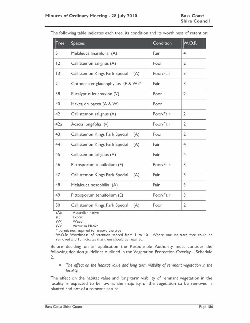
Minutes of Ordinary Meeting - 28 July 2010 Bass Coast Shire Council
Bass Coast Shire Council Page 186
The following table indicates each tree, its condition and its worthiness of retention:
Tree Species Condition W.O.R
5 Melaleuca linariifolia (A) Fair 4
12 Callistemon salignus (A) Poor 2
13 Callistemon Kings Park Special (A) Poor/Fair 3
21 Cotoneaster glaucophyllus (E & W)* Fair 3
38 Eucalyptus leucoxylon (V) Poor 2
40 Hakea drupacea (A & W) Poor
42 Callistemon salignus (A) Poor/Fair 2
42a Acacia longifolia (v) Poor/Fair 2
43 Callistemon Kings Park Special (A) Poor 2
44 Callistemon Kings Park Special (A) Fair 4
45 Callistemon salignus (A) Fair 4
46 Pittosporum tenuifolium (E) Poor/Fair 3
47 Callistemon Kings Park Special (A) Fair 3
48 Melaleuca nesophilia (A) Fair 3
49 Pittosporum tenuifolium (E) Poor/Fair 3
50 Callistemon Kings Park Special (A) Poor 2
(A): Australian native (E): Exotic (W): Weed (V): Victorian Native * permit not required to remove the tree W.O.R: Worthiness of retention scored from 1 to 10. Where one indicates tree could be removed and 10 indicates that trees should be retained.
Before deciding on an application the Responsible Authority must consider the following decision guidelines outlined in the Vegetation Protection Overlay – Schedule 2.
• The effect on the habitat value and long term viability of remnant vegetation in the locality.
The effect on the habitat value and long term viability of remnant vegetation in the locality is expected to be low as the majority of the vegetation to be removed is planted and not of a remnant nature.

Minutes of Ordinary Meeting - 28 July 2010 Bass Coast Shire Council
Bass Coast Shire Council Page 187
• The significance of the vegetation, particularly if it forms part of a recognised wildlife corridor.
The vegetation does not form part of a recognised wildlife corridor. Individually the subject trees are considered to be relatively insignificant in terms of habitat value.
• The reason for any removal of native vegetation and whether an alternative option can be developed which conserves the vegetation.
The reason for the proposal is to allow for the construction of the proposed aged care facility and driveway. None of the trees are indigenous; they are of fair to poor quality and have low retention value. The redesign of the proposed development to retain these trees is not considered necessary.
• The purpose of the underlying zone.
The fundamental purpose of the Residential 1 Zone (R1Z) is to provide for residential development at a range of densities with a variety of dwellings to meet the housing needs of all households. Permitting the removal of these trees will facilitate a development that can contribute to the diversity of housing within the Shire.
Submitter’s Concerns
The written submissions received identify a variety of concerns to the proposed development including car parking, traffic impacts and vegetation removal. These concerns have been considered in the context of applicable planning policy and provisions and have been addressed in the body of the report above.
However, one objection was received in relation to the removal of the Cowes Cinema. While the loss of the cinema will be disappointing, there are no planning provisions within the Bass Coast Planning Scheme requiring that the cinema be retained.
Conclusion
The State Planning Policy Framework and the Local Planning Policy Framework incorporating the Municipal Strategic Statement, the Residential 1 Zone, and the Vegetation Protection Overlay support the proposal.
The proposed development has been assessed and is considered to be in general accordance with the objectives and standards of Clause 55 of the Bass Coast Planning Scheme.

Minutes of Ordinary Meeting - 28 July 2010 Bass Coast Shire Council
Bass Coast Shire Council Page 188
Recommendation
That in relation to planning permit application no. 100101 for the development of a residential aged care facility and removal of vegetation at 192-198 (Lot 1, LP139809) Thompson Avenue, Cowes, Council resolves to issue a Notice of Decision to Grant a Permit subject to the following conditions:
Bass Coast Shire Council
1. Before the works commence, amended plans must be submitted to and approved by the Responsible Authority. When approved, the plans will be endorsed and will then form part of the permit. The plans must be drawn to scale with dimensions and three (3) copies must be provided (one copy must be A3 size). The plans must be generally in accordance with the plans submitted with the application but modified to show:
(a) Provision of an additional 14 on-site car parking spaces (total of 45 spaces) located adjacent to the parking area shown in the plans originally submitted;
(b) Location of air conditioners and solar hot water systems;
(c) Colours for all external surfaces of the development;
(d) Details of signage, including access signage;
(e) External lighting scheme baffled to ensure that no light spill falls on adjacent properties and otherwise in accordance with the Bass Coast Shire Council Street Lighting Policy;
(f) A permanent vehicle/pedestrian exclusion zoned around the Golden Cypress trees located in front of the subject site;
(g) All roof elements including plant, lift over-runs, and other building services, to be absorbed within the overall building form, or included as part of the roof design;
(h) A dedicated storage area for resident’s mobility scooters and parking for visitor’s mobility scooters ;
(i) Provide 15 bicycle parking spaces in accordance with Clause 52.34 of the Bass Coast Planning Scheme;
(j) Erection and display of signage as required by Clause 52.34 of the Bass Coast Planning Scheme indicating location of bicycle parking areas and change facilities;
(k) Increase the width of the footpath abutting the driveway which connects the Aged Care Facility to Thompson Avenue from one (1) metre to a width that will enable two (2) scooters or two (2) wheelchairs to use the footpath simultaneously; and
(l) The footpath abutting the driveway must be increased in length to connect to the Aged-Care Facility’s main entrance.
2. The development as shown on the endorsed plans shall not be amended, altered or modified (whether or not in order to comply with

Minutes of Ordinary Meeting - 28 July 2010 Bass Coast Shire Council
Bass Coast Shire Council Page 189
any statute, statutory rule or, for any other reason) without the written consent of the Responsible Authority.
3. The development must incorporate principles of Environmentally Sustainable Design (ESD) including energy management together with water conservation and re-use to the satisfaction of the Responsible Authority.
4. Before the work commences, an access audit prepared by a suitably qualified person or firm must be submitted to the satisfaction of the Responsible Authority for approval. The audit must included, but not be limited to, an assessment of the accessibility of the fit out of the rooms and communal spaces. The plans should be suitably modified to adopt the recommendations of the audit. When approved the amended plans will be endorsed and form part of the permit. The plans must be drawn to scale with dimensions and three (3) copies must be provided (one copy must be A3 size).
5. Before the works commences, an amended landscape plan prepared by a landscape architect or suitably qualified person or firm must be submitted to the satisfaction of the Responsible Authority for approval. When approved, the plans will be endorsed and form part of the permit. The plans must be drawn to scale with dimensions and three (3) copies must be provided (one copy must be A3 size). The plans must show:
(a) Areas to be landscaped;
(b) A schedule of proposed species that are to be planted on the site including quantities, size at maturity and scientific names;
(c) Minimum 80% locally indigenous species; and
(d) Paving treatments and finishes.
All species are to be non-invasive and not include any environmental weeds as listed within the publication titled Common Weeds of Gippsland, Bass Coast Shire 2002.
6. The development hereby approved must not be occupied until the landscaping shown on the endorsed plans has been completed to the satisfaction of the Responsible Authority. The landscaping shown on the endorsed plans must be planted, established and thereafter maintained to the satisfaction of the Responsible Authority, including the replacement of failed plants.
7. Before the works commence, detailed civil construction plans must be prepared to the satisfaction of the Responsible Authority for endorsement by the Responsible Authority. All construction plans submitted for approval must be consistent with this permit and must conform with the requirements of all relevant servicing and road authorities, and in particular water, sewerage, drainage, telephone power, VicRoads and Council. The plans must be drawn to scale with dimensions and three copies must be provided. The plans must show:
(a) Drainage of the subject land including:
I. Compliance with the Best Practice Environmental
Minutes of Ordinary Meeting - 28 July 2010 Bass Coast Shire Council
Bass Coast Shire Council Page 190
Management Guidelines for Urban Stormwater and Bass Coast Shire Stormwater Management Plan (2003). Any quality treatment proposed in accordance with these Guidelines;
II. A drainage retardation system on the subject land serving each lot allowing an unrestricted flow path for 1 in 100 year extreme event storm flows. The drainage retardation system must discharge to the existing underground system/legal point of discharge and be maintained to the satisfaction of the Responsible Authority; and
III. Consideration of any buildings and works and landscaping in relation to any detrimental impacts to underground drainage pipes located on any existing or proposed drainage or sewerage easement.
(b) Vehicle and pedestrian access and car parking including:
I. Concrete driveways in accordance with Council’s Standard Drawings;
II. A footpath on the frontage of the land;
III. The internal footpath designed and constructed to disabled access standards, linking Thompson Avenue to the front entrance of the facility with minimal traffic conflict;
IV. Car parking areas including disabled parking and access ways to be designed, constructed and sealed with an all-weather seal pavement to the satisfaction of the Responsible Authority;
V. Car parking spaces and access aisles designed in accordance with the Australian Standard for off-street car parking AS 2890.1 – 2004; and
VI. Sixty degree car parking spaces shall be maximised in Thompson Avenue and must be constructed and sealed along the frontage of the site to the driveway of 190 Thompson Avenue including parking signage to the satisfaction of the Responsible Authority.
All works must be constructed or carried out in accordance with those plans.
8. Before the works commence, a Tree Protection and Management Plan must be prepared by a qualified arboriculturist and submitted to and approved by the Responsible Authority. When approved, the plan will be endorsed and will then form part of the permit. The Tree Protection and Management Plan must be prepared in accordance with AS 4970-2009 (Protection of trees on development sites). The plan must provide protection measures for trees to be retained on site, trees on adjacent sites that are within 5 metres of common boundaries, and street trees adjacent to the site. Protection measures
Minutes of Ordinary Meeting - 28 July 2010 Bass Coast Shire Council
Bass Coast Shire Council Page 191
for street trees must include permanent protection measures. The plan must also detail proposed pruning works to existing trees on the site and on adjoining properties and road reserves (if required). These works must be carried out by a qualified arboriculturist in accordance with the recommendations of the plan.
9. Vehicle and pedestrian access and drainage to serve the subject land must be located, constructed and maintained to the satisfaction of the Responsible Authority.
10. Before the works commence, a Construction Management Plan must be prepared to the satisfaction of the Responsible Authority for endorsement by the Responsible Authority. The plan must address, but not be limited to following:
(a) The requirements of all servicing authorities, and in particular water, sewerage, drainage, telephone and power supply authorities. The details of any servicing requirements affecting the subject land shall be included, such as power kiosks, pumps or other upgrading required;
(b) Containment of litter, dust, dirt and mud within the site and method and frequency of clean up procedures in the event of build up of matter within and outside of the site;
(c) Parking proposed for construction workers;
(d) Delivery and unloading methods and expected frequency and times;
(e) A liaison officer for contact by residents and the Responsible Authority in the event of relevant queries or problems experienced;
(f) Best Practice Environmental Management Guidelines for Urban Stormwater;
(g) Environmental Guidelines for Urban Stormwater (EPA Publication No. 480, December 1995); and
(h) Construction Techniques for Sediment Pollution Control (EPA Publication No. 275, May 1991).
The Construction Management Plan, once endorsed, will form part of the permit. All works constructed or carried out must be in accordance with the approved Construction Management Plan. All care must be taken to minimise the effect of construction activity on the amenity of the surrounding neighbourhood. Once endorsed the Construction Management Plan must not be altered except with the written consent of the Responsible Authority.
11. Before the works commence, a Traffic and Parking Management Plan must be prepared to the satisfaction of the Responsible Authority for endorsement by the Responsible Authority. The plan must address, but not be limited to following:
(a) the location of all areas on site to be used for staff, visitor and patron parking. No parking shall be permitted off-site on any

Minutes of Ordinary Meeting - 28 July 2010 Bass Coast Shire Council
Bass Coast Shire Council Page 192
nearby land or road reserve without the further approval in writing of the Responsible Authority;
(b) the dimensions and location of the roads, parking spaces, access lanes and site facilities including measures proposed to limit traffic speeds on the site;
(c) specification of staff, resident and visitor numbers adequate to enable efficient provision and operation of car parking areas on-site including emergency egress provision for fire evacuations or other emergency situations;
(d) the number and location of all on and off-site security installations or measures;
(e) the means by which the direction of traffic and pedestrian flows to and from car parking areas will be controlled on and off the site;
(f) measures to discourage patron car parking in non-parking areas;
(g) measures to preclude staff parking in designated patron car parking areas;
(h) staffing and other measures or plans to ensure the orderly departure and arrival of patrons especially for large groups departing at peak times; and
(i) servicing and maintenance proposals for the road system and car parking areas.
The Traffic and Parking Management Plan, once endorsed, will form part of the permit. All future traffic operations relating to the use and development must be in accordance with the approved Traffic and Parking Management Plan. Once endorsed the Traffic and Parking Management Plan must not be altered except with the written consent of the Responsible Authority.
12. Before the use commences, a Waste Management Plan (WMP) must be prepared to the satisfaction of the Responsible Authority for endorsement by the Responsible Authority. Once endorsed, the WMP will form part of the permit. All waste collection and disposal must be undertaken in accordance with the approved WMP. Once endorsed the WMP must not be altered except with the written consent of the Responsible Authority.
13. Drainage of the subject land must be to the satisfaction of the Responsible Authority including compliance with the Best Practice Management practices for Stormwater and the Bass Coast Shire Stormwater Management Plan (2003).
14. All car parking spaces must be designed to allow all vehicles to exit the subject land in a forward direction.
15. Access to the site shall only be at the nominated crossing shown on the endorsed plan. The crossing and road pavement works are to be constructed to the satisfaction of the (VicRoads Corporation and/or the) Responsible Authority.
16. No buildings or works shall be constructed on any existing (including

Minutes of Ordinary Meeting - 28 July 2010 Bass Coast Shire Council
Bass Coast Shire Council Page 193
implied sewer, drainage, telephone, power and water easement) or proposed easement without the further approval in writing of the Responsible Authority and/or the relevant service provider.
17. The development hereby approved must not be occupied until:
(a) the landscaping shown on the endorsed plans has been completed to the satisfaction of the Responsible Authority. The landscaping shown on the endorsed plans must be planted, established and thereafter maintained to the satisfaction of the Responsible Authority;
(b) all redundant infrastructure associated with the development is removed, damaged infrastructure is replaced and the area reinstated to the satisfaction of the Responsible Authority; and
(c) all works required by the conditions of this permit have been completed to the satisfaction of the Responsible Authority.
18. The development must be managed during construction so that the amenity of the area is not detrimentally affected through the:
(a) transport of materials, goods or commodities to or from the land;
(b) appearance of any building, works or materials;
(c) emission of noise, artificial light, vibration, smell, fumes, smoke, vapour, steam, soot, ash, litter, dust, waste water, waste products, grit or oil; and
(d) presence of vermin or animals.
19. No mud, dirt, sand, soil, clay, stones, oil, grease, scum, litter, chemicals, sediments, gross pollutants, animal waste or domestic waste shall be washed into, allowed to enter, or discharged to the stormwater drainage system, receiving waters or surrounding land and road reserves, during the construction works hereby approved to the satisfaction of the Responsible Authority.
20. The development hereby approved must not be occupied until:
(a) All redundant infrastructure associated with the development is removed and the area reinstated to the satisfaction of the Responsible Authority;
(b) All works required by the conditions of this permit have been completed to the satisfaction of the Responsible Authority;
(c) Street lighting provided in accordance with the Bass Coast Shire Council Street Lighting Policy;
(d) Public waste/recycling bins must be provided within the pedestrian areas to the satisfaction of the Responsible Authority; and
(e) All works and contributions required by the conditions of this permit have been completed to the satisfaction of the Responsible Authority.
21. Noise levels emanating from the premises must not exceed those required to be met under State Environment Protection Policy
Minutes of Ordinary Meeting - 28 July 2010 Bass Coast Shire Council
Bass Coast Shire Council Page 194
(Control of Noise from Commerce, Industry and Trade), No. 1-1.
22. All external plant and equipment must be acoustically treated or placed in soundproof housing to reduce noise to a level satisfactory to the Responsible Authority.
23. The use of the premises must not be operated to the detriment of the amenity of the area to the satisfaction of the Responsible Authority, including through the loading and unloading of delivery vehicles and playing of amplified music.
24. No building or works shall be constructed on any existing (including implied sewer and water easement) or proposed easement without the future approval in writing of the Responsible Authority and/or relevant service provider.
25. Truck and van deliveries and waste collection must not occur on Sundays and must not occur before 7.30am and after 5.00pm, Monday to Saturday.
26. Car parking and access lanes must be kept available for these purposes at all times.
27. This permit will expire if either of the following circumstances apply:
(a) the development is not commenced within two (2) years;
(b) the development is not completed within four (4) years of the date of this permit.
The Responsible Authority may extend the periods referred to if a request is made in writing before the permit expires or within three (3) months afterwards.
VicRoads
28. Provide an updated traffic impact assessment based on current traffic volumes for peak event times for review and assessment by Vic Roads. This impact assessment should be based on VicRoads Guidelines for traffic impact assessment reports.
Attachments
AT-1 Locality Plan 2 Pages AT-2 Application and Plans 56 Pages AT-3 Traffic Impact Report - March 2010 29 Pages AT-4 CONFIDENTIAL - Submissions 4 Pages
Minutes of Ordinary Meeting - 28 July 2010 Bass Coast Shire Council
Bass Coast Shire Council Page 195
Council Decision
Moved: Cr. Jane Dore Daly / Seconded: Cr. Gareth Barlow
Recommendation
That in relation to planning permit application no. 100101 for the development of a residential aged care facility and removal of vegetation at 192-198 (Lot 1, LP139809) Thompson Avenue, Cowes, Council resolves to issue a Notice of Decision to Grant a Permit subject to the following conditions:
Bass Coast Shire Council
1. Before the works commence, amended plans must be submitted to and approved by the Responsible Authority. When approved, the plans will be endorsed and will then form part of the permit. The plans must be drawn to scale with dimensions and three (3) copies must be provided (one copy must be A3 size). The plans must be generally in accordance with the plans submitted with the application but modified to show:
(a) Provision of an additional 14 on-site car parking spaces (total of 45 spaces) located adjacent to the parking area shown in the plans originally submitted;
(b) Location of air conditioners and solar hot water systems;
(c) Colours for all external surfaces of the development;
(d) Details of signage, including access signage;
(e) External lighting scheme baffled to ensure that no light spill falls on adjacent properties and otherwise in accordance with the Bass Coast Shire Council Street Lighting Policy;
(f) A permanent vehicle/pedestrian exclusion zoned around the Golden Cypress trees located in front of the subject site;
(g) All roof elements including plant, lift over-runs, and other building services, to be absorbed within the overall building form, or included as part of the roof design;
(h) A dedicated storage area for resident’s mobility scooters and parking for visitor’s mobility scooters ;
(i) Provide 15 bicycle parking spaces in accordance with Clause 52.34 of the Bass Coast Planning Scheme;
(j) Erection and display of signage as required by Clause 52.34 of the Bass Coast Planning Scheme indicating location of bicycle parking areas and change facilities;
(k) Increase the width of the footpath abutting the driveway which connects the Aged Care Facility to Thompson Avenue from one (1) metre to a width that will enable two (2) scooters or two (2) wheelchairs to use the footpath simultaneously; and

Minutes of Ordinary Meeting - 28 July 2010 Bass Coast Shire Council
Bass Coast Shire Council Page 196
(l) The footpath abutting the driveway must be increased in length to connect to the Aged-Care Facility’s main entrance.
2. The development as shown on the endorsed plans shall not be amended, altered or modified (whether or not in order to comply with any statute, statutory rule or, for any other reason) without the written consent of the Responsible Authority.
3. The development must incorporate principles of Environmentally Sustainable Design (ESD) including energy management together with water conservation and re-use to the satisfaction of the Responsible Authority.
4. Before the work commences, an access audit prepared by a suitably qualified person or firm must be submitted to the satisfaction of the Responsible Authority for approval. The audit must included, but not be limited to, an assessment of the accessibility of the fit out of the rooms and communal spaces. The plans should be suitably modified to adopt the recommendations of the audit. When approved the amended plans will be endorsed and form part of the permit. The plans must be drawn to scale with dimensions and three (3) copies must be provided (one copy must be A3 size).
5. Before the works commences, an amended landscape plan prepared by a landscape architect or suitably qualified person or firm must be submitted to the satisfaction of the Responsible Authority for approval. When approved, the plans will be endorsed and form part of the permit. The plans must be drawn to scale with dimensions and three (3) copies must be provided (one copy must be A3 size). The plans must show:
(a) Areas to be landscaped;
(b) A schedule of proposed species that are to be planted on the site including quantities, size at maturity and scientific names;
(c) Minimum 80% locally indigenous species; and
(d) Paving treatments and finishes.
All species are to be non-invasive and not include any environmental weeds as listed within the publication titled Common Weeds of Gippsland, Bass Coast Shire 2002.
6. The development hereby approved must not be occupied until the landscaping shown on the endorsed plans has been completed to the satisfaction of the Responsible Authority. The landscaping shown on the endorsed plans must be planted, established and thereafter maintained to the satisfaction of the Responsible Authority, including the replacement of failed plants.
7. Before the works commence, detailed civil construction plans must be prepared to the satisfaction of the Responsible Authority for endorsement by the Responsible Authority. All construction plans submitted for approval must be consistent with this permit and must conform with the requirements of all relevant servicing and road authorities, and in particular water, sewerage, drainage, telephone

Minutes of Ordinary Meeting - 28 July 2010 Bass Coast Shire Council
Bass Coast Shire Council Page 197
power, VicRoads and Council. The plans must be drawn to scale with dimensions and three copies must be provided. The plans must show:
(a) Drainage of the subject land including:
I. Compliance with the Best Practice Environmental Management Guidelines for Urban Stormwater and Bass Coast Shire Stormwater Management Plan (2003). Any quality treatment proposed in accordance with these Guidelines;
II. A drainage retardation system on the subject land serving each lot allowing an unrestricted flow path for 1 in 100 year extreme event storm flows. The drainage retardation system must discharge to the existing underground system/legal point of discharge and be maintained to the satisfaction of the Responsible Authority; and
III. Consideration of any buildings and works and landscaping in relation to any detrimental impacts to underground drainage pipes located on any existing or proposed drainage or sewerage easement.
(b) Vehicle and pedestrian access and car parking including:
I. Concrete driveways in accordance with Council’s Standard Drawings;
II. A footpath on the frontage of the land;
III. The internal footpath designed and constructed to disabled access standards, linking Thompson Avenue to the front entrance of the facility with minimal traffic conflict;
IV. Car parking areas including disabled parking and access ways to be designed, constructed and sealed with an all-weather seal pavement to the satisfaction of the Responsible Authority;
V. Car parking spaces and access aisles designed in accordance with the Australian Standard for off-street car parking AS 2890.1 – 2004; and
VI. Sixty degree car parking spaces shall be maximised in Thompson Avenue and must be constructed and sealed along the frontage of the site to the driveway of 190 Thompson Avenue including parking signage to the satisfaction of the Responsible Authority.
All works must be constructed or carried out in accordance with those plans.
8. Before the works commence, a Tree Protection and Management Plan must be prepared by a qualified arboriculturist and submitted to and approved by the Responsible Authority. When approved, the plan will be endorsed and will then form part of the permit. The Tree

Minutes of Ordinary Meeting - 28 July 2010 Bass Coast Shire Council
Bass Coast Shire Council Page 198
Protection and Management Plan must be prepared in accordance with AS 4970-2009 (Protection of trees on development sites). The plan must provide protection measures for trees to be retained on site, trees on adjacent sites that are within 5 metres of common boundaries, and street trees adjacent to the site. Protection measures for street trees must include permanent protection measures. The plan must also detail proposed pruning works to existing trees on the site and on adjoining properties and road reserves (if required). These works must be carried out by a qualified arboriculturist in accordance with the recommendations of the plan.
9. Vehicle and pedestrian access and drainage to serve the subject land must be located, constructed and maintained to the satisfaction of the Responsible Authority.
10. Before the works commence, a Construction Management Plan must be prepared to the satisfaction of the Responsible Authority for endorsement by the Responsible Authority. The plan must address, but not be limited to following:
(a) The requirements of all servicing authorities, and in particular water, sewerage, drainage, telephone and power supply authorities. The details of any servicing requirements affecting the subject land shall be included, such as power kiosks, pumps or other upgrading required;
(b) Containment of litter, dust, dirt and mud within the site and method and frequency of clean up procedures in the event of build up of matter within and outside of the site;
(c) Parking proposed for construction workers;
(d) Delivery and unloading methods and expected frequency and times;
(e) A liaison officer for contact by residents and the Responsible Authority in the event of relevant queries or problems experienced;
(f) Best Practice Environmental Management Guidelines for Urban Stormwater;
(g) Environmental Guidelines for Urban Stormwater (EPA Publication No. 480, December 1995); and
(h) Construction Techniques for Sediment Pollution Control (EPA Publication No. 275, May 1991).
The Construction Management Plan, once endorsed, will form part of the permit. All works constructed or carried out must be in accordance with the approved Construction Management Plan. All care must be taken to minimise the effect of construction activity on the amenity of the surrounding neighbourhood. Once endorsed the Construction Management Plan must not be altered except with the written consent of the Responsible Authority.
11. Before the works commence, a Traffic and Parking Management Plan must be prepared to the satisfaction of the Responsible Authority for

Minutes of Ordinary Meeting - 28 July 2010 Bass Coast Shire Council
Bass Coast Shire Council Page 199
endorsement by the Responsible Authority. The plan must address, but not be limited to following:
(a) the location of all areas on site to be used for staff, visitor and patron parking. No parking shall be permitted off-site on any nearby land or road reserve without the further approval in writing of the Responsible Authority;
(b) the dimensions and location of the roads, parking spaces, access lanes and site facilities including measures proposed to limit traffic speeds on the site;
(c) specification of staff, resident and visitor numbers adequate to enable efficient provision and operation of car parking areas on-site including emergency egress provision for fire evacuations or other emergency situations;
(d) the number and location of all on and off-site security installations or measures;
(e) the means by which the direction of traffic and pedestrian flows to and from car parking areas will be controlled on and off the site;
(f) measures to discourage patron car parking in non-parking areas;
(g) measures to preclude staff parking in designated patron car parking areas;
(h) staffing and other measures or plans to ensure the orderly departure and arrival of patrons especially for large groups departing at peak times; and
(i) servicing and maintenance proposals for the road system and car parking areas.
The Traffic and Parking Management Plan, once endorsed, will form part of the permit. All future traffic operations relating to the use and development must be in accordance with the approved Traffic and Parking Management Plan. Once endorsed the Traffic and Parking Management Plan must not be altered except with the written consent of the Responsible Authority.
12. Before the use commences, a Waste Management Plan (WMP) must be prepared to the satisfaction of the Responsible Authority for endorsement by the Responsible Authority. Once endorsed, the WMP will form part of the permit. All waste collection and disposal must be undertaken in accordance with the approved WMP. Once endorsed the WMP must not be altered except with the written consent of the Responsible Authority.
13. Drainage of the subject land must be to the satisfaction of the Responsible Authority including compliance with the Best Practice Management practices for Stormwater and the Bass Coast Shire Stormwater Management Plan (2003).
14. All car parking spaces must be designed to allow all vehicles to exit the subject land in a forward direction.
15. Access to the site shall only be at the nominated crossing shown on the

Minutes of Ordinary Meeting - 28 July 2010 Bass Coast Shire Council
Bass Coast Shire Council Page 200
endorsed plan. The crossing and road pavement works are to be constructed to the satisfaction of the (VicRoads Corporation and/or the) Responsible Authority.
16. No buildings or works shall be constructed on any existing (including implied sewer, drainage, telephone, power and water easement) or proposed easement without the further approval in writing of the Responsible Authority and/or the relevant service provider.
17. The development hereby approved must not be occupied until:
(a) the landscaping shown on the endorsed plans has been completed to the satisfaction of the Responsible Authority. The landscaping shown on the endorsed plans must be planted, established and thereafter maintained to the satisfaction of the Responsible Authority;
(b) all redundant infrastructure associated with the development is removed, damaged infrastructure is replaced and the area reinstated to the satisfaction of the Responsible Authority; and
(c) all works required by the conditions of this permit have been completed to the satisfaction of the Responsible Authority.
18. The development must be managed during construction so that the amenity of the area is not detrimentally affected through the:
(a) transport of materials, goods or commodities to or from the land;
(b) appearance of any building, works or materials;
(c) emission of noise, artificial light, vibration, smell, fumes, smoke, vapour, steam, soot, ash, litter, dust, waste water, waste products, grit or oil; and
(d) presence of vermin or animals.
19. No mud, dirt, sand, soil, clay, stones, oil, grease, scum, litter, chemicals, sediments, gross pollutants, animal waste or domestic waste shall be washed into, allowed to enter, or discharged to the stormwater drainage system, receiving waters or surrounding land and road reserves, during the construction works hereby approved to the satisfaction of the Responsible Authority.
20. The development hereby approved must not be occupied until:
(a) All redundant infrastructure associated with the development is removed and the area reinstated to the satisfaction of the Responsible Authority;
(b) All works required by the conditions of this permit have been completed to the satisfaction of the Responsible Authority;
(c) Street lighting provided in accordance with the Bass Coast Shire Council Street Lighting Policy;
(d) Public waste/recycling bins must be provided within the pedestrian areas to the satisfaction of the Responsible Authority; and
Minutes of Ordinary Meeting - 28 July 2010 Bass Coast Shire Council
Bass Coast Shire Council Page 201
(e) All works and contributions required by the conditions of this permit have been completed to the satisfaction of the Responsible Authority.
21. Noise levels emanating from the premises must not exceed those required to be met under State Environment Protection Policy (Control of Noise from Commerce, Industry and Trade), No. 1-1.
22. All external plant and equipment must be acoustically treated or placed in soundproof housing to reduce noise to a level satisfactory to the Responsible Authority.
23. The use of the premises must not be operated to the detriment of the amenity of the area to the satisfaction of the Responsible Authority, including through the loading and unloading of delivery vehicles and playing of amplified music.
24. No building or works shall be constructed on any existing (including implied sewer and water easement) or proposed easement without the future approval in writing of the Responsible Authority and/or relevant service provider.
25. Truck and van deliveries and waste collection must not occur on Sundays and must not occur before 7.30am and after 5.00pm, Monday to Saturday.
26. Car parking and access lanes must be kept available for these purposes at all times.
27. This permit will expire if either of the following circumstances apply:
(a) the development is not commenced within two (2) years;
(b) the development is not completed within four (4) years of the date of this permit.
The Responsible Authority may extend the periods referred to if a request is made in writing before the permit expires or within three (3) months afterwards.
VicRoads
28. Provide an updated traffic impact assessment based on current traffic volumes for peak event times for review and assessment by Vic Roads. This impact assessment should be based on VicRoads Guidelines for traffic impact assessment reports.
CARRIED
Minutes of Ordinary Meeting - 28 July 2010 Bass Coast Shire Council
Bass Coast Shire Council Page 202
K.8 Webb Drive Special Charge Scheme No.32
File No: CM10/241 Department: Infrastructure Council Plan Strategic Objective: Cohesive Communities
We will improve lifestyle opportunities and options by managing the built environment and encouraging cohesive communities.
Declaration
The author of this report has no direct or indirect interests in relation to the issue.
Summary
Webb Drive Special Charge Scheme No 32 provided for the construction of a sealed road pavement with kerb and channel and underground drainage for the full length of Webb Drive, the Bass Highway service road (Mullin Parade to Webb Drive) and road widening works adjacent to the Bass Highway.
All the statutory procedures relating to declaring and levying of the scheme have been completed.
The final costs for the construction of the Webb Drive Wonthaggi Special Charge Scheme have recently been determined with final completion of works in May 2010.
Property owners in the scheme were required to contribute to the project based on Council’s estimate prior to tendering. Final costs have now been assessed and it has been determined that the total scheme costs exceeded the estimated costs. The variation in costs is associated with the following:
• Additional design costs to exclude Elizabeth Street and Mullin Parade from the original scheme. This was based on the Council decision 21 March 2007
• VicRoads requirements for additional road widening works and traffic management on the Bass Highway and the service road.
• Water main works in Webb Drive that was required by South Gippsland Water due to the adjustment to the finished road levels.
• Higher than normal construction costs due to high construction activity at the time of tendering (a contract was awarded prior to the economic slowdown).
The budget for the scheme construction costs was varied in March 2008 prior to awarding a contract for the works. The amount to be recovered from landowners was not varied. If the scheme was varied at the time of tendering it would have provided the landowners with the ability to consider whether the scheme should proceed.
Council effectively now has two options. Council can either require the landowners in the scheme to fund part of the increase in the cost of the works or alternatively not increase the costs to landowners.

Minutes of Ordinary Meeting - 28 July 2010 Bass Coast Shire Council
Bass Coast Shire Council Page 203
If Council were to vary the scheme now, to require the landowners to recover additional costs, it could be argued that the landowners have been denied natural justice. This is based on the fact that had the landowners been aware of the additional costs, at the time of tendering, they may have objected to the scheme and Council would not have been able to proceed with the scheme.
Based on the circumstances of the particular scheme and the fact that the majority of the additional costs associated with the project can not be attributable to the landowners it is recommended that Council not require the landowners to contribute the additional scheme costs.
Introduction
The construction of Webb Drive and the service road adjacent to Bass Highway between Webb Drive and Mullin Parade continues Council’s commitment to construct all its urban streets to a sealed status.
The scheme included 15 properties at the time of development of the scheme. The scheme generally included the following works:
• construction of new roads for Webb Drive and service road adjacent to the Bass Highway, including intersection treatments of Webb Drive and Mullin Parade
• installation of underground stormwater pipes
• naturestrip reinstatement and planting of street trees
Council declared the scheme on 21 March 2007. There were no appeals lodged with the Victorian Civil and Administrative Tribunal (VCAT).
Council entered into a contract in July 2008 for the works in the scheme. The contract defects liability period ended in May 2010. Therefore, the actual costs can now be calculated.
To explain the history of this project, Table 1 below describes the sequence of events and the impact to the declared costs: (Note all costs are GST exclusive)
Table 1 – Project History
Description Date Total Estimated Cost ($)
Levy Cost ($)
Comments
Advertising the Scheme – Intention to declare
12 December 2006
$842,887.10 $583,537.22 Included Elizabeth Street, entire length of Mullin Parade Note 1
Levy – Final Declaration
21 March 2007
$511,113.80 $359,141.23 Following consideration of submissions the committee removed Elizabeth Street and Mullin Parade and adjusted the contributions of landowners and

Minutes of Ordinary Meeting - 28 July 2010 Bass Coast Shire Council
Bass Coast Shire Council Page 204
Council Note 2
Tender Process
20 May 2008 $855,906.20 Additional design work was required to satisfy VicRoads requirements. Hence increase of estimated costs Note 3
and 4
March 2008 budget review
Adopted early June 2008 as part of the 08/09 budget process
$766,000.00 $359,141.23 Budget review carried out to increase budget based on revised estimated costs – Road component $548,000 Drainage component $218,000Note 5
Tender Process No. 2
2 July 2008 $640,245.09 Contract value Note 6
Practical completion
18 December 2008
$640,199.47 Roadworks reached practical completion – Final contract cost Note 7
Final Completion
6 May 2010 Final defects liability period ended. All defects been rectified. Note 7
Final Report (this report)
16 June 2010 $754,534.41 $359,141.23 Includes VicRoads additional works for Bass Highway and water main replacement in Webb Drive and design/supervision costs Note 8
The table above refers to the following notes:
1. At its meeting of 12 December 2006 Council resolved to advertise its intention to declare a Special Charge Scheme at its March 21st 2007 meeting for the construction of Webb Drive, Elizabeth Street, Mullin Parade and Bass Highway between Webb Drive and Mullin Parade. A public notice was placed in the local paper, and notices were sent to affected landowners advising of Council’s intention to declare a scheme. Notices included an invitation for submissions or objections in relation to the proposal.
2. A Committee of Council considered the submissions on 20 February 2007. On 21 March 2007, Council adopted the recommendation to remove two streets (Elizabeth Street and Mullin Parade) from the Scheme. This resulted in a decreased total estimated cost of the project to $511,113.80 with the

Minutes of Ordinary Meeting - 28 July 2010 Bass Coast Shire Council
Bass Coast Shire Council Page 205
landowner’s contribution being $359,141.23 and Council’s contribution $151,972.57. The modified scheme was declared at the Council meeting of 21 March 2007.
3. Detailed design plans continued. Discussions were held with VicRoads to seek approval of the detailed design plans. From these discussions, Council was required to provide a road safety audit based on the detailed design to satisfy VicRoads requirements. From this audit, further road widening was required on the southern edge of the highway and additional width between the median island and the eastbound carriageway. This increased the total estimated costs for the project. Council submitted a “Roadbid” to seek a contribution for the roadworks on Bass Highway adjacent to the service road. This was unsuccessful.
4. Council tendered this project. At this time, there was a general lack of availability for Contractors to do the works. The tenders were above budget. The prices received did not represent value for money, so no tender was accepted.
5. In the March 2008 budget review, Council officers requested an increase to the current budget to reflect current market rates. Council agreed to this request.
6. Council re-tendered in 20 May 2008. The value of the contract was significantly lower than the initial tender and represented value for money. This project was significantly above the estimated levied amount. The project was awarded to Sure Constructions (Vic.) Pty Ltd on 2 July 2008.
7. Practical completion was reached on 18 December 2008 with the defects period and final completion certificate issued 6 May 2010.
8. This report highlights the actual final costs associated with the special charge scheme
9. At the time of the budget review, Council officers did not seek to adjust the levy amount. Based on the additional design works to satisfy VicRoads requirements, it was considered unreasonable to re-distribute to landowners. Therefore, the levy amount remained the same.
Strategic Basis
The construction of the roads is consistent with the Council strategic objective 2009 - Cohesive Communities and Council’s Urban Improvement Policy.
The achievement of this objective is assisted through the construction of the roads and drainage. It has improved the amenity, environment, safety and access for residents and landowners in the area and is an investment in the Council’s infrastructure assets.
Finances
Owners of each property were levied the amounts based on an estimate of the cost of the works prior to a number of design changes and tendering of the works.
The total value of the Special Charge Scheme was estimated at $511,113.80, which included an estimated Council contribution of $151,972.57.
The following table details the estimated versus final actual costs associated with the project and how the variation in costs could be apportioned to landowners and Council.
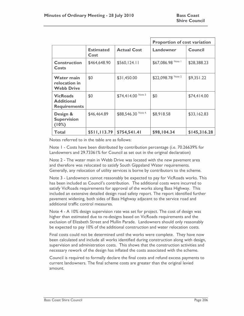
Minutes of Ordinary Meeting - 28 July 2010 Bass Coast Shire Council
Bass Coast Shire Council Page 206
Proportion of cost variation
Estimated Cost
Actual Cost Landowner Council
Construction Costs
$464,648.90
$560,124.11
$67,086.98 Note 1 $28,388.23
Water main relocation in Webb Drive
$0 $31,450.00 $22,098.78 Note 2 $9,351.22
VicRoads Additional Requirements
$0 $74,414.00 Note 3 $0 $74,414.00
Design & Supervision (10%)
$46,464.89
$88,546.30 Note 4. $8,918.58 $33,162.83
Total $511,113.79 $754,541.41 $98,104.34 $145,316.28
Notes referred to in the table are as follows:
Note 1 - Costs have been distributed by contribution percentage (i.e. 70.26639% for Landowners and 29.73361% for Council as set out in the original declaration)
Note 2 - The water main in Webb Drive was located with the new pavement area and therefore was relocated to satisfy South Gippsland Water requirements. Generally, any relocation of utility services is borne by contributors to the scheme.
Note 3 - Landowners cannot reasonably be expected to pay for VicRoads works. This has been included as Council’s contribution. The additional costs were incurred to satisfy VicRoads requirements for approval of the works along Bass Highway. This included an extensive detailed design road safety report. The report identified further pavement widening, both sides of Bass Highway adjacent to the service road and additional traffic control measures.
Note 4 - A 10% design supervision rate was set for project. The cost of design was higher than estimated due to re-designs based on VicRoads requirements and the exclusion of Elizabeth Street and Mullin Parade. Landowners should only reasonably be expected to pay 10% of the additional construction and water relocation costs.
Final costs could not be determined until the works were complete. They have now been calculated and include all works identified during construction along with design, supervision and administration costs. This shows that the construction activities and necessary rework of the design has inflated the costs associated with the scheme.
Council is required to formally declare the final costs and refund excess payments to current landowners. The final scheme costs are greater than the original levied amount.

Minutes of Ordinary Meeting - 28 July 2010 Bass Coast Shire Council
Bass Coast Shire Council Page 207
Stakeholders
The primary stakeholders are the scheme contributors who have funded the works included in the scheme, being the owners of properties abutting Webb Drive and adjacent service road between Webb Drive and Mullin Parade on Bass Highway
Other stakeholders are users of the roads.
Statutory Requirements/Codes/Standards/Policies
All statutory requirements in relation to the Special Charge Scheme procedures, tendering and construction have been met to date.
The only remaining statutory requirement is for Council to finalise the scheme and advise landowners of the final actual cost.
Section 165 of the local Government Act 1989 details the requirements to be met in relation to the receipt of excess money. It states as follows;
If a Council receives more money than it requires from the special rate or special charge, it must make a refund, which is proportionate to the contributions received by the Council to the current owners of the relevant land.
It has been determined that the “actual” project costs have exceeded the estimated scheme costs. Therefore there will be no refund for the contributing landowners and Council.
Other Options
In presenting other options, it should be noted that Section 163 (2BA) (b) of the Local Government Act does not allow the liability of any person to increase by 10% or more once the scheme has been declared without undertaking a submission (and objection) process.
The options are as follows;
1. Pass on the full cost attributable to landowners of approximately $98,104.34 or 28.43% over the original scheme costs. However, because this would increase the liability of landowners by more than 10%, Council will need to go through an additional scheme process to approve the additional costs. It is unlikely that the landowners would be in favour of this. The costs of running another scheme process for this additional amount would be significant.
2. Council can increase each landowner’s contribution by 10%. Therefore Council could pass $35,914.12, which would be in the order of $862.30 to $5,317.78 per property
3. Council absorbs the additional costs associated with the scheme.
Officer’s Comments/Conclusion
It is concluded that Option 1 would not be feasible as the increase in costs would trigger an additional scheme process and a right of appeal to VCAT.
In relation to Option 2 the legislation for special charge schemes allows for a scheme to be varied by a maximum of 10% (without the need for an additional scheme process). By excluding Elizabeth Street and Mullin Parade, the overall design costs, project and contractor establishment costs was spread over 15 properties instead of the initial 30 properties as proposed in December 2006.

Minutes of Ordinary Meeting - 28 July 2010 Bass Coast Shire Council
Bass Coast Shire Council Page 208
There could be a question as to whether it is reasonable for the remaining landowners to carry the costs, as at the time of the original scheme proposal when the landowners had agreed to the scheme, the costs were to be spread amongst 15 other properties.
It would also be considered unreasonable for the remaining 15 landowners in the scheme to contribute for the initial design work associated with the inclusion of Elizabeth Street and Mullin Parade and further rework of the detailed design to exclude Elizabeth Street and Mullin Parade landowners.
Option 3 would allow Council to absorb the additional costs associated with the scheme.
It would have been appropriate to vary the special charge scheme at the time that the contract was awarded for the scheme works. At that time the budget was varied to ensure that sufficient funds were available for the construction of the works however the amount to be recovered from landowners was not modified.
Current practice is for the scheme to be varied at the time that the works are tendered. This occurred for the White Road special charge scheme where Council reduced the amount payable by landowners as the tendered prices was below the estimated amount.
If Council were to vary the scheme to require the landowners to recover additional costs it could be argued that the landowners have been denied natural justice. This is based on the fact that the legislation would have allowed for objections from landowners. Had the landowners been aware of the additional costs, at the time of tendering, they may have objected to the scheme and Council would not have been able to proceed with the scheme.
Given the history of this particular scheme including such things as changes in the size of the scheme, changes in the scope of works required by other authorities and a reduction in the number of scheme contributors it is recommended that Council absorb the additional costs associated with the scheme.
Recommendation
In relation to the Webb Drive Special Charge Scheme No. 22
1. The amount to be recovered from landowners remain at $359,141.21
Attachments
There are no attachments for this report.
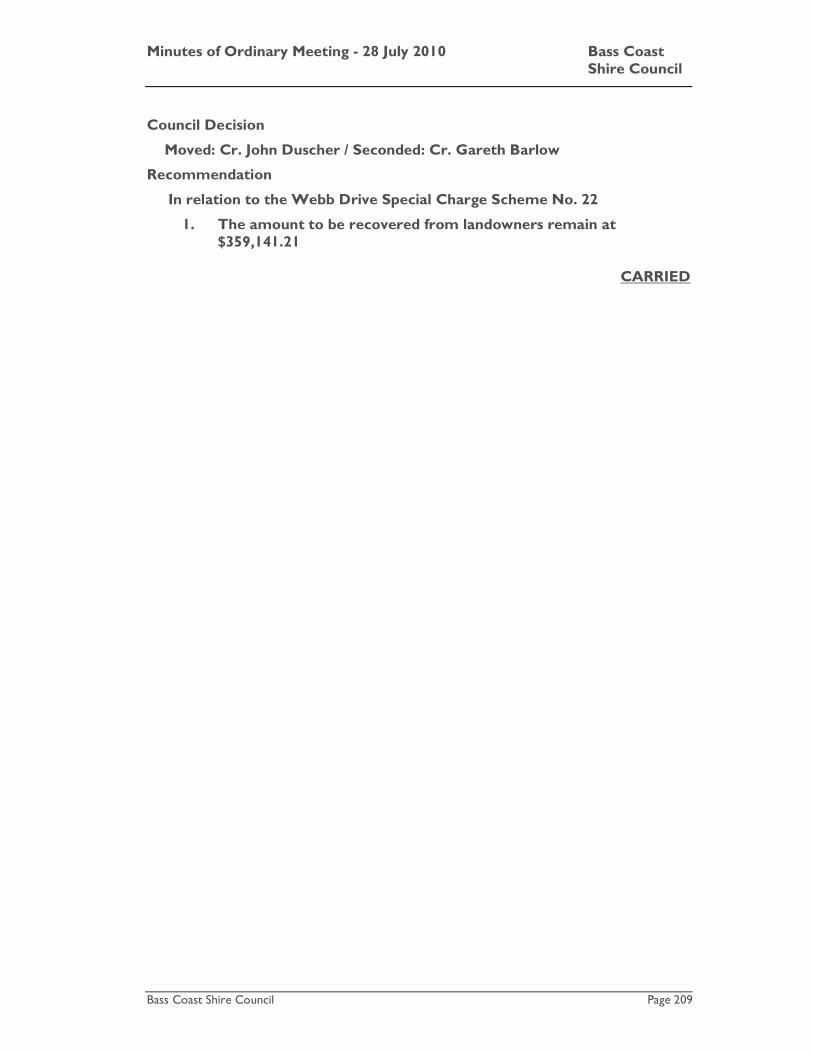
Minutes of Ordinary Meeting - 28 July 2010 Bass Coast Shire Council
Bass Coast Shire Council Page 209
Council Decision
Moved: Cr. John Duscher / Seconded: Cr. Gareth Barlow
Recommendation
In relation to the Webb Drive Special Charge Scheme No. 22
1. The amount to be recovered from landowners remain at $359,141.21
CARRIED

Minutes of Ordinary Meeting - 28 July 2010 Bass Coast Shire Council
Bass Coast Shire Council Page 210
K.9 Land Acquisition - Tenby Point Area Special Charge Scheme No.55
File No: CM10/245 Department: Infrastructure Council Plan Strategic Objective: Cohesive Communities
We will improve lifestyle opportunities and options by managing the built environment and encouraging cohesive communities.
Previous Items: SR4/10 - Land Acquisition - Tenby Point Area Special Charge
Scheme No.55 - Council - 17 March 2010
Declaration
The reporting officer does not have any direct or indirect interests in relation to the issue.
Summary
At the Ordinary Council meeting of 17 March 2010 Council resolved its intention to compulsorily acquire an interest in a strip of land located at 275 Guy Road, Corinella for the creation of a drainage easement. These acquisitions are necessary to construct the works as part of the Tenby Point Area Special Charge Scheme No. 55. Plans of the creation of easement are attached for Council’s information.
A notice of Council’s intention to acquire an interest in these properties was served on the landowners on 31 March 2010. Council is required to acquire the land within six months of serving the notice of intention.
At the time of writing this report a decision from the Victorian Civil and Administrative Tribunal (VCAT) had not been made in relation to the scheme. It should be noted that the VCAT hearing occurred in February this year and Council Officers have regularly followed up with VCAT in relation to a decision. Officers are in the process of writing formally to VCAT requesting a decision.
Regardless of the outcome of the VCAT decision, Council would need to proceed with the easement acquisition and minor works to assist in flood protection of the residential properties located to the east of the large rural farm of 275 Guy Road.
The cost of the acquisition of the easement is valued at $10,000 and will be recovered from the scheme subject to the scheme’s approval by VCAT.
It is recommended that Council proceed with the acquisition process and formally acquire the land to create an easement for the purpose of drainage.

Minutes of Ordinary Meeting - 28 July 2010 Bass Coast Shire Council
Bass Coast Shire Council Page 211
Introduction
After Council resolved its intention to acquire the land, the next step was to notify affected property owners and the Land Titles Office Victoria of this intention.
The notice of intention was forwarded to all those persons with an interest in the land (property owners and mortgagees) and a notice lodged with the Land Titles Office Victoria.
An independent land valuer, m3property(Vic) Pty Ltd Property Strategists, determined the valuation. This detailed the amount of compensation payable in relation to the land values for the affected properties, and is shown in Column 3 of the table below.
The Land Acquisition and Compensation Regulations 1998 requires Council to compensate the landowner for:
1. Value of land and may include amounts for any special value to the landowner of the land acquired (Column 3).
2. Compensation due to disturbance (for instance if the landowner has to move to other land) or an amount for the decrease in value of land which is owned and which is connected with the land which is acquired (Column 4).
The total of the compensation valuation for the property is shown in the following table.
Column 1 Column 2 Column 3 Column 4 Column 5
Title Information
Volume/ Folio
Property Address
Area to be
acquired (m2)
Land Valuation ($)
Other Expenses
($)
Total Offer of Compensation
($)
Lot 2 PS 514759
10939/349 275 Guy Road Corinella
975.4 $1,829 $8,171 $10,000
Note: Council would be required to reimburse any additional costs based on independent legal, valuation or other professional costs, which the landowner has to pay. This may be in the order of $2,000 to $5,000.
The easement is required for the purpose of drainage works associated with the scheme. A shallow grass swale and an earth mound is to be constructed to assist in flood protection of the residential properties located to the east of the large rural farm of 275 Guy Road.
This report is required in order to formalise the commencement of the land acquisition process for the property involved.
Strategic Basis
The construction of road and drainage works for the Special Charge Scheme is consistent with the Council Plan, Municipal Strategic Statement and Urban Streets Improvement Policy.
Minutes of Ordinary Meeting - 28 July 2010 Bass Coast Shire Council
Bass Coast Shire Council Page 212
Finances
Section 187 of the Land Acquisition and Compensation Regulations Act 1998 requires that Council will pay any reasonable expenses, which are paid by the affected landowner. These expenses may include obtaining the help of a solicitor, valuer or other professional adviser. Fees may be in the order of $5,000 to $10,000 per property.
The total of the compensation valuation for the easement is detailed in the table within the Introduction section of this report.
Drainage Easement Acquisition
The value of the easement is related to the value of the land plus costs associated with disturbance and of the land. The total offer of compensation determined from the independent valuation of the land for the creation of the easement is $10,000. The cost of the land acquisition for the creation of the drainage easement is to be fully recovered through the Tenby Point Area Special Charge Scheme No 55.
Stakeholders
The primary stakeholders for the drainage easement will be the property owner(s) of the land to be acquired and the wider community. Preliminary discussions have been held with the affected landowners.
Statutory Requirements/Codes/Standards/Policies
Section 187 of the Local Government Act 1989 gives Council the following power:
• A Council may purchase or compulsorily acquire any land which is, or may be, required by the Council for, or in connection with, or as incidental to, the performance of its function or exercise of its powers.
• Council has the power under the Land Acquisition and Compensation Act to acquire land. The land is required for easement drainage, as part of the special charge scheme.
• Land to be acquired by Council normally requires that the land first is reserved under a planning instrument. A drainage easement or land for minor road widening however can be acquired as long as the value of the unencumbered freehold interest in the land is not reduced by more than ten percent and no more than ten percent of the land can be acquired.
Council has to comply with the following steps to compulsorily acquire an interest in land.

Minutes of Ordinary Meeting - 28 July 2010 Bass Coast Shire Council
Bass Coast Shire Council Page 213
The statutory process may be summarised as follows:
Stage Description Progress
1 Council resolves that it intends to acquire an interest in the land
Completed
2 Serve Notice of Intention to Acquire an Interest in Land in accordance with Section 8(1) and 8(2) of the Land Acquisition and Compensation Act.
Completed
3 Advise the responsible authority in accordance with section 9 of the Land Acquisition and Compensation Act.
Completed
4 Lodge a Notice with the Registrar of Titles in accordance with Section 8(3)(b) and 10(1) of the Land Acquisition and Compensation Act.
Completed
5 Council resolves that it acquires the land
This Stage
6
Place a Notice in the Government Gazette after 2 months and no later than 6 months from issue of the Notice of Intention to Acquire in accordance with Sections 16, 19, 20 and 24 of the Land Acquisition and Compensation Act 1986.
This Stage
7 Place notice of acquisition of Interest in Land in a local newspaper in accordance with Sections 19 and 23 of the Land Acquisition and Compensation Act 1986.
This Stage
8
Serve Notice of Acquisition and make an offer of compensation within 14 days of acquisition (date the Notice appears in Government Gazette) in accordance with Sections 22 and 31.
This Stage
9 Council then deals with disputed claims in accordance with the Land Acquisition and Compensation Act 1986.
Next Stage
Other Options
The acquisition of land for the purpose of drainage easements is required in order to construct drainage works as part of the Special Charge Scheme.
An alternative is to not acquire the land. Consequently the proposed drainage could not be constructed as part of the works. This would affect the flood protection for up to 11 properties.
The 11 properties impacted by this alternative are included within the Special Charge Scheme. These properties are seen to gain benefit from the drainage. Withdrawing these sections of the drainage from the scheme would mean that Council could not charge these properties for costs associated for a drainage benefit.
Based on this, it is recommended to acquire the land for the purpose of drainage easement.

Minutes of Ordinary Meeting - 28 July 2010 Bass Coast Shire Council
Bass Coast Shire Council Page 214
Officer’s Comments/Conclusion
The acquisition of the land would enable the construction of low impact drainage works as part of the special charge scheme. The creation of the easement is necessary to legally allow the construction of this infrastructure.
It should be noted that appeals were lodged with the Victorian Civil Administrative Tribunal (VCAT) in relation to the Special Charge Scheme. The hearing was held in February 2010 and a decision has not yet been handed down. The decision should not have an impact on whether the scheme proceeds, but may have a decision about the level of special benefit received by the applicants.
Regardless of the outcome of the VCAT decision, Council would proceed with the easement acquisition and minor works to assist in flood protection of the residential properties located to the east of the large rural farm of 275 Guy Road.
It is recommended that Council proceed with the acquisition of the easement and an offer of compensation is made to the landowner.
Recommendation
Council resolve to:
1. Acquire an interest in the land as shown in Schedule 1 below from the owner of the properties shown in Column 1 for drainage purposes identified in Column 6 for those properties.
2. In accordance with Sections 16, 19, 20, 21, 22 and 23 of the Land Acquisition and Compensation Act 1986, advertise the notice of acquisition in the Government Gazette and the South Gippsland Sentinel Times and serve the notice of acquisition on the persons whom the Notice of Intention to Acquire was served and any other person who had an interest in the land.
3. In accordance with Section 31 of the Land Acquisition and Compensation Act 1986, that the compensation as shown in Column 5 of Schedule 1 be offered to the owner(s) of the property shown in Column 1 of Schedule 1.
Schedule 1
Column 1 Column 2
Column 3 Column 4 Column 5 Column 6
Title Information
Volume/ Folio
Property Address
Area to be
acquired (m2)
Total Offer of Compensation
($)
Land Valuation
($)
Other Expenses
($)
Interest Acquired
Lot 2 PS 514759
10939/349 275 Guy Road Corinella
975.4 $1,829 $8,171 $10,000 Drainage Easement
Attachments
AT-1 CONFIDENTIAL - Valuation Report 46 Pages AT-2 Creation of easement plan 2 Pages

Minutes of Ordinary Meeting - 28 July 2010 Bass Coast Shire Council
Bass Coast Shire Council Page 215
Council Decision
Moved: Cr. Veronica Dowman / Seconded: Cr. Gareth Barlow
Recommendation
Council resolve to:
1. Acquire an interest in the land as shown in Schedule 1 below from the owner of the properties shown in Column 1 for drainage purposes identified in Column 6 for those properties.
2. In accordance with Sections 16, 19, 20, 21, 22 and 23 of the Land Acquisition and Compensation Act 1986, advertise the notice of acquisition in the Government Gazette and the South Gippsland Sentinel Times and serve the notice of acquisition on the persons whom the Notice of Intention to Acquire was served and any other person who had an interest in the land.
3. In accordance with Section 31 of the Land Acquisition and Compensation Act 1986, that the compensation as shown in Column 5 of Schedule 1 be offered to the owner(s) of the property shown in Column 1 of Schedule 1.
Schedule 1
Column 1 Column 2
Column 3 Column 4 Column 5 Column 6
Title Information
Volume/ Folio
Property Address
Area to be
acquired (m2)
Total Offer of Compensation
($)
Land Valuation
($)
Other Expenses
($)
Interest Acquired
Lot 2 PS 514759
10939/349 275 Guy Road Corinella
975.4 $1,829 $8,171 $10,000 Drainage Easement
CARRIED

Minutes of Ordinary Meeting - 28 July 2010 Bass Coast Shire Council
Bass Coast Shire Council Page 216
K.10 Proposed exchange of land between Council and Country Fire Authority - Wonthaggi
File No: CM10/281 Department: Infrastructure Council Plan Strategic Objective: We will manage our resources
effectively, keep the community engaged, listen to our communities' concerns to create positive outcomes.
Good Governance
Declaration
The author of this report has no direct or indirect interest in relation to this issue.
Summary
This report deals with a proposed exchange of land between Council and the Country Fire Authority (CFA).
The Council owned land is a vacant block at 99-103 White Rd, Wonthaggi. The CFA owned land is the current Wonthaggi Fire Station at 76 Watt St, Wonthaggi. The purpose of the exchange is to allow the CFA to construct a new and much larger Fire Station in Wonthaggi. The location of the properties is shown on the attached plan (AT-1).
The CFA approached Council in December 2007 to initiate discussion regarding an alternative fire station site in Wonthaggi as the current premises would not meet the future needs of the community.
A number of sites were identified and over the period from late 2007 until earlier this year. This involved a number of meetings between Council Officers and the CFA.
This culminated in a recent request from the CFA to exchange Council’s land in White Road for the current CFA site in Watt Street. The exchange is proposed on a cost neutral basis with the CFA remaining at the site for a further two years and the CFA being able to relocate minor buildings and fixtures to the new site.
Given that there is a significant public benefit to be gained from the development of a modern fire station in Wonthaggi and that the exchange is proposed on a cost neutral basis, it is recommended that Council approve the exchange of land, and authorise Council staff to take the necessary action to facilitate the exchange.
Introduction
In December 2007 CFA’s Acting General Manager for the Westernport Area wrote to Council asking to initiate discussions in relation to a possible new Fire Station for Wonthaggi. As he outlined in the introductory paragraph to his letter:
“The existing Wonthaggi fire station has been located on Watt Street since 1962 and with subsequent extension and refurbishment over the years has served the Brigade and the Bass Coast community well. Nevertheless, given the extent of development in the greater Wonthaggi area and the town clearly emerging as an activity hub for the region, in addition to the changing
Minutes of Ordinary Meeting - 28 July 2010 Bass Coast Shire Council
Bass Coast Shire Council Page 217
and specialised needs of the Brigade, it has become evident that a new fire station is required to properly service the future needs of the community.”
The letter went on to suggest a number of possible alternative sites that local Brigade members felt might be suitable, and to request a meeting with senior Council staff to discuss a possible course of action.
Through 2008 and 2009 further meetings, discussions and correspondence have progressed, to the point that CFA and Council Officers now believe that they have identified a suitable new site for a re-developed Wonthaggi Fire Station, and an appropriate mechanism by which this proposal might be achieved.
The suggested site is on Council owned land at 99-103 White Road, Wonthaggi (see attached Location Plan). This is an undeveloped vacant block with an area of 5,293 square metres. The land is currently zoned Industrial (IN1Z). Given the projected growth for Wonthaggi, the site will be near the geographic centre of Wonthaggi within a relatively short period. It is located on a main road, with ready access to the Bass Highway.
The suggested mechanism is an exchange of land between Council and CFA as outlined in a letter from Mr Peter Schmidt, General Manager, CFA Westernport Area to Council dated 16 February 2010. A copy of this letter is attached (AT-2). The proposal is that Council exchange the land owned by it at 99-103 White Road for the current CFA site at 76 Watt Street.
After receiving the February letter from the CFA Council Officers continued discussions with the CFA to clarify a number of issues including the valuations of the two parcels of land, the likely timeframe that the CFA would need to remain at its current location and technical details regarding how the transfer might proceed.
This resulted in the CFA approaching Council with a formal request that the exchange proceed (letter dated 14 May 2010 from Mr Peter Schmidt, General Manager, CFA Westernport Area attached at AT-3 refers).
Independent valuers acting under the instructions of the Valuer-General Victoria have assessed the current market value of the two properties. The property at 76 Watt Street (currently occupied by CFA) has been valued at $886,000, and that at 99-103 White Road (Council’s property) at $900,000.
The CFA proposal is that the two properties be exchanged with the difference in valuation ($14,000) that would otherwise be payable by it to Council being discounted for reasons outlined in Mr Schmidt’s letter of 14 May 2010. This issue is discussed in further detail below.
The CFA also requires the ability (by means of a licence or the like) to remain in occupation of the Watt Street site following the exchange (should it proceed) until such time as the new Fire Station is completed and they are in a position to re-locate to it. They estimate that two years would be a sufficient period for their purposes.

Minutes of Ordinary Meeting - 28 July 2010 Bass Coast Shire Council
Bass Coast Shire Council Page 218
Strategic Basis
The Vision for Council’s asset management function (as stated in the Asset Management Policy initially adopted by Council in 2002, and the revised Asset Management Policy and Asset Management Improvement Strategy 2006-2008 adopted by Council at its Ordinary Meeting on 13 December 2006) is that:
“We will provide and maintain assets in a sustainable manner to improve the quality of life and safety of the Bass Coast Community.”
Council seeks to achieve this vision by ensuring that (among other strategies):
• All Council assets exist to support service delivery or enhance the environment and/or quality of life of the residents.
• All assets are created, acquired, maintained, rehabilitated or made obsolete to enable Council to meet its Council Plan strategies and objectives.
• All Council asset management activities will take place within a strategic framework that it driven by service delivery needs within resource limitations.
The Council owned land at 99-103 White Road fulfils no service delivery role at present. It is simply a large vacant block of land.
Council has not identified an alternative use for the current Wonthaggi Fire Station site at 76 Watt Street but, given its location, zoning, etc it would be readily marketable should it need to be sold in the future.
It is well located for alternative uses by Council should such a use be identified in the future. Council’s car park in Graham Street is located on the opposite side of the laneway to the CFA site.
In the short to medium term, once the CFA have vacated the site, it could be utilised for overflow car parking or alternatively leased for another business use.
Finances
As stated above, the property at 76 Watt Street (currently occupied by CFA) has been independently valued at $886,000, and that at 99-103 White Road (Council’s property) at $900,000.
Ordinarily, Council could expect to be paid the difference between these valuations (i.e. $14,000), as it is exchanging a higher value property for a lower value one. CFA has argued that, as the White Road site is not connected to sewerage, that the $14,000 should be offset by the likely cost of installing the required connection (see Mr Schmidt’s letter of 14 May 2010 – AT-3). With respect to Mr Schmidt, the flaw with this argument is that the valuer has already “… given some weight to the issue of lack of sewerage services to the subject property and unknown cost to provide”. So a further discount would represent ‘double counting’.
However, on balance Council staff recommend that the exchange be completed on a cost neutral basis for the two parties, for reasons discussed in Officer’s Comments/Conclusion below.
Minutes of Ordinary Meeting - 28 July 2010 Bass Coast Shire Council
Bass Coast Shire Council Page 219
Stakeholders
Council, CFA, other emergency service providers, the owners of other properties in the vicinity of the two sites, the wider Wonthaggi and Bass Coast Shire communities, and ratepayers in general have an interest in the matter.
Statutory Requirements/Codes/Standards/Policies
Section 189 of the Local Government Act 1989 sets out the requirements which must ordinarily be met for Council to sell or exchange land:
• The proposed sale or exchange must be advertised at least four weeks prior to sale.
• Council must obtain a valuation for the land not more than six months prior to sale.
• Council must formally consider any submission received.
However, in this instance Section 191 of the Local Government Act applies to the proposed exchange. This section provides for Council to undertake an exchange “with or without consideration” with a range of entities including a “public body”. If Council is exchanging land in accordance with Section 191 of the Act the usual requirements of Section 189 do not apply.
The Local Government Act defines a “public body” as “… any government department or municipal council or body established for a public purpose by an Act of the Parliament of Victoria, any other State or Territory of the Commonwealth, of the Commonwealth”.
The Corporate Counsel/Executive Manager Governance of CFA has confirmed that it is a “public body” as defined in the Act. Specifically, she advises that:
“CFA is a statutory corporation pursuant to section 6 of the Country Fire Authority Act 1958. Its role and function is the prevention and suppression of fires in the country area of Victoria and the protection of life and property. … It is a body corporate with perpetual succession and a common seal and is capable of suing and being sued (section 6(2)). It fits the definition of “public body” in the Local Government Act 1989.”
So public notice of the proposed exchange is not required to be given. However, as section 191 applies, the exchange still needs to be undertaken in accordance with the Victorian Government’s Local Government Guideline for the Sale, Exchange & Transfer of Land – June 2009. These guidelines were introduced in order to provide Councils with an outline of the process to be followed in relation to the sale or exchange of land by local government.
They require that where a council and a government agency are proposing to transact a private treaty sale for land, the Government Land Monitor’s policy needs to be followed in relation to the transaction and valuations. CFA has ensured that the proposed exchange does meet the Government Land Monitor’s requirements – hence the involvement of the Valuer-General Victoria to value the land and advise on the transaction.

Minutes of Ordinary Meeting - 28 July 2010 Bass Coast Shire Council
Bass Coast Shire Council Page 220
Other Options
A range of other options have been considered and discussed between Council and CFA as this matter has progressed. Other potential sites have been considered, but all were found to be inferior to that at 99-103 White Road. Other forms of tenure were also considered (principally the possibility of CFA leasing the White Road site and selling 76 Watt Street to finance construction). Following considerable (and very positive and constructive) discussion and consideration Council officers and CFA Officers are of the view that the proposal now before Council offers the best outcome for all stakeholders.
Officer’s Comments/Conclusion
It is clear to both Council and CFA Officers that the current CFA site in Watt Street is too small to accommodate this vital service in a growing town. CFA has occupied the site since 1962 when Wonthaggi was a very different town to what it is today. Subsequent extensions and additions have helped the Wonthaggi Fire Station meet the needs of the township and surrounding area, but it has now reached a point where a new Fire Station is required.
The proposed exchange of land provides an opportunity for CFA to construct a new Fire Station, but it also provides an opportunity for a more central location for the new Fire Station. Also, the proposed new, larger site would allow for further expansion in the future should it be required.
The proposed new CFA site in White Road was one of two large industrial lots purchased from the Crown by Council in the late 1990s with a view to potential industrial use. No such industrial use has since been identified, but in any case, one of these lots (i.e. that at 105-107 White Road) remains in Council’s ownership for such a use should the opportunity arise in the future.
Exchanging the land at 99-103 White Road for that at 76 Watt Street not only allows for a new Wonthaggi Fire Station, it also allows Council to acquire a potentially strategically valuable piece of land in the Wonthaggi CBD.
As mentioned in earlier in the report the normal statutory process of calling for submissions in relation to a proposed exchange of land is not required in this instance, as the proposed exchange is with a public body.
The landowners in the area near the Council owned land in White Road may be aggrieved that they are denied the opportunity to make a submission to Council in relation to the proposal. Given that there is a significant public benefit to be gained from the development of a modern fire station in Wonthaggi, that will meet the needs of future generations, it is appropriate that Council undertake the exchange without a submission process (as allowed by legislation).
It would appear that the only remaining issue of concern is that of the difference in valuation between the two properties. However it may well be that this difference is ‘academic’ rather than actual. The independent valuer’s assessment of the current market value of the current CFA site at 76 Watt Street as $886,000 was straightforward and non-controversial.
Assessing the market value of the Council owned site at 99-103 White Road was less straightforward. One valuer valued the property at $795,000, and another valued it at $1,000,000. A Valuers’ conference was held under the auspices of the Valuer-General Victoria, which arrived at a valuation of $900,000, but noted the difficulty of

Minutes of Ordinary Meeting - 28 July 2010 Bass Coast Shire Council
Bass Coast Shire Council Page 221
assessing the value of the block due to the “… very limited comparable sales evidence of directly comparable land of this size and zoning”. Further attempts to value the property could well arrive at values higher or lower than the valuation for 76 Watt Street.
On balance Council officers recommend that the exchange proceed on a cost neutral basis, with both parties meeting their own legal, survey, administrative and other expenses associated with the transaction.
It is also recommend that the CFA be permitted to remain in occupation of their current site for a period of up to two years after the exchange so that they can continue to service the township and surrounds during the construction period – as they have requested. However, with a view to ensuring that the proposed re-location takes place without undue delay, it is proposed that the Licence period be strictly limited to two years, with CFA being charged a market rent for the Watt Street site should they not have vacated it in that timeframe.
CFA has also requested that they be permitted to remove and relocate some or all of the sheds and the like at the rear of the site for use elsewhere. As Council has no plans for the use of these buildings, Council officers have no objection to this proposal.
Recommendation
That Council: 1. Authorises the exchange of land owned by Council at 99-103 White
Road, Wonthaggi (Crown Allotment 34B Section 117 Township of Wonthaggi) for land owned by the Country Fire Authority at 76 Watt Street, Wonthaggi (Crown Allotments 17 (part – TP450453) & 18 Section 6 Township of Wonthaggi) for the purpose of developing a new Fire Station for Wonthaggi.
2. Directs that the exchange be on a cost neutral basis (i.e. at no net cost to either party), and that each party be responsible for its own legal, survey, administrative and similar costs associated with the transaction.
3. Directs that the CEO write to the Country Fire Authority offering to exchange the land and providing the Authority with 90 days to accept the offer.
4. Allows the Country Fire Authority to remain in occupation of the site at 76 Watt Street, Wonthaggi for a period of two years from the date of the acceptance of the offer to exchange the land.
5. That a Licence or similar agreement is negotiated between Council and the Country Fire Authority, with no Licence Fee or other cost to the Authority, for the Authority to remain at the site.
6. Directs that, unless Council’s Chief Executive Officer is satisfied that any delay in construction and/or relocation is due to circumstances beyond the control of the Country Fire Authority, that the Authority will be required to pay an independently assessed market rental for the 76 Watt Street site should it not have vacated it by the end of the two year Licence period until such time as it vacates the Watt Street site.

Minutes of Ordinary Meeting - 28 July 2010 Bass Coast Shire Council
Bass Coast Shire Council Page 222
7. Allows the Country Fire Authority to remove from the site such minor buildings, fixtures and fittings as it wishes prior to vacating the site (subject to the site being left in a safe state, and with the remaining buildings on site being weather proof and secure).
8. Authorises Council officers to take all necessary action to implement this resolution, and to continue negotiations with the Country Fire Authority with the objective of progressing the proposed construction of a new Fire Station for Wonthaggi.
Attachments
AT-1 Location Plan 1 Page AT-2 CFA Letter - 16 February 2010 1 Page AT-3 CFA letter - 14 May 2010 1 Page Council Decision
Moved: Cr. John Duscher / Seconded: Cr. Veronica Dowman
Recommendation
That Council: 1. Authorises the exchange of land owned by Council at 99-103 White
Road, Wonthaggi (Crown Allotment 34B Section 117 Township of Wonthaggi) for land owned by the Country Fire Authority at 76 Watt Street, Wonthaggi (Crown Allotments 17 (part – TP450453) & 18 Section 6 Township of Wonthaggi) for the purpose of developing a new Fire Station for Wonthaggi.
2. Directs that the exchange be on a cost neutral basis (i.e. at no net cost to either party), and that each party be responsible for its own legal, survey, administrative and similar costs associated with the transaction.
3. Directs that the CEO write to the Country Fire Authority offering to exchange the land and providing the Authority with 90 days to accept the offer.
4. Allows the Country Fire Authority to remain in occupation of the site at 76 Watt Street, Wonthaggi for a period of two years from the date of the acceptance of the offer to exchange the land.
5. That a Licence or similar agreement is negotiated between Council and the Country Fire Authority, with no Licence Fee or other cost to the Authority, for the Authority to remain at the site.
6. Directs that, unless Council’s Chief Executive Officer is satisfied that any delay in construction and/or relocation is due to circumstances beyond the control of the Country Fire Authority, that the Authority will be required to pay an independently assessed market rental for the 76 Watt Street site should it not have vacated it by the end of the two year Licence period until such time as it vacates the Watt Street site.
7. Allows the Country Fire Authority to remove from the site such minor buildings, fixtures and fittings as it wishes prior to vacating the site

Minutes of Ordinary Meeting - 28 July 2010 Bass Coast Shire Council
Bass Coast Shire Council Page 223
(subject to the site being left in a safe state, and with the remaining buildings on site being weather proof and secure).
8. Authorises Council officers to take all necessary action to implement this resolution, and to continue negotiations with the Country Fire Authority with the objective of progressing the proposed construction of a new Fire Station for Wonthaggi.
CARRIED UNANIMOUSLY
Minutes of Ordinary Meeting - 28 July 2010 Bass Coast Shire Council
Bass Coast Shire Council Page 224
K.11 Proposed discontinuance of roads and exchange of land - Vicars Avenue, North Wonthaggi
File No: CM10/290 Department: Infrastructure Council Plan Strategic Objective: Good Governance
We will manage our resources effectively, keep the community engaged, listen to our communities' concerns to create positive outcomes.
Declaration
The author of this report has no direct or indirect interest in this issue.
Summary
This report deals with the proposed discontinuance of unused roads, and a consequential exchange of land, in order to facilitate a proposed subdivision development immediately to the north of Vicars Avenue, North Wonthaggi. The location of the site is shown on the plan at AT-1.
The Road Reserves in question are ‘paper roads’ dating back to the original 1912 subdivision. They are lanes in that subdivision that have never been constructed or used in any way. The proposal is that they be exchanged for the land which will be used for new roads in the development.
This report recommends that Council resolve to commence the exchange process, give public notice to that effect, and call for submissions on the matter.
Introduction
For some time consultants acting for the owners of a large site to the north of Vicars Avenue, North Wonthaggi have been in discussion with Council in relation to a proposed subdivision of the site.
The location of the site is shown on the attached Location Plan (AT-1).
Council considered the question of a proposed subdivision development of this site at its Ordinary Meeting of 21 April 2010 (Item I.7 refers) when it resolved (in summary) to rezone the site from Low Density Residential Zone to Residential 1 Zone as part of Amendment C101 to the Bass Coast Planning Scheme.
The site in question has been used for agricultural purposes, mainly grazing, for many years (probably since the area was originally settled), and the roads have never actually existed on the ground.
In order to facilitate the subdivision (the proposed layout of which is shown at AT-2) the proponent has asked Council to consider exchanging the land from those of the unused ‘paper roads’ from the original 1912 subdivision of the land that will not be required in the new subdivision, for the land to be used for new or widened roads within the subdivision.
The proposed road exchange is illustrated by the plan at AT-3 below.

Minutes of Ordinary Meeting - 28 July 2010 Bass Coast Shire Council
Bass Coast Shire Council Page 225
The roads proposed to be discontinued and disposed of by Council have an area of 1,491 square metres and were independently valued in April 2010 at $9,000.
The new roads proposed in the subdivision, which will vest in Council, have an area of 3,739 square metres and were independently valued in April 2010 at $22,500.
The area of the land proposed to be acquired by Council is greater than the land that it is proposed dispose of (by 2,248 square metres), and has a higher value (by $13,500) as independently assessed.
Strategic Basis
The Vision for Council’s asset management function (as stated in the Asset Management Policy initially adopted by Council in 2002, and the revised Asset Management Policy and Asset Management Improvement Strategy 2006-2008 adopted by Council at its Ordinary meeting on 13 December 2006) is that:
“We will provide and maintain assets in a sustainable manner to improve the quality of life and safety of the Bass Coast Community.”
Council seeks to achieve this vision by ensuring that (among other strategies):
• all Council assets exist to support service delivery or enhance the environment and/or quality of life of the residents
• all assets are created, acquired, maintained, rehabilitated or made obsolete to enable Council to meet its Corporate Plan strategies and objectives
• all Council asset management activities will take place within a strategic framework that is driven by service delivery needs within resource limitations.
The roads proposed to be discontinued and exchanged fulfil no service delivery function for the community as they have never been constructed or used.
The consensus view of Council staff is that the proposed discontinuance and exchange is consistent with, and will help to facilitate, the proposed development of the site as envisaged in Amendment C101 to the Bass Coast Planning Scheme.
Finances
While the land to be acquired by Council has been valued at $13,500 more than the property it is proposed to be exchanged for, there is no suggestion (and has been no request that) the developer be reimbursed for the difference.
Council’s legal, survey and administrative costs will be met by the standard Administration Fee of $1,000 (plus GST) payable by the applicant.
Stakeholders
Council, nearby property owners, the wider North Wonthaggi community, and ratepayers in general have an interest in the matter.
Minutes of Ordinary Meeting - 28 July 2010 Bass Coast Shire Council
Bass Coast Shire Council Page 226
Statutory Requirements/Codes/Standards/Policies
Section 189 of the Local Government Act 1989 sets out the requirements which must be met if Council is to sell or exchange land:
• the proposed sale or exchange must be advertised at least four weeks prior to sale
• Council must obtain a valuation for the land not more than six months prior to sale
• Council must formally consider any submission received.
Council policy is that land be sold at, or exchanged on the basis of, a current market valuation and subject to payment of an Administration Fee of $1,000, unless there are sound public policy reasons to do otherwise.
As explained above, in there is no element of a ‘sale’ by Council in this case as the land it is acquiring has a higher value than the land it is disposing of, the proposal is that the land currently set aside for roads be exchanged for the land forming a more appropriate and ‘modern’ alignment for the roads within the development.
Other Options
Council may choose not to exchange the land in question.
Officer’s Comments/Conclusion
It would appear that the proposed discontinuance of unused ‘paper roads’ and the exchange of land offers an opportunity for more efficient use of the land in the site, and improved amenity for the future residents of the area in question.
It would seem to be entirely reasonable to give the wider community notice of the proposed discontinuance and exchange and to call for submissions that can be considered by Council before a final and binding decision is made.

Minutes of Ordinary Meeting - 28 July 2010 Bass Coast Shire Council
Bass Coast Shire Council Page 227
Recommendation
1. That Council being of the opinion that the roads shown in blue on the attached plan (AT-3) are not reasonably required as roads for public use that the roads be discontinued and the land from the roads be transferred to Council.
2. That as the land shown in blue on the attached plan (AT-3) is not required for public purposes, that it be exchanged for that shown in purple on that plan.
3. That Council give notice, by means of a public notice placed in the South Gippsland Sentinel Times of its intention to discontinue the roads shown blue on the attached plan (AT-3) and exchange this for the area of land shown purple on the attached plan (AT-3) and invite submissions to be considered in accordance with Section 223 of the Local Government Act 1989.
4. That the public notice referred to in point 3 above be published following payment by the proponent of the first $500 (plus GST) instalment of Council’s standard Administration Fee of $1,000 (plus GST).
Attachments
AT-1 Location Plan AT-2 Subdivision layout (proposed) AT-3 Proposed road discontinuance and exchange
plan
Council Decision
Moved: Cr. Gareth Barlow / Seconded: Cr. Veronica Dowman
Recommendation
1. That Council being of the opinion that the roads shown in blue on the attached plan (AT-3) are not reasonably required as roads for public use that the roads be discontinued and the land from the roads be transferred to Council.
2. That as the land shown in blue on the attached plan (AT-3) is not required for public purposes, that it be exchanged for that shown in purple on that plan.
3. That Council give notice, by means of a public notice placed in the South Gippsland Sentinel Times of its intention to discontinue the roads shown blue on the attached plan (AT-3) and exchange this for the area of land shown purple on the attached plan (AT-3) and invite submissions to be considered in accordance with Section 223 of the Local Government Act 1989.
4. That the public notice referred to in point 3 above be published following payment by the proponent of the first $500 (plus GST) instalment of Council’s standard Administration Fee of $1,000 (plus GST).
CARRIED

Minutes of Ordinary Meeting - 28 July 2010 Bass Coast Shire Council
Bass Coast Shire Council Page 228
K.12 Recreation Reserve at 16 Wallace Avenue, Inverloch
File No: CM10/288 Department: Infrastructure Council Plan Strategic Objective: Good Governance
We will manage our resources effectively, keep the community engaged, listen to our communities' concerns to create positive outcomes.
Declaration
The author of this report has no direct or indirect interest in this issue.
Summary
This report deals with a small Recreation Reserve at 16 Wallace Avenue, Inverloch.
This Reserve was previously identified as being surplus to Council’s requirements, largely because its small size and inconvenient location were thought to be such that it does not meet Council’s criteria for the development of recreational facilities.
Council considered a report on this matter at its Ordinary Meeting of 17 February 2010 (Item 1.9 refers), and resolved to initiate the statutory processes required to allow for the sale of this property, and to give public notice of the proposed sale in order to allow for further consideration of the matter. Council also appointed a Committee of Councillors to consider submissions in response to the public notice.
The required public notice has been given and a number of submissions have been received, including a group submission made direct and in person to the Committee of Council. The Committee has considered all of the submission made, and recommends that the site remain in Council ownership as an area of public open space for passive recreation. The Committee makes further recommendations in relation to this site, parking and traffic in the vicinity, and the wider issue of playgrounds in the Inverloch area.
Introduction
At its Ordinary Meeting of 15 October 2008 Council resolved that:
“A report is presented to Council detailing the status of unused land and road reserves in Inverloch that are not being actively managed for community purposes.”
Following that meeting Council officers reviewed Council’s land holdings in Inverloch, and a further report was considered by Council at its Ordinary Meeting of 28 January 2009. The report identified two properties in Inverloch that might meet the description in the earlier Council resolution – one of these properties was that at 16 Wallace Avenue, Inverloch. At the 28 January 2009 meeting Council resolved:
“That Council notes the report and authorises Council officers to proceed with such further investigation and consultation that may be required to obtain the information necessary to allow Council to make appropriate decisions
Minutes of Ordinary Meeting - 28 July 2010 Bass Coast Shire Council
Bass Coast Shire Council Page 229
with respect to the retention or disposal of Averne Street, Inverloch and 16 Wallace Avenue, Inverloch.”
This report outlines the further investigation and consultation that has taken place with respect to 16 Wallace Avenue, Inverloch.
As shown by the attached Location Plan (AT-1), the property at 16 Wallace Avenue, is a 1,098 square metre residential allotment at the court bowl end of a dead end street.
It was not created as a Recreation Reserve in the relevant Plan of Subdivision (LP147786), but as a residential allotment (Lot 4). It was acquired by the former Shire of Woorayl on 8 December 1987, 2½ years after registration of the Plan of Subdivision.
While it is zoned appropriately for a Recreation Reserve (PPRZ – Public Park Recreation), neither the former Shire of Woorayl nor the current Council have developed the site in any way. For over twenty years it has simply been an area of roughly mown grass. More recently bollards have been erected across the front of it to prevent a neighbouring property owner from using it for parking.
Following Council’s resolution on 28 January 2009, an informal poll of the owners of all other properties along Wallace Avenue was undertaken. This poll was to ascertain if they might support disposal, or had other comments to make on the matter. A simple ‘tick box’ questionnaire (with an opportunity to make further comment should the respondent choose to do so) was sent to 18 households. Twelve questionnaires were returned (a 66.7% response rate).
Of the 12 responses, two supported disposal, nine were opposed, and one response was a “maybe” indicating that Council should retain the land, but only if it could be used for a “useful” purpose.
Those in favour of retention consistently argued that it should be developed as a play ground and not simply continue to be an area of mown grass. Many pointed to the lack of public open space to the east of Williams Street, and the number of children in the area that often played in the street due to a lack of an alternative. Some also commented on a perceived shortage of parking in the area. One more detailed response stated that 16 Wallace Avenue was one of three areas of land acquired by the former Shire of Woorayl to offset the loss of Apex Park in Williams Street for community housing.
Council’s Arts & Leisure Department has advised that there is no realistic chance that the development of this site as a playground could ever be justified. Council’s Open Space Plan sets a minimum size of 1 hectare (10,000 square metres) for a local level social family recreation park (16 Wallace Avenue has an area of 1,098 square metres). Its location at the end of a court would also make it inappropriate for such development. A standard playground would cost in the order of $60,000. There are currently 39 playgrounds in the Shire, each of which has a life before replacement of 5 years. Council’s current budget for playgrounds is fully committed with the replacement program for the existing playgrounds and has no capacity to add to their number.
To meet the requirements of the Local Government Act 1989 with respect to the proposed sale of property, an independent valuation was obtained for the property. Based on the assumption that the property was rezoned as Residential (from its

Minutes of Ordinary Meeting - 28 July 2010 Bass Coast Shire Council
Bass Coast Shire Council Page 230
current zoning of Public Park & Recreation) prior to sale, the market value of the land was assessed at $270,000.
At its Ordinary Meeting of 17 February 2010 Council considered a report on this matter (Item I.9 refers) and resolved:
“1. That Council being of the opinion that the property at 16 Wallace
Avenue, Inverloch (Lot 4 LP147786) is not required for Council purposes directs that the statutory procedures required by the Local Government Act 1989 be commenced to sell the property and that under Section 223 of that Act public notice of the proposed sale be given by means of a notice published in the South Gippsland Sentinel Times.
2. The proposed sale is subject to the following conditions:
• The property is to be sold on the open market for not less than the independently assessed market valuation.
• The owners of all other properties in Wallace Avenue and Phillip Street are sent a copy of the text of the public notice referred to above and advised of their right to make a submission on the matter.
3. That Council provides “in-principle” support for the land to be rezoned from Public Park Recreation Zone to Residential 1 Zone and enables consultation on the rezoning to occur concurrently with the consultation on the sale of the land and prior to the official commencement of the rezoning process.
4. Council considers submissions in relation to the proposed rezoning of the land as part of the public submission process for the proposed sale of the land.
5. Council nominate a Committee of three Councillors to consider any submissions made in accordance with Section 223 of the Local Government Act.”
Councillors Paul, Duscher and Smith were appointed to the Committee at that meeting.
The required public notice was published in the South Gippsland Sentinel Times on 30 March 2010, and a number of written submissions were received in response to the notice. Following coverage of the issue in the local press in the period between the Council meeting and publication of the notice, two letters were received which were also treated as submissions on the matter. Copies of all written submissions are attached (AT-2 and AT-3).
The Committee of Council appointed at the meeting of 17 February 2010 met on 7 June 2010 to consider the written submissions, and to hear directly from those submitters who wished to speak to the Committee in person. Cr Paul was unavailable on 7 June and his place was taken by Cr Barlow. The minutes of the meeting are attached (AT-4), together with the text of a verbal submission made (AT-5), a presentation made at the meeting by Council’s Recreation & Leisure Planner (AT-6), and a letter received from the Rotary Club of Inverloch offering the assistance

Minutes of Ordinary Meeting - 28 July 2010 Bass Coast Shire Council
Bass Coast Shire Council Page 231
of both Rotary and Lions in the development of recreation facilities in Inverloch (AT-7).
The Committee has considered all submissions received and made, and recommends that the site remain in Council ownership as an area of public open space for passive recreation. The Committee makes further recommendations in relation to this site, parking and traffic in the vicinity, and the wider issue of playgrounds in the Inverloch area.
The reasoning behind these recommendations is discussed in Officer’s Comments/Conclusions below.
Strategic Basis
The Vision for Council’s asset management function (as stated in the Asset Management Policy initially adopted by Council in 2002, and the revised Asset Management Policy and Asset Management Improvement Strategy 2006-2008 adopted by Council at its Ordinary meeting on 13 December 2006) is that:
“We will provide and maintain assets in a sustainable manner to improve the quality of life and safety of the Bass Coast Community.”
Council seeks to achieve this vision by ensuring that (among other strategies):
• all council assets exist to support service delivery or enhance the environment and/or quality of life of the residents
• all assets are created, acquired, maintained, rehabilitated or made obsolete to enable council to meet its corporate plan strategies and objectives
• all council asset management activities will take place within a strategic framework that is driven by service delivery needs within resource limitations
The proposal to sell the land was based on Council’s strategies in relation to public open space and the development of recreational infrastructure to meet the needs of the community. Council Officers were of the opinion that the funds from the sale of the land could have been invested in the recreation reserve fund and retained by Council for future investments in recreational infrastructure. This would have been consistent with the original intent of Council, in relation to the purchase of the land for public open space to meet the recreational needs of the community.
The strategic justification, from an asset management perspective, for retention of a relatively small parcel of land, that serves a catchment of less than 100 properties, is limited.
The Recreation Reserve at 16 Wallace Avenue, Inverloch currently fulfils no service delivery function for the wider community. It has largely been unused (except for parking by abutting property owners, and by local children to play when the state of the grass has allowed) for over twenty years.
As outlined above, expenditure in the order of $60,000 would be required to equip a playground of the sort that would meet the relevant standards.
However, taking account of the submissions received and presented the Committee of Council believes that local community involvement and enthusiasm can be harnessed in order to provide a useful resource for the residents of Wallace Avenue and the surrounding area.

Minutes of Ordinary Meeting - 28 July 2010 Bass Coast Shire Council
Bass Coast Shire Council Page 232
Finances
If the property were to be sold at the current market valuation as assessed by an independent valuer, Council could expect to receive at least $270,000 from the sale. However, expenses such as agent commission, administrative costs, advertising, and other costs would have to be deducted from the gross revenue.
However, the recommendation below is that the site be retained for passive recreational use, with the local community invited to prepare draft landscape plans, as well as plans for their involvement in the ongoing maintenance of the site.
The cost implications of this proposal cannot be assessed until such time as these plans are prepared, but should not be excessive and will be considered through Council’s budgetary process in the usual way.
Stakeholders
Council, nearby property owners, the Inverloch community (particularly those in the north-eastern part of the township), and ratepayers in general have an interest in the matter.
Statutory Requirements/Codes/Standards/Policies
Section 189 of the Local Government Act 1989 sets out the requirements which must be met if Council is to sell land:
• the proposed sale must be advertised at least four weeks prior to sale
• Council must obtain a valuation for the land not more than six months prior to sale
• Council must formally consider any submission received (in a manner that satisfies the requirements of Section 223 of the Local Government Act 1989).
Council policy is that land be sold at a current market valuation, unless there are sound public policy reasons to do otherwise.
These requirements have been satisfied in this instance.
Other Options
Council may determine that the property at 16 Wallace Avenue, Inverloch should be sold or otherwise disposed of, or retained for an alternative purpose to that proposed.
Officer’s Comments/Conclusion
The issue of the Recreation Reserve at 16 Wallace Avenue, Inverloch was first raised following a Council resolution in October 2008 requiring Council officers to identify, and report to Council on, “… unused land and road reserves in Inverloch that are not being actively managed for community purposes”.
This reserve certainly appeared to meet this definition, never having been developed for a recreational purpose despite being acquired by the former Shire of Woorayl over 20 years ago.
Most submitters highlighted the fact that this land was acquired in order to offset the loss of public open space (Apex Park) for public housing (indeed that the Victorian Government required the land to be offset before allowing the construction of the public housing to proceed). However, it was the present and future role of the land,

Minutes of Ordinary Meeting - 28 July 2010 Bass Coast Shire Council
Bass Coast Shire Council Page 233
rather than issues around its acquisition, which ultimately convinced the Committee of Council to recommend its retention rather than disposal.
The Committee is not proposing that the site be used for a playground, as it accepts that the site does not meet the requirements of the previously adopted Open Space and Playground Plans (and accepts that these requirements are sound and well supported by expert opinion). The Committee is recommending that the land be retained as an area of public open space for passive recreation. It envisages a simply landscaped area of open space available for the community to meet and for local children to play.
The Committee was impressed by the level of enthusiasm and commitment demonstrated by the submitters from the Wallace Avenue Neighbourhood Community Group, and the support they garnered from the wider Inverloch community (particularly the Inverloch Community Planning Group, and Inverloch Rotary and Lions). It recommends that they be given an opportunity to develop a Draft Landscape Plan for the site. This Plan is to have a passive rather than active recreational focus. The intention behind this recommendation is that the local community’s enthusiasm and commitment can be harnessed for the development of the Draft Plan, and for the development and on-going maintenance of the site – themselves an opportunity for the local community to work together for a common goal.
The Wallace Avenue Neighbourhood Community Group also articulated concerns about traffic and parking in the area, that the Committee feels Council and the Group should examine more closely with a view to ameliorating these concerns.
The Committee of Council accepts that the 16 Wallace Avenue site is not suitable for development as a playground, but it understands that there are other sites in Inverloch that could be developed in that way, and that do meet the requirements of Council’s Open Space and Playground Plans. The potential assistance offered by the Inverloch Community Planning Group, the Rotary Club of Inverloch and the Lions Club of Inverloch in relation to Wallace Avenue could be a valuable resource in this regard and the Committee recommends that this assistance should be sought by Council.
Recommendation
That the Council having given notice of it’s intention to sell the land at 16 Wallace Avenue under Section 189 of the Local Government Act, having considered submissions in accordance with Section 223 of the Act and considered all other matters now resolves that:
1. That the land at 16 Wallace Avenue remain in Council ownership as an area of public open space for passive recreation.
2. That the local community, through the Wallace Avenue Neighbourhood Community Group and Inverloch Community Planning Group, in conjunction with Council, be asked to develop Draft Landscape Plans for the development of the site for passive recreation, and for the development and on-going maintenance of the Reserve by the Wallace Avenue Neighbourhood Community Group, for further

Minutes of Ordinary Meeting - 28 July 2010 Bass Coast Shire Council
Bass Coast Shire Council Page 234
consideration by Council.
3. That Council staff and the Wallace Avenue Neighbourhood Community Group examine and discuss traffic and parking arrangements in the vicinity of Wallace Avenue with a view to ameliorating problems identified by the Group
4. That the Inverloch Community Planning Group, the Rotary Club of Inverloch and Lions Club of Inverloch be invited to participate in processes to develop other sites in Inverloch that better fit Council’s Open Space Plan and Playground Plan requirements for playgrounds (for example Thompson Reserve and other areas of the foreshore).
5. That all submitters be advised of this decision and thanked for their contribution to the consideration of this issue.
Attachments
AT-1 Location Plan AT-2 CONFIDENTIAL - Written submissions AT-3 CONFIDENTIAL - Additional written submission AT-4 Minutes of Committee of Council hearing AT-5 Verbal presentation to Committee of Council AT-6 Recreation & Leisure Planner's presentation to Committee of Council AT-7 Rotary letter Council Decision
Moved: Cr. Ross Smith / Seconded: Cr. Gareth Barlow
Recommendation
That the Council having given notice of it’s intention to sell the land at 16 Wallace Avenue under Section 189 of the Local Government Act, having considered submissions in accordance with Section 223 of the Act and considered all other matters now resolves that:
1. That the land at 16 Wallace Avenue remain in Council ownership as an area of public open space for passive recreation.
2. That the local community, through the Wallace Avenue Neighbourhood Community Group and Inverloch Community Planning Group, in conjunction with Council, be asked to develop Draft Landscape Plans for the development of the site for passive recreation, and for the development and on-going maintenance of the Reserve by the Wallace Avenue Neighbourhood Community Group, for further consideration by Council.
3. That Council staff and the Wallace Avenue Neighbourhood Community Group examine and discuss traffic and parking arrangements in the vicinity of Wallace Avenue with a view to ameliorating problems identified by the Group

Minutes of Ordinary Meeting - 28 July 2010 Bass Coast Shire Council
Bass Coast Shire Council Page 235
4. That the Inverloch Community Planning Group, the Rotary Club of Inverloch and Lions Club of Inverloch be invited to participate in processes to develop other sites in Inverloch that better fit Council’s Open Space Plan and Playground Plan requirements for playgrounds (for example Thompson Reserve and other areas of the foreshore).
5. That all submitters be advised of this decision and thanked for their contribution to the consideration of this issue.
CARRIED UNANIMOUSLY

Minutes of Ordinary Meeting - 28 July 2010 Bass Coast Shire Council
Bass Coast Shire Council Page 236
K.13 Daisy Avenue Reserve (Pioneer Bay) Development
File No: CM10/304 Department: Community and Economic
Development Council Plan Strategic Objective: Cohesive Communities
We will improve lifestyle opportunities and options by managing the built environment and encouraging cohesive communities.
Declaration
The Arts and Leisure Manager has no direct or indirect interests in relation to the issue.
Summary
A petition and joint letter representing nine properties and containing 12 signatures was received by Council on 7 June 2010 and tabled at the 16 June 2010 Council Meeting.
The joint letter states in part:
The proposed development of Daisy Avenue Reserve;
This petition and letter from concerned residents living at Pioneer Bay on or near the reserve brings to the attention of the Bass Shire Council our opposition to the proposed projects t the said reserve.
We believe that the proposed development would have an adverse impact on each resident’s lifestyle also for the birdlife and will change the reserve from a green area for everyone to use safely in to a concrete park.
The petition highlighted concerns held in relation to the finalised development plans for Daisy Avenue Reserve. The concept plans have been developed over the past two years by a Section 86 Special Committee and in conjunction with the local community.
The report provides details of the community consultation undertaken by the Committee and the support for the proposed development of the park. The report also deals with the concerns highlighted in the petition and seeks Council support for the Development Plan for Daisy Avenue Reserve, Pioneer Bay.
Introduction
Background
In 2006 the Department of Planning and Community Development formed a partnership with the South Gippsland and Bass Coast Shire Councils to fund a Community Building initiative to develop a Community Action Plan for the area known as Hills2Sea. The six coastal towns of Grantville, Corinella, Pioneer Bay, Tenby Point, Coronet Bay and Kernot were included in the initiative.

Minutes of Ordinary Meeting - 28 July 2010 Bass Coast Shire Council
Bass Coast Shire Council Page 237
Through a process of local workshops, communities provided a “wish list” for their town from which a plan for each township was developed. The Plan for Pioneer Bay was “…..further development of the park’s facilities and desirability as a community space” (quoted from the Hills2Sea Community Action Plan 2007). The Plan went on to state “ (with the BBQ and shelter development)…an increase of community pride is evident and will be encouraged through the development of the Daisy Avenue Reserve as parkland, recreation and a community meeting place.”
Council’s Committee of Management sought a community grant from Council and in 2008, with Committee funds, arranged for a concept design for the Parks development. This draft plan was undertaken by a Council nominated qualified landscape architect. The draft concept plan took into consideration the initial areas highlighted by the Hills2Sea findings.
In April 2009 a draft plan was prepared and after Council Officer’s consideration of any issues, a final concept plan was developed for the community’s consideration.
The Committee arranged days in the park where residents could view the concept plans. Plans were also displayed at the BBQ area and were available at the Progress Association meetings.
Initial comments were considered by the Reserve Committee and the Arts and Leisure Manager. Amendments were made to the draft design, which then formed the basis for further community consultation in 2010.
The Committee undertook a door knock of residences in Pioneer Bay seeking comment on the draft concept plan. The Committee encouraged community feedback in regular updates included in the local newsletter, The Pioneer Bay News.
In May 2010, the Committee presented the results of the survey in the form of a briefing document to the Arts and Leisure Manager (See Copy Attached “From Paddock to Park”). In summary, the following were highlighted:
• Using the 2006 Census data, there are an estimated 127 occupied dwellings in the township;
• 111 responses to the survey were received of which 98 were in favour of the project;
• There were 3 objections to the plan and 10 refusals to participate;
• The door to door approach also resulted in an increasing volunteer list to assist with the project in the future;
• 35 responses in support of the plan suggested alterations to the plan and these were considered by the Committee with many suggested changes incorporated into the amended final plan;
• Comments from persons who objected referred to the over design of the park, the development would attract the wrong people, and safety concerns for children.
The Committee met with the Arts and Leisure Manager and discussed the findings of the survey, the issues raised by the community and amendments to be made to the concept plan. Taking into consideration the overwhelming support of the plan, approval was given for the Committee to proceed with stage one of the project. This stage includes:
Minutes of Ordinary Meeting - 28 July 2010 Bass Coast Shire Council
Bass Coast Shire Council Page 238
• planting of native trees and shrubs to provide a vegetation buffer between residences and the park and to also provide a habitat for birdlife;
• inclusion of a concrete pathway around the park.
The Committee have applied for funding to assist with the costs of undertaking stage one and are awaiting the outcome of the grant application.
Petitioner Concerns and Issues
The petition signed by 12 residents (representing 9 households) raises concerns that the proposed development of the reserve is inappropriate for a small community park surrounded by residences.
The major issues raised in the petition are summarised as follows:
• the development plan is a copy of the Grantville Memorial Park and as it is only 3kms away and the area more suited due to not impinging on the residential area, another one is not needed in Pioneer Bay;
• Residents in Pioneer Bay live right on the park and will be greatly impacted by the development;
• The park will attract potential bad behaviour 24/7 with noise and become a nightmare for residents;
• Current park is a safe community park for children and adults;
• Overdevelopment with concrete structures and activity areas will cause safety issues;
• Green area (open space) is adjacent to designated significant birdlife area and is used for grazing for birds;
• Council will need to be responsible for the park and dealing with issues caused by vandalism, maintenance, security and bad behaviour;
• Pioneer Bay Newsletter details amendments to the initial concept plan that comment was sought on and will impinge on the use by the community and wildlife;
• Requesting that Council halt the process for the development until the petitioners have had an opportunity to raise their concerns with the Council’s Environment and Planning Department.

Minutes of Ordinary Meeting - 28 July 2010 Bass Coast Shire Council
Bass Coast Shire Council Page 239
The Committee discussed the concerns with five of the petitioners on 22 June 2010. At this meeting the above concerns were raised. The Committee responded to the concerns as follows:
Concern Committee Response
There is too small an area of grass for children to utilise and for the park birds
The only area of added concrete would be paths and a small area surrounding the skate ramp and statements of “concrete park/jungle” could not be further from the truth.
There is still ample grassed area to play cricket as the main areas of development are around the edges of the park and not the middle
The planting of shrubs will bring more birds to the park and provide a better habitat than is existing
Why is the pathway so wide? After discussions with Council the pathway was made as a shared pathway and therefore had to be wider to conform to requirements
Would the amphitheatre be grassed or concrete?
Grass would be covering a built up earth mound with a cleared area in front and bollards treated with anti-graffiti finish
The toilet would require cleaning and security
The toilet would be cleaned by the Council’s contractor and as is the case with other Council amenities, locked after the last bus and opened for the first bus in the morning.
The Committee have considered the placement of CCTV to assist with the security of the area.
There is no adequate parking at the Park
As the park is for residents, the only time it is perceived parking would be an issue is with gatherings such as Carols, but this would occur whether the park was developed or not.
A suggestion for use of recycled concrete was made as it was more environmentally friendly
The Committee will investigate this option.
The plan gets bigger and bigger each time
The feedback from the surveys received resulted in additional elements being included on the final plan

Minutes of Ordinary Meeting - 28 July 2010 Bass Coast Shire Council
Bass Coast Shire Council Page 240
The Committee believes that it has provided all members of the community with opportunities for input into the design for the development of the Park. It feels that the issues raised have been considered in full. That the majority of the community have accepted the plan and therefore the Committee and Council has the support to commence its staged development of Daisy Reserve.
Strategic Basis
The development plan is in keeping with the recommendation of the Council’s Playground Plan 2010-2015. Daisy Avenue Reserve, Pioneer Bay is listed as a Township Park and therefore the elements within the concept design are within the scope of the Plan’s recommendations.
The Committee has been appointed under Section 86 of the Local Government Act to manage and develop the reserve on behalf of the Council. They are working within their delegations.
Finances
The staging of the development of the reserve will require funding. The Committee, with Council approval, are sourcing various funding opportunities to provide the necessary resources for the development of the park. As funding becomes available, works will be undertaken under Council supervision.
Stakeholders
Bass Coast Shire Council, Pioneer Bay residents and ratepayers and the general community.
Statutory Requirements/Codes/Standards/Policies
All proposed works and developments are required to meet specific guidelines, standards and regulations.
Other Options
Council may chose to halt the development of the reserve as sought by the signatories to the petition. This would result in the withdrawal of a funding application for stage one of the project which may not be available in the future. It could also result in 88% of survey participants, who are in favour of the development plan, concerned as to why an overwhelming majority community support is not seen as sufficient approval for the development of the park to commence.
Officer’s Comments/Conclusion
The Pioneer Bay Reserve Committee has been given the delegated responsibility to develop and maintain the Daisy Avenue Reserve.
The community, through the Hills2Sea Community Planning program, has provided its vision for the town and indicated its priorities for the development of the Reserve.
The Committee has sought and given every opportunity for community comment on the plan. Survey results indicate that community support for the Reserve development is in the majority.

Minutes of Ordinary Meeting - 28 July 2010 Bass Coast Shire Council
Bass Coast Shire Council Page 241
The concerns of the Petitioners have been noted and discussed. Their concerns have been answered and addressed, where possible. The following points raised by the Petitioners will require a future response from Council:
Concern Officer Response
The development plan is a copy of Grantville Memorial Park and as it is only 3kms away and the area more suited due to not impinging on the residential area, another one is not needed in Pioneer Bay
Pioneer Bay has no community facility other than Daisy Avenue Reserve.
The opportunity for activities for the children of all ages is limited with the current park facilities. The redevelopment will offer a greater range of activities to encourage social interaction and physical activity by all ages and abilities.
The Grantville and District Memorial Park has a focus on the history of the area. The similar element for Daisy Avenue is the amphitheatre which will provide the community with a focal point for community celebrations.
In relation to the residential proximity to the Reserve, all effort has been made in the planning to reduce the impact of the developments on neighbouring residences. But a park is a public facility and there will at times be noise and people gathered in it.
The park will attract potential bad behaviour 24/7 with noise and become a nightmare for residents
It is believed that the major use of the Reserve will be by local residents. As the community will be involved in the development of the Reserve it is hoped that any issues with bad behaviour can be dealt with at an early stage. It is a small community where most people would know each other and this usually works to the disadvantage of those who are seen to be doing the wrong thing.
Any lighting in the park will be time limited so that there will be no light to impinge on the residents. This also usually deters others from hanging around parks. Provision for lighting for special celebrations will be able to be provided when needed.
Council will need to be responsible for the park and dealing with issues caused by vandalism, maintenance, security and bad behaviour
Council, in conjunction with its Committee of Management, will be responsible for the Reserve as is the case now.
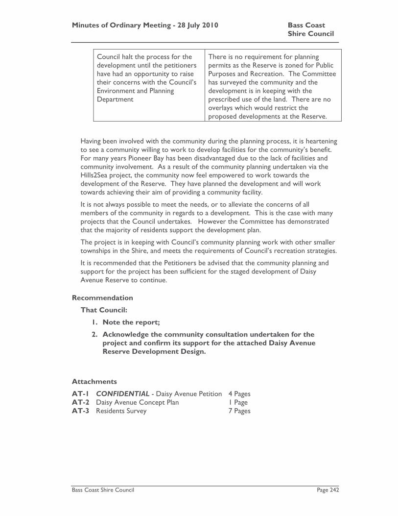
Minutes of Ordinary Meeting - 28 July 2010 Bass Coast Shire Council
Bass Coast Shire Council Page 242
Council halt the process for the development until the petitioners have had an opportunity to raise their concerns with the Council’s Environment and Planning Department
There is no requirement for planning permits as the Reserve is zoned for Public Purposes and Recreation. The Committee has surveyed the community and the development is in keeping with the prescribed use of the land. There are no overlays which would restrict the proposed developments at the Reserve.
Having been involved with the community during the planning process, it is heartening to see a community willing to work to develop facilities for the community’s benefit. For many years Pioneer Bay has been disadvantaged due to the lack of facilities and community involvement. As a result of the community planning undertaken via the Hills2Sea project, the community now feel empowered to work towards the development of the Reserve. They have planned the development and will work towards achieving their aim of providing a community facility.
It is not always possible to meet the needs, or to alleviate the concerns of all members of the community in regards to a development. This is the case with many projects that the Council undertakes. However the Committee has demonstrated that the majority of residents support the development plan.
The project is in keeping with Council’s community planning work with other smaller townships in the Shire, and meets the requirements of Council’s recreation strategies.
It is recommended that the Petitioners be advised that the community planning and support for the project has been sufficient for the staged development of Daisy Avenue Reserve to continue.
Recommendation
That Council:
1. Note the report;
2. Acknowledge the community consultation undertaken for the project and confirm its support for the attached Daisy Avenue Reserve Development Design.
Attachments
AT-1 CONFIDENTIAL - Daisy Avenue Petition 4 Pages AT-2 Daisy Avenue Concept Plan 1 Page AT-3 Residents Survey 7 Pages

Minutes of Ordinary Meeting - 28 July 2010 Bass Coast Shire Council
Bass Coast Shire Council Page 243
Council Decision
Moved: Cr. Veronica Dowman / Seconded: Cr. Jane Dore Daly
Recommendation
That Council:
1. Note the report;
2. Acknowledge the community consultation undertaken for the project and confirm its support for the attached Daisy Avenue Reserve Development Design.
CARRIED

Minutes of Ordinary Meeting - 28 July 2010 Bass Coast Shire Council
Bass Coast Shire Council Page 244
K.14 Petition - Review parking in front of Newsagency/Post Office, San Remo
File No: CM10/310 Department: Infrastructure Council Plan Strategic Objective: Good Governance
We will manage our resources effectively, keep the community engaged, listen to our communities' concerns to create positive outcomes.
Previous Items: 43/10 - Petition - Review parking in front of Newsagency/Post
Office, San Remo - Council - 16 June 2010
Declaration
The reporting officer does not have any direct or indirect interests in this matter.
Summary A petition with 43 signatures, together with a covering fax and other information, was received by Council on 27 May 2010.
The same petition and information, was again received on 31 May 2010 with an increased number of signatures totalling 178. A covering letter also accompanied this information.
The petition relates to two matters and states as follows:
A petition to change the long term parking to short term parking in front of San Remo Post Office and Newsagency and keeping the bus stop as it is.
In relation to the matter regarding the bus stop, when the petition was tabled at the 16 June 2010 Council Meeting it was noted that this was in the hands of the Department of Transport (DOT) and that Council had been actively lobbying DOT to find an amicable resolution for San Remo. At that time, no official direction had been received from DOT but it was noted that the bus stop was to remain in its current location.
Council Officers completed a study in relation to parking demand and turnover in the San Remo town centre over the peak summer period of 2010. Officers are currently developing a plan to address the longer term parking needs of the community. The plan is likely to identify the need for long and short term parking zones and improvements to accessible parking in San Remo.
In relation to the request for time restrictions to be implemented in the area immediately adjacent to the Post Office and Newsagent Council Officers support this request. It is recommended that a 15 minute parking zone be introduced in the area and the head petitioner be advised of Council’s decision.

Minutes of Ordinary Meeting - 28 July 2010 Bass Coast Shire Council
Bass Coast Shire Council Page 245
Introduction
Following discussions with DOT representatives, the current location of the bus stop at 107 Marine Parade will remain until agreement and funding is made available to develop an alternative bus facility. DOT are currently investigating alternative locations and have indicated that a facility may be able to be constructed directly along Phillip Island Road.
Council Officers have assessed the viability of the proposal to “change the long term parking to short term parking in front of San Remo Post Office”.
The proposal to create short term parking does have merit, considering the temporary patronage of users to facilities at the post office and also the neighbouring bank. There is a substantial amount of long term parking on the opposite side of the road, to allow for visitors to other shops and facilities in this section of Marine Parade, San Remo.
There are compelling reasons for Council to introduce short term parking from immediately in front of the Bendigo Bank through to the Post Office. A setback of 10 metres from the intersection of Marine Parade and Wynne Road will still need to be maintained as a “no standing” area for compliance with road rules.
It may be worth noting that through the whole of the San Remo business district along Marine Parade, data was collected prior to this petition being received in relation to parking usage. This data was collected during the ‘peak holiday’ period by council staff to determine parking capacities and turnover rates, to assist in the development of longer term parking solutions. The data is currently being reviewed and some proposals are expected to be tabled during the 2010/2011 financial year, which would include the introduction of long and short term parking zones and improvements to accessible parking in San Remo.
Strategic Basis
By periodically assessing, adjusting and monitoring parking restrictions, Councils objective to “manage our resources effectively, keep the community engaged, and listen to our communities concerns to create positive outcomes” can be achieved.
Finances
The cost to place appropriate parking signage in the area of the Post Office, including installation, would cost Council approximately $400. These costs can be met with funds allocated in the Traffic Improvements Budget
Stakeholders
The stakeholders involved with this issue are the Bass Coast Shire Council, San Remo residents and visitors, the San Remo Bendigo Bank (and users) and San Remo Post Office (and users).
Statutory Requirements/Codes/Standards/Policies
The relevant statutory requirements are as follows.
Road Management Act 2004
Australian Standard1742.2 – On Street Parking

Minutes of Ordinary Meeting - 28 July 2010 Bass Coast Shire Council
Bass Coast Shire Council Page 246
Other Options
Council could choose to retain the existing situation however this is unlikey to be satisfactory to the adjoining businesses and their customers in the longer term.
Officer’s Comments/Conclusion
Issues such as the implementation of a parking zone are normally operational matters that are dealt with by Council Officers. In this instance the request has come directly to Council as part of a petition. Council Officers are of the view that the request in relation to parking could have been resolved by Officers however given that the businesses have taken the time to develop a petition it is appropriate that Council determine the matter.
In this particular instance the issue of parking was a secondary consideration to the matter of the proposal to relocate the bus zone to the area directly adjacent to the Post Office.
As detailed earlier the issue in relation to the bus stop has been temporarily resolved and Council Officers support the implementation of a short term parking zone in the area given the use of the adjacent facilities.
If the recommendation of the short term parking is supported by Council the signs will be ordered from an approved supplier and installed in due course.
Recommendation
1. Council supports the introduction of a 15 minute parking zone in the area immediately adjacent to the San Remo Post Office.
2. The head petitioner be advised of Councils decision
Attachments
AT-1 CONFIDENTIAL - Petition 10 Pages Council Decision
Moved: Cr. Gareth Barlow / Seconded: Cr. Jane Dore Daly
Recommendation
1. Council supports the introduction of a 15 minute parking zone in the area immediately adjacent to the San Remo Post Office.
2. The head petitioner be advised of Councils decision CARRIED
Minutes of Ordinary Meeting - 28 July 2010 Bass Coast Shire Council
Bass Coast Shire Council Page 247
K.14 Petition - Maintenance of roads in the Bass Township
File No: CM10/312 Department: Infrastructure Council Plan Strategic Objective: Good Governance
We will manage our resources effectively, keep the community engaged, listen to our communities' concerns to create positive outcomes.
Declaration
The author of this report has no direct or indirect interests in relation to the issue.
Summary
A joint letter was received by Council on 13 May 2010 and tabled at the 16 June 2010 Ordinary Council Meeting to lie until the next ordinary meeting of Council on 28 July 2010.
The joint letter representing nine properties, four of which are businesses, and containing 11 signatures was accompanied by a covering letter. The covering letter states that the joint letter was also sent to Ken Smith MP and Greg Hunt MP by the head signatory. A letter has since been received by Council from Greg Hunt MP about this matter.
The joint letter states in part:
We the under signed wish to put in an official complaint about the maintenance of the roads consisting of Acton Rd, Massie Rd, Stephens Rd and Pender Rd in Bass.
The petition details concerns of residents and businesses in relation to the dangerous condition of these roads in wet weather and their request as follows:
All we are asking for is stones to be placed down (and not just were the holes are) and for the roads to be maintained on a regular basis.
Council Officers have undertaken works in the area, which were identified as part of Council’s regular inspection and maintenance program, to address the concerns of the residents and will continue to monitor the roads to ensure that they remain in a safe condition.
It is recommended that Council Officers continue to monitor the condition of the roads and advise the petitioner and the interested members of parliament of the works that have been completed and Council’s decision.
Introduction
Prior to receiving the joint letter on 13 May 2010, Council Officers inspected these roads on 6 May 2010 as part of Council’s routine zone maintenance program. It was determined from this inspection that the roads required some minor maintenance work but otherwise were in a safe condition. Works were programmed for late May due to other higher priority works.

Minutes of Ordinary Meeting - 28 July 2010 Bass Coast Shire Council
Bass Coast Shire Council Page 248
During the period 20 May to 24 May resheeting (placing of additional crushed rock on the road) and grading works on the roads were completed. Subject to need, either a light or heavy resheet was put over all these roads and then graded. Particular attention was paid to the road intersections where it was determined that the heaviest resheet was required. It was then identified that the roads would require a follow-up grade. This grading was programmed for weekending 2 July 2010 however due to adverse weather conditions works were not completed until the following week. The head signatory was progressively informed of the status of works when necessary.
Future maintenance works will be determined through Council’s Routine Zone Maintenance Program.
Strategic Basis
The vision for Councils asset management function (as stated in the Asset Management Policy initially adopted by Council in 2002, and the revised Asset Management Policy and Asset Management Improvement Strategy 2006-2008 adopted at its Ordinary Meeting on 13 December 2006) is that:
“We provide and maintain assets in a sustainable manner to improve the quality of life and safety of the Bass Coast Community”
As a strategy, the zone maintenance program enables us to achieve the Council vision with a coordinated and consistent approach. That is, each Council road is inspected every six weeks, with an additional inspection for link and collector roads every three weeks. Works are then programmed in accordance with their priority.
Finances
As stated previously, depending on need all roads either had a light or heavy resheet. To fully rehabilitate these roads they would require a major resheet. However, Councils current major resheet budget does not have the funds to complete these works given that there are other roads requiring a major resheet and are taking priority. Council Officers maintain that these roads, namely Acton, Massie, Stephens and Pender, are in a safe condition with finance provided by Council as part of the operating budget.
Stakeholders
The primary stakeholders who benefit from maintenance are the residents and businesses in the area. Other stakeholders are Council, the ratepayers of the Shire and visitors to the area.
Statutory Requirements/Codes/Standards/Policies
The relevant statutory requirements include:
• Road Management Act 2004
• Councils Road Management Plan
• Councils Asset Management Plan
The Road Management Plan defines the acceptable level of defects that are allowable for various categories of roadway. Council’s zone inspection program caters for

Minutes of Ordinary Meeting - 28 July 2010 Bass Coast Shire Council
Bass Coast Shire Council Page 249
regular inspections of all roads and identifies defects that have reached or reaching intervention levels. Works are then programmed accordingly.
Other Options
Council could choose to place a major resheet on the four roads of Acton, Massie, Stephens and Pender in Bass township. However these works are not considered as high a priority as other roads in the municipality and therefore this is not considered the most valuable use of Council funds.
Officer’s Comments/Conclusion
Council Officers are satisfied that the action taken to date, together with ongoing monitoring of the road under the routine zone maintenance program, has and will address the concerns expressed by the signatories in the joint letter.
It is recommended that Council Officers continue to monitor the condition of the roads and advise the petitioner and the interested members of parliament of the works that have been completed and Council’s decision.
Recommendation
1. Council Officers continue to monitor and maintain Acton, Massie, Stephens and Pender roads under its Routine Zone Maintenance Program.
2. Advise the head signatory of the works that have been completed and of Councils decision.
3. Advise Ken Smith MP and Greg Hunt MP of the outcome of this matter.
Attachments
AT-1 CONFIDENTIAL - Joint Letter 4 Pages Council Decision
Moved: Cr. Veronica Dowman / Seconded: Cr. Jane Dore Daly
Recommendation
1. Council Officers continue to monitor and maintain Acton, Massie, Stephens and Pender roads under its Routine Zone Maintenance Program.
2. Advise the head signatory of the works that have been completed and of Councils decision.
3. Advise Ken Smith MP and Greg Hunt MP of the outcome of this matter.
CARRIED

Minutes of Ordinary Meeting - 28 July 2010 Bass Coast Shire Council
Bass Coast Shire Council Page 250
K.16 Influenza Pandemic Plan
File No: CM10/308 Department: Community and Economic
Development Council Plan Strategic Objective: Cohesive Communities
We will improve lifestyle opportunities and options by managing the built environment and encouraging cohesive communities.
Declaration
The reporting officer has no direct or indirect interests in relation to this issue.
Summary
Bass Coast Shire Council, as part of its emergency management planning, is putting in place an Influenza Pandemic Plan.
Whilst the likelihood of an influenza pandemic affecting Bass Coast Shire is low, the impact on Council and the community of such an event could be devastating.
In Victoria, an influenza pandemic would constitute an emergency under the Emergency Management Act 1986. The Department of Human Services (DHS) is the designated control agency for human illnesses/epidemics.
This paper seeks Council’s endorsement of the Influenza Pandemic Plan as a sub plan of the Bass Coast Shire Council Municipal Emergency Management Plan.
Introduction
The 2009 flu pandemic was a global outbreak of a new strain of H1N1 influenza virus, often referred to as "swine flu”. This accelerated pandemic planning across the State.
Local government is the closest level of government to the community and is often the first point of contact for assistance, advice and information. It has an important role in influenza pandemic planning that includes:
• assisting in reducing the impacts of an influenza pandemic within its municipality
• providing support and recovery assistance throughout the duration of the influenza pandemic.
The objectives of the Influenza Pandemic Plan are:
• preparedness – have arrangements in place to reduce the pandemic impact;
• containment – prevent transmission, implement infection control measures, provide support services to people who are isolated or quarantined within the municipality;
• maintain essential municipal services – provision for business continuity in the face of staff absenteeism and rising demand on local government services;
Minutes of Ordinary Meeting - 28 July 2010 Bass Coast Shire Council
Bass Coast Shire Council Page 251
• mass vaccination – assist in providing vaccination services to the community, if an influenza pandemic vaccine becomes available;
• communication – develop media and communication messages, in line with whole of government messages, to inform the community and staff of any changes to normal municipal service delivery; and
• community support and recovery – ensure a comprehensive approach to emergency recovery planning in the Municipal Emergency Management Plan, with specific focus on influenza pandemic.
The Emergency Management Coordinator is nominated as the Pandemic Coordinator for the municipality and has worked with Council’s Disaster Response Team and business continuity planning in identifying critical staff and functions.
The Team Leader of Environmental Health, who is also the Deputy Pandemic Coordinator, has assisted the Emergency Management Coordinator in the development of the mass vaccination plan.
A sub group of the Municipal Emergency Management Planning Committee (‘the Committee’) was formed to provide input and feedback on Council’s plan. The Bass Coast Shire Influenza Pandemic Plan was subsequently endorsed by the Committee in order to be presented to Council for adoption as a sub plan to the Municipal Emergency Management Plan.
Strategic Basis
The Municipal Emergency Management Plan provides the framework for emergency planning in Bass Coast Shire.
Finances
The financial implications to Council resulting from an Influenza Pandemic are not yet known. All work to date relating to planning has been completed within current budgets.
In the event of a pandemic outbreak, a budget review will be completed for any costs incurred in the event of a pandemic that cannot be met within current budgets.
Stakeholders
Council and the Bass Coast Shire community, specifically those community members identified as vulnerable may be affected as a direct or indirect result of the impacts of an influenza pandemic.
Statutory Requirements/Codes/Standards/Policies
Sections 6, 7 and 8 of the Local Government Act 1989 empower and require Councils to use their resources for emergency management.
Minutes of Ordinary Meeting - 28 July 2010 Bass Coast Shire Council
Bass Coast Shire Council Page 252
Other Options
Council may choose not to adopt this plan as a sub plan of the Municipal Emergency Management Plan
Officer’s Comments/Conclusion
Council has worked closely with the Department of Human Services to develop an Influenza Pandemic plan that is consistent across whole of government.
The layout and contents are of an agreed format to enable synergies between LGAs.
We have developed procedures to manage mass vaccination and have identified locations and resources to complete this element of the Plan.
The Plan has identified critical business functions and identified staff numbers required to deliver these functions.
The Plan will be reviewed and tested on an annual basis to ensure its currency.
Recommendation
That Council endorse the Influenza Pandemic Plan as a sub plan of the Bass Coast Shire Council Municipal Emergency Management Plan.
Attachments
AT-1 Bass Coast Shire Influenza Pandemic Plan 69 Pages Council Decision
Moved: Cr. Gareth Barlow / Seconded: Cr. Veronica Dowman
Recommendation
That Council endorse the Influenza Pandemic Plan as a sub plan of the Bass Coast Shire Council Municipal Emergency Management Plan.
CARRIED

Minutes of Ordinary Meeting - 28 July 2010 Bass Coast Shire Council
Bass Coast Shire Council Page 253
K.17 Neighbourhood Safer Places in Bass Coast Shire
File No: CM10/305 Department: Community and Economic
Development Council Plan Strategic Objective: Cohesive Communities
We will improve lifestyle opportunities and options by managing the built environment and encouraging cohesive communities.
Declaration
The reporting officer has no direct or indirect interests in relation to this issue
Summary
In its Interim Report, the 2009 Victorian Bushfires Royal Commission recommended that Neighbourhood Safer Places - Places of Last Resort , or ‘NSPs’, be identified and established to provide persons in bushfire affected areas with a place of last resort during a bushfire
In response to this recommendation, the Victorian Government has introduced the Emergency Services Legislation Amendment Act 2009 (Vic) (‘ESLA Act’) which amends the Country Fire Authority Act 1958 (CFA Act) and the Emergency Management Act 1986.
From 2010-onwards section 50G of the CFA Act requires Council to identify potential Neighbourhood Safer Places locations.
The legislation also provides a policy defence in relation to indemnity. In order to secure this indemnity, a Council must adopt a Municipal Neighbourhood Safer Places Plan.
A Council is not required to designate a Neighbourhood Safer Place if no site can be found that meets the CFA assessment criteria or if Council is not satisfied that the site meets the criteria of the Neighbourhood Safer Places Plan.
This report seeks Council’s adoption of the Municipal Neighbourhood Safer Places Plan and designation of additional Neighbourhood Safes Places – Places of Last Resort.
Introduction
A Neighbourhood Safer Place is described by the CFA as “a place of last resort that may afford some protection from radiant heat – the biggest killer during bushfire”.
Council designated the Inverloch Hub as a Neighbourhood Safer Place in December 2009, based on a Municipal Neighbourhood Safer Place Plan template which details the process of assessment for Councils to follow when considering potential location(s) for a neighbourhood safer place.

Minutes of Ordinary Meeting - 28 July 2010 Bass Coast Shire Council
Bass Coast Shire Council Page 254
This process has been used again to make assessment of potential sites across Bass Coast Shire. The Municipal Neighbourhood Safer Place Plan template has been updated at the advice of the Municipal Association of Victoria (MAV) to include details of Municipal Emergency Management Planning Committee (‘the Committee) involvement in the process and detailing the signage that should be used to identify a Neighbourhood Safer Place.
The Committee at it’s meeting of the 1st March 2010 formed a working party to identify potential neighbourhood safer places and complete assessments based on the Municipal Neighbourhood Safer Places Plan. Through the Committee a number of areas across Bass Coast Shire were prioritised for Neighbourhood Safer Place identification. The prioritised areas for investigation were Grantville (Including Adams Estate to The Gurdies), Silverleaves, Ventnor and any other areas highlighted by a MEMPC working party if time or workloads allowed. The named areas were proposed by the CFA as being in line with where the State Government had suggested Township Protection Plan may be implemented in the future.
Criteria for assessment
The working party has assessed potential sites against the following criteria outlined in the Municipal Neighbourhood Safer Place Plan:
• Consents and rights of access
• Access and egress
• Opening of the Neighbourhood Safer Place
• Defendable Space
• Defendability of buildings
• Signage
• Maintenance and maintainability
• Separation and demarcation of area
• Disabled access
• Alternative uses of potential neighbourhood safer place
• Community communication
The working party agree that the criteria in the Municipal Neighbourhood Safer Place Plan can be met at the following sites and that the sites should be designated as a Neighbourhood Safer Places.
Location Where Address
Grantville Memorial Park 1504-1510 Bass Hwy Grantville 3984
Pioneer Bay Daisy Road Reserve 11 Daisy Ave Pioneer Bay 3984
Silverleaves Cowes Recreation Reserve 1-15 Church St, Cowes 3922
Cape Woolamai Woolamai Park
11-19 Sunnyside Ave Cape Woolamai 3925
Ventnor Ventnor Hall Site 491 Ventnor Beach Rd Ventnor 3922
Inverloch Inverloch Hub grounds and footpath surrounding hub 16 A’Beckett St Inverloch

Minutes of Ordinary Meeting - 28 July 2010 Bass Coast Shire Council
Bass Coast Shire Council Page 255
Council has received certification from the CFA that these sites have been determined as being compliant with the CFA’s Neighbourhood Safer Places Interim Assessment Guidelines criteria.
At the Committee meeting of the 7 June 2010 members supported the work of the designated working group and recommended that on certification of these sites by the CFA, the locations be presented to council for designation.
Strategic Basis
The Municipal Fire Prevention Plan and the Municipal Emergency Management Plan provide the framework for fire prevention and emergency planning in Bass Coast Shire.
Finances
The financial implications to Council resulting from the designation of these NSP will be minimal as the areas are currently maintained through normal processes. There will be costs associated with the production and installation of signage.
A budget review will be completed for any costs incurred in complying with requirements that cannot be met by current budgets.
The MAV is continuing its advocacy to both the Federal and State Governments for further funding support to address the increasing costs of new initiatives to local government in relation to fire preparedness, particularly where costs arise as a direct result of changes to Federal and/or State policies and legislation.
Stakeholders
Council and the Bass Coast Shire community, specifically those residents of and visitors to the identified prioritised areas, and agencies involved in emergency management planning around fire: CFA, Victoria Police and Department of Sustainability and Environment.
Statutory Requirements/Codes/Standards/Policies
Sections 6, 7 and 8 of the Local Government Act 1989 empower and require Councils to use their resources for emergency management.
The Country Fire Authority Act 1958 – S. 50G identifies that council must identify and designate places as Neighbourhood Safer Places in its municipal district. In identifying and designating Neighbourhood Safer Places, a municipal council may have regard to its Municipal Council Neighbourhood Safer Places Plan.
Other Options
A council is not required to designate an Neighbourhood Safer Place if no site meets the CFA assessment criteria or if a council is satisfied that despite a place being CFA certified, there are reasonable grounds that make a place not appropriate to designate as a Neighbourhood Safer Place; or any suitable existing place is on non-council land and the occupier or person in control of the land does not consent to its designation as an Neighbourhood Safer Place.

Minutes of Ordinary Meeting - 28 July 2010 Bass Coast Shire Council
Bass Coast Shire Council Page 256
Officer’s Comments/Conclusion
Council has worked closely with emergency services agencies, in particular the CFA, DSE and Victoria Police to identify, certify and provide Council with the information needed to confidently designate these sites as neighbourhood safer places.
Due to the requirements for CFA certification and the detailed prescriptions of the Municipal Neighbourhood Safer Places Plan, several sites around Bass Coast that were inspected did not meet the specifications. This meant that there were no options in some localities and more general areas were identified such as the Memorial Park in Grantville and the Recreation Reserve in Cowes.
The Municipal Emergency Management Committee supports and recommends these sites for designation. The Municipal Neighbourhood Safer Place Plan follows a detailed assessment process against required criteria. A Neighbourhood Safer Place may only be designated by a resolution of the Council.
Once the sites have been designated as Neighbourhood Safer Places by Council, Council’s Emergency Management Coordinator will commence with the erection of appropriate signage on site, publish the location of the Neighbourhood Safer Places on the Council website and begin a process of communicating the locations to the community.
There is also a requirement to update Council’s Municipal Emergency Management Plan and Municipal Fire Prevention Plan to incorporate the designated Neighbourhood Safer Places. Council’s Emergency Management Coordinator must also provide an up-to-date list of NSPs to the CFA no later that 30 September each year under section 50K of the Country Fire Authority Act.
Recommendation
That Council
• adopt the attached Municipal Neighbourhood Safer Places Plan and publish it on the Council’s website;
• designate: • Grantville - Memorial Park
• Pioneer Bay - Daisy Road Reserve • Silverleaves - Cowes Recreation Reserve
• Cape Woolamai Woolamai Park
• Ventnor - Ventnor Hall Site
• Inverloch Hub - grounds and footpath surrounding the Hub as Neighbourhood Safer Places – Places of Last Resort having considered:
• the Country Fire Authority’s assessment, which assesses the Neighbourhood Safer Place – Place of Last Resort as compliant with the Country Fire Authority Fire Rating Guidelines; and
• the assessment of the Neighbourhood Safer Place – Place of Last Resort in accordance with the criteria detailed in the
Minutes of Ordinary Meeting - 28 July 2010 Bass Coast Shire Council
Bass Coast Shire Council Page 257
Municipal Neighbourhood Safer Places Plan;
• establish and maintain the Neighbourhood Safer Place in accordance with the requirements of the Municipal Neighbourhood Safer Places Plan;
• record the designated Neighbourhood Safer Place(s) in the Municipal Fire Prevention Plan in accordance with section 55A(2)(ca) of the Country Fire Authority Act 1958 and in the Municipal Emergency Management Plan in accordance with section 20(2)(ba)(i) of the Emergency Management Act 1986;
• note that the Municipal Fire Prevention Officer will advise the Country Fire Austhority of the designation of the Neighbourhood Safer Place – Place of Last Resort as soon as practicable and note that the Municipal Fire Prevention Officer is required to provide to the Country Fire Authority, by 30 September in each year, an up-to-date list of all designated Neighbourhood Safer Places in the municipality; and
• communicate to the public:
• the designation of the Neighbourhood Safer Place - Place of Last Resort;
• that the purpose of the Neighbourhood Safer Place - Place of Last Resort is to provide some protection from the effects of radiant heat during the passage of a bushfire;
• that there is no guarantee of safety or survival at the Neighbourhood Safer Place - Place of Last Resort or travelling to the Neighbourhood Safer Place - Place of Last Resort;
• Neighbourhood Safer Places - Place of Last Resort may not have the capacity to cater for special needs and there will be no support services (food or drink, material aid) or provision for pets; and
• that the use of a Neighbourhood Safer Place - Place of Last Resort should only be contemplated when all other bushfire plans have failed.
Attachments
AT-1 Municipal Neighbourhood Safer Places Plan 28 Pages
Minutes of Ordinary Meeting - 28 July 2010 Bass Coast Shire Council
Bass Coast Shire Council Page 258
Council Decision
Moved: Cr. Jane Dore Daly / Seconded: Cr. John Duscher
Recommendation
That Council
• adopt the attached Municipal Neighbourhood Safer Places Plan and publish it on the Council’s website;
• designate:
• Grantville - Memorial Park
• Pioneer Bay - Daisy Road Reserve
• Silverleaves - Cowes Recreation Reserve
• Cape Woolamai Woolamai Park
• Ventnor - Ventnor Hall Site
• Inverloch Hub - grounds and footpath surrounding the Hub as Neighbourhood Safer Places – Places of Last Resort having considered:
• the Country Fire Authority’s assessment, which assesses the Neighbourhood Safer Place – Place of Last Resort as compliant with the Country Fire Authority Fire Rating Guidelines; and
• the assessment of the Neighbourhood Safer Place – Place of Last Resort in accordance with the criteria detailed in the Municipal Neighbourhood Safer Places Plan;
• establish and maintain the Neighbourhood Safer Place in accordance with the requirements of the Municipal Neighbourhood Safer Places Plan;
• record the designated Neighbourhood Safer Place(s) in the Municipal Fire Prevention Plan in accordance with section 55A(2)(ca) of the Country Fire Authority Act 1958 and in the Municipal Emergency Management Plan in accordance with section 20(2)(ba)(i) of the Emergency Management Act 1986;
• note that the Municipal Fire Prevention Officer will advise the Country Fire Austhority of the designation of the Neighbourhood Safer Place – Place of Last Resort as soon as practicable and note that the Municipal Fire Prevention Officer is required to provide to the Country Fire Authority, by 30 September in each year, an up-to-date list of all designated Neighbourhood Safer Places in the municipality; and
• communicate to the public:
• the designation of the Neighbourhood Safer Place - Place of Last
Minutes of Ordinary Meeting - 28 July 2010 Bass Coast Shire Council
Bass Coast Shire Council Page 259
Resort;
• that the purpose of the Neighbourhood Safer Place - Place of Last Resort is to provide some protection from the effects of radiant heat during the passage of a bushfire;
• that there is no guarantee of safety or survival at the Neighbourhood Safer Place - Place of Last Resort or travelling to the Neighbourhood Safer Place - Place of Last Resort;
• Neighbourhood Safer Places - Place of Last Resort may not have the capacity to cater for special needs and there will be no support services (food or drink, material aid) or provision for pets; and
• that the use of a Neighbourhood Safer Place - Place of Last Resort should only be contemplated when all other bushfire plans have failed.
CARRIED

Minutes of Ordinary Meeting - 28 July 2010 Bass Coast Shire Council
Bass Coast Shire Council Page 260
Mayoral Announcement Of Next Meeting Of Council
The Mayor advised that the next meeting of Council will be the Meeting to be held on Wednesday, 18 August 2010 in Meeting Room 1, Cowes Cultural Centre, Thompson Avenue, Cowes at 5.00pm. The meeting will be open to the public from 5.00pm onwards. There will be no public briefings held prior to the Council Meeting.
Minutes of Ordinary Meeting - 28 July 2010 Bass Coast Shire Council
Bass Coast Shire Council Page 261
Items Closed to the Public
Excerpt of Section 89 of Local Government Act 1989.
(2) A Council or special committee may resolve that the meeting be closed to members of the public if the meeting is discussing any of the following:
(a) Personnel matters; (b) The personal hardship of any resident or ratepayer; (c) Industrial matters; (d) Contractual matters; (e) Proposed developments; (f) Legal advice; (g) Matters affecting the security of Council property; (h) Any other matter which the Council or special committee considers
would prejudice the Council or any person; (i) A resolution to close the meeting to members of the public.
(3) If a Council or special committee resolves to close a meeting to members of the public the reason must be recorded in the minutes of the meeting.
Minutes of Ordinary Meeting - 28 July 2010 Bass Coast Shire Council
Bass Coast Shire Council Page 262
L Items Closed to the Public
L.1 Contractual matter
L.2 Contractual matter
L.3 Contractual matter
Meeting Adjourned The meeting was adjourned at 8.35pm.