basic design study report on the project for ...open_jicareport.jica.go.jp/pdf/11608510_01.pdf ·...
TRANSCRIPT

BASIC DESIGN STUDY REPORTON
THE PROJECT FOR REHABILITATIONFOR MEDIUM WAVE RADIO BEACON
STATIONSIN
THE REPUBLIC OF INDONESIA
November 2000
Japan International Cooperation AgencyJapan Aids to Navigation Association
GR3
CR (1)
00-205
No.Directorate General of Sea Communications
Ministry of Communications
The Republi of Indonesia
PREFACE
In response to a request from the Government of the Republic ofIndonesia, the Government of Japan decided to conduct a basic design studyon the Project for Rehabilitation for Medium Wave Radio Beacon Stationsand entrusted the study to the Japan International Cooperation Agency(JICA).
JICA sent to Indonesia a study team from April 9 to May 19, 2000.
The team held discussions with the officials concerned of theGovernment of Indonesia, and conducted a field study at the study area.After the team retuned to Japan, further studies were made. Then, amission was sent to Indonesia in order to discuss a draft basic design, and asthis result, the present report was finalized.
I hope that this report will contribute to the promotion of the projectand to the enhancement of friendly relations between our two countries.
I wish to express my sincere appreciation to the officials concernedof the Government of the Republic of Indonesia for their close cooperationextended to the teams.
November 2000
Kunihiko Sato
President
Japan International Cooperation Agency
November 2000
LETTER OF TRANSMITTAL
We are pleased to submit to you the basic design study report on theProject for Rehabilitation for Medium Wave Radio Beacon Stations in theRepublic of Indonesia.
This study was concerned by Japan Aids to Navigation Association,under a contract to JICA, during the period from March 24, 2000 toNovember 30, 2000. In conducting the study, we have examined thefeasibility and rationale of the project with due consideration to the presentsituation of Indonesia and formulated the most appropriate basic design forthe project under Japan’s grant aid scheme.
Finally, we hope that this report will contribute to further promotionof the project.
Very truly yours,
Senji TanakaProject Manager,Basic design study team onThe Project for RehabilitationMedium Wave Radio BeaconStationsJapan Aids to NavigationAssociation
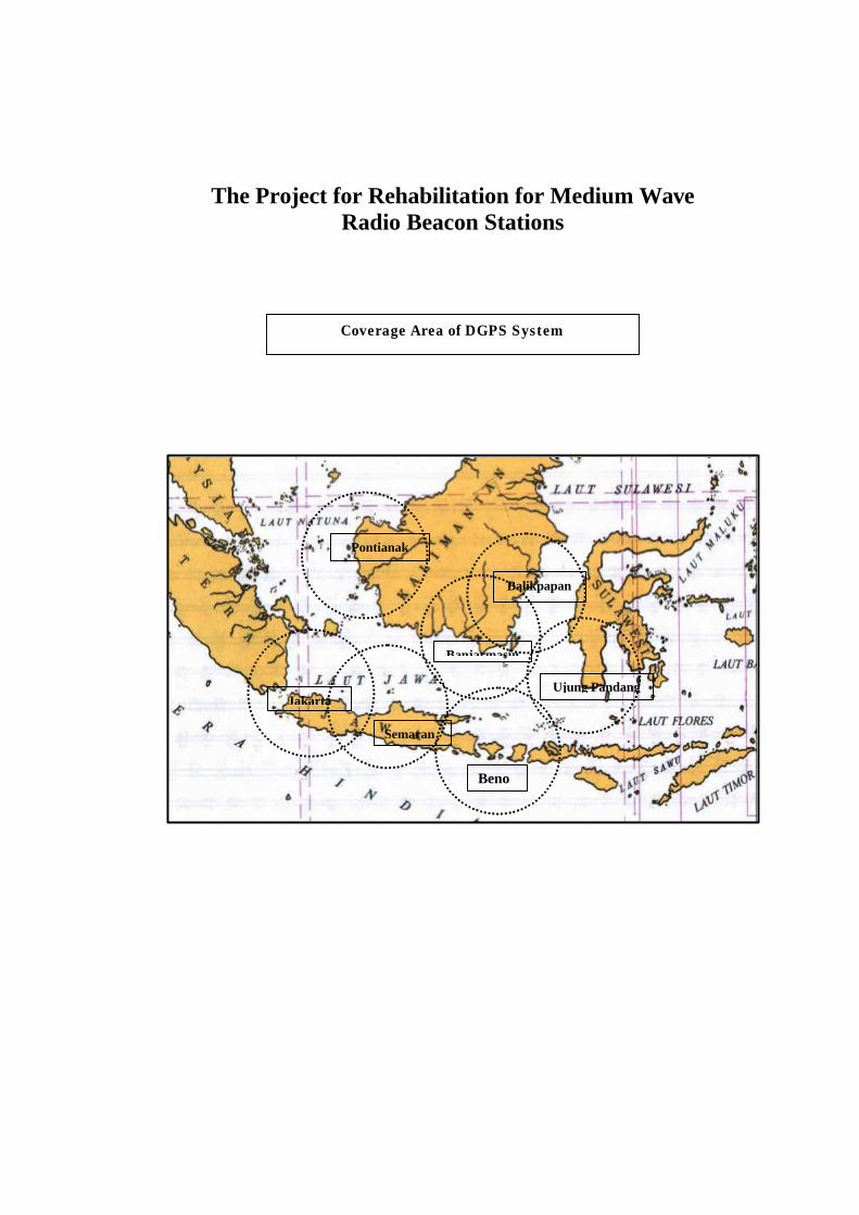
Jakarta
Semaran
Beno
Ujung Pandang
Banjarmasin
Pontianak
Balikpapan
The Project for Rehabilitation for Medium WaveRadio Beacon Stations
Coverage Area of DGPS System

Location Map
Semarang DGPS Station (Coastal Radio Transmitting Station)
Jakarta DGPS Station (Coastal Radio Transmitting Station)

Benoa DGPS Station (Coastal Radio Transmitting Station)
Ujung Pandang DGPS Station (Coastal Radio Transmitting Station)

Banjarmasin DGPS Station (Coastal Radio Transmitting Station)
Balikpapan DGPS Station (Coastal Radio Transmitting Station)

Pontianak DGPS Station (Coastal Radio Transmitting Station)

AbbreviationsABS-95 Absolute Accuracy at 95%AC Alternative CurrentADPEL Administrator Pelabuhan (Port Administrator)AIS or UAIS Universal ship-borne Automatic Identification SystemAtoN Aids to NavigationAVR Automatic Voltage RegulatorB/A Banking ArrangementsB/D Basic DesignBAKOSURTANAL Badan Kodinasi dan Survei Pemetaan Nasional
(National Mapping Survey and Coordination Agency)BAPPENAS Badan Perencanaan Pembangunan Nasional
(National Development Planning Agency)BPPT Badan Pengkajian dan Penerapan Teknologi
(Agency for the Assessment and Application ofTechnology)
C/A Course AcquisitionCCIR (IRCC) International Radio Consultative CommissionCD-ROM Compact Disk Read-only MemoryCH ChannelCRT Cathode Ray TubeCP Check PointCPU Central Processing UnitD B/D Draft Basic DesignDC Direct CurrentDCT Data Communication TransferDGPS Differential GPSDGSC Directorate General of Sea CommunicationsDISNAV District of Navigation OfficeDOP Dilution of PrecisionDRMS Distance Root Mean SquareE/N Exchange of NotesECDIS Electric Chart Display Information SystemFDD Floppy Disk DriveGL Ground LevelGMDSS Global Maritime Distress and Safety SystemGPS Global Positioning SystemHDD Hard Disk DriveIALA International Association of Marine Aids to
Navigation and Lighthouse AuthoritiesIAPH International Association of Ports and HarborsICAO International Civil Aviation OrganizationI/F InterfaceIGEB Interagency GPS Executive BoardIM Integrity MonitorIMO International Maritime Organizationin InchISO International Standards OrganizationITU International Telecommunication UnionJANA Japan Aids to Navigation AssociationJBIC Japan Bank for International CooperationJGC Japan Coast Guard
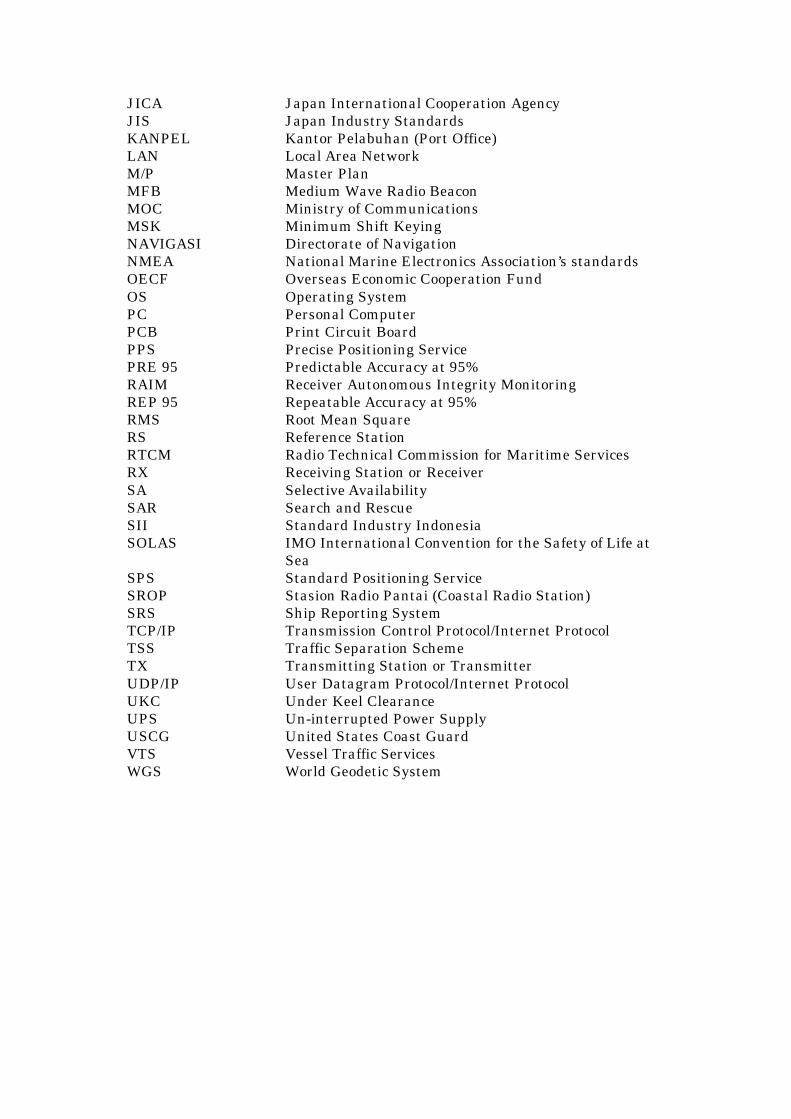
JICA Japan International Cooperation AgencyJIS Japan Industry StandardsKANPEL Kantor Pelabuhan (Port Office)LAN Local Area NetworkM/P Master PlanMFB Medium Wave Radio BeaconMOC Ministry of CommunicationsMSK Minimum Shift KeyingNAVIGASI Directorate of NavigationNMEA National Marine Electronics Association’s standardsOECF Overseas Economic Cooperation FundOS Operating SystemPC Personal ComputerPCB Print Circuit BoardPPS Precise Positioning ServicePRE 95 Predictable Accuracy at 95%RAIM Receiver Autonomous Integrity MonitoringREP 95 Repeatable Accuracy at 95%RMS Root Mean SquareRS Reference StationRTCM Radio Technical Commission for Maritime ServicesRX Receiving Station or ReceiverSA Selective AvailabilitySAR Search and RescueSII Standard Industry IndonesiaSOLAS IMO International Convention for the Safety of Life at
SeaSPS Standard Positioning ServiceSROP Stasion Radio Pantai (Coastal Radio Station)SRS Ship Reporting SystemTCP/IP Transmission Control Protocol/Internet ProtocolTSS Traffic Separation SchemeTX Transmitting Station or TransmitterUDP/IP User Datagram Protocol/Internet ProtocolUKC Under Keel ClearanceUPS Un-interrupted Power SupplyUSCG United States Coast GuardVTS Vessel Traffic ServicesWGS World Geodetic System
PrefaceLetter of TransmittalCoverage Area of DGPS System/ Location MapAbbreviations
Chapter 1 Background of the Project........................................................................................ 1
Chapter 2 Contents of the Project .......................................................................................... 32-1Objective of the Project ................................................................................................... 32-2 Basic Concept of the Project.......................................................................................... 32-3 Basic Design .................................................................................................................... 7
2-3-1 Design Concept ........................................................................................................ 72-3-2 Basic Design ............................................................................................................. 9
Chapter 3 Implementation Plan........................................................................................... 163-1 Implementation Plan ................................................................................................... 16
3-1-1 Implementation Concept ...................................................................................... 163-1-2 Implementation Conditions ................................................................................. 163-1-3 Scope of Works ....................................................................................................... 173-1-4 Consultant Supervision ........................................................................................ 183-1-5 Procurement Plan.................................................................................................. 223-1-6 Implementation Schedule..................................................................................... 263-1-7 Soft Component Plan ............................................................................................ 27
3-2 Project Cost Estimation ................................................................................................. 273-3 Operation and Maintenance Cost Estimation.......................................................... 27
Chapter 4 Project Evaluation and Recommendation ........................................................ 294-1 Project Effect ................................................................................................................. 294-2 Technical Cooperation and Relationship with Other Donors...................................... 304-3 Recommendation ............................................................................................................ 32
DRAWINGS .............................................................................................................................. 33
Appendices ............................................................................................................................. 571. Member List of the Survey Team ..................................................................................... 582. Survey Schedule.................................................................................................................. 593. List of Party Concerned in the Recipient Country ........................................................ 624. Other Relevant Data .......................................................................................................... 635. References ............................................................................................................................ 66

1
Chapter 1 Background of the Project
Indonesia is an archipelago country with about 1.9 million square kilometersof the land area , which is composed of many large and small islands spread in the area,about 5 thousand kilometers east-west and about 2 thousand kilometers north-south.In addition, Indonesia is a maritime country, which has the sea area of about 7.9million square kilometers including exclusive economic zone.
Indonesia, archipelago and maritime country, is greatly dependent for theinter-islands transportation upon a marine transportation. Therefore, Indonesia haspositively promoted many maritime modernization projects on maritime sector such asshipbuilding, harbor, aids to navigation and so forth for promotion of maritimeindustry.
As a part of this development, eighteen (18) of the Medium Wave RadioBeacon (MFB) Stations were established by Japan’s Yen Loan of 1982 fiscal year inorder to secure navigation safety and promote efficiency of sea traffic at the seawaterswith large traffic volume in Indonesian waters.
However, the MFB stations almost stop their operation by 1996. It is a majorreason that the failures of power supply system and so forth were not recoveredbecause of weakness of management and maintenance system including a lack ofbudget for operation and maintenance, difficulty of access to the sites, complex factorssuch as lightning attack, salty wind and rain and so forth exceeding pre-estimate atthe time of planning of construction. At the present time, only one (1) station of No.1Sabang MFB is still operated.
In connection with the MFB station, the International Maritime Organization(IMO) and the International Association of Marine Aids to Navigation and LighthouseAuthorities (IALA) have a concept to introduce Differential GPS (DGPS) for animprovement of ship positioning accuracy as a global system. Many of the MFB stationin the world were changed to DGPS station, and the exclusive MFB stations out ofsubject for the DGPS has been closing. Some DGPS stations have been operated by theneighboring country of Indonesia at Malacca Singapore Strait and waters around itsstrait. Singapore operates one (1) station, Malaysia operates four (4) stations and Indiaoperates one (1) station at least around its Strait.
On the other hand, as the present trend around Indonesian water, Indonesiahas established three (3) strategic sea-lanes that are No.1 sea-lane, No.2 sea-lane andNo. 3 sea-lane around Sunda strait, Lombok Strait and other waters respectively.Indonesia has approved that foreign warships and other vessels can free navigate atthe sea-lanes as a parts of Indonesian waters since 1998. The extension of TrafficSeparation Scheme (TSS) and the introduction of Ship Reporting System at MalaccaSingapore Strait were decided. Ministry of Sea Exploration and Fishers was newlyestablished along with start of new administrative power. Based on those points,further, Indonesia has been stressing on the policy as a maritime country.
As those circumstances above, the development of aids to navigation facilities,which is the basis of securing navigation safety in maritime traffic, has become

2
important matter. It is expected that the function of MFB stations, which is availablefor twenty four (24) hours under all-weather conditions, is voluntarily recovered byIndonesia. However, it is difficult to recover immediately the function of MFB stationbecause of economy crisis of Indonesia.
Therefore, the Government of Indonesia requested Japan’s Grant Aids based onthe Project for Rehabilitation for Medium Wave Radio Beacon Stations according to theinternational trend of IMO and so forth, to the Government of Japan on March 1999. Theproject area requested in the Project is seven (7) stations faced to the most important seawaters. Those MFB stations to be rehabilitated in the Project are re-located and co-sitedwith the existing Coastal Radio Stations in order to secure the operation and maintenancesystem for DGPS system.
3
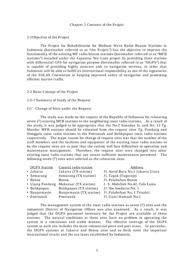
Chapter 2 Contents of the Project
2-1Objective of the Project
The Project for Rehabilitation for Medium Wave Radio Beacon Stations inIndonesia (hereinafter referred to as “the Project”) has the objective to improve thefunctionality of the existing MF radio beacon stations (hereinafter referred to as “MFBstations”) installed under the Japanese Yen Loan project by providing those stationswith differential GPS for navigation purpose (hereinafter referred to as “DGPS”) thatis capable of providing highly accurate aids to navigation services, in order thatIndonesia will be able to fulfill its international responsibility as one of the signatoriesof the SOLAS Convention in keeping improved safety of navigation and promotingefficient marine traffic.
2-2 Basic Concept of the Project
2-2-1 Summary of Study of the Request
(1) Change of Sites under the Request
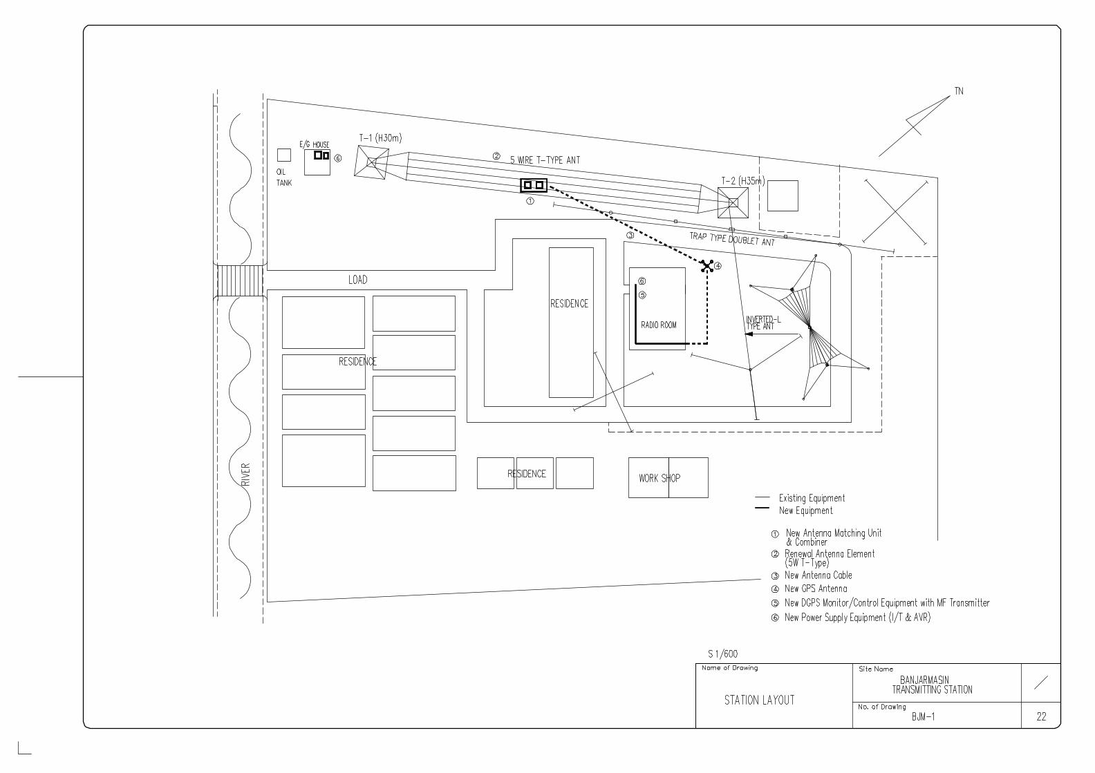
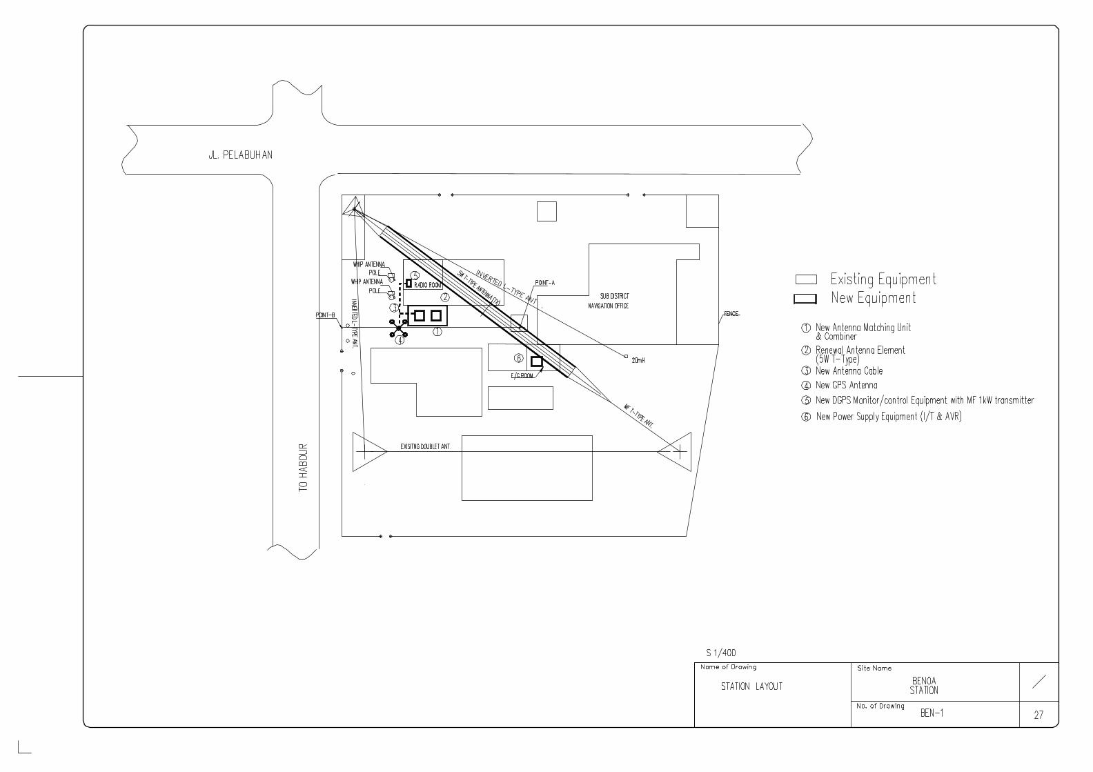
The study was made on the request of the Republic of Indonesia for relocatingseven (7) existing MFB stations to the neighboring coast radio stations. As a result ofthe study, it was judged to be appropriate that the No.2 Simedan Is. and No. 13 Tg.Mandar MFB stations should be relocated from the request sites Tg. Pandang andDonggala coast radio stations to the Pontianak and Balikpapan coast radio stationsrespectively. The major reason for change of request sites was that the number of thestaff members and the facilities and equipment of the existing coast radio stations tobe the request sites are so poor that the system will face difficulties in operation andmaintenance management. Therefore, the request sites were changed into otherexisting coast radio stations that can secure sufficient maintenance personnel. Thefollowing seven (7) sites were selected as the relocation sites:
DGPS Station Coastal radio station Address• Jakarta Jakarta (TX station) Jl. Ancol Baru No.1 Jakarta Utara• Semarang Semarang (TX station) Jl. Tapak (Tugurejo)• Benoa Benoa Jl. Pelabuhan Benoa• Ujung Pandang Makassar (TX station) J. S. Abdullah No.42, Talo Lama• Balikpapan Balikpapan (TX station) Jl. Yos Soedarso No. 1• Banjarmasin Banjarmasin (TX station) Jl. Palabuhan No. 1 Trisakti• Pontianak Pontianak Jl. Gusti Hamzah No.1
The management system of the coast radio stations as seven (7) sites and thecompetent District of Navigation Offices was also examined. As a result, it wasjudged that the DGPS personnel necessary for the Project are available at thesestations. The natural conditions at these sites have no problem in operating thesystem in a continuous and stable manner. The effective coverage of the DGPSsystem at each site includes the main commercial ports and port areas. In particular,the DGPS systems at Jakarta and Benoa sites and so forth cover the importantinternational straits and the sea-lanes established by Indonesia.
4
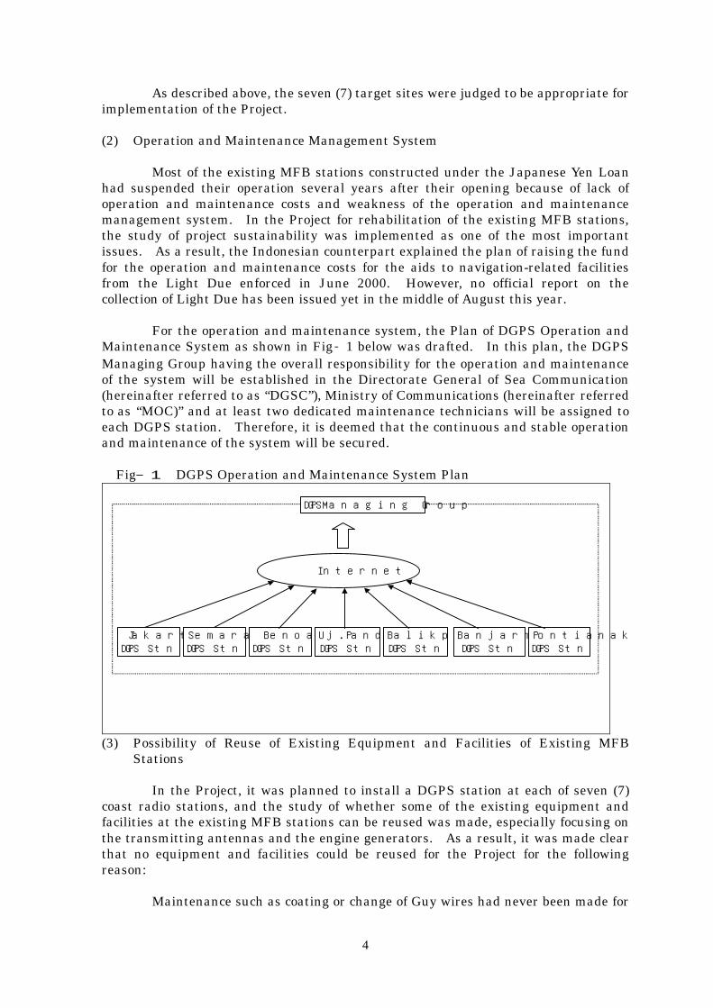
As described above, the seven (7) target sites were judged to be appropriate forimplementation of the Project.
(2) Operation and Maintenance Management System
Most of the existing MFB stations constructed under the Japanese Yen Loanhad suspended their operation several years after their opening because of lack ofoperation and maintenance costs and weakness of the operation and maintenancemanagement system. In the Project for rehabilitation of the existing MFB stations,the study of project sustainability was implemented as one of the most importantissues. As a result, the Indonesian counterpart explained the plan of raising the fundfor the operation and maintenance costs for the aids to navigation-related facilitiesfrom the Light Due enforced in June 2000. However, no official report on thecollection of Light Due has been issued yet in the middle of August this year.
For the operation and maintenance system, the Plan of DGPS Operation andMaintenance System as shown in Fig‐1 below was drafted. In this plan, the DGPSManaging Group having the overall responsibility for the operation and maintenanceof the system will be established in the Directorate General of Sea Communication(hereinafter referred to as “DGSC”), Ministry of Communications (hereinafter referredto as “MOC)” and at least two dedicated maintenance technicians will be assigned toeach DGPS station. Therefore, it is deemed that the continuous and stable operationand maintenance of the system will be secured.
Fig―1 DGPS Operation and Maintenance System Plan
Internet
JakartaDGPS Stn
SemarangDGPS Stn
BenoaDGPS Stn
Uj.PandangDGPS Stn
BalikpapanDGPS Stn
BanjarmasinDGPS Stn
PontianakDGPS Stn
DGPSManaging Group
(3) Possibility of Reuse of Existing Equipment and Facilities of Existing MFBStations
In the Project, it was planned to install a DGPS station at each of seven (7)coast radio stations, and the study of whether some of the existing equipment andfacilities at the existing MFB stations can be reused was made, especially focusing onthe transmitting antennas and the engine generators. As a result, it was made clearthat no equipment and facilities could be reused for the Project for the followingreason:
Maintenance such as coating or change of Guy wires had never been made for
5
the transmitting antennas after their construction, so that it will be very difficult toreuse these antennas for next ten (10) years or more. The engine generators do notmeet the requirement for the power capacity necessary for the Project and could not bereused in the Project.
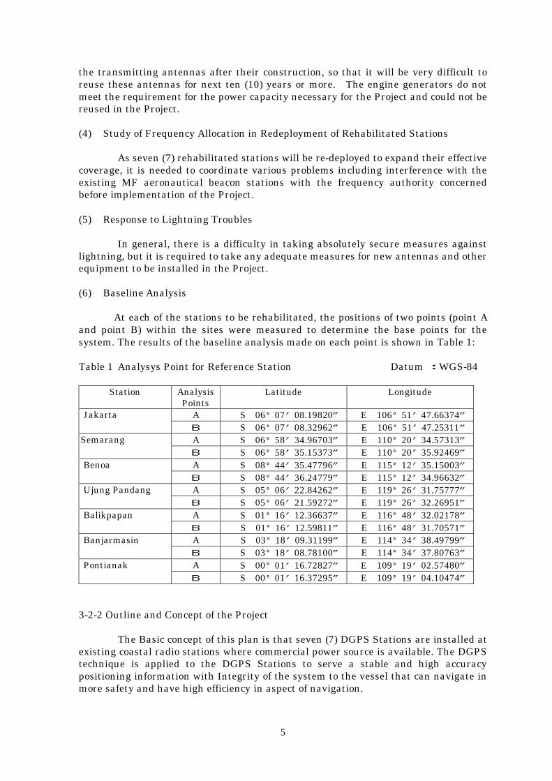
(4) Study of Frequency Allocation in Redeployment of Rehabilitated Stations
As seven (7) rehabilitated stations will be re-deployed to expand their effectivecoverage, it is needed to coordinate various problems including interference with theexisting MF aeronautical beacon stations with the frequency authority concernedbefore implementation of the Project.
(5) Response to Lightning Troubles
In general, there is a difficulty in taking absolutely secure measures againstlightning, but it is required to take any adequate measures for new antennas and otherequipment to be installed in the Project.
(6) Baseline Analysis
At each of the stations to be rehabilitated, the positions of two points (point Aand point B) within the sites were measured to determine the base points for thesystem. The results of the baseline analysis made on each point is shown in Table 1:
Table 1 Analysys Point for Reference Station Datum :WGS-84
Station AnalysisPoints
Latitude Longitude
A S 06°07′08.19820″ E 106°51′47.66374″JakartaB S 06°07′08.32962″ E 106°51′47.25311″A S 06°58′34.96703″ E 110°20′34.57313″SemarangB S 06°58′35.15373″ E 110°20′35.92469″A S 08°44′35.47796″ E 115°12′35.15003″BenoaB S 08°44′36.24779″ E 115°12′34.96632″A S 05°06′22.84262″ E 119°26′31.75777″Ujung PandangB S 05°06′21.59272″ E 119°26′32.26951″A S 01°16′12.36637″ E 116°48′32.02178″BalikpapanB S 01°16′12.59811″ E 116°48′31.70571″A S 03°18′09.31199″ E 114°34′38.49799″BanjarmasinB S 03°18′08.78100″ E 114°34′37.80763″A S 00°01′16.72827″ E 109°19′02.57480″PontianakB S 00°01′16.37295″ E 109°19′04.10474″
3-2-2 Outline and Concept of the Project
The Basic concept of this plan is that seven (7) DGPS Stations are installed atexisting coastal radio stations where commercial power source is available. The DGPStechnique is applied to the DGPS Stations to serve a stable and high accuracypositioning information with Integrity of the system to the vessel that can navigate inmore safety and have high efficiency in aspect of navigation.

6
The service area of each DGPS Station is shown as Figure –2 “ServiceCoverage of DGPS Stations”.
Figure‐2 Service Coverage of DGPS Stations
The DGPS system is designed based on the following basic concept;
・ Compliance with International standard and Indonesian Law.・ Establishment of long-term operation.・ Securing stable operation of system and easy maintenance.・ Minimization of maintenance cost・ Consideration of environmental condition.・ Rehabilitation of the existing Equipment on the DGPS system・ Maximal utilization of existing equipment and facilities・ Securing the stable operation and maintenance system
Jakarta
Semarang
Benoa
Ujung Pandang
Banjarmasin
Pontianak
Balikpapan
7
2-3 Basic Design
2-3-1 Design Concept
(1) Consideration for Environmental Conditions
The following points shall be considered for the procurement of equipment andmaterials in the light of the environmental conditions in Indonesia.
・ The adequate operational temperature range is applied for Outdoor andIndoor equipment respectively.
・ Waterproof mechanism is applied for Outdoor equipment.・ Operational temperature of “40°C” is applied to Outdoor equipment.・ Wind load of “45m/s” is applied to Outdoor equipment.・ Seismic factor is complied with Indonesian Standard.・ Operational temperature of “35°C” and relative humidity of “98% at “35°C”
with no condensation are applied to Indoor equipment except PersonalComputer (PC) and its peripheral.
・ The PC and its peripheral are complied with standard temperaturespecification that is applied usually in market.
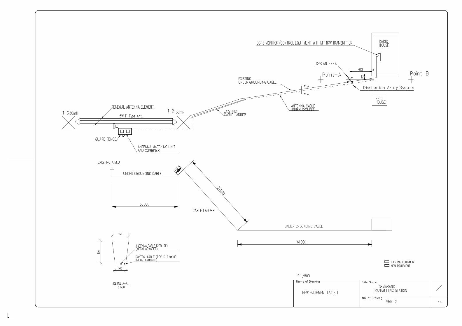
・ Improvement of existing anti-lightning apparatus is carried out to reinforceanti-lightning ability. And the Dissipation Array System (DAS) is providedin Semarang to prevent damage for the newly installed GPS antenna bycause of lightning where there are no anti-lightning facilities.
(3) Practical use of Local Contractor
・ Engineer of manufacture carries out an adjustment works for equipmentbecause DGPS system is first adoption in Indonesia.
・ Local engineer and technician carry out an installation works for equipmentunder control by Engineer of manufacture.
(4) Countermeasure for ability of Operation and Maintenance by the executing Agency
The DGSC and Survey team has been agreed as follows;Immediately after the signing of the Exchange of Notes (E/N) on the Project under theJapan’s Grant Aid, the DGPS Managing Group is newly established in DGSC tomanage and control the DGPS system. The DGPS Managing Group composes ofadequate staffs and leader. Two maintenance personnel at least are assigned for eachDGPS Station.
Head of the DGPS Managing Group is recommended to join the counter parttraining to have knowledge regarding the securing of a budget, establishment ofmanagement group, arrangement of staffs, training plan and operation andmaintenance schedule for management of the DGPS Station.
Chief of Technical Engineer is recommended to join the counterpart trainingand On-the-job Training (OJT) for having of knowledge regarding latest technology,and technique of maintenance and operation.
Even though DGSC is able at present to secure two personnel as engineer,
8
(Table 2), for operation and maintenance of DGPS Station system, the technicaltraining is important to have the more skilled engineer for maintenance and operationin future.
Table 2 List of staffs of Coastl Radio Stations
Name of station(Class)
Sta
tion
Mas
ter
Ch
ief
Tec
h-N
icia
n
Mar
-co
nis
Tec
h-n
icia
n
Total
Jakarta (I) 1 1 96 21 119Uj. Pandang (I) 1 1 46 11 59Balikpapan (II) 1 1 15 7 24
Banjarmasin (II) 1 1 22 12 36Semarang (II) 1 1 31 10 43
Benoa (III) 1 0* 23 1 25Pontianak (III) 1 0* 18 1 20
Training course for maintenance engineer has been postponed in latest three(3) years because of lacking of budget. The resumption of training course is advised inDGSC to skill up and maintains technical level of engineers.Maintenance engineers for DGPS Station are advised to skill up by carrying out ofSoft-component by JICA and the OJT that will be done by the manufacturer.
(5) Scope of Building and Equipment, Setting of grade
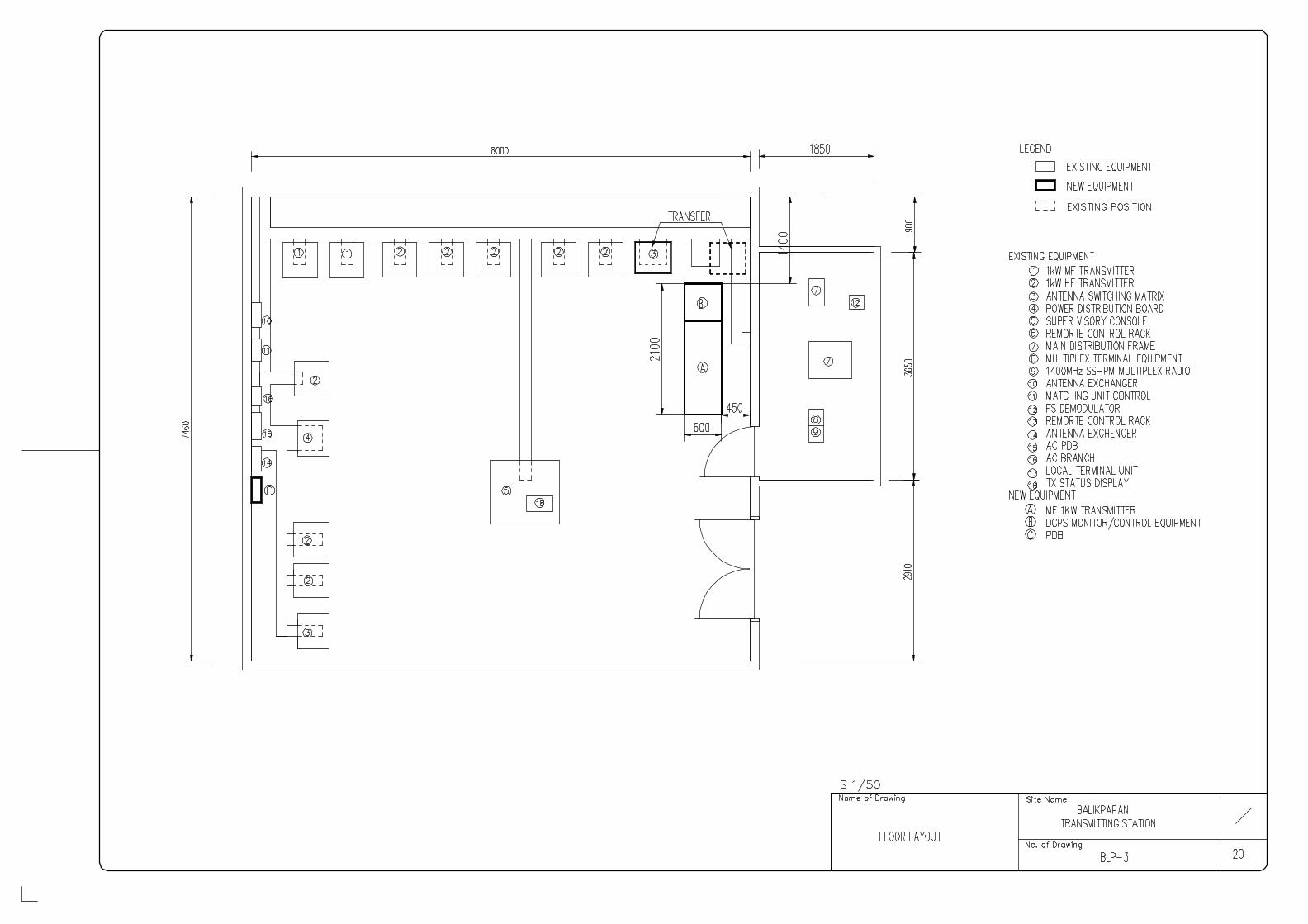
The Project provides no building work because installation space forequipment is available to secure by re-allocation of existing equipment or furniture ateach existing coastal radio station.
The DGPS system requires the high-grade (high reliability) equipment inorder to offer high accuracy positioning information, even if it is a severeenvironmental condition for vessel navigating coastal of Indonesian waters in safety.
(6) Concept of the Implementation schedule
In case the Project is carried out under the Japan’s Grad Aid, the Project shallbe completed usually in a fiscal year. The fifteen-(15) months of implementation periodare required from contract to complete the Project. Degradation of outdoor workefficiency will be made on a rainy season from December in Indonesia.
To complete the Project by the target date, the foundation work of tower andembedding work of cable is planed to carry out before the beginning of rainy season.
The Implementation schedule shall be discussed on time with staff of coastalradio station because the system for DGPS Station is planed to co-use with the existingequipment of T-type antenna, Antenna matching unit and Power supply system as acomponent of the new system.
9
2-3-2 Basic Design
2-3-2-1 Overall Plans
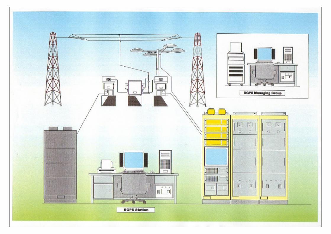
(1) Outline of the system
The DGPS system composes mainly of “DGPS transmitting system” and“DGPS monitoring system” as shown in Fig 3. The DGPS transmitting systemcomposes of a transmitting antenna, antenna-matching unit, MF Transmitter andDGPS monitor/control equipment. The DGPS monitoring system composes of Datacommunication/transfer equipment and Data processing Equipment that are able tocommunicate each other by INTERNET. The DGPS Managing Group is finally ableto have the DGPS monitoring data of seven (7) stations.
Power supply system and air-conditioner are improved or reinforced uponconsideration of actual situation of each station. The navigation vessel at the servicecoverage of DGPS stations is able to not only use DGPS signal for correction of vesselposition, but also confirm the Integrity of system that guarantees positioning accuracy.
Figure 3 DGPS System Outline
DGPS Signal GPS Satellite
GPS Signal
DGPS Signal
GPS Signal
DGPS Monitoring System
Provider
DGPS Signal GPS Signal
Transmitting antenna
Data ProcessingEquipment
DataCommunication/
Transfer Equipment
MF TRansmitter
DGPS Monitor/ControlEquipment
Antenna Matching Unit
Power Supply System
DGPS Transmittingsystem
INTERNET

10
(2) Allocation Plan of Main Equipment for Seven (7) Stations
Allocation Plan of main equipment for seven (7) stations is shown in Table 3;
Table 3 Allocation Plan of Main Equipment
Main Equipment
JKT
SM
G
BN
A
UP
G
BP
N
BJM
PT
K
DM
G
1. DGPS Transmitting System(1) Transmitting Antenna ○ ○ ○ ○ ○ ○ ○
(2) Antenna Matching Unit ○ ○ ○ ○ ○ ○ ○
(3) Antenna tower ○ ○ ○ ○ ○ ○ ○
(4) MF Transmitter ○ ○ ○ ○ ○ ○ ○
(5) DGPS Monitor/Control ○ ○ ○ ○ ○ ○ ○
(6) Software for (5) above. ○ ○ ○ ○ ○ ○ ○
2. DGPS Monitoring System(1) Data Processing Equipment ○
(2)Data Comm./transfer Equip. ○ ○ ○ ○ ○ ○ ○
(3) Software for (2) above. ○ ○ ○ ○ ○ ○ ○
3. Power supply system(1) Engine Generator ○ ○ ○
(2) Isolation transformer ○ ○ ○ ○
(3) Automatic Voltage Regulator ○ ○ ○ ○
(4) Step-up/down ○ ○ ○ ○
4. Interference Protection Equipment ○ ○
5. Associated facility(1) Anti-lightning facility ○ ○ ○
(2) Air conditioner ○ ○ ○
6. Operation & Maintenance Equipment ○ ○ ○ ○ ○ ○ ○
7. Spares ○ ○ ○ ○ ○ ○ ○ ○
Note: JKT: Jakarta, SMG: Semarang, BNA: Benoa, UPG: Ujung Pandang,BPN: Balikpapan, BJM: Banjarmasin, PTK: Pontianak, DMG: DGPS Managing Group
(3) Circumstances of Operation at Coastal Radio Stations
The coastal radio station where DGPS Station will be installed iscategorized as Class I, Class II and Class III. Criteria to categorize coastal radiostation are shown in Table 4.
Table 4 Criteria of Coastal Radio Stations in Indonesia
Category TransmittingPower
Operation TimeSchedule
TX and RXStation
Seven (7) stations forthe Project
Class Ⅰ 1kW~5kW 24 hours Separate Jakarta,Uj. Pandang
Class Ⅱ 500W 16~18 hours Separate SemarangBalikpapan
Banjarmasin
Class Ⅲ 250W 8hours Co-site BenoaPontianak
Class Ⅳ 100W Intermittentoperation
Co-site ---------

11
There are some discrepancies between the actual operation schedule and theschedule above, in aspect of Transmitting Power and Operation Time Schedule becausethose criterions have been applied before establishment of GMDSS. For example,even though some coastal radio stations are Class II and III, the 24 hours operationhas been adopted. The only Pontianak coastal radio station out of seven (7) stationsadopts of thirteen (13) hours operation. Other stations adopt 24 hours operation.Pontianak station will adopt 24 hours operation when the DGPS Station isestablished.
(4) Power supply system and Backup for system
The existing power supply system is utilized as possible as subject to thesecuring of operation and maintenance in coming ten (10) years. The un-interruptedPower Supply (UPS) with batteries is adopted in minimum for important part aspersonal computer (PC) that controls and monitors DGPS system. The supportingtime duration by UPS is designed of twenty (20) minutes in maximum because theoutput of engine generator (E/G) system will be established within ten (10) minutesafter commercial power off.
2-3-2-2 Equipment Plan
Purposes and Specifications of main equipment for DGPS Station are specifiedas follows.
(1) DGPS Transmitting System
The MF Transmitter and DGPS Monitor/Control equipment have a duty and astandby those are able to exchange automatically when malfunction will be detected.Purpose, specification and quantity of main equipment is shown in Table 5.
Table 5 Main Equipment for DGPS Transmitting System
Name of equipment Purpose Main specification Q’ty1.Transmitting Antenna Simultaneous transmission of
two frequencies by oneantenna.
T-type, Medium frequency, five(5)element, Rated power: 1/5kW, Anti-corrosion type
7
2. Antenna matching
a. Combiner Combine of output forNAVTEX/TG and DGPSsystem
Rated power:1kW except Jakarta,5kW for Jakarta、Outdoor type
7
b. AntennaMatching Unit
Matching of impedance forAntenna and transmitter
Rated power:1kW、Outdoor type 7
3. Antenna Tower(Only for SROP
Benoa)
Supporting of T-type antennainstalled newly.
30m Height、Hot-dippedgalvanize:500g/㎡、Self supporting、Flat base foundation
7
4. MF Transmitter Transmitting correctinformation for DGPS Stationsystem.
RF output power:1kW、All solidstated、Frequency band: 285 -325kHz、MSK modulation、Consumable power: 4kVAor less、Duty and Standby
7
12
Name of equipment Purpose Main specification Q’tyReference Station (RS) Unit(Creating Position CorrectionInformation, and send totransmitter)
2 freq. model、RS functions、Mask ofeach 0.5°steps、RSIM Monitoring、Unti-multi-pass, Waterproof of Ant.,Ant for 2 freq. type、Duty andstandby.
Integrity Monitor Unit(Securing System Integrity)
1 freq. model、IM functions、MaskAngle of each 0.5°steps、Unit-multi-pass, Waterproof of Ant., GPS Antfor 2 freq. type、High electro-magnetic field type Duty andstandby
5. DGPS Monitor/ Control Equipment
Monitor and Control Unit(Securing of Monitor/Controlfunctions for DGPSTransmitting system)
CPU:32bits or more、Clock:200MHzor more, Memory::64MB or more、HDD:4GB or more、CD-ROM・FDD、
WinNT4.0 latest English Version、Monitor:14 inch、Monitor/ controlfunctions、UPS, LAN:100/10Base-T、
Duty and Standby
7
6.Software for DGPS Monitor/Control
Equipment
Control and Monitor functionfor MF TransmitterDGPS Monitor/ ControlEquipment
Application Software 1
(2) DGPS Monitoring System
The operation and monitoring system composes of Datacommunication/transfer equipment and Data processing equipment. The Datacommunication/transfer equipment is installed at seven (7) coastal radio stations andData processing equipment is installed at DGSC Jakarta. Purpose, specification andquantity of each equipment is shown in Table 6.
Table 6 Main Equipment for DGPS Monitoring System
Name of equipment Purpose Main specification Q’ty
1. Data processingEquipment
Receiving of Monitoringdata, Data Processing,Display, Print out,Calculation of Statistics forDGPS Station, Analyze ofOperational status
CPU:32bits or more、Clock:500MHzor more、Memory::64MB or more、HDD:4GB or more、CD-ROM・FD
D、Win-NT4.0 latest EnglishVersion、Color Laser Printer:600dots or more A4&A3、Monitor:17 inch 1027x768dots ormore, with Modem, UPS andIntegrated application softwareincluding spreadsheet, wordprocessor and mailing software atleast
1

13
Name of equipment Purpose Main specification Q’ty
2. Data Communication/ Transfer Equipment
Sending of monitoring datafor DGPS Station, Editingof data, Data processing,Display, Print out ofprocessed data
CPU:32bits or more、Clock:500MHzor more、Memory::64MB or more、HDD:4GB or more、CD-ROM・FD
D、Win-NT4.0 latest EnglishVersion、Ink jet Printer (A4 ) ormore、Monitor:15 inch 1027x768dots ormore, with Modem, UPS andIntegrated application softwareincluding spreadsheet, wordprocessor and mailing software atleast.
7
3. Software for DGPS Monitoring System
Operation and monitorfunction for DGPS system
Application Software 1
(3) Anti-lightning Facilities
Improvement of anti-lightning facilities and installation of Dissipation ArraySystem are done to prevent damage caused by lightning for newly installed equipment.Purpose, specification and quantity of each equipment is shown in Table 7.
Table 7 Main Equipment for Anti-Lightning Facilities
Name of equipment Purpose Main specification Site Q’ty1. Dissipation Array
SystemPrevention of damage forDGPS equipment bydischarging continuously oflightning power.
Dissipation ArraySystem shall cover GPSantenna.
Semarang 1
2. Improvement of anti-lightning facilities
Prevention of damage forDGPS equipment bybypassing of lightning power.
Protection angle 45°,Earth resistance: 10ohm or less
Semarang (2),Benoa (2),Pontianak (2)
6
(4) Power Supply System
The existing power supply system is basically utilized as backup power systemfor DGPS Station. Improvement and rehabilitation works are done for the aged powersupply system and the lacking of power supply capacity. Purpose, specification andquantity of each equipment is shown in Table 8.
Table 8 Main Equipment for Power Supply System
Name of equipment Purpose Main specification Site Q’ty1. 15kVA Engine
GeneratorBackup ofcommercial powersupply
Rated capacity:15kVA 50Hz、Output voltage:AC380/220V3P4W、LocalControl Panel、Day tank
Benoa,Pontianak
2
14
Name of equipment Purpose Main specification Site Q’ty2. 50kVA Engine
Generatorditto Rated capacity:50kVA 50Hz、
Output voltage:AC380/220V3P4W、LocalControl Panel、Day tank
Uj. Pandang 1
3. Isolation Transformer Protection forlightning
Rated capacity:15kVA、
Input:AC380/220V3P4W、
Output:AC380/220V3P4W、
Discharge capacity:15kAContinuous operation
Benoa,Pontianak
2
4. Isolation Transformer ditto Rated capacity:40kVA、
Input:AC380/380V3P4W、
Output:AC380/380V3P4W、
Discharge capacity:15kAContinuous operation
Balikpapan,Banjarmasin(2 sets)
3
5. Automatic VoltageRegulator
Voltage regulationfor commercialinput voltage
Rated capacity:15kVA 50Hz、Continuous operation、Input voltage:AC380/220V3P、Output:AC380/220V3P,Stability±2% or more、Natural cooling
Benoa,Pontianak
2
6. Automatic VoltageRegulator
ditto Rated capacity:40kVA 50Hz、Continuous operation、Input voltage:AC380/220V3P、Output:AC380/220V3P,Stability±2% or more,Natural cooling
Balikpapan,Banjarmasin
2
7.Step-up/downTransformer
Step-up to AC380Vfrom AC220V andStep-down fromAC380V to AC220V
Rated capacity:7.5kVA 50Hz
Continuous Operation、Input:AC220V3P4W、
Output:AC380V3P4W、
Natural cooling
Jakarta,Uj.Pandang,Balikpapan,Banjarmasin
4
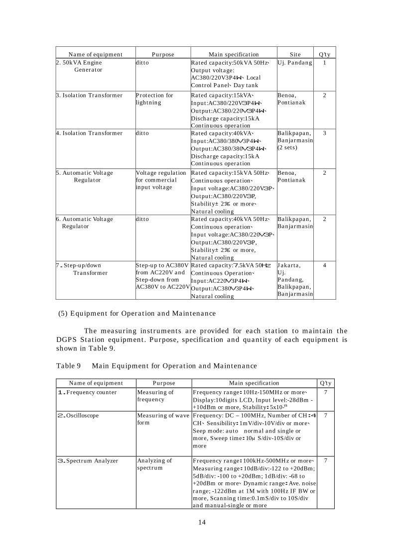
(5) Equipment for Operation and Maintenance
The measuring instruments are provided for each station to maintain theDGPS Station equipment. Purpose, specification and quantity of each equipment isshown in Table 9.
Table 9 Main Equipment for Operation and Maintenance
Name of equipment Purpose Main specification Q’ty
1.Frequency counter Measuring offrequency
Frequency range:10Hz-150MHz or more、Display:10digits LCD, Input level:-28dBm -+10dBm or more, Stability:5x10⁻⁸
7
2.Oscilloscope Measuring of waveform
Frequency: DC – 100MHz, Number of CH:4
CH、Sensibility:1mV/div-10V/div or more、Seep mode: auto normal and single ormore, Sweep time:10μS/div-10S/div ormore
7
3.Spectrum Analyzer Analyzing ofspectrum
Frequency range:100kHz-500MHz or more、Measuring range:10dB/div:-122 to +20dBm;5dB/div: -100 to +20dBm; 1dB/div: -68 to+20dBm or more、Dynamic range:Ave. noiserange; -122dBm at 1M with 100Hz IF BW ormore, Scanning time:0.1mS/div to 10S/divand manual-single or more
7

15
Name of equipment Purpose Main specification Q’ty
4.DGPS Signal EvaluationEquipment
Measuring ofDGPS signals, andtheir evaluation
1freq. type、12CH、S/N, Signal strength、MNEA0183 type、Lap-top type P/C(Pentium500MHz or more、memory 64MB or more、LCD12inch or more、CD-ROM、FDD、
OS:Win98 English Version)、hand-carrycase.
7
(6) Spares
The spares are provided to recover the original functions when malfunction isoccurred. The unit in failure shall be repaired and putted back in the box. Purpose,specification and quantity of each equipment are shown in Table 10.
Table 10 Main Equipment for Spares
Name of equipment Purpose of use Main specification Storage Q’ty
1. Spare for MF transmittersystem
Maintenance forDGPS station
system
a.Main PCB for MFTransmitter and others
Recovery offunction in ashort term
TX Power unit, PS Monitorunit, Alarm display, Meterselector, Power amplifier, RFOutput monitor, Signalcontroller, TX power regulator
Jakarta 3 lots
b.Spare for MFtransmitter
Recovery offunction in ashort term
E/O Modem, E/O Cable, SerialI/F, Parallel I/F, Change overunit, Line compensator, TXcontrol unit, I/F for TXcontrol, Switch for TX controlunit, MSK Modem
Each DGPSstations
7 lots
2. Spare for DGPS Monitorand Control Equipment
Maintenance forDGPS station
system
a.RS Receive unit Recovery offunction in ashort term
RS function, 2 freq. Type,Rack mount type
Jakarta 3 lots
b.IM Receiver unit Ditto IM function, 1frq., Rackmount type
Ditto 3 lots
c.Monitor and controlunit
Ditto CPU:32bits or more, Clock:200MHz or more、HDD:4GBor more, CD-ROM・FDD、
OS:WinNT V4 latest EnglishVersion, Application softwarefor Monitor and controllingunit
Ditto 3 lots
d.DGPS Antenna Ditto High electric magnetic model Ditto 3 lots
e.GPS Antenna Ditto Unti-Multi-pass type、2freq.Type
Each DGPSStation
7 lots
f.Monitor Changer Ditto Two-input selectable forMonitor & Mouse
Ditto 7 lots
g.Signal Distributor Ditto RS, IM, DGPS Mon/ConEquip signal selectableautomatically
Ditto 7 lots
16
Chapter 3 Implementation Plan
3-1 Implementation Plan
When the Project is defined as a Japan’s Grant Aid project, it will beimplemented in accordance with the following concept:
3-1-1 Implementation Concept
The Project will be implemented by the DGSC, MOC as the executing agencyto control the aids to navigation administration in a centralized way, and the Sub-Directorate of Maritime Telecommunication under the Directorate of Navigation ofDGSC will be in charge of the Project. In the operation and maintenance stages aftersupply of equipment, the DGPS Managing Group to be newly established within theDGSC will have the overall responsibility for all matters related to the suppliedequipment.
After the Exchange Note (E/N) is agreed under the resolution of the Cabinet,the contract will be concluded between the executing agency of Indonesia and aJapanese consultant company to entrust the consultant company with the tender andproject management works. The contracted consultant must extensively support theexecuting agency in conducting these works in all the processes in which the contractorto undertake the equipment delivery and installation will be selected and signs thecontract in accordance with fair and proper procedures.
The main contractor of the Project will be a Japanese corporation, which isrequired to be familiar with the local conditions at the project sites, have wealthyexperience and to be prepared for the after-delivery service system in the equipmentprocurement work. In this respect, it is desirable that such corporation has a branchoffice or resident representative office in Indonesia.
The Project will basically be implemented as an equipment procurementproject. The civil work including tower foundation and buried waved-duct works willhave a small portion of the entire project, in which the equipment installation work isincluded.
In the Project, the MFB stations will be improved in their functionality byproviding those with DGPS-related equipment and computers for system monitor andcontrol, so that the installation and adjustment works will require special expertiseand technique. Therefore, the local technicians will conduct the installation workunder the supervision of Japanese engineers, but the Japanese engineers willundertake all the adjustment work.
As a new system is introduced, the technical training and consulting for theoperation and maintenance personnel on the Indonesian side will be studied fromvarious aspects. In addition, the soft component will support the Indonesiancounterpart in preparing operation and maintenance manuals for the system.
3-1-2 Implementation Conditions

17
According to the implementation concept above, it is necessary to take thefollowing items into account to smoothly execute the Project based on theimplementation schedule.
(1) Securing Prompt Procedure within the Recipient CountryAs the Project is one fiscal year matter by the Japan’s Grant Aid, it will be
required for the smooth and prompt execution of procedures for the Project, in orderthat a delay of the implementation schedule does not result from the time to be spentfor the several procedures within the recipient country.
(2) Re-allocation of FrequencySince the DGPS station co-establishes at the existing Coastal Radio Station
side by side, and the coverage area of the DGPS station enlarges by 300km, it isnecessary to coordinate previously with authority concerned on the new frequency tobe re-allocated for each DGPS station. The settlement of frequency matter should becompleted before the commencement of manufacturer’s test for the equipment.
(3) Contract of Commercial Electricity Power SupplySince the DGPS transmitting system is newly installed at the existing coastal
radio station, it is necessary to increase the contract capacity of commercial electricitypower for the Benoa and Pontianak stations to be in short supply. It is required tocomplete the change of contract capacity before the commencement of installationworks.
(4) Installation of New Public Telephone LinesIt is required to install more the public telephone lines on the establishment of
Internet before the commencement of adjustment work. A delay of the installation ofnew public telephone Lines not only causes a delay of synthetic and/or individualadjustment works, but also causes retracing adjustment work steps
(5) Selection of the Internet Service ProviderThe Internet Service Provider of an established reputation should be selected
for the DGPS Managing group and each DGPS station, as the smooth E-mailcommunication circumstances will be secured.
(6) Temporary WorksSince the existing facilities and equipments of the coastal radio station are co-
used for the Project, it is necessary to make a sufficient pre-discussion and aconsideration for the execution of temporary works, so as not to hinder the regularservices of the coastal radio station at the installation work stage.
3-1-3 Scope of Works
The obligation of both of the Governments on the Project is specified asfollows;
(1) Obligation of the Japanese Government
・ Procurement of the goods (Equipments and materials) for the Project, andmarine transportation and inland transportation to the Sites.
・ Installation works for the equipments on the Project, including civil works onthe foundation work for self-supporting tower, buried wave ducts work and so

18
forth.・ Preparation of the operation and maintenance plan, and technical assistance
on the system operation.・ Marine Insurance including Inland Transportation
(2) Obligation of the Recipient Country
・ Supplement of the Contract of Commercial Electricity Power Supply・ Contract and Installation of the new Public Telephone Line・ Establishment of the E-mail circumstances including contract of the Internet
Service Provider・ Establishment of the operation and maintenance system including the
organization and budgetary management in order to operate and maintainsmoothly the system to be established by the Project.
・ Re-allocation of the Frequency
3-1-4 Consultant Supervision
(1) Consulting Services
The Consultant carries out the supervision for the implementation of theProject based on the proper progress management of the works, quality control and themanagement of amount of works done.
The Consultant dispatches one (1) permanent managing staff in time to thecommencement of installation works, and spottily dispatches the engineer asmanaging specialist for each work progress to the Indonesia on the consulting services.
In consideration with the execution of the Project by the Japan’s Grant Aid,the Consultant copes with the first of all for the smooth execution of the Project bymeans of the proper assigning of managing staff so as to exactly execute the discussionwith the authorities concerned that is the executing agency and so forth, and theseveral procedure in Japan on the Japan’s Grant Aid.
And also, the Consultant deals with a positive manner of the technicaltransfer on the methods and technique of installation. The main services of theConsultant are as follows;
・ The consultation and discussion with the executing agency and the authoritiesconcerned on the installation works in Indonesia.
・ Confirmation of the installation work progress・ Confirmation of the quality control of the materials・ Witness to the Inspections・ Confirmation of the Coordinates of Antenna Positions of the DGPS Reference
Station・ The execution of Evaluation Test of the System Accuracy, and Confirmation of
the Accuracy・ Issue of the several Certifications after endorsement by Recipient Country・ Submission of the several Reports・
(2) Conditions of the Consulting Services

19
In connection with the execution of the main services above of the Consultant,the items to be considered seriously are as follows;
1) The Consultation and Coordination with the executing agency and the authoritiesconcerned on the installation works in Indonesia
In connection with the progress of the responsible matters to be born byIndonesia and the several procedures and/or formalities, the Consultant should takethem into account so as not to cause the effects to the implementation schedule of theProject, as the execution of the Project within one (1) fiscal year.
2) Confirmation of the Work Progress, and so forth・ Preparation of the inspection manuals on the work progress management, and
establishment of the frequency of the execution of their inspection.・ Preparation of the inspection manuals on the quality control, and
establishment of the frequency of the execution of their inspections.・ Preparation of the inspection manuals on the work progress management, and
establishment of the frequency of their inspections.・ Execution of the proper photographing management of the installation works,
and taking and keeping adequately the photographs at the installation workstage, at the portions with the difficulties to watch after installation worksand under the construction.
3) Confirmation of the Quality Control of the Materials
The Consultant confirms the quality of materials and so forth upon thesubmission of the data on quality guaranteed.
4) Witness to the Inspections
・ Execution of the inspection on progress-payment for the Contractor, and theapproval procedure
・ Execution of the inspection before the work completion, and Instructions onthe readjustment of the works.
・ Execution of the final inspection (Acceptance Test), and procedures on thework completion
5) Confirmation of the Coordinates of the Antenna Position of the DGPS ReferenceStation
The consultant confirms that the coordinate of the antenna position of theDGPS reference station of each DGPS station complies with the coordinate planned.
6) Evaluation of the System, and Confirmation of the System Accuracy
The Consultant carries out the Evaluation Test due to the confirmation thateach DGPS station has a planned positioning accuracy.
7) Issue of the several Certifications after endorsement by Recipient Countries
The Consultant issues the following certificates;・ Certificates on the work progress at the times of payments to the Contractor

20
・ Certification of the work completion・ Certification of the completion of warranty period
8) Submission of the several Reports
The Consultant shall submit the reports on work progress, as-built drawingsand photographs-related to the Project Implementation to the Government ofIndonesia and JICA, and shall submit the work completion report to the JICA
(3) Organization of the Consulting Services
The Consulting services on the procurement of equipments and theinstallation works are major works in the Project. It is planned for nine (9) months ofthe procurement stage and six (6) months of the installation work stage. In addition,the execution of the services on design stage, inspection of the manufacturing progressand so forth is required as a part of the Consulting services.
Therefore, the Consultant dispatches no permanent managing staff to theIndonesia for the whole period of the Project. However, the Consultant properlydispatches the specialist necessary for each work progress to the Indonesia. Japaneseengineers on the Consulting Services are timely dispatched when necessary, and thenumbers of engineers and their period to be dispatched are allocated in accordancewith the contents of works and implementation schedule as follows
1) Chief Consultant
The Chief Consultant is in charged of the whole Consulting Services. He isdispatched to the Indonesia at the time of the pre-consultation/ discussion before thecommencement of the installation works, the commencements of major works andtheir completion, and the whole work completion.
2) Procurement Plan
The engineer in charge of Procurement Plan is dispatched for the followingservices;
① Services in Japan・ Prior Discussion with Manufacturer before manufacturing・ Check and approval of the shop/ manufacturing drawing・ Factory Inspection under manufacturing・ Factory Inspection on manufacturing including shipping inspection
② Services in Indonesia・ Work progress management for the installation work period・ Witness to the inspection of the work completion after the installation works
3) Supervision I
The Supervision I stays permanently for the period of installation works onthe shift of equipment and improvement of the existing equipment for the Project. Heis in charge of the following services;・ Discussion with the Contractor

21
・ Check/ confirmation of the installation drawings, and their approval・ Inspection on the equipment procurement in Indonesia, and their shipping
inspection・ Work progress management for the installation work period・ Witness to the inspection of work completion after the installation works・ Check/Confirmation of the operating condition of the system by the inspection for
warranty at the time of one (1) year after the acceptance completed
4) SupervisionⅡ
The SupervisionⅡ supervises for the equipment to be newly installed for theDGPS, in accordance with the contents of services of the Supervision I as described theabove.
5) Aids to Navigation Expert
The Aids to Navigation Expert is generally in charge of the supervision ofmanufacturing on the function of the DGPS monitor/Control equipment in Japan inaccordance with the services of Procurement Plan above, and in charge of the followingservices in Indonesia;
・ Witness to the Inspection on the equipment procurement in Indonesia, andtheir shipping inspection
・ Check/ confirmation of the Antenna Position for the reference stations・ Evaluation test of the DGPS system, and check/ confirmation of its system
accuracy
22
3-1-5 Procurement Plan
(1) Examination on Country of Origin of Equipment and Materials
In this project, the rehabilitation of MFB stations are achieved by means ofDGPS technique and DGPS station is co-sited at the existing coastal radio station.DGPS transmitting system, which is a core of DGPS system, was designed based onDGPS system operated in Japan. Internet is utilized as data communication line tomonitor all DGPS stations as against utilizing a communication satellite in Japan.
This system forms a part of aids to navigation services. Operation andmaintenance are very important matter in order to achieve the positioning accuracyand high availability (99.9%) recommended by IALA. For a navigator, not only thatthe DGPS station continuously transmits the DGPS signal and its signal can bereceived at ship, but also the Integrity of system (Guarantee of positioning accuracy tobe required for the system) must be secured.
When we construct this system, it is necessary not only a close inspectionmade on performance of each part, but also to confirm that the required positioningaccuracy and high availability must be secured for the system.
On the premise that the said availability and positioning accuracy areachieved, it is indispensable that the Consultant and/ or Contractor assist fromtechnical aspect, in order that the operation and maintenance by Indonesia side areput into practice with certainty, after acceptance of the equipment and materials whichare procured under Japan’s Grant Aids Scheme. In case of consideration ofmaintainability and securing aftercare system, it is necessary that the supplier‘ssupport system for operation and maintenance of the system can be always confirmedby the Consultant and the Contractor. As a result of examination for country of originof equipment and materials to be procured under the Project in consideration of thoseimportant points, there is no advantage to procure goods in the third country. Inaddition, we decided that the major equipment and materials should be procured inJapan.
Further, we decided the following equipment as local procurements which canprocure in Indonesia and be fully supported by the supplier for the operation andmaintenance, based on the result of field survey;
① Personal computers and their peripherals except server machines for DGPSMonitor and Control Equipment.
② Antenna tower③ Diesel engine generator with radiator④ Air-conditioning Facilities
23
(2) DGPS Transmitting System
The DGPS Transmitting System consists of MF Transmitter and DGPSMonitor/Control Equipment, and these shall be in compliance with the technicalstandards on the International Telecommunications Union (ITU), InternationalMaritime Organization (IMO), International Association of Marine Aids to navigationand Lighthouse Authorities (IALA) and so forth. Local Area Network (LAN) is incompliance with the IEEE802.3, and the TCP/IP or UDP/IP is required for thecommunication protocol.
It is desirable for the manufacturer being well skilled on the equipmentrelated to the DGPS and the MFB band equipment, since the DGPS Monitor/ControlEquipment of the DGPS Transmitting System have an influence upon the positioningaccuracy of the system, and the existing 500KHz band MF transmitting Antenna is co-used for the Project
In connection with the selection of the Contractor, it should be taken intoaccount for that the assistances are indispensable for the operation and maintenanceafter acceptance of system.
The specification of server machine level or better as generally required fordata processing system is required for the computers on the monitor and control of theDGPS Transmitting system, since those computers are continuously and fully operatedfor twenty-four (24) hours.
It is desirable that the MF Transmitters and the DGPS monitor /controlequipment is manufactured in Japan, by the engineers who have full knowledge of theDGPS system.
(3) Operating & Monitoring System
The Operating and Monitoring System consists of the DataCommunication/Transfer Equipment, Internet and Data Processing Equipment. Theestablishment of E-mail circumstances by Internet is a responsibility of theGovernment of Indonesia.
The hardware including the peripheral equipment such as laser printer, UPSand so forth for the Data Communication/Transfer Equipment and the DataProcessing Equipment shall be procured in Indonesia, and the operating software (OS)for those equipment uses Windows NT 4.0 as the latest English version. E-mailsoftware should be software on the market and being popularly used in Indonesia.
It is desirable for that the functions of the printing forms, graphical display ofmonitoring data, and data integration should be manufactured in Japan, as thosefunctions have a close relation with the functions of the DGPS Transmitting system.
(4) Power Supply System
The standby engine generator sets among the Power Supply System arewater-cooling engine with radiator, and these should be procured in Indonesia.The AVR and I/T should be procured in Japan, since these operate and connect directly
24
with the DGPS Transmitting System.
(5) Associated Facilities
1) Air-conditioning Facilities
Whole air-conditioning facilities will be procured in Indonesia.
2) Unti-lightning Facilities
There are actual use results of the Dissipation Array System within the Unti-lightning Facilities in of both the Indonesia and Japan. However, the Japan madeshould be applied for Dissipation Array System, since the data on those effectivenessand efficiency is completed.
(6) Local Procurement Goods
The goods to be procured in Indonesia are as follows;・ Self Supporting Antenna Tower・ Personal Computers (Excluding Server Machines)・ Displays、Printers、UPSs・ Engine Generators・ Air-conditioning Facilities・ General Construction Materials, i.e. steel bars, sands, cement and so
forth
(7) Transportation Routes
The procurement goods to be properly packed to export after the factoryinspection in Japan will be made to clear the customs at the main port in Indonesia inaccordance with the transportation routes procured in Japan shown in Table 11.
Immediately after the customs clearance, the goods should be transported andstored to each Site by the inland transportation. After the customs clearance, it is landtransportation for the destination of Jakarta, Semarang and Ujung Pandang, and seatransportation for the other Sites.
Table 11 Transportation Routes on Procurement Goods in Japan
Port ofShipment
MarineTransportation
Port ofDischarge
InlandTransportation
Destination
Tg.Priok(Jakarta) By land JakartaTg.Priok(Jakarta) Ditto SemarangSurabaya By sea BenoaUjung Pandang By land Ujung PandangSurabaya By sea BalikpapanSurabaya Ditto Banjarmasin
Japan~
Tg.Priok(Jakarta) Ditto Pontianak
The transportation routes for the local procurement goods with difficulties toprocure at the near Sites, the transportation routes will be made in accordance withthe inland transportation for the procurement goods in Japan.(8) Measures to Repair and Maintenance Service

25
Most of the serious troubles in the coastal radio stations that will be operatedin conjunction with the DGPS system have been caused by lightning. In the Project,therefore, it has been planned that the extensive measures against lightning will betaken to reduce the cost of repairs necessary for system maintenance.
The repairs of the existing radio equipment in the existing coastal radiostations have been carried out by the technical staff at the radio stations in general,though they are depending upon the grade of trouble in the system-related equipment.In the cases of major troubles, the technical staff has received technical advice fromthe equipment suppliers. For general replacing parts such as resistors and capacitors,the spare parts in stock and the parts procured locally or taken out from similarexisting radio equipment have been used or reused.
The units having major troubles that are not reparable in Indonesia havebeen sent to the manufacturers of those for repairs and the technical staff at thecoastal radio stations has replaced the repaired units.
Based on the repair conditions of radio equipment at the coastal radiostations, the proper selection and efficient distribution of spare parts to the coastalradio stations was made. The core equipment of the system that requires uniformmaintenance to keep the system accuracy was planned to be stored in the DGPSManaging Group to ensure centralized maintenance management. The units forwhich the frequency of maintenance is expected to be high and for which no standbyunits are provided in the system will be stored in each DGPS station to ensure thesystem that the high availability required for the aids to navigation should berequired.
For the related equipment to be procured within Indonesia, the equipment forwhich the repair parts can be procured and the vendor services are available inIndonesia was selected.
26
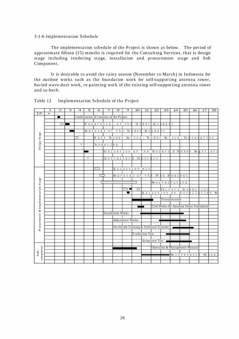
3-1-6 Implementation Schedule
The implementation schedule of the Project is shown as below. The period ofapproximate fifteen (15) months is required for the Consulting Services, that is designstage including tendering stage, installation and procurement stage and SoftComponent.
It is desirable to avoid the rainy season (November to March) in Indonesia forthe outdoor works such as the foundation work for self-supporting antenna tower,buried wave-duct work, re-painting work of the existing self-supporting antenna towerand so forth.
Table 12 Implementation Schedule of the Project
1 2 3 4 5 6 7 8 9 10 11 12 13 14 15 16 17 18E/N ▲
Confirmation of Contents of the Project
Preparation of the Tender Document
Approval of the Tender Document
Draft Tender Notice, Tender Notice, Explanation of the Tender Document
▽ Tendering
Evaluation of the Tenders & Tender Negotiation
▽ Contractor's Contract
Discussion with the Contractor
Approval of the Shop Drawings
Manufacturing
Factory InspectionDiscussion on Installation Works
Transportation
Civil Works for Antenna Tower Foundation
Installation Works
Adjustment Works
On-the-job Training & Technical Transfer
Evaluation Test
Acceptance Test
Operation & Management Manual
Maintenance Manual
Des
ign
Sta
geP
rocu
rem
ent
& I
mpl
emen
tati
on S
tage
Sof
t-co
mpo
nen
t
27
3-1-7 Soft Component Plan
Since the DGPS system is a new system for the Indonesia, there was a requestof the soft component to assist making the system management/ operation plan andmaintenance manual as a part of the establishment of appropriate maintenancemanagement system for the DGPS.
In connection with the execution of the soft component, it was planned for thegoal that the DGPS system in Indonesia lasted to steadily provide user with the highaccurate positioning information for the long time, with a mind to the following points:・ Smooth operation and management of DGPS System・ Proper maintenance and management for the equipment and facilities of DGPS
system
When the soft component is carried out, it is a goal that makes theresponsibility of each staff clear and understand his own roles at the individualsections or groups related on the operation and maintenance, and that the wholesystem should be operated and maintained in good conditions by the operation andmaintenance with relationship mutually among each staff of headquarter, andheadquarter and local stations.
To achieve this goal as a result of assistance by means of the soft component,the Consultant assists for the preparation of draft manuals, that is, the “ManagementManual” defined as efficient management organizations on DGPS services inIndonesia, the “Operation Manual” defined concretely as daily, regular and emergencyoperation for the DGPS system and the “Maintenance Manual” defined concretely asdaily, regular and emergency maintenance for the DGPS system.
3-2 Project Cost Estimation
When the Project is executed under the Japan’s Grant Aids, the cost to beborne by the Government of Indonesia is approximately 5.3 million Rupiah as shown inTable 13, according to the Scope of Work given in Chapter 3, item 3-1-3 .
Table 13 Estimated Project Cost Unit: RupiahItem Estimated Cost
1. Amendment of Electricity Power Contract 500,000 2. Preparation of E-mail Circumstances
(Public Telephone Lines、Contract of Provider Services)
4,800,000
Total 5,300,000
3-3 Operation and Maintenance Cost Estimation
It is judged that the Operation and Maintenance Cost for Directorate ofNavigation, DGSC in the past five (5) years have chronically fallen into lack. Light Duenewly introduced in this year is seriously expected for operation and maintenance forAids to Navigation and their related matters in the future. The operation andmaintenance cost for the DGPS System with improvement of Medium Wave RadioBeacon Stations is to be provided by the Light Due in the future.

28
It is recommended that Operation and maintenance staff for the DGPSManaging Group to be newly established in DGSC consist of five (5) persons at least,which should be one (1) head in charge of group, two (2) managing staff, one (1) chief incharge of technical matters and one (1) technician. And two (2) operation andmaintenance staff should be allocated for each DGPS Station. These can cope by a re-arrangement of the staffs of DGSC.
After the completion of the Project, the operation and maintenance costrequired for DGPS Stations to be operated by DGSC is estimated as shown in Table 14.
Table 14 Operation and Maintenance Cost of DGPS Stations Unit:x1000 Rupiah
Item Amount1. Personnel Expenses 175,200
(1) DGPS Managing Group 57,600(2) DGPS Stations 117,600
2. Operation and Maintenance Cost 335,2433. Traveling Cost 30,620
Total 541,063
In connection with the above personnel expenses of the operation andmaintenance cost for DGPS System, it can allot within the personnel expenses in theformer budget. The operation and maintenance cost except for the above personnelexpenses shall allot the Light Due newly established on 6 June 2000.

29
Chapter 4 Project Evaluation and Recommendation
4-1 Project Effect
4-1-1 Role of the Project
In verifying the necessity, appropriateness and urgency of The Project, it isnecessary to define the role of the Project.
The Project is a Japan’s Grant Aid project for the MFB stations systemimplemented by the Government of Indonesia under a Japanese Yen Loan. TheProject is intended to improve the MFB stations to attain the requirements for a radioaids to navigation system from the international point of view, so that vesselsnavigating in the Indonesian waters will secure the safety and efficiency of navigation.At the same time, the sustainability of the Project should be fully secured.
Therefore, the Project is aimed at providing the DGPS stations with thefunctions to meet the international standard for positioning information as anoperational requirement for radio aids to navigation systems as recommended by theIMO and IALA. In addition, it is also necessary to ascertain that the maintenancesystem for the DGPS stations and the related budget will be established and secured inIndonesia.
4-1-2 Verification of Project Sustainability
The annual maintenance cost under the Project is roughly estimated to beabout 7 million yen (excluding personnel cost), but it is difficult for Indonesia tomanage to budget the cost in the conventional general account. Therefore, Indonesiahas declared the policy that the maintenance cost will be allocated from the Light Duethat was enforced in June 2000.
Then, the Light Due taxation system has been enforced, but no amount of duerevenues has not concretely been reported and it is still unclear at this momentwhether the maintenance cost for the Project has been secured or not.
4-1-3 Enhanced GPS Accuracy after SA Termination
The US Administration announced hastily on May 1, 2000 to the users of SPS(Standard Positioning Service) that the Selective Availability (SA) intended for GPSpositioning with a lower accuracy than that for military use was terminated atmidnight on May 1, 2000 Eastern Time under the President’s statement of May 1, 2000.As a result, the GPS positioning accuracy was globally enhanced around 10 times ashigh as before. In this connection, the Interagency GPS Executive Board (IGEB) ofthe US Administration has declared that “User in the U.S. and the rest of the worldshould now be experiencing the same basic GPS accuracy of 10-20 meters or better”
The GPS positioning accuracy at the time of the request, namely before the SATermination, was about 100m. By the SA Termination, the GPS accuracy wasenhanced to around 10m. As a large change appeared in the background situation forthe request of Indonesia, we could not but review the necessity, appropriateness andurgency of the project as Japan’s Grant Aid.
30
The IMO recommends that a radio navigation system used to assist in thenavigation of ships in those harbor entrances and approaches and other waters wherefreedom to maneuver is limited shall provide positional information with an error notgreater than 10m with a probability of 95%. The introduction of DGPS will enhancethe positioning accuracy further, ensuring the system to contribute to safety andefficiency of navigation. However, if the current GPS positioning accuracy inIndonesia nearly meets the recommended value, it is necessary to consider deliberatelywhether the DGPS should be introduced under the Japan’s Grant Aid.
The measurement made independently by the Japan Coast Guard made clearthat the positioning accuracy was 9.03m (at 95% probability) as a temporary dataavailable from a specific GPS receiver. In addition, the DGSC has obtained thepositioning accuracy of 9.43m (at 95% probability) in the measurement made inJakarta for a short period with the cooperation of JICA Expert. From thesemeasurements, it has been confirmed that the GPS accuracy has been enhanced ingeneral. However, the GPS signals include some errors such as seasonal changes dueto the influence of the ionosphere and the atmosphere, because the signals aretransmitted from the satellites orbiting at high altitudes of more than 20,000 km. Indiscussing the GPS positioning accuracy based on SA Termination, therefore, it isnecessary to measure the long-time variations including seasonal changes, makeaccuracy measurements taking into account the difference of GPS receiver models, andcheck the statistic and dynamic accuracy.
4-2 Technical Cooperation and Relationship with Other Donors
The Japan International Cooperation Agency (JICA) plans to implement adevelopment study “Development Study for the Maritime Safety System DevelopmentPlan” to develop the navigation safety system in Indonesia including Aids toNavigation. In the Study, it is desirable to make the study of the following items inrelation with the Project:
(1) Check on the conditions for introduction of Light Due
Most of the existing MFB stations installed under the Japanese Yen Loanproject have suspended their operation several years after their completion due to lackof maintenance cost. Under these circumstances, it is scarcely expected to budget themaintenance and operation costs for the DGSC from the general account. Therefore,it is absolutely indispensable to securely establish the Light Due taxation system thatwas enforced in May this year and started to be collected in June as a special account,in order to promote, and maintain and operate the DGPS and other plans as well asthe existing services in the Directorate of Navigation (NAVIGASI) of the DGSC.Although it seems that Light Due collection has been started, no official report on theamount of due collected has been issued from the DGSC for its own reason.
Under these circumstances, it is deemed to be necessary ① to check theconditions of the established systems including the system of reporting on Light Duewithin the Indonesian Government, and ② to fully verify the Light Due amount andits distribution plan that has originally been estimated.
For ①, it will take some time, but it will be cleared sooner or later if theestablishment as a system delays simply due to clerical formalities. For ②, it isnecessary to analyze the actual conditions of collecting the due amounts, compare the
31
sum of collected due amounts with the originally estimated sum and check on the planof allocation, in order to verify that the operation and maintenance costs of the DGPSsystem can be secured.
In verification of ②, it is also necessary to grasp the total tonnage of allvessels entering port to pay the Light Due and the sum of collected due amounts.
(2) Confirmation of GPS positioning accuracy
It has been confirmed that the GPS positioning accuracy in Indonesia after SATermination is 11m and 17m in the simple measurement made by the consultant and9.4m in the successive short-time measurement made by Indonesia counterpart incooperation of the JICA Expert. These measured values fall within 20m asannounced by the US Administration operating the GPS system. However, the GPSsignals are transmitted from the satellites orbiting at high altitudes of more than20,000km, including the errors such as seasonal changes affected the ionosphere andthe atmosphere. Therefore, the precise discussions on the GPS positioning accuracyafter the SA Termination should be made based on the measurement and analysisconsidering the following points:
① Error measurement considering the model difference of GPS receivers;② Error measurement for a long time considering seasonal changes③ Confirmation of static and dynamic accuracy
(3) International trend for safety navigation and role of DGPS system
Currently, the international move for safe navigation of vessels is activelypromoted by the positive use of new technology in the maritime world. Theintroduction of advanced navigation systems including the Automatic IdentificationSystem (AIS) to be obligated to install at the relevant vessel defined in Article V of theSOLAS Convention being now under deliberation at the IMO conference aiming at itsenforcement in July 2002, and the Vessel Traffic Services (VTS) and the ElectronicChart Display and Information System (ECDIS) that will operate side by side with thefunction of the AIS, has been in progress. The VTS and ECDIS will be installed ordeveloped from the independent standpoint by each country individually.
The DGPS is currently positioned as a basic positioning system to be able toprovide highly accurate positional information with the Integrity to be secured to thosefuture systems.
In respect of the dealing with the DGPS in Indonesia under the internationaltrends above and the Japan’s Grant Aid, it is necessary to discuss how does theIndonesia deal with future VTS and ECDIS in Indonesia, and to discuss on theprogress of possible introduction plan of such systems.
(4) Other discussions
It is necessary to define the issues as mentioned above, to determine whetherto introduce the DGPS in Indonesia and to verify the necessity, appropriateness andbenefits of the project from various angles. For this purpose, the following matters

32
should be examined with due consideration for the progress after SA Termination:
① Shipping accident cases by sea area② Number of vessels in voyage③ Shipping statistics④ Port development⑤ Progress of the international maritime policy and cooperation system of Indonesia in
relation with Malaysia and Singapore after completion of the basic design study
4-3 Recommendation
To further examine the implementation of the Project under the Japan’s GrantAid, as described in section 4-1 and 4-2 above; we deem it indispensable to ascertainthe project sustainability, appropriateness and benefits of the Project in thecircumstances of GPS that the positioning accuracy has enhanced owing to sudden SATermination. In addition, the feasibility and the effects of the Project should beascertained from a higher point of view including the international trend fornavigation aids and other factors.

33
DRAWINGS

34
Contents of Drawings
Station Code Drawing NameJakarta JKT-1 Station Layout
JKT-2 New Equipment LayoutJKT-3 Floor Layout
Ujung Pandang UPD-1 Station LayoutUPD-2 New Equipment LayoutUPD-3 Floor Layout
Semarang SMR-1 Station LayoutSMR-2 New Equipment LayoutSMR-3 Floor Layout
Balikpapan BLP-1 Station LayoutBLP-2 New Equipment LayoutBLP-3 Floor Layout
Banjarmasin BJM-1 Station LayoutBJM-2 New Equipment LayoutBJM-3 Floor Layout
Benoa BEN-1 Station LayoutBEN-2 New Equipment LayoutBEN-3 Floor Layout
Pontianak PON-1 Station LayoutPON-2 New Equipment LayoutPON-3 Floor Layout