base station network - iihr · gravity high and to efforts by industry to locate petroleum-bearing...
TRANSCRIPT

IOWA GEOLOGICAL SURVEY
IOWA CITY. IOWA
H. GARLAND HERSH6Y, Directorand SJcrto CoIofllM
mimm
REPORT OF INVESTIGATIONS 8
K)WA GRAVITY
BASE STATION NETWORK
by
D. H. HASE
RUSSELL B. CAMPBELL
ORVILLE J VAN ECK
PUblMwdBy
THE STATE OF IOWA
1969

STATE OF IOWA
1969
IOWA GRAVITY
BASE STATION NETWORK
by
D. H. HASE
The University of Iowa
RUSSELL B. CAMPBELL
The University of Iowa
ORVILLE J VAN ECK
Iowa Geological Survey
REPORT OF INVESTIGATIONS 8
IOWA GEOLOGICAL SURVEY
IOWA CITY, IOWA
H. GARLAND HERSHEY, Directorand State Geologist
PB-13937

CONTENTS
PAGE
ABSTRACT 1
INTRODUCTION 1
INSTRUMENTATION AND METHOD OF SURVEY - - 2
RESULTS 3
COMPARISON WITH OTHER GRAVITY BASES - - 5
CONCLUSIONS 8
REFERENCES CITED 8
ILLUSTRATIONS
Figure 1. Location of gravity base stations, Iowa GeologicalSurvey network 3
2. Comparisons of Iowa Geological Survey gravityvalues with Woollard and Rose (1983) gravityvalues (base line) 7
TABLES
Table 1. Gravity data at base stations 4
2. Gravity data and station descriptions 5
3. Comparison of Iowa Geological Survey and Woollardgravity values 6

IOWA GRAVITY BASE STATION NETWORK
by
D. H. HASE, RUSSELL B. CAMPBELL, and ORVILLE J VAN ECK
ABSTRACT
In the spring of 1967, the Iowa Geological Survey established42 gravity base stations at airports throughout the state to provide amore adequate and extensive gravity base station network than hadexisted previously. Measurements were made with LaCoste-Romberg geodetic gravity meters and were tied to the U. S.National Gravity Base Net through station Minneapolis L (I. G. C.15443L). For all but one station, the maximum network uncertaintyat any station is ±0.041 milligal. One U. S. Air Force and twoWoollard and Rose (1963) stations were recovererd, and the differences in observed gravity measured by the Iowa Geological Surveyand reported at these stations arc —0.005, 0.00, and —0.02 milligalrespectively.
INTRODUCTION
The number of gravity measurements throughout the state hasincreased in recent years owing to interest in the mid-continentgravity high and to efforts by industry to locate petroleum-bearingstructures and structures to store natural gas. There is also interestin obtaining additional geophysical data in areas of magneticanomalies previously defined by an airborne magnetometer surveyof the state which was begun in 1961 and is now about three-fourthscompleted. Prior to this gravity base station network survey, 5pendulum base stations (Duerksen, 1949) and 12 gravity meter basestations (Woollard and Rose, 1963) had been established in the state.Some of these stations are inconveniently located; others are lostor inaccessible because of construction.
The objective of the survey was to establish with the mostaccurate gravity meters available a more adequate and extensivegravity control network at more uniformly distributed base stationswhich would facilitate the integration of local gravity surveys intothe network for application to regional geophysical and geologicalinvestigations. The Iowa Geological Survey gravity base stationnetwork was planned so as to recover some of the Woollard andRose airport gravity meter bases. The base stations in the Iowa

2 IOWA GRAVITY RASE STATION NETWORK
(IGS) network are tied to the U. S. National Gravity Base Netusing Washington A, 980.188000 gals, as the base station and throughit to the international gravity net, thus making gravity data in thestate available for worldwide geologic and geodetic studies.
The LaCoste-Romberg geodetic gravity meters used in the surveywere made available through the courtesy of R. M. Iverson, ArmyMap Service, Washington, D. C. The GRAVAS gravity reductionprogram was adapted by D. J. Gockel, U. S. Geological Survey,Iowa City, Iowa to run on the IBM 360/65 computer at The University of Iowa. We are indebted to the officers and men of theIowa Army National Guard who provided air transportation andto our colleagues who assisted in obtaining field observations.
INSTRUMENTATION AND METHOD OF SURVEY
Most of the gravity measurements were made with LaCoste-Romberg geodetic gravity meters Nos. G-142 and G-143, and additional ties between the stations at Minneapolis, Minnesota andWaterloo, Iowa were made with geodetic gravity meter No. G-59.The meters are well suited for this type of work because of a verylow drift rate, a reading sensitivity of about 5 microgals, and a largereading range. The calibration factors supplied by the manufacturerfor each instrument were used in the computations.
The gravity base station network values have been determinedon the basis of differences in gravity relative to the U. S. Air Forcegravity station at the International Airport Terminal (Wold-Chamberlain Field), Minneapolis, Minnesota (Minneapolis L; I. G. C. 15443L)at which the adjusted value is 980.594651 gals.
Observations for the gravity base station network were made ina series of loops which closed on the same base from which theloop originated. Five auxiliary base stations were established inthe state to facilitate this procedure. During the period 11 Aprilthrough 16 May 1967, stations were established at 42 airportsthroughout the state by 17 loops. Air transportation was used fornine loops, and ground transportation was used for the remainder.The time required to complete a loop ranged from a minimum of2M hours to a maximum of 10& hours.
Most of the stations were established inside airport terminal buildings or hangers which are expected to have a permanency of at least10 years. Airport elevations listed on the Dubuque and Des Moines
IOWA GRAVITY BASE STATION NETWORK
x-.-_!_.^._.L »96 j
fttifvicffiUrJASQmghM)
I j ! ! j • : " ! "9 ii I oI is j ! 1 i j . ! fo>«"i i o#»» \ *
> i 4T j | ! j ! r—'•—,-—'—,.-.'-.,..-! —,—I \* \e«7~ • r>iT-—,-t-j—i.-|--j- -j i i i »55 i *»»..>>• VEo.„n. !e„^« jeeffln !c„.„. jn.*!? i$,«, jh£!£i | '"»• j»t«.» | m»^ j '""J* L j.., j. j | j j j ^ j_^_ J i gun".
<* / ' ! ' '• ' i so ! ts j T j CtMl '.-Ny—~-/'% ("«"'»•" j SWII K>U<>JWKr.i I Dollo. i ft,, ! j,g„ Unuji; le.g !j»M»it ' •
T 7•; i—i—! "T'"t r~~7 "uS Po-To.o.iot... j ji„ ! Ma„ ;mm„„ i,^ u„„. i u«m,i. i k,.i„. mm™™! '•
'•-\ • Mu«r#V-. 70 V*d«lr jMMWn IWar'tn j Morten jMeheiko ! Kfohufc |*Wi«i8toi:
1 ..J.__..i._;_.J._.r.._j J j. ";LoviM I'~riBo'o"T ! r-<—;—•—j- 1'
,._.i _ j i se1* i i ®soi ! m&.j. ...^ . . _ .( 1,.1,1 i *^Q« ©1 T«IW' jn^oocw •0«co!yf i worm itopwwwi Og*<t p*» Bwwj•J--.Ti..L i L i._.._..L.!5_i_.._..i i
MISSOURI
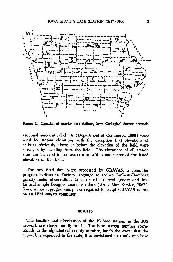
Figure 1. Location of gravity base stations, Iowa Geological Survey network.
sectional aeronautical charts (Department of Commerce, 1966) wereused for station elevations with the exception that elevations ofstations obviously above or below the elevation of the field weresurveyed by levelling from the field. The elevations of all stationsites are believed to be accurate to within one meter of the h'stedelevation of the field.
The raw field data were processed by GRAVAS, a computerprogram written in Fortran language to reduce LaCoste-Romberggravity meter observations to corrected observed gravity and freeair and simple Bouguer anomaly values (Army Map Service, 1967).Some minor reprogramming was required to adapt GRAVAS to runon an IBM 360/65 computer.
RESULTS
The location and distribution of the 42 base stations in the IGSnetwork are shown on figure 1. The base station number corresponds to the alphabetical county number, for in the event that thenetwork is expanded in the state, it is envisioned that only one base

IOWA GRAVITY BASE STATION NETWORK
Table 1. — Gravity data at base stations
Station numberand location
IGS 4
ICS 7
IGS 8
IGS 14
IGS 15
IGS 17
ICS 18
IGS 21
IGS 22
IGS 23
IGS 24
IGS 28
IGS 29
ICS 31
IGS 32
ICS 33
ICS 34
ICS 42
IGS 43
IGS 44
IGS 47
ICS 50
IGS 52
IGS 53
IGS 55
IGS 57
IGS 59
ICS 64
ICS 07
IGS 69
IGS 70
ICS 71
ICS 73
IGS 77
IGS 79
IGS 82
IGS 88
ICS 90
ICS 92
IGS 94
IGS 96
IGS 97
Centervillc
Waterloo
Boone
Carroll
Atlantic
Mason CityCherokee
SpencerElkader
Clinton
Denison
Manchester
BurlingtonDubuqueEsthervillc
Clermont
Charles CityIowa Falls
Missouri ValleyMount Pleasant
Ida Grove
Newton
Iowa CityMonticcllo
AlgonaCedar RapidsChariton
Mnrshnlltown
Onown
Red Oak
Muscatine
Sheldon
Clarinda
Dcs Moines
BrooklynDavenportCreston
Ottumwa
WashingtonFort DodgeDecorah
Sioux City
Mean valueobserved gravity
(gals.) and numberof occupations
(4)(20)
(16)(4)(4)(2)
980.134317
980.302465
980.321269
980.251273
980.261049
980.421396
980.312210 (4)980.309352 (4)980.358497 (4)980.268003 (4)980.192478 (2)980.359958 (4)980.164849 (4)980.300247 (4)980.349518 (4)980.377610 (4)980.317721 (2)980.270162 (2)980.168165 (2)980.179060
980.264068
980.220279
980.251791
980.282053 (4)980.340242 (4)980.251028 (4)980.163338 (4)980.250637 (8)980.262991 (2)980.150110 (4)980.231669 (4)980.340850 (4)980.111550 (4)980.198087 (16)980.243659 (4)980.250280 (12)980.132224 (4)980.183328 (4)980.205721 (4)980.295319 (4)980.415955 (4)980.306701 (4)
(4)(4)(4)(16)
Maximumdeviation
single meter±
(milligals)
0.002
0.029
0.025
0.025
0.008
0.012
0.031
0.024
0.041
0.034
0.010
0.010
0.018
0.073
0.009
0.044
0.001
0.029
0.007
0.013
0.003
0.007
0.010
0.029
0.011
0.022
0.006
0.008
0.016
0.012
0.030
0.011
0.024
0.020
0.023
0.024
0.044
0.012
0.012
0.040
0.015
0.013
Maximumdeviationbetweenmeters
±
(milligals)
0.051
0.034
0.047
0.018
0.004
(*)0.010
0.037
0.031
0.012
(*)0.015
0.009
0.008
0.068
0.002
(*)(*)
(*')0.009
0.027
0.020
0.022
0.011
0.042
0.031
0.014
0.047
(*)0.031
0.004
0.056
0.015
0.019
0.052
0.062
0.017
0.023
0.013
0.043
0.029
0.026
* Single meter; readings from G-142 rejected on two loops because of malfunction
IOWA GRAVITY BASE STATION NETWORK 5
station will be established in each county, and each base stationcan thus be indexed according to the county number.
Ten interval values were obtained between the U. S. Air Force
gravity station, Minneapolis L, and the primary base station of theIGS network at Waterloo, IGS 7. The observed gravity at Waterloois 980.302465 gals, and the maximum uncertainty on the loops is±0.048 milligal.
The mean value at each base station, the number of occupations,the maximum deviation upon reoccupation for a single meter, andthe maximum deviation between the two meters are listed in table 1.
The maximum deviation is ±0.073 milligal, resulting from a singleoccupation at IGS 31 Dubuque, which suggests that the internaluncertainty of the entire network is on the order of ±0.10 milligal.However, the internal uncertainty of most of the network may morereasonably be on the order of ±0.05 milligal, based on evaluation ofthe data after three observations were rejected because they wereoutside the designated accuracy limit of 0.05 milligals for the survey.This evaluation indicates that the maximum network uncertainty atany station is ±0.041 milligal, the mean is ±0.036 milligal, and theroot mean square is ±0.027 milligal. The values for maximumdeviation of observed gravity between the two meters at any givenstation further corroborates the internal accuracy of the network.
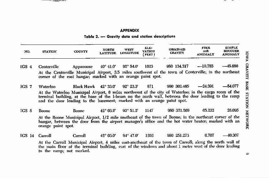
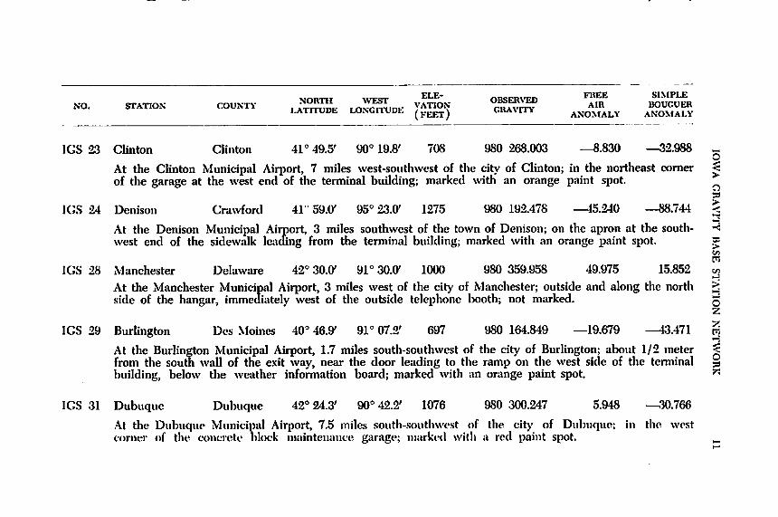
Table 2 (Appendix) gives the station descriptions and observedgravity for all stations in the IGS network as well as the elevation,latitude, longitude, free air gravity and simple Bouguer gravitycalculated for a density of 2.67.
COMPARISON WITH OTHER GRAVITY BASES
The gravity values and differences between observations made ator near six previously established stations reported by Woollard andRose (1963) are compared in table 3. A more valid comparison isobtained after the IGS values are adjusted by a factor of +0.8milligal inasmuch as the IGS stations are tied to Washington A base,value 980.118000 gals, and the Woollard and Rose stations are alsotied to Washington A base, assigned value 980.118800 gals. Theadjusted differences between the two sets of data range from 0.45 to—0.53 milligal. Although the IGS and the Woollard and Rose stationsat both Cedar Rapids and Des Moines are not on precisely thesame sites, the Woollard and Rose stations were recovered andseparate ties were made between them and the new IGS stations.

Table 3. — Comparison of Iowa Geological Survey (IGS) and Woollard (WA) gravity values
Station Numberand Location
AIGS
(gals)
BWA(gals)
Difference(A - B)(mgals)
AdjustedDifference
(mgols)[(A+0.8) - B]
(mgab)
Minneapolis L (WA 118) 980.594651 980.5950 -0.35 0.45
IGS 8 Boone (WA 220) 980.321269 980.3226 -1.33 -0.53
IGS 31 Dubuque (WA 224) 980.300247 980.3014 -1.15 -0.35
IGS 57 Cedar Rapids (WA 24)* 980.251085 980.2519 -0.82 -0.02
IGS 77 Des Moines (WA 25)* 980.197597 980.1984 -0.80 0.00
IGS 82 Davenport (WA 226) 980.250280 980.2509 -0.62 0.18
IGS 97 Sioux City (WA 228) 980.306701 980.3073 -0.60 0.20
*IGS station values adjusted to WA station values by separate ties.
>v.
H
V.
>
5z
z
OEd

IOWA GRAVITY BASE STATION NETWORK
1.00
o 0.50zIxJKUJ
-
D*l M«I«M BASE LINE
Hi«n««Mllt I.
(WOOLLARD AND ROSE
•t-
VALUES)
+••«M
1 1 1 1 1 1 1 1 1 1 1 1 I 1 1 1 1 1 1 1 1 1 1 1 1 1 1 1
0.00
S -0.50
-1.00 -
980.0 .1 .2 .3 .4 .5 .6 .7
6ALS GRAVITY
Figure 2. Comparison of Iowa Geological Survey gravity values with Woollardand Rose (1963) gravity values (base line).
The differences between the two sets of data arc —0.02 milligal atCedar Rapids and 0.00 milligal at Des Moines. This would thereforeindicate very close agreement between the two surveys.
The Woollard and Rose stations at Davenport and Sioux City were"partially" recovered inasmuch as the respective IGS stations arebelieved to be within 200 feet of them. Reconstruction of the terminal
facilities at these airports has made the exact location of the previouslyestablished stations doubtful. The difference between the IGS and
the Woollard and Rose values at Davenport is 0.18 milligal and atSioux City is 0.20 milligal. A difference in observed gravity of —0.005milligal was obtained at IGS 97 Sioux City, value 980.306701 gals,which is on die site of the U. S. Air Force station Sioux City J (I.G.C.15426J), value 980.306706 gals.
Attempts to recover the Woollard and Rose stations near Minneapolis L, IGS 8 Boone, and IGS 31 Dubuque were unsuccessful,and differences in location between the respective stations are veryprobably on the order of hundreds of feet. The comparisons are notsignificant and are included only for completeness.
The comparison between the IGS gravity values and the Woollardand Rose gravity values using the latter as the base line is illustratedin figure 2. Discounting the values obtained at Minneapolis, Boone,and Dubuque where the Woollard and Rose stations were notrecovered, the differences between the two sets of data from the

8 IOWA GRAVITY BASE STATION NETWORK
"partially" recovered stations at Davenport and Sioux City are 0.20milligal or less and from the recovered stations at Cedar Rapids andDes Moines are 0.02 milligal or less. No systematic variation withgravity is apparent in the data.
CONCLUSIONS
The Iowa Geological Survey study has provided a more adequateand extensive gravity base station network tied to the U. S. NationalGravity Base Net which will augment the inadequate net that previously existed in the state. The maximum uncertainty at one stationis ±0.073 milligal, but at all other stations the uncertainty is about±0.05 milligal with reference to the base value used.
REFERENCES CITED
Army Map Service, 1967, A computer program to reduce land gravityobservations: Army Map Service, Geodetic Memorandum No.1617, October, 64 p.
Department of Commerce, 1966, Des Moines Sectional AeronauticalChart and Dubuque Sectional Aeronautical Chart, scale 1:500,000,July.
Duerksen, J. A., 1949, Pendulum gravity data in the United States:U. S. Coast and Geodetic Survey, Sp. Pub. No. 244, 218 p.
Woollard, G. P. and Rose, J. C, 1963, International Gravity Measurement: Menasha, Wisconsin, George Banta Company, Inc., 518 p.
APPENDIX
Table 2. — Gravity data and station descriptions
NO. STATION" COUNT, ¥™™ .„£»"* Y^foN "J™ A* £££»LATTTUDE LONCITUDE (j^ CRAVITY AN0.MALY ANOMALY O^>
IGS 4 Centerville Appanoose 40° 41.0' 92° 54.0' 1023 980 134.317 —10.785 --15.686 2At the Centerville Municipal Airport, 3.5 miles southwest of the town of Centerville; in the northeast <corner of the east hangar; marked with an orange paint spot. ^
w
IGS 7 Waterloo Black Hawk 42° 33.W 92° 23.3' 871 980 302.465 —24.391 —54.077 fepi
At the Waterloo Municipal Airport, 6 miles northwest of the city of Waterloo; in the cargo room of the „,terminal building, at the base of the I-beam on the north wall, between the door leading to the ramp £jand the door leading to the basement; marked with an orange paint spot. H
Oz
IGS 8 Boone Boone 42° 03.2' 93° 51.2' 1147 980 321.269 65.232 26.095 5,m
At the Boone Municipal Airport, 1/2 mile southeast of the town of Boone; in the northeast corner of the j|hangar, between the door from the airport manager's office and the hot water heater; marked with an §orange paint spot. *
IGS 14 Carroll Carroll 42° 03.0' 94° 47.0' 1202 980 251.273 0.707 —40.307
At the Carroll Municipal Airport, 4 miles east-southeast of the town of Carroll; along the north wall ofthe main floor of the terminal building, east of the windows and about 1 meter west of the door leadingto the ramp; not marked.

FI,E- FRFF SIMPI.K
STATION mUNTY ™™'K L()^^DE VAT.ON «^™' AIR BOUGUEHLATITUDh LOM.ITUDL (FEET) GRAM I\ ANOMALY ANOMALY
IGS 15 AtlanHc Cass 41° 24.0' 95° OS.O' 1158 980 261.649 65.210 25.697 _
At the Atlantic Municipal Airport, 1 mile west of the town of Atlantic; in the southeast corner of the ^airport manager's office, between the doors to the rest rooms; marked with an orange paint spot. >
a
IGS 17 Mason City Cerro Gordo 43° 09.0' 93° 20.0- 1216 980 421.396 73.237 31.745 |At the Mason City Municipal Airport, 8 miles west of the city of Mason City; in the drive-through be- 3tween the terminal building and the hangar, below the thermostat on the east wall; marked with an Korange paint spot. >
M
IGS 18 Cherokee Cherokee 42° 44.0' 95° 33.0' 1212 980 312.210 1.417 40.175 «
At the Cherokee Municipal Airport, 1 mile south of the town of Cherokee; in the north end of the termi- qnal building, in the middle of the floor, on the inlaid compass rose. g
Z
IGS 21 Spencer Clay 43° lOJff 95° 12.0' 1335 980 309.352 29.115 74.667 gAt the Spencer Municipal Airport, 3 miles northwest of the city of Spencer; in the terminal building, din the southeast corner of the office area between the windows and the back of the service counter; omarked with an orange paint spot. ^
IGS 22 Elkader Clayton 42° 50.8' 91° 22.5' 932 980 358.497 10.937 20.864At the Elkader Municipal Airport, 1.5 miles southeast of the town of Elkader; on the concrete sidewalkon the west side of the office midway between the door and the window; marked with an orangepaint spot.
WWTH WFST ELE" owsFRVPn FKEE SIMPLENO. STATION COUNTY JggSL U,™E )'ATiOIi Sm AIR BOUCUERLATITUDE LONGITUDE (FEET) GKAVUY ANOMALY ANOMALY
IGS 23 Clinton Clinton 41° 49.5' 90° 19.8' 708 980 268.003 —8.830 —32.988 aO
At the Clinton Municipal Airport, 7 miles west-southwest of the city of Clinton; in the northeast comer ^of the garage at the west end of the terminal building; marked with an orange paint spot.
»
IGS 24 Denison Crawford 41 59.0' 95° 23.0' 1275 980 192.478 —45.240 —88.744 <
At the Denison Municipal Airport, 3 miles southwest of the town of Denison; on the apron at the south- •<west end of the sidewalk leading from the terminal building; marked with an orange paint spot. «
PI
IGS 28 Manchester Delaware 42° 30.0' 91° 30.0' 1000 980 359.958 49.975 15.852 v>H
At the Manchester Municipal Airport, 3 miles west of the city of Manchester; outside and along the north ^side of the hangar, immediately west of the outside telephone booth; not marked. g
z
IGS 29 Burlington Des Moines 40° 46.9' 91° 07.2' 697 980 164.849 —19.679 —43.471 pjAt the Burlington Municipal Airport, 1.7 miles south-southwest of the city of Burlington; about 1/2 meterfrom the south wall of the exit way, near the door leading to the ramp on the west side of the terminalbuilding, below the weather information board; marked with an orange paint spot. "
IGS 31 Dubuque Dubuque 42° 24.3' 90° 42.2' 1076 980 300.247 5.948 —30.766
At the Dubuque Municipal Airport, 7.5 miles south-southwest of the city of Dubuque; in the westcomer of the concrete block maintenance garage; marked with a red paint spot.
O53

STATION COUNTY J™™^ lo^de Y^ '"" ^ ^^LATITUDE LONGITUDE (FEET) GHAVIH ANOMALY ANOMALY
IGS 32 Estherville Emmet 43° 25.C 94° 45.0' 1317 980 349.518 —13.166 —58.103O
At the Estherville Municipal Airport, 4 miles east of the town of Estherville; in the northeast corner of ^the terminal building, below the bulletin board; not marked.
$IGS 33 Clermont Fayette 42° 59.0' 91° 39.0' 869 980 377.610 11.823 —17.827 <At the Clermont Municipal Airport (Valley), 1/2 mile south of the town of Clermont; by the doors on «;the north side of the hangar, on the concrete dividing strip; marked with a red paint spot. bs
IGS 34 Charles City Floyd 43° 04.0' 92° 36.0' 1130 980 317.721 —31.022 —69.579At the Charles City Municipal Airport, 3 miles east of the town of Charles City; in the northeast comerof the middle hangar, inside the north door; marked with an orange paint spot.
V.
P!
Oz
IGS 42 Iowa Falls Hardin 42° 28.0' 93° 16.0' 1140 980 276.162 —17.660 —56.558 gpi
At the Iowa Falls Municipal Airport, 3 miles south of the town of Iowa Falls; in the southeast corner of 3the hangar, about 1/2 meter northwest of the block wall between the hangar door and the door to the §office; marked with a red paint spot. ^
IGS 43 Missouri Valley Harrison 41° 32.0' 95° 53.0' 1000 980 168.165 —55.072 —89.194At thf> Missouri Vnlley Municipal Airport. 1 mile south of the town of Missouri Valley; outside and atthe northwest comer of the middle hangar, adjacent to a U. S. G. S. monument set in a cement postapproximately even with the ground.

ELE- FREE SIMPLE,.„ 8T.Tinv rniiKTY NORTH WEST VATION OBSERVED B UOUGUERNO. STATION COUNTY latitude LONGITUDE [A™ GRAVITY ANOMALY ANOMALY
IGS 44 Mount Pleasant Henry 40° Sl.V 91° 31.0' 727 980 179.060 —17.676 —42.481At the Mount Pleasant Municipal Airport, 3 miles southeast of the city of Mount Pleasant; in the north- ^west comer of the waiting room in the terminal building, about 1/2 meter from the west wall, between >the windows and the door leading to the basement; marked with an orange paint spot. O
IGS 47 Ida Grove Ida 42° 20.C 95° 27.C 1250 980 264.068 —7.426 —50.078 <At the Ida Grove Municipal Airport, 1/2 mile east-southeast of the town of Ida Grove; along the outside of 3the southwest side of the terminal building, in line with the sidewalk leading from the field; marked with an worange paint spot. pi
IGS 50 Newton Jasper 41° 40.7' 93° 01.5' 953 980 220.279 —20.369 —52.886 HAt the Newton Municipal Airport, 1.5 miles southeast of the city of Newton; in the northeast hangar, dalong the northwest wall, between the door leading to the waiting room and the first support pillar gto the southwest; marked with an orange paint spot. 2
IGS 52 Iowa City Johnson 41° 38.4' 91° 32.5' 661 980 251.791 —12.734 —35.288At the Iowa City Municipal Airport, 2 miles south of the city of Iowa City; near the east entrance outside the terminal building, along the offset north wall between the entrance and the outside telephonebooth; marked with a red paint spot.
IGS 53 Monticello Jones 42° 14.0' 91° 10.0' 847 980 282.053 —18.360 —47.261At the Monticello Municipal Airport, 1 mile southeast of the town of Monticello; in the northwest comerof the storage room east of the office, near the water heater tank; marked with an orange paint spot.
Pi
io»

X
NO. STATION COUNTY j^^L LONCrHJDE ft™'! ZlH ^V" a^S^{FEET / ANOMAL\ ANOMALY
IGS 55 Algona Kossuth 43° 04.0' 94° 16.0' 1219 980 340.242 — 0.140 —41.725At the Algona Municipal Airport, 2 miles west of the town of Algona; in the southeast comer of the air- ^port manager's office; not marked. >
a
IGS 57 Cedar Rapids Linn 41° 53.0' 91° 42.0' 863 980 251.028 —16.464 —15.911 £At the Cedar Rapids Municipal Airport, 6.5 miles southwest of the city of Cedar Rapids; along the south Ejwall of the east waiting room of the terminal building, below the windows and about 1 meter west of *the trophy case; marked with an orange paint spot. ^
PJ
IGS 59 Chariton Lucas 41° 01.0' 93° 21.0' 1050 980 163.338 —8.976 -^4.804
At the Chariton Municipal Airport, 2.5 miles west of the town of Chariton; on the edge of the apron at the %southwest corner of the north hangar; marked with an orange paint spot. g
Z
IGS 64 Marshalltown Marshall 42° 06.4' 92° 55.5' 972 980 250.637 —26.496 —59.662 ZP5
At the Marshalltown Municipal Airport, 4 miles north of the city of Marshalltown; inside the hangar 5ljust to the southeast of the manager's office building, along the northeast wall between the hangar door §and the personnel door, marked with an orange paint spot. «5
IGS 67 Onawa Monona 42° 02.0' 96° 06.0' 1056 980 262.991 0.190 —35.842
At the Onawa Municipal Airport, 1 mile south of the town of Onawa; on the southwest side of the countryclub house, on the concrete slab in front of the outside telephone booth, near the main entrance to theclub house; marked with an orange paint spot.

NORTH WEST ELE" OBSERVED FREE SIMPLENO. STATION COUNTY JSgEL LONGmTOE YATKM? gSt7 ASR BOUGUERLATITUDE LONGITUDE (fect) GHAVirY ANOMALY ANOMALY
IGS 69 Red Oak Montgomery 41° 00.0' 95° 15.0' 1044 980 150.110 —21.279 —56.902 MAt the Red Oak Municipal Airport, 1.5 miles west of the city of Red Oak; along the west wall of the ^office, at the south end of the large wall map of the United States; about 1 meter north of the entrance >door; not marked. Q
IGS 70 Muscatine Muscatine 41° 22.0' 91° 09.0' 546 980 231.669 —19.343 —37.974 gAt the Muscatine Municipal Airport, 6 miles southwest of the city of Muscatine; in the first hangar north Bof the terminal building, along the north wall, at the base of the second I-beam east of the hangar doors >which open to the west; not marked. pi
en
IGS 71 Sheldon O'Brien 43° 12.8' 95° 50.4' 1419 980 340.850 6.078 —42.340 SjAt the Sheldon Municipal Airport, 1 mile northeast of the town of Sheldon; on the southeast side of the gterminal building, on the concrete sidewalk, northeast of the door leading to the ramp; marked with an Zorange paint spot. z
IGS 73 Clarinda Page 40° 43.0' 95° Ol.C 992 980 111.550 —39.435 —73.284 3At the Clarinda Municipal Airport, 1 mile southeast of the town of Clarinda; on the concrete sidewalk §just outside the south door of the airport office; marked with an orange paint spot. ^
IGS 77 Des Moines Polk 41° 31.5' 93° 2&ff 947 980 198.087 —29.984 —62.298
At the Des Moines Municipal Airport, 4.5 miles southwest of the city of Des Moines; in the basement ofthe terminal building, in room 28, at the base of the column immediately to the right upon entering theroom; not marked.

STATION COUNTY J%™ ^Simr )A™>\ 'gRAVHt' ^ ™™>™LATTTUDh LONGITUDE (FFET) GRAM II ANOMALY ANOMALY
IGS 79 Brooklyn Poweshiek 41° 45.0' 92° 25.0' 840 980 243.659 —14.035 —42.702 MAt the Brooklyn Val-Air Airport, 2 miles east-northeast of the town of Brooklyn; at the south end of the ^concrete sidewalk outside of the airport manager's office, at the southwest comer of the hangar; marketl >with an orange paint spot. O
IGS 82 Davenport Scott 41°36.6' 90° 35.1' 753 980 250.280 —3.055 —28.748 <At the Davenport Municipal Airport; near the village of Mt. Joy; 6 miles north of the citv of Davenport; 3in the terminal building, in the northeast comer of the waiting room, near the FFA Radio-weather tele- wphone booth, about 1/2 meter from the east wall with the glass block window; marked with an orange wpaint spot. w
IGS 88 Creston Union 41° 01.0' 94° 21.0' 1293 980 132.224 —17.237 —61.356 £At the Creston Municipal Airport; 3 miles south of the town of Creston; in die terminal building along Othe north wall of the waiting room, below the window and about 1 meter west of the counter; not marked. z
IGS 90 Ottumwa Wapello 41° 06.2' 92° 26.1' 845 980 183.328 —16.011 —44.843 gAt the Ottumwa Municipal Airport, 6 miles north-northwest of the city of Ottumwa; near the northwest gcomer of the terminal building, in front of the radiator along the north wall, between tht public telephone gobooth on the west and the Hertz counter on the east; not marked.
IGS 92 Washington Washington 41° 16.0' 91° 41.0' 769 980 205.721 —15.370 —41.610At the Washington Municipal Airport, 1.5 miles south-southeast of the town of Washington; on the eastside of the office building, on the concrete slab immediately south of the door; marketl with a ret! paintspot.
r,

vn cTATinM i-«iimtv NORTH WEST ELE- OBSERVED AT_ uniiniimNO. STATION COUNTY LATrrUDE LONGITUDE VATION GRAVITY' AIR BOUCUERFREE SIMPLE
ATR BOUCUER
ANOMAIY ANOMALY
IGS 94 Fort Dodge Webster 42° 33.C 94° ll.C 1165 980 295.319 —3.643 —43.394
At the Fort Dodge Municipal Airport, 3.5 miles north of the city of Fort Dodge; outside the terminal build- Oing, along the south wall, on the concrete sidewalk just west of the door, below the outdoor telephonebooth; marked with 2 orange paint spots. n
IGS 96 Decorah Winneshiek 43° 17.C 91° 45.C 1154 980 415.955 49.956 10.580 <
At the Decorah Municipal Airport, 3 miles southeast of the town of Decorah; in the south corner of the khangar, near the northeast wall of the office; marked with an orange paint spot. w
IGS 97 Sioux Citv Woodburv 42° 24.0' 96° 23.0' 1096 980 306.701 14.781 —22.674 f5At the Sioux City Municipal Airport, 4 miles south of the city of Sioux City; in the airport terminal build- Ping, in the northwest comer of the waiting room, north of the field entrance and south of the restaurant, tiin the corner formed by the flowerbox and the radiator; not marked. §
ZPIH
OW