baldwin county, georgia · baldwin county, georgia pre-disaster mitigation plan ... page 3 of 47...
TRANSCRIPT
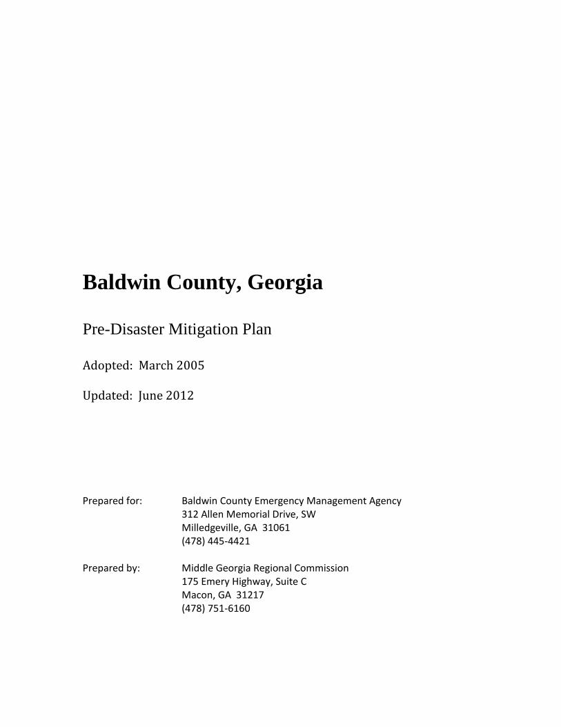
Baldwin County, Georgia
Pre-Disaster Mitigation Plan
Adopted: March 2005
Updated: June 2012
Prepared for: Baldwin County Emergency Management Agency 312 Allen Memorial Drive, SW Milledgeville, GA 31061 (478) 445-4421 Prepared by: Middle Georgia Regional Commission 175 Emery Highway, Suite C Macon, GA 31217 (478) 751-6160

Baldwin County, Georgia Pre-Disaster Mitigation Plan Update (2012)
i
Table of Contents
Table of Appendices
Stakeholders
Chapter 1: Introduction .......................................................................................................1
Chapter 2: Natural Hazard, Risk and Vulnerability Summary ...........................................8
A. Flooding
B. Winter Storms
C. Tornados
D. Thunderstorm Winds
E. Extreme Temperatures
F. Wildland Fires
Chapter 3: Technological Hazard, Risk and Vulnerability Summary ..............................19
Hazardous Materials Spills
Chapter 4: Natural Hazard Mitigation Goals, Objectives and Action Steps.....................22
A. Flooding
B. Winter Storms
C. Tornados
D. Thunderstorm Winds
E. Extreme Temperatures
F. Wildland Fires
Chapter 5: Technological Hazard Mitigation Goals, Objectives and Action Steps ..........34
A. Hazardous Materials Spills
Chapter 6: Executing the Plan...........................................................................................37
A. Implementation/Action Plan
B. Evaluation/Monitoring/Updating
C. Plan Update and Maintenance/Public Involvement
Chapter 7: Conclusion.......................................................................................................46
Sources

Baldwin County, Georgia Pre-Disaster Mitigation Plan Update (2012)
ii
Table of Appendices
Appendix A – Hazard Identification, Risk Assessment and Vulnerability
Hazard Descriptions and Area Maps
GEMA Worksheet #3a
GEMA Worksheet #3b
GMIS Critical Facility Inventory Reports
Appendix B – Growth and Development Trends / Community Information
Baldwin County Joint Comprehensive Plan – Introduction, Floodplain Narrative,
Land Use Element and Economic Development Data
Baldwin County/City of Milledgeville 2010 Census Profile
Baldwin County/City of Milledgeville Business Summary
Baldwin County Area Labor Profile
Appendix C – Relevant Community Planning Documents
Middle Georgia Regionally Important Resources Plan – Introduction
Middle Georgia Regional Plan – Executive Summary
Baldwin County/City of Milledgeville Summary of Service Delivery Arrangements
for
Emergency Management (Service Delivery Strategy – Form 2)
Georgia College & State University Pre-Disaster Mitigation Plan
Appendix D – Planning Process Worksheets
GEMA Worksheet #1: Identify the Hazards
GEMA Worksheet #2: Profile Hazard Events
GEMA Worksheet #4: Evaluate Alternative Mitigation Actions
Hazard Frequency Table
Critical Facility Data Collection Form
Appendix E – Planning Documentation (In Chronological Order)
Meeting Agendas
Attendance Records
Public Hearing Notices
Planning Process Timeline
Resolutions

Baldwin County, Georgia Pre-Disaster Mitigation Plan Update (2012)
iii
Stakeholders
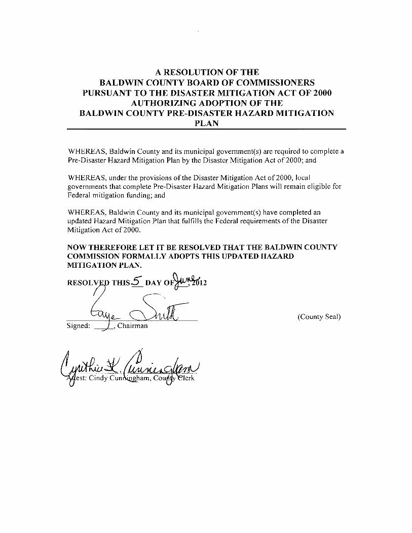
The Baldwin County Board of Commissioners, in conjunction with the Baldwin County
Emergency Management Agency, amended and updated the Baldwin County Pre-
Disaster Mitigation Plan, through the planning processes described herein. This Pre-
Disaster Mitigation planning process was completed in cooperation with Baldwin
County’s sole municipality: Milledgeville. Additionally, representatives from various
community agencies, authorities and local businesses participated in the update of this
important document. The Middle Georgia Regional Commission facilitated the planning
process and documented all significant accomplishments and milestones.

Baldwin County, Georgia Pre-Disaster Mitigation Plan Update (2012)
Page 1 of 47
CHAPTER 1: INTRODUCTION
I. Pursuant to requirements stated in the Disaster Mitigation Act of 2000, counties
across the nation were required to create a Pre-Disaster Mitigation Plan to address the
community’s vulnerability to hazards prior to a disaster event. In 2003, Baldwin County
recognized the need to initiate work on such a plan in an expeditious manner to ensure
that the County would have a plan in place by the deadline imposed in the legislation. In
2005, the County’s efforts culminated in the adoption of the Baldwin County Pre-
Disaster Mitigation Plan. The intent of the Pre-Disaster Mitigation Plan is to help
Baldwin County reduce risks from natural and technological hazards, and also to serve as
a roadmap for decision makers as they commit time and resources to reduce the effects of
potential hazards.
In 2011, Baldwin County initiated efforts to amend and update the Baldwin County Pre-
Disaster Mitigation Plan. The local Emergency Management Agency, once again
requested the assistance of the Middle Georgia Regional Commission, a regional
planning agency which facilitated the development of the initial Baldwin County Pre-
Disaster Mitigation Plan. The plan update includes a detailed and comprehensive
analysis and evaluation of critical community facilities, hazard events, losses, and current
plans. From this analysis and evaluation, an updated prioritized list of goals, objectives
and strategies, designed to further ensure the safety of Baldwin County residents, was
developed. The Baldwin County Pre-Disaster Mitigation Plan is intended to be a
working document where hazard mitigation measures are continually monitored and
implemented throughout the community.
II. The process of updating the Baldwin County Pre-Disaster Mitigation Plan began
with the selection of community representatives to serve on the Planning Committee.
The various departments, organizations and agencies which made up the original
Planning Committee were invited to participate in the plan update process. In fact, many
of the original Planning Committee members elected to serve once again on the
Committee. Several new organizations and agencies were asked to participate in the plan
update. It is important to note that all jurisdictions that participated in the development of
the original Pre-Disaster Mitigation Plan (i.e., Baldwin County and the City of
Milledgeville) also participated fully in the update of the plan.
The full Planning Committee acted as a steering agent for the Pre-Disaster Mitigation
Plan update process, ultimately responsible for all new goals, objectives, and action items
contained herein. The planning process consisted of facilitation of all meetings by the
Middle Georgia Regional Commission. Revisions were made through this planning
process to ensure that all components of the plan were as accurate and up-to-date as
possible. Specific tasks undertaken in the update of the Baldwin County Pre-Disaster
Mitigation Plan includes, but is not limited to the following:
Critical Facilities – Reviewed critical facilities inventory contained in the 2005
Pre-Disaster Mitigation Plan to ensure data is current and accurate;
modified/updated as applicable. Collected and compiled a detailed inventory of

Baldwin County, Georgia Pre-Disaster Mitigation Plan Update (2012)
Page 2 of 47
all new, or previously unrecorded critical facilities, and the characteristics of
those facilities, located within the County. A locally developed data collection
form was utilized to record all relevant information. Data was entered into the
Georgia Mitigation Information System (GMIS).
Identify/Profile Hazards – Reviewed hazards data contained in the 2005 Pre-
Disaster Mitigation Plan to determine if information is still relevant and
applicable. Researched various historical records, reviewed existing plans and
reports, gathered pertinent data from a variety of internet websites, and conducted
interviews with experts in the local community in order to identify any additional
natural and technological hazards that might affect the County and its member
city.
Vulnerability and Loss Analysis – Conducted a detailed risk assessment for the
County. Reviewed and analyzed hazard event profiles and critical facilities to
determine potential losses from hazard events. Potential losses include life,
building, infrastructure, and community assets. Reviewed vulnerability and loss
data contained in the 2005 Pre-Disaster Mitigation Plan; updated data as
applicable.
Developed Mitigation Goals and Strategies – Identified, analyzed and
prioritized various mitigation goals, objectives, and action steps. Utilized the
results of the countywide risk assessment to develop specific hazard mitigation
goals, as well as a comprehensive strategy to address the mitigation priorities
within the community. Reviewed goals and strategies contained in the 2005 Pre-
Disaster Mitigation Plan; updated as applicable.
As mentioned previously, numerous participants were involved in the update of this
document. Representatives of the public and private sectors were afforded seats at the
planning table. The list of Planning Committee participants and their titles are as
follows:
Name Title Organization
Archebelle, Rodney G. Regional Dir. of Safety Central State Hospital
Arp, Ricky
Avery, Bobby Baldwin County Board of Commissioners
Beer, Pamela Editor The Baldwin Bulletin
Bell, Mark A. Milledgeville Police Department
Blue, Woodrow Chief of Police Milledgeville Police Department
Braziel, Geneva Superintendant Baldwin County Board of Education
Burrows, Brione Central Georgia Technical College
Butts, Jason Georgia Forestry Commission
Byous, Andrea Assistant Supervisor MCCG EMS
Byous, Shane Supervisor MCCG EMS
Cates, C.L. Baldwin County Tax Assessor’s Office
Cheeves, Robert Milledgeville Police Department

Baldwin County, Georgia Pre-Disaster Mitigation Plan Update (2012)
Page 3 of 47
Cowart, Allen Milledgeville Police Department
Dietrich, Tom Chief Milledgeville Fire Department
Duke, Colin Assistant Director Baldwin County Emergency Mgmt. Agency
French, Gilbert Training Officer Baldwin County Fire/Rescue
Gore, Danny
Grant, Joe GCSU Police
Haines, Bryan Asst. Area Engineer Georgia Dept. of Transportation
Helms, Troy Georgia Forestry Commission
Hodnet, James Chief Georgia Military College Police
Joiner, Kelly MCCG EMS
LaRocque, Lynette Captain Baldwin County Sheriff's Office
Martin, Allen Baldwin County Board of Education
Miller, Jeff Milledgeville Fire Department
Moody, Lani Oconee Regional Medical Center
Palmer, Janet UGA Cooperative Extension
Ptak, Amanda Baldwin County Sheriff's Office
Reynolds, Troy Chief Baldwin County Fire/Rescue
Riley, Jeremy Baldwin County Tax Assessor’s Office
Shinn, Anthony Sinclair Water Authority
Smith, William T. Chief Baldwin County Fire/Rescue
Somers, Steve Baldwin County Fire/Rescue
Spires, Christopher A. Baldwin County Sheriff's Office
Tuft, Donald Dir. of Transportation Baldwin County Board of Education
Veal, Smokey Director Baldwin County Emergency Mgmt. Agency
Vinson, Matt Env. Health Specialist Central State Hospital
Walden, Eddie Milledgeville Fire Department
Walker, Jim Oconee Regional Medical Center
Washington, Lee Baldwin County Public Works
Washington Jr., Jessie Milledgeville Fire Department
Witcher, Joey Sinclair Water Authority
Through the planning process, with the individuals identified above participating,
complete records were maintained for all meetings. This documentation includes
agendas, sign-in sheets and labor documentation forms verifying the community’s 25
percent in-kind local match. All records and data are maintained and retained by the
Middle Georgia Regional Commission for a period no less than three years from the date
of GEMA/FEMA approval, should either entity seek to audit for verification purposes.
The plan update was prepared by assembling the ideas, thoughts, and research of the
Baldwin County Pre-Disaster Mitigation Planning Committee. The assembly of the plan
document was completed by the Middle Georgia Regional Commission staff. The ideas,
thoughts, and actions of the Committee were put together into one comprehensive
document. A draft was presented to the full committee for its review and comment.
Two Public Hearings were conducted during the planning process in an effort to solicit
public input and participation into the local plan update (see Public Hearing Notices and
Agendas in Appendix E). The first public hearing was held early in the planning process,
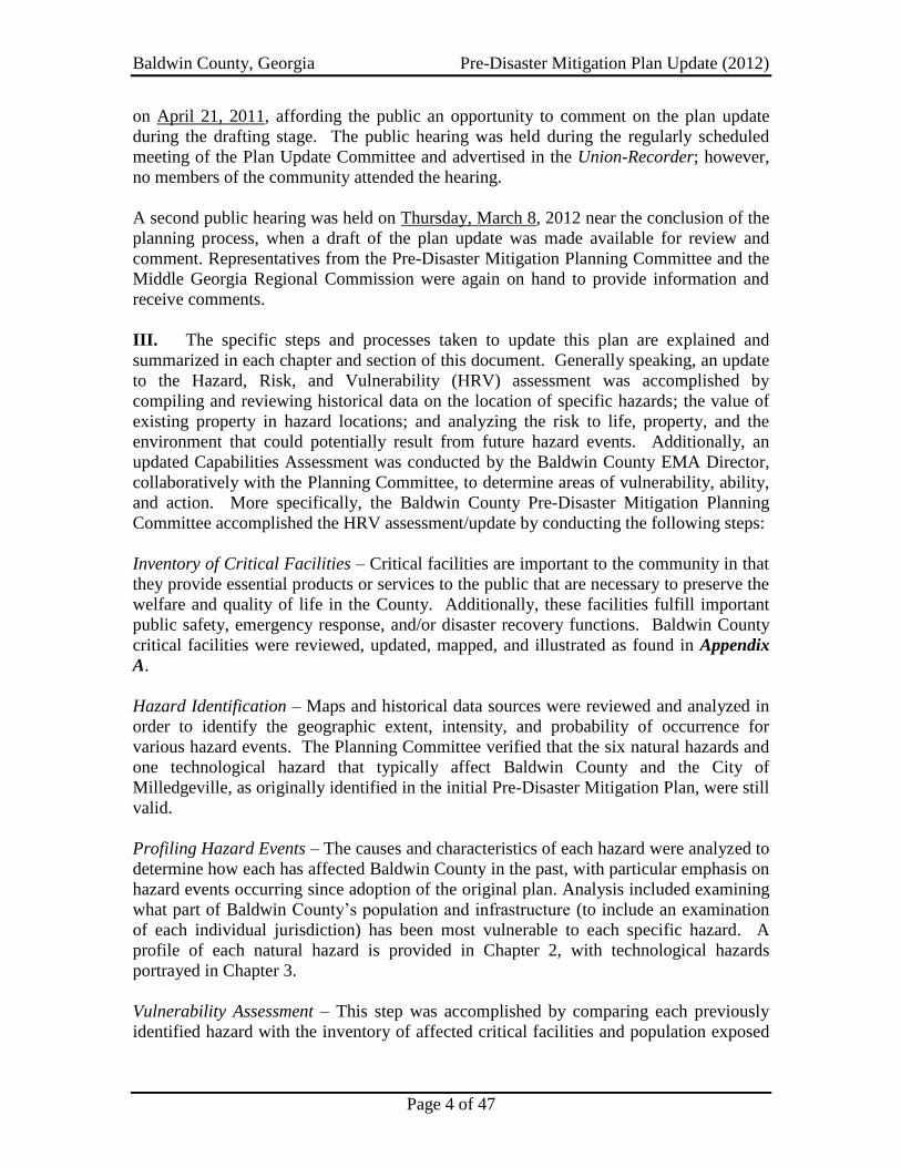
Baldwin County, Georgia Pre-Disaster Mitigation Plan Update (2012)
Page 4 of 47
on April 21, 2011, affording the public an opportunity to comment on the plan update
during the drafting stage. The public hearing was held during the regularly scheduled
meeting of the Plan Update Committee and advertised in the Union-Recorder; however,
no members of the community attended the hearing.
A second public hearing was held on Thursday, March 8, 2012 near the conclusion of the
planning process, when a draft of the plan update was made available for review and
comment. Representatives from the Pre-Disaster Mitigation Planning Committee and the
Middle Georgia Regional Commission were again on hand to provide information and
receive comments.
III. The specific steps and processes taken to update this plan are explained and
summarized in each chapter and section of this document. Generally speaking, an update
to the Hazard, Risk, and Vulnerability (HRV) assessment was accomplished by
compiling and reviewing historical data on the location of specific hazards; the value of
existing property in hazard locations; and analyzing the risk to life, property, and the
environment that could potentially result from future hazard events. Additionally, an
updated Capabilities Assessment was conducted by the Baldwin County EMA Director,
collaboratively with the Planning Committee, to determine areas of vulnerability, ability,
and action. More specifically, the Baldwin County Pre-Disaster Mitigation Planning
Committee accomplished the HRV assessment/update by conducting the following steps:
Inventory of Critical Facilities – Critical facilities are important to the community in that
they provide essential products or services to the public that are necessary to preserve the
welfare and quality of life in the County. Additionally, these facilities fulfill important
public safety, emergency response, and/or disaster recovery functions. Baldwin County
critical facilities were reviewed, updated, mapped, and illustrated as found in Appendix
A.
Hazard Identification – Maps and historical data sources were reviewed and analyzed in
order to identify the geographic extent, intensity, and probability of occurrence for
various hazard events. The Planning Committee verified that the six natural hazards and
one technological hazard that typically affect Baldwin County and the City of
Milledgeville, as originally identified in the initial Pre-Disaster Mitigation Plan, were still
valid.
Profiling Hazard Events – The causes and characteristics of each hazard were analyzed to
determine how each has affected Baldwin County in the past, with particular emphasis on
hazard events occurring since adoption of the original plan. Analysis included examining
what part of Baldwin County’s population and infrastructure (to include an examination
of each individual jurisdiction) has been most vulnerable to each specific hazard. A
profile of each natural hazard is provided in Chapter 2, with technological hazards
portrayed in Chapter 3.
Vulnerability Assessment – This step was accomplished by comparing each previously
identified hazard with the inventory of affected critical facilities and population exposed

Baldwin County, Georgia Pre-Disaster Mitigation Plan Update (2012)
Page 5 of 47
to each hazard. Updated and revised data and information was utilized in conducting the
assessment. Additionally, as part of the update process, the presence of repetitive loss
structures were addressed in assessing vulnerability as well as an analysis of development
trends and an attempt to assess each participating jurisdiction’s risks where they may
vary from the risks facing the entire County.
Estimating losses – Utilizing the best available data (as updated), this step involved
estimating damage and financial losses likely to be sustained within a given geographic
area by the use of a mathematical model. Describing vulnerability in terms of monetary
losses provides the County with a common framework in which to measure the effects of
hazards on critical facilities.
Additionally, during the plan update process, the Planning Committee considered the
recommendations provided by FEMA as a result of its review of the original Baldwin
County Pre-Disaster Mitigation Plan. Specifically, the Planning Committee discussed
possible future buildings, infrastructure and critical facilities when assessing vulnerability
related to each of the identified hazard events. At the time of this plan update, no known
facilities of critical significance are anticipated in the near future; however, it was agreed
that all relevant mitigation practices and principles presented in this Plan should be
applied to any significant development, infrastructure expansion or critical facility that
occurs over the five-year planning period. Any significant additions of community
facilities/infrastructure will necessitate an immediate update of the Plan.
FEMA recommendations from the original plan also resulted in greater emphasis being
placed on evaluating existing and future development and land use trends for Baldwin
County and the City of Milledgeville as well as extensive analysis related to identifying
differences between the County and the City in terms of risks and vulnerabilities for each
of the identified hazard events. Further discussion is found in Chapter 2.
IV. As identified in the Table of Contents, the Baldwin County Pre-Disaster
Mitigation Plan is organized as follows: Chapter 1 provides an introduction to the
original planning process as well as actions taken during the update of the plan. It
includes the purpose and intent of the plan; the methodology used in developing and
updating the plan; a list of those involved in the planning process; and a descriptive
narrative of how each section of the plan was reviewed, analyzed and revised.
Chapter 2 profiles the various natural hazards that can occur within the community while
Chapter 3 addresses technological hazards. Chapter 4 identifies specific community-
based mitigation goals, objectives and strategies for each of the identified natural hazards,
with Chapter 5 identifying goals, objectives and strategies to mitigate any technological
hazards that may occur within the community. Chapter 6 provides for the assignment of
various mitigation activities to certain individuals/organizations to ensure that the plan is
implemented and carried out. Included is an evaluation and monitoring component as
well as a process for future plan updates. Chapter 7 concludes with a summary of the
plan and identification of all references.

Baldwin County, Georgia Pre-Disaster Mitigation Plan Update (2012)
Page 6 of 47
Additionally, the plan contains a series of appendices that incorporate various planning
tools and supporting documentation. It should be noted that Appendix E fully documents
the plan update process. This appendix is presented in chronological order showing the
sequence of events and actions that occurred. The Planning Committee felt this would be
helpful to community officials during future plan updates.
V. Current research confirms that within Baldwin County, the most prevalent,
significant, natural hazard events continue to be thunderstorm winds that routinely strike,
especially during the spring and summer seasons. Additionally, hazardous materials
spills are the most prevalent technological hazard and continue to occur at a high rate
within Baldwin County. This was determined by reviewing 58 years of data, the time
period for which data is available. Baldwin County has also identified and verified four
additional natural hazard events which could significantly impact the community in a
negative manner. These five events are: tornados, flooding, wildland fires, and winter
storms.
Earthquakes, drought, extreme temperatures, hurricanes and tropical storms were
considered and discussed, but Hazard, Risk and Vulnerability Analysis determined the
frequency of occurrence and degree of impact (e.g. injuries, deaths, property damage) in
Baldwin County and the City of Milledgeville to be minimal or non-existent, and thus are
not included in or, in the case of extreme temperatures, have been removed from the plan.
Additionally, pandemic conditions were discussed during the update process. The
Committee elected not to include pandemic conditions in the Pre-Disaster Mitigation
Plan.
VI. As set forth by the Baldwin County Service Delivery Strategy, resulting from
Georgia House Bill 489, the Emergency Management Agency is the overall
implementing agency for projects such as Pre-Disaster Mitigation. The City of
Milledgeville has authorized Baldwin EMA to act on its behalf in a prudent manner.
Documentation to this intent from the current, approved Service Delivery Strategy can be
found in Appendix C. The City and the unincorporated County were included in the
planning process. Participation from each jurisdiction was solicited and received and, as
a result, a truly multi-jurisdictional plan was created for Baldwin County with ideas and
viewpoints of all entities included.
Disaster events also have the potential to severely impact certain vulnerable and/or
special needs populations within the County. According to the 2010 Decennial Census,
senior citizens (65 years of age and over) living in the County constitute only 12.0
percent of the population; however, 39.6 percent of those 65 to 74 years of age and 64.5
percent of those over 75 are considered disabled to some degree. Pre-disaster mitigation
planning for vulnerable and special needs populations should also take into consideration
the presence of 19 licensed daycare facilities in Baldwin County, one general hospital,
three nursing homes and a burgeoning Hispanic population, many of which do not speak,
read or write English.
Baldwin County, Georgia Pre-Disaster Mitigation Plan Update (2012)
Page 7 of 47
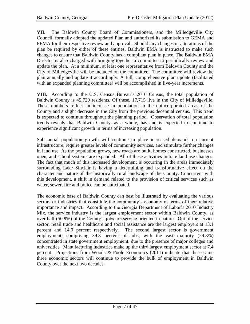
VII. The Baldwin County Board of Commissioners, and the Milledgeville City
Council, formally adopted the updated Plan and authorized its submission to GEMA and
FEMA for their respective review and approval. Should any changes or alterations of the
plan be required by either of these entities, Baldwin EMA is instructed to make such
changes to ensure that Baldwin County has a compliant plan in place. The Baldwin EMA
Director is also charged with bringing together a committee to periodically review and
update the plan. At a minimum, at least one representative from Baldwin County and the
City of Milledgeville will be included on the committee. The committee will review the
plan annually and update it accordingly. A full, comprehensive plan update (facilitated
with an expanded planning committee) will be accomplished in five-year increments.
VIII. According to the U.S. Census Bureau’s 2010 Census, the total population of
Baldwin County is 45,720 residents. Of these, 17,715 live in the City of Milledgeville.
These numbers reflect an increase in population in the unincorporated areas of the
County and a slight decrease in the City from the previous decennial census. This trend
is expected to continue throughout the planning period. Observation of total population
trends reveals that Baldwin County, as a whole, has and is expected to continue to
experience significant growth in terms of increasing population.
Substantial population growth will continue to place increased demands on current
infrastructure, require greater levels of community services, and stimulate further changes
in land use. As the population grows, new roads are built, homes constructed, businesses
open, and school systems are expanded. All of these activities initiate land use changes.
The fact that much of this increased development is occurring in the areas immediately
surrounding Lake Sinclair is having a determining and transformative effect on the
character and nature of the historically rural landscape of the County. Concurrent with
this development, a shift in demand related to the provision of critical services such as
water, sewer, fire and police can be anticipated.
The economic base of Baldwin County can best be illustrated by evaluating the various
sectors or industries that constitute the community’s economy in terms of their relative
importance and impact. According to the Georgia Department of Labor’s 2010 Industry
Mix, the service industry is the largest employment sector within Baldwin County, as
over half (50.9%) of the County’s jobs are service-oriented in nature. Out of the service
sector, retail trade and healthcare and social assistance are the largest employers at 13.1
percent and 14.0 percent respectively. The second largest sector is government
employment; comprising 39.3 percent of jobs, with the vast majority (29.3%)
concentrated in state government employment, due to the presence of major colleges and
universities. Manufacturing industries make up the third largest employment sector at 7.4
percent. Projections from Woods & Poole Economics (2011) indicate that these same
three economic sectors will continue to provide the bulk of employment in Baldwin
County over the next two decades.

Baldwin County, Georgia Pre-Disaster Mitigation Plan Update (2012)
Page 8 of 47
CHAPTER 2: NATURAL HAZARD, RISK AND VULNERABILITY SUMMARY
During the plan update process, the Baldwin County Pre-Disaster Mitigation Planning
Committee utilized the natural hazards identified in the original plan as a baseline for
discussion and analysis. The Planning Committee then reviewed, discussed and
considered other natural hazards that could potentially affect Baldwin County. They
pared down the original plan’s findings from six natural hazards that pose a direct,
measurable threat to the entire community (see GEMA Worksheet #1 – Appendix D) to
five—removing extreme temperatures The Planning Committee reaffirmed that of these
five, the entire County is exposed to four hazards relatively equally: winter storms,
tornados, thunderstorm winds, and wildland fires. Flooding, on the other hand, is
isolated to select areas of the County that are within the floodplain and/or hazard area.
Each of these potential hazards is addressed individually, with data to support the
Committee’s findings and recommendations. Additionally, each hazard is followed by a
summary of changes resulting from the plan update.
After having identified the natural hazards that pose a significant threat to the
community, the Planning Committee proceeded to “profile” each hazard event in order to
help answer the question: How Bad Can it Get? This process consisted of examining
hazard frequency data, assessing existing maps (i.e. road maps, topographic maps, aerial
photography, etc.) and technology (e.g. Geographic Information System (GIS) and digital
mapping) that may already exist at the local level, and inventorying assets and facilities
exposed to each hazard event. GEMA Worksheet #2 (see Appendix D) and GEMA
Worksheets #3a and #3b (see Appendix A) were helpful planning tools utilized by the
Planning Committee during this process. Also, new and/or projected development, to
include buildings and infrastructure, was researched, discussed, and given consideration.
A. Flooding (See Appendix A for hazard area map and related data.)
Within any given geography, many different variables must be considered when
determining if an area is susceptible to flooding. Topography, ground saturation, soil
permeability, rainfall intensity and duration, drainage, and vegetative cover, to only name
a few, contribute to the determination of whether or not an area will flood. Large
amounts of rainfall over a short amount of time can result in flash floods, which routinely
do minimal damage. Should the soil become saturated or super-saturated, even a small
amount of rainfall can cause flooding issues. As more and more land is being developed,
the presence of impermeable surfaces, roads, driveways, and parking lots cause an
increase in the likelihood of flooding within an area.
The Baldwin County Pre-Disaster Mitigation Planning Committee re-examined historical
data from the original plan as well as more recent data made available through the
National Climatic Data Center (NCDC), for effects of flooding on the community. The
areas most susceptible to flooding are illustrated in the Flood Hazard Area Map found in
Appendix A, with all other areas primarily spared from flooding. Unfortunately,
available data is not suitable or sufficient to make a reliable determination regarding
Baldwin County, Georgia Pre-Disaster Mitigation Plan Update (2012)
Page 9 of 47
frequency of occurrence, or future probability of flooding, for each individual jurisdiction
within Baldwin County.
According to the National Climatic Data Center, only one minor flood event has occurred
in Baldwin County since local adoption in 2005 of the original Pre-Disaster Mitigation
Plan (see Hazard Frequency Table in Appendix D). Two flood events have occurred
within the past ten years; both in 2004, causing damages estimated at $663,000 (Note:
This future probability is being calculated based on the frequency of previous
occurences). However, according to the National Weather Service, the historical high
crest for the Oconee River at Milledgeville is 42.90 feet on 2/25/1961—this should be
considered the greatest magnitude for mitigation planning purposes. Utilizing reliable
data from the past ten years, it can be inferred that a flood event causing more than
$50,000 in damage is likely to occur every ten years in Baldwin County (i.e., one
significant flood event in the past ten years).
As accomplished during development of the original plan, during the update process,
assets (particularly critical facilities) were examined using risk-based analysis to
determine the most vulnerable locations within the County (see GEMA Worksheet #3a
and GMIS Critical Facility Inventory Reports in Appendix A). Because not all facilities
are located within a flood hazard area, some facilities can be assumed to be safe should
flooding within the community occur. Within the flood hazard area, there are two critical
facilities that could sustain extensive water damage and/or structural destabilization due
to flooding. Total, should these two facilities be severely damaged or destroyed, is
estimated at $3,560,109.00. Additional losses are experienced in the form of
displacement and functional downtime.
Baldwin County and City of Milledgeville both participate in the National Flood
Insurance Program (NFIP)—a fact that has not changed since the previous plan was
adopted. As part of the plan update process, the Planning Committee conducted research
in order to determine if any repetitive loss structures exist within the County or its City.
A repetitive loss structure is defined as one of the following: (a) structures with four or
more claims paid under the National Flood Insurance Program of at least $1,000 per
occurrence; (b) structures with two or more claims in 10 years with the cumulative
damages exceeding the value of the property; or (c) structures with three or more claims
with the cumulative damages exceeding the value of the property. A Severe Repetitive
Loss Structure is either a structure with four or more claims of at least $5,000 per
occurrence, or a structure with two or more claims within 10 years with the cumulative
damages of the claims exceeding the market value of the structure. Research reveals that
there are 0 residential properties located in Baldwin County that are categorized by the
National Flood Insurance Program as repetitive loss properties.
During the update of the Baldwin County Pre-Disaster Mitigation Plan, the Planning
Committee felt it would be beneficial to examine land use and development trends as
they relate to mitigation planning for flood hazard events. An emphasis was placed on
examining residential and commercial uses because of the high degree of vulnerability to
life and property associated with these uses.

Baldwin County, Georgia Pre-Disaster Mitigation Plan Update (2012)
Page 10 of 47
Many areas of Baldwin County, particularly the areas around Lake Sinclair, have
experienced rapid suburban development over the past 15 years.
Land use and development trends provide a basis for making decisions on the type of
mitigation approaches to consider, and the locations where these approaches can be
implemented. Specific goals, objectives and strategies related to flooding vulnerability
resulting from land use and development in Baldwin County and the City of
Milledgeville is found in Chapter 4.
Summary of Changes: Hazard history and frequency data related to flooding was
updated from the original plan; probability of future occurrences was adjusted
accordingly; maps were created utilizing the Georgia Mitigation Information System
(GMIS); repetitive loss properties were researched and analyzed as part of the risk
assessment; vulnerability in terms of dollar values and/or percent of damage was updated;
a new analysis of land use, development trends and existing ordinances and regulations
was accomplished; flooding susceptibility for each jurisdiction was re-examined via
GMIS on-line tool.
B. Winter Storms (See Appendix A for hazard area map and related data.)
The Baldwin County Pre-Disaster Mitigation Planning Committee researched historical
data from NCDC, local newspapers, and local knowledge to arrive at historical winter
storm events during the update of the plan. In addition to snow, winter storms bring the
threat of freezing rain and ice storms to Baldwin County. A heavy accumulation of ice,
especially when accompanied by high winds, devastates trees and power lines. When ice
forms on sidewalks, streets, roads, or highways, each becomes extremely hazardous to
pedestrians and motorists in Baldwin County. There are no significant differences
between the County and the City in terms of the risks and vulnerabilities associated with
winter storms. Data is simply not suitable or sufficient to make an accurate assessment
regarding frequency of occurrence, or future probability for each individual jurisdiction
within Baldwin County.
Research indicates that Baldwin County has experienced significant snow or ice twice
since the original plan adoption. Baldwin County, like much of Middle Georgia does not
have equipment necessary to keep the community functional in the event of a massive
winter storm. When these types of storms occur, the community is crippled in many
cases. NCDC and local newspapers indicate five winter storm incidents in the past 58
years (see Hazard Frequency Table in Appendix D). There is a 9.4 percent chance of a
winter storm occurring each year in Baldwin County, equating to one winter storm every
ten years. (Note: This future probability is being calculated based on the frequency of
previous occurences.)
Unlike most natural hazards that typically threaten both people and property, winter
storms often expose primarily people to the greatest risk. GEMA Worksheet #3a in
Appendix A depicts the total number of structures, the value of those structures and the
Baldwin County, Georgia Pre-Disaster Mitigation Plan Update (2012)
Page 11 of 47
population exposed to the winter storm hazard (encompasses the entire planning area; not
available by individual jurisdiction). While damage to buildings resulting from winter
storms is minimal, it is important to note that the numbers of people who either reside,
work in, or visit these structures on a daily basis are vulnerable to the effects of winter
storms. Similarly, the Critical Facility Inventory Report, obtained from the Georgia
Mitigation Information System (see Appendix A), reflect data on the value of the
community’s critical facilities, content value, as well as occupancy estimates. In excess
of 73,188 people from these critical facilities are potentially exposed to the hazards of
winter storms.
In February of 2011, the County was largely shut-down due to approximately two inches
of snow that fell overnight. Events like this one are fairly infrequent, and therefore, it is
impractical for Baldwin County to procure and maintain the necessary equipment to
address such weather conditions. Additionally, land use and development trends were
analyzed, but were determined to be not applicable to mitigation planning due to the
nature of winter storms (encompasses the entire planning area) and their infrequent
occurrence.
The extent to which the community is vulnerable to this hazard is evident when
examining snow and ice accumulations from previous storms. As stated, this is an
infrequent hazard event; however, accumulations have averaged between two-four
inches. This is exceptionally high for the Middle Georgia region, and the problem is
exasperated due to the lack of snow and ice removal equipment. As little as one-half inch
of accumulation can wreck havoc on the community—however, for planning purposes
the greatest potential magnitude the area can expect is identified at four inches.
Within the County, damage to facilities is caused primarily by downed trees and power
lines crashing into or falling onto facilities. Consequently, gaping holes are created in the
structure, or fires are ignited as a result of the severe weather. Also, during times of snow
and ice, generally associated with very cold temperatures, persons with inadequate heat
have a tendency to try warming their homes at all costs, which frequently results in
structure fires as the heat source ignites flammable materials. Winter storms are typically
short in duration, and the damage associated with them is often minimal (particularly to
critical facilities); however, the potentially crippling affect this hazard poses, necessitates
mitigation measures being undertaken to lessen its impact.
Summary of Changes: Hazard history and frequency data related to winter storms was
updated from the original plan; probability of future occurrences was adjusted
accordingly; changes in land use and development trends were examined for
applicability; GMIS on-line tool was utilized for mapping and analysis.
C. Tornados (See Appendix A for hazard area map and related data.)
Extensive discussion took place among Planning Committee members to address
FEMA’s recommendation (Local Hazard Mitigation Plan Review – January 2004) to
more clearly define or identify differences between the County and the City in terms of

Baldwin County, Georgia Pre-Disaster Mitigation Plan Update (2012)
Page 12 of 47
risks and vulnerabilities. However, extensive statistical analysis is unable to identify any
clear differences. While there are many more residences and commercial businesses
located in unincorporated Baldwin County than there are in the City of Milledgeville, one
could make the argument that Baldwin County is more vulnerable and at risk than the
City of Milledgeville. However, Milledgeville’s population is much greater in density
than that of the County, suggesting greater risk and vulnerability to the City.
The many variables involved (i.e. unpredictable nature of tornados, degrees of severity,
infrequency of occurrence, differences in population density, differences in land area,
number of structures/infrastructure, location of facilities, etc.) makes it statistically
impossible to infer any distinct statistical differences between the County and the City.
This same consideration holds true for the other natural hazards (excluding flood)
addressed in this Plan; however, vulnerable critical facilities and infrastructure, as
defined by their value and importance to the community, are discussed under each hazard
as well as depicted in the Critical Facility Inventory Reports found in Appendix A.
During update of the plan, the Committee reviewed historical data from the NCDC, the
Georgia Tornado Database (1808 – 2002) and the Tornado History Project to determine
the past effects of tornados. A tornado is a violently rotating column of air extending
from a thunderstorm cloud to the ground. The most violent tornados are capable of
tremendous destruction, in some cases extreme devastation, with wind speeds that can
exceed 250 miles per hour. Damage paths can be of varying widths up to and exceeding
one mile, with the length of the path up to 50 miles long. Tornados are the most
unpredictable and destructive of all weather phenomena that affect Baldwin County.
Tornado season in Georgia typically runs from March through August; however, tornados
can strike at any time of year if the deadly atmospheric conditions are present.
As no one can predict when or where a tornado might touch down, all of Baldwin County
is vulnerable to the threat of a tornado. There are no significant differences between the
County and the City in terms of the risks associated with tornados. Because of the
infrequency in which tornados actually touch down, data is not sufficient to make a
reliable determination regarding frequency of occurrence, or future probability of
occurrence, for each individual jurisdiction within Baldwin County. Baldwin County has
experienced one tornado within the last ten years, resulting in no injuries or deaths, and a
total of $75,000 in property damage. Although infrequent, the potential devastation
associated with a tornado dictates appropriate mitigation measures.
Over the past 50 years, the touchdown of four tornados has been verified in Baldwin
County (see Hazard Frequency Table in Appendix D). Trend analysis shows that
Baldwin County should be prepared for a tornado touch down every ten years. This
equates to a 7.55 percent chance of a tornado touching down every year in the County.
(Note: This future probability is being calculated based on the frequency of previous
occurences.) The potential damage caused by a tornado event is extremely high. In
1964, an F3 tornado touched down causing $2.5 million in property damage.
Baldwin County, Georgia Pre-Disaster Mitigation Plan Update (2012)
Page 13 of 47
The Fujita Scale is typically used to rate the intensity of a tornado by examining the
damage caused by the tornado after it has passed over man-made structures. The scale
ranges from F0 to F6 with an F0 tornado having wind speeds of 40-72 mph and damage
typically minor (e.g. damage to chimneys; tree branches broken; shallow-rooted trees
pushed over; and damage to signs). The other end of the scale is represented by an F6
tornado, with wind speeds between 319 and 379 mph and capable of lifting automobiles
into the air and completely destroying buildings.
Recent historical data indicates that the highest magnitude tornado that Baldwin County
has experienced since 1952 was an F3. However, an F4 tornado was recorded in
neighboring Putnam County in 1992. Based on this historical area data, Baldwin County
and the City of Milledgeville can reasonably expect the greatest potential magnitude of a
tornado in the area to be an F4. Therefore, Baldwin County should be prepared for well-
constructed houses to be leveled, structures with weak foundations blown off some
distance, cars thrown and large missiles generated.
Since 1970, Baldwin County has more than doubled in population and become a popular
vacation and seasonal destination. Because of this rapid growth and the population
fluctuation, tornados continue to pose a substantial threat to Baldwin County, its citizens
and guests.
A specific geographic hazard area cannot be determined for tornados because such
weather events are indiscriminate as to when or where they strike. Therefore, all critical
facilities and infrastructure within Baldwin County should be considered equally
susceptible to tornado damage. Utilizing a straight-lined method for estimating losses, it
can be assumed that structures with the greatest replacement value could potentially
sustain the most monetary damage.
Operating on the assumption that a facility would sustain 75 percent damage in the event
of a tornado, some of the other facilities that have extremely high vulnerabilities include
many of the area schools, particularly the high school, as well as the Baldwin County
Courthouse, Baldwin County Sheriff’s Department, Baldwin County Public Works, and
area colleges. GEMA Worksheet #3a in Appendix A reflects totals for types of assets,
their values, and local populations exposed to tornados. The GMIS generated Critical
Facility Inventory Report found in Appendix A reflects this same data for the
community’s critical facilities.
During the update of this plan, the Planning Committee elected to follow the same
methodology as used during development of the original plan. Utilizing structure
replacement, content replacement, functional downtime, and displacement time, the same
facilities indicated by straight-lined loss estimates were shown to be the most vulnerable
to tornados.
All of Baldwin County has the same design wind speed as indicated by FEMA How-to
Guide #2: Understanding Your Risks and the Georgia Mitigation Information System
(GMIS). Additionally, the entire County has the potential to be affected by a tornado.

Baldwin County, Georgia Pre-Disaster Mitigation Plan Update (2012)
Page 14 of 47
As a result, any steps taken to lessen the effect of a tornado should be undertaken at a
county-wide level to ensure that the most stringent regulations are in place for protecting
vital facilities and infrastructure within the community. Baldwin County is located in
wind zone III, which is associated with 200-mph wind speeds.
Land use and development trends were examined and discussed, but were determined to
be not overly relevant to mitigation planning for tornados. This is due to a tornado’s
propensity to strike anywhere within the County and with varying degrees of severity.
Developing around or away from a tornado is not feasible. Baldwin County currently has
building codes, but the language in these codes does not mandate that structures be built
to the design wind speed of approximately 200 miles per hour; however, construction
must adhere to the Georgia State Minimum Standard Codes. The minimum standards
established by these codes provide reasonable protection to persons and property within
structures that comply with the regulations for most natural hazards. Additionally,
ordinances currently exist within Baldwin County to allow local officials to implement
curfews to close off certain portions of the County in the event of a tornado.
Overall, Baldwin County has high exposure to potential damage from tornados. Should a
tornado hit certain portions of the County that are highly concentrated with homes or
critical facilities, significant damage could occur, depending on the strength and duration
of the event. As has been evidenced by the number of events within the past 50 years (4
events), tornados have struck Baldwin County on average once every 12.5 years. As the
location of tornados is indiscriminant, no one can predict what facilities, if any, will be
damaged in such an event. Additionally, the Planning Committee determined that due to
the indiscriminate nature of tornados, mitigation activities should be applicable to the
entire planning area. Any mitigation measures that can be taken by local officials to
make the community safer in the event of tornado activity are encouraged.
Summary of Changes: Hazard history and frequency data related to tornados was
updated from the original plan; probability of future occurrences was adjusted
accordingly; changes in land use and development trends were examined for
applicability; GMIS on-line tool was utilized for mapping and analysis.
D. Thunderstorm Winds (See Appendix A for hazard area map and related data.)
The Baldwin County Pre-Disaster Mitigation Planning Committee again utilized NCDC
data to research the historical impact of thunderstorm winds within the County during the
update process. Thunderstorm winds are generally short in duration involving straight-
line winds and/or gusts in excess of 50 miles per hour. Thunderstorm winds tend to
affect areas of the County with significant tree stands, areas with exposed property and
infrastructure, and above-ground utilities. Thunderstorm winds can cause power outages,
cause transportation and economic disruptions, significant property damage, and pose a
high risk for injuries or loss of life. There are no significant differences between the
County and the City in terms of risks and vulnerabilities associated with thunderstorm
winds. Existing data is not suitable or sufficient to make a reliable determination

Baldwin County, Georgia Pre-Disaster Mitigation Plan Update (2012)
Page 15 of 47
regarding frequency of occurrence, or future probability of thunderstorm winds for each
individual jurisdiction within Baldwin County.
Available data does, however, substantiate the fact that the most prevalent hazard events
occurring in Baldwin County are thunderstorm winds. During spring and summer
seasons, the County typically experiences countless thunderstorms, some packing
significant winds. As a result of these winds, properties are damaged, whether from roofs
blowing off, trees being downed or loose debris.
As illustrated in the wind hazard maps found in Appendix A, the County is split into to
two wind zones. The first includes the northern portion of the unincorporated county and
the Milledgeville City limits (roughly bounded by Georgia Highway 22) and has a wind
hazard score of 1. The southern wind zone includes the majority of the City of
Milledgeville and the southern portion of the County and has a wind hazard score of 2;
therefore, Baldwin County residents can typically expect 90 to 99 mile per hour winds
during severe thunderstorm events as the greatest potential magnitude. The Wind Hazard
Score is reflective of the 2000 International Building Code.
Since 1958, 80 thunderstorm and high wind events have been recorded in Baldwin
County (see Hazard Frequency Table in Appendix D). On average, 1.5 thunderstorms
each year produce winds strong enough to inflict significant damage to facilities within
the County. (Note: This future probability is based on the frequency of previous
occurences.) As previously indicated, severe thunderstorm winds occur more frequently
than any other natural hazard event within Baldwin County. When considering the
probability of future occurrence, NCDC data indicates that Baldwin County has a 150
percent chance of at least one thunderstorm occurring each year.
In evaluating assets that are susceptible to thunderstorm winds, the Committee concurred
with the findings documented in the original plan that all critical facilities, as well as all
public, private and commercial property, is susceptible to damage from thunderstorm
winds including, but not limited to structural damage from fallen trees, downed power
lines, damaged siding or windows from wind-borne missiles (see Appendix A, GEMA
Worksheet #3a). Again, using straight-lined loss estimates (structure replacement, content
replacement, functional downtime, and displacement time), some of the County’s larger
employers were the most likely to sustain costly damage from thunderstorm winds.
Overall, thunderstorm winds pose one of the greatest threats to the livelihood of citizens
in Baldwin County. As thunderstorms tend to “pop-up” anytime and anywhere, this
hazard poses a serious threat to both lives and property and impacts the entire planning
area. As with tornados, the Planning Committee determined that limiting land use and
development was not useful in preparation for thunderstorm winds, but because it is the
most frequent hazard that affects Baldwin County, it is recommended that specific
attention be given to ensure that structures within Baldwin County are built to appropriate
code standards. Presently, local codes require that all mobile homes within the County be
“tied-down” to prevent damage during strong thunderstorm winds. Additional mitigation
measures of this type are encouraged.
Baldwin County, Georgia Pre-Disaster Mitigation Plan Update (2012)
Page 16 of 47
Summary of Changes: Hazard history and frequency data related to thunderstorm winds
was updated from the original plan; probability of future occurrences was adjusted
accordingly; changes in land use and development trends were examined for
applicability; GMIS on-line tool was utilized for mapping and analysis.
E. Extreme Temperatures
The Baldwin County Pre-Disaster Mitigation Planning Committee again reviewed
historical data from NCDC to evaluate extreme temperature conditions in the County.
For the purpose of the Pre-Disaster Mitigation planning process, Baldwin County
determined that extreme temperatures to be considered would be extreme heat during
summer months and extreme cold temperatures during winter months. After evaluation,
the Committee determined that extreme temperatures should be removed from the plan
due to the fact that the chances of loss of life or property were relatively insignificant
during these events (see Appendix A, GEMA Worksheet #3a).
Summary of Changes: Hazard history and frequency data related to extreme
temperatures was updated from the original plan; probability of future occurrences was
adjusted accordingly; extreme temperatures was removed as a primary vulnerability
under this plan.
F. Wildland Fires (See Appendix A for hazard area map and related data.)
Wildfires are uncontrolled fire spreading through vegetative fuels, exposing and possibly
consuming structures. They often begin in small scale, but can quickly escalate into
catastrophic events. These are routinely dependent upon fuels available, weather
conditions, and wind speed and direction.
During the update of the Baldwin County Pre-Disaster Mitigation Plan, the Planning
Committee concurred with the findings of the original plan: when coupled with
prolonged drought, wildfires pose a significant threat to Baldwin County. Baldwin
County's agricultural and forestry lands make it highly vulnerable to uncontrolled
wildfire. As a result, nearby structures (residences and businesses) and major facilities
have the potential to incur significant damage, including, but not limited to catastrophic
crop or structure loss.
Although NCDC reports no instances of wildfire activity in Baldwin County over the past
58 years, the Committee relied on its local knowledge to gauge the impact, or potential
impact, of wildfires on the community. Data is also available through the Georgia
Forestry Commission (GFC), but it reflects all reported fires and does not distinguish
between wildfires and small brush fires. In 2011, the GFC reported 32 fires, affecting
147.44 acres, with the most destructive single fire affecting 21 acres and being caused by
lightning (see table 1 below). Over the past five years, the GFC reports an average of
29.8 fires affecting 108.22 acres per year. The five-year average shows the most
destructive single incidents caused by debris from forestry-related site preparation

Baldwin County, Georgia Pre-Disaster Mitigation Plan Update (2012)
Page 17 of 47
affecting an average of 9.8 acres; however, lightning-caused fires are a close second
affecting an average of 8.0 acres per fire. Based on this historical data, the greatest
potential magnitude of likely wildfires is a single fire that would affect 20-25 acres.
Baldwin County can reasonably expect about 30 fires of varying size every year. (Note:
This future probability is based on the frequency of previous occurences.) The consensus
of the Committee was that while past fire events have been relatively minor and small-
scale, each incident has the potential for developing into a wildfire and causing
significant damage within the community. Predicting probability of occurrence is also
difficult due to the nature of available data.
County = Baldwin Cause Fires Acres
Fires
5-Yr
Avg
Acres
5-Yr
Avg
Campfire Campfire 0 0.00 0.40 0.57
Children Children 1 5.00 1.40 3.41
Debris: Ag Fields, Pastures,
Orchards, Etc. Debris: Ag Fields, Pastures,
Orchards, Etc. 3
10.08 1.20 6.26
Debris: Construction Land
Clearing
Debris: Construction Land
Clearing 0 0.00 1.20 2.87
Debris: Escaped Prescribed
Burn
Debris: Escaped Prescribed
Burn 1 1.60 1.20 2.95
Debris: Household Garbage Debris: Household Garbage 0 0.00 0.60 0.50
Debris: Other Debris: Other 0 0.00 0.20 1.67
Debris: Residential, Leaf Piles,
Yard, Etc. Debris: Residential, Leaf Piles,
Yard, Etc. 6
8.40 4.80 9.26
Debris: Site Prep – Forestry-
Related
Debris: Site Prep – Forestry-
Related 1 1.00 3.20 31.37
Incendiary Incendiary 0 0.00 1.00 1.23
Lightning Lightning 1 21.00 1.80 14.34
Machine Use Machine Use 6 34.00 6.60 15.05
Miscellaneous Miscellaneous 13
66.36 5.60 17.87
Railroad Railroad 0 0.00 0.40 0.50
Smoking Smoking 0 0.00 0.20 0.36
Totals for County: Baldwin
Year: 2011 32
147.44 29.80 108.22
Source: Georgia Forestry Commission

Baldwin County, Georgia Pre-Disaster Mitigation Plan Update (2012)
Page 18 of 47
Wildfires can cause varying degrees of damage to critical facilities should one or more be
located in the destructive path of a wildfire event. The Planning Committee elected to
use the same methodology utilized during the development of the original plan to
determine the vulnerability of critical facilities to wildfire. Within Baldwin County, the
wildfire hazard area has been determined to be the unincorporated portion of the County.
Outside of the City of Milledgeville’s corporate limits lie almost half of the critical
facilities verified and identified by the Pre-Disaster Mitigation Planning Committee
during the update of the plan.
Facility losses in the event that a massive wildfire consumed unincorporated Baldwin
County would be in excess of $75 million (see GEMA Worksheet #3a in Appendix A).
Although, it is highly unlikely that all facilities would be negatively impacted, the
potential does exist that wildfire could have catastrophic consequences for the
community. Numerous opportunities exist for fires to get out of control and spread,
causing considerable damage within the community.
During the update of the Baldwin County Pre-Disaster Mitigation Plan, the Planning
Committee felt it would be beneficial to examine land use and development trends as
they relate to mitigation planning for wildfire events. An emphasis was placed on
examining residential and commercial uses because of the high degree of vulnerability to
life and property associated with these uses. Land use and development trends provide a
basis for making decisions on the type of mitigation approaches to consider, and the
locations where these approaches can be implemented. Specific goals, objectives and
strategies related to wildfire vulnerability resulting from inappropriate land use and
development is addressed further in Chapter 4.
Summary of Changes: Hazard history and frequency data related to wildfire was
updated from the original plan; probability of future occurrences was adjusted
accordingly; changes in land use and development trends were examined for
applicability; GMIS on-line tool was utilized for mapping and analysis.

Baldwin County, Georgia Pre-Disaster Mitigation Plan Update (2012)
Page 19 of 47
CHAPTER 3: TECHNOLOGICAL HAZARD, RISK AND VULNERABILITY
SUMMARY
Within Baldwin County, one technological hazard is readily apparent within the
community. Hazardous material spills occur rather frequently within the County, with
the majority of incidents being fixed location spills, and considerably fewer are
transportation-related. As there are state and federal highways running through the
County, many trucks travel through the community and near the downtown areas on a
daily basis. These trucks could possibly contain agents with the potential to cause
significant damage to the Baldwin County community. Surprisingly, with the number of
vehicles traveling through the County, there have been minimal transportation-related
hazardous material spills reported to the Department of Natural Resources Environmental
Protection Division (DNR-EPD) from Baldwin County since 1987.
A. Hazardous Materials Spills (See Appendix A for hazard area map and related data.)
During the update of the Baldwin County Pre-Disaster Mitigation Plan, the Planning
Committee reviewed historical data from the Georgia Department of Natural Resources
Environmental Protection Division in its research involving hazardous materials in the
community. Hazardous materials are substances that are harmful to the health and safety
of people and property. Facilities that produce, process, or store hazardous materials are
at risk for spills, as well as facilities that treat or dispose of hazardous waste. Hazardous
materials spills generally come from two sources. Transportation-related spills occur on
or along roads and rail lines within a jurisdiction as hazardous substances are transported
from one location to another. Fixed location spills occur anywhere within the County
where the materials are stored, maintained, or handled.
Commercial businesses and private citizens are all potentially responsible for the spilling
of hazardous materials within Baldwin County. With the diverse mixture of business and
industrial sectors operating in Baldwin County, the types of hazardous materials that
could spill in the community are many and varied. Residents and employees alike must
be sure to take precaution when transporting or using hazardous materials to ensure the
safety to their property, their neighbor’s property, and the well-being of everyone in the
vicinity.
Within a 21-year period for which data is available, there were 37 hazardous material
spills within the County (see Hazard Frequency Table in Appendix D). Interestingly, all
were fixed releases and none of those were reportedly transportation-related. The
hazardous material spills that have been documented indicate that Baldwin County has
been fortunate to experience so few (approximately one per year) transportation-related
hazardous materials spills. However, data indicates that there is a 176 percent chance of
a fixed-release hazardous material spill within Baldwin County over the course of any
given year. This correlates to one hazardous material spill within the County every two
years.
Baldwin County, Georgia Pre-Disaster Mitigation Plan Update (2012)
Page 20 of 47
Data was obtained from the Toxics Release Inventory (1987 – 2005) and the Hazardous
Site Response Notification database made available by the Georgia Department of
Natural Resources Environmental Protection Division. While the data was analyzed to
determine noteworthy differences between the County and the City in terms of the risks
and vulnerabilities associated with hazardous material spills, no clear patterns emerged.
Existing data is not suitable or sufficient to make a reliable determination regarding
frequency of occurrence, or future probability of hazardous materials spills related to
each individual jurisdiction within Baldwin County.
All critical facilities within the County are susceptible to experiencing downtime due to
hazardous material spills. Persons occupying certain critical facilities may be forced to
evacuate the premises should spills of certain substances occur in close proximity to the
structure, thus creating downtime at the facility. Additionally, some of the facilities have
potentially harmful substances stored on site. Should these materials be spilled, the
potential exists for damage to property, as well as evacuations due to the contaminants.
There are no specific regulations that can prevent the spill of hazardous materials within
the County boundaries. However, mitigation measures can be taken to help ensure that
vital natural resources and critical facilities are adequately protected in the event of a
hazardous material spill.
There are no discernable differences in the susceptibility of Baldwin County facilities
when compared to the City of Milledgeville in regards to hazardous material spills. Each
jurisdiction’s facilities, as well as private facilities, must maintain proper procedures and
precautions for handling hazardous materials. Additionally, each must maintain
measures for action in the event of a spill either in the facility or nearby.
The potential extent of this hazard on the planning area is difficult to quantify. Each
potential spill would be unique in its magnitude and severity. Past data and information
does not allow for an accurate profile of this hazard event; however, the important thing
to keep in mind is the potential catastrophic nature of this technological hazard and the
need for the community to be prepared and vigilant. GEMA Worksheet 3a and the GMIS
Critical Facility Inventory Reports located in Appendix A help to illustrate the sheer
number of buildings, infrastructure and people exposed to this hazard on a daily basis
(encompasses the entire planning area; not available by individual jurisdiction).
Land use and development trends were examined for possible application related to
hazardous materials spills and mitigation measures. With burgeoning residential and
commercial development occurring in Baldwin County, best management practices
should be followed in relation to minimizing the impact of hazardous materials spills on
residences, businesses and environmentally sensitive areas. Examples include: using
infrastructure availability to steer certain types of development (those prone to hazardous
material spills) away from areas of natural, cultural, historic and environmentally
sensitive resources; using appropriate setbacks to minimize risks to citizens and
businesses from transportation-related hazardous materials spills; developing general
policies and protection measures for those industries/developments that use, store or
transport hazardous materials.

Baldwin County, Georgia Pre-Disaster Mitigation Plan Update (2012)
Page 21 of 47
Summary of Changes: Hazard history and frequency data related to hazardous materials
spills was updated from the original plan; probability of future occurrences was adjusted
accordingly; changes in land use and development trends were examined for
applicability; GMIS on-line tool was utilized for mapping and analysis.

Baldwin County, Georgia Pre-Disaster Mitigation Plan Update (2012)
Page 22 of 47
CHAPTER 4: NATURAL HAZARD MITIGATION GOALS, OBJECTIVES,
AND ACTION STEPS
This chapter identifies a series of community goals and objectives pertaining to each of
the natural hazards identified in Chapter 2. As part of the update process, the Planning
Committee performed a comprehensive review of the goals and objectives listed in the
original plan. The Committee also discussed overall community mitigation goals and
values to ensure consistency with those identified for each natural hazard. Existing
policies, regulations, ordinances and land use were examined for applicability; new
and/or projected development, to include buildings and infrastructure, was researched and
given consideration.
The Planning Committee also revisited the STAPLEE Criteria (Social, Technical,
Administrative, Political, Legal, Economic, and Environmental) in evaluating alternative
mitigation actions (see GEMA Worksheet #4 in Appendix D). Finally, adjustments were
made as necessary to those goals and objectives that were re-evaluated and determined to
still be valid; new goals and objectives were added where applicable. Each hazard is
followed by a summary of changes resulting from the plan update initiative.
The Planning Committee also identified and validated several methods of public
education and awareness regarding natural hazard mitigation. All public information
efforts are aimed at keeping the citizens of Baldwin County fully engaged in the
implementation and periodic maintenance of this mitigation plan. Many of these
education and awareness tools are multi-hazard in nature and include the following:
implementing a countywide crisis alert or notification system, distribution of
informational brochures or pamphlets, public and private sector briefings, workshops and
demonstrations, Public Service Announcements, etc.
The section that follows (as well as corresponding section in Chapter 5) serves as the
Baldwin County Mitigation Action Plan. Each natural and technological hazard is
described along with relevant goals and objectives. Specific action steps designed to
achieve each objective are identified, along with the agency or department responsible for
implementation. An estimated cost is provided as well as various funding mechanisms,
the affected jurisdiction(s), a projected timeline towards implementation, the priority of
the action as determined by the Pre-Disaster Mitigation Planning Committee, and finally
the status of the action or project.
A. Flooding – As previously stated (see Chapter 2, Section I), flooding has caused
considerable although infrequent damage within Baldwin County over the past half
century, most notably during the flood of 1994. The update committee concurred with
the original planning document that the presence of Lakes Sinclair and Oconee on the
borders of the County, along with the presence of several streams and creeks inside the
County, necessitates mitigation goals and objectives, and ultimately action steps, be taken
pertaining to flooding.

Baldwin County, Georgia Pre-Disaster Mitigation Plan Update (2012)
Page 23 of 47
In previous flooding instances, as mentioned above, considerable damage was done to
structures within the community. Mitigation measures identified by the Planning
Committee are to lessen the effect of such damage in the future. The mitigation goals
and objectives identified for flooding are also consistent with the overall community
mitigation goal of making Baldwin County and its municipalities less vulnerable to the
effects of natural hazards through development of a coordinated mitigation strategy. A
part of this coordinated mitigation strategy is the current and continued participation of
Baldwin County and the City of Milledgeville in the National Flood Insurance Program
(NFIP).
The Baldwin County Pre-Disaster Mitigation Planning Committee considered a range of
mitigation options related to flooding and identified both structural and non-structural
mitigation measures to ensure that the community adequately tackles all relevant issues.
This may result in alteration to current policies/practices, land use applications and
building codes, if deemed necessary. In regards to facilities that are subject to flooding,
there are no historic or special considerations that pose extraordinary challenges for the
community. Several of the mitigation goals, objectives and action steps identified here
are a part of the community’s ongoing strategy for ensuring continued compliance with
the National Flood Insurance Program.
Flooding Mitigation Strategy and Recommendations
Goal 1: Educate the public and public safety officials on hazards.
Objective 1: Provide educational opportunities to school children.
Action Item 1: Implement Master of Disaster curriculum into school
system.
Action Item 2: Utilize City of Milledgeville’s Fire Safety House for
Severe Weather Training in Schools.
Objective 2: Provide educational opportunities to the general public.
Action Item 1: Educate the public through GEMA/FEMA/Red Cross
brochures.
Objective 3: Train relevant personnel.
Action Item 1: Educate staff of relevant organizations on Incident
Command.
Action Item 2: Add qualified inter-agency members to Incident
Management Team and increase awareness of team.
Goal 2: Establish necessary regulatory controls to address hazard events.
Objective 1: Ensure that required records have adequate backup.
Action Item 1: Create a backup of essential records for Baldwin
County.
Action Item 2: Create a backup of essential records for the City of
Milledgeville.
Objective 2: Develop or review local ordinances relevant to hazard
mitigation.
Baldwin County, Georgia Pre-Disaster Mitigation Plan Update (2012)
Page 24 of 47
Action Item 1: Update local ordinances regarding construction in flood
zones.
Objective 3: Develop and enact local agreements relevant to hazard
mitigation.
Action Item 1: Develop agreements with hotels and restaurants for
Georgia Power and Red Cross.
Goal 3: Ensure a proper response in the event of a hazard.
Objective 1: Ensure coordination with other entities to ensure adequate
response.
Action Item 1: Update and complete essential community contact
personnel list for Georgia Power.
Action Item 2: Coordinate between Georgia Power and EMA to
identify priority areas around emergency shelters.
Action Item 3: Conduct intra-agency drills on an annual basis.
Objective 2: Construct or establish emergency shelters.
Action Item 1: Establish National Guard Armory as an emergency
shelter.
Action Item 2: Develop special needs shelter.
Objective 3: Develop adequate Emergency Operations Center and back-up.
Action Item 1: Set up EM-Net in "City" dispatch office.
Action Item 2: Upgrade the Baldwin County Emergency Operations
Center (EOC) and make it more secure.
Action Item 3: Develop a backup EOC to serve Baldwin County.
Goal 4: Purchase necessary equipment and/or supplies.
Objective 1: Obtain necessary equipment and/or supplies for emergency
shelters.
Objective 2: Utilize technology in the hazard mitigation process.
Action Item 1: Implement Phase II of E-911 system.
Action Item 2: Evaluate feasibility of implementing Reverse 911.
Goal 5: Provide for power supplies to critical facilities.
Objective 1: Obtain backup generators for critical facilities.
Action Item 1: Acquire heating/cooling generator for High School
gymnasium.
Action Item 2: Acquire heating/cooling generator for three dialysis
centers.
Action Item 3: Acquire generator for City Water Treatment Plant.
Action Item 4: Wire critical facilities to accept portable generators
capable of providing emergency power to facilities.
Goal 6: Reduce potential impacts from Hazard Events.
Objective 1: Reduce impacts on critical facilities and infrastructure.

Baldwin County, Georgia Pre-Disaster Mitigation Plan Update (2012)
Page 25 of 47
Action Item 1: Conduct engineering studies on roads and bridges that
cross potential flood areas to determine need for
structural improvements.
Action Item 2: Coordinate protection strategies with owners of dams
and levees within the County.
Objective 2: Reduce long-term risk to existing structures.
Action Item 1: Add or increase capacity of storm drainage
infrastructure.
Action Item 2: Modify or elevate existing structures in potential flood
zones to reduce impacts.
Action Item 3: Maintain participation in National Flood Insurance
Program.
Summary of Changes: During the update process, the Planning Committee elected to
remove some objectives and corresponding action steps included in the original Pre-
Disaster Mitigation Plan, which have since been accomplished and are no longer
applicable. Due to successful completion, the following action steps were removed:
"Distribute 30 weather radios within the community" under Objective #1, “Update
FEMA Flood Maps” under Objective #2, i. "Acquisition of cots by American Red
Cross" under Objective #4, and "Acquire heating/cooling generator for National
Guard Armory" under Objective #5. Goal #6 and associated objectives and action items
were added.
Those action steps that remain unchanged from the original Pre-Disaster Mitigation Plan
were reviewed by the Planning Committee and found to be valid and still meaningful to
the community. A review of the STAPLEE criteria substantiates this finding. Although
not accomplished or implemented during the past planning period, due to budgetary
and/or personnel limitations, they remain relevant.
B. Winter Storms – Within Baldwin County there is a legitimate concern over the threat
of periodic winter storms (see Chapter 2, Section VI). Baldwin County does not receive
the amounts of snow and ice that other areas of the country receive; however, this alone
poses a problem in that the community does not have the equipment necessary to combat
treacherous weather conditions. In the Middle Georgia region, the formation of ice on
roads, tree limbs, and power lines is the cause of most damage. The Baldwin County
Pre-Disaster Mitigation Planning Committee determined during the update of this plan
that several steps could be undertaken to ensure that the effects of winter storms within
the community are minimized.
A range of options were considered, and both structural and non-structural mitigation
measures are identified in order to adequately address all issues related to winter storm
conditions. Implementation of these measures may involve altering or modifying current
policies and practices. Currently, there are no historic or special considerations that pose
extraordinary challenges for the community related to the affects of winter storms. Also,
the mitigation goals and objectives identified for winter storms are consistent with the
overall community mitigation goal of creating a safe and livable environment for all

Baldwin County, Georgia Pre-Disaster Mitigation Plan Update (2012)
Page 26 of 47
Baldwin County citizens and for making Baldwin County and its municipality less
vulnerable to the effects of natural hazards. Mitigation goals, objectives and action steps
for winter storms, as determined by the Committee, are as follows:
Winter Storm Mitigation Strategy and Recommendations
Goal 1: Educate the public and public safety officials on hazards.
Objective 1: Provide educational opportunities to school children.
Action Item 1: Implement Master of Disaster curriculum into school
system.
Action Item 2: Utilize City of Milledgeville’s Fire Safety House for
Severe Weather Training in schools.
Objective 2: Provide educational opportunities to the general public.
Action Item 1: Educate the public through GEMA/FEMA/Red Cross
brochures.
Action Item 2: Distribute 30 weather radios within the community.
Objective 3: Train relevant personnel.
Action Item 1: Educate staff of relevant organizations on Incident
Command.
Goal 2: Establish necessary regulatory controls to address hazard events.
Objective 1: Ensure that required records have adequate backup.
Action Item 1: Create a backup of essential records for Baldwin
County.
Action Item 2: Create a backup of essential records for the City of
Milledgeville.
Goal 3: Ensure a proper response in the event of a hazard.
Objective 1: Ensure coordination with other entities to ensure adequate
response.
Action Item 1: Update and complete essential community contact
personnel list for Georgia Power.
Action Item 2: Coordinate between Georgia Power and EMA to
identify priority areas around emergency shelters.
Action Item 3: Conduct intra-agency drills on an annual basis.
Objective 2: Construct or establish emergency shelters.
Action Item 1: Establish National Guard Armory as an emergency
shelter.
Action Item 2: Develop special needs shelter.
Goal 4: Purchase necessary equipment and/or supplies.
Objective 1: Obtain necessary equipment and/or supplies for emergency
shelters.
Objective 2: Utilize technology in the hazard mitigation process.
Action Item 1: Implement Phase II of E-911 system.
Action Item 2: Evaluate feasibility of implementing Reverse 911.
Baldwin County, Georgia Pre-Disaster Mitigation Plan Update (2012)
Page 27 of 47
Goal 5: Provide for power supply to critical facilities.
Objective 1: Obtain backup generators for critical facilities.
Action Item 1: Acquire heating/cooling generator for High School
gymnasium.
Action Item 2: Acquire heating/cooling generator for three dialysis
centers.
Action Item 3: Acquire generator for Centennial Center.
Action Item 4: Acquire generator for United Methodist Church.
Action Item 5: Acquire generator for Walter Williams.
Action Item 6: Acquire generator for City Water Treatment Plant.
Action Item 7: Wire critical facilities to accept portable generators
capable of providing emergency power to facilities.
Summary of Changes: During the update process, the Planning Committee elected to
remove some objectives and corresponding action steps included in the original Pre-
Disaster Mitigation Plan, which have since been accomplished and are no longer
applicable. Due to successful completion, the following action steps were removed:
"Distribute 30 weather radios within the community" under Objective #1, "Acquisition
of cots by American Red Cross" under Objective #4, and "Acquire heating/cooling
generator for National Guard Armory" under Objective #5.
Those action steps that remain unchanged from the original Pre-Disaster Mitigation Plan
were reviewed by the Planning Committee and found to be valid and still meaningful to
the community. A review of the STAPLEE criteria substantiates this finding. Although
not accomplished or implemented during the past planning period, due to budgetary
and/or personnel limitations, they remain relevant.
C. Tornados – Should a tornado touch down in Baldwin County, significant property
and crop damage could be incurred, in addition to the potential human toll (see Chapter 2,
Section II). In 1992, an F4 tornado touched down and travelled 20 miles, killing 4,
injuring 55, and causing $25 million in property damage. In addition to this tornado,
three more documented events, and countless tornado watches that, fortunately, never
materialized provide a constant reminder of the potential for tornadic activity within
Baldwin County. Mitigation measures identified by the Committee can be used by local
officials to take appropriate actions whereby the community is potentially spared future
losses.
The Baldwin County Pre-Disaster Mitigation Planning Committee considered a range of
mitigation options related to tornados and identified both structural and non-structural
mitigation goals, objectives and action steps. The goals and objectives identified here
may result in the creation of new policies and procedures to administer implementation.
Additionally, some existing policies, regulations or ordinances may need to be modified
or amended.
The mitigation goals and objectives identified for tornados are consistent with the overall
community mitigation goal of creating a safe and livable environment for all Baldwin

Baldwin County, Georgia Pre-Disaster Mitigation Plan Update (2012)
Page 28 of 47
County citizens. Mitigation goals, objectives and action steps for tornados, as determined
by the Committee, are as follows:
Tornado Mitigation Strategy and Recommendations
Goal 1: Educate the public and public safety officials on hazards.
Objective 1: Provide educational opportunities to school children.
Action Item 1: Implement Master of Disaster curriculum into school
system.
Action Item 2: Utilize City of Milledgeville’s Fire Safety House for
Severe Weather Training in schools.
Objective 2: Provide educational opportunities to the general public.
Action Item 1: Educate the public through GEMA/FEMA/Red Cross
brochures.
Action Item 2: Distribute FEMA brochures on safe rooms through
local government offices.
Objective 3: Train relevant personnel.
Action Item 1: Educate staff of relevant organizations on Incident
Command.
Action Item 2: Distribute 30 weather radios within the community.
Goal 2: Establish necessary regulatory controls to address hazard events.
Objective 1: Ensure that required records have adequate backup.
Action Item 1: Create a backup of essential records for Baldwin
County.
Action Item 2: Create a backup of essential records for the City of
Milledgeville.
Goal 3: Ensure a proper response in the event of a hazard.
Objective 1: Ensure coordination with other entities to ensure adequate
response.
Action Item 1: Update and complete essential community contact
personnel list for Georgia Power.
Action Item 2: Coordinate between Georgia Power and EMA to
identify priority areas around emergency shelters.
Objective 2: Conduct intra-agency drills on an annual basis. Construct or
establish emergency shelters.
Action Item 1: Establish National Guard Armory as an emergency
shelter.
Action Item 2: Develop special needs shelter.
Action Item 3: Construct Community Safe Rooms.
Objective 3: Notify County residents of impending disasters or other hazard
events.
Action Item 1: Establish County-Wide Emergency Alert/Notification
System.
Baldwin County, Georgia Pre-Disaster Mitigation Plan Update (2012)
Page 29 of 47
Goal 4: Purchase necessary equipment and/or supplies.
Objective 1: Obtain necessary equipment and/or supplies for emergency
shelters.
Objective 2: Utilize technology in the hazard mitigation process.
Action Item 1: Implement Phase II of E-911 system.
Action Item 2: Evaluate feasibility of implementing Reverse 911.
Goal 5: Provide for power supplies to critical facilities.
Objective 1: Obtain backup generators for critical facilities.
Action Item 1: Acquire heating/cooling generator for High School
gymnasium.
Action Item 2: Acquire heating/cooling generator for three dialysis
centers.
Action Item 3: Acquire generator for Centennial Center.
Action Item 4: Acquire generator for United Methodist Church.
Action Item 5: Acquire generator for Walter Williams.
Action Item 6: Acquire generator for City Water Treatment Plant.
Action Item 7: Wire critical facilities to accept portable generators
capable of providing emergency power to facilities.
Summary of Changes: During the update process, the Planning Committee elected to
remove some objectives and corresponding action steps included in the original Pre-
Disaster Mitigation Plan, which have since been accomplished and are no longer
applicable. Due to successful completion, the following action steps were removed:
"Distribute 30 weather radios within the community" under Objective #1, "Acquisition
of cots by American Red Cross" under Objective #4, and "Acquire heating/cooling
generator for National Guard Armory" under Objective #5. Under Goal #3, Objective
#3 was added along with Action Step #1: "Establish County-Wide Emergency
Alert/Notification System." Under Goal #3, Objective #2, Action Item #3, "Construct
Community Safe Rooms," was added.
Those action steps that remain unchanged from the original Pre-Disaster Mitigation Plan
were reviewed by the Planning Committee and found to be valid and still meaningful to
the community. A review of the STAPLEE criteria substantiates this finding. Although
not accomplished or implemented during the past planning period, due to budgetary
and/or personnel limitations, they remain relevant.
D. Thunderstorm Winds – Within Baldwin County, the most frequent hazard event that
occurs is damage associated with heavy thunderstorm winds (see Chapter 2, Section IV).
On average, one severe thunderstorm capable of causing significant structural and
property damage strikes Baldwin County each year. Although heavy thunderstorm winds
do not routinely affect critical facilities within the community, there is a real threat posed
to these facilities as, primarily, roofs and windows could be damaged. During the update
process, the Planning Committee agreed that mitigation measures could be undertaken to
help minimize the affects of thunderstorm winds on the community.
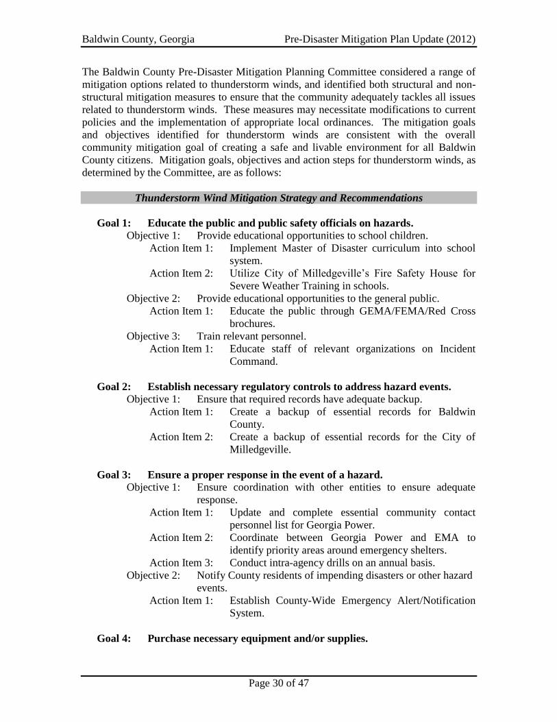
Baldwin County, Georgia Pre-Disaster Mitigation Plan Update (2012)
Page 30 of 47
The Baldwin County Pre-Disaster Mitigation Planning Committee considered a range of
mitigation options related to thunderstorm winds, and identified both structural and non-
structural mitigation measures to ensure that the community adequately tackles all issues
related to thunderstorm winds. These measures may necessitate modifications to current
policies and the implementation of appropriate local ordinances. The mitigation goals
and objectives identified for thunderstorm winds are consistent with the overall
community mitigation goal of creating a safe and livable environment for all Baldwin
County citizens. Mitigation goals, objectives and action steps for thunderstorm winds, as
determined by the Committee, are as follows:
Thunderstorm Wind Mitigation Strategy and Recommendations
Goal 1: Educate the public and public safety officials on hazards.
Objective 1: Provide educational opportunities to school children.
Action Item 1: Implement Master of Disaster curriculum into school
system.
Action Item 2: Utilize City of Milledgeville’s Fire Safety House for
Severe Weather Training in schools.
Objective 2: Provide educational opportunities to the general public.
Action Item 1: Educate the public through GEMA/FEMA/Red Cross
brochures.
Objective 3: Train relevant personnel.
Action Item 1: Educate staff of relevant organizations on Incident
Command.
Goal 2: Establish necessary regulatory controls to address hazard events.
Objective 1: Ensure that required records have adequate backup.
Action Item 1: Create a backup of essential records for Baldwin
County.
Action Item 2: Create a backup of essential records for the City of
Milledgeville.
Goal 3: Ensure a proper response in the event of a hazard.
Objective 1: Ensure coordination with other entities to ensure adequate
response.
Action Item 1: Update and complete essential community contact
personnel list for Georgia Power.
Action Item 2: Coordinate between Georgia Power and EMA to
identify priority areas around emergency shelters.
Action Item 3: Conduct intra-agency drills on an annual basis.
Objective 2: Notify County residents of impending disasters or other hazard
events.
Action Item 1: Establish County-Wide Emergency Alert/Notification
System.
Goal 4: Purchase necessary equipment and/or supplies.
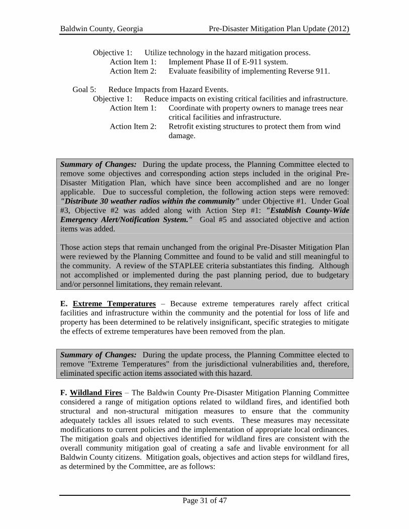
Baldwin County, Georgia Pre-Disaster Mitigation Plan Update (2012)
Page 31 of 47
Objective 1: Utilize technology in the hazard mitigation process.
Action Item 1: Implement Phase II of E-911 system.
Action Item 2: Evaluate feasibility of implementing Reverse 911.
Goal 5: Reduce Impacts from Hazard Events.
Objective 1: Reduce impacts on existing critical facilities and infrastructure.
Action Item 1: Coordinate with property owners to manage trees near
critical facilities and infrastructure.
Action Item 2: Retrofit existing structures to protect them from wind
damage.
Summary of Changes: During the update process, the Planning Committee elected to
remove some objectives and corresponding action steps included in the original Pre-
Disaster Mitigation Plan, which have since been accomplished and are no longer
applicable. Due to successful completion, the following action steps were removed:
"Distribute 30 weather radios within the community" under Objective #1. Under Goal
#3, Objective #2 was added along with Action Step #1: "Establish County-Wide
Emergency Alert/Notification System." Goal #5 and associated objective and action
items was added.
Those action steps that remain unchanged from the original Pre-Disaster Mitigation Plan
were reviewed by the Planning Committee and found to be valid and still meaningful to
the community. A review of the STAPLEE criteria substantiates this finding. Although
not accomplished or implemented during the past planning period, due to budgetary
and/or personnel limitations, they remain relevant.
E. Extreme Temperatures – Because extreme temperatures rarely affect critical
facilities and infrastructure within the community and the potential for loss of life and
property has been determined to be relatively insignificant, specific strategies to mitigate
the effects of extreme temperatures have been removed from the plan.
Summary of Changes: During the update process, the Planning Committee elected to
remove "Extreme Temperatures" from the jurisdictional vulnerabilities and, therefore,
eliminated specific action items associated with this hazard.
F. Wildland Fires – The Baldwin County Pre-Disaster Mitigation Planning Committee
considered a range of mitigation options related to wildland fires, and identified both
structural and non-structural mitigation measures to ensure that the community
adequately tackles all issues related to such events. These measures may necessitate
modifications to current policies and the implementation of appropriate local ordinances.
The mitigation goals and objectives identified for wildland fires are consistent with the
overall community mitigation goal of creating a safe and livable environment for all
Baldwin County citizens. Mitigation goals, objectives and action steps for wildland fires,
as determined by the Committee, are as follows:

Baldwin County, Georgia Pre-Disaster Mitigation Plan Update (2012)
Page 32 of 47
Wildland Fire Mitigation Strategy and Recommendations
Goal 1: Educate the public and public safety officials on hazards.
Objective 1: Provide educational opportunities to school children.
Action Item 1: Implement Master of Disaster curriculum into school
system.
Action Item 2: Utilize City of Milledgeville’s Fire Safety House for
Severe Weather Training in schools.
Objective 2: Provide educational opportunities to the general public.
Action Item 1: Educate the public through GEMA/FEMA/Red Cross
brochures.
Objective 3: Train relevant personnel.
Action Item 1: Educate staff of relevant organizations on Incident
Command.
Goal 2: Ensure a proper response in the event of a hazard.
Objective 1: Ensure that required records have adequate backup.
Action Item 1: Create a backup of essential records for Baldwin
County.
Action Item 2: Create a backup of essential records for the City of
Milledgeville.
Objective 2: Notify County residents of impending disasters or other hazard
events.
Action Item 1: Establish County-Wide Emergency Alert/Notification
System.
Objective 3: Ensure coordination with other entities to ensure adequate
response.
Action Item 1: Develop and regularly update a Community Wildfire
Protection Plan.
Goal 3: Purchase necessary equipment and/or supplies.
Objective 1: Obtain necessary equipment and/or supplies for emergency
shelters.
Objective 2: Utilize technology in the hazard mitigation process.
Action Item 1: Implement Phase II of E-911 system.
Action Item 2: Evaluate feasibility of implementing Reverse 911.
Goal 4: Provide for power supplies to critical facilities.
Objective 1: Obtain backup generators for critical facilities.
Action Item 1: Acquire heating/cooling generator for High School
gymnasium.
Action Item 2: Acquire heating/cooling generator for three dialysis
centers.
Action Item 3: Acquire generator for Centennial Center
Action Item 4: Acquire generator for United Methodist Church.
Action Item 5: Acquire generator for Walter Williams.

Baldwin County, Georgia Pre-Disaster Mitigation Plan Update (2012)
Page 33 of 47
Action Item 6: Acquire generator for City Water Treatment Plant.
Action Item 7: Wire critical facilities to accept portable generators
capable of providing emergency power to facilities.
Goal 5: Prevent Wildland Fires
Objective 1: Ensure regulatory issues are adequate for agencies active in
hazard mitigation.
Action Item 1: Encourage stronger enforcement of burn permits by
Georgia Forestry Commission to educate the public on
fire safety and inform the public of burn permit
availability online.
Goal 6: Reduce Impacts from Hazard Events.
Objective 1: Reduce risk to critical facilities and infrastructure.
Action Item 1: Coordinate vegetation management around critical
facilities with property owners.
Action Item 2: Ensure defensible space around critical facilities and
infrastructure in areas at higher risk to wildfires.
Summary of Changes: During the update process, the Planning Committee elected to
remove some objectives and corresponding action steps included in the original Pre-
Disaster Mitigation Plan, which have since been accomplished and are no longer
applicable. Due to successful completion, the following action steps were removed:
"Distribute 30 weather radios within the community" under Objective #1, "Acquisition
of cots by American Red Cross" under Objective #3, and "Acquire heating/cooling
generator for National Guard Armory" under Objective #4. Under Goal #2, Objective
#2 was added along with Action Step #1: "Establish County-Wide Emergency
Alert/Notification System." Goal #6, as well as Goal #2, Objective #3 and associated
action items were added.
Those action steps that remain unchanged from the original Pre-Disaster Mitigation Plan
were reviewed by the Planning Committee and found to be valid and still meaningful to
the community. A review of the STAPLEE criteria substantiates this finding. Although
not accomplished or implemented during the past planning period, due to budgetary
and/or personnel limitations, they remain relevant.

Baldwin County, Georgia Pre-Disaster Mitigation Plan Update (2012)
Page 34 of 47
CHAPTER 5: TECHNOLOGICAL HAZARD MITIGATION GOALS,
OBJECTIVES AND ACTION STEPS
A. Hazardous Materials Spills – During the plan update process, the Baldwin County
Pre-Disaster Mitigation Planning Committee validated and confirmed that hazardous
materials spills constitute the most prevalent technological hazard potentially damaging
to the community (see Chapter 3, Section I). There have been a considerable number of
minor spills in recent history, but this does not limit the potential of a catastrophic spill
within the community. The threat is exacerbated due to the fact that there are several
industries within the community that utilize large quantities of hazardous materials.
Hazardous chemicals are transported into and out of the County on a daily basis;
therefore, measures must be undertaken to ensure that the roads and rails of Baldwin
County are protected.
The Planning Committee also identified and validated several methods of public
education and awareness regarding technological hazard mitigation. They include the
following: implementing a countywide crisis alert or notification system, distribution of
informational brochures or pamphlets, public and private sector briefings, workshops and
demonstrations, Public Service Announcements, etc.
In regards to facilities that are subject to hazardous materials spills, there are no historic
or special considerations that pose extraordinary challenges for the community.
Mitigation goals and objectives identified for hazardous materials spills are consistent
with the overall community mitigation goal of creating a safe and livable environment for
all Baldwin County citizens and for making Baldwin County and the City of
Milledgeville less vulnerable to the effects of technological hazards. Mitigation goals,
objectives and action steps for hazardous materials spills, as determined by the
Committee, are as follows:
Hazardous Materials Spill Mitigation Strategy and Recommendations
Goal 1: Educate the public and public safety officials on hazards.
Objective 1: Provide educational opportunities to school children.
Action Item 1: Implement Master of Disaster curriculum into school
system.
Action Item 2: Utilize City of Milledgeville’s Fire Safety House for
Severe Weather Training in Schools.
Objective 2: Provide educational opportunities to the general public.
Action Item 1: Educate the public through GEMA/FEMA/Red Cross
brochures.
Objective 3: Train relevant personnel.
Action Item 1: Educate staff of relevant organizations on Incident
Command.
Action Item 2: Add qualified inter-agency members to Incident
Management Team and increase awareness of team.
Goal 2: Establish necessary regulatory controls to address hazard events.
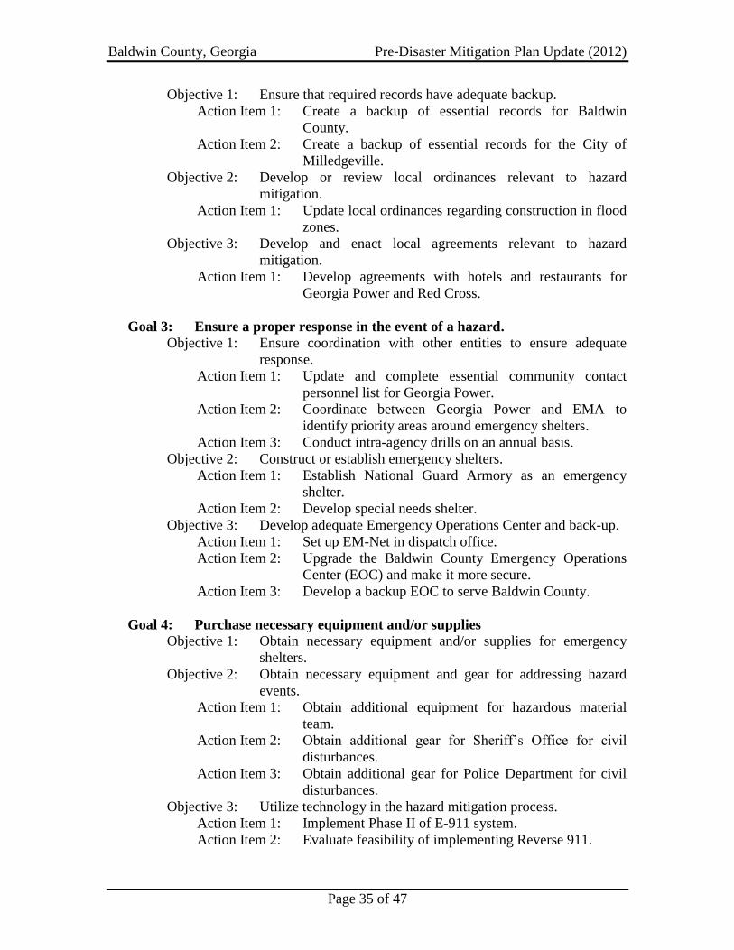
Baldwin County, Georgia Pre-Disaster Mitigation Plan Update (2012)
Page 35 of 47
Objective 1: Ensure that required records have adequate backup.
Action Item 1: Create a backup of essential records for Baldwin
County.
Action Item 2: Create a backup of essential records for the City of
Milledgeville.
Objective 2: Develop or review local ordinances relevant to hazard
mitigation.
Action Item 1: Update local ordinances regarding construction in flood
zones.
Objective 3: Develop and enact local agreements relevant to hazard
mitigation.
Action Item 1: Develop agreements with hotels and restaurants for
Georgia Power and Red Cross.
Goal 3: Ensure a proper response in the event of a hazard.
Objective 1: Ensure coordination with other entities to ensure adequate
response.
Action Item 1: Update and complete essential community contact
personnel list for Georgia Power.
Action Item 2: Coordinate between Georgia Power and EMA to
identify priority areas around emergency shelters.
Action Item 3: Conduct intra-agency drills on an annual basis.
Objective 2: Construct or establish emergency shelters.
Action Item 1: Establish National Guard Armory as an emergency
shelter.
Action Item 2: Develop special needs shelter.
Objective 3: Develop adequate Emergency Operations Center and back-up.
Action Item 1: Set up EM-Net in dispatch office.
Action Item 2: Upgrade the Baldwin County Emergency Operations
Center (EOC) and make it more secure.
Action Item 3: Develop a backup EOC to serve Baldwin County.
Goal 4: Purchase necessary equipment and/or supplies
Objective 1: Obtain necessary equipment and/or supplies for emergency
shelters.
Objective 2: Obtain necessary equipment and gear for addressing hazard
events.
Action Item 1: Obtain additional equipment for hazardous material
team.
Action Item 2: Obtain additional gear for Sheriff’s Office for civil
disturbances.
Action Item 3: Obtain additional gear for Police Department for civil
disturbances.
Objective 3: Utilize technology in the hazard mitigation process.
Action Item 1: Implement Phase II of E-911 system.
Action Item 2: Evaluate feasibility of implementing Reverse 911.

Baldwin County, Georgia Pre-Disaster Mitigation Plan Update (2012)
Page 36 of 47
Goal 5: Provide for power supplies to critical facilities.
Objective 1: Obtain backup generators for critical facilities.
Action Item 1: Acquire heating/cooling generator for High School
gymnasium.
Action Item 2: Acquire heating/cooling generator for three dialysis
centers.
Action Item 3: Acquire generator for Centennial Center.
Action Item 4: Acquire generator for United Methodist Church.
Action Item 5: Acquire generator for Walter Williams.
Action Item 6: Acquire generator for City Water Treatment Plant.
Action Item 7: Wire critical facilities to accept portable generators
capable of providing emergency power to facilities.
Summary of Changes: During the update process, the Planning Committee elected to
remove some objectives and corresponding action steps included in the original Pre-
Disaster Mitigation Plan, which have since been accomplished and are no longer
applicable. Due to successful completion, the following action steps were removed:
"Distribute 30 weather radios within the community," "Obtain training for Oconee
Regional Medical Center personnel on decontamination equipment" and "Train
additional firefighters to HazMat Technician’s level for Baldwin County and the City
of Milledgeville" under Objective #1, "Acquisition of cots by American Red Cross"
under Objective #3, and "Acquire heating/cooling generator for National Guard
Armory" under Objective #4.
Those action steps that remain unchanged from the original Pre-Disaster Mitigation Plan
were reviewed by the Planning Committee and found to be valid and still meaningful to
the community. A review of the STAPLEE criteria substantiates this finding. Although
not accomplished or implemented during the past planning period, due to budgetary
and/or personnel limitations, they remain relevant.

Baldwin County, Georgia Pre-Disaster Mitigation Plan Update (2012)
Page 37 of 47
CHAPTER 6: EXECUTING THE PLAN
A. Implementation / Action Plan: The Baldwin County Pre-Disaster Mitigation Plan
update process was overseen by the Baldwin EMA. Facilitation of the planning process
was conducted by the Middle Georgia Regional Commission. The Baldwin County
Board of Commissioners authorized submission of the plan update to both GEMA and
FEMA for their respective approvals. Upon favorable responses from each of these
agencies, the Board of Commissioners will reconvene and formally adopt this plan and
direct its implementation.
As a result of this update process, the Baldwin EMA Director shall assume the
responsibility of upkeep and maintenance of the plan. It shall be the responsibility of the
Baldwin EMA Director to ensure that the plan is utilized as a guide for undertaking
mitigation measures within the community. The Baldwin EMA Director shall also be
authorized to reconvene the Planning Committee to periodically review and update the
plan throughout the useful life of the plan, not to exceed five years.
Through this process, the Baldwin EMA Director shall identify mitigation projects that
have been undertaken within the community. During subsequent updates to the plan,
these projects shall be noted within the planning document to indicate their status (i.e.
completed, underway, postponed, cancelled, etc.). Additionally, the Planning Committee
shall continue to brainstorm, identify, and prioritize any additional mitigation projects
that the community can/should undertake.
Each mitigation action item identified in this plan was prioritized by the members of the
Baldwin County Pre-Disaster Mitigation Plan Update Committee. Priority categories
consist of High, Medium and Low. The methodology involved a comprehensive review
of the projects identified in the original plan, a determination as to those projects still
active and/or relevant to the community, and identification of new projects to be included
in the plan update. Several criteria were set forth to assist Committee members in the
prioritization of these projects. These criteria include perceived cost benefit of the action,
availability of potential funding sources, overall feasibility, measurable milestones within
the project, whether multiple objectives were addressed, and political support for the
project. The prioritized project list is as follows:
High Priority Action Item Medium Priority Action Item Low Priority Action Item
Action Item: Establish County-Wide Emergency Alert/Notification System.
Priority: High
Responsibility: Baldwin EMA; Baldwin County; City of Milledgeville
Status: New Ongoing Deferred
If deferred, explain why:
Timeline: 2015
Cost: $150,000
$ Sources: Local General Funds, Grants
Action Item: Educate the public through GEMA/FEMA/Red Cross brochures.
Priority: High

Baldwin County, Georgia Pre-Disaster Mitigation Plan Update (2012)
Page 38 of 47
Responsibility: City of Milledgeville; Baldwin County; BCBOE
Status: New Ongoing Deferred
If deferred, explain why:
Cost: Staff Time
Action Item: Educate staff of relevant organizations on Incident Command.
Priority: High
Responsibility: Baldwin County EMA
Status: New Ongoing Deferred
If deferred, explain why: Must coordinate staff time among multiple organizations.
Timeline: 2015
Cost: Staff Time
Action Item: Create a backup of essential records for Baldwin County and City of Milledgeville.
Priority: High
Responsibility: Baldwin County, City of Milledgeville
Status: New Ongoing Deferred
If deferred, explain why:
Cost: Staff Time
Action Item: Update and complete essential community contact personnel list for Georgia Power.
Priority: High
Responsibility: Baldwin EMA
Status: New Ongoing Deferred
If deferred, explain why:
Cost: Staff Time
Action Item: Conduct intra-agency drills on an annual basis.
Priority: High
Responsibility: Baldwin EMA
Status: New Ongoing Deferred
If deferred, explain why:
Cost: Staff Time
Action Item: Establish National Guard Armory as an emergency shelter.
Priority: High
Responsibility: Baldwin EMA
Status: New Ongoing Deferred
If deferred, explain why: No funding for acquisition of building.
Timeline: 2012
Cost: Staff Time
$ Sources: Local General Funds; Grants
Action Item: Set up EM-Net in "City" dispatch office.
Priority: High
Responsibility: Baldwin EMA; City of Milledgeville; BCSO
Status: New Ongoing Deferred
If deferred, explain why: No funding for equipment and software.
Timeline: 2014
Cost: $50,000
$ Sources: Local General Funds; Grants
Action Item: Upgrade security at the Baldwin County Emergency Operations Center (EOC).
Priority: High
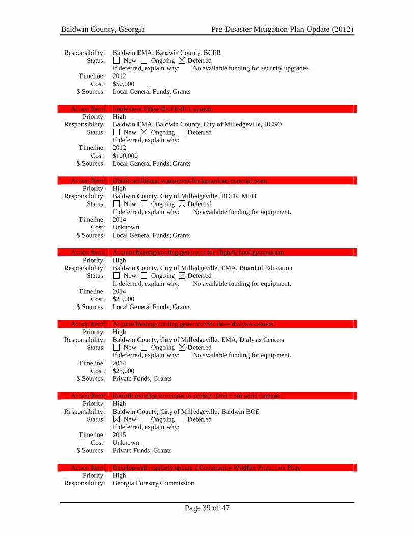
Baldwin County, Georgia Pre-Disaster Mitigation Plan Update (2012)
Page 39 of 47
Responsibility: Baldwin EMA; Baldwin County, BCFR
Status: New Ongoing Deferred
If deferred, explain why: No available funding for security upgrades.
Timeline: 2012
Cost: $50,000
$ Sources: Local General Funds; Grants
Action Item: Implement Phase II of E-911 system.
Priority: High
Responsibility: Baldwin EMA; Baldwin County, City of Milledgeville, BCSO
Status: New Ongoing Deferred
If deferred, explain why:
Timeline: 2012
Cost: $100,000
$ Sources: Local General Funds; Grants
Action Item: Obtain additional equipment for hazardous material team.
Priority: High
Responsibility: Baldwin County, City of Milledgeville, BCFR, MFD
Status: New Ongoing Deferred
If deferred, explain why: No available funding for equipment.
Timeline: 2014
Cost: Unknown
$ Sources: Local General Funds; Grants
Action Item: Acquire heating/cooling generator for High School gymnasium.
Priority: High
Responsibility: Baldwin County, City of Milledgeville, EMA, Board of Education
Status: New Ongoing Deferred
If deferred, explain why: No available funding for equipment.
Timeline: 2014
Cost: $25,000
$ Sources: Local General Funds; Grants
Action Item: Acquire heating/cooling generator for three dialysis centers.
Priority: High
Responsibility: Baldwin County, City of Milledgeville, EMA, Dialysis Centers
Status: New Ongoing Deferred
If deferred, explain why: No available funding for equipment.
Timeline: 2014
Cost: $25,000
$ Sources: Private Funds; Grants
Action Item: Retrofit existing structures to protect them from wind damage.
Priority: High
Responsibility: Baldwin County; City of Milledgeville; Baldwin BOE
Status: New Ongoing Deferred
If deferred, explain why:
Timeline: 2015
Cost: Unknown
$ Sources: Private Funds; Grants
Action Item: Develop and regularly update a Community Wildfire Protection Plan.
Priority: High
Responsibility: Georgia Forestry Commission

Baldwin County, Georgia Pre-Disaster Mitigation Plan Update (2012)
Page 40 of 47
Status: New Ongoing Deferred
If deferred, explain why:
Timeline: 2012
Cost: Staff Time
Action Item: Construct Community Safe Rooms.
Priority: Medium
Responsibility: City of Milledgeville; Baldwin County; Baldwin EMA
Status: New Ongoing Deferred
If deferred, explain why:
Cost: $100,000
$ Sources: Local General Funds; Grants
Action Item: Utilize Milledgeville’s Fire Safety House for Severe Weather Training in Schools.
Priority: Medium
Responsibility: City of Milledgeville; Baldwin County; BCBOE
Status: New Ongoing Deferred
If deferred, explain why:
Cost: Staff Time
Action Item: Coordinate vegetation management around critical facilities with property owners.
Priority: Medium
Responsibility: City of Milledgeville; Baldwin County; BCBOE; Private Property Owners
Status: New Ongoing Deferred
If deferred, explain why:
Cost: Staff Time
Action Item: Ensure defensible space around critical facilities and infrastructure.
Priority: Medium
Responsibility: City of Milledgeville; Baldwin County; BCBOE; Private Property Owners
Status: New Ongoing Deferred
If deferred, explain why:
Cost: Staff Time
Action Item: Conduct engineering studies on roads and bridges that cross potential flood areas to
determine need for structural improvements.
Priority: Medium
Responsibility: City of Milledgeville; Baldwin County
Status: New Ongoing Deferred
If deferred, explain why:
Cost: $500,000
$ Sources: Local General Funds; Grants
Action Item: Add or increase capacity of storm drainage infrastructure.
Priority: Medium
Responsibility: City of Milledgeville; Baldwin County
Status: New Ongoing Deferred
If deferred, explain why:
Cost: $3,000,000
$ Sources: Local General Funds; Grants
Action Item: Implement Master of Disaster curriculum into school system.
Priority: Medium
Responsibility: City of Milledgeville; Baldwin County; BCBOE
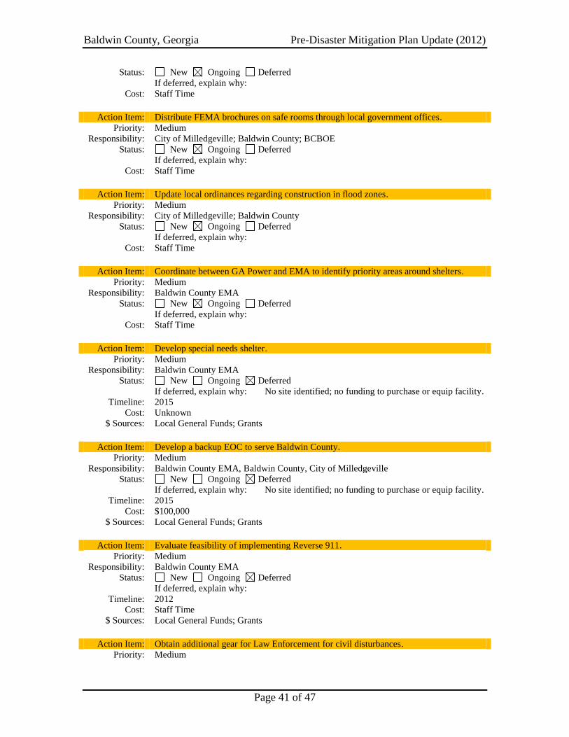
Baldwin County, Georgia Pre-Disaster Mitigation Plan Update (2012)
Page 41 of 47
Status: New Ongoing Deferred
If deferred, explain why:
Cost: Staff Time
Action Item: Distribute FEMA brochures on safe rooms through local government offices.
Priority: Medium
Responsibility: City of Milledgeville; Baldwin County; BCBOE
Status: New Ongoing Deferred
If deferred, explain why:
Cost: Staff Time
Action Item: Update local ordinances regarding construction in flood zones.
Priority: Medium
Responsibility: City of Milledgeville; Baldwin County
Status: New Ongoing Deferred
If deferred, explain why:
Cost: Staff Time
Action Item: Coordinate between GA Power and EMA to identify priority areas around shelters.
Priority: Medium
Responsibility: Baldwin County EMA
Status: New Ongoing Deferred
If deferred, explain why:
Cost: Staff Time
Action Item: Develop special needs shelter.
Priority: Medium
Responsibility: Baldwin County EMA
Status: New Ongoing Deferred
If deferred, explain why: No site identified; no funding to purchase or equip facility.
Timeline: 2015
Cost: Unknown
$ Sources: Local General Funds; Grants
Action Item: Develop a backup EOC to serve Baldwin County.
Priority: Medium
Responsibility: Baldwin County EMA, Baldwin County, City of Milledgeville
Status: New Ongoing Deferred
If deferred, explain why: No site identified; no funding to purchase or equip facility.
Timeline: 2015
Cost: $100,000
$ Sources: Local General Funds; Grants
Action Item: Evaluate feasibility of implementing Reverse 911.
Priority: Medium
Responsibility: Baldwin County EMA
Status: New Ongoing Deferred
If deferred, explain why:
Timeline: 2012
Cost: Staff Time
$ Sources: Local General Funds; Grants
Action Item: Obtain additional gear for Law Enforcement for civil disturbances.
Priority: Medium

Baldwin County, Georgia Pre-Disaster Mitigation Plan Update (2012)
Page 42 of 47
Responsibility: Baldwin County; City of Milledgeville; BCSO, MPD
Status: New Ongoing Deferred
If deferred, explain why: No available funding for equipment.
Timeline: 2015
Cost: Unknown
$ Sources: Local General Funds; Grants
Action Item: Acquire generator for City Water Treatment Plant.
Priority: Medium
Responsibility: City of Milledgeville, EMA
Status: New Ongoing Deferred
If deferred, explain why: No available funding for equipment.
Timeline: 2014
Cost: $25,000
$ Sources: Local General Funds; Grants
Action Item: Wire critical facilities to accept portable generators to provide emergency power.
Priority: Medium
Responsibility: Baldwin County, City of Milledgeville, EMA
Status: New Ongoing Deferred
If deferred, explain why: No available funding for equipment.
Timeline: 2014
Cost: $25,000
$ Sources: Local General Funds; Grants; Private Funds
Action Item: Acquire generator for United Methodist Church.
Priority: Medium
Responsibility: Baldwin County, City of Milledgeville, EMA
Status: New Ongoing Deferred
If deferred, explain why: No available funding for equipment.
Timeline: 2014
Cost: $25,000
$ Sources: Local General Funds; Grants
Action Item: Acquire generator for Walter Williams.
Priority: Medium
Responsibility: Baldwin County, EMA
Status: New Ongoing Deferred
If deferred, explain why: No available funding for equipment.
Timeline: 2014
Cost: $25,000
$ Sources: Local General Funds; Grants
Action Item: Acquire generator for Centennial Center.
Priority: Medium
Responsibility: Baldwin County, EMA
Status: New Ongoing Deferred
If deferred, explain why: No available funding for equipment.
Timeline: 2014
Cost: $25,000
$ Sources: Local General Funds; Grants
Action Item: Coordinate with property owners to manage trees near critical facilities and
infrastructure.
Priority: Low

Baldwin County, Georgia Pre-Disaster Mitigation Plan Update (2012)
Page 43 of 47
Responsibility: Baldwin County EMA
Status: New Ongoing Deferred
If deferred, explain why:
Cost: Staff Time
Action Item: Maintain participation in National Flood Insurance Program.
Priority: Low
Responsibility: Baldwin County EMA
Status: New Ongoing Deferred
If deferred, explain why:
Cost: Staff Time
Action Item: Modify or elevate existing structures in potential flood zones to reduce impacts.
Priority: Low
Responsibility: Baldwin County; City of Milledgeville; Private Property Owners
Status: New Ongoing Deferred
If deferred, explain why:
Cost: $10,000 per unit
$ Sources: Local General Funds; Grants; Private Funds
Action Item: Coordinate protection strategies with owners of dams and levees within the County.
Priority: Low
Responsibility: Baldwin County EMA
Status: New Ongoing Deferred
If deferred, explain why:
Cost: Staff Time
Action Item: Develop agreements with hotels and restaurants for Georgia Power and Red Cross.
Priority: Low
Responsibility: Baldwin County EMA
Status: New Ongoing Deferred
If deferred, explain why:
Cost: Staff Time
Through the prioritization process, several projects emerged as being of greater priority
than others. Some of the projects involved expending considerable amounts of funds to
undertake the action. Other projects allowed the community to pursue completion of the
project under grant funding. Still others required no significant financial commitment by
the community.
The determination of the cost benefit of a project was based upon the anticipated cost in
relation to the perceived benefit of the action taken (see Worksheet #4 in Appendix D).
If there was a high price tag associated with a project, yet minimal numbers of people
would benefit, the project was considered to have a low-cost benefit. Conversely, if
minimal expenditures were required and the entire community would benefit, this
received a favorable cost benefit rating. All projects were evaluated to determine the
favorability of the benefit in relation to the cost associated with completing the project.
Additionally, Committee members utilized criteria referenced above (availability of
potential funding sources, overall feasibility, measurable milestones within the project,
whether multiple objectives were addressed, and political support for the project) in order

Baldwin County, Georgia Pre-Disaster Mitigation Plan Update (2012)
Page 44 of 47
to determine the final prioritization of the project. Through discussion and debate, the
Committee collectively ranked its priorities, obtained consensus, and inserted the
prioritized list of projects into the plan.
A comprehensive review on the part of the Plan Update Committee substantiated that the
goals, objectives, strategies and action items identified in this Baldwin County Pre-
Disaster Mitigation Plan update are consistent with other important community planning
documents (see Appendix B and C). These include the Baldwin County/City of
Milledgeville Joint Comprehensive Plan, the Joint Solid Waste Management Plan
(SWMP), the Middle Georgia Regional Plan, the Baldwin County Emergency Operations
Plan, the Middle Georgia Regionally Important Resources (RIR) Plan, and the Middle
Georgia Economic Development District’s Comprehensive Economic Development
Strategy (CEDS). Additionally, over the previous five-year planning period, the Baldwin
County Pre-Disaster Mitigation Plan was utilized by community planners and local
officials during the update of these other planning mechanisms, and when appropriate,
the Plan’s data, mitigation strategies and action steps were incorporated into these
documents.
New mitigation action steps identified in this update of the Baldwin County Pre-Disaster
Mitigation Plan will also be evaluated for possible inclusion in the next update of the
Baldwin County STWP as well as the Community Agenda portion of the Regional Plan
update in 2011. In addition, relevant sections of this Pre-Disaster Mitigation Plan update
will be included in the next revision of the Baldwin County Emergency Operations Plan.
Baldwin County and the City of Milledgeville are committed to ensuring all relevant
mitigation strategies identified in this plan will be incorporated and integrated into
existing plans, as well as all applicable future planning efforts.
B. Evaluation/Monitoring/Updating: As mentioned previously, the Baldwin EMA
Director will be charged with ensuring that this plan is monitored and periodically
updated in subsequent years. An analysis of the previously approved plan’s method and
schedule for monitoring, evaluating, and updating the plan has indicated a high degree of
success and satisfaction among local officials and community stakeholders. The method
of evaluation employed, as agreed upon by the Pre-Disaster Mitigation Planning
Committee, will consist of utilizing a report of accomplishments to illustrate what
actions/projects were undertaken, the completion date (or current status) of those
actions/projects, the cost of the actions/projects, and whether the actions/projects were
deemed to be successful. Pursuant to the requirements set forth in the Disaster Mitigation
Act of 2000, the community is again required to update and evaluate the plan no more
than five years after its adoption. At the discretion of the Baldwin County EMA
Director, the committee that is designated to review and update the plan will convene in
order to evaluate progress within the community. The Director is encouraged to maintain
regular meetings, either quarterly, semi-annually, or annually to preserve continuity and
consistency throughout the process.
No later than the conclusion of the five-year period following approval of the plan
update, the Baldwin EMA Director shall submit a revised Pre-Disaster Mitigation Plan to

Baldwin County, Georgia Pre-Disaster Mitigation Plan Update (2012)
Page 45 of 47
GEMA for its approval. It is important to note that the plan update process, as
established by the Planning Committee, is subject to change, depending upon subsequent
regulations and/or requirements set forth by GEMA and FEMA.
C. Plan Update and Maintenance/Public Involvement: Because the Pre-Disaster
Mitigation Plan is intended to help ensure a safe and livable environment for all Baldwin
County citizens, it is imperative that citizen involvement be an integral part of the
planning process. Since adoption of the original Baldwin County Pre-Disaster Mitigation
Plan in 2006, citizens have been kept involved and apprised of plan progress through
such forums as regularly scheduled meetings of the Board of Commissioners.
This same level of public education and awareness and citizen involvement will continue
over the next five years until the next required update of the Baldwin County Pre-Disaster
Mitigation Plan. When specific issues dictate, public hearings will be conducted, and all
other community planning efforts (Comprehensive Plan, Regional Plan, CEDS, etc.) will
afford citizens the opportunity to participate in and comment on the need to incorporate
hazard mitigation initiatives.

Baldwin County, Georgia Pre-Disaster Mitigation Plan Update (2012)
Page 46 of 47
CHAPTER 7: CONCLUSION
After undertaking the first update to the Pre-Disaster Mitigation Plan, the community has
obtained a great deal of information regarding disaster history, the presence of natural
and technological hazards, and the impacts that these hazards present to the community.
The update process began with the identification and verification of hazards that have
occurred within Baldwin County over the past 50 years. This was followed with
updating critical facilities data within the community. Assessments were then made to
determine the vulnerability of the community to various hazards and determine its
potential losses. After evaluation of the potential losses within the community, goals and
strategies were developed to implement mitigation measures within the community.
These goals and strategies were then prioritized and were used to formulate an action
plan that the community can undertake to make the community a safer place to live and
work.
Additionally, the plan update process included reconvening the Planning Committee and
continued citizen involvement through two public hearings that were conducted in order
to provide members of the community with the opportunity to comment and make
suggestions about disaster mitigation, both present and future, within the community. It
is hoped that this plan update will serve well the citizens of Baldwin County and as stated
in the vision statement found at the beginning of this plan, will help to foster a
countywide hazard mitigation mindset through local government leadership and
community-based partnerships, leading the way to a safe and livable environment for all
Baldwin County citizens.

Baldwin County, Georgia Pre-Disaster Mitigation Plan Update (2012)
Page 47 of 47
Sources – Numerous sources were utilized to ensure that the most complete planning
document could be assembled. In an effort to ensure that all data sources consulted are
cited, references are listed in the following format: 1) publications, 2) web sites, 3) other
sources.

Appendix A
Hazard Identification, Risk Assessment and Vulnerability
Hazard Descriptions and Area Maps
GEMA Worksheet #3a
GEMA Worksheet #3b
GMIS Critical Facility Inventory Reports
Baldwin County, Georgia Pre-Disaster Mitigtion Plan Update (2011)
FLOODING Description Simply put, flooding in an excess volume of water that is in a place or location where it is unwanted. Flooding is the most common and widespread of all natural disasters, with the exception of fire according to FEMA. Additionally, it is typified by partial or complete inundation of two or more acres of normally dry land or two or more properties which have been inundated by overflow of inland or tidal waters, unusual and rapid accumulation of runoff or surface waters, mudflows, or dam failures. Only a few inches of rapidly moving water can sweep an adult off of their feet and wash them downstream, causing serious injury or death. As evidenced, flooding can be slow-occurring events or they can happen almost instantaneously. Slower-occurring events occur after several days of heavy rains or winter snow thaws that result in water levels rising within a given geographic area. Faster-occurring events are visible as hurricanes slam against coastal regions, dams fail causing potentially millions of gallons of water to rush downstream, or localized flash flooding events. Flash flooding occurs from intense rains and can reach their full peak in only a few minutes. Occasionally, improperly maintained culverts, storm drainage, or curb and guttering can cause flash flooding conditions to be exacerbated. Source: FEMA
Figure 1: Baldwin County Flood Hazard Area Map

Baldwin County, Georgia Pre-Disaster Mitigtion Plan Update (2011)
Milledgeville
Figure 1a: Milledgeville Flood Hazard Area Map

Baldwin County, Georgia Pre-Disaster Mitigtion Plan Update (2011)
Figure 2: NFIP Repetitive Loss Properties
Baldwin County, Georgia Pre-Disaster Mitigtion Plan Update (2011)
THUNDERSTORM WINDS Description A severe thunderstorm as defined by the National Weather Service is a storm with hail equal to or greater than 3/4” in diameter or convective winds equal to or greater than 58 miles per hour. Even if a storm is not severe, it still remains a potential killer. Lightning, flash flooding, hail, and general thunderstorm wind gusts pose a threat to life and/or property. According to FEMA, all thunderstorms go through a three-stage life cycle, whether they become severe or not. The first stage, cumulus, occurs when thunderstorm development begins. Upward-moving air currents reach heights of around 20,000 feet above the ground. This stage is followed by the mature state, which is the most dangerous stage of the storm’s cycle as it contains both upward and downward moving air currents with precipitation in the downdraft areas. A downdraft results from precipitation evaporating, which causes cooling. When the cool downdraft hits the ground, it spreads out and forms a gust front, which may include damaging winds called a downburst. At the top of the storm, the updraft rapidly decelerates and clouds spread out and form an anvil. The third, and final stage, is called the dissipating stage. Eventually excessive precipitation and downdraft will weaken the updraft. At the surface, the gust front will move away from the storm and cut off the inflow of energy into the storm.
Figure 3: Wind Hazard Map

Baldwin County, Georgia Pre-Disaster Mitigtion Plan Update (2011)
WILDLAND FIRE Description A wildland fire is an event where grassland, brush, and/or undergrowth is not intentionally set for the purpose of a prescribed burn by responsible entities. While healthy for the ecosystem in some cases, events where these fires rage out of control can place lives and property in extreme danger. The vast majority of these hazard events begin either through negligence or the deliberate setting of fires. To alleviate the likelihood of a wildland fire occurring in the state of Georgia, the Georgia Forestry Commission (GFC) rates the fire hazard on a daily basis and informs the public of this through signs, bulletins, or websites. Additionally, the GFC has the authority to cease issuing burn permits if conditions are favorable for wildland fires to spread. Furthermore, the state of Georgia has begun enacting a burn ban to be in effect through summer months to limit the likelihood of wildland fires causing significant damages. Source: Georgia Forestry Commission
Figure 4: Wildland Fire Hazard Map

Baldwin County, Georgia Pre-Disaster Mitigtion Plan Update (2011)
WINTER STORMS Description A winter storm can range from a moderate snow over a few hours to blizzard conditions with blinding wind-driven snow that lasts several days. Some winter storms may be large enough to affect several states, while others may affect only a single community. Many winter storms are accompanied by low temperatures and heavy and/or blowing snow, which can severely reduce visibility. Winter storms are defined differently in various parts of the country. Heavy snow in the south can be a dusting in the mountains. Sleet is raindrops that freeze into ice pellets before reaching the ground and usually bounces when hitting a surface and does not stick to objects; however, it can accumulate and cause a hazard to motorists. Freezing rain falls onto a surface with a temperature below freezing; this causes it to freeze to surfaces, such as trees, cars, and roads, forming a glaze of ice. Even small accumulations of ice can cause a significant hazard. An ice storm occurs when freezing rain falls and freezes immediately on impact; communications and power can be disrupted for days, and even small accumulations of ice may cause extreme hazards to motorists and pedestrians. There are various types of winter weather that affect lives of persons in an affected area.
1. Snow and heavy snow - Snow is dangerous to travelers since it causes the road to become slippery. One of the more dangerous times during winter storms is when the road initially becomes snow covered. A thin layer of snow offers less traction than an inch or more. When traveling during a falling snow, remember to be especially careful when the road is first covered with snow. Snow often leads to other problems which will be described below.
2. Rain or freezing rain – Freezing rain is extremely dangerous to travelers since it coats roadways with ice. This reduces the friction or "grabbing ability" that tires normally need to keep a car attached to the road. When you drive on ice, you are no longer on the road!
3. Sleet and snow pellets – Sleet and snow pellets often occur during major winter storms when the atmosphere is near freezing on the eastern edge of the storm. Usually this is a sign of a “large and dangerous” storm which will have strong winds and colder weather following.
4. Wind and blowing snow – One of the major dangers of winter storms is wind. Wind transports moisture into the storm at the surface and aloft which allows the storm to intensify and continue unabated. Wind can also create life-threatening conditions. Wind driven snow can cause "white-out" conditions which reduce visibility so much that motorists can not see the road or other vehicles traveling on the road. White-out conditions occur most often with major storms that produce a drier, more powdery snow.
5. Blizzards: The worst winter storms – A blizzard is a storm which contains heavy snowfall, strong winds, and cold temperatures. The combination of these elements creates blinding snow with near zero visibility, deep drifts, and life-threatening wind chills.
Sources: NOAA and KGAN-CBS

Baldwin County, Georgia Pre-Disaster Mitigtion Plan Update (2011)
TORNADO Description Tornados are weather events that occur as a rotating wall cloud spins violently around a base. By mixing warm, moist air into the spiraling wall cloud, a tornado increases to maximum size and intensity. A tornado’s intensity is measured based upon the Fujita Damage Scale which categorizes tornados ranging from F0 to F5. An F0 tornado is associated with a relatively weak tornado event, while F5 tornados are catastrophic. Listed below are wind speeds and damages characteristic of the various tornado events.
FUJITA DAMAGE SCALE FOR TORNADOS F-Scale
Number Wind Speed Type of Damage Done
F0 40-72 Some damage to chimneys; breaks branches off of trees; pushes over shallow-rooted trees; damages to sign boards.
F1 73-112 The lower limit is the beginning of hurricane wind speed; peels surface off roofs; mobile homes pushed off foundations or overturned; moving autos pushed off the road; attached garages may be destroyed.
F2 113-157 Considerable damage. Roofs torn off frame houses; mobile homes demolished; boxcars toppled; large trees snapped or uprooted; light object missiles generated.
F3 158-206 Roof and some walls torn off well-constructed homes; trains overturned; must trees in forest uprooted.
F4 207-260 Well-constructed houses leveled; structures with weak foundations blown off some distance; cars thrown and large missiles generated.
F5 261-318 Strong frame houses lifted off foundations and carried considerable distances to disintegrate; automobile sized missles fly through the air in excess of 100 yards; trees debarked; steel reinforced concrete structures badly damaged.
Source: FEMA

Baldwin County, Georgia Pre-Disaster Mitigtion Plan Update (2011)
EXTREME TEMPERATURES Description Throughout the country, extreme temperatures kill hundreds of persons during any given year. These events can exist for several days or several weeks, but the potential for loss of life, primarily, is very high during these periods. For the purpose of the Pre-Disaster Mitigation planning process, Baldwin County determined that extreme temperatures to be considered would be extreme heat during summer months and extreme cold temperatures during winter months. The committee determined that unseasonable temperatures would not be evaluated due to the fact that the chances of loss of life or property were relatively insignificant during these events. Extreme heat conditions in middle Georgia exist primarily during the months of July and August, but can also be apparent as early as May or as late as September. Extreme heat, when coupled with the high humidity of middle Georgia during summer months creates a potentially deadly recipe for loss of life or serious health complications. Due to the fact that many residents in older homes do not have air conditioning, the problem is exacerbated. Many times, the individuals living without air conditioning are elderly persons, the most dangerous group to be exposed to prolonged heat. Strokes are one of the most common results from persons exposed to extreme heat conditions for a prolonged period of time. Extreme cold conditions in middle Georgia are rare, but they do exist just the same. Typically, winter weather is relatively moderate in regards to temperature, but there are occurrences where mercury levels dip into or below single digits. In these cases, health concerns are also significant issues to be addressed within a community. While many homes in middle Georgia are not equipped with air conditioning, similarly, many homes do not have heating systems adequate to keep residents warm during prolonged cold periods. When persons must rely on additional, alternative heating sources, fire department personnel must be ready to respond to senseless fire calls where a fire has caused the loss of life or property attributable directly to extreme cold temperatures. Source: Local Knowledge

Baldwin County, Georgia Pre-Disaster Mitigtion Plan Update (2011)
HAZARDOUS MATERIAL SPILLS Description Hazardous materials are chemicals (such as paints or insecticides), biological agents (such as disease-causing materials), or physical agents (such as radioactive materials) that are dangerous to humans or to animals and plants. Hazardous waste is unusable hazardous material that results from the activities of human society. Research institutes, industrial plants, individual households, and government agencies all generate chemical waste. About one percent is classified as hazardous.
A hazardous spill occurs when hazardous material or waste gets into the environment in an uncontrolled fashion. Many manufacturing processes use hazardous materials or generate hazardous waste, but a hazardous spill doesn't always come from a chemical plant or a factory. Any substance in the wrong place at the wrong time in too large an amount can cause harm to the environment.
The response to a spill depends on the situation. When an emergency response team is notified of a spill, it must quickly decide what sort of danger is likely. Members of the team collect appropriate clothing and equipment and travel to the scene. There they try to contain the spill, sometimes testing a sample to identify it. If necessary, they decontaminate themselves before leaving the area. Once the material has been identified, other personnel arrive to remove it. Source: Newton’s Apple - KTCA
GEMA Worksheet #3a Inventory of Assets Jurisdiction: Baldwin County Hazard: Tornados, Thunderstorm Winds, Winter Storms, and Hazardous Material Spills Task A. Determine the proportion of buildings, the value of buildings, and the population in your community or state that are located in hazard areas. Type of Structure
(Occupancy
Class)
# in
Community
of State
# in Hazard
Area
% in Hazard
Area
$ in Community or
State $ in Hazard Area
% in Hazard
Area
# in
Community or
State
# in Hazard
Area
% in Hazard
Area
Residential 19,180 19,180 100.000% 2,989,183,820 2,989,183,820 100.000% 46,252 46,252 100%
Commercial 1,146 1,146 100.000% 74,813,172 74,813,172 100.000% 2,502 2,502 100%
Industrial 92 92 100.000% 120,973,008 120,973,008 100.000% 1,230 1,230 100%
Agricultural 32 32 100.000% 1,106,613 1,106,613 100.000% 77 77 100%
Religious/ Non-
profit 184 184 100.000% 38,439,037 38,439,037 100.000% 18,400 18,400 100%
Government 60 60 100.000% 68,472,000 68,472,000 100.000% 2,470 2,470 100%
Education 31 31 100.000% 27,094,053 27,094,053 100.000% 2,220 2,220 100%
Utilities 9 9 100.000% 65,985,001 65,985,001 100.000% 37 37 100%
Total 20,734 20,734 100.000% 3,386,066,705 3,386,066,705 100.000% 73,188 73,188 100%
Number of Structures Value of Structures Number of People
Sources: ESRI Business Analyst Online, Business Summary Report and ACS Housing Summary Report; GA Dept. of Revenue Tax Digest Consolidated Summary; Input from Planning Committee.
Task B. Determine whether (and where) you want to collect additional inventory data. Y N 1. Do you know where the greatest damages may occur in your area?
2. Do you know whether your critical facilities will be operational after a hazard event?
3. Is there enough data to determine which assets are subject to the greatest potential damages?
4. Is there enough data to determine whether significant elements of the community are vulnerable to potential hazards?
5. Is there enough data to determine whether certain areas of historic, environmental, political, or cultural significance are vulnerable to potential hazards?
6. Is there concern about a particular hazard because of its severity, repetitiveness, or likelihood of occurrence?
7. Is additional data needed to justify the expenditure of community or state funds for mitigation initiatives?

GEMA Worksheet #3a Inventory of Assets Jurisdiction: Milledgeville, City Hazard: Tornados, Thunderstorm Winds, Winter Storms, and Hazardous Material Spills Task A. Determine the proportion of buildings, the value of buildings, and the population in your community or state that are located in hazard areas. Type of Structure
(Occupancy
Class)
# in
Community
of State
# in Hazard
Area
% in Hazard
Area
$ in Community or
State $ in Hazard Area
% in Hazard
Area
# in
Community or
State
# in Hazard
Area
% in Hazard
Area
Residential 6,993 6,993 100.000% 910,635,453 910,635,453 100.000% 20,738 20,738 100%
Commercial 872 872 100.000% 90,240,065 90,240,065 100.000% 9,634 9,634 100%
Industrial 79 79 100.000% 31,121,129 31,121,129 100.000% 1,089 1,089 100%
Agricultural 20 20 100.000% 591,147 591,147 100.000% 55 55 100%
Religious/ Non-
profit 70 70 100.000% 38,439,037 38,439,037 100.000% 7,000 7,000 100%
Government 57 57 100.000% 107,521,224 107,521,224 100.000% 2,006 2,006 100%
Education 22 22 100.000% 19,487,650 19,487,650 100.000% 1,719 1,719 100%
Utilities 8 8 100.000% 5,573,342 5,573,342 100.000% 27 27 100%
Total 8,121 8,121 100.000% 1,203,609,047 1,203,609,047 100.000% 42,268 42,268 100%
Number of Structures Value of Structures Number of People
Sources: ESRI Business Analyst Online, Business Summary Report and ACS Housing Summary Report; GA Dept. of Revenue Tax Digest Consolidated Summary; Input from Planning Committee.
Task B. Determine whether (and where) you want to collect additional inventory data. Y N 1. Do you know where the greatest damages may occur in your area?
2. Do you know whether your critical facilities will be operational after a hazard event?
3. Is there enough data to determine which assets are subject to the greatest potential damages?
4. Is there enough data to determine whether significant elements of the community are vulnerable to potential hazards?
5. Is there enough data to determine whether certain areas of historic, environmental, political, or cultural significance are vulnerable to potential hazards?
6. Is there concern about a particular hazard because of its severity, repetitiveness, or likelihood of occurrence?
7. Is additional data needed to justify the expenditure of community or state funds for mitigation initiatives?

GEMA Worksheet #3a Inventory of Assets Jurisdiction: Baldwin County Hazard: Flood Task A. Determine the proportion of buildings, the value of buildings, and the population in your community or state that are located in hazard areas. Type of Structure
(Occupancy
Class)
# in
Community
of State
# in Hazard
Area
% in Hazard
Area
$ in Community or
State $ in Hazard Area
% in Hazard
Area
# in
Community of
State
# in Hazard
Area
% in Hazard
Area
Residential 19,180 0 0.000% 2,989,183,820 0 0.000% 46,252 0 0%
Commercial 1,146 1 0.087% 74,813,172 202,000 0.270% 2,502 11 0%
Industrial 92 0 0.000% 120,973,008 0 0.000% 1,230 0 0%
Agricultural 32 0 0.000% 1,106,613 0 0.000% 77 0 0%
Religious/ Non-
profit 184 0 0.000% 38,439,037 0 0.000% 18,400 0 0%
Government 60 1 1.667% 68,472,000 3,358,109 4.904% 2,470 35 1%
Education 31 0 0.000% 27,094,053 0 0.000% 2,220 0 0%
Utilities 9 0 0.000% 65,985,001 0 0.000% 37 0 0%
Total 20,734 2 0.010% 3,386,066,704 3,560,109 0.105% 73,188 46 0%
Number of Structures Value of Structures Number of People
Sources: ESRI Business Analyst Online, Business Summary Report and ACS Housing Summary Report; GA Dept. of Revenue Tax Digest Consolidated Summary; Input from Planning Committee.
Task B. Determine whether (and where) you want to collect additional inventory data. Y N 1. Do you know where the greatest damages may occur in your area?
2. Do you know whether your critical facilities will be operational after a hazard event?
3. Is there enough data to determine which assets are subject to the greatest potential damages?
4. Is there enough data to determine whether significant elements of the community are vulnerable to potential hazards?
5. Is there enough data to determine whether certain areas of historic, environmental, political, or cultural significance are vulnerable to potential hazards?
6. Is there concern about a particular hazard because of its severity, repetitiveness, or likelihood of occurrence?
7. Is additional data needed to justify the expenditure of community or state funds for mitigation initiatives?

GEMA Worksheet #3a Inventory of Assets Jurisdiction: Milledgeville, City Hazard: Flood Task A. Determine the proportion of buildings, the value of buildings, and the population in your community or state that are located in hazard areas. Type of Structure
(Occupancy
Class)
# in
Community
of State
# in Hazard
Area
% in Hazard
Area
$ in Community or
State $ in Hazard Area
% in Hazard
Area
# in
Community or
State
# in Hazard
Area
% in Hazard
Area
Residential 6,993 0.000% 910,635,453 0 0.000% 20,738 0 0%
Commercial 872 1 0.115% 90,240,065 202,000 0.224% 9,634 11 0%
Industrial 79 0 0.000% 31,121,129 0 0.000% 1,089 0 0%
Agricultural 20 0 0.000% 591,147 0 0.000% 55 0 0%
Religious/ Non-
profit 70 0 0.000% 38,439,037 0 0.000% 7,000 0 0%
Government 57 1 1.754% 107,521,224 3,358,109 3.123% 2,006 35 2%
Education 22 0 0.000% 19,487,650 0 0.000% 1,719 0 0%
Utilities 8 0 0.000% 5,573,342 0 0.000% 27 0 0%
Total 8,121 2 0.025% 1,203,609,047 3,560,109 0.296% 42,268 46 0%
Number of Structures Value of Structures Number of People
Task B. Determine whether (and where) you want to collect additional inventory data. Y N 1. Do you know where the greatest damages may occur in your area?
2. Do you know whether your critical facilities will be operational after a hazard event?
3. Is there enough data to determine which assets are subject to the greatest potential damages?
4. Is there enough data to determine whether significant elements of the community are vulnerable to potential hazards?
5. Is there enough data to determine whether certain areas of historic, environmental, political, or cultural significance are vulnerable to potential hazards?
6. Is there concern about a particular hazard because of its severity, repetitiveness, or likelihood of occurrence?
7. Is additional data needed to justify the expenditure of community or state funds for mitigation initiatives?

GEMA Worksheet #3a Inventory of Assets Jurisdiction: Baldwin County Hazard: Wildland Fires Task A. Determine the proportion of buildings, the value of buildings, and the population in your community or state that are located in hazard areas. Type of Structure
(Occupancy
Class)
# in
Community
of State
# in Hazard
Area
% in Hazard
Area
$ in Community or
State $ in Hazard Area
% in Hazard
Area
# in
Community of
State
# in Hazard
Area
% in Hazard
Area
Residential 19,180 11,508 60.000% 2,989,183,820 1,793,510,292 60.000% 46,252 27,751 60%
Commercial 1,146 458 40.000% 74,813,172 29,925,269 40.000% 2,502 1,001 40%
Industrial 92 37 40.000% 120,973,008 48,389,203 40.000% 1,230 492 40%
Agricultural 32 13 40.000% 1,106,613 442,645 40.000% 77 31 40%
Religious/ Non-
profit 184 74 40.000% 38,439,037 15,375,615 40.000% 18,400 7,360 40%
Government 60 12 20.000% 68,472,000 13,694,400 20.000% 2,470 494 20%
Education 31 6 20.000% 27,094,053 5,418,811 20.000% 2,220 444 20%
Utilities 9 5 50.000% 65,985,001 32,992,501 50.000% 37 19 50%
Total 20,734 12,112 58.418% 3,386,066,704 1,939,748,735 57.286% 73,188 37,591 51%
Number of Structures Value of Structures Number of People
Sources: ESRI Business Analyst Online, Business Summary Report and ACS Housing Summary Report; GA Dept. of Revenue Tax Digest Consolidated Summary; Input from Planning Committee.
Task B. Determine whether (and where) you want to collect additional inventory data. Y N 1. Do you know where the greatest damages may occur in your area?
2. Do you know whether your critical facilities will be operational after a hazard event?
3. Is there enough data to determine which assets are subject to the greatest potential damages?
4. Is there enough data to determine whether significant elements of the community are vulnerable to potential hazards?
5. Is there enough data to determine whether certain areas of historic, environmental, political, or cultural significance are vulnerable to potential hazards?
6. Is there concern about a particular hazard because of its severity, repetitiveness, or likelihood of occurrence?
7. Is additional data needed to justify the expenditure of community or state funds for mitigation initiatives?
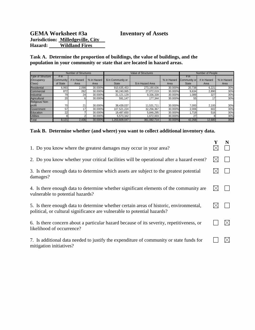
GEMA Worksheet #3a Inventory of Assets Jurisdiction: Milledgeville, City Hazard: Wildland Fires Task A. Determine the proportion of buildings, the value of buildings, and the population in your community or state that are located in hazard areas. Type of Structure
(Occupancy
Class)
# in
Community
of State
# in Hazard
Area
% in Hazard
Area
$ in Community or
State $ in Hazard Area
% in Hazard
Area
# in
Community or
State
# in Hazard
Area
% in Hazard
Area
Residential 6,993 2,098 30.000% 910,635,453 273,190,636 30.000% 20,738 6,221 30%
Commercial 872 262 30.000% 90,240,065 27,072,019 30.000% 9,634 2,890 30%
Industrial 79 24 30.000% 31,121,129 9,336,339 30.000% 1,089 327 30%
Agricultural 20 6 30.000% 591,147 177,344 30.000% 55 17 30%
Religious/ Non-
profit 70 21 30.000% 38,439,037 11,531,711 30.000% 7,000 2,100 30%
Government 57 17 30.000% 107,521,224 32,256,367 30.000% 2,006 602 30%
Education 22 7 30.000% 19,487,650 5,846,295 30.000% 1,719 516 30%
Utilities 8 2 30.000% 5,573,342 1,672,003 30.000% 27 8 30%
Total 8,121 2,436 30.000% 1,203,609,047 361,082,714 30.000% 42,268 12,680 30%
Number of Structures Value of Structures Number of People
Task B. Determine whether (and where) you want to collect additional inventory data. Y N 1. Do you know where the greatest damages may occur in your area?
2. Do you know whether your critical facilities will be operational after a hazard event?
3. Is there enough data to determine which assets are subject to the greatest potential damages?
4. Is there enough data to determine whether significant elements of the community are vulnerable to potential hazards?
5. Is there enough data to determine whether certain areas of historic, environmental, political, or cultural significance are vulnerable to potential hazards?
6. Is there concern about a particular hazard because of its severity, repetitiveness, or likelihood of occurrence?
7. Is additional data needed to justify the expenditure of community or state funds for mitigation initiatives?

GEMA Worksheet #3b NFIP Repetitive Loss Properties Task: Use this worksheet to inventory the overall number, type and value of National Flood Insurance Program (NFIP) Repetitive Loss Structures.
Type of Structure
(Occupancy
Class)
Total
Repetitive
Loss
Structures
Severe
Repetitive
Loss
Structures
% Severe
Repetitive
Loss
Total Value of
Repetitive Loss
Structures
Value of Severe
Repetitive Loss
Structures
% Severe
Repetitive Loss
Residential 0 0 #DIV/0! $0.00 $0.00 #DIV/0!
Commercial 0 0 #DIV/0! $0.00 $0.00 #DIV/0!
Industrial 0 0 #DIV/0! $0.00 $0.00 #DIV/0!
Agricultural 0 0 #DIV/0! $0.00 $0.00 #DIV/0!
Religious/ Non-
profit 0 0 #DIV/0! $0.00 $0.00 #DIV/0!
Government 0 0 #DIV/0! $0.00 $0.00 #DIV/0!
Education 0 0 #DIV/0! $0.00 $0.00 #DIV/0!
Utilities 0 0 #DIV/0! $0.00 $0.00 #DIV/0!
Total 0 0 #DIV/0! $0.00 $0.00 #DIV/0!
Number of Structures Value of Structures
1. This worksheet works just like Worksheet 3A. To work in the table, double click
inside the table. The table will then work like an Excel spreadsheet. When done, click outside of the table.
2. Determine the overall number and value of Repetitive Loss Structures within the
community. Repetitive Loss Structures are defined as one of the following: A. Structures with 4* or more claims of at least $1,000 per occurrence. B. Structures with 2* or more claims in 10 years with the cumulative damages
exceeding the value of the property. C. Structures with 3* or more claims with the cumulative damages exceeding the
value of the property.
3. Determine the overall number and value of Severe Repetitive Loss Structures within the community. Severe Repetitive Loss Structures are defined as one of the following:
A. Structures with 4* or more claims of at least $5,000 per occurrence. B. Structures with 2* or more claims in 10 years (building only) with the cumulative
damages of the building portion of the claims exceeding the market value of the building.
4. The worksheet will automatically calculate the percentage of repetitive losses that are
considered severe based on the totals of each category. *For individual occurrences to be considered separate, they must occur at least 10 days apart. For example, if flood damage occurs March 5, 2009 and again March 10, 2009, the two occurrences will be considered one claim.

GovernmentJurisdiction
Type Name orStructure
Description
Esse
ntia
l Fac
ility
" sr
c="i
mg/
rpt_
essf
Tran
spor
tatio
n Sy
stem
" Li
felin
e Sy
stem
" sr
c="i
mg/
rpt_
lifel
iH
igh
Pote
ntia
l Lo
ss"
Haz
Mat
Fac
ility
" sr
c="i
mg/
rpt_
haz
Impo
rtan
t Fac
ility
" sr
c="i
mg/
rpt_
imp2
Vuln
erab
le
Popu
latio
n"
Econ
omic
Ass
ets"
sr
c="i
mg/
rpt_
ecoa
Spec
ial
Con
side
ratio
ns"
His
toric
C
onsi
dera
tions
" O
ther
"
src=
"im
g/rp
t_ot
he Sizeof
Bldg.(sq.ft.)
ReplaceValue
($)
ReplaceValueYear
ContentsValue
($)
ContentsValueYear
FunctionalValue
($)
DisplaceCost($ perday)
Occupancy HazardScore
Baldwin County Landfill Baldwin County
Central RecyclingX 7,200 $187,200 2003 $151,200 2003 $45,000 12 N/A
Milledgeville city Elementary School Blandy Hills
Elementary SchoolX X 69,743 $7,468,797 2003 $560,160 2003 $3,427,453 $13,183 685 N/A
Milledgeville city Elementary School Creekside
Elementary SchoolX X 79,234 $7,389,132 2003 $554,185 2003 $3,914,699 $15,057 790 N/A
Baldwin County Elementary School Davis Alternative
SchoolX X 42,500 $1,631,436 2003 $122,358 2003 $78,587 $302 67 N/A
Baldwin County C&D BALDWIN CO-
UNION HILL CH
RD, PH 3 (MSWL)
X 8,060 $363,000 2004 $211,600 2004 $1,333,800 7 N/A
Baldwin County Fire Station East Baldwin Fire
Station - CountyX X 2,945 $164,000 2004 $37,100 2004 $135,389 6 N/A
Milledgeville city Public University GCSU LLC - West
ClubhouseX 5,785 $491,725 2007 $55,000 2007 $111 15 N/A
Milledgeville city Public University Georgia College -
Scene ShopX 3,400 $119,000 2007 $35,000 2007 $65 5 N/A
Milledgeville city Public University GCSU LLC -
Student Activities
Center
X 4,716 $6,000,000 2007 $25,000 2007 $90 250 N/A
Milledgeville city Public University GCSU LLC - West
100X X 58,374 $5,253,660 2007 $275,000 2007 $1,120 138 N/A
Milledgeville city Public University GCSU LLC - West
200X X 51,331 $4,619,790 2007 $250,000 2007 $984 108 N/A
Milledgeville city Public University GCSU LLC - West
300X X 51,331 $4,619,790 2007 $250,000 2007 $984 108 N/A
Milledgeville city Public University GCSU LLC - West
400X X 67,789 $6,101,010 2007 $285,000 2007 $1,300 157 N/A
Milledgeville city Public University GCSU LLC - West
500X X 67,781 $6,100,290 2007 $280,000 2007 $1,300 149 N/A
Milledgeville city Public University GCSU LLC - West
600X X 67,512 $6,076,080 2007 $280,000 2007 $1,295 149 N/A
Milledgeville city Public University Georgia College -
Underwood HouseX 4,842 $459,990 2007 $12,000 2007 $93 8 N/A
Milledgeville city Public University Georgia College -
Watts HouseX 6,257 $594,415 2007 $12,000 2007 $120 11 N/A
Reporting for Slosh Hazard Countywide Grouped by Hazard Score
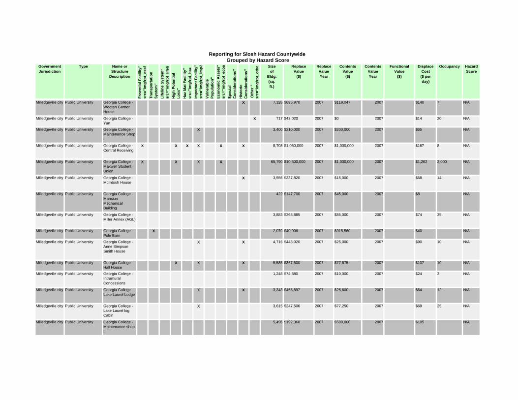
GovernmentJurisdiction
Type Name orStructure
Description
Esse
ntia
l Fac
ility
" sr
c="i
mg/
rpt_
essf
Tran
spor
tatio
n Sy
stem
" Li
felin
e Sy
stem
" sr
c="i
mg/
rpt_
lifel
iH
igh
Pote
ntia
l Lo
ss"
Haz
Mat
Fac
ility
" sr
c="i
mg/
rpt_
haz
Impo
rtan
t Fac
ility
" sr
c="i
mg/
rpt_
imp2
Vuln
erab
le
Popu
latio
n"
Econ
omic
Ass
ets"
sr
c="i
mg/
rpt_
ecoa
Spec
ial
Con
side
ratio
ns"
His
toric
C
onsi
dera
tions
" O
ther
"
src=
"im
g/rp
t_ot
he Sizeof
Bldg.(sq.ft.)
ReplaceValue
($)
ReplaceValueYear
ContentsValue
($)
ContentsValueYear
FunctionalValue
($)
DisplaceCost($ perday)
Occupancy HazardScore
Reporting for Slosh Hazard Countywide Grouped by Hazard Score
Milledgeville city Public University Georgia College -
Wooten Garner
House
X 7,326 $695,970 2007 $119,047 2007 $140 7 N/A
Milledgeville city Public University Georgia College -
YurtX 717 $43,020 2007 $0 2007 $14 20 N/A
Milledgeville city Public University Georgia College -
Maintenance Shop
I
X 3,400 $210,000 2007 $200,000 2007 $65 N/A
Milledgeville city Public University Georgia College -
Central ReceivingX X X X X X 8,708 $1,050,000 2007 $1,000,000 2007 $167 8 N/A
Milledgeville city Public University Georgia College -
Maxwell Student
Union
X X X X 65,790 $10,500,000 2007 $1,000,000 2007 $1,262 2,000 N/A
Milledgeville city Public University Georgia College -
McIntosh HouseX 3,556 $337,820 2007 $15,000 2007 $68 14 N/A
Milledgeville city Public University Georgia College -
Mansion
Mechanical
Building
422 $147,700 2007 $45,000 2007 $8 N/A
Milledgeville city Public University Georgia College -
Miller Annex (AGL)
3,883 $368,885 2007 $85,000 2007 $74 35 N/A
Milledgeville city Public University Georgia College -
Pole BarnX 2,070 $40,906 2007 $915,560 2007 $40 N/A
Milledgeville city Public University Georgia College -
Anne Simpson
Smith House
X X 4,716 $448,020 2007 $25,000 2007 $90 10 N/A
Milledgeville city Public University Georgia College -
Hall HouseX X X 5,585 $367,500 2007 $77,875 2007 $107 10 N/A
Milledgeville city Public University Georgia College -
Intramural
Concessions
1,248 $74,880 2007 $10,000 2007 $24 3 N/A
Milledgeville city Public University Georgia College -
Lake Laurel LodgeX X 3,343 $455,897 2007 $25,600 2007 $64 12 N/A
Milledgeville city Public University Georgia College -
Lake Laurel log
Cabin
X 3,615 $247,506 2007 $77,250 2007 $69 25 N/A
Milledgeville city Public University Georgia College -
Maintenance shop
II
5,496 $192,360 2007 $500,000 2007 $105 N/A

GovernmentJurisdiction
Type Name orStructure
Description
Esse
ntia
l Fac
ility
" sr
c="i
mg/
rpt_
essf
Tran
spor
tatio
n Sy
stem
" Li
felin
e Sy
stem
" sr
c="i
mg/
rpt_
lifel
iH
igh
Pote
ntia
l Lo
ss"
Haz
Mat
Fac
ility
" sr
c="i
mg/
rpt_
haz
Impo
rtan
t Fac
ility
" sr
c="i
mg/
rpt_
imp2
Vuln
erab
le
Popu
latio
n"
Econ
omic
Ass
ets"
sr
c="i
mg/
rpt_
ecoa
Spec
ial
Con
side
ratio
ns"
His
toric
C
onsi
dera
tions
" O
ther
"
src=
"im
g/rp
t_ot
he Sizeof
Bldg.(sq.ft.)
ReplaceValue
($)
ReplaceValueYear
ContentsValue
($)
ContentsValueYear
FunctionalValue
($)
DisplaceCost($ perday)
Occupancy HazardScore
Reporting for Slosh Hazard Countywide Grouped by Hazard Score
Milledgeville city Public University Georgia College -
Mansion Kitchen
Addition
2,121 $201,495 2007 $25,000 2007 $41 1 N/A
Milledgeville city Public University Georgia College -
Bookstore AnnexX X 8,808 $705,000 2007 $500,000 2007 $169 10 N/A
Milledgeville city Public University Georgia College -
BusbarnX X 2,202 $210,000 2007 $500,000 2007 $42 2 N/A
Milledgeville city Public University Georgia College -
Centenial Pool
House
X 1,876 $210,000 2007 $12,000 2007 $36 2 N/A
Milledgeville city Public University Georgia College -
Central Chiller
Plant
X X 4,186 $3,966,424 2007 $750,000 2007 $80 1 N/A
Milledgeville city Public University Georgia College -
Mansion Education
Center
1,233 $117,135 2007 $75,000 2007 $24 N/A
Milledgeville city Public University Georgia College -
Grassman Studio
2,616 $420,000 2007 $73,000 2007 $50 100 N/A
Milledgeville city Other Central State
Hospital -
Yarbrough Building
X X 166,790 $11,269,678 2004 $692,200 2004 1,066 N/A
Milledgeville city Other Central State
Hospital - EWACX X 51,746 $2,350,477 2004 $33,333 2004 400 N/A
Milledgeville city Other Central State
Hospital - Allen
Building
X X X 112,448 $11,102,410 2004 $443,907 2004 400 N/A
Milledgeville city Other Central State
Hospital -
Lawrence Building
X X 202,810 $5,355,410 2004 $4,279,589 2004 156 N/A
Milledgeville city Other Central State
Hospital - Boone
Building
X X 133,488 $6,294,428 2004 $576,834 2004 N/A
Milledgeville city Other Central State
Hospital - Medical
Surgery
X X 162,312 $16,751,507 2004 $5,826,027 2004 200 N/A
Milledgeville city Other Magnolia State
Bank - Columbia
Street Branch
X 11,000 $750,000 2004 $275,000 2004 $2,000,000 $10,000 120 N/A
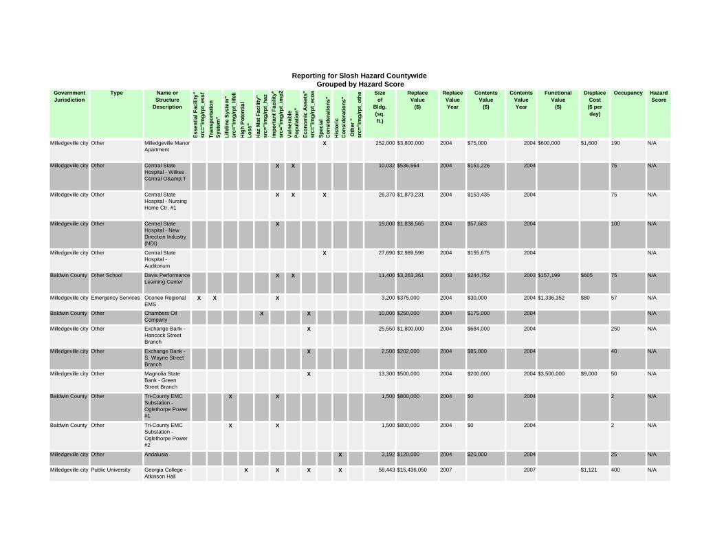
GovernmentJurisdiction
Type Name orStructure
Description
Esse
ntia
l Fac
ility
" sr
c="i
mg/
rpt_
essf
Tran
spor
tatio
n Sy
stem
" Li
felin
e Sy
stem
" sr
c="i
mg/
rpt_
lifel
iH
igh
Pote
ntia
l Lo
ss"
Haz
Mat
Fac
ility
" sr
c="i
mg/
rpt_
haz
Impo
rtan
t Fac
ility
" sr
c="i
mg/
rpt_
imp2
Vuln
erab
le
Popu
latio
n"
Econ
omic
Ass
ets"
sr
c="i
mg/
rpt_
ecoa
Spec
ial
Con
side
ratio
ns"
His
toric
C
onsi
dera
tions
" O
ther
"
src=
"im
g/rp
t_ot
he Sizeof
Bldg.(sq.ft.)
ReplaceValue
($)
ReplaceValueYear
ContentsValue
($)
ContentsValueYear
FunctionalValue
($)
DisplaceCost($ perday)
Occupancy HazardScore
Reporting for Slosh Hazard Countywide Grouped by Hazard Score
Milledgeville city Other Milledgeville Manor
ApartmentX 252,000 $3,800,000 2004 $75,000 2004 $600,000 $1,600 190 N/A
Milledgeville city Other Central State
Hospital - Wilkes
Central O&T
X X 10,032 $536,564 2004 $151,226 2004 75 N/A
Milledgeville city Other Central State
Hospital - Nursing
Home Ctr. #1
X X X 26,370 $1,873,231 2004 $153,435 2004 75 N/A
Milledgeville city Other Central State
Hospital - New
Direction Industry
(NDI)
X 19,000 $1,838,565 2004 $57,683 2004 100 N/A
Milledgeville city Other Central State
Hospital -
Auditorium
X 27,690 $2,989,598 2004 $155,675 2004 N/A
Baldwin County Other School Davis Performance
Learning CenterX X 11,400 $3,263,361 2003 $244,752 2003 $157,199 $605 75 N/A
Milledgeville city Emergency Services Oconee Regional
EMSX X X 3,200 $375,000 2004 $30,000 2004 $1,336,352 $80 57 N/A
Baldwin County Other Chambers Oil
CompanyX X 10,000 $250,000 2004 $175,000 2004 N/A
Milledgeville city Other Exchange Bank -
Hancock Street
Branch
X 25,550 $1,800,000 2004 $684,000 2004 250 N/A
Milledgeville city Other Exchange Bank -
S. Wayne Street
Branch
X 2,500 $202,000 2004 $85,000 2004 40 N/A
Milledgeville city Other Magnolia State
Bank - Green
Street Branch
X 13,300 $500,000 2004 $200,000 2004 $3,500,000 $9,000 50 N/A
Baldwin County Other Tri-County EMC
Substation -
Oglethorpe Power
#1
X X 1,500 $800,000 2004 $0 2004 2 N/A
Baldwin County Other Tri-County EMC
Substation -
Oglethorpe Power
#2
X X 1,500 $800,000 2004 $0 2004 2 N/A
Milledgeville city Other Andalusia X 3,192 $120,000 2004 $20,000 2004 25 N/A
Milledgeville city Public University Georgia College -
Atkinson HallX X X X 58,443 $15,436,050 2007 2007 $1,121 400 N/A
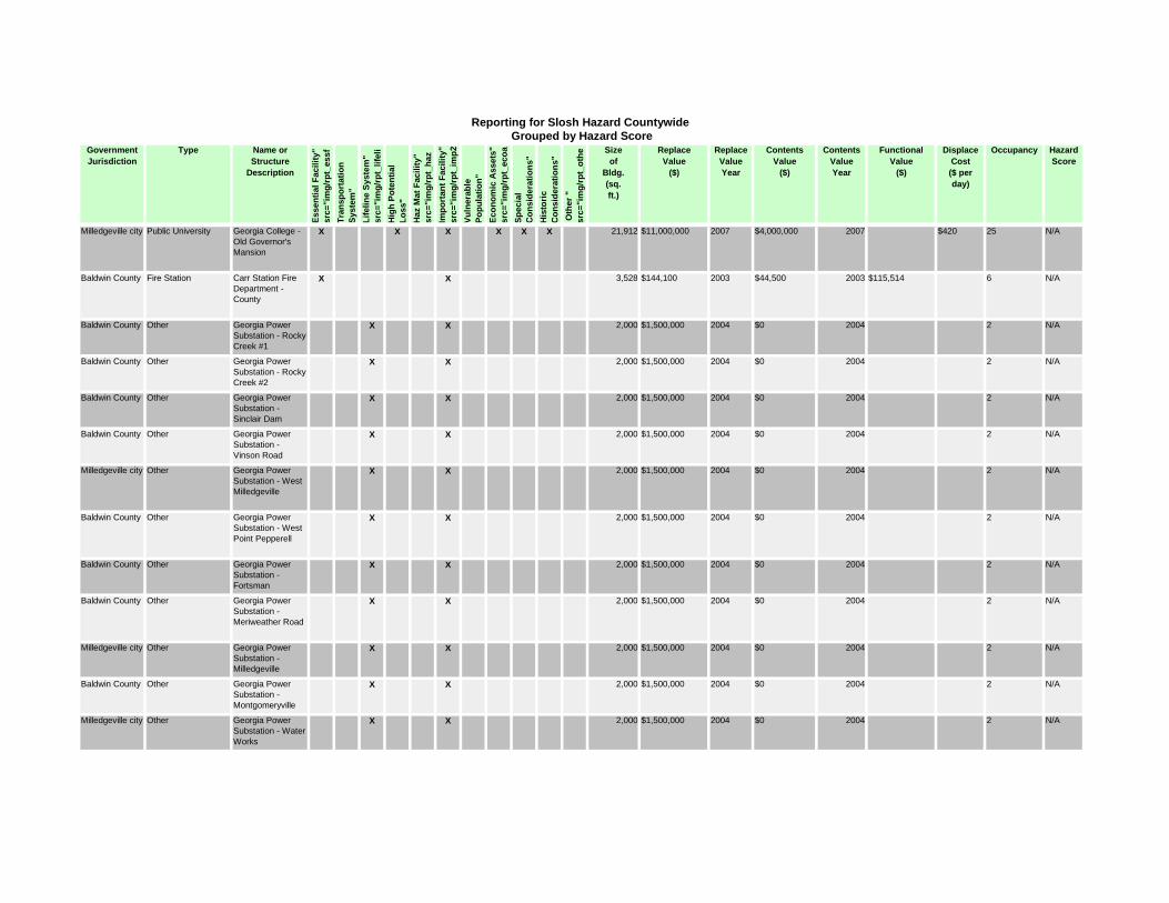
GovernmentJurisdiction
Type Name orStructure
Description
Esse
ntia
l Fac
ility
" sr
c="i
mg/
rpt_
essf
Tran
spor
tatio
n Sy
stem
" Li
felin
e Sy
stem
" sr
c="i
mg/
rpt_
lifel
iH
igh
Pote
ntia
l Lo
ss"
Haz
Mat
Fac
ility
" sr
c="i
mg/
rpt_
haz
Impo
rtan
t Fac
ility
" sr
c="i
mg/
rpt_
imp2
Vuln
erab
le
Popu
latio
n"
Econ
omic
Ass
ets"
sr
c="i
mg/
rpt_
ecoa
Spec
ial
Con
side
ratio
ns"
His
toric
C
onsi
dera
tions
" O
ther
"
src=
"im
g/rp
t_ot
he Sizeof
Bldg.(sq.ft.)
ReplaceValue
($)
ReplaceValueYear
ContentsValue
($)
ContentsValueYear
FunctionalValue
($)
DisplaceCost($ perday)
Occupancy HazardScore
Reporting for Slosh Hazard Countywide Grouped by Hazard Score
Milledgeville city Public University Georgia College -
Old Governor's
Mansion
X X X X X X 21,912 $11,000,000 2007 $4,000,000 2007 $420 25 N/A
Baldwin County Fire Station Carr Station Fire
Department -
County
X X 3,528 $144,100 2003 $44,500 2003 $115,514 6 N/A
Baldwin County Other Georgia Power
Substation - Rocky
Creek #1
X X 2,000 $1,500,000 2004 $0 2004 2 N/A
Baldwin County Other Georgia Power
Substation - Rocky
Creek #2
X X 2,000 $1,500,000 2004 $0 2004 2 N/A
Baldwin County Other Georgia Power
Substation -
Sinclair Dam
X X 2,000 $1,500,000 2004 $0 2004 2 N/A
Baldwin County Other Georgia Power
Substation -
Vinson Road
X X 2,000 $1,500,000 2004 $0 2004 2 N/A
Milledgeville city Other Georgia Power
Substation - West
Milledgeville
X X 2,000 $1,500,000 2004 $0 2004 2 N/A
Baldwin County Other Georgia Power
Substation - West
Point Pepperell
X X 2,000 $1,500,000 2004 $0 2004 2 N/A
Baldwin County Other Georgia Power
Substation -
Fortsman
X X 2,000 $1,500,000 2004 $0 2004 2 N/A
Baldwin County Other Georgia Power
Substation -
Meriweather Road
X X 2,000 $1,500,000 2004 $0 2004 2 N/A
Milledgeville city Other Georgia Power
Substation -
Milledgeville
X X 2,000 $1,500,000 2004 $0 2004 2 N/A
Baldwin County Other Georgia Power
Substation -
Montgomeryville
X X 2,000 $1,500,000 2004 $0 2004 2 N/A
Milledgeville city Other Georgia Power
Substation - Water
Works
X X 2,000 $1,500,000 2004 $0 2004 2 N/A

GovernmentJurisdiction
Type Name orStructure
Description
Esse
ntia
l Fac
ility
" sr
c="i
mg/
rpt_
essf
Tran
spor
tatio
n Sy
stem
" Li
felin
e Sy
stem
" sr
c="i
mg/
rpt_
lifel
iH
igh
Pote
ntia
l Lo
ss"
Haz
Mat
Fac
ility
" sr
c="i
mg/
rpt_
haz
Impo
rtan
t Fac
ility
" sr
c="i
mg/
rpt_
imp2
Vuln
erab
le
Popu
latio
n"
Econ
omic
Ass
ets"
sr
c="i
mg/
rpt_
ecoa
Spec
ial
Con
side
ratio
ns"
His
toric
C
onsi
dera
tions
" O
ther
"
src=
"im
g/rp
t_ot
he Sizeof
Bldg.(sq.ft.)
ReplaceValue
($)
ReplaceValueYear
ContentsValue
($)
ContentsValueYear
FunctionalValue
($)
DisplaceCost($ perday)
Occupancy HazardScore
Reporting for Slosh Hazard Countywide Grouped by Hazard Score
Milledgeville city Other Georgia Power
Substation - North
Milledgeville
X X 2,000 $1,500,000 2004 $0 2004 2 N/A
Milledgeville city Water System City of Milledgeville
Water Tank -
Meadows
X X 1,600 $500,000 2004 $750 2004 N/A
Milledgeville city Water System City of Milledgeville
Water Tank -
Dunlap
X X 1,600 $1,000,000 2004 $1,500 2004 N/A
Milledgeville city Water System City of Milledgeville
Water Tank -
Sinclair
X X 1,600 $500,000 2004 $750 2004 N/A
Milledgeville city Water System City of Milledgeville
Water Tank -
Sinclair (ground)
X X 1,600 $200,000 2004 $300 2004 N/A
Milledgeville city Other Georgia Power
Substation -
Central State
X X 2,000 $1,500,000 2004 $0 2004 2 N/A
Milledgeville city Other Georgia Power
Substation -
Fishing Creek
X X 2,000 $1,500,000 2004 $0 2004 2 N/A
Baldwin County Wastewater
Treatment Plant
Baldwin County Lift
Station - Fountain
Motel
X X 1,000 $32,890 2004 $0 2004 N/A
Baldwin County Other Baldwin County
Maintenance
Garage
X 8,060 $363,000 2004 $211,600 2004 $660,892 14 N/A
Baldwin County Other Baldwin County
Senior Citizens'
Center
X 3,090 $220,300 2004 $73,000 2004 $31,642 28 N/A
Baldwin County Other Walter B. Williams
Recreational ParkX 51,895 $3,252,600 2004 $613,600 2004 $735,183 28 N/A
Baldwin County Other Little River Creek
Golf CourseX 13,210 $450,400 2004 $242,100 2004 $487,700 100 N/A
Milledgeville city Water System City of Milledgeville
Water Tank -
Industrial Park
X X 1,600 $300,000 2004 $450 2004 N/A
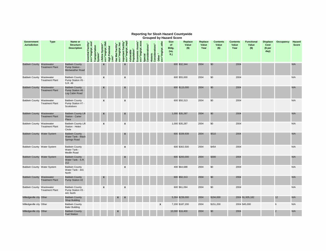
GovernmentJurisdiction
Type Name orStructure
Description
Esse
ntia
l Fac
ility
" sr
c="i
mg/
rpt_
essf
Tran
spor
tatio
n Sy
stem
" Li
felin
e Sy
stem
" sr
c="i
mg/
rpt_
lifel
iH
igh
Pote
ntia
l Lo
ss"
Haz
Mat
Fac
ility
" sr
c="i
mg/
rpt_
haz
Impo
rtan
t Fac
ility
" sr
c="i
mg/
rpt_
imp2
Vuln
erab
le
Popu
latio
n"
Econ
omic
Ass
ets"
sr
c="i
mg/
rpt_
ecoa
Spec
ial
Con
side
ratio
ns"
His
toric
C
onsi
dera
tions
" O
ther
"
src=
"im
g/rp
t_ot
he Sizeof
Bldg.(sq.ft.)
ReplaceValue
($)
ReplaceValueYear
ContentsValue
($)
ContentsValueYear
FunctionalValue
($)
DisplaceCost($ perday)
Occupancy HazardScore
Reporting for Slosh Hazard Countywide Grouped by Hazard Score
Baldwin County Wastewater
Treatment Plant
Baldwin County
Pump Station -
Meriweather Road
X X 600 $32,344 2004 $0 2004 N/A
Baldwin County Wastewater
Treatment Plant
Baldwin County
Pump Station #5 -
S.R. 49
X X 600 $55,000 2004 $0 2004 N/A
Baldwin County Wastewater
Treatment Plant
Baldwin County
Pump Station #6 -
Log Cabin Road
X X 600 $115,000 2004 $0 2004 N/A
Baldwin County Wastewater
Treatment Plant
Baldwin County
Pump Station #7 -
Scottsboro
X X 600 $50,313 2004 $0 2004 N/A
Baldwin County Wastewater
Treatment Plant
Baldwin County Lift
Station - Carter
Place
X X 1,000 $35,287 2004 $0 2004 N/A
Baldwin County Wastewater
Treatment Plant
Baldwin County Lift
Station - Helen
Circle
X X 1,000 $35,287 2004 $0 2004 N/A
Baldwin County Water System Baldwin County
Water Tank - Black
Springs Road
X 600 $339,939 2004 $510 2004 N/A
Baldwin County Water System Baldwin County
Water Tank -
Medlin Road
X 600 $302,500 2004 $454 2004 N/A
Baldwin County Water System Baldwin County
Water Tank - S.R.
212
X 600 $200,000 2004 $300 2004 N/A
Baldwin County Water System Baldwin County
Water Tank - 441
North
X 400 $64,688 2004 $0 2004 N/A
Baldwin County Wastewater
Treatment Plant
Baldwin County
Pump Station #2X 600 $50,313 2004 $0 2004 N/A
Baldwin County Wastewater
Treatment Plant
Baldwin County
Pump Station #3 -
441 North
X X 600 $61,094 2004 $0 2004 N/A
Milledgeville city Other Baldwin County
Shop BuildingX X 5,304 $239,000 2004 $194,000 2004 $1,935,182 12 N/A
Milledgeville city Other Baldwin County
Baler BuildingX 7,200 $187,200 2004 $151,200 2004 $45,000 6 N/A
Milledgeville city Other Baldwin County
Fuel StationX 10,000 $16,400 2004 $0 2004 2 N/A
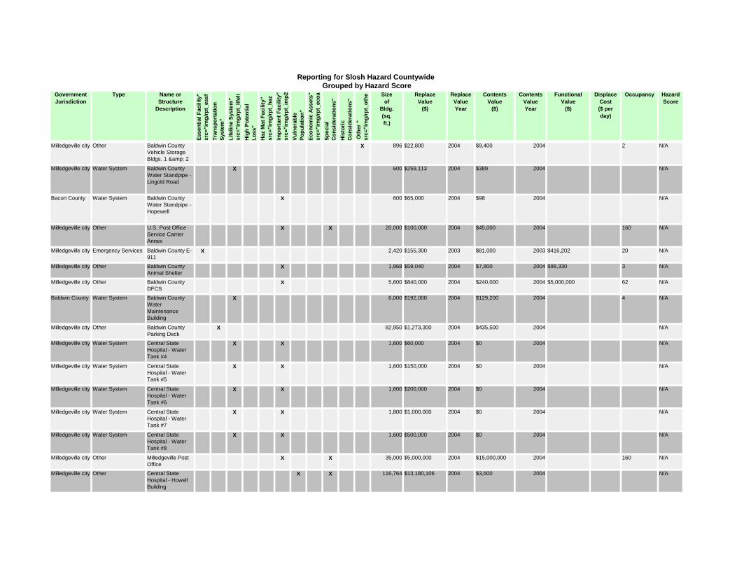
GovernmentJurisdiction
Type Name orStructure
Description
Esse
ntia
l Fac
ility
" sr
c="i
mg/
rpt_
essf
Tran
spor
tatio
n Sy
stem
" Li
felin
e Sy
stem
" sr
c="i
mg/
rpt_
lifel
iH
igh
Pote
ntia
l Lo
ss"
Haz
Mat
Fac
ility
" sr
c="i
mg/
rpt_
haz
Impo
rtan
t Fac
ility
" sr
c="i
mg/
rpt_
imp2
Vuln
erab
le
Popu
latio
n"
Econ
omic
Ass
ets"
sr
c="i
mg/
rpt_
ecoa
Spec
ial
Con
side
ratio
ns"
His
toric
C
onsi
dera
tions
" O
ther
"
src=
"im
g/rp
t_ot
he Sizeof
Bldg.(sq.ft.)
ReplaceValue
($)
ReplaceValueYear
ContentsValue
($)
ContentsValueYear
FunctionalValue
($)
DisplaceCost($ perday)
Occupancy HazardScore
Reporting for Slosh Hazard Countywide Grouped by Hazard Score
Milledgeville city Other Baldwin County
Vehicle Storage
Bldgs. 1 & 2
X 896 $22,800 2004 $9,400 2004 2 N/A
Milledgeville city Water System Baldwin County
Water Standpipe -
Lingold Road
X 600 $259,113 2004 $389 2004 N/A
Bacon County Water System Baldwin County
Water Standpipe -
Hopewell
X 600 $65,000 2004 $98 2004 N/A
Milledgeville city Other U.S. Post Office
Service Carrier
Annex
X X 20,000 $100,000 2004 $45,000 2004 160 N/A
Milledgeville city Emergency Services Baldwin County E-
911X 2,420 $155,300 2003 $81,000 2003 $416,202 20 N/A
Milledgeville city Other Baldwin County
Animal ShelterX 1,968 $59,040 2004 $7,800 2004 $98,330 3 N/A
Milledgeville city Other Baldwin County
DFCSX 5,600 $840,000 2004 $240,000 2004 $5,000,000 62 N/A
Baldwin County Water System Baldwin County
Water
Maintenance
Building
X 6,000 $192,000 2004 $129,200 2004 4 N/A
Milledgeville city Other Baldwin County
Parking DeckX 82,950 $1,273,300 2004 $435,500 2004 N/A
Milledgeville city Water System Central State
Hospital - Water
Tank #4
X X 1,600 $60,000 2004 $0 2004 N/A
Milledgeville city Water System Central State
Hospital - Water
Tank #5
X X 1,600 $150,000 2004 $0 2004 N/A
Milledgeville city Water System Central State
Hospital - Water
Tank #6
X X 1,600 $200,000 2004 $0 2004 N/A
Milledgeville city Water System Central State
Hospital - Water
Tank #7
X X 1,800 $1,000,000 2004 $0 2004 N/A
Milledgeville city Water System Central State
Hospital - Water
Tank #8
X X 1,600 $500,000 2004 $0 2004 N/A
Milledgeville city Other Milledgeville Post
OfficeX X 35,000 $5,000,000 2004 $15,000,000 2004 160 N/A
Milledgeville city Other Central State
Hospital - Howell
Building
X X 116,764 $13,180,106 2004 $3,600 2004 N/A
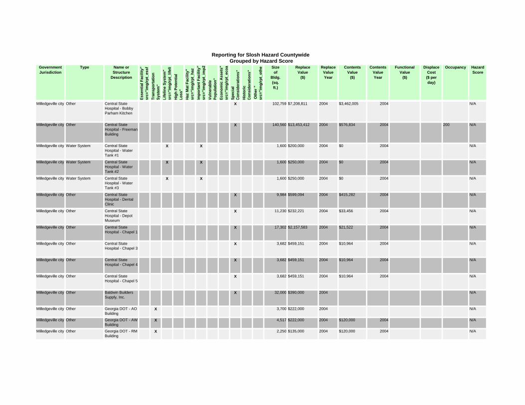
GovernmentJurisdiction
Type Name orStructure
Description
Esse
ntia
l Fac
ility
" sr
c="i
mg/
rpt_
essf
Tran
spor
tatio
n Sy
stem
" Li
felin
e Sy
stem
" sr
c="i
mg/
rpt_
lifel
iH
igh
Pote
ntia
l Lo
ss"
Haz
Mat
Fac
ility
" sr
c="i
mg/
rpt_
haz
Impo
rtan
t Fac
ility
" sr
c="i
mg/
rpt_
imp2
Vuln
erab
le
Popu
latio
n"
Econ
omic
Ass
ets"
sr
c="i
mg/
rpt_
ecoa
Spec
ial
Con
side
ratio
ns"
His
toric
C
onsi
dera
tions
" O
ther
"
src=
"im
g/rp
t_ot
he Sizeof
Bldg.(sq.ft.)
ReplaceValue
($)
ReplaceValueYear
ContentsValue
($)
ContentsValueYear
FunctionalValue
($)
DisplaceCost($ perday)
Occupancy HazardScore
Reporting for Slosh Hazard Countywide Grouped by Hazard Score
Milledgeville city Other Central State
Hospital - Bobby
Parham Kitchen
X 102,759 $7,208,811 2004 $3,462,005 2004 N/A
Milledgeville city Other Central State
Hospital - Freeman
Building
X 140,560 $13,453,412 2004 $576,834 2004 200 N/A
Milledgeville city Water System Central State
Hospital - Water
Tank #1
X X 1,600 $200,000 2004 $0 2004 N/A
Milledgeville city Water System Central State
Hospital - Water
Tank #2
X X 1,600 $250,000 2004 $0 2004 N/A
Milledgeville city Water System Central State
Hospital - Water
Tank #3
X X 1,600 $250,000 2004 $0 2004 N/A
Milledgeville city Other Central State
Hospital - Dental
Clinic
X 9,984 $599,094 2004 $415,282 2004 N/A
Milledgeville city Other Central State
Hospital - Depot
Museum
X 11,230 $232,221 2004 $33,456 2004 N/A
Milledgeville city Other Central State
Hospital - Chapel 1X 17,302 $2,157,583 2004 $21,522 2004 N/A
Milledgeville city Other Central State
Hospital - Chapel 3X 3,682 $459,151 2004 $10,964 2004 N/A
Milledgeville city Other Central State
Hospital - Chapel 4X 3,682 $459,151 2004 $10,964 2004 N/A
Milledgeville city Other Central State
Hospital - Chapel 5X 3,682 $459,151 2004 $10,964 2004 N/A
Milledgeville city Other Baldwin Builders
Supply, Inc.X 32,000 $390,000 2004 N/A
Milledgeville city Other Georgia DOT - AO
BuildingX 3,700 $222,000 2004 N/A
Milledgeville city Other Georgia DOT - AW
BuildingX 4,517 $222,000 2004 $120,000 2004 N/A
Milledgeville city Other Georgia DOT - RM
BuildingX 2,250 $135,000 2004 $120,000 2004 N/A

GovernmentJurisdiction
Type Name orStructure
Description
Esse
ntia
l Fac
ility
" sr
c="i
mg/
rpt_
essf
Tran
spor
tatio
n Sy
stem
" Li
felin
e Sy
stem
" sr
c="i
mg/
rpt_
lifel
iH
igh
Pote
ntia
l Lo
ss"
Haz
Mat
Fac
ility
" sr
c="i
mg/
rpt_
haz
Impo
rtan
t Fac
ility
" sr
c="i
mg/
rpt_
imp2
Vuln
erab
le
Popu
latio
n"
Econ
omic
Ass
ets"
sr
c="i
mg/
rpt_
ecoa
Spec
ial
Con
side
ratio
ns"
His
toric
C
onsi
dera
tions
" O
ther
"
src=
"im
g/rp
t_ot
he Sizeof
Bldg.(sq.ft.)
ReplaceValue
($)
ReplaceValueYear
ContentsValue
($)
ContentsValueYear
FunctionalValue
($)
DisplaceCost($ perday)
Occupancy HazardScore
Reporting for Slosh Hazard Countywide Grouped by Hazard Score
Milledgeville city Psychoeducational Central State
Hospital - Steam
Plant
X 39,898 $4,658,671 2004 N/A
Milledgeville city Psychoeducational Central State
Hospital - Laundry
Building
X 30,387 $1,610,253 2004 N/A
Milledgeville city Public University Georgia College -
Health Sciences
Building
X X X X 41,735 $6,260,250 2007 $353,144 2007 $800 150 N/A
Milledgeville city Public University GCSU LLC -
Sanford HallX X X 44,897 $6,734,550 2007 $225,000 2007 $861 73 N/A
Milledgeville city Public University Georgia College -
Herty HallX X X 24,909 $5,604,525 2007 $800,000 2007 $478 100 N/A
Milledgeville city Public University Georgia College -
Old CourthouseX X X 20,866 $3,129,900 2007 $25,000 2007 $400 N/A
Milledgeville city Public University Georgia College -
Arts &
Sciences Bldg.
X X X X 124,857 $19,950,000 2007 2007 $2,395 N/A
Milledgeville city Public University Georgia College -
Beeson HallX X X 28,626 $11,550,000 2007 $165,167 2007 $549 25 N/A
Milledgeville city Public University Georgia College -
Depot/Wellness
Center
X 7,770 $1,365,000 2007 $950,000 2007 $149 100 N/A
Milledgeville city Public University Georgia College -
Terrell HallX X 32,697 $7,122,693 2007 $100,000 2007 $627 40 N/A
Milledgeville city Public University Georgia College -
Miller GymX X 13,038 $1,629,750 2007 $366,600 2007 $250 13 N/A
Milledgeville city Public University Georgia College -
Bone Campus
Information Center
X X X 3,254 $433,650 2007 $119,047 2007 $62 10 N/A
Milledgeville city Public University Georgia College -
Porter HallX X X 36,484 $5,472,600 2007 $425,000 2007 $700 75 N/A
Milledgeville city Public University Georgia College -
Mayfair HallX X X 9,542 $6,227,550 2007 $1,396,785 2007 $183 75 N/A
Milledgeville city Public University Georgia College -
Parks Memorial
Nursing
X X X 10,508 $1,576,200 2007 $195,200 2007 $202 75 N/A
Milledgeville city Public University Georgia College -
Parks HallX X 40,069 $5,008,625 2007 $2,025,000 2007 $768 60 N/A

GovernmentJurisdiction
Type Name orStructure
Description
Esse
ntia
l Fac
ility
" sr
c="i
mg/
rpt_
essf
Tran
spor
tatio
n Sy
stem
" Li
felin
e Sy
stem
" sr
c="i
mg/
rpt_
lifel
iH
igh
Pote
ntia
l Lo
ss"
Haz
Mat
Fac
ility
" sr
c="i
mg/
rpt_
haz
Impo
rtan
t Fac
ility
" sr
c="i
mg/
rpt_
imp2
Vuln
erab
le
Popu
latio
n"
Econ
omic
Ass
ets"
sr
c="i
mg/
rpt_
ecoa
Spec
ial
Con
side
ratio
ns"
His
toric
C
onsi
dera
tions
" O
ther
"
src=
"im
g/rp
t_ot
he Sizeof
Bldg.(sq.ft.)
ReplaceValue
($)
ReplaceValueYear
ContentsValue
($)
ContentsValueYear
FunctionalValue
($)
DisplaceCost($ perday)
Occupancy HazardScore
Reporting for Slosh Hazard Countywide Grouped by Hazard Score
Milledgeville city Public University Georgia College -
Russell AuditoriumX X X 14,536 $3,832,500 2007 $185,000 2007 $279 900 N/A
Milledgeville city Public University Georgia College -
Miller Court Plant
Operations
X X X 19,008 $3,592,050 2007 $1,000,000 2007 $365 60 N/A
Milledgeville city Public University GCSU LLC - Bell
Hall AnnexX X X X 32,300 $6,924,110 2007 $1,000,000 2007 $2,500 N/A
Milledgeville city Public University Georgia College -
Centennial CenterX X 99,748 $16,800,000 2007 $885,000 2007 $1,913 1,500 N/A
Milledgeville city Public University GCSU LLC -
Parkhurst HallX X 79,732 $7,175,880 2007 $325,000 2007 $1,529 261 N/A
Milledgeville city Public University GCSU LLC - Wells
HallX X X X 53,554 $4,819,860 2007 $300,000 2007 $1,027 186 N/A
Milledgeville city Public University GCSU LLC-
Adams HallX X X X X 65,426 $5,888,340 2007 2007 $1,255 239 N/A
Milledgeville city Public University Georgia College -
Lanier HallX X X X 20,375 $3,543,750 2007 $2,500,000 2007 $391 50 N/A
Milledgeville city Public University Georgia College -
Russell LibraryX X 139,732 $21,000,000 2007 $7,500,000 2007 $2,680 1,000 N/A
Milledgeville city Public University Georgia College -
Ennis HallX X 31,530 $5,958,750 2007 $100,000 2007 $605 25 N/A
Milledgeville city Public University Georgia College -
West Campus
Athletic Complex
X 14,384 $2,100,000 2007 $72,000 2007 $276 25 N/A
Milledgeville city Public University Georgia College -
Kilpatrick
#1/Peabody
X X X 57,536 $14,453,714 2007 $600,000 2007 $1,103 150 N/A
Milledgeville city Public University Georgia College -
Kilpatrick #2X 27,504 $2,612,880 2007 275 N/A
Milledgeville city Public University Georgia College -
Chappell HallX X X X 36,032 $13,177,500 2007 $3,243,742 2007 $691 75 N/A
Milledgeville city Public University GCSU LLC -
Napier HallX X 53,988 $4,858,920 2004 $300,000 2007 $1,035 184 N/A
Milledgeville city Public University GCSU LLC -
Foundation HallX X X X 81,683 $7,351,470 2007 $1,000,000 2007 $1,567 283 N/A
Milledgeville city Private Two-Year
College
Georgia Military
College - Jenkins
Hall
X 18,269 $1,644,210 2003 $147,760 2003 N/A
Milledgeville city Private Two-Year
College
Georgia Military
College - Ennis
Building
X 5,475 $410,625 2003 $129,300 2003 N/A

GovernmentJurisdiction
Type Name orStructure
Description
Esse
ntia
l Fac
ility
" sr
c="i
mg/
rpt_
essf
Tran
spor
tatio
n Sy
stem
" Li
felin
e Sy
stem
" sr
c="i
mg/
rpt_
lifel
iH
igh
Pote
ntia
l Lo
ss"
Haz
Mat
Fac
ility
" sr
c="i
mg/
rpt_
haz
Impo
rtan
t Fac
ility
" sr
c="i
mg/
rpt_
imp2
Vuln
erab
le
Popu
latio
n"
Econ
omic
Ass
ets"
sr
c="i
mg/
rpt_
ecoa
Spec
ial
Con
side
ratio
ns"
His
toric
C
onsi
dera
tions
" O
ther
"
src=
"im
g/rp
t_ot
he Sizeof
Bldg.(sq.ft.)
ReplaceValue
($)
ReplaceValueYear
ContentsValue
($)
ContentsValueYear
FunctionalValue
($)
DisplaceCost($ perday)
Occupancy HazardScore
Reporting for Slosh Hazard Countywide Grouped by Hazard Score
Milledgeville city Private Two-Year
College
Georgia Military
College -
Admissions
Building
X 3,500 $262,500 2003 $48,040 2003 N/A
Milledgeville city Public University Georgia College -
Harrison HouseX X 4,242 $402,990 2007 $80,000 2007 $81 7 N/A
Milledgeville city Public University Georgia College -
Humber White
House
X X 5,382 $511,290 2007 $75,000 2007 $103 8 N/A
Milledgeville city Public University Georgia College -
Blackbridge HallX X X 5,165 $2,798,256 2007 $106,199 2007 $99 100 N/A
Milledgeville city Private Two-Year
College
Georgia Military
College - Old
Capitol Bldg.
X X 40,237 $7,645,030 2003 $567,227 2003 N/A
Milledgeville city Private Two-Year
College
Georgia Military
College - Nash
House
X 875 $30,625 2003 $12,300 2003 N/A
Milledgeville city Private Two-Year
College
Georgia Military
College - Modulars
1-4
X 7,200 $194,000 2003 $38,640 2003 N/A
Milledgeville city Private Two-Year
College
Georgia Military
College - Miller HallX 32,000 $6,080,000 2003 $1,008,750 2003 N/A
Milledgeville city Private Two-Year
College
Georgia Military
College - Military
Science
X 6,602 $594,180 2003 $58,790 2003 N/A
Milledgeville city Private Two-Year
College
Georgia Military
College - Main
Barracks
X X 31,312 $2,348,400 2003 $389,190 2003 N/A
Milledgeville city Other School Baldwin High
School StadiumX X 5,000 $1,575,000 2003 $0 2003 3,200 N/A
Baldwin County Private School John Milledge
Academy - Middle
School
X X 8,700 $670,000 2003 $112,000 2003 $2,000,000 175 N/A
Baldwin County Private School John Milledge
Academy -
Elementary School
X X 23,800 $1,300,000 2000 $138,000 2003 $2,000,000 350 N/A
Milledgeville city Private Two-Year
College
Georgia Military
College - White
House
X 1,525 $43,335 2003 $19,700 2003 N/A
Milledgeville city Library Georgia Military
College - Sibley
Cone Library
X 13,816 $2,587,420 2003 $1,370,400 2003 N/A
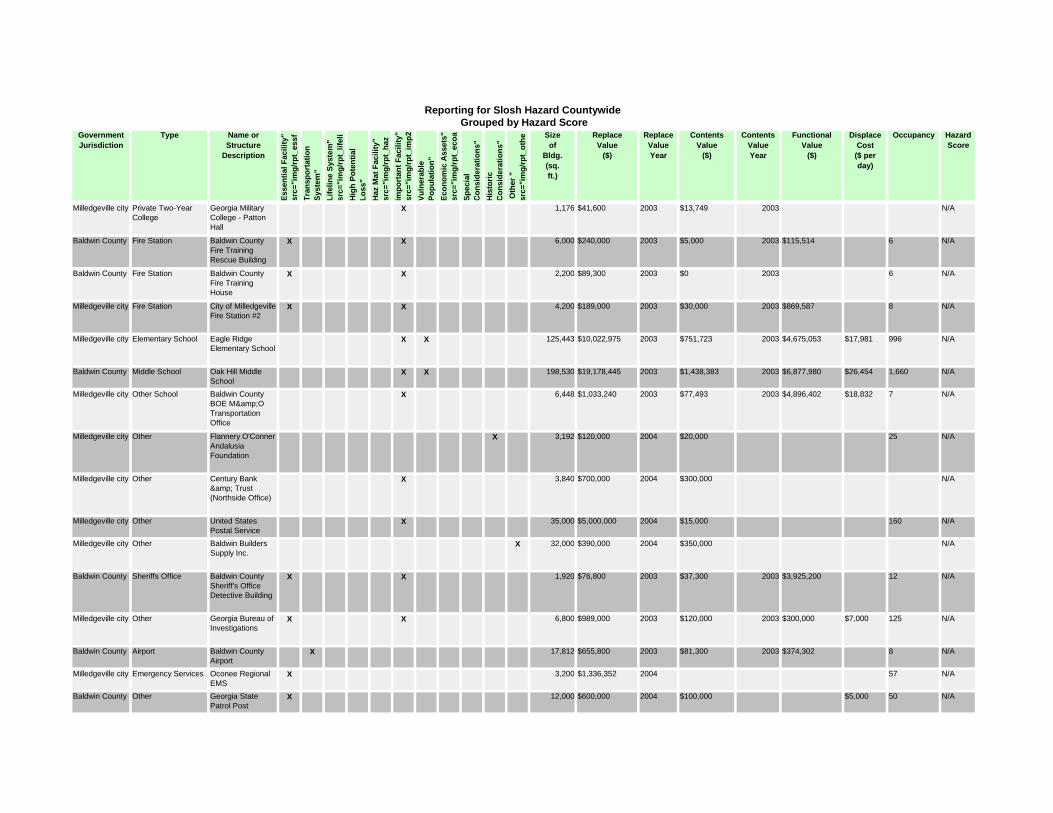
GovernmentJurisdiction
Type Name orStructure
Description
Esse
ntia
l Fac
ility
" sr
c="i
mg/
rpt_
essf
Tran
spor
tatio
n Sy
stem
" Li
felin
e Sy
stem
" sr
c="i
mg/
rpt_
lifel
iH
igh
Pote
ntia
l Lo
ss"
Haz
Mat
Fac
ility
" sr
c="i
mg/
rpt_
haz
Impo
rtan
t Fac
ility
" sr
c="i
mg/
rpt_
imp2
Vuln
erab
le
Popu
latio
n"
Econ
omic
Ass
ets"
sr
c="i
mg/
rpt_
ecoa
Spec
ial
Con
side
ratio
ns"
His
toric
C
onsi
dera
tions
" O
ther
"
src=
"im
g/rp
t_ot
he Sizeof
Bldg.(sq.ft.)
ReplaceValue
($)
ReplaceValueYear
ContentsValue
($)
ContentsValueYear
FunctionalValue
($)
DisplaceCost($ perday)
Occupancy HazardScore
Reporting for Slosh Hazard Countywide Grouped by Hazard Score
Milledgeville city Private Two-Year
College
Georgia Military
College - Patton
Hall
X 1,176 $41,600 2003 $13,749 2003 N/A
Baldwin County Fire Station Baldwin County
Fire Training
Rescue Building
X X 6,000 $240,000 2003 $5,000 2003 $115,514 6 N/A
Baldwin County Fire Station Baldwin County
Fire Training
House
X X 2,200 $89,300 2003 $0 2003 6 N/A
Milledgeville city Fire Station City of Milledgeville
Fire Station #2X X 4,200 $189,000 2003 $30,000 2003 $869,587 8 N/A
Milledgeville city Elementary School Eagle Ridge
Elementary SchoolX X 125,443 $10,022,975 2003 $751,723 2003 $4,675,053 $17,981 996 N/A
Baldwin County Middle School Oak Hill Middle
SchoolX X 198,530 $19,178,445 2003 $1,438,383 2003 $6,877,980 $26,454 1,660 N/A
Milledgeville city Other School Baldwin County
BOE M&O
Transportation
Office
X 6,448 $1,033,240 2003 $77,493 2003 $4,896,402 $18,832 7 N/A
Milledgeville city Other Flannery O'Conner
Andalusia
Foundation
X 3,192 $120,000 2004 $20,000 25 N/A
Milledgeville city Other Century Bank
& Trust
(Northside Office)
X 3,840 $700,000 2004 $300,000 N/A
Milledgeville city Other United States
Postal ServiceX 35,000 $5,000,000 2004 $15,000 160 N/A
Milledgeville city Other Baldwin Builders
Supply Inc.X 32,000 $390,000 2004 $350,000 N/A
Baldwin County Sheriffs Office Baldwin County
Sheriff's Office
Detective Building
X X 1,920 $76,800 2003 $37,300 2003 $3,925,200 12 N/A
Milledgeville city Other Georgia Bureau of
InvestigationsX X 6,800 $989,000 2003 $120,000 2003 $300,000 $7,000 125 N/A
Baldwin County Airport Baldwin County
AirportX 17,812 $655,800 2003 $81,300 2003 $374,302 8 N/A
Milledgeville city Emergency Services Oconee Regional
EMSX 3,200 $1,336,352 2004 57 N/A
Baldwin County Other Georgia State
Patrol PostX 12,000 $600,000 2004 $100,000 $5,000 50 N/A

GovernmentJurisdiction
Type Name orStructure
Description
Esse
ntia
l Fac
ility
" sr
c="i
mg/
rpt_
essf
Tran
spor
tatio
n Sy
stem
" Li
felin
e Sy
stem
" sr
c="i
mg/
rpt_
lifel
iH
igh
Pote
ntia
l Lo
ss"
Haz
Mat
Fac
ility
" sr
c="i
mg/
rpt_
haz
Impo
rtan
t Fac
ility
" sr
c="i
mg/
rpt_
imp2
Vuln
erab
le
Popu
latio
n"
Econ
omic
Ass
ets"
sr
c="i
mg/
rpt_
ecoa
Spec
ial
Con
side
ratio
ns"
His
toric
C
onsi
dera
tions
" O
ther
"
src=
"im
g/rp
t_ot
he Sizeof
Bldg.(sq.ft.)
ReplaceValue
($)
ReplaceValueYear
ContentsValue
($)
ContentsValueYear
FunctionalValue
($)
DisplaceCost($ perday)
Occupancy HazardScore
Reporting for Slosh Hazard Countywide Grouped by Hazard Score
Milledgeville city Other Magnolia State
BankX 3,300 $5,000,000 2004 $2,000,000 $9,000 50 N/A
Milledgeville city Other Century Bank
& TrustX 25,850 $3,500,000 1992 $1,700,000 N/A
Milledgeville city Other Magnolia State
BankX 11,000 $750,000 2004 $275,000 $10,000 120 N/A
Milledgeville city Water System City of Milledgeville
- Scottsboro Water
Tank
X X 600 $500,000 2003 $750 2003 $1,500 1 N/A
Baldwin County Water System Baldwin County /
Cooper CommunityX X 600 $100,000 2004 $150 2004 $300 1 N/A
Milledgeville city Water System Baldwin County
Board of
Commissioners
X X 3,600 $219,500 2004 $94,500 2004 $3,694,500 6 N/A
Milledgeville city Library Mary Vinson
Memorial LibraryX 18,975 $1,651,000 2003 $2,030,000 2003 $542,513 91 N/A
Milledgeville city Hospital, Emergency
Entrance
Med-Surg Center
of Central StateX X 162,312 $16,751,507 2004 $5,826,027 2004 $104,695,635 200 N/A
Milledgeville city Hospital, Admissions
Entrance
Regional
Psychiatric Div. of
Central State
Hospital
X X 226,626 $16,368,168 2003 $905,629 2003 225 N/A
Baldwin County Fire Station Baldwin County
Fire Department
(Hdqrts.)
X X 9,312 $792,500 2004 $117,300 2004 $500,559 20 N/A
Milledgeville city High School Baldwin High X 170,000 $24,591,137 2004 $1,844,335 2004 $7,528,777 $27,918 1,601 N/A
Baldwin County Private School John Milledge
Academy High
School
X X 29,700 $1,500,000 2004 $66,000 2004 $2,000,000 200 N/A
Milledgeville city Wastewater
Treatment Plant
City of Milledgeville
Wastewater
Treatment Plant
X 28,000 $3,034,483 2003 $52,324 2003 $1,203,072 15 N/A
Milledgeville city Water System City of Milledgeville
- Lamar F Harr
Water Plant
X X 24,999 $2,063,811 2003 $451,758 2003 $1,681,261 13 N/A

GovernmentJurisdiction
Type Name orStructure
Description
Esse
ntia
l Fac
ility
" sr
c="i
mg/
rpt_
essf
Tran
spor
tatio
n Sy
stem
" Li
felin
e Sy
stem
" sr
c="i
mg/
rpt_
lifel
iH
igh
Pote
ntia
l Lo
ss"
Haz
Mat
Fac
ility
" sr
c="i
mg/
rpt_
haz
Impo
rtan
t Fac
ility
" sr
c="i
mg/
rpt_
imp2
Vuln
erab
le
Popu
latio
n"
Econ
omic
Ass
ets"
sr
c="i
mg/
rpt_
ecoa
Spec
ial
Con
side
ratio
ns"
His
toric
C
onsi
dera
tions
" O
ther
"
src=
"im
g/rp
t_ot
he Sizeof
Bldg.(sq.ft.)
ReplaceValue
($)
ReplaceValueYear
ContentsValue
($)
ContentsValueYear
FunctionalValue
($)
DisplaceCost($ perday)
Occupancy HazardScore
Reporting for Slosh Hazard Countywide Grouped by Hazard Score
Milledgeville city Wastewater
Treatment Plant
City of Milledgeville
- Baugh Water
Treatment Plant
X X 11,287 $3,358,109 2003 $559,702 2003 $492,275 6 N/A
Milledgeville city Fire Station Milledgeville Fire
Station #1X X 4,200 $189,000 2003 $32,000 2003 $869,587 10 N/A
Baldwin County Fire Station North Baldwin Fire
Station - CountyX X 2,960 $164,600 2004 $37,300 2004 $115,514 6 N/A
Baldwin County Fire Station Meriweather Fire
Station - CountyX X 3,528 $142,500 2004 $44,500 2004 $14,906 6 N/A
Baldwin County Fire Station West Baldwin Fire
Station - CountyX X 3,300 $182,600 2004 $41,600 2004 $99,938 6 N/A
Baldwin County Fire Station Coopers Fire
Station - CountyX X 2,945 $162,700 2004 $37,100 2004 $13,250 6 N/A
Baldwin County Fire Station Central State
Hospital Fire
Station
X X 4,000 $145,000 2003 $35,000 2003 $174,360 6 N/A
5,594,693 $620,960,929 $99,802,492 $175,714,309 $211,477 25,026
5,594,693 $620,960,929 $99,802,492 $175,714,309 $211,477 25,026
- Pre-Disaster Mitigation
- Fiscal Year: 2009
- Report created: Aug 16, 2011
- For more information call GEMA Pre-Disaster Mitigation at 1-800-TRY-GEMA
Totals for Baldwin County, Hazard Score = N/A
Grand Totals

Appendix B
Growth and Development Trends / Community Information
Baldwin County-Milledgeville Joint Comprehensive Plan
Introduction, Floodplain Narrative, Land Use Element and
Economic Development Data
Baldwin County and City of Milledgeville 2010 Census
Profile
Baldwin County and City of Milledgeville Business
Summaries
Baldwin County Area Labor Profile
2006 Joint Comprehensive Plan Update for Baldwin County and
the City of Milledgeville
Draft Community Assessment

Cover Photo Courtesy of: http://www.baldwincountyga.com/

Draft-Baldwin County/City of Milledgeville Comprehensive Plan Update 1
TABLE OF CONTENTS
Identification of Potential Issues and Opportunities ....................................................7
Population.................................................................................................................................... 7 Economic Development .............................................................................................................. 8 Housing ..................................................................................................................................... 11 Natural and Cultural Resources................................................................................................. 13Community Facilities and Services........................................................................................... 16 Intergovernmental Coordination ............................................................................................... 18Transportation System............................................................................................................... 19
Analysis of Existing Development Patterns .....20Existing Land Use ..................................................................................................................... 20
Residential ........................................................................................................................... 20 Commercial.......................................................................................................................... 21 Industrial............................................................................................................................... 22Public/Institutional............................................................................................................... 22 Transportation/Communication/Utilities .......................................................................... 23 Parks/Recreation/Conservation ....................................................................................... 23 Agriculture/Forestry ............................................................................................................ 24 Undeveloped/Vacant.......................................................................................................... 24
Areas Requiring Special Attention............................................................................................ 24Areas of Significant Natural/Cultural Resources ........................................................... 24 Areas of Rapid Development............................................................................................ 25 Areas Outpacing Availability of Community Facilities/Services .................................. 25 Areas in Need of Redevelopment .................................................................................... 25 Large Abandoned Structures or Sites ............................................................................. 25 Areas with Significant Infill Development Opportunities............................................... 26 Areas of Significant Disinvestment, Poverty or Unemployment.................................. 26
Recommended Character Areas ................................................................................................ 26
Analysis of Consistency with Quality Community Objectives .......................................................26
Traditional Neighborhood......................................................................................................... 26 Infill Development .................................................................................................................... 28 Sense of Place............................................................................................................................ 28 Transportation Alternatives....................................................................................................... 29 Regional Identity ....................................................................................................................... 30 Heritage Preservation ................................................................................................................ 30 Open Space Preservation........................................................................................................... 30 Environmental Protection.......................................................................................................... 31 Growth Preparedness................................................................................................................. 32

Draft-Baldwin County/City of Milledgeville Comprehensive Plan Update 2
Appropriate Businesses ............................................................................................................. 32 Employment Options................................................................................................................. 33 Housing Options........................................................................................................................ 33 Educational Opportunities......................................................................................................... 34 Local-Self Determination.......................................................................................................... 34 Regional Cooperation................................................................................................................ 35
Supporting Analysis of Data and Information...35Population.................................................................................................................................. 35
Total ...................................................................................................................................... 36 Components of Population Change................................................................................. 37 Number of Households ...................................................................................................... 37
Future Projections........................................................................................................... 37 Average Household Size ................................................................................................... 37
Future Projections........................................................................................................... 38 Educational Attainment...................................................................................................... 39
Dropout Rates .................................................................................................................. 39 Test Scores ....................................................................................................................... 39 Residents with Advanced Degrees ................................................................................. 40
Age Distribution................................................................................................................... 41 Race and Ethnicity ............................................................................................................. 42
Future Trends .................................................................................................................. 42 Economic Development ............................................................................................................ 43
Income.................................................................................................................................. 43 Per Capita Income........................................................................................................... 43 Average Household Income............................................................................................ 43 Household Income Distribution ..................................................................................... 43
Economic Base ................................................................................................................... 44 Employment by Sector.................................................................................................... 44 Earnings by Sector .......................................................................................................... 45
Labor Force ......................................................................................................................... 46 Employment Status ......................................................................................................... 46 Unemployment Rates ...................................................................................................... 46 Occupations...................................................................................................................... 48 Personal Income .............................................................................................................. 48 Wages................................................................................................................................ 49 Commuting Patterns ....................................................................................................... 50
Economic Resources ......................................................................................................... 50 Development Agencies .................................................................................................... 50 Development Programs................................................................................................... 51
Education and Training.............................................................................................. 54 Other Economic Resources and Tools........................................................................... 55
Recent or Planned Major Community-Level Economic Activities....................... 55 Special or Unique Economic Activities.................................................................... 56
Economic Trends................................................................................................................ 57 Assessment of Current and Future Needs..................................................................... 57 Growing/Declining Economic Sectors ........................................................................... 57

Draft-Baldwin County/City of Milledgeville Comprehensive Plan Update 3
Growing Economic Sectors....................................................................................... 57 Declining Economic Sectors ..................................................................................... 58
Developing and Diversifying the Economic Base ......................................................... 58 Appropriateness of Jobs Available in the Community ................................................ 59 Local Economy in a Regional Context .......................................................................... 59 Impact of Proposed Plans or Projects on Regional Assets and Natural & Cultural Resources.......................................................................................................................... 60 Survey of Issues and Opportunities............................................................................... 61
Housing ..................................................................................................................................... 62 Housing Types and Mix ..................................................................................................... 62 Condition and Occupancy ................................................................................................. 63
Age and Condition of Housing ....................................................................................... 63 Owner and Renter Units................................................................................................. 64
Cost of Housing .................................................................................................................. 64 Cost-Burdened Households.............................................................................................. 65 Special Needs Housing ..................................................................................................... 65 Jobs-Housing Balance....................................................................................................... 66
Natural and Cultural Resources................................................................................................. 67Environmental Planning Criteria....................................................................................... 68
Water Supply Watersheds.............................................................................................. 68 Wetlands........................................................................................................................... 69 Groundwater Recharge Areas ....................................................................................... 70 Protected River Corridors.............................................................................................. 71 Water Quality .................................................................................................................. 72 Water Monitoring, Impaired Streams, and TMDLs ................................................... 72 Source Water Assessment Plans .................................................................................... 73
Other Environmentally Sensitive Areas .......................................................................... 74 Steep Slopes...................................................................................................................... 74 Flood Plains...................................................................................................................... 75 Soils................................................................................................................................... 75 Soil Erosion ...................................................................................................................... 78
Recommendations ..................................................................................................... 78 Plant and Animal Habitats ............................................................................................. 79 Endangered and Threatened Species ............................................................................ 79
Significant Natural Resources .......................................................................................... 80 Scenic Areas ..................................................................................................................... 80 Prime Agricultural or Forest Land ............................................................................... 83 Major Parks, Recreation and Conservation Areas ...................................................... 83
Oconee River Corridor............................................................................................... 83 Significant Cultural Resources ......................................................................................... 85
Archeological Resources ................................................................................................. 87 Assessment ................................................................................................................. 87
Regionally Significant Resources ................................................................................... 88 Other Natural Resources and Events ............................................................................ 88 Impact of Other Policies and Activities in the Plan ..................................................... 89
Community Facilities and Services........................................................................................... 90

Draft-Baldwin County/City of Milledgeville Comprehensive Plan Update 4
General Government Facilities......................................................................................... 90 Senior Citizens Center .................................................................................................... 90 City and County Government Facilities........................................................................ 90 Educational Facilities ...................................................................................................... 91
Telecommunications .......................................................................................................... 91 Energy .................................................................................................................................. 92
Electricity ......................................................................................................................... 92 Water Supply and Treatment............................................................................................ 93
Characteristics of Regional Water Resources .............................................................. 93 Utilization of Water Supply............................................................................................ 93
Sewerage Systems and Wastewater Treatment ........................................................... 94 Analysis of Sewerage Issues............................................................................................ 95
Other Facilities and Services ............................................................................................ 95 Fire Protection ................................................................................................................. 95
ISO Rating..................................................................................................................... 96Public Safety .................................................................................................................... 97
Law Enforcement........................................................................................................ 97 Emergency Medical Services ................................................................................... 98 Health Care Facilities................................................................................................. 99
Parks and Recreation.................................................................................................... 102 Libraries ......................................................................................................................... 103 Allied Arts Center ......................................................................................................... 103 Festivals and Celebrations............................................................................................ 104 Regional Activities......................................................................................................... 104 Storm water Management ............................................................................................ 104 Solid Waste Management Facilities............................................................................. 104
Solid Waste Management Analysis ....................................................................... 105 Consistency with Service Delivery Strategy................................................................. 106
Intergovernmental Coordination ............................................................................................. 106 Adjacent Local Governments ......................................................................................... 106 Agreements Between Baldwin County and the City of Milledgeville ........................ 107
Services Provided by Baldwin County ........................................................................ 107 Independent Special Authorities/Districts ..................................................................... 108 School Boards................................................................................................................... 109 Independent Development Authorities/Districts........................................................... 109
Assessment of Current Intergovernmental Coordination......................................... 110 Transportation System............................................................................................................. 110
Road Network ................................................................................................................... 110 Major Roads and Highways ......................................................................................... 110 Dirt Roads, Resurfacing, and Bridge Repair.............................................................. 111
Alternative Modes............................................................................................................. 112 Bicycle/Pedestrian Facilities ......................................................................................... 112
Implementation Strategy ......................................................................................... 114 Public Transportation................................................................................................... 115
Railroads, Trucking and Airports.................................................................................... 115 Freight and Passenger Rail Lines ................................................................................ 115
Draft-Baldwin County/City of Milledgeville Comprehensive Plan Update 5
Commercial and General Purpose Airports ............................................................... 116 APPENDIX A: Quality Community Objectives Checklist............................................ 118 APPENDIX B: Data Tables ............................................................................................. 126
Table B-1a: Total Population ....................................................................................... 127 Table B-1b: Percent Population Change..................................................................... 127 Table B-2a: Components of Population Change, 1990-2000..................................... 128 Table B-3a: Number of Households ............................................................................ 128 Table B-4a: Average Household Size .......................................................................... 129 Table B-5a: % Educational Attainment, 1980............................................................ 129 Table B-5b: % Educational Attainment, 1990 ........................................................... 130 Table B-5c: % Educational Attainment, 2000............................................................ 130 Table B-5d: Additional Education Statistics for Baldwin County ........................... 131 Table B-6a: % Age Distribution Baldwin County (Yrs. Old) ................................... 131 Table B-6b: 1980 % Population by Age ...................................................................... 132 Table B-6c: % Population by Age, 1990 ..................................................................... 133 Table B-6d: % Population by Age, 2000 ..................................................................... 134 Table B-7a: % Racial Composition, 1980 ................................................................... 134 Table B-7b: % Racial Composition, 1990 ................................................................... 135 Table B-7c: % Racial Composition, 2000 ................................................................... 135 Table B-7d: % Racial Composition for Baldwin County.......................................... 136 Table B-8a: Per Capita Income ................................................................................... 136 Table B-8b: Average Household Income .................................................................... 137 Table B-8c: % Household Income Distribution, 1980 ............................................... 137 Table B-8d: % Household Income Distribution, 1990............................................... 138 Table B-8e: % Household Income Distribution, 2000 ............................................... 139 Table B-9a: Employment by Sector in Baldwin County ........................................... 140 Table B-9b: Employment by Sector in Baldwin County (%) ................................... 141 Table B-9c: Employment by Sector for the State of Georgia.................................... 142 Table B-9d: Employment by Sector for the State of Georgia (%) ........................... 143 Table B-9e: Earnings by Sector for Baldwin County (1996 $).................................. 144 Table B-9f: Earnings by Sector for Baldwin County (%) ......................................... 145 Table B-9g: Earnings by Sector (In Millions) for the State of Georgia (1996 $)..... 146 Table B-9h: Earnings by Sector for the State of Georgia (%) .................................. 147 Table B-10a: Labor Force Participation in Baldwin County.................................... 148 Table B-10b: Labor Force Participation in the State of Georgia ............................. 149 Table B-10c: Labor Force Participation in the United States................................... 150 Table B-10d: Baldwin County Labor Statistics.......................................................... 150 Table B-10e: Unemployment Rates for Surrounding Counties ................................ 151 Table B-10f: Labor Statistics for the State of Georgia .............................................. 151 Table B-10g: Labor Statistics for the United States................................................... 151 Table B-10h: Employment by Occupation in Baldwin County ................................ 152 Table B-10i: Employment by Occupation in Baldwin County (%).......................... 153 Table B-10j: Employment by Occupation in the State of Georgia ........................... 154 Table B-10k: Employment by Occupation in the State of Georgia (%) .................. 154 Table B-10l: Employment by Occupation in the United States ................................ 155 Table B-10m: Employment by Occupation in the United States (%) ...................... 156
Draft-Baldwin County/City of Milledgeville Comprehensive Plan Update 6
Table B-10n: Personal Income by Type (In Thousands) in Baldwin County (1996$)......................................................................................................................................... 156 Table B-10O: Personal Income by Type in Baldwin County (%) ............................ 157 Table B-10p: Personal Income by Type (In Millions) in the State of Georgia (1996 $)......................................................................................................................................... 157 Table B-10q: Personal Income by Type in the State of Georgia (%) ....................... 158 Table B-10r: Average Weekly Wages in Baldwin County ........................................ 158 Table B-10s: Average Weekly Wages in the State of Georgia .................................. 159 Table B-10t: Labor Force by Place of Work in Baldwin County ............................. 159 Table B-11a: Housing Types in Baldwin County ....................................................... 160 Table B-11b: Housing Types in the Middle Georgia Region .................................... 160 Table B-11c: Housing Types in the State of Georgia ................................................. 161 Table B-12a: Housing Built Before 1939 in Baldwin County ................................... 161 Table B-12b: Housing Built Before 1939 in the Middle Georgia Region ................. 161 Table B-12c: Housing Built Before 1939 in the State of Georgia.............................. 161 Table B-12d: Housing Conditions in Baldwin County .............................................. 162 Table B-12e: Housing Conditions in the Middle Georgia Region ............................ 162 Table B-12f: Housing Conditions in the State of Georgia ......................................... 162 Table B-12g: Occupancy Characteristics in Baldwin County .................................. 162 Table B-12h: Occupancy Characteristics in the Middle Georgia Region................ 163 Table B-12i: Occupancy Characteristics in the State of Georgia ............................. 163 Table B-13a: Cost Burdened Households in Baldwin County .................................. 163 Table B-13b: Housing Costs in Baldwin County........................................................ 164 Table B-13c: Housing Costs in the Middle Georgia Region...................................... 164 Table B-13d: Housing Costs in the State of Georgia.................................................. 164
APPENDIX C: MAPS ....................................................................................................... 165
Draft-Baldwin County/City of Milledgeville Comprehensive Plan Update 7
COMMUNITY ASSESSMENT
Identification of Potential Issues and Opportunities The following is a preliminary list of issues and opportunities created by the citizens of Baldwin County and the City of Milledgeville in conjunction with Middle Georgia Regional Development Center Staff. The intent of this list is to direct focus to those items that will be addressed in the remainder of this plan. This list will also be used as a guide for educating the citizens of Baldwin County and the City of Milledgeville about their community and soliciting their input about the community’s future.
Issues
� Population increases have occurred due to the presence of secondary educational institutions and recreational opportunities of Lake Sinclair. These population increases could lead to pressures on water and sewer services, public safety services, the Baldwin County school system, and land use. This population is comprised of part time residents that do not contribute to the tax base in the same manner as the full time residents of Baldwin County and the City of Milledgeville.
� The observed trend of smaller household size may lead to an increase in housing units in Baldwin County and the City of Milledgeville. Additional housing units could lead to increased sprawl development, which in turn could lead to pressures on water and sewer services, public safety services, and land use for Baldwin County, the City of Milledgeville, and the Middle Georgia region.
� Current and future increases in the elderly and student segments of the population will most likely lead to a greater demand of services that these populations require.
� Baldwin County High School has historically seen higher drop out rates than the State of Georgia. This limits the available workforce within the community, therefore limiting the attractiveness of the community to industry and businesses.
� Baldwin County High School students’ standardized test scores have historically been lower than the State average. This could potentially make the community less attractive to perspective residents with school age children or to a population that will be having school age children in the future. This also can make the community less attractive to perspective businesses and industry as a low level of education can correlate to a less skilled workforce.
Population
Draft-Baldwin County/City of Milledgeville Comprehensive Plan Update 8
� Baldwin County and the City of Milledgeville have limited success in retaining those sectors of the population that have earned advanced degrees. A low population of residents that have earned advanced degrees could limit the ability of Baldwin County and the City of Milledgeville to attract industries and businesses that require a higher level of skills and training.
� Per capita income in Baldwin County and the City of Milledgeville are lower than both State and the national averages. This indicates that Baldwin County and the City of Milledgeville are not recruiting industries and businesses that provide jobs paying comparable wages to that of the State of Georgia and the rest of the nation.
Opportunities
� Baldwin County and the City of Milledgeville have the opportunity to begin planning for the provision of services that are geared toward the increasing special populations. These populations include senior citizens, students, and tourists.
� Baldwin County and the City of Milledgeville have the opportunity to explore programs to retain educated population. These programs could be an extension of those already in place between the institutes of higher education currently present in the area and the Baldwin County School System or new programs to take advantage of previously untapped resources could be examined.
� Baldwin County and the City of Milledgeville have the opportunity to explore ways to recruit higher paying employment opportunities that will provide quality jobs for the community and assist in the retention of residents that have obtained advanced degrees.
Issues
� Baldwin County and the City of Milledgeville lack an updated long-range transportation plan. Projects that have been completed since the last plan was completed need to be evaluated and identification and planning for additional transportation issues needs to begin.
� In both Baldwin County and the City of Milledgeville inadequate infrastructure exists along Highway 49. These inadequacies prevent substantial residential, commercial, and industrial development from occurring in these areas. If this type of development is desired in this section of Baldwin County and the City of Milledgeville, adequate infrastructure needs to be provided.
Economic Development

Draft-Baldwin County/City of Milledgeville Comprehensive Plan Update 9
� Residents of Baldwin County and the City of Milledgeville receive separate services from the City and County such as water and sewer. This division of services leads to conflicts in service delivery creating problems for the governments and residents.
� Baldwin County currently does not have a zoning ordinance in place. Although there are development regulations in place, certain businesses and industries find areas that have consistent county and municipal zoning more attractive for location.
� Literacy rates for residents of Baldwin County and the City of Milledgeville are low, creating a shallow pool of trained workers. The lack of trained and qualified workers makes the area unattractive to perspective businesses and industries.
� Many of the building facades in downtown Milledgeville need improvement. Improving the structure and appearance of the downtown area will encourage more businesses to locate in the area.
� The existing storm sewerage infrastructure is inadequate in downtown Milledgeville. Inadequate infrastructure inhibits new development and business location in the downtown area as well as creating an undesirable environment for existing businesses. Existing businesses that are unhappy with their current situation will search for alternate locations that provide a more hospitable environment, most likely outside of the central business district.
� The streets of downtown Milledgeville are congested by the amount of large truck traffic on a daily basis. This is due to the fact that the only truck route across the Oconee River is along Highway 22, which happens to run straight through the heart of downtown Milledgeville. This large amount of truck traffic causes traffic problems that can be a deterrent to visitors and potential businesses that would prefer a less congested area.
� Highway 22W is still only 2 lanes in some areas between the City of Milledgeville and the Jones County Line. Creating 4 lanes on this road between the two areas would ease the flow of traffic and enable greater access to the Milledgeville-Baldwin County Industrial Park on Highway 22.
� Baldwin County and the City of Milledgeville have difficulty retaining educated youth. Students that are residents of Baldwin County and the City of Milledgeville that remain in the area to obtain advanced degrees and those students that move to the area for the sole purpose of obtaining an advanced degree often must leave the area because there are not enough employment opportunities for them to pursue that would utilize their skills. The lack of a highly skilled workforce is therefore a detriment to the acquisition of businesses and industries that employ workers with these skills.
Draft-Baldwin County/City of Milledgeville Comprehensive Plan Update 10
Opportunities
� The community has the opportunity to continue the development of downtown Milledgeville that has already begun. Because there has been successful business recruitment in the past and projects such as the streetscape are improving the aesthetics of downtown Milledgeville, the momentum is present to continue the progress. Continued development of the downtown area would only serve to make the area more attractive to prospective businesses.
� Baldwin County and the City of Milledgeville have the opportunity to begin planning for development along the proposed Highway 112 Scenic Byway corridor. This designation will be beneficial to the community in terms of tourism and economic development. If the community decides now what type of development they would like to have in the area, haphazard and undesired development can be avoided, therefore maximizing the benefits this designation can bring.
� The community has the opportunity to develop a zoning ordinance for Baldwin County that is compatible with the City of Milledgeville’s current Ordinance. The development of compatible ordinances would aid in the future annexations, economic development projects, and promote County and City cooperation.
� The community has the opportunity to guide development in the proposed Fall Line Freeway area in order to most effectively utilize the new road system. This process has already begun with the formation of the Fall Line Regional Development Authority. This same approach can be applied to other projects in the area as well.
� Baldwin County and the City of Milledgeville have the opportunity to research the feasibility of a joint City & County water and sewer authority. The subject has been approached at different times and now that infrastructure is expanding throughout Baldwin County and other growth is occurring in the area, the possibility of consolidation is once again being considered. A joint authority between the County and City would eliminate service conflicts and possibly conserve resources, inevitably making the area more attractive to business and industry.
� Baldwin County and the City of Milledgeville have the opportunity to develop signage throughout the community for specific attractions and locations. Improved signage not only in the downtown area, but also for lesser-publicized attractions in other areas of Baldwin County would enhance tourism and possibly encourage visitors to spend more time and money in the area.
� The community has the opportunity to research new ways improve educational programs and infrastructure to increase literacy, graduation rates, test scores, etc. There are currently some programs in place that are either underutilized or not as effective as they could be. By improving education, Baldwin County and the City of Milledgeville will be more attractive to business and industry, not only by having a
Draft-Baldwin County/City of Milledgeville Comprehensive Plan Update 11
local workforce but also by having a desirable education system for employees to place their children in.
� The community has the opportunity to encourage business location in downtown Milledgeville. With the streetscape improvements that are underway the area is more attractive to perspective businesses than ever.
� The community has the opportunity to link programs at Central Georgia Technical College with local business expansions and development. There is already an certain degree of cooperation between all of the educational institutions and this could benefit the local businesses and industries by having a locally available trained workforce.
� The community has the opportunity to recruit industries that will ensure retention of younger educated population. The Milledgeville-Baldwin County Industrial Park has adequate space for industry location and has plans for expansion; also plans are currently underway for a Fall Line Freeway Industrial Park as a joint venture between Baldwin and Wilkinson Counties. With a large pool of workers with advanced degrees to choose from, industries should find Baldwin County and the City of Milledgeville as an attractive location.
Issues
� A large percentage of mobile homes and single-family detached dwellings are present in Baldwin County. This indicates that there is a lack of diverse housing in the unincorporated areas of Baldwin County. This could mean that there is a lack of affordable housing such as apartments, town homes, and other high-density housing. A large percentage of mobile homes could indicate a burden on the tax base as well as the possibility of having an increased number of substandard housing in the future due to the fact that mobile homes tend to deteriorate and depreciate faster than stick-built housing.
� A substantial increase in severely cost burdened households has occurred over the past twenty years in Baldwin County and the City of Milledgeville. An increase in cost burdened households indicates that housing prices are inflated to the point where it is no longer a viable option for those earning a certain income to live in the area. This group of people usually includes those working in public service such as teacher, policemen, and hospital workers. These workers are forced to move to adjacent communities and commute to their jobs. This could lead to those people finding employment in areas where they can afford to purchase a home and face a shorter commute, thereby decreasing Baldwin County’s and the City of Milledgeville’s workforce. An increase in severely cost burdened households could also indicate that
Housing
Draft-Baldwin County/City of Milledgeville Comprehensive Plan Update 12
Baldwin County and the City of Milledgeville is not attracting competitive wage paying employers.
� A severe increase in price of rental units has occurred since 1985 in the City of Milledgeville. This dramatic increase in rent leads to more cost burdened households and leads to the situations discussed previously. Another problem with rent increasing at such substantial rates is that more owners of single-family housing will be pressured into converting their property into rental units in order to make an increased profit. The most obvious factor driving these price increases is the strong student presence in the City of Milledgeville. When more than one person is willing to occupy a residence, the amount of rent per capita decreases, therefore making the option more appealing to the student population.
� A substantial increase in the number of mobile homes has occurred since 1985 in Baldwin County and the City of Milledgeville. Mobile homes tend to create a burden on the tax base because they are taxed as personal property instead of real property as stick-built homes are. This has been an affordable housing option in the past, but now the price of mobile homes has increased to such an extent that they are no longer a viable affordable housing option for residents of Baldwin County and the City of Milledgeville. Mobile homes are also associated with a social stigma that causes citizens to feel the need to eliminate them from the community. Their presence may also make a community less desirable to live in.
� A significant increase in housing with 20-49 units has occurred since 1985 in the City of Milledgeville. This increase has most likely been due to the continued growth of the institutes of higher education in the City of Milledgeville. With a shortage in parking and the desire to keep traffic congestion to a minimum, more student housing has appeared as close to the campuses as possible. This in turn creates an inflated rental market and drives those individuals who cannot afford to rent these units farther into the unincorporated areas of Baldwin County or into adjacent communities.
� A decrease has been seen in the number of housing units built before 1939 that remain in existence in Baldwin County and the City of Milledgeville. This decrease could be an indication that the housing stock is deteriorating and the older units are being replaced with new ones. This could also be an indication that historic residential properties are either being lost before they are eligible for the historic registry or are overlooked for historic classification and are lost as a result of deterioration.
� An increase in the number of single-family housing used as rental property and multifamily housing in downtown Milledgeville has been occurring since 1985. As previously stated, an increase in student population has created a demand for rental property in the vicinity of the school campuses. The conversion of single-family housing into multi-family housing creates a different neighborhood than what the zoning of the area intends. This not only creates an unaffordable housing situation by

Draft-Baldwin County/City of Milledgeville Comprehensive Plan Update 13
driving up rent prices, but it creates conflict between owners of the single-family housing and the educational institutions.
Opportunities
� Baldwin County and the City of Milledgeville have the opportunity to begin planning for the provision of housing for special needs populations. These special populations mostly encompass the elderly and the majority of the workforce, those who are struggling with affordable housing. As these populations increase and their housing needs are not met, they will seek residence in other communities.
� Baldwin County and the City of Milledgeville have the opportunity to continue the preservation and protection of the many historic housing resources present in the community. These resources not only provide housing for residents, they preserve the community’s history and can provide economic development opportunities through tourism as they currently do now with the historic homes tour offered through the Milledgeville-Baldwin County Convention and Visitors’ Bureau.
� Baldwin County and the City of Milledgeville have the opportunity to redevelop poverty census tracts to provide additional affordable housing. These census tracts can become part of opportunity zones that are eligible for grant money that can fund revitalization efforts.
� Baldwin County and the City of Milledgeville have the opportunity to research regional examples of successful redevelopment projects related to housing in a downtown area, student housing, and elderly housing. These regional examples could prove very helpful in gaining ideas about what type of projects could work in the area.
Issues
� The water quality of the James E. Baugh and Lamar Hamm Intakes must be protected. These intakes are the major water sources for both Baldwin County and the City of Milledgeville. Unchecked development and lax environmental regulations could lead to contamination of the water supply and the natural environment.
� Existing ground water sources (e.g. springs throughout Baldwin County) must be protected and conserved. These resources are not widely used for the general water supply but they are used for agricultural and other purposes at various times. This source of water is a reserve supply and does affect the quality of surface waters in the long run.
Natural and Cultural Resources

Draft-Baldwin County/City of Milledgeville Comprehensive Plan Update 14
� Existing wetlands throughout Baldwin County and the City of Milledgeville must be protected and preserved. These wetlands protect water quality and provide habitat for various forms of plant and animal life.
� Development must be limited on steep slopes along Stembridge and Kings Roads, and along Monticello Road. Unchecked development along steep slopes can lead to pollution of streams and rivers through sedimentation and runoff. This type of pollution affects water quality and habit.
� Poor soil types exist throughout Baldwin County for septic tank use. A high incidence of septic tank use in areas that contain non-percolating soils or soils with poor percolation have higher incidences of septic tank failure. Septic tank failure cannot only be costly to the homeowner but can result in environmental contamination. Areas with a high percentage of poor soils for septic tank use would highly benefit from the availability of public sewer service.
� Existing County and City ordinances must continue to be enforced to prevent further soil erosion. As previously stated soil erosion can lead to environmental contamination and habitat loss.
� Development in flood prone areas should be limited. Any development within a flood plain is prone to the effects of flooding. In most cases this is in the form of structure or property loss. Any development that is considered for the flood plain should be in the form of parks or other recreation areas to minimize the potential for loss when a flood event does occur.
� Plant and animal habitats must be conserved and protected in Baldwin County and the City of Milledgeville to preserve the integrity of the natural environment. When restrictions are placed on development near or on plant and animal habitats water and air quality are protected. Growth can be concentrated in areas as infill or cluster development.
� The following impaired water bodies are present in Baldwin County: Big Cedar Creek, Tobler Creek, Town Creek, and Lake Sinclair. The presence of impaired water bodies indicates that regulations are either not being enforced or not followed at all. This neglect has serious ramifications on water and air quality for the community and can lead to financial penalties for the offenders.
� Historic structures and sites must be preserved throughout Baldwin County and the City of Milledgeville. These structures and sites are part of the community’s history and should be preserved in order to educate future generations about the past. These structures and sites can also be utilized for tourism opportunities and draw visitors to the area.
� Large amounts of land are owned by timber industries in Baldwin County. This can present a problem if the proper practices are not followed in relation to erosion and
Draft-Baldwin County/City of Milledgeville Comprehensive Plan Update 15
sedimentation control. Stream and river pollution can resort in water supply contamination or habitat loss. This can also be an issue in relation to the economy of the region. If a large number of jobs in the area are dependent on this industry, the loss of the industry could have devastating consequences on the workforce. The large amount of land in timber industry hands is beneficial for the protection of wildlife due to the fact that the Bald Eagle’s habitat, an endangered species, is mainly included in these timber holdings. A looming issue is that if this industry were to go out of business, this land could be sold for development that would destroy the habitat.
Opportunities
� Baldwin County and the City of Milledgeville have the opportunity to continue the preservation and protection of Georgia Military College as a cultural resource. The Georgia Military College campus is located on the site of the Old Capitol building, the Georgia seat of government during the early 1800’s. The campus also currently houses a regional museum dedicated to this portion of Milledgeville’s history. Preserving this part of history is not only beneficial to tourism, but it also helps draw people to attend Georgia Military College and live in the area.
� Baldwin County and the City of Milledgeville have the opportunity to preserve and protect the Fletcher Shoals area as a natural and cultural resource. This area is not only vital to the area’s ecosystem, but it serves as a reminder of the region’s history. If the area could be utilized intelligently, it could be incorporated into an ecotourism scenario.
� Baldwin County and the City of Milledgeville have the opportunity to continue the redevelopment of the cultural resources in downtown Milledgeville. This redevelopment will not only benefit the tourist industry, but it will make the area a more desirable place to live and locate businesses and industry.
� Baldwin County and the City of Milledgeville have the opportunity to begin the development of natural and cultural resources along the Highway 112 Scenic Byway. Because the application for scenic byway designation for this highway is in the final stages, planning can begin for the types of development that will maximize the benefits of this designation.
� Baldwin County and the City of Milledgeville have the opportunity to continue the development of the Oconee River Greenway. Now that phase 1 is well underway, the County and City can help support the development of any future phases. The greenway will not only provide recreation opportunities for residents, but it will also make the area more attractive to tourists and anyone looking to relocate to the area.
� Baldwin County and the City of Milledgeville have the opportunity to pursue the further development of ecotourism opportunities in the area. Ecotourism increases the variety of visitors to the area and also helps diversify the economy, ensuring that the demise of one sector, such as manufacturing, would not make recovery as difficult.

Draft-Baldwin County/City of Milledgeville Comprehensive Plan Update 16
Issues
� Baldwin County has a significant amount of infrastructure located in the unincorporated areas. The majority of funds available for repair are available to State or National highways. This lack of funds mainly affects the roads and bridges maintained by the County. These roads and bridges will be in states of repair more frequently if they are located in areas where they are the main routes of travel. If these are the main routes of travel for some areas, then having these roads and bridges in continuous states of disrepair can be detrimental to the public’s safety.
� There is a need for local transit service in Baldwin County and the City of Milledgeville. Currently the only forms of public transportation are the 5311 services and the Georgia College & State University shuttle. These programs are very limited in scope and are not widely available to the general public. A countywide public transportation system would alleviate downtown parking problems and traffic congestion along all roadways.
� At its current location, the Baldwin County Airport has limited room for expansion. Because airport services can be a lucrative industry-recruiting tool, limited air capabilities near industrial sites can hurt these efforts.
� Because the 5311 program received a large portion of its budget from State funds, the ever-increasing gas prices could limit service in Baldwin County. Users are already charged about $1 for each trip, this price could increase to pay for gas and could the service could become unaffordable for some of the users, leaving them without a reliable transportation service.
� In those areas currently not serviced by public sewer there is the possibility of water supply contaminated due to septic tank failure. As development increases in areas that do not have access to public sewer, so will the number of individual septic systems, which in turn can lead to saturation of the soil and eventual contamination of the water supply for drinking or irrigation.
� The Rapidly developing areas of Baldwin County are not receiving services such as water and sewer. It is easier to plan for infrastructure in areas that are slated for development than it is to place infrastructure in areas that are already developed.
� The service delivery strategy between Baldwin County and the City of Milledgeville requires updating. The service delivery strategy between municipalities is used to plan for future services. If this document is outdated, this could lead to duplication of services or confusion over service areas, resulting in poor service for the customers and increased costs for the providers.
Community Facilities and Services

Draft-Baldwin County/City of Milledgeville Comprehensive Plan Update 17
� Baldwin County and the City of Milledgeville do not have effective websites for the distribution of government information. Limited government information is available through the Chamber and Industrial Authority websites, but the County and City should have a separate website that provides thorough information to residents and those who are considering moving to the area. With today’s technology, more and more people are choosing to receive their information electronically alone and feel inconvenienced if they have to pursue other options. Having both County and City information available on-line would enable residents to stay informed of government happenings and allow visitors to gain a better idea of what the area is like.
Opportunities
� Baldwin County and the City of Milledgeville have the opportunity to work together and with the institutes of higher education in the area to improve educational programs and facilities. Improvements in programs and facilities could lead to an improvement in test scores, graduation rates, and literacy rates. This would provide a better trained workforce and aid in the recruitment of industry and make the area more attractive to individuals who are considering re-locating to Baldwin County.
� Baldwin County and the City of Milledgeville have the opportunity to continue their existing cooperation between themselves and with the Sinclair Water Authority.
� Baldwin County and the City of Milledgeville have the opportunity to plan for infrastructure placement in those areas that are slated for future development. This planning would eliminate the need for the placement of infrastructure after the development as already taken place. It would also allow the County and City to identify areas where they would like to see less intense development and steer infrastructure placement away from those areas.
� Baldwin County and the City of Milledgeville have been used as a test case in the Middle Georgia Regional Bike & Pedestrian Facilities Plan. This is an opportunity to provide infrastructure for alternative transportation programs that will reduce traffic congestion, alleviate some parking problems, and help people lead healthier lifestyles. These measures would also make the area more attractive to tourists and future residents.
� Baldwin County and the City of Milledgeville have the opportunity to utilize the existing wireless technology at Georgia Military College and Georgia College & State University to provide an expanded service area. This would enable businesses in downtown Milledgeville to attract more customers by providing wireless Internet connections. This would especially be beneficial to students from the nearby colleges and university. This would make the downtown more attractive to businesses that would like to offer wireless Internet service as well. More businesses and customers would ensure that downtown Milledgeville remains an active area of the City.

Draft-Baldwin County/City of Milledgeville Comprehensive Plan Update 18
� Baldwin County and the City of Milledgeville have the opportunity to improve existing programs and the appearance of existing recreation facilities and parks to better meet the needs of the community. If residents have attractive recreational areas that offer them the programs and equipment they desire, then members of the community will want to spend more time in the area instead of having to drive to another community to find what they are looking for. These improvements could lead to a more active community and make the area more attractive to perspective residents.
� Baldwin County and the City of Milledgeville have the opportunity to produce compatible websites that can be interconnected with private websites to ensure more efficient distribution of community information. If community information is more easily accessible, residents will be more willing to participate in community activities, travelers will be more willing to plan a stop in the area, and those looking to relocate will be more open to moving to the area.
Issues
� A substantial amount of State owned land is present within the borders of Baldwin County and the City of Milledgeville. Along with the educational institutions, the State of Georgia also owns land that contains the Central State Hospital Campus, the Veteran’s Cemetery, and Bartram Forest. Neither Baldwin County nor the City of Milledgeville can collect taxes from these properties or have any influence on the use of this land. The County and/or the City must also provide services to these properties such as water and sewer. This situation can cause a strained relationship between all parties if a suitable agreement cannot be established. The County and City also run into problems with these properties when trying to plan for future growth due to the fact that they have no control over these properties.
� Islands of land that has not been unincorporated into the City of Milledgeville remain in Baldwin County. This situation not only causes problems in relation to tax rates and services, but the State of Georgia also considers these islands to be illegal. The City of Milledgeville is currently in the process of trying to annex these islands, but the process is slow and if there is sufficient opposition, annexation of these properties could take years to complete. The process of rectifying the situation could put a strain on the relationship between the County and the City, making any joint effort more difficult to achieve.
� Disagreements between Baldwin County and the City of Milledgeville exist in regards to the joint service delivery strategy. These disagreements could not only affect services to both communities, but if the service delivery strategy is not revised and adopted by February 28, 2007, both communities could loose their Qualified
Intergovernmental Coordination
Draft-Baldwin County/City of Milledgeville Comprehensive Plan Update 19
Local Government Status. Loosing this Status makes a community ineligible for certain types of State funding.
Opportunities
� The City of Milledgeville has begun to facilitate annexation procedures for the unincorporated islands in Baldwin County. This is a positive step in relieving the situation and shows that both communities are making efforts to correct the problem. By annexing these properties, it is possible that the problems that exist in the service delivery strategy can be resolved more easily.
� Baldwin County and the City of Milledgeville have he opportunity to form an intergovernmental agreement with the Sinclair Water Authority. This alliance could lead to better service for all customers and take the pressure of Baldwin County and the City of Milledgeville to be the only suppliers to County residents. This could also enhance Baldwin County and the City of Milledgeville’s relationship with Putnam County and the City of Gray, leading to cooperation in other projects as well.
� Baldwin County and the City of Milledgeville have the opportunity to continue cooperating with Wilkinson County in the development of the Fall Line Freeway Industrial Park. This industrial park will be beneficial to both counties and could lead to further cooperation in other projects in the future.
Issues
� Currently the only major truck road crossing the Oconee River is Hancock Street/Highway 22. Large truck traffic in downtown Milledgeville exists due to lack of second major highway bridge across the Oconee River. This truck traffic causes many different problems such as traffic congestion and damage to the road surface. If an additional bridge crossing for the Oconee River were to be constructed, the larger truck traffic would have an alternate route, freeing up the downtown streets for residents and tourists.
� The existing road structure in some areas of Baldwin County and the City of Milledgeville is inadequate to accommodate current development patterns. This inadequacy is the result of intense development occurring in areas that were intended for less dense development. Residential neighborhoods adjacent to the City limits are most affected by this where narrow streets were built for small neighborhoods and now they are being used for cut-through traffic. The population of the City of Milledgeville has also exceeded the capacity of the road structure in these areas due to the presence of the educational facilities in the area.
� An additional Highway 441 by-pass is being proposed for Baldwin County and the City of Milledgeville. The main issue with the proposed by-pass is the location.
Transportation System
Draft-Baldwin County/City of Milledgeville Comprehensive Plan Update 20
Several different routes have been considered and many of these routes will encroach or completely eliminate existing neighborhoods.
� Emergency vehicles have no easily accessible alternate routes when railroad crossings are engaged. Traffic can be tied up in several places within Milledgeville when train traffic is moving through the City. The train track span all of the roadways leaving no alternate routes for emergency vehicles. The public is endangered due to the increased response time either to the emergency site, or to the hospital after the response has been made.
Opportunities
� Baldwin County and the City of Milledgeville have the opportunity to support a location of the additional Highway 441 by-pass that will minimize impact on existing residential development. This will benefit those residents that might otherwise be relocated, and it could benefit the DOT by reducing the amount of right-of-way they might have to acquire for the project.
� Baldwin County and the City of Milledgeville have the opportunity to support the construction of an additional bridge that crosses the Oconee River. If the County and City begin working with the DOT in the early planning stages, they might have more influence on the location and timing of the project.
Analysis of Existing Development Patterns
Residential
Residential development is fairly evenly dispersed throughout the unincorporated areas of Baldwin County. The southeastern corner of Baldwin County is the only area where residential development is sparse. The majority of this residential development is single-family housing. Multifamily housing is present in areas where public water and sewer is available or where private septic systems have been placed. Both site built and mobile/manufactured housing is present in Baldwin County and the City of Milledgeville. Subdivision regulations exist for both the incorporated and unincorporated areas of Baldwin County.
Residential development in the City of Milledgeville is divided into single family and multifamily residential zoning districts. Within these categories, different districts exist to allow for differing densities of development. Because the City provides both water and sewer service, multifamily housing is more prevalent in Milledgeville. Several historic residential properties are located in the historic district of downtown Milledgeville. Most of these properties are single family but a number of homes have been converted into multifamily housing and are used as
Existing Land Use
Draft-Baldwin County/City of Milledgeville Comprehensive Plan Update 21
rental property. Residential development is allowed in the downtown area as part of commercial buildings. This option is rarely utilized because of the parking requirements listed in the current zoning ordinance for the City of Milledgeville.
Residential development outside of the Milledgeville City limits is very random. Baldwin County could control the location of future residential development by creating a countywide zoning ordinance, planning for the placement of future public water and sewer services, and by creating more specific regulations for mixed-use and planned unit developments within the current land development regulations. These measures would ensure that valuable open space in Baldwin County is preserved and negative effects on the environment caused by an overabundance of private septic tanks and wells could be minimized.
Commercial
Commercial development in the unincorporated areas of Baldwin County are primarily general commercial uses such as convenience stores, gas stations, and business that cater to outdoor recreational activities. Most of the commercial development in Baldwin County is located in areas adjacent to the Milledgeville city limits. There are a few commercial developments that are scattered throughout the perimeter of the county.
Commercial development in the City of Milledgeville is separated into central business commercial, community commercial, and heavy commercial zoning districts. Central business commercial uses include retail, restaurants, and general commercial activities. This district is primarily located along three blocks on the northern side of Hancock Street, and along four blocks on the southern side of Hancock Street. The Historic District designated by the Milledgeville Historic Preservation Commission and the City of Milledgeville’s zoning ordinance dictates allowable uses and building design in this zoning district.
Uses within the Community commercial district primarily include general commercial establishments. These districts are located around the Historic District and in the outlying parts of the city limits. This district is commonly used to provide a smoother transition from higher density development in the central city to lower density developments on the edges of the city limits. Community commercial development in Milledgeville is mostly in the form of strip development along highway corridors and open-air strip mall developments.
Heavy commercial district uses are limited in Milledgeville. These uses are primarily those establishments that engage in more intensive business practices and may require more operating space and heavy equipment than general commercial enterprises. These include veterinarians, equipment maintenance businesses, and medical laboratories. According to the current zoning map for Milledgeville, there are only two small heavy commercial districts located along the Highway 441 corridor. One is located closer to the downtown area and the other is located further north on the outskirts of the city.
The growth rate of commercial development in Baldwin County and the City of Milledgeville shows no sign of slowing. In order to more effectively utilize the land currently occupied by development the county and city should examine ways to encourage infill and mixed use
Draft-Baldwin County/City of Milledgeville Comprehensive Plan Update 22
development. This would discourage sprawl into residential, agricultural, and forestry land. Also, to avoid any further strip style development, town center and other comparable designs should be considered for new commercial enterprises.
Industrial
Land designated for industrial use is primarily located within the city limits of Milledgeville. Industrial sites located in the unincorporated areas of Baldwin County are extensions of the industrial land located within the city limits. Industrial uses within the city are divided into heavy and light districts. The heavy industrial zoning district is primarily reserved for those companies that occupy the industrial park on Highway 22. Light industrial districts are located on the western side of the Oconee River, near Sinclair Dam.
Future sites for industrial park expansion have been located in the unincorporated areas of Baldwin County. One of these sites is located near the proposed intersection of the Fall Line Freeway and Highway 441. Planning for the development of these areas now will facilitate implementation when and if the property is developed. Implementing countywide zoning would also help in the recruitment of industries to these additional industrial sites. Both of these projects should be implemented in phases to prevent the overextension of infrastructure and services.
Public/Institutional
Public and institutional land in Baldwin County and the City of Milledgeville is occupied by not only city and county facilities, but many state facilities as well. A large portion of land within the Milledgeville city limits is dedicated to state facilities such as: Central State Hospital; Rivers, Baldwin, Men’s, Bostick, and Scott State Prisons; Baldwin Inmate Boot Camp; Georgia State Patrol Office; and the Georgia Bureau of Investigation. Areas that are dedicated to public or institutional uses in the unincorporated areas of Baldwin County are: the Georgia Veterans’ Memorial Cemetery, the Baldwin State Forest, and Bartram Forest. These areas are significant because neither the county nor city can collect tax revenue from these facilities but the city and county must become the service providers. The county or city also has no control over the development of this land and cannot plan for future uses of the properties.
Public and institutional land that the county and city does have control over the development of are: Baldwin County schools, Baldwin County Board of Education, private schools, institutes of higher education, and county and city offices. Within the City of Milledgeville’s zoning ordinance public and institutional uses are also categorized as office institutional. Baldwin County Schools, the Board of Education, and Central Georgia Technical College are located in a complex adjacent to Highway 441. County and city offices, Georgia College and State University, and Georgia Military College are located in downtown Milledgeville. Because these entities are in such close proximity to each other, cooperation will become essential as they continue to develop and expand.

Draft-Baldwin County/City of Milledgeville Comprehensive Plan Update 23
Transportation/Communication/Utilities
Transportation facilities in Baldwin County and the City of Milledgeville are in the form of roads and rail. An extensive national, state, and local road system is present throughout the county. This network may expand slightly in the future with the possible addition of a second bypass for Highway 441 and the possible addition of the Fall Line Freeway. Other expansions are likely to be in the form of the addition of lanes to the existing road structure. Rail service is less extensive than it has been in previous years and is limited to freight service only. It is unlikely that this service will expand in the future and there is a high possibility of the further reduction in services. Abandoned rail lines could become a hazard in the future and any future plans should provide for the reuse or removal of this infrastructure.
There is not a specific designation for communication infrastructure on the existing land use map. The majority of the communication infrastructure in Baldwin County and the City of Milledgeville occupies land that is classified as another land use. This infrastructure is located above and below ground and includes the following: phone lines, cable lines, fiber optics, cell phone towers, and satellite equipment. Any future expansion of this infrastructure will most likely continue in the same format and should not require large tracts of land to be set aside for this use.
Land designated for utility use in Baldwin County and the City of Milledgeville is primarily located along Lake Sinclair. Georgia Power owns this property and devotes these areas to electricity production through Sinclair Dam and a coal burning power plant. Georgia Power owns other property around the lake that is used for residential development, recreation, and wildlife management areas. Any expansion of these areas will be at the discretion of Georgia Power as their operating needs increase.
Parks/Recreation/Conservation
Land classified as public and institutional land on the existing land use map is also dedicated to park use in Baldwin County and the City of Milledgeville. Parks maintained by the Baldwin County Recreation Department are located on Highway 22 near the industrial park and Central Georgia Technical College. These parks offer a variety of activities such as tennis courts, ball fields and courts, a pool, and walking trail along a lake. The only park maintained by the City of Milledgeville is Central City Park located on Tatnall Street. This park offers a playground and picnic area as well as baseball and softball fields.
Recreation areas in Baldwin County and the City of Milledgeville are also classified as public and institutional on the existing land use map. These areas include the Little Fishing Creek Golf Course, located near the Baldwin County Recreational Park on Highway 22, and several recreational areas located on Lake Sinclair. There are also several nature trails located along the Oconee River.
Land designated for conservation in Baldwin County and the City of Milledgeville is classified as conservation and preferential on the existing land use map. These areas are primarily forestry and agricultural lands very evenly distributed throughout the county
Draft-Baldwin County/City of Milledgeville Comprehensive Plan Update 24
and city. Individuals have placed restrictive covenants on their land to preserve the agricultural use and receive a reduced tax rate. These restrictions allow for open and green space to be preserved and remove the pressure from landowners to sell their land to developers. These restrictions should be renewed to ensure the continued preservation of this land. Countywide zoning would also assist in this protection by classifying these parcels as protected zoning districts and placing restrictions on the uses permitted in these districts. The agricultural residential zoning district currently protects these lands that are located within the city limits of Milledgeville.
Agriculture/Forestry
The majority of the agricultural and forestry land is located in the unincorporated areas of Baldwin County but there are a few tracts located within the city limits of Milledgeville. Private timber companies own most of the forested land and individuals own the majority of agricultural land. This land is classified as agricultural; public and institutional; preferential; and conservation, agricultural, and, forestry on the existing land use map. This land is used for crop production, raising livestock, pasture, fallow fields, and commercial forestry.
Undeveloped/Vacant
There are no areas classified as undeveloped or vacant on the existing land use map for Baldwin County and the City of Milledgeville. Undeveloped and vacant properties do exist in both the county and city and are owned by public and private entities. These properties are either in the process of being redeveloped, on the market to be sold, or are transitioning between uses. Some of these areas include former mobile home sales lots along Highway 441 and buildings on the Central State Hospital campus. Ideal uses for these properties would be infill development consisting of affordable housing or mixed use centers.
The following areas are places in Baldwin County and the City of Milledgeville where citizens felt that development patterns should be addressed in this plan. This list was complied via citizen input and analysis completed by Middle Georgia Regional Development Center staff.
Areas of Significant Natural/Cultural Resources
The following areas are where significant natural and cultural resources are located in Baldwin County and the City of Milledgeville. These resources are likely to be intruded upon or impacted in some manner by existing or future development.
� Lake Sinclair � Highway 441 Corridor � City of Milledgeville � Oconee River Corridor, Including Historical Resources Located Near the River
Areas Requiring Special Attention
Draft-Baldwin County/City of Milledgeville Comprehensive Plan Update 25
Areas of Rapid Development
The following are areas where land use is rapidly changing in Baldwin County and the City of Milledgeville.
� Highway 441 Corridor � Lake Sinclair � Downtown Milledgeville � Oconee River Corridor, Including Historical Resources Near the River � Future Fall Line Freeway Area
Areas Outpacing Availability of Community Facilities/Services
The following are areas in Baldwin County and the City of Milledgeville where the pace of development has already or could possibly outpace the availability of services. These services include water and sewer, available land, and transportation infrastructure.
� Downtown Milledgeville � Baldwin County Airport � Lake Sinclair � Fall Line Freeway Area � Highway 441 Corridor
Areas in Need of Redevelopment
The following are areas in Baldwin County and the City of Milledgeville that are in need of redevelopment, including those where attractiveness and aesthetics can be enhanced.
� Entrances to Milledgeville: Highways 441, 49, 22, & 112 � Downtown Milledgeville � Oconee River Corridor � Highway 441 Corridor � 12 census tracts where 20% or more of the population live in poverty
Large Abandoned Structures or Sites
The following includes structures or sites in Baldwin County and the City of Milledgeville that are abandoned and could possibly be environmentally contaminated.
� Vacant School Sites around Baldwin County � Brownfield and Grayfield sites around Baldwin County � Vacant Buildings on Central State Hospital Campus � Abandoned Landfill Sites throughout Baldwin County

Draft- Baldwin County/City of Milledgeville Comprehensive Plan Update 26
Areas with Significant Infill Development Opportunities
The following are areas in Baldwin County and the City of Milledgeville that have scattered vacant sites that are ideal for infill development.
� Highway 441 Corridor � Downtown Milledgeville � Hardwick� Poverty Census Tracts
Areas of Significant Disinvestment, Poverty or Unemployment
The following are areas that have been neglected by investors and have levels of poverty or unemployment that are higher than the average for Baldwin County and the City of Milledgeville.
� Poverty Census Tracts � South of MLK � Graham Homes
The following is a preliminary list of character areas that was derived from both the preliminary list of issues and opportunities and the areas requiring special attention.
Highway 441 Corridor Downtown Milledgeville Oconee River Area Existing Industrial Park Baldwin County Educational Infrastructure Rural Baldwin County Area
Analysis of Consistency with Quality Community Objectives
Traditional neighborhood development is comprised of human scale development with mixed uses located within easy walking distance of one another. This scale and mix creates a pedestrian friendly environment for residents of the community.
Recommended Character Areas
Traditional Neighborhood

Draft-Baldwin County/City of Milledgeville Comprehensive Plan Update 27
Baldwin County has the potential to utilize traditional neighborhood development and has already begun to set the stage for its introduction. Baldwin County currently has allowances in the land development codes for unconventional and planned unit developments. Mixed-use developments are not specifically addressed in the land use codes and a buffer is required between any residential and commercial development. These land use codes could easily be amended to allow mixed-use developments that will provide for the convenient location of retail and professional offices within future planned unit developments. Current road specifications could be amended to require sidewalks with landscaping buffers in future subdivisions and building setbacks could be reduced to create a more pedestrian friendly community. The adoption of a county wide zoning ordinance would create more opportunities for traditional neighborhood development in the unincorporated areas of Baldwin County.
The City of Milledgeville has more effectively provided for traditional neighborhood development. The Land Development Code for the City of Milledgeville designates several zoning districts that allow for a mix of retail, commercial, and residential. Neighborhood Oriented Commercial, Community Commercial, Central Business Commercial, and Planned Development districts provide opportunities for mixed-use developments with sidewalks and landscaping to create a more pedestrian oriented community. Single Family Residential and Multifamily Residential zoning districts allow for alternative forms of residential development that provide greenspace and a variety of housing densities.
Downtown Milledgeville provides a good example of a traditional neighborhood area. The City is in the process of implementing a streetscape plan that has placed utilities underground, refurbished sidewalks, placed trees along sidewalks, and improved crosswalks and other pedestrian facilities. Because professional offices, retail, commercial and dining establishments are located within close proximity of one another daily business can be conducted on foot if desired.
The presence of the campuses of Georgia College and State University and Georgia Military College in downtown Milledgeville creates a traditional neighborhood feel. This is the only area in the City of Milledgeville and Baldwin County where students can safely walk and ride bicycles to school. Apartments and dormitories are located in close proximity to campus facilities, eliminating the need for a large portion of the student body to commute. Baldwin County schools are located in a central complex away from the majority of residential neighborhoods. Sidewalks are present along some roadways, but most of these are major highways and the infrastructure in not present to ensure pedestrian safety. Central Georgia and Technical College is also located near this complex, away from any residential development, making it necessary for students, faculty, and staff to commute by automobile every day.
Milledgeville is a test case in the Middle Georgia Region’s Bicycle and Pedestrian Facilities Plan. Implementation of this plan would introduce shared use trails that would allow residents to walk and bike to areas of the City that are currently considered unsafe. These areas would also be connected to parts of Milledgeville that already have pedestrian friendly facilities. Once this plan is in place, Milledgeville and Baldwin County will have more opportunities to facilitate traditional neighborhood development.

Draft-Baldwin County/City of Milledgeville Comprehensive Plan Update 28
To maximize the use of existing infrastructure and minimize the conversion of undeveloped land along the urban periphery, the development or redevelopment of sites closer to the downtown or traditional urban core of a community should be encouraged.
Baldwin County and the City of Milledgeville have many opportunities available for infill development. Baldwin County has recently acquired Geographic Information Systems (GIS) technology and is in the process of compiling a list of available vacant properties within the unincorporated areas of the County. The County is aware of several brown and gray field sites and does allow redevelopment of these sites when appropriate opportunities are available. This process should become more effective when the County’s GIS system is further developed. Historically development in the County has occurred along major roads. This has become an issue in the Comprehensive Plan Update Process and alternatives are being examined. Where public water and sewer is available in the unincorporated areas of Baldwin County, lot size is not a restrictive factor in the type of development allowed.
The City of Milledgeville is currently not utilizing GIS technology. A Downtown Development Authority is present and does keep a record of all available vacant property within downtown Milledgeville. Vacant property information is also available through the City’s tax office. Development has historically occurred along the Highway 441 corridor, but recent discussions of a second by-pass for this route has prompted discussions of alternative development patterns to protect existing residential neighborhoods. A variety of lot sizes are allowed within Milledgeville’s residential zoning districts and there is no minimum lot size required within the downtown area. This flexibility allows for the possibility of infill development within these areas and promotes mixed-use developments.
Activity centers that serve as community focal points should be encouraged through the maintenance or redevelopment of a community’s traditional downtown or other areas where people choose to gather. These places should be attractive, contain mixed-use development, and be pedestrian friendly.
Baldwin County and the City of Milledgeville have managed to maintain the sense of place that has been provided due to the fact that Milledgeville is the former capital of Georgia. The city will always retain a special place in history if only because of this fact. Milledgeville has done an excellent job on restoring and preserving the many historic structures and places that make the city so unique. The visitors and convention bureau provide tours and information, Georgia Military College houses a museum showcasing many of the City’s historic traits, and the former Governor’s mansion has been restored and also houses many historic articles. The unique courtyard of Georgia Military College is immediately recognizable and associated with the City of Milledgeville. These features not only make the City and County a popular tourist destination, but draws students to Georgia Military College, Georgia College and State University, and Central Georgia Technical College as well.
Infill Development
Sense of Place

Draft-Baldwin County/City of Milledgeville Comprehensive Plan Update 29
Baldwin County also has unique qualities that give the unincorporated areas a sense of place. Lake Sinclair an the Oconee River have played a very important part in the history of Georgia as well as in life in Baldwin County today. Both the lake and river provide water for the city and county along with many recreational opportunities. Lake Sinclair is the site of a Georgia Power plant and many residential developments. The Oconee River Greenway is currently being developed that will preserve many of the archeological resources along the river and educate the public about certain historical events that occurred in the vicinity.
To promote better connectivity, reduce traffic congestion, and promote better stewardship of the environment, communities should offer transportation alternatives such as mass transit, bicycle routes, and pedestrian facilities. As these alternatives become available, the public should be encouraged to take advantage of these opportunities.
Public transportation is available in both Baldwin County through the 5311 Transit program. This program provides limited service to residents of Baldwin County and is available on a per trip basis. Funding is provided by state agencies and is not widely advertised. These services are in danger of being reduced or eliminated due to rising gas prices and state budget cuts. Public transit in the City of Milledgeville is provided by Georgia College and State University in the form of shuttle busses that run from peripheral parking areas to the main campus. Residents have voiced their desire for a wide-ranging public transportation system that would provide service to the entire county.
Connectivity in the unincorporated areas of Baldwin County and the City of Milledgeville is sporadic. Current county and city land development regulations do not require street networks in new developments to connect with existing street networks in adjacent developments. Several subdivisions or residential developments are adjacent to one another, but remain isolated due to the lack of connecting roadways. Street specifications only require that streets and cul-de-sacs be constructed according to the requirements of the Georgia Department of Transportation. The City of Milledgeville does state in their street design standards that all development along arterial and collector streets must provide sidewalks for the safety of pedestrian traffic. There are several areas along the Highway 441 corridor where sidewalks are present, but they are non-contiguous and lack buffers to protect pedestrians from highway traffic. Downtown Milledgeville is currently the only in Baldwin County where there is adequate sidewalk infrastructure. Retail and commercial development along Highway 441 is partially connected by shared parking lots, but many adjacent parking lots could be reconfigured to achieve further connectivity.
The Middle Georgia Regional Development Center has recently completed a regional bike and pedestrian facilities plan for the Middle Georgia region. Milledgeville was chose as a test case and the initial phases of the plan are entering the implementation stage. This plan calls for sidewalks, bike trails, and crosswalks to connect downtown Milledgeville with the outlying areas of Baldwin County. Upon completion, these facilities will propel Baldwin County and the City of Milledgeville toward becoming one of the most pedestrian friendly areas in Georgia.
Transportation Alternatives

Draft-Baldwin County/City of Milledgeville Comprehensive Plan Update 30
Shared characteristics such as traditional architecture and economic linkages should be promoted and preserved to present a regional identity to the rest of the state and nation.
Baldwin County and the City of Milledgeville are actively engaged in promoting and preserving those qualities that link the area with the rest of Middle Georgia. With respect to tourism, Baldwin County and the City of Milledgeville are displayed on Georgia’s Historic Heartland Regional Map and Guide, Georgia’s Antiques Trail map, and listed in Georgia’s Antebellum Trail Guide. These publications display the common history and features that the community shares with the rest of Georgia. The Milledgeville/Baldwin County Visitors Bureau promotes these activities along with historic walking tours of the many examples of regional architecture in the downtown area. Examples of natural resources found within the region are also promoted through the Oconee River, Bartram Forest, and Lockerly Arboretum. With respect to economic development, Baldwin County and the City of Milledgeville are displayed on the US 441 Economic Development Council’s map.
In order to preserve the traditional character of the community, historic areas should be preserved and revitalized, new development that is compatible with the traditional features of the community should be encouraged, and any other scenic or natural features that are vital to the community’s character should be protected.
Baldwin County has begun to recognize several areas along the Oconee River and throughout the County that are in need of protection and revitalization. Several attempts at creating an historical preservation commission for the unincorporated areas of Baldwin County have been unsuccessful, but the idea has remained a topic of community discussions. Once a commission has been formed, the protection and revitalization of valuable County resources will be possible.
The City of Milledgeville has been more successful at the preservation process. The Milledgeville Historic Preservation Commission of was formed in 1984. Since then the Commission has designated a downtown historic district whose boundaries are less inclusive than the district designated by the National Register of Historic Places. The Commission has also created an historic district ordinance along with design guidelines to ensure that any new development or preservation efforts are in keeping with the character of the designated district. The Commission is actively identifying new structures on the periphery of the existing district that could possibly be included in the future.
In order to ensure the preservation of open space, a community should encourage new development that is designed to minimize the amount of land consumed along with the adoption
Regional Identity
Heritage Preservation
Open Space Preservation
Draft-Baldwin County/City of Milledgeville Comprehensive Plan Update 31
of compact development ordinances. A community should also have a program in place that actively identifies land to be set aside for use as public parks or greenbelts and wildlife corridors.
Subdivision regulations for both Baldwin County and the City of Milledgeville contain provisions for the protection of open space. For large scale and non-conventional developments, Baldwin County requires at least 50 percent of a development be retained for open space, with at least 30 percent being retained for greenspace. For developments within the Planned Development district, the City of Milledgeville requires that at least 20 percent of the area be retained for open space, with at least half of that area being preserved for passive or active recreation. Neither Baldwin County nor the City of Milledgeville have specific conservation or cluster subdivision regulations, but they have made advances in that direction. Hopefully both governments will encourage greater preservation of open space when their ordinances are amended in the future.
Baldwin County and the City of Milledgeville contain large amounts of State owned land. A large portion of this land is maintained as open space. Bartram Forest, Baldwin State Forest, and portions of the Central State Hospital property are all devoted to greenspace and recreation areas. The County and City are also working in conjunction with the Oconee River Greenway Authority to ensure that areas along the Oconee River are preserved for recreational opportunities through the Oconee River Greenway. This greenway could eventually run the entire length of the Oconee River in Baldwin and Wilkinson Counties.
Baldwin County and the City of Milledgeville also preserve open space through county and city maintained parks and recreation areas. Also, several tracts of agricultural land in Baldwin County are protected through special easements that lower tax rates for a specified number of years.
Communities should strive to protect environmentally sensitive areas from the negative impacts of development. The natural terrain, drainage patterns, and vegetation of these areas should be preserved if at all possible.
Although both Baldwin County and the City of Milledgeville have an extensive working knowledge of the various natural resources in the area, neither currently maintains a comprehensive natural resources inventory. The Department of Geography and History at Georgia College and State University has undertaken a mapping project that entails the identification of land cover throughout the County. This data combined with the land use-mapping project completed by the University of Georgia will provide a basis for a natural resource inventory in the future.
Both Baldwin County and the City of Milledgeville have adopted ordinances that ensure protection of their vital natural resources. Both the County and City are issuing authorities for storm water management permits. In Baldwin County this is the duty of the Code Enforcement Officer and in Milledgeville, the Zoning Administrator assumes the role. Baldwin County has
Environmental Protection

Draft-Baldwin County/City of Milledgeville Comprehensive Plan Update 32
passed a flood damage prevention ordinances as well as erosion and sedimentation control ordinance to ensure new development follows the necessary steps to prevent environmental damage. There is also a section on embankments and erosion control in the standards for road improvement section of the County’s Land Use Codes.
The City of Milledgeville also has guidelines for flood damage prevention and soil erosion and sedimentation control in the land development activities section of its Land Development Code. The City has gone one step further by creating overly districts for groundwater recharge areas, wetlands, water supply watersheds, and river corridors. These districts are listed as separate zoning districts and have their own set of development standards.
Currently neither Baldwin County nor the City of Milledgeville incorporates a tree protection ordinance into their land development codes. Ideally, future amendments and revisions will consider including tree protection into the guidelines.
A community should identify the type of growth that it would like to achieve. Through the comprehensive planning process a community can begin to lay the groundwork for desired growth. Infrastructure, workforce training, development regulations, and capable leadership are ways a community can prepare for desirable future growth.
Baldwin County and the City of Milledgeville have population figures from the last joint comprehensive plan update to refer to when they are making infrastructure decisions. The Baldwin County School Board has also used these and updated projections to create a master plan for the school system. Neither government has implemented a Capital Improvements Plan. The City of Milledgeville has expressed interest in creating a Capital Improvements Plan after the current comprehensive plan update. Areas where both the County and City would like to see growth are being identified through the current comprehensive plan update. A development plan for these areas will be addressed through the community agenda update.
A community should encourage the development and expansion of businesses and industries that are compatible with the goals and resources of the area. Communities should not only consider the job skills required, but the sustainability, cohesiveness with other economic linkages, impact on resources, the potential for expansion, and the creation of higher –skilled job opportunities of a business or industry as well.
The Joint Development Authority, Downtown Development Authority, Milledgeville Chamber of Commerce, and the Middle Georgia Regional Development Center in Macon provide economic development services for Baldwin County and the City of Milledgeville. There are also several regional resources that are available to both the County and City.
Growth Preparedness
Appropriate Businesses

Draft-Baldwin County/City of Milledgeville Comprehensive Plan Update 33
The Development Authority of the City of Milledgeville and Baldwin County recruit industries for the existing industrial park as well as locate sites for future industrial park expansions. The Authority recruits business that will utilize the skills provided by classes at the Milledgeville campus of Central Georgia Technical College (CGTC). The Authority is also in the process of attempting to coordinate with CGTC to expand their class offerings at the Milledgeville campus to more accurately reflect the current businesses and industries located in Baldwin County and Milledgeville. The recruitment of sustainable industries has recently become a priority for the Development Authority.
Baldwin County and the City of Milledgeville have a wide variety of industries and businesses due to the presence of State facilities, institutes of higher education, and industries located within the City. Several major employers have either closed or relocated over the last twenty years and unemployment rates have managed to either remain comparable or lower than state and national averages.
Baldwin County and the City of Milledgeville utilize regional resources such as the Small Business Development Center at the University of Georgia in Athens to support entrepreneurs in the area. The Center has a local office in Macon that is only approximately 30 miles from Milledgeville. Consulting and continuing education are only two of the many services offered by the Center.
Many of the businesses and industries offer employment for those with skills in the electrical, machinery, and chemical fields. Service industry jobs are available throughout Baldwin County and the City of Milledgeville for those who lack skills in a specific field. Professional and managerial jobs are available in the businesses and industries that require both skilled and unskilled labor. These employment opportunities are also available at the institutes of higher education located in the City of Milledgeville. The recruitment and retention of individuals that have obtained a higher level of education has become a top priority throughout this comprehensive plan update.
A community should be able to provide a variety of housings options such as size, cost, and density so that those who work in the community can also live there. Through the provision of housing options, a community will promote a mixture of incomes and age groups in areas where these populations would otherwise become segregated and isolated.
Baldwin County and the City of Milledgeville’s land development regulations allow for a wide variety of housing to be developed. Baldwin County allows a variety of housing densities in areas where the appropriate infrastructure is available. Water and sewer availability is the only barrier to smaller lot sizes in the unincorporated areas of Baldwin County. Abandoned and
Employment Options
Housing Options

Draft-Baldwin County/City of Milledgeville Comprehensive Plan Update 34
vacant sites are available that could be developed as multifamily housing, but the lack of funding is the major barrier.
The City of Milledgeville offers more opportunities for housing choice because of the mixed use zoning districts present in the land development code. Accessory residential structures are allowed within development guidelines. Loft dwellings are also permitted in the Central Business District of downtown Milledgeville. Revisions in the parking requirements in this district are a major barrier to residential development in this district and would need to be amended to make this a more viable use of downtown space.
Affordability of housing is more of an issue in Baldwin County and the City of Milledgeville than housing choice. The presence of Georgia College & State University and Georgia Military College have increased median rents in the downtown area and all adjacent areas. Developers have chosen to flood the housing market in Baldwin County and the City of Milledgeville with upscale housing, making it impossible for many of those who work in the community to live there. These workers did at one time turn to manufactured housing as an affordable alternative, but due to the increased demand, these homes have also become unaffordable to the majority of the workforce. Habitat for Humanity is active in this area, but more options are needed.
Education and training opportunities should be readily available in each community. Residents should have access to programs and facilities that will enable them to acquire improved job skills, keep pace with technological advances, or pursue entrepreneurial opportunities.
Residents of Baldwin County and the City of Milledgeville have the opportunity to achieve these goals through the programs at Central Georgia Technical College (CGTC). CGTC not only has a campus in Milledgeville, but many others throughout the region with a minimal commuting distance. The Milledgeville campus offers work-force training that enables displaced workers to acquire the skills necessary to pursue new careers. Residents also have the opportunity to pursue a higher education due to the presence of both Georgia Military College and Georgia College & State University in Milledgeville. One of the obstacles that Baldwin County and Milledgeville is presented with is the retention of those students who earn advanced degrees. Although jobs are available in the community that require higher education, the opportunities are few and the recruitment of businesses and industries with these qualifications has become a priority in Baldwin County and the City of Milledgeville.
Communities should be encouraged to develop a vision that defines specific objectives to be achieved through future development. State financial and technical assistance should be utilized in ways that will encourage the realization of theses objectives.
Educational Opportunities
Local-Self Determination
Draft-Baldwin County/City of Milledgeville Comprehensive Plan Update 35
Baldwin County and the City of Milledgeville strive to keep citizens informed of all development processes through regular County Commissioner and City Council meetings. Notification is provided in order to allow any desired public participation.
Throughout the comprehensive plan update process ample opportunities have been provided to ensure the public has been adequately educated about the process and what the benefits will be to their community. Residents of the County and City have been very involved in the plan update and have made valuable contributions to the future development plan for the community.
Both Baldwin County and the City of Milledgeville have readily available copies of their land development codes for public review. Preliminary work on the community agenda has revealed several amendments or updates that must take place in both sets of land development codes to ensure the achievement of the community’s future goals.
In order to ensure that ventures such as protection of shared natural resources or the development of transportation networks are successful, regional cooperation should be encouraged. Such cooperation is also helpful when setting priorities, identifying shared needs, and finding collaborative solutions.
Baldwin County and the City of Milledgeville have made great strides toward improving regional cooperation efforts. Such cooperation is exhibited through the mutual aid agreements that exist between the County and City public safety providers. Services such as E911, fire, and police are provided throughout the community, regardless of municipal boundaries.
The County and City continue to jointly update their comprehensive plan along with their solid waste plan and service delivery strategy. Although some conflicts have arisen concerning the current service delivery strategy, every effort is being utilized to reach a resolution in a timely manner.
Supporting Analysis of Data and Information
The Population Element of the Comprehensive Plan provides the information necessary for communities and planners to complete a population and demographic inventory as well as statistical analyses. This information is essential to the entire planning process. Data and analyses developed during this phase of the process serves as the underpinning for the additional elements of the comprehensive plan. In addition to portraying current population and demographic characteristics, this section depicts historical and predictive trends throughout Baldwin County and The City of Milledgeville. Where appropriate, data particular to Baldwin County and Milledgeville is addressed against contiguous regional, state, and national statistics
Regional Cooperation
Population

Census 2010 Summary Profile
Baldwin County, GA Middle Georgia Regional CommissionBaldwin County, GA (13009)Geography: County
2000-2010 2000 2010 Annual Rate
Population 44,700 45,720 0.23%Households 14,758 16,788 1.30%Housing Units 17,173 20,159 1.62%
Population by Race Number PercentTotal 45,720 100.0%
Population Reporting One Race 45,164 98.8%White 25,121 54.9%Black 18,965 41.5%American Indian 98 0.2%Asian 582 1.3%Pacific Islander 19 0.0%Some Other Race 379 0.8%
Population Reporting Two or More Races 556 1.2%
Total Hispanic Population 919 2.0%
Population by SexMale 22,683 49.6%Female 23,037 50.4%
Population by AgeTotal 45,720 100.0%
Age 0 - 4 2,775 6.1%Age 5 - 9 2,647 5.8%Age 10 - 14 2,407 5.3%Age 15 - 19 4,167 9.1%Age 20 - 24 5,767 12.6%Age 25 - 29 3,003 6.6%Age 30 - 34 2,525 5.5%Age 35 - 39 2,476 5.4%Age 40 - 44 2,685 5.9%Age 45 - 49 3,196 7.0%Age 50 - 54 3,169 6.9%Age 55 - 59 2,821 6.2%Age 60 - 64 2,574 5.6%Age 65 - 69 1,901 4.2%Age 70 - 74 1,344 2.9%Age 75 - 79 982 2.1%Age 80 - 84 669 1.5%Age 85+ 612 1.3%
Age 18+ 36,369 79.5%Age 65+ 5,508 12.0%
Median Age by Sex and Race/Hispanic OriginTotal Population 34.1
Male 34.2Female 34.1
White Alone 36.2Black Alone 33.1American Indian Alone 33.9Asian Alone 35.3Pacific Islander Alone 19.2Some Other Race Alone 23.0Two or More Races 17.2Hispanic Population 24.4
Data Note: Hispanic population can be of any race. Census 2010 medians are computed from reported data distributions.Source: U.S. Census Bureau, Census 2010 Summary File 1. Esri converted Census 2000 data into 2010 geography.
November 25, 2011
Made with Esri Business Analyst©2011 Esri www.esri.com/ba 800-447-9778 Try it Now! Page 1 of 4

Census 2010 Summary Profile
Baldwin County, GA Middle Georgia Regional CommissionBaldwin County, GA (13009)Geography: County
Households by TypeTotal 16,788 100.0%
Households with 1 Person 4,523 26.9%Households with 2+ People 12,265 73.1%
Family Households 10,373 61.8%Husband-wife Families 6,384 38.0%
With Own Children 2,205 13.1%Other Family (No Spouse Present) 3,989 23.8%
With Own Children 2,089 12.4%Nonfamily Households 1,892 11.3%
All Households with Children 5,112 30.5%Multigenerational Households 776 4.6%Unmarried Partner Households 1,073 6.4%
Male-female 978 5.8%Same-sex 95 0.6%
Average Household Size 2.45
Family Households by Size
Total 10,373 100.0%
2 People 4,545 43.8%
3 People 2,675 25.8%
4 People 1,851 17.8%
5 People 803 7.7%
6 People 327 3.2%
7+ People 172 1.7%
Average Family Size 2.97
Nonfamily Households by SizeTotal 6,415 100.0%
1 Person 4,523 70.5%2 People 1,175 18.3%3 People 452 7.0%4 People 238 3.7%5 People 18 0.3%6 People 7 0.1%7+ People 2 0.0%
Average Nonfamily Size 1.45
Population by Relationship and Household TypeTotal 45,720 100.0%
In Households 41,151 90.0%In Family Households 31,821 69.6%
Householder 10,373 22.7%Spouse 6,384 14.0%Child 12,609 27.6%Other relative 1,447 3.2%Nonrelative 1,008 2.2%
In Nonfamily Households 9,330 20.4%In Group Quarters 4,569 10.0%
Institutionalized Population 2,771 6.1%Noninstitutionalized Population 1,798 3.9%
Data Note: Households with children include any households with people under age 18, related or not. Multigenerational households are families with 3 or moreparent-child relationships. Unmarried partner households are usually classified as nonfamily households unless there is another member of the household related to thehouseholder. Multigenerational and unmarried partner households are reported only to the tract level. Esri estimated block group data, which is used to estimate polygonsor non-standard geography. Average family size excludes nonrelatives.Source: U.S. Census Bureau, Census 2010 Summary File 1.
November 25, 2011
Made with Esri Business Analyst©2011 Esri www.esri.com/ba 800-447-9778 Try it Now! Page 2 of 4

Census 2010 Summary Profile
Baldwin County, GA Middle Georgia Regional CommissionBaldwin County, GA (13009)Geography: County
Family Households by Age of HouseholderTotal 10,373 100.0%
Householder Age 15 - 44 4,164 40.1%Householder Age 45 - 54 2,318 22.3%Householder Age 55 - 64 1,977 19.1%Householder Age 65 - 74 1,233 11.9%Householder Age 75+ 681 6.6%
Nonfamily Households by Age of HouseholderTotal 6,415 100.0%
Householder Age 15 - 44 2,827 44.1%Householder Age 45 - 54 1,026 16.0%Householder Age 55 - 64 1,056 16.5%Householder Age 65 - 74 758 11.8%Householder Age 75+ 748 11.7%
Households by Race of HouseholderTotal 16,788 100.0%
Householder is White Alone 9,711 57.8%Householder is Black Alone 6,598 39.3%Householder is American Indian Alone 42 0.3%Householder is Asian Alone 202 1.2%Householder is Pacific Islander Alone 4 0.0%Householder is Some Other Race Alone 94 0.6%Householder is Two or More Races 137 0.8%
Households with Hispanic Householder 249 1.5%
Husband-wife Families by Race of HouseholderTotal 6,384 100.0%
Householder is White Alone 4,405 69.0%Householder is Black Alone 1,792 28.1%Householder is American Indian Alone 19 0.3%Householder is Asian Alone 106 1.7%Householder is Pacific Islander Alone 1 0.0%Householder is Some Other Race Alone 27 0.4%Householder is Two or More Races 34 0.5%
Husband-wife Families with Hispanic Householder 94 1.5%
Other Families (No Spouse) by Race of HouseholderTotal 3,989 100.0%
Householder is White Alone 1,285 32.2%Householder is Black Alone 2,614 65.5%Householder is American Indian Alone 11 0.3%Householder is Asian Alone 20 0.5%Householder is Pacific Islander Alone 0 0.0%Householder is Some Other Race Alone 21 0.5%Householder is Two or More Races 38 1.0%
Other Families with Hispanic Householder 52 1.3%
Nonfamily Households by Race of HouseholderTotal 6,415 100.0%
Householder is White Alone 4,021 62.7%Householder is Black Alone 2,192 34.2%Householder is American Indian Alone 12 0.2%Householder is Asian Alone 76 1.2%Householder is Pacific Islander Alone 3 0.0%Householder is Some Other Race Alone 46 0.7%Householder is Two or More Races 65 1.0%
Nonfamily Households with Hispanic Householder 103 1.6%Source: U.S. Census Bureau, Census 2010 Summary File 1.
November 25, 2011
Made with Esri Business Analyst©2011 Esri www.esri.com/ba 800-447-9778 Try it Now! Page 3 of 4
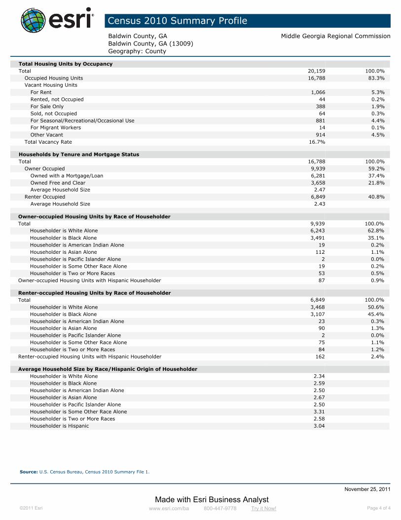
Census 2010 Summary Profile
Baldwin County, GA Middle Georgia Regional CommissionBaldwin County, GA (13009)Geography: County
Total Housing Units by OccupancyTotal 20,159 100.0%
Occupied Housing Units 16,788 83.3%Vacant Housing Units
For Rent 1,066 5.3%Rented, not Occupied 44 0.2%For Sale Only 388 1.9%Sold, not Occupied 64 0.3%For Seasonal/Recreational/Occasional Use 881 4.4%For Migrant Workers 14 0.1%Other Vacant 914 4.5%
Total Vacancy Rate 16.7%
Households by Tenure and Mortgage StatusTotal 16,788 100.0%
Owner Occupied 9,939 59.2%Owned with a Mortgage/Loan 6,281 37.4%Owned Free and Clear 3,658 21.8%Average Household Size 2.47
Renter Occupied 6,849 40.8%Average Household Size 2.43
Owner-occupied Housing Units by Race of HouseholderTotal 9,939 100.0%
Householder is White Alone 6,243 62.8%Householder is Black Alone 3,491 35.1%Householder is American Indian Alone 19 0.2%Householder is Asian Alone 112 1.1%Householder is Pacific Islander Alone 2 0.0%Householder is Some Other Race Alone 19 0.2%Householder is Two or More Races 53 0.5%
Owner-occupied Housing Units with Hispanic Householder 87 0.9%
Renter-occupied Housing Units by Race of HouseholderTotal 6,849 100.0%
Householder is White Alone 3,468 50.6%Householder is Black Alone 3,107 45.4%Householder is American Indian Alone 23 0.3%Householder is Asian Alone 90 1.3%Householder is Pacific Islander Alone 2 0.0%Householder is Some Other Race Alone 75 1.1%Householder is Two or More Races 84 1.2%
Renter-occupied Housing Units with Hispanic Householder 162 2.4%
Average Household Size by Race/Hispanic Origin of HouseholderHouseholder is White Alone 2.34Householder is Black Alone 2.59Householder is American Indian Alone 2.50Householder is Asian Alone 2.67Householder is Pacific Islander Alone 2.50Householder is Some Other Race Alone 3.31Householder is Two or More Races 2.58Householder is Hispanic 3.04
Source: U.S. Census Bureau, Census 2010 Summary File 1.
November 25, 2011
Made with Esri Business Analyst©2011 Esri www.esri.com/ba 800-447-9778 Try it Now! Page 4 of 4

Census 2010 Summary Profile
Milledgeville Middle Georgia Regional Commission
2000-2010 2000 2010 Annual Rate
Population 17,725 17,491 -0.13%Households 4,908 5,777 1.64%Housing Units 5,423 6,652 2.06%
Population by Race Number PercentTotal 17,492 100.0%
Population Reporting One Race 17,239 98.6%White 9,389 53.7%Black 7,352 42.0%American Indian 30 0.2%Asian 299 1.7%Pacific Islander 11 0.1%Some Other Race 158 0.9%
Population Reporting Two or More Races 253 1.4%
Total Hispanic Population 396 2.3%
Population by SexMale 8,522 48.7%Female 8,969 51.3%
Population by AgeTotal 17,490 100.0%
Age 0 - 4 924 5.3%Age 5 - 9 843 4.8%Age 10 - 14 712 4.1%Age 15 - 19 2,259 12.9%Age 20 - 24 3,681 21.0%Age 25 - 29 1,218 7.0%Age 30 - 34 865 4.9%Age 35 - 39 766 4.4%Age 40 - 44 770 4.4%Age 45 - 49 965 5.5%Age 50 - 54 973 5.6%Age 55 - 59 853 4.9%Age 60 - 64 790 4.5%Age 65 - 69 551 3.2%Age 70 - 74 419 2.4%Age 75 - 79 349 2.0%Age 80 - 84 278 1.6%Age 85+ 274 1.6%
Age 18+ 14,541 83.1%Age 65+ 1,871 10.7%
Median Age by Sex and Race/Hispanic OriginTotal Population 26.3
Male 27.0Female 25.6
White Alone 24.5Black Alone 30.6American Indian Alone 33.0Asian Alone 29.1Pacific Islander Alone 18.4Some Other Race Alone 23.1Two or More Races 18.8Hispanic Population 23.0
Data Note: Hispanic population can be of any race. Census 2010 medians are computed from reported data distributions.Source: U.S. Census Bureau, Census 2010 Summary File 1. Esri converted Census 2000 data into 2010 geography.
November 25, 2011
Made with Esri Business Analyst©2011 Esri www.esri.com/ba 800-447-9778 Try it Now! Page 1 of 4

Census 2010 Summary Profile
Milledgeville Middle Georgia Regional Commission
Households by TypeTotal 5,778 100.0%
Households with 1 Person 1,730 29.9%Households with 2+ People 4,048 70.1%
Family Households 2,888 50.0%Husband-wife Families 1,475 25.5%
With Own Children 483 8.4%Other Family (No Spouse Present) 1,413 24.5%
With Own Children 738 12.8%Nonfamily Households 1,160 20.1%
All Households with Children 1,445 25.0%Multigenerational Households 223 3.9%Unmarried Partner Households 391 6.8%
Male-female 355 6.1%Same-sex 36 0.6%
Average Household Size 2.53
Family Households by Size
Total 2,889 100.0%
2 People 1,283 44.4%
3 People 776 26.9%
4 People 488 16.9%
5 People 217 7.5%
6 People 81 2.8%
7+ People 44 1.5%
Average Family Size 3.24
Nonfamily Households by SizeTotal 2,889 100.0%
1 Person 1,730 59.9%2 People 638 22.1%3 People 342 11.8%4 People 158 5.5%5 People 13 0.5%6 People 6 0.2%7+ People 2 0.1%
Average Nonfamily Size 1.72
Population by Relationship and Household TypeTotal 17,491 100.0%
In Households 14,642 83.7%In Family Households 9,687 55.4%
Householder 3,190 18.2%Spouse 1,630 9.3%Child 3,991 22.8%Other relative 534 3.1%Nonrelative 342 2.0%
In Nonfamily Households 4,955 28.3%In Group Quarters 2,849 16.3%
Institutionalized Population 1,145 6.5%Noninstitutionalized Population 1,704 9.7%
Data Note: Households with children include any households with people under age 18, related or not. Multigenerational households are families with 3 or moreparent-child relationships. Unmarried partner households are usually classified as nonfamily households unless there is another member of the household related to thehouseholder. Multigenerational and unmarried partner households are reported only to the tract level. Esri estimated block group data, which is used to estimate polygonsor non-standard geography. Average family size excludes nonrelatives.Source: U.S. Census Bureau, Census 2010 Summary File 1.
November 25, 2011
Made with Esri Business Analyst©2011 Esri www.esri.com/ba 800-447-9778 Try it Now! Page 2 of 4
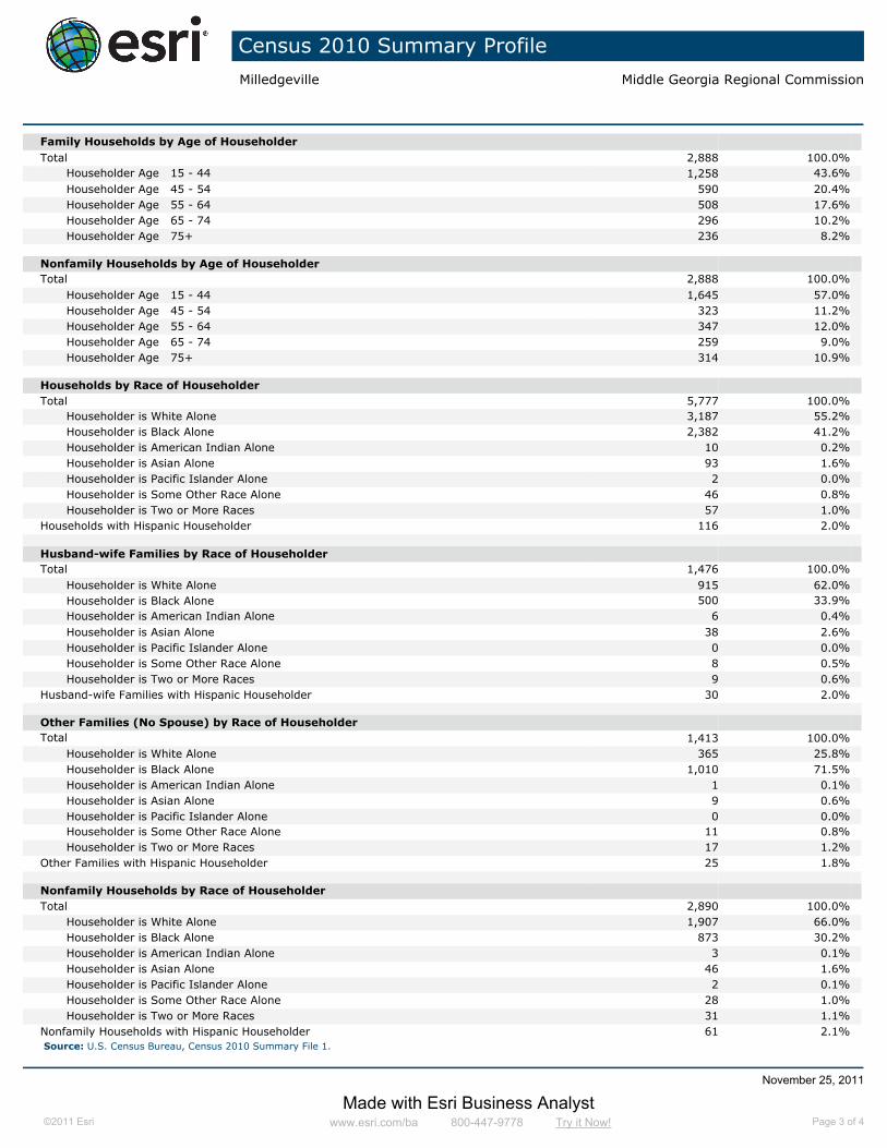
Census 2010 Summary Profile
Milledgeville Middle Georgia Regional Commission
Family Households by Age of HouseholderTotal 2,888 100.0%
Householder Age 15 - 44 1,258 43.6%Householder Age 45 - 54 590 20.4%Householder Age 55 - 64 508 17.6%Householder Age 65 - 74 296 10.2%Householder Age 75+ 236 8.2%
Nonfamily Households by Age of HouseholderTotal 2,888 100.0%
Householder Age 15 - 44 1,645 57.0%Householder Age 45 - 54 323 11.2%Householder Age 55 - 64 347 12.0%Householder Age 65 - 74 259 9.0%Householder Age 75+ 314 10.9%
Households by Race of HouseholderTotal 5,777 100.0%
Householder is White Alone 3,187 55.2%Householder is Black Alone 2,382 41.2%Householder is American Indian Alone 10 0.2%Householder is Asian Alone 93 1.6%Householder is Pacific Islander Alone 2 0.0%Householder is Some Other Race Alone 46 0.8%Householder is Two or More Races 57 1.0%
Households with Hispanic Householder 116 2.0%
Husband-wife Families by Race of HouseholderTotal 1,476 100.0%
Householder is White Alone 915 62.0%Householder is Black Alone 500 33.9%Householder is American Indian Alone 6 0.4%Householder is Asian Alone 38 2.6%Householder is Pacific Islander Alone 0 0.0%Householder is Some Other Race Alone 8 0.5%Householder is Two or More Races 9 0.6%
Husband-wife Families with Hispanic Householder 30 2.0%
Other Families (No Spouse) by Race of HouseholderTotal 1,413 100.0%
Householder is White Alone 365 25.8%Householder is Black Alone 1,010 71.5%Householder is American Indian Alone 1 0.1%Householder is Asian Alone 9 0.6%Householder is Pacific Islander Alone 0 0.0%Householder is Some Other Race Alone 11 0.8%Householder is Two or More Races 17 1.2%
Other Families with Hispanic Householder 25 1.8%
Nonfamily Households by Race of HouseholderTotal 2,890 100.0%
Householder is White Alone 1,907 66.0%Householder is Black Alone 873 30.2%Householder is American Indian Alone 3 0.1%Householder is Asian Alone 46 1.6%Householder is Pacific Islander Alone 2 0.1%Householder is Some Other Race Alone 28 1.0%Householder is Two or More Races 31 1.1%
Nonfamily Households with Hispanic Householder 61 2.1%Source: U.S. Census Bureau, Census 2010 Summary File 1.
November 25, 2011
Made with Esri Business Analyst©2011 Esri www.esri.com/ba 800-447-9778 Try it Now! Page 3 of 4

Census 2010 Summary Profile
Milledgeville Middle Georgia Regional Commission
Total Housing Units by OccupancyTotal 6,712 100.0%
Occupied Housing Units 5,777 86.1%Vacant Housing Units
For Rent 435 6.5%Rented, not Occupied 21 0.3%For Sale Only 110 1.6%Sold, not Occupied 16 0.2%For Seasonal/Recreational/Occasional Use 70 1.0%For Migrant Workers 3 0.0%Other Vacant 280 4.2%
Total Vacancy Rate 13.2%
Households by Tenure and Mortgage StatusTotal 5,777 100.0%
Owner Occupied 2,326 40.3%Owned with a Mortgage/Loan 1,435 24.8%Owned Free and Clear 891 15.4%Average Household Size 2.60
Renter Occupied 3,451 59.7%Average Household Size 2.49
Owner-occupied Housing Units by Race of HouseholderTotal 2,326 100.0%
Householder is White Alone 1,393 59.9%Householder is Black Alone 864 37.1%Householder is American Indian Alone 3 0.1%Householder is Asian Alone 44 1.9%Householder is Pacific Islander Alone 0 0.0%Householder is Some Other Race Alone 8 0.3%Householder is Two or More Races 14 0.6%
Owner-occupied Housing Units with Hispanic Householder 33 1.4%
Renter-occupied Housing Units by Race of HouseholderTotal 3,452 100.0%
Householder is White Alone 1,795 52.0%Householder is Black Alone 1,519 44.0%Householder is American Indian Alone 7 0.2%Householder is Asian Alone 49 1.4%Householder is Pacific Islander Alone 2 0.1%Householder is Some Other Race Alone 38 1.1%Householder is Two or More Races 42 1.2%
Renter-occupied Housing Units with Hispanic Householder 83 2.4%
Average Household Size by Race/Hispanic Origin of HouseholderHouseholder is White Alone 2.39Householder is Black Alone 2.69Householder is American Indian Alone 2.60Householder is Asian Alone 2.87Householder is Pacific Islander Alone 3.00Householder is Some Other Race Alone 2.98Householder is Two or More Races 2.82Householder is Hispanic 2.91
Source: U.S. Census Bureau, Census 2010 Summary File 1.
November 25, 2011
Made with Esri Business Analyst©2011 Esri www.esri.com/ba 800-447-9778 Try it Now! Page 4 of 4

Business Summary by SIC CodesMiddle Georgia Regional Commission
©2011 Esri On-demand reports and maps from Business Analyst Online. Order at www.esri.com/bao or call 800-447-9778 11/25/2011 Page 1 of 2
Baldwin County, GABaldwin County, GA (13009)Geography: County
Total Businesses: 1,567
Total Employees: 16,584
Total Residential Population: 47,638
Employee/Residential Population Ratio: 0.35
Businesses Employees
Number Percent Number PercentAgriculture & Mining 32 2.0% 77 0.5%
Construction 134 8.6% 491 3.0%
Manufacturing 35 2.2% 856 5.2%
Transportation 51 3.3% 168 1.0%
Communication 15 1.0% 61 0.4%
Utility 12 0.8% 103 0.6%
Wholesale Trade 38 2.4% 300 1.8%
Retail Trade Summary 409 26.1% 4,020 24.2%
Home Improvement 28 1.8% 297 1.8%
General Merchandise Stores 18 1.1% 233 1.4%
Food Stores 37 2.4% 440 2.7%
Auto Dealers, Gas Stations, Auto Aftermarket 73 4.7% 461 2.8%
Apparel & Accessory Stores 23 1.5% 82 0.5%
Furniture & Home Furnishings 31 2.0% 538 3.2%
Eating & Drinking Places 107 6.8% 1,475 8.9%
Miscellaneous Retail 92 5.9% 494 3.0%
Finance, Insurance, Real Estate Summary 145 9.3% 731 4.4%
Banks, Savings & Lending Institutions 38 2.4% 253 1.5%
Securities Brokers 13 0.8% 37 0.2%
Insurance Carriers & Agents 30 1.9% 127 0.8%
Real Estate, Holding, Other Investment Offices 64 4.1% 314 1.9%
Services Summary 592 37.8% 7,320 44.1%
Hotels & Lodging 17 1.1% 101 0.6%
Automotive Services 63 4.0% 225 1.4%
Motion Pictures & Amusements 22 1.4% 135 0.8%
Health Services 85 5.4% 2,269 13.7%
Legal Services 17 1.1% 58 0.3%
Education Institutions & Libraries 31 2.0% 2,233 13.5%
Other Services 357 22.8% 2,299 13.9%
Government 90 5.7% 2,455 14.8%
Other 14 0.9% 2 0.0%
Totals 1,567 100.0% 16,584 100.0%
Source: Business data provided by Infogroup, Omaha NE Copyright 2010, all rights reserved. Esri forecasts for 2010.

Business Summary by NAICS CodesMiddle Georgia Regional Commission
©2011 Esri On-demand reports and maps from Business Analyst Online. Order at www.esri.com/bao or call 800-447-9778 11/25/2011 Page 2 of 2
Baldwin County, GABaldwin County, GA (13009)Geography: County
Total Businesses: 1,567
Total Employees: 16,584
Total Residential Population: 47,638
Employee/Residential Population Ratio: 0.35
Businesses Employees
Number Percent Number PercentAgriculture, Forestry, Fishing & Hunting 11 0.7% 19 0.1%
Mining 0 0.0% 0 0.0%
Utilities 9 0.6% 37 0.2%
Construction 137 8.7% 516 3.1%
Manufacturing 30 1.9% 811 4.9%
Wholesale Trade 36 2.3% 246 1.5%
Retail Trade 290 18.5% 2,502 15.1%
Motor Vehicle & Parts Dealers 46 2.9% 344 2.1%
Furniture & Home Furnishings Stores 17 1.1% 499 3.0%
Electronics & Appliance Stores 12 0.8% 20 0.1%
Bldg Material & Garden Equipment & Supplies Dealers 25 1.6% 270 1.6%
Food & Beverage Stores 41 2.6% 440 2.7%
Health & Personal Care Stores 26 1.7% 161 1.0%
Gasoline Stations 27 1.7% 117 0.7%
Clothing & Clothing Accessories Stores 28 1.8% 105 0.6%
Sport Goods, Hobby, Book, & Music Stores 15 1.0% 80 0.5%
General Merchandise Stores 18 1.1% 233 1.4%
Miscellaneous Store Retailers 32 2.0% 128 0.8%
Nonstore Retailers 3 0.2% 105 0.6%
Transportation & Warehousing 44 2.8% 150 0.9%
Information 26 1.7% 173 1.0%
Finance & Insurance 92 5.9% 453 2.7%
Central Bank/Credit Intermediation & Related Activities 49 3.1% 289 1.7%
Securities, Commodity Contracts & Other Financial Investments & Other Related Activities 13 0.8% 37 0.2%
Insurance Carriers & Related Activities; Funds, Trusts & Other Financial Vehicles 30 1.9% 127 0.8%
Real Estate, Rental & Leasing 91 5.8% 309 1.9%
Professional, Scientific & Tech Services 77 4.9% 256 1.5%
Legal Services 17 1.1% 58 0.3%
Management of Companies & Enterprises 2 0.1% 76 0.5%
Administrative & Support & Waste Management & Remediation Services 53 3.4% 1,076 6.5%
Educational Services 31 2.0% 2,220 13.4%
Health Care & Social Assistance 130 8.3% 2,679 16.2%
Arts, Entertainment & Recreation 20 1.3% 80 0.5%
Accommodation & Food Services 124 7.9% 1,576 9.5%
Accommodation 17 1.1% 101 0.6%
Food Services & Drinking Places 107 6.8% 1,475 8.9%
Other Services (except Public Administration) 257 16.4% 879 5.3%
Automotive Repair & Maintenance 46 2.9% 197 1.2%
Public Administration 91 5.8% 2,470 14.9%
Unclassified Establishments 16 1.0% 56 0.3%
Total 1,567 100.0% 16,584 100.0%
Source: Business data provided by Infogroup, Omaha NE Copyright 2010, all rights reserved. Esri forecasts for 2010.

Business Summary by SIC CodesMiddle Georgia Regional Commission
©2011 Esri On-demand reports and maps from Business Analyst Online. Order at www.esri.com/bao or call 800-447-9778 11/25/2011 Page 1 of 2
Milledgeville
Total Businesses: 1,129
Total Employees: 12,908
Total Residential Population: 20,770
Employee/Residential Population Ratio: 0.62
Businesses Employees
Number Percent Number PercentAgriculture & Mining 17 1.5% 50 0.4%
Construction 75 6.6% 313 2.4%
Manufacturing 20 1.8% 405 3.1%
Transportation 32 2.8% 130 1.0%
Communication 10 0.9% 49 0.4%
Utility 9 0.8% 66 0.5%
Wholesale Trade 28 2.5% 204 1.6%
Retail Trade Summary 306 27.1% 3,291 25.5%
Home Improvement 17 1.5% 240 1.9%
General Merchandise Stores 15 1.3% 206 1.6%
Food Stores 23 2.0% 364 2.8%
Auto Dealers, Gas Stations, Auto Aftermarket 50 4.4% 373 2.9%
Apparel & Accessory Stores 20 1.8% 73 0.6%
Furniture & Home Furnishings 24 2.1% 317 2.5%
Eating & Drinking Places 80 7.1% 1,277 9.9%
Miscellaneous Retail 77 6.8% 441 3.4%
Finance, Insurance, Real Estate Summary 117 10.4% 627 4.9%
Banks, Savings & Lending Institutions 34 3.0% 235 1.8%
Securities Brokers 10 0.9% 29 0.2%
Insurance Carriers & Agents 28 2.5% 119 0.9%
Real Estate, Holding, Other Investment Offices 45 4.0% 244 1.9%
Services Summary 432 38.3% 5,771 44.7%
Hotels & Lodging 13 1.2% 86 0.7%
Automotive Services 48 4.3% 194 1.5%
Motion Pictures & Amusements 18 1.6% 115 0.9%
Health Services 73 6.5% 1,688 13.1%
Legal Services 16 1.4% 56 0.4%
Education Institutions & Libraries 22 2.0% 1,731 13.4%
Other Services 242 21.5% 1,901 14.7%
Government 72 6.4% 2,006 15.5%
Other 10 0.9% 0 0.0%
Totals 1,128 100.0% 12,908 100.0%
Source: Business data provided by Infogroup, Omaha NE Copyright 2010, all rights reserved. Esri forecasts for 2010.

Business Summary by NAICS CodesMiddle Georgia Regional Commission
©2011 Esri On-demand reports and maps from Business Analyst Online. Order at www.esri.com/bao or call 800-447-9778 11/25/2011 Page 2 of 2
Milledgeville
Total Businesses: 1,129
Total Employees: 12,908
Total Residential Population: 20,770
Employee/Residential Population Ratio: 0.62
Businesses Employees
Number Percent Number PercentAgriculture, Forestry, Fishing & Hunting 5 0.4% 12 0.1%
Mining 0 0.0% 0 0.0%
Utilities 8 0.7% 35 0.3%
Construction 75 6.7% 313 2.4%
Manufacturing 19 1.7% 363 2.8%
Wholesale Trade 27 2.4% 185 1.4%
Retail Trade 215 19.1% 1,976 15.3%
Motor Vehicle & Parts Dealers 34 3.0% 299 2.3%
Furniture & Home Furnishings Stores 12 1.1% 283 2.2%
Electronics & Appliance Stores 10 0.9% 17 0.1%
Bldg Material & Garden Equipment & Supplies Dealers 14 1.2% 216 1.7%
Food & Beverage Stores 26 2.3% 362 2.8%
Health & Personal Care Stores 22 2.0% 142 1.1%
Gasoline Stations 16 1.4% 74 0.6%
Clothing & Clothing Accessories Stores 25 2.2% 94 0.7%
Sport Goods, Hobby, Book, & Music Stores 12 1.1% 66 0.5%
General Merchandise Stores 15 1.3% 206 1.6%
Miscellaneous Store Retailers 25 2.2% 113 0.9%
Nonstore Retailers 3 0.3% 105 0.8%
Transportation & Warehousing 28 2.5% 118 0.9%
Information 19 1.7% 156 1.2%
Finance & Insurance 81 7.2% 414 3.2%
Central Bank/Credit Intermediation & Related Activities 44 3.9% 266 2.1%
Securities, Commodity Contracts & Other Financial Investments & Other Related Activities 10 0.9% 29 0.2%
Insurance Carriers & Related Activities; Funds, Trusts & Other Financial Vehicles 28 2.5% 119 0.9%
Real Estate, Rental & Leasing 62 5.5% 221 1.7%
Professional, Scientific & Tech Services 56 5.0% 212 1.6%
Legal Services 16 1.4% 56 0.4%
Management of Companies & Enterprises 2 0.2% 76 0.6%
Administrative & Support & Waste Management & Remediation Services 29 2.6% 967 7.5%
Educational Services 22 2.0% 1,713 13.3%
Health Care & Social Assistance 108 9.6% 2,054 15.9%
Arts, Entertainment & Recreation 16 1.4% 66 0.5%
Accommodation & Food Services 93 8.3% 1,363 10.6%
Accommodation 13 1.2% 86 0.7%
Food Services & Drinking Places 80 7.1% 1,277 9.9%
Other Services (except Public Administration) 179 15.9% 630 4.9%
Automotive Repair & Maintenance 39 3.5% 177 1.4%
Public Administration 72 6.4% 2,017 15.6%
Unclassified Establishments 11 1.0% 19 0.1%
Total 1,127 100.0% 12,908 100.0%
Source: Business data provided by Infogroup, Omaha NE Copyright 2010, all rights reserved. Esri forecasts for 2010.

Page 1 of 8Version 2.0 Baldwin Area
Updated: Jul 2011
County
Baldwin
MARK BUTLER - COMMISSIONER, GEORGIA DEPARTMENT OF LABOREqual Opportunity Employer/Program
Auxillary Aids and Services Available upon Request to Individuals with Disabilities
Workforce Statistics & Economic Research; E-mail: [email protected] Phone: (404) 232-3875
Baldwin 45,720 43 51,125 11.8 57,682 26.2
Georgia 9,687,653 11,076,619 14.3 13,426,590 38.6
Baldwin Area 135,786 149,669 10.2 170,697 25.7
City of Milledgeville
17,715
United States 309,050,816 322,365,787 4.3 349,439,199 13.1
Source: Population Division, U.S. Census Bureau, *Governor's Office of Planning and Budget.
Population
2010 Census
2015 Rank
2015 Estimate
% Change 2010-2015
2025 Projected*
% Change 2010-2025
Jones 14,111 12,774 1,337 9.5%
Hancock 3,029 2,351 678 22.4%
Baldwin Area 57,742 49,943 7,799 13.5%
Wilkinson 4,416 3,887 529 12.0%
Washington 7,634 6,459 1,175 15.4%
Baldwin 18,842 15,879 2,963 15.7%
Putnam 9,710 8,593 1,117 11.5%
United States 153,889,000 139,064,000 14,825,000 9.6%
Georgia 4,693,711 4,213,719 479,992 10.2%
Note: This series reflects the latest information available. Labor Force includes residents of the county who are employed or actively seeking employment.
Source: Georgia Department of Labor; U.S. Bureau of Labor Statistics.
Labor Force Activity - 20102010 ANNUAL AVERAGES
Labor Force Employed Unemployed Rate
Employment Trends
Unemployment Rate Trends

Page 2 of 8Version 2.0 Baldwin Area
ALL INDUSTRIES 912 15,435 100.0 581 2,439 35,880 100.0 598Local Government 15 1,476 9.6 670 82 6,000 16.7 577State Government 49 4,522 29.3 582 108 6,391 17.8 577Federal Government 6 66 0.4 1,071 39 250 0.7 939
Total - Government 70 6,064 39.3 774 229 12,641 35.2 584Total - Private Sector 842 9,372 60.7 764 2,210 23,240 64.8 606Unclassified - industry not assigned 21 16 0.1 361 52 46 0.1 412
Other Services (except Public Administration) 63 330 2.1 409 202 668 1.9 406
Accommodation and Food Services 87 1,560 10.1 218 181 2,786 7.8 221Arts, Entertainment, and Recreation 12 122 0.8 341 25 255 0.7 305Health Care and Social Assistance 107 2,166 14.0 663 207 3,595 10.0 613Educational Services 9 126 0.8 464 15 265 0.7 486
Administrative and Support and Waste Management and Remediation Services 46 516 3.3 309 101 840 2.3 372
Management of Companies and Enterprises 0 0 0.0 0 6 * * *
Professional, Scientific, and Technical Services 58 172 1.1 537 158 565 1.6 687
Real Estate and Rental and Leasing 36 112 0.7 470 80 * * *Finance and Insurance 57 333 2.2 759 127 881 2.5 800Information 9 141 0.9 619 24 251 0.7 658Transportation and Warehousing 17 65 0.4 624 74 1,042 2.9 602Retail Trade 181 2,027 13.1 414 423 4,725 13.2 396Wholesale Trade 26 127 0.8 679 92 457 1.3 790Utilities 3 51 0.3 1,244 14 539 1.5 1,316
Service-Providing 711 7,850 50.9 470 1,729 17,444 48.6 515Beverage and Tobacco Product 0 0 0.0 0 1 * * *Textile Product Mills 0 0 0.0 0 0 * * *Miscellaneous 3 * * * 6 27 0.1 595Furniture and Related Product 3 * * * 8 27 0.1 661Transportation Equipment 2 * * * 3 * * *Machinery 3 103 0.7 3,609 7 111 0.3 3,389Fabricated Metal Product 2 * * * 10 140 0.4 753Nonmetallic Mineral Product 2 * * * 12 494 1.4 1,028Plastics and Rubber Products 1 * * * 3 * * *Chemical 1 * * * 4 145 0.4 846Printing and Related Support Activities 4 * * * 8 23 0.1 358Paper 2 * * * 3 42 0.1 477Wood Product 1 * * * 20 494 1.4 574Apparel 1 * * * 1 * * *Textile Mills 1 * * * 1 * * *Food 4 18 0.1 553 9 54 0.2 529
Manufacturing 30 1,147 7.4 1,182 96 2,488 6.9 953Construction 75 346 2.2 661 267 1,581 4.4 678
Mining, Quarrying, and Oil and Gas Extraction 0 0 0.0 0 20 1,218 3.4 1,117
Agriculture, Forestry, Fishing and Hunting 5 13 0.1 626 46 464 1.3 588Goods-Producing 110 1,506 9.8 1,058 429 5,750 16.0 883
ALL INDUSTRIES - Georgia 267,525 3,752,981 844
Note: *Denotes confidential data relating to individual employers and cannot be released. These data use the North American Industrial Classification System(NAICS) categories. Average weekly wage is derived by dividing gross payroll dollars paid to all employees - both hourly and salaried - by the average number of employees who had earnings; average earnings are then divided by the number of weeks in a reporting period to obtain weekly figures. Figures in other columns may not sum accurately due to rounding. All figures are annual averages of 2010.Source: Georgia Department of Labor. These data represent jobs that are covered by unemployment insurance laws.
Baldwin Baldwin Area
Industry Mix - 2010
INDUSTRY OF FIRMS NUMBER PERCENT WAGE OF FIRMS NUMBER PERCENT WAGE
NUMBER EMPLOYMENT WEEKLY NUMBER EMPLOYMENT WEEKLY
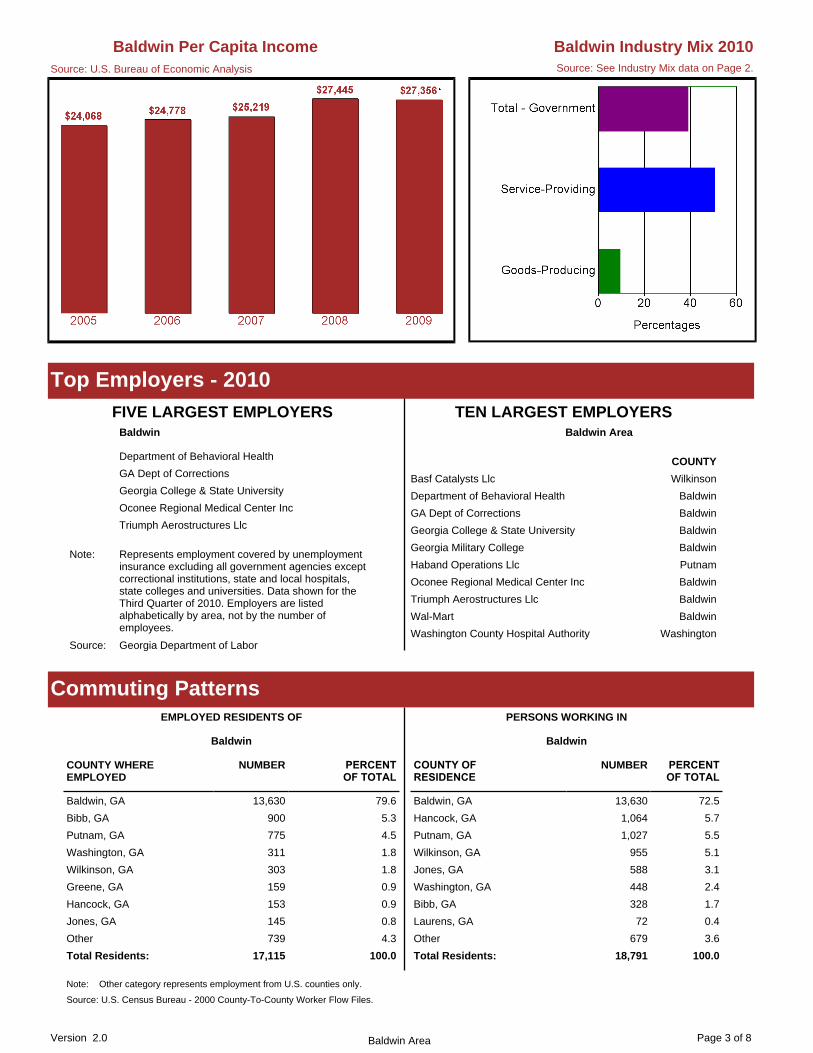
Page 3 of 8Version 2.0 Baldwin Area
Greene, GA 159 0.9
Total Residents: 17,115 100.0
Washington, GA 311 1.8
Other 739 4.3
Jones, GA 145 0.8
Hancock, GA 153 0.9
Baldwin, GA 13,630 79.6
Wilkinson, GA 303 1.8
Putnam, GA 775 4.5
Bibb, GA 900 5.3
Note: Other category represents employment from U.S. counties only.
Source: U.S. Census Bureau - 2000 County-To-County Worker Flow Files.
EMPLOYED RESIDENTS OF
Baldwin
COUNTY WHERE EMPLOYED
NUMBER PERCENTOF TOTAL
Washington, GA 448 2.4
Jones, GA 588 3.1
Total Residents: 18,791 100.0
Other 679 3.6
Laurens, GA 72 0.4
Bibb, GA 328 1.7
Baldwin, GA 13,630 72.5
Wilkinson, GA 955 5.1
Putnam, GA 1,027 5.5
Hancock, GA 1,064 5.7
PERSONS WORKING IN
COUNTY OFRESIDENCE
NUMBER PERCENTOF TOTAL
Baldwin
Commuting Patterns
Triumph Aerostructures Llc
Oconee Regional Medical Center Inc
Georgia College & State University
GA Dept of Corrections
Department of Behavioral Health
Note: Represents employment covered by unemployment insurance excluding all government agencies except correctional institutions, state and local hospitals, state colleges and universities. Data shown for the Third Quarter of 2010. Employers are listed alphabetically by area, not by the number of employees.
Source: Georgia Department of Labor
FIVE LARGEST EMPLOYERSBaldwin
Washington County Hospital Authority Washington
Wal-Mart Baldwin
Triumph Aerostructures Llc Baldwin
Oconee Regional Medical Center Inc Baldwin
Haband Operations Llc Putnam
Georgia Military College Baldwin
Georgia College & State University Baldwin
GA Dept of Corrections Baldwin
Department of Behavioral Health Baldwin
Basf Catalysts Llc Wilkinson
Baldwin Area
TEN LARGEST EMPLOYERS
COUNTY
Top Employers - 2010
Source: See Industry Mix data on Page 2.
Baldwin Industry Mix 2010Baldwin Per Capita IncomeSource: U.S. Bureau of Economic Analysis

Page 4 of 8Version 2.0 Baldwin Area
48.6%27.6%19.4%19.8%31.2%28.2%Some High School
Note: Totals are based on the portion of the labor force between ages 18 - 65+. Some College category represents the percentage total
65+45-6435-4425-3418-24OF TOTAL
Some College 22.1% 32.4% 25.4% 22.3% 19.4% 14.0%
Totals 100.0% 100.0% 100.0% 100.0% 100.0% 100.0%
Post Grad Studies 4.6% 0.4% 2.9% 4.7% 7.1% 5.1%
College Grad 4 Yr 7.8% 3.8% 10.7% 9.1% 8.4% 5.4%
High School Grad/GED 37.4% 32.2% 41.3% 44.5% 37.6% 27.0%
Some High School 28.2% 31.2% 19.8% 19.4% 27.6% 48.6%
PERCENT DISTRIBUTION BY AGE
OF TOTAL 18-24 25-34 35-44 45-64 65+
PERCENT
Education of the Labor Force
Source: U.S. Census Bureau - 2000 Decennial Census.
Baldwin Area
of workers with either Some College with no degree or an Associate degree.
Putnam 136 -- 136
Washington 221 -- 221
Wilkinson 98 -- 98
Baldwin Area 1,095 -- 1,095
Jones 287 -- 287
Baldwin 247 -- 247
Hancock 106 -- 106
PUBLICSCHOOLS
PRIVATESCHOOLS*
TOTAL
Note:
*
Public schools include city as well as county schools systems.
Private schools data is not available for 2010 from Georgia Independent SchoolAssociation.
High School Graduates - 2010
Sandersville Technical College www.sandersvilletech.edu
Washington
Hancock County Center (Satellite campus of Sandersville Technical College)
www.sandersvilletech.edu
Hancock
Georgia Military College-Milledgeville Camp www.gmc.cc.ga.us/
Georgia College & State University www.gcsu.edu
Central Georgia Technical College (Technical college servicing area) www.centralgatech.edu
Baldwin
Putnam County Center (Satellite campus of Central Georgia Technical College)
www.centralgatech.edu
Putnam
Jones County Center (Satellite campus of Central Georgia Technical College)
www.centralgatech.edu
Jones
Note: The colleges and universities listed include public and private institutions. This list is updated periodically as information becomes available.
Source: Integrated Postsecondary Education Data System (IPEDS).
Colleges and Universities
Baldwin Area

Page 5 of 8Version 2.0 Baldwin Area
Data Modeling/Warehousing and Database Administration 2 4 1 100.0 -75.0
Data Entry/Microcomputer Applications, General 15 21 24 40.0 14.3
Data Processing and Data Processing Technology/Technician
16 11 11 -31.3 0.0
Drafting and Design Technology/Technician, General 4 8 5 100.0 -37.5
Dental Hygiene/Hygienist 12 17 18 41.7 5.9
Construction Management 2 4 4 100.0 0.0
Computer Systems Networking and Telecommunications 79 118 117 49.4 -0.8
Cosmetology, Barber/Styling, and Nail Instructor 2 1 1 -50.0 0.0
Criminal Justice/Safety Studies 30 31 26 3.3 -16.1
Cosmetology/Cosmetologist, General 37 29 47 -21.6 62.1
Early Childhood Education and Teaching 40 41 30 2.5 -26.8
Food Preparation/Professional Cooking/Kitchen Assistant 11 19 8 72.7 -57.9
Entrepreneurship/Entrepreneurial Studies 3 8 15 166.7 87.5
Electrical/Electronics Maintenance and Repair Technology, Other
1 7 1 600.0 -85.7
Electrical/Electronics Equipment Installation and Repair, General
18 59 43 227.8 -27.1
Electrician 52 57 50 9.6 -12.3
Emergency Medical Technology/Technician (EMT Paramedic)
25 23 47 -8.0 104.3
Electroneurodiagnostic/Electroencephalographic Technology/Technologist
24 17 16 -29.2 -5.9
Animation, Interactive Technology, Video Graphics and Special Effects
5 4 8 -20.0 100.0
Allied Health Diagnostic, Intervention, and Treatment Professions, Other
8 7 17 -12.5 142.9
Automobile/Automotive Mechanics Technology/Technician 27 83 103 207.4 24.1
Autobody/Collision and Repair Technology/Technician 7 20 7 185.7 -65.0
Airframe Mechanics and Aircraft Maintenance Technology/Technician
83 99 162 19.3 63.6
Accounting Technology/Technician and Bookkeeping 55 79 88 43.6 11.4
Computer Programming/Programmer, General 1 2 2 100.0 0.0
Aesthetician/Esthetician and Skin Care Specialist 15 9 15 -40.0 66.7
Administrative Assistant and Secretarial Science, General 67 44 32 -34.3 -27.3
Child Care Provider/Assistant 11 15 100 36.4 566.7
Child Care and Support Services Management 16 17 14 6.3 -17.6
Computer Installation and Repair Technology/Technician 37 47 53 27.0 12.8
Clinical/Medical Laboratory Technician 7 10 6 42.9 -40.0
Carpentry/Carpenter 20 43 33 115.0 -23.3
Business Administration, Management and Operations, Other 6 5 6 -16.7 20.0
Barbering/Barber 9 14 12 55.6 -14.3
Cardiovascular Technology/Technologist 3 5 12 66.7 140.0
Cabinetmaking and Millwork 17 12 15 -29.4 25.0
Technical College Graduates - 2010
2008 2009 2010 2008-2009 2009-2010
PROGRAMS TOTAL GRADUATES PERCENT CHANGE

Page 6 of 8Version 2.0 Baldwin Area
Medical/Health Management and Clinical Assistant/Specialist 40 21 29 -47.5 38.1
Nail Technician/Specialist and Manicurist 3 1 3 -66.7 200.0
Operations Management and Supervision 31 35 14 12.9 -60.0
Medical/Clinical Assistant 94 76 70 -19.1 -7.9
Medical Insurance Coding Specialist/Coder 58 46 66 -20.7 43.5
Medical Reception/Receptionist 57 39 15 -31.6 -61.5
Welding Technology/Welder 25 35 68 40.0 94.3
Pharmacy Technician/Assistant 4 9 13 125.0 44.4
Sales, Distribution, and Marketing Operations, General 5 7 7 40.0 0.0
Surgical Technology/Technologist 10 14 17 40.0 21.4
Web Page, Digital/Multimedia and Information Resources Design
3 2 3 -33.3 50.0
Renal/Dialysis Technologist/Technician 29 39 43 34.5 10.3
Phlebotomy Technician/Phlebotomist 22 29 31 31.8 6.9
Plumbing Technology/Plumber 6 6 3 0.0 -50.0
Radiologic Technology/Science - Radiographer 41 36 39 -12.2 8.3
Hospitality Administration/Management, General 4 3 4 -25.0 33.3
Industrial Mechanics and Maintenance Technology 73 61 108 -16.4 77.0
Instrumentation Technology/Technician 9 18 28 100.0 55.6
Medical Transcription/Transcriptionist 15 10 1 -33.3 -90.0
Heating, Air Conditioning, Ventilation and Refrigeration Maintenance Technology/Technician
139 77 82 -44.6 6.5
Home Health Aide/Home Attendant 18 29 13 61.1 -55.2
Logistics, Materials, and Supply Chain Management 12 29 38 141.7 31.0
Marine Maintenance/Fitter and Ship Repair Technology/Technician
10 4 1 -60.0 -75.0
Mechanic and Repair Technologies/Technicians, Other 4 4 8 0.0 100.0
Insurance 3 2 1 -33.3 -50.0
Legal Administrative Assistant/Secretary 2 3 3 50.0 0.0
Licensed Practical/Vocational Nurse Training 88 83 76 -5.7 -8.4
Source: Integrated Postsecondary Education Data System
Definition: All graduates except those listed as technical certificates are diploma and degree graduates. Diploma and degree programs are one to two years in length. Technical certificates are less than a year in length.
Note - The data shown is from Central Georgia Technical College
Technical College Graduates - 2010
2008 2009 2010 2008-2009 2009-2010
PROGRAMS TOTAL GRADUATES PERCENT CHANGE

Page 7 of 8Version 2.0 Baldwin Area
Total Area 8,096 242 968 368 183 896 1,099 31 693 368 1,964 1,284
Wilkinson 580 13 58 24 14 51 81 0 61 46 145 87
Washington 1,075 34 101 38 32 133 153 5 100 43 238 198
Putnam 1,076 15 116 41 26 104 129 5 77 47 274 242
Jones 974 26 77 36 13 81 221 4 152 74 163 127
Hancock 751 22 50 24 21 44 85 5 56 24 249 171
Baldwin 3,640 132 566 205 77 483 430 12 247 134 895 459
Note: For current applicant data available for a specific occupation, contact the nearest Georgia Department of Labor Career Center.
Source: Georgia Department of Labor (active applicants as of June 2011).
Active Applicants - Georgia Department of Labor (cont.)TOTAL Protect.
Svcs.Food Prep.
Ground Cleaning
PersonalCare
Sales Office Support
Farm. & Forestry
Cons-truction
InstallationMain.
Prod. Trans. & Moving
Total Area 1,174 324 54 22 47 20 51 15 137 30 99 375
Wilkinson 74 13 1 2 3 3 3 1 19 0 7 22
Washington 137 21 7 4 10 4 7 3 16 6 9 50
Putnam 163 72 8 1 5 3 3 1 24 4 16 26
Jones 220 72 21 10 12 1 15 3 21 4 30 31
Hancock 86 12 2 0 3 0 2 1 18 2 8 38
Baldwin 494 134 15 5 14 9 21 6 39 14 29 208
Active Applicants - Georgia Department of LaborTOTAL Mgt. Bus. &
FinanceCompu. &
MathArch. &
Eng.Life &
Soc. Svcs.Comm. &Svcs
Legal Ed. &Training
Arts &Design
HealthPrac.
HealthSupport
Installation, Maintenance and Repair Craft Workers 1,014 5.5
Production Operative Workers 2,030 10.9
Administrative Support Workers 2,392 12.9
Construction and Extractive Craft Workers 859 4.6
Protective Service Workers 744 4.0
Service Workers, except Protective 3,098 16.6
Transportation and Material Moving Operative Worke 733 3.9
Laborers and Helpers 779 4.2
Unemployed, No Civilian Work Experience Since 1995 175 0.9
Management, Business and Financial Workers 1,383 7.4
Total Civilian Labor Force 18,620 100.0
Sales Workers 1,896 10.2
Science, Engineering and Computer Professionals 300 1.6
Technicians 625 3.4
Other Professional Workers 1,863 10.0
Healthcare Practitioner Professionals 729 3.9
Baldwin
NUMBER PERCENT
3,453 6.3
6,064 11.0
7,236 13.2
3,508 6.4
2,064 3.8
7,699 14.0
3,096 5.6
2,902 5.3
704 1.3
4,128 7.5
54,987 100.0
5,284 9.6
891 1.6
1,852 3.4
4,419 8.0
1,687 3.1
Baldwin Area
NUMBER PERCENT
Source: U.S. Census Bureau - 2000 Decennial Census.(EEO Data Tools)
Occupational Profile for Residents of Baldwin County

Page 8 of 8Version 2.0 Baldwin Area
Suite 1022930 Heritage Place
Milledgeville, GA 31061-7211Phone: (478) 445 - 4781
Rehabilitation Center(s)
Milledgeville GA 31061156 Roberson Mill Road
Phone: (478) 445 - 5465 Fax: (478) 445 - 2040
Career Center(s)
For copies of Area Labor Profiles, please visit our website at: www.dol.state.ga.us or contact Workforce Statistics & Economic Research, Georgia Department of Labor, 148 Andrew Young International Blvd N.E. Atlanta, GA. 30303-1751. Phone: 404-232-3875; Fax: 404-232-3888 or Email us at [email protected]
Georgia Department of Labor Location(s)

Appendix C
Relevant Community Planning Documents
Middle Georgia Regionally Important Resources Plan -
Introduction
Middle Georgia Regional Plan - Executive Summary
Baldwin County-Milledgeville Summary of Service Delivery
Arrangements for Emergency Management (Service
Delivery Strategy – Form 2)
Georgia College and State University Pre-Disaster
Mitigation Plan

Middle Georgia Regional Plan 2011-2031
Regional Assessment

22222222222222222222222222
Middle Georgia Regional Plan 2011-2031Regional Assessment
Adopted, ________(date)_________by the Middle Georgia Regional Council
Prepared by:
175 Emery Highway, Suite CMacon, Georgia 31217Phone: (478) 751-6160 Fax: (478) 751-6517Website: www.middlegeorgiarc.org
Photograph Credits (Front Cover, L-R): Highway 341 Pecan Grove, Kris� na Harpst; Bond Swamp - Piedmont Na� onal Wildlife Refuge, John Holingsworth/USFWS; Down-town Macon, Carlyle Place website; Academy Distribu� on Facility, Nick Kouloungis).

33333333333333333333333333
Table of Contents
Suppor� ng Analysis of Data and Informa� on .........39 Popula� on ................................................................ 40Economic Development ............................................ 43Housing .................................................................... 47Transporta� on .......................................................... 50Community Facili� es and Services ........................... 52Natural and Cultural Resources ................................ 54Intergovernmental Coordina� on .............................. 55
AppendixA. Maps .................................................................... 58 Future Development Map ..................................... 59 Transporta� on Network Map ............................... 60 B. Tables and Data .................................................... 61C. Quality Growth Assessment Tool .......................... 94
Execu� ve Summary ..................................................4 Purpose .....................................................................4Overview .................................................................... 4
Poten� al Issues and Opportuni� es ..........................6 Popula� on .................................................................. 8Economic Development .............................................. 9Housing .................................................................... 10Transporta� on .......................................................... 12Community Facili� es and Services ........................... 13Natural and Cultural Resources ................................ 14Intergovernmental Coordina� on .............................. 16Land Use ................................................................... 17
Analysis of Regional Development Pa� erns ...........18 Purpose .................................................................... 19Overview .................................................................. 21Areas Requiring Special A� en� on ............................ 28
Consistency with Quality Community Objec� ves ...29Overview .................................................................. 30Development Pa� erns .............................................. 31Resource Conserva� on ............................................. 34Social and Economic Development ........................... 36Governmental Rela� ons ........................................... 38
44444444444444444444444444
Execu� ve Summary
PurposeA successful regional planning strategy begins with prepara� on, re-search, and a wide-ranging objec� ve evalua� on of exis� ng condi� ons. This involves accurately iden� fying and analyzing current regional assets, resources, and opportuni� es. A comprehensive inventory of current condi� ons allows regional stakeholders and decision makers to accurately evaluate the region’s strengths and weaknesses and, in turn, e� ec� vely plan for its future.
The Regional Assessment is intended to serve as a factual and con-ceptual founda� on upon which a Regional Agenda, or “road map,” for the region’s future is developed. The Regional Assessment in-volved the collec� on and analysis of relevant data and informa� on related to a series of regional planning elements. These elements include popula� on, economic development, housing, community fa-cili� es and services, cultural and historic resources, intergovernmen-tal coordina� on, and transporta� on. This report re� ects the results of that analysis and is intended to be used as a guide by regional stakeholders and decision makers during the development of the Regional Agenda.
OverviewThe Regional Assessment contains dis� nct elements that re� ect on current condi� ons throughout the region, speci� cally: an analysis of suppor� ng data and informa� on accompanied by poten� al issues and opportuni� es that may be applicable for the region; an analysis of regional development pa� erns, which includes a projected devel-opment pa� erns map and iden� � ca� on of areas requiring special a� en� on; and an evalua� on of current policies, prac� ces, and de-velopment pa� erns in the region for consistency with Quality Com-munity Objec� ves.
The Georgia Planning Act of 1989 requires that each local govern-ment prepare, adopt, and maintain a comprehensive plan that meets or exceeds the State’s rules and procedures for local planning. It is important to note that local comprehensive plans from the 11 Middle Georgia coun� es served as a valuable resource in the prepa-ra� on of the Regional Assessment.
The most current versions of the following locally adopted compre-hensive plans were used in the prepara� on of the Middle Georgia Regional Assessment:
Joint Comprehensive Plan for Baldwin County and the City of • Milledgeville;
Joint Comprehensive Plan for Bibb County and the City of • Macon;
Comprehensive Plan for the Town of Payne City;•
Joint Comprehensive Plan for Crawford County and the City of • Roberta;
Joint Comprehensive Plan for Houston County and the Ci� es • of Centerville, Perry, and Warner Robins;

55555555555555555555555
Joint Comprehensive Plan for Jones County and the City of • Gray;
Joint Comprehensive Plan for Monroe County and the Ci� es • of Culloden and Forsyth;
Joint Comprehensive Plan for Peach County and the Ci� es of • Byron and Fort Valley;
Joint Comprehensive Plan for Pulaski County and the City of • Hawkinsville;
Joint Comprehensive Plan for Putnam County and the City of • Eatonton;
Joint Comprehensive Plan for Twiggs County and the Ci� es of • Danville and Je� ersonville;
Joint Comprehensive Plan for Wilkinson County and the • Ci� es of Allentown, Gordon, Irwinton, Ivey, McIntyre, and Toomsboro.
Addi� onally, the Regional Assessment has been prepared in accor-dance with the Standards and Procedures for Regional Planning (Chapter 110-12-6) established by the Georgia Department of Com-munity A� airs.

Middle Georgia Regional Commission
January 2010
Regionally Important Resources Plan
MIDDLE GEORGIA
REGIONALLY IMPORTANT RESOURCES PLAN
MIDDLE GEORGIA
JANUARY 2010
Prepared by:
175 Emery Highway, Suite C
Macon, Georgia 31217
Phone: (478) 751-6160
Fax: (478) 751-6517
Website: www.middlegeorgiarc.org
Ralph Nix, Executive Director
Regional Commission Staff Who Assisted with the Project
Robert J. Rychel, Manager of Planning Programs
Kristina A. Harpst, AICP, Regional / Historic Preservation Planner
Amy Saxton, Information Technology Specialist
Sandi Glore, Offi ce Manager

TABLE of CONTENTS
INTRODUCTION ..................................................................... 4�� Purpose ............................................................................ 4�� Overview........................................................................... 4
METHODOLOGY .................................................................... 5�� Stakeholder and Public Involvement ................................ 5�� Timeline ............................................................................ 6
IMPLEMENTATION ................................................................ 7
HERITAGE RESOURCES .................................................... 8�� Overview........................................................................... 9
o Fort Hawkins ............................................................... 13o Historic Middle Georgia Courthouses ......................... 14o Johnston-Felton Hay House ........................................ 16o Milledgeville Historic District ....................................... 18o Ocmulgee National Monument .................................... 20o Old Clinton Historic District ......................................... 22o Old Creek Agency Reserve ......................................... 24o Old Governor’s Mansion ............................................. 25o Old State Capitol ......................................................... 26o Performance Theatres ................................................ 27o Raines-Carmichael House .......................................... 30o Rock Eagle/Rock Hawk Effi gy Mounds ....................... 31o Sidney Lanier Cottage ................................................. 32
�� Appropriate Development Practices ................................. 33�� General Policies and Protection Measures ...................... 34
PARK AND FORESTRY RESOURCES ........................... 35�� Overview........................................................................... 36
o Balls Ferry State Park ................................................. 37o Bond Swamp National Wildlife Refuge ....................... 38o Brown’s Mount ............................................................ 40o High Falls State Park .................................................. 41o Jarrell Plantation ......................................................... 42o Oconee National Forest .............................................. 43o Piedmont National Wildlife Refuge .............................. 44
�� Appropriate Development Practices ................................. 45�� General Policies and Protection Measures ...................... 46
WATER RESOURCES ........................................................... 49�� Overview........................................................................... 50
Flint Rivero ..................................................................... 51 Lake Julietteo ................................................................. 52 Lake Oconeeo ................................................................ 53 Lake Sinclairo ................................................................. 54 Lake Tobesofkeeo .......................................................... 56 Ocmulgee Rivero ............................................................ 57 Oconee Rivero ............................................................... 59
Appropriate Development Practices�� ................................. 60General Policies and Protection Measures�� ...................... 61
REGIONALLY IMPORTANT RESOURCES MAP ......... 64
APPENDICES .......................................................................... 66Appendix A – Regional StakeholdersAppendix B – RIR Nomination Form
Regionally Important Resources Plan 3

INTRODUCTION
Purpose
This plan is intended to serve as a guide for the protection and management of the many important natural, cultural, and historic resources found throughout the Middle Georgia region. These resources, hereinafter referred to as Regionally Important Resources (RIR), are those determined to be of value to the region and thus the state, and to be vulnerable to the effects of uncontrolled or incompatible development. Additionally, the plan hopes to lay a foundation for improved local, regional and state level coordination in protecting and managing these important resources.
The plan has been prepared in accordance with the rules and procedures established by the Georgia Department of Community Affairs (effective July 1, 2009) for the identifi cation of RIRs, the development of a plan for protection and management of the RIRs, and for review of activities potentially impacting the RIRs.
Overview
The plan contains three (3) categories of RIRs: Cultural and Historic Resources, Parks and Forestry Resources, and Water Resources. Each individual resource is identifi ed by category and refl ects “snapshot” data, a description of the resource’s value to the region, and an explanation of its susceptibility to the impacts of new development. Each category concludes with appropriate development practices recommended for developers when designing new developments to be located near RIRs, and general policies and protection measures recommended for use by local governments in making decisions that affect RIRs.
Another important component of the plan is a Regionally Important Resources Map, which depicts the area’s important resources, and includes a Green Infrastructure Network overlay illustrating important linkages connecting the RIRs.
Regionally Important Resources Plan 4

SERVICE DELIVERY STRATEGY SUMMARY OF SERVICE DELIVERY ARRANGEMENTS PAGE 2
Instructions: Make copies of this form and complete one for each service listed on page 1, Section III. Use exactly the same service names listed on page 1. Answer each question below, attaching additional pages as necessary. If the contact person for this service (listed at the bottom of the page) changes, this should be reported to the Department of Community Affairs. _________________________________________________________________________________________________________ County: ____________________________________ Service: __________________________________ 1. Check the box that best describes the agreed upon delivery arrangement for this service:
Service will be provided countywide (i.e., including all cities and unincorporated areas) by a single service provider. (If this box is checked, identify the government, authority or organization providing the service.): ____________________________________________________________________________
Service will be provided only in the unincorporated portion of the county by a single service provider.
(If this box is checked, identify the government, authority or organization providing the service.):_____________________________________________________________________________
One or more cities will provide this service only within their incorporated boundaries, and the service will not be provided in unincorporated areas. (If this box is checked, identify the government(s), authority or organization providing the service: ___________________________
One or more cities will provide this service only within their incorporated boundaries, and the county will provide the service in unincorporated areas. (If this box is checked, identify the government(s), authority or organization providing the service.): ______________________________________________
Other (If this box is checked, attach a legible map delineating the service area of each service provider, and identify the government, authority, or other organization that will provide service within each service area.): ______________________________________________________________________
2. In developing the strategy, were overlapping service areas, unnecessary competition and/or duplication
of this service identified? Yes No
If these conditions will continue under the strategy, attach an explanation for continuing the arrangement (i.e., overlapping but higher levels of service (See O.C.G.A. 36-70-24(1)), overriding benefits of the duplication, or reasons that overlapping service areas or competition cannot be eliminated). If these conditions will be eliminated under the strategy, attach an implementation schedule listing each step or action that will be taken to eliminate them, the responsible party and the agreed upon deadline for completing it.

3. List each government or authority that will help to pay for this service and indicate how the service will be funded (e.g., enterprise funds, user fees, general funds, special service district revenues, hotel/motel taxes, franchise taxes, impact fees, bonded indebtedness, etc.).
Local Government or Authority: Funding Method: 4. How will the strategy change the previous arrangements for providing and/or funding this service within
the county?
5. List any formal service delivery agreements or intergovernmental contracts that will be used to
implement the strategy for this service: Agreement Name: Contracting Parties: Effective and Ending Dates: 6. What other mechanisms (if any) will be used to implement the strategy for this service (e.g., ordinances,
resolutions, local acts of the General Assembly, rate or fee changes, etc.), and when will they take effect?
7. Person completing form: ________________________________________________________________
Phone number: _____________________________Date completed: _____________________________ 8. Is this the person who should be contacted by state agencies when evaluating whether proposed local
government projects are consistent with the service delivery strategy? Yes No If not, provide designated contact person(s) and phone number(s) below: ____________________________________________________________________________________
PAGE 2 (continued)

Appendix D
Planning Process Worksheets
GEMA Worksheet #1: Identify the Hazards
GEMA Worksheet #2: Profile Hazard Events
GEMA Worksheet #4: Evaluate Alternative Mitigation
Actions
Hazard Frequency Table
Critical Facility Data Collection Form
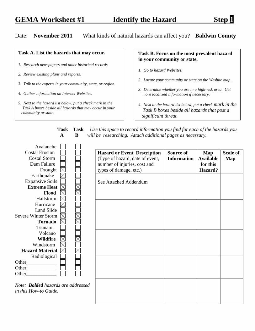
GEMA Worksheet #1 Identify the Hazard Step 1 Date: November 2011 What kinds of natural hazards can affect you? Baldwin County Task Task Use this space to record information you find for each of the hazards you A B will be researching. Attach additional pages as necessary. Avalanche Costal Erosion Costal Storm Dam Failure Drought Earthquake Expansive Soils Extreme Heat Flood Hailstorm Hurricane Land Slide Severe Winter Storm Tornado Tsunami Volcano Wildfire Windstorm Hazard Material Radiological Other____________ Other____________ Other____________ Note: Bolded hazards are addressed in this How-to Guide.
Hazard or Event Description (Type of hazard, date of event, number of injuries, cost and types of damage, etc.)
Source of Information
Map Available for this Hazard?
Scale of Map
See Attached Addendum
Task A. List the hazards that may occur. 1. Research newspapers and other historical records 2. Review existing plans and reports. 3. Talk to the experts in your community, state, or region. 4. Gather information on Internet Websites. 5. Next to the hazard list below, put a check mark in the Task A boxes beside all hazards that may occur in your community or state.
Task B. Focus on the most prevalent hazard in your community or state. 1. Go to hazard Websites. 2. Locate your community or state on the Wesbite map. 3. Determine whether you are in a high-risk area. Get more localized information if necessary. 4. Next to the hazard list below, put a check mark in the Task B boxes beside all hazards that post a significant threat.

1 of 4
Type Magnitude Deaths Injuries Property Damage Crop Damage07/08/58 Tstm Wind 0 kts. 0 0 -$ -$ NCDC NO N/A07/08/58 Tstm Wind 0 kts. 0 0 -$ -$ NCDC NO N/A02/24/61 Tornado F2 0 0 25,000$ -$ NCDC NO N/A05/27/63 Tstm Wind 0 kts. 0 0 -$ -$ NCDC NO N/A12/25/64 Tornado F3 0 0 2,500,000$ -$ NCDC NO N/A12/25/64 Tstm Wind 0 kts. 0 0 -$ -$ NCDC NO N/A07/23/67 Tornado F1 0 0 3,000$ -$ NCDC NO N/A03/21/74 Tstm Wind 0 kts. 0 0 -$ -$ NCDC NO N/A06/29/77 Tstm Wind 0 kts. 0 0 -$ -$ NCDC NO N/A07/31/77 Tstm Wind 0 kts. 0 0 -$ -$ NCDC NO N/A08/14/80 Tstm Wind 0 kts. 0 0 -$ -$ NCDC NO N/A03/18/81 Tstm Wind 0 kts. 0 0 -$ -$ NCDC NO N/A04/23/83 Hail 1.75 in. 0 0 -$ -$ NCDC NO N/A04/23/83 Hail 1.75 in. 0 0 -$ -$ NCDC NO N/A07/25/84 Tstm Wind 0 kts. 0 0 -$ -$ NCDC NO N/A04/05/85 Tstm Wind 0 kts. 0 0 -$ -$ NCDC NO N/A07/19/86 Tstm Wind 0 kts. 0 0 -$ -$ NCDC NO N/A07/29/87 Tstm Wind 0 kts. 0 0 -$ -$ NCDC NO N/A04/23/88 Tstm Wind 0 kts. 0 0 -$ -$ NCDC NO N/A06/17/88 Hail 1.75 in. 0 0 -$ -$ NCDC NO N/A06/25/88 Tstm Wind 0 kts. 0 0 -$ -$ NCDC NO N/A04/04/89 Tstm Wind 0 kts. 0 0 -$ -$ NCDC NO N/A04/04/89 Hail 1.00 in. 0 0 -$ -$ NCDC NO N/A05/05/89 Hail 0.75 in. 0 0 -$ -$ NCDC NO N/A02/10/90 Tstm Wind 0 kts. 0 0 -$ -$ NCDC NO N/A07/10/90 Tstm Wind 0 kts. 0 0 -$ -$ NCDC NO N/A03/29/91 Tstm Wind 0 kts. 0 0 -$ -$ NCDC NO N/A04/09/91 Tstm Wind 0 kts. 0 0 -$ -$ NCDC NO N/A05/04/91 Tstm Wind 0 kts. 0 0 -$ -$ NCDC NO N/A05/05/91 Tstm Wind 0 kts. 0 0 -$ -$ NCDC NO N/A07/03/92 Tstm Wind 0 kts. 0 0 -$ -$ NCDC NO N/A02/12/93 Hail 1.75 in. 0 0 -$ -$ NCDC NO N/A02/12/93 Thunderstorm Winds 0 kts. 0 0 5,000$ -$ NCDC NO N/A03/22/93 Thunderstorm Winds 0 kts. 0 0 -$ -$ NCDC NO N/A03/31/93 Hail 1.00 in. 0 0 -$ -$ NCDC NO N/A08/03/93 Thunderstorm Winds 0 kts. 0 0 5,000$ -$ NCDC NO N/A06/13/94 Flash Flood N/A 0 0 500,000$ -$ NCDC NO N/A06/22/94 Hail 0.75 in. 0 0 -$ -$ NCDC NO N/A06/22/94 Thunderstorm Winds 0 kts. 0 0 5,000$ -$ NCDC NO N/A06/24/94 Thunderstorm Winds 0 kts. 0 0 50,000$ -$ NCDC NO N/A12/04/94 Thunderstorm Wind 0 kts. 0 0 1,000$ -$ NCDC NO N/A12/04/94 Thunderstorm Wind 0 kts. 0 0 5,000$ -$ NCDC NO N/A01/06/95 Thunderstorm Winds 0 kts. 0 0 50$ -$ NCDC NO N/A05/15/95 Thunderstorm Winds 0 kts. 0 0 200,000$ -$ NCDC NO N/A06/21/95 Thunderstorm Winds 0 kts. 0 0 500$ -$ NCDC NO N/A06/29/95 Lightning N/A 0 0 2,000$ -$ NCDC NO N/A10/04/95 Flash Flood N/A 0 0 -$ -$ NCDC NO N/A10/05/95 Thunderstorm Winds 0 kts. 8 7 75,000,000$ 50,000,000$ NCDC NO N/A02/03/96 Extreme Cold N/A 0 0 -$ -$ NCDC NO N/A03/17/96 Hail 0.75 in. 0 0 -$ -$ NCDC NO N/A06/14/96 Hail 0.75 in. 0 0 -$ -$ NCDC NO N/A09/21/96 Tstm Wind 0 kts. 0 0 -$ -$ NCDC NO N/A04/21/97 Hail 1.00 in. 0 0 -$ -$ NCDC NO N/A04/22/97 Hail 0.75 in. 0 0 -$ -$ NCDC NO N/A04/22/97 Tstm Wind 0 kts. 0 0 35,000$ 12,000$ NCDC NO N/A06/01/97 Unseasonably Cool N/A 0 0 -$ -$ NCDC NO N/A06/25/97 Tstm Wind 0 kts. 0 0 2,000$ -$ NCDC NO N/A07/27/97 Tstm Wind 0 kts. 0 0 2,000$ -$ NCDC NO N/A08/18/97 Tstm Wind 0 kts. 0 0 5,000$ -$ NCDC NO N/A09/01/97 Drought N/A 0 0 -$ 20,000,000$ NCDC NO N/A10/25/97 Tstm Wind 50 kts. 0 0 10,000$ -$ NCDC NO N/A12/24/97 Flood N/A 0 0 200,000$ -$ NCDC NO N/A
GEMA Worksheet #1 Addendum
Use this space to record information you find for each of the hazards you will be researching. Attach additional pages as necessary
Scale of Map
Map Available for this Hazard?
Source of Information
DateHazard Event Description

2 of 4
Type Magnitude Deaths Injuries Property Damage Crop Damage
GEMA Worksheet #1 Addendum
Use this space to record information you find for each of the hazards you will be researching. Attach additional pages as necessary
Scale of Map
Map Available for this Hazard?
Source of Information
DateHazard Event Description
02/04/98 Flood N/A 0 0 400,000$ -$ NCDC NO N/A03/08/98 Flood N/A 0 0 500,000$ -$ NCDC NO N/A04/21/98 Hail 0.75 in. 0 0 -$ -$ NCDC NO N/A04/21/98 Hail 1.00 in. 0 0 -$ -$ NCDC NO N/A04/22/98 Hail 0.75 in. 0 0 -$ -$ NCDC NO N/A07/20/98 Tstm Wind 0 kts. 0 0 2,000$ -$ NCDC NO N/A08/19/98 Tstm Wind 0 kts. 0 0 1,000$ -$ NCDC NO N/A05/01/99 Drought N/A 0 0 -$ -$ NCDC NO N/A06/04/99 Hail 1.75 in. 0 0 -$ -$ NCDC NO N/A06/04/99 Hail 1.00 in. 0 0 -$ -$ NCDC NO N/A06/29/99 Hail 0.75 in. 0 0 -$ -$ NCDC NO N/A06/30/99 Hail 0.75 in. 0 0 -$ -$ NCDC NO N/A07/20/99 Excessive Heat N/A 2 0 -$ -$ NCDC NO N/A08/01/99 Drought N/A 0 0 -$ -$ NCDC NO N/A08/01/99 Excessive Heat N/A 0 0 -$ -$ NCDC NO N/A08/17/99 Tstm Wind 0 kts. 0 0 1,000$ -$ NCDC NO N/A02/01/00 Drought N/A 0 0 -$ -$ NCDC NO N/A03/11/00 Tstm Wind 0 kts. 0 0 -$ -$ NCDC NO N/A04/01/00 Drought N/A 0 0 -$ -$ NCDC NO N/A04/09/00 Unseasonably Cold N/A 0 0 -$ -$ NCDC NO N/A05/01/00 Drought N/A 0 0 -$ -$ NCDC NO N/A06/01/00 Drought N/A 0 0 -$ 306,700,000$ NCDC NO N/A06/07/00 Unseasonably Cold N/A 0 0 -$ -$ NCDC NO N/A06/21/00 Tstm Wind 0 kts. 0 0 3,000$ -$ NCDC NO N/A07/01/00 Drought N/A 0 0 -$ -$ NCDC NO N/A07/11/00 Hail 0.88 in. 0 0 -$ -$ NCDC NO N/A07/30/00 Hail 0.75 in. 0 0 -$ -$ NCDC NO N/A07/30/00 Tstm Wind 0 kts. 0 0 10,000$ -$ NCDC NO N/A09/21/00 Urban/sml Stream Fld N/A 0 0 -$ -$ NCDC NO N/A09/22/00 High Wind 0 kts. 0 0 75,000$ -$ NCDC NO N/A10/01/00 Drought N/A 0 0 -$ -$ NCDC NO N/A10/08/00 Unseasonably Cold N/A 0 0 -$ -$ NCDC NO N/A12/01/00 Unseasonably Cold N/A 0 0 -$ -$ NCDC NO N/A01/19/01 Tstm Wind 0 kts. 0 0 5,000$ -$ NCDC NO N/A03/01/01 Extremely Wet N/A 0 0 -$ -$ NCDC NO N/A03/20/01 High Wind 0 kts. 0 0 1,500,000$ -$ NCDC NO N/A04/03/01 High Wind 0 kts. 0 0 30,000$ -$ NCDC NO N/A06/11/01 Tropical Storm N/A 0 0 -$ -$ NCDC NO N/A06/13/01 Urban/sml Stream Fld N/A 0 0 22,000$ -$ NCDC NO N/A07/03/01 Tstm Wind 0 kts. 0 0 1,000$ -$ NCDC NO N/A09/26/01 Unseasonably Cold N/A 0 0 -$ -$ NCDC NO N/A10/01/01 Very Dry N/A 0 0 -$ -$ NCDC NO N/A10/27/01 Unseasonably Cold N/A 0 0 -$ -$ NCDC NO N/A11/01/01 Unseasonably Warm N/A 0 0 -$ -$ NCDC NO N/A11/01/01 Drought N/A 0 0 -$ -$ NCDC NO N/A12/01/01 Unseasonably Warm N/A 0 0 -$ -$ NCDC NO N/A12/01/01 Very Dry N/A 0 0 -$ -$ NCDC NO N/A01/02/02 Heavy Snow N/A 0 0 -$ -$ NCDC NO N/A01/24/02 Unseasonably Warm N/A 0 0 -$ -$ NCDC NO N/A01/29/02 Fog N/A 0 0 -$ -$ NCDC NO N/A01/30/02 Fog N/A 0 0 -$ -$ NCDC NO N/A02/26/02 Extreme Cold N/A 0 0 -$ -$ NCDC NO N/A03/01/02 Unseasonably Cold N/A 0 0 -$ -$ NCDC NO N/A03/15/02 Unseasonably Warm N/A 0 0 -$ -$ NCDC NO N/A04/01/02 Dry N/A 0 0 -$ -$ NCDC NO N/A04/16/02 Unseasonably Warm N/A 0 0 -$ -$ NCDC NO N/A05/18/02 Unseasonably Cool N/A 0 0 -$ -$ NCDC NO N/A07/02/02 Tstm Wind 0 kts. 0 0 3,000$ -$ NCDC NO N/A08/01/02 Drought N/A 0 0 -$ -$ NCDC NO N/A09/03/02 Very Warm N/A 0 0 -$ -$ NCDC NO N/A09/14/02 Tropical Storm N/A 0 0 -$ -$ NCDC NO N/A09/26/02 Strong Wind 0 kts. 0 0 2,000$ -$ NCDC NO N/A
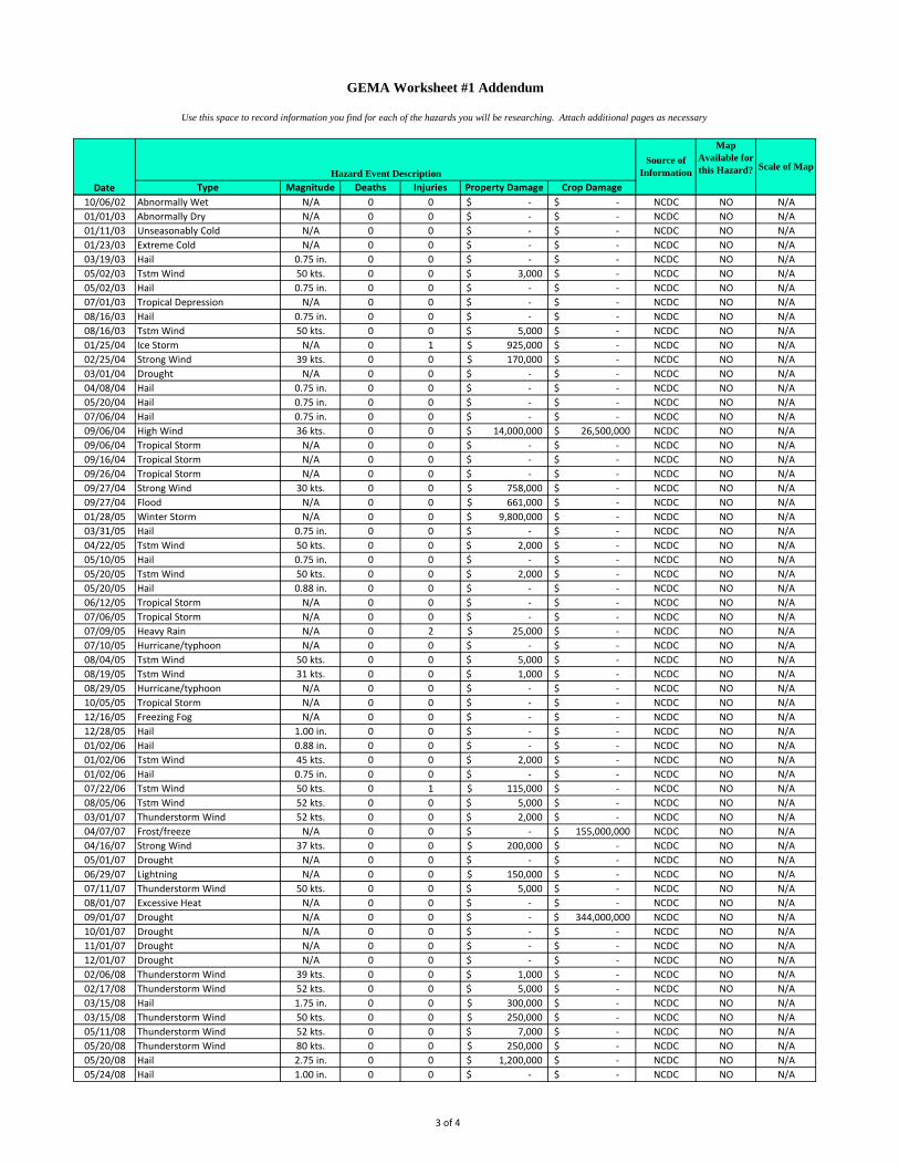
3 of 4
Type Magnitude Deaths Injuries Property Damage Crop Damage
GEMA Worksheet #1 Addendum
Use this space to record information you find for each of the hazards you will be researching. Attach additional pages as necessary
Scale of Map
Map Available for this Hazard?
Source of Information
DateHazard Event Description
10/06/02 Abnormally Wet N/A 0 0 -$ -$ NCDC NO N/A01/01/03 Abnormally Dry N/A 0 0 -$ -$ NCDC NO N/A01/11/03 Unseasonably Cold N/A 0 0 -$ -$ NCDC NO N/A01/23/03 Extreme Cold N/A 0 0 -$ -$ NCDC NO N/A03/19/03 Hail 0.75 in. 0 0 -$ -$ NCDC NO N/A05/02/03 Tstm Wind 50 kts. 0 0 3,000$ -$ NCDC NO N/A05/02/03 Hail 0.75 in. 0 0 -$ -$ NCDC NO N/A07/01/03 Tropical Depression N/A 0 0 -$ -$ NCDC NO N/A08/16/03 Hail 0.75 in. 0 0 -$ -$ NCDC NO N/A08/16/03 Tstm Wind 50 kts. 0 0 5,000$ -$ NCDC NO N/A01/25/04 Ice Storm N/A 0 1 925,000$ -$ NCDC NO N/A02/25/04 Strong Wind 39 kts. 0 0 170,000$ -$ NCDC NO N/A03/01/04 Drought N/A 0 0 -$ -$ NCDC NO N/A04/08/04 Hail 0.75 in. 0 0 -$ -$ NCDC NO N/A05/20/04 Hail 0.75 in. 0 0 -$ -$ NCDC NO N/A07/06/04 Hail 0.75 in. 0 0 -$ -$ NCDC NO N/A09/06/04 High Wind 36 kts. 0 0 14,000,000$ 26,500,000$ NCDC NO N/A09/06/04 Tropical Storm N/A 0 0 -$ -$ NCDC NO N/A09/16/04 Tropical Storm N/A 0 0 -$ -$ NCDC NO N/A09/26/04 Tropical Storm N/A 0 0 -$ -$ NCDC NO N/A09/27/04 Strong Wind 30 kts. 0 0 758,000$ -$ NCDC NO N/A09/27/04 Flood N/A 0 0 661,000$ -$ NCDC NO N/A01/28/05 Winter Storm N/A 0 0 9,800,000$ -$ NCDC NO N/A03/31/05 Hail 0.75 in. 0 0 -$ -$ NCDC NO N/A04/22/05 Tstm Wind 50 kts. 0 0 2,000$ -$ NCDC NO N/A05/10/05 Hail 0.75 in. 0 0 -$ -$ NCDC NO N/A05/20/05 Tstm Wind 50 kts. 0 0 2,000$ -$ NCDC NO N/A05/20/05 Hail 0.88 in. 0 0 -$ -$ NCDC NO N/A06/12/05 Tropical Storm N/A 0 0 -$ -$ NCDC NO N/A07/06/05 Tropical Storm N/A 0 0 -$ -$ NCDC NO N/A07/09/05 Heavy Rain N/A 0 2 25,000$ -$ NCDC NO N/A07/10/05 Hurricane/typhoon N/A 0 0 -$ -$ NCDC NO N/A08/04/05 Tstm Wind 50 kts. 0 0 5,000$ -$ NCDC NO N/A08/19/05 Tstm Wind 31 kts. 0 0 1,000$ -$ NCDC NO N/A08/29/05 Hurricane/typhoon N/A 0 0 -$ -$ NCDC NO N/A10/05/05 Tropical Storm N/A 0 0 -$ -$ NCDC NO N/A12/16/05 Freezing Fog N/A 0 0 -$ -$ NCDC NO N/A12/28/05 Hail 1.00 in. 0 0 -$ -$ NCDC NO N/A01/02/06 Hail 0.88 in. 0 0 -$ -$ NCDC NO N/A01/02/06 Tstm Wind 45 kts. 0 0 2,000$ -$ NCDC NO N/A01/02/06 Hail 0.75 in. 0 0 -$ -$ NCDC NO N/A07/22/06 Tstm Wind 50 kts. 0 1 115,000$ -$ NCDC NO N/A08/05/06 Tstm Wind 52 kts. 0 0 5,000$ -$ NCDC NO N/A03/01/07 Thunderstorm Wind 52 kts. 0 0 2,000$ -$ NCDC NO N/A04/07/07 Frost/freeze N/A 0 0 -$ 155,000,000$ NCDC NO N/A04/16/07 Strong Wind 37 kts. 0 0 200,000$ -$ NCDC NO N/A05/01/07 Drought N/A 0 0 -$ -$ NCDC NO N/A06/29/07 Lightning N/A 0 0 150,000$ -$ NCDC NO N/A07/11/07 Thunderstorm Wind 50 kts. 0 0 5,000$ -$ NCDC NO N/A08/01/07 Excessive Heat N/A 0 0 -$ -$ NCDC NO N/A09/01/07 Drought N/A 0 0 -$ 344,000,000$ NCDC NO N/A10/01/07 Drought N/A 0 0 -$ -$ NCDC NO N/A11/01/07 Drought N/A 0 0 -$ -$ NCDC NO N/A12/01/07 Drought N/A 0 0 -$ -$ NCDC NO N/A02/06/08 Thunderstorm Wind 39 kts. 0 0 1,000$ -$ NCDC NO N/A02/17/08 Thunderstorm Wind 52 kts. 0 0 5,000$ -$ NCDC NO N/A03/15/08 Hail 1.75 in. 0 0 300,000$ -$ NCDC NO N/A03/15/08 Thunderstorm Wind 50 kts. 0 0 250,000$ -$ NCDC NO N/A05/11/08 Thunderstorm Wind 52 kts. 0 0 7,000$ -$ NCDC NO N/A05/20/08 Thunderstorm Wind 80 kts. 0 0 250,000$ -$ NCDC NO N/A05/20/08 Hail 2.75 in. 0 0 1,200,000$ -$ NCDC NO N/A05/24/08 Hail 1.00 in. 0 0 -$ -$ NCDC NO N/A

4 of 4
Type Magnitude Deaths Injuries Property Damage Crop Damage
GEMA Worksheet #1 Addendum
Use this space to record information you find for each of the hazards you will be researching. Attach additional pages as necessary
Scale of Map
Map Available for this Hazard?
Source of Information
DateHazard Event Description
05/24/08 Thunderstorm Wind 52 kts. 0 0 5,000$ -$ NCDC NO N/A05/28/08 Thunderstorm Wind 35 kts. 0 0 1,000$ -$ NCDC NO N/A06/15/08 Hail 0.88 in. 0 0 -$ -$ NCDC NO N/A06/26/08 Hail 0.75 in. 0 0 -$ -$ NCDC NO N/A08/21/08 Tropical Storm N/A 0 0 1,900,000$ -$ NCDC NO N/A10/24/08 Strong Wind 39 kts. 0 0 2,000$ -$ NCDC NO N/A04/02/09 Flood N/A 0 0 2,000$ -$ NCDC NO N/A04/10/09 Hail 0.75 in. 0 0 -$ -$ NCDC NO N/A06/22/09 Thunderstorm Wind 54 kts. 0 0 4,000$ -$ NCDC NO N/A12/02/09 Strong Wind 35 kts. 0 0 1,000$ -$ NCDC NO N/A12/02/09 Strong Wind 39 kts. 0 0 5,000$ -$ NCDC NO N/A02/12/10 Heavy Snow N/A 0 0 -$ -$ NCDC NO N/A02/12/10 Winter Weather N/A 0 0 -$ -$ NCDC NO N/A05/03/10 Tornado F0 0 0 75,000$ -$ NCDC NO N/A07/26/10 Thunderstorm Wind 39 kts. 0 0 1,000$ -$ NCDC NO N/A12/25/10 Winter Weather N/A 0 0 -$ -$ NCDC NO N/A01/10/11 Heavy Snow N/A 0 0 -$ -$ NCDC NO N/A01/10/11 Ice Storm N/A 0 0 -$ -$ NCDC NO N/A01/10/11 Winter Storm N/A 0 0 -$ -$ NCDC NO N/A01/10/11 Winter Weather N/A 0 0 -$ -$ NCDC NO N/A02/10/11 Heavy Snow N/A 0 0 -$ -$ NCDC NO N/A02/10/11 Winter Weather N/A 0 0 -$ -$ NCDC NO N/A05/26/11 Hail 1.00 in. 0 0 -$ -$ NCDC NO N/A

1
GEMA Worksheet #2 Profile Hazard Events Step 2 County: Baldwin Date: November 2011 How Bad Can It Get? Task A. Obtain or create a base map. GEMA will be providing you with a base map, USGS topos and DOQQ as part of our deliverables to local government for the planning process. Additionally, we will be providing you with detailed hazard layer coverages. These data layers originate from state or nationwide coverage or datasets. Therefore, it is important for local government to assess what you already have at the local level. It is important for you at the local level to have an idea of what existing maps you have available for the planning process. Some important things to think about:
1) What maps do we already have in the county that would be relevant to the planning process?
2) Have other local plans used maps or mapping technology where there is specific data that is also needed in my local plan?
3) What digital maps do we have? 4) Do we have any Geographic Information System (GIS) data, map themes or layers or
databases here at the local level (or regional) that we can use? 5) If we do have any GIS data, where is it located at, and who is our local expert? 6) Are there any ongoing GIS or mapping initiatives at the local level in other planning or
mapping efforts? If so, what are they, and what are the timetables for completion? 7) Are there mapping needs that have been identified at the local level in the past? If so,
what are they and when were they identified? 8) Of the existing maps, GIS data and other digital mapping information, what confidence
do we have at the local level that it is accurate data? Please answer the above questions on a separate sheet of paper and attach to this worksheet. It is important to realize that those counties that already have GIS and digital mapping, (ie: parcel level data, GPS fire hydrants, etc) higher levels of spatial accuracy and detail will exist for some data layers at the local level. However, for this planning process, that level of detail will not be needed on all layers in the overall mapping and analysis. You can use existing maps from: • Road Maps • USGS topographic maps or Digital Orthophoto
Quarter Quads (DOQQ) • Topographic and/or planimetric maps from other
agencies • Aerial topographic and/or planimetric maps • Field Surveys • GIS software • CADD software • Digitized paper map
Title of Map Scale Date
GDOT Highway & Transportation Map
1: 24,000 2009
USGS Topographic Map 1:16,000 2009
100 Year Floodplain GIS Map
1:24,000 2006
FEMA Q3 Flood Data FIRM Map
1:24,000 2008
Georgia Mitigation Information System
1:25,000 2009

2
Task B. Obtain a hazard event profile.
Task C. Record your hazard event profile information.
Avalanche - N/A Coastal Storm / Coastal Erosion
1. Get a copy of your FIRM. ______X______ 2. Verify that the FIRM is up-to-date and complete.
________X______________ 3. Determine the annual rate of coastal erosion.
_____N/A___________ 4. Find your design wind speed. 5. _____200 mph__________________
1. Transfer the boundaries of your coastal storm hazard areas onto your base map.
2. Transfer the BFEs onto your base map. 3. Record the erosion rates on your base map:
________N/A_____________ 4. Record the design wind speed here and on your
base map: ___200 mph______
Dam Failure - N/A Drought – Entire Planning Area Earthquake
1. Go to the http://geohazards.cr.usgs.gov Website. 2. Locate your planning area on the map. 3. Determine your PGA.
1. Record your PGA: ____-1___________ 2. If you have more than one PGA print, download
or order your PGA map.
Expansive Soils - N/A Extreme Heat - N/A Flood
1. Get a copy of your FIRM. _____X______ 2. Verify the FIRM is up-to-date and complete.
_________X______________
1. Transfer the boundaries from your firm onto your base map (floodway, 100-yr flood, 500-yr flood).
2. Transfer the BFEs onto your base map.
Hailstorm - N/A Hurricane - N/A Land Subsidence - N/A Landslide
1. Map location of previous landslides. ________N/A__________________
2. Map the topography. ____________ 3. Map the geology. _______________ 4. Identify thee high-hazard areas on your map.
________________________
1. Mark the areas susceptible to landslides onto your base map.
Severe Winter Storm - Entire Planning Area Tornado
1. Find your design wind speed. _________200 mph______________________
1. Record your design wind speed: _200 mph__ 2. If you have more than one design wind speed, print, download or copy your design wind speed zones, copy the boundary of your design wind speed zones on your base map, then record the design wind speed zones on your base map.
Tsunami - N/A Wildfire
1. Map the fuel models located within the urban-wildland interface areas. ______X_________
2. Map the topography. _____X______________ 3. Determine your critical fire weather frequency.
___________X_______________________ 4. Determine your fire hazard severity. __X____
1. Draw the boundaries of your wildfire hazard areas onto your base map.
Other 1. Map the hazard. ______X____________
1. Record hazard event info on your base map.

Worksheet #4 Evaluate Alternative Mitigation Actions 1. Fill in the goal and its corresponding objective. Use a separate worksheet for each objective. The considerations under each criterion are suggested ones to use; you can revise these to reflect your own considerations (see Table 2-1). 2. Fill in the alternative actions that address the specific objectives the planning team identified in Worksheet #1. 3. Scoring: For each consideration, indicate a plus (+) for favorable, and a negative (-) for less favorable. When you complete the scoring; negatives will indicate gaps or shortcomings in the particular action, which can be noted in the Comments section. For considerations that do not apply, fill in N/A for not applicable. Only leave a blank if you do not know an answer. In this case, make a note in the Comments section of the “expert” or source to consult to help you evaluate the criterion.
Goal: Educate the public and public safety officials on hazards Objective: Provide educational opportunities to school children
Considerations → for
Alternative Actions
↓
Com
munity
Accepta
nce
Eff
ect
on S
egm
ent
of
Popula
tion
Technic
al
Feasib
ility
Long-t
erm
Solu
tion
Secondary
Impacts
Sta
ffin
g
Fundin
g A
llocate
d
Main
tenance /
Opera
tions
Political S
upport
Local C
ham
pio
n
Public S
upport
Sta
te A
uth
ority
Exis
ting L
ocal
Auth
ority
Pote
ntial Legal
Challenge
Benefit
of
Action
Cost
of
Action
Contr
ibute
s t
o
Econom
ic G
oals
Outs
ide F
undin
g
Required
Eff
ect
on L
and /
Wate
r
Eff
ect
on
Endangere
d
Specie
sE
ffect
on
HA
ZM
AT
/ W
aste
Sites
Consis
tent
with
Com
munity
Environm
enta
l
Goals
Consis
tent
With
Federa
l Law
s
Implement Master of Disaster curriculum into school system (+) (+) (+) (+) (+) (+) (+) (+) (+) (+) (+) (+) (+) (+) (+) (+) (+) (+) N/A N/A N/A N/A N/A
Utilize City of
Milledgeville’s Fire
Safety House for
Severe Weather
Training in Schools
(+) (+) (+) (+) (+) (+) (+) (+) (+) (+) (+) (+) (+) (+) (+) (+) (+) (+) N/A N/A N/A N/A N/A
A
(Administrative)
P
(Political)STAPLEE Criteria
S
(Social)
T
(Technical)
E
(Environmental)
L
(Legal)
E
(Economic)
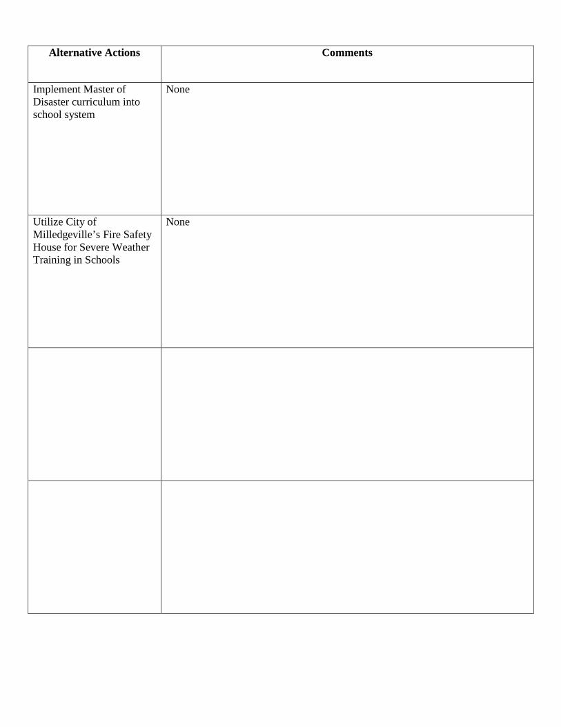
Alternative Actions Comments
Implement Master of Disaster curriculum into school system
None
Utilize City of Milledgeville’s Fire Safety House for Severe Weather Training in Schools
None

Worksheet #4 Evaluate Alternative Mitigation Actions 1. Fill in the goal and its corresponding objective. Use a separate worksheet for each objective. The considerations under each criterion are suggested ones to use; you can revise these to reflect your own considerations (see Table 2-1). 2. Fill in the alternative actions that address the specific objectives the planning team identified in Worksheet #1. 3. Scoring: For each consideration, indicate a plus (+) for favorable, and a negative (-) for less favorable. When you complete the scoring; negatives will indicate gaps or shortcomings in the particular action, which can be noted in the Comments section. For considerations that do not apply, fill in N/A for not applicable. Only leave a blank if you do not know an answer. In this case, make a note in the Comments section of the “expert” or source to consult to help you evaluate the criterion.
Goal: Educate the public and public safety officials on hazards Objective: Provide educational information to the general public
Considerations → for
Alternative Actions
↓
Com
munity
Accepta
nce
Eff
ect
on S
egm
ent
of
Popula
tion
Technic
al
Feasib
ility
Long-t
erm
Solu
tion
Secondary
Impacts
Sta
ffin
g
Fundin
g A
llocate
d
Main
tenance /
Opera
tions
Political S
upport
Local C
ham
pio
n
Public S
upport
Sta
te A
uth
ority
Exis
ting L
ocal
Auth
ority
Pote
ntial Legal
Challenge
Benefit
of
Action
Cost
of
Action
Contr
ibute
s t
o
Econom
ic G
oals
Outs
ide F
undin
g
Required
Eff
ect
on L
and /
Wate
r
Eff
ect
on
Endangere
d
Specie
sE
ffect
on
HA
ZM
AT
/ W
aste
Sites
Consis
tent
with
Com
munity
Environm
enta
l
Goals
Consis
tent
With
Federa
l Law
s
Educate the public through GEMA/FEMA/Red Cross brochures
(+) (+) (+) (+) (+) (+) (+) (+) (+) (+) (+) (+) (+) (+) (+) (+) (+) (+) N/A N/A N/A N/A N/A
Distribute 30 weather radios within the community
(+) (+) (+) (+) (+) (+) (+) (+) (+) (+) (+) (+) (+) (+) (+) (+) (+) (+) N/A N/A N/A N/A N/A
Distribute FEMA brochures on safe rooms through local government offices
(+) (+) (+) (+) (+) (+) (+) (+) (+) (+) (+) (+) (+) (+) (+) (+) (+) (+) N/A N/A N/A N/A N/A
A
(Administrative)
P
(Political)STAPLEE Criteria
S
(Social)
T
(Technical)
E
(Environmental)
L
(Legal)
E
(Economic)

Alternative Actions Comments
Educate the public through GEMA/FEMA/Red Cross brochures
None
Distribute 30 weather radios within the community
None
Distribute FEMA brochures on safe rooms through local government offices
None
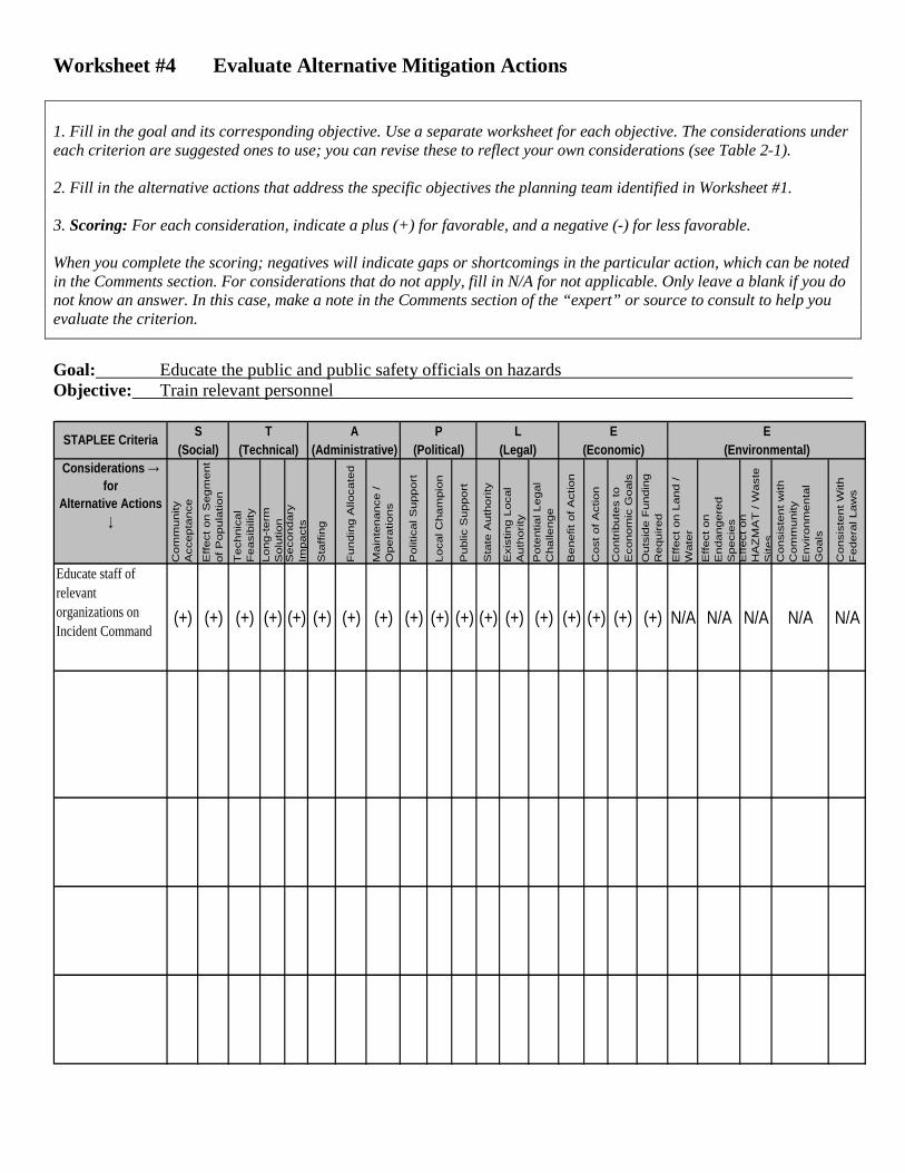
Worksheet #4 Evaluate Alternative Mitigation Actions 1. Fill in the goal and its corresponding objective. Use a separate worksheet for each objective. The considerations under each criterion are suggested ones to use; you can revise these to reflect your own considerations (see Table 2-1). 2. Fill in the alternative actions that address the specific objectives the planning team identified in Worksheet #1. 3. Scoring: For each consideration, indicate a plus (+) for favorable, and a negative (-) for less favorable. When you complete the scoring; negatives will indicate gaps or shortcomings in the particular action, which can be noted in the Comments section. For considerations that do not apply, fill in N/A for not applicable. Only leave a blank if you do not know an answer. In this case, make a note in the Comments section of the “expert” or source to consult to help you evaluate the criterion.
Goal: Educate the public and public safety officials on hazards Objective: Train relevant personnel
Considerations → for
Alternative Actions
↓
Com
munity
Accepta
nce
Eff
ect
on S
egm
ent
of
Popula
tion
Technic
al
Feasib
ility
Long-t
erm
Solu
tion
Secondary
Impacts
Sta
ffin
g
Fundin
g A
llocate
d
Main
tenance /
Opera
tions
Political S
upport
Local C
ham
pio
n
Public S
upport
Sta
te A
uth
ority
Exis
ting L
ocal
Auth
ority
Pote
ntial Legal
Challenge
Benefit
of
Action
Cost
of
Action
Contr
ibute
s t
o
Econom
ic G
oals
Outs
ide F
undin
g
Required
Eff
ect
on L
and /
Wate
r
Eff
ect
on
Endangere
d
Specie
sE
ffect
on
HA
ZM
AT
/ W
aste
Sites
Consis
tent
with
Com
munity
Environm
enta
l
Goals
Consis
tent
With
Federa
l Law
s
Educate staff of relevant organizations on Incident Command
(+) (+) (+) (+) (+) (+) (+) (+) (+) (+) (+) (+) (+) (+) (+) (+) (+) (+) N/A N/A N/A N/A N/A
A
(Administrative)
P
(Political)STAPLEE Criteria
S
(Social)
T
(Technical)
E
(Environmental)
L
(Legal)
E
(Economic)

Alternative Actions Comments
Educate staff of relevant organizations on Incident Command
None
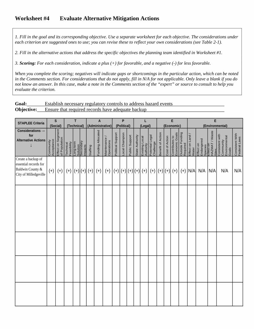
Worksheet #4 Evaluate Alternative Mitigation Actions 1. Fill in the goal and its corresponding objective. Use a separate worksheet for each objective. The considerations under each criterion are suggested ones to use; you can revise these to reflect your own considerations (see Table 2-1). 2. Fill in the alternative actions that address the specific objectives the planning team identified in Worksheet #1. 3. Scoring: For each consideration, indicate a plus (+) for favorable, and a negative (-) for less favorable. When you complete the scoring; negatives will indicate gaps or shortcomings in the particular action, which can be noted in the Comments section. For considerations that do not apply, fill in N/A for not applicable. Only leave a blank if you do not know an answer. In this case, make a note in the Comments section of the “expert” or source to consult to help you evaluate the criterion.
Goal: Establish necessary regulatory controls to address hazard events Objective: Ensure that required records have adequate backup
Considerations → for
Alternative Actions
↓
Com
munity
Accepta
nce
Eff
ect
on S
egm
ent
of
Popula
tion
Technic
al
Feasib
ility
Long-t
erm
Solu
tion
Secondary
Impacts
Sta
ffin
g
Fundin
g A
llocate
d
Main
tenance /
Opera
tions
Political S
upport
Local C
ham
pio
n
Public S
upport
Sta
te A
uth
ority
Exis
ting L
ocal
Auth
ority
Pote
ntial Legal
Challenge
Benefit
of
Action
Cost
of
Action
Contr
ibute
s t
o
Econom
ic G
oals
Outs
ide F
undin
g
Required
Eff
ect
on L
and /
Wate
r
Eff
ect
on
Endangere
d
Specie
sE
ffect
on
HA
ZM
AT
/ W
aste
Sites
Consis
tent
with
Com
munity
Environm
enta
l
Goals
Consis
tent
With
Federa
l Law
s
Create a backup of essential records for Baldwin County & City of Milledgeville
(+) (+) (+) (+) (+) (+) (+) (+) (+) (+) (+) (+) (+) (+) (+) (+) (+) (+) N/A N/A N/A N/A N/A
A
(Administrative)
P
(Political)STAPLEE Criteria
S
(Social)
T
(Technical)
E
(Environmental)
L
(Legal)
E
(Economic)

Alternative Actions Comments
Create a backup of essential records for Baldwin County & City of Milledgeville
None

Worksheet #4 Evaluate Alternative Mitigation Actions 1. Fill in the goal and its corresponding objective. Use a separate worksheet for each objective. The considerations under each criterion are suggested ones to use; you can revise these to reflect your own considerations (see Table 2-1). 2. Fill in the alternative actions that address the specific objectives the planning team identified in Worksheet #1. 3. Scoring: For each consideration, indicate a plus (+) for favorable, and a negative (-) for less favorable. When you complete the scoring; negatives will indicate gaps or shortcomings in the particular action, which can be noted in the Comments section. For considerations that do not apply, fill in N/A for not applicable. Only leave a blank if you do not know an answer. In this case, make a note in the Comments section of the “expert” or source to consult to help you evaluate the criterion.
Goal: Establish necessary regulatory controls to address hazard events Objective: Develop or review local ordinances relevant to hazard mitigation
Considerations → for
Alternative Actions
↓
Com
munity
Accepta
nce
Eff
ect
on S
egm
ent
of
Popula
tion
Technic
al
Feasib
ility
Long-t
erm
Solu
tion
Secondary
Impacts
Sta
ffin
g
Fundin
g A
llocate
d
Main
tenance /
Opera
tions
Political S
upport
Local C
ham
pio
n
Public S
upport
Sta
te A
uth
ority
Exis
ting L
ocal
Auth
ority
Pote
ntial Legal
Challenge
Benefit
of
Action
Cost
of
Action
Contr
ibute
s t
o
Econom
ic G
oals
Outs
ide F
undin
g
Required
Eff
ect
on L
and /
Wate
r
Eff
ect
on
Endangere
d
Specie
sE
ffect
on
HA
ZM
AT
/ W
aste
Sites
Consis
tent
with
Com
munity
Environm
enta
l
Goals
Consis
tent
With
Federa
l Law
s
Update local ordinances regarding construction in flood zones
(+) (+) (+) (+) (+) (+) (+) (+) (+) (+) (+) (+) (+) (+) (+) (+) (+) (+) (+) (+) N/A (+) (+)
A
(Administrative)
P
(Political)STAPLEE Criteria
S
(Social)
T
(Technical)
E
(Environmental)
L
(Legal)
E
(Economic)

Alternative Actions Comments
Update local ordinances regarding construction in flood zones
None

Worksheet #4 Evaluate Alternative Mitigation Actions 1. Fill in the goal and its corresponding objective. Use a separate worksheet for each objective. The considerations under each criterion are suggested ones to use; you can revise these to reflect your own considerations (see Table 2-1). 2. Fill in the alternative actions that address the specific objectives the planning team identified in Worksheet #1. 3. Scoring: For each consideration, indicate a plus (+) for favorable, and a negative (-) for less favorable. When you complete the scoring; negatives will indicate gaps or shortcomings in the particular action, which can be noted in the Comments section. For considerations that do not apply, fill in N/A for not applicable. Only leave a blank if you do not know an answer. In this case, make a note in the Comments section of the “expert” or source to consult to help you evaluate the criterion.
Goal: Establish necessary regulatory controls to address hazard events Objective: Develop and enact local agreements relevant to hazard mitigation
Considerations → for
Alternative Actions
↓
Com
munity
Accepta
nce
Eff
ect
on S
egm
ent
of
Popula
tion
Technic
al
Feasib
ility
Long-t
erm
Solu
tion
Secondary
Impacts
Sta
ffin
g
Fundin
g A
llocate
d
Main
tenance /
Opera
tions
Political S
upport
Local C
ham
pio
n
Public S
upport
Sta
te A
uth
ority
Exis
ting L
ocal
Auth
ority
Pote
ntial Legal
Challenge
Benefit
of
Action
Cost
of
Action
Contr
ibute
s t
o
Econom
ic G
oals
Outs
ide F
undin
g
Required
Eff
ect
on L
and /
Wate
r
Eff
ect
on
Endangere
d
Specie
sE
ffect
on
HA
ZM
AT
/ W
aste
Sites
Consis
tent
with
Com
munity
Environm
enta
l
Goals
Consis
tent
With
Federa
l Law
s
Develop agreements with hotels and restaurants for Georgia Power and Red Cross
(+) (+) (+) (+) (+) (+) (+) (+) (+) (+) (+) (+) (+) (+) (+) (+) (+) (+) N/A N/A N/A N/A N/A
A
(Administrative)
P
(Political)STAPLEE Criteria
S
(Social)
T
(Technical)
E
(Environmental)
L
(Legal)
E
(Economic)

Alternative Actions Comments
Develop agreements with hotels and restaurants for Georgia Power and Red Cross
None

Worksheet #4 Evaluate Alternative Mitigation Actions 1. Fill in the goal and its corresponding objective. Use a separate worksheet for each objective. The considerations under each criterion are suggested ones to use; you can revise these to reflect your own considerations (see Table 2-1). 2. Fill in the alternative actions that address the specific objectives the planning team identified in Worksheet #1. 3. Scoring: For each consideration, indicate a plus (+) for favorable, and a negative (-) for less favorable. When you complete the scoring; negatives will indicate gaps or shortcomings in the particular action, which can be noted in the Comments section. For considerations that do not apply, fill in N/A for not applicable. Only leave a blank if you do not know an answer. In this case, make a note in the Comments section of the “expert” or source to consult to help you evaluate the criterion.
Goal: Ensure a proper response in the event of a hazard Objective: Ensure coordination with other entities to ensure adequate response
Considerations → for
Alternative Actions
↓
Com
munity
Accepta
nce
Eff
ect
on S
egm
ent
of
Popula
tion
Technic
al
Feasib
ility
Long-t
erm
Solu
tion
Secondary
Impacts
Sta
ffin
g
Fundin
g A
llocate
d
Main
tenance /
Opera
tions
Political S
upport
Local C
ham
pio
n
Public S
upport
Sta
te A
uth
ority
Exis
ting L
ocal
Auth
ority
Pote
ntial Legal
Challenge
Benefit
of
Action
Cost
of
Action
Contr
ibute
s t
o
Econom
ic G
oals
Outs
ide F
undin
g
Required
Eff
ect
on L
and /
Wate
r
Eff
ect
on
Endangere
d
Specie
sE
ffect
on
HA
ZM
AT
/ W
aste
Sites
Consis
tent
with
Com
munity
Environm
enta
l
Goals
Consis
tent
With
Federa
l Law
s
Update and complete essential community contact personnel list for Georgia Power
(+) (+) (+) (+) (+) (+) (+) (+) (+) (+) (+) (+) (+) (+) (+) (+) (+) (+) N/A N/A N/A N/A N/A
Coordinate between Georgia Power and EMA to identify priority areas around emergency shelters (+) (+) (+) (+) (+) (+) (+) (+) (+) (+) (+) (+) (+) (+) (+) (+) (+) (+) N/A N/A N/A N/A N/A
Conduct intra-agency drills on an annual basis (+) (+) (+) (+) (+) (+) (+) (+) (+) (+) (+) (+) (+) (+) (+) (+) (+) (+) N/A N/A N/A N/A N/A
Develop and regularly update a Community Wildfire Protection Plan
(+) (+) (+) (+) (+) (+) (+) (+) (+) (+) (+) (+) (+) (+) (+) (+) (+) (+) N/A N/A N/A N/A N/A
A
(Administrative)
P
(Political)STAPLEE Criteria
S
(Social)
T
(Technical)
E
(Environmental)
L
(Legal)
E
(Economic)
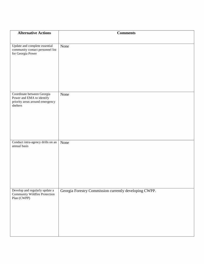
Alternative Actions Comments
Update and complete essential community contact personnel list for Georgia Power
None
Coordinate between Georgia Power and EMA to identify priority areas around emergency shelters
None
Conduct intra-agency drills on an annual basis
None
Develop and regularly update a Community Wildfire Protection Plan (CWPP)
Georgia Forestry Commission currently developing CWPP.

Worksheet #4 Evaluate Alternative Mitigation Actions 1. Fill in the goal and its corresponding objective. Use a separate worksheet for each objective. The considerations under each criterion are suggested ones to use; you can revise these to reflect your own considerations (see Table 2-1). 2. Fill in the alternative actions that address the specific objectives the planning team identified in Worksheet #1. 3. Scoring: For each consideration, indicate a plus (+) for favorable, and a negative (-) for less favorable. When you complete the scoring; negatives will indicate gaps or shortcomings in the particular action, which can be noted in the Comments section. For considerations that do not apply, fill in N/A for not applicable. Only leave a blank if you do not know an answer. In this case, make a note in the Comments section of the “expert” or source to consult to help you evaluate the criterion.
Goal: Ensure a proper response in the event of a hazard Objective: Construct or establish emergency shelters
Considerations → for
Alternative Actions
↓
Com
munity
Accepta
nce
Eff
ect
on S
egm
ent
of
Popula
tion
Technic
al
Feasib
ility
Long-t
erm
Solu
tion
Secondary
Impacts
Sta
ffin
g
Fundin
g A
llocate
d
Main
tenance /
Opera
tions
Political S
upport
Local C
ham
pio
n
Public S
upport
Sta
te A
uth
ority
Exis
ting L
ocal
Auth
ority
Pote
ntial Legal
Challenge
Benefit
of
Action
Cost
of
Action
Contr
ibute
s t
o
Econom
ic G
oals
Outs
ide F
undin
g
Required
Eff
ect
on L
and /
Wate
r
Eff
ect
on
Endangere
d
Specie
sE
ffect
on
HA
ZM
AT
/ W
aste
Sites
Consis
tent
with
Com
munity
Environm
enta
l
Goals
Consis
tent
With
Federa
l Law
s
Establish National Guard Armory as an emergency shelter (+) (+) (+) (+) (+) (+) (+) (+) (+) (+) (+) (+) (+) (+) (+) (+) (+) (+) N/A N/A N/A N/A N/A
Develop special needs shelter
(+) (+) (+) (+) (+) (+) (+) (+) (+) (+) (+) (+) (+) (+) (+) (+) (+) (+) N/A N/A N/A N/A N/A
Construct Community Safe Rooms (+) (+) (+) (+) (+) (+) (-) (+) (+) (+) (+) (+) (+) (+) (+) (-) (+) (-) N/A N/A N/A N/A N/A
A
(Administrative)
P
(Political)STAPLEE Criteria
S
(Social)
T
(Technical)
E
(Environmental)
L
(Legal)
E
(Economic)

Alternative Actions Comments
Establish National Guard Armory as an emergency shelter
None
Develop special needs shelter None
Construct Community Safe Rooms
No funding currently allocation. Will likely require outside grant funding.

Worksheet #4 Evaluate Alternative Mitigation Actions 1. Fill in the goal and its corresponding objective. Use a separate worksheet for each objective. The considerations under each criterion are suggested ones to use; you can revise these to reflect your own considerations (see Table 2-1). 2. Fill in the alternative actions that address the specific objectives the planning team identified in Worksheet #1. 3. Scoring: For each consideration, indicate a plus (+) for favorable, and a negative (-) for less favorable. When you complete the scoring; negatives will indicate gaps or shortcomings in the particular action, which can be noted in the Comments section. For considerations that do not apply, fill in N/A for not applicable. Only leave a blank if you do not know an answer. In this case, make a note in the Comments section of the “expert” or source to consult to help you evaluate the criterion.
Goal: Ensure a proper response in the event of a hazard Objective: Notify county residents of impending disasters or other hazard events
Considerations → for
Alternative Actions
↓
Com
munity
Accepta
nce
Eff
ect
on S
egm
ent
of
Popula
tion
Technic
al
Feasib
ility
Long-t
erm
Solu
tion
Secondary
Impacts
Sta
ffin
g
Fundin
g A
llocate
d
Main
tenance /
Opera
tions
Political S
upport
Local C
ham
pio
n
Public S
upport
Sta
te A
uth
ority
Exis
ting L
ocal
Auth
ority
Pote
ntial Legal
Challenge
Benefit
of
Action
Cost
of
Action
Contr
ibute
s t
o
Econom
ic G
oals
Outs
ide F
undin
g
Required
Eff
ect
on L
and /
Wate
r
Eff
ect
on
Endangere
d
Specie
sE
ffect
on
HA
ZM
AT
/ W
aste
Sites
Consis
tent
with
Com
munity
Environm
enta
l
Goals
Consis
tent
With
Federa
l Law
s
Establish County-Wide Emergency Alert/Notification System
(+) (+) (+) (+) (+) (+) (-) (-) (+) (+) (+) (+) (+) (+) (+) (-) (+) (-) N/A N/A N/A N/A (+)
A
(Administrative)
P
(Political)STAPLEE Criteria
S
(Social)
T
(Technical)
E
(Environmental)
L
(Legal)
E
(Economic)

Alternative Actions Comments
Establish County-Wide Emergency Alert/Notification System
Will likely require outside funding from grants or other sources.

Worksheet #4 Evaluate Alternative Mitigation Actions 1. Fill in the goal and its corresponding objective. Use a separate worksheet for each objective. The considerations under each criterion are suggested ones to use; you can revise these to reflect your own considerations (see Table 2-1). 2. Fill in the alternative actions that address the specific objectives the planning team identified in Worksheet #1. 3. Scoring: For each consideration, indicate a plus (+) for favorable, and a negative (-) for less favorable. When you complete the scoring; negatives will indicate gaps or shortcomings in the particular action, which can be noted in the Comments section. For considerations that do not apply, fill in N/A for not applicable. Only leave a blank if you do not know an answer. In this case, make a note in the Comments section of the “expert” or source to consult to help you evaluate the criterion.
Goal: Ensure a proper response in the event of a hazard Objective: Develop adequate Emergency Operations Center and back-up
Considerations → for
Alternative Actions
↓
Com
munity
Accepta
nce
Eff
ect
on S
egm
ent
of
Popula
tion
Technic
al
Feasib
ility
Long-t
erm
Solu
tion
Secondary
Impacts
Sta
ffin
g
Fundin
g A
llocate
d
Main
tenance /
Opera
tions
Political S
upport
Local C
ham
pio
n
Public S
upport
Sta
te A
uth
ority
Exis
ting L
ocal
Auth
ority
Pote
ntial Legal
Challenge
Benefit
of
Action
Cost
of
Action
Contr
ibute
s t
o
Econom
ic G
oals
Outs
ide F
undin
g
Required
Eff
ect
on L
and /
Wate
r
Eff
ect
on
Endangere
d
Specie
sE
ffect
on
HA
ZM
AT
/ W
aste
Sites
Consis
tent
with
Com
munity
Environm
enta
l
Goals
Consis
tent
With
Federa
l Law
s
Set up EM-Net in "City" dispatch office
(+) (+) (+) (+) (+) (+) (+) (+) (+) (+) (+) (+) (+) (+) (+) (+) (+) (+) N/A N/A N/A N/A N/A
Upgrade the Baldwin County Emergency Operations Center (EOC) and make it more secure (+) (+) (+) (+) (+) (+) (+) (+) (+) (+) (+) (+) (+) (+) (+) (+) (+) (+) N/A N/A N/A N/A N/A
Develop a backup EOC to serve Baldwin County (+) (+) (+) (+) (+) (+) (+) (+) (+) (+) (+) (+) (+) (+) (+) (+) (+) (+) N/A N/A N/A N/A N/A
A
(Administrative)
P
(Political)STAPLEE Criteria
S
(Social)
T
(Technical)
E
(Environmental)
L
(Legal)
E
(Economic)

Alternative Actions Comments
Set up EM-Net in "City" dispatch office
None
Upgrade the Baldwin County Emergency Operations Center (EOC) and make it more secure
None
Develop a backup EOC to serve Baldwin County
None

Worksheet #4 Evaluate Alternative Mitigation Actions 1. Fill in the goal and its corresponding objective. Use a separate worksheet for each objective. The considerations under each criterion are suggested ones to use; you can revise these to reflect your own considerations (see Table 2-1). 2. Fill in the alternative actions that address the specific objectives the planning team identified in Worksheet #1. 3. Scoring: For each consideration, indicate a plus (+) for favorable, and a negative (-) for less favorable. When you complete the scoring; negatives will indicate gaps or shortcomings in the particular action, which can be noted in the Comments section. For considerations that do not apply, fill in N/A for not applicable. Only leave a blank if you do not know an answer. In this case, make a note in the Comments section of the “expert” or source to consult to help you evaluate the criterion.
Goal: Purchase necessary equipment and/or supplies Objective: Utilize technology in the hazard mitigation process
Considerations → for
Alternative Actions
↓
Com
munity
Accepta
nce
Eff
ect
on S
egm
ent
of
Popula
tion
Technic
al
Feasib
ility
Long-t
erm
Solu
tion
Secondary
Impacts
Sta
ffin
g
Fundin
g A
llocate
d
Main
tenance /
Opera
tions
Political S
upport
Local C
ham
pio
n
Public S
upport
Sta
te A
uth
ority
Exis
ting L
ocal
Auth
ority
Pote
ntial Legal
Challenge
Benefit
of
Action
Cost
of
Action
Contr
ibute
s t
o
Econom
ic G
oals
Outs
ide F
undin
g
Required
Eff
ect
on L
and /
Wate
r
Eff
ect
on
Endangere
d
Specie
sE
ffect
on
HA
ZM
AT
/ W
aste
Sites
Consis
tent
with
Com
munity
Environm
enta
l
Goals
Consis
tent
With
Federa
l Law
s
Implement Phase II of E-911 system
(+) (+) (+) (+) (+) (+) (+) (+) (+) (+) (+) (+) (+) (+) (+) (+) (+) (+) N/A N/A N/A N/A N/A
Evaluate feasibility of implementing Reverse 911
(+) (+) (+) (+) (+) (+) (+) (+) (+) (+) (+) (+) (+) (+) (+) (+) (+) (+) N/A N/A N/A N/A N/A
E
(Environmental)
L
(Legal)
E
(Economic)
A
(Administrative)
P
(Political)STAPLEE Criteria
S
(Social)
T
(Technical)

Alternative Actions Comments
Implement Phase II of E-911 system
None
Evaluate feasibility of implementing Reverse 911
None

Worksheet #4 Evaluate Alternative Mitigation Actions 1. Fill in the goal and its corresponding objective. Use a separate worksheet for each objective. The considerations under each criterion are suggested ones to use; you can revise these to reflect your own considerations (see Table 2-1). 2. Fill in the alternative actions that address the specific objectives the planning team identified in Worksheet #1. 3. Scoring: For each consideration, indicate a plus (+) for favorable, and a negative (-) for less favorable. When you complete the scoring; negatives will indicate gaps or shortcomings in the particular action, which can be noted in the Comments section. For considerations that do not apply, fill in N/A for not applicable. Only leave a blank if you do not know an answer. In this case, make a note in the Comments section of the “expert” or source to consult to help you evaluate the criterion.
Goal: Purchase necessary equipment and/or supplies Objective: Obtain necessary equipment and gear for addressing hazard events
Considerations → for
Alternative Actions
↓
Com
munity
Accepta
nce
Eff
ect
on S
egm
ent
of
Popula
tion
Technic
al
Feasib
ility
Long-t
erm
Solu
tion
Secondary
Impacts
Sta
ffin
g
Fundin
g A
llocate
d
Main
tenance /
Opera
tions
Political S
upport
Local C
ham
pio
n
Public S
upport
Sta
te A
uth
ority
Exis
ting L
ocal
Auth
ority
Pote
ntial Legal
Challenge
Benefit
of
Action
Cost
of
Action
Contr
ibute
s t
o
Econom
ic G
oals
Outs
ide F
undin
g
Required
Eff
ect
on L
and /
Wate
r
Eff
ect
on
Endangere
d
Specie
sE
ffect
on
HA
ZM
AT
/ W
aste
Sites
Consis
tent
with
Com
munity
Environm
enta
l
Goals
Consis
tent
With
Federa
l Law
s
Obtain additional equipment for hazardous material team
(+) (+) (+) (+) (+) (+) (-) (+) (+) (+) (+) (+) (+) (+) (+) (-) (+) (-) N/A N/A N/A N/A N/A
Obtain additional gear for Law Enforcement for civil disturbances
(+) (+) (+) (+) (+) (+) (-) (+) (+) (+) (+) (+) (+) (+) (+) (-) (+) (-) N/A N/A N/A N/A N/A
E
(Environmental)
L
(Legal)
E
(Economic)
A
(Administrative)
P
(Political)STAPLEE Criteria
S
(Social)
T
(Technical)

Alternative Actions Comments
Obtain additional equipment for hazardous material team
Will likely require additional funding from grants or other sources.
Obtain additional gear for Law Enforcement for civil disturbances
Will likely require additional funding from grants or other sources.

Worksheet #4 Evaluate Alternative Mitigation Actions 1. Fill in the goal and its corresponding objective. Use a separate worksheet for each objective. The considerations under each criterion are suggested ones to use; you can revise these to reflect your own considerations (see Table 2-1). 2. Fill in the alternative actions that address the specific objectives the planning team identified in Worksheet #1. 3. Scoring: For each consideration, indicate a plus (+) for favorable, and a negative (-) for less favorable. When you complete the scoring; negatives will indicate gaps or shortcomings in the particular action, which can be noted in the Comments section. For considerations that do not apply, fill in N/A for not applicable. Only leave a blank if you do not know an answer. In this case, make a note in the Comments section of the “expert” or source to consult to help you evaluate the criterion.
Goal: Provide for power supplies to critical facilities Objective: Obtain backup generators for critical facilities
Considerations → for
Alternative Actions
↓
Com
munity
Accepta
nce
Eff
ect
on S
egm
ent
of
Popula
tion
Technic
al
Feasib
ility
Long-t
erm
Solu
tion
Secondary
Impacts
Sta
ffin
g
Fundin
g A
llocate
d
Main
tenance /
Opera
tions
Political S
upport
Local C
ham
pio
n
Public S
upport
Sta
te A
uth
ority
Exis
ting L
ocal
Auth
ority
Pote
ntial Legal
Challenge
Benefit
of
Action
Cost
of
Action
Contr
ibute
s t
o
Econom
ic G
oals
Outs
ide F
undin
g
Required
Eff
ect
on L
and /
Wate
r
Eff
ect
on
Endangere
d
Specie
sE
ffect
on
HA
ZM
AT
/ W
aste
Sites
Consis
tent
with
Com
munity
Environm
enta
l
Goals
Consis
tent
With
Federa
l Law
s
Acquire heating/cooling generator for High School gymnasium
(+) (+) (+) (+) (+) (+) (-) (+) (+) (+) (+) (+) (+) (+) (+) (-) (+) (+) N/A N/A N/A N/A N/A
Acquire heating/cooling generator for three dialysis centers
(+) (+) (+) (+) (+) (+) (-) (+) (+) (+) (+) (+) (+) (+) (+) (-) (+) (+) N/A N/A N/A N/A N/A
Acquire generator for City Water Treatment Plant
(+) (+) (+) (+) (+) (+) (-) (+) (+) (+) (+) (+) (+) (+) (+) (-) (+) (+) N/A N/A N/A N/A N/A
Wire critical facilities to accept portable generators capable of providing emergency power to facilities
(+) (+) (+) (+) (+) (+) (-) (+) (+) (+) (+) (+) (+) (+) (+) (-) (+) (+) N/A N/A N/A N/A N/A
Acquire generator for United Methodist Church
(+) (+) (+) (+) (+) (+) (-) (+) (+) (+) (+) (+) (+) (+) (+) (-) (+) (+) N/A N/A N/A N/A N/A
Acquire generator for Walter Williams (+) (+) (+) (+) (+) (+) (-) (+) (+) (+) (+) (+) (+) (+) (+) (-) (+) (+) N/A N/A N/A N/A N/A
Acquire generator for Centennial Center (+) (+) (+) (+) (+) (+) (-) (+) (+) (+) (+) (+) (+) (+) (+) (-) (+) (+) N/A N/A N/A N/A N/A
A
(Administrative)
P
(Political)STAPLEE Criteria
S
(Social)
T
(Technical)
E
(Environmental)
L
(Legal)
E
(Economic)

Alternative Actions Comments
Acquire heating/cooling generator for High School gymnasium
May require additional funding from grants or other sources.
Acquire heating/cooling generator for three dialysis centers
May require additional funding from grants or other sources.
Acquire generator for City Water Treatment Plant
May require additional funding from grants or other sources.
Wire critical facilities to accept portable generators capable of providing emergency power to facilities
May require additional funding from grants or other sources.
Acquire generator for United Methodist Church
May require additional funding from grants or other sources.
Acquire generator for Walter Williams
May require additional funding from grants or other sources.
Acquire generator for Centennial Center
May require additional funding from grants or other sources.

Worksheet #4 Evaluate Alternative Mitigation Actions 1. Fill in the goal and its corresponding objective. Use a separate worksheet for each objective. The considerations under each criterion are suggested ones to use; you can revise these to reflect your own considerations (see Table 2-1). 2. Fill in the alternative actions that address the specific objectives the planning team identified in Worksheet #1. 3. Scoring: For each consideration, indicate a plus (+) for favorable, and a negative (-) for less favorable. When you complete the scoring; negatives will indicate gaps or shortcomings in the particular action, which can be noted in the Comments section. For considerations that do not apply, fill in N/A for not applicable. Only leave a blank if you do not know an answer. In this case, make a note in the Comments section of the “expert” or source to consult to help you evaluate the criterion.
Goal: Prevent Wildland Fires Objective: Ensure regulatory issues are adequate for agencies active in hazard mitigation
Considerations → for
Alternative Actions
↓
Com
munity
Accepta
nce
Eff
ect
on S
egm
ent
of
Popula
tion
Technic
al
Feasib
ility
Long-t
erm
Solu
tion
Secondary
Impacts
Sta
ffin
g
Fundin
g A
llocate
d
Main
tenance /
Opera
tions
Political S
upport
Local C
ham
pio
n
Public S
upport
Sta
te A
uth
ority
Exis
ting L
ocal
Auth
ority
Pote
ntial Legal
Challenge
Benefit
of
Action
Cost
of
Action
Contr
ibute
s t
o
Econom
ic G
oals
Outs
ide F
undin
g
Required
Eff
ect
on L
and /
Wate
r
Eff
ect
on
Endangere
d
Specie
sE
ffect
on
HA
ZM
AT
/ W
aste
Sites
Consis
tent
with
Com
munity
Environm
enta
l
Goals
Consis
tent
With
Federa
l Law
s
Encourage stronger enforcement of burn permits by Georgia Forestry Commission to educate the public on fire safety and inform the public of burn permit availability online
(+) (+) (+) (+) (+) (+) (+) (+) (+) (+) (+) (+) (+) (+) (+) (+) (+) (+) (+) (+) N/A (+) (+)
E
(Environmental)
L
(Legal)
E
(Economic)
A
(Administrative)
P
(Political)STAPLEE Criteria
S
(Social)
T
(Technical)

Alternative Actions Comments
Encourage stronger enforcement of burn permits by Georgia Forestry Commission to educate the public on fire safety and inform the public of burn permit availability online
None

Worksheet #4 Evaluate Alternative Mitigation Actions 1. Fill in the goal and its corresponding objective. Use a separate worksheet for each objective. The considerations under each criterion are suggested ones to use; you can revise these to reflect your own considerations (see Table 2-1). 2. Fill in the alternative actions that address the specific objectives the planning team identified in Worksheet #1. 3. Scoring: For each consideration, indicate a plus (+) for favorable, and a negative (-) for less favorable. When you complete the scoring; negatives will indicate gaps or shortcomings in the particular action, which can be noted in the Comments section. For considerations that do not apply, fill in N/A for not applicable. Only leave a blank if you do not know an answer. In this case, make a note in the Comments section of the “expert” or source to consult to help you evaluate the criterion.
Goal: Reduce Impacts from Hazard Events Objective: Reduce impacts on critical facilities and infrastructure
Considerations → for
Alternative Actions
↓
Com
munity
Accepta
nce
Eff
ect
on S
egm
ent
of
Popula
tion
Technic
al
Feasib
ility
Long-t
erm
Solu
tion
Secondary
Impacts
Sta
ffin
g
Fundin
g A
llocate
d
Main
tenance /
Opera
tions
Political S
upport
Local C
ham
pio
n
Public S
upport
Sta
te A
uth
ority
Exis
ting L
ocal
Auth
ority
Pote
ntial Legal
Challenge
Benefit
of
Action
Cost
of
Action
Contr
ibute
s t
o
Econom
ic G
oals
Outs
ide F
undin
g
Required
Eff
ect
on L
and /
Wate
r
Eff
ect
on
Endangere
d
Specie
sE
ffect
on
HA
ZM
AT
/ W
aste
Sites
Consis
tent
with
Com
munity
Environm
enta
l
Goals
Consis
tent
With
Federa
l Law
s
Conduct engineering studies on roads and bridges that cross potential flood areas to determine need for structural improvements.
(+) (+) (+) (+) (+) (+) (+) (+) (+) (+) (+) (+) (+) (+) (+) (-) (+) (-) N/A N/A N/A N/A N/A
Coordinate protection strategies with owners of dams and levees within the county.
(+) (+) (+) (+) (+) (+) (+) (+) (+) (+) (+) (+) (+) (+) (+) (-) (+) (-) N/A N/A N/A N/A N/A
Coordinate with property owners to manage trees near critical facilities and infrastructure.
(+) (+) (+) (+) (+) (+) (+) (+) (+) (+) (+) (+) (+) (+) (+) (-) (+) (-) (-) (-) (-) (-) (+)
Retrofit existing structures to protect them from wind damage. (+) (+) (+) (+) (+) (+) (+) (+) (+) (+) (+) (+) (+) (+) (+) (-) (+) (-) N/A N/A N/A N/A N/A
Coordinate vegetation management around critical facilities with property owners.
(+) (+) (+) (+) (+) (+) (+) (+) (+) (+) (+) (+) (+) (+) (+) (-) (+) (-) (-) (-) (-) (-) (+)
Ensure defensible space around critical facilities and infrastructure in areas at higher risk to wildfires. (+) (+) (+) (+) (+) (+) (+) (+) (+) (+) (+) (+) (+) (+) (+) (-) (+) (-) (-) (-) (-) (-) (+)
E
(Environmental)
L
(Legal)
E
(Economic)
A
(Administrative)
P
(Political)STAPLEE Criteria
S
(Social)
T
(Technical)

Worksheet #4 Evaluate Alternative Mitigation Actions 1. Fill in the goal and its corresponding objective. Use a separate worksheet for each objective. The considerations under each criterion are suggested ones to use; you can revise these to reflect your own considerations (see Table 2-1). 2. Fill in the alternative actions that address the specific objectives the planning team identified in Worksheet #1. 3. Scoring: For each consideration, indicate a plus (+) for favorable, and a negative (-) for less favorable. When you complete the scoring; negatives will indicate gaps or shortcomings in the particular action, which can be noted in the Comments section. For considerations that do not apply, fill in N/A for not applicable. Only leave a blank if you do not know an answer. In this case, make a note in the Comments section of the “expert” or source to consult to help you evaluate the criterion.
Goal: Reduce Impacts from Hazard Events Objective: Reduce long-term risk to existing structures
Considerations → for
Alternative Actions
↓
Com
munity
Accepta
nce
Eff
ect
on S
egm
ent
of
Popula
tion
Technic
al
Feasib
ility
Long-t
erm
Solu
tion
Secondary
Impacts
Sta
ffin
g
Fundin
g A
llocate
d
Main
tenance /
Opera
tions
Political S
upport
Local C
ham
pio
n
Public S
upport
Sta
te A
uth
ority
Exis
ting L
ocal
Auth
ority
Pote
ntial Legal
Challenge
Benefit
of
Action
Cost
of
Action
Contr
ibute
s t
o
Econom
ic G
oals
Outs
ide F
undin
g
Required
Eff
ect
on L
and /
Wate
r
Eff
ect
on
Endangere
d
Specie
sE
ffect
on
HA
ZM
AT
/ W
aste
Sites
Consis
tent
with
Com
munity
Environm
enta
l
Goals
Consis
tent
With
Federa
l Law
s
Add or increase capacity of storm-drainage infrastructure.
(+) (+) (+) (+) (+) (+) (+) (+) (+) (+) (+) (+) (+) (+) (+) (-) (+) (-) (+) (+) N/A (+) (+)
Modify or elevate existing structures in potential flood zones to reduce impacts.
(+) (+) (+) (+) (+) (+) (+) (+) (+) (+) (+) (+) (+) (+) (+) (-) (+) (-) N/A N/A N/A N/A N/A
Maintain participation in National Flood Insurance Program
(+) (+) (+) (+) (+) (+) (+) (+) (+) (+) (+) (+) (+) (+) (+) (+) (+) (+) N/A N/A N/A N/A N/A
A
(Administrative)
P
(Political)STAPLEE Criteria
S
(Social)
T
(Technical)
E
(Environmental)
L
(Legal)
E
(Economic)

Alternative Actions Comments
Add or increase capacity of storm-drainage infrastructure.
Insufficient funding currently allocated for county wide improvements, infrastructure improvements prioritized by jurisdictional authorities.
Modify or elevate existing structures in potential flood zones to reduce impacts.
None
Maintain participation in National Flood Insurance Program
None

Alternative Actions Comments
Conduct engineering studies on roads and bridges that cross potential flood areas to determine need for structural improvements.
None
Coordinate protection strategies with owners of dams and levees within the county.
None
Coordinate with property owners to manage trees near critical facilities and infrastructure.
None
Retrofit existing structures to protect them from wind damage.
No funding currently allocation. May require outside or grant funding.
Coordinate vegetation management around critical facilities with property owners.
None
Ensure defensible space around critical facilities and infrastructure in areas at higher risk to wildfires.
None
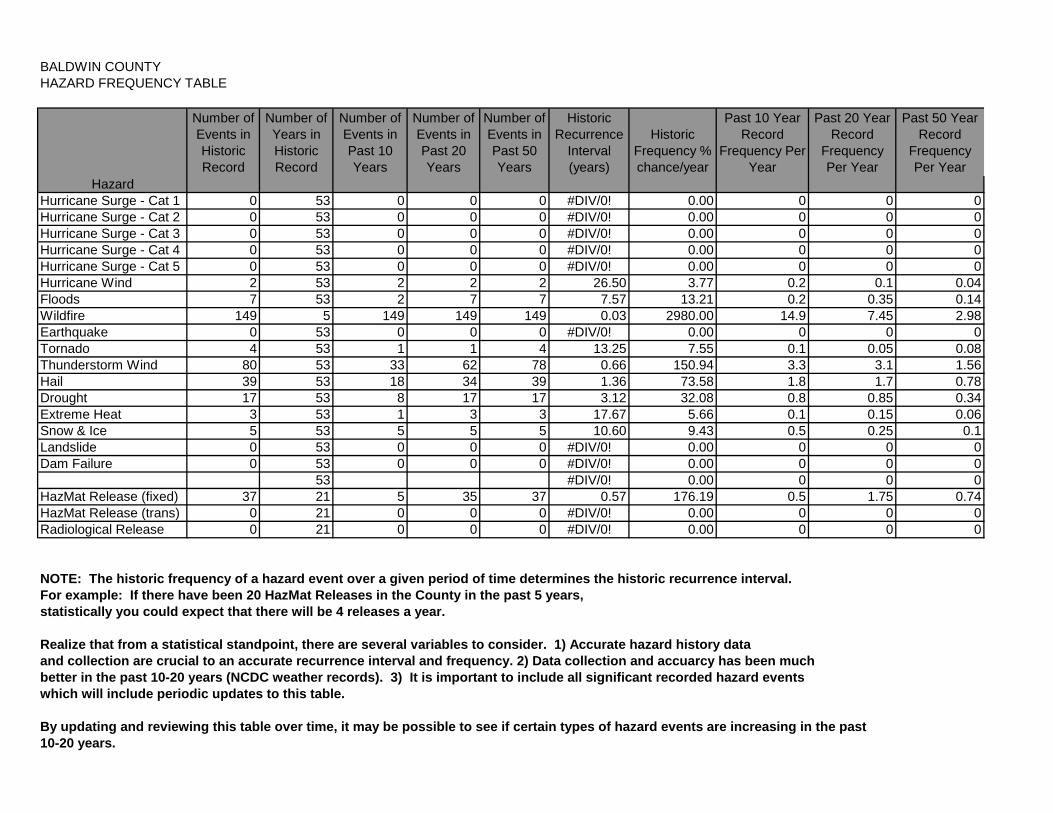
BALDWIN COUNTYHAZARD FREQUENCY TABLE
Number of Events in Historic Record
Number of Years in Historic Record
Number of Events in Past 10 Years
Number of Events in Past 20 Years
Number of Events in Past 50 Years
Historic Recurrence
Interval (years)
Historic Frequency % chance/year
Past 10 Year Record
Frequency Per Year
Past 20 Year Record
Frequency Per Year
Past 50 Year Record
Frequency Per Year
HazardHurricane Surge - Cat 1 0 53 0 0 0 #DIV/0! 0.00 0 0 0Hurricane Surge - Cat 2 0 53 0 0 0 #DIV/0! 0.00 0 0 0Hurricane Surge - Cat 3 0 53 0 0 0 #DIV/0! 0.00 0 0 0Hurricane Surge - Cat 4 0 53 0 0 0 #DIV/0! 0.00 0 0 0Hurricane Surge - Cat 5 0 53 0 0 0 #DIV/0! 0.00 0 0 0Hurricane Wind 2 53 2 2 2 26.50 3.77 0.2 0.1 0.04Floods 7 53 2 7 7 7.57 13.21 0.2 0.35 0.14Wildfire 149 5 149 149 149 0.03 2980.00 14.9 7.45 2.98Earthquake 0 53 0 0 0 #DIV/0! 0.00 0 0 0Tornado 4 53 1 1 4 13.25 7.55 0.1 0.05 0.08Thunderstorm Wind 80 53 33 62 78 0.66 150.94 3.3 3.1 1.56Hail 39 53 18 34 39 1.36 73.58 1.8 1.7 0.78Drought 17 53 8 17 17 3.12 32.08 0.8 0.85 0.34Extreme Heat 3 53 1 3 3 17.67 5.66 0.1 0.15 0.06Snow & Ice 5 53 5 5 5 10.60 9.43 0.5 0.25 0.1Landslide 0 53 0 0 0 #DIV/0! 0.00 0 0 0Dam Failure 0 53 0 0 0 #DIV/0! 0.00 0 0 0
53 #DIV/0! 0.00 0 0 0HazMat Release (fixed) 37 21 5 35 37 0.57 176.19 0.5 1.75 0.74HazMat Release (trans) 0 21 0 0 0 #DIV/0! 0.00 0 0 0Radiological Release 0 21 0 0 0 #DIV/0! 0.00 0 0 0
NOTE: The historic frequency of a hazard event over a given period of time determines the historic recurrence interval.
For example: If there have been 20 HazMat Releases in the County in the past 5 years,
statistically you could expect that there will be 4 releases a year.
Realize that from a statistical standpoint, there are several variables to consider. 1) Accurate hazard history data
and collection are crucial to an accurate recurrence interval and frequency. 2) Data collection and accuarcy has been much
better in the past 10-20 years (NCDC weather records). 3) It is important to include all significant recorded hazard events
which will include periodic updates to this table.
By updating and reviewing this table over time, it may be possible to see if certain types of hazard events are increasing in the past
10-20 years.

BALDWIN COUNTY, GEORGIA Critical Facility Data Collection Form
Facility Name: Street Address: City: Zip Code: Nearest Cross Street: GPS Coordinates: Lat: Long: Point of Contact: Phone Number: Year Constructed: Square Footage: sq. ft. Finished Floor Elevation: Number of Stories: Replacement Cost of Structure: $ Replacement Cost of Contents: $ Emergency Generator (Yes/No): Yes No Number of Times Damaged/Causes: (Wind, Flooding, Lightening, etc.) Type of Construction: Brick/Mortar Glass Steel Other (Specify): Wood Type of Roof: Shingle Pitch Masonry Other (Specify): Metal Examples of Critical Facilities: Police Stations, Fire Stations, Water Treatment Plants, Sewage Treatment Plants, Water Towers, Electrical Stations, Pumping Stations, Schools, Emergency Operation Centers, 911 Centers, Major Highways, Bridges, Evacuation Shelters, High Hazard Facilities, Hospitals, Nursing Homes, Etc.
PLEASE PREPARE THIS FORM FOR EACH CRITICAL FACILITY IN YOUR COUNTY

Appendix E
Planning Documentation (In Chronological Order)
Meeting Agendas
Attendance Records
Public Hearing Notices
Planning Process Timeline
Resolutions

BALDWIN COUNTY PRE-DISASTER MITIGATION PLAN UPDATE
UPDATE COMMITTEE MEETING BALDWIN COUNTY FIRE/RESCUE HQ – ALLEN MEMORIAL DRIVE
THURSDAY, JANUARY 27, 2011, 2:00 P.M.
AGENDA Welcome and Purpose ................................................................................................................... Colin Duke
Baldwin County EMA
FEMA Planning Presentation ......................................................................................................... Alan Sloan
GEMA Planning Process & Grant Administration ............................................................................ Nick Kouloungis
Middle Georgia Regional Commission Committee Introductions Questions or Comments .................................................................................................. Update Committee Adjourn


BALDWIN COUNTY PRE-DISASTER MITIGATION PLAN UPDATE
UPDATE COMMITTEE MEETING BALDWIN COUNTY FIRE/RESCUE HQ – ALLEN MEMORIAL DRIVE
THURSDAY, MARCH 3, 2011, 2:00 P.M.
AGENDA Welcome and Review of Previous Meeting .......................................................................... Nick Kouloungis
Middle Georgia Regional Commission
Review and Update of Critical Facility Inventory ............................................................ Update Committee Questions or Comments .................................................................................................. Update Committee Adjourn


BALDWIN COUNTY PRE-DISASTER MITIGATION PLAN UPDATE
UPDATE COMMITTEE MEETING BALDWIN COUNTY FIRE/RESCUE HQ – ALLEN MEMORIAL DRIVE
THURSDAY, MARCH 24, 2011, 2:00 P.M.
AGENDA Welcome and Review of Previous Meeting .......................................................................... Nick Kouloungis
Middle Georgia Regional Commission
Review and Update of Hazard Vulnerabilities ................................................................ Update Committee Questions or Comments .................................................................................................. Update Committee Adjourn


BALDWIN COUNTY PRE-DISASTER MITIGATION PLAN UPDATE
UPDATE COMMITTEE MEETING & PUBLIC HEARING BALDWIN COUNTY FIRE/RESCUE HQ – ALLEN MEMORIAL DRIVE
THURSDAY, APRIL 21, 2011, 2:00 P.M.
AGENDA Welcome and Review of Previous Meeting .......................................................................... Nick Kouloungis
Middle Georgia Regional Commission
Review and Update of Mitigation Goals, Objectives and Action Items .......................... Update Committee Questions or Comments .................................................................................................. Update Committee Adjourn


BALDWIN COUNTY PRE-DISASTER MITIGATION PLAN UPDATE
UPDATE COMMITTEE MEETING BALDWIN COUNTY FIRE/RESCUE HQ – ALLEN MEMORIAL DRIVE
THURSDAY, MAY 19, 2011, 3:30 P.M.
AGENDA Welcome and Review of Previous Meeting .......................................................................... Nick Kouloungis
Middle Georgia Regional Commission
Public Hearing on PDMP Update Development ................................................................... Nick Kouloungis Middle Georgia Regional Commission
Review of Preliminary Draft Update ............................................................................... Update Committee Questions or Comments .................................................................................................. Update Committee Adjourn