ba fqqcq fqqcq sahara desert endurance races
TRANSCRIPT

BA https://www.youtube.com/watch?v=QnMRjL
FqQCQ Sahara Desert endurance races

Questions to ask students after the video How high will temperatures reach? What is the name of the race? How long in time is the race? How long in miles is the race? What are some of the runners’ secret weapons? The course begins with what? What motivates some people to do the race? What is the most common medical problem? What is another issue with the runners? What is the longest day of the race? What is the race really about?

Physical Description AfricaUnit 7
SSWG4
The student will describe the interaction of physical and human systems
that have shaped contemporary Sub-Saharan Africa. a. Describe the location of major physical features and their impact on Sub-Saharan Africa.
b. Describe the major climates of Sub-Saharan Africa and how they have affected the development of Sub-Saharan Africa.
c. Describe the pattern of population distribution in the countries of Sub-Saharan Africa in relation to urbanization and modernization.
d. Explain how Sub-Saharan Africa’s physical features have had an impact on the distribution of its population.

4 Regions of AfricaThere are 4 different regions of Africa:
1. North Africa (covered in Unit 6) Sahara Desert (included in West/Central Africa)
2. West & Central Africa
3. East Africa
4. South Africa
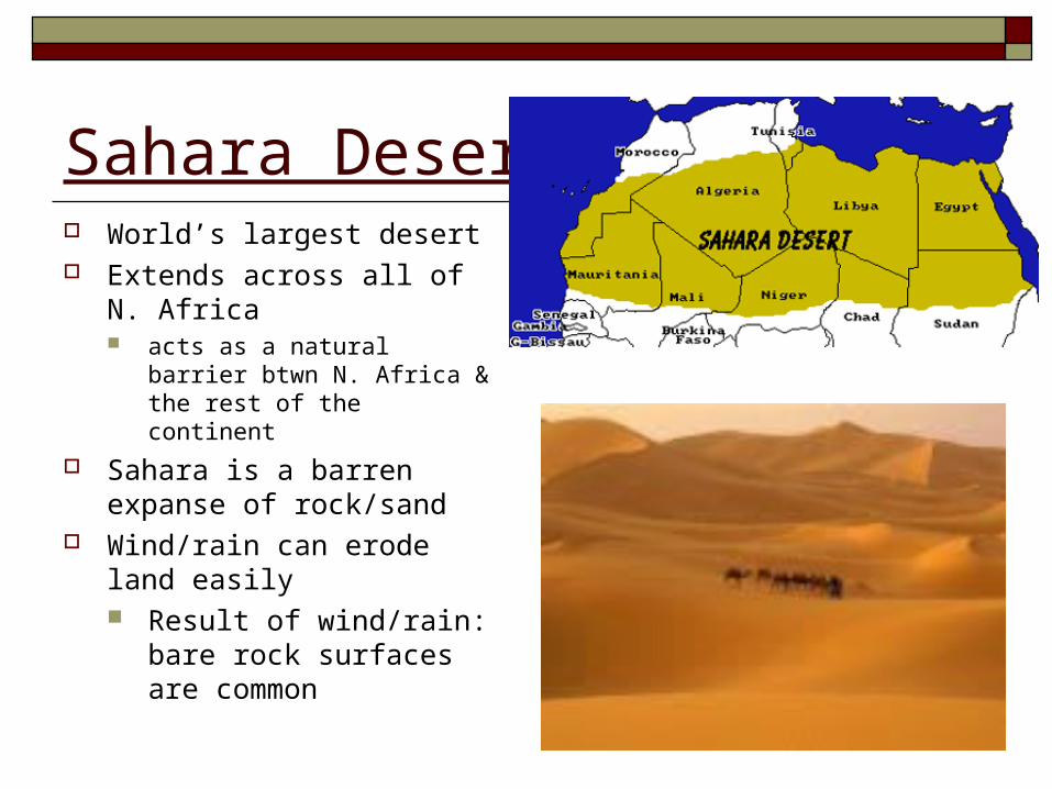
Sahara Desert World’s largest desert Extends across all of N.
Africa acts as a natural barrier btwn
N. Africa & the rest of the continent
Sahara is a barren expanse of rock/sand
Wind/rain can erode land easily Result of wind/rain:
bare rock surfaces are common

Sahara/continued Basins below rocky ridges are
covered w/ sand dunes --- create a sea of sand called erg
In other areas, wind blows sand away --- leaves gravel covered plain called a reg
Sahara has large low areas called depressions


West/Central Africa/Bodies of Water Congo River (1)
Flows northward from Zambia, emptying into the Atlantic
Niger River (2) River flows northeast across
to the Gulf of Guinea

The Sahel/West/Central Africa Region of semiarid climate that
sits @ the southern edge of the Sahara
Extends from Senegal & Mauritania in the west to the Sudan in eastern Africa
Receives 4-8 inches of rainfall each year
Most of the people follow subsistence farming Subsistence farming: food is produced
by a family just for its own needs

Climate/West/Central Africa South of the Sahel is a zone of tropical wet &
dry climate Hot, dry dusty conditions in winter
Climate zone closest to the Equator is tropical humid Rain falls year round, temps rarely drop below
65 F⁰ Dense tropical rainforests

Natural Resources/West/Central Africa Most valuable resource in the
region is oil Nigeria is Africa’s largest oil
producer
West Africa is the world’s major source of cocoa beans Although native to S. America,
tree brought during Colonial period
Cote d’Ivoire (koht-dee-vwahr) is world’s leading producer

5 Problems in West & Central Africa1. Population growing too quickly
2. Political problems lead to civil war
Congo, Liberia, Sierra Leone 1000s dead
3. Destruction of grasslands and tropical rain forest
4. Food shortages & malnutrition
5. Disease: Malaria & HIV

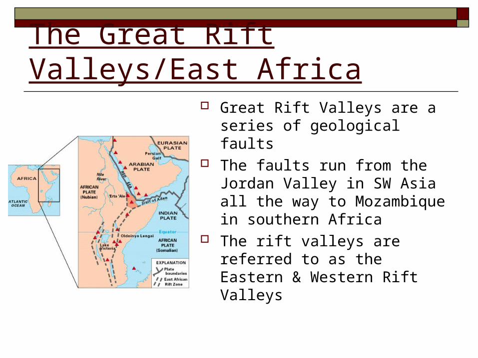
The Great Rift Valleys/East Africa Great Rift Valleys are a series
of geological faults The faults run from the
Jordan Valley in SW Asia all the way to Mozambique in southern Africa
The rift valleys are referred to as the Eastern & Western Rift Valleys

Great Rift Valleys/East Africa continued Volcanoes erupt w/in or
near both rifts
Kilimanjaro, near the Tanzania-Kenya border, is the most famous of the rift volcanoes Kilimanjaro near the Equator,
but has snow caps @ 19, 341 ft---highest mtn. in
Africa

Bodies of Water/Climate/East Africa Home of Lake Victoria
Africa’s largest lake Waters drain into Nile River
Climates in E. Africa are varied Near the Equator & along mountain slopes,
there is heavy rainfall Highlands of Kenya/Uganda
Farther north of the Equator, experience periods of drought Sudan, Ethiopia

Natural Resources/East Africa Not as rich in natural
resources as other African regions
Soil is not rich, so agriculture is almost nonexistent
Tanzania mines gems such as diamonds & sapphires
Scenery of E. Africa a resource Many wildlife resorts Tourism expands economy

3 Hazards to Development1. Droughts lead to starvation
2. Locusts eat all plant life Come with heavy rains
3. Sleeping sickness caused by the Tsetse fly
Keeps farmers and herders out of area
http://www.youtube.com/watch?v=4aVUrGO97Zg

Landforms/Southern Africa Narrow coastal plain along
southern Africa’s coastline Less than 100 miles wide
Inland, a high plateau reaches more than 4,000 ft above sea level
Btwn coastal plain & plateau lies an escarpment Escarpment: steep face @ the
edge of a plateau or other raised area

Bodies of Water & Climate/Southern Africa Only major river in the southern Africa is the Orange
River Starts in the Drakensburg Mt. Range & empties in the
Atlantic
the Limpopo River & the Zambezi River, along w/ the Orange River, produces hydroelectric power in Southern Africa
Climate is tropical AND arid (dry) Tropical rainforests in Madagascar
Known for its biodiversity


Natural Resources/Southern Africa South Africa/Zimbabwe have large coal
deposits Regions’ electricity is generated by burning coal
South Africa also has gold & platinum deposits
South Africa/Botswana/Namibia all have diamond mines

5 Challenges in South Africa1. Poverty
People cannot afford a balanced diet
2. High birthrates Housing shortages and rapidly growing cities
3. Droughts & floods
4. Loss of Madagascar’s rainforests & soil erosion
5. More than 25% of the population has HIV Botswana: 36% of adults are infected