b one map policy for sustainable development of indonesia big... · 2018-09-27 · kemhan . 85...
TRANSCRIPT

One Map Policy for Sustainable Development of Indonesia
Prof. Dr. Hasanuddin Z. Abidin Head
Geospatial Information Agency of Indonesia
The Forum on “The Importance and Role of National Spatial Data Infrastructure
towards Sustainable Development Goals” Ulaanbaatar, Mongolia, 20-21 September 2018
b

PERBANDINGAN LUAS INDONESIA DAN EROPA Indonesia: The Maritime Continent
INDONESIA IS HUGE COUNTRY: Ujung Barat (Sabang) – Timur (Merauke) = London – Bagdad Ujung Utara (Kep. Satal) – Selatan (P. Rote) = Jerman – Aljazair
Volume of Geospatial Information will be enormous
(Big Spatial Data).
Strong Human Resources and Industries in Geospatial
Information are compulsory.
Geospatial Information is compulsory for managing and
developing the country.

Geospatial Information Agency of Indonesia: Business Process
Geospatial Information
Basic Geospatial
Information
Base Maps
Topographic Map (RBI)
Coastal Area Map (LPI)
Marine Area Map
(LLN)
Geodetic Control Network
Horizontal
Vertical
Gravity & Tide
Thematic Geospatial
Information 85 themes (OMP)
Base Map Features: 1. Coastline 2. Hypsographic 3. Hydrographic 4. Geographic Name 5. Administrative Boundary 6. Transportation & Utility 7. Building & Social Facility 8. Land Cover • Executor
• Regulator
• Coordinator • Integrator
Geospatial Information
Infrastructure
• Data infrastructure • Standard and Regulation • Institutional Arrangement • Human Resources • Science & Technology
• Executor • Coordinator • Regulator
One Map Policy (OMP)
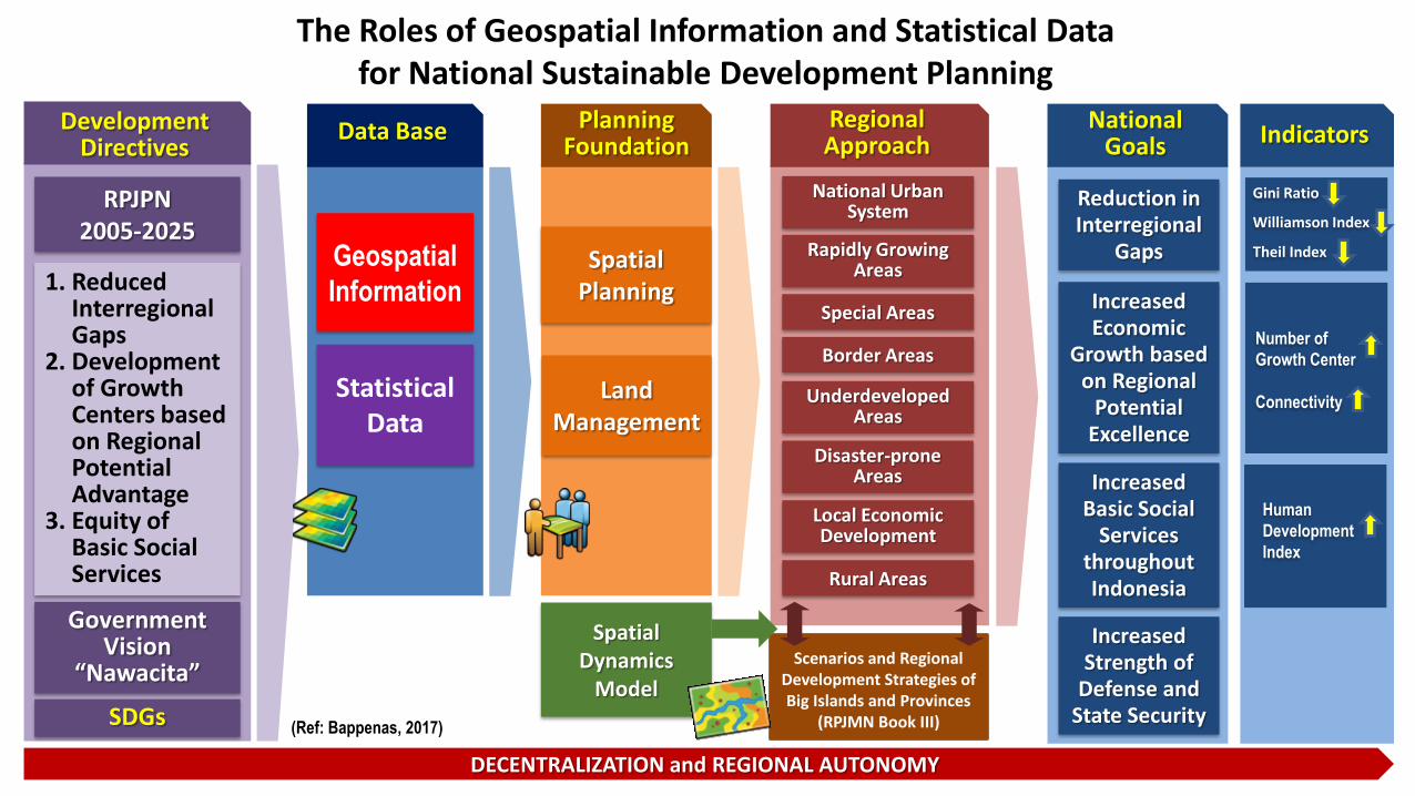
The Roles of Geospatial Information and Statistical Data for National Sustainable Development Planning
Geospatial
Information
Statistical Data
Data Base
Spatial Planning
Land Management
Rapidly Growing Areas
Regional Approach
Border Areas
Disaster-prone Areas
Local Economic Development
DECENTRALIZATION and REGIONAL AUTONOMY
Reduction in Interregional
Gaps
Increased Basic Social
Services throughout Indonesia
RPJPN 2005-2025
Government Vision
“Nawacita”
Development Directives
1. Reduced Interregional Gaps
2. Development of Growth Centers based on Regional Potential Advantage
3. Equity of Basic Social Services
Increased Economic
Growth based on Regional
Potential Excellence
National Urban System
Special Areas
Underdeveloped Areas
Rural Areas
Spatial Dynamics
Model
Gini Ratio Williamson Index Theil Index
Number of
Growth Center
Connectivity
Human
Development
Index
Indicators
(Ref: Bappenas, 2017)
Planning Foundation
National Goals
Increased Strength of
Defense and State Security
Scenarios and Regional Development Strategies of Big Islands and Provinces
(RPJMN Book III) SDGs

Geospatial Information issues in Indonesia:
Many Layers and Many Actors
Low quality decision making process and consequently degrade the achievement
of the national development goals
THE PROBLEMS OF GEOSPATIAL DATA : Non-Uniform Georeference. Limited Data Availability. Out of date and Inaccurate. Difficult Accessibility. No Optimum Utilization, etc.
More than one institutions produced and published the same map without coordination;
Several maps were not created by authorized institutions; Different geospatial information was published such as the
number of islands and the size of forest areas; Overlaps of land uses permits (licenses); Basic Geospatial Information was rarely used as the basis for
creating maps; Satellite imageries for the same area were purchased by more
than one institutions.
? ?
?
One Map Policy (OMP) Background

Example of Overlapping Permits due to Non Unified Maps
Topographic Map (RBI)
Permits of Mining Sector
Permits of Forestry Sector
Permits of Cadastral Sector
Tanah Grogot
CREATING LEGAL, SOCIAL & ECONOMIC CONFLICTS : Lead to unattractive investment condition Hampering the development process Delaying the project completion Wasting the energy of development

Acceleration of One Map Policy (Presidential Regulation 9/2016)
CHARACTERISTICS
• One Georeference • One Standard • One Database • One Geoportal
ACTIVITIES
• Compilation • Integration • Synchronization • Data Sharing
Ministries
One Map Policy
Product
Provinces
Thematic Maps
19 34
85
Value
• Unified National Geospatial Data and Information
• Reliable and Accountable Spatial Planning
• Reliable and Accountable Development Policy
ONE MAP POLICY Program
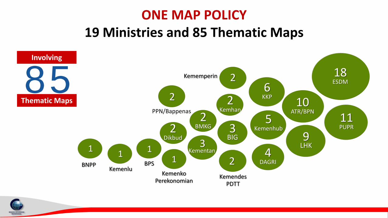
ONE MAP POLICY 19 Ministries and 85 Thematic Maps
18 ESDM
2
2
2
1 3
1 1 1
8 5 T e r d a a t
P e t a t e m a t i k
Involving
Thematic Maps
11 PUPR
10 ATR/BPN
9 LHK
4 DAGRI
5 Kemenhub
6 KKP
3 BIG
2 BMKG
BNPP Kemenlu
BPS
Kemenko Perekonomian
Kemendes PDTT
Kementan
PPN/Bappenas
Kememperin
2 Dikbud
2 Kemhan
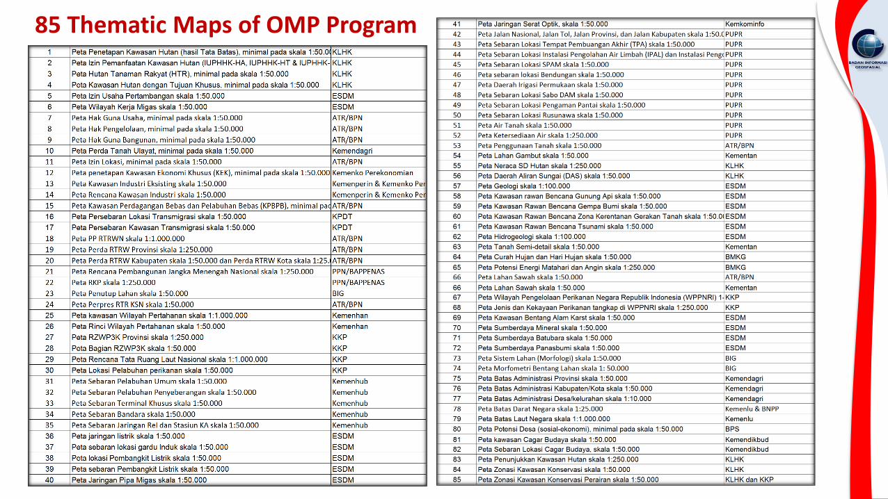
85 Thematic Maps of OMP Program

Benefits of One Map Policy for Sustainable Development
The acceleration of infrastructure
development
Benefits of One Map
Policiy
Resolution of conflicts over land use and
licensing
Ease of doing business and certainty of investing
The implementation of economic growth and
equity policies
Supporting national sustainable development planning. Supporting the implementation of “THIS” national development paradigm Supporting sustainable natural resource management Prevention of corruption related to natural resources management
Thematic
Holistic
Integrated
Spatial
National Development
Paradigm
2
1
3
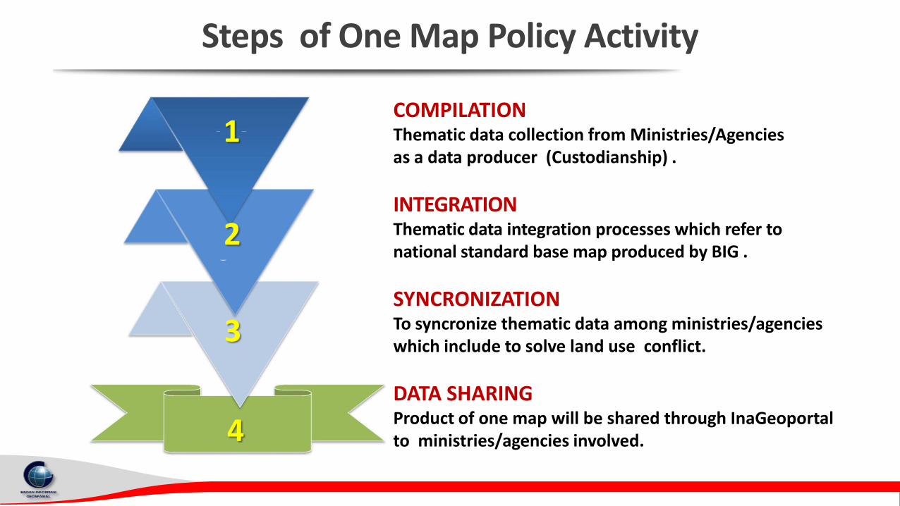
Steps of One Map Policy Activity
4
COMPILATION Thematic data collection from Ministries/Agencies as a data producer (Custodianship) .
INTEGRATION Thematic data integration processes which refer to national standard base map produced by BIG .
SYNCRONIZATION To syncronize thematic data among ministries/agencies which include to solve land use conflict.
DATA SHARING Product of one map will be shared through InaGeoportal to ministries/agencies involved.

2017 2016
2018
2018
2017
2017
2018
2019 Updating and Refinement
Priority Areas of One Map Policy (2016-2019)
Kalimantan : 05 Provinces Sumatera : 10 Provinces Sulawesi : 06 Provinces
Papua : 02 Provinces Maluku : 02 Provinces
Jawa, Bali, Nusa Tenggara : 09 Provinces

Status of One Map Policy (OMP) Data Integration (July 2018)
SUMATERA
76 from 84 IGT
JAWA
68 from 83 IGT
KALIMANTAN
71 from 80 IGT
SULAWESI
75 from 82 IGT
BALI & NT
68 from 80 IGT
MALUKU
64 from 82 IGT
PAPUA
62 from 83 IGT
Data Integration in 2016
Legend :
Data Integration in 2017
Data Integration in 2018
The Geoportal of One Map Policy will be officially launched by the Indonesian President on Sept. 2018

OMP Results is housed in InaGeoportal BIG
Not yet available to public; waiting for the data sharing regulation

National Geospatial Information
Network (NGIN)
MINISTRIES & AGENCIES
PROVINCIES
REGENCIES CITIES UNIVERSITIES
(PPIDS)
Situation Room
(Kemenko Perekonomian)
Data Center of BIG
(Cibinong)
Ina Geoportal
Situation Room
(Bina Graha)
VPN/
Cloud
Server Sekretariat PKSP
(Medan Merdeka Barat)
Ministries/Agencies
(Data Custodian)
Ministries, Agencies, Provincies,
Regencies, Cities, and Public
Pu
bli
kasi
VPN
VPN
1 2
3
7 4
5
Portal Satu Peta
6
8
9
VPN
KOMPILASI INTEGRASI SINKRONISASI
DATA UPDATING
Ina Geoportal
Status of NGIN Nodes
TARGET CONNECTED
Ministries/Agencies 57 23
Provinces 34 34
Regencies/Cities 514 22
Universities 34 19

Link to OMP Geoportal
Ina-GeoPortal : National Geospatial Information Network, http://tanahair.indonesia.go.id

OMP-Geoportal inside InaGeoportal, http://portalksp.ina-sdi.or.id/
OMP-Geoportal is only available for OMP
stakeholders, and governed by data sharing protocol.

Number of Geospatial Information Metadata InaGeoportal
is connected to the network
nodes of Ministries, Agencies,
Provinces, Districts

Status of Network Nodes of Ministry/Agency August 2018 Status
Ref. Kemenko Perekonomian (Agt. 2018)
ALREADY OPERATIONAL
ALREADY OPERATIONAL BUT NOT YET OPTIMAL*
NOT YET OPERATIONAL **
Already connected to NIGN and has supporting regulation
* Already connected to NIGN but no supporting regulation yet
** Not yet connected to NIGN but has supporting regulation

Status of Network Nodes of Provinces August 2018 Status
Ref. Kemenko Perekonomian (Agt. 2018)
ALREADY OPERATIONAL
ALREADY OPERATIONAL BUT NOT YET OPTIMAL*
* Already connected to NIGN but no supporting regulation yet

Sumatera Utara http://sumutprov.ina-sdi.or.id
Aceh http://gisportal. acehprov.go.id
Kep. Bangka Belitung http://geoportal. babelprov.go.id
Kep. Riau http://kepriprov. ina-sdi.or.id
Riau http://geoportal.riau.go.id
Sumatera Barat http://sumbarprov.ina-sdi.or.id
Jambi http://jambiprov.ina-sdi.or.id
Bengkulu http://bengkuluprov.ina-sdi.or.id
Sumatera Selatan http://geoportal.sumselprov.go.id
Lampung http://sumutprov.ina-sdi.or.id
DKI Jakarta http://jakartasatu. jakarta.go.id/portal/
Banten http://geoportal.bantenprov.go.id
Jawa Barat http://geodatabase.pusdalisbang. jabarprov.go.id
Jawa Tengah http://geoportal.jatengprov.go.id
D.I. Yogyakarta http://gis.jogjaprov.go.id
Jawa Timur http://geoportal.jatimprov.go.id
Bali http://baliprov.ina-sdi.or.id
Nusa Tenggara Barat http://geoportal.ntbprov.go.id
Gorontalo http://gorontaloprov.ina-sdi.or.id
Sulawesi Utara http://sulutprov.ina-sdi.or.id
Papua Barat http://papuabarat.ina-sdi.or.id
Papua http://papuaprov.ina-sdi.or.id
Nusa Tenggara Timur http://nttprov.ina-sdi.or.id
Maluku Utara http://malukuutara.ina-sdi.or.id
Maluku http://maluku.ina-sdi.or.id
Sulawesi Tenggara http://sultraprov.ina-sdi.or.id
Kalimantan Timur http://onedataonemap. kaltimprov.go.id
Kalimantan Selatan http://geoportal. kalselprov.go.id
Kalimantan Tengah http://kaltengprov.ina-sdi.or.id
Kalimantan Utara http://geoportal. kaltraprov.go.id
Sulawesi Barat http:// sulbarprov. ina-sdi.or.id
Sulawesi Selatan http://geoportal. sulselprov.go.id
Sulawesi Tengah http://geoportal. sultengprov.go.id
Kalimantan Barat http:// geoportal.bappeda. kalbarprov.go.id
19 Already connected to NIGN and has supporting regulation.
15 Already connected to NIGN but no supporting regulation yet.
Geoportal Address of Provinces (August 2018)
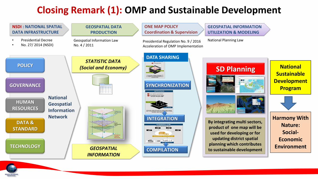
Closing Remark (1): OMP and Sustainable Development
• Presidential Decree • No. 27/ 2014 (NSDI)
SYNCHRONIZATION
INTEGRATION
COMPILATION
POLICY
GOVERNANCE
DATA & STANDARD
TECHNOLOGY
HUMAN RESOURCES
National Geospatial Information Network
GEOSPATIAL INFORMATION
STATISTIC DATA (Social and Economy) SD Planning
By integrating multi sectors, product of one map will be used for developing or for
updating district spatial planning which contributes to sustainable development
NSDI : NATIONAL SPATIAL DATA INFRASTRUCTURE
GEOSPATIAL DATA PRODUCTION
ONE MAP POLICY Coordination & Supervision
GEOSPATIAL INFORMATION UTILIZATION & MODELING
Geospatial Information Law No. 4 / 2011
Presidential Regulation No. 9 / 2016 Acceleration of OMP Implementation
National Planning Law
National Sustainable
Development Program
Harmony With Nature: Social-
Economic Environment
DATA SHARING

Closing Remark (2)
Geoportal housing OMP data will be launched on September 2018. The synchronization stage is continuing.
Data Sharing of OMP data is waiting for regulation which also will be available on August/September 2018.
The National Geospatial Information Network is being completed to support data sharing of OMP data.
Several issues for OMP continuation:
• Utilization of OMP Data in Decision Making Process of Central and Local Governments
• Toward Larger Scale of 1:5.000 • Human Resource Development
• Inclusion of other Thematic Maps • Institutional and Policy Enhancement
• Adding more Stakeholders, e.g. NGO and Private Sector
