b o s t o n regio n mpo
TRANSCRIPT

MEMORANDUM
DATE: April 17, 2014 TO: Boston Region Metropolitan Planning Organization (MPO) FROM: Chen-Yuan Wang, MPO Staff RE: Routes 127A/127 Subregional Priority Roadway Study in Gloucester and
Rockport
1 INTRODUCTION
The study corridor comprises Route 127A in Gloucester and Rockport, Route 127 from Route 127A in Rockport to Grant Circle on Route 128 in Gloucester, and major roadways in downtown Rockport. It is one of two corridors selected for analysis as part of a larger study funded by the Boston Region MPO: Addressing Safety, Mobility, and Access on Subregional Priority Roadways.1
This memorandum summarizes the existing conditions and issues, roadway operations and safety analyses, and proposes improvements for the entire corridor and specific locations. It contains the following sections:
1. Introduction
2. Existing Conditions and Issues
3. Safety and Operations Analyses
4. Proposed Improvements
5. Summary and Recommendations
This memorandum also includes appendices that contain relevant technical data and methods applied in the study.
1.1 Background
During the MPO’s outreach process for developing the Unified Planning Work Program (UPWP) and Long-Range Transportation Plan (LRTP), Metropolitan Area Planning Council (MAPC) subregional groups and other entities submit comments and identify transportation issues that concern them. Often, these issues are related to bicycle, pedestrian, and freight accommodation, bottlenecks, safety, or lack of safe or convenient access for abutters along
1 The study’s work program was approved on December 6, 2012. The other selected corridor is
Route 3A in Cohasset and Scituate, whose findings are reported in a separate memorandum.
State Transportation Building • Ten Park Plaza, Suite 2150 • Boston, MA 02116-3968 Tel. (617) 973-7100 • Fax (617) 973-8855 • TTY (617) 973-7089 • www.bostonmpo.org
Richard A. Davey, MassDOT Secretary and CEO and MPO ChairmanKarl H. Quackenbush, Executive Director, MPO Staff
BOSTON REGION METROPOLITAN PLANNING ORGANIZATIONBOSTON REGION
METRO
POLITAN PLANNING ORGAN
IZAT
IONMPO

Boston Region MPO 2 April 17, 2014
roadway corridors. In addition to affecting mobility and safety, such issues also can influence livability, including economic development and air quality.
To address these kinds of concerns, this study was included in the federal fiscal year (FFY) 2013 UPWP.2 The purpose of this study was to identify roadway segments in the MPO region that concern subregional groups but that have not been identified in the LRTP regional needs assessment.
This study focusses on issues identified by relevant subregional groups and the recommendations developed to address them. In addition to mobility, safety, and access, the study considers transit feasibility, truck issues, bicycle and pedestrian transportation, preservation, and other topics.
1.2 Selection Procedure
The MPO used a comprehensive procedure to select the study location. First, staff identified potential study locations via various means: soliciting suggestions during the outreach process for the FFY 2014 UPWP; reviewing meeting records from the UPWP outreach process for the past-five years; appraising potential locations in the MPO’s LRTP Priority Corridors study; and monitoring roadways in the MPO’s Congestion Management Process (CMP) program.
MPO staff identified 20 potential study locations in the MPO region. Staff then assembled detailed data on the identified roadways and evaluated them according to five selection criteria:
• Safety Conditions: Location has a high crash rate for its functional class or contains areas with a high number of crashes or a significant number of pedestrian/bicycle crashes
• Multimodal Significance: Location supports transit, bicycle, or pedestrian activity or has an implementation project to support one or more of these activities
• Subregional Significance: Location carries a significant proportion of subregional vehicle, bicycle, or pedestrian traffic3
• Subregional Priority: Location is endorsed by a subregion and is a priority for that subregion
2 Boston Region Metropolitan Planning Organization, Unified Planning Work Program, Federal
Fiscal Year 2013, Endorsed by the Boston Region Metropolitan Planning Organization on June 28, 2012.
3 Geographic equity among subregions also was considered in this criterion.

Boston Region MPO 3 April 17, 2014
• Implementation Potential: Location is proposed by the roadway agency or related agencies that have identified prospective funding resources for design and implementation
The Boston Region MPO selected and approved two roadway corridors for study:4
• Routes 127A/127 in Gloucester and Rockport (also known as the “Cape Ann Loop” by bicyclists)
• Route 3A in Cohasset and Scituate (from the Massachusetts Bay Transportation Authority (MBTA) commuter rail station in Cohasset to Henry Turner Bailey Road in Scituate)
The section of Routes 127A/127 in Gloucester and Rockport is a part of the 90-mile state-designated Essex Coastal Scenic Byway. The Essex National Heritage Commission (ENHC) and the North Shore Task Force subregion proposed three roadway sections in the byway system for review and potential improvements—for all users, with emphasis on pedestrian and bicycle safety and accommodations. This corridor was regarded as the highest priority among the three proposed sections.5 (See Appendix A for a description of Essex Coastal Scenic Byway and a map of the designated byway system.)
1.3 Study Objectives
The objectives of this study are to:
• Identify the safety, mobility, access, and other transportation-related problems in the corridor
• Develop and evaluate potential multimodal—pedestrian, bicycle, trucks, and transit modes—transportation solutions to the problems
1.4 Study Area and Data Collection
The study corridor is about 16 miles long, and consists of three sections:
• Route 127A from Route 128 in Gloucester to Route 127 (Main Street) in Rockport
• Route 127 from Route 127A (Broadway) in Rockport to Route 128 (Grant Circle) in Gloucester
• Major Roadways in downtown Rockport:
4 Selection of Study Locations: Addressing Safety, Mobility, and Access on Subregional Priority
Roadways, Memorandum to Boston Region MPO, Chen-Yuan Wang, February 7, 2013. 5 The other two proposed roadways were Route 127 from Beverley to Gloucester and Route
133 from Gloucester to Ipswich.

Boston Region MPO 4 April 17, 2014
o Mount Pleasant Street from Broadway to Main Street
o Main Street from Mount Pleasant Street to Broadway6
o Beach Street from Main Street to Granite Street
The sections of Route 127A and Route 127 are under the jurisdiction of the City of Gloucester or the Town of Rockport, depending on their specific locations. The major roadways in downtown Rockport are under the jurisdiction of the Town. Massachusetts Department of Transportation (MassDOT) Highway Division District 4 oversees the development and maintenance of the state routes in the area.
With the assistance of MassDOT, Gloucester, and Rockport, MPO staff collected roadway traffic counts, speed data, and intersection turning movement counts (including pedestrian crossings, bicycle movements, and heavy-vehicle counts) at a number of selected locations; they also gathered relevant transportation and land use data in the areas adjacent to the study corridor.
1.5 Study Advisory Meetings
During the course of the study, MPO staff conducted three meetings with representatives from Gloucester, Rockport, MassDOT, MAPC, and ENHC. The first two meetings—held in Gloucester on April 4, 2013 and Rockport on May 22, 2013—introduced and coordinated the study, and discussed the concerns about the study corridor. The third and final meeting—held in Rockport Town Hall on February 10, 2014—presented findings from data analyses and reviewed the proposed improvements.
On May 3, 2103, the Gloucester Community Development Department led a bicycle tour of the study corridor to examine roadway conditions for cycling and to discuss various transportation issues on site. (See Appendix B for a list of participants in the three advisory meetings and bicycle tour.)
2 EXISTING CONDITIONS AND ISSUES
This section examines the corridor’s location; adjacent major transportation roadway configurations and facilities; adjacent land uses; and observed traffic, pedestrian, and bicycle conditions. It also summarizes issues and concerns raised in the study advisory meetings.
6 Broadway is another major roadway in downtown Rockport and is included in the Route 127A
section of this study.

Boston Region MPO 5 April 17, 2014
2.1 Study Corridor and Major Transportation Facilities in the Area
Cape Ann—which includes the city of Gloucester, and the towns of Essex, Manchester-by-the-Sea, and Rockport—is located about 30 miles northeast of Boston on the Atlantic Ocean. The study corridor is basically a circular route, the Cape Ann Loop, around “The Island” of Cape Ann.7
Route 127 is a major state route in the North Shore area, which runs east along the shore from Beverley Harbor, through Manchester-by-the-Sea, to downtown Gloucester. It then turns north, away from the shore, crosses Route 128, and continues into Rockport. At the “Five-Corner” intersection8, Route 127 veers northwest near the shore, passes the MBTA commuter rail station, Rowe’s Cove, Pigeon Cove, and Halibut Point State Park, and bends southward, re-entering Gloucester. It then runs along Rowley Shore and the banks of the Annisquam and Mill Rivers and ends at Grant Circle (Route 128).
Route 127A is a north–south state route that runs from Route 127 (Eastern Avenue) in Gloucester to Route 127 (Main Street) in Rockport. It serves as a coastal alternative to the Route 127 inland section (from downtown Gloucester to the Five-Corner intersection in Rockport) on “The Island.”
Figure 1 shows the location of the study corridor and major transportation facilities in the area. The 16-mile corridor consists of about 9.5 miles of Route 127, about 5.5 miles of Route 127A, and about 1.0 miles of major roadways in downtown Rockport. About half of the selected roadways are located in Gloucester and the other half in Rockport.
All of the study-corridor roadways are classified as urban minor arterials. Besides two principal arterials on the Island, Route 128 and the inland section of Route 127, these roadways are significant to the area’s residents and businesses.
They all have two lanes and are undivided (one travel lane in each direction with no median). Each travel lane is about 12 feet wide, with a shoulder of two feet or less. Most of the roadways have sidewalks on one side (usually the coastal side) and some have sidewalks on both sides (such as the streets in downtown Rockport). However, a substantial section of Route127A (Thatcher Road) and another section of Route 127 (Granite Street/Washington Street) have no sidewalks on either side. No bike lanes exist on the study corridor roadways. 7 At the end of Cape Ann, the Annisquam River splits Gloucester into two parts: East and West
Gloucester. Local residents refer to the land east of the Annisquam River (East Gloucester and Rockport) as “The Island.”
8 The intersection of Main Street, Broadway, Railroad Avenue, and Parker Street has five legs. It is the most traveled intersection in Rockport and locally known as the “Five-Corner” intersection.

Boston Region MPO 6 April 17, 2014
The MBTA Rockport commuter rail line is the major regional transit service for commuters to and from Boston and communities along the line, and for people visiting the area. The commuter rail runs parallel to Route 127 in the middle of the “island” with two stops: Gloucester Station and Rockport Station. Gloucester Station has 96 parking spaces, with a parking rate of $4.00 per day. Rockport Station has 140 parking spaces, with no charge for parking. Commuters usually can find a parking space at the two stations. In summer, the MBTA provides a “bicycle coach” on the line so that riders may carry their bikes with them.
Locally, the Cape Ann Transportation Authority (CATA) provides bus services along the major roadways in the area.9 Major bus routes that serve the study area include:
• Thatcher Road Route (Red Line): Downtown Gloucester and Rockport via East Gloucester, Rocky Neck, and Back Shore
• Rockport Express (Green Line): Downtown Gloucester and Rockport via Eastern Avenue
• Lanesville Route (Blue Line): Downtown Gloucester and Rockport via Lanesville
• Rockport Park & Ride Loop (seasonal): Blue Gate Meadows Parking Lot to Dock Square
• Gloucester Crossing and Business Express Loop (Orange Line): Gloucester Senior Center to Mill Pond Medical Center via Addison Gilbert Hospital and Blackburn Industrial Park
These routes run five to ten trips each way on weekdays and four-to-eight trips on Saturdays; except for the Rockport Park & Ride Loop, which operates daily in July and August, Saturday and Sundays in June and September, and on a few special days in May and October. (Please see Appendix C for details of CATA service routes and schedules.)
2.2 Adjacent Land Use and Developments
In general, adjacent land use on Route 127A and Route 127 is mainly residential; though mainly commercial and institutional in downtown Rockport. There are some variations of land use and development density given the roadway locations and surrounding natural environment. Existing land use and developments are summarized below.
9 CATA is a nonprofit transit service for the Cape Ann area, with additional service to the
Danvers and Peabody Malls, and Ipswich, Essex, and Beverly.

Boston Region MPO 7 April 17, 2014
Route 127A in Gloucester • Bass Avenue: Medium-to-high density residential developments and
extensive business developments
• Thatcher Road: Low-to-medium density residential and a few business developments near Witham Street and Rockport Street
• Good Harbor Beach: Located on the south side between Barn Lane and Witham Street
Route 127A in Rockport • Thatcher Road: Low-density single-family residential developments and
vacant woodlands
• South Street: Mostly single-family houses with scattered woodlands
• Mount Pleasant Street: Fully developed medium-density residential areas
Major Roadways in Downtown Rockport • Mt. Pleasant Street and Main Street: Souvenir shops, bakeries,
restaurants, art galleries, and retail stores located on both sides
• Broadway: Mainly institutional developments (Town Hall, Town Library, Town Fire Station, and churches), with Rockport Market and a few stores
• Main Street (south of Beach Street): Medium-to-high density residential developments
• Beach Street: A number of small houses and a hotel
• Shalin Liu Performance Center: At the intersection of Main Street and School Street
• Bearskin Neck, adjacent to Dock Square (the junction of Mt. Pleasant Street and Main Street): A popular spot for viewing the ocean and coastal landscape
• Beach Street: Front and back beaches
• Barletts Park and Harvey Park (Broadway at Mt. Pleasant Street): Small town greens
Route 127 in Rockport • Railroad Avenue: Medium-density residential developments, with local
businesses
• MBTA Rockport Station: South side near King Street
Boston Region MPO 8 April 17, 2014
• Granite Street: Low-to-medium density residential developments (mostly single-family houses), with a few restaurants on the north side near the Gloucester city line
Route 127 in Gloucester • Washington Street (from Rockport border to Langsford Street): Low-
density single-family residential developments and woodlands
• Langsford Street: Mostly low-to-medium density residential developments and two cemeteries (near eastern leg of Washington Street)
• Lanesville Village Center: Local business and high-density residential districts
• Washington Street from Langsford Street to Holly Street: Mostly single-family houses, with scattered open spaces
• Washington Street from Holly Street to Route 128: Low-to-medium residential developments, with increasing density as roadway approaches Route 128
No major large-scale business developments are expected in the study corridor in the near future, as the city and town generally constrain these on Route 128 and the inland section of Route 127. The only anticipated major development is the old Cape Ann Tool Company on Granite Street (Route 127). The area’s potential land use would be townhouses or multiple residential units with limited businesses. (See Appendices D and E for the current zoning maps for Gloucester and Rockport.)
Beyond the roadside developments, an abundance of open space—sandy beaches, inlets, rocky shores, swamplands, ponds, coastal woods, nature trails, hilly woods, tranquil quarries—flanks Routes 127A and 127. (See Appendix F, the Cape Ann Trail Map (produced by MAPC).)
2.3 Traffic Volumes, Pedestrians, and Bicycles
The study area is a popular tourist destination for beaches and sightseeing. Traffic, pedestrians, and bicycles increase significantly from May to October, especially on weekend days and holidays from late June to early September.
2.3.1 Traffic Volumes
According to study advisory members, traffic at most locations in the study corridor generally moves well on weekdays, except at the Five-Corner intersection in the evening peak hour. However, during peak tourism hours on Saturdays and Sundays (usually around noontime), roadways are congested at popular destinations, such as the areas adjacent to Good Harbor Beach and

Boston Region MPO 9 April 17, 2014
the roadways and intersections in downtown Rockport. The congestion start time and duration differ somewhat from location to location.
In order to estimate the effect of tourism on traffic, MPO staff requested MassDOT’s assistance in collecting traffic counts for a series of weekend and weekdays in the summer peak season. The counts were performed from July 10 to 14, 2013, at 14 selected locations.
Figure 2 shows two sets of estimated traffic volumes, one for an average weekday and one for an average summer weekend day, by direction.10 The figure also shows average daily traffic (total of both directions) on Route 128 and the inland section of Route 127—from the MassDOT Roadway Inventory database.11
Depending upon their locations, the roadways in the study corridor carry about 3,000-to-13,500 vehicles per average weekday, and about 3,500-to-14,000 vehicles per summer weekend day. Comparisons of the average weekday and summer weekend day traffic volumes indicate that summer weekend daily traffic increases about 20-to-30 percent at most locations in the corridor. Notably, summer daily traffic increases about 40-to-50 percent on the major roadways in downtown Rockport and nearly 100 percent on Route 127A at the Good Harbor Beach.12 Appendix G summarizes the traffic volume estimations and comparisons at the count location.
Staff also analyzed traffic volumes by hours of the day. Figure 3 shows the peak-hour traffic volumes for average weekdays and summer weekend days.
The weekday peak hour occurs from 3:00 to 6:00 PM, and the summer weekend peak hour is generally between 11:00 AM to 2:00 PM. Analysis indicates that summer weekend daily traffic increases about 15-to-30 percent at most locations in the corridor. Notably, summer peak-hour traffic increases about 40-to-60 percent on Route 127 at the Good Harbor Beach and about 30-to-80 percent on the major roadways in downtown Rockport. (See Appendix G for a summary of estimated traffic volumes.)
10 Staff estimated the average weekday traffic by averaging the counts on July 10 (Wednesday)
to July 12 (Friday) and adjusting them with seasonal factors to represent average annual weekday traffic. Staff estimated the average weekend day traffic by averaging the counts on July 13 (Saturday) and July 14 (Sunday) to represent average weekend day traffic in the peak summer season.
11 Summer traffic data and directional information are not available from the database. 12 The increase on Route 127A at Good Harbor Beach could be overestimated. Field
observations indicated that during peak hours, visitors often queued on Route 127A waiting to enter the beach parking lot; or they drove back and forth looking for other places nearby to park their cars.

Boston Region MPO 10 April 17, 2014
In addition to the roadway traffic counts, MassDOT collected turning movement counts at six selected intersections for this study, which are:
1. Route 127A (Thatcher Road/Bass Avenue) at Atlantic Road in Gloucester
2. Route 127A (Thatcher Road) at Barn Lane in Gloucester
3. Route 127A (Thatcher Road) at Witham Street in Gloucester
4. Route 127A (Mt. Pleasant Street/Broadway) at T-Wharf in Rockport
5. Dock Square (Mt. Pleasant St. at Main Street) in Rockport
6. Route 127 (Washington Street) at Stanwood Street in Gloucester
The counts were performed on Saturday, July 13, 2013 from 10:00 AM to 2:00 PM. Counts by various modes, including pedestrians, bicycles, and heavy vehicles, were collected. (Appendix H presents the data in 15-minute intervals at the six selected locations. Appendix I presents a summary of the counts by mode by hour, with the peak hour highlighted in yellow in the summary table.)
It is essential to examine the proportion of heavy-vehicle (truck and bus) traffic in a corridor, as an unusually high share of these may seriously affect roadway and intersection operations. The counts indicate that the corridor’s heavy vehicles comprised about 1.0 to 1.5 percent of total traffic on the count date—a summertime weekend day. (See Appendix I for heavy-vehicle percentage summarized by hour.)
According to the study advisory members from Gloucester and Rockport, heavy-vehicle traffic may be slightly higher on weekdays than on weekend days. However, it is in the similar range of about two percent or less, as the area’s heavy vehicles generally use Route 128 and the inland section of Route 127 as their major routes. This percentage is considered normal, or even slightly lower, than that of some urban minor arterials.
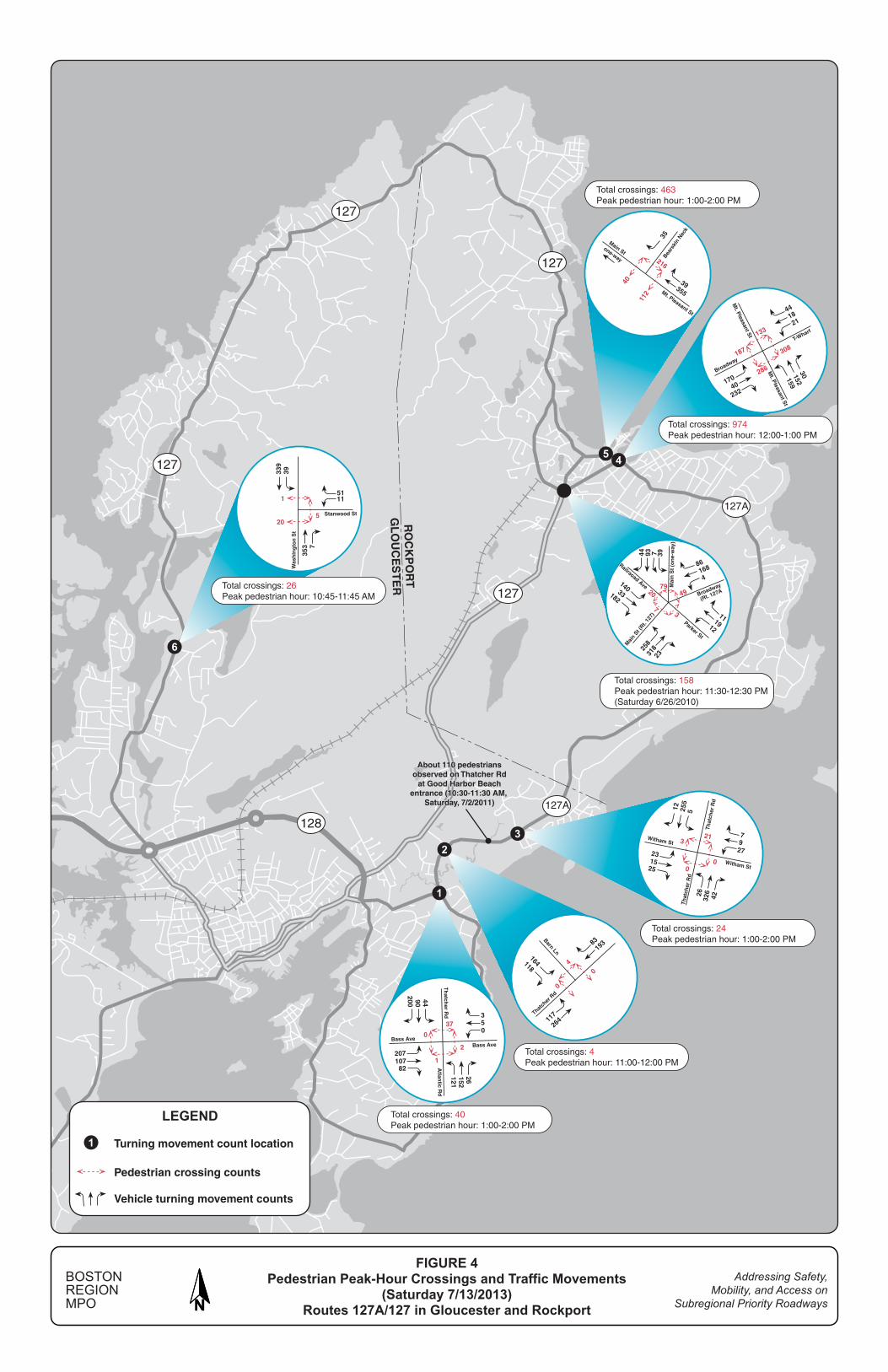
2.3.2 Pedestrians
Based on the pedestrian crossing counts collected by MassDOT, Figure 4 shows the highest hourly pedestrian crossings at the major intersections between 10:00 AM and 2:00 PM on Saturday, July 13, 2103.13 For contrast, the figure also shows traffic movement counts at the major intersections during the peak pedestrian crossing hour.
13 In addition to the MassDOT counts, the figure includes counts at the Five-Corner
intersection, which were taken from a recent MPO Study: Rockport Five-Corner Intersection Improvement Study, Community Transportation Technical Assistance Program, Boston Region MPO, May 2, 2011.

Boston Region MPO 11 April 17, 2014
In general, the area adjacent to Dock Square in downtown Rockport has the most intensive pedestrian activity in the corridor. Pedestrian counts indicate that, during the peak hour, as many as nearly 1,000 pedestrians crossed the intersection of Mount Pleasant Street at Broadway/T-Wharf, and nearly 500 pedestrians crossed Dock Square. About 160 pedestrians crossed the Five-Corner intersection, located at the perimeter of downtown. At the same time, traffic volume approaching these intersections also was high.
Good Harbor Beach is another pedestrian-heavy area. A recent count conducted by volunteers from the city (see Appendix J) shows that on Route 127A (Thatcher Road) near the beach entrance, about 60-to-110 pedestrians per hour were observed from 10:30 AM to 2:30 PM, with the most active pedestrian hour defined as 10:30 to 11:30 AM.14 The counts also indicate that traffic on Route 127A was very congested during the noon hour in the area adjacent to the entrance.
Depending upon the location, the peak pedestrian-crossing hour is usually around noon. At popular tourist locations, such as the areas adjacent to Dock Square and Good Harbor Beach, peak pedestrian crossings can last as long as three-to-four hours. (See Appendix I for total pedestrian crossings summarized by hour at the major intersections.)
2.3.3 Bicycles
Based on the MassDOT turning movement counts, Figure 5 presents the highest hourly bicycle movement counts at the major intersections in the study corridor. The figure also shows directional bicycle counts on Route 127A and Route 127, estimated from the bicycle turning movement counts.
Approximately 40-to-50 bicycles per hour traveled at various locations in the corridor on July 13, 2013, an average summer weekend day. The bicycle peak hour is identified as 10:00 to 11:00 AM at most count locations. At Dock Square, the peak bicycle hour is identified as 10:30 to 11:30 AM, which indicates that cyclists might take a snack break or detour to Bearskin Neck for sightseeing. (See Appendix I for the hourly bicycle counts at selected locations.)
The directional bicycle counts indicate that most cyclists travel the Cape Ann Loop in a counter-clockwise direction (on the coastal side of the corridor). The directional spilt is about 80% on the coastal side and 20% on the inland side.
14 The Gloucester Community Development Department also performed pedestrian and bicycle
counts at the beach entrance on July 22, 2013, for this study. It was a very hot day and there was less-than-normal pedestrian and bicycle activity. The counts, therefore, were not used to represent normal summer weekend pedestrian activity.

Boston Region MPO 12 April 17, 2014
2.4 Issues and Concerns
In the scope meetings on April 4 and May 22, 2013, study advisory members from Gloucester, Rockport, MassDOT, and MAPC shared their concerns about the study corridor, which are summarized below.
• Discontinuous sidewalks at several locations
• Pedestrian safety—long crossing distance and poor view of traffic at intersections and busy roadway sections
• Lack of bicycle accommodations on Routes 127A/127
• No clear signage to identify Cape Ann Loop bike route
• High travel speeds in residential areas
• Summer traffic congestion in popular areas, such as Good Harbor Beach and downtown Rockport
• Pedestrian safety and traffic issues in downtown Rockport
• Roadway maintenance issues
• Preservation of the area’s character
The study advisory members also discussed safety and operational problems at specific locations in the corridor. These, along with the proposed improvements, are summarized by location in Section 4 of this memorandum.
3 SAFETY AND OPERATIONS ANALYSES
To explore potential improvements, this section examines recent five-year crash data, existing speed controls and prevailing travel speeds, and existing roadway cross-sections.
3.1 Crash Data Analysis
Crash data are essential for identifying safety and operational problems in a study area. Analysis of crash locations, collision types, time-of-day, roadway conditions, and other factors can help to develop improvement strategies.
Based on the 2006–10 MassDOT crash data, 202 crashes occurred in the study corridor in the five-year period. Figure 6 shows the crash locations and crash rates in different sections of the corridor.
In general, all the roadway sections have a crash rate lower than the state average of 3.63 crashes per million vehicle miles traveled on urban minor arterials. Most of them have a crash rate of less than 1.60 crashes per million vehicle miles traveled. A few sections of the study area have a slightly higher crash rate because of greater vehicle and pedestrian activity. These sections

Boston Region MPO 13 April 17, 2014
are Bass Avenue from Route 128 to Thatcher Road in Gloucester and Mt. Pleasant Street, Broadway, and Railroad Avenue in Rockport. The section of Mt. Pleasant Street between Broadway and Prospect Street has the highest crash rate. It is a transition zone into downtown Rockport but already experiences intense roadway activity.
With one (or less) crash per year on average, most of the intersections in the corridor are low-crash locations, except for the following intersections:
• Five-Corner (Main Street at Broadway): 4.4 crashes per year
• Railroad Avenue at King Street: 2.2 crashes per year
• Mt. Pleasant Street at Broadway: 1.2 crashes per year
• Bass Avenue at Thatcher Road/Atlantic Road: 1.2 crashes per year
Figure 6 also shows that seven crashes involved a pedestrian and four involved a cyclist. Six of the seven pedestrian crashes occurred in downtown Rockport (three on Main Street, two on Bearskin Neck Road, and one at the Five-Corner intersection). One pedestrian crash occurred at the intersection of South Street at Jerdens Lane. (The Rockport School District is located further south of the intersection on Jerdens Lanes.)
Two of the bicycle crashes occurred near the downtown area, both on Mt. Pleasant Street northbound near Norwood Avenue. The other two bicycle crashes occurred near the intersection of Bass Avenue and Thatcher Road near the Good Harbor Beach.
According to Gloucester, Grant Circle is a tough location for pedestrians and cyclists to cross; thus, the city designated Cherry Street-Popular Street-Maplewood Avenue as an alternate bike route. The crash data indicate that one pedestrian crash occurred in 2008 and one bicycle crash in 2006, at this location.
In 2008, one fatal crash—a head-on collision that involved three vehicles—occurred on Washington Street just south of Stanwood Street in Gloucester. The day was clear and the cause is not identified in the database. This incident is considered to be a random case in the study corridor.
3.2 Travel Speeds and Speed Controls
Figure 7 shows the existing speed controls and observed 85th percentile travel speeds in the study corridor. The “85th percentile” is the principle value used for establishing speed controls. It is the speed at or below which 85 percent of vehicles passing a given point are traveling. The 85th percentile speeds at seven selected locations in the corridor were derived from spot speed studies performed by MassDOT in July 2013.

Boston Region MPO 14 April 17, 2014
Speed limits in the corridor are regulated in five ranges: 15-, 20-, 25-, 30-, and 35 miles per hour (mph). Most sections on Route 127A are designated as 30- or 35-mph speed zones. Exceptions are Bass Avenue between Route 128 and Thatcher Road in Gloucester and Mt. Pleasant Street between Prospect Street and Broadway in Rockport, which are designated as 25-mph zones because of their dense business and residential districts.
All of the study roadways in downtown Rockport are designated as 20-mph zones, including Mt. Pleasant Street, Main Street, Broadway, and Beach Street. Drivers usually do not travel too fast on these roadways because they are narrow, with on-road traffic and roadside activities. However, drivers tend to travel somewhat faster on Broadway, as it is a straight and downhill path toward downtown.
Speed regulations on Route 127 from Five-Corner to Route 128, are variable, ranging between 15-and-30 mph. Most sections, however, are 25-mph zones, as they are thickly settled residential districts. A number sections scattered along Route 127 are designated as 20-mph zones. These usually are narrow, winding, and near a village center, or adjacent to a major intersection. The other sections are 30-mph zones, except for a small section of Granite Street just south of Beach Street, which is only about 600 feet long and is designated as a 15-mph zone.15 The section of Route 127 parallel to the Annisquam River is narrow and winding. Though it is mostly under a 20-mph speed-limit control, a third of the section, between Bennett Street and Bittersweet Road, is zoned for 30 mph.
As shown in Figure 7, the observed 85th percentile speeds are about two-to-five mph higher than the posted speed limits at most count locations. The following locations have a wider variation between the observed 85th percentile speed and its posted speed limit:
• Route 127 (Granite Street) north of Beach Street: About nine-to-ten mph higher than the posted 25-mph speed in both directions
• Route 127 (Granite Street) north of the Gloucester border: About eight mph higher than the posted 25-mph speed in both directions
• Route 127 (Washington) north of Stanwood Street: About 9-to-11 mph higher than the posted 20-mph speed in the southbound direction
15 This section is straight, somewhat narrow, and downhill; no crash history or other strong
reason may be found for why it is zoned at such a low speed. There are a few houses located very close to the roadway, whose residents would prefer a lower travel speed. However, such a regulation usually has little effect on speeds of drivers who do not live in the area.

Boston Region MPO 15 April 17, 2014
A review of the regulated and observed speeds, and the roadway’s adjacent land use, indicates that some speed-regulation adjustments could be considered at the following locations:
• Adjust regulation from 35-mph to 30-mph:
o Route 127A (Thatcher Road) between Rockport Road and Briny Way
o Route 127A (South Street) between Eden Road and Briarstone Road
• Adjust regulation from 30-mph to 25-mph:
o Route 127A (South Street) between Jerdens Lane and Prospect Street
o Route 127 (Granite Street) between Wharf Road and Landmark Lane
o Route 127 (Langsford Street) between Butman Avenue and Andrews Street
o Route 127 (Washington Street) between Bennett Street and Bittersweet Road
Establishing or modifying speed regulations is a complicated procedure that requires careful engineering analyses. The proposed locations for modification were based on limited speed data collected as part of the recent traffic counts.16 They should be further examined and validated according to the procedures required by MassDOT.17
3.3 Roadway Cross-section Analysis
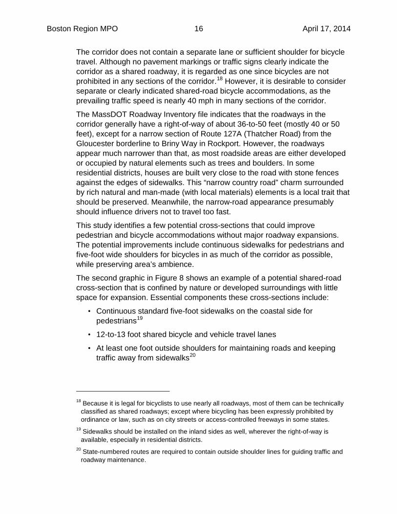
To address two major concerns in the study corridor, this section examines the existing roadway cross-sections and explores those with the potential to accommodate pedestrians and bicycles (see Figure 8).
Currently most sections on Route 127A and Route 127 have a roadway surface of about 24-to-28 feet that contains two 12-foot travel lanes and outside shoulders generally less than two feet wide. In general, sidewalks are on the coastal side only; and a substantial section of Route127A (Thatcher Road) and another section on Route 127 (Granite Street/Washington Street) have no sidewalks at all. Cyclists need to travel with traffic on the 12-foot travel lanes.
16 The 85th percentile speeds for this study were spot speeds derived from data collected from
automatic traffic recorders. To establish or modify speed controls, MassDOT requires data to be collected using radar or laser guns at critical locations for an area not to exceed 0.25 miles, in addition to vehicle trial runs in the study area.
17 Procedures for Speed Zoning on State and Municipal Roadways, MassDOT Highway Division, May 2012.
Boston Region MPO 16 April 17, 2014
The corridor does not contain a separate lane or sufficient shoulder for bicycle travel. Although no pavement markings or traffic signs clearly indicate the corridor as a shared roadway, it is regarded as one since bicycles are not prohibited in any sections of the corridor.18 However, it is desirable to consider separate or clearly indicated shared-road bicycle accommodations, as the prevailing traffic speed is nearly 40 mph in many sections of the corridor.
The MassDOT Roadway Inventory file indicates that the roadways in the corridor generally have a right-of-way of about 36-to-50 feet (mostly 40 or 50 feet), except for a narrow section of Route 127A (Thatcher Road) from the Gloucester borderline to Briny Way in Rockport. However, the roadways appear much narrower than that, as most roadside areas are either developed or occupied by natural elements such as trees and boulders. In some residential districts, houses are built very close to the road with stone fences against the edges of sidewalks. This “narrow country road” charm surrounded by rich natural and man-made (with local materials) elements is a local trait that should be preserved. Meanwhile, the narrow-road appearance presumably should influence drivers not to travel too fast.
This study identifies a few potential cross-sections that could improve pedestrian and bicycle accommodations without major roadway expansions. The potential improvements include continuous sidewalks for pedestrians and five-foot wide shoulders for bicycles in as much of the corridor as possible, while preserving area’s ambience.
The second graphic in Figure 8 shows an example of a potential shared-road cross-section that is confined by nature or developed surroundings with little space for expansion. Essential components these cross-sections include:
• Continuous standard five-foot sidewalks on the coastal side for pedestrians19
• 12-to-13 foot shared bicycle and vehicle travel lanes
• At least one foot outside shoulders for maintaining roads and keeping traffic away from sidewalks20
18 Because it is legal for bicyclists to use nearly all roadways, most of them can be technically
classified as shared roadways; except where bicycling has been expressly prohibited by ordinance or law, such as on city streets or access-controlled freeways in some states.
19 Sidewalks should be installed on the inland sides as well, wherever the right-of-way is available, especially in residential districts.
20 State-numbered routes are required to contain outside shoulder lines for guiding traffic and roadway maintenance.

Boston Region MPO 17 April 17, 2014
The third graphic in Figure 8 shows a sample cross-section that contains five-foot shoulders to accommodate bicycles apart from vehicular traffic. This cross-section may be used where a right-of-way of about 42 feet is available to include standard five-foot sidewalks on both sides. Major elements of the proposed wide-shoulder cross-sections include:
• Five-foot sidewalks on both sides for pedestrians
• Five-foot shoulders on both sides for bicycles
• Reduced 11-foot travel lanes21
It is important that wide shoulders for bicycle travel are continuous (preferably for at least half a mile); fragmented wide shoulders would cause bicycles to weave in and out of traffic, and create difficulties for roadway maintenance.
For areas with a tight right-of-way, but which also hold potential for wide-shoulder application, a four-foot shoulder may be considered. However, MassDOT requires a standard five-foot shoulder for bicycle travel, and a four-foot shoulder would require a design exemption, if federal or state funding is applied.22
Study advisory members from MAPC suggested a roadway cross-section without centerlines in order to accommodate bicycles (see Appendix K). This “no center-line” design would remove centerlines that delineate opposite traffic streams and provide wide shoulders on both sides for bicycle travel (also known as “advisory bicycle lanes”) by using dashed lines to delineate vehicle and bicycle travels. The dashed lines would allow vehicles to travel on the shoulders while passing from opposite directions. The design is intended for narrow roadways with relatively low traffic volume and speed. See Appendix L for details about this design concept and its application.
Currently, staff does not propose such an application in the study corridor because:
• Routes 127 and 127A are minor principal arterials with relatively high traffic volumes.23
• The roads are steep and winding in many sections, with frequent horizontal and vertical transitions, where centerlines are essential for safety.
21 Though no extensive research indicates significant evidence in the reduction of travel
speeds, narrowing travel lanes in an appropriate dimension is generally considered to have effects on the majority of drivers to slow down somewhat or at least not to travel too fast .
22 MassDOT Project Development and Design Guide, January 2006, Massachusetts Department of Transportation.
23 Except for the section of Route 127 between Halibut Point State Park and Lanesville, all of the roadways in the corridor carry about 5,000-to-10,000 vehicles per day.

Boston Region MPO 18 April 17, 2014
• Limited application in the study corridor would be a sudden and drastic change from the rest of the corridor and likely would cause drivers’ confusion.
• A major transition section to alert drivers the change would be required before and after the application section.
However, this no centerline application is effective in slowing traffic and providing bicycle and pedestrian accommodations and could be considered for local streets or low-volume collectors in areas adjacent to the study corridor.
Staff consulted with various bicycle advocates, MAPC transportation planners, and MassDOT design professionals about what elements to include and how to design bicycle, pedestrian, and vehicle accommodations that share a roadway with significant right-of-way constraints. These views are included in Appendix K. As some of the opinions are not consistent, we expect that, at the design stage and depending upon the funding source, all of these views would be taken into account and compared against the design standards. At that time, various existing design standards could also be contested by proceeding through the formal design exemption application process.
4 PROPOSED IMPROVEMENTS
Based on the preceding analyses, this section proposes a series of safety and operational improvements for pedestrians, bicycles, and traffic in the study corridor and at a number of selected locations.
4.1 Pedestrian Accommodations and Safety Improvements
Figure 9 shows the locations of existing sidewalks and proposed locations for standard five-foot sidewalk installation. Major proposed improvements include:
• Install five-foot sidewalks on the coastal side to provide a continuous path
• Install five-foot sidewalks on the inland side in sections are thickly settled
• Upgrade existing substandard sidewalks, such as those on Langsford Street (Route 127) adjacent to Lanesville and Beach Streets on the inland side
• Designate Bearskin Neck Road as a pedestrian zone.24
Note that standard five-foot sidewalks on both sides of the roadways, especially in dense residential districts, are desirable in the corridor. However, some sections in the corridor likely would have a right-of-way only wide enough for 24 Vehicle travels are prohibited on the roadway, except for residents and customers of hotels
and restaurants located in the stretch, people with disabilities, and deliveries.
Boston Region MPO 19 April 17, 2014
sidewalks on one side. The goal is to provide at least a continuous pedestrian path on the coastal side of the corridor. Based on the recently issued MassDOT Engineering Directive E-14-001 (see Appendix M), the sections with sidewalks on only one side would require a design exemption process, if federal or state funding is used for the improvements.
Also note that the proposed locations were based on field observations and reviews of online assessors’ maps. Further investigation of right-of-way availabilities and roadside obstructions (such as utility poles) is required to determine exact locations for proposed improvements.
Although the roadways in the study corridor are narrow, the layouts of many intersections in the corridor are relatively wide.25 These intersections create long crossing distances for pedestrians; and it is difficult for drivers to observe pedestrians at the far corners. These intersections mostly could be reconfigured into tighter layouts with reduced curb radii in order to slow turning traffic. Sidewalk extensions and pedestrian bulb-outs could be installed—to compensate for lessened curb radii—to shorten pedestrian crossing distances and so drivers and pedestrians could see each other better. See Section 4.3 for further discussion of these improvements.
There are many crosswalks at intersections and at mid-blocks of the roadways in the corridor; and a large number of them are not equipped with Americans with Disabilities Act (ADA) standard wheelchair ramps. Their locations and viability for enhancements, along with those of wide intersections, should be examined further to provide a systematic outcome for pedestrian safety improvements.
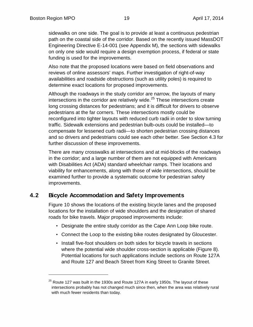
4.2 Bicycle Accommodation and Safety Improvements
Figure 10 shows the locations of the existing bicycle lanes and the proposed locations for the installation of wide shoulders and the designation of shared roads for bike travels. Major proposed improvements include:
• Designate the entire study corridor as the Cape Ann Loop bike route.
• Connect the Loop to the existing bike routes designated by Gloucester.
• Install five-foot shoulders on both sides for bicycle travels in sections where the potential wide shoulder cross-section is applicable (Figure 8). Potential locations for such applications include sections on Route 127A and Route 127 and Beach Street from King Street to Granite Street.
25 Route 127 was built in the 1930s and Route 127A in early 1950s. The layout of these
intersections probably has not changed much since then, when the area was relatively rural with much fewer residents than today.

Boston Region MPO 20 April 17, 2014
• Install “share the road with bicycles” signs26 or sharrow markings at selected locations, such as narrow, steep, or curved sections, or thickly settled areas.
• Install bike racks at the proposed rest stops.
• Regularly maintain the roadways clear of potholes and debris for safe bicycle travel.
The proposed locations were based on field observations and reviews of online assessors’ and wetland maps. Further analyses of right-of-way and wetland constraints are required to determine exact locations for proposed improvements. For instance, the section of Route 127A in Rockport from Red Fox lane to Briny Way is located in an environmentally sensitive area and its wide-shoulder expansion should be examined further.
The section of Route 127A (Thatcher Road) from Witham Street in Gloucester to Eden Street in Rockport provides some scenic ocean views on the coastal side and is relatively narrow, so that wide-shoulders potentially may be applied only on one side. However, based on a number of context-sensitive factors (below), it may be feasible to consider the wide-shoulder accommodation on the coastal side as well:
• Unique roadway character with limited right-of-way
• High bicycle travel demand with 80% split on coastal side
• 35-mph posted speed
• Relatively low crash rate in the corridor
Study advisory members from MassDOT expressed their concerns about wide-shoulder bicycle accommodation on only one side of roadways based on the principal of consistency in highway design (see Appendix K) and stressed that such application would require a design-exemption process, if federal or state funding is used for the roadway improvements.
4.3 Traffic Operations and Safety Improvements
The study corridor carries substantial numbers of pedestrians and bicycles, especially in the tourism season. The key to traffic operations in the corridor is how to maintain suitable low- to-medium travel speeds in order to accommodate all travel modes and enhance safety for all users, including
26 The standard Manual on Uniform Traffic Control Devices (MUTCD) application consists of an
assembly of the “bicycle” (W11-1) warning sign and “share the road” (W16-1P) warning plaque.

Boston Region MPO 21 April 17, 2014
pedestrians, cyclists, and drivers. Major proposed improvements related to traffic operations include:
• Consider speed regulation adjustments in the roadway sections suggested in Section 3.2, with further engineering analyses.
• Install solar-powered “Your Speed” warning signs to calm traffic at three critical locations that enter downtown Rockport. The town currently is working with MassDOT to identify the exact location for Route 127 (Main Street) northbound approaching the Five-Corner intersection. This study suggests that the following two additional locations be considered for improvements.
o Route 127A northbound before Jerdens Lane (Rockport School District): The vicinity is somewhat open and visitors may be not aware that they are about to enter the school district and dense residential area.
o Route 127 northbound before Wharf Road (Keystone Bridge): Keystone Bridge is somewhat narrower than its adjacent roadway and the downhill section following the bridge is steep and curved. It is a 25-mph speed zone and the 85-percentile traffic speed is nearly 10 MPH higher than the posted speed limit (see Section 3.2).
• Preserve roadside elements that have the effect of calming traffic, such as sidewalks, stone fences, trees, boulders, and a variation in natural landscape.
• Regularly maintain speed-limit signs and periodically enforce the posted speed limits.
• Redesign and reconstruct wide-layout intersections with reduced curb radii to slow turning vehicles; and add sidewalk extensions (pedestrian bulb-outs) to shorten pedestrian crossing distances. A review of aerial photos indicates that about 27 intersections in the corridor are suitable for these improvements (see Appendix N for a list of the identified intersections). Figure 11 shows an example of Route 127A (Bass Avenue/Thatcher Road) at Atlantic Road in Gloucester with these proposed improvements.
• Remove excessive warning signs and upgrade parking-regulation signs. On Route 127 in the study corridor, there are excessive warning (mostly Children at Play) and parking-regulation signs (most for beach goers in residential districts) that are not MUTCD27 compliant. Excessive signs
27 Manual on Uniform Traffic Control Devices, Federal Highway Administration, Washington
D.C., May 2012.

Boston Region MPO 22 April 17, 2014
should be removed and parking signs should be consistent with MUTCD standards.
• Update or install pedestrian warning signs at major crossing locations. Many of the existing pedestrian crossing warning signs are faded. They should be replaced with MUTCD-compliant reflective materials.
4.4 Proposed Improvements at Selected Locations
Based on discussions with study advisory members, the major locations of concern in the corridor are Good Harbor Beach in Gloucester and downtown Rockport.
4.4.1 Good Harbor Beach
Good Harbor Beach is a popular destination in summers, especially on weekend days. Its parking lot that takes nearly 950 passenger cars is usually full around 11:00 AM on weekend days. Major issues and concerns include:
• The roadway section is narrow with no sidewalks or sufficient shoulders to accommodate pedestrians and bicycles.
• Route 127A between Barn Lane and Witham Street is highly congested during summer weekend days. Traffic congestion impedes pedestrian and bicycle movements.
• The roadway section is adjacent to wetlands and it may not be feasible to add sidewalks or bike lanes.
• Visitors do not have sufficient parking information before they enter the beach area. Some of them travel back and forth on Route 127A looking for parking spaces, which increases traffic in the area.
Proposed roadway improvements and traffic and parking management schemes for the beach area include:
• Install sidewalks on either side or on both sides of Route 127A between Barn Lane and Witham Street (depending upon an environmental evaluation of its potential effect on the adjacent wetlands). A pedestrian path with wood structure (boardwalk) could also be considered.
• Install five-foot shoulders for bicycle travel if the environmental evaluation permits.28
• Install an electronic sign stating “Parking Lot Full. No Stopping” in the vicinity of the parking entrance.
28 Major roadway expansions affecting environmentally sensitive areas would require an
extensive MEPA (Massachusetts Environmental Policy Act) review process.
Boston Region MPO 23 April 17, 2014
• In the long term, install advanced warning signs (electronic with remote controls) indicating parking availability at the following locations:
o Route 128 eastbound before Grant Circle
o Route 127 northbound after Flannagan Square and before Eastern Avenue
o Route 127A southbound before Witham Street
• Install bike racks in the parking lot.
• Move the fee collection booth further into the parking lot (currently the space between the booth and Route 127A is limited, which results in queues on Route 127A during peak entry hours).
• Hire a consultant to redesign the entire parking system and space arrangement; and consider an automatic fee-collection system.
• Study seasonal traffic-management measures, such as one-way circulation or street closings, which should aim to improve pedestrian and bicycle movements.
4.4.2 Downtown Rockport
Downtown Rockport has many commercial and historical attractions, and is a very popular destination during the summer season. Streets are usually mixed with vehicles, pedestrians, and bicycles, especially on weekend days. Major issues and concerns of the area include:
• There is parking on most downtown streets and in municipal lots. However, more parking and transportation options for visitors in the tourism season are needed.
• To improve parking and transportation service for visitors, the town and CATA worked together to provide shuttles between a park-and-ride lot and Dock Square.29 However, some visitors do not seem to know about the service, and they tend to circle the downtown area looking for parking spaces.
• There are no clearly defined walking paths or way-finding systems to guide visitors to historical and commercial attractions.
29 The service is referred as “Rockport Park & Ride Loop” (see Section 2.1). The designated
park-and-ride lot is located next to the town’s transfer station on Blue Gate lane. All parking is free. The parking lot has 199 spaces and six accessible spaces. The shuttle fee is $1.00 per person. The shuttles (with about 20-25 minute headway) will operate on most days of the season from May 18 to September 29, and on October 19 for the Rockport Harvest Festival.

Boston Region MPO 24 April 17, 2014
• Sidewalks are usually about five-to-six feet wide, which is not sufficient in places where people tend to gather.
Proposed improvements for the area in general include:
• Increase visitor awareness of the park-and-ride service via the Internet and other media.
• Install electronic signs at the park-and-ride lot, and let visitors know the location and arrival time of shuttle buses via global positioning system and smart-phone applications.
• The town’s Economic Development Committee has proposed constructing a walking trail modeled on Boston’s Freedom Tail in order to promote downtown cultural and economic activities. The initial idea is to use an iconic image stenciled on the sidewalk to guide visitors from the commuter rail station to the downtown cultural district.
• Expand sidewalks at spots with intensive pedestrian activity.
• Extend sidewalks at major intersections to improve pedestrian crossing safety.
Improvements for pedestrian accommodation and safety are proposed at the following specific locations.
Intersection of Route 127A (Mt. Pleasant Street/Broadway) at T-Wharf There is intensive pedestrian activity at this intersection, which is relatively wide and undefined, and has a small traffic island holding a mini lighthouse that extends from Broadway. Crosswalks are located away from the intersection and create long crossing distances for pedestrians. Figure 12 shows the intersection’s existing conditions and proposed improvements.
Dock Square (Mt. Pleasant Street at Main Street/Bearskin Neck Road) Dock Square is located close to the T-Wharf intersection and also carries intensive pedestrian activity. Traffic splits at a central island. Through-town traffic is advised to use the left lane. There is a crosswalk from the east side of Mt. Pleasant Street to the central island but no crosswalks from the central island to the west side of Mt. Pleasant Street.
Figures 13 and 14 show the existing conditions and three proposed alternatives for the intersection, which are:
• Alternative 1: Install crosswalks and ADA-compliant ramps without modifying existing central island
• Alternative 2: Expand central island, expand sidewalk on north side of Main Street, and install crosswalks and ADA-compliant ramps
Boston Region MPO 25 April 17, 2014
• Alternative 3: Remove central island, and redesign and reconstruct the intersection
Bearskin Neck Road Bearskin Neck Road—which leads to a grand ocean view—is relatively narrow with stores and shops located densely on both sides and is a popular walking area. There are no clear entry policies for traffic control. Two crashes occurred between 2006 and 2010; both involved a pedestrian being hit by a vehicle. Proposed improvements for this road include:
• Convert entire stretch into a pedestrian zone.
• Prohibit vehicular traffic, except those driven by residents, customers to hotels and restaurants with reserved parking spaces, people with disabilities, and delivery vehicles.
• Pave the road with local cobblestones or other textured materials suitable for inclement weather.
• Install pedestrian-scale street lighting.
Five-Corner (Intersection of Main Street/Railroad Avenue at Broadway and Parker Street) MPO staff and MAPC jointly studied this intersection in 2011.30 Signalization and modern roundabout options were reviewed but not preferred. The preferred options include modifying intersection layouts, extending sidewalks, and relocating crosswalks.
Intersection of Main Street at Beach Street Beach Street and Main Street south of Beach Street are located in mostly residential districts; and residents expressed concern about pedestrian accessibility and safety at this intersection. Figure 15 shows the existing conditions and proposed improvements for this intersection. The existing crosswalk is located at the lower side of the intersection. Installing a pedestrian bulb-out and relocating the crosswalk to a higher position would significantly increase pedestrians’ view of traffic and drivers’ view of pedestrians.
30 Rockport Five-Corner Intersection Improvement Study, Community Transportation Technical
Assistance Program, Boston Region MPO, May 2, 2011.

Boston Region MPO 26 April 17, 2014
5 SUMMARY AND RECOMMENDATIONS
This study performed various analyses to identify safety and operational problems in the study corridor and proposed improvements to address the identified problems. Benefits of proposed improvements:
• Sidewalk additions and upgrades would provide continuous and safe access for pedestrians.
• Shoulder expansions and upgrades would accommodate bicycle travel and enhance cyclists’ safety.
• Speed-limit adjustments would make speeds more consistent and smooth transitions, improving safety for all.
• Improvements at major locations, such as Good Harbor Beach and intersections in downtown Rockport, would improve traffic operations, enhancing safety, mobility, and access for all roadway users.
• Widening intersections would slow traffic and enhance safety and mobility for pedestrians and cyclists.
• Context-sensitive roadway reconstruction would preserve the character of this scenic area.
The study outlines transportation improvements that the city and town could consider for the corridor’s long-term plan. In the near term, however, the following measures should be considered to enhance safety, mobility, and access for all:
• Update or install pedestrian warning signs at major crossing locations.
• Designate Bearskin Neck Road as a pedestrian zone.
• Upgrade substandard sidewalks wherever funds are available.
• Designate the entire study corridor as the Cape Ann Loop bike route.31
• Install Share the Road with Bike MUTCD signs or sharrow markings at critical locations, such as narrow, steep, or curved sections, or thickly settled areas to enhance cyclists’ safety.
• Regularly keep roadways clear of potholes and debris for safe bicycle travel.
31 ENHC is currently working with MassDOT to install scenic way-finding signs along the routes
in the byway system. The comprehensive signage system will serve as the principal on-road method of directing travelers to the byway from the region’s three arterial highways (I-95, Rt. 128, and Rt. 1); then once on the byway, guiding them along the entire route. In the study advisory meeting, the possibility of placing a plaque indicating the Cape Ann Loop bike route underneath the byway way-finding signs was mentioned.

Boston Region MPO 27 April 17, 2014
• Install solar-powered Your Speed warning signs to calm traffic at proposed locations entering downtown Rockport.
• Regularly maintain speed-limit signs and periodically enforce speed limits.
• Remove excessive warning signs and upgrade parking signs on Route 127.
• Promote the information about MBTA and CATA services, especially the Rockport Park & Ride Loop shuttle, to reduce vehicular traffic in the corridor.
In the past few years, Gloucester has been promoting walking and cycling in the city through a number of projects, including “Get Fit Gloucester!” and a series of Compete Streets Community Forums based on a draft complete streets plan.32 A master plan for downtown Rockport (2011) addresses the pedestrian safety and access issues. More significantly, MassDOT recently issued an engineering directive E 14-001 (Appendix M) containing new design criteria for pedestrian and bicycle accommodations that support healthy transportation alternatives.
These initiatives indicate that the city, the town, and MassDOT are moving toward a consensus vision of complete streets and context-sensitive roadway design and reconstruction. Implementing the proposed improvements, however, would require sufficient resources and cooperation from the city, the town, and related agencies (such as MassDOT and ENHC), as well as residents, business owners, and citizen groups.
CW/CW/cw
32 Planning for Complete Streets in Gloucester (draft), Gloucester Community Development
Department, April 2012.

127A
127A
127
128
127
127
127
GloucesterStation
GloucesterStation
RockportStation
RockportStation
Atla
ntic
RdE.M
ain
St
Atla
ntic
RdE.M
ain
St
Gra
nite
St
Broadway
Gra
nite
St
Was
hing
ton
St
Was
hing
ton
St
Broadway
Mai
n S
tM
ain
St
Thatcher Rd
Thatcher Rd
FIGURE 1Study Corridor and Adjacent Major
Transportation FacilitiesRoutes 127A/127 in Gloucester and Rockport
BOSTONREGION MPO
Addressing Safety,Mobility, and Access on
Subregional Priority Roadways
LEGENDPrincipal arterial (access-controlled)
Principal arterial (full-access)
Other roadways
Study corridor
MBTA commuter rail line
MBTA commuter rail station
Urban minor arterial
Municipal boundary
Bike Routes (shared/separate)designed by Gloucester
RO
CK
PO
RT
GL
OU
CE
ST
ER

52,300(2,500)
2,400(2,900)
42,100(2,700)
2,600(3,200)
3
4,700(9,800)
4,900(9,300)
1
4,400(5,400)Total ADT (2009)
10,000
Total ADT (2009)20,900
Total ADT (2009)19,800
Total ADT (2009)25,200
Total ADT (2009)13,400
Total ADT (2009)44,000
4,000(5,000)
2
4,200(5,100)
4,100(5,100)
66,100
(6,500)6,000(6,600)
9
2,000(2,900)
10600(900)
1,500(2,100)
113,500(4,100)
3,700(4,300)
7
2,400(2,600)
4,500(7,300)
8
3,600(4,700)
2,700(3,500)
12
1,500(2,000)
1,400(1,800)
131,200
(1,300) 1,500(1,800)
144,500
(4,700) 4,100(4,400)
127A
127A
127
128
127
127
127
RO
CK
PO
RT
GL
OU
CE
ST
ER
FIGURE 2Daily Traffic Volumes
Routes 127A/127 in Gloucester and Rockport
BOSTONREGION MPO
Addressing Safety,Mobility, and Access on
Subregional Priority Roadways
LEGEND
1 Recent traffic count location (7/10-14, 2013)
Directional traffic volumes, estimated from recent traffic counts
Average annual weekday traffic
Average summer weekend daily traffic
Average daily traffic (both directions)estimated from MassDOT database
0,000
(0,000)

5170(240)
210(250)
4150(200)
250(290)
3
440(700)
470(650)
1
360(510)
320(370)
2
370(410)
370(550)
6450
(510)510(570)
9
170(270)
1050(80)
140(180)
11280(320)
350(360)
7
170(240)
370(700)
8
280(410)
210(340)
12
140(180)
140(170)
13110
(130) 120(150)
14420
(400)280(320)
127A
127A
127
128
127
127
127
FIGURE 3Peak-Hour Traffic Volumes
Routes 127A/127 in Gloucester and Rockport
BOSTONREGION MPO
Addressing Safety,Mobility, and Access on
Subregional Priority Roadways
LEGEND
1 Recent traffic count location (7/10-14, 2013)
Directional traffic volumes, estimated from recent traffic counts
Average weekday evening peak-hour traffic
Average summer weekend peak-hour traffic
000
(000)
RO
CK
PO
RT
GL
OU
CE
ST
ER
Bass AveBass Ave
26152121
4490200
Th
atcher R
dA
tlantic R
d
350
207
37
1
2
0
10782
Witham St
Witham St
2632
642
12 255
5
Th
atch
er R
d
Th
atch
er R
d
792723
21
00
3
1525
Thatch
er R
d
164118
Barn Ln
8319
3
117
40
0
264
Total crossings: 40Peak pedestrian hour: 1:00-2:00 PM
Total crossings: 24Peak pedestrian hour: 1:00-2:00 PM
About 110 pedestriansobserved on Thatcher Rd
at Good Harbor Beachentrance (10:30-11:30 AM,
Saturday, 7/2/2011)
About 110 pedestriansobserved on Thatcher Rd
at Good Harbor Beachentrance (10:30-11:30 AM,
Saturday, 7/2/2011)
Total crossings: 4Peak pedestrian hour: 11:00-12:00 PM
T-Wharf
Broadway
30152159
Mt. P
leasant St
Mt. P
leasant St
441821
170
133
286
308187
40
232
Mt. Pleasant St
Main St one-way
35Bea
rski
n Nec
k
39355
216
112
40
Total crossings: 463Peak pedestrian hour: 1:00-2:00 PM
Stanwood St
353 7
339
39W
ash
ing
ton
St
51111
205
Broadway
(Rt. 127A
Mai
n St (
Rt. 12
7)
Mai
n S
t (o
ne-
way
)
111912
861684
44 93 397
14033182
Railraoad Ave
Parker St25
8
20
3
4979
7
318
23
Total crossings: 158Peak pedestrian hour: 11:30-12:30 PM(Saturday 6/26/2010)
127A
127A
127
128
127
127
127
1
23
5 4
6
Total crossings: 26Peak pedestrian hour: 10:45-11:45 AM
FIGURE 4Pedestrian Peak-Hour Crossings and Traffic Movements
(Saturday 7/13/2013)Routes 127A/127 in Gloucester and Rockport
BOSTONREGION MPO
Addressing Safety,Mobility, and Access on
Subregional Priority Roadways
LEGEND
1 Turning movement count location
Pedestrian crossing counts
Vehicle turning movement counts
RO
CK
PO
RT
GL
OU
CE
ST
ER
Total crossings: 974Peak pedestrian hour: 12:00-1:00 PM

14
38
37
39
8
3
3
3
Bass AveBass Ave
0252
333
Th
atcher R
dA
tlantic R
d
360
1040
Witham St
Witham St
139 0
0 3 0
Th
atch
er R
d
Th
atch
er R
d
000
002
Thatch
er R
d
00
Barn Ln
03
037
T-Wharf
Broadway
0283
Mt. P
leasant St
Mt. P
leasant St
200
210
Mt. Pleasant St
23Bea
rski
n Nec
k
131
Stanwood St
2 0
25 3W
ash
ing
ton
St
10
Broadway
(Rt. 127A
Mai
n St (
Rt. 12
7)
Mai
n S
t (o
ne-
way
)
02
3
310
2 3 20
40
1
Railraoad Ave
Parker St
02
1
0
31
25
7
5
83
3
3
225
328
Main St one-way
Total counts: 40Peak bicycle hour: 10:00-11:00 AM
Total counts: 53Peak bicycle hour: 10:00-11:00 AM
Total counts: 31Peak bicycle hour: 10:00-11:00 AM
127A
127A
127
128
127
127
127
1
23
5 4
6
Total counts: 37Peak bicycle hour: 10:30-11:30 AM
Total counts: 36Peak bicycle hour: 10:00-11:00 AM
Total counts: 45Peak bicycle hour: 10:00-11:00 AM
FIGURE 5Bicycle Peak-Hour Counts (Saturday 7/13/2013)Routes 127A/127 in Gloucester and Rockport
BOSTONREGION MPO
Addressing Safety,Mobility, and Access on
Subregional Priority Roadways
LEGEND
1 Turning movement count location
Estimated bicycle directional counts
Bicycle turning movement counts
RO
CK
PO
RT
GL
OU
CE
ST
ER
About 30 bicyclesobserved on Thatcher Rd
at Good Harbor Beachentrance (10:00-11:00 pm,
Saturday, 7/2/2011)
About 30 bicyclesobserved on Thatcher Rd
at Good Harbor Beachentrance (10:00-11:00 AM,
Saturday, 7/2/2011)
Total counts: 24Count hour: 11:30 AM-12:30 PM (Saturday 6/26/2010, counts before 11:30AM not available)

0.57
1.11
0.91
Bass Ave.
1.78
Thatcher Rd (1)
127A
127A
127
128
127
127
127
Notes:1. Crash locations identified from MassDOT crash database 2006-10. 2. Except for bicycle and pedestrian crash locations, one crash location may represent many crashes.3. Total number of crashes from the database: 202.4. 2010 state average crash rate for minor arterials in urban areas: 3.63 crashes per million vehicles miles traveled (updated 1/23/2013).
Gra
nite
St (
1)1.
55
RR Ave
1.66
One fatal crashhead-on collision
(8/6/08)
One bicycle crash(7/1/07)
One bicycle crash(7/22/06)
One pedestrian crash(3/3/09)
Two pedestrian crasheson Bearskin Neck Rd
(3/20/10) (10/9/10)
Two pedestrian crashes(5/18/08) (8/11/09)
One pedestrian crash(12/29/08)
One pedestrian crash(12/29/08)
Two bicycle crashes(6/18/06)(8/21/09)
One pedestrian crash (8/24/08)GrantCircle
BlackburnCircle
One bicycle crash (6/15/10)
FIGURE 6Crash Locations and Crash Rates
Routes 127A/127 in Gloucester and Rockport
BOSTONREGION MPO
Addressing Safety,Mobility, and Access on
Subregional Priority Roadways
LEGEND
Crashes involving a motor vehicle
Crash location:
Segment street name0.00 segment crash rate
Crashes involving a pedestrianCrashes involving a cyclist
Less than 0.80 crashes per million vehicles miles traveled
0.80-1.60 crashes per million vehicles miles traveled
More than 1.60 crashes per million vehicles miles traveled
Crash rate:
Thatcher Rd (2)
South St
Gra
nite
St (
2)
Was
hing
ton
St (1
)/ La
ngsf
ord
St
0.79
Was
hing
ton
St (2
)
0.40
Was
hing
ton
St (3
)
Was
hing
ton
St (4
)1.
05
0.83
1.04
0.92
Broadway
Mt. Pleasant St
Main St
Beach St
2.25
1.441.25
1.76
Granite St (3)
RO
CK
PO
RT
GL
OU
CE
ST
ER

39.8(38.3)
40.0(38.5)
38.5(33.7)
36.4(34.8)
39.1(38.7)
39.1(38.8)
34.3(33.9)
34.6(34.3)
31.9(31.6) 23.7
(23.7)
28.7(28.7) 23.3
(23.3)
33.3(31.8)
33.1(32.0)
Lanesville
127A
127A
127
128
127
127
127
FIGURE 7Existing Speed Regulations and Observed 85th-Percentile Speeds
Routes 127A/127 in Gloucester and Rockport
BOSTONREGION MPO
Addressing Safety,Mobility, and Access on
Subregional Priority Roadways
LEGEND
15-mph speed zone
Observed 85th-percentile speeds forweekday average(weekend average)based on spot speedcounts 7/11-14/2013
20-mph speed zone25-mph speed zone30-mph speed zone35-mph speed zone
RO
CK
PO
RT
GL
OU
CE
ST
ER
DowntownRockport
RockportSchoolDistrict
Denseresidential
district
Denseresidential
district
Annisquam
RockportStation
Denseresidential
district
Denseresidential
district
Residentialdistrict
Residentialdistrict
Businessdistrict
Residentialdistrict
Denseresidential
district
Denseresidential
district
Denseresidential
district
Narrow andwinding roadwaysection
Narrow andwinding roadwaysection
Steep andwinding roadway
section

Existing Roadway Typical Cross-Section
(Coastal Side)(Inland Side)4’-5’DiscontinuousSidewalks
Less Than2’
Shoulder
LessThan
2’Shoulder
12’TravelLane
12’TravelLane
Potential Shared-Road Cross-Section
12’-13’SharedLane
12’-13’SharedLane 5’
ContinuousSidewalks
1’Shoulder
Minimal
1’Shoulder
Minimal
(Inland Side) (Coastal Side)
Potential Wide-Shoulder Cross-Section
(Coastal Side)(Inland Side)
11’TravelLane
11’TravelLane 5’
ContinuousSidewalks
5’Shoulder
Right-Of-Way Requirement =about 42’
5’ContinuousSidewalks
5’Shoulder
FIGURE 8Existing and Potential Roadway Cross-Sections
Route 127A/127 in Gloucester and Rockport
Addressing Safety,Mobility, and Access on
Subregional Priority Roadways
BOSTONREGION MPO
Right-Of-Way Requirement =about 33’

127A
127A
127
128
127
127
FIGURE 9Existing Sidewalks and Proposed Improvements
Routes 127A/127 in Gloucester and Rockport
BOSTONREGION MPO
Addressing Safety,Mobility, and Access on
Subregional Priority Roadways
DowntownRockport
RockportSchoolDistrict
GoodHarborBeach
Lanesville
Denseresidential
district
Denseresidential
district
AnnisquamBearskin
Neck
BackBeach
RockportStation
Denseresidential
district
Denseresidential
district
Denseresidential
district
Residentialdistrict
Residentialdistrict
Residentialdistrict
Residentialdistrict
Residentialdistrict
Residentialdistrict
Halibut PointState Park
Denseresidential
district
LEGEND
Proposed pedestrian zoneUpgrade existing substandard sidewalks
Proposed 5’ sidewalksExisting 4’-5’ sidewalks
RO
CK
PO
RT
GL
OU
CE
ST
ER

127
FIGURE 10Existing and Proposed Bicycle Accommodations
Routes 127A/127 in Gloucester and Rockport
BOSTONREGION MPO
Addressing Safety,Mobility, and Access on
Subregional Priority Roadways
LEGEND
EnvironmentallySensitive Area
Stage FortPark
HiddenPark(City)
Existing bike lanes
Existing shared roads
Popular bike side loops
Potential 5’ shoulders for bike travel
Proposed shared roads
Potential shared-road connections
Bike routes to be studied
Proposed bike rest stops
RockportStation
Good HarborBeach(City)
WillowRest
Halibut PointState Park
Back Beach(Town)
T-Wharf(Town)
RO
CK
PO
RT
GL
OU
CE
ST
ER
EnvironmentallySensitive Area
127
127
127
127A
128

Three-way stop control
Free movements onRoute 127A northbound
Wide turningradius
Three-way stop control
Free movements onRoute 127A northbound
Wide turningradius
Bass Ave (Route 127A)
Th
atcher R
d (R
ou
te 127A)
Atlantic Rd
Bass Ave
Bass Ave (Route 127A)
Th
atcher R
d (R
ou
te 127A)
Atlantic Rd
Bass Ave
Bass Ave (Route 127A)
Th
atcher R
d (R
ou
te 127A)
Atlantic Rd
Bass Ave
Bass Ave (Route 127A)
Th
atcher R
d (R
ou
te 127A)
Atlantic Rd
Bass Ave
No crosswalksNo crosswalks
Install crosswalkInstall crosswalk
Expand sidewalk andreduce curb radius
Expand sidewalk andreduce curb radius
Reduce curb(vehicle-turning) radius
Reduce curb(vehicle-turning) radius
Extend sidewalkExtend sidewalk
FIGURE 11Existing Conditions and Proposed Improvements
Routes 127A (Bass Avenue/Thatcher Road) at Atlantic Road, Gloucester
Existing Conditions
Proposed Improvements
BOSTONREGION MPO
Addressing Safety,Mobility, and Access on
Subregional Priority Roadways

Main St
Broadway
Mt. Pleasant St.
T-Wharf
Main St
Broadway
Mt. Pleasant St.
T-Wharf
Main St
Broadway
Mt. Pleasant St.
T-Wharf
Main St
Broadway
Mt. Pleasant St.
T-Wharf
HarveyPark
One-w
ay traffic
BartlettPark
BartlettPark
Extra roadway space
Narrow sidewalk forheavy pedestrian traffic
Existing small lighthouse statue
Extra roadway space
Narrow sidewalk forheavy pedestrian traffic
VisitorInformation
Kiosk
VisitorInformation
KioskExisting small
lighthouse statue
Setback crosswalk:Not observable todrivers from Mt.Pleasant Street
Setback crosswalk:Not observable todrivers from Mt.Pleasant Street
Limited pedestrianview of traffic
Long pedestriancrossing distance
Limited pedestrianview of traffic
Long pedestriancrossing distance
HarveyPark
HarveyPark
HarveyPark
One-w
ay traffic
Relocate parking spaces
Relocate crosswalk
Expand sidewalkto 10’ wide
Relocate parking spaces
Relocate crosswalk
Expand sidewalkto 10’ wide
Expand sidewalk
Relocate crosswalksRelocate crosswalks
Relocate andshorten crosswalkRelocate andshorten crosswalk
Install pedestrianbulb-out
Install pedestrianbulb-out
Install pedestrianbulb-outs
Install pedestrianbulb-outs
Extend sidewalk andinstall pedestrian bulb-outs
Extend sidewalk andinstall pedestrian bulb-outs
FIGURE 12Existing Conditions and Proposed Improvements
Routes 127A (Mt. Pleasant Street/Broadway) at T-Wharf Rockport
Existing Conditions
Proposed Improvements
BOSTONREGION MPO
Addressing Safety,Mobility, and Access on
Subregional Priority Roadways

FIGURE 13Existing Conditions and Proposed Improvements Alternative 1
Dock Square (Main Street at Mt. Pleasant Street), Rockport
Existing Conditions
Proposed Improvements Alternative 1:Install Crosswalks and ADA Ramps
BOSTONREGION MPO
Addressing Safety,Mobility, and Access on
Subregional Priority Roadways

FIGURE 14Proposed Improvements Alternatives 2 and 3
Dock Square (Main Street at Mt. Pleasant Street), Rockport
Proposed Improvements Alternative 3:Redesign and Reconstruct the Intersection
BOSTONREGION MPO
Addressing Safety,Mobility, and Access on
Subregional Priority Roadways
Proposed Improvements Alternative 2:Expand Central Island and Install Crosswalks and ADA Ramps

Substandard sidewalkless than 5’ wide
Substandard sidewalkless than 5’ wide
Slightly expand sidewalk curb Slightly expand sidewalk curb
Maintain “no centerline” striping to slow down traffic
Maintain “no centerline” striping to slow down traffic
“No centerline” striping on Beach Street
“No centerline” striping on Beach Street
Main St
Main St
Main StMain St
Beach St
Front Beach
Beach St
Front Beach
One-way traffic
Pedestrian crossing at lower side of road surface
Limited pedestrianview of traffic
No crosswalkon Main Street
Pedestrian crossing at lower side of road surface
Limited pedestrianview of traffic
No crosswalkon Main Street
One-way traffic
One-way traffic
One-way traffic
Two-way traffic
Two-way traffic
Main St
Main St
Main StMain St
Beach St
Front Beach
Beach St
Front Beach
One-way trafficOne-way traffic
One
-way
traf
fic
One
-way
traf
fic
Two-way traffic
Two-way traffic
Expand sidewalk curb andinstall pedestrian bulb-out
Improve/widensidewalks
Install crosswalkRelocate crosswalk
Expand sidewalk curb andinstall pedestrian bulb-out
Improve/widensidewalks
Install crosswalkRelocate crosswalk
FIGURE 15Existing Conditions and Proposed ImprovementsMain Street at Beach Street, Downtown Rockport
Existing Conditions
Proposed Improvements
BOSTONREGION MPO
Addressing Safety,Mobility, and Access on
Subregional Priority Roadways