b. ecological framework: the lands and waters that produce ...ecoregions can be defined as large...
TRANSCRIPT

B. Ecological Framework: The Lands and Waters that Produce OurFish and WildlifeIntroduction: Alaska’s 32 Ecoregions
This section describes the rich mosaic of landscapes and wildlife in each of the state’s 32ecoregions, as delineated by Nowacki et al. (2001). Ecoregions can be defined as large areas ofland and waters containing vegetation communities that share species and ecological dynamics,environmental conditions, and interactions that are critical for their long-term persistence. Thissection also touches on other important facets of Alaskan ecoregions: their people, land use, andland management. In the land management tables for each ecoregion, private ownership includesprivate individuals and entities, such as Native corporations. Local ownership includes city andborough governments, and “percent of ecoregion” refers to the portion of the ecoregion in theUnited States.
A description of each ecoregion follows the statewide map on page 27. This map combines theBailey and Omernik approach to ecoregion mapping in Alaska and was developed cooperativelyby the USFS, NPS, USGS, TNC, and personnel from many other agencies and privateorganizations.
Newly discovered coral and sponge gardens off the Aleutian Islands A. Lindner, NOAA Fisheries
26

27
Figure 1. Statewide ecoregions map
27

Beaufort Coastal Plain in winter USFWS
PPPPPolar olar olar olar olar ArArArArArctic ctic ctic ctic ctic TTTTTundrundrundrundrundraaaaaBeaufort Coastal PlainArea: 15,862,580 acres (6,419,385 hectares)Alaska 92%, Canada 8%Landscape:The Beaufort Coastal Plain is a treeless, windsweptlandscape stretching across the Alaska coast of theArctic Ocean and into Canada. The ecoregion ischaracterized by an abundance of lakes, wetlands,and permafrost-related features such as pingos, ice-wedge polygon networks, peat ridges, and frostboils. Permafrost is almost continuous across theregion, so soils typically are saturated and have thick organic horizons. The plain gradually ascends fromthe coast southward to the foothills of the Brooks Range. Numerous large, braided rivers, originating inthe Brooks Range, drain northward across the coastal plain. Small streams dry up or freeze completely inthe winter. Thousands of shallow rectangular lakes cover the coastal plain in a north-northwest orienta-tion due to winds on the shorelines. These thaw lakes cover up to 50% of the Arctic coastal plain. Smallsand dunes irregularly occur along the coast.
Due to the abundance of lakes and saturated soils, over 82% of the ecoregion is considered wetland.Vegetation is dominated by wet sedge tundra in drained lake basins, swales, and floodplains, and bytussock tundra and sedge-Dryas tundra on gentle ridges. Low willow thickets grow on well-drainedriverbanks.
A dry, polar climate produces short, cool summers and long, cold winters. Proximity to the Arctic Oceanand abundant sea ice contribute to the cool, frequently foggy, summers. Annual precipitation is low [4 to6 inches (10 to 15 centimeters)] and mostly falls as snow during the winter. The average annual tempera-ture varies from 8 to 14 °F (–13 to –10 °C).
Wildlife and Fish:Many species of waterfowl nest on the coastal plain, including Greater White-fronted Geese; SnowGeese; Tundra Swans; Brant; Common, King, and Spectacled Eiders; and Yellow-billed Loons. Numer-ous seabirds, including Glaucous Gulls and Black Guillemots, can be found here in the summer. Ptarmi-gan and Long-tailed Jaegers move from the foothills to the plains to breed.
Polar Arctic tundra is important to shorebirds, both nationally and internationally. The bulk of the U.S.breeding population of Long-billed Dowitcher, Dunlin, and Semipalmated, Pectoral, Buff-breasted and
Figure 2. Beaufort Coastal Plain ecoregion
28

Stilt Sandpipers occurs here. In total, more thantwo dozen shorebird species breed here, with over6 million birds estimated to breed on the NationalPetroleum Reserve-Alaska alone. Many shorebirdspecies also use the coastal areas of the region forstaging prior to migrating to southern parts of theWestern Hemisphere, Southeast Asia, Oceania,Australia and New Zealand.
Four caribou herds (Central Arctic, Porcupine,Teshekpuk Lake, and Western Arctic) use thisecoregion, seeking its windier areas for relief frominsects. The Central Arctic, Porcupine, and Teshekpuk Lake herds calve on the coastal plain, while thelargest herd, the Western Arctic, calves in the Utukok Uplands. Other herbivores include muskoxen,lemmings, barren ground shrews, singing voles, and arctic ground squirrels. The main mammalianpredators near the coast are arctic foxes and polar bears; gray wolves and brown bears occur throughoutthe ecoregion. Marine mammals found in the nearshore areas include walruses in low densities; minke,beluga, gray, and bowhead whales; and bearded, spotted, and ringed seals. The coastal waters in thisregion are an important feeding area of the endangered bowhead whale during the fall.
Arctic cisco, broad whitefish, least cisco, and Dolly Varden char overwinter in the larger rivers that donot freeze completely.
People:Villages are located along the coast or inland a few miles on rivers. Most residents are Inupiaq. Thelargest communities are Barrow, Wainwright, and Nuiqsut. People have traditionally depended onbowhead and beluga whales, seals, and walruses, caribou, edible plants and waterfowl for subsistence inthis ecoregion. Many oil field workers live temporarily in and around Prudhoe Bay.
Land Use:Most development is related to oil exploration and extraction. Subsistence activities are similar to those thathave been practiced for centuries. More than 90% of the habitat within the ecoregion remains intact, withdevelopment largely restricted to the town of Barrow and other villages, and oil fields at Prudhoe Bay andKuparuk.
Land Management:The federal government manages 73% of this ecoregion, with management primarily by the Bureau ofLand Management (BLM) at the National Petroleum Reserve-Alaska. The State of Alaska owns over18%. The North Slope Borough has jurisdiction over most of this ecoregion.
Arctic cisco R. West, USFWS
Federal BLM 66.5%Federal DOD <1.0%Federal USFWS 6.5%Local Local <1.0%Private 8.7%State DNR 18.3%
Percent ofOwner Agency Ecoregion
Table 1. Beaufort Coastal Plain land status
29

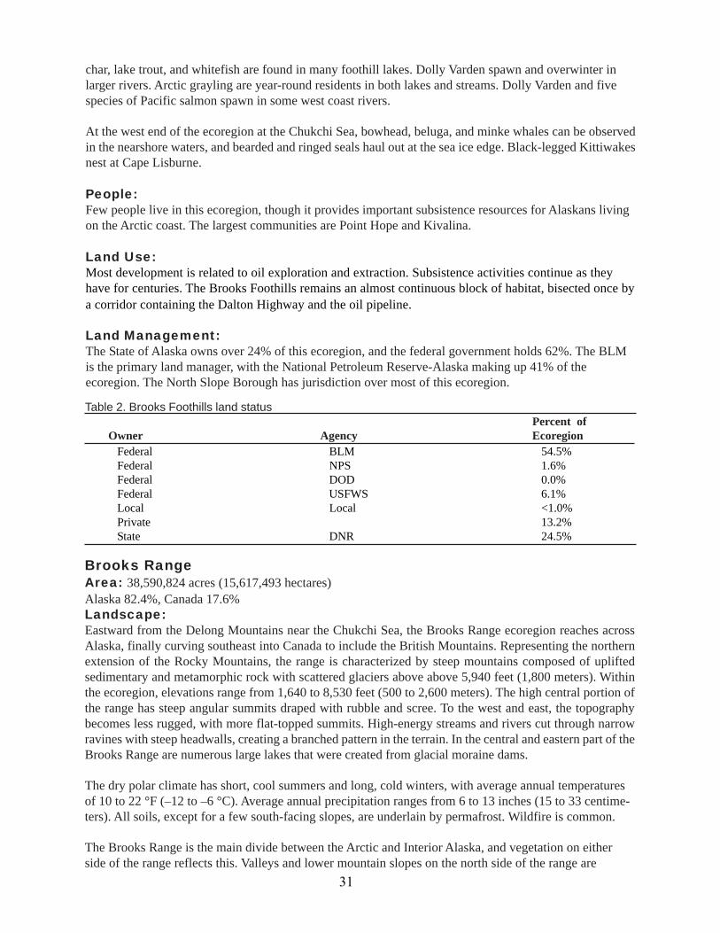
Brooks FoothillsArea: 28,474,479 acres (11,523,464 hectares)Landscape:Composed of gently rolling hills and broad, exposed ridges, the Brooks Foothills ecoregion stretches fromPoint Hope at the Chukchi Sea eastward, almost to the Canadian border. Long, linear ridges, buttes, andmesas composed of tightly folded sedimentary rocks divide narrow alluvial valleys and glacial moraines.Above a thick, continuous layer of permafrost are ice-related features, such as gelifluction lobes, pingos,and ice-wedge polygon networks. Because the permafrost impedes drainage, soils are usually saturatedand have fairly thick organic horizons. Lakes are infrequent, but many swift streams and rivers originat-ing in the Brooks Range cross through the foothills, occasionally braiding across gravel flats. Somestreams freeze solid each winter, creating large aufeis deposits that last well into summer.
A dry polar climate dominates the land, but is somewhat warmer and wetter than the climate of theBeaufort Coastal Plain. The average annual precipitation ranges from 6 to 10 inches (15–25 centimeters),and average annual temperature ranges from 9 to 20 °F (–13 to –7 °C).
Vegetation along rivers is dominated by willow. The rest of theecoregion is dominated by vast expanses of mixed shrub-sedgetussock tundra. Dryas tundra occurs on ridges, and calcareous areassupport sedge-Dryas tundra. Wetlands are present in more than 83%of the ecoregion.
Wildlife and Fish:The Brooks Foothills provide habitat for wide-ranging mammals.The Western Arctic, Porcupine and Central Arctic caribou herdsmigrate through the foothills to reach their calving grounds in theUtukok Uplands (Western Arctic herd) and Beaufort Coastal Plain(Porcupine and Central Arctic herds). The foothills contain denningsites for brown bears and wolves. Additionally, the area is importantto muskoxen, arctic ground squirrels, Smith’s Longspurs, andPeregrine Falcons. The moist tundra provides nesting habitat forBaird’s, Stilt and Buff-breasted Sandpipers and small mammals suchas the insular vole. The Colville River bluffs contain nesting andfeeding habitat for the Peregrine Falcon and other raptors. ArcticPeregrine Falcon USFWS
Figure 3. Brooks Foothills ecoregion
30
char, lake trout, and whitefish are found in many foothill lakes. Dolly Varden spawn and overwinter inlarger rivers. Arctic grayling are year-round residents in both lakes and streams. Dolly Varden and fivespecies of Pacific salmon spawn in some west coast rivers.
At the west end of the ecoregion at the Chukchi Sea, bowhead, beluga, and minke whales can be observedin the nearshore waters, and bearded and ringed seals haul out at the sea ice edge. Black-legged Kittiwakesnest at Cape Lisburne.
People:Few people live in this ecoregion, though it provides important subsistence resources for Alaskans livingon the Arctic coast. The largest communities are Point Hope and Kivalina.
Land Use:Most development is related to oil exploration and extraction. Subsistence activities continue as theyhave for centuries. The Brooks Foothills remains an almost continuous block of habitat, bisected once bya corridor containing the Dalton Highway and the oil pipeline.
Land Management:The State of Alaska owns over 24% of this ecoregion, and the federal government holds 62%. The BLMis the primary land manager, with the National Petroleum Reserve-Alaska making up 41% of theecoregion. The North Slope Borough has jurisdiction over most of this ecoregion.
Brooks RangeArea: 38,590,824 acres (15,617,493 hectares)Alaska 82.4%, Canada 17.6%Landscape:Eastward from the Delong Mountains near the Chukchi Sea, the Brooks Range ecoregion reaches acrossAlaska, finally curving southeast into Canada to include the British Mountains. Representing the northernextension of the Rocky Mountains, the range is characterized by steep mountains composed of upliftedsedimentary and metamorphic rock with scattered glaciers above above 5,940 feet (1,800 meters). Withinthe ecoregion, elevations range from 1,640 to 8,530 feet (500 to 2,600 meters). The high central portion ofthe range has steep angular summits draped with rubble and scree. To the west and east, the topographybecomes less rugged, with more flat-topped summits. High-energy streams and rivers cut through narrowravines with steep headwalls, creating a branched pattern in the terrain. In the central and eastern part of theBrooks Range are numerous large lakes that were created from glacial moraine dams.
The dry polar climate has short, cool summers and long, cold winters, with average annual temperaturesof 10 to 22 °F (–12 to –6 °C). Average annual precipitation ranges from 6 to 13 inches (15 to 33 centime-ters). All soils, except for a few south-facing slopes, are underlain by permafrost. Wildfire is common.
The Brooks Range is the main divide between the Arctic and Interior Alaska, and vegetation on eitherside of the range reflects this. Valleys and lower mountain slopes on the north side of the range are
Table 2. Brooks Foothills land status
Federal BLM 54.5%Federal NPS 1.6%Federal DOD 0.0%Federal USFWS 6.1%Local Local <1.0%Private 13.2%State DNR 24.5%
Percent ofOwner Agency Ecoregion
31
covered by mixed shrub-sedge tussock tundra withwillow thickets along rivers and streams. Many ofthe highest ridges are barren or ice-covered. On thesouth side, lower mountain slopes and valleyspossess sedge tussocks and shrubs. Sparse conifer-birch forests and tall shrubs are restricted to largervalleys on the south side of the range in Alaska, butthe Arctic tree line extends across the range inCanada. The steepest slopes remain barren due toinstability. Upper and intermediate slopes containalpine heath communities; lower slopes have moistsedge-tussock meadows; and shrub communitiesform in thickets along major rivers. Wetlandsoccupy at least 20% of the ecoregion.
Wildlife and Fish:Dall sheep, gray wolves, brown bears, Alaskamarmots, and caribou inhabit the mountains. Birds,such as Golden Eagles, Horned Larks, and Smith’sLongspurs, and small mammals, such as singingvoles, are found in the wide valley floors. Deeplakes provide habitat for Arctic char, lake trout,Arctic grayling, and whitefish, while ground watersprings provide spawning habitat for Dolly Vardenand chum salmon. Arctic grayling and slimysculpin live in most of the area’s waterways.
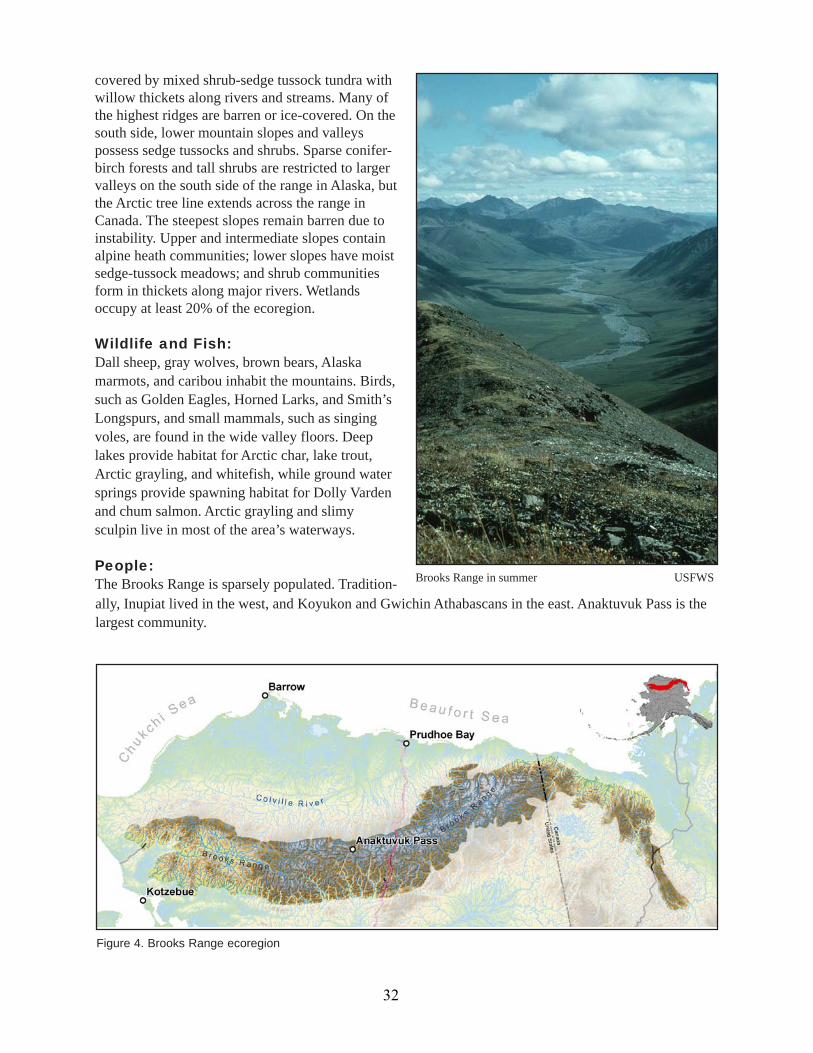
People:The Brooks Range is sparsely populated. Tradition- Brooks Range in summer USFWS
ally, Inupiat lived in the west, and Koyukon and Gwichin Athabascans in the east. Anaktuvuk Pass is thelargest community.
Figure 4. Brooks Range ecoregion
32

Land Use:Most development is related to oil exploration and extraction. The Dalton Highway bisects the ecoregion,acting as the primary land transportation route to the oil and gas fields to the north. This ecoregion remainsalmost entirely intact, except for development at Red Dog Mine, the Dalton Highway, and the trans-Alaskapipeline. Subsistence activities are important uses of the land and waters, as they have been for centuries.
Land Management:Over 17% of this ecoregion is in Canada, where a portion has been designated as Ivvavik National Park.The majority of the Alaska portion of the ecoregion has been legislatively set aside as national parks andwildlife refuges: Gates of the Arctic National Park, Noatak National Park, Kobuk Valley National Park,and the Arctic National Wildlife Refuge. The NPS and USFWS together manage over 75% of the Alaskalands. The BLM has designated several Areas of Critical Environmental Concern.11 The State of Alaskaowns more than 13% of the ecoregion. Private ownership is very low. The North Slope and NorthwestArctic boroughs have jurisdiction over parts of this ecoregion.
Bering TaigaNulato HillsArea: 14,433,528 acres (5,841,169 hectares)Landscape:The low, rolling Nulato Hills form a divide betweenthe Bering Sea and the Yukon River, with streams onthe east side flowing into the river and those on thewest draining into Norton Sound. An ancient moun-tain range has been eroded down to these southwest-northeast oriented hills with a maximum elevationof 4,040 feet (1,230 m) and narrow valleys risingfrom sea level. Some valleys have thaw lakes, andpermafrost underlies most of the ecoregion.
The vegetation pattern is largely based on the eleva-tion and terrain. Higher elevations are barren or al-pine tundra of Dryas-lichen or sedge-ericaceousshrubs. As one descends in elevation, the vegetationchanges to dwarf shrubs, followed by taller willow-birch-alder shrublands. Spruce and birch forests oc-
11 An area designated pursuant to the federal Land Policy and Management Act of 1976, where special managementattention is required to protectand prevent irreparable damage to important historic, cultural, or scenic values, fishand wildlife resources, or other natural systems or processes, or to protect life and safety from natural hazards.
cur at lowest elevations. Wildfires are a common disturbance in this ecoregion.
Percent ofOwner Agency EcoregionFederal BLM 7.7%Federal NPS 50.0%Federal USFWS 31.9%Private 2.0%State DNR 13.4%
Table 3. Brooks Range land status
Figure 5. Nulato Hills ecoregion
33

The moist polar climate is somewhat moderated bythe Bering Sea, though the presence of sea ice earlyin the winter allows direct passage of cold air fromSiberia. The average annual temperature ranges from23 to 28 °F (–5 to –2 °C), and the average annualprecipitation is 12 to 16 inches (30 to 40 centime-ters).
Wildlife and Fish:As part of the ice-free Beringia corridor linking NorthAmerica and Asia in the past, this ecoregion stillpossesses species more common in Eurasia than therest of Alaska. Yellow and White Wagtails,Bluethroats, and Red-throated Pipits are found here.Species more common to Alaska also live here—moose, brown bears, caribou, arctic foxes, and Alaskahares. River otters occur in the major river valleys. Polar bears; spotted, bearded, and ringed seals; belugaand minke whales; and walruses are seen near the coast and on adjacent ice floes. Five species of Pacificsalmon ascend area rivers to spawn. Dolly Varden spawn and overwinter in most rivers, and Arctic graylingare resident in larger streams. Bering cisco and Alaska blackfish are common residents of the fresh waters.
People:Native Alaskans in the area include Inupiat, Koyukon Athabascans, and Central Yup’iks. The largest com-munities are Unalakleet and Mountain Village.
Land Uses:Subsistence remains an integral part of the people and economy of this ecoregion, with an emphasis oncaribou and fish. Mining exploration and prospecting continue on a limited basis.
Land Management:The federal government manages over 85% of the Nulato Hills. The BLM has responsibility for most of thefederal lands and has designated several Areas of Critical Environmental Concern. The majority of theUSFWS lands are part of Yukon Delta National Wildlife Refuge. Private landowners, primarily Nativecorporations, own more land than the state.
Nulato Hills in winter S. Steinacher, ADF&G
Yukon-Kuskokwim DeltaArea: 18,965,040 acres(7,675,047 hectares)Landscape:The Yukon-Kuskokwim Delta in southwest Alaska results from the deposition of heavy sediment loads fromthe glacial Yukon and Kuskokwim Rivers. Abundant thermokarst lakes, meandering streams, and highlyproductive brackish marshes and wet meadows characterize the flat coastal plain. Isolated basalt hills andvolcanic cinder cones less than 400 feet (120 meters) punctuate the landscape. Discontinuous permafrost
Federal BLM 67.0%Federal DOD <1.0%Federal USFWS 18.4%Local Local <1.0%Private 11.2%State DNR 3.4%
Table 4. Nulato Hills land statusPercent of
Owner Agency Ecoregion
34

impedes drainage and contributes to shallow organicsoils. Large tidal fluctuations near the coast, alongwith occasional storm tide surges, flood coastal ar-eas with salt water, creating invertebrate-rich coastalmarshes.
Wet tundra communities on the coastal plain prima-rily consist of sedge mats, moss, and low-growingshrubs. Uplands due to peat mounds, sand dunes andvolcanic soils support dwarf scrub communities ofbirch and ericaceous shrubs. Inland bogs contain tus-sock-forming sedges and sedge-moss communities.Willow thickets form along rivers and on better- Fall tundra USFWS
drained slopes, and alders and stunted spruce and birch grow along the major streams.
The Bering Sea somewhat moderates the moist polar climate, though sea ice in winter allows cold Siberianwinds into this ecoregion. Average annual precipitation is 15 to 22 inches (38 to 56 centimeters), and theaverage annual temperature varies from 25 to 31 °F (–4 to –1 °C).
Wildlife and Fish:The combination of lakes, streams, tidal flats, wet tundra, and sedge flats supports abundant populationsof waterfowl and shorebirds; more than 20 species of waterfowl and 10 species of shorebirds breed here.The Yukon-Kuskokwim Delta supports 50% of the world’s Black Brant, the majority of the world’sEmperor Swans, all of North America’s nesting Cackling Canada Geese, and the highest densities ofnesting Tundra Swans. Long-tailed Duck, Scaup, Common Eider, Spectacles Eider, Northern Pintail,Green-winged Teal, and Northern Shoveler can also be found here. Hundreds of thousands of shorebirdsuse the coastal littoral and wetland areas during spring and fall migration. Breeding shorebirds includeBristle-thighed Curlew; Black-bellied Plover; Bar-tailed Godwit; Ruddy and Black Turnstone; Red-necked Phalarope; Long-billed Dowitcher; Red Knot, Semipalmated, and Western Sandpiper; and Dunlin.
The coastal portions of the ecoregion provide feed-ing grounds for beluga and minke whales; Pacific wal-ruses; and bearded, spotted, ribbon and ringed seals.Large runs of anadromous fishes, including Arcticlamprey, Dolly Varden, humpback and broad white-fish, Bering cisco, and five species of Pacific salmon,migrate up the Yukon and Kuskokwim Rivers annu-ally. Northern pike, Arctic grayling, whitefish andrainbow trout are resident in many streams. Black-fish, sticklebacks and whitefish are abundant in low-lying watersheds. Sheefish, Bering cisco and broadwhitefish are important for subsistence. Terrestrialmammals include river otters, brown bears, moose,and wolves.
People:This ecoregion is the heart of the area inhabitedtraditionally by the Yup’ik people. Bethel is thelargest community.
Land Use:This ecoregion is almost entirely intact, with Figure 6. Yukon-Kuskokwim Delta ecoregion
35

minimal development around several small communities along the rivers and coast. A commercial salmonfishery employs some people, and subsistence fishing and hunting is prevalent.
Land Management:The federal government manages 74% of the land in this ecoregion, almost entirely as the Yukon DeltaNational Wildlife Refuge. Private landowners are the other major landowner, with Native corporationsholding most of that land.
Ahklun MountainsArea: 9,565,938 acres (3,871,282 hectares)Landscape:Located in the southwest part of the state, the Ahklunand Kilbuck Mountains define the divide between thedrainages into Kuskokwim and Bristol Bays. Thesemountains are steep and sharp, with elevations reach-ing 4,950 feet (1,500 meters). Past glaciers carvedbroad U-shaped valleys, and a few small glaciers stillpersist. Great northeast-trending faults have cutthrough the underlying sedimentary and volcanicrock, and large “finger” lakes fill valleys on the southside of the mountains. Permafrost is generally absentfrom soils covered by forests, but exists in most low-lying areas and in high mountains.
The Bering Sea influences the continental climateof this ecoregion by moderating temperatures in thesummer and allowing access for cold Siberian air
Percent ofOwner Agency EcoregionFederal BLM <1.0%Federal USFWS 73.7%Local Local <1.0%Private 24.1%State DNR 1.9%
Table 5. Yukon-Kuskokwim Delta land status
across the ice pack in the winter. Annual average precipitation ranges from 102 centimeters in lowlands to203 centimeters at higher elevations, with average annual temperatures from 33 to 39 °F (–2 to 1 °C).
The Ahklun Mountains separate two extensive wetland complexes (Yukon-Kuskokwim Delta to the northand Bristol Bay Lowlands to the south) along the southern Bering Sea, and wetlands of sedge-tussocktundra occupy up to 55% of the ecoregion. Vegetation in the higher elevations is largely dominated bylichen tundra and dwarf scrub communities with ericaceous shrubs. The proportion and size of thewillow, birch, and alder shrubs increases at lower elevations. In valleys, shrublands and wetlands aremixed with forests of white spruce, balsam poplar, or mixed white spruce and paper birch.
Wildlife and Fish:The large lakes and rivers have rainbow trout, grayling, lake trout, Arctic char, Dolly Varden, whitefish,and northern pike. Five species of Pacific salmon spawn in the river systems, with abundant runs ofsockeye salmon to headwater lakes. Beavers are found in the lakes and wetlands, and Wood Frogs inhabitdiverse habitats.
Figure 7. Ahklun Mountains ecoregion
36

The coastline and islands of this ecoregion provide important habitat for marine mammals and seabirds.Common Murre, Pigeon Guillemot, and Black-legged Kittiwake colonize here. The Walrus Islands groupgets it name from the large number of bachelor walruses that haul out on its beaches each summer. Thelargest concentration occurs on Round Island, where Steller sea lions also haul out. Harbor seals are alsofound here. This area is unique as the only region where ranges of the closely related harbor seal andspotted seal overlap. These marine waters support the largest Pacific herring stock in Alaska, as well aslarval and juvenile red king crab. Gray, beluga, killer, and minke whales feed along the coast.
People:Yup’ik groups from Bristol Bay and the Yukon-Kuskokwim Delta live here. Salmon, freshwater fish,seals, beluga whales, caribou, migratory waterfowl, eggs and plants are traditional foods derived fromthis ecoregion. Most of the population lives in Togiak on Togiak Bay.
Land Use:This ecoregion is almost entirely intact, with minimal development around several small communitiesalong the rivers and coast. Sockeye salmon are the most important fish commercially. Whitefish are animportant subsistence species in the Tikchik Lakes.
Land Management:A majority (58.4%) of the land in the Ahklun Mountain ecoregion is owned by the federal government.The USFWS manages most of the federal lands as Togiak National Wildlife Refuge. The State of Alaskaowns a third of the ecoregion. The Ahklun Mountain ecoregion contains most of the largest state park inthe nation, Wood-Tikchik State Park, and the entire Walrus Islands State Game Sanctuary is here. Noborough has been organized in this ecoregion.
The different habitats at varying elevations supporta wide range of terrestrial species. Moose andarctic hares thrive in the shrubby habitats. Caribouand brown bear can be found throughout theecoregion, but black bear populations are limited tothe northern and eastern parts. Common smallgame and furbearers include muskrat, river otter,fox, wolverine, mink, and porcupine. Groundsquirrels and marmots are abundant in alpinetundra. Birds nesting in the area include a widevariety of waterfowl, gulls, Bald Eagles, GoldenEagles, Arctic Terns, various loons, Spotted andLeast Sandpipers, Semipalmated Plovers, WillowPtarmigan, Spruce Grouse, Rusty Blackbirds, andBlackpoll Warblers.
Cape Newenham on the Togiak National Wildlife Refuge M. Smith, USFWS
Percent ofOwner Agency EcoregionFederal BLM 6.9%Federal USFWS 51.5%Private 8.4%State DNR 33.2%
Table 6. Akhlun Mountains land status
37
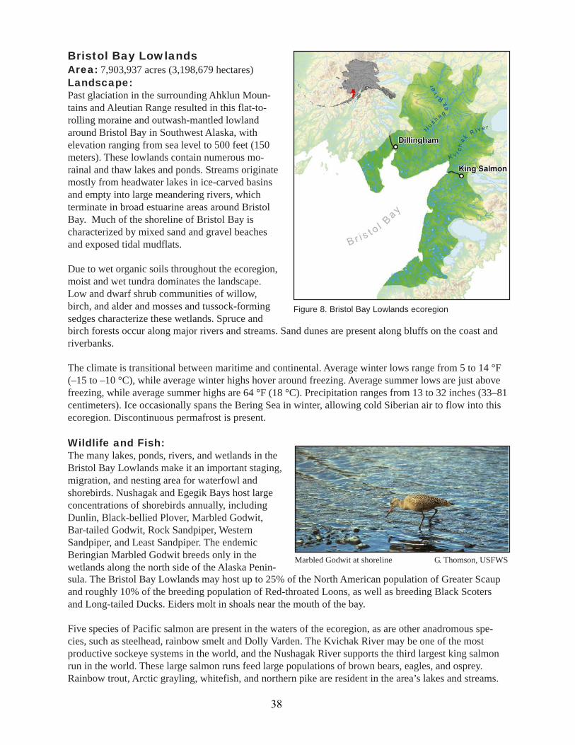
Bristol Bay LowlandsArea: 7,903,937 acres (3,198,679 hectares)Landscape:Past glaciation in the surrounding Ahklun Moun-tains and Aleutian Range resulted in this flat-to-rolling moraine and outwash-mantled lowlandaround Bristol Bay in Southwest Alaska, withelevation ranging from sea level to 500 feet (150meters). These lowlands contain numerous mo-rainal and thaw lakes and ponds. Streams originatemostly from headwater lakes in ice-carved basinsand empty into large meandering rivers, whichterminate in broad estuarine areas around BristolBay. Much of the shoreline of Bristol Bay ischaracterized by mixed sand and gravel beachesand exposed tidal mudflats.
Due to wet organic soils throughout the ecoregion,moist and wet tundra dominates the landscape.Low and dwarf shrub communities of willow,birch, and alder and mosses and tussock-formingsedges characterize these wetlands. Spruce and
Marbled Godwit at shoreline G. Thomson, USFWS
birch forests occur along major rivers and streams. Sand dunes are present along bluffs on the coast andriverbanks.
The climate is transitional between maritime and continental. Average winter lows range from 5 to 14 °F(–15 to –10 °C), while average winter highs hover around freezing. Average summer lows are just abovefreezing, while average summer highs are 64 °F (18 °C). Precipitation ranges from 13 to 32 inches (33–81centimeters). Ice occasionally spans the Bering Sea in winter, allowing cold Siberian air to flow into thisecoregion. Discontinuous permafrost is present.
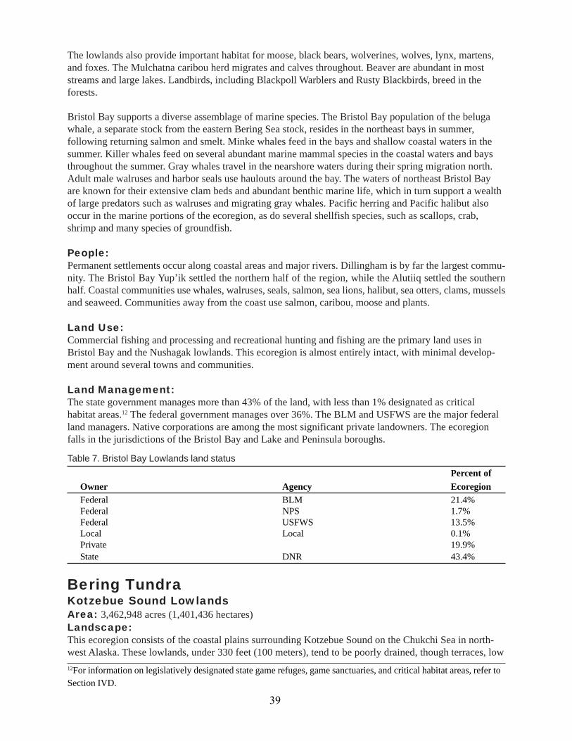
Wildlife and Fish:The many lakes, ponds, rivers, and wetlands in theBristol Bay Lowlands make it an important staging,migration, and nesting area for waterfowl andshorebirds. Nushagak and Egegik Bays host largeconcentrations of shorebirds annually, includingDunlin, Black-bellied Plover, Marbled Godwit,Bar-tailed Godwit, Rock Sandpiper, WesternSandpiper, and Least Sandpiper. The endemicBeringian Marbled Godwit breeds only in thewetlands along the north side of the Alaska Penin-sula. The Bristol Bay Lowlands may host up to 25% of the North American population of Greater Scaupand roughly 10% of the breeding population of Red-throated Loons, as well as breeding Black Scotersand Long-tailed Ducks. Eiders molt in shoals near the mouth of the bay.
Five species of Pacific salmon are present in the waters of the ecoregion, as are other anadromous spe-cies, such as steelhead, rainbow smelt and Dolly Varden. The Kvichak River may be one of the mostproductive sockeye systems in the world, and the Nushagak River supports the third largest king salmonrun in the world. These large salmon runs feed large populations of brown bears, eagles, and osprey.Rainbow trout, Arctic grayling, whitefish, and northern pike are resident in the area’s lakes and streams.
Figure 8. Bristol Bay Lowlands ecoregion
38
The lowlands also provide important habitat for moose, black bears, wolverines, wolves, lynx, martens,and foxes. The Mulchatna caribou herd migrates and calves throughout. Beaver are abundant in moststreams and large lakes. Landbirds, including Blackpoll Warblers and Rusty Blackbirds, breed in theforests.
Bristol Bay supports a diverse assemblage of marine species. The Bristol Bay population of the belugawhale, a separate stock from the eastern Bering Sea stock, resides in the northeast bays in summer,following returning salmon and smelt. Minke whales feed in the bays and shallow coastal waters in thesummer. Killer whales feed on several abundant marine mammal species in the coastal waters and baysthroughout the summer. Gray whales travel in the nearshore waters during their spring migration north.Adult male walruses and harbor seals use haulouts around the bay. The waters of northeast Bristol Bayare known for their extensive clam beds and abundant benthic marine life, which in turn support a wealthof large predators such as walruses and migrating gray whales. Pacific herring and Pacific halibut alsooccur in the marine portions of the ecoregion, as do several shellfish species, such as scallops, crab,shrimp and many species of groundfish.
People:Permanent settlements occur along coastal areas and major rivers. Dillingham is by far the largest commu-nity. The Bristol Bay Yup’ik settled the northern half of the region, while the Alutiiq settled the southernhalf. Coastal communities use whales, walruses, seals, salmon, sea lions, halibut, sea otters, clams, musselsand seaweed. Communities away from the coast use salmon, caribou, moose and plants.
Land Use:Commercial fishing and processing and recreational hunting and fishing are the primary land uses inBristol Bay and the Nushagak lowlands. This ecoregion is almost entirely intact, with minimal develop-ment around several towns and communities.
Land Management:The state government manages more than 43% of the land, with less than 1% designated as criticalhabitat areas.12 The federal government manages over 36%. The BLM and USFWS are the major federalland managers. Native corporations are among the most significant private landowners. The ecoregionfalls in the jurisdictions of the Bristol Bay and Lake and Peninsula boroughs.
12For information on legislatively designated state game refuges, game sanctuaries, and critical habitat areas, refer toSection IVD.
Percent ofOwner Agency EcoregionFederal BLM 21.4%Federal NPS 1.7%Federal USFWS 13.5%Local Local 0.1%Private 19.9%State DNR 43.4%
Table 7. Bristol Bay Lowlands land status
Bering TundraKotzebue Sound LowlandsArea: 3,462,948 acres (1,401,436 hectares)Landscape:This ecoregion consists of the coastal plains surrounding Kotzebue Sound on the Chukchi Sea in north-west Alaska. These lowlands, under 330 feet (100 meters), tend to be poorly drained, though terraces, low
39
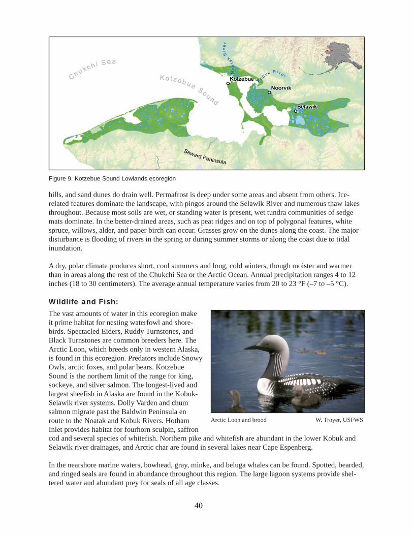
Figure 9. Kotzebue Sound Lowlands ecoregion
Arctic Loon and brood W. Troyer, USFWS
hills, and sand dunes do drain well. Permafrost is deep under some areas and absent from others. Ice-related features dominate the landscape, with pingos around the Selawik River and numerous thaw lakesthroughout. Because most soils are wet, or standing water is present, wet tundra communities of sedgemats dominate. In the better-drained areas, such as peat ridges and on top of polygonal features, whitespruce, willows, alder, and paper birch can occur. Grasses grow on the dunes along the coast. The majordisturbance is flooding of rivers in the spring or during summer storms or along the coast due to tidalinundation.
A dry, polar climate produces short, cool summers and long, cold winters, though moister and warmerthan in areas along the rest of the Chukchi Sea or the Arctic Ocean. Annual precipitation ranges 4 to 12inches (18 to 30 centimeters). The average annual temperature varies from 20 to 23 °F (–7 to –5 °C).
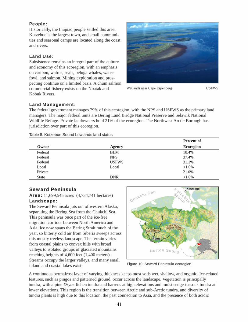
Wildlife and Fish:The vast amounts of water in this ecoregion makeit prime habitat for nesting waterfowl and shore-birds. Spectacled Eiders, Ruddy Turnstones, andBlack Turnstones are common breeders here. TheArctic Loon, which breeds only in western Alaska,is found in this ecoregion. Predators include SnowyOwls, arctic foxes, and polar bears. KotzebueSound is the northern limit of the range for king,sockeye, and silver salmon. The longest-lived andlargest sheefish in Alaska are found in the Kobuk-Selawik river systems. Dolly Varden and chumsalmon migrate past the Baldwin Peninsula enroute to the Noatak and Kobuk Rivers. HothamInlet provides habitat for fourhorn sculpin, saffroncod and several species of whitefish. Northern pike and whitefish are abundant in the lower Kobuk andSelawik river drainages, and Arctic char are found in several lakes near Cape Espenberg.
In the nearshore marine waters, bowhead, gray, minke, and beluga whales can be found. Spotted, bearded,and ringed seals are found in abundance throughout this region. The large lagoon systems provide shel-tered water and abundant prey for seals of all age classes.
40
People:Historically, the Inupiaq people settled this area.Kotzebue is the largest town, and small communi-ties and seasonal camps are located along the coastand rivers.
Land Use:Subsistence remains an integral part of the cultureand economy of this ecoregion, with an emphasison caribou, walrus, seals, beluga whales, water-fowl, and salmon. Mining exploration and pros-pecting continue on a limited basis. A chum salmoncommercial fishery exists on the Noatak andKobuk Rivers.
Percent ofOwner Agency EcoregionFederal BLM 10.4%Federal NPS 37.4%Federal USFWS 31.1%Local Local <1.0%Private 21.0%State DNR <1.0%
Table 8. Kotzebue Sound Lowlands land status
Wetlands near Cape Espenberg USFWS
Land Management:The federal government manages 79% of this ecoregion, with the NPS and USFWS as the primary landmanagers. The major federal units are Bering Land Bridge National Preserve and Selawik NationalWildlife Refuge. Private landowners hold 21% of the ecoregion. The Northwest Arctic Borough hasjurisdiction over part of this ecoregion.
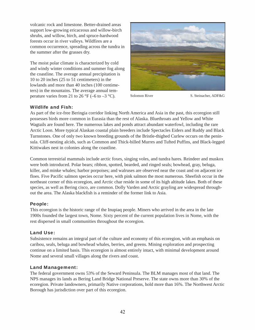
Seward PeninsulaArea: 11,699,545 acres (4,734,741 hectares)Landscape:The Seward Peninsula juts out of western Alaska,separating the Bering Sea from the Chukchi Sea.This peninsula was once part of the ice-freemigration corridor between North America andAsia. Ice now spans the Bering Strait much of theyear, so bitterly cold air from Siberia sweeps acrossthis mostly treeless landscape. The terrain variesfrom coastal plains to convex hills with broadvalleys to isolated groups of glaciated mountainsreaching heights of 4,600 feet (1,400 meters).Streams occupy the larger valleys, and many smallinland and coastal lakes exist.
A continuous permafrost layer of varying thickness keeps most soils wet, shallow, and organic. Ice-relatedfeatures, such as pingos and patterned ground, occur across the landscape. Vegetation is principallytundra, with alpine Dryas-lichen tundra and barrens at high elevations and moist sedge-tussock tundra atlower elevations. This region is the transition between Arctic and sub-Arctic tundra, and diversity oftundra plants is high due to this location, the past connection to Asia, and the presence of both acidic
Figure 10. Seward Peninsula ecoregion
41
volcanic rock and limestone. Better-drained areassupport low-growing ericaceous and willow-birchshrubs, and willow, birch, and spruce-hardwoodforests occur in river valleys. Wildfires are acommon occurrence, spreading across the tundra inthe summer after the grasses dry.
The moist polar climate is characterized by coldand windy winter conditions and summer fog alongthe coastline. The average annual precipitation is10 to 20 inches (25 to 51 centimeters) in thelowlands and more than 40 inches (100 centime-ters) in the mountains. The average annual tem-perature varies from 21 to 26 °F (–6 to –3 °C).
Wildlife and Fish:As part of the ice-free Beringia corridor linking North America and Asia in the past, this ecoregion stillpossesses birds more common in Eurasia than the rest of Alaska. Bluethroats and Yellow and WhiteWagtails are found here. The numerous lakes and ponds attract abundant waterfowl, including the rareArctic Loon. More typical Alaskan coastal plain breeders include Spectacles Eiders and Ruddy and BlackTurnstones. One of only two known breeding grounds of the Bristle-thighed Curlew occurs on the penin-sula. Cliff-nesting alcids, such as Common and Thick-billed Murres and Tufted Puffins, and Black-leggedKittiwakes nest in colonies along the coastline.
Common terrestrial mammals include arctic foxes, singing voles, and tundra hares. Reindeer and muskoxwere both introduced. Polar bears; ribbon, spotted, bearded, and ringed seals; bowhead, gray, beluga,killer, and minke whales; harbor porpoises; and walruses are observed near the coast and on adjacent icefloes. Five Pacific salmon species occur here, with pink salmon the most numerous. Sheefish occur in thenortheast corner of this ecoregion, and Arctic char reside in some of its high altitude lakes. Both of thesespecies, as well as Bering cisco, are common. Dolly Varden and Arctic grayling are widespread through-out the area. The Alaska blackfish is a reminder of the former link to Asia.
People:This ecoregion is the historic range of the Inupiaq people. Miners who arrived in the area in the late1900s founded the largest town, Nome. Sixty percent of the current population lives in Nome, with therest dispersed in small communities throughout the ecoregion.
Land Use:Subsistence remains an integral part of the culture and economy of this ecoregion, with an emphasis oncaribou, seals, beluga and bowhead whales, berries, and greens. Mining exploration and prospectingcontinue on a limited basis. This ecoregion is almost entirely intact, with minimal development aroundNome and several small villages along the rivers and coast.
Land Management:The federal government owns 53% of the Seward Peninsula. The BLM manages most of that land. TheNPS manages its lands as Bering Land Bridge National Preserve. The state owns more than 30% of theecoregion. Private landowners, primarily Native corporations, hold more than 16%. The Northwest ArcticBorough has jurisdiction over part of this ecoregion.
Solomon River S. Steinacher, ADF&G
42
Bering Sea IslandsArea: 2,347,545 acres (950,038 hectares)Landscape:Five major islands—St. Lawrence, Nunivak, St. Matthew, and the two Pribilof Islands of St. George andSt. Paul—and their adjacent islets dot the inner shelf of the Bering Sea and constitute the Bering SeaIslands ecoregion. The largest island, St. Lawrence, is 1,278,000 acres, and the smallest, St. George, isjust 22,150 acres. The relatively shallow marine waters surrounding these islands host a high concentra-tion of benthic invertebrates.
The climate is a mix of polar and maritime, with the season determining which one predominates. Sea iceforms on the inner shelf of the Bering Sea, and dry polar air from Siberia travels across the ice pack tothese islands. After the ice breaks up in the spring, cool, moist maritime conditions are typical throughthe summer. Soils are thin and rocky and underlain by thin to moderately thick permafrost.
The intercontinental access available during pastglaciation and annual ice pack has contributed tovegetation with North American and Asian affini-ties. These rocky volcanic islands are treeless andcharacterized by moist tundra meadows of sedges,grasses, low shrubs, and lichens. The shorelines area mix of rocky sea cliffs and sand dunes.
Wildlife and Fish:These islands possess globally importantpopulations of seabirds, waterfowl, and marinemammals. The Pribilof Islands provide habitat forapproximately 3 million seabirds, including nearlythe entire world population of Red-leggedKittiwakes. Other large breeding colonies exist onthe islands for the Black-legged Kittiwake,Parakeet Auklet, Crested Auklet, Least Auklet,Northern Fulmar, Red-faced Cormorant, PigeonGuillemot, Leach’s and Fork-tailed Storm-petrels,and Common and Thick-billed Murres. In thewinter, an ice-free area south of St. LawrenceIsland hosts the entire population of SpectaclesEiders. King and Common Eiders and Long-tailedDuck feed along the southern coast of that islandin the summer and winter along the edge of the icepack. The Pribilof Rock Sandpiper only breeds onBering Sea islands. McKay’s Bunting, the only
Percent ofOwner Agency EcoregionFederal BLM 39.4%Federal NPS 13.2%Federal USFWS <1.0%Local Local <1.0%Private 16.1%State DNR 30.8%
Table 9. Seward Peninsula land status
Red-legged Kitttiwake colony USFWS
43

passerine endemic to Alaska, breeds only on St.Matthew and Hall Islands.
The Bering Sea shelf supports king, Tanner, andhair crabs. One of the richest pockets ofinvertebrate life in the Bering Sea is found near St.Lawrence Island, where extremely productivebenthic communities, including bivalve mollusksand amphipods, support marine mammals andwaterfowl. A diverse mix of marine fish, includingpollock, halibut, salmon, and forage fish, such asherring, Pacific sandlance, capelin, and lanternfish(Myctophids), also contribute to the abundance ofbirds and mammals. Breeding and winteringwalruses inhabit the open ocean near St. LawrenceIsland. Bowhead whales winter in the region nearSt. Lawrence Island. The ice-associated seals—ringed, bearded, spotted, and ribbon—can be found at thenorthern islands. The Pribilof Islands provide critical breeding grounds for Steller sea lions andapproximately 80% of the world’s northern fur seals. An important gray whale feeding area is locatedjust north of St. Lawrence Island in the Chirikov Basin. Blue, bowhead, minke, beluga, killer, sei,northern right, humpback, and gray whales swim through the waters of the Bering Sea shelf. DollyVarden, chum, coho and pink salmon spawn on St. Lawrence and Nunivak Islands. Resident populationsof Arctic grayling, whitefish, and northern pike live in the area’s lakes and streams.
Few terrestrial mammals naturally occur on the islands; reindeer and muskoxen have been introduced.The Pribilof Island (St. Paul) and St. Lawrence Island shrews are endemic and limited in range to thoseislands. Declines in population levels of seabirds, some fish and shellfish, and marine mammals arelikely a result of trophic changes in the Bering Sea ecosystem due to commercial harvest of fish andwhales over the last 40 years, as well as climate change.
People:Alaskan and Siberian Yupik people settled the larger islands closer to the Alaska mainland. Most of thepopulation of this ecoregion lives in one of the four communities on St. Lawrence Island and the PribilofIslands.
Land Use:Commercial fishing and subsistence fishing and hunting are the main uses of natural resources in thisecoregion. These islands remain largely undeveloped except for small villages; however, pollution fromthe U.S. Department of Defense remains on St. Lawrence Island.
Land Management:Private ownership of the land in this ecoregion makes up a larger percentage (56.8%) than for any otherecoregion because one Native corporation owns most of St. Lawrence Island. The USFWS is the othermajor landowner, with most of Nunivak Island and parts of St. Paul and St. George managed as nationalwildlife refuges (Yukon Delta and Alaska Maritime National Wildlife Refuges).
Figure 11. Bering Sea Islands ecoregion
Table 10. Bering Sea Islands land statusPercent of
Owner Agency EcoregionFederal BLM <1.0%Federal USFWS 43.2%Private 56.8%
44

Intermontane BorealKuskokwim MountainsArea: 21,092,700 acres (8,536,099 hectares)Landscape:The Kuskokwim Mountains are rolling mountainswith elevations generally below 4,000 feet (1,210meters). Swift streams and rivers meander throughthe deep narrow valleys, following fault lines andhighly eroded bedrock seams of the southwest-northeast trending ridges. Meandering streams andrivers have resulted in oxbow lakes in the valleys.Thaw lakes occur in the valleys and cirque lakesoccur in the mountains.
Permafrost is almost continuous under thisecoregion, but varies in thickness from thin tomoderate. Most lowlands and high mountains areunderlain by permafrost, but forested lands or thosecovered by grasses and alders do not have perma-frost beneath. The continental climate is relativelydry, with average annual precipitation of 12 to 22inches (30 to 56 centimeters). Influence from theBering Sea can bring more moisture to the south-west portion of the ecoregion in the summer. Theaverage annual temperature ranges from 22 to 29 °F (–6 to –2 °C).
Boreal forests characterize the Kuskokwim Mountains. The lowlands contain black spruce and tamarack,while stands of white spruce, white birch, and trembling aspen occur on the slopes and uplands. Areasaffected by recent forest fires have tall willow, birch, and alder shrubs. Smaller willow and alder shrubscan also occur in alpine areas, along with sedges and tundra.
Wildlife and Fish:The boreal forest supports a large variety of birdsand terrestrial mammals. Sharp-shinned Hawks,Golden Eagles, Horned Larks, Surfbirds, andWhite-tailed Ptarmigan inhabit the alpine areas.Landbirds using this ecoregion include Olive-sidedFlycatchers, Blackpoll Warblers, Boreal Owls,Great Gray Owls, and Rusty Blackbirds.
Furbearers include marten, mink, short-tailed andleast weasels, and Canada lynx. Brown beardensities are low to moderate, while moose andbeaver are abundant. Several small caribou herdslive in this ecoregion, and northern bog lemmingscan be found here. Five species of salmon migrateup the Kuskokwim River to spawn in tributarystreams. The deep lakes provide habitat for laketrout. Sheefish, whitefish, Dolly Varden, northernpike and Arctic grayling are common freshwaterresidents.
Figure 12. Kuskokwim Mountains
Sunshine Mountains J. Whitman, ADF&G
45
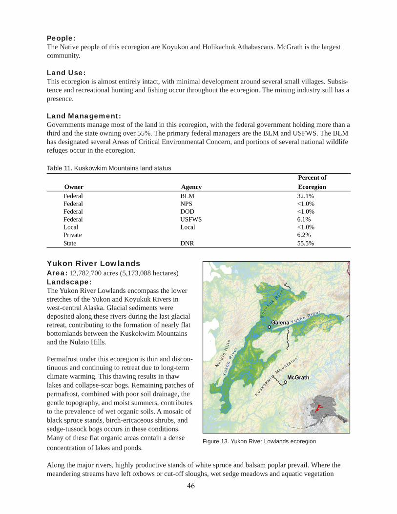
Yukon River LowlandsArea: 12,782,700 acres (5,173,088 hectares)Landscape:The Yukon River Lowlands encompass the lowerstretches of the Yukon and Koyukuk Rivers inwest-central Alaska. Glacial sediments weredeposited along these rivers during the last glacialretreat, contributing to the formation of nearly flatbottomlands between the Kuskokwim Mountainsand the Nulato Hills.
Permafrost under this ecoregion is thin and discon-tinuous and continuing to retreat due to long-termclimate warming. This thawing results in thawlakes and collapse-scar bogs. Remaining patches ofpermafrost, combined with poor soil drainage, thegentle topography, and moist summers, contributesto the prevalence of wet organic soils. A mosaic ofblack spruce stands, birch-ericaceous shrubs, andsedge-tussock bogs occurs in these conditions.Many of these flat organic areas contain a dense
People:The Native people of this ecoregion are Koyukon and Holikachuk Athabascans. McGrath is the largestcommunity.
Land Use:This ecoregion is almost entirely intact, with minimal development around several small villages. Subsis-tence and recreational hunting and fishing occur throughout the ecoregion. The mining industry still has apresence.
Land Management:Governments manage most of the land in this ecoregion, with the federal government holding more than athird and the state owning over 55%. The primary federal managers are the BLM and USFWS. The BLMhas designated several Areas of Critical Environmental Concern, and portions of several national wildliferefuges occur in the ecoregion.
Percent ofOwner Agency EcoregionFederal BLM 32.1%Federal NPS <1.0%Federal DOD <1.0%Federal USFWS 6.1%Local Local <1.0%Private 6.2%State DNR 55.5%
Table 11. Kuskowkim Mountains land status
concentration of lakes and ponds.
Along the major rivers, highly productive stands of white spruce and balsam poplar prevail. Where themeandering streams have left oxbows or cut-off sloughs, wet sedge meadows and aquatic vegetation
Figure 13. Yukon River Lowlands ecoregion
46
occur. Tall alders and willows dominate activefloodplains and river bars. Seasonal changes inwater levels affect these lowlands, with waterlevels dropping in the fall during freeze-up andthen flooding during spring breakup due to icejams.
Wildlife and Fish:The wet habitats of these lowlands support manybirds, mammals, and fish. Common Loons, Hornedand Red-necked Grebes, Trumpeter Swans, andCommon Goldeneyes breed near the lakes andwetlands. The forests along the river valleys attractRuffed Grouse, Belted Kingfishers, Alder Flycatchers, and Hammond’s Flycatchers. Landbirds inhabitingthis ecoregion include Olive-sided Flycatchers, Blackpoll Warblers, Boreal Owls, Great Gray Owls, andRusty Blackbirds.
This ecoregion also provides prime habitat for mink, marten, muskrat, moose, and river otter. Smallermammals include red squirrels, northern bog lemmings, yellow-cheeked voles, and the recently discov-ered tiny shrew. Several caribou herds range throughout the broad expanse of these lowlands, as dopopulations of black bear.
The rivers and streams commonly contain coho, chum, and king salmon. Northern pike and whitefish arecommon in lowland drainages, and Arctic lamprey migrate up the Yukon River in vast numbers in the fall.
People:Koyukon and Holikachuk Athabascans are the traditional inhabitants of this ecoregion. The largestcommunities are Galena, Nulato, and Tanana.
Land Use:The Yukon River provides transportation of people and supplies through the ecoregion to locations ineastern and northern Alaska. This ecoregion is almost entirely intact, with minimal development aroundsmall villages. Subsistence and recreational hunting and fishing occur throughout the ecoregion.
Land Management:The largest landowner is the federal government, with the USFWS responsible for the majority. Theecoregion contains all or part of four national wildlife refuges—Koyukok, Innoko, Nowitna, and YukonDelta. The BLM has designated the Arms Lake Research Natural Area and Dulbi-Kaiyuh Area of CriticalEnvironmental Concern here. Native corporations own most of the privately held land.
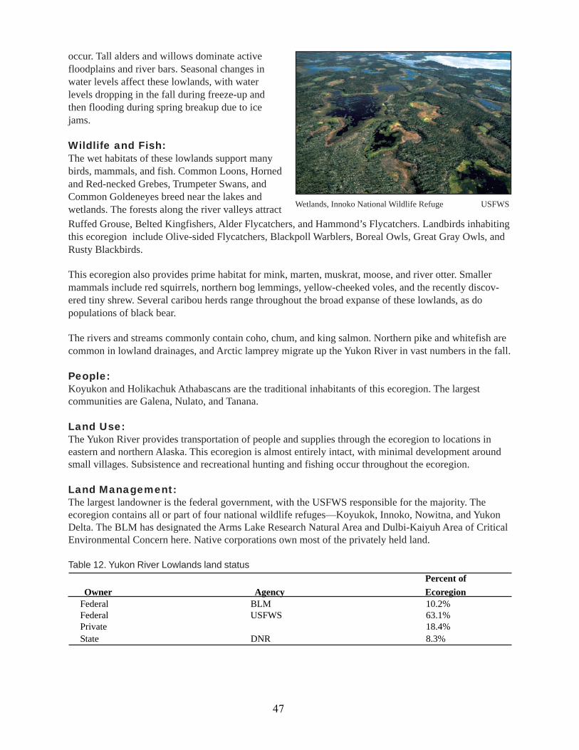
Wetlands, Innoko National Wildlife Refuge USFWS
Percent ofOwner Agency Ecoregion
Federal BLM 10.2%Federal USFWS 63.1%Private 18.4%State DNR 8.3%
Table 12. Yukon River Lowlands land status
47

Kobuk Ridges and ValleysArea: 13,624,124 acres (5,513,607 hectares)Landscape:The ecoregion consists of several large rivers (Kobuk, Noatak, Huslia, and Selawik), their broad valleys,and numerous small mountain ranges south of the Brooks Range. Past ice sheets from glaciers in theBrooks Range carved out immense U-shaped valleys. The mountain ranges vary from the the low,rounded Selawik Hills, which top out at 3,300 feet (1,000 meters), to the steeper, taller Baird andSchwatka Mountains, with a maximum elevation of 8,570 feet (2,600 meters).
The valleys conduct cold air from the Brooks Range during the winter, which deepens the cold of thewinters. The dry, continental climate is characterized by long, cold winters and short, cool summers.
Permafrost is almost continuous under this ecoregion, but varies in thickness from thin to moderate. Thepresence of permafrost and floodplains contributes to poorly drained soils and wet conditions along therivers. These areas are dominated by black spruce in bogs. Better-drained places along the rivers supportwhite spruce and balsam poplar. White spruce, paper birch, and trembling aspen grow on uplands. Towardthe western part of this ecoregion, trees become smaller and occur in stands that are less dense andrestricted to lower elevations.
Throughout the ecoregion, mountain peaks are either barren or have alpine tundra. Tall willow, birch, andalder communities can also be found in this ecoregion. Relatively warm and dry summers and frequentlightning storms during that season combine to make forest fires a common disturbance in these moun-tains.
Wildlife and Fish:The rivers and lakes in this ecoregion support freshwater and anadromous fish species and represent thenorthernmost range of king, sockeye, and silver salmon. Chum salmon runs are strong in the Kobuk andNoatak Rivers. The longest-lived and largest sheefish in Alaska are found in the Kobuk-Selawik riversystems. Large runs of least cisco and broad and humpback whitefish ascend the Noatak and KobukRivers to spawn. Dolly Varden spawn and overwinter in both rivers. Northern pike and whitefish arecommon residents in lowland drainages.
The boreal forest supports a large variety of birds and terrestrial mammals. The mixed forests are inhab-ited by breeding landbirds, such as Gray Jays, Boreal Chickadees, Boreal Owls, and Great Gray Owls.
Figure 14. Kobuk Ridges and Valleys ecoregion
48
Furbearers include marten, mink,short-tailed and least weasels, andCanada lynx. This ecoregion repre-sents the northern extent of Ameri-can beaver and muskrat in Alaska.Arctic ground squirrels inhabit thehigh mountainous areas. The West-ern Arctic caribou herd winters inthe southern portion of thisecoregion and migrates through theecoregion to reach calving andsummering grounds to the north.Top-level predators include brownbears, wolverines, and gray wolves.
13An area that has received a special designation because of its importance for educational and/or research purposes.
Percent ofOwner Agency EcoregionFederal BLM 31.7%Federal NPS 17.5%Federal DOD <1.0%Federal USFWS 22.4%Local Local <1.0%Private 12.9%State DNR 15.5%
Table 13. Kobuk Ridges and Valleys land status
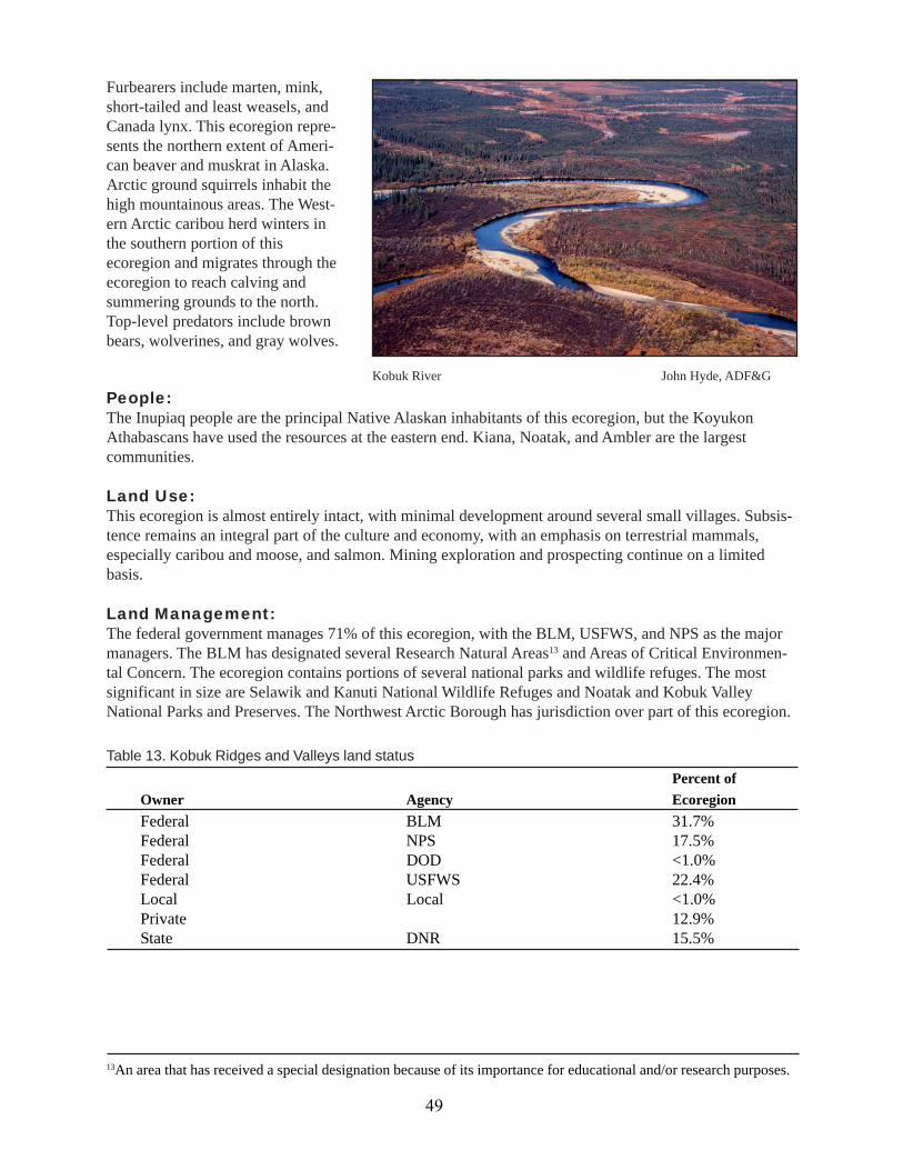
Kobuk River John Hyde, ADF&G
People:The Inupiaq people are the principal Native Alaskan inhabitants of this ecoregion, but the KoyukonAthabascans have used the resources at the eastern end. Kiana, Noatak, and Ambler are the largestcommunities.
Land Use:This ecoregion is almost entirely intact, with minimal development around several small villages. Subsis-tence remains an integral part of the culture and economy, with an emphasis on terrestrial mammals,especially caribou and moose, and salmon. Mining exploration and prospecting continue on a limitedbasis.
Land Management:The federal government manages 71% of this ecoregion, with the BLM, USFWS, and NPS as the majormanagers. The BLM has designated several Research Natural Areas13 and Areas of Critical Environmen-tal Concern. The ecoregion contains portions of several national parks and wildlife refuges. The mostsignificant in size are Selawik and Kanuti National Wildlife Refuges and Noatak and Kobuk ValleyNational Parks and Preserves. The Northwest Arctic Borough has jurisdiction over part of this ecoregion.
49
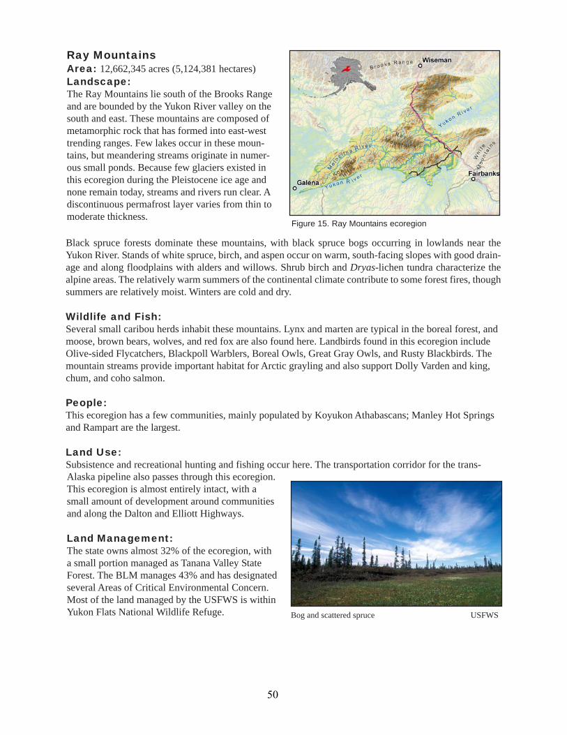
Ray MountainsArea: 12,662,345 acres (5,124,381 hectares)Landscape:The Ray Mountains lie south of the Brooks Rangeand are bounded by the Yukon River valley on thesouth and east. These mountains are composed ofmetamorphic rock that has formed into east-westtrending ranges. Few lakes occur in these moun-tains, but meandering streams originate in numer-ous small ponds. Because few glaciers existed inthis ecoregion during the Pleistocene ice age andnone remain today, streams and rivers run clear. Adiscontinuous permafrost layer varies from thin tomoderate thickness.
Black spruce forests dominate these mountains, with black spruce bogs occurring in lowlands near theYukon River. Stands of white spruce, birch, and aspen occur on warm, south-facing slopes with good drain-age and along floodplains with alders and willows. Shrub birch and Dryas-lichen tundra characterize thealpine areas. The relatively warm summers of the continental climate contribute to some forest fires, thoughsummers are relatively moist. Winters are cold and dry.
Wildlife and Fish:Several small caribou herds inhabit these mountains. Lynx and marten are typical in the boreal forest, andmoose, brown bears, wolves, and red fox are also found here. Landbirds found in this ecoregion includeOlive-sided Flycatchers, Blackpoll Warblers, Boreal Owls, Great Gray Owls, and Rusty Blackbirds. Themountain streams provide important habitat for Arctic grayling and also support Dolly Varden and king,chum, and coho salmon.
People:This ecoregion has a few communities, mainly populated by Koyukon Athabascans; Manley Hot Springsand Rampart are the largest.
Land Use:Subsistence and recreational hunting and fishing occur here. The transportation corridor for the trans-
Bog and scattered spruce USFWS
Figure 15. Ray Mountains ecoregion
Alaska pipeline also passes through this ecoregion.This ecoregion is almost entirely intact, with asmall amount of development around communitiesand along the Dalton and Elliott Highways.
Land Management:The state owns almost 32% of the ecoregion, witha small portion managed as Tanana Valley StateForest. The BLM manages 43% and has designatedseveral Areas of Critical Environmental Concern.Most of the land managed by the USFWS is withinYukon Flats National Wildlife Refuge.
50
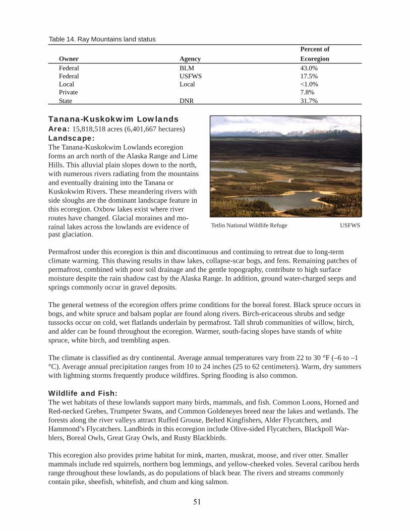
Tanana-Kuskokwim LowlandsArea: 15,818,518 acres (6,401,667 hectares)Landscape:The Tanana-Kuskokwim Lowlands ecoregionforms an arch north of the Alaska Range and LimeHills. This alluvial plain slopes down to the north,with numerous rivers radiating from the mountainsand eventually draining into the Tanana orKuskokwim Rivers. These meandering rivers withside sloughs are the dominant landscape feature inthis ecoregion. Oxbow lakes exist where riverroutes have changed. Glacial moraines and mo-rainal lakes across the lowlands are evidence of
Percent ofOwner Agency EcoregionFederal BLM 43.0%Federal USFWS 17.5%Local Local <1.0%Private 7.8%State DNR 31.7%
Table 14. Ray Mountains land status
Tetlin National Wildlife Refuge USFWSpast glaciation.
Permafrost under this ecoregion is thin and discontinuous and continuing to retreat due to long-termclimate warming. This thawing results in thaw lakes, collapse-scar bogs, and fens. Remaining patches ofpermafrost, combined with poor soil drainage and the gentle topography, contribute to high surfacemoisture despite the rain shadow cast by the Alaska Range. In addition, ground water-charged seeps andsprings commonly occur in gravel deposits.
The general wetness of the ecoregion offers prime conditions for the boreal forest. Black spruce occurs inbogs, and white spruce and balsam poplar are found along rivers. Birch-ericaceous shrubs and sedgetussocks occur on cold, wet flatlands underlain by permafrost. Tall shrub communities of willow, birch,and alder can be found throughout the ecoregion. Warmer, south-facing slopes have stands of whitespruce, white birch, and trembling aspen.
The climate is classified as dry continental. Average annual temperatures vary from 22 to 30 °F (–6 to –1°C). Average annual precipitation ranges from 10 to 24 inches (25 to 62 centimeters). Warm, dry summerswith lightning storms frequently produce wildfires. Spring flooding is also common.
Wildlife and Fish:The wet habitats of these lowlands support many birds, mammals, and fish. Common Loons, Horned andRed-necked Grebes, Trumpeter Swans, and Common Goldeneyes breed near the lakes and wetlands. Theforests along the river valleys attract Ruffed Grouse, Belted Kingfishers, Alder Flycatchers, andHammond’s Flycatchers. Landbirds in this ecoregion include Olive-sided Flycatchers, Blackpoll War-blers, Boreal Owls, Great Gray Owls, and Rusty Blackbirds.
This ecoregion also provides prime habitat for mink, marten, muskrat, moose, and river otter. Smallermammals include red squirrels, northern bog lemmings, and yellow-cheeked voles. Several caribou herdsrange throughout these lowlands, as do populations of black bear. The rivers and streams commonlycontain pike, sheefish, whitefish, and chum and king salmon.
51
Yukon-Tanana UplandsArea: 25,331,894 acres (10,251,677 hectares)Alaska 62.2%, Canada 37.8%Landscape:The Yukon-Tanana Uplands are rounded mountains and hills located between the Yukon and TananaRivers and spanning the Alaska-Yukon Territory border. The underlying geology results in exposedbedrock and coarse rubble on ridges and colluvium on lower slopes. Rivers cut deep, narrow V-shapedvalleys into the uplands. Elevations range from 1,650 feet (500 meters) in the valleys to more than 4,950feet (1,500 meters) on the peaks. Small lakes occur primarily in valleys where drainage has been blocked.Discontinuous permafrost lies beneath north-facing slopes and valley bottoms, so the terrain can behummocky in these areas. In the valley bottoms, the permafrost is thin, ice-rich, and near its meltingpoint.
Black spruce favors north-facing slopes underlain with permafrost; spruce also occurs with sedge tus-socks and scrub bogs in valley bottoms. White spruce, birch, and aspen dominate south-facing slopes.
People:These bottomlands have attracted people forcenturies for the food sources and transportationroutes provided by the rivers. Native people aremainly Koyukon, Tanana, and KuskokwimAthabascans. The western half of the ecoregioncontains many villages that depend on the river,winter trails, and aviation for transportation. Theeastern half contains the Alaska Highway, andthus, has a greater population. Fairbanks is thelargest town, and North Pole, Tok, and DeltaJunction are important communities along theAlaska Highway.
Land use:The greater population in the east has a more diversified economy than the west. Use of the land includestransportation of people and oil, timber production, and limited agriculture. Subsistence and recreationalhunting and fishing occur throughout the ecoregion. Tourism also plays a large role and is based mainlyon the landscape and wildlife values of the greater region.
Land Management:The State of Alaska owns 45% of this ecoregion and manages a small portion of it as game refuges andstate forest. The federal government owns 40%, with the main managers being the BLM, Department ofDefense, and NPS. This ecoregion contains part of Denali National Park. Private landowners hold 15% ofthe land. The Fairbanks North Star and Denali boroughs have jurisdiction over parts of this ecoregion.
Table 15. Tanana-Kuskokwim Lowlands land statusPercent of
Owner Agency Ecoregion
Federal BLM 15.7%Federal NPS 13.9%Federal DOD 7.2%Federal USFWS 3.2%Local Local <1.0%Private 15.1%State DNR 44.6%
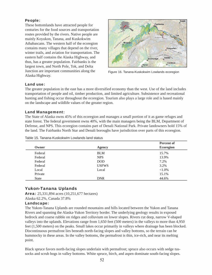
Figure 16. Tanana-Kuskokwim Lowlands ecoregion
52
White spruce, balsam poplar, alder, and willowsoccur in floodplains on better-drained sites. Lowbirch-ericaceous shrubs and Dryas-lichen tundraare the primary vegetation above tree line, andsome peaks are barren.
The continental climate features long, very coldwinters and dry, warm summers. Summer light-ning storms are frequent; the region has thehighest incidence of lightning strikes in Alaskaand the Yukon Territory, so forest fires are verycommon. In the lower elevations, mean annualprecipitation is about 13 inches (32.5 centime-ters), but precipitation increases from east to westand with increasing elevation. Mean Januarytemperatures can drop to –22 °F (–30 °C), and
Northern Flicker USFWS
mean July temperatures are near 61 °F (16 °C). Mean annual temperature is 23 °F (–5 °C).
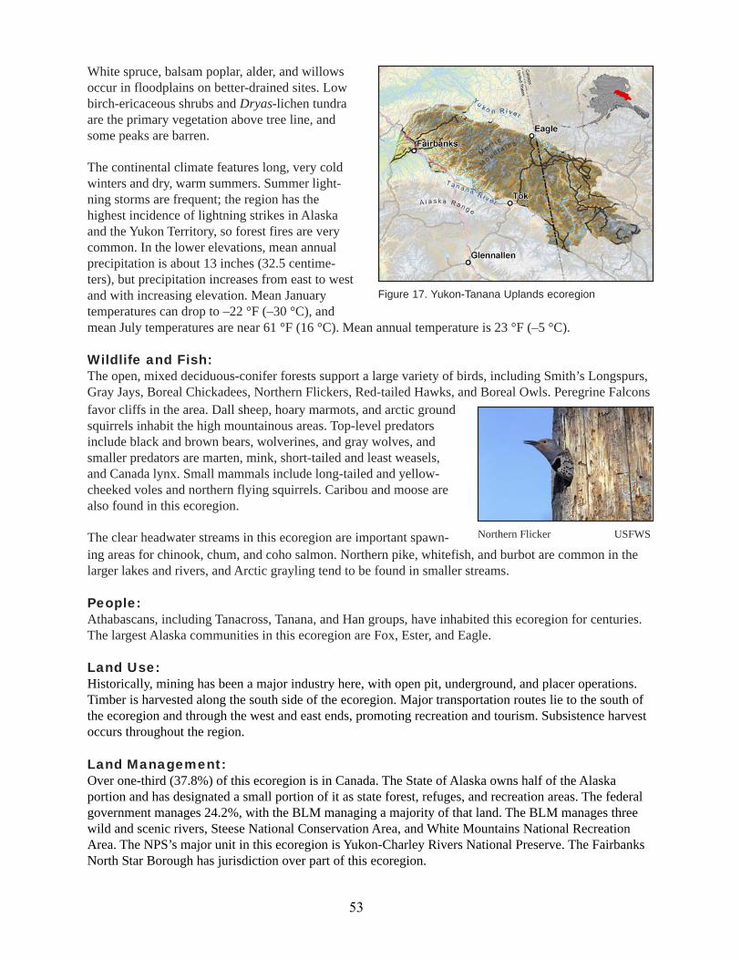
Wildlife and Fish:The open, mixed deciduous-conifer forests support a large variety of birds, including Smith’s Longspurs,Gray Jays, Boreal Chickadees, Northern Flickers, Red-tailed Hawks, and Boreal Owls. Peregrine Falconsfavor cliffs in the area. Dall sheep, hoary marmots, and arctic groundsquirrels inhabit the high mountainous areas. Top-level predatorsinclude black and brown bears, wolverines, and gray wolves, andsmaller predators are marten, mink, short-tailed and least weasels,and Canada lynx. Small mammals include long-tailed and yellow-cheeked voles and northern flying squirrels. Caribou and moose arealso found in this ecoregion.
The clear headwater streams in this ecoregion are important spawn-ing areas for chinook, chum, and coho salmon. Northern pike, whitefish, and burbot are common in thelarger lakes and rivers, and Arctic grayling tend to be found in smaller streams.
People:Athabascans, including Tanacross, Tanana, and Han groups, have inhabited this ecoregion for centuries.The largest Alaska communities in this ecoregion are Fox, Ester, and Eagle.
Land Use:Historically, mining has been a major industry here, with open pit, underground, and placer operations.Timber is harvested along the south side of the ecoregion. Major transportation routes lie to the south ofthe ecoregion and through the west and east ends, promoting recreation and tourism. Subsistence harvestoccurs throughout the region.
Land Management:Over one-third (37.8%) of this ecoregion is in Canada. The State of Alaska owns half of the Alaskaportion and has designated a small portion of it as state forest, refuges, and recreation areas. The federalgovernment manages 24.2%, with the BLM managing a majority of that land. The BLM manages threewild and scenic rivers, Steese National Conservation Area, and White Mountains National RecreationArea. The NPS’s major unit in this ecoregion is Yukon-Charley Rivers National Preserve. The FairbanksNorth Star Borough has jurisdiction over part of this ecoregion.
Figure 17. Yukon-Tanana Uplands ecoregion
53

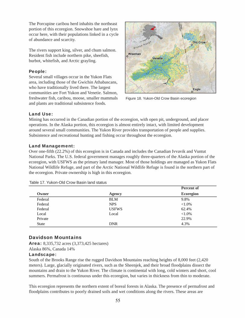
Yukon-Old Crow BasinArea: 17,934,802 acre (7,258,115 hectares)Alaska 77.8%, Canada 22.2%Landscape:The Yukon-Old Crow Basin is characterized bymeandering rivers and sloughs, sandbars, oxbowand thaw lakes, and marshy flats that occur alongthe Yukon, Porcupine, Chandalar, Christian,Sheenjek, and Old Crow Rivers. The rollinguplands surrounding the flats have fewer waterbodies. The Old Crow Basin in the Yukon Territory,at elevations below 990 feet (300 meters), withsurrounding uplands between 990 and 1,980 feet(300 and 600 meters), has numerous squarish lakes oriented southeast to northwest. The Alaska portion ofthe ecoregion, often called the Yukon Flats, ranges in elevation from 300 to 820 feet (90 to 250 meters).
The dry, continental climate is colder in the winter than surrounding ecoregions, due to the influence ofArctic high-pressure systems, and warmer in the summer as surrounding mountains block many coolerweather systems. In the Old Crow Basin, average annual precipitation varies from 7 to 10 inches (17 to 25centimeters), and the mean annual temperature ranges from 10 to 16 °F (–9 to –12 °C). Temperatures andprecipitation levels are slighter higher in the Alaska portion. Due to the dryness of the basin, water levelsin lakes and bogs are maintained primarily by spring flooding of the rivers. Warm summers create condi-tions favorable for frequent forest fires.
Flooding and poor drainage due to nearly continuous permafrost keep soils wet. Vegetation varies withsoil drainage. Wet grass marshes and low shrub swamps occur in the flats among the streams, rivers, andlakes. Open black spruce stands also grow at lower elevations, with white spruce growing on betterdrained sites. Paper birch, balsam poplar, and aspen are most likely found in early successional standsfollowing fires. Extensive thickets of birch, willow, and some alder occur in openings and under treesfrom lower elevations to above tree line. Sedge and cottongrass tussocks are found throughout theecoregion.
Wildlife and Fish:The Yukon Flats have been called the most productive Arctic habitat on the continent (McNab and Avers1994). The rich aquatic habitats attract millions of waterfowl and provide prime habitat for moose, riverotters, beavers, and muskrats. Species breeding here include Lesser Scaup; Northern Pintail; Scoter;Widgeon; Sandhill Crane; Arctic, Red-throated and Common Loons; and Horned and Red-necked Grebes.Most of the Canvasback Ducks that nest in Alaska do so on the Yukon Flats.
Beaver Creek D. Spencer, USFWS
Table 16. Yukon-Tanana Uplands land statusPercent of
Owner Agency EcoregionFederal BLM 30.5%Federal NPS 8.1%Federal DOD 1.4%Federal USFWS 1.6%Local Local <1.0%Private 6.8%State DNR 49.9%
54
The Porcupine caribou herd inhabits the northeastportion of this ecoregion. Snowshoe hare and lynxoccur here, with their populations linked in a cycleof abundance and scarcity.
The rivers support king, silver, and chum salmon.Resident fish include northern pike, sheefish,burbot, whitefish, and Arctic grayling.
People:Several small villages occur in the Yukon Flatsarea, including those of the Gwichin Athabascans,who have traditionally lived there. The largestcommunities are Fort Yukon and Venetie. Salmon,freshwater fish, caribou, moose, smaller mammalsand plants are traditional subsistence foods.
Land Use:Mining has occurred in the Canadian portion of the ecoregion, with open pit, underground, and placeroperations. In the Alaska portion, this ecoregion is almost entirely intact, with limited developmentaround several small communities. The Yukon River provides transportation of people and supplies.Subsistence and recreational hunting and fishing occur throughout the ecoregion.
Land Management:Over one-fifth (22.2%) of this ecoregion is in Canada and includes the Canadian Ivvavik and VuntutNational Parks. The U.S. federal government manages roughly three-quarters of the Alaska portion of theecoregion, with USFWS as the primary land manager. Most of those holdings are managed as Yukon FlatsNational Wildlife Refuge, and part of the Arctic National Wildlife Refuge is found in the northern part ofthe ecoregion. Private ownership is high in this ecoregion.
Davidson MountainsArea: 8,335,732 acres (3,373,425 hectares)Alaska 86%, Canada 14%Landscape:South of the Brooks Range rise the rugged Davidson Mountains reaching heights of 8,000 feet (2,420meters). Large, glacially originated rivers, such as the Sheenjek, and their broad floodplains dissect themountains and drain to the Yukon River. The climate is continental with long, cold winters and short, coolsummers. Permafrost is continuous under this ecoregion, but varies in thickness from thin to moderate.
This ecoregion represents the northern extent of boreal forests in Alaska. The presence of permafrost andfloodplains contributes to poorly drained soils and wet conditions along the rivers. These areas are
Percent ofOwner Agency EcoregionFederal BLM 9.8%Federal NPS <1.0%Federal USFWS 62.4%Local Local <1.0%Private 22.9%State DNR 4.3%
Table 17. Yukon-Old Crow Basin land status
Figure 18. Yukon-Old Crow Basin ecoregion
55

dominated by black spruce bogs. Better-drainedplaces along the rivers support white spruce andbalsam poplar. White spruce, paper birch, andtrembling aspen grow on uplands. Mountain peaksare either barren or have alpine tundra.
Tall willow, birch, and alder communities can alsobe found in this ecoregion. Relatively warm anddry summers and frequent lightning storms duringthat season combine to make forest fires a com-mon disturbance in these mountains.
Mancha Creek near Mancha Pinnacles D. Cline, USFWSWildlife and Fish:The boreal forest supports a large variety of birds and terrestrial mammals. The mixed forests are inhab-ited by breeding landbirds, such as Gray Jays, Boreal Chickadees, and Boreal Owls. Landbirds inhabitingthis ecoregion include Olive-sided Flycatchers, Blackpoll Warblers, Rusty Blackbirds, Great Gray Owls,and Boreal Owls.
Furbearers include marten, mink, short-tailed and least weasels, and Canada lynx. Dall sheep, hoarymarmots, and Arctic ground squirrels inhabit the high mountainous areas. This is part of the Porcupinecaribou herd’s overall range. Top-level predators include brown bears, wolverines, and gray wolves.
Northern pike, whitefish, and Arctic grayling are common in the lakes and rivers.
People:Gwich’in Athabascans inhabit this ecoregion on both sides of the border. The only Alaska community inthis ecoregion is Arctic Village.
Land Use:This ecoregion is almost entirely intact, with limited development. Subsistence and limited recreationremain the primary uses of the land.
Land Management:Fourteen percent of this ecoregion is in Canada, and part of that has been designated as Ivvavik NationalPark. The U.S. federal government manages almost two-thirds of the Alaska portion of this ecoregion. Of
Figure 19. Davidson Mountains ecoregion
56
that total, the USFWS manages more than 70% as the Arctic or Yukon Delta National Wildlife Refuges.The other major landowners on the U.S. side of the border are private individuals and Native corpora-tions.
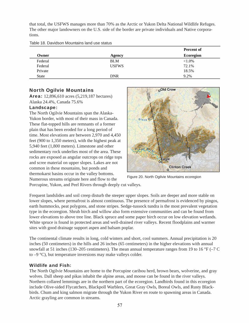
North Ogilvie MountainsArea: 12,896,610 acres (5,219,187 hectares)Alaska 24.4%, Canada 75.6%Landscape:The North Ogilvie Mountains span the Alaska-Yukon border, with most of their mass in Canada.These flat-topped hills are remnants of a formerplain that has been eroded for a long period oftime. Most elevations are between 2,970 and 4,450feet (900 to 1,350 meters), with the highest peak at5,940 feet (1,800 meters). Limestone and othersedimentary rock underlies most of the area. Theserocks are exposed as angular outcrops on ridge topsand scree material on upper slopes. Lakes are notcommon in these mountains, but ponds andthermokarst basins occur in the valley bottoms.Numerous streams originate here and flow to thePorcupine, Yukon, and Peel Rivers through deeply cut valleys.
Frequent landslides and soil creep disturb the steeper upper slopes. Soils are deeper and more stable onlower slopes, where permafrost is almost continuous. The presence of permafrost is evidenced by pingos,earth hummocks, peat polygons, and stone stripes. Sedge-tussock tundra is the most prevalent vegetationtype in the ecoregion. Shrub birch and willow also form extensive communities and can be found fromlower elevations to above tree line. Black spruce and some paper birch occur on low elevation wetlands.White spruce is found in protected areas and well-drained river valleys. Recent floodplains and warmersites with good drainage support aspen and balsam poplar.
The continental climate results in long, cold winters and short, cool summers. Annual precipitation is 20inches (50 centimeters) in the hills and 26 inches (65 centimeters) in the higher elevations with annualsnowfall at 51 inches (130–205 centimeters). The mean annual temperature ranges from 19 to 16 °F (–7 Cto –9 °C), but temperature inversions may make valleys colder.
Wildlife and Fish:The North Ogilvie Mountains are home to the Porcupine caribou herd, brown bears, wolverine, and graywolves. Dall sheep and pikas inhabit the alpine areas, and moose can be found in the river valleys.Northern collared lemmings are in the northern part of the ecoregion. Landbirds found in this ecoregioninclude Olive-sided Flycatchers, Blackpoll Warblers, Great Gray Owls, Boreal Owls, and Rusty Black-birds. Chum and king salmon migrate through the Yukon River en route to spawning areas in Canada.Arctic grayling are common in streams.
Percent ofOwner Agency EcoregionFederal BLM <1.0%Federal USFWS 72.1%Private 18.5%State DNR 9.2%
Table 18. Davidson Mountains land use status
Figure 20. North Ogilvie Mountains ecoregion
57

People:There are very few permanent communities in theAlaska portion of these mountains, with the townof Eagle at the southern boundary being the largest.Newer residents, as well as the descendents of theGwich’in Athabascans, rely on salmon, caribou,moose, small mammals, and plants for subsistence.
Land Use:Gold, silver, platinum, and tin have been mined inthese mountains, though not extensively. Energy-related resources, including coal, petroleum, anduranium, also occur here, but have not been tapped
Alaska Range TransitionLime HillsArea: 7,095,672 acres (2,871,579 hectares)Landscape:The Lime Hills ecoregion lies at the southwest endof the Alaska Range. The topography reflects thetransition from the rugged Alaska Range to a morerolling landscape. Here, peaks over 6,500 feet(1,970 meters) are found in the east, while lowerridges and broad valleys characterize the rest of theecoregion. The influence of heavy glaciation isevident in the repeated sharp mountain ridges, thindeep lakes, and broad U-shaped valleys, primarilyoriented northeast to southwest. Several large riversbegin in this ecoregion, passing through broadvalleys lined with wetlands.
Rusty Blackbird USFWS
yet.
Land Management:Over three-fourths (75.6%) of this ecoregion is in Canada and is included as parts of Ivvavik NationalPark and Fishing Branch Territorial Park. On the U.S. side of these mountains (24.4% of the ecoregion),the BLM and the NPS are the major land managers. Yukon-Charley Rivers National Preserve is thelargest federal unit. Private landowners hold 23% of the ecoregion.
Percent ofOwner Agency EcoregionFederal BLM 35.7%Federal NPS 29.2%Federal USFWS 10.1%Private 22.9%State DNR 2.1%
Table 19. North Ogilvie Mountains land status
Permafrost exists in isolated areas in the ecoregion. Maritime influences of the Bering Sea and Gulf ofAlaska moderate the continental climate of the Lime Hills. The average annual precipitation ranges from22 to 30 inches (56 to 76 centimeters), with average annual temperatures from 27 to 32 °F (–3 to 0 °C).
Figure 21. Lime Hills ecoregion
58

Land Use:The ecoregion remains primarily intact, with some development around communities and along theshores of Lake Clark. The major uses of this ecoregion remain subsistence, with a growing tourismindustry based on recreational hunting and fishing.
Land Management:The State of Alaska owns most of this ecoregion. Management by the federal government is split betweenthe NPS and the BLM. Lake Clark National Park and Preserve constitutes 18% of the ecoregion. Privateand local ownership is low.
Higher elevations are barren or covered with alpine tundra and heath.Communities of tall and low shrubs and assemblages of willow,birch, and alder dominate most of the Lime Hills. Spruce forests andspruce-aspen-birch forests occur at lower elevations. Wildfires arefrequent.
Wildlife and Fish:The Lime Hills provide habitat for many of the larger species—moose, brown bears, and the Mulchatna caribou herd. White-tailedPtarmigan and Golden Eagles can be found in the alpine tundra.Northern bog lemmings are common in the more poorly drainedareas. Dolly Varden, sockeye, king and coho salmon spawn in mostof the area’s rivers. Rainbow trout and Arctic grayling are commonresidents in streams, and Arctic char are common in lakes.
People:Tanaina Athabascans are the traditional inhabitants. The largestcommunities are Nondalton and Port Alsworth.
Golden Eagle G. Atwell, USFWS
Table 20. Lime Hills land statusPercent of
Owner Agency EcoregionFederal BLM 14.3%Federal NPS 18.3%Federal DOD <1.0%Local Local <1.0%Private 4.5%State DNR 62.6%
Cook Inlet BasinArea: 7,186,358 acre (2,908,279 hectares)Landscape:Bisected by Cook Inlet, the Cook Inlet Basin is encompassed by the Aleutian Range to the west, theAlaska Range to the north, and the Talkeetna, Chugach, and Kenai Mountains to the east. Elevationwithin the basin spans from sea level to 1,980 feet (600 meters). The gently sloping lowlands wereextensively glaciated during the Pleistocene epoch. Hundreds of small lakes, swamps, and bogs occur onground moraines. Several large rivers, including the Susitna, Kenai, and Matanuska, drain glaciers in thesurrounding mountains. The basin experiences a mix of maritime and continental climates. Temperaturesrange from the winter average minimum 5 °F (–15 °C) to the summer average maximum 64 °F (18 °C),and annual precipitation is 15 to 27 inches (38–68 centimeters), with snowfall 63 to 100 inches (160–255centimeters).
59
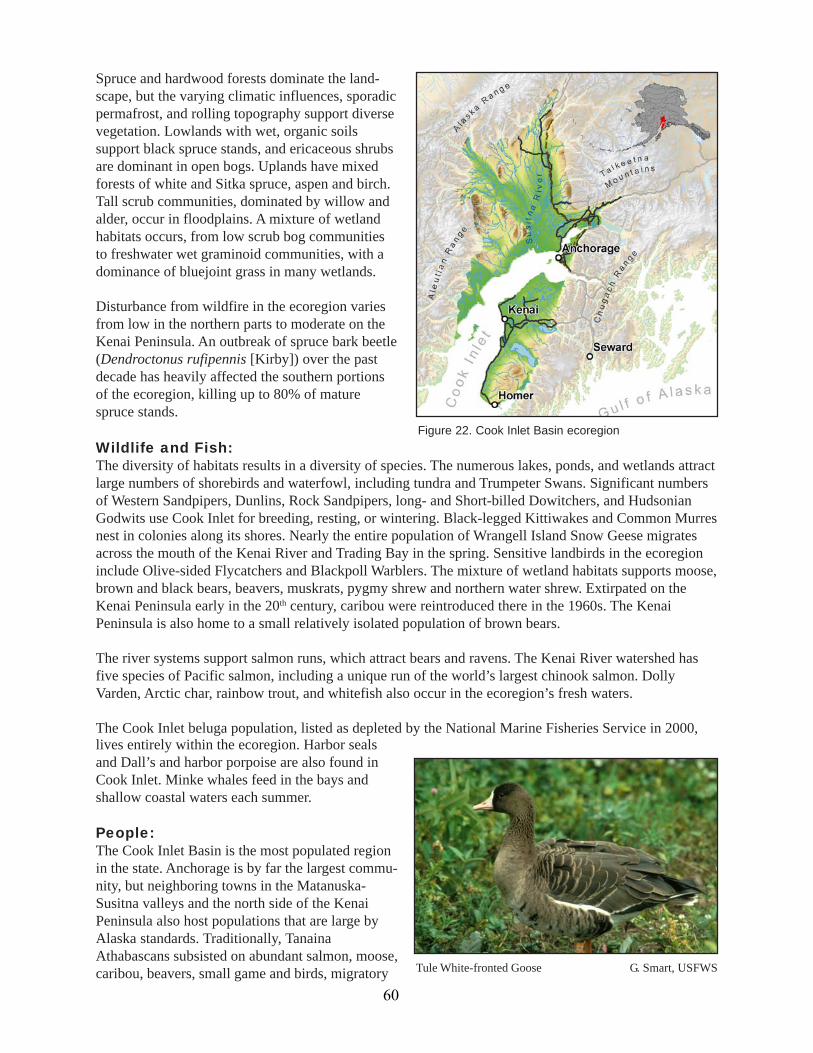
Spruce and hardwood forests dominate the land-scape, but the varying climatic influences, sporadicpermafrost, and rolling topography support diversevegetation. Lowlands with wet, organic soilssupport black spruce stands, and ericaceous shrubsare dominant in open bogs. Uplands have mixedforests of white and Sitka spruce, aspen and birch.Tall scrub communities, dominated by willow andalder, occur in floodplains. A mixture of wetlandhabitats occurs, from low scrub bog communitiesto freshwater wet graminoid communities, with adominance of bluejoint grass in many wetlands.
Disturbance from wildfire in the ecoregion variesfrom low in the northern parts to moderate on theKenai Peninsula. An outbreak of spruce bark beetle(Dendroctonus rufipennis [Kirby]) over the pastdecade has heavily affected the southern portionsof the ecoregion, killing up to 80% of maturespruce stands.
Tule White-fronted Goose G. Smart, USFWS
Wildlife and Fish:The diversity of habitats results in a diversity of species. The numerous lakes, ponds, and wetlands attractlarge numbers of shorebirds and waterfowl, including tundra and Trumpeter Swans. Significant numbersof Western Sandpipers, Dunlins, Rock Sandpipers, long- and Short-billed Dowitchers, and HudsonianGodwits use Cook Inlet for breeding, resting, or wintering. Black-legged Kittiwakes and Common Murresnest in colonies along its shores. Nearly the entire population of Wrangell Island Snow Geese migratesacross the mouth of the Kenai River and Trading Bay in the spring. Sensitive landbirds in the ecoregioninclude Olive-sided Flycatchers and Blackpoll Warblers. The mixture of wetland habitats supports moose,brown and black bears, beavers, muskrats, pygmy shrew and northern water shrew. Extirpated on theKenai Peninsula early in the 20th century, caribou were reintroduced there in the 1960s. The KenaiPeninsula is also home to a small relatively isolated population of brown bears.
The river systems support salmon runs, which attract bears and ravens. The Kenai River watershed hasfive species of Pacific salmon, including a unique run of the world’s largest chinook salmon. DollyVarden, Arctic char, rainbow trout, and whitefish also occur in the ecoregion’s fresh waters.
The Cook Inlet beluga population, listed as depleted by the National Marine Fisheries Service in 2000,lives entirely within the ecoregion. Harbor sealsand Dall’s and harbor porpoise are also found inCook Inlet. Minke whales feed in the bays andshallow coastal waters each summer.
People:The Cook Inlet Basin is the most populated regionin the state. Anchorage is by far the largest commu-nity, but neighboring towns in the Matanuska-Susitna valleys and the north side of the KenaiPeninsula also host populations that are large byAlaska standards. Traditionally, TanainaAthabascans subsisted on abundant salmon, moose,caribou, beavers, small game and birds, migratory
Figure 22. Cook Inlet Basin ecoregion
60

waterfowl, freshwater fish, and plants. The diversepopulation today still makes widespread use ofwildlife for hunting and fishing.
Land Use:Although this ecoregion has had the greatestimpacts from humans in the state, it is estimatedthat only about 10% of its area has been heavilyaltered. Most development is concentrated inseveral areas. Today, tourism and recreation, the oiland gas industry, limited agriculture, and govern-ment employment support most residents.
Land Management:Cook Inlet Basin is characterized by a higher percentage of private land ownership than in most otherecoregions, but still the majority of land is publicly managed. State-managed lands constitute half of theecoregion, and federally managed lands make up 15%. The State of Alaska has set aside lands aroundCook Inlet to protect fish and wildlife habitat; these small areas have been designated critical habitatareas, game refuges, and wildlife refuges. Several recreation areas also exist here. The Kenai NationalWildlife Refuge is the largest federal area. The ecoregion falls in the jurisdictions of the Kenai PeninsulaBorough, Matanuska-Susitna Borough, and the Municipality of Anchorage.
Kenai National Wildlife Refuge lakes USFWS
Table 21. Cook Inlet Basin land statusPercent of
Owner Agency EcoregionFederal BLM <1.0%Federal NPS 1.1%Federal DOD <1.0%Federal USFWS 13.1%Federal USFS <1.0%Local Local 11.3%Private 24.6%State DNR 49.1%
Alaska RangeArea: 25,534,440 acres (10,333,440 hectares)Landscape:The mountains of the Alaska Range ecoregion arehigh, very steep, and covered with glaciers, rockyslopes, and ice fields. Elevations vary from broadvalleys at 1,980 feet (600 meters) to peaks greaterthan 12,870 feet (3,900 meters), with the tallestmountain in North America, Mount McKinley,rising to 20,320 feet (6,100 meters). Glaciers,which still remain in some places, have shapedthese mountains, so cirques and U-shaped valleysare common features due to extensive glaciation.Streams and rivers, heavy with sediment, runswiftly down mountain ravines and braid acrossvalley bottoms. Permafrost is discontinuous. Disturbance processes are primarily landslides and ava-lanches on the steep, scree-covered slopes. Active volcanoes also occur here.
Figure 23. Alaska Range ecoregion
61

Due to the Alaska Range’s height, a cold, continen-tal climate prevails. The highest mountains occa-sionally intercept streams of Pacific moisture tohelp feed small ice fields and glaciers. In the lowerelevations mean annual precipitation is approxi-mately 15 inches (380 millimeters), with snowfallranging from 60 to 120 inches (150 to 305 centime-ters). At the higher peaks, average annual precipita-tion is 41 inches (103 centimeters), with snowfallestimated at 40 inches (101.5 centimeters).
Vegetation is sparse, with dwarf scrub communitiescommonly occurring in windswept areas. Shrubcommunities of willow, birch, and alder occupy themore protected lower slopes and valley bottoms. Spruce forests occur in some valleys and lower slopes,with white spruce dominating and black spruce interspersed in areas with poorer drainage. About 7% ofthe ecoregion is wetlands.
Wildlife and Fish:Top-level predators—brown bears, gray wolves, and wolverines—are common in the Alaska Range.They prey on Dall sheep in the alpine tundra and large migrating caribou herds in the broad valleys andpasses. Small mammals include hoary marmots, singing voles and pikas. Lake trout are found in deeplakes and salmon migrate, rear, and spawn in many of the streams. Dolly Varden and Arctic grayling areresident in many streams. This may be the northern extent of the water shrew’s range. Smith’s Longspursprobably breed along the Denali Highway.
People:Due to the harshness of the landscape and climate, this ecoregion is sparsely populated. Historically,several seminomadic Athabascan groups, such as the Tanaina, Ahtna and Tanacross, lived there; theyrelied on salmon, freshwater fish, large mammals, smaller fur-bearing mammals and edible plants. Todaythe largest communities are Healy, McKinley Park, Cantwell, and Chickaloon.
Land Use:Little of this ecoregion has been developed due to the low population. The George Parks Highwaybisects the ecoregion into east and west halves. Most human use is subsistence and sport hunting andfishing, though recreation and tourism are growing. Limited mining also occurs, including coal mining atHealy.
Land Management:Half of this ecoregion is owned by the State of Alaska. The largest state designated area is the NelchinaPublic Use Area. The federal government is also a major landowner (44%). The NPS manages most of itslands as Denali National Park and Preserve or Lake Clark National Park and Preserve. The Denali, KenaiPeninsula, and Matanuska-Susitna Boroughs have jurisdiction over parts of this ecoregion.
Aeriel view of Alaska Range in winter USFWS
62
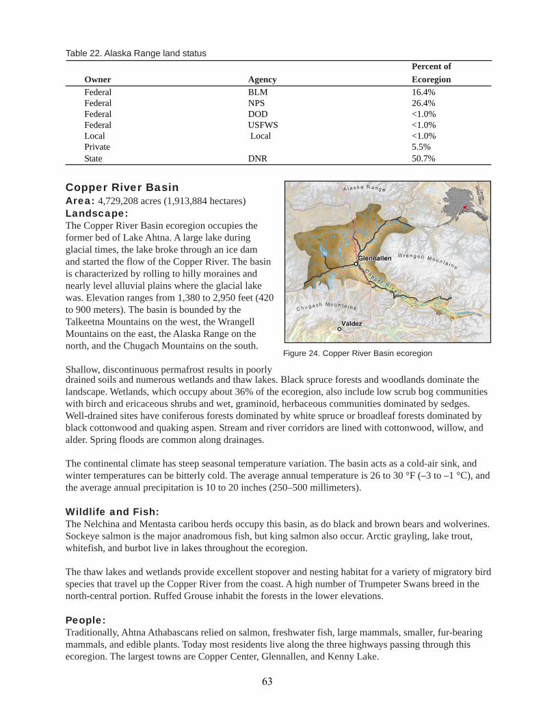
drained soils and numerous wetlands and thaw lakes. Black spruce forests and woodlands dominate thelandscape. Wetlands, which occupy about 36% of the ecoregion, also include low scrub bog communitieswith birch and ericaceous shrubs and wet, graminoid, herbaceous communities dominated by sedges.Well-drained sites have coniferous forests dominated by white spruce or broadleaf forests dominated byblack cottonwood and quaking aspen. Stream and river corridors are lined with cottonwood, willow, andalder. Spring floods are common along drainages.
The continental climate has steep seasonal temperature variation. The basin acts as a cold-air sink, andwinter temperatures can be bitterly cold. The average annual temperature is 26 to 30 °F (–3 to –1 °C), andthe average annual precipitation is 10 to 20 inches (250–500 millimeters).
Wildlife and Fish:The Nelchina and Mentasta caribou herds occupy this basin, as do black and brown bears and wolverines.Sockeye salmon is the major anadromous fish, but king salmon also occur. Arctic grayling, lake trout,whitefish, and burbot live in lakes throughout the ecoregion.
The thaw lakes and wetlands provide excellent stopover and nesting habitat for a variety of migratory birdspecies that travel up the Copper River from the coast. A high number of Trumpeter Swans breed in thenorth-central portion. Ruffed Grouse inhabit the forests in the lower elevations.
People:Traditionally, Ahtna Athabascans relied on salmon, freshwater fish, large mammals, smaller, fur-bearingmammals, and edible plants. Today most residents live along the three highways passing through thisecoregion. The largest towns are Copper Center, Glennallen, and Kenny Lake.
Copper River BasinArea: 4,729,208 acres (1,913,884 hectares)Landscape:The Copper River Basin ecoregion occupies theformer bed of Lake Ahtna. A large lake duringglacial times, the lake broke through an ice damand started the flow of the Copper River. The basinis characterized by rolling to hilly moraines andnearly level alluvial plains where the glacial lakewas. Elevation ranges from 1,380 to 2,950 feet (420to 900 meters). The basin is bounded by theTalkeetna Mountains on the west, the WrangellMountains on the east, the Alaska Range on thenorth, and the Chugach Mountains on the south.
Shallow, discontinuous permafrost results in poorly
Table 22. Alaska Range land statusPercent of
Owner Agency EcoregionFederal BLM 16.4%Federal NPS 26.4%Federal DOD <1.0%Federal USFWS <1.0%Local Local <1.0%Private 5.5%State DNR 50.7%
Figure 24. Copper River Basin ecoregion
63

Land Use:This area is a major transportation crossroads inAlaska for the movement of people and oil.Subsistence and recreational hunting and fishingoccur throughout the ecoregion. Tourism alsoplays a large role. A small agriculture industryexists.
Land Management:Compared to other ecoregions, the Copper River Ba-sin has a large percentage of privately owned land(23.6%) The state owns a third of the ecoregion andmanages more than a quarter of its land as theNelchina Public Use Area. The federal government is the largest landowner (42.5%) with management splitalmost equally between the BLM and the NPS. Wrangell-St. Elias National Park and Preserve makes upmore than one-fifth of the ecoregion.
Aleutian MeadowsAleutian IslandsArea: 2,929,397 acres (1,185,511 hectares)Landscape:Arcing 1,180 miles (1,900 km) westward from theAlaska Peninsula to the island of Attu, the AleutianIslands are a chain of volcanic islands that wereformed by the Pacific plate being forced beneaththe Bering Sea plate. Fog often shrouds the steep,rubble-covered peaks, which rise to 6,230 feet(1,900 meters) above sea level. Icecaps or smallglaciers occur on many of the volcanoes, and pastglaciation is evident. Short, swift streams havecarved fjords into the sides of the cones. Highcliffs, wave-beaten platforms, boulder beaches, or
Copper River Basin T. Paul, ADF&G
Table 23. Copper River Basin land statusPercent of
Owner Agency EcoregionFederal BLM 20.2%Federal NPS 22.3%Local Local <1.0%Private 23.6%State DNR 33.9%
small dune fields ring the islands.
The archipelago’s location over an active seismic fault results in frequent volcanic and seismic activity.Forty of the 76 volcanoes in the chain have been active in the past 250 years. Intense ocean storms arealso an important disturbance process, bringing strong winds and heavy rains. A cool, maritime climatebrings abundant, yet varying, precipitation throughout the chain, from 20 inches in some places to 82inches in others (53 to 208 centimeters), with average annual temperatures from 36 to 39 °F (2 to 4 °C).The islands are permafrost free, and the winter sea ice pack does not reach here.
Figure 25. Aleutian Islands ecoregion
64
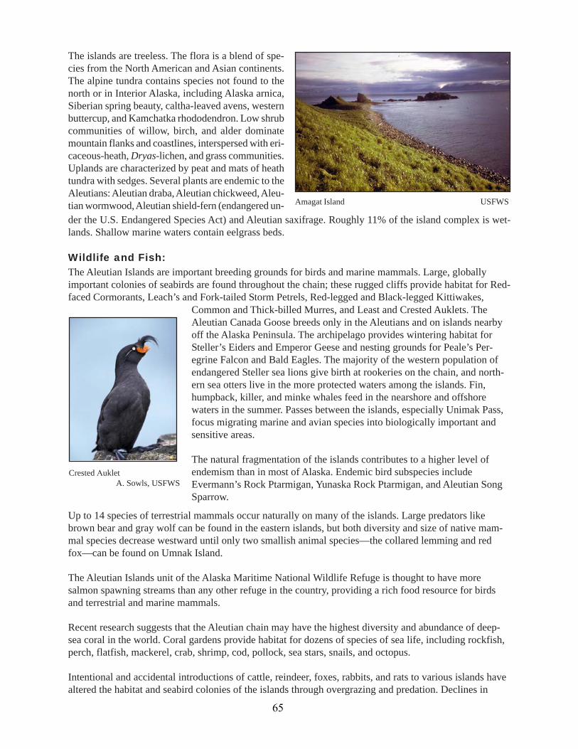
The islands are treeless. The flora is a blend of spe-cies from the North American and Asian continents.The alpine tundra contains species not found to thenorth or in Interior Alaska, including Alaska arnica,Siberian spring beauty, caltha-leaved avens, westernbuttercup, and Kamchatka rhododendron. Low shrubcommunities of willow, birch, and alder dominatemountain flanks and coastlines, interspersed with eri-caceous-heath, Dryas-lichen, and grass communities.Uplands are characterized by peat and mats of heathtundra with sedges. Several plants are endemic to theAleutians: Aleutian draba, Aleutian chickweed, Aleu-tian wormwood, Aleutian shield-fern (endangered un-der the U.S. Endangered Species Act) and Aleutian saxifrage. Roughly 11% of the island complex is wet-lands. Shallow marine waters contain eelgrass beds.
Wildlife and Fish:The Aleutian Islands are important breeding grounds for birds and marine mammals. Large, globallyimportant colonies of seabirds are found throughout the chain; these rugged cliffs provide habitat for Red-faced Cormorants, Leach’s and Fork-tailed Storm Petrels, Red-legged and Black-legged Kittiwakes,
Common and Thick-billed Murres, and Least and Crested Auklets. TheAleutian Canada Goose breeds only in the Aleutians and on islands nearbyoff the Alaska Peninsula. The archipelago provides wintering habitat forSteller’s Eiders and Emperor Geese and nesting grounds for Peale’s Per-egrine Falcon and Bald Eagles. The majority of the western population ofendangered Steller sea lions give birth at rookeries on the chain, and north-ern sea otters live in the more protected waters among the islands. Fin,humpback, killer, and minke whales feed in the nearshore and offshorewaters in the summer. Passes between the islands, especially Unimak Pass,focus migrating marine and avian species into biologically important andsensitive areas.
The natural fragmentation of the islands contributes to a higher level ofendemism than in most of Alaska. Endemic bird subspecies includeEvermann’s Rock Ptarmigan, Yunaska Rock Ptarmigan, and Aleutian SongSparrow.
Up to 14 species of terrestrial mammals occur naturally on many of the islands. Large predators likebrown bear and gray wolf can be found in the eastern islands, but both diversity and size of native mam-mal species decrease westward until only two smallish animal species—the collared lemming and redfox—can be found on Umnak Island.
The Aleutian Islands unit of the Alaska Maritime National Wildlife Refuge is thought to have moresalmon spawning streams than any other refuge in the country, providing a rich food resource for birdsand terrestrial and marine mammals.
Recent research suggests that the Aleutian chain may have the highest diversity and abundance of deep-sea coral in the world. Coral gardens provide habitat for dozens of species of sea life, including rockfish,perch, flatfish, mackerel, crab, shrimp, cod, pollock, sea stars, snails, and octopus.
Intentional and accidental introductions of cattle, reindeer, foxes, rabbits, and rats to various islands havealtered the habitat and seabird colonies of the islands through overgrazing and predation. Declines in
Crested Auklet A. Sowls, USFWS
Amagat Island USFWS
65

population levels of seabirds, some fish and shellfish, and marine mammals are likely a result of trophicchanges in the Bering Sea ecosystem due to commercial harvest of fish and whales over the last 40 years,as well as climate change.
People:The Native people of the islands are Aleut. Their subsistence foods come from the diverse habitats of theislands, including the marine mammals, caribou, salmon, chitons, fish, mussels, urchins, octopus, birds,eggs, and plants. The largest communities are Adak Station and Unalaska.
Land Use:Commercial fishing and subsistence are the major uses of natural resources in this ecoregion. The archi-pelago also defines a major shipping route. Active and shuttered military installations exist on the islands.Pollutants are locally acute, and radioactivity from nuclear testing persists on Amchitka Island.
Land Management:The federal government is the largest landholder (80.4%). The USFWS manages most of the ecoregion asthe Alaska Maritime National Wildlife Refuge. Private owners are the other major landholders.
Alaska PeninsulaArea: 15,745,664 acres (6,372,183 hectares)Landscape:The Alaska Peninsula and Unimak Island, thenorthernmost island of the Aleutian Archipelago,compose this ecoregion, which separates the Gulfof Alaska from the Bering Sea. The dominantfeature of the ecoregion is the Aleutian Range, thepeninsula’s volcanic spine, which reaches eleva-tions of 8,580 feet (2,600 meters) above sea level.Extensive glaciation has carved U-shaped valleysinto the mountains. Because glaciers remain in thehigh peaks, many lakes and rivers contain sus-pended glacial flour. The lowlands contain numer-
Alaska Peninsula volcano K. Bollinger, USFWS
Table 24. Aleutian Islands land statusPercent of
Owner Agency EcoregionFederal BLM <1.0%Federal DOD <1.0%Federal USFWS 80.3%Local Local <1.0%Private 19.6%State DNR <1.0%
ous lakes, estuaries, and large river basins, which terminate in broad estuarine areas on the Bering Sea.On the south side, deeply cut fjords characterize the landscape. Volcanic activity and major ocean stormsfrom the Gulf of Alaska have also shaped the topography and soils. The Alaska Peninsula is largely freeof permafrost.
Much of the shoreline along the Bering Sea is characterized by mixed sand and gravel beaches andexposed tidal mudflats. The protected bays and lagoons often have eelgrass beds, which form the foodbase for many fish and waterfowl. Izembek Lagoon contains one of the largest eelgrass beds in the world.
66

The rugged Gulf coast has intertidal and subtidalalgal forests, characterized by kelp attached torocky substrates.
The maritime climate affects the south slope of theAleutian Range, with average annual precipitationranging from 24 to 65 inches (61 to 165 centime-ters), and average annual temperature ranging from34 to 39 °F (1 to 4° C). Sea ice does not form alongthis coast, except in a few protected bays andinlets. On the north side, the transitional climatecreates a slightly cooler, yet drier, climate.
Due to topography, past glaciation, and climate,tundra vegetation characterizes this ecoregionbelow the barren and ice-covered peaks. The alpine tundra is a semiarid habitat that supports low shrubs,lichens, mosses, and grasses. Moist tussock tundra of mosses, lichens, and tufted hair grass occurs inmountain valleys and along plateaus. Wet tundra is confined to low-lying coastal areas around BristolBay. Ponds, lakes, and wetlands cover most of these areas. High brush communities of alder and willowdominate floodplains. Black spruce occurs primarily in interior lowlands, on north-facing slopes, and onpoorly drained flats. Mixed forests of black or white spruce, balsam poplar, black cottonwood, paper birchand quaking aspen can also be found.
Wildlife and Fish:The diverse habitats of the Alaska Peninsula support a rich wildlife assemblage. Five species of Pacificsalmon, steelhead, rainbow smelt, Arctic grayling, and Dolly Varden are present in the ecoregion; DollyVarden, steelhead and salmon spawn in many of the region’s streams. Healthy populations of many top-level predators live here, including brown bear, wolf, wolverine, and lynx. Several caribou herds rangeacross the region. Moose inhabit the uplands and riparian corridors. Smaller mammals include hoarymarmots and tundra hares.
Coastal wetlands, lagoons, and bays provide staging areas for large seasonalaggregations of waterfowl and shorebirds. Izembek and Moffet Lagoons hostconcentrations of more than 500,000 shorebirds each spring, includingMarbled Godwits and Rock Sandpipers, and the majority of the easternPacific population of Black Brant each fall. Aleutian Terns, Arctic Warblers,Red-faced Cormorants, and Kittlitz’s Murrelets breed here. The ecoregionprovides prime wintering habitat for several bird species—Emperor Goose,King Eider, Steller’s Eider, and McKay’s Bunting.
Rookeries and haulouts for Steller sea lions are distributed primarily alongthe Gulf coast, while harbor seals haul out on beaches along both coastlines.Sea otters have recolonized the lower half of the peninsula, but the popula-tion has decreased dramatically in recent years. Fin, humpack, and minkewhales feed in the nearshore and offshore waters in the summer. Pacificherring and halibut occur in the marine portions of the ecoregion, as doseveral shellfish species, such as scallops, crab, shrimp and many species of groundfish.
Several species are endemic to the islands, including tundra voles, the Amak Island Song Sparrow, theSemidi Islands Winter Wren, McKay’s Bunting, and the Beringian Marbled Godwit. The globally rareBristle-thighed Curlew also inhabits this ecoregion.
Red-faced Cormorant USFWS
Figure 26. Alaska Peninsula ecoregion
67
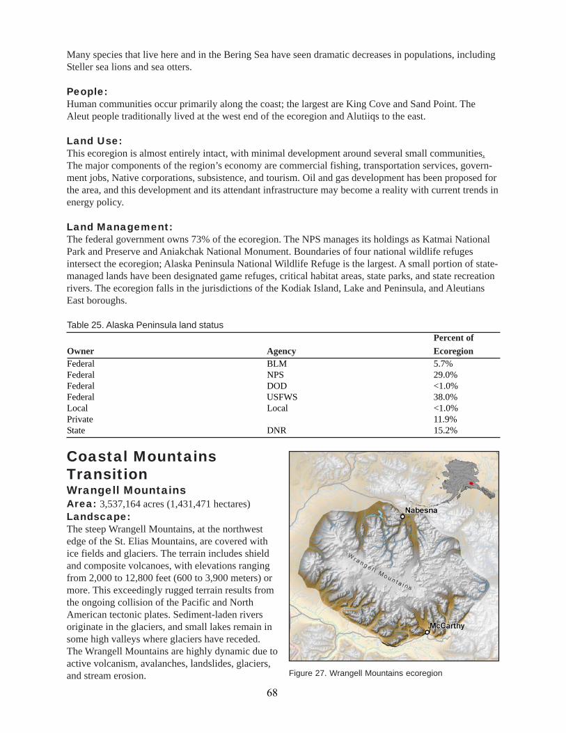
Many species that live here and in the Bering Sea have seen dramatic decreases in populations, includingSteller sea lions and sea otters.
People:Human communities occur primarily along the coast; the largest are King Cove and Sand Point. TheAleut people traditionally lived at the west end of the ecoregion and Alutiiqs to the east.
Land Use:This ecoregion is almost entirely intact, with minimal development around several small communities.The major components of the region’s economy are commercial fishing, transportation services, govern-ment jobs, Native corporations, subsistence, and tourism. Oil and gas development has been proposed forthe area, and this development and its attendant infrastructure may become a reality with current trends inenergy policy.
Land Management:The federal government owns 73% of the ecoregion. The NPS manages its holdings as Katmai NationalPark and Preserve and Aniakchak National Monument. Boundaries of four national wildlife refugesintersect the ecoregion; Alaska Peninsula National Wildlife Refuge is the largest. A small portion of state-managed lands have been designated game refuges, critical habitat areas, state parks, and state recreationrivers. The ecoregion falls in the jurisdictions of the Kodiak Island, Lake and Peninsula, and AleutiansEast boroughs.
Federal BLM 5.7%Federal NPS 29.0%Federal DOD <1.0%Federal USFWS 38.0%Local Local <1.0%Private 11.9%State DNR 15.2%
Table 25. Alaska Peninsula land statusPercent of
Owner Agency Ecoregion
Coastal MountainsTransitionWrangell MountainsArea: 3,537,164 acres (1,431,471 hectares)Landscape:The steep Wrangell Mountains, at the northwestedge of the St. Elias Mountains, are covered withice fields and glaciers. The terrain includes shieldand composite volcanoes, with elevations rangingfrom 2,000 to 12,800 feet (600 to 3,900 meters) ormore. This exceedingly rugged terrain results fromthe ongoing collision of the Pacific and NorthAmerican tectonic plates. Sediment-laden riversoriginate in the glaciers, and small lakes remain insome high valleys where glaciers have receded.The Wrangell Mountains are highly dynamic due toactive volcanism, avalanches, landslides, glaciers,and stream erosion. Figure 27. Wrangell Mountains ecoregion
68
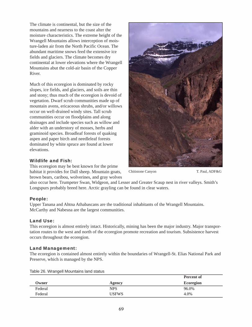
The climate is continental, but the size of themountains and nearness to the coast alter themoisture characteristics. The extreme height of theWrangell Mountains allows interception of mois-ture-laden air from the North Pacific Ocean. Theabundant maritime snows feed the extensive icefields and glaciers. The climate becomes drycontinental at lower elevations where the WrangellMountains abut the cold-air basin of the CopperRiver.
Much of this ecoregion is dominated by rockyslopes, ice fields, and glaciers, and soils are thinand stony; thus much of the ecoregion is devoid ofvegetation. Dwarf scrub communities made up ofmountain avens, ericaceous shrubs, and/or willowsoccur on well-drained windy sites. Tall scrubcommunities occur on floodplains and alongdrainages and include species such as willow andalder with an understory of mosses, herbs andgraminoid species. Broadleaf forests of quakingaspen and paper birch and needleleaf forestsdominated by white spruce are found at lowerelevations.
Wildlife and Fish:This ecoregion may be best known for the primehabitat it provides for Dall sheep. Mountain goats,brown bears, caribou, wolverines, and gray wolvesalso occur here. Trumpeter Swan, Widgeon, and Lesser and Greater Scaup nest in river valleys. Smith’sLongspurs probably breed here. Arctic grayling can be found in clear waters.
People:Upper Tanana and Ahtna Athabascans are the traditional inhabitants of the Wrangell Mountains.McCarthy and Nabesna are the largest communities.
Land Use:This ecoregion is almost entirely intact. Historically, mining has been the major industry. Major transpor-tation routes to the west and north of the ecoregion promote recreation and tourism. Subsistence harvestoccurs throughout the ecoregion.
Land Management:The ecoregion is contained almost entirely within the boundaries of Wrangell-St. Elias National Park andPreserve, which is managed by the NPS.
Chitistone Canyon T. Paul, ADF&G
Table 26. Wrangell Mountains land statusPercent of
Owner Agency EcoregionFederal NPS 96.0%Federal USFWS 4.0%
69

Kluane RangeArea: 5,170,434 acres (2,092,446 hectares)Alaska 24%, Canada 76%Landscape:The Kluane Range ecoregion lies primarily inCanada. Tall mountains to the south force much ofthe moisture from the Pacific Ocean to drop alongthe coast, so the Kluane Range has a dry continen-tal climate. Lower elevations receive 7 to 11 inches(19 to 28.5 centimeters) of precipitation a year,with possibly greater amounts at higher elevationsin the northern part of the ecoregion. The meanannual temperature ranges from 27 to 23 °F (–3 to–5 °C), with cold winter temperatures of –22 °F (–30 °C) being common.
Few glaciers exist in this ecoregion, except for those extending down from the St. Elias Mountains.Permafrost is discontinuous, but ground freezing results in solifluction lobes, ice wedges, and patternedground, especially on north-facing uplands. Due to the steepness of the slopes, the dominant disturbanceprocesses in the mountains are scree movement, rock falls, landslides, and soil creep. On the steepmountainsides, streams are swift. In the valleys, streams meander and soil drainage is poor in valleybottoms.
Black spruce stands and sedge tussock fields dominate vegetation in the poorly drained areas. Whitespruce occurs on better-drained sites at lower elevations. Much of the ecoregion is above tree line, withalpine tundra and barrens of lichens, prostrate willows, and ericaceous shrubs. Shrub birch and willoware prevalent in the subalpine.
Wildlife and Fish:Ungulates typically found in alpine areas—Dall sheep and mountain goats—are abundant in thisecoregion, with moose and caribou occurring in the valleys and subalpine areas. Predators include brownbears, wolves, and wolverines.
People:The Alaska portion of this ecoregion has few people due to its ruggedness and location within Wrangell-St. Elias National Park. Traditionally, Athabascan people lived in the northern part of the ecoregion andTlingit in the south.
Kluane Range T. Paul, ADF&G
Land Use:The Alaska Highway runs through this ecoregion,bringing supplies and tourists from Canada toAlaska. In Alaska, this ecoregion remains intactdue to its ruggedness. Historically, mining has beena major industry here, with open pit, underground,and placer operations. Coal deposits also exist buthave not been developed.
Land Management:More than three-quarters of this ecoregion falls inCanada. Canada has included parts of it in KluaneNational Park and Tatshenshini-Alsek ProvincialPark. The Alaska portion is almost entirely part ofWrangell-St. Elias National Park and Preserve. Figure 28. Kluane Range ecoregion
70
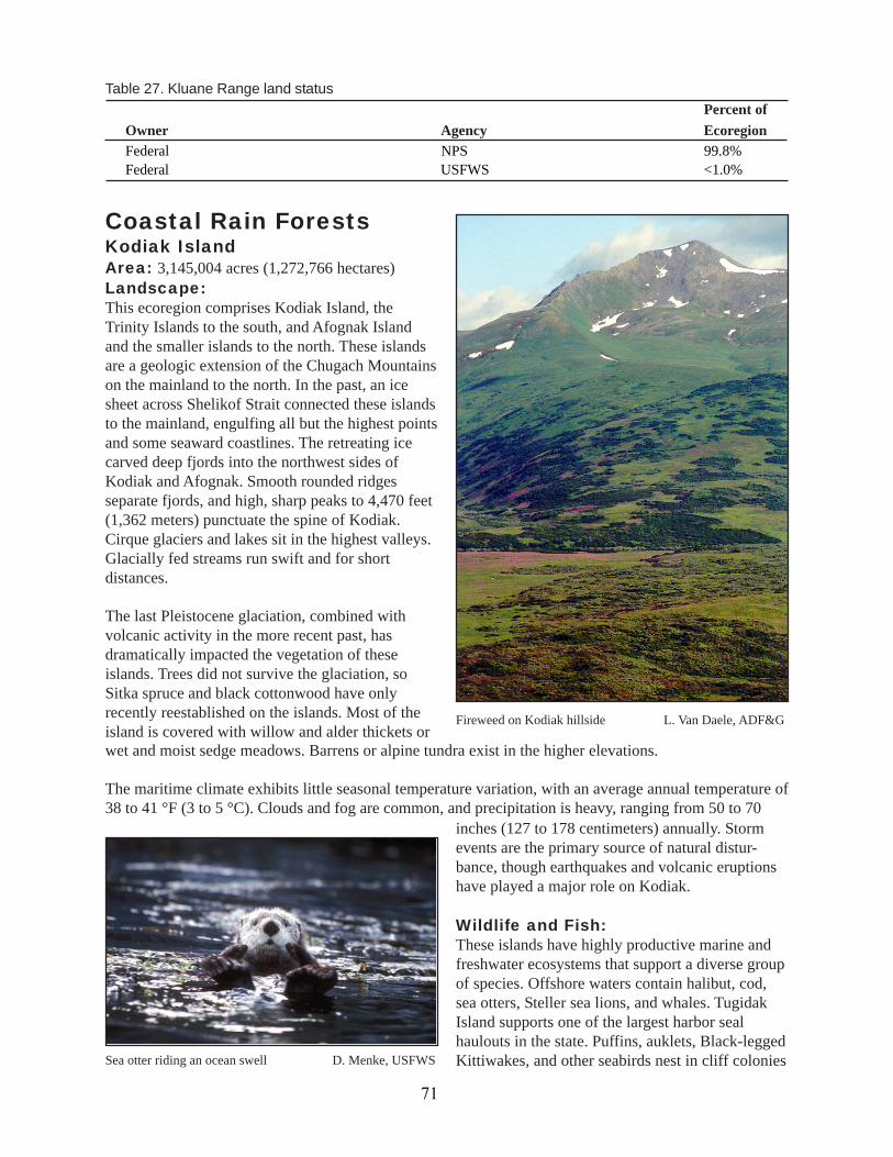
Coastal Rain ForestsKodiak IslandArea: 3,145,004 acres (1,272,766 hectares)Landscape:This ecoregion comprises Kodiak Island, theTrinity Islands to the south, and Afognak Islandand the smaller islands to the north. These islandsare a geologic extension of the Chugach Mountainson the mainland to the north. In the past, an icesheet across Shelikof Strait connected these islandsto the mainland, engulfing all but the highest pointsand some seaward coastlines. The retreating icecarved deep fjords into the northwest sides ofKodiak and Afognak. Smooth rounded ridgesseparate fjords, and high, sharp peaks to 4,470 feet(1,362 meters) punctuate the spine of Kodiak.Cirque glaciers and lakes sit in the highest valleys.Glacially fed streams run swift and for shortdistances.
The last Pleistocene glaciation, combined withvolcanic activity in the more recent past, hasdramatically impacted the vegetation of theseislands. Trees did not survive the glaciation, soSitka spruce and black cottonwood have onlyrecently reestablished on the islands. Most of theisland is covered with willow and alder thickets or
Table 27. Kluane Range land statusPercent of
Owner Agency EcoregionFederal NPS 99.8%Federal USFWS <1.0%
Fireweed on Kodiak hillside L. Van Daele, ADF&G
wet and moist sedge meadows. Barrens or alpine tundra exist in the higher elevations.
The maritime climate exhibits little seasonal temperature variation, with an average annual temperature of38 to 41 °F (3 to 5 °C). Clouds and fog are common, and precipitation is heavy, ranging from 50 to 70
Sea otter riding an ocean swell D. Menke, USFWS
inches (127 to 178 centimeters) annually. Stormevents are the primary source of natural distur-bance, though earthquakes and volcanic eruptionshave played a major role on Kodiak.
Wildlife and Fish:These islands have highly productive marine andfreshwater ecosystems that support a diverse groupof species. Offshore waters contain halibut, cod,sea otters, Steller sea lions, and whales. TugidakIsland supports one of the largest harbor sealhaulouts in the state. Puffins, auklets, Black-leggedKittiwakes, and other seabirds nest in cliff colonies
71
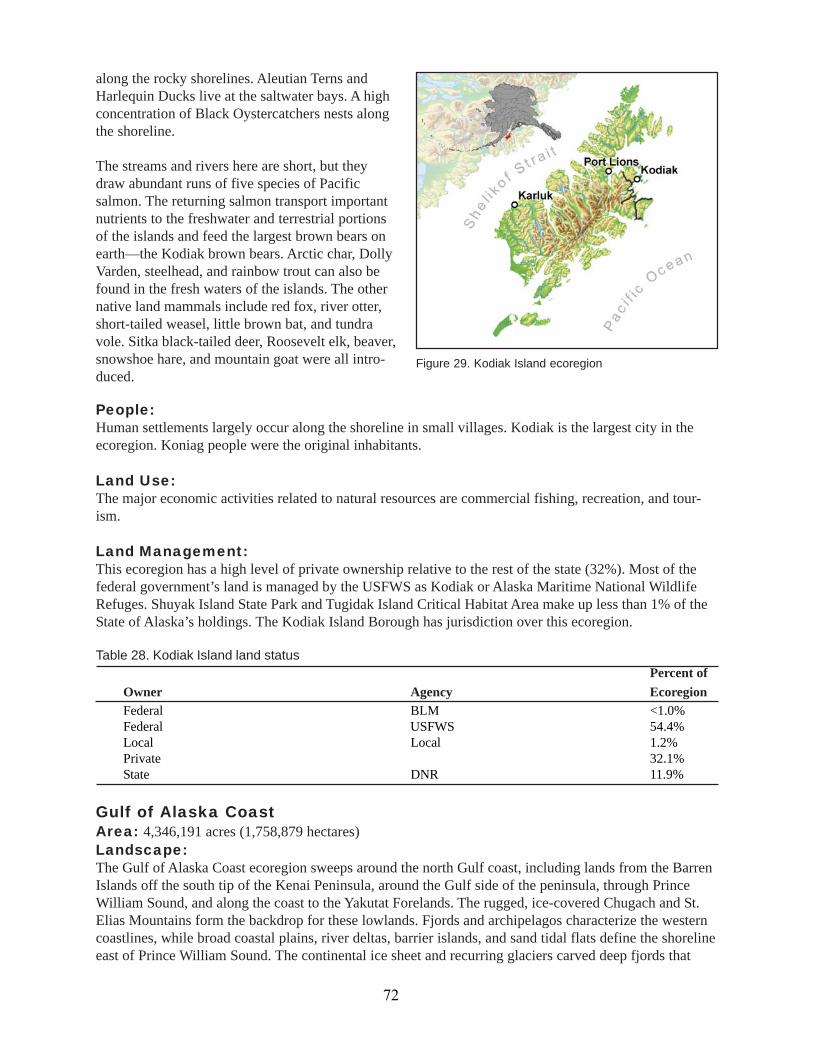
along the rocky shorelines. Aleutian Terns andHarlequin Ducks live at the saltwater bays. A highconcentration of Black Oystercatchers nests alongthe shoreline.
The streams and rivers here are short, but theydraw abundant runs of five species of Pacificsalmon. The returning salmon transport importantnutrients to the freshwater and terrestrial portionsof the islands and feed the largest brown bears onearth—the Kodiak brown bears. Arctic char, DollyVarden, steelhead, and rainbow trout can also befound in the fresh waters of the islands. The othernative land mammals include red fox, river otter,short-tailed weasel, little brown bat, and tundravole. Sitka black-tailed deer, Roosevelt elk, beaver,snowshoe hare, and mountain goat were all intro-duced.
Gulf of Alaska CoastArea: 4,346,191 acres (1,758,879 hectares)Landscape:The Gulf of Alaska Coast ecoregion sweeps around the north Gulf coast, including lands from the BarrenIslands off the south tip of the Kenai Peninsula, around the Gulf side of the peninsula, through PrinceWilliam Sound, and along the coast to the Yakutat Forelands. The rugged, ice-covered Chugach and St.Elias Mountains form the backdrop for these lowlands. Fjords and archipelagos characterize the westerncoastlines, while broad coastal plains, river deltas, barrier islands, and sand tidal flats define the shorelineeast of Prince William Sound. The continental ice sheet and recurring glaciers carved deep fjords that
People:Human settlements largely occur along the shoreline in small villages. Kodiak is the largest city in theecoregion. Koniag people were the original inhabitants.
Land Use:The major economic activities related to natural resources are commercial fishing, recreation, and tour-ism.
Land Management:This ecoregion has a high level of private ownership relative to the rest of the state (32%). Most of thefederal government’s land is managed by the USFWS as Kodiak or Alaska Maritime National WildlifeRefuges. Shuyak Island State Park and Tugidak Island Critical Habitat Area make up less than 1% of theState of Alaska’s holdings. The Kodiak Island Borough has jurisdiction over this ecoregion.
Table 28. Kodiak Island land statusPercent of
Owner Agency EcoregionFederal BLM <1.0%Federal USFWS 54.4%Local Local 1.2%Private 32.1%State DNR 11.9%
Figure 29. Kodiak Island ecoregion
72

filled with seawater when the glaciers retreated,leaving broad U-shaped valleys, and well abovecurrent sea level, hanging glaciers. In the easternpart of the ecoregion, unconsolidated glacial,alluvial, and marine deposits have been lifted bytectonics and isostatic rebound after glacial retreatto produce a relatively flat plain. Most largerstreams in this ecoregion originate in glaciers; inthe eastern portion, silt-laden streams are lowgradient and braided, terminating in broad deltasand wetlands. The prime example of this is theCopper River Delta, which at 700,000 acres,constitutes the largest contiguous wetland on thePacific Coast of North America. Small lakes occurhigh in glacially carved valleys. Glacial outburst floods, land subsidence, isostatic rebound, and localizedhigh wind events continue to dominate and influence landscape patterns.
The marine environments of this ecoregion vary, from exposed coastlines to sandy barrier islands to deepfjords. In Prince William Sound, depths reach 800 meters and icebergs float at the base of tidewaterglaciers. Tides are strong, and a large amount of fresh water flows into the ocean from this section ofcoast.
The cool, maritime climate brings extended periods of clouds and fog with abundant precipitation. Theaverage annual precipitation ranges from 30 to 160 inches (76–206 centimeters). Mean annual snowfallvaries from 80 to 600 centimeters. The average annual temperature also has a large range: 30 to 42 °F (–1to 6 °C). Permafrost is absent from this ecoregion.
Abundant precipitation and braided streams keep organic soils on the flat plains saturated. Wetlands inthese locations support black spruce muskeg, tall scrub communities, low scrub bogs, wet graminoidherbaceous communities, and wet forb herbaceous communities. Where soils are better drained along theshoreline and on mountain slopes, a lush temperate rain forest predominated by western hemlock andSitka spruce grows. Cottonwood and alder stands occur along river valleys throughout the ecoregion, withbirch occurring in valleys only in the Kenai Peninsula.
Orca in winter, Prince William Sound USFWS
Figure 30. Gulf of Alaska Coast ecoregion
73

Wildlife and Fish:Migratory birds find important stopover, nesting and feeding areas in this ecoregion. One of the mostimportant shorebird stopover sites in North America is the Copper River Delta. Along with nearbyController Bay (Bering River Delta), the area supports the largest spring concentration of shorebirds inthe Western Hemisphere (Bishop et al. 2000). Thirty-six species of migrating shorebirds have beencounted in the Copper River Delta alone, with the two most abundant species being Dunlins and WesternSandpipers. Waterfowl, passerine, and shorebird species of importance include an extremely dense
Black Oystercatcher ADF&G
population of Trumpeter Swans; the entire breeding population ofDusky Canada Geese; a sizable population of Aleutian Terns, Red-throated Loons, Harlequin Ducks, and Black Oystercatchers; a largeconcentration of Surfbirds each spring; and high nesting concentra-tions of Bald Eagles and Marbled Murrelets. Yellow-billed Loonsand many species of sea ducks winter along the coast in PrinceWilliam Sound. Parasitic Jaegers are known to breed in the area, andLong-tailed Jaegers migrate through seasonally. Sensitive landbirdsin the ecoregion include Olive-sided Flycatchers and BlackpollWarblers.
This ecoregion also hosts a diverse assemblage of marine species.Steller sea lions and harbor seals haul out on its rocky shores andicebergs, and sea otters forage along its shoreline. Cetaceans includeDall’s and harbor porpoises and orca, fin, humpback, and minke
whales; also, an isolated pod of beluga whales has recently been documented in Disenchantment Bay.Forage species, particularly herring, capelin, and sand lance, are abundant and form the food base formost marine fishes and seabirds. Marine invertebrates and fish, such as the many species of rockfish,inhabit many different niches in the Gulf. Important nutrients from the marine environment are trans-ported to the terrestrial and freshwater ecosystems by returning salmon and by other marine life, such asforage fish, which can be carried inland by nesting seabirds.
The many streams and rivers support mainly Dolly Varden, coastal cutthroat trout, and all five species ofPacific salmon. Two species of lamprey occur on the Yakutat Foreland. Large runs of steelhead are foundin the Copper River and in the Situk River near Yakutat. Small runs of steelhead are documented in theDoame, Akwe, Italio, Yahtze, Tsiu, and Kiklukh Rivers; Steelhead Creek (Lituya Bay); Humpback Creek;Manby Stream; and the Anhau Lagoon/Lost river system. Some number of steelhead probably inhabit justabout every coastal stream along the Gulf in this ecoregion (Robert Johnson, ADF&G, personal commu-nication). Alaska blackfish are known to occur in the Tsiu River, far south of their normal range. Stickle-backs are found in the brackish water margins between the glacial lakes and ponds at the headwaters ofmany streams.
Terrestrial mammals include snowshoe hares, black and brown bears, moose, mountain goats, and Sitkablack-tailed deer. Moose were introduced to the Copper River Delta during the 1950s, and deer wereintroduced to Yakutat Bay islands from Sitka about 1950; both species have flourished. Furbearersinclude wolves, wolverines, coyotes, foxes, lynx, martens, mink, beavers, weasels, and red squirrels. TheMontague Island vole is a large subspecies of tundra vole occurring only on Montague Island. Hoarymarmots occur in a patchy distribution from sea level to alpine; sightings of Alaska marmot have alsobeen reported, but visual identifications have not been confirmed with sampling (Robert Johnson and PhilMooney, ADF&G, personal communication).
Two amphibians are found here: Wood Frog and Western Toad. As for reptiles, several Olive RidleySeaturtle carcasses have washed ashore in this ecoregion over the years.
74

People:Tlingit people have traditionally inhabited the eastern portion of the ecoregion, while Eyak, Chugach, andKoniag people settled in different parts of the west. Mainland dwellers subsisted on salmon, eulachon,mountain goats and, in very limited locales prior to introduction, moose. Island dwellers used moremarine resources, including marine mammals, shellfish, salmon, herring, halibut, seaweed, and berries.Seward and Cordova are the largest towns.
Land Use:Timber harvest, commercial fishing, and recreation are the primary economic activities related to naturalresources in the area. Mining of metallic and nonmetallic elements and energy-related commodities alsooccurs. This area received substantial oil exploration activities, both onshore and offshore, in the 1950sthrough mid 1970s.
Land Management:This ecoregion has a relatively high level of private ownership (19.7%). The federal government owns63%. Due to the extensive east-west reach of this ecoregion, Wrangell-St. Elias, Glacier Bay, and KenaiFjords National Parks and Preserves, as well as Tongass and Chugach National Forests, all intersect itsboundaries. Most of the federal land here is managed as Chugach National Forest. The State of Alaskahas designated several critical habitat areas, marine parks, refuges, and recreation areas here.
Table 29. Gulf of Alaska Coast land status Percent of
Owner Agency EcoregionFederal BLM 2.1%Federal NPS 8.1%Federal USFWS <1.0%Federal USFS 52.9%Local Local <1.0%Private 19.8%State DNR 16.4%
Chugach-St. Elias MountainsArea: 23,013,682 acres (9,313,510 hectares)Alaska 85.2%, Canada 14.8%Landscape:The Chugach and St. Elias Mountains form acrescent behind the Gulf of Alaska coastline,reaching from the southern tip of the Kenai Penin-sula around to the Fairweather Range in the AlaskaPanhandle. These rugged mountains contain thelargest collection of ice fields and glaciers outsideof the polar regions.
Elevation ranges from 330 feet to more than 14,750 Scott Glacier USFWS
feet (100 to 4,500 meters) and greater, with huge ice fields, snowfields, and glaciers surrounding steepangular peaks. Small isolated peaks called nunataks jut from the middle of broad glaciers. Some glaciersstill run all the way to tidewater, but where others have receded, broad U-shaped valleys with long lakesand deep fjords were left. The deeper soils in these valleys, formed from unconsolidated morainal andfluvial deposits, insulate isolated pockets of permafrost. During the summer, meltwater from the snowand ice flows along the base of the glaciers and eventually forms swift, short streams in valleys or inun-dates coastal flats. Only two rivers, the Alsek and Copper, breach these mountain ranges.
75
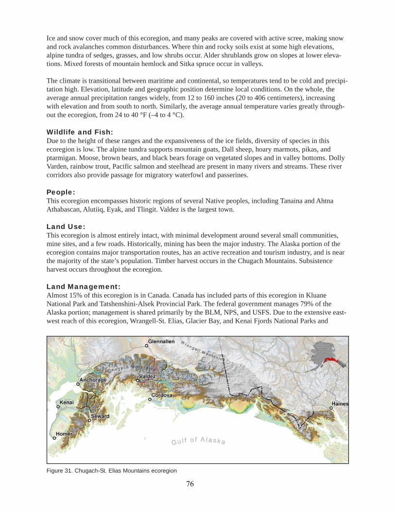
Ice and snow cover much of this ecoregion, and many peaks are covered with active scree, making snowand rock avalanches common disturbances. Where thin and rocky soils exist at some high elevations,alpine tundra of sedges, grasses, and low shrubs occur. Alder shrublands grow on slopes at lower eleva-tions. Mixed forests of mountain hemlock and Sitka spruce occur in valleys.
The climate is transitional between maritime and continental, so temperatures tend to be cold and precipi-tation high. Elevation, latitude and geographic position determine local conditions. On the whole, theaverage annual precipitation ranges widely, from 12 to 160 inches (20 to 406 centimeters), increasingwith elevation and from south to north. Similarly, the average annual temperature varies greatly through-out the ecoregion, from 24 to 40 °F (–4 to 4 °C).
Wildlife and Fish:Due to the height of these ranges and the expansiveness of the ice fields, diversity of species in thisecoregion is low. The alpine tundra supports mountain goats, Dall sheep, hoary marmots, pikas, andptarmigan. Moose, brown bears, and black bears forage on vegetated slopes and in valley bottoms. DollyVarden, rainbow trout, Pacific salmon and steelhead are present in many rivers and streams. These rivercorridors also provide passage for migratory waterfowl and passerines.
People:This ecoregion encompasses historic regions of several Native peoples, including Tanaina and AhtnaAthabascan, Alutiiq, Eyak, and Tlingit. Valdez is the largest town.
Land Use:This ecoregion is almost entirely intact, with minimal development around several small communities,mine sites, and a few roads. Historically, mining has been the major industry. The Alaska portion of theecoregion contains major transportation routes, has an active recreation and tourism industry, and is nearthe majority of the state’s population. Timber harvest occurs in the Chugach Mountains. Subsistenceharvest occurs throughout the ecoregion.
Land Management:Almost 15% of this ecoregion is in Canada. Canada has included parts of this ecoregion in KluaneNational Park and Tatshenshini-Alsek Provincial Park. The federal government manages 79% of theAlaska portion; management is shared primarily by the BLM, NPS, and USFS. Due to the extensive east-west reach of this ecoregion, Wrangell-St. Elias, Glacier Bay, and Kenai Fjords National Parks and
Figure 31. Chugach-St. Elias Mountains ecoregion
76
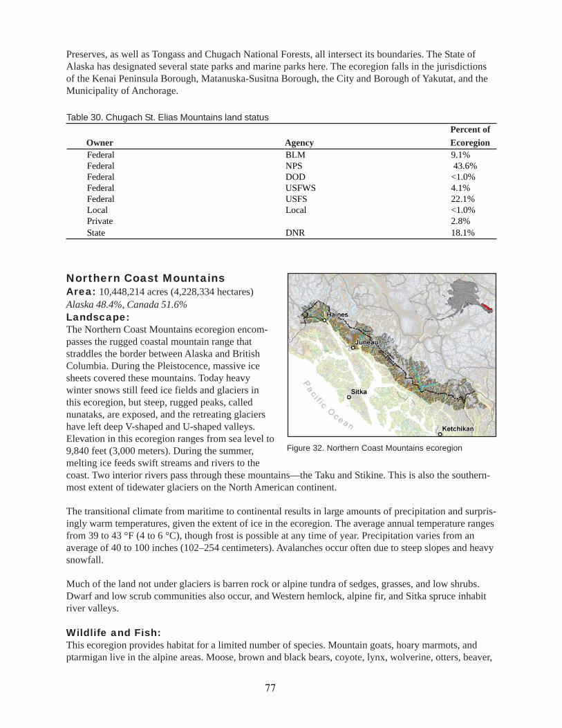
Preserves, as well as Tongass and Chugach National Forests, all intersect its boundaries. The State ofAlaska has designated several state parks and marine parks here. The ecoregion falls in the jurisdictionsof the Kenai Peninsula Borough, Matanuska-Susitna Borough, the City and Borough of Yakutat, and theMunicipality of Anchorage.
Percent ofOwner Agency Ecoregion
Table 30. Chugach St. Elias Mountains land status
Federal BLM 9.1%Federal NPS 43.6%Federal DOD <1.0%Federal USFWS 4.1%Federal USFS 22.1%Local Local <1.0%Private 2.8%State DNR 18.1%
Northern Coast MountainsArea: 10,448,214 acres (4,228,334 hectares)Alaska 48.4%, Canada 51.6%Landscape:The Northern Coast Mountains ecoregion encom-passes the rugged coastal mountain range thatstraddles the border between Alaska and BritishColumbia. During the Pleistocence, massive icesheets covered these mountains. Today heavywinter snows still feed ice fields and glaciers inthis ecoregion, but steep, rugged peaks, callednunataks, are exposed, and the retreating glaciershave left deep V-shaped and U-shaped valleys.Elevation in this ecoregion ranges from sea level to9,840 feet (3,000 meters). During the summer,melting ice feeds swift streams and rivers to the
Figure 32. Northern Coast Mountains ecoregion
coast. Two interior rivers pass through these mountains—the Taku and Stikine. This is also the southern-most extent of tidewater glaciers on the North American continent.
The transitional climate from maritime to continental results in large amounts of precipitation and surpris-ingly warm temperatures, given the extent of ice in the ecoregion. The average annual temperature rangesfrom 39 to 43 °F (4 to 6 °C), though frost is possible at any time of year. Precipitation varies from anaverage of 40 to 100 inches (102–254 centimeters). Avalanches occur often due to steep slopes and heavysnowfall.
Much of the land not under glaciers is barren rock or alpine tundra of sedges, grasses, and low shrubs.Dwarf and low scrub communities also occur, and Western hemlock, alpine fir, and Sitka spruce inhabitriver valleys.
Wildlife and Fish:This ecoregion provides habitat for a limited number of species. Mountain goats, hoary marmots, andptarmigan live in the alpine areas. Moose, brown and black bears, coyote, lynx, wolverine, otters, beaver,
77

and gray wolves inhabit the ecoregion, as do birds,including Vancouver Canada Geese, TrumpeterSwans, and Golden Eagles. The streams, headwaterlakes, and rivers support large runs of five Pacificsalmon species, which transport important, marine-derived nutrients back to the freshwater and terres-trial ecosystems and draw brown bears and otherscavengers. Other resident and anadromous fishspecies in these watersheds include Dolly Varden,and bull, cutthroat, rainbow, and steelhead trout.Other anadromous fish include lampreys andeulachon. Large spawning concentrations ofeulachon can occur during spring near the mouths
Taku Inlet in winter J. Hyde, ADF&G
of rivers, attracting large concentrations of Bald Eagles, gulls, and Steller sea lions.
People:This ecoregion is on the eastern side of the region traditionally inhabited by the Tlingit people. Juneau isthe largest community in this area and the capital of Alaska.
Land Use:Major components of the economy are tourism and recreation, government, commercial fishing, and min-ing. Historically, mining has been a major industry here, with open pit, underground, and some placeroperations. Today, mining exploration and production occur primarily in the Purcupine district northwest ofHaines, at the Kensington gold mine north of Juneau and, in Canada, at the Tulsequah Chief mine arealocated adjacent to the Taku River. Limited timber harvest occurs in the Chilkat River valley. Majortransportation routes to the Interior extend from Skagway and Haines, promoting recreation and tourism.Subsistence harvest occurs throughout the region. In the Canadian portion, this ecoregion is almost entirelyintact, with limited development along the Haines and Skagway Highways and at small mine sites.
Land Management:Over half (51.6%) of this ecoregion falls in Canada. British Columbia has included part of it in Atlin Provin-cial Park. On the Alaska side of the border, the federal government owns almost 90%. The USFS managesthe majority of the Alaska portion as the Tongass National Forest. The State of Alaska owns 10%, mostlylocated at the northwest end of the ecoregion, and has designated a state forest and critical habitats, pre-serves, and parks in the ecoregion. The ecoregion falls in the jurisdictions of the Haines Borough and theCity and Borough of Juneau.
Table 31. Northern Coast Mountains land statusPercent of
Owner Agency EcoregionFederal BLM 5.7%Federal NPS <1.0%Federal USFS 83.6%Local Local <1.0%Private <1.0%State DNR 9.9%
78

Alexander ArchipelagoArea: 13,634,178 acres (5,517,676 hectares)Landscape:The Alexander Archipelago is characterized by itstemperate rain forests, long fjords, abundantislands, and maritime climate. Past glaciers carveddeep, narrow valleys, which filled with seawaterwhen the glaciers retreated. A few alpine glaciersstill remain in broad U-shaped valleys at the headsof fjords, but most major glaciers have retreated tothe adjacent ecoregions. Mainland rivers passingthrough this ecoregion typically start in glaciersfarther inland. Elevations in this rugged ecoregionrange from sea level to over 3,280 feet (1,000meters), with rounded mountains and steep-sided angular mountains both present. Rolling morainelandforms dominate the hills and valley bottoms. Tectonic movement and the forces of rebound afterglacier retreat have raised and lowered marine terraces, forming rich coastal lowlands and estuaries. Thelarge rivers slow near the coast and end in broad deltas. Limestone underlies parts of the ecoregion, andkarst topography of sinkholes, caves, underground streams, and fractured bedrock fosters high levels ofendemism in plants.
Various disturbance regimes affect the landscape—localized intense winter winds topple coastal trees,frequent landslides and avalanches denude steep mountain slopes, and flooding recurs in streams andrivers. With many narrow passages for tidewaters to transit, tidal range and currents can be extreme.
The cool maritime climate sees relatively little seasonal temperature variation, large amounts of precipita-tion, mostly in the form of rain, and extended periods of cloudiness and fog. Mean annual precipitationranges from 30 to 220 inches (76 to 559 centimeters), and the mean annual temperature varies from 33 to46 °F (1 to 8 °C). The northern part of the ecoregion experiences the drier and colder weather.
The temperate rain forest, consisting primarily of western hemlock and Sitka spruce, reaches from thecoastline to the steeper, rockier mountain slopes. Salal and western red cedar are also found in the south-ern parts of the archipelago. Mixed conifer, black cottonwood, and lodgepole pine occur on drier sites.Where bedrock is not exposed, the forest gradually transitions to shrublands and alpine tundra of mossesand sedges. Water-tolerant plants such as sphagnum moss, sedges, bog kalmia and shore pine occur inpeat lands. Poorly drained soils support open muskeg and forested wetlands.
Wildlife and Fish:The natural fragmentation of the archipelago has influenced species distribution and promoted a level ofendemism high for Alaska. Furbearers such as river otter, marten, mink, weasel, beaver and red squirrelsare on the mainland and some of the islands. Brown bears roam the mainland and northern islands,including Admiralty, Baranof and Chichagof, and some adjacent smaller islands. Black bears occur on themainland and most islands south of Frederick Sound. Gray wolves occur everywhere in the ecoregionexcept Admiralty, Baranof, and Chichagof Islands and a host of inconsequentially small islands. Wolvesare most abundant on southern islands of the archipelago (i.e., south of Frederick Sound), where theyoccur as an endemic subspecies, the Alexander Archipelago wolf. As a result of Southeast Alaska’sunique island biogeography and variable glaciation through time, populations of many other endemicbirds, invertebrates, and mammals, including Gapper’s red-backed vole, occur here.
This ecoregion is also rich—in comparison to the rest of the state—for the presence of amphibians,including Rough-skinned Newts, Northwestern Salamanders, Long-toed Salamanders, Wood Frogs,
Figure 33. Alexander Archipelago ecoregion
79

Spotted Frogs, and Boreal Toads. When leather-back or green turtles follow the Japan or NorthPacific currents north, there are also occasionallyreptiles in this ecoregion. Additionally, there arefive species of bats (little brown, long-legged,Keen’s, silver-haired, and big brown), some ofwhich also occur elsewhere along the Gulf ofAlaska coast.
The forests, estuaries, wetlands, and rivers providerich habitat for birds and fish. Dolly Varden andcutthroat, rainbow, and steelhead trout occur here.Five species of Pacific salmon return to the
Screech-owls, and goshawks (Northern Goshawk and its subspecies, the Queen Charlotte Goshawk).Southeast Alaska encompasses the largest Marbled Murrelet population in the world; Marbled Murreletsare listed as threatened throughout their range south of Southeast Alaska.
Sitka black-tailed deer are the most wide-ranging large mammal in the ecoregion. Mountain goats occurnaturally on the mainland mountains and steep fjord coasts; due to introductions, they are also now foundon Baranof and Revillagigedo Islands. Moose are primarily found in the mainland river valleys. Smallmammals include northern water shrews, deer mice, and long-tailed voles. Humpback, gray, orca, andminke whales; Dall’s and harbor porpoises; harbor seals; Steller sea lions; and sea otters inhabit themarine waters. The Forrester Island complex supports the largest Steller sea lion rookery in Alaska.Northern (pinto) abalone is abundant in the outside coastal waters.
People:Human settlements occur almost entirely along the coastline in this ecoregion. The Tlingit and HaidaNatives traditionally subsisted on salmon, moose, eulachon, mountain goat, herring, halibut, seaweed,deer, waterfowl, grouse, seals, clams, cockles, chitons, and edible plants, and many still maintain subsis-tence lifestyles today. The largest towns are Sitka and Ketchikan.
Land Use:The major components of the economy are timber harvest and processing, tourism and recreation, com-mercial fishing, and mining. Greens Creek Mine, one of the nation’s largest producers of silver, is locatedin this ecoregion.
Land Management:The federal government manages 91% of this ecoregion, with management largely by the USFS. TongassNational Forest includes Misty Fjords National Monument. The NPS manages Glacier Bay National Parkand Preserve. Some of the state-managed lands have been designated game refuges, critical habitat areas,state parks, marine parks, and recreation rivers, but altogether these small units make up less than 2% of
Chichagof Island T. Paul, ADF&G
streams each year, transporting important nutrients back to the freshwater andterrestrial ecosystems. Other anadromous fish include lampreys and eulachon.Spawning fish also provide rich food for bears, wolves, ravens, gulls, and thehighest nest density of Bald Eagles in the world. Other birds include VancouverCanada Geese, Trumpeter Swans, Red-tailed Hawks, Peregrine Falcons, Red-breasted Sapsuckers, Pacific-slope Flycatchers, Rufous Hummingbirds, Golden-crowned Kinglets, Varied Thrush, Red and White-winged Crossbills, BlueGrouse, ptarmigan, sandpipers, sea ducks, Black Oystercatchers, CommonMurres, Tufted Puffins, Marbled Murrelets, Great Blue Herons, Western Wood Frog USFWS
80

the ecoregion. The ecoregion falls in the jurisdictions of the Haines Borough, Ketchikan Gateway Bor-ough, the City and Borough of Sitka, and the City and Borough of Juneau.
Table 32. Alexander Archipelago land statusPercent of
Owner Agency EcoregionFederal BLM <1.0%Federal NPS 6.1%Federal USFWS 85.0%Local Local <1.0%Private 5.7%State DNR 3.2%
Literature CitedAbell, R. A., D. M. Olson, E. Dinerstein, P. T. Hurley, et al. 2000. Freshwater ecoregions of North
America, a conservation assessment. Island Press. Washington. 319 p.
Aderman, A., M. Hinkes, and J. Woolington. 2000. Population identity and movements of moose in theTogiak, Kulukak, and Goodnews River drainages, southwest Alaska. Progress Report 00-01.USFWS and ADF&G. Dillingham, AK. 26 p.
Alaska Department of Environmental Conservation. 1976. Coastal ecosystems of Alaska: a preliminaryreview of the distribution and abundance of primary producers and consumers in the marineenvironment / DEC, prepared by Water Programs, Environmental Analysis Section, through areimbursable services agreement for the Alaska Coastal Management Program. Juneau, AK.180 p.
ADF&G. 1994. ADF&G’s wildlife notebook series. Juneau, AK. 1 vol.
ADF&G. 1999. Yakataga State Game Refuge Management Plan. ADF&G. Douglas, AK. 86 p.
Alaska Sea Duck Working Group. 1999. Population status and trends of sea ducks in Alaska. USFWS.Anchorage, AK. 136 p.
Alaska Shorebird Working Group. 2000. U.S. shorebird conservation plan, a conservation plan for Alaskashorebirds, version 1.0. USFWS, USGS. Anchorage, AK. 1 vol.
Banks, D., R. Hagenstein, J. Pearce, A. Springer and M. Williams, editors. 1999. Ecoregion-based conser-vation in the Bering Sea: identifying important areas for biodiversity conservation. The NatureConservancy and World Wildlife Fund. Anchorage, AK.
Bishop, M. A., P. Meyers, and P. F. McNeley. 2000. A method to estimate shorebird numbers on theCopper River Delta, Alaska. Journal of Field Ornithology. 71(4): 627–637.
Boreal Partners in Flight Working Group. 1999. Landbird conservation plan for Alaska biogeographicregions, version 1.0. USFWS. Anchorage, AK. 1 vol.
Dragoo, D. E., G. V. Byrd, and D. B. Irons. 2001. Breeding status, population trends and diets of seabirdsin Alaska, 2000. USFWS. Homer, AK. 77 p.
Gallant, A. L., E. F. Binnian, J. M. Omernik, and M. B. Shasby. 1995. Ecoregions of Alaska. USGSProfessional Paper 1567. Available from U.S. Government Printing Office, Washington. 73 p.
81
Gibson, D. D. and B. Kessel. 1989. Geographic variation in the Marbled Godwit and description of anAlaskan subspecies. Condor 91:436–443.
Kruger, L. E. and C. B. Tyler. 1995. Management needs assessment for the Copper River Delta, Alaska.Gen. Tech. Report. PNW-GTR-356. USFS, Pacific Northwest Research Station. Portland, OR. 45p.
Mac, M. J., P. A. Opler, C. E. Puckett Haecker, and P. D. Doran. 1998. Status and trends of the nation’sbiological resources. U.S. Department of the Interior, USGS. Reston, VA. 2 vols, 964 pp.
McNab, H. and P. E. Avers. 1994. Ecological subregions of the United States: Section Descriptions.USFS. Washington. Prepared in cooperation with the Regional Compilers and the ECOMAPTeam of the Forest Service. WO-WSA-5.
Nowacki, G., P. Spencer, M. Fleming, T. Brock, and T. Jorgenson. 2001. Ecoregions of Alaska: 2001.USGS Open-File Report 02-297 (map).
Oswald, E. T. and J. P. Senyk. 1977. Ecoregions of Yukon Territory. Fisheries and Environment Canada,Canadian Forestry Service. Victoria, British Columbia. 115 p.
Ott, R. 1998. Alaska’s Copper River Delta. Artists for Nature Foundation. The University of WashingtonPress. 160 p.
Ricketts, T. H., E. Dinerstein, D. M. Olson, C. J. Loucks, et al. 1999. Terrestrial ecoregions of NorthAmerica, a conservation assessment. Island Press, Washington. 485 p.
Selkregg, L. 1976. Alaska regional profiles: southwest region. Arctic Environmental Information andData Center, Anchorage, AK. 313 p.
Wynne, K. 1997. Guide to marine mammals of Alaska. Alaska Sea Grant College Program, University ofAlaska Fairbanks. 76 p.
Literature Cited (continued)
82