aware - national weather service · 11 hurricane safety 12 outreach/ ... have worked some truly...
TRANSCRIPT
AwareVolume 2, April 2007
Climate, Water, Weather
Inside Aware
2 Air Quality
3 Digital Services
5 Dissemination
9 Flood Safety
11 Hurricane Safety
12 Outreach/ Education
14 Severe Weather/ Tornadoes
18 StormReady/ TsunamiReady
18 Climate, Water and Weather Links
Aware is published by NOAA’s National Weather Service to enhance communications within the Agency
and with the emergency management community.
The Long Road Travelled and the Road Still to Walk
By Dennis McCarthy, Director, Office of Climate, Weather and Water Services
I have mixed feelings about writing this article for Aware, since it will be my last as Director of the NWS Office of Climate, Water, and Weather Services. I will be retiring on May 31 after a little more than 36 years of federal service, including more than 33 with the NWS. After starting out as an intern and forecaster in Portland, ME, in January 1974, I moved to Indianapolis 30 years ago this month and spent the rest of my field days in the Midwest and Plains before coming to NWS Headquarters in January 2005.
It’s been a great privilege for me to work alongside such talented and dedicated NWS employees over the past three decades. It’s also been an incredible experience working in partnership with so many dedicated emergency services people, including volunteer spotters and local emergency managers, county and state officials, federal partners, the media and our commercial partners. We have worked some truly memorable events together, and together we have made significant progress.
We have already seen the progress this year in severe weather events across the Southeast, the Midwest and the Plains, accompanied by major winter weather impacts in the High Plains, Great Lakes and Northeast. We have also seen, however, the work that remains to be done to promote preparedness and awareness. Overnight tornadoes, especially in communities without shelters, continue to be one of our major challenges, along with the dangerous mix of vehicles and flood waters, and the risks of storm surge and inland flooding from tropical storms.
It has been encouraging to see excellent progress in preparedness and awareness programs such as StormReady and TsunamiReady, NOAA Weather Radio All Hazards, lightning awareness, HazCollect, Turn Around Don’t Drown, inundation mapping and all the great partnering activities that have put NOAA Weather Radios in more homes, schools and businesses.
On the science and technology side, the new Open Radar Data Acquisition hardware for NEXRAD will make higher resolution data available soon. We can also look forward to integration of more FAA Terminal Doppler Weather Radar data over the next couple of years, and to storm-based (polygon) warnings nationwide this year. Meanwhile, we are exploring ways to make better use of XML dissemination capability, especially for our most critical short-fused products.
For my part, I am looking forward to participating from the other side in the years to come. I hope to contribute to NWS work using my 4-inch rain gage, my snow board, WeatherCoder software and my amateur radio. This is my chance to get out there a bit after working so many events from the inside. So when you hear KC5EVH on your ham radio network later this year, it will be my best effort to contribute a timely and accurate NWS report. Meanwhile, in ham radio vocabulary, 73 to all, and keep up the great work.
2
Air Quality
NOAA’s National Weather Service
Office of Climate, Water and Weather Services
Director Dennis H. McCarthy
Awareness
Branch Chief Bob McLeod
EditorsMelody Magnus
Donna Ayres Deborah Lavine
Articles/Questions: [email protected]
Aware in PDF:www.weather.gov/os/aware/
Subscribe/Unsubscribe www.weather.gov/os/awarelist.shtml
ISSN 1936-8178
Aware
National Air Quality Awareness Week is Approaching
By Michael Dion, NWS Fire and Public Weather Services Branch [email protected]
NWS and the U.S. Environmental Protection Agency (EPA) urge Americans to “Be Air Aware” during Air Quality Awareness Week, which runs April 30-May 4, 2007.
The goal of Air Quality Awareness Week is to provide information on outdoor air pollution and its impact on the quality of the air we breathe. The week targets a different air quality topic daily:
Ozone and particle pollutionCauses of poor air qualityHow to protect yourself on poor air quality daysHow air quality predictions are madeSteps you can take to improve the cleanliness of the air we breathe
For more information on Air Quality Awareness Week, go to www.airquality.noaa.gov/.
NWS Transitions Smoke Forecast Tool into Operations
By Michael Dion, NWS Fire and Public Weather Services Branch [email protected]
•••••
For the past few years, in conjunction with the EPA, NWS has produced air quality guidance out to 48 hours for predicted surface ozone concentrations in the eastern United States. NWS now has added a Smoke Forecast Tool to this guidance that covers the entire continental United States.
The Smoke Forecast Tool is a daily product offering a 48-hour prediction of smoke transport and concentration. This product uses information from four sources:
NOAA satellite information on the location of wildfiresNWS weather inputs from its North American Mesoscale modelSmoke dispersion simulations from NOAA’s Office of Oceanic and Atmospheric Research HYSPLIT modelU.S. Forest Service estimates for wildfire smoke emissions based on vegetation cover
The air quality program seeks to provide citizens with ozone, particulate matter and other pollutant forecasts with enough advance notice to reduce adverse effects. The Smoke Forecast Tool leverages capabilities within and outside NOAA to forecast smoke concentrations in the air we breathe.
This guidance is available on the Web at www.weather.gov/aq/. Expanded coverage with experimental ozone predictions, from coast to coast, is
available at www.weather.gov/aq-expr. Detailed information on our Air Quality Forecasts is available at:
www.weather.gov/ost/air_quality/.
•••
•

3
Digital Services
Convective Outlooks Probability Elements Available in NDFD
By John Ferree, NWS Severe Storms Service Leader [email protected]
On February 27, NWS added nine convective outlook hazard probability elements to the National Digital Forecast Database (NDFD) on an experimental basis. All nine of these elements are generated by the Storm Prediction Center (SPC) in Norman, OK. These elements are available in NDFD for the contiguous United States and for the 16 pre-defined NDFD CONUS subsectors. The nine elements are:
Convective Hazard Outlook for Days 1, 2 and 3Probability of Tornadoes for Day 1Probability of Hail for Day 1Probability of Damaging Thunderstorm Winds for Day 1 Probability of Extreme Tornadoes for Day 1 Probability of Extreme Hail for Day 1 Probability of Extreme Thunderstorm Winds for Day 1Total Probability of Severe Thunder-storms for Days 2 and 3Total Probability of Extreme Severe Thunderstorms for Days 2 and 3.
The Categorical Convective Outlook elements specify the perceived level of threat as Slight, Moderate or High Risk.
The individual probabilistic elements provide a more detailed look at specific severe weather hazards through the use of probabilities, such as percent likelihood of occurrence. For Day 1, expectations of large hail, damaging winds and tornadoes are explicitly conveyed in separate forecasts.
By producing forecasts of each hazard individually, users who are most affected by one particular threat can make more informed decisions; for example, car dealers may be particularly concerned about large hail.
You can find details of these elements at products.weather.gov/PDD/9SPC_NDFD_PDD.pdf and on the SPC Website at www.spc.noaa.gov/products/outlook/probinfo.html.
Users can download the grid format and convert it into shapefiles for use in decision assistance tools such as Geographic Information Systems. For instructions on how to download these grids, see Technical Information Notification (TIN) 07-05 and related NDFD notifications at: www.weather.gov/ndfd/tins.htm.
NWS is seeking comments on these experimental elements through June 29, 2007. You can find instructions on how to comment in TIN07-05, linked above. After all feedback is assessed and staff complete a technical analysis, NWS will determine whether to transition the experimental elements to operational status, discontinue them, or revise and retain them as experimental elements.
•
•••
•
••
•
•
NWS Website displaying CONUS Convective Outlook Grid from Saturday March 31. Note that it is found under the “Hazardous” menu in the upper right corner.

4
Experimental Web Feature Service Added To Digital Services Pantheon
By John Schattel, NWS Meteorological Development Laboratory Staff [email protected]
In May, NWS will launch an experimental Web Feature Service (WFS) to enhance GIS access to NDFD data. The WFS will allow GIS applications that support the Open Geospatial Consortium’s (OGC) WFS protocol to easily import NWS digital forecasts via the Web. These GIS applications will be able to use the retrieved NDFD data to answer questions, make decisions and generate value-added products. Users will be able to display and analyze NDFD data and to merge NDFD forecasts with other data sets.
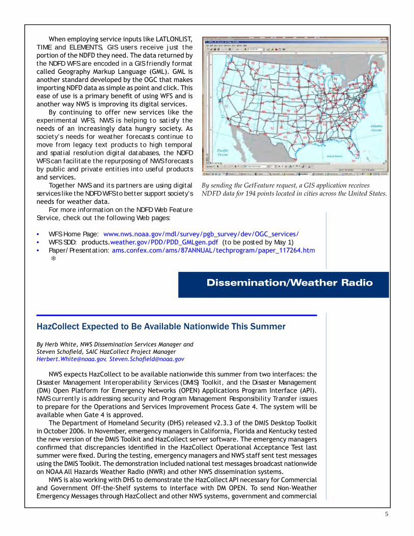
To transfer NDFD data from the experimental WFS server, GIS applications will rely on requests sent to three standard interfaces: GetCapabilities, DescribeFeatureType and GetFeature. These interfaces enable GIS applications to learn what services and data are available from the service (GetCapabilities), understand how the data are structured (DescribeFeatureType) and retrieve the data (GetFeature). Sample requests to these interfaces on the NDFD WFS are shown below:
GetCapabilities Request www.weather.gov/forecasts/xml/OGC_services/ndfdOWSserver.php?SERVICE=WFS&REQUEST=GetCapabilities
DescribeFeatureType Request www.weather.gov/forecasts/xml/OGC_services/ndfdOWSserver.php?SERVICE=WFS&REQUEST=DescribeFeatureType&VERSION=1.0.0&TYPENAME=Forecast_Gml2Point
GetFeature Requestwww.weather.gov/forecasts/xml/OGC_services/ndfdOWSserver.php?SERVICE=WFS&REQUEST=GetFeature&VERSION=1.0.0&TYPENAME=Forecast_Gml2Point
By sending the GetFeature request shown above, a GIS application receives NDFD data for 194 U.S. cities. In addition to this default behavior, the NDFD WFS allows users to tailor the retrieved data by providing inputs to the service for the desired location, time and NDFD element. A sample request that tells the WFS server to return maximum and minimum temperature for Washington, D.C., and New York, NY, at noon on March 28, 2007, is shown below:
Tailored GetFeature Requestwww.weather.gov/forecasts/xml/OGC_services/ndfdOWSserver.php?SERVICE=WFS&REQUEST=GetFeature&VERSION=1.0.0&LATLONLIST=38.90505,-77.01616 40.66980,-73.94384&TIME=2007-03-28T17:00:00&ELEMENTS=maxt,mint&TYPENAME=Forecast_Gml2Point
5
Dissemination/Weather Radio
When employing service inputs like LATLONLIST, TIME and ELEMENTS, GIS users receive just the portion of the NDFD they need. The data returned by the NDFD WFS are encoded in a GIS friendly format called Geography Markup Language (GML). GML is another standard developed by the OGC that makes importing NDFD data as simple as point and click. This ease of use is a primary benefit of using WFS and is another way NWS is improving its digital services.
By continuing to offer new services like the experimental WFS, NWS is helping to satisfy the needs of an increasingly data hungry society. As society’s needs for weather forecasts continue to move from legacy text products to high temporal and spatial resolution digital databases, the NDFD WFS can facilitate the repurposing of NWS forecasts by public and private entities into useful products and services.
Together NWS and its partners are using digital services like the NDFD WFS to better support society’s needs for weather data.
For more information on the NDFD Web Feature Service, check out the following Web pages:
WFS Home Page: www.nws.noaa.gov/mdl/survey/pgb_survey/dev/OGC_services/WFS SDD: products.weather.gov/PDD/PDD_GMLgen.pdf (to be posted by May 1)Paper/Presentation: ams.confex.com/ams/87ANNUAL/techprogram/paper_117264.htm
•••
By sending the GetFeature request, a GIS application receives NDFD data for 194 points located in cities across the United States.
HazCollect Expected to Be Available Nationwide This Summer
By Herb White, NWS Dissemination Services Manager and Steven Schofield, SAIC HazCollect Project Manager [email protected], [email protected]
NWS expects HazCollect to be available nationwide this summer from two interfaces: the Disaster Management Interoperability Services (DMIS) Toolkit, and the Disaster Management (DM) Open Platform for Emergency Networks (OPEN) Applications Program Interface (API). NWS currently is addressing security and Program Management Responsibility Transfer issues to prepare for the Operations and Services Improvement Process Gate 4. The system will be available when Gate 4 is approved.
The Department of Homeland Security (DHS) released v2.3.3 of the DMIS Desktop Toolkit in October 2006. In November, emergency managers in California, Florida and Kentucky tested the new version of the DMIS Toolkit and HazCollect server software. The emergency managers confirmed that discrepancies identified in the HazCollect Operational Acceptance Test last summer were fixed. During the testing, emergency managers and NWS staff sent test messages using the DMIS Toolkit. The demonstration included national test messages broadcast nationwide on NOAA All Hazards Weather Radio (NWR) and other NWS dissemination systems.
NWS is also working with DHS to demonstrate the HazCollect API necessary for Commercial and Government Off-the-Shelf systems to interface with DM OPEN. To send Non-Weather Emergency Messages through HazCollect and other NWS systems, government and commercial

�
incident management applications must interface with DM OPEN and be enabled to use Common Alerting Protocol. DM OPEN enables secure data exchange for sharing emergency alerts or incident-related information through the use of standards-based messages. These federal government interfaces are free.
To learn more about DMIS and DM OPEN, go to www.dmi-services.org/ or the DM OPEN Special Interest Group Website: www.emforum.org/OPEN/.
NWS will update its Hazcollect Website with information on how to register for HazCollect later this year. For details check: www.weather.gov/os/hazcollect/.
NWS to Offer Four New Experimental XML Products
By Steve Olson, NWS Meteorological Development Laboratory Staff [email protected]
Later this spring, NWS plans to introduce, on an experimental basis, modernized versions of The Selected Cities Weather Summary and Forecasts (SCS) and Travelers Forecast Table (TAV) that use eXtensible Markup Language (XML). These products, issued since 1972, offer observed and forecast weather information for U.S. cities in a tabular format. If successful, NWS plans to replace the legacy SCS/TAV tabular products when users shift to the new XML product suite. These new XML products include:
Selected US Day 1-3 Forecasts (FoX3)Selected US Day 1-7 Forecasts (FoX7)Selected US Observations (ObX)US High/Low Temperatures Extremes (TEX)
In addition, NWS plans to automatically produce experimental text versions of the SCS (SCS01-04) from the XML products in parallel with the legacy SCS.
The four experimental XML products will have a number of advantages over their tabular counterparts:
The new XML products are designed to serve the 24-hour news cycle. NWS will issue the XML products more frequently and the products will be more accurate because they are generated directly from the NDFD. XML allows NWS users and partners the flexibility to capture some or all of the data being delivered in the products. NWS and its users and partners can better handles additional cities, weather elements or time projections without major software redevelopment efforts.
These new XML products will be experimental for 6 months while NWS evaluates their effectiveness. NWS will issue a Public Information Statement when these experimental products become available. These statements are online at www.weather.gov/os/notif.htm.
••••
••
•
•
speeding emergency messages to the public
�
Storm-Based Warnings on Track for October Roll Out
By John Ferree, NWS Severe Storms Service Leader [email protected]
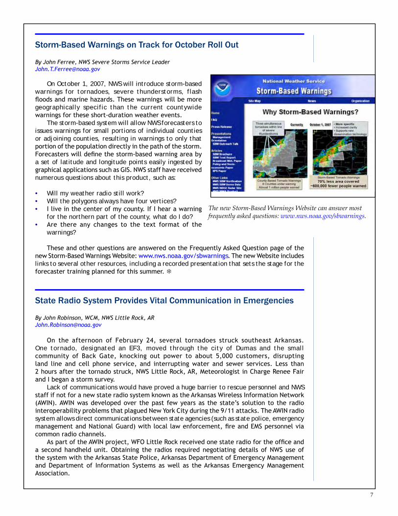
On October 1, 2007, NWS will introduce storm-based warnings for tornadoes, severe thunderstorms, flash floods and marine hazards. These warnings will be more geographically specific than the current countywide warnings for these short-duration weather events.
The storm-based system will allow NWS forecasters to issues warnings for small portions of individual counties or adjoining counties, resulting in warnings to only that portion of the population directly in the path of the storm. Forecasters will define the storm-based warning area by a set of latitude and longitude points easily ingested by graphical applications such as GIS. NWS staff have received numerous questions about this product, such as:
Will my weather radio still work? Will the polygons always have four vertices? I live in the center of my county. If I hear a warning for the northern part of the county, what do I do?Are there any changes to the text format of the warnings?
These and other questions are answered on the Frequently Asked Question page of the new Storm-Based Warnings Website: www.nws.noaa.gov/sbwarnings. The new Website includes links to several other resources, including a recorded presentation that sets the stage for the forecaster training planned for this summer.
State Radio System Provides Vital Communication in Emergencies
By John Robinson, WCM, NWS Little Rock, AR [email protected]
On the afternoon of February 24, several tornadoes struck southeast Arkansas. One tornado, designated an EF3, moved through the city of Dumas and the small community of Back Gate, knocking out power to about 5,000 customers, disrupting land line and cell phone service, and interrupting water and sewer services. Less than 2 hours after the tornado struck, NWS Little Rock, AR, Meteorologist in Charge Renee Fair and I began a storm survey.
Lack of communications would have proved a huge barrier to rescue personnel and NWS staff if not for a new state radio system known as the Arkansas Wireless Information Network (AWIN). AWIN was developed over the past few years as the state’s solution to the radio interoperability problems that plagued New York City during the 9/11 attacks. The AWIN radio system allows direct communications between state agencies (such as state police, emergency management and National Guard) with local law enforcement, fire and EMS personnel via common radio channels.
As part of the AWIN project, WFO Little Rock received one state radio for the office and a second handheld unit. Obtaining the radios required negotiating details of NWS use of the system with the Arkansas State Police, Arkansas Department of Emergency Management and Department of Information Systems as well as the Arkansas Emergency Management Association.
•••
•
The new Storm-Based Warnings Website can answer most frequently asked questions: www.nws.noaa.gov/sbwarnings.

8
During the damage surveys, I used the portable radio to communicate directly with the command post and state and county emergency management personnel. As we completed the surveys, the results were communicated to the emergency managers. In a couple of cases, the survey team discovered damage that had not yet been reported and was able to communicate a description of the damage directly to the state and county emergency managers.
On the morning of March 1, a severe thunderstorm moved through Dumas while recovery operations were taking place. Using the AWIN radio, the WFO was able to alert the Incident Commander more than an hour before the storms began their approach and again when the WFO issued a severe thunderstorm warning. The WFO received thanks for its assistance from the Arkansas State Police and the state’s Department of Emergency Management.
During other severe weather outbreaks, the radios have been used to monitor state police broadcasts throughout the state. The WFO staff can hear troopers on the scene as they give first-hand reports of damage and can communicate directly with them if additional details are necessary. Additionally, emergency managers can report damage on a specified radio channel, allowing users to hear reports simultaneously. ``
Emergency Manager Links New Transmitter to Distribution of NWR All Hazards
By John Paul Martin, WCM, NWS Bismarck, ND [email protected]
The U.S. Department of Agriculture’s Rural Development Office recently approved a grant to install a 1,000 watt dual transmitter at Scranton, ND, to serve four rural North Dakota counties, including Hettinger County, and two South Dakota counties. In response, Ilene Hardmeyer,
Hettinger County Emergency Manager, came up with a great idea to promote NWR and its All Hazards aspect: use Homeland Security funds to purchase radios, sell the radios at a reduced price and then use that money to purchase more radios to sell.
In January, in support of Ilene’s idea, I conducted a presentation on NWR and HazCollect to the Hettinger County Emergency Planning Committee. Following the presentation, the board approved Ilene’s request to use $6,000 in Homeland Security funding to purchase NOAA Weather Radios. After doing some comparison shopping, Ilene was able to purchase about 200 Midland WR-100 radios. She plans to sell the radios, one to a household for $15.
Distribution was slated to take place out of Hettinger County’s mobile EOC during North Dakota’s Severe Summer Weather Awareness Week, April 23-27, 2007. NWS Bismarck will have staff on hand to promote the lifesaving potential of the radios, to publicize the USDA program bringing coverage to these rural counties, and to answer questions on programming the receivers and any related issues.
```````````````````````````````````````````````````````````
EMWIN Receive Systems Testing Scheduled for Summer
By Bill Johnson, NWS Office of the Chief Information Officer [email protected]
Vendors will have an excellent opportunity to develop and test EMWIN-N receive systems later this year. NOAA may bring the GOES 13 (formerly GOES-N) out of storage, offering users an EMWIN-N broadcast for much of the test period. Vendors interested in producing EMWIN-N equipment would then be able to test their systems under live conditions with a broadcast directly from the satellite.

9
NOAA tentatively has scheduled these tests for August 2007. NESDIS is still in the early planning stages, however, and the dates are subject to change.
EMWIN-N will offer several improvements over the existing EMWIN broadcast, including an increased data rate and forward error correction. Vendors are encouraged to prepare for the tests and to contact the EMWIN team with questions. The EMWIN Website will be updated as more information develops.
To keep abreast of new developments in the EMWIN transition, visit the NWS EMWIN Website at: www.weather.gov/emwin/index.htm. ``
EMWIN Team Offers Training for Caribbean Island Nations
By Bill Johnson, NWS Office of the Chief Information Officer [email protected]
The EMWIN team, in coordination with NWS International Affairs, conducted Phase 1 of the EMWIN training for Caribbean Island nations March 5-9. The training was held at the National Hurricane Center in Miami as part of the White House Third Border Initiative (TBI). This project supplies current generation EMWIN systems and training to a number of Caribbean nations. Each country involved sent a representative from its meteorological service and its disaster management organization. The training and equipment were enthusiastically received by those attending from the first five of the island nations. The EMWIN team is now preparing for Phase 2 of the training, which will cover an additional seven island nations. Phase 2 is tentatively planned for 2007 in the Bahamas. ``
Flood Safety
NWS Partners with Water Management Agency on Flood Safety Campaign
By David Nicosia, WCM, NWS, Binghamton, NY [email protected]
In response to record breaking, devastating floods in June 2006, Susan Obleski, Director of Communications for the Susquehanna River Basin Commission, organized an extensive flood awareness campaign. The campaign focused on the north branch of the Susquehanna River Basin, which includes the Greater Binghamton, NY, area.
I assisted Susan in this massive effort held during National Flood Safety Awareness Week in March. The main focus of the campaign was use of the NWS Turn Around, Don’t Drown™ (TADD) program. We also targeted how to prepare for and receive river and flood forecast information, including NOAA’s Advanced Hydrologic Prediction Service.
The media campaign was extensive, including 30- and 60-second prime time TV safety messages on all major networks and CNN in the Binghamton media market. Public Service Announcements about TADD were sent to all local radio stations; quarter-page ads were placed in several major newspapers, reaching up to 100,000 people. National Flood
GOES Satellite

10
From left, NWS Charleston, WV, Meteorologist in Charge Alan Rezek accepts the Flood Safety Week proclamation from West Virginia Governor Joe Manchin III.
Safety Awareness Week and TADD information was also displayed on the home pages of major media outlets.
In addition, both Susan and I did numerous taped and live interviews on flood safety, included interviews with all of Binghamton’s TV networks and several major radio stations and local newspapers. The campaign was a huge success due to the region’s heightened sensitivity to flooding. You can see the video safety messages at the following link under TADD: www.floodsafety.noaa.gov/.
West Virginia Flood Awareness Week
By Dan Bartholf, WCM, NWS Charleston, WV [email protected]
WFO Charleston, working through the West Virginia Division of Homeland Security and Emergency Management (WVDHSEM), succeeded in having Governor Joe Manchin III sign a proclamation declaring the week of March 18-24, 2007, as “West Virginia Flood Awareness Week.” The proclamation ceremony received widespread media coverage from five TV stations, a radio station and two newspapers. Supporters of the campaign included the state Library Commission, West Virginia DHSEM, Citizen Corps, Fire Marshal’s office and state offices of the Insurance Commissioner.
Both the WVDHSEM and WFO Charleston issued media advisories to draw attention to the proclamation signing. The West Virginia Citizens Corps helped make sure every public school in the state received an NWR and that the radio was properly located and programmed. In some cases, we provided outdoor antennas to schools on the fringe of our broadcast areas.
During the weeklong awareness campaign, I taped a half hour show with the WVDHSEM called “Distress Signals,” which airs on local cable channels and across the library network. Topics included the Turn Around Don’t Drown™ program and environmental awareness. The state Insurance Commissioner also taped a program on flood insurance and covered the proclamation signing by the Governor. `
NWS Installs First High Water Mark Sign for Flooding
By Ron Trumbla, NWS Southern Region Public Affairs Director [email protected]
The first of several high water mark signs to be installed across the southeastern United States was unveiled in Rome, GA, on March 21. A joint effort of the NWS forecast office, the Southeast River Forecast Center (SERFC), the U.S. Geologic Survey and Floyd County Emergency Management Agency, the sign is part of a campaign to raise public awareness of local flood history. The Rome flood of record occurred on April 1, 1886, when the Oostanaula River rose to a stage of 40.3 feet, inundating parts of downtown Rome with more than 20 feet of water.
John Feldt, SERFC hydrologist-in-charge, said, “The High Water Mark sign at Rome is the first such sign nationwide. Other signs are planned in coming months. The signs not only document major historical floods, but more importantly convey the potential impact that floods have had and could have again on communities. They are a reminder to maintain our vigilance and evaluate our preparedness for floods.”

11
Floods are one of the most deadly natural disasters. More people have lost their lives due to flooding than lightning or tornadoes. Kent Frantz, senior service hydrologist at WFO Atlanta, GA, emphasized, “Most flood-related deaths and injuries could be avoided if people who come upon areas covered with water followed this simple advice. Just Turn Around Don’t Drown®.”
The SERFC creates forecast guidance of river levels and flows for more than 200 points in the southeast. The U.S. Geologic Survey maintains a
real time hydrologic-monitoring network of river stage, stream flow and rainfall gages that are a crucial component of the NWS river forecast and flood warning programs. `
Hurricane Wilma sits over Florida, October 2006.
National Hurricane Preparedness Week Resources Available
By Scott Kiser, NWS National Tropical Program Manager [email protected]
NOAA will conduct the 2007 National Hurricane Preparedness Week May 20-26. NWS leads the annual campaign to increase the public=s knowledge about tropical cyclone hazards and to encourage individuals to develop preparedness plans. NWS hopes for another Presidential Proclamation for this event; if signed, this would be the 7th year in a row this event has been recognized on a presidential level.
In addition to many local and state preparedness activities and gubernatorial proclamations during the week, NOAA will announce its 2007 Atlantic Hurricane Season Outlook on Tuesday, May 22. NOAA will host a news conference at Ronald Reagan Washington National Airport where NOAA and Air Force Reserve “Hurricane Hunter” aircraft will serve as the backdrop for the announcement. For more resources and links on hurricane preparedness, history, names and more, go to: www.weather.gov/os/hurricane/index.shtml. `
Hurricane Safety

12
Outreach and Education
GO TO MEETING Software Useful for Remote Briefings
By Jim Keeney, Regional WCM for NWS Central Region [email protected]
Over the past several months, NWS Central Region Headquarters has been working with the Federal Emergency Management Agency Region VII in Kansas City, MO, to find a way to more effectively provide remote briefings for potential severe weather and updates and reports after significant events. GO TO MEETING software has proven an efficient way to communicate. Along with the FXNet client-server system, GO TO MEETING can provide a plethora of information for presentation from Internet to AWIPS displays.
There are many potential uses for this resource. The application will be used in the Central Region Operations Support Center and will be available for field office use. GO TO MEETING can handle up to 25 participants at a time; for conferences of more than 25 participants up to 1000, we use the GO TO WEBINAR application. `
Before, During and After a Hurricane: A Factsheet for Safety
By Melody Magnus, Aware Editor [email protected]
The first in a new series of NWS factsheets offers the public an easy-to-print, 2-page guide to hurricane safety. The factsheet tells the public what to do before, during and after a hurricane; offers tips on what to bring to a shelter; and includes an explanation of the difference between advisories, watches and warnings.
This product does not replace our more comprehensive hurricane booklet, which offers the science and history of hurricanes. The new product will only be available online. You can find Weather Safety: Hurricane online on the NWS Hurricane Safety and Awareness Website at http://www.weather.gov/os/hurricane/index.shtml or on our brochures and booklets site: http://www.weather.gov/os/brochures.shtml.

13
NWS Managers Certified in Emergency Management
By Daniel Noah, WCM, WFO Tampa Bay Area, FL [email protected]
Staff members at the Tampa Bay Area forecast office are adding to their credentials and becoming even more valuable members of their community. To broaden his understanding of emergency management, WCM Daniel Noah received his Florida Professional Emergency Manager certification on January 31, 2007, from the Florida Emergency Preparedness Association. MIC Shawn Bennett will receive his certification at the annual conference in 2008. Certification requires a minimum of 150 hours of emergency management training, EOC disaster and exercise experience, and involvement in at least six emergency management activities.
Becoming certified in emergency management will enable NWS employees to build an even stronger relationship with their local emergency management personnel. Over the next couple of years, NWS meteorologist across the country will begin training in the field of emergency management. Additional availability of NWS HazMat meteorologists for events is also planned.
NWS is looking for ways to form even stronger relationships with emergency managers. Similar efforts are allowing NWS HazMat meteorologists to be available for more events. NWS values its partnerships and is constantly evaluating ways to strengthen them. `
NWS Joins with Local Emergency Organization for Tabletop Hazmat Drill
By Jeff Savadel, WCM, NWS Elko, NV [email protected]
During the past year, staff members from WFO Elko, NV, have become more active in the Local Emergency Planning Committee (LEPC). An LEPC is a voluntary organization established to meet the requirements of the federal Superfund Act for emergency response planning. Members of an LEPC usually include local officials including police, fire, civil defense, public health and transportation, along with community groups and the media.
WFO Elko staff took part in an Elko County LEPC committee that developed a hazmat tabletop drill conducted on April 10, 2007. The scenario involved a tanker that crashed on I-80 resulting in a toxic plume threatening populated areas as well as motorists. There were about 25 participants in the half-day exercise, including representatives from law enforcement, emergency management and health services.
Although the population of WFO Elko’s county warning area is relatively low, there is a significant amount of hazardous material transported across the region via interstate and railway. WFO Elko staff members also used this opportunity to test their operational response to the hazmat scenario, including a test run of the NCEP Hysplit model.
The Elko, NV, Local Emergency Planning Committee Table Top Drill.

14
Severe Weather/Tornadoes
SPC Fire and Convective Outlooks Reach Out to 8 Days
By Dan McCarthy, WCM, Storm Prediction Center, Norman, OK [email protected]
The NWS Storm Prediction Center (SPC) plans to make the Day 3-8 Fire Weather Outlook operational May 22, 2007.
SPC changed its Day 4-8 Convective Outlook to an operational product on March 22, 2007. These products have been listed as experimental since March 2005. (See www.spc.noaa.gov.) The products also are available in graphical form at www.weather.gov/forecasts/graphical/sectors/conusHazardDay.php.
These products allow users to monitor conditions and forecasts so they can prepare further in advance for the potential of severe weather. Forecasters use a variety of models to identify weather patterns that could produce at least a 15% probability of severe storms between 4 to 8 days from the Day 1 Convective Outlook.
The accuracy of these products has been displayed in numerous outlooks during the experimental period. For example, the Day 4-8 Convective Outlook issued early on February 24 indicated an area of severe storms for parts of the southeastern states for March 1-2 (See Figure 1). On
March 1, a tornado outbreak resulted in violent tornadoes across southern Alabama and southwest Georgia, resulting in 20 fatalities (See Figure 2).
The SPC has been testing fire weather forecasts for the Day 3-8 period since January 2006. As with the Day 4-8 Convective Outlook, forecasters use common weather patterns favorable for wildfires, such as Santa Ana winds, as well as looking at areas where there are prevailing dry fuels and drought conditions that may lead to fire weather conditions. `
Figure 1: Day 4-8 Convective Outlook issued February 24, valid for March 1-2, 2007.
Figure 2: Plot of storm reports across the U.S. from 1200 UTC March 1 to 1200 UTC March 2, 2007.

15
Evolving Severe Weather Spotter Program for 21st Century
By Bryan Henry, Senior Forecaster, Peter Felsch, WCM, WFO Missoula, MT [email protected], [email protected]
Recruiting spotters in strategic locations across the rural Intermountain West has always been a challenge for the NWS. Obtaining timely, mission critical information from these areas is often difficult at best. Realizing this, WFO Missoula, MT, is transforming its local severe weather spotter program to better meet customer needs in the 21st century.
Traditionally, the severe weather spotter program has consisted of weather spotters reporting significant weather from fixed locations. Ham radio operators, law enforcement personnel and other volunteers have proven to be a vital resource for the program. A problem, however, is that spotter coverage was population-centric, closely mimicking population density maps for Western Montana and North Central Idaho. NWS had to deal with significant gaps in obtainable weather data in low population areas.
To combat the problem, WFO Missoula has set up “MobilNet” and “Flood Watcher” programs within its severe weather spotter network to obtain data from unpopulated areas. MobilNet is a network of 89 spotters who commute through data void areas on a daily basis. They include drivers for commercial freight companies and freightliners, Postal Service and Department of Transportation employees, guides for back country and white water excursions, forest service lookouts, long distance commuters and law enforcement dispatchers.
The concept is simple: instead of having spotters relay data from fixed locations, have them gather information as they traverse the normally data-void areas. The Flood Watcher program operates in a similar manner. Flood Watchers are spotters who have been carefully selected to monitor rivers and streams during potential flood events. Waterways monitored by these spotters can be as long as 30 miles! When Flood Watchers observe significant hydrologic issues, they relay the information to the forecaster on duty.
In addition to MobilNet and Flood Watcher, two other programs have been incorporated under the severe weather spotter umbrella: “CoCoRaHS” and “Snowfall Reporter.” The CoCoRaHS program is a community-based, high-density network of volunteers who take daily measurements of rain, hail and snow in their backyards and record the information onto the CoCoRaHS Website. Observations are immediately available in map and table format for NWS and the public to view. The program was started in 1998 with a few dozen volunteers in Colorado. More information on the CoCoRaHS program can be found at www.cocorahs.org. Snowfall Reporters are strategically placed spotters who contact WFO Missoula whenever 1 inch of snow or more has been measured in a 24 hour period.
These new innovations have led to a 41% increase in the number of spotters over the past 2 years. False alarm ratios of weather warnings have decreased and verification scores have increased as new information has become more readily available. `
Severe Weather Event Opens Discussion
By Gary Woodall, WCM, WFO, Ft. Worth/Dallas, TX [email protected]
On February 16, WFO Fort Worth/Dallas hosted a severe weather workshop for area media partners. The two-hour workshop was presented twice during the day, allowing both morning and evening television staffs to attend. A total of 19 television and radio personalities attended the two sessions. Presentations included the following:
Review of mesoscale forecasting, severe weather parameters, and new concepts regarding severe weather production: NWS Science Operations Officer Greg Patrick. Greg stressed the importance of low-level boundaries, cloud base heights, and low-level vertical wind shear in the generation of storm rotation.
•

1�
Overview of “heat burst” high wind events and meteorological parameters favorable for heat bursts: Forecaster Ted Ryan. Ted also reviewed warning philosophy for heat burst events. Review of the May 9, 2006, significant tornado event in Collin and Grayson Counties: WCM Gary Woodall. Gary discussed the large-scale elements and the storm-scale evolution which contributed to the production of the tornadoes, and stressed the importance of storm spotter reports. Discussion of flood warning philosophy and product suite, gathering input from the media partners regarding coverage of flash flood warnings and urban/small stream advisories: led by MIC Bill Bunting.
The workshop concluded with an open discussion on topics such as IEM Chat (unanimously applauded by media partners), storm-based warnings, the EF-scale, and plans for Severe Weather Awareness Week. `
NWS Promotes Hazardous Weather Poster Contest to Better Involve Kids
By Bob Goree, WCM, NWS Tallahassee [email protected]
For the 6th straight year, the NWS offices serving Florida partnered with the Capital Area American Red Cross and others to promote a statewide poster contest. The contest coincided with Florida’s Hazardous Weather Awareness Week held in February. The competition allowed 4th and 5th graders from all over the state to create posters highlighting hazardous weather and promoting weather safety.
NWS Tallahassee, FL, staff helped judge the hundreds of posters and select ones with effective safety messages. As always, the contestants showed creativity and artistry while learning about weather hazards. The winners received cash prizes along with NOAA Weather Radios. Several winners were given a trip to Tallahassee for the award ceremony at the State Capitol. For more information on this annual contest, visit redcross.tallytown.com/pc2007.html. `
Service Assessment Underway for Tornadoes in Southern Alabama and Georgia
By Wayne Presnell, Meteorologist, NWS Performance Branch [email protected]
March 2007 roared in like a lion in southern Alabama and Georgia as strong tornadoes moved through the area on the first day of the month, resulting in 19 fatalities. The deadliest tornado occurred in Enterprise, AL, where eight high school students perished as a concrete wall collapsed onto them while they were huddled in the hallway in a crouched position. This tornado was rated a 4 on the Enhanced Fujita (EF) Tornado Scale. For details about the EF scale, go to www.spc.noaa.gov/faq/tornado/ef-scale.html.
Another deadly tornado struck near the town of Newton, GA, killing six people in a mobile home park. The Newton tornado was rated an EF2. Overall, there were 17 significant tornadoes in Alabama and Georgia during this event.
NWS has formed a service assessment team to evaluate its performance during this event. One of NWS’s primary commitments is to help guard the Nation against loss of life and property from forces in the natural world. As such, NWS staff take part in building hazard-resilient communities by continually learning how to improve its service to the nation. A seven member
•
•
•
A previous winning poster helps announce the 2007 contest.

1�
A special “exhibit” at the Severe Weather Workshop was the WFO Amarillo van. The van was wrapped in storm clouds by FAST SIGNS of Amarillo. This vehicle is regularly used by Amarillo staff when traveling to Spotter Training and to other outreach presentations.
assessment team, led by NWS Lacrosse, WI, MIC Glenn Lussky will document and evaluate the performance and overall effectiveness of NWS services and operational procedures for the event.
The assessment team will identify best-case operations, procedures and practices, and make recommendations to address service deficiencies, if any. The report will contain the key facts surrounding the event and focus on the offices and entities most impacted. Specifically, it will look at areas where severe thunderstorms and tornadoes resulted in casualties or significant property damage. The assessment team also will look at how using the Storm Based Warnings approach would have affected outcomes during this event.
Currently, the NWS issues short duration severe weather warnings based on county boundaries. Storm Based Warnings are more geographically specific, providing the public with more specific information about the location of severe weather and the direction it is expected to take. (See article, Page 7) The team was also asked to examine some of the social issues relating to this event, such as tornado safety in mobile homes and in large industrial, educational, or government facilities.
Some preliminary information from the team indicates excellent performance of the offices during the event. The offices were on top of the event as it unfolded, provided information in a variety of ways to their critical customers, communicated well and employed science and technology appropriately. There may be some areas for improvement in the frequency of post Tornado Warning updates, accuracy of local storm reports and timeliness of post event summaries to WFO Web pages. The report should be released this fall. `
NWS and Community Partners Host Severe Weather Workshop
By Steve Drillette, WCM, WFO Amarillo, TX [email protected]
A strong lineup of speakers and topics helped draw attendees to the NWS Amarillo, TX, Severe Weather Workshop. NWS staff partnered with the Amarillo Department of Emergency Management and local business BWXT Pantex to host the March workshop.
Sponsors for the event included local television and radio stations and Wal-Mart. The workshop, held at the Amarillo Civic Center, opened in the morning with numerous booths related to weather or emergency operations followed by severe weather presentations in the afternoon. More than 400 people attended the biennial event, which began in 1995. The topics and speakers for the presentations included:
Fire in the Plains: Lessons Learned from the 2006 Panhandle Wildfires: Jason Jordan, Amarillo NWS Forecaster The June 11, 2005 Tornado Outbreak: “Doppler” Dave Oliver and Staff, KFDA-TV Meteorologists A Look Back at the 2006 Childress Tornado: Matt Hines & Staff, KAMR-TV Meteorologists The Forecast Funnel: A Press Box View of Severe Weather Forecasting: Dr. Kevin Kloesel, University of Oklahoma College of GeosciencesThe Rating of Tornadoes: The New Enhanced Fujita Scale: Larry Vannozzi, MIC, NWS Nashville, TN. `
•
•
•
•
•
18
Climate, Water and Weather Links
Online Spring Awareness Resources
For information on severe weather awareness brochures, booklets and state awareness event links, go to http://www.weather.gov/os/severeweather/index.shtml.
StormReady/TsunamiReady
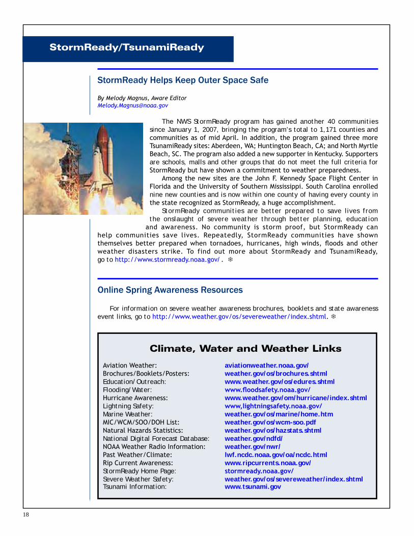
StormReady Helps Keep Outer Space Safe
By Melody Magnus, Aware Editor [email protected]
The NWS StormReady program has gained another 40 communities since January 1, 2007, bringing the program’s total to 1,171 counties and communities as of mid April. In addition, the program gained three more TsunamiReady sites: Aberdeen, WA; Huntington Beach, CA; and North Myrtle Beach, SC. The program also added a new supporter in Kentucky. Supporters are schools, malls and other groups that do not meet the full criteria for StormReady but have shown a commitment to weather preparedness.
Among the new sites are the John F. Kennedy Space Flight Center in Florida and the University of Southern Mississippi. South Carolina enrolled nine new counties and is now within one county of having every county in the state recognized as StormReady, a huge accomplishment.
StormReady communities are better prepared to save lives from the onslaught of severe weather through better planning, education
and awareness. No community is storm proof, but StormReady can help communities save lives. Repeatedly, StormReady communities have shown themselves better prepared when tornadoes, hurricanes, high winds, floods and other weather disasters strike. To find out more about StormReady and TsunamiReady, go to http://www.stormready.noaa.gov/. `
Aviation Weather: aviationweather.noaa.gov/Brochures/Booklets/Posters: weather.gov/os/brochures.shtmlEducation/Outreach: www.weather.gov/os/edures.shtmlFlooding/Water: www.floodsafety.noaa.gov/Hurricane Awareness: www.weather.gov/om/hurricane/index.shtmlLightning Safety: www,lightningsafety.noaa.gov/Marine Weather: weather.gov/os/marine/home.htmMIC/WCM/SOO/DOH List: weather.gov/os/wcm-soo.pdfNatural Hazards Statistics: weather.gov/os/hazstats.shtmlNational Digital Forecast Database: weather.gov/ndfd/NOAA Weather Radio Information: weather.gov/nwr/Past Weather/Climate: lwf.ncdc.noaa.gov/oa/ncdc.html Rip Current Awareness: www.ripcurrents.noaa.gov/StormReady Home Page: stormready.noaa.gov/Severe Weather Safety: weather.gov/os/severeweather/index.shtmlTsunami Information: www.tsunami.gov