author's personal copy - connected conservation
TRANSCRIPT

1 23
Animal Cognition ISSN 1435-9448Volume 22Number 2 Anim Cogn (2019) 22:251-263DOI 10.1007/s10071-019-01242-9
Spatial mapping shows that some Africanelephants use cognitive maps to navigatethe core but not the periphery of their homeranges
Andrea Presotto, Richard Fayrer-Hosken, Caitlin Curry & MargueriteMadden

1 23
Your article is protected by copyright and
all rights are held exclusively by Springer-
Verlag GmbH Germany, part of Springer
Nature. This e-offprint is for personal use only
and shall not be self-archived in electronic
repositories. If you wish to self-archive your
article, please use the accepted manuscript
version for posting on your own website. You
may further deposit the accepted manuscript
version in any repository, provided it is only
made publicly available 12 months after
official publication or later and provided
acknowledgement is given to the original
source of publication and a link is inserted
to the published article on Springer's
website. The link must be accompanied by
the following text: "The final publication is
available at link.springer.com”.

Vol.:(0123456789)1 3
Animal Cognition (2019) 22:251–263 https://doi.org/10.1007/s10071-019-01242-9
ORIGINAL PAPER
Spatial mapping shows that some African elephants use cognitive maps to navigate the core but not the periphery of their home ranges
Andrea Presotto1 · Richard Fayrer‑Hosken2 · Caitlin Curry1 · Marguerite Madden3
Received: 28 September 2018 / Revised: 5 January 2019 / Accepted: 21 January 2019 / Published online: 28 January 2019 © Springer-Verlag GmbH Germany, part of Springer Nature 2019
AbstractStrategies of navigation have been shown to play a critical role when animals revisit resource sites across large home ranges. The habitual route system appears to be a sufficient strategy for animals to navigate while avoiding the cognitive cost of traveling using the Euclidean map. We hypothesize that wild elephants travel more frequently using habitual routes to revisit resource sites as opposed to using the Euclidean map. To identify the elephants’ habitual routes, we created a python script, which accounted for frequently used route segments that constituted the habitual routes. Results showed elephant navigation flexibility traveling at Kruger National Park landscape. Elephants shift strategies of navigation depend on the familiarity of their surroundings. In the core area of their home range, elephants traveled using the Euclidean map, but intraindividual differences showed that elephants were then converted to habitual routes when navigating within the less familiar periphery of their home range. These findings are analogous to the recent experimental results found in smaller mammals that showed that rats encode locations according to their familiarity with their surroundings. In addition, as recently observed in monkeys, intersections of habitual routes are important locations used by elephants when making navigation decisions. We found a strong association between intersections and new segment usage by elephants when they revisit resource sites, suggesting that intersection choice may contribute to the spatial representations elephants use when repeatedly revisiting resource sites.
Keywords Navigation flexibility · Animal navigation · Spatial cognition · African elephants · Habitual routes · Geographic information system
Introduction
In the wild, species regularly navigate away from, and then return to, specific locations within their home range. In doing so, they rely on the strategies of navigation that vary according to their cognitive ability and the constraints of their environment. Currently, a significant amount of
evidence indicates that animals’ navigational skills rely on acquiring particular spatial information, memorizing this information, and then getting familiar within their envi-ronment (Wehner et al. 1996, 2006; Graham et al. 2003; Dolins 2009; Wystrach and Graham 2012). Such findings demonstrate the different mechanisms many animals use to efficiently navigate in various contexts (Wehner et al. 2004; Sommer et al. 2008). Experimental studies on small mam-mals show that pyramidal cells in the hippocampus remap (remap in this context refers to the brain cells reassembling their fields in “an entirely new representation”) themselves according to the location the animal experiences (Sommer et al. 2008).
Social insects are known to be skilled navigators, and it is hypothesized that they store spatial and visual information by familiarizing themselves with their environment (Menzel et al. 2005). For example, ants (Melophorusbagoti) use land-marks as guides to select the travel routes associated with frequently visited food sources (Graham and Cheng 2009; Collett 2010; Wystrach and Graham 2012) and familiarize
Electronic supplementary material The online version of this article (https ://doi.org/10.1007/s1007 1-019-01242 -9) contains supplementary material, which is available to authorized users.
* Andrea Presotto [email protected]
1 Department of Geography and Geosciences, Salisbury University, 1101 Camden Avenue, Salisbury, MD 21801, USA
2 San Diego Zoo, Institute for Conservation Research, 15600 San Pasqual Valley Rd, Escondido, CA 92027, USA
3 Center for Geospatial Research, University of Georgia, 210 Field Street, Athens, GA 30602, USA
Author's personal copy

252 Animal Cognition (2019) 22:251–263
1 3
themselves with the routes which they travel, repeating and maintaining proximity to their habitual routes (Wehner et al. 2006).
In general, it is expected that wild animals use an efficient and reliable navigation system to return to resources and that many animals likely combine more than one strategy of nav-igation. Repeating routes seems to be the default navigation system among the majority of studied species in contrast to the more cognitively demanding Euclidean map (McNamara and Shelton 2003; Haun et al. 2006; Di Fiore and Suarez 2007; Noser and Byrne 2007; Sommer et al. 2008). In a route-based map, animals would maintain an internal rep-resentation of a sequence of landmarks and create intersec-tions of routes to detect their goal while constantly repeating routes and route segments (Sigg and Stolba 1981; Poucet 1993; Byrne 2000; Sommer et al. 2008). When animals travel using the Euclidean map, the location and orientation of the species is centered on features in their surrounding environment that they can use to get distance and direction knowledge (Poucet 1993; Byrne 2000). If the Euclidean map is the dominant approach, wild animals will be able to travel by creating new segments of routes and departing from different locations (Menzel et al. 2005; Presotto and Izar 2010; Suarez 2014) to reach already visited resources. Animals may also show flexibility in combining both strate-gies depending on the environmental context, just as humans do (Burgess 2006; Presotto and Izar 2010). The Euclidean map approach may be more utilized in areas where food resources are unpredictable and subject to change. On the other hand, in landscapes where food sources, like fruits, experience a smaller interval of fructification and plant spe-cies are predictable year-round, creating new routes or route segments might be unnecessary energy spent, since resource locations do not change (Izar et al. 2012). In addition, it is possible that the wild animals need to switch between navi-gation strategies based on seasonal changes in food avail-ability (Presotto and Izar 2010).
Small mammals in experimental settings demonstrate flexibility in navigational strategies. In manipulated envi-ronments, rats switched strategies to navigate according to their familiarity with the location (Hayman et al. 2003; Alme et al. 2014). The intraindividual variation found in rats occurred when the same individual changed from one strat-egy to another depending on how they internally represent their environment (Cheng 1986; Shettleworth 1998; Jeffery et al. 2004).
In the wild, it is challenging to compare animal behavio-ral responses to findings in the experimental settings. Yet, vector data produced by the animal movement can eluci-date the different context animals use to navigate their home range within their core and peripheral areas. Wild primates offer important insights into strategies of navigation regard-ing various systems based on resource distribution (Presotto
and Izar 2010; Presotto et al. 2018). The majority of primate species are reported to travel over habitual routes (Milton 2000; Byrne 2000; Di Fiore and Suarez 2007; Noser and Byrne 2007; Suarez 2014), whereas selected few create new segments when they revisit food sources (Haun et al. 2006; Normand and Boesch 2009; Presotto and Izar 2010). As for other taxa, primates may rely on familiarizing themselves with locations they are likely to return to while searching for food. As for primates, if food availability is a constant variable, an animal would be able to memorize its environ-ment through the consistent repetition of routes. When the availability of food is not a constant, an animal could encode specific locations and create new segments using these loca-tions as a reference, thus increasing the chance of finding resources.
In this paper, we investigated wild African elephants’ strategy of navigation traveling within their core and periph-eral areas. We classified the routes and route segments that four female African elephants (Loxodonta africana) used to revisit resource sites. We also evaluated the spatial role of intersections along the elephants’ habitual routes. Elephants are strong candidates to study the strategies of navigation, since they travel long distances (Viljoen 1989; Douglas-Hamilton 1998; Blake et al. 2001; Leggett 2006), visit a variety of resources daily (Chamaill-Jammes et al. 2013), and exhibit effective spatial memory (Polansky et al. 2015). A well-developed hippocampal structure likely provides ele-phants with the potential for high learning capacity similar to humans and other primates (Nissani 2004).
For this study, a route is a collection of GPS points within one given day comprised of many segments. Route segments are the distance between two GPS points at 1-h intervals and an intersection is defined as a fixed point along the routes where the elephant intersected a previously used travel route. Locations where two routes merged, traveled in parallel but did not transect each other were not considered intersections. To investigate if elephants frequently repeat route segments when revisiting resources, we applied the habitual route analysis method (HRAM), which identifies route segments that are used repeatedly. This study attempts to expand on three ideas. First, we compared elephants’ pat-terns of navigation to investigate interindividual and intrain-dividual navigational differences within their home range in the savannah of KNP. Second, we tested if elephants primar-ily travel over habitual routes. Finally, we examined the role of intersections of routes within the route-network system and modeled the probability of intersections occurring as a function of landscape covariates, including the distance of human influences.
Author's personal copy
253Animal Cognition (2019) 22:251–263
1 3
Methods
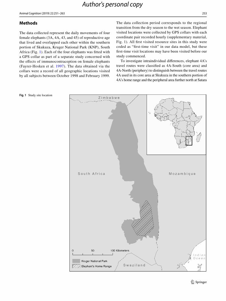
The data collected represent the daily movements of four female elephants (3A, 4A, 43, and 45) of reproductive age that lived and overlapped each other within the southern portion of Skukuza, Kruger National Park (KNP), South Africa (Fig. 1). Each of the four elephants was fitted with a GPS collar as part of a separate study concerned with the effects of immunocontraception on female elephants (Fayrer-Hosken et al. 1997). The data obtained via the collars were a record of all geographic locations visited by all subjects between October 1998 and February 1999.
The data collection period corresponds to the regional transition from the dry season to the wet season. Elephant visited locations were collected by GPS collars with each coordinate pair recorded hourly (supplementary material, Fig. 1). All first visited resource sites in this study were coded as “first-time visit” in our data model, but these first-time visit locations may have been visited before our study commenced.
To investigate intraindividual differences, elephant 4A’s travel routes were classified as 4A-South (core area) and 4A-North (periphery) to distinguish between the travel routes 4A used in its core area at Skukuza in the southern portion of 4A’s home range and the peripheral area further north at Satara
Fig. 1 Study site location
Author's personal copy
254 Animal Cognition (2019) 22:251–263
1 3
in the northern portion of 4A’s home range. Two months after the data collection started, 4A traveled 36 km to the north of Skukuza to Satara. Individual home ranges were defined by the Minimum Convex Polygons (MCPs), or the smallest polygon that no internal angle exceeds 180 degrees and contains all the sites recorded with the presence of each elephant position (Aebischer et al. 1993).
Repeated versus new segments
To define potential food and water resources elephants visited throughout their home range, woodland and water locations were extracted using remote-sensing techniques (see “Method” below). We then identified and manually classified new and repeated route segments each elephant used to repeatedly reach these locations. A route segment is considered new if (a) it was further than 300 m from an existing route segment to a resource location or (b) the elephants changed the cardinal direction of travel from all previously used segments and did not return to the cardinal direction in which they came from using 45° as minimum angulation (supplementary material, Fig. 2a). A route seg-ment is considered a repeated route segment if it is less than 300 m and/or less than 45° of an existing route segment to a resource location (supplementary material, Fig. 2b). 300 m was a conservative estimate of the distance that an elephant may see in this environment based on specialist observa-tions (Frayer-Hosken; personal communications; see Data and Procedures section below for further details). Initially, the first route segment used to reach a resource site was identified and the direction where the animal came from identified as North, South, East, or West. Next, we identi-fied the second route segment traveled when the individual returned to that location, classifying the segment as new or repeated accordingly. This procedure was repeated as many times as the elephant revisited a resource site for all route segments across all elephants.
We also expected the elephants to repeat route segments more often than create new segments, especially over short-time intervals. Short intervals between revisits may lead ani-mals to repeat route segments, because resources may occur for a period in the same location (Normand et al. 2009). To control for short-interval revisit bias that may be introduced by the analysis, we conducted a descriptive and mean analy-sis of the distribution of intervals in days that the elephants used to revisit resources sites.
Intersections
All intersections elephants traversed before revisiting woodland and water locations were visually identified and counted. Intersections were separated by the ones detected
by the HRAM (see method below) or clustered intersections occurring along habitual routes and the intersections occur-ring outside the habitual routes that occurred once. Intersec-tions occurring outside of the habitual routes were detected visually by overlaying all, non-repeated routes across all elephants. If intersections were not important locations to link route segments that compose the habitual routes, both types of intersections should play a similar role in elephants’ choice to use repeated or create new route segments to reach repeated locations. We expected no significant differences between these two types of intersection.
In an attempt to replicate what was recently found for monkeys (Presotto et al. 2018), using binary logistic regres-sion, the probability of elephants using intersections outside their habitual routes/intersections along habitual routes as a function of intersection locations was modeled. To fit the logistic regression assumption, we excluded all the repeated measurements. To eliminate repeated measurements, inter-sections clustered at 50 m from each other were grouped. For each one of the 44 groups of reused intersections, only one intersection was randomly assigned to each group. Therefore, we assumed independence of the observed inter-sections. To test intersection locations, the environmental covariates located within the elephants’ home range were used as predictors:
(a) the distance to tourism facilities, which are locations created by KNP for animals’ sighting. Elephants may not frequently travel in closer proximity to these loca-tions to avoid human presence (Blake et al. 2008);
(b) the distance to main rivers because rivers/water are considered the main drivers for elephants and can be spatial references in the topography (Bohrer et al. 2014);
(c) the distance to water bodies. Water bodies in KNP are man-made locations to provision water to animals dur-ing the dry season. These are human influenced loca-tions but that provide water resources to elephants;
(d) the terrain steepness (slope/topography), which gives animals a better visibility to the horizon, which in turn could allow them to make decision based on visibility (Presotto et al. 2018);
(e) the orientation of the terrain steepness (aspect) plays a role on vegetation predominance, which could influ-ence the location of the intersections;
(f) the presence of woodland/water in the land cover (1), and any other type of land cover (0) was used to observe if woodland/water influenced on intersection location (see land-cover method below), and finally:
(g) the intensity of space usage since, within their home range, animals may use more or less intensively deter-mined areas (Willems and Hill 2009) (supplementary material, Fig. 3).
Author's personal copy

255Animal Cognition (2019) 22:251–263
1 3
(h) Intersections outside the habitual routes were classi-fied as non-success (0) and intersections along habitual routes were classified as success (1) (p) being between 0 and 1. We tested intersection locations for spatial autocorrelation using Morans’ I = 0.22 (z score = 4.28, p = 0.000) followed by a binary logistic regression con-trolled for spatial autocorrelation (Rangel et al. 2010; Seltman 2012). Following (Presotto et al. 2018), we ranked the individual covariates, employing the Akaike Information Criterion (AICc), and used only the sta-tistically significant exploratory variables in the final logistic regression model as follows:
where p is the probability of using intersections outside of habitual routes (0) or probability of using intersec-tions along habitual routes (1); exp = 2.72; a the con-stant of the equation, and b the coefficient of the predic-tor variables.
If intersections were key locations used by elephants as a spatial reference to revisit resource sites, we expected elephants to use intersections in association to new route segments. Every intersection of a route segment used imme-diately before the elephants reached every repeated resource site were detected for each time they revisited that site. We applied a Chi-square to test the null hypothesis, which assumed no association between using an intersection when departing from a new route segment of using a repeated segment to revisit resource sites. Thus, four categories were tested: (a) travel over a new route segment with intersection usage; (b) travel over a new route segment without intersec-tion usage; (c) travel over a repeated route segment with intersection usage; (d) travel over a repeated route segment without intersection usage. A post hoc analysis of the Chi-square results based on z values was conducted. This test was a comparison of the result of the p value with the Bonferroni p value (p = 0.05/4, or the number of the cross categories), assuming that if the calculated p value based on the adjusted residuals was larger than the Bonferroni value, the distribu-tion was not significant.
The z value and the p values represented the statistical significance of the index values at 95% confidence level.
Data and procedure
We classified woodland and water using Landsat 5 imagery at approximately 30 m resolution (supplementary mate-rial, Fig. 4). Our study area falls within the Landsat path 168 and row 77. The scene utilized was scene ID
p =exp(a+b1x1+b2x2+b3x3…)
1 + exp(a+b1x1+b2x2+b3x3…),
LT51680771998278JSA00, and it was acquired on 10th of October 1998. For elevation creation, we used ASTER DEM again at approximately 30 m horizontal resolution. We generated five land-cover classes that consisted of grass-land, mixed vegetation, woodland, bare soil, and water by conducting a pixel-based supervised classification, a maxi-mum-likelihood algorithm. The classification was validated using the confusion matrix, which compares the category-by-category basis between the core classification and higher resolution imagery classification. The classification accuracy was 82% for water and 75% for woodland. Resource sites were only revisited sites located on woodland and water. Therefore, to avoid accounting for repeated locations that did not represent potential resources, all other land-cover classes were eliminated from the analysis. This approach was used to be conservative detecting the locations of patchily distrib-uted resources. We assumed that the mixed vegetation areas in savannas would show dispersed resource locations where elephants would feed on-the-go and not necessary return-ing to areas where resources were previously encountered (Hills 2006).
The GPS-enabled tracking collars were produced by Lotek Fish and Wildlife monitoring systems. A detailed analysis of the GPS collars’ specifications, accuracy, and reliability was performed by (Douglas-Hamilton 1998). The location data from the collars were stored in a dedicated bank of non-volatile RAM within the collar’s GPS unit and retrieved at the end of the study. During the study, the data set consisted of approximately 600 total daily routes constructed by connecting individual daily sequential geo-graphic coordinate pair for each elephant. From the total data set, across all elephants, 116 days were excluded due GPS collars loss of connection with satellite for more than 6 h. Thus, the total days used in this study were 484.
To investigate the existence of a route-network system used by elephants, we applied the Habitual Route Analy-sis Method (HRAM) (supplemental material, Readme). The habitual route infers that: (a) repeated routes and route segments occur more often than newly created segments when revisiting resource sites and the usage of (b) well-defined intersections along the routes. HRAM isolates a daily route and delineates a buffer around the route, which should have as an input the specie-specific visual site range. The buffer distance applied in this study is based on the sight range derived from the species ability to see in their given habitat. Unfortunately, visual acuity studies in African elephants lack conclusive findings. Male elephants’ visual acuity is estimated to be four-to-five times less than a nor-mally sighted human; apparently, elephants can see nearby objects to differentiate between food sources, but there is limited evidence of how far they can see towards the hori-zon (Shyan-Norwalt et al. 2010). For elephants in savannas, we assumed an arbitrary extended sight range of 300 m.
Author's personal copy

256 Animal Cognition (2019) 22:251–263
1 3
The 300 m applied is most likely an overestimated distance for an elephant’s visual range in our study area. Yet, the site range can be affected by the terrain topography, which may play a role in the capability that the elephants have to navigate as they do for some taxa (Benhamou and Poucet 1998; Menzel et al. 2005; Wystrach et al. 2011). The 300 m distance was used to eliminate the potential effect of visual reach on the memorization of locations. Thus, all daily route buffers assumed 300 m distance. HRAM requires an input value for the buffer distance based on the data projection’s unit of measurement. For example, the data in this study use WGS_1984_UTM_Zone_36S projection, which uses meters as its unit of measurement. The buffer distance in this study is adjusted according to the species-specific visual range. Once the daily route buffer of 300 m is created, other daily routes generated from the same elephant overlay onto the buffer for the entire study period, excluding the month, which the daily route’s buffer fell within. For example, in this study, if elephants repeated a specific location October 1st and then repeated the route segment on October 15th, then this segment was excluded to eliminate the possibility that elephants traveled using habitual routes and revisited the same resource site, because it happened within the same month (Presotto and Izar 2010). All segments within the
300 m buffer of all daily routes composed the habitual routes used by each elephant (Fig. 2).
The resulting habitual routes were then used to investi-gate how far the elephants traveled from these segments. We tested the distance the elephants deviated from the habit-ual routes by creating zones of a predetermined distance around the habitual route. We calculated the percentages of all the geographical coordinates that fell within 500 m, 1000 m, 1500 m, 2000 m, 2500 m, 3000 m, 4000 m, 5000 m, and greater than 5000 m from the habitual routes for each elephant.
The land-cover classification was conducted using ESRI ArcGIS 10. Geospatial Modeling Environment (GME) was used to created routes from the sequence of geographic coor-dinates by day; Spatial Analysis for Macroecology (SAM) was used to conduct the spatial logistic regression model, and SPSS 23 to conduct descriptive statistics, Mann–Whit-ney and Kruskal–Wallis statistical tests. To create the HRAM, which identifies route and route segment repeti-tion, we used a combination of python and structured query language (SQL) within Pgadmin by PostGres. Pgadmin is an open source object-relational database management system, which utilizes a spatial extension called PostGIS. HRAM is freely available on Github and on our data repository.
Fig. 2 a All January 1998 routes and November 11th, 1997; b all January 1998 days and segments that repeated the location used November 11th, 1997; c route segments repeated and intersected in January previously used November 11th, 1997
Author's personal copy

257Animal Cognition (2019) 22:251–263
1 3
Results
The Kruskal–Wallis test (H = 4, p = 0.406) showed that ele-phants did not differ in the size of area which they explored during the studied period, but they differ in the mean daily travel distance (H = 34.8, p = 0.000) they navigated. The Mann–Whitney two-tailed test (U = 2, p = 0.879) showed no intraindividual difference for 4A when it traveled the North and South of its range for the same variable (supplementary material, Table 1).
Route segments and repeated segments’ distance
For 484 days, elephants navigated over 7766 route segments, repeating 25% of the total (N = 1977). The distance of the repeated route segments used by elephants significantly varied among themselves (Kruskal–Wallis test H = 68, p = 0.000), with no intraindividual significant difference (Mann–Whitney two-tailed test U = 63, p = 0.144) (supple-mentary material, Table 2).
We expected elephants finding resources in close prox-imity to the habitual routes. The total number of locations elephants used did not fall equally within predetermined distance bands around their habitual routes (Fig. 3). In the north, 4A showed the largest percent of locations used in close proximity to its habitual route.
New versus repeated route segments
From the 1977 repeated route segments, only route segments that ended on repeated woodland and water (N = 774) were classified as new or repeated. Except for 4A traveling in the South, elephants repeated route segments significantly below than expected by chance when revisiting resource sites in their core area, whereas 4A traveling in the North repeated route segments above than expected by chance when revisit-ing resource sites in the periphery (Table 1), with no inter (Kruskal–Wallis test H = 1.94, p = 0.745) nor intraindividual (Mann–Whitney two-tailed test U = 9, p = 0.867) statistically significant difference in the usage of repeated and new route segments to revisit resource sites.
Elephants revisit resource sites the most during the first 5 days after their first visit. They all decrease repetition of
Fig. 3 Zones of the predetermined distance around the habitual routes show all geographical coordinates that fell within the distance bands (500 m, 1000 m, 1500 m, 2000 m, 2500 m, 3000 m, 4000 m, 5000 m, and > 5000 m)
Table 1 Chi-square test comparing the use of new and repeated route segments used to revisit resource sites for each elephant separately
Chi-square (1) degree of freedom, the value of the test result, N is the total case per elephant, and p test—significance value
χ2 N p
3A (1) = 12 108 0.00145 (1) = 3.78 128 0.0543 (1) = 7.62 170 0.0064A-South (1) = 3.38 58 0.0664A-North (1) = 21.6 310 0.000
Author's personal copy

258 Animal Cognition (2019) 22:251–263
1 3
the site after the first 5 days and continued decreasing within the same month (supplementary material, Fig. 5). Yet, the elephants were most often using new than repeated route segments to revisit resource sites. There was an interindi-vidual significant statistic difference in the interval elephants waited to revisit resource sites (Kruskal–Wallis test H = 20.6, p = 0.000) and also an intraindividual significant difference (Mann–Whitney two-tailed test U = 7, p = 0.006). 4A in the North showed shorter intervals to repeat resource sites than when traveling in the South.
Intersections of route segments
From the total 8750 fixes, about 10% (N = 867) were inter-sections that elephants used to revisit resource sites (3A N = 184; 43 N = 207; 45 N = 170; 4A in the South N = 104; 4A in the North N = 202). From the total number of used intersections, 51% occurred along habitual routes selected by the HRAM.
There were no statistically significant differences between intersections outside the habitual routes/intersections along habitual routes for terrain steepness (Mann–Whitney two-tailed test U = 98, p = 0.295). Both intersections outside the habitual routes and intersection along habitual routes faced the south of the elephants’ home range. Intersections along habitual routes showed higher usage than intersec-tions outside the habitual routes (Mann–Whitney two-tailed test U = 103 p = 0.007), intersections along habitual routes were significantly closer to water bodies than intersections outside the habitual routes (Mann–Whitney two-tailed test U = 60.1, p = 0.000), intersections along habitual routes were significantly farther from the main rivers than intersections outside the habitual routes (Mann–Whitney two-tailed test U = 116.4, p = 0.000), and finally, intersections along habit-ual routes were significantly closer to tourism facilities than
intersections outside the habitual routes Mann–Whitney two-tailed test U = 36.9, p = 0.000 (Table 2). Table 3 in the supplementary material shows descriptive landscape differ-ences between intersections outside the habitual routes and intersections along habitual routes.
The comparison between the dichotomous intersections outside the habitual routes (0)/intersections along habitual routes (1) showed negative relationship with (a) distance of tourism facilities (rs = − 0.525, p = 0.000), (b) distance to water bodies (rs = − 0.311, p = 0.000), and positive relation-ship with (d) distance to main rivers (rs = 0.208, p = 0.000), and (e) intensity of space usage (rs = 0.092, p = 0.007) N = 867. All relationships were significant at the 0.01 level. Intersections outside the habitual routes/intersections along habitual routes did not show any relationship in regards to terrain steepness (rs = 0.036, p = 0.295), and direction of ter-rain steepness (rs = 0.058, p = 0.088) N = 867.
The logistic regression model showed that distances from main rivers, water bodies, tourism facilities and the inten-sity of space usage were the best predictors for intersections occurring along habitual routes (Table 3). The total area under the curve was set as 1 for a perfect prediction accu-racy (Fig. 4). The probability of that an intersection along habitual routes was used appeared to be related to how far intersections were from tourism facilities and water bodies, how close they were to main rivers, and the proportion of route segments used.
Intersection usage with new route segments vs. intersection usage with repeated route segments
Results showed a clear association between the uses of inter-sections associated with the uses of new route segments. We found that elephants were more likely to use intersections when traveling over new segments than when traveling over
Table 2 Significant differences in location between intersections along habitual routes and intersections outside the habitual routes
Intersections Intensity of space usage
Proximity to water bodies (m)
Proximity to main rivers (m)
Proximity to tourism facili-ties (m)
Mean SD Mean SD Mean SD Mean SD
Along habitual routes 2.12 1.34 3405 1438 5799 4511 5687 2978Outside the habitual routes 1.9 1.2 4499 1762 3771 3074 9388 2955
Table 3 Parameter estimates of the logistic regression model expressing the distribution as a function of distances of tourism facilities, water bodies, main rivers, and intensity of space usage
Variable Coefficient Std. coeff. Std. error t p value
Constant 4.024 0 0.524 7.683 < 0.001Tourism facilities < 0.001 − 3.611 < 0.001 − 12.65 < 0.001Water bodies < 0.001 − 1.543 < 0.001 − 6.743 < 0.001Main rivers < 0.001 1.861 < 0.001 8.288 < 0.001Intensity of space usage 0.204 0.517 0.089 2.292 0.022
Author's personal copy

259Animal Cognition (2019) 22:251–263
1 3
repeated segments [Chi-square test χ2(1, N = 774) = 16.63, p < 0.000, supplementary material, Table 4a]. Although all elephants were more likely to use new route segments in association with the intersections, intraindividual statistical significant differences showed the most robust association between the uses of intersection with new route segments when 4A was in the peripherical-North of its home range. In 52% of the observations, 4A traveled over new route seg-ments when route segments were associated with the use of intersections in the North, against 21.9% of intersec-tions associated with repeated route segments [Chi-square test χ2(1, N = 310) = 27, p = 0.000]. When 4A traveled by repeated route segments in the North, intersections were not used in 78% of the observations. In the South, we did not find a significant difference when 4A traveled over new nor repeated route segments associated with intersections.
Discussion
African elephants in the savannah of KNP exhibited flexibil-ity in navigation and mostly did not rely on habitual routes to travel in their home range. The elephants explored different area sizes and traveled significantly different daily distances. Though elephants showed significant differences in distance and explored area size, they did use the same strategies of navigation within their core area.
At least in the core area, the data did not show heavy usage of the habitual routes and in the periphery, we found the strong evidence of switching strategies in a similar manner to primates (Normand and Boesch 2009; Presotto and Izar 2010). These results did not support the hypoth-esis that African elephants in KNP travel most of the time
over habitual routes. From the total route segments used, only 25% were reused continuously, while 75% of the route segments elephants used to revisit resource sites were new. Elephants in the core area created multiple new route seg-ments and departed from any point of their home range to revisit resource sites. This finding was similar to what was found for chimpanzees in the Tai forest, where chimpan-zees were able to find the resources departing from different points of their home range without the use of habitual routes (Normand and Boesch 2009). The navigation strategies of both chimpanzees and elephants appear similar.
Although similar to chimpanzees, elephant strategies of navigation differed from other primates such as capuchins in the rainforest of Brazil that traveled most of the time by creating new route segments to revisit resource sites when outside of their core area (Presotto and Izar 2010). While chimpanzees and elephants used a high proportion of new route segments in their core area, supporting that familiarity may play a role in memory of locations (Mangan and Webb 2009), in the rainforest, capuchins used a higher proportion of habitual routes within their core area and used new route segments most frequently while traveling in the periphery (Presotto and Izar 2010).
For elephants, it appears that familiarity with locations may play a role in their navigation at least within their core area. In the savanna of KNP elephants may familiar-ized themselves with their core area and revisited resources departing from any point to reach well-known locations like other elephants living in different areas do when visiting waterholes (De Beer et al. 2006). At Etosha National Park (ENP), Namibia elephants can reach waterholes departing from different directions, suggesting that familiarity with waterholes allowed the animals to understand the distance
Fig. 4 Results for binary logis-tic regression model using four explanatory variables: distance of tourism location, distance from water bodies, distance from the main rivers, and inten-sity of space usage. The area for the logistic regression model was 77% prediction accuracy for intersections outside of the habitual routes = 0/intersections along the habitual routes = 1: McFadden’s Rho-Squared: 0.3847, χ2 = 43,971, p = 0.000, AIC = 712
Author's personal copy
260 Animal Cognition (2019) 22:251–263
1 3
that they needed to travel when shifted from one waterhole to a different one (De Beer et al. 2006).
With no formal studies showing how far elephants can see towards the horizon of savannas, it is possible that our esti-mation of 300 m may not be accurate for elephants’ capacity of visual reach. However, if habitual routes were visible, elephants could easily repeat them without the cognitive cost of triangulating information to reach resource sites. By eliminating route visibility, the use of new route seg-ments to revisit locations showed that elephants have spatial knowledge about resource sites (Polansky et al. 2015). We eliminated the possibility that short intervals between revis-its to resource sites could allow elephants to remember the routes and easily repeat them by removing from the analysis resources occurring in the same month. Resource sites rep-etition occurred the most in the first 5 days after the first visit and decreased after the first month. Therefore, we showed that elephants potentially remembered resource sites even when they do not regularly revisit them. Elephants may use the other senses (e.g., the scent of water) to locate resources, but these effects were not considered in this study. These results shed light on the recent suggestions that elephants were likely traveling using the Euclidean-cognitive map (Polansky et al. 2015).
We also tested the hypothesis of no association between the uses of an intersection of routes in association with a higher proportion of new route segments. We did not con-firm this hypothesis, because we found that elephants were more likely to use intersections while traveling over new route segments than when traveling over repeated route segments. The strongest association, however, occurred when an elephant switched its navigation strategy. Intrain-dividual differences showed that an elephant used habitual routes when it traveled the peripheral area of its home range, while, in the core area, elephants showed a high proportion of new route segment usage. 4A in the North shifted its strategy from creating new segments to repeat-ing them. The strategy used by 4A in the North opposed the strategy used by 4A in the South. Though the South-core area, 4A used the same strategies that the other ele-phants did. Once it arrived at the North-peripheral area, 4A increased the number of repeated route segments, increased the number of used intersections, and visited resource sites closer to the habitual routes. This intrain-dividual difference suggested that using habitual routes when the location is not well-known might be a way to learn the route segments until they become familiar. Once the habitual routes become familiar, elephants may start to create new route segments to revisit resource sites, which potentially can shorten the distances between two resources (De Beer et al. 2006). 4A in the North increased the use of repeated route segments approximately to 75%. While 4A in the South explored 66% of the resource sites
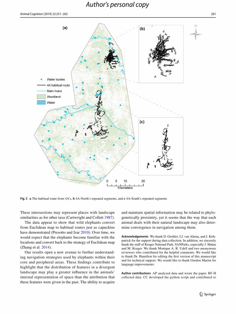
at 500 m from the habitual route, in the North, it explored around 80% of the resource sites at 500 m from the habit-ual routes. The habitual route 4A used in the South was composed of 233 repeated route segments, whereas, in the North, its habitual route was composed of 634 repeated route segments. Eighty-five percent of all resource sites 4A visited in the North were repeated, while, in the South 4A, only revisited 15% of all resource sites (Fig. 5a–c).
Finally, the hypothesis that intersections were used more often when elephants traveled over new route segments with the strongest association found for 4A in the North was accepted. In 52% of the times, 4A in the North traveled over new route segments; these segments were associated with the use of intersections, while the use of intersections associated with repeated route segments dropped to 22%. It is valuable to mention that while traveling over repeated segments in the North 4A did not use intersections in 78% of the observations. If intersections of routes were a key loca-tion to making a navigation decision, it is possible that 4A in the North needed time to create a spatial representation of these locations and, therefore, traveling over habitual routes likely minimizes the need of having key locations when in the peripheral areas. As suggested by (Polansky et al. 2015), when the landscape varies in time and space, elephants seem to adapt their navigation strategy. As with primates, elephants may adjust their strategy of navigation according to resource distribution (Presotto and Izar 2010). In addi-tion, creating new route segments may allow elephants to first learn the routes to have fast access to resources and then improve the strategies similarly to humans (Zhang et al. 2014). As for other taxa, the use of intersection as locations to make decisions appears to play a role in elephant naviga-tion too (Presotto et al. 2018). We suggest that the intraindi-vidual difference found in this study may be time-dependent. If animals travel most of the time over their core area, they may need certain period to internally represent the periphery of the home range to acquire similar spatial knowledge that they have within their core area. The observation required to answer this question could not be obtained, but it is known that the strategies of navigation may change based on mem-ory degradation (Chen et al. 2011).
The role of intersections in an animals’ home range needs further analysis to understand if intersections are used as decision-making locations. In the savanna of KNP, distinct woodland and water distribution along the landscape may work as very distinct features to memorize the location of place. When intersections were located along the habitual routes, they occurred close to the main rivers. This is likely due to the fact that water is considered a critical resource that helps shape elephant navigation (Polansky et al. 2015). The intersections also occurred in the most intensively used areas within the elephants’ home range, which suggest that these intersections were not randomly chosen by the elephants.
Author's personal copy
261Animal Cognition (2019) 22:251–263
1 3
These intersections may represent places with landscape similarities as for other taxa (Cartwright and Collett 1987).
The data appear to show that wild elephants convert from Euclidean map to habitual routes just as capuchins have demonstrated (Presotto and Izar 2010). Over time, we would expect that the elephants become familiar with the locations and convert back to the strategy of Euclidean map (Zhang et al. 2014).
Our results open a new avenue to further understand-ing navigation strategies used by elephants within their core and peripheral areas. These findings contribute to highlight that the distribution of features in a divergent landscape may play a greater influence in the animals’ internal representation of space than the attribution that these features were given in the past. The ability to acquire
and maintain spatial information may be related to phylo-genetically proximity, yet it seems that the way that each animal deals with their natural landscape may also deter-mine convergence in navigation among them.
Acknowledgements We thank D. Grobler, J.J. van Altena, and J. Kirk-patrick for the support during data collection. In addition, we sincerely thank the staff of Kruger National Park, SANParks, especially J. Malan and M. Kruger. We thank Monique A. R. Udell and two anonymous reviewers who contributed for the helpful comments. We would like to thank Dr. Hamilton for editing the first version of this manuscript and for technical support. We would like to thank Gordon Martin for language improvements.
Author contributions AP analyzed data and wrote the paper. RF-H collected data. CC developed the python script and contributed to
Fig. 5 a The habitual route from 4A’s, b 4A-North’s repeated segments, and c 4A-South’s repeated segments
Author's personal copy

262 Animal Cognition (2019) 22:251–263
1 3
language improvement. MM contributed to data analysis. All authors contributed to comments and improving the manuscript.
Funding This study was conducted with no grant funds.
Data availability The data sets analyzed during the currently study are available on Salisbury University repository.
Compliance with ethical standards
Conflict of interest The authors declare no conflict of interests.
Ethical approval Data collection used in this research complied with protocols approved by the Animal Behavior Society and the Animal Research Ethics Committee of the School of Veterinary of the Univer-sity of Georgia, Athens, GA, USA, and SANParks legal requirements under the permit BERHJ9.
References
Aebischer NJ, Robertson PA, Kenward RE (1993) Compositional analysis of habitat use from animal radio-tracking data. Ecol-ogy 74:1313–1325
Alme CB, Miao C, Jezek K, Treves A, Moser EI, Moser M (2014) Place cells in the hippocampus: eleven maps for eleven rooms. Proc Natl Acad Sci 111:18428–18435
Benhamou S, Poucet B (1998) Landmark use by navigating rats (Rat-tus norvegicus) contrasting geometric and featural information. J Comp Psychol 112(3):317–322
Blake S, Douglas-Hamilton I, Karesh WB (2001) GPS telemetry of forest elephants in Central Africa: results of a preliminary study. Afr J Ecol 39:178–186
Blake S, Deem SL, Strindberg S, Maisels F, Momont L, Isia I, Douglas-Hamilton I, Karesh WB, Kock MD (2008) Roadless wilderness area determines forest elephant movements in the Congo Basin. PLoS One 3:e3546
Bohrer G, Beck PS, Ngene SM, Skidmore AK, Douglas-Hamilton I (2014) Elephant movement closely tracks precipitation-driven vegetation dynamics in a Kenyan forest-savanna landscape. Mov Ecol 2:2
Burgess N (2006) Spatial memory: how egocentric and allocentric combine. Trends Cogn Sci 10:551–557
Byrne RW (2000) How monkeys find their way: leadership, coordina-tion, and cognitive maps of African baboons. In: On the move. How and why animals travel in groups, pp 491–518
Cartwright BA, Collett TS (1987) Landmark maps for honeybees. Biol Cybern 57:85–93
Chamaill-Jammes S, Mtare G, Makuwe E, Fritz H (2013) African elephants adjust speed in response to surface-water constraint on foraging during the dry-season. PLoS One 8:e59164
Chen Y, Byrne P, Crawford JD (2011) Time course of allocentric decay, egocentric decay, and allocentric-to-egocentric conver-sion in memory-guided reach. Neuropsychologia 49:49–60
Cheng K (1986) A purely geometric module in the rat’s spatial rep-resentation. Cognition 23:149–178
Collett M (2010) How desert ants use a visual landmark for guidance along a habitual route. Proc Natl Acad Sci 107:11638–11643
De Beer Y, Kilian W, Versfeld W, Van Aarde RJ (2006) Elephants and low rainfall alter woody vegetation in Etosha National Park, Namibia. J Arid Environ 64:412–421
Di Fiore A, Suarez SA (2007) Route-based travel and shared routes in sympatric spider and woolly monkeys: cognitive and evolutionary implications. Anim Cogn 10:317–329
Dolins FL (2009) Captive cotton-top tamarins’ (Saguinus Oedipus oedipus) use of landmarks to localize hidden food items. Am J Primatol 71:316–323
Douglas-Hamilton I (1998) Tracking African elephants with a global positioning system (GPS) radio collar. Pachyderm 25:81–92
Fayrer-Hosken RA, Brooks P, Bertschinger HJ, Kirkpatrick JF, Turner JW, Liu IK (1997) Management of African elephant populations by immunocontraception. Wildl Soc Bull 25(1):18–21
Graham P, Cheng K (2009) Ants use the panoramic skyline as a visual cue during navigation. Curr Biol 19:R937
Graham P, Fauria K, Collett TS (2003) The influence of beacon-aiming on the routes of wood ants. J Exp Biol 206:535–541
Haun DB, Rapold CJ, Call J, Janzen G, Levinson SC (2006) Cognitive cladistics and cultural override in Hominid spatial cognition. Proc Natl Acad Sci 103:17568–17573
Hayman RMA, Chakraborty S, Anderson MI, Jeffery K (2003) Con-text-specific acquisition of location discrimination by hippocam-pal place cells. Eur J Neurosci 18:2825–2834
Hills TT (2006) Animal foraging and the evolution of goal-directed cognition. Cogn Sci 30(1):3–41
Izar P, Verderane MP, Peternelli-dos-Santos L, Mendonça-Furtado O, Presotto A, Tokuda M, Visalberghi E, Fragaszy D (2012) Flexible and conservative features of social systems in tufted capuchin monkeys: comparing the socioecology of Sapajus libidinosus and Sapajus nigritus. Am J Primatol 74:315–331
Jeffery KJ, Anderson MI, Hayman R, Chakraborty S (2004) Studies of the hippocampal cognitive map in rats and humans. http://www.resea rchga te.net. Accessed 20 May 2015
Leggett KE (2006) Home range and seasonal movement of elephants in the Kunene Region, northwestern Namibia. Afr Zool 41:17–36
Mangan M, Webb B (2009) Modelling place memory in crickets. Biol Cybern 101:307
McNamara TP, Shelton AL (2003) Cognitive maps and the hippocam-pus. Trends Cogn Sci 7:333–335
Menzel R, Greggers U, Smith A, Berger S, Brandt R, Brunke S, Bun-drock G, Hülse S, Plümpe T, Schaupp F, Schüttler E (2005) Honey bees navigate according to a map-like spatial memory. Proc Natl Acad Sci 102:3040–3045
Milton K (2000) Quo vadis? Tactics of food search and group move-ment in primates and other animals. In: On the move: how and why animals travel in groups, pp 375–417
Nissani M (2004) Theory of mind and insight in chimpanzees, ele-phants, and other animals? In: Comparative vertebrate cognition, pp 227–261
Normand E, Boesch C (2009) Sophisticated Euclidean maps in forest chimpanzees. Anim Behav 77(5):1195–1201
Normand E, Ban SD, Boesch C (2009) Forest chimpanzees (Pan troglo-dytes verus) remember the location of numerous fruit trees. Anim Cogn 12(6):797–807
Noser R, Byrne RW (2007) Travel routes and planning of visits to out-of-sight resources in wild chacma baboons, Papio ursinus. Anim Behav 73:257–266
Polansky L, Kilian W, Wittemyer G (2015) Elucidating the significance of spatial memory on movement decisions by African savannah elephants using state-space models. Proc R Soc Lond B Biol Sci 282:20143042
Poucet B (1993) Spatial cognitive maps in animals: new hypotheses on their structure and neural mechanisms. Psychol Rev 100:163
Presotto A, Izar P (2010) Spatial reference of black capuchin mon-keys in Brazilian Atlantic Forest: egocentric or allocentric? Anim Behav 80:125–132
Presotto A, Verderane MP, Biondi L, Mendonca-Furtado O, Spagno-letti N, Madden M, Izar P (2018) Intersection as key locations for
Author's personal copy
263Animal Cognition (2019) 22:251–263
1 3
bearded capuchin monkeys (Sapajus libidinosus) traveling within a route network. Anim Cognit 21(3):1–13
Rangel TF, Diniz-Filho JAF, Bini LM (2010) SAM: a comprehen-sive application for spatial analysis in macroecology. Ecography 33:46–50
Seltman HJ (2012) Experimental design and analysis. http://www.stat.cmu.edu/,hselt man/309/Book/Book.pdf. Accessed 1 Feb 2016
Shettleworth SJ (1998) Cognition, evolution and behavior. Oxford Uni-versity Press, New York
Shyan-Norwalt MR, Peterson J, Milankow King B, Staggs TE, Dale RH (2010) Initial findings on visual acuity thresholds in an Afri-can elephant (Loxodonta africana). Zoo Biol 29:30–35
Sigg H, Stolba A (1981) Home range and daily march in a hamadryas baboon troop. Folia Primatol 36:40–75
Sommer S, von Beeren C, Wehner R (2008) Multiroute memories in desert ants. Proc Natl Acad Sci 105:317–322
Suarez SA (2014) Ecological factors predictive of wild spider monkey (Ateles belzebuth) foraging decisions in Yasuni, Ecuador. Am J Primatol 76:1185–1195
Viljoen PJ (1989) Spatial distribution and movements of elephants (Loxodonta africana) in the northern Namib Desert region of the Kaokoveld, South West Africa/Namibia. J Zool 219:1–19
Wehner R, Michel B, Antonsen P (1996) Visual navigation in insects: coupling of egocentric and geocentric information. J Exp Biol 199:129–140
Wehner R, Meier C, Zollikofer C (2004) The ontogeny of forage behav-iour in desert ants, Cataglyphis bicolor. Ecol Entomol 29:240–250
Wehner R, Boyer M, Loertscher F, Sommer S, Menzi U (2006) Ant navigation: one-way routes rather than maps. Curr Biol 16:75–79
Willems EP, Hill RA (2009) Predator-specific landscapes of fear and resource distribution: effects on spatial range use. Ecology 90:546–555
Wystrach A, Graham P (2012) What can we learn from studies of insect navigation? Anim Behav 84:13–20
Wystrach A, Schwarz S, Schultheiss P, Beugnon G, Cheng K (2011) Views, landmarks, and routes: how do desert ants negotiate an obstacle course? J Comp Physiol 197(2):167–179
Zhang H, Zherdeva K, Ekstrom AD (2014) Different “routes” to a cog-nitive map: dissociable forms of spatial knowledge derived from route and cartographic map learning. Mem Cognit 42:1106–1117
Publisher’s Note Springer Nature remains neutral with regard to jurisdictional claims in published maps and institutional affiliations.
Author's personal copy