author(s) diamond, scott m. title monterey, california
TRANSCRIPT

Calhoun: The NPS Institutional ArchiveDSpace Repository
Theses and Dissertations 1. Thesis and Dissertation Collection, all items
2006-06
Aerially deployed real-time targeting sensor net
Diamond, Scott M.Monterey, California. Naval Postgraduate School
http://hdl.handle.net/10945/2763
Downloaded from NPS Archive: Calhoun

NAVAL
POSTGRADUATE SCHOOL
MONTEREY, CALIFORNIA
THESIS
Approved for public release; distribution is unlimited
AERIALLY DEPLOYED REAL-TIME TARGETING SENSOR NET by
Scott M. Diamond
June 2006
Thesis Advisor: Orin Marvel Second Reader: Karl Pfeiffer

THIS PAGE INTENTIONALLY LEFT BLANK

i
REPORT DOCUMENTATION PAGE Form Approved OMB No. 0704-0188
Public reporting burden for this collection of information is estimated to average 1 hour per response, including the time for reviewing instruction, searching existing data sources, gathering and maintaining the data needed, and completing and reviewing the collection of information. Send comments regarding this burden estimate or any other aspect of this collection of information, including suggestions for reducing this burden, to Washington headquarters Services, Directorate for Information Operations and Reports, 1215 Jefferson Davis Highway, Suite 1204, Arlington, VA 22202-4302, and to the Office of Management and Budget, Paperwork Reduction Project (0704-0188) Washington DC 20503. 1. AGENCY USE ONLY (Leave blank)
2. REPORT DATE June 2006
3. REPORT TYPE AND DATES COVERED Master’s Thesis
4. TITLE AND SUBTITLE Aerially Deployed Real-Time Targeting Sensor Net 6. AUTHOR(S) Scott M. Diamond
5. FUNDING NUMBERS
RIB57
7. PERFORMING ORGANIZATION NAME(S) AND ADDRESS(ES) Naval Postgraduate School Monterey, CA 93943-5000
8. PERFORMING ORGANIZATION REPORT NUMBER
9. SPONSORING /MONITORING AGENCY NAME(S) AND ADDRESS(ES) N/A
10. SPONSORING/MONITORING AGENCY REPORT NUMBER
11. SUPPLEMENTARY NOTES The views expressed in this thesis are those of the author and do not reflect the official policy or position of the Department of Defense or the U.S. Government. 12a. DISTRIBUTION / AVAILABILITY STATEMENT Approved for public release; distribution is unlimited
12b. DISTRIBUTION CODE
13. ABSTRACT (maximum 200 words) This thesis focuses on developing and analyzing a model for an aerially deployed
real-time targeting sensor net to close the current gap that exists between the potential technological-doctrinal capability within society and that of the military. It outlines current real-time targeting need due to the decomposition of warfare after the fall of the Soviet Union, and portrays the targeting discrepancies in the Global War on Terror. From end-user surveys requirements are layed out for a system of systems to meet targeting needs. A feasible solution consisting of a system architecture anchored in existing commercial off the shelf technology is proposed to meet the discrete deliverables necessary to accomplish targeting goals to deal with asymmetric threats in opaque environments.
15. NUMBER OF PAGES
115
14. SUBJECT TERMS Sensor Net, Targeting, Wireless Mesh, C2, Command And Control, Special Operations, Asymmetric Warfare, Capability Gaps, Technological Doctrinal Gap, Real Time Targeting, Systems Engineering, Reverse Engineering, Requirements Definition, Special Forces, Targeting, Decomposition, Real-Time, Ultra Wideband, TNT, COASTS, Aerial Deployment, Ad-Hoc Networks, Sensor Network, Sensor Feed, Common Operational Picture, EMF Detection, Complex Targeting, Real-Time Communication, Jungle Insurgency, ISR, Intelligence, Surveillance, Reconnaissance
16. PRICE CODE
17. SECURITY CLASSIFICATION OF REPORT
Unclassified
18. SECURITY CLASSIFICATION OF THIS PAGE
Unclassified
19. SECURITY CLASSIFICATION OF ABSTRACT
Unclassified
20. LIMITATION OF ABSTRACT
UL NSN 7540-01-280-5500 Standard Form 298 (Rev. 2-89) Prescribed by ANSI Std. 239-18

ii
THIS PAGE INTENTIONALLY LEFT BLANK

iii
Approved for public release; distribution is unlimited
AERIALLY DEPLOYED REAL-TIME TARGETING SENSOR NET
Scott M. Diamond Ensign, United States Navy
B.S., United States Naval Academy, 2005
Submitted in partial fulfillment of the requirements for the degree of
MASTER OF SCIENCE IN SYSTEMS TECHNOLOGY (COMMAND, CONTROL AND COMMUNICATIONS (C3))
from the
NAVAL POSTGRADUATE SCHOOL June 2006
Author: Scott M. Diamond
Approved by: Orin E. Marvel, Ph.D. Thesis Advisor
Karl D. Pfeiffer, Ph.D., LtCol USAF Second Reader
Dan Boger, Ph.D. Chairman, Department of Information Sciences

iv
THIS PAGE INTENTIONALLY LEFT BLANK

v
ABSTRACT
This thesis focuses on developing and analyzing a
model for an aerially deployed real-time targeting sensor
net to close the current gap that exists between the
potential technological-doctrinal capability within society
and that of the military. It outlines current real-time
targeting need due to the decomposition of warfare after
the fall of the Soviet Union, and portrays the targeting
discrepancies in the Global War on Terror. From end-user
surveys requirements are layed out for a system of systems
to meet targeting needs. A feasible solution consisting of
a system architecture anchored in existing commercial off
the shelf technology is proposed to meet the discrete
deliverables necessary to accomplish targeting goals to
deal with asymmetric threats in opaque environments.

vi
THIS PAGE INTENTIONALLY LEFT BLANK

vii
TABLE OF CONTENTS
I. INTRODUCTION AND BACKGROUND DATA ........................1 A. WARFARE DECOMPOSITION (UNBOUND WARFARE) ............2 B. VICTORY REDEFINED: SURVIVAL AND IDEOLOGY ...........5 C. TECHNOLOGICAL DOCTRINAL GAP (TDG) ..................7 D. PURPOSE OF THE STUDY ..............................10 E. RATIONALE .........................................11 F. THESIS OBJECTIVES AND RESEARCH QUESTIONS ..........12 G. DEFINITION OF TERMS ...............................14 H. THESIS ORGANIZATION ...............................15
II. METHODOLOGY ............................................17 A. TOP DOWN APPROACH .................................17 B. RESEARCH APPROACH .................................18
1. Phase 1: Problem Definition ..................19 2. Phase 2: Complex Targeting Research ..........19 3. Phase 3: Concept (Model) Analysis ............20 4. Phase 4: Conclusions and Future Development ..20
C. COASTS FIELD EXPERIMENTATION ......................20 D. END-USER DEFINED REQUIREMENTS .....................24 E. ASSUMPTIONS AND LIMITATIONS .......................24
III. TECHNOLOGY/LITERATURE REVIEW ...........................27 A. NEW FORM OF WARFARE ...............................27 B. TECHNOLOGIES AND IMPLICATIONS .....................28
1. Sensor Nets ..................................28 2. Ultrawideband Sensors ........................29 3. Information Dissemination ....................31 4. Wireless Information Security ................32 5. Aerially Deployed Autonomous Sensor-Shooter
Grid .........................................33 6. Wireless Mesh Communications Nodes ...........34 7. Aerially Deployed Environmental Remote
Sensors ......................................35 8. Remote Power Source Technology ...............35 9. Miniaturized Sensor Webs .....................36 10. Target Data Layered onto a Sensor Feed .......37 11. Networkable Aerial Sensors ...................38 12. Static Aerial Sensor and Transmission Nodes ..39 13. Summary ......................................40
C. SENSOR REVIEW .....................................40 1. Ultra-Wideband Sensors .......................40 2. Visual Feed Sensors ..........................43
D. CHAPTER SUMMARY ...................................44

viii
IV. MODEL ANALYSIS .........................................45 A. NEED ..............................................45
1. Need in Thailand .............................45 2. Perceived Thai Problem .......................46 3. COASTS Scenario Overview .....................47 4. COASTS Scenario Overview .....................49
B. REAL-TIME TARGETING PARADIGM PROBLEM ..............51 C. SENSORS ...........................................51
1. Small Shooter-Small Sensor ...................51 2. Sensor Net Operations ........................56
D. END-USER SURVEY ...................................59 1. Problem Definition ...........................59 2. Discrete Deliverables ........................59 3. Ideal Equipment Requirements .................60 4. Ideal Doctrinal Requirements .................62
E. MEASURES OF EFFECTIVENESS ANALYSIS ................63 F. SYSTEM (MODEL) ARCHITECTURE .......................67 G. AERIALLY DEPLOYED SENSOR NET ......................73
1. Overview of the Model ........................73 H. IMPLEMENTATION OF SENSOR NET ......................76
V. SYSTEM SOLUTION AND FUTURE DEVELOPMENT .................79 A. FUTURE DEVELOPMENTS ...............................79
1. Path to a Solution ...........................79 B. FUTURE RESEARCH ...................................82
APPENDIX A. ACRONYMS .......................................85 APPENDIX B. MEASURES OF EFFECTIVENESS ......................89 APPENDIX C. COALITION OPERATING AREA SURVEILLANCE AND
TARGETING SYSTEM (COASTS) THAILAND FIELD EXPERIMENT (MAY 2006) .............................................91 A. BACKGROUND ........................................91
LIST OF REFERENCES ..........................................93 INITIAL DISTRIBUTION LIST ...................................99

ix
LIST OF FIGURES
Figure 1. Illustration of the Technological-Doctrinal Gap..7 Figure 2. Special Operations Core Tasks....................9 Figure 3. Attempts to Fill the TDG for Sensor Technology
in Homeland Security (From: Vent, 2005).........10 Figure 4. Top-Down Development Process....................18 Figure 5. COASTS 2006 Network Topology....................23 Figure 6. COASTS 2006 Communications Network Model........24 Figure 7. SOSUS Acoustic Sensor Network...................29 Figure 8. Ultra Wideband (UWB) Video Sensor Looking
through Wall(From: Herzig, 2005)................30 Figure 9. UWB Video Link (From: Herzig, 2005).............30 Figure 10. UWB Sensors Looking through a Wall (From:
Herzig).........................................31 Figure 11. UWB Sensor Generating a Video Stream from
Reflected Wavelengths through a Wall (From: Herzig).........................................31
Figure 12. Illustration of Link-16 Interoperability........32 Figure 13. SecNet 11 NSA Approved Encryption...............33 Figure 14. CBU-97 Sensor Fuzed Weapon......................34 Figure 15. Mesh Dynamics Wireless Mesh Box.................35 Figure 16. Gridpoint Remotely Managed Renewable Power
Source..........................................36 Figure 17. Webbed Pods Created by NASA and NOAA in “The
Link Project”...................................37 Figure 18. Gumball Size Wireless Sensor Pod................37 Figure 19. Large Sized CyberBug Launch.....................38 Figure 20. Networked VTOL Mobile Aerial Sensor.............39 Figure 21. Visual Sensor and Information Node..............40 Figure 22. Signal Comparison against Noise Threshold.......41 Figure 23. Full Duplex Handheld UWB Transceiver............42 Figure 24. UWB Precision Geolocation System Transceiver....42 Figure 25. Event Breakdown for the Mae Gnat Dam Drug
Interdiction Scenario...........................50 Figure 26. Current Recognized Principles of War............53 Figure 27. The Real-Time Sensor Cycle......................54 Figure 28. Special Operations Liaison Element Functions
(From: JSOTF Pub)...............................55 Figure 29. Common Operational Picture Displaying UAV
Sensor Feed FOVs, TDD, and Friendly Overlay.....56 Figure 30. Aerial Sensor Feed Overlayed with TDD, Friendly
Data, and Sensor Feed Priority..................57 Figure 31. CyberDefense CyberBug Gimbaled Visual Sensor
Feed............................................59

x
Figure 32. RQ-11 Raven Squad Level UAV.....................61 Figure 33. RQ-1 Predator UAV...............................62 Figure 34. Sensor in Depth Layers..........................74 Figure 35. RQ-4 Globalhawk ISR UAV Similar to the U-2 Spy
Plane...........................................75 Figure 36. Ruggedized MTM Micro Tablet by Modular PC
(From: http://modular-pc.com/, Retrieved March 2, 2006)........................................80

xi
ACKNOWLEDGMENTS
I would like to thank Professor Marvel for his
brilliant insight and methodology. His class inspired me
from the beginning.
I would also like to thank COL Pfeiffer for vectoring
me onto target and the COASTS team for an incredible
opportunity and their support.
Thank you to SPAWAR SSC for the funding and their
belief in my ideas, and to the COASTS research group for
the opportunities and experiences.
And most of all my Mom and Dad, who supported me
throughout this endeavor.

xii
THIS PAGE INTENTIONALLY LEFT BLANK

1
I. INTRODUCTION AND BACKGROUND DATA
Today’s ever-changing military environment is best
described by Jackowski (2002). He explains that military
missions “are being redefined daily due to rapidly changing
world situations and the call for fighting in different
types of conflict...New emerging technologies that are
revolutionary will be deployed [in the near future] that
will really change current military operations” (p. 2).
The literature has acknowledged the fact that
technologies are continuing to change and evolve, even at
the present time (Aloul & Aboelaze, 2005; Nekoogar, 2005;
Suh & Horton, 2004). Internet Protocol version 6 (IPv6),
Voice over Internet Protocol (VoIP), and high speed
networks, for example, are now everyday capabilities and
expectations. The Internet is also growing with respect to
its dimensions - networks are evolving from land-based
facilities to composite network based entities, now called
net-centric networks (Bowie, Haffa, & Mullins, 2003;
Jackowski, 2002). These are comprised of land, air and
space modules. In the view of Jackowski (2002), The Net-
centric network:
...promises to be the most revolutionary improvement in network-enabled operations by rapidly getting critical information to the right individual or organization, thereby significantly improving the efficiency and speed of combat operations. In essence, the major areas influencing military operations are new government directed missions driven by world events and rapidly changing enabling technologies... (p. 2).

2
Clearly, change is constantly taking place at an
accelerated rate with regard to military operations to keep
up with the times and the new technology. As Jackowski
(2002) has noted, “all the new technologies must be fully
integrated into a comprehensive military architecture as
early as possible” (p. 2) because warfare has changed as
well. In order to understand the purpose and objectives of
the present thesis, it is first necessary to provide an
overview of warfare changes in terms of decomposition, a
redefinition of victory in terms of survival and ideology,
and the current technological-doctrinal gap that currently
exists.
A. WARFARE DECOMPOSITION (UNBOUND WARFARE)
After the Cold War world dissolved the Soviet Union in
the 1990s many expected tranquility to follow. However,
the weapons of war remained, and just because the Command
and Control structure had dissolved from the top down, the
basic elements did not disappear. Instead they
consolidated after decomposing into their component parts.
In Yugoslavia, the decomposition was called ethnic
nationalism. In Rwanda, it was called tribalism. Like
droplets of water coagulating around dust particles, forces
were rebound around their arms. Why? Because they had the
option of violence and a new found self-organization to
achieve their objectives. They had been born into a
culture of violence, the fear was not there, they had been
desensitized to the violence. These decompositions took
place in formerly controlled locations of Soviet rule, such

3
as Somalia and Afghanistan. “The world now faces a
particularly virulent array of decomposed forces, bound
through ideology” (Braden, 2006, p. 61).
This force decomposition requires an interoperable
modularization of our forces. This means that the greater
forces must be broken down into component parts which can
be tailored to the basic sensing-output delivery missions.
Such sensor missions vary from location to location. In
environments consisting of dense foliage, for example,
sensors can be hung in the trees, whereas aerial coverage
is not feasible. Conversely, desert (which is the current
operating environment for the majority of US operations)
does not lend itself to ground sensors; aerial sensor
operations are optimal. The entire mission package must be
tailored to the operation, location, and enemy. This is
the essence of a modularly delivered force that is required
of this new form of unbound, decomposed warfare (Bowie,
Haffa, & Mullins, 2003).
Warfare today is intrinsically a joint operation
because of the decomposition of opposing forces. However,
the disadvantage of joint operations is that it combines
two large ungainly forces into one - multiple bureaucracies
and/or multiple chains of command (Joint Vision 2020, GPO
2000). As seen in the recent special operations intensive
conflicts of Operation Enduring Freedom and Operation Iraqi
Freedom jointness often leads to communication and
coordination issues that can intensify the fog of war and
ultimate cost lives. Documents such as Joint Vision 2020
(GPO, 2000) and Sea Power 21 (Clark, 2002) which shape U.S.
national military strategy call for the use of unattended
sensor networks to provide persistent intelligence,

4
surveillance, and reconnaissance (ISR). The evolution of
integrated circuits, wireless communications, and data
networking makes unattended, wireless sensor networks
practical for military and law enforcement applications
(Bach & Fickel, 2004; Chong & Kumar, 2003; Karlof & Wagner,
2003; Halvardsson & Lindberg, 2004).
Sensor and shooter are rarely the same platform today.
The concept of distributed Command and Control (C2) is
being implemented downwards to the tactical level.
Platforms are reaching absolute levels of sensor/shooter
automation while the boundaries between force
effectiveness’ are blurring as combined arms and joint
doctrines employ systems of systems. Technological
capability continues to accelerate past the
doctrinal/conceptual boundaries of today’s military, and
the Global War on Terror (GWOT) has opened up new fronts
around the globe and shifted the threat of war from
nationalistic targets to ideological targets. There is no
clear front anymore. The front is global, and the tactics
are asymmetric.
Refinement of distributed targeting is a necessity in
order to combat current and future threats in the GWOT with
Joint Forces. Complex Targeting in a desert environment
has proven feasible in OIF where visibility is not limited
by flora. However as operations continue to expand around
the globe in the GWOT, American forces will face the
challenge of diverse opaque environments (OE) where
extremist ideologies hostile to the United States and
American interests also reside.
The GWOT is essentially a war without boundaries or
fronts (Shreves, 2004). Forces and weaponry have

5
decomposed into component parts comprised of individual
persons with personal communications capabilities for a
direct mesh of information flow between the edges.
B. VICTORY REDEFINED: SURVIVAL AND IDEOLOGY
Today the country does not face a national threat as
before. The previously understood threat has decomposed
doctrinally and geographically and continues to progress
into the next phase of warfare (Shreves, 2004). Just as
many look back upon military tactics of the civil war as
obsolete, so too will the current capability of warfare be
viewed in the one day in the future.
Group survival today relies upon a group ideological
replication, not the traditional notion of genealogical
survival. Small nations such as Singapore exist and
produce great capital with very few national resources.
Land is no longer a necessary goal of conquering nation
states. Conquering the world’s information real estate is.
It is the next level of Darwinian survival. During times
of tribal life man sought the survival of his individual
genes. Once humans began to organize into larger groups
they fought for group physical survival. To survive and
replicate genes in this type of society required land and
resources.
In the first world, today’s sense of survival has
become rooted in the propagation of ideology. As Shreves
(2004) has pointed out, “Much has been written recently on
how terrorism is a tactic and not an enemy” (p. 3) thus
supporting the view that survival is indeed related to
ideology. Historically, ideas have emerged and demanded
their own survival - Christianity, Islamic fundamentalism,

6
etc. - these sought to replicate across human minds by
their intrinsic nature. Today we have reached a societal
apex satisfying physical needs, and moved onward to
ideological survival and competition of mutually exclusive
ideologies. It is this self replication of mental real
estate which is the source of today’s conflicts, and in an
information age, the replication of ideas is rapid and
competitive. Historically, ideological replication
depended on roadways and physical lines of communication.
Today information flows freely even through the borders of
the most repressive regime, and the freedom of information
is one of the fundamental elements that appears to have
catalyzed the decomposition of warfare and redefined
victory.
It is this global flow of ideologies that influences
everything from the strategic to the tactical level and
requires a rewrite of doctrine. Attrition warfare was
created to fight in the plane of physical survival.
Guerilla warfare was created to make war on the local
ideological plane. A new plane of global information
warfare must be created to combat the ideological threat
being faced in today’s society.
Contrastingly, this warfare is simplified because of
it’s decomposition of forces; however this requires a
greater modularity because of variability of battlespaces.
Physical survival used to be regionally bound by resources
and countries. The rules have changed for ideological
survival. Individuals now have access to national level
ideas that formerly required large organizational support
to propagate. The individual is now empowered with the
ability from the tactical level to flow information up to a

7
global audience and achieve strategic goals. This person
can now utilize commercial off the shelf (COTS) technology
to achieve strategic goals, while at the same time,
utilizing that technology to downlink strategic ideological
goals and operate independent of national tasking, and
carrying out the basic principles of exclusive ideological
replication.
C. TECHNOLOGICAL DOCTRINAL GAP (TDG)
Technology has moved beyond traditional doctrinal and
conceptual understanding within the collective military
mind (Figure 1).
Figure 1. Illustration of the Technological-Doctrinal Gap
Military doctrine today is based on tried and true
methods that have been proven, are acceptable, clearly work
and are cost-effective. People with corporate knowledge
get the job done. For the majority of the military,
explicit and tacit doctrine favors antiquated methodologies
and technologies.

8
As a result, there are technological capabilities not
exploited by our military. Specifically, there is a
technological-doctrinal gap between potential sensor
capabilities based upon society’s technological level and
current conceptual understanding/doctrinal practices
(Akyildiz, Weilian, Sankarasubramaniam, & Cayirci, 2002;
Caimu & Raghavendra, 2005; Fraden, 2004). Given the input
of a location in either absolute or relative coordinates
the desired change of state – whether it be weapons action
or otherwise - can be produced in real-time (given assets
are within range).
That reactionary capability has now been achieved. The
failure is producing the location output given raw
emissions from a target. We depend upon too primitive
detection methods of raw emissions from enemy units. If a
target is emitting or reflecting detectable emissions that
raw data should be converted into a location output that
can effectively be used to produce a targeting solution for
weapons action in real-time. It is important to note that
there are EMF emissions (subcategorized into reflected and
emitted) and acoustic emissions, mostly emitted (Aboelaze &
Aloul, 2005).
Given the lack of bounding of enemy forces that must
be detected – now ideologically bound and highly variable –
this capability must be highly modularized and made to be
interoperable. In studies and general experiences with the
military detected what is loosely labeled as the
technological-doctrinal gap (TDG). This gap, especially
related to wireless sensor networks (see Pahlavan &
Krishnamurthy, 2004) is a model for the discrepancy that
exists. Figure 2 lists core tasks of special operations.

9
Figure 2. Special Operations Core Tasks
Notice the lack of a targeting paradigm or
description. Instead, targeting is an implied element in
each of these tasks but not the focus. Targeting doctrine
should be developed as a task to supplement each of these
tasks. These highlight the TDG in the sense that there is
a lack of a doctrinal paradigm for focusing real-time
targeting operations to streamline and bootstrap existing
tasks.
The presence of the TDG is concluded from the
correlation of several technological and doctrinal items
seen in both civilian and military sectors of our society.
These are highlighted in Figure 3 which shows an attempt to
fill the TDG for sensor technology in homeland security.

10
Figure 3. Attempts to Fill the TDG for Sensor Technology
in Homeland Security (From: Vent, 2005) D. PURPOSE OF THE STUDY
The purpose of this thesis is to evaluate a model –
that is, a system of systems. This model will be based on
fundamental concepts to define targeting problems and
provide support and background for a potential solution to
sensor deficiencies. The model will help us determine how
to overcome these deficiencies through an aerially deployed
wireless mesh sensor network which acquires targeting data
through a net of sensors utilizing a surrounding wireless
cloud as the information medium to pass multi-layered
target data and sensor feeds through interoperable gateways
(high frequency (HF), very high frequency (VHF), ultra high
frequency (UHF), Link-16, or otherwise) to the shooter(s).

11
Thus, this thesis focuses on a system of systems – top
level technologies, doctrines, and tactical concepts
required for the development of special operations
forces(SOF)/air power mission accomplishment. This system
of systems purports to use the Coalition Operating Area
Surveillance and Targeting System (COASTS) research program
(see Appendix C) at the Naval Postgraduate School (NPS) as
a tropical-location test bed for equipment and ideas.
E. RATIONALE
This thesis was founded on the vision that there is a
solution to be found to the problems and requirements for
the GWOT and the rapidly changing nature of warfare within
the current technological capacity of our society. The
vision is to solve the issues of this new form of ill-
defined warfare using current techniques, technology, and
doctrinal capabilities. Some label the new form of
asymmetric warfare faced today as unconventional, special,
or military operations other than war (MOOTW); however, it
is proposed to fundamentally be decomposed into the
empirical elements of warfare. This decomposition was
catalyzed by the fall of the Soviet Union, which provided
enhanced capabilities to the decomposed elements which in
turn were allowed to restructure and reorganize at a grass
roots level.
It is this new threat of these decomposed elements
that this thesis seeks to address. Through the leveraging
of untapped societal technological capabilities and the
empirical units of warfare cycles in real-time the US

12
forces can effectively leverage prosecution capabilities
against the enemy as is demanded by the strategic
objectives of the United States.
To highlight the ideas embodied in this work, an
analysis of the current GWOT operations needs to take place
in terms of desert environment versus triple canopy
targeting. In Iraq the environment is essentially
transparent to visual, infrared (IR), and near IR
wavelength classes of sensors. However, in OE situations
where targets cannot be sensed by direct reflections or
emissions, issues arise with targeting operations. Urban
operations are declared bloody casualty rich operations
because of the opaque nature of the urban environment which
allows decomposed enemy units to ensnare the military
within their lower capability level of the sensor-shooter
cycle highlighting US military sensor deficiencies.
In the opaque environment (OE) of Vietnam this was
consistently the case. American forces retained weapon
superiority throughout the war, but relied on the basic
visual or acoustic contacts of foot patrols to output
targeting data to shooters and prosecute the target.
Often, sensor and shooter became the same unit, placing
human life on the line as the sensors to gather targeting
data. Today in the global environment produced by free
information flow, this life losing deficiency in sensor
capability is not acceptable.
F. THESIS OBJECTIVES AND RESEARCH QUESTIONS
The objective of this investigative thesis is to
provide a proposed model, or system of systems based upon
currently feasible technologies and the conceptual

13
doctrines/capabilities to augment the solution. To combat
this new form of decomposed warfare a flexible and modular
targeting system need be employed to detect the empirical
units of war and produce outputs that can be utilized to
leverage superior weapons capabilities.
In proposing a paradigm to further enhance strategic
development of warfare for the United States, this proposed
system will incorporate a system for rapid deployment.
This insinuates an aerial delivery system not unlike that
of the sonobuoy acoustic sensor system or the CBU-97/CBU-
105 Sensor Fuzed Weapon (SFW). In addition, to cover the
wide areas in OE’s the sensor net will need to autonomously
share and fuse multiple data feeds into a coherent real-
time common operational picture (COP) to complete two
tasks: (1) provide the knowledge necessary for situational
awareness (SA) and target discrimination and (2) output the
data for target prosecution by the shooter(s).
In summary, this thesis is an independently tasked
contribution to the strategic objectives of the United
States of America. Its supreme objective is to contribute
to the next paradigm of warfare principles and meaningful
progress towards the strategic objectives of the United
States.
Based on the objectives stated above, the following
research questions have been identified:
1. What are the underlying causes of current targeting problems?
2. What are the empirical causes of these problems?
3. What is a model for a solution to these problems?
4. Can a solution be feasibly accomplished with currently available technological-doctrinal capabilities?

14
G. DEFINITION OF TERMS
Several common terms listed below are uniquely used in
the study:
1. Battlespace: Dawidowicz (2001) defines this term as
“the topology of the physical space where the action is
taking place, the physical laws, the involved equipment and
the entities' physical attributes” (p. 1).
2. Net-Centric: This designation refers to any entity
or service that centers around the Internet and involves
some type of computing system. A net-centric approach
refers to the method used by a community of interest
(agency, group, division, unit, etc.) brought together
through a social network that aligns itself with Internet
and computerized metadata. According to Zenishek and
Usechak (2002), “a net-centric enterprise [whatever the
form] must be implemented using open standards, non-
proprietary APIs, loose coupling between data and
applications, and agile (i.e., not fragile) interfaces” (p.
218).
3. Measures of Effectiveness and Performance: Measures
of effectiveness (MOE) refers to a qualitative description
of the desired parameters of the system (e.g. “the system
will identify if the target is carrying a weapon”). A
listing of these can be found in Appendix A at the end of
the thesis. Measures of Performance (MOP) refer to a
quantitative definition of the desired capabilities of the
system (e.g. range, spectrum, etc.).

15
4. Small Sensor – Small Shooter: It is best to have a
small sensor footprint. Today’s global situation demands
surgically striking without getting shot. Striving to
achieve this is an ideal, but not often realistic.
5. Real-Time Targeting: Rather this thesis focuses on
the current realized need for the accurate, high-tempo, and
real-time targeting of high value targets. However, the
fundamentals proposed can be rescaled to analyze larger
targeting missions.
6. Technological-Doctrinal Gap: This refers to a lack
of doctrinal understanding for focusing real-time targeting
operations to streamline and bootstrap existing tasking.
H. THESIS ORGANIZATION
Chapter I introduces the study. It explains the topic,
background of the problem, and the purpose of the study. It
also redefines the meaning of victory and describes warfare
decomposition. It addition, it provides research questions
and definitions of terms that are unique to the study.
Chapter II details the methodology of the research
study. Included is an explanation of the thesis structure,
approach and method, assumptions, and limitations.
Chapter III reviews the pertinent technology
literature. It details technology reports, sensor studies,
fundamentals of warfare and network centric warfare.
Chapter IV provides a suggested model for real-time
targeting – that is, a system of systems through an
aerially deployed wireless mesh sensor network
conceptualized from support in professional literature and
research experiences.

16
Chapter V concludes the study. It brings together the
separate modular components into a unified whole. It
suggests a system solution and provides a path relevant to
future developments.

17
II. METHODOLOGY
A. TOP DOWN APPROACH
This thesis was written with a top down approach as
shown in Figure 4. Need and problems are defined first
followed by paradigm development, refinement, and
solutions. First and foremost, need is identified.
Second, requirements are defined through an end-user
perspective derived from operators and refined into
measures of effectiveness and performance
It is important to note that this thesis and the
resulting model were developed through an evolutionary
process. Techniques were developed, evaluated, and
accepted or discarded based upon anticipated effectiveness.
The methodology evolved with the writing of the thesis to
optimally transfer information to the reader taking full
advantage of the benefits of transferring information
visually through figures and diagrams.

18
Figure 4. Top-Down Development Process B. RESEARCH APPROACH
The present study represents qualitative research in
that information is collected from researcher experiences,
findings from the literature review, and conclusions were
made from supporting experiences. In qualitative research,
according to Creswell (2003), the researcher must ensure
that the data collected is an accurate representation of
the subject being studied, is comparable with known
information, and is verifiable across subjects and

19
situations. This is necessary with qualitative research
because this type of investigation emphasizes the
uniqueness of human situations and experiences that are not
necessarily accessible to validation through traditional
(quantitative) forms of empirical evidence (Creswell,
2003). In light of this restriction, the quantitative
terms reliability and validity are replaced with more
qualitative terms, dependability and credibility. The
research approach and method of the study draws on past and
current studies, reports, and related material in addition
to researcher experience. Experience data was supported by
findings from authoritative studies, when possible.
The methodology of the present investigative research
focused on developing concepts leading to the suggestion of
a model – that is, a system of systems. Thus, the research
method was divided into phases. These are described as
follows.
1. Phase 1: Problem Definition
Phase 1 involves the provision of basic definitions of
current global requirements for complex targeting based
upon geo-political climate/geographical concerns. Current
problem of complex targeting must first be defined and a
thorough statement of need developed. From the problem
definition and the statement of need requirements are
developed.
2. Phase 2: Complex Targeting Research
This phase involves research of current techniques,
technologies, and doctrine for complex targeting. This
phase includes the necessary academic review of existing
technical material, techniques, and doctrine utilized in
complex targeting in both triple canopy rainforest and

20
other environments. The academic review will include
verbal interviews of end-users. The review will take an
end-user, top down view to development a comprehensive
needs statement. Shortfalls in the linkage of doctrine to
technology will be discussed and examined.
3. Phase 3: Concept (Model) Analysis
Once thorough research of current technologies,
doctrine, training, and current operations/cases has been
completed, an encompassing conceptual model is developed –
one that employs appropriate technologies, training, and
personnel to accomplish the well defined complex targeting
mission. During the development of the concept MOE’s will
be created to objectively evaluate future results.
4. Phase 4: Conclusions and Future Development
The final phase consists of analyzing the system
requirements and MOE’s to develop a proposed system
architecture and a legitimate path for future systems
development
.
C. COASTS FIELD EXPERIMENTATION
The concept underlying the COASTS program emulates a
very successful ongoing NPS-driven field experimentation
program entitled the NPS-U.S Special Operations Command
Field Experimentation Program (NPSSOCFEP) (see Appendix C).
This program has been active and successful since 2002
(COASTS Thailand Field Experiment, 2006). Right from the
start this program supported USSOCOM requirements for
integrating emerging wireless local area network
technologies with surveillance and targeting
hardware/software systems. The purpose was to augment SOF
missions.

21
Since its inception, NPSSOCFEP has significantly
grown. Today it includes almost a dozen private sector
companies, several Department of Defense (DoD)
organizations, and various academic institutions that
contribute resources. An important activity of NPSSOCFEP
is to conduct quarterly complex experiments to:
• Provide an opportunity for NPS students/faculty to experiment/evaluate the latest technologies which have potential near-term application to the warfighter.
• Provide operational experience to students/faculty.
• Provide military, national laboratories, contractors, and universities an opportunity to test and evaluate new technologies in operational environments; and implement self-forming multi-path, ad-hoc network w/sensor cell, ground, air, and satellite communications (SATCOM) network components.
COASTS 2005 used wireless local area network
technologies to bring together data from ground and air
sensors to a real-time, tactical C2 center. The successful
display of capability clearly indicated United States
Pacific Command dedication to encourage technology
development and coalition warfare. Results of the
experiment were shared with such countries as South Korea,
Singapore, Thailand, Australia, and South Korea (COASTS
Thailand Field Experiment, 2006).
COASTS 2006 will expand on the previous experiment and
integrate the technology capability into a larger system of
systems in support of tactical action scenarios in the form
of an air, ground, and water-based scenario north of Chiang
Mai, Thailand. Collection of tactical information will be
displayed and distributed in real-time centers. This fusion

22
of information will authenticate the use of wireless
communication mediums and test and evaluate the ‘last mile’
solution for the disadvantaged user.
It is important to explain that COASTS is a small unit
network-capable communication and threat warning system
that uses an open, plug-and-play architecture. This type
of structure can be customized – that is, configured by the
user.
Building self-configurable systems is most desirable,
according to Subramanian and Katz (2000). It is possible
to employ wireless ad-hoc networks, SA software
applications, air balloons, UAVs, and biometrics
capabilities, among other capabilities. All included
components communicate through wireless network technology.
COASTS 2006 provides a testing and experimental
setting for both Thailand as well as the United States. In
this setting operational testing, field validation of newer
wireless technologies, and integration can take place.
A number of research elements were addressed during
the 2006 experiment. These include 802.11 b Distributed
Sequence Spread Spectrum (DSSS); 802.11a/g Orthogonal
Frequency Division Multiplexing (OFDM); 802.16 OFDM
(Stationary); 802.16 OFDM (Mobile); SATCOM; and SA Overlay
Software. In addition, wearable computing devices were
tested as well as mobile C2 platforms. Shown in Figures 5
and 6 are the COASTS 2006 network topology and
communications network model.

23
Figure 5. COASTS 2006 Network Topology

24
Figure 6. COASTS 2006 Communications Network Model
D. END-USER DEFINED REQUIREMENTS
Qualitative requirements were derived from End-User
Interview of Special Forces Personnel with experience
operating in the Philippines Area of Operations. This
area of operations (AO) includes the Triple Canopy OE
Jungle and Urban Centers where insurgents intermix with
non-combatants.
E. ASSUMPTIONS AND LIMITATIONS
Below is a list of assumptions and limitations used
for this thesis:
1. There exists a technological doctrinal gap (TDG).
2. There is a current need for a more proficient targeting system.
3. Combat will mostly be performed below the divisional level in the future.

25
4. Sensors are a detectable vulnerability.
5. With regard to sensor discrepancy, there are currently a number of issues associated with producing outputs from full spectrum emissions.
6. This thesis was restricted with regard to scope in terms of finances and time.
7. It is assumed that there can be a scalable solution with respect to affordable real-time targeting through an aerially deployed wireless mesh sensor network.

26
THIS PAGE INTENTIONALLY LEFT BLANK

27
III. TECHNOLOGY/LITERATURE REVIEW
The previous portion of this thesis introduced the
subject of concern, provided background information, stated
the purpose, and presented the objectives and research
questions. The purpose of this chapter is to review the
technology literature relevant to the major focus on the
study. The new form of warfare is examined first. The
subject of technologies and implications is reviewed next,
followed by a section on sensors.
A. NEW FORM OF WARFARE
The Counter Insurgency (COIN) Academy in Baghdad has
been specifically established to address the needs of the
emerging requirement of victory in the new form of warfare
(Ricks, 2006). Being compulsory for all officers to take,
it requires:
The School’s textbook, a huge binder, [which] offers the example of a mission that busts into a house and captures someone who mortared a U.S. base.
On the surface, a raid that captures a known insurgent or terrorist may seem like a sure victory for the coalition,’ it observes in red block letters. It continues, ‘The potential second- and third-order effects, however, can turn it into a long-term defeat if our actions humiliate the family, needlessly destroy property, or alienate the local population from our goals (Ricks, 2006, p. A10).
The handbook attempts to address the essential
underlying cause of tactical victories turning into
strategic losses. Information propagation in itself is not
28
inherently a detriment to U.S. forces. The fidelity of the
information being spread and the bias lent to that
information are what cause strategic steps backward.
It is also important to understand that fragments of
information can cause more damage than an individual
Improvised Explosive Device (IED) to strategic objectives.
Data fragments can spread, support, and plant the seed for
the ideology of hate that tasks the people to conduct such
operations of terrorism against the Western World.
Consequently, it is this ideology that must be combated
with precision operations.
This emerging requirement for victory requires a high
level of precision, but not just precise weapons action
(that capability has already been acquired), but precise
target detection.
B. TECHNOLOGIES AND IMPLICATIONS
The following review focuses on technologies and their
respective implications. For the sake of brevity, various
technologies of importance are cited in terms of items
below, followed by conclusions.
1. Sensor Nets
The technology exist and was developed when the need
was catalyzed by Cold War operations in the past Sonobuoys
and the Sound Surveillance System (SOSUS) system were
developed from the threat of nuclear destruction during the
Cold War (Figure 7).

29
• Conclusion: Acoustic sensor technology exists.
• Conclusion: A form of rapidly deployable sensor net technology exists
• Conclusion: Real-time targeting network technology and doctrine exists.
Figure 7. SOSUS Acoustic Sensor Network
2. Ultrawideband Sensors
The technology exists to actively output, sense,
analyze, and display reflected wideband electromagnetic
energy. The raw data can be processed to classify a target
(Figure 8, 9, 10, and 11).
• Conclusion: The technology for highly sensitive and flexible sensors with the ability to automously produce discriminating data exists.
• Conclusion: The capability for real-time sensor feeds layered with target data exists.

30
Figure 8. Ultra Wideband (UWB) Video Sensor Looking
through Wall(From: Herzig, 2005)
Figure 9. UWB Video Link (From: Herzig, 2005)

31
Figure 10. UWB Sensors Looking through a Wall (From:
Herzig)
Figure 11. UWB Sensor Generating a Video Stream from
Reflected Wavelengths through a Wall (From: Herzig).
3. Information Dissemination
Link-16 and other technologies are currently in use to
transmit data between platforms and forces (Figure 12)
(Fenton, 1999).
• Conclusion: The technology exists for a reliable, secure information medium to pass information solutions from sensor to shooter.

32
Figure 12. Illustration of Link-16 Interoperability
4. Wireless Information Security
NSA approved SecNet 11 technology exists for 802.11
wireless security at the secret level (see Figure 13).
• Conclusion: The technology exists to support of wireless security in a combat zone.

33
Figure 13. SecNet 11 NSA Approved Encryption
5. Aerially Deployed Autonomous Sensor-Shooter Grid
The CBU-97/CBU-105 Sensor Fuzed Weapon is an aerially
deployed weapon that deploys munitions that hunt with IR
sensors, hover, and fire munitions into tanks.
• Conclusion: The ability to aerially deploy and maneuver sensors in an optimized grid to autonomously search for and destroy tanks exists. We have a real-time unmanned sensor-shooter grid (Figure 14).
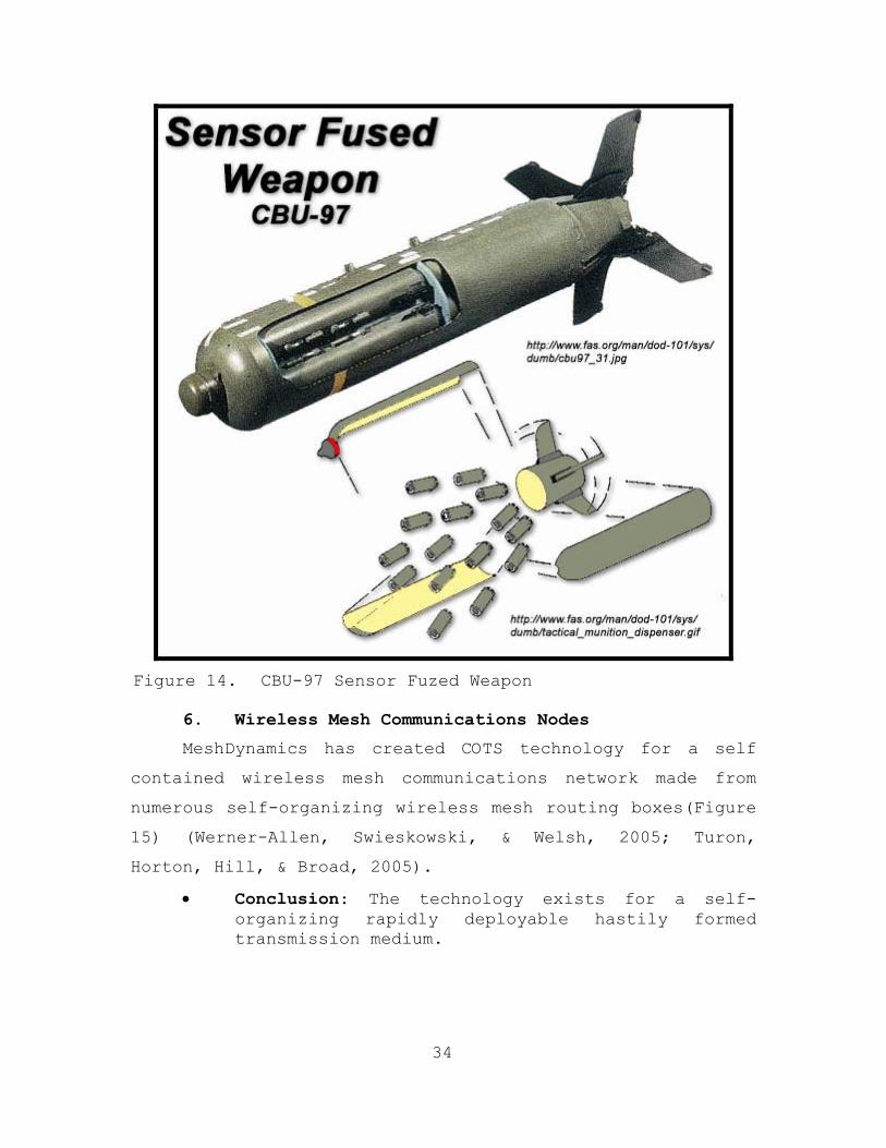
34
Figure 14. CBU-97 Sensor Fuzed Weapon
6. Wireless Mesh Communications Nodes
MeshDynamics has created COTS technology for a self
contained wireless mesh communications network made from
numerous self-organizing wireless mesh routing boxes(Figure
15) (Werner-Allen, Swieskowski, & Welsh, 2005; Turon,
Horton, Hill, & Broad, 2005).
• Conclusion: The technology exists for a self-organizing rapidly deployable hastily formed transmission medium.

35
Figure 15. Mesh Dynamics Wireless Mesh Box
7. Aerially Deployed Environmental Remote Sensors
Technology deployed aerially which transmits surface
environmental data to an aircraft for High Altitude High
Opening (HAHO) and High Altitude Low Opening (HALO) drop
accuracy exists.
• Conclusion: Capabilities exist to aerially deploy sensors in high tempo operations.
• Conclusion: Capabilities exist for the ruggedization of sensors.
8. Remote Power Source Technology
There is COTS technology to remotely deploy solar
powered remote renewable hydrogen power sources. These
power sources can be miniaturized and ruggedized (Figure
16).
• Conclusion: There exist resources for a sustainable, renewable, and ruggedized remotely managed power source.

36
Figure 16. Gridpoint Remotely Managed Renewable Power
Source
9. Miniaturized Sensor Webs
The National Oceanic and Atmospheric Administration
(NOAA) and the National Aeronautics and Space Association
(NASA) have jointly developed a technology labeled Sensor
Webs designed as a web of adaptive, self healing,
miniaturized pods that share environmental information
(Figure 17 and 18).
• Conclusion: The technology exists for a web of networked, wireless, sustainable, spatially distributed, miniaturized sensors.

37
Figure 17. Webbed Pods Created by NASA and NOAA in “The
Link Project”
Figure 18. Gumball Size Wireless Sensor Pod
10. Target Data Layered onto a Sensor Feed
In the British Subway there exists technology to
overlay ultra wideband (UWB) sensor data onto a video
stream from a camera to identify those carrying firearms or
explosives onto the subway.
• Conclusion: The technology exists to classify targets as hostile based on what they are carrying, and discriminate between multiple targets.

38
11. Networkable Aerial Sensors
Rotomotion LLC and Cyberdefense Inc. have both
developed networkable miniature unmanned aerial vehicles
(UAV’S) utilizing 802.11 wireless protocol. These are the
CyberBug and the Rotomotion SR50. This researcher was
trained to operate both miniature UAV’s while supporting
the COASTS team in Thailand (Figures 19 and 20).
• Conclusion: Mobile aerial sensors exist. Although the prototypes had technical and operational problems, they supported incorporation of mobile aerial wireless sensors into the real-time targeting sensor loop in order to produce the required targeting outputs.
Figure 19. Large Sized CyberBug Launch

39
Figure 20. Networked VTOL Mobile Aerial Sensor
12. Static Aerial Sensor and Transmission Nodes
During COASTS’ development of a tactical sensor net
tethered balloons were utilized to carry a payload
including an internet protocol (IP) camera and a
MeshDynamic’s routing box attached to them as a payload.
The balloons operated effectively as sensor and
transmission medium nodes at altitudes up to 4,000 feet
(see Figure 21 below).
• Conclusion: It is feasible to utilize COTS technology to create an aerial sensor and communications set held aloft by a balloon. As an information medium this provides extended range and could provide a link to additional sensor nets or weapons elements.

40
Figure 21. Visual Sensor and Information Node
13. Summary
From these examples it is reasonable to conclude that
sensor technology and doctrine is in fact gapped far behind
the potential capabilities to satisfy current operational
needs.
C. SENSOR REVIEW
1. Ultra-Wideband Sensors
According to Herzig (2005) in his analysis of the
ultra wideband (UWB) and mesh network technology in the
feasibility of UWB sensors for tactical operations, UWB can

41
operate effectively as a security fence. It can establish
a stationary radio frequency perimeter. In addition, due
to its wide frequency spectrum and the different ways
unique frequencies reflect off of different materials, the
UWB sensor system has the ability to discriminate between
materials to the resolution of telling a man from a deer,
or the location of a firearm on a man’s body (Cravotta,
2002; Intel, 2004; Nekoogar, 2005).
Herzig’s (2005) work characterizes the UWB sensors in
work by Lawrence Livermore National Laboratories (LLNL) as
covert. Their signal is difficult to detect since it falls
below the typical noise threshold at most distances and has
a low probability of intercept (LPI). The pulse-repetition
frequency (PRF) is random, mimicking white-noise (Figure
22).
UWB signals act as a reflecting form of radar. In
addition they can be used to encode the information
necessary for communications and this is another positive
attribute for sensor nodes that must communicate, self
organize, and finally output information to the weapons
actor (Figure 23).
Figure 22. Signal Comparison against Noise Threshold

42
Figure 23. Full Duplex Handheld UWB Transceiver
In addition, UWB technology can be used for effective
geolocation (Figure 24) where coordinates can not be
derived from the Global Positioning System (GPS) such as in
thick forests or man made structures (Rabaey, Ammer, da
Silva, Patel, & Roundy, 2000; Wilson, 2002).
Figure 24. UWB Precision Geolocation System Transceiver

43
Herzig (2005) also concluded that UWB was the ideal
medium for the physical layer of network operations.
Coupled with the capability to detect, classify, and output
targeting data, UWB provides a multi-use technology that
could simplify sensor operations while combining the sensor
and the transmission medium into the same node (Callaway,
2004; He, Stankovic, Lu, & Abdelzaher, 2003).
These capabilities combined with LLNL developed UWB
technology for military applications makes it the leading
candidate sensor for full spectrum coverage of target
reflections (Herzig 2005). The capabilities of UWB allow
for autonomous characterization of targets (Cravotta,
2002).
In addition, LLNL is currently researching and
producing a device titled the “Guardian Sensor” which is an
UWB device also that also acts as a sensor fence.
2. Visual Feed Sensors
According to a recent report by Innovative Wireless
Technologies (2006), improved communications and awareness
of one’s situation are vital components to reaching current
military objectives both at home and overseas. “A key
aspect...is sensor networks. These sensors, with ad-hoc
networking capability, could provide an early-threat
detection that is rapidly deployable, failsafe and
inexpensive” (p. 1).
Visual sensors or sensors that can produce a visual
output from emissions or reflections (IR, near IR, UWB, or
even acoustic) are also essential in a sensor net that will
create a real time sensor-loop for command, control,
communications, computers, intelligence, surveillance, and
reconnaissance (C4ISR) (DeBardelaben, 2003; Fraden, 2004).

44
D. CHAPTER SUMMARY
The purpose of this chapter was to review literature
pertinent to the study. The first section described the
new form of warfare. It was explained that victory has
been redefined as the spread of the correct ideology to
prevent the tasking of the attack on the U.S. or her
interests by individuals capable of it.
Technologies and sensors were reviewed next. The
review included discussion on ultra-wideband and visual
sensors. The following portion of the review focused on
problems with research. COASTS and Thailand problems were
detailed, followed by an examination of general real-time
targeting issues. Included were discussions of small
shooter-small sensor, COASTS deployment, and sensor net
operations.
Chapters I and II of this thesis have now laid the
groundwork for the study and its attendant objectives. The
following chapters will now define the problem and develop
a model for the solution.

45
IV. MODEL ANALYSIS
The purpose of this chapter is to describe the model
recommended for resolving the TDG problem. Before this can
be achieved, however, it is first necessary to explain need
and define requirements. Following that will be a
description of solutions and the model architecture.
A. NEED
The need for real-time targeting solutions in the
uncontrolled OE regions of Thailand is representative of
the global need the U.S. must meet in the GWOT.
1. Need in Thailand
The need for successful operations in Thailand has
never been greater. Asymmetric threats to the national
security of America continue to increase (Parr, 2003).
These include narcotics smuggling, piracy, human
trafficking, and terrorism, among other similar activities
(Parr, 2003). Globalization of these types of activities
continues to redirect American attention away from her own
borders. In addition, the separatist insurgency in the
southern provinces has been linked to various terrorist
organizations that operate internationally and have been a
serious threat to not just Thailand, but to the United
States and its allies as well (Roberts, Trace, & Klein,
2004).
Unfortunately, current tactical systems are not able
to rapidly deploy a common information environment among
air and land entities. An autonomous network cannot be
generated. While some technologies exist that could assist

46
in this endeavor, these typically do not meet the stringent
DoD and coalition partner requirements for the GWOT and
other security missions.
Security issues now command the fullest attention.
These are being addressed on many different levels. For
example, Joint Interagency Task Force West (JIATF-W) is
initiating data/intelligence fusion centers in Chiang Mai,
Thailand. Such a data center focuses on collecting
intelligence for many different types of operations. In
addition, the Regional Maritime Security Initiative (RMSI)
is focusing on coastal areas involving transnational open
ocean counter-piracy and counter-terrorism.
These entities are now meshing their activities with
American efforts in a coalition-oriented effort to decrease
the ever-growing problems associated with illegal drug
activities and human trafficking (Roberts et al., 2004).
The growth of such problems was recently reported by the
Bangkok Post (03 January 2006) as follows:
The [Thai] Narcotics Control Board forecasts a continuing rise in the number of drug-related cases this year, but expects the overall amount of methamphetamine in circulation to decline. Secretary-general Krissana Polanant said the trend is for traffickers to carry smaller quantities of pills which means the smugglers will have to make more trips which increases the chances of them being arrested. Provinces on the bureau’s close-watch list are Chiang Rai, Chiang Mai, Tak, Nan, Nakhon Sawan, Nonthaburi, Sing Buri, Ayutthaya, Nakhon Pathom and Bangkok.
2. Perceived Thai Problem
According to a recent report (Central Intelligence
Agency, 2005), Thailand has an extended border with Burma
that requires military assets to patrol for the purpose of

47
battling drug smugglers and human traffickers. The
military provides monitoring, surveillance, and targeting.
The illicit drug smuggling and trafficking in human cargo
has significantly increased in recent years and has become
a significant problem, especially in light of the fact that
these illicit operations can provide financial support for
international terrorist organizations. The problem is
further increased when note is taken that many of the
illegal drugs reach the United States through shipments
through the Straits of Malacca and Singapore Straits. It
is the responsibility of the Royal Thai Army (RTA) 3rd Army
to maintain ground–based security and surveillance.
Other security problems are currently occurring which
demand Thai military attention in the southern regions of
Thailand. In fact, the RTA 4th Army has been deployed to
this region to deescalate tensions caused by insurgency and
unrest.
In addition, small boat activity in the Gulf of
Thailand has escalated. The purpose of this activity is to
illegally distribute weapons and ammunition. All these
problems and insurgencies have financially impacted the
Thailand government and taken their toll on the country’s
military forces. Clearly, more capable ISR will enable
Thailand to reduce asymmetric attacks against civilian and
military targets.
3. COASTS Scenario Overview
The COASTS research team executed a drug interdiction
scenario (see Appendix C for details on the COASTS concept
of operations) in direct support of the following nine
principal mission areas. These are briefly described as
follows (COASTS Thailand Field Experiment, 2006):

48
1. Direct Action (DA): During short-duration, high-
tempo offensive missions, the primary function of COASTS is
to provide force protection that requires little or no
operator interface. COASTS also will provide automated
reporting to the Tactical Operations Center (TOC) for
potential threats relevant to a specific mission.
2. Tactical Reconnaissance (TR): The purpose of a TR
mission is to collect data. COASTS will augment other
capabilities to obtain/verify information and will support
a range of information and communication functions.
3. Foreign Internal Defense (FID): COASTS assists Host
Nation (HN) military and paramilitary forces, with the goal
to enable forces to maintain the HN’s internal stability.
4. Combating Terrorism (CBT): COASTS will support CBT
activities to include anti-terrorism (defensive measures
taken to reduce vulnerability) and counterterrorism
(offensive measures taken to prevent, deter, and respond).
5. Civil Affairs (CA): COASTS assists in peacetime to
preclude grievances from flaring into war and during
hostilities to help ensure that civilians do not interfere
with operations and that they are protected.
6. Counter-proliferation Weapons of Mass Destruction
(WMD): COASTS assists traditional capabilities to seize,
capture, destroy, render safe, or recover WMD. COASTS also
provides data to assist U.S. military forces and coalition
partners to operate against threats.
7. Information/Counter-Narcotic Operations: COASTS
augments actions and applies information across all phases
of an operation and the spectrum of military operations.

49
Counter-narcotic operations augment JIATF-W, U.S. Embassy
Bangkok, and Thai law enforcement efforts to reduce the
level of transnational narcotic smuggling.
8. Maritime Security and Interdiction Operation:
COASTS uses C4ISR capability for small boats capable of
conducting maritime terrorism exclusion operations. The
modular usage of fly away kit (FLAK) technology makes small
boat interdictions ISR-mission capable. Visit, board,
search, and seizure (VBSS) operations are conducted by all
U.S. and coalition forces.
9. Psychological Operations (PSYOP): As a vital IO
tool in counter-insurgency and counter-terrorism
operations, the COASTS research program analyzes the
ability of the wireless network to be utilized for PSYOP
missions in the tactical environment.
4. COASTS Scenario Overview
The scenario decomposed the force into its component
parts and highlights the redefinition of the component
parts of military actions. It should be noted that three
fundamental classes exist in this object orientated
operation. These include: sensor, information input/output,
and the weapons action.
Illustrated below in Figure 25 is a visual
representation of the scenario.

50
Figure 25. Event Breakdown for the Mae Gnat Dam Drug
Interdiction Scenario
During the above functional decomposition of a real-
time targeting force, three broad classes of action were
developed:
1. Sensor Operations: for identification, classification, and location of target(s);
2. Information Transfer: for transfer of above processed information through the information medium.
3. Weapons Action: takedown or destruction of identified targets—this doctrine has been developed and well refined through military history.
51
The Weapons Action portion of the operation is ready
to receive inputs from targeting. However there is little
doctrine for iterative real-time targeting.
B. REAL-TIME TARGETING PARADIGM PROBLEM
Special forces (SF) end-users when regarding targeting
operations assumed that a paradigm existed for real-time
targeting. What was found, however, was that in reality
very little of the real-time targeting paradigm existed in
the collective consciousness of the Special Forces.
Instead, personnel were focused on targeting as a non real-
time process. Little or no focus was paid to enhancing
capability. Instead, it was insinuated that the sensory
operations for most missions followed naturally from the
doctrine sensor information came from visual human ground
sensors, visual human aerial sensors, etc. Data would be
passed over a voice net between sensor and shooter and
often the sensor was the shooter. The enhancement and
separation of the sensor element was not regarded as a
principle of warfare.
C. SENSORS
1. Small Shooter-Small Sensor
Today’s sensors have too much footprint. But there is
almost no footprint for shooters up at 30,000 feet against
GWOT enemies. Clearly, sensor operations require
improvement. How should this be fixed? Doctrine and
sensor technology for past conflicts with a larger level of
bounded combat exists. Previous doctrine required the
forces to be bounded in geography, communications,

52
movements, and tactics. Such bounding of forces is an
assumption of a previous form of warfare that no longer
holds true.
As previously noted, victory has been redefined by the
enemy. No longer is it a national victory; rather, it is
ideological. Because of the nature of the forces — that
is, independently operating cells — and the nature of their
goals (political) the American military force faces a
changing combat paradigm. Because the luxury of detecting
division level forces no longer exists, shooters have been
adjusted appropriately. However, the sensors continue to
struggle. A current solution for this lagging sensor
technology is often heard in the common rhetoric of “boots
on the ground.” In other words, people need to be sent in
to walk around and visually identify targets and produce
from that visual identification a location—relative or
absolute—and then follow with the necessary operations to
prosecute targets at that location. Consequently, the
sensors (humans in this case) that are employed are limited
conceptually, technologically, and doctrinally.
Because of these changing requirements and assumptions
the principles of warfare have shifted from what they once
were. There is little focus upon where to direct combat
power and little focus on sensor necessity. Figure 26
highlights the currently recognized principles of war.

53
Figure 26. Current Recognized Principles of War
Figure 27 illustrates the real-time sensor cycle1,
today’s technology has enabled the medium that binds the
shooter to the sensor. Bootstrapping has focused the
majority of concern on the shooter because in the past the
opposing forces have not been difficult to detect - at
least not with the level of technology that existed at the
time. Thus, sensors have been shooters.
1 See Lim (2001) for information dissemination in self-organizing
real-time sensor networks.

54
Figure 27. The Real-Time Sensor Cycle
As can be seen in the Figure 28, the task of targeting
is not focused upon in the current Joint Architecture for
joint special operations task force elements. Architecture
is not broken down along functional lines; instead it is
broken down into traditional task oriented components. The
proposed real-time targeting architecture suggested in this
thesis is broken down into elements that are functionally

55
separated into sensor, information processing,
dissemination, and prosecution elements. These elements
could be automated and do not necessarily require humans in
the loop.
Figure 28. Special Operations Liaison Element Functions
(From: JSOTF Pub)

56
2. Sensor Net Operations
The C4ISR operators require several objects layered
with the sensor feed to utilize it for situational
awareness (SA). The first is visually represented
positional data, most likely a map or an overhead image
with an updating overlay of the field of view (FOV) (Figure
29). The second is simplified target classification data
layered onto the feed(s). Target classification, for
example, could include an overlay onto the real time feed
identifying the target with a rendered box (Figure 30).
The target can then be identified on the feed and mapped to
the common operational picture. Otherwise, in a congested
local area of operations, the target will be lost in the
noise.
Figure 29. Common Operational Picture Displaying UAV
Sensor Feed FOVs, TDD, and Friendly Overlay

57
In addition, sensor feed overlays should take
advantage of UWB capabilities by indicating hostile
equipment or contraband (improvised explosive devices
(IED’s), firearms, etc.) on persons or targets. Finally,
not included in the feed, but in the feed interface, there
must be some way of identifying and accessing multiple
feeds for the operator. There must be a portal interface
that prioritizes which feeds provide the most targeting
information on the COP.
Figure 30. Aerial Sensor Feed Overlayed with TDD, Friendly
Data, and Sensor Feed Priority
In experiences with UAV operations and sensor net
operations, it was found that SA was not generated
adequately from a raw visual feed (Yan & Tsa, 2005).
Instead, the feed required SA augmentation. This
augmentation takes the form of an overhead or map display

58
with the FOV rendered on it in real-time. This gives the
client of the sensor net adequate SA to transform a raw
feed into actionable knowledge.
In precision guided bomb procedures the process is
similar with the airborne operator guiding in the bomb
based on a visual reference produced from SA, from a map or
a visual look. In addition RQ-1 Predator drones utilize
this exact FOV mapping method, calculating the location of
the FOV from laser range data.
In experiences with airborne visual sensor feeds
(CyberDefense’s Cyberbug, Rotomotion vertical takeoff and
landing (VTOL) UAV’s) without an accompanying geographical
orientation rendered, it was difficult to identify the
location of practice targets. To gain the SA required,
frequent camera orientation to the front of the aircraft
(swiveling it up to a forward looking view) and correlating
it with the direction of flight displayed on the map the
ground control station displayed for navigation purposes
(Figure 31) was required. If the sensor is providing an SA
feed, the process needs to be appropriately formalized for
mobile airborne sensor operations.

59
Figure 31. CyberDefense CyberBug Gimbaled Visual Sensor
Feed D. END-USER SURVEY
1. Problem Definition
The largest problems for operators attempting to
prosecute targets within OE’s are: (1) target
discrimination between the non-combatants and enemy targets
and (2) opaque barriers obscuring targets such as the
jungle environment foliage or man made structures. This
is because insurgents are often embedded within the local
populace. The main problem is the variation of
environmental opacity obscuring sensor capability in
addition to the discrimination of actual targets and non-
combatants. The margin for error is small making this a
difficult problem. Within such OE’s where Joint forces are
operating, the fog of war becomes an issue with friendly SA
causing fratricide.
2. Discrete Deliverables
There are several discrete deliverables required from
sensor operations to input into weapons operations as
defined by the end-user survey. These are:

60
• Highly accurate grid coordinates in Military Grid Reference System (MGRS) format (most sensor systems deliver a general location of sighted warm bodies which is often not sufficient for targeting)
• SA feeds augmented with grid coordinates
• Information on whether targets are armed or unarmed
• Accurate numbers of personnel
• Queuing of targets in prioritized by threat
• Proper fusion of the sensor data
• Generation of an accurate, COP
• Secure and reliable transmission of the COP
3. Ideal Equipment Requirements
On the tactical level ground sensors that can provide
real-time sensor feeds equivalent to that of Human
Intelligence (HUMINT) or equivalent to that of an RQ-11
Raven UAV (Figure 32).

61
Figure 32. RQ-11 Raven Squad Level UAV
On the operational level a wide area of coverage must
be kept within an SA feed to provide operators with the SA
of their larger operational surroundings equivalent to that
of a RQ-1 Predator (Figure 33).

62
Figure 33. RQ-1 Predator UAV
4. Ideal Doctrinal Requirements
Doctrine must support a policy of bootstrapping and
empowerment of the scene operators responsible for target
prosecution. That is the primary mission. The data must
be simple and feed directly to the operator. There should
be no middle-man utilizing the data to manage the
operators. The on-scene operators must have supreme
control over their incoming data to produce the desired
weapons effect.
Mission modularity is key. The On-Scene commander
must be empowered to tailor the mission, equipment, and
personnel in modular building blocks to the appropriate
mission. Also, personnel footprint should be minimized.

63
E. MEASURES OF EFFECTIVENESS ANALYSIS
A list of important considerations can be found in
Appendix A. This section now provides MOE answers. Each MOE
is listed first, followed by a listing of component parts
and answers:
1. Target Discrimination
a. Equipment - Utilize Ultra Wideband (UWB) frequency patterns to recognize hostile equipment
b. Location - Locate target with any sensor available, output a grid-coordinate layered with target data
c. Stance - Requires a sensor to visual real-time feed for screening by a human operator to discern hostile stance, layer in additional sensor data.
d. Target discrimination data must be stored and correlated in a database in order to maintain target fidelity should the target move out of range of UWB sensors and into larger range passive sensors
e. Suggested Equipment – IR/Near IR Sensors/Visual Sensors
2. Grid Coordinates
a. Visual, IR, Near IR, or even acoustic based sensors can passively acquire a set of targets. In addition, active acoustic sensors could be utilized to locate targets. However, such sensors will need target discrimination data layered on top of the coordinate outputs. The larger set of targets can be filtered with UWB active reflection data to discriminate hostile targets. With positional data either from UWB device geospatial orientation, or a global positioning system (GPS) output meshed with range data to a device’s known position targets can be localized.

64
3. Real-Time Visual Stream
a. A real time visual stream can be produced from IR, Near IR, or even UWB Sensors. Real-time feeds from UWB type sensors have the added advantage of penetrating through opaque environments. Again the output must be layered with Target Discriminating Data (TDD) for the operator interface. Real time feeds can come from ground sensors, however the most effective sensor for maintaining a passive IR/Near IR/Visual feed is a mobile or static aerial sensor.
4. Prioritization of Sensor Feeds
a. Accomplished through autonomous software analysis of UWB TDD on such variables as hostile equipment, number of hostile targets, and high priority locations of targets. In addition, manual input by operators of high priority targets prioritized by stance or otherwise should override autonomous settings.
5. Queuing of Targets
a. Process similar to Prioritization of sensor feeds. Targets will be queued with layered UWB TDD in addition to operator overrides.
6. Layered COP
a. Layered COP will be generated through complete sensor fusion onsite within the payload of a persistent aerial sensor onboard a payload onboard a tethered static aerial sensor. This portion of the system should be highly redundant as it is fault point. Tethered Static Unmanned Aerial Nodes should be equipped with payloads capable of autonomous sensor fusion operations to support prioritization, queuing, and layering of data. In addition these airborne fusion centers should be the centers for layering of sensor feeds to support the operator. Finally, the payloads should also carry a backhaul transmission to a forward operating base (FOB), airborne platform, or other gateway outside of the local operating area.

65
7. Dissemination of Data
a. Backhaul gateways will disseminate data beyond the sensor net. The gateways will be contained onboard static aerial nodes. These static aerial nodes could either be a tethered balloon or a persistent airship. The payloads must be compatible with a number of different transmission mediums including but not limited to UHF, SATCOM, and Link-16 in order to deliver end products to weapons delivery systems such Tomahawk Land Attack Missiles or Attack Aircraft. In addition, the common operating picture can be provided upwards to higher levels for dissemination to commanders for support operations.
b. Within the sensor net, ground operators can interface directly with client devices. Transmission nodes will utilize UWB as the physical layer of communication for the transmission medium since it is the most secure and robust for operations in opaque environments.
8. Ground Operator Interface
a. Ground operators within the operating area should have access to the autonomously filtered TDD, prioritized sensor feeds for SA, and targeting solutions via a rendered common operational picture. The interface will be wearable, possibly a heads up display (HUD) helmet (not unlike S.W.A.T. helmets or the HUD Helmet in development for the F-35 Joint Strike Fighter) or a wearable device preferably on the forearm. The device must utilize a full spectrum interface that can accept voice and keyed commands. All methods of end-user experimentation and survey should be utilized to find out the optimal method for the man-machine interface. The data deliverable to the ground operators within the sensor net will include (1) a COP in the form of a map with layered targets on top of it. The TDD on each target should be hidden but accessible through the graphical user

66
interface (GUI) layers for the operator. In addition, real-time sensor feeds should be available to the operator in a prioritized fashion with FOV selection. If there are airborne mobile sensors the operator should have access to control their FOV coordinates.
9. Rapidly Deployable
a. Airborne deployment of the system is necessary for sensor net operations. It is the only foreseeable solution to high tempo operations requiring a sensor net. The sensor net should be deployed from an aircraft, or several aircraft. The deployment design should conform to the terrain of operations. For instance, if operating within triple canopy jungle UWB sensors should be deployed from aircraft via a parachute system that will entangle them and have them looking downward from the trees. In other terrain sensors could utilize deployment not unlike that of the device used to sense surface environmental data for HALO drops (a device deployed from an aircraft that implants itself by a stake in the ground). The UWB sensors should be deployed in a highly redundant fashion to ensure the fidelity of the net. UWB sensors should be deployed as the primary ground sensor and if they can be ruggedized sufficiently they should be deployed in a cluster fashion similar to that of the SFW. IR, Near IR, and Visual passive sensors will need to be onboard the payloads of static aerial devices since they provide also the majority of wide area coverage. UAV’s that mesh with the sensor net should be launched.
10. Modularity
a. System will have preset TDD prioritization algorithms for varying Rules of Engagement (ROE), varying deployment payloads, varying deployment patterns, and varying operating environments.

67
11. Interoperability
a. System will be interoperable with Link6, UHF/VHF/HF bands, satellite communications (SATCOM) and other transmission mediums required to make the precise passing of targeting data to shooters possible. This capability will be deployed onboard the static aerial sensors to ensure fidelity and access.
While the above provides MOE answers for the new
system, it is important to add several important notes:
• Static aerial nodes are required at varying altitudes for persistent aerial real-time feed coverage (recommend up to 4,500’).
• Static aerial nodes are also required at varying altitudes for backhaul transmission and wide area transmission coverage/redundancy. This transmission system can also serve as a secure and reliable medium for audio communications. The operator only need transmit to the nearest transmission node and transmission will be relayed through the entire net.
• TDD is required for discriminating Hostile Target Equipment. For example, in Baghdad, IED’s are a hostile equipment priority. In Thailand large quantities of narcotic substances are the priority, and in the Philippines, Soviet made weaponry are the priority. This of course, relies upon the final capabilities of UWB discrimination capabilities. Prioritization tables of hostile equipment should be included in the AO modular package. This data helps for queuing and prioritization of targets.
F. SYSTEM (MODEL) ARCHITECTURE
The system architecture will be broken down areas as
follows:
1. Sensor Net Elements 1.1. Real-Time Sensor Feeds (can be anything that
produces a real-time feed)
1.1.1. Aerial Feeds

68
1.1.1.1. Mobile Aerial Feeds
1.1.1.1.1. Function:
1.1.1.1.1.1. Flexible Aerial Coverage of Local Operating Area
1.1.1.1.2. Example Equipment:
1.1.1.1.2.1. RQ-11A Raven 1.1.1.1.2.2. RQ-1 Predator 1.1.1.1.2.3. RQ-4A Global Hawk
1.1.1.2. Static Aerial Feeds
1.1.1.2.1. Function:
1.1.1.2.1.1. Persistent Coverage of Wide Area for area coverage a visual type passive sensor, real-time feed
1.1.1.2.2. Example Equipment:
1.1.1.2.2.1. Tethered Balloon Payload Aerial feed (Visual/IR/Near IR)
1.1.2. Ground Feeds
1.1.2.1. Static Ground Feeds
1.1.2.1.1. Function:
1.1.2.1.1.1. SA Augmentation with overlayed FOV and TDD
1.1.2.1.2. Example Equipment:
1.1.2.1.2.1. Ground Passive Visual, IR, or Near IR Camera feeds
1.1.2.1.2.2. UWB Active Sensor Reflections transformed into Visual Sensor Feeds for environmental transparency
1.1.2.2. Mobile Ground Feeds (Manned Sensor Feeds)
1.1.2.2.1. Local Area Operator Sensor Feeds (Visual/IR/Near IR)
1.1.2.2.1.1. Function: 1.1.2.2.1.1.1. Flexible ground SA
Augmentation with overlayed FOV and TDD
1.1.2.2.1.2. Example Equipment: 1.1.2.2.1.2.1. Vehicle Mounted Sensor Feeds

69
1.1.2.2.1.2.2. Maritime 1.1.2.2.1.2.3. Terrestrial 1.1.2.2.1.2.4. Wearable Sensor Feeds
1.2. Threshold Sensors 1.2.1. Functions:
1.2.1.1. Provide Area Target Coverage and area prioritization
1.2.1.2. Do not provide sensor feeds, they provide alerts when the threshold of passive emissions is detected for area prioritization
1.2.2. Equipment Example:
1.2.2.1. Static Aerial Payloads of Magnetic/Acoustic/IR/Near IR/Visual Sensors
1.2.2.2. Static Ground Threshold Sensors of Magnetic/Acoustic/IR/Near IR/Visual Sensors similar to the Crossbow sensors utilized in the COASTS 2006 program
1.3. Active Friendly Transmitters 1.3.1. Functions:
1.3.1.1. Transmit location data on friendly units to sensor fusion payloads to provide friendly SA
2. Transmission Medium Elements – UWB Physical Layer 2.1. Ground Nodes
2.1.1. Mobile
2.1.1.1. Functions:
2.1.1.1.1. Provide a flexible SA and data gathering intelligence center if necessary
2.1.1.1.2. C2 Functions
2.1.1.1.3. Can serve the Gateway function for interoperability purposes
2.1.1.1.4. UAV integration/operation
2.1.1.2. Example Equipment:
2.1.1.2.1. Network Operation Centers (NOC) similar to the Nemesis Van utilized in COASTS 2006 prototyping at Pt. Sur, Ft. Ord, and Camp Roberts

70
2.1.1.2.2. Man Portable Transmission Medium Nodes similar to the tactical communications Kit utilized in COASTS 2006 at Mae Gnat Dam
2.1.2. Static
2.1.2.1. Functions
2.1.2.1.1. Serve as a reliable Physical Level layer for a transmission medium
2.1.2.1.2. Provide communications security through frequency hopping
2.1.2.2. Example Equipment:
2.1.2.2.1. UWB Nodes (can double as sensors and transmission nodes)
2.2. Aerial Nodes 2.2.1. Mobile
2.2.1.1. Functions
2.2.1.1.1. Flexible Network Extenders
2.2.1.2. Example Equipment
2.2.1.2.1. Predator UAV’s acting as network extenders
2.2.1.2.2. Rotomotion VTOL Miniature UAV’s ability to extend a 802.11 Network
2.2.2. Static
2.2.2.1. Functions:
2.2.2.1.1. Wide Area Access Points for Network Integrity and Coverage
2.2.2.1.2. Network Mesh Connectors to connect the topology where it can not be connected on the ground
2.2.2.2. Example Equipment:
2.2.2.2.1. Static Aerial Node Payload such as the balloons utilized in COASTS 2006
2.2.2.2.2. Unmanned Air Ships that maintain a persistent presence
2.3. Gateways 2.3.1. Static Aerial Gateways
2.3.1.1. Functions:
2.3.1.2. Example Equipment

71
2.3.1.2.1. Payload onboard static aerial nodes (balloons) not unlike that utilized in COASTS 2006 at high altitudes for link integrity
2.3.1.2.1.1. UHF Link 2.3.1.2.1.2. VHF Link 2.3.1.2.1.3. 802.20 Link 2.3.1.2.1.4. 802.16 Link 2.3.1.2.1.5. Link-16 Link 2.3.1.2.1.6. SATCOM Link
2.4. Sensor Fusion Centers 2.4.1. Functions:
2.4.1.1. TDD
2.4.1.1.1. Prioritization
2.4.1.1.2. Queuing
2.4.1.1.3. Database of Targets
2.4.1.2. Common Picture Production
2.4.1.2.1. Map Layering
2.4.1.2.2. Target Layering
2.4.1.2.3. Sensor Feed Layering
2.4.1.2.4. TDD Layering
2.4.1.3. Real-Time Sensor Feeds
2.4.1.3.1. Prioritization
2.4.1.3.2. Layering of TDD on top of Video Streams
2.4.1.4. Example Equipment
2.4.1.4.1. Custom designed Hardware and Software Payload of Static Aerial Nodes that acts like a server to fuse together information and provide it to end-users
3. Rapid System Deployment Elements 3.1. Cluster Deployment of Ground Sensors
3.1.1. Functions:
3.1.1.1. Modularity for deployment from a number platforms
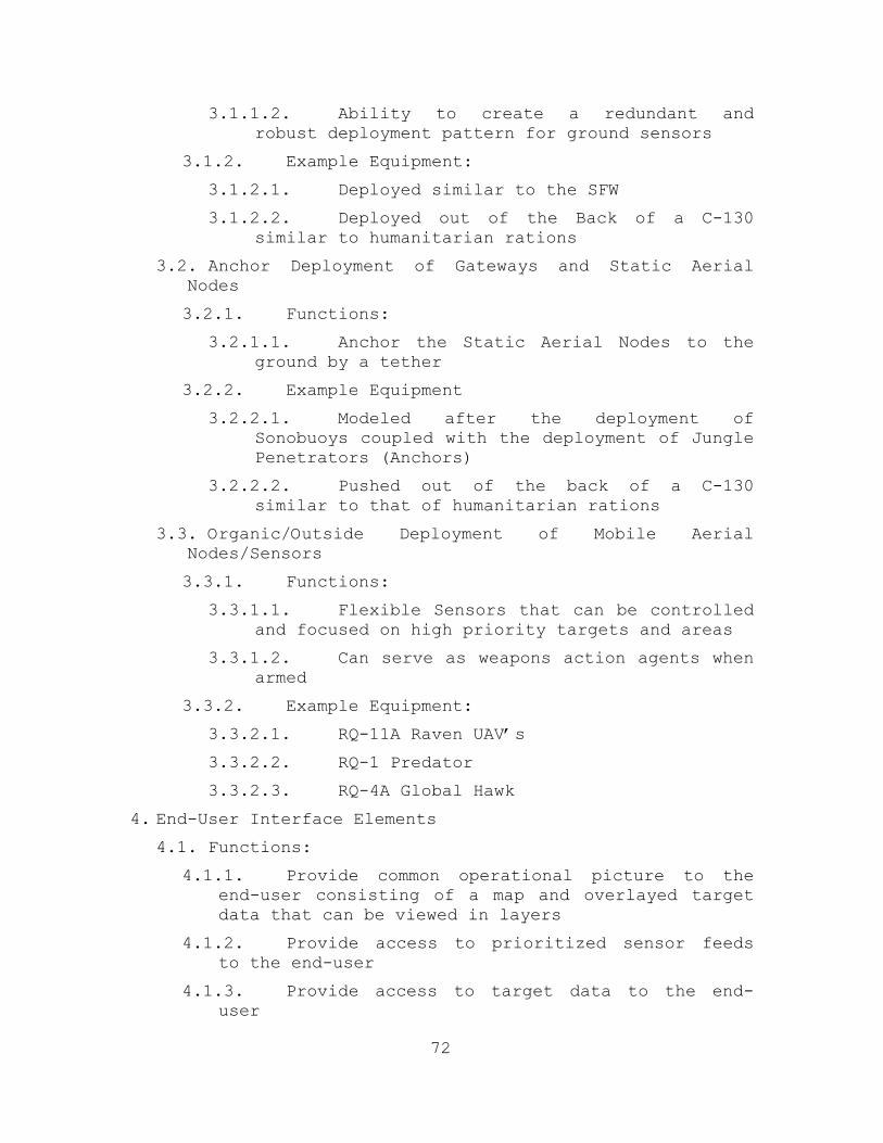
72
3.1.1.2. Ability to create a redundant and robust deployment pattern for ground sensors
3.1.2. Example Equipment:
3.1.2.1. Deployed similar to the SFW
3.1.2.2. Deployed out of the Back of a C-130 similar to humanitarian rations
3.2. Anchor Deployment of Gateways and Static Aerial Nodes
3.2.1. Functions:
3.2.1.1. Anchor the Static Aerial Nodes to the ground by a tether
3.2.2. Example Equipment
3.2.2.1. Modeled after the deployment of Sonobuoys coupled with the deployment of Jungle Penetrators (Anchors)
3.2.2.2. Pushed out of the back of a C-130 similar to that of humanitarian rations
3.3. Organic/Outside Deployment of Mobile Aerial Nodes/Sensors
3.3.1. Functions:
3.3.1.1. Flexible Sensors that can be controlled and focused on high priority targets and areas
3.3.1.2. Can serve as weapons action agents when armed
3.3.2. Example Equipment:
3.3.2.1. RQ-11A Raven UAV’s
3.3.2.2. RQ-1 Predator
3.3.2.3. RQ-4A Global Hawk
4. End-User Interface Elements 4.1. Functions:
4.1.1. Provide common operational picture to the end-user consisting of a map and overlayed target data that can be viewed in layers
4.1.2. Provide access to prioritized sensor feeds to the end-user
4.1.3. Provide access to target data to the end-user

73
4.1.4. Provide a common operational picture of fused sensor data for SA
4.2. Example Equipment: 4.2.1. Modular PC’s wearable PC’s
4.2.2. Tacticomps
4.2.3. The HUD Helmet in development for the F-35 Joint Strike Fighter (JSF) which can overlay target data onto an individuals visual orientation of the scene
4.2.4. Blue Force Tracker (BFT)
G. AERIALLY DEPLOYED SENSOR NET
1. Overview of the Model
The system architecture for the sensor net will
include a topology similar to that of the COASTS network or
the Tactical Network Topology Program (TNT). It will be
deployed aerially for rapid employment in the area of
operation utilizing the sensor in depth doctrine for
integration into Joint Operations.
The sensor in depth doctrine (Figure 34) will utilize
multiple sensor layers from a strategic level providing
global coverage (if necessary) to a tactical level. The
strategic level will leverage national intelligence assets
to localize the AO. Intelligence assets include imagery
intelligence (IMINT), HUMINT, Signals Intelligence
(SIGINT), and other global level assets that can identify a
hot spot.

74
Figure 34. Sensor in Depth Layers
Necessary intelligence will be passed down to the next
level, the operational sensor layer, for further
localization within the AO. In addition, sensors will be
deployed for passive patrolling of the AO to identify local
operating areas containing possible targets of interest.
Examples of patrolling elements at the operational level
include RQ-1 Predator UAV’s, RQ-4 Globalhawks (see Figure

75
35), and HUMINT. These localizers, once they identify an
active target area, will pass the info downward for a
closer look at the sensor net level.
Figure 35. RQ-4 Globalhawk ISR UAV Similar to the U-2 Spy
Plane
The operational layer acts to localize threats further
and trigger the deployment of the real-time sensor net
establishing the tactical sensor layer. This will be a
high tempo operation requiring real-time tactical targeting
of targets within a pre-defined area passed down through
the operational layer.
After deployment, backhaul gateways should be
established and tested as should the full functionality of
the system. Once fidelity and security is assured the

76
operation can discriminate, classify, and monitor targets
in real-time. Standard doctrine will enable transmission of
the targeting information to weapons action agents. Also,
it is important to mention that the sensor net should be
highly redundant to ensure fidelity of the information and
establish appropriate feeds.
H. IMPLEMENTATION OF SENSOR NET
COTS technology can be a big cost advantage to the
real-time sensor net. Following is an itemized list of the
technologies that could be utilized:
• Cyber Defense Systems CyberBUG mini-UAV Drone
• Lightweight surveillance, reconnaissance, target acquisition
• Rotomotion SR20 Vertical Takeoff and Landing (VTOL) UAV Helicopter System
• Surveillance, reconnaissance, target acquisition, network extension, sensor deployment
• Crossbow Wireless Ad-hoc Sensor Network
• Infrared and magnetic anomaly sensors for security and tracking
• CACI/Cisco Tactical Communications Kit (TCK)
• Ruggedized rapidly-deployable, secure voice, data, and video communications open-standard Internet Protocol router, interfaces Cisco Voice over Internet Protocol (VoIP), wireless, satellite, and land mobile radio (LMR) connectivity (LMRoIP)
• Harris AN/PRC-117 ground-to-air havequick I/II radio system
• HF/VHF/UHF (30-512 MHz) reprogrammable digital radio
• Harris AN/PRC-150 man pack radio system

77
• NSA certified HF/VHF radio for secure voice and data (9600 bps) communication up to 60 MHz
• SecNet 11 National Security Agency (NSA) Certified 802.11 Encryption
• XACTA Deployable Wireless Mesh Nodes
• Tachyon tactical SATCOM equipment
• Integrated Blimp Works’ 10’/13’ Ball Balloons and My-te Winch Hoists
• Equipped with MeshDynamics Network Devices and Antennas to act as network extenders at 4,500 feet
• IEEE 802.11. 802.16, and 802.20 wireless protocols
• MeshDynamic Systems (MDS) 802.16/11 Boxes
• A Mobile Network Operations Center (MNOC) titled “Nemesis”
• Two way radio integration of Land Mobile Radio over IP (LMRoIP), ARC over IP (ARCoIP), SATCOMoIP, and Voice over (VoIP) for backhaul gateways
• MDS DenyGPS
The suggested sensor net could easily to jammed by a
national level force’s technology (i.e. China or Iran).
However, this system is designed for decomposed forces that
will most likely not have the capability to jam or even
detect such a system as having been set up.

78
THIS PAGE INTENTIONALLY LEFT BLANK

79
V. SYSTEM SOLUTION AND FUTURE DEVELOPMENT
The purpose of this investigative study was to suggest
a model for a system of systems which improves real-time
targeting through an aerially deployed wireless mesh sensor
network.
A. FUTURE DEVELOPMENTS
1. Path to a Solution
The path to a solution is multifaceted and multi-
tasked. Paths to a proven concept should thus include the
following components:
• Experimentation for Development of MOP’s
• Additional Survey for Development of MOP’s
• LLNL Guardian Sensors
• In depth research by established foundation SPAWAR
• Survey, ruggedized, and reliable COTS equipment
Prioritization algorithms need to be developed, given
the input of TDD and coordinates and high value asset
coordinates. These algorithms should be modular and
flexible to the requirements of the AO (geographical,
political, current forces in the area, threat intelligence,
threat priorities (i.e. if they’re carrying drugs, rifles,
or IEDs).
The path to a solution also requires network
development and gateway integration. Transmission medium
must be developed to be robust, secure, and self healing.
Gateway interoperability must be developed for the aerial
payloads. Interoperability with SATCOM, UHF, Link-16, and
even 802.20 must be utilized.
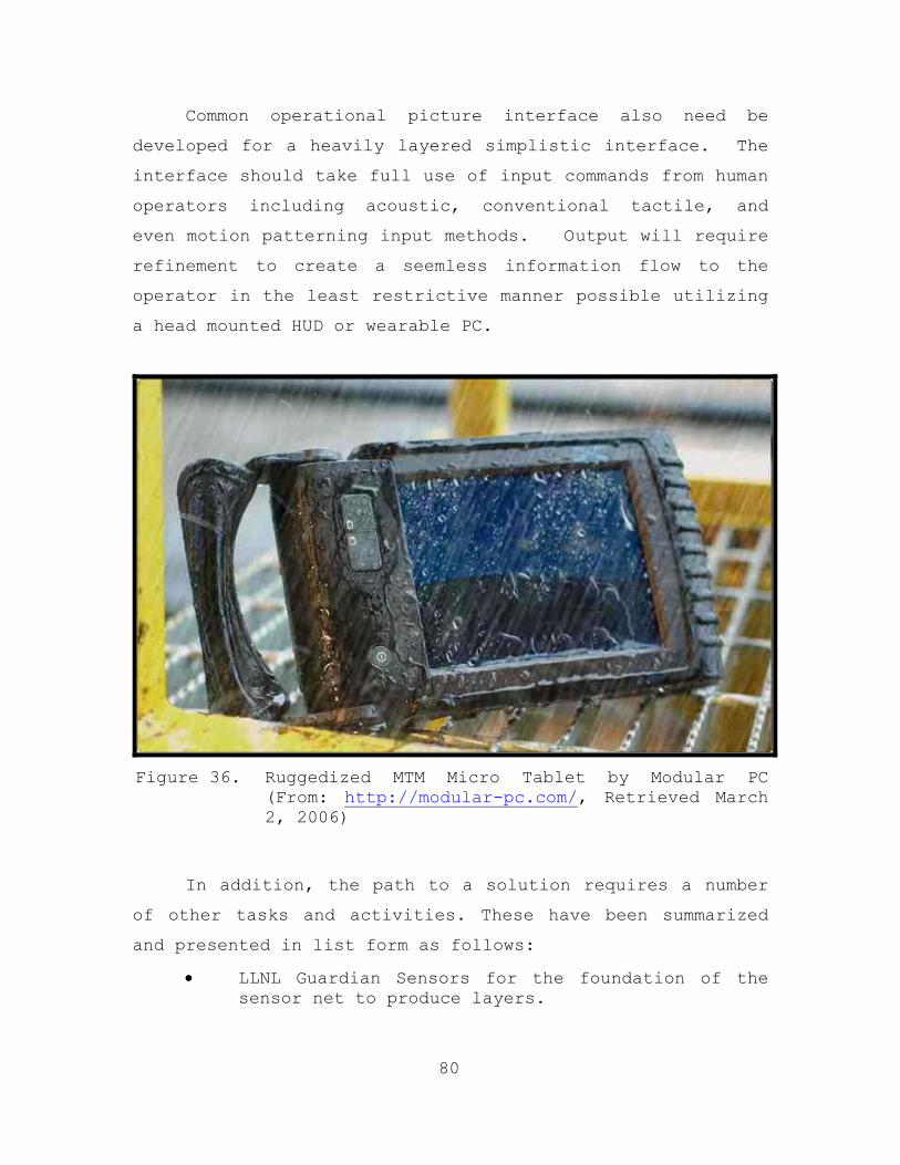
80
Common operational picture interface also need be
developed for a heavily layered simplistic interface. The
interface should take full use of input commands from human
operators including acoustic, conventional tactile, and
even motion patterning input methods. Output will require
refinement to create a seemless information flow to the
operator in the least restrictive manner possible utilizing
a head mounted HUD or wearable PC.
Figure 36. Ruggedized MTM Micro Tablet by Modular PC
(From: http://modular-pc.com/, Retrieved March 2, 2006)
In addition, the path to a solution requires a number
of other tasks and activities. These have been summarized
and presented in list form as follows:
• LLNL Guardian Sensors for the foundation of the sensor net to produce layers.

81
• Integration of UAV’s — RQ-11 Raven, RQ-1 Predator, RQ-4 Global Hawk links into static aerial sensor fusion center.
• Sensor fusion payloads which accept multiple inputs from different layers.
• A static aerial node deployment method, not unlike the canopy penetrators utilized in Vietnam, but with balloons that inflate quickly.
• Integration of already existing IR and near IR sensors.
• Static ground sensors deployed as a cluster munitions like the SFW.
• Man-portable mobile ground real-time sensor feeds for flexible first person operator views.
• Modular systems for urban ops, jungle ops, mountain ops, and desert ops; all built from common modules.
• UWB analyses for ability penetration of opaque environments.
• Long life power supplies of all equipment (gridpoint renewable power sources).
• Airborne Sensor Fusion Centers for TDD layering technology. For example, the London subways use of UWB sensors to layer target data onto a real-time visual feed literally drawing a box around a weapon a person is carrying.
• Integrate GPS systems into all sensor nodes for positional layering purposes and FOV calculation in addition to outputting accurate grid coordinates to weapons.
• Efficient GUI interface for the common operational picture. The interface should be developed in a layered system displaying top level data that can be drilled downwards and access feeds.
The path to a solution also involves doctrine
development. It is important to categorize hostile stance
imagery from real-time sensor feeds and integration into
training doctrine for TDD rules of engagement (ROE). That

82
is, what TDD weapon kill and answer the question as to how
much sensor data is required to initiate weapon action on a
target. There is also a need to experiment with optimal
aerial deployment pattern for the Sensor Net (not unlike
the deployment patterns for sonobuoy sub hunting)
Interface doctrine must also be created. It should be
determined as to who is allowed to control the focus of
limited real-time sensor feed assets and how many sensor
interface units are required by local area operators within
the net. In addition, it is important to develop doctrine
for utilization of real-time sensor feeds and determine
when to monitor them, what information is required, and how
reliable are they.
B. FUTURE RESEARCH
Future research should focus on a survey of. Such a
survey should include SOF, Airborne Attack Craft, Attack
UAV’s, and target prosecuting forces.
Future research should also focus on test beds and
delivering products to the end user. It is important to
work closer with end-users to identify essential products
and simplify needs.
In addition, future research should experiment with
the ability/use of ground sensor feeds. Such research
should try to answer the questions, “Are they feasible?”
“Does a pattern of randomly spread real-time sensor feeds
assist in SA?”
It is also important to research the interoperability
links of the RQ-4A Global Hawk, the RQ-11A Raven, and the
RQ-1 Predator. What links will be required on the Gateway

83
Payload to link to these organic and outside assets? This
was an issue when linking the Cyberbug UAV and the
Rotomotion UAV into the COASTS 2006 network. Since links
were in different formats, the UAVs lacked
interoperability.
The following specific research studies need to be
performed:
1. A research study on the prioritization/queuing of TDD should be performed. How should targets/local operating areas be optimally prioritized by algorithms? How will this vary in varying AO’s, urban vs. triple canopy jungle, political insurgencies vs. genocide?
2. Research the network layers. To determine what it can support, how it can integrate with sensor feeds and when overload occurs.
3. Examine feasibility of uplinking data to an aerial attack craft and seeing how much SA could be provided.
4. Investigate the feasibility of a common operational picture being inserted into an aircraft. Such a study should ask, how can this be accomplished? Will that be useful? How much targeting can be achieved with it? Can airborne attack assets control their own weapons release and identify targets with the interface link from the common operational picture? To whom other than on scene operators will the common operational picture be disseminated?
5. Research security protocol during real time operations for an UWB physical layer (Secnet.11 NSA certified security encryption for 802.11 already exists, so it is feasible to apply to UWB communications). In addition, natural security features of UWB frequency hopping should be investigated.
6. Research altitude requirements for the transmission medium payload of the static aerial nodes (balloons). Finally, the pattern of graduated heights should be investigated to

84
determine a lower layer of sensor net coverage and an upper layer of sensor fusion centers with gateway backhauls.
7. Research gateway nodes to determine how they should be linked - what SATCOM links, with forward operating bases, with intelligence centers? What kind of doctrine should be developed for the gateway nodes? To whom should they report?
8. How should data be classified coming from the Sensor Net if it can be made available to a wider military community via the gateways. What doctrine could be developed for the control of the data dissemination?
9. Future research should determine whether local area operators utilizing the transmission medium and the targeting net can to release weaponry onto targets.
The solution exists in the potential technological-
doctrinal capabilities of our society to overcome current
targeting discrepancies and meet the asymmetric threat of
ideological hatred faced in opaque environments globally
through an aerially deployed, real-time targeting, sensor
net.

85
APPENDIX A. ACRONYMS
AO Area of Operations AOR Area of Responsibility ATO Air Tasking Order BFT Blue Force Tracker C2 Command and Control CA Civil Affairs CBT Combating Terrorism COASTS Coalition Operating Assisted Surveillance
and Targeting System COCOM Combatant Commander COIN Counter Insurgency COP Common Operational Picture COTS Commercial off The Shelf DA Direct Action DoD Department of Defense DSS Distributed Spread Spectrum FID Foreign Internal Defense FLAK Fly Away Kit GPS Global Positioning System GWOT Global War on Terrorism GUI Graphical User Interface HAHO High Altitude High Opening HALO High Altitude Low Opening HF High Frequency HN Host Nation HUD Heads up Display HUMINT Human Intelligence IED Improvised Explosive Device IO Information Operations IP Internet Protocol IR Infrared ISR Intelligence, Surveillance, and
Reconnaissance

86
JC4ISR Joint Command, Control, Communications, Computers, Intelligence, Surveillance, and Reconnaissance
JIATF-W Joint Interagency Task Force West JSOTF Joint Special Operations Task Force LAN Local Area Network LLNL Lawrence Livermore National Laboratory LPI Low Probability of Intercept MGRS Military Grid Reference System MNOC Mobile Network Operations Center MOE Measures of Effectiveness MOOTW Military Operations Other Than War MOP Measures of Performance NASA National Aeronautics and Space Association NOAA National Oceanic and Atmospheric
Administration NPS Naval Postgraduate School NPSSOCFEP Naval Postgraduate School Special Operations
Field Experimentation Program OE Opaque Environment OEF Operation Enduring Freedom OFDM Orthogonal Frequency Division Multiplexing OIF Operation Iraqi Freedom PRF Pulse Repetition Frequency PSYOP Psychological Operations RMSI Regional Maritime Security Initiative ROE Rules of Engagement RTA Royal Thai Army RTAF Royal Thai Air Force SATCOM Satellite Communications SFW Sensor Fuzed Weapon SOF Special Operations Force SOSUS Sound Surveillance System TDG Technological-Doctrinal Gap TNT Tactical Network Topology TOC Tactical Operations Center TR Tactical Reconnaissance

87
UAV Unmanned Aerial Vehicle UHF Ultra High Frequency USPACOM United States Pacific Command USSOCOM United States Special Operations Command UWB Ultra Wideband VBSS Visit Board Search and Seizure VTOL Vertical Takeoff and Landing VHF Very High Frequency WLAN Wireless Local Area Network WMD Weapons of Mass Destruction

88
THIS PAGE INTENTIONALLY LEFT BLANK

89
APPENDIX B. MEASURES OF EFFECTIVENESS
1. Deliver target discrimination data between targets and non-combatants utilizing hostile equipment on the target and coordinates of the target(s)
2. Deliver Highly Accurate Grid Coordinates layered
with target discrimination data. Data should be filtered out for modularity purposes.
3. Provide a real-time visual (visual, IR, near IR,
or UWB produced) sensor feed on the target layered with target discrimination data, FOV data.
4. Prioritize multiple real-time sensor feeds by
target discrimination data and number of targets autonomously.
5. Multiple targets must be queued up in order of
priority based upon target data autonomously. 6. Generate a layered common operational picture of
all targets by fusing all sensor data together. 7. From the common operational picture allow portal
type access to layered real-time sensor feeds, and layered individual target data.
8. Disseminate the common operational picture beyond
the tactical force for Joint Operations empowerment and force situational awareness.
9. Sensor operations and data filtering should be in
complete control of the on scene operator(s). 10. The system must be rapidly deployable within the
time frame of a half an hour. 11. Operators must have direct interface with data
from the sensor net in visual and auditory interfaces.

90
12. The system must be modular, allowing for a variety of preplanned and ad-hoc environmental variances.
13. Above all the system goal must be to bootstrap
and empower the on scene commander to accomplish the mission.

91
APPENDIX C. COALITION OPERATING AREA SURVEILLANCE AND TARGETING SYSTEM (COASTS) THAILAND FIELD
EXPERIMENT (MAY 2006)
In FY2006 the Naval Postgraduate School (NPS) carried
out a research program entitled the Coalition Operating
Area Surveillance and Targeting System (COASTS). The COASTS
field experimentation program supports U.S. Pacific Command
(USPACOM), Joint Interagency Task Force West (JIATF-W),
Joint U.S. Military Advisory Group Thailand (JUSMAGTHAI),
U.S. Special Operations Command (USSOCOM), NPS, Royal Thai
Armed Forces (RTARF), and the Thai Department of Research &
Development Office (DRDO) science and technology research
requirements relating to theater and national security,
counter-drug and law enforcement missions, and the War On
Terror (WOT). This CONOPS is primarily intended for use by
the NPS and RTARF management teams as well as by
participating commercial partners. However, it may be
provided to other U.S. Government (USG) organizations as
applicable. This document describes research and
development aspects of the COASTS program and establishes a
proposed timetable for a cap-stone demonstration during May
2006 in Thailand.
A. BACKGROUND
The COASTS programmatic concept is modeled after a
very successful ongoing NPS-driven field experimentation
program entitled the NPS-U.S. Special Operations Command
Field Experimentation Program (NPSSOCFEP). NPSSOCFEP is
executed by NPS, in cooperation with USSOCOM and several
contractors, and has been active since FY2002. Program
inception supported USSOCOM requirements for integrating

92
emerging wireless local area network (WLAN) technologies
with surveillance and targeting hardware/software systems
to augment Special Operations Forces (SOF) missions.
NPSSOCFEP has grown significantly since inauguration to
include 10-12 private sector companies who continue to
demonstrate their hardware/software capabilities, several
DoD organizations (led by NPS) who provide operational and
tactical surveillance and targeting requirements, as well
as other academic institutions and universities who
contribute a variety of resources.
NPSSOCFEP conducts quarterly 1-2 week long complex
experiments comprising 8-10 NPS faculty members, 20-30 NPS
students, and representatives from multiple private
companies, DoD and US government agencies. Major objectives
are as follows:
• Provide an opportunity for NPS students and faculty to experiment/evaluate with the latest technologies which have potential near-term application to the warfighter.
• Leverage operational experience of NPS students and faculty
• Provide military, national laboratories, contractors, and civilian universities an opportunity to test and evaluate new technologies in operational environments
• Utilize small, focused field experiments with well-defined measures of performance for both the technologies and the operator using the technologies
• Implement self-forming / self-healing, multi-path, ad-hoc network w/sensor cell, ground, air, and satellite communications (SATCOM) network components

93
LIST OF REFERENCES
Abdelzaher, T.F, et al. (2003). EnviroTrack: Environmental programming model for tracking applications in distributed sensor networks. (Tech. Rep. No. CS-2003-02). Charlottesville, Virginia: University of Virginia.
Aboelaze, M., and Aloul, F. (2005). Current and future trends in sensor networks: a survey. Wireless and Optical Communications Networks, 2005. WOCN 2005. Second IFIP International Conference, March 6-8, 2005.
Adamy, D. (2004). EW 101: A first course in electronic warfare. Norwood, Massachusetts: Artech House Publishers.
Akyildiz, I.F., Weilian, S., Sankarasubramaniam, Y., & Cayirci, E. (2002, August). A survey on sensor networks. Communications Magazine, IEEE, 40(8), 102-114.
Aloul, F., and Aboelaze, M. (2005, March). Current and future trends in sensor networks: A survey. Wireless and optical communications networks, 2005. Second IFIP International Conference, March 6-8, 2005.
Bach, E.J., and Fickel, M.G. (2004, September). An analysis of the feasibility and applicability of IEEE 802.X wireless mesh networks within the global information grid. Unpublished master’s thesis. Naval Postgraduate School, Monterey, California.
Bowie, C., Haffa, R. and Mullins, R. (2003). Future war: What trends in America’s post-cold war military conflicts tell us about early 21st century warfare. Washington D.C., Northrop Grumman Analysis Center.
Braden, N. (2006, May). Reading the signs of threat transformation. Proceedings, 61.
Bragnisky, D., and Estrin, D. (2002, September). Rumor routing algorithms for sensor networks. Proceedings of Association for Computer Machinery Workshop on Wireless Sensor Networks and Applications, 22-31.
Callaway, Jr., E. (2004). Wireless sensor networks architectures and protocols. New York: Auerbach Pub.

94
Central Intelligence Agency (2005). Thailand: World Factbook 2005. Office of Public Affairs. Retrieved June 2, 2006 from http://ww.cia.gov/cia/publications/factbook/geos/th.html
Chong, C., and Kumar, S. (2003, August). Sensor networks: Evolution, opportunities, and challenges. Proceedings of the IEEE, 91(8), 1247-1256.
Clark, V. (2002, October). Sea Power 21. Proceedings, Retrieved April 3, 2006, from http://www.chinfo.navy.mil/navpalib/cno/proceedings.html.
Coalition Operating Area Surveillance and Targeting System (COASTS) (2006, May). Thailand field experiment: Concept of operations. Naval Postgraduate School. Monterey, California.
Cooklev, T. (2004). Wireless communication standards: A study of IEEE 802.11, 802.15 and 802.16. New York: IEEE Press.
Cravotta, N. (2002, October 17). Ultrawideband: The next wireless panacea? Retrieved June 3, 2006 from http://www.edn.com/article/ca250832.html.
Creswell, J. W. (2003). Research design, qualitative, quantitative, and mixed methods approaches. Second edition. Thousand Oaks, California: Sage.
Crossbow. (2003). Retrieved June 2, 2006 from http://www.xbow.com/Products/Product-pdf-files/MICAO/o2Odata %20sheet,pdf.
DeBardelaben, J.A. (2003, November). Multimedia sensor networks for ISR applications. Signals, Systems and Computers. Conference Record of the Thirty-Seventh Asilomar Conference, 2, 2009-2012.
Fenton, S. J. (1999). Global broadcast service reach back via satellite tactical digital link J (S-tadil J). Unpublished Master’s Thesis. Naval Postgraduate School, Monterey, California.
Fraden, J. (2004). Handbook of modern sensors (2nd ed.). New York: Springer-Verlag.

95
Halvardsson, M., and Lindberg, P. (2004, February 14). Reliable Group Communication in a Military Mobile Ad hoc Network. Unpublished master’s thesis, Vaxjo, Sweden: Vaxjo University.
He, T., Stankovic, J.A., Lu, C., and Abdelzaher, T. (2003, May). SPEED: A stateless protocol for real-time communications in sensor networks. Proceedings of IEEE International Conference on Distributed Computing Systems 2003, 46-57d.
Herzig, J. F. Jr. (2005, March). An analysis of the feasibility of implementing ultra wideband and mesh network technology in support of military operations. Master’s Thesis. Naval Postgraduate School, Monterey, California.
Hill, J., Szewczyk, R., Woo, A., Hollar, S., Culler, D., and Pister, K. (2000, Nov.). System architecture directions for networked sensors. Proceedings of Architectural Support for Programming Languages and Operating Systems, Boston, Massachusetts, 93-104.
Hu, Z., & Li, B. (2004). On the fundamental capacity and lifetime limits of energy-constrained wireless sensor networks. Real-Time and Embedded Technology and Applications Symposium, 2004. Proceedings. Real-Time and Embedded Technology and Applications Symposium 2004. 10th IEEE, 2-9.
Innovative Wireless Technologies. (2006). Sensors networks, wireless sensor network development. Retrieved June 1, 2006 from http://www.iwtwireless.com/SensorNetworks.htm.
Intel. (2005, February). Ultra-wideband (UWB) technology. Enabling high-speed wireless personal area networks. Retrieved March 10, 2006 from http://www.intel.com/technology/comms/uwb/download/ultra-wideband.pdf.
Joint Vision 2020. (2000, June). US Government Printing Office. Retrieved May 10, 2006 from http://www.dtic.mil/jointvision/ jvpub2.htm.
Karlof, C., and Wagner, D. (2003, May). Secure routing in wireless sensor networks: Attacks and countermeasures. Proceedings of IEEE Workshop on Sensor Networks Protocols and Applications.

96
Lim, A. (2001, September). Distributed services for information dissemination in self-organizing sensor networks. Journal of Franklin Institute, 338(6), 707-727.
Lu, C., Blum, B., Abdelzaher, T., Stankovic, J., and He, T. (2002, September). RAP: Real-time communication in sensor networks. Proceedings of IEEE Real Time and Embedded Technology and Applications Symposium 2002, 55-66.
MESHDynamics. (2005). Why structured MESH is different. Retrieved May 1, 2006 from http:/www.MESHdynamics. com/WhyStructuredMESH.html.
Navy Concept Development and Experimentation Expeditionary Power Projection. (2001, June). Retrieved February 2, 2006 from http://www. dtic.mil/ndia/2001ewc/ncde.pdf.
Nekoogar, F. (2005). Ultra-Wideband Communications-Fundamentals & Applications. Upper Saddle River, NJ: Prentice Hall.
Pahlavan, K., and Krishnamurthy, P. (2004). Principles of wireless sensor networks. Upper Saddle River, NJ: Prentice Hall.
Parr, S. (2003, July). New threats to human security in the era of globalization. Journal of Human Development, 4(2), 167-179.
Pierson, J. (2001, May). Entran tech tips–miniature sensors: When, where and why should we use them? Pierson & Associates. Retrieved January 28, 2006 from http://www.entran.com/TechTipPart1.htm.
Rabaey, J., Ammer, M., da Silva, J., Patel, D., & Roundy, S. (2000, July). PicoRadio supports adHoc ultra-low power wireless networking. IEEE Computer, 33(7), 42-48.
Ricks, T. E. (2006, February 21)). U.S. counterinsurgency academy giving officers a new mind-set. Washington Post, A10.
Roberts, M., Trace, M., and Klein, A. (2004). Thailand’s war on drugs. The Beckley Foundation Drug Policy Programme. A Drugscope Briefing Paper.

97
Shreves, K. W. (2004, April). National military strategy and the GWOT – Choosing the means. Maxwell Air Force. Course 5605. Retrieved June 2, 2006 at http://www.maxwell.af.mil/au/awc/awcgate/ndu/shreves_gwot_strat.pdf.
Subramanian, L., and Katz, R.H. (2000). An architecture for building self-configurable systems. Mobile and Ad Hoc Networking and Computing, 2000. MobiHOC, 63-73.
Suh, J., and Horton, M. (2005). Current hardware and software technology for sensor networks. Retrieved March 2, 2006 from http://www.unl.im.dendai.ac.jp/INSS2004/INSS2004_papers/ShortPresentations/H7.pdf.
Tseng, V.S., and Lin, K.W. (2005). Mining temporal moving patterns in object tracking sensor networks. Ubiquitous Data Management, 2005. International Workshop, 105-112.
Turon, M., Horton, M., Hill, J., and Broad, A. (2005, February). XMesh Routing Layer. TinyOS Technology Exchange. Retrieved March 3, 2006 http://www.tinyos.net/ttx-02-2005/.
Van Dyck, R.E., and Miller, L.E. (2001, October). Distributed sensor processing, over an ad hoc wireless network: Simulation framework and performance criteria. Retrieved March 2, 2006 http://w3.antd.nist.gov/pubs/milcom01.pdf.
Vent, D. BioNet Program Overview. County of San Diego Department of Environmental Health. Retrieved March 2, 2006 from http://www.nlectc.org/training/nij2005/Vent.pdf.
Werner-Allen, G., Swieskowski, P., & Welsh, M. (2005). MoteLab: A wireless sensor network testbed. Information Processing in Sensor Networks, 2005. IPSN 2005. Fourth International Symposium, 483-488.
Wilson, J. M. (2002, September 10). Ultra-wideband/a disruptive RF technology? Retrieved June 4, 2006 from http://www.intel.com/technology/comms/uwb/download/Ultra-Wideband_Technology.pdf.

98
Ye, F., Chen, A., Lu, S., & Zhang, L. (2001, October). A scalable solution to minimum cost forwarding in large sensor networks. Proceedings of IEEE International Conference on Computers Communications and Networks 2001, 304-309.

99
INITIAL DISTRIBUTION LIST
1. Defense Technical Information Center Ft. Belvoir, Virginia
2. Dudley Knox Library Naval Postgraduate School Monterey, California
3. Dr. Orin E. Marvel Naval Postgraduate School Monterey, California
4. LtCol Karl D. Pfeiffer, Ph.D. Naval Postgraduate School Monterey, California
5. Mr. James Ehlert Naval Postgraduate School Monterey, California
6. Commanding Officer SPAWARSYSCEN San Diego, California
7. Dr. Marion Ceruti SPAWARSYSCEN San Diego, California
8. Ms. Rita Painter
Naval Postgraduate School Monterey, California
9. Dr. Gurminder Singh Naval Postgraduate School Monterey, California
10. Col Brian Greenshields Naval Postgraduate School Monterey, California
11. LTC Gregory Wilson Naval Postgraduate School Monterey, California

100
12. MAJ Ewing Naval Postgraduate School Monterey, California
13. Professor Bill Kemple Naval Postgraduate School Monterey, California
14. Mr. Ivan Cardenas Kestrel Technology Group Houston, Texas
15. CAPT Phil Erdie US Marine Corps Systems Command (MARCORSYSCOM) Quantico, Virginia
16. Col Thomas Lee Williams U.S. Pacific Command Camp Smith, Hawaii
17. Mr. Jim Alman CyberDefense UAV Systems Saint Petersburg, Florida
18. Mr. Dennis B. D’Annunzio COO, Rotomotion, LLC 459 Jessen Lane, Suite C Charleston, South Carolina
19. Group Captain Teerachat Krajomkeaw Directorate of Operations Royal Thailand Air Force (RTAF) Headquarters Bangkok, Thailand
20. NETWARCOM, FORCENet Execution Center – West BLDG 16 San Diego, California
21. CDR Phil Rigier Joint Special Operations Task Force - Philippines Camp Navarro, Philippines
22. CDR Fred Kacher
Chief of Naval Operations (OPNAV) Information, Plans and Strategy (N3/N5) Washington, District of Columbia

101
23. LCDR Christopher Sweeney Chief of Naval Operations (OPNAV) Information, Plans and Strategy (N3/N5) Washington, District of Columbia
24. Mr. Peter A. Landauer
Gridpoint, Inc. Baltimore, Maryland
25. Mr. Thomas Latta C4ISR & IO PM Space and Naval Warfare Systems Command DOT&E IA&I/IO OT&E Branch, COMOPTEVFOR San Diego, California
26. Dr. Dan Boger Naval Postgraduate School Monterey, California