authorization and eligibility - ventura...
TRANSCRIPT

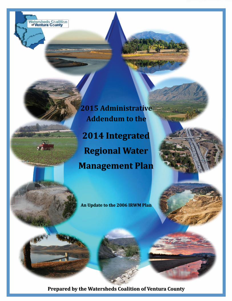
WATERSHEDS COALITION OF VENTURA COUNTY 2015 IRWM Implementation Grant Proposal
AUTHORIZATION AND ELIGIBILITY
Adopted Plan and Proof of Formal Adoption
The 2014 Watersheds Coalition of Ventura County (WCVC) IRWM Plan was adopted by WCVC (the Regional Water Management Group) on June 19, 2014. The adopted Plan was submitted to DWR on June 30, 2014 and deemed to be consistent with the Proposition 84 IRWM Plan Standards by DWR on July 29, 2014. Proof of adoption according to California Water Code §10543 was provided to DWR with the 2014 Drought Grant application and is therefore not included herein.
All five project proponents (see below) in this proposal have adopted the 2014 WCVC IRWM Plan along with many other entities. The resolutions of adoption for all entities adopting the Plan, including the four project proponents that did not previously adopt the Plan, are included in the 2015 Administrative Addendum, Appendix I, attached hereto. Included as proof of adoption are the following:
• Resolution of the Ventura County Board of Supervisors adopting the 2014 IRWM Plan on behalfof the Ventura County Waterworks District No. 1 - Moorpark
• Resolution of the City of San Buenaventura (Ventura Water) adopting the 2014 IRWM Plan• Resolution from Cal Trout adopting the 2014 IRWM Plan
• Resolution from Pleasant Valley Mutual Water Company adopting the 2014 IRWM Plan
The Camrosa Water District previously submitted proof of adoption to DWR as part of the 2014 Drought Grant Solicitation.
Attachment 1: Authorization and Eligibility Requirements 1-1
2014Integrated
RegionalWater
ManagementPlan
PreparedbytheWatershedsCoalitionofVenturaCounty
AnUpdatetothe2006IRWMPlan
2015AdministrativeAddendumtothe

2014 Integrated Regional Water Management Plan
2015 Administrative Addendum
TABLE OF CONTENTS
Introduction Section 1.0 – Ventura River Watershed Management Plan Section 2.0 – IRWM Plan Adoption Section 3.0 – Summary and Findings of Special Planning Studies
A. Las Posas Conjunctive Use Study – Phase 2
B. Lower Santa Clara River Watershed Salt and Nutrient Management Plant
C. Anticipated Benefits of Special Studies
D. Incorporation of Special Studies into WCVC IRWM Plan
Section 4.0 – New Implementation Projects for Inclusion in the Plan
1
2
3
4 4
8
12 18
19
a) Introduction 19
b) Process to Develop Administrative Addendum 20
c) Summary of Projects Included in Administrative Addendum 22
d) Consistency with IRWM Plan Objectives 27
e) Projects Included in Prop. 84 Grant Proposal 30
Appendix C (Revised) – Ventura River Watershed Management Plan
Appendix H (Revised) – Additional Special Studies
Las Posas Conjunctive Use Study Phase 2
Lower Santa Clara River Watershed Salt and Nutrient Management Plan
Appendix I – Resolutions of Adoption
Appendix J – Summary of Meeting – WCVC General Membership
40 56
57 108

2014IntegratedRegionalWaterManagementPlan 2015AdministrativeAddendum
INTRODUCTIONTheWCVC Integrated RegionalWater Management (IRWM) Plan is a guiding document for watermanagement programs and projects being implemented throughout theWatersheds Coalition ofVenturaCounty(WCVC)IRWMRegion.In2006,theWCVCadoptedtheIRWMPlan.Morethan30entities,includingall10citiesaswellaswaterdistricts,specialdistricts,theCounty,andotherentitiesadoptedtheIRWMPlan.In2010and2013respectivelyadministrativeaddendumswerepreparedtoaddnewprojects,forthepurposesofapplyingforsubsequentroundsofProposition84ImplementationGrantfundingandtoaddressobjectivesandprioritiesintheIRWMPlan.In2014theWCVCcompletedanupdatetotheIRWMPlantoaddresschangesthathaveoccurredsince2006andtobringthePlanintocompliancewiththe2010Proposition84IRWMPlanStandards.InJune2014theIRWMPlanwasadoptedbyWCVC,theCountyBoardofSupervisorsandotherentities.SubsequentlyanumberofotherlocalentitiesadoptedorsupportedthePlan.This2015AdministrativeAddendumtothe2014IRWMPlanhasbeenpreparedinordertoincludeinformationthatwasnotavailableatthetimethe2014IRWMPlanwaspublished.ThefollowinginformationisincludedinthisAddendum,andisherebyincorporatedintothe2014IRWMPlan:
FinalVenturaRiverWatershedManagementPlan(replacesoldAppendixC) ResolutionsofPlanadoptionbyWCVCstakeholders(AppendixI) FindingsandresultsoftwospecialstudiesconductedaspartofaProposition84PlanningGrant
(RoundTwo)–LowerSantaClaraRiverWatershedSaltandNutrientManagementPlan;andLasPosasConjunctiveUseStudyPhase2.(RevisedAppendixH)
ProjectsbeingaddedtothePlanfor inclusioninthe2015SolicitationfortheProposition84IRWMImplementationGrant.
Managementofwater resources isanongoingprocess. TheWCVC IRWMPlan isdynamicdocument.AsinformationchangesthePlanwillbeperiodicallyamended.
1
2014IntegratedRegionalWaterManagementPlan 2015AdministrativeAddendum
1. VENTURARIVERWATERSHEDMANAGEMENTPLAN
TheVenturaRiverWatershedCounciladoptedtheVenturaRiverWatershedManagementPlanonMarch5,2015.ThePlan,thefirstofitskindintheWatershed,isacomprehensivedocumentwhichcontainsfourpartsandanexecutivesummary,andcanbedownloadedasacompletedocument(800+pages),orasindividualplansections. TheWatershedManagementPlanismeanttoserveasbothaplanandacomprehensiveonlineresourceofinformationaboutthewatershed. Facts, descriptions, and analyses are available on a wide range of topics, allpresentedinstyleofwritingmeanttobeaccessiblebyageneralaudience.When the 2014 WCVC IRWM Plan was adopted in 2014, the Ventura River WatershedManagementPlanwasstillunderdevelopment.AppendixCcontainedaninterimversionofthe Watershed Management Plan. The completed, adopted Ventura River WatershedManagementPlannowreplacesthecontentintheoriginalAppendixC.PleaseseeAppendixCinthisAddendumfortheExecutiveSummaryoftheWatershedManagementPlan.A full copy of the Plan can be found on the Council’s website athttp://venturawatershed.org/the‐watershed‐plan and also on the WCVC Website at:http://vcportal.ventura.org/WCVC/IRWMP/2014/Appendix_C.pdf
2

2014IntegratedRegionalWaterManagementPlan 2015AdministrativeAddendum
2.2014WCVCIRWMPLANADOPTIONThe2014WCVCIRWMPlanwasadoptedbytheWatershedsCoalitionofVenturaCountyinJuneof2014andwassubsequentlysenttotheDepartmentofWaterResourcesforreviewandapproval.ThePlanwasdeemedbyDWRtobecompliantwiththeIRWMPlanStandardsinlateJulyof2014.Since that time the Plan has been adopted by a number of local stakeholders. Appendix IcontainstheresolutionsofadoptionandlettersofsupportfromstakeholdersintheRegion.AsadditionalentitiesendorseoradoptthePlan,theywillbeaddedtoAppendixI.
3

2014IntegratedRegionalWaterManagementPlan 2015AdministrativeAddendum
3.SUMMARYANDFINDINGSOFSPECIALPLANNINGSTUDIESLowerSantaClaraRiverWatershedSaltandNutrientManagementPlanandLasPosasConjunctiveUseStudyPhase2.(SeeRevisedAppendixH)On behalf ofWCVC the Ventura CountyWatershed Protection District received a Round 2Proposition84IRWMPlanningGranttoconducttwospecialstudies(LowerSantaClaraRiverWatershedSaltandNutrientManagementPlanandLasPosasConjunctiveUseStudyPhase2)that would benefit implementation of the WCVC IRWMP Plan. The special studies wereselectedtoenhancetheIRWMPlanbyprovidingcriticalinformationonthestatusoftwooftheRegion’smostimportantwaterresources–groundwaterandrecycledwater.The IRWMP is a dynamic planningdocument. There is an ongoingprocess for keeping theproposedprojectlistup‐to‐datethroughregularupdateswithadditionalrevisionasneededasconditions change, funding is identified, projects are implemented and objectivesrefined.ThesetwospecialstudieshaveidentifiedspecificprojectsthatwillassisttheRegioninmeetingvariousgoalsandobjectives.Theprojectsproposedbythespecialstudiesarebeingvettedfor implementationthroughtheapplicablewatershedcommitteesandultimatelytheWCVCgeneralmembership,consistentwiththeWCVCCharter.Informationaboutthetwostudiesincludingfindingsarepresentedbelow.A. LasPosasConjunctiveUseStudy–Phase2
OverviewIncreasingsalinitylevelsinbothgroundwaterandsurfacewaterwithinVenturaCountyandtheCalleguasCreekwatershedposeanumberofproblemsforcertainbeneficialuses.Risingsalinity is harmful to agriculture, primarily for growers of high‐value strawberries andavocados,whoareincreasinglyunabletouselocalsurfacewaterorgroundwaterforirrigationwithoutreducingagriculturalproductivity.Highsalinitylevelsinsoilsandsurfacewatercanalso be detrimental to sensitive habitat.Additionally,water supplieswithin theRegion areheavilydependentonimportedwatersourcesandfacethechallengeofgroundwateroverdraft.Unfortunately,somelocalgroundwaterresourcesaremarginalduetowaterqualityconcerns,primarilysalts.Thepurpose of the LasPosasConjunctiveUse Study (Study)was to better understand theopportunitiesandconstraintsfordevelopingtheselocalgroundwaterresources.Developmentofthecurrentlyunderutilizedshallowbrackishgroundwaterresourcesprovidesaframeworkfor advancingbrackishgroundwaterproduction, treatment, anddistribution toagricultural
4

2014IntegratedRegionalWaterManagementPlan 2015AdministrativeAddendum
usersoverlyingthebasinsinordertoresolvethesewater‐relatedconflictsandimprovelocalwatersupplyreliability.TheStudywasconductedintwoseparatephases:
Phase 1 identified existing water supply and distribution infrastructure within theStudy area, including the installation of three new shallow aquifer groundwatermonitoringwellsintendedtoprovidefurtherdatatoinformtheStudy;and
Phase 2 developed and evaluated potential alternatives to produce brackishgroundwater, treat it, and distribute blendedwater to agricultural userswithin theStudy area. This phasewas funded in part by a Round Two Proposition 84 IRWMPlanningGrant,administeredbytheCaliforniaDepartmentofWaterResources.
Results of this Study found that opportunities to construct one ormore desalters to treatexisting chloride‐impactedwells and provide blendedwater suitable for chloride‐sensitivecrops is feasible, although the cost‐effectiveness depends on the water quality goal to beachieved and the size and location of the desalter facility and associated conveyanceinfrastructure.
Figure1–LasPosasConjunctiveUseStudyPhase2Area
5

2014IntegratedRegionalWaterManagementPlan 2015AdministrativeAddendum
FindingsandConclusions–LasPosasConjunctiveUseStudyThe purpose of the Study was to better understand the opportunities and constraints fordeveloping the currently underutilized shallowbrackish groundwater resourceswithin theEast and South Las Posas basins. The groundwater resources of the shallow aquifer areconsidered to be underutilized due to the potential to receive increased recharge fromstreamflowpercolationiftheaquiferwasmanagedinsuchawaythatitisnotalwaysfullornearly full. By increasing pumping in the shallow aquifer it may be possible to captureadditionalrechargefromtheArroyoSimi/LasPosastooffsettheincreasedshallowpumping,whilealsopreventingamaterialdecreaseinrechargetotheunderlyingFoxCanyonAquifer.The Study thereby provides a framework for advancing brackish groundwater production,treatment,anddistributiontoagriculturalusersoverlyingthebasinsinordertoresolvewater‐relatedconflictsandimprovelocalwatersupplyreliability.Brackishwaterwithelevatedchloridelevelsislimitingtheproductivityofchloride‐sensitivecrops,suchasstrawberriesandavocados,bylocalgrowers.Somegrowerspurchasepotablewaterforblendingtoachievelowerchloridelevels,whileotherschoosetogrowcropsthataremore salt tolerant. Some of the Mutual Water Companies (MWC) that provide water forirrigationareconsideringdesaltingtoaddressthewaterqualityneedsofareagrowers.TheMWCwellsmostimpactedbyhighchloridesaretheZoneMWCwellslocatedintheEastLasPosasbasinandtheArroyoLasPosasMWCwell,withchlorideconcentrationsintherangeof160to220mg/l.TheBerylwoodMWCwellsarenotcurrentlyimpactedbyhighchlorides,but are predicted to be impacted at levels similarwithin the next five to ten years as thechlorideplumemigratesnorth.Theopportunitytoconstructoneormoredesalterstotreatexistingchloride‐impactedwellsand provide blended water suitable for chloride‐sensitive crops is feasible. The cost‐effectivenesswilldependonthewaterqualitygoaltobeachievedandthesizeandlocationofthedesalterfacilityandassociatedconveyanceinfrastructure.Constructing multiple desalters (Alternative 3) offers the most flexibility for phasingconstructiontomeetstakeholderneeds,andisalsothemostcost‐effectivealternatives.Thedesalterswould be located at or near the chloride‐impactedwells tominimize newpipingrequiredtoconveyrawandblendedwatertoandfromthedesalter(s).Theselocations,andinparticulartheZoneMWCdesalternearLosAngelesAvenueandLaCumbreRoad,arelocatedin close proximity to the SMP alignment along Los Angeles Avenue. Blendedwater can bedistributedusingtheexistingMWCsystemstogrowerscurrentlyusinghighchloridewater.TheZoneMWCdesaltercouldbeconstructedfirsttotreatZoneMWCWell#20andprovideblendedwatertotheeasternportionoftheirservicearea(about1200acres).TheBerylwoodHeightsMWCcouldbeconstructedinthefutureasthechlorideplumemigratesnorthandtheBerylwoodHeightsMWCwellsbecomeimpacted(about1,300acres).TheArroyoLasPosas
6

2014IntegratedRegionalWaterManagementPlan 2015AdministrativeAddendum
MWCdesaltercouldbeconstructednoworinthefuturetoprovideblendedwaterwithinitsservicearea(about380acres).The opportunity to develop the Shallow Aquifer is feasible by constructing new wells toprovidemakeupwaterforthedesalterbrineloss,andtoprovideasourceofwaterforVCWWDNo.19agriculturalcustomers.BasedonrecenthydrogeologicinvestigationsintheStudyarea,it appears that the new shallow wells could be constructed near the Arroyo Las PosassouthwestofthepotentiallocationfortheZoneMWCdesalter.Theopportunitytodistributedesaltedwatertoabout670acresofVCWWDNo.19agriculturalcustomersbywheelingthroughtheexistingZoneMWC,BerylwoodHeightsMWC,andArroyoLasPosasMWCsystemsappears feasible,basedonpreliminary (screening level)hydraulicanalysis.However,theanalysisisbasedoncertainassumptionsforsystemdemands,pointsofconnection,andpeakflowsthatwouldneedtobeverifiedbeforeanyplansareimplemented.FutureStudiesandOtherConsiderationsSeveral ideas were identified during discussions with the stakeholders that could offeropportunitiesforfuturestudieswiththepotentialtoenhancetheuseand/orcosteffectivenessofaregionaldesalter foragriculturaluse.The followingrepresents thekey ideasthatwereidentified.
Reduce capacity of desalter for peaking. The preliminary desalter sizes providesufficientcapacitytomeetpeakdemandswithallgrowerspumpingtheimpactedwellsatcapacityatthesametime,inordertomaintainthecurrentlevelofserviceatthewaterqualitygoals.Thesizeofthedesaltercouldbereducedifhigherchloridelevelswereacceptableduringshorterperiodsofpeakdemand,withoutadverselyimpactinglongtermcropproductivity.Theremayalsobeimprovedefficienciesassociatedwithalowerchloride supply that helps reduce peak demands. Preliminary discussions bystakeholders suggested that a 5 to 10% reduction in peaking capacity may beacceptable.
Baseloadchloride‐impactedwellstoimprovebasinmanagementanddesalterruntime.
Theevaluationassumedthedesalterwouldrunseasonally,basedonruntimesofthechloride‐impacted wells estimated from annual production and well capacities.However,certainchloride‐impactedwells,iftreated,couldbepumpedmorethroughouttheyearinordertooffsetpumpingfromtheWestLasPosasbasinwellslocatedinapumpingdepression,andhelpwithoverallgroundwatermanagementintheLasPosasBasin. This also offers the benefit of increased run‐time for the desalter providingimprovedcapitalcostrecoveryforthefacility.
7

2014IntegratedRegionalWaterManagementPlan 2015AdministrativeAddendum
Constructadualusedesalterthatcanprovidewaterforagriculturalcustomersduringthegrowingseason,andpotablewaterformunicipalandindustrial(M&I)customersduringotherperiodswhenitisnotusedtomeetagriculturaldemands.VCWWDNo.19hasexpressedinterestedinfurtherstudyanddevelopmentofadesalterprojectintheSomisareaforbothagriculturalandM&Iuses.Potablewaterfromaregionaldesaltercouldalsobeinjectedintotheaquiferthroughexistingand/ornewAquiferStorageandRecoverywells.
Considerformationofanew,regionalMWCtoallowindividualMWCandstakeholders
topurchasesharesinaregionaldesalterfacilitytoprovideflexibilityforwatertransfersamongMWCsystems.ExistingMWCsystemssupplywatertotheircustomersandareprecludedfromthetransferofwaterbetweensystems.
B. LowerSantaClaraRiverWatershedSaltandNutrientManagementPlan
(excerptsfromtheLowerSantaClaraRiverWatershedSaltandNutrientManagementPlanpreparedbyLarryWalkerAssociates,Corollo,HydrometricsWRI,RinconConsultantingandDr.NormBrowninApril2015)OverviewIn February 2009 the StateWater Resources Control Board (StateWater Board) adopted theRecycled Water Policy, which requires the development of regional or sub‐regional salt andnutrientmanagement plans (SNMPs) for groundwater basins in California. The purpose of theRecycledWaterPolicyistoincreasetheuseofrecycledwaterfrommunicipalwastewatersourcesconsistent with state and federal water quality laws. Since recycled water contains salts andnutrientsthatmaycauseorcontributetoexceedancesofwaterqualityobjectives,managementoftheseconstituentsinrecycledwaterprojectsisimportant.ThisdocumentprovidestheSNMPfortheLowerSantaClaraRiver(LSCR)Watershed,locatedinVenturaCounty.TheLSCRSNMPcoversthePiru,Fillmore, SantaPaula,MoundandOxnardForebaysub‐basinswithin theLowerSantaClaraRiverGroundwaterBasin.TheSNMPareaincludesthecitiesofFillmore,SantaPaula,andSanBuenaventura(Ventura)andsmallunincorporatedcommunitiesinVenturaCounty,andincludessevenwastewatertreatmentplants (WWTPs). Five of theWWTPs have actively participated in the SNMPdevelopment andprovidedinputintopotentialfutureplansforrecycledwaterprojects.TheLSCRSNMPhasbeendeveloped as a comprehensive planning document that provides all of the key technicalinformationnecessarytomeettherequirementsoftheRecycledWaterPolicy.TheSNMPhasalso
8

2014IntegratedRegionalWaterManagementPlan 2015AdministrativeAddendum
beendevelopedasaflexibleplanningdocumentthatcanguidethemanagementandregulationofdischargesofsaltsandnutrientsinthecontextoftheuniquecharacteristicsofthewatershedandthecurrentstatusof recycledwaterprojectplanning.Whileallof theparticipatingwastewateragencieshaveplanstorecyclewater,onlyafewspecificrecycledwaterprojectlocationshavebeenidentified.Mostoftheplansaremoregeneral,includinggoalsforvolumesofrecycledwatertobeused,butthespecificprojectlocationsfortherecycledwaterapplicationsarestillbeingidentified.To accommodate the range of stages of recycledwater planning in the SNMP area, the SNMPincludes required background information and an assessment of the groundwater basins,providing a description of water recycling and stormwater recharge goals and objectives,quantificationofsources,identificationofloadingestimates,estimatesofassimilativecapacity,anddescriptionoffateandtransportofsaltsandnutrients.Basedonthistechnicalinformation,alistof project scenarios encompassing the potential projects found in the recycledwater planningdocumentsandmanagementmeasureswas identified.TheSNMPprovidesanevaluationof thefuturescenarios,developsastructureforevaluatingspecificprojectsastheyareimplementedinthefuture,andidentifiesmanagementmeasureswhereappropriate.TheSNMPbuildsonarangeofwaterqualitymanagementpoliciesandmechanismsalreadyinplaceorbeingimplemented,andisaccordinglyfocusedonmanagementofincreasedrecycledwaterutilizationtobenefitthestudyarea.
Figure2LowerSantaClaraRiverSNMPArea
SNMPGOALSANDOBJECTIVESAkeyreasonfordevelopingtheLSCRSNMPistostreamlinerequirementsandencourageuseofrecycledwaterasanalternativewatersupplytohelpthestatemeetincreasingwaterdemands.Agenciesintheregionareplanningforandimplementingsuchrecyclingprograms.Stakeholdersin the LSCR watershed are reliant on groundwater for almost all of the local water supply.SignificantagriculturalusersofgroundwateralsoexistintheLSCR.Inadditiontowaterrecycling,
9

2014IntegratedRegionalWaterManagementPlan 2015AdministrativeAddendum
stormwater management practices to implement low impact development (LID) will supportgroundwaterrechargetosupplementthegroundwatersupply.TheoverarchinggoaloftheLSCRSNMPisto:protect,conserve,andaugmentwatersuppliesandtoimprovewatersupplyreliability.Thisgoalissupportedbyobjectivesof:•ProtectingAgriculturalandMunicipalDrinkingWaterBeneficialUsesofgroundwater;•Supportingincreasedrecycledwateruseinthebasin;• Facilitating long‐term planning and balancing use of assimilative capacity and managementmeasuresacrossthebasin;•EncouraginggroundwaterrechargeintheSantaClaraRiver(SCR)valley;and•Collecting,treating,andinfiltratingstormwaterrunoffinnewdevelopmentandredevelopmentprojects.The SNMPhas beendeveloped to support these general goals andobjectives.Additionally, thestakeholdershaveidentifiedrecycledwaterandstormwateruseandrechargegoalsfortheSNMP.ProjectScenariosRuralandopenspacedominatethewatershed(>69%),thesourcesofsaltsandnutrientsthatcanbe managed have been and are expected to be consistent over time, and no trends in theconstituents of concern have been observed in most wells in the SNMP area. As a result, thedevelopmentofprojectscenariosforevaluationintheSNMPfocusedonrecycledwaterprojects.Therecycledwaterpurveyorsinthewatershedareinvariousstagesofdevelopingrecycledwaterprojects. A number of planned projects have been identified but only the Ventura CountyWaterworksDistrict 16 – PiruWWTPhas advanced to the point of identifying specific projectlocations.AspartoftheSNMP,fourscenariosweredeveloped.Tocovertherangeofpossiblerecycledwaterscenarios,threevolumesofrecycledwaterwereconsideredplusoneadditionalscenario.ThesescenariosaredescribedintheSNMP.Inadditiontotherecycledwatervolumeandassociatedwaterquality,thelocationoftherecycledwateruseisimportant.Asdiscussedpreviously,allofthewastewaterdischarges,exceptfortheVWRF, either recycle or discharge all of their effluent to the groundwater through percolationponds.Iftherecycledwaterwillbeusedinthesamesubareaasthecurrentdischarge,thenanyrecycled water projects up to the current discharge volume would not be new loads to thegroundwatersubarea.However,iftherecycledwaterisappliedinadifferentsubarea,itmaybeanew load to that subarea and a reduction in load in the subarea currently receiving the load.Therefore, the locationof therecycledwaterprojectscenarios isalso important.SantaPaula isconsideringrecycledwaterprojectsinthesamesubareatowhichtheycurrentlydischargeandinadjacentsubareas.Asaresult,theSNMPalsoincludesconsiderationofscenariosforSantaPaulathatinvolvedischargestodifferentsubareasandthesamesubarea.
10
2014IntegratedRegionalWaterManagementPlan 2015AdministrativeAddendum
ImplementationMeasures toManage Salt andNutrient Loading in theGroundwaterBasinonaSustainableBasisTheprimarygoaloftheSNMPistoprotect,conserve,andaugmentwatersuppliesandimprovewatersupplyreliability.RecycledwaterprojectsserveakeyroleintheSNMPareatosupportwatersupplyreliability.However,theimplementationoftheprojectsneedstobedoneinawaythat ensures the protection of the groundwater basin. This section outlines existingmanagementmeasuresthatarecurrentlyinplaceintheSNMPareathatwillbemaintainedunderanyfuturescenarioandoutlinesaprocessforevaluatingrecycledwaterprojectsanddetermining whether additional management measures are needed. Potential futuremanagementmeasuresareidentifiedthatcanbeselectedifneededtoimplementaplannedproject.ExistingManagementMeasuresTheobjectiveofSNMPimplementationmeasuresistomanagesaltandnutrientloadingsonasustainable basis and to maintain long term supply for multiple beneficial uses. Per theguidance provided in the document, RegionalWater Board Assistance in Guiding Salt andNutrientManagementPlanDevelopmentintheLosAngelesRegion,thesestrategiesshouldbetailoredtobasinspecificcharacteristicsandconditions,butshouldbegenerallyfocusedon:•Pollutionprevention;•Sourceloadreductionstogroundwaterbasins;•Treatmentandmanagementofareasofimpairedwaterquality;•Boostingorstabilizingdecliningwaterlevelswherewaterqualityisnotaffected;•Increasinggroundwaterrechargebystormwater;and•Increasingrecycledwateruse.IntheLSCRplanningarea,saltandnutrientmanagementhasbeenongoingforanumberofyears.Thereareanumberofexistingmanagementmeasuresandactivitiesthatcontributetoreducingloadsandimprovinggroundwaterquality.Theexistingmanagementmeasuresarecategorizedbysourceandpathwayforreducingsaltand nutrient contributions to the groundwater. For example, somemanagementmeasurespreventloadsfromenteringthebasin(e.g.,waterconservationorwatersoftenerbans),othersoffsetloadsfromanothersource(e.g.,changingthesourcewaterforanirrigationproject),andothersremoveloadingfromthebasin(e.g.,groundwatertreatment).Thecategoriesusedtodescribethemanagementmeasuresare:•Improvewastewaterandreclaimedwaterquality;•Improvemunicipalwaterquality;•Reducesepticsystemleachateandimprovequality;•Manageurbanstormwaterrunofftosupportbasinwaterquality;•Improvenon‐stormwaterdischargecontrolandquality;•Improveagriculturalrunoffcontrolandquality;
11

2014IntegratedRegionalWaterManagementPlan 2015AdministrativeAddendum
•Increaserecycledwateruse;•Increaseaquiferrechargewithlowerconcentrationwatersources;•Improveurbanandagriculturalwaterefficiency/conservation;•Reducesaltwaterintrusionandprotectgroundwaterquality;and•Managegroundwaterpumpingandwaterlevels.1SuchastheConditionalWaiverforDischargefromIrrigatedLands(OrderNo.R4‐2010‐0186.)2SuchastheVenturaCountyMS4Permit,OrderNo.R4‐2010‐0108.ApproachForEvaluatingProjectsAndIdentifyingNeedForPotentialFutureManagementStrategiesAssimilativecapacityisestimatedasthedifferencebetweenthewaterqualityobjectivesandtheexisting groundwater quality for eachbasin/subarea. Assimilative capacity is available in allsubareasexcept forTDS intheMoundbasin.Theoverallapproachtoevaluatingprojects isbasedonevaluatingtheamountofassimilativecapacity thatwouldbeusedbyaprojectorgroupofprojectsanddeterminingwhethertheamountofassimilativecapacityusedwouldresultindegradationofthebasinasoutlinedintheanti‐degradationanalysis.Ifaprojectwouldresult in degradation of the basin, managementmeasures can be selected from the list ofpotential futuremanagementmeasures tooffset the additional loading.Alternatively, a fullanti‐degradationanalysiscouldbeconductedfortheprojecttodetermineifthedegradationisoffsetbyimportantsocialandeconomicbenefitstothepeopleofthestate.ItisimportanttorememberthattheimplementationofrecycledwaterprojectsintheLSCRSNMP is in and of itself a management measure for sustainable management of thegroundwaterbasins.IntheLSCRSNMPprojectarea,thegroundwateristheprimarysourceofagricultural andmunicipalwater supply. Recycledwater projects provide amechanism tooffsetgroundwateruseandthereforecontributetotheavailabilityofgroundwatersupplies.Additionally,usingrecycledwatertoirrigatevegetationinsteadofdisposingoftheeffluentinpercolationpondsreducestheloading,particularlyofnutrients,thatreachesthegroundwaterthroughuptakeofnutrientsandsaltsbytheplants.
C. AnticipatedBenefitsofSpecialStudiesIncludeRegionalProjectsTheIRWMPUpdate,which includesthesetwostudies,will includeprojectsproposedbythestudies currently being vetted for implementation through the watershed committees andultimatelytheWCVCgeneralmembership(consistentwiththeWCVCCharter).Theseprojectswillbecomepriorityprojectsforfuturefunding. Theresultsofthetwostudiesarebeingusedto informplanstoprotectandaugmentregionalwatersupplies,enhanceefficientwateruse,and improve the supply reliability across the region. The studies have become invaluableresources fortheRegion,especiallyduringthecurrentperiodofdrought.
12
2014IntegratedRegionalWaterManagementPlan 2015AdministrativeAddendum
EffectivelyIntegrateWaterManagementProgramandProjectWithinaRegionTheLSCRPlanallowsmultipleagenciestocontinuetouseand/orexpanduseofrecycledwaterintheirserviceareas. ItbenefitsfourseparategroundwaterbasinsoftheLowerSantaClaraRiver:Mound, SantaPaula, Fillmore, andPiru basins,which in total underlie 67,300 acres(105 squaremiles)ofVenturaCounty.Intotalthesebasinsprovideanaverageof86,100acre‐feet of water for multiple beneficial uses in the County. The Regional LSCR Plancomprehensively addresses all four basins, thewaterusers, and contributors of salts andnutrients in the study area. This avoids the need to develop separate salt and nutrientmanagementplansforeach groundwaterbasinand/orindividualrecycledwaterprojects.
For many years, the Region has undertaken great efforts to implement recycled waterprograms. TheRegionalLSCRPlanisanecessaryextensionoftheselocalefforts.Itprovidesimportant opportunitiesforincreasingregionalsupplyreliabilitywhilereducingdependenceon imported water through increased use of recycledwater and adequate protection ofgroundwatersupplies.
Efforts tomanage theLasPosasBasin sustainablyhave consistentlyhad a strong regionalfocus, whichincludestheLasPosasStudy.Thisstudybenefitsthemultipleanddiversewaterusers in theLasPosasBasinbyincreasingregionalwatersuppliesandenhancingbeneficialusescurrently impactedbysalinityinthebasin.ThisstudybenefitsawidestakeholderbasefromacrosstheLas Posas Valley. In addition to the UnitedWater Conservation District,CalleguasMunicipalWater District,and theCountyofVentura,principal interestsare localgroundwaterpumpers that includecities,mutualwatercompaniesandwaterdistricts,andagricultural interests.TheLas PosasValleyGroundwaterBasinencompassesasurfaceareaof42,200acres(66squaremiles), ofwhichtheEastandSouthLasPosasBasinsmakeupthemajority.Currently,theEastandSouth LasPosasBasins(thebasinsaddressedbythestudy)supplyover30,416acre‐feetperyear,with the majority of water extractions used foragricultural purposes (Fox Canyon Groundwater ManagementAgency, Annual Report,2014).
WhiletheLasPosasStudydirectlyenhancesopportunitiesforbrackishwaterproductioninthe Las Posas Valley, this study represents a basin‐wide effortwith far‐reaching regionalbenefits. TheCalleguasCreekWatershed,inwhichtheLasPosasBasinislocated,isheavilydependenton importedwater for its supplies.Formanyyears, theRegionhasworked toimprovelocalwater supply, as evidenced by the construction of the SalinityManagementPipelineandplansfor futuredesalters.TheLasPosasStudyandassociatedresultsprovidea critical framework for advancingsimilareffortsinotherbasinsoftheRegion.Thestudyestablishes effectivemethods and opportunities for desalting of brackish groundwatersupplies, which remains one of few meanstoaugmentregionalwatersupplies.Itthereby
13

2014IntegratedRegionalWaterManagementPlan 2015AdministrativeAddendum
represents a crucial step towards increasing regional water supply with untappedgroundwater sources and in turndecreasing dependenceonimportedwaterintheRegion.
EffectivelyResolveSignificantWater‐RelatedConflictsThe special studieswill effectively resolvewater‐related conflict bothwithin and betweenregions byaddressingcritical issuesassociatedwithwatersupply,watersupplyreliability,and water quality through a stakeholder process. By establishing a more thoroughunderstandingofthe basinswithupdatedandmorecompletedata,thespecialstudieswillallow the scale of local resourceissues,suchastheextentofsaltandnutrientimpacts,tobetterbedefined.Asaresult,water‐relatedconflictscanbetterbeanticipated,addressedorresolved.Priortothisstudy,no individualorregionalsaltandnutrientmanagementplan(s)existedforanyofthelowerSanta ClaraRivergroundwaterbasins.Byworkingtogether,theidentifiedpartiespooled their resourcestowardcommondatasharing,analysesandreportwriting.TheRegionalLSCRPlanwill enablecooperationamongallinterestedpartiesandwillalsoprovideadirectforumfor coordinationwiththeUpperSantaClaraIRWMPRegion.Thiswillhelpresolvepotentialconflicts betweenwatermanagers andusers in both theUpperandLowerportionsof thewatershed. Futureconflictsrelatedtogroundwaterwater‐qualityissuesthatmightarisefromfuturerecycled waterprojectsoverlyingthefourbasinsoftheLowerSantaClaraRivercanbemitigatedwiththe helpofthegroundwatermonitoringplanandsaltandnutrientsourceidentificationconducted undertheRegionalLSCRPlan.
By addressingmultiple common regional objectives andwith a strong stakeholder drivenregional approach,theLasPosasStudyalsogreatlycontributestoresolvingwater‐relatedconflictsinthe Region.OneofthegoalsoftheLasPosasStudywastopreventtheneedforbasinadjudication. Thebasinhassomezoneswithmoderatetogoodwaterqualityandotherzonesthatarebrackish andunusable.Developmentandtreatmentofthebrackishwaterwillreducethestressonthe zones that are currently over‐pumped andwill allow both urbanandagriculturalusestobe addressed.Thenewinformationprovidedbythestudywillenablemore effective planning and enhanced response to regional issues, resulting in conflictresolution.
ContributetoAttainmentofoneorMoreObjectivesoftheCALFEDBay‐DeltaProgramBoth special studies will help to increase regional water supply reliability by identifyingopportunitiesformoreefficientandsustainableuseoflocalsupplies.Asaresult,demandfor,anddependenceon,importedwatersupplieswillbereduced.ThisdecreaseddependencyonBay‐Delta was will increase water supply availability and improve water quality foralternative uses, as well as improve and increase aquatic and terrestrial habitats andenhanceecosystem healthintheDeltasystem.
AddressCriticalWaterSupplyandWaterQualityNeedsofDisadvantagedCommunities(DAC) ThespecialstudieseffectivelyaddresswatersupplyandwaterqualityneedsofDACs
14

2014IntegratedRegionalWaterManagementPlan 2015AdministrativeAddendum
dependent onwatersupplies located inthespecialstudyareas. Thereare largepocketsofDACs in the communityofPiruandtheCityofSantaPaula. TheLSCRwillprotect bothwaterqualityandwatersupplyavailabletothesecommunities.TheLSCRstudywillhelpbalance the need for additional water supplymade available through recycled waterwhile protectingsupplies foragriculture, and importantaspectof the local economy thatsupports manyoftheDACs.
There isalsoapocketofhouseholdsqualifyingasaDACintheSouthLasPosasBasin. TheLas Posas Studywill help address the salinity issues in this basin, enhancewater supplyreliability, andprotect a low costwater supply available to agriculturalusers, critical forboththe documentedDACsandthosethatcannotbeeffectivelyidentifiedduetotheirmigrantnature.EffectivelyIntegrateWaterManagementwithLandUsePlanningThere has been a strong focus on integrating land use planning throughout the IRWMprocess, includingongoingcollaborationwiththeVenturaCountyResourceManagementAgency, PlanningDivision,aswell as involvementof local citiesthroughtheCity/CountyPlanning Association. The special studies will enhance the link between water and landuse planning including:
Promotingwatermanagementstrategiesconsistentwithlandusepolicies; Promotingtheuseanddeliveryofrecycledwater,whichrequiresin
depth understandingofcurrentandfuturelanduses; FacilitatinglandusepoliciesthatprotectandpreservetheCounty’simportant
agricultural lands;and Promotingbetterunderstandingbylanduseplannersofavailablewatersuppliesto
meet futureneedsasprojectedinlanduseplans.TheRegionalLSCRPlanandtheexpansionofrecycledwaterintheRegionarecloselytiedtoland useplanningandprovidesignificantopportunityfor further integrationwithwatermanagement. Oneoftheprimarybenefitsofwaterrecyclingisaugmentingwatersuppliesandbeingableto offsetpotablewaterdemand.
Given the importanceof agriculture to the local economy, thepreservationofagriculturalresources,includingaccesstowaterresources,isapriorityoflocallanduseentities.In2009the estimatedgrossvalueforVenturaCountyagriculturewas$1,623,857,000.TheVenturaCounty GeneralPlanstatesthatitisCountypolicyto:
Preserve and protect irrigated agricultural lands as a nonrenewable resourceto assurethecontinuedavailabilityofsuchlandsfortheproductionoffood,fiberand ornamentals.
15

2014IntegratedRegionalWaterManagementPlan 2015AdministrativeAddendum
BoththeRegionalLSCRPlanandtheLasPosasStudyprovidethedataneededtopreservethe qualityandqualityofwaterfortheimportantagriculturalusesinthecounty.
ActionsDesigned to Integrate theStormwaterResourcePlanRequirementsof IRWMPlan Stakeholders in Ventura County, through their TMDL implementation plandevelopment are creatingaresourcedocumentthatwillcontainrecommendedactionstoguide implementation of a watershed‐based strategy for stormwater management. Inaddition, as outlined in the TechnicalGuidanceManualpreparedbytheCountyofVenturaaspartoftheStormwater(MS4) Permit,theManual’s intentistoguidethedevelopmentcommunityinminimizingwaterquality impactsoffuturedevelopmentinVenturaCounty,through new countywide National Pollutant Discharge Elimination System (NPDES)stormwaterpermit.TheLasPosasStudyprovidesinformationonconjunctiveusepotentialinthatBasin.Thiswillbe the first step in identifying opportunities to augment local water supply throughgroundwater rechargeorstorageforbeneficialreuseofstormwater.
DroughtPreparednessTheoutcomeofthespecialstudieswillpositiontheRegiontomoreeffectivelyaddresslong‐term droughts. They will help develop additional sustainable local water sources andincreasewater supplyreliability,evenduringextendeddryperiods.
Executionofthesestudiesachievesthefollowingspecificdrought‐relatedobjectives:
Promoteconjunctiveuseandwaterrecycling; Achievelong‐termreductionofpotablewateruse;and Improveeffectiveandefficientgroundwaterbasinmanagement.
TheLasPosasStudywillfacilitateanewlocalsourceofwatertoagriculturalusersintheLasPosas Valleybyproducingpreviouslyuntappedbrackishgroundwater.Analternativewatersupplywill alsobemadeavailabletoagricultureandothernon‐potableusesintheformofrecycledwater asaresultofthedevelopmentoftheRegionalLSCRPlan.Itisimportanttonote that recycled waterisconsideredtobeavirtuallydrought‐proofwatersourcewhoseavailabilityisunaffected by dry year conditions, unlike surfacewater supplies. In recentyears imported surface water sources have become increasingly less reliable due toprolonged dry conditions and increasing competing interests.Duringdroughtconditionsthere is also increased competition for regional groundwater resources. By makingadditionalnon‐potablewateravailableforappropriateuses, potablewatersupplieswillbemoreavailabletomeetwaterdemandsandasneededforother beneficialpurposesintheRegion.
UseandReuseWaterMoreEfficiently
16

2014IntegratedRegionalWaterManagementPlan 2015AdministrativeAddendum
Thespecialstudiesarecrucial inhelpingtheRegionmeetfuturewaterdemands,increasewater supply reliability, and adapt to climate change through more efficient use andincreasedreuseof existinglocalwaterresources.
Recycled water projects promoted through development of the Regional LSCR Plan willgreatly contribute toincreasing urbanandagricultural wateruseefficiency,particularlybybetter matching water quality to water uses. Potable water demand can be offset andtherebymore efficientlyused,byprovidingrecycledwaterinlieuofpotablewatertonon‐potableuses,such asagriculture,golfcourses,parksandotherlandscapeirrigation.
Additionally,thespecialstudieswillhelpaugmentlocalwatersuppliesandincreaseefficientuse byreducingtheamountofusablewaterexported fromtheRegion.Promotingwaterrecycling will allow wastewater effluent to be reused within the Region, instead ofdischargingittothe SantaClaraRiver,forexample,whereitsubsequentlyflowstotheoceanwithoutdirectfurther beneficialuse.TheLasPosasStudyalsoevaluatesthewaterqualityneedsofthevarioususersandidentifiesthe existinginfrastructureavailablefordeliveringwatertovarioususes.Theultimateresultwillbea planwherebywaterqualityis“matched”touseandthereforeusedmoreefficiently.
ClimateChangeResponseActionsThe special studies will augment local water supplies, thereby increasing local watersupply reliability and reducing demand for imported water. This will result in reducedwater‐related energydemandsandgreenhousegasemissions,asthedeliveryofimportedwater requires significantly more energy than that of local water supplies, includingtreated brackish and recycledwater.Thespecialstudieswillallowforthecontinueduseand expansion of recycled water, a supply that is anticipated to be reliable even givenpredicted climate change. Additionally, it can be anticipated that State Water Projectsupplieswillbecomeincreasingly unreliableasaresultofclimatechange,sothatimprovinglocalwatersupplyreliabilityachieved bythesespecialstudieswillbecomeanincreasinglyimportantclimatechangeresponsestrategy.
By protecting regional water sources andimproving water quality, the special studieswill improvetheRegion’sabilitytoadapttoclimatechange.
ExpandEnvironmentalStewardshipThe Regional LSCR Planwill facilitate use of recycled water in a way thatmay enhanceecosystem health. Forexample,theRegionalLSCRPlanwillmakeitpossiblefortheCityofVenturatodivert andrecyclebetween50to100percentofitswastewatereffluent,effluentthatwouldotherwise bedischargedtotheSantaClaraRiverestuary.
17

2014IntegratedRegionalWaterManagementPlan 2015AdministrativeAddendum
PracticeIntegratedFloodManagementTheLasPosasStudywillprovideopportunitiesforusingbrackishwaterfromtheshallowaquifer, therebypotentially freeingup storage capacity in thebasin. This couldprovideopportunitiesto integratefloodmanagementandstormwatercapturewithconjunctiveusestrategies.
By taking a basin‐wide approach, the Regional LSCR Plan will provide information onregional opportunities and constraints for dealing with critical regional water‐relatedconcerns and will result in effectivemanagement of the salts and nutrientswithin theRegion.
ImproveTribalWaterandNaturalResourcesThe Chumash are Native Americans that inhabited parts of several central and southcoast counties,includingtheCountyofVenturapriortoSpanishoccupation.TheChumashstillreside in Ventura County today. Some tribalmembershave been participants in theIRWMP process sinceits inception.AspartoftheWCVCIRWMPupdateNativeAmericanTribeswithinterestin VenturaCountyhavebeenidentified.Tribalmembershaveexpressedconcernsthatcontinued degradation ofwater quality and habitat qualitywill limit theirhistoricalabilitytoliveoffthe land, andultimately threatens the cultureof Chumash andindigenous peoples. The special studiesareonesteptowardsaddressingtheseconcerns.
EnsureEquitableDistributionofBenefitsThe special studies will improve and protect water quality while improving water supplyreliability in both the Santa Clara and CalleguasCreekWatersheds. Benefits of the specialstudieswillbe widelydistributedacrossmostofVenturaCounty.DACsarefoundinthe studyareasforboththeRegionalLSCRPlanandtheLasPosasStudy.DACsarecountedamongthekeyconstituenciesforoutreachactivitiesplannedaspartofthespecialstudiesandinputwill besoughtforindividualtests.
D. IncorporationofSpecialStudiesintoWCVCIRWMPlan
These two special studies and their findings – found in this 2015 AdministrativeAddendum–areherebyincorporatedintothe2014WCVCIRWMPlanandwillcontinuetoprovide important information to inform selection of integrated, multi‐benefitimplementationprojectsinthefuture.ForacopyofthefullPlan,pleasevisittheWCVCwebsiteatwww.watershedscoalition.org.
18

2014IntegratedRegionalWaterManagementPlan 2015AdministrativeAddendum
4.NEWIMPLEMENTATIONPROJECTSFORINCLUSIONINTHEIRWMPLANa. IntroductionThe IRWMPlan is a long‐term, dynamic planning document. Selection and implementation ofprojects is an ongoing process. Project needs vary as conditions change, funding is identified,projectsareimplementedandobjectivesrevised.Specificprojectproposalsareidentifiedatthetimeafundingsolicitationisreleased,andprojectsareselectedbasedonavarietyofcriteriaincludingtheirapplicabilitytothefundingrequirements,whetherornottheymeetmultiplegoals,theircontributiontoregionalclimatechangeadaptation,readinesstoproceed,statusofCEQAreviewandengineeringdesign,availabilityofmatchingfunds,andotherfactorsdiscussedinSection7.3.SubsequentlyanIRWMPlanAddendumispreparedthatincludesthespecificprojects.ThishasbeenthepastpracticeoftheWCVCIRWMRegionsincethefirstaddendumwaspreparedin2010.The 2014 WCVC IRWM Plan only includes a short list of specific projects planned forimplementationaspartofthe2014DroughtSolicitationforProposition84.The2014Plandoes,however, include a list of priority types of projects needed to address the Region’s goals andobjectives.Becauseitisverytimeconsumingforprojectproponentstodevelopdetailedprojectproposals, and those proposals can quickly become out of date, project proposals are onlydevelopedatthetimefundingbecomesavailableasstatedabove.Priorityprojects,andtheabilityoftheprojectproponentstoimplementthem,fluctuateovertime.Asaresultofthe2015IRWMImplementationGrantSolicitation,WCVCstakeholdersmetinMarchandApril to selectprojects fora regionalproposal.Theseprojectsarenowbeingadded to theIRWMPlanaspartofthis2015AdministrativeAddendum,inaccordancewiththeprocessoutlinedintheWCVCCharterandSection7.2ofthe2014WCVCIRWMPlan.TheseadditionalintegratedimplementationprojectsweredevelopedtoaddresstheIRWMPlanobjectivesandhelpmeettheRegion’swaterandwater‐relatedneedsandtoresolvewatermanagementconflicts.
19

2014IntegratedRegionalWaterManagementPlan 2015AdministrativeAddendum
b. ProcesstoDevelopAdministrativeAddendum
Overview:The process for adding projects to the WCVC IRWM Plan, and including them in subsequentproposals for funding, is detailed in Section 7 of the adopted 2014WCVC IRWMPlan. Theseprojects were reviewed by stakeholders in the three watershed committees, the SteeringCommitteeandtheGeneralMembershipasdetailedinthesectionthatfollows.Oncethefinalsuiteofprojectswasselectedandapproved,thisAddendumwaspreparedtoformallyaddtotheWCVCIRWMPlanthoseprojectsnotincludedinthe2014IRWMPlan.
DetailsoftheStakeholderProcess:The process to develop the Administrative Addendum began inMarch of 2015with a call forprojects ineachwatershed. Projectproponentspreparedandsubmitteddetailedproject inputformsthatcontainedinformationabouttheproject,includinghowitwasconsistentwiththeWCVCIRWMPlan. Eachof the threewatershedcommittees reviewed theproposedprojects for theirwatersheds.Eachprojectevaluatedwasdeterminedtobereadytoimplement,metthecriteriaforProposition 84 IRWM funding, and also met multiple goals in the WCVC IRWM Plan. TheProposition84Guidelinesincludecriteria,whichwereusedtoevaluatetheprojects.Thesecriteriarequirethattheprojectsbewell‐integrated,addresswatermanagementneedsintheWCVCIRWMRegion,meetstatewideprioritiesandprogrampreferences,addresstheneedsoflocalDACswhenpossible,improvewateruseefficiency,andbeotherwiseconsistentwiththeWCVCIRWMPlan.
InMarchandApril2015,eachofthewatershedcommitteesmettoreviewtheprojectinputformsandfinalizeandprioritizetheirlistofprojectstobeconsideredbytheWCVCSteeringCommitteeforinclusionintheProposition84ImplementationGrantproposal.
OnApril27,2015theSteeringCommitteeunanimouslyagreedtorecommendapprovalof5ofthe6projectsforinclusioninthefinalsuiteofprojectsfortheProposition842015ImplementationGrantSolicitation(finalround)proposal.
OnApril29,2015theWCVCGeneralMembershipunanimouslyratifiedtheSteeringCommittee’srecommendation toapprove thesuiteof5projects for the ImplementationGrantproposal andauthorized staff to prepare the 2015 IRWM Plan Administrative Addendum including all sixprojectsreviewed,asdescribedinthemeetingsummaryprovidedinAppendixJ.Table1providesasummaryoftheWCVCstakeholderactionsregardingprojectselection.
20

2014IntegratedRegionalWaterManagementPlan 2015AdministrativeAddendum
Table1ProjectAdditionandApprovalMilestones
Committee Action DateActionTakenWatershedsCoalitionofVenturaCounty–GeneralMembership
Initiatecallforprojects March2015
AllWatershedCommittees ReviewProposedProjects March‐April2015CalleguasCreekSteeringCommittee
ApprovelistofprojectsforthewatershedforSteeringCommitteeconsideration
April15,2015
SantaClaraRiverWatershedCommittee
ApprovelistofprojectsforthewatershedforSteeringCommitteeconsideration
April17,2015
VenturaRiverWatershedCouncil
ApprovelistofprojectsforthewatershedforSteeringCommitteeconsideration
Consensusbye‐mail–April2015
WCVCSteeringCommittee RecommendActiononSuiteofProjects
April27,2015
WCVCGeneralMembership ApproveFinalSuiteofProjectsApprove/DirectStafftoprepareAdministrativeAddendumtoIRWMPlan
April29,2015
21

2014IntegratedRegionalWaterManagementPlan 2015AdministrativeAddendum
c. SummaryofProjectsIncludedinAdministrativeAddendumSixprojectswerereviewedbytheWCVCandincludedinthisAddendum(seeTable2forsummarylist). These projects include all the projects considered for funding in the final round of theProposition84ImplementationGrant–the2015IRWMImplementationGrantSolicitation.Theseprojectswerereviewedbystakeholders inthethreewatershedcommittees, theSteeringCommitteeandtheGeneralMembership. Subsequent to theselectionandapprovalof the finalsuiteofprojects,theAdministrativeAddendumwaspreparedtoaddthoseprojectsthatwerenotidentifiedintheadopted2014WCVCIRWMPlan.
22

2014IntegratedRegionalWaterManagementPlan 2015AdministrativeAddendum
TABLE2–NEWPROJECTSADDEDTOTHEIRWMPLAN
ProjectNameProject
Proponent
ProjectDescription
GrantRequest/CostShare
Proposition84–ImplementationGrant
WaterWiseConvertandSaveIncentiveProgram(RegionalProject)
CityofVentura
Arebateprogramdesignedtoincentivizeoutdoorwatersavingsbyremovingwater‐intensivegrasslawnsandinstallinglowwater‐use/droughttolerantplantsintheirplace.Theprogramisopentobothresidentialandcommercialpropertyowners.Rebateswillpayupto$2persquarefootforturfreplacementandupto$800perpropertyownerforparcelslessthan1acreandupto$1600forparcelsgreaterthan1acre.
$1,875,000CostShare$625,000
Camrosa/CamSanRecycledWaterInterconnection
CamrosaWaterDistrict
A3,000foot16‐inchpipewillteeoffoftheeffluentpipelinethatCamSan isrunningtothesalinitymanagementpipeline(SMP).Thislinewilltraverseexclusivelyagriculturalland,tunnelunderCalleguasCreekanddischargeintoPond4ofCamrosa’sstorageponds.AsthewastewateristreatedtotertiaryatCamSan,noothertreatmentwillbenecessary.
$600,000CostShare$200,000
PleasantValleyDesalterPleasantValleyMutualWaterCompany
ThePleasantValleyMutualWaterdesalterwillconsistofareverseosmosistreatmentandchemicalfeedsystemthatwillbeinstalleddownstreamoftheexistingironandmanganesetreatmentplant.Constructionwillincludeanapproximate1600squarefootpre‐engineeredbuilding,inwhichtheROequipmentwillbelocated,aswellaspiping,permeatestoragetank,waterpumps,chemicaltanksandchemicalfeedsystem,remotemonitoringandcontrol,andabrinedischargepipeline.Theproposeddesalterisanticipatedtoproduceatotalofapproximately1500AFYofdrinkingwater,resultingintheavoidanceofapproximately1000AFYofimportedwater.
$2,400,000CostShare$980,283
23

2014IntegratedRegionalWaterManagementPlan 2015AdministrativeAddendum
ProjectNameProject
Proponent
ProjectDescription
GrantRequest/CostShare
MoorparkDesalterVenturaCountyWaterworksDistrict#1
TheMoorparkDesalter projectwillextracthighsalinitygroundwaterfromashallowaquiferatanewlyconstructedwellfieldandthentreatthewateratastate‐of‐the‐artdesalinationplantusingmembranefiltrationtechnologyfortheremovalofsaltsincludingchloride,totaldissolvedsolids(TDS),boron,andsulfate.Thewellfieldconsistsofconstructingapproximately20,200‐foot‐deepwells,andthepumpedwellwaterwillbetreatedatthedesalinationplantthroughamembraneprocesstoremovethesaltsandTDS.TreatedwaswillmeetTitle22potablewaterqualitystandardsandbedistributedtoDistrictcustomersandpotentiallytootheradjacentwateragencies.BrinegeneratedfromtheplantwillbedischargedintotheSMP.
$7,000,000CostShare$50,788,125
SantaClaraRiverSteelheadCoalitionRestorationProject
CalTrout
TheprojectwillremoveArundo andrestorehabitatintheSantaClaraRiverfloodplaininanidentifiedcriticalwildlifezone.Theprojectispartofalarge‐scaleeffortbytheCaliforniaCoastalConservancytoeliminateArundofromthewatershedtoimprovewaterresourcesintheregion.
$421,380CostShare$140,460
AdvancedWaterPurificationFacility–CapacityExpansion
CityofOxnard
TheCityofOxnardproposestodoubletheproductioncapacityoftheAdvancedWaterPurificationFacility(AWPF)from6.25to12.5MGD.Thiswillrequireadditionalpumpsandequipment,andexpansionoftheinnovativewetlandsystem,whichtreatseffluentfromtherecycledwaterprocess.Therecycledwatercanbeusedforagriculture,landscaping,manufacturingandindustry,indirectpotablereuseandpotentiallydirectpotablereuse.
$5,000,000CostShare$1,250,000
TOTAL
24

2014IntegratedRegionalWaterManagementPlan 2015AdministrativeAddendum
Figure3–RegionalMapofProposedProjects
25
2014IntegratedRegionalWaterManagementPlan 2015AdministrativeAddendum
d. ConsistencywithIRWMPlanGoals
TheprojectsincludedinthisAddendumhavebeenreviewedforconsistencywiththe2006WCVCIRWMPlanObjectives.PleaseseeTable3forachecklistofprojectsandtheirconsistencywithIRWMPlanObjectives.Objective#1wasdividedintotwocolumnsinordertoemphasizeprojectsthatreducedependenceonimportedstatewater.
Section4ofthe2006WCVCIRWMPlanidentifiedfivemajorobjectives,listedandsummarizedintheexcerptbelow,toprovideguidanceinselectingandprioritizingimplementationprojects.WCVCIRWMPlanGoals:IRWMPLANGOAL1: Reducedependenceonimportedwaterandprotect,conserveandaugmentwatersupplies
Objectives
Implementprojectsandprogramsthatincreaseandenhancethebeneficialusesoflocalwatersupplies,includingstormwater.Improvewatersupplyreliability.
Enhanceunderstandingaboutlocalwatershedsbygatheringandsynthesizingmoredataandinformationregardingwatersupply(capacity,safeyield,flows)andwaterdemand.
Ensuresecurewatersuppliesbyhelpinglocalwateragenciesaddresstheimpactsoffuturedroughtsandotherwatershortages.
Documenteffortsbeingmadebylocalwaterdistricts,environmentalinterestgroupsandotheragenciestoimprovethemanagementoflocalwatersuppliesandtoidentifywaystobuildontheseeffortsforgreaterfuturesuccess.
Protectgroundwatersuppliesthroughgroundwaterrechargeprojectsandprotectionofrechargeareas.
Develop watershed management plans to enhance understanding of watershedcharacteristicsandappropriateactions.
Assurecriticalwatersupplyneedsofdisadvantagedcommunitiesaremet.
IRWMPLANGOAL2: ProtectandimprovewaterqualityObjectives
Implementprojectsandprogramsthatimproveandprotectwaterquality. MeetStateandFederalwaterqualitystandards. Manageandremovesaltsinthewatershedsandhelpestablishandcomplywith
TMDLrequirements. Assurecriticalwaterqualityneedsofdisadvantagedcommunitiesaremet.
IRWMPLANGOAL3: Protectpeople,propertyandtheenvironmentfromadversefloodingimpactsObjectives
27

2014IntegratedRegionalWaterManagementPlan 2015AdministrativeAddendum
Explore use of incentives for avoiding construction of physical structures in thefloodplain.
Exploreuseofincentivesforuseofnon‐structuralfloodplainprotectionmethods. Implement projects and programs which will result in reduced damage due to
flooding. Developandimplementlandusemeasuresthatwillhelpmitigatetheimpactsof
newdevelopmentinfloodplains.IRWMPLANGOAL4: Protectandrestorehabitatandecosystems
Objectives Implementprojectsandprogramstoprotect,improveandrestorehabitats.
Integrateandcoordinateecosystemrestorationefforts. Researchandimplementprojectstoremoveinvasivespecies. Developamasterpermitforremovalofinvasiveplantspecies.
IRWMPLANGOAL5: Providewater‐relatedrecreational,publicaccess,stewardship,engagementandeducationalopportunities Objectives
Developprogramswhichenhance thepublic’sknowledgeandawarenessofwaterissuesandengagethemintheintegratedregionalwatermanagementprocessandstewardshipofthewatershed.
Improvepublicaccessandrecreationopportunitieswhenimplementingnewprojectsandprograms.
IRWMPLANGOAL6: Prepareforandadapttoclimatechange
Objectives Assessvulnerabilitiestotheeffectsofclimatechange. Implementprojectsandprogramswhichhelptheregionadapttoclimatechange.
28

2014IntegratedRegionalWaterManagementPlan 2015AdministrativeAddendum
Table3ConsistencywithWCVCIRWMPlanObjectives
IRWMPlanObjective
PROPOSALPROJECTSWaterWiseConvertN’
SaveIncentiveProgram
Camrosa‐CamSanRecycled
WaterInterconnection
PleasantValleyMutualCompanyDesalter
MoorparkDesalterPhase1
InvasivePlantRemoval,EcosystemRestoration,andHabitatProtection
ProjectReducedependenceonimportedwaterandprotect,conserve,andaugmentwatersupplies
Protectandimprovewaterquality
Protectpeople,propertyandtheenvironmentfromadversefloodingimpacts
Protectandrestorehabitatandecosystemsinwatersheds
Providewater‐relatedrecreational,publicaccessandeducationalopportunities
Prepareforandadapttoclimatechange
29

2014IntegratedRegionalWaterManagementPlan 2015AdministrativeAddendum
e. ProjectsIncludedinProposition84ImplementationGrantProposal
This section contains further detail regarding the projects included in the 2015 IRWMImplementation Grant proposal approved by WCVC stakeholders for inclusion in thisAddendum.
CityofSanBuenaventura(VenturaWater)WaterWiseConvertN’SaveIncentiveProgramProjectDescriptionThisprojectwillbeanewwaterconservationprogramthatfocusesonprovidingoutdoorwateruseefficiencyincentivestocustomersofVenturaWateraswellas theCityofSantaPaulaandCasitasWaterDistrict,andpotentiallyotherfuturecommunitypartners.Theprogramisanticipatedtoresultinwatersavingsofuptonearly4,000acrefeetoverthelifeoftheproject.Theprogramproposesconvertingatleast1,000,000squarefeet(sf)(andupto2,000,000sf)ofturfto ocean friendly gardens. Residential customers will be able to purchase discounted smartcontrollersorsoilmoisturesensorstoreducetotalirrigationdemands.Upto25freehighefficiencynozzleswillbeprovidedtoresidentialcustomersandtheprogramwillalsodistribute250rainbarrelrebates.Wateruseauditswillfirstbeconductedtoidentifytheappropriatecombinationoflandscapewaterefficiencymeasuresordevicesperpropertyandtoverifypreandpostturfreplacement(ifapplicable).Customerswillberequiredtosubmittherebatesandcompleteinstallationswithin120calendar days. The rebates will be offered for up to 18 months or until the funding has beenexhausted,followedbyaperiodofevaluationandfinalreportpreparation.ProjectCost:$2.5MGrantRequest:$1,875,000CostShare:$625,0000(25%)ProjectBenefits: Watersavingsofnearly4,000acrefeet Incentivestoencouragewateruseefficiencyandhelpmeetwaterconservationtargets Multi‐benefitproject:stormwaterpollutionprevention,reducedrunoff,watersavings Increasedwatersupplyreliabilitythroughdemandreductions
30

2014IntegratedRegionalWaterManagementPlan 2015AdministrativeAddendum
Figure4
31

2014IntegratedRegionalWaterManagementPlan 2015AdministrativeAddendum
CamrosaWaterCamrosaRecycledWaterPipelineProjectDescriptionTheCamrosaRecycledWaterPipelinewillconsistofa3,000feet,16‐inchpipethatwillteeoffoftheCityofCamarilloSanitaryDistrict(CamSan)RecycledWaterInterconnection.(TheRecycledWater Interconnection isaproject fundedunderProposition84,Round1.)ThePipelinewillallowCamrosatointerceptupto500AFYofCamSan’shighlytreatedrecycledwaterforbeneficialusesbeforeitgetsdischargedtotheSalinityManagementPipeline.TheinterceptedwaterwillbedeliveredprimarilytoPVCWDtohelpoffsetgroundwaterpumpinginthesouthernportionofthePleasantValleyBasin.
The RecycledWater Pipeline will run across agricultural fields through which Camrosaalreadyhaseasementsforotherpipelines,tunnelundertheConejoCreek,andconnectwithCamrosa’sStoragePondsthatcurrentlyretainrecycledwaterproducedattheCWRFandnonpotablewaterdivertedfromConejoCreek.ThewaterwouldbedeliveredtoPVCWDviaCamrosa’sexistingpipelinesleadingfromthePondstoPVCWD.ProjectCost:$800,000GrantRequest:$600,000CostShare:$200,000(25%)ProjectBenefits: Providesupto500AFYrecycledwatertooffsetgroundwaterpumping Enablesbeneficialuseofrecycledwaterthatwouldotherwisebedisposedof HelpsalleviatedeclininggroundwaterlevelsinthesouthernportionofthePleasant
ValleyBasin IncreasedwatersupplyreliabilityintheCalleguasCreekWatershed
32

2014IntegratedRegionalWaterManagementPlan 2015AdministrativeAddendum
Figure5CamrosaRecycledWaterPipeline
33

2014IntegratedRegionalWaterManagementPlan 2015AdministrativeAddendum
PleasantValleyMutualWaterCompanyPleasantValleyMutualWaterCompanyDesalter
ProjectDescriptionPleasant Valley Mutual Water Company (PVMWC) is proposing to construct a reverseosmosis(RO)desaltertotreatitsgroundwaterthatcurrentlyexceedssecondarydrinkingwater standards forTDSand sulfate.TheDesalterwill be constructeddownstream fromPVMWC’sexistingironandmanganesetreatmentplant,onanapproximately1,600squarefoot pre‐engineered building. Brine from the PVMWCDesalterwill be discharged to theregionalSalinityManagementPipelineviatheCityofCamarillo’sbrinedischargeline.TheDesalterwillprovidetreatmentforPVMWC’sfullgroundwaterallocationwithadesigncapacityof1,200gallonsperminute,whichwillhelpPVMWCavoidusingimportedwatertocomplywithsecondarydrinkingwaterstandards.ProjectCost:$3.3MGrantRequest:$2.4MCostShare:$900,000(27%)ProjectBenefits: Improvedwaterqualityandcompliancewithsecondarydrinkingwaterstandards Enablescontinueduseofatleast673AFYlocalgroundwatersupplies Reducedneedofimportedwatertomeetdrinkingwaterstandards Increasedlocalwatersupplyreliability ImprovedsaltmanagementintheCalleguasCreekWatershedthroughbrinedisposalvia
theSMP IncreasedwatersupplyreliabilityintheCalleguasCreekWatershed
34

2014IntegratedRegionalWaterManagementPlan 2015AdministrativeAddendum
Figure6PleasantValleyMutualDesalter
35

2014IntegratedRegionalWaterManagementPlan 2015AdministrativeAddendum
VenturaCountyWaterworksDistrict1MoorparkDesalterPhase1ProjectDescription:TheprojectwouldextracthighsalinitygroundwaterfromtheshallowaquiferoftheSouthLasPosasBasinatanewlyconstructedwellfieldandthentreatthewateratastate‐of‐the‐artdesalterplantusingmembranefiltrationtechnologyfortheremovalofsaltsincludingchloride, total dissolved solids, boron, and sulfate. The new well field will consist ofapproximately twenty 200‐foot‐deep wells. The treated water will meet potable waterquality standards and will be distributed to the District’s customers including theDisadvantagedCommunity in thedowntownMoorpark andpotentially to other adjacentwateragencies.ThebrinegeneratedfromthedesalterwillbedischargedintotheSalinityManagementPipelinebeingbuiltbytheCalleguasMunicipalWaterDistrict.Thisprojectwillbethefirstphaseofathree‐phaseproject.Phase1willbedesignedandconstructedtobecapable of producing 2,500 AFY of potable water. Subsequent phases, not part of thisproposal, will increase facility capacity to 5,000 AFY and include a one‐megawatt solarphotovoltaicfacilitytoproduceandprovideelectricalpowertothedesalinationfacility.ProjectCost:$57M(Allphases)GrantRequest:$7MCostShare:$50M(88%)(Atleast25%willbeprovidedascostshare.Additionalphasesmaybefundedthroughothergrants)ProjectBenefits: Enhanceduseoflocal,currentlyunusable,brackishgroundwatersupplies‐production
of2,500AFYinPhase1(upto5,000infinalphase) Reduceddependenceonenergy‐intensiveimportedwatersupplies ImprovedsaltmanagementintheCalleguasCreekWatershedthroughbrinedisposalvia
theSMP Facilitatedbasinreplenishmentwithhigherqualityrunoffthroughfreed‐upstorage
space IncreasedwatersupplyreliabilityintheCalleguasCreekWatershed
36

2014IntegratedRegionalWaterManagementPlan 2015AdministrativeAddendum
Figure7MoorparkDesalter–Phase1
37

2014IntegratedRegionalWaterManagementPlan 2015AdministrativeAddendum
CaliforniaTrout,Inc.SantaClaraRiverSteelheadCoalition:InvasivePlantRemoval,EcosystemRestorationandHabitatProtectionProjectDescription:ThisprojectconsistsofanArundo(giantreed)controlandhabitatrestorationprogramintheSantaClaraRiver(SCR)floodplainonpropertiesbetweenSespeCreekandSantaPaulaCreek(VenturaCounty).Thisprojectwillrestorebetween30and50acresofriparianhabitatbyremovingArundoandotherinvasiveplantspecies,re‐establishnativeriparianhabitats,andmonitorenvironmentalandwildliferesponsestotracktheprogressandbenefitsoftheproject.Theprojectisanticipatedtoconserveapproximately800AFYofwater,reducefloodandfirerisk,andimproveriparianhabitatforCaliforniasensitivespeciesandfederallylistedspecies. This project is intended to benefit watershed water resources and recovery ofhabitatsandwildlifethathavebeenimpactedbyhumanactions.ProjectCost:$560,000GrantRequest:$421,380CostShare:$140,000(25%)ProjectBenefits: Restorationofupto50acresofarundo‐infestedriparianhabitat Watersavingsofupto800AFY Reducedfloodandfirerisk ImprovedriparianhabitatforCaliforniasensitivespeciesandfederallylistedspecies
38
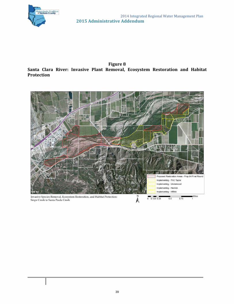
2014IntegratedRegionalWaterManagementPlan 2015AdministrativeAddendum
Figure8Santa Clara River: Invasive Plant Removal, Ecosystem Restoration and HabitatProtection
39

2014IntegratedRegionalWaterManagementPlan 2015AdministrativeAddendum
APPENDIXC
VenturaRiverWatershedManagementPlan‐2015ExecutiveSummary
40

Executive Summary
Lake Casitas Intake Structure Under Construction, 1958Photo courtesy of Casitas Municipal Water District
The Watershed’s Story . . . . . . . . . . . . . . . . . . . . . . . . . . . . . . . . . . . . xxvii
A Collective Management Strategy . . . . . . . . . . . . . . . . . . . . . . . . . . xxxi
Going Forward . . . . . . . . . . . . . . . . . . . . . . . . . . . . . . . . . . . . . . . . . . xxxii
Goals and Core Findings . . . . . . . . . . . . . . . . . . . . . . . . . . . . . . . . . xxxii
The Plan and the Process . . . . . . . . . . . . . . . . . . . . . . . . . . . . . . . .xxxviii
www.venturawatershed.org
FINAL DRAFT
41

EXECUTIVE SUMMARY xxvii
Executive Summary
The Watershed’s StoryThe Ventura River watershed is a rare and remarkable coastal southern California treasure; it is water-self-reliant, providing clean water to many farms and residents both within and outside its boundaries. Stream networks in surrounding watersheds are often channelized and hard to recognize as streams; in the Ventura River watershed river and streams are largely unchannelized. Urban development dominates much of the landscape of southern California; yet cities comprise only three percent of the Ventura River watershed, and developed land only 13%. A unique set of circumstances has left this small watershed with a relatively healthy ecosystem, containing over 100 special status plant and animal species.
At 226 square miles (144,833 acres), the Ventura River watershed is the smallest of Ventura County’s three major watersheds. The watershed extends from its Matilija Creek headwaters in the steep Transverse Ranges of the Matilija Wilderness to the Pacific Ocean, 33.5-miles downstream. The beginning of the Ventura River itself is marked by the confluence of Matilija Creek with North Fork Matilija Creek, 16.2 miles from the Pacific Ocean.
The river flows south along the western edge of the Ojai Valley; past the City of Ojai and the communities of Meiners Oaks, Mira Monte, Oak View, Casitas Springs, and through the edge of the City of Ventura. In its final stretch, the river flows through the Ventura River estuary, and if the sandbar is breached, proceeds to the ocean. Along the river’s route it picks up water from tributaries, the most significant being San Antonio Creek.
What is a watershed?
A watershed is a basin that catches rain and snow and drains into a
central waterbody—in this case, the Ventura River. Every area of land
is part of a watershed. Watersheds come in all shapes and sizes and
often contain smaller “subwatersheds.” There are complex interrela-
tionships among the streams, aquifers, lakes, habitats, people and
economies that make up a watershed system, such that changes or
impacts to one part of a watershed can ripple through and affect
other parts.
The Ventura River watershed is a rare and remarkable coastal southern California treasure; it is water-self-reliant, providing clean water to many farms and residents both within and outside its boundaries.
FINAL DRAFT
42

xxviii VENTURA RIVER WATERSHED MANAGEMENT PLAN
San
Anto
nio
Cre
ek
L i on Ca nyon Creek
Ca ña d a
Larg
a
Creek
Mat ili ja Creek
Se
nio
rC
an
y o
n
R ee ves CreekM
cNel l
C ree k
T ha ch e rC
r e
ek
LakeCasitas
MatilijaReservoir
Ven
tura
Riv
er
Sa nta An aCr eek
Co
yote
Cre
ek
N
o rt h Fo rkM
at i
lij a
C r.
MeinersOaks
OjaiMiraMonte
OakView
Cas itasSprings
VenturaVentura River
Estuary
UpperOjai
S A N TABA R B A R ACO U N T Y
V E N T U R ACO U N T Y
£¤101
·þ126
·þ33
·þ150
£¤101
L o s Pad re sN at i o n a l
Fo re s t
Ste
wa
rtC
any
on
Gri
dley
Can
yon
Fox
Ca
nyo
nBa
rra
n ca
S ycamore
Creek
0 1 2 3 40.5Miles
Watershed OverviewVentura River Watershed
¯
P a c i f i cO
c e a n
Urban Areas
U.S. Forest Service
Data Source:California Protected Areas Database v1.8
Urban Areas: FMMP Map Created by GreenInfo Network using Esri software
October 2013 www.greeninfo.org
Watershed Overview Map
FINAL DRAFT
43
EXECUTIVE SUMMARY xxix
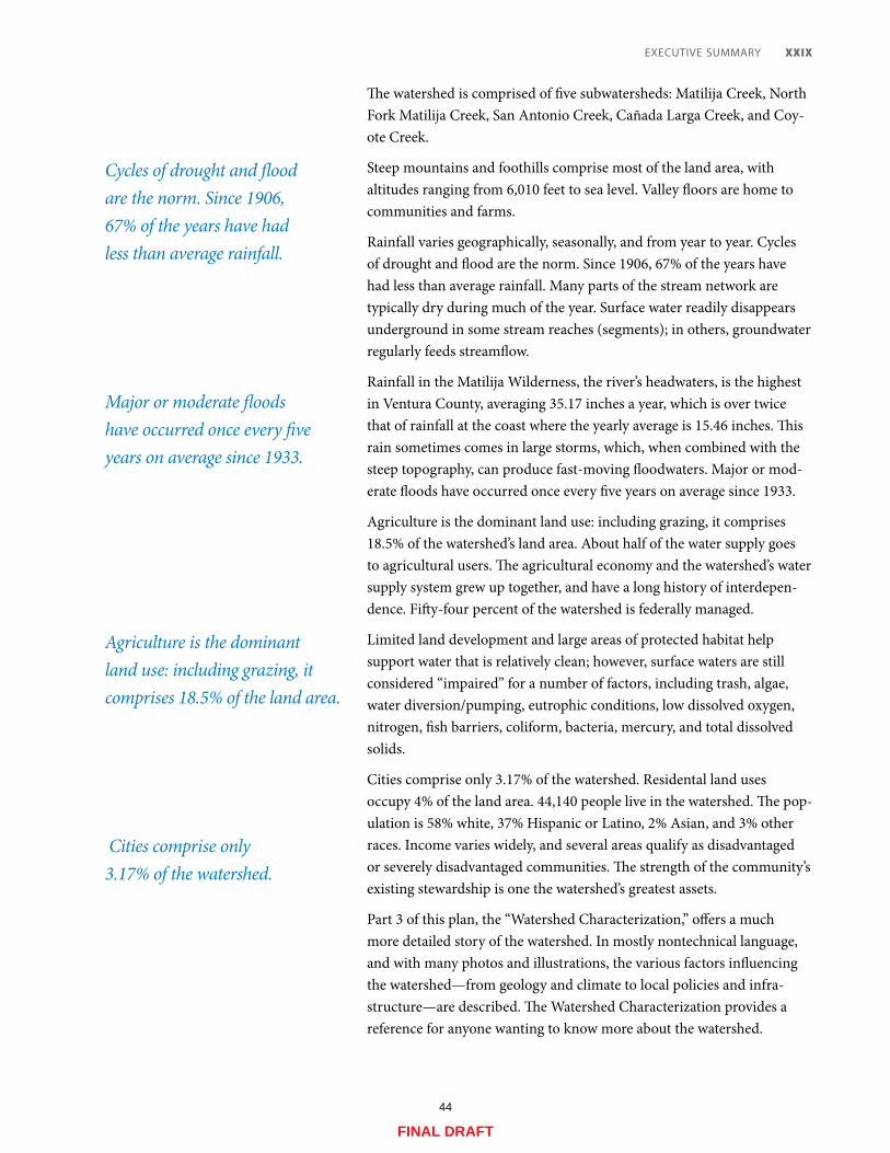
The watershed is comprised of five subwatersheds: Matilija Creek, North Fork Matilija Creek, San Antonio Creek, Cañada Larga Creek, and Coy-ote Creek.
Steep mountains and foothills comprise most of the land area, with altitudes ranging from 6,010 feet to sea level. Valley floors are home to communities and farms.
Rainfall varies geographically, seasonally, and from year to year. Cycles of drought and flood are the norm. Since 1906, 67% of the years have had less than average rainfall. Many parts of the stream network are typically dry during much of the year. Surface water readily disappears underground in some stream reaches (segments); in others, groundwater regularly feeds streamflow.
Rainfall in the Matilija Wilderness, the river’s headwaters, is the highest in Ventura County, averaging 35.17 inches a year, which is over twice that of rainfall at the coast where the yearly average is 15.46 inches. This rain sometimes comes in large storms, which, when combined with the steep topography, can produce fast-moving floodwaters. Major or mod-erate floods have occurred once every five years on average since 1933.
Agriculture is the dominant land use: including grazing, it comprises 18.5% of the watershed’s land area. About half of the water supply goes to agricultural users. The agricultural economy and the watershed’s water supply system grew up together, and have a long history of interdepen-dence. Fifty-four percent of the watershed is federally managed.
Limited land development and large areas of protected habitat help support water that is relatively clean; however, surface waters are still considered “impaired” for a number of factors, including trash, algae, water diversion/pumping, eutrophic conditions, low dissolved oxygen, nitrogen, fish barriers, coliform, bacteria, mercury, and total dissolved solids.
Cities comprise only 3.17% of the watershed. Residental land uses occupy 4% of the land area. 44,140 people live in the watershed. The pop-ulation is 58% white, 37% Hispanic or Latino, 2% Asian, and 3% other races. Income varies widely, and several areas qualify as disadvantaged or severely disadvantaged communities. The strength of the community’s existing stewardship is one the watershed’s greatest assets.
Part 3 of this plan, the “Watershed Characterization,” offers a much more detailed story of the watershed. In mostly nontechnical language, and with many photos and illustrations, the various factors influencing the watershed—from geology and climate to local policies and infra-structure—are described. The Watershed Characterization provides a reference for anyone wanting to know more about the watershed.
Cycles of drought and flood are the norm. Since 1906, 67% of the years have had less than average rainfall.
Major or moderate floods have occurred once every five years on average since 1933.
Agriculture is the dominant land use: including grazing, it comprises 18.5% of the land area.
Cities comprise only 3.17% of the watershed.
FINAL DRAFT
44

xxx VENTURA RIVER WATERSHED MANAGEMENT PLAN
Chapter 2.3, “Campaigns,” also tells the watershed’s story—in this case the story of the work already underway to improve conditions in the watershed, the people doing it, the ways they are working together, and some of the key proposed projects and programs that would further advance this work.
Quick Facts
Main Tributaries & Subwatersheds Matilija Creek, North Fork Matilija Creek, San Antonio Creek, Cañada Larga Creek, Coyote Creek
Jurisdictions Of the watershed area in Ventura County: County of Ventura (49.1%), US Forest Service (47.7%), City of Ojai (1.9%), City of Ventura (1.2%). A small corner of the watershed is in Santa Barbara County (3.9% of the entire watershed).
Population 44,140
Headwaters Transverse Ranges
Mouth Pacific Ocean (Santa Barbara Channel)
Length 33.5 miles (16.2 miles of main stem, plus 17.3 miles of Matilija Creek headwaters)
Area 226 sq. mi., 144,833 acres
Average Annual Precipitation 15.46" (lower watershed)
21.31" (middle watershed) 35.17" (upper watershed)
Median Annual Precipitation 14.12" (lower watershed)
19.20" (middle watershed) 28.74" (upper watershed)
Discharge Average – 65 cubic feet per second (cfs); Maximum – 63,600 cfs (1978)
Elevation Highest: 6,010 ft. Lowest: sea level
Ventura River Estuary Looking out to the Santa Barbara ChannelPhoto courtesy of Santa Barbara Channelkeeper
FINAL DRAFT
45

EXECUTIVE SUMMARY xxxi
A Collective Management StrategyChapter 2.3, “Campaigns,” outlines a strategy to collectively solve shared watershed problems and manage shared resources. As an alternative to focusing on separate individual priority projects or programs, the Coun-cil chose to widen the perspective and focus on a short list of six priority regional “campaigns.” The campaigns build upon work already underway, and illustrate specific watershed interrelationships and why collaboration is so important at the watershed scale.
Advancing these priority campaigns depends upon implementation of a variety of different types of projects and programs, involving many different stakeholders at many different levels of effort. By presenting the Council’s priority projects and programs in this broader perspec-tive, the campaigns offer a realistic framework for collectively achieving improvements.
The Council’s six implementation campaigns are:
• River Connections Campaign. Seeks to increase understanding, appreciation, and stewardship of the Ventura River and its watershed by connecting people with the river, with information about its his-tory and issues, and with the community working to keep it vital.
• Resiliency through Infrastructure Campaign. Seeks to strengthen both infrastructure and local policy in order to reduce the vulnera-bility of the watershed and its residents to extended droughts, major floods, seismic hazards, and water supply contamination.
• Extreme Efficiency Campaign. Seeks to maximize the conservation of water by all water users by continually realizing greater water use efficiency from equipment, technology, and people; pursuing more opportunities to reuse water; and rewarding conservation.
• Water Smart Landscapes and Farms Campaign. Seeks to improve and innovate residential and commercial landscape and farm man-agement practices in order to protect, supplement, and extend water supplies, and protect the long-term viability of farms.
• Arundo-Free Watershed Campaign. Seeks to remove, and keep at bay, the invasive non-native plant Arundo donax, which consumes excessive amounts of water, poses a major fire hazard, clogs flood control channels, and destroys native habitat.
• Healthy San Antonio Creek Campaign. Seeks to increase the flow of clean water in San Antonio Creek, increase recharge of the inter-connected Ojai Valley Groundwater Basin, and improve the creek’s riparian and instream habitats.
Matilija Creek
FINAL DRAFT
46
xxxii VENTURA RIVER WATERSHED MANAGEMENT PLAN
Going ForwardImplementation of this plan through the six campaigns will be achieved by individuals and organizations working both independently and col-lectively. The extent of implementation will depend upon the availability of grant funds and the priorities and budget conditions of dozens of dif-ferent organizations, as well as landowners and businesses.
The Council is committed to continuing its work on integrated water-shed planning, and building upon the momentum and assets it has established thus far.
Goals and Core FindingsThe Council developed and approved seven goals for the watershed man-agement plan. All the goals put together form the Council’s “vision” and big-picture priorities for the watershed. Each goal is supported by key findings, which describe the key factors that underlie that goal.
These goals are:
Sufficient Local Water Supplies. Sufficient local water supplies to allow continued independence from imported water and reliably support ecosystem and human (including urban and agricultural) needs in the watershed now and in the future, through wise water management.
Clean Water. Water of sufficient quality to meet regulatory require-ments and safeguard public and ecosystem health.
Integrated Flood Management. An integrated approach to flood management that improves flood protection, restores natural river processes, enhances floodplain ecosystems, increases water infiltra-tion and storage, and balances sediment input and transport.
Healthy Ecosystems. Healthy aquatic and terrestrial ecosystem structures, functions, and processes that support a diversity of native habitats.
Access to Nature. Ample and appropriate opportunities for the public to enjoy the watershed’s natural areas and open spaces associ-ated with aquatic habitats, to provide educational opportunities, and to gain appreciation of the need to protect the watershed and its ecosystems.
Responsible Land and Resource Management. Land and resources managed in a manner that supports social and economic goals and is compatible with healthy ecosystem goals.
FINAL DRAFT
47
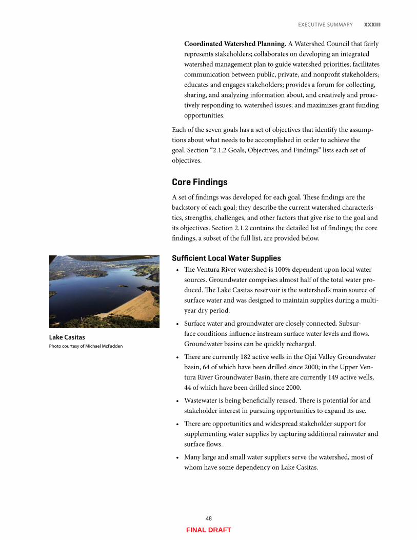
EXECUTIVE SUMMARY xxxiii
Coordinated Watershed Planning. A Watershed Council that fairly represents stakeholders; collaborates on developing an integrated watershed management plan to guide watershed priorities; facilitates communication between public, private, and nonprofit stakeholders; educates and engages stakeholders; provides a forum for collecting, sharing, and analyzing information about, and creatively and proac-tively responding to, watershed issues; and maximizes grant funding opportunities.
Each of the seven goals has a set of objectives that identify the assump-tions about what needs to be accomplished in order to achieve the goal. Section “2.1.2 Goals, Objectives, and Findings” lists each set of objectives.
Core FindingsA set of findings was developed for each goal. These findings are the backstory of each goal; they describe the current watershed characteris-tics, strengths, challenges, and other factors that give rise to the goal and its objectives. Section 2.1.2 contains the detailed list of findings; the core findings, a subset of the full list, are provided below.
Sufficient Local Water Supplies• The Ventura River watershed is 100% dependent upon local water
sources. Groundwater comprises almost half of the total water pro-duced. The Lake Casitas reservoir is the watershed’s main source of surface water and was designed to maintain supplies during a multi-year dry period.
• Surface water and groundwater are closely connected. Subsur-face conditions influence instream surface water levels and flows. Groundwater basins can be quickly recharged.
• There are currently 182 active wells in the Ojai Valley Groundwater basin, 64 of which have been drilled since 2000; in the Upper Ven-tura River Groundwater Basin, there are currently 149 active wells, 44 of which have been drilled since 2000.
• Wastewater is being beneficially reused. There is potential for and stakeholder interest in pursuing opportunities to expand its use.
• There are opportunities and widespread stakeholder support for supplementing water supplies by capturing additional rainwater and surface flows.
• Many large and small water suppliers serve the watershed, most of whom have some dependency on Lake Casitas.
Lake CasitasPhoto courtesy of Michael McFadden
FINAL DRAFT
48

xxxiv VENTURA RIVER WATERSHED MANAGEMENT PLAN
• Because water supplies are 100% local and the amount of rainfall received annually is highly variable, supplies must be managed with caution.
• Water originating in the Ventura River watershed is used both inside and outside of the watershed, and use is divided roughly equally between the agricultural and urban sectors. Data on groundwater use are incomplete.
• State and federal requirements regulating the amount of surface water that must be available for endangered species affect manage-ment of the watershed’s water resources. Potential requirements to provide increased instream flows could further reduce water avail-able for municipal, agricultural, and other uses.
• Groundwater is estimated to provide almost half of the local water supply; however, the locations and volumes of groundwater extracted and the effects on streamflow are not accurately known. This data gap inhibits analysis and planning. The Sustainable Groundwater Management Act, signed into law in September, 2014, should result in more groundwater management plans with addi-tional data gathering that will help fill this gap.
• The invasive exotic riparian plant Arundo donax, which can be found throughout the watershed, removes scarce water from stream channels at a rate three times that of native riparian plants.
• Increased demand for water has been relatively low; changes in this trend would present management challenges.
• While considerable improvements in conservation and efficiency have been made, significant potential for reducing water demand remains.
Clean Water• Surface water quality is good compared with more developed water-
sheds in the region and has improved notably in recent decades.
• Despite relatively good water quality, all of the watershed’s major waterbodies are on the Clean Water Act Section 303(d) list of impaired waterbodies. Between these waterbodies there are 14 dif-ferent types of impairments.
• Further efforts are required in order to improve instream water qual-ity conditions and meet water quality regulations.
• The effort and resources devoted to compliance with water quality regulations are considerable and could benefit from better efficien-cies, integration, and new funding sources.
Ojai Valley Sanitary District Wastewater Treatment Plant
FINAL DRAFT
49

EXECUTIVE SUMMARY xxxv
• Groundwater quality is generally good enough for drinking and irrigating, though a few parameters exceed standards with some regularity and are monitored and managed accordingly.
• Casitas Municipal Water District and the Bureau of Reclamation maintain proactive programs to maintain good water quality in Lake Casitas.
Integrated Flood Management• Major or moderate floods have occurred once every five years on
average since 1933.
• The steep terrain of the Ventura River watershed, coupled with intense downpours that can occur in the upper watershed, result in flash flood conditions where floodwaters rise and fall in a matter of hours.
• Besides riverine flooding, the watershed also experiences alluvial fan, coastal, and urban drainage flooding, and related hazards.
• Flood protection infrastructure, including all three levees, is in need of improvement. Important water and sewer facilities are vulnerable to flood damage because of their location.
• High sediment loads carried and deposited by local streams are a very significant factor in local riverine flood risk and present major challenges to flood management.
• Alterations in natural sediment transport regimes have exacerbated coastal erosion and increased coastal flooding risk.
• Restoring natural floodplain functions where feasible is favored by stakeholders as a least cost/greatest gain strategy for long-term flood management.
Healthy Ecosystems• The Ventura River watershed supports a remarkable array of healthy
and biodiverse southern California natural habitats.
• The watershed’s river and stream network remains largely unchan-nelized and is supportive of considerable wetland and riparian habitats. These riparian habitats are especially critical in dry south-ern California.
• The Ventura River estuary, a place where river water and ocean water converge, is an exceptionally valuable wetland habitat and ecological resource.
• Streamflow and pools support aquatic systems in some reaches; other reaches are typically too dry to sustain aquatic habitats.
East Ojai FloodingPhoto courtesy of David Magney
Red-Legged FrogPhoto courtesy of Chris Brown
FINAL DRAFT
50

xxxvi VENTURA RIVER WATERSHED MANAGEMENT PLAN
• The watershed is home to numerous protected species and habitats, including 137 plants and animals protected at either the federal, state, or local level. The watershed is also challenged by invasive, non-native species.
• The federally endangered southern California steelhead is of par-ticular significance. The streamflow and pools, and associated food chain, required for its survival are indicators of healthy aquatic eco-systems. Allocating that “environmental water,” given the watershed’s often dry and always variable climate, is challenging and a continu-ing source of stakeholder controversy.
• Controlling Arundo donax (giant reed) is a priority for habitat resto-ration, as well as fire prevention, flood protection, and water supply enhancement.
• Removing Matilija Dam is a priority restoration project with wide-spread stakeholder support. A coalition of stakeholders has been working to remove Matilija Dam since 1999.
• Local land conservancies have proven to be very effective at acquir-ing, protecting, and restoring strategic habitats for the benefit of the watershed.
• Facilitating the recovery of the steelhead is important to many stakeholders.
• Lack of funding is preventing the US Forest Service from effectively addressing important management issues of concern, including fish passage barriers, illegal and destructive marijuana farms, and the spread of invasive species.
• A changing climate could modify the biological diversity and viabil-ity of the watershed’s ecosystems.
Access to Nature• Residents and visitors are more likely to gain appreciation of the
need to protect the watershed when given the opportunity to visit and learn about the diverse ecosystem processes and services pro-vided by its aquatic habitats. Access to nature is available, though educational opportunities could be substantially improved.
• The watershed is fortunate to have many organizations committed to providing the public with safe access to nature and nature-based recreation opportunities.
• The availability and ease of public access to nature-based activities varies in different parts of the watershed and for different user types.
Teens Relocating Crawdads, Lower Ventura River
FINAL DRAFT
51

EXECUTIVE SUMMARY xxxvii
• The vision of a “Ventura River Parkway”—a network of trails, vista points, and natural areas along the river—is being actively pursued by a coalition of stakeholders.
Responsible Land and Resource Management• Developed land comprises only about 13% of the total land area in
the watershed.
• Local policies and physical constraints have effectively limited devel-opment on the watershed’s privately owned land.
• Agriculture is the dominant land use and is a critical factor in the management and stewardship of the land and water.
• Agriculture plays a critical role in maintaining many services sup-portive of a healthy watershed.
• The viability of agriculture is seriously threatened by water supply issues, high land costs, continued threats from exotic pests, and the challenges of competing in the modern industrial-scale farming business.
• Residential land use makes up about 4% of the area of watershed, and much of this is rural and low density.
• Oil extraction is a significant commercial land use, making up about 3.5% of the area of the watershed.
• Wildfires can threaten local water quality and supply. Moderate wildfires occur once every 10 years on average, and extreme wildfires once every 20 years.
• The population of the watershed is relatively small and the rate of growth low.
• Employment opportunities are diverse. Leisure and hospitality jobs, which rely on the natural beauty and recreational assets of the water-shed to attract visitors, dominate the employment landscape.
Coordinated Watershed Planning• Coordinated watershed planning offers a wide range of fiscal and
management benefits.
• Through their participation, Watershed Council members have demonstrated a commitment to the value of a collective approach.
• While participants clearly value the Watershed Council and understand the benefits of integrated watershed planning, process problems challenge the implementation of such planning.
Ojai Valley’s East End
FINAL DRAFT
52

xxxviii VENTURA RIVER WATERSHED MANAGEMENT PLAN
The Plan and the ProcessThe Ventura River Watershed Management Plan was developed over the course of three years, from 2012 to 2015.
The Ventura River Watershed Council, a large and diverse group of stakeholders, put considerable effort into developing the plan: they met regularly as a group and in subcommittees; conversed in emails and on phone calls; faced disagreements; worked out compromises; edited and re-edited draft language.
This management plan is not mandatory and it has no regulatory teeth. It crosses multiple jurisdictions and authorities. Its implementation success depends upon the priorities and budget conditions of dozens of different organizations, as well as landowners and businesses.
Even so, watershed-level planning has taken hold across the globe as understanding grows that water is not bound by arbitrary jurisdictional authorities; water is bound by the watershed. The interconnected biologi-cal, chemical, and physical parts and processes that comprise watersheds do not correspond to the fragmented patchwork of land and water regu-latory jurisdictions.
Watershed-level planning has taken hold across the globe as understanding grows that water is not bound by arbitrary jurisdictional authorities; water is bound by the watershed.
Ventura River near Meiners Oaks
FINAL DRAFT
53

EXECUTIVE SUMMARY xxxix
The Ventura River, Looking Upstream from Main Street BridgePhoto courtesy of Santa Barbara Channelkeeper
In California, watershed-level planning is not yet mandatory, but is “highly encouraged,” (for example with preferential access to grant fund-ing) and there is a growing move to institutionalize the watershed-level view. Some water quality regulations are now issued by watershed.
This plan was developed to serve as a guiding document for the Coun-cil and to inform the public about the watershed and the factors that influence its conditions. The plan outlines the Council’s priorities for maintaining and improving the watershed’s health and sustainability for the benefit of the people and ecosystems that depend upon it. The plan initiates the integration of the many parts and processes of the watershed through recommendations for projects and programs developed with the complexity of the Ventura River watershed in mind.
The Ventura River Watershed Council was formed in 2006 to work on watershed planning. Twenty-one different organizations now serve on the Council’s Leadership Committee (voting members), representing a balance of perspectives and interests, including government, water and sanitary districts, land management and recreation organizations, envi-ronmental nonprofits, agricultural organizations, and businesses.
FINAL DRAFT
54

xl VENTURA RIVER WATERSHED MANAGEMENT PLAN
The Ventura River Watershed Council
Between 2011 and 2014, the Council established its Leadership Com-mittee; developed a mission statement, a logo, and a governance charter; tripled stakeholder involvement and grew member diversity; devel-oped a useful, content-rich website; compiled and inventoried over 500 documents, plans, and policies relevant to the watershed; professionally mapped 36 different aspects of the watershed and posted a Map Atlas online; and developed this plan. Over $400,000 in local support and grant funding has been invested in building the Council’s capacity as an organization—and it shows. The Council has built capability; it has built confidence; and it has a plan.
The strengthening of the Watershed Council for the purposes of produc-ing this plan is in itself an important achievement. The Council now provides a structure for continued input from and dialogue between stakeholders. The Council’s meetings, website resources, e-newsletters, and other services offer opportunities for improved community under-standing, interest, and leadership in watershed issues. Compiled data and information help reduce duplicative work efforts and efficiently advance new research and analysis. The Council cultivates relationships and facilitates partnerships and collaboration.
The Council identified four primary purposes of the plan:
1. To tell the story of the watershed and its many interdependencies.
2. To identify and prioritize water-related concerns in the watershed.
3. To outline a strategy to collectively solve our shared watershed prob-lems and collectively manage our shared resources.
4. To better position ourselves for funding.
The Council cultivates relationships and facilitates partnerships and collaboration.
FINAL DRAFT
55

2014IntegratedRegionalWaterManagementPlan 2015AdministrativeAddendum
APPENDIXH
LowerSantaClaraRiverWatershedSaltandNutrientManagementPlan
LasPosasConjunctiveUseStudy,Phase2
FinalReport
FundedinPartbyProposition84RoundTwoPlanningGrant,AdministeredbyCaliforniaDepartmentofWaterResources
SeeLinkBelowforCopyofFullStudyResults
http://vcportal.ventura.org/WCVC/IRWMP/2014/Appendix_H.pdf
56

2014 Integrated Regional Water Management Plan
2015 Administrative Addendum
APPENDIX I
Adoption Resolutions and Letters of Support
(As of June 26, 2015)
Watersheds Coalition of Ventura County
Camrosa Water District
City of Camarillo
City of Oxnard
City of Port Hueneme
City of San Buenaventura (Ventura)
City of Simi Valley/Ventura County Waterworks District No. 8
City of Thousand Oaks
Conejo Recreation and Park District
Calleguas Municipal Water District
Casitas Municipal Water District
United Water Conservation District
Pleasant Valley Mutual Water Company
Ventura County Board of Supervisors
Ventura County Watershed Protection District Board of Supervisors
Ventura County Waterworks District #1 (Moorpark)
Camarillo Sanitary District
Cal Trout
Friends of the Santa Clara River
Ojai Valley Sanitary District
Ventura County Resource Conservation District
The Nature Conservancy
The Ojai Valley Land Conservancy
57
58

59

Board of Oirec:tors WATER AI E. Fox Division JCAM RO SA D ISTRICT Jeffrey C. Brown
BUILDING WATER SELF - RELIANC E Divisionl Tim-othy H. Hoag
Division 3 Eugene F. West
Division 4
Resolution No: 14=06 Terry L. Foreman Division 5
General Manager A Resolution ofthe Board ofDirectors Tony L. Stafford
ofCamrosa Water District
Adopting the 2014 Watersheds Coalition ofVentura County Integrated Regional Water Management Plan, Finding that the Plan Is Exempt from the California
Environmental Quality Act
Whereas, in 2006, the Ventura County Board ifSupervisors adopted the first Watersheds Coalition if Ventura County (WCVC) Inte8rated Re8ional Water Mana8ement (lR WM) Plan per the reqUirements ifProposition 50,
the Water Security, Clean Drinkin8 Water, Coastal and Beach Protection Act if 2002 (Water Code Section 79500, et
seq.); and
Whereas, in November if2006, the California electorate approved Proposition 84, the Scife Drinkin8
Water, Water Qyality and Supply, Flood Control, River and Coastal Protection Bond Act if2006 (Public Resource Code
Section 75001 et seq.) that includedJunding Jor projects that were part if an Inte8rated Re8ional Water Mana8ement
(IR WM) Plan; and
Whereas, Proposition 84 included new IR WM Plan standards that necessitated updating the 2006
WCVC IR WM Plan in order to be eligible to receive IR WM implementation 8rantJunds; and
Whereas, the 2014 WCVC IRWM Plan was developed throu8h a comprehensive stakeholder process
and provides Jor on80in9 data gatherin8, planning, design, implementation, and evaluation through a long-term,
dynamic, community-based process; and
f1Vhereas, the Widespread adoption if the 2014 WCVC IR WM Plan ensures multi-a8ency participation
andJuture water management planning ifJorts in the Region; and
Whereas, District Stet! has reviewed the 2014 WC VC IR WM Plan and has determined that the Plan is
exemptJrom the California Environmental Qyality Act (CE0l) pursuant to CE0l Guidelines Section 15262 because the
Plan is a planning study which identifies potential proJects, programs, and policies Jor possible Juture actions; and
Sections 15306, 15307, and 15308 because the Plan consists if basic data and iriformation collection and includes
possible actions, subject to Juture adoption and approval, which would protect natural resources and the environment;
NoWy Therefore, Be It Resolved by the Cam rosa Water District Board ifDirectors
that the 2014 Watersheds Coalition if Ventura County Integrated Regional Water Mana8ement Plan is adopted and
Jound to be exemptJrom the California Environmental Qyality Act.
60
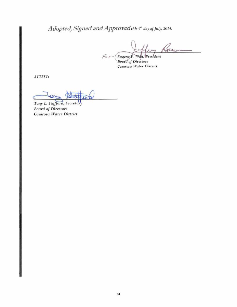
Adopted, Signed and Approvedthis 9th day oJJuly, 2014.
oj Directors Camrosa Water District
ATTEST:
Board ofDirectors
Camrosa Water District
61

62

63
64

65

66

67

68

69
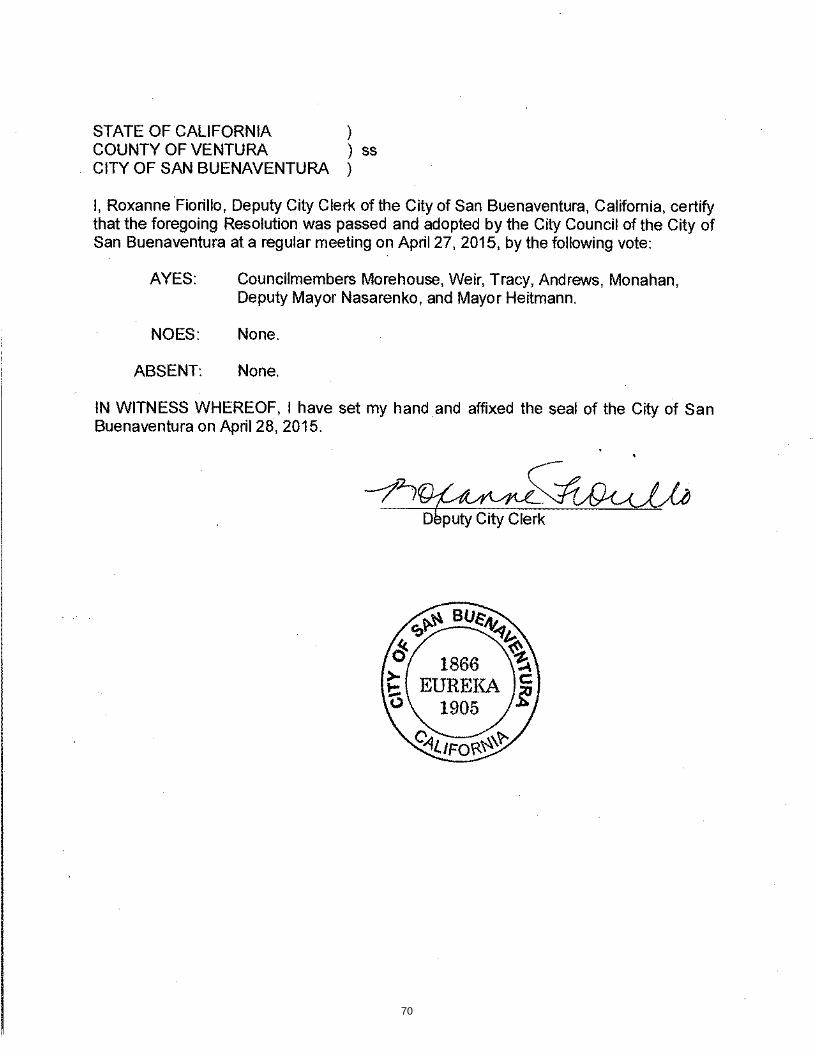
70

71
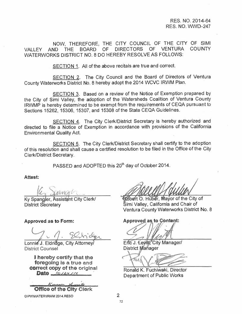
72

73

74
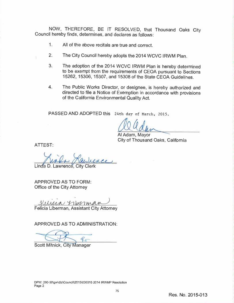
75

76
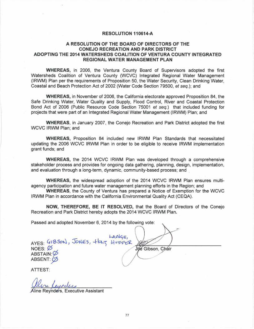
77

78

79
80
81

82

83

84

85
86

87
88

89

90
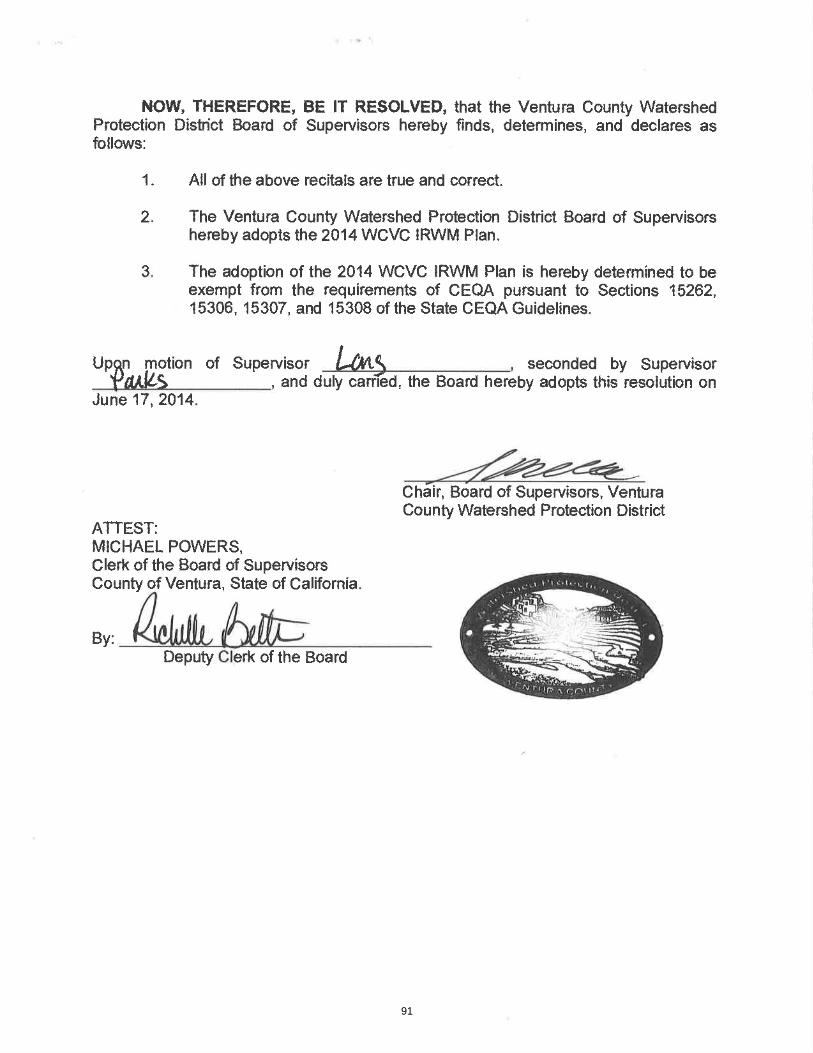
91

92

93

94

95

96

Page 1 of 2
360 Pine Street, 4th Floor San Francisco, CA 94104
Phone: (415) 392-8887 June 15, 2015 Watersheds Coalition of Ventura County
c/o Susan Hughes, Chair WCVC
County of Ventura
800 South Victoria Avenue
Ventura, CA 93009-1940
RE: Adoption of the updated Integrated Regional Water Management Plan (IRWMP) 2014
Dear Ms. Hughes, I am writing to express California Trout’s (CalTrout) support for the adoption of the Watershed Coalition of Ventura County’s (WCVC) 2014 Integrated Regional Water Management (IRWM) Plan. We are pleased to have been given the opportunity to participate as a stakeholder in the preparation of this plan update. We acknowledge that the 2014 WCVC IRWM Plan was developed through a comprehensive stakeholder process and provides for ongoing data gathering, planning, design, implementation, and evaluation through a long term, community based process. We also support widespread adoption of the 2014 WCVC IRWM Plan to ensure multi-agency participation and future integrated water management planning effort s in the region. CalTrout is a Round Thee project proponent within the current Department of Water Resources Proposal, for their Santa Clara River Steelhead Coalition – Invasive Plant Removal, Habitat Restoration, and Water Enhancement Project. As such, CalTrout demonstrates full support for the WCVC IRWMP and will participate in active implementation of a project that is consistent with WCVC IRWMP. CalTrout has also successfully secured funding for projects that address IRWM Plan objectives outside of the current Round Three Project suite, as chair of the Santa Clara River Steelhead Coalition.
97

Page 2 of 2
The Santa Clara River Steelhead Coalition’s mission is to protect and restore wild southern California steelhead and its habitat in the Santa Clara River watershed. To that end, coalition members are currently addressing estuary restoration design, Arundo donax removal and habitat restoration projects, multi-benefit fish passage remediation projects on Santa Paula Creek at Harvey Diversion, as well as on the main stem of the Santa Clara River at the 12th Street/South Mountain Road bridge. We appreciate your consideration of our joint Proposal and look forward to the opportunity to work with DWR in promoting ecological reconciliation through multi-benefit projects that will sustain working landscapes that underpin the socio-economics of Ventura County. Sincerely,
Candice Meneghin Santa Clara River Steelhead Coalition Chair Conservation Manager, Southern California Region
98

BOARD RESOLUTION Board of Governors Resolution No: 15-01 In the matter of: a resolution to adopt the Watersheds Coalition of Ventura County’s (WCVC) 2014 Integrated Regional Water Management (IRWM) Plan. By adopting the Plan, CalTrout will be eligible to propose their Santa Clara River Steelhead Coalition - Invasive Plant Removal, Habitat Restoration, and Water Enhancement Project (Project.) The Project will remove 30-100 acres of invasive non-native plant species, restore contiguous riparian habitat, and conserve water that will recharge groundwater basins. This project will promote recovery of endangered southern California steelhead (O. mykiss) by enhancing: a) in-stream flows, and b) fish passage. The following resolution was duly passed by the Board of Governors of California Trout by ballot on June 11, 2015 by the following vote: Ayes: 16 Noes: 0 Abstentions: 0 Absent: 4 Signed and approved by:
Doug Ballinger Chair, Board of Governors
99

100
101

102
103

104

105

106

107

2014IntegratedRegionalWaterManagementPlan 2015AdministrativeAddendum
APPENDIXJ
WCVCGeneralMembershipSummaryofMeeting
April29,2015
108

2014IntegratedRegionalWaterManagementPlan 2015AdministrativeAddendum
GeneralMembershipMeeting#35
WEDNESDAY,APRIL29,20159:30AM
PacificConferenceRoom,HallofJustice
COUNTYGOVERNMENTCENTER–800SOUTHVICTORIAAVENUE,VENTURA
MEETINGSUMMARYWCVC‐WatershedsCoalitionofVenturaCounty;IRWMP–IntegratedRegionalWaterManagementPlan
1. Welcome
2. Self‐IntroductionsandPublicComments
3. WCVCGovernancea. SuereportedthatthewatershedcommitteesvotedtomaintainthecurrentSteering
CommitteeComposition–withtwomembersrepresentingeachofthethreewatershedcommittees.
4. IRWMProgram–2015‐16WorkPlanandFundingAllocation
a. LynnreportedthateachofthefundingpartnerswillreceiveaworkplanandfundingallocationtableforFiscalYear2015‐16.PaymentswillbedueJuly1,2015.
5. Proposition84IRWMImplementationGrant:2015Solicitationa. ConsiderWCVCSteeringCommitteerecommendationregardingSuiteofProjectsfor
applicationAction:FollowingtherecommendationoftheWCVCSteeringCommittee,theGeneralMembershipunanimouslyapprovedasuiteof5projectsforinclusioninanapplicationforupto$13.3millioninProposition84ImplementationGrantFunding(finalround)–seeattachedtable.WCVCstaffwillpreparethenecessaryIRWMAdministrativeAddendumandwereauthorizedtoapplyforthegrantonbehalfofWCVC.Motion:RonMercklingSecond:TonyMorganVote‐Unanimous 6. Proposition1–WaterBond
a. LynnandSueprovidedanoverviewoffundingelementsinProposition1.WCVCmemberswillreceiveregularupdatesregardingopportunitiestoapplythroughe‐mailsandthewebsite.
Adjourn–Themeetingwasadjournedat1:20p.m.
109

2014IntegratedRegionalWaterManagementPlan 2015AdministrativeAddendum
WCVCPROJECTSAPPROVEDFORINCLUSIONINWCVCIRWMPLANADMNISTRATIVEADDENDUM
ANDPROPOSALFOR2015IRWMIMPLEMENTATIONGRANTAPPLICATION
ProjectNameProject
Proponent
ProjectDescription
GrantRequest/CostShare
Proposition84–ImplementationGrant
WaterWiseConvertandSaveIncentiveProgram(RegionalProject)
CityofVentura
Arebateprogramdesignedtoincentivizeoutdoorwatersavingsbyremovingwater‐intensivegrasslawnsandinstallinglowwater‐use/droughttolerantplantsintheirplace.Theprogramisopentobothresidentialandcommercialpropertyowners.Rebateswillpayupto$2persquarefootforturfreplacementandupto$800perpropertyownerforparcelslessthan1acreandupto$1600forparcelsgreaterthan1acre.
$1,875,000CostShare$625,000
Camrosa/CamSanRecycledWaterInterconnection
CamrosaWaterDistrict
A3,000foot16‐inchpipewillteeoffoftheeffluentpipelinethatCamSan isrunningtothesalinitymanagementpipeline(SMP).Thislinewilltraverseexclusivelyagriculturalland,tunnelunderCalleguasCreekanddischargeintoPond4ofCamrosa’sstorageponds.AsthewastewateristreatedtotertiaryatCamSan,noothertreatmentwillbenecessary.
$600,000CostShare$200,000
PleasantValleyDesalterPleasantValleyMutualWaterCompany
ThePleasantValleyMutualWaterdesalterwillconsistofareverseosmosistreatmentandchemicalfeedsystemthatwillbeinstalleddownstreamoftheexistingironandmanganesetreatmentplant.Constructionwillincludeanapproximate1600squarefootpre‐engineeredbuilding,inwhichtheROequipmentwillbelocated,aswellaspiping,permeatestoragetank,waterpumps,chemicaltanksandchemicalfeedsystem,remotemonitoringandcontrol,andabrinedischargepipeline.Theproposeddesalterisanticipatedtoproduceatotalofapproximately1500AFYofdrinkingwater,resultingintheavoidanceofapproximately1000AFYofimportedwater.
$2,400,000CostShare$980,283
MoorparkDesalterVenturaCountyWaterworksDistrict#1
TheMoorparkDesalter projectwillextracthighsalinitygroundwaterfromashallowaquiferatanewlyconstructedwellfieldandthentreatthewateratastate‐of‐the‐artdesalinationplantusingmembranefiltrationtechnologyfortheremovalofsaltsincludingchloride,totaldissolvedsolids(TDS),boron,andsulfate.Thewellfieldconsistsofconstructingapproximately20,200‐foot‐deepwells,andthepumpedwellwaterwillbetreatedatthe
$7,000,000CostShare$50,788,125
110

2014 Integrated Regional Water Management Plan
2015 Administrative Addendum
desalination plant through a membrane process to remove the salts and TDS. Treated was will meet Title 22 potable water quality standards and be distributed to District customers and potentially to other adjacent water agencies. Brine generated from the plant will be discharged into the SMP.
Santa Clara River Steelhead Coalition Restoration Project
Cal Trout
The project will remove arundo and restore habitat in the Santa Clara River floodplain in an identified critical wildlife zone. The project is part of a large-scale effort by the California Coastal Conservancy to eliminate arundo from the watershed to improve water resources in the region.
$421,380 Cost Share $140,460
TOTAL
$ 12,295,000
111