austin a. buhta, scott f. anfinson, eric c. grimm, and l ... archaic...
TRANSCRIPT

MINNESOTA’S ARCHAIC TRADITION:
AN ARCHEOLOGICAL AND PALEOENVIRONMENTAL
OVERVIEW AND ASSESSMENT
Austin A. Buhta, Scott F. Anfinson,
Eric C. Grimm, and L. Adrien Hannus
December 2017
Archeological Contract Series 292
This project was funded by the Arts and Cultural Heritage Fund of the Minnesota Clean Water, Land, and Legacy Amendment as part of the Statewide Survey of Historical and Archaeological Sites
Prepared by: Archeology Laboratory Augustana University 2032 South Grange Avenue
Sioux Falls, South Dakota 57105
Prepared for: The Oversight Board of the
Statewide Survey of Historical and Archaeological Sites and the
Minnesota Historical Society 345 Kellogg Boulevard West
St. Paul, Minnesota 55102-1906

MINNESOTA’S ARCHAIC TRADITION:
AN ARCHEOLOGICAL AND PALEOENVIRONMENTAL
OVERVIEW AND ASSESSMENT
Austin A. Buhta, Scott F. Anfinson,
Eric C. Grimm, and L. Adrien Hannus
L. Adrien Hannus (Co-Principal Investigator)
December 2017
Archeological Contract Series 292
This project was funded by the Arts and Cultural Heritage Fund of the Minnesota Clean Water, Land, and Legacy Amendment as part of the Statewide Survey of Historical and Archaeological Sites
Prepared by: Archeology Laboratory Augustana University 2032 South Grange Avenue
Sioux Falls, South Dakota 57105
Prepared for: The Oversight Board of the
Statewide Survey of Historical and Archaeological Sites and the
Minnesota Historical Society 345 Kellogg Boulevard West
St. Paul, Minnesota 55102-1906

Cover Image: Old Copper (top two specimens) projectile points from Minnesota Historical Society collections and lithic projectile points from the Itasca Bison (21CE1–lower left) and Granite Falls Bison (21YM47–lower right) sites.
Minnesota’s Archaic Tradition:
An Archeological and Paleoenvironmental Overview and Assessment
Archeology Laboratory, Augustana University ii December 2017
ABSTRACT
This report presents the findings of an archeological investigation of the Archaic tradition in Minnesota. The project, conducted by the Archeology Laboratory, Augustana University, Sioux Falls, South Dakota, is one of a series undertaken as part of the Legacy Amendment-funded studies focused on the investigation of Minnesota’s poorly understood historic contexts. The primary objectives of the study were to describe the environmental conditions during the Archaic throughout Minnesota, to investigate the timing of Archaic origins and demise in the various regions of the state, and to examine the nature of Archaic cultural manifestations in Minnesota, especially with regard to material culture and subsistence-settlement patterns. The current study investigated the Archaic tradition through a review of relevant archeological and environmental literature, the organization of a symposium focusing on local and regional Archaic topics, an evaluation of the utility of Minnesota’s current division of Archaic tradition historic contexts, and a synthesis of the investigation results. Future research on Minnesota’s Archaic should focus on basic site prospection in geologically high-potential landscapes, development of greater chronological control through the expansion of the database of viable radiocarbon ages, and the continued study and dating of strategically located palynological sites.

Minnesota’s Archaic Tradition:
An Archeological and Paleoenvironmental Overview and Assessment
Archeology Laboratory, Augustana University iii December 2017
CONTENTS HEADING PAGE
ABSTRACT ......................................................................................................................................................................................................................... ii TABLES ............................................................................................................................................................................................................................... vi FIGURES ........................................................................................................................................................................................................................... vii ACKNOWLEDGMENTS .................................................................................................................................................................................................. ix 1. PROJECT OVERVIEW ................................................................................................................................................................................................ 1 Description and Objectives ..................................................................................................................................................................... 2 Research Design .................................................................................................................................................................................. 3 Personnel and Project Orientation ...................................................................................................................................................... 5 Report Framework and Organization ................................................................................................................................................. 5 Report Chapters .................................................................................................................................................................................. 5 Appendices ............................................................................................................................................................................................ 6 2. THE STATE OF THE STATE’S ARCHAIC ............................................................................................................................................................. 7 Introduction ................................................................................................................................................................................................... 7 Archaic Studies in Minnesota ................................................................................................................................................................ 7 The Currently Known Archaic Record in Minnesota ............................................................................................................... 16 Important Minnesota Archaic Sites ................................................................................................................................................... 19 Itasca Bison (21CE1)....................................................................................................................................................................... 19 La Moille Rockshelter (21WN1) ................................................................................................................................................ 20 Petaga Point (21ML11) .................................................................................................................................................................. 23 Canning (21NR9) ............................................................................................................................................................................. 25 King Coulee (21WB56) ................................................................................................................................................................. 26 Granite Falls Bison (21YM47) .................................................................................................................................................... 28 Sandy Lake Dam (21AK11) ......................................................................................................................................................... 30 21CR155 .............................................................................................................................................................................................. 31 Jeffers (21CO3).................................................................................................................................................................................. 33 Conclusions .................................................................................................................................................................................................. 35 3. PALEONVIRONMENTS OF MINNESOTA DURING THE ARCHAIC PERIOD ........................................................................................ 36 Introduction ................................................................................................................................................................................................. 36 Pollen Datasets and Chronologies ..................................................................................................................................................... 38 Pollen Diagrams and Numerical Methods ...................................................................................................................................... 42 Results............................................................................................................................................................................................................. 43 Northcentral Transect .................................................................................................................................................................... 43 Northeastern Transect .................................................................................................................................................................... 45 Central Transect ............................................................................................................................................................................... 46 Southern Transect ............................................................................................................................................................................ 47 Discussion ..................................................................................................................................................................................................... 49 Vegetation Synthesis – Early Holocene................................................................................................................................... 49 Vegetation Synthesis – Middle Holocene .............................................................................................................................. 50 Vegetation Synthesis – Late Holocene .................................................................................................................................... 51 Time-transgressive versus Synchronous Change ................................................................................................................. 52 Asymmetric Vegetation Change ................................................................................................................................................. 53 Implications for Human Subsistence ....................................................................................................................................... 53 4. ARCHAIC SOCIETIES OF THE MIDWEST: A REGIONAL PERSPECTIVE ............................................................................................... 54 Archeological Origins of the North American Archaic ............................................................................................................. 54 Great Plains Area ....................................................................................................................................................................................... 58

Minnesota’s Archaic Tradition:
An Archeological and Paleoenvironmental Overview and Assessment
Archeology Laboratory, Augustana University iv December 2017
CONTENTS (CONTINUED) HEADING PAGE
4. ARCHAIC SOCIETIES OF THE MIDWEST: A REGIONAL PERSPECTIVE (CONTINUED) .................................................................. 58 Cherokee Sewer ................................................................................................................................................................................ 58 Logan Creek ....................................................................................................................................................................................... 59 Coffey .................................................................................................................................................................................................... 59 Rustad ................................................................................................................................................................................................... 59 Signal Butte ......................................................................................................................................................................................... 60 Southwestern Black Hills .............................................................................................................................................................. 60 Mississippi Area .......................................................................................................................................................................................... 61 Koster ..................................................................................................................................................................................................... 62 Modoc Rockshelter .......................................................................................................................................................................... 62 Great Lakes Area ........................................................................................................................................................................................ 63 Raddatz Rockshelter ........................................................................................................................................................................ 64 Durst ...................................................................................................................................................................................................... 64 Weber I ................................................................................................................................................................................................. 65 Old Copper Complex ..................................................................................................................................................................... 65 5. MINNESOTA’S ARCHAIC TRADITION TAXONOMY: A REVIEW AND ASSESSMENT ...................................................................... 66 Minnesota’s Archaic Historic Contexts ........................................................................................................................................... 66 Prairie Archaic ................................................................................................................................................................................... 66 Riverine Archaic ............................................................................................................................................................................... 68 Lake-Forest Archaic ......................................................................................................................................................................... 70 Shield Archaic .................................................................................................................................................................................... 71 Assessing the Utility of Minnesota’s Archaic Historic Contexts ........................................................................................... 72 6. ARCHAIC TRADITION MATERIAL CULTURE IN MINNESOTA ............................................................................................................... 75 Introduction ................................................................................................................................................................................................. 75 Archaic Artifact Types ............................................................................................................................................................................. 75 Chipped Stone Artifacts ................................................................................................................................................................ 75 Adzes ............................................................................................................................................................................................. 75 Hafted Scrapers ........................................................................................................................................................................ 76 Hafted Bifaces ........................................................................................................................................................................... 76 Dalton Cluster ................................................................................................................................................................ 77 Thebes Cluster ................................................................................................................................................................ 77 Early Archaic Bifurcated Base Cluster .................................................................................................................. 79 Archaic Side-notched Cluster ................................................................................................................................... 79 McKean Cluster .............................................................................................................................................................. 80 Sedalia/Nebo Hill Cluster ......................................................................................................................................... 80 Late Archaic Stemmed Cluster ................................................................................................................................ 81 Large Plains Notched Cluster ................................................................................................................................... 82 Pecked or Groundstone Artifacts .............................................................................................................................................. 82 Grooved Axes ........................................................................................................................................................................... 83 Bannerstones ............................................................................................................................................................................. 83 Copper Artifacts ................................................................................................................................................................................ 83 Specimens from the Itasca Bison (21CE1) and Granite Falls Bison (21YM47) Sites ................................................... 84 Itasca Bison Site (21CE1) Specimens ...................................................................................................................................... 84 Granite Falls Bison Site (21YM47) Specimens .................................................................................................................... 86 7. SYNTHESIS AND RECOMMENDATIONS ........................................................................................................................................................... 87 Research Objectives and Investigation Results ............................................................................................................................. 87

Minnesota’s Archaic Tradition:
An Archeological and Paleoenvironmental Overview and Assessment
Archeology Laboratory, Augustana University v December 2017
CONTENTS (CONTINUED) HEADING PAGE
7. SYNTHESIS AND RECOMMENDATIONS (CONTINUED) .............................................................................................................................. 87 Minnesota’s Archaic Tradition in Context ..................................................................................................................................... 87 Origins and Demise ......................................................................................................................................................................... 87 Paleoenvironments .......................................................................................................................................................................... 88 Material Culture and patterns of Subsistence and Settlement ..................................................................................... 89 Historic Contexts and Archaeological Regions ................................................................................................................... 90 Recommendations for Future Study ................................................................................................................................................. 90 Paleoecological Outlook ................................................................................................................................................................ 90 Archeological Outlook ................................................................................................................................................................... 91 8. REFERENCES CITED ............................................................................................................................................................................................... 94 APPENDIX A: Bibliography of Minnesota Archaic Tradition Sources ................................................................................................ 120 APPENDIX B: A Timeline of Minnesota Archaic Archeology ................................................................................................................ 129

Minnesota’s Archaic Tradition:
An Archeological and Paleoenvironmental Overview and Assessment
Archeology Laboratory, Augustana University vi December 2017
TABLES TABLE PAGE
1 Archaeological Region Identification Key ................................................................................................................................................ 3 2 Sites Used in this Study with the Numbers of Conventional and AMS Radiocarbon Dates .......................................... 39 3 Old Carbon Reservoir Corrections Published for Radiocarbon Dates from Minnesota Lake Cores .......................... 41 4 Classification of Archaic Hafted Biface Clusters by Temporal Association ............................................................................ 77 5 Minnesota Archaic Historic Context Material Culture Composition by General Artifact Category ........................... 89

Minnesota’s Archaic Tradition:
An Archeological and Paleoenvironmental Overview and Assessment
Archeology Laboratory, Augustana University vii December 2017
FIGURES FIGURE PAGE
1 Minnesota’s SHPO Archaeological Regions and Subregions .......................................................................................................... 4 2 Wilford’s 1955 classification of Minnesota’s prehistoric cultures. Note nothing is listed under Archaic (Wilford 1955:Table 6) ..................................................................................................................................................................................... 9 3 Johnson’s 1988 Chart of Minnesota Prehistory showing all of the Archaic classified as Eastern Archaic ................. 11 4 Steinbring’s 1974 chart of the cultural levels at Houska Point (21KC6). The lower three levels are Archaic (from Steinbring 1974:Figure 5) ................................................................................................................................................................. 13 5 MnDOT deep site testing protocol profile for Fritsche Creek site (21NL63) showing bison bonebed dating to 6570 ± 40 14C yr BP (from Monaghan et al. 2006:Figure 6.4.1-4) ......................................................................................... 15 6 Distribution of Minnesota archeological sites with copper artifacts. Large circles represent concentrations ........... 17 7 Archaic site distribution by SHPO Archaeological Region ............................................................................................................ 18 8 Itasca Bison Site (21CE1). Bison skull in situ (top) and projectile points from bog and hill loci (bottom) (from Shay 1971) ............................................................................................................................................................................................... 20 9 Top: Wilford’s diagrams of La Moille Cave (21WN1) excavations (from Wilford 1954). Bottom: La Moille projectile points: left to right, the first two are from Level 2, then Level 4, Level 5, Level 6, and Level 8 ................. 21 10 Petaga Point site (21ML11). Top: Archaic points. Bottom: copper artifacts recovered by 1967 University of
Minnesota excavations (from Bleed 1969) ............................................................................................................................................. 24 11 Canning site (21NR9). Top: 1982 excavation looking east. Bottom: projectile points (photo by Mike Michlovic) ............................................................................................................................................................................................................. 26 12 King Coulee site (21WB56). Top: 1987 excavations looking east. Bottom: Early Woodland–Late Archaic
projectile points. The two points in the lower right were classified as Durst with a date of 2320 ± 70 14C yr BP on the smaller point ................................................................................................................................................................................. 27 13 Granite Falls Bison site (21YM47). Top: projectile points (photo by Kent Bakken). Bottom: excavation diagram with IMA units on either side of original backhoe pit (from Lewis and Heikes 1990) ..................................... 29 14 Sandy Lake Dam site (21AK11). Top: tanged copper knife. Bottom: Frank Florin pointing at Archaic feature that contained copper artifacts and Oxbow point (photos by Florin Cultural Resources) ................................ 31 15 21CR155. Top: Archaic projectile point (from Florin et al. 2015). Bottom: 2012 Area A unit looking west ......... 33 16 Jeffers Petroglyph site (21CO3). Top: drawings of weapons and bison (from Lothson 1976). Bottom: view of rock ledge looking northeast .................................................................................................................................................................. 34 17 Minnesota’s generalized presettlement vegetation and pollen core sites discussed in text ................................................ 37 18 Simplified composite pollen diagrams arranged in four transects. Boundaries are shown as dashed white lines
for sites with major early and late Holocene zones identified by stratigraphically constrained cluster analysis. For sites within the range of Pinus strobus where the subgenera of Pinus were distinguished, the curve for Pinus subg. Strobus is shown as a white line within the blue curve for Pinus ........................................................................................ 40
19 Weighted mean calibrated ages of early and late Holocene zone boundaries at sites on the northcentral transect. The error bars indicate the 95 percent HPD confidence intervals. Red lines show the fit from weighted least-squares regression ................................................................................................................................................................ 43
20 Weighted mean calibrated ages of palynological features: A) Maximum value of prairie herbs plus Quercus; B) Maximum value of prairie herbs; C) Age at which prairie herbs first exceed 30 percent; D) Curves from graphs A, B, and C plotted together. In graphs A–C, the error bars indicate the 95 percent HPD confidence intervals, and black lines show the fit from weighted least-squares regression ....................................................................... 44
21 Some important midwestern Archaic sites discussed in the text .................................................................................................. 55 22 Koster site projectile point sequence (from Brown and Vierra 1983:182) ............................................................................... 57 23 Statewide distribution of sites with components of Minnesota’s defined Archaic tradition contexts ......................... 67 24 Mapped Prairie Archaic sites relative to the anticipated extent of the context’s distribution (after Dobbs and
Anfinson 1993) .................................................................................................................................................................................................... 68 25 Mapped Riverine Archaic sites relative to the anticipated extent of the context’s distribution (after Dobbs
and Anfinson 1993) ......................................................................................................................................................................................... 69 26 Mapped Lake-Forest Archaic sites relative to the anticipated extent of the context’s distribution (after Dobbs
and Anfinson 1993) ......................................................................................................................................................................................... 71

Minnesota’s Archaic Tradition:
An Archeological and Paleoenvironmental Overview and Assessment
Archeology Laboratory, Augustana University viii December 2017
FIGURES (CONTINUED) FIGURE PAGE
27 Mapped Shield Archaic sites relative to the anticipated extent of the context’s distribution (after Dobbs and Anfinson 1993) .................................................................................................................................................................................................... 72
28 Archaic-classified hafted bifaces in MHS collections. Sample includes specimen catalog numbers 17.124.4 (a), 25.22.1 (b), 1988.120.15.34 (c), 3497.A2578.1 (d), 948.A368.1 (e), and 1991.248.7 (f) .................................................. 78
29 McKean lanceolate (a), Duncan (b), and Hanna (c) specimens from the McKean type-site (from Kornfeld et al. 2010:Figure 2.57) .............................................................................................................................................................................................. 80
30 Scale image of broken Pelican Lake biface from southwestern Black Hills (from Augustana comparative col-lection) ................................................................................................................................................................................................................... 82
31 Bannerstone specimen 2013.27.1 from MHS collection, lateral (left) and dorsal (right) views. Discovered in Anoka County along the Mississippi River ........................................................................................................................................... 83
32 Copper artifacts from MHS collections: projectile point specimen A827 (top); projectile point specimen 1984.41.21.2 (middle); and awl specimen 88.85 (bottom) ............................................................................................................. 84
33 Specimens 176.1.1 (a), 571.196 (b), 571.151 (c), 571.108.1 (d), 540.594 (e), 540.37.1 (f), and 540.1813 (g), site 21CE1 ............................................................................................................................................................................................................ 85
34 Specimens 91.4.14.(5) (left) and 91.4.15.0.1 (right), site 21YM47 .............................................................................................. 86

Minnesota’s Archaic Tradition:
An Archeological and Paleoenvironmental Overview and Assessment
Archeology Laboratory, Augustana University ix December 2017
ACKNOWLEDGMENTS
We are indebted to many for their help in the completion of this work. For providing us with assistance in accessing various artifact collections curated at the Fort Snelling History Center, we wish to acknowledge the efforts of Bruce Koenen (Office of the State Archaeologist) and Pat Emerson (Minnesota Historical Society). We thank Tom Cinadr for assistance with the files search. Additional thanks are directed towards Mike Bergervoet, Minnesota Department of Transportation, who provided data for previously recorded Archaic sites in the state. We wish to acknowledge the efforts of Pat Emerson, and Bruce Koenen, for administering the project, for providing advice and support (and reports, field notes, photos, and access to artifact collections at Ft. Snelling) throughout. Finally, very special thanks are extended to Scott Anfinson, Mike Michlovic, Toby Morrow, Rolfe Mandel, Kent Bakken, and Eric Grimm, for their time and participation in the Archaic tradition symposium held at the Council for Minnesota Archaeology meeting at Hamline University and for offering some wonderful insights into Minnesota’s ever-elusive Archaic. Thanks again, everyone, we truly appreciate it.

Minnesota’s Archaic Tradition:
An Archeological and Paleoenvironmental Overview and Assessment
Archeology Laboratory, Augustana University 1 December 2017
1. PROJECT OVERVIEW
In North America, the Archaic tradition is understood to represent cultural or societal groups inhabiting the continent during a time of great transition, one featuring the introduction of new technologies, economies, and social practices. It was a period of readaptation during which the climatic shift from the Pleistocene to the Holocene resulted in wholesale changes to local and regional environments in the Plains and Upper Midwest. Though these environmental changes are only considered “rapid” if viewed from a geological perspective, they were both dramatic and dynamic, occurring across the entirety of the recognized Archaic timespan. Among Minnesota’s precontact cultural traditions, the Archaic seems rather paradoxical on the surface as it spans the greatest period of time yet remains the most poorly understood. Furthermore, there is an ongoing debate as to whether the Archaic is most appropriately categorized as a tradition, a period, or even an adaptive response. Perhaps, as with other elements of the Archaic, these distinctions will ultimately be seen as overlapping. For many years, the Archaic represented a convenient “plug” in the time-gap between the readily recognizable lanceolate spear points of the Paleoindian tradition and the unmistakable ceramics and mounds of later Woodland groups. In Minnesota, it preceded intensive farming and wild rice harvesting and followed the extinction of Pleistocene megafauna. In short, the Archaic was a cultural tradition defined as frequently by hallmarks it did not possess as by those it did. Since the recognition and definition of the Archaic 85 years ago, our understanding of the tradition has grown significantly, though there remain substantial gaps in our collective knowledge. The Archaic in North America spans a considerable timeframe and was initially divided into early, middle, and late subdivisions to reflect the recognition of differing traits at Modoc Rock Shelter (Fowler 1959a, 1959b). However, there is increasing evidence to suggest that these subdivisions may not be as distinct as was originally believed. For example, despite the presence/absence of lanceolate hafted bifaces, similarities between Early Archaic and Late Paleoindian subsistence and lithic raw material usage have been observed at sites from the Upper Midwest to the Rocky Mountains (e.g., Frison and Walker 2007; Kuehn 1998; Michlovic and Running 2005). The conventional segregation of the Archaic into early, middle, and late divisions was found to be both overly simplistic and not entirely sufficient for application in Minnesota. Instead, it was determined that there was greater utility in separating Archaic groups into historic contexts based more on the variance in adaptive strategies as dictated by their respective environments (Dobbs 1989; Dobbs and Anfinson 1993). From their work on the development of the state’s historic contexts, Dobbs and Anfinson (1993) settled on four distinct biome-based Archaic contexts: Prairie Archaic, Riverine Archaic, Lake Forest Archaic, and Shield Archaic. Given the extensive timeframe of the Archaic, Dobbs and Anfinson (1993) note that these contexts are only useful if one assumes that they are environment-specific, cohesive adaptations. More recently, Gibbon (2012:65) defined Minnesota’s Archaic tradition as “…one that lacks both Paleoindian projectile points and pottery and that dates roughly before 500 BC,” but he retained the use of the more conventional early, middle, and late descriptors. In Minnesota, the Archaic (ca. 11,500–2500 BP) is the period during which we first recognize a technological shift in hafted bifaces from larger, lanceolate specimens to smaller, stemmed and notched varieties, possibly signaling the application of atlatl technology (but see McElrath et al. 2009a:6–10 for a discussion of this problematic issue). We also begin to recognize the proliferation of groundstone and native copper tools (e.g., Gibbon 2012:77–78; Mason 1998a) during this time, as well as evidence of early horticulture and the use of pemmican and lodgepole structures (Michlovic 2017). Early utilization of milling stones appears during the Archaic further to the west (e.g., Jennings 1980) while evidence of seine weights was discovered during this timeframe in aquatic settings in the Midwest (e.g., Struever and Holton 2000). Minnesota Office of the State Archaeologist (OSA) site file data indicated that 146 Archaic-age radiocarbon dates have been obtained from sites throughout the state. However, the majority of these dates are from sites that lack accompanying diagnostic artifacts. Conversely, most of the state’s roughly 700 sites with well-established or potential Archaic affiliation lack absolute dates; rather, cultural affiliation at these sites is based primarily on diagnostic hafted biface typology. Unfortunately, the majority of these sites are unstratified or mixed multicomponent assemblages from which few
Minnesota’s Archaic Tradition:
An Archeological and Paleoenvironmental Overview and Assessment
Archeology Laboratory, Augustana University 2 December 2017
definitive insights can be drawn. To-date, only three excavated single-component Archaic sites (21CR155, 21WN15, and 21YM47) have associated radiocarbon dates. Additionally, a radiocarbon sample from the Old Copper component of the multicomponent Sandy Lake Dam site (21AK11) recently yielded an Archaic age. Although this site is multicomponent, it reportedly retains stratigraphic integrity (Bradford 2013). Archaic sites that include diagnostic artifacts and radiocarbon dates are the Itasca Bison Kill site (21CE1), the Granite Falls Bison site (21YM47), King Coulee (21WB56), 21CR155, and Sandy Lake Dam (21AK11). Compounding matters is the relatively limited number of Archaic sites identified on the landscape. The majority of Archaic sites currently identified in Minnesota are upland lithic scatters or isolated finds in surface or near-surface contexts. While sites in these settings are more readily detectable, they are almost always devoid of intact, datable settlement features in direct association with functionally and culturally diagnostic artifact assemblages. Hence, the ability to understand critical issues concerning past lifeways, settlement patterns, subsistence, and climate from these sites is compromised. In other physiographic settings, such as stream valleys, Archaic-period sites are all but undetectable by means of traditional archeological survey methodology (pedestrian transects and standard shovel testing). In such settings, sites of Archaic age are typically either deeply buried in alluvial or colluvial sediments, or have been excised by lateral stream migration. Deeply buried Archaic sites have been discovered in stream terrace and alluvial fan deposits throughout the Plains (e.g., Mandel 1995, 2006, 2008) and have also been identified in similar settings in Minnesota’s major river valleys (e.g., Florin et al. 2015; Michlovic 1982, 1985, 1986, 1987; Peterson et al. 1988). Evidence of buried, Archaic-age land surfaces in stream valley settings is well-documented throughout the Plains and Upper Midwest (e.g., Artz 1995; Bettis and Hajic 1995; Mandel 1995, 2006, 2008). When did Archaic groups occupy Minnesota and is there evidence to suggest a point of origination? Are settlement and subsistence patterns detectable in the archeological record and how, if at all, do they vary among archeological regions? How did Archaic groups interact with the environment as it continued to change throughout the Holocene? Does sufficient data exist to reliably parse Minnesota’s Archaic tradition into early, middle, and late chronological divisions as is common elsewhere in North America (e.g., Fowler 1959b)? Does Minnesota’s current, biome-based division of Archaic historic contexts (Dobbs and Anfinson 1993) represent a more viable solution, or is it in need of revision? The current investigation attempts to explore these and other issues in order to further understand Minnesota’s Archaic tradition in the context of the state’s broader precontact archeological record. DESCRIPTION AND OBJECTIVES On December 14, 2016, the Archeology Laboratory, Augustana University (Augustana), Sioux Falls, South Dakota, entered into a contract (No. 4709655) with the Minnesota Historical Society (MHS) and the Oversight Board of the Statewide Historical and Archaeological Survey, St. Paul to conduct an archeological investigation of Minnesota’s Archaic tradition. As outlined on page 3 of the project Request for Proposals (RFP), the objectives of the study are: “…to describe the environmental conditions during the Archaic throughout Minnesota, to investigate the timing of Archaic origins and demise in the various regions of the state, and to examine the nature of Archaic cultural manifestations in Minnesota, especially with regard to material culture and subsistence-settlement patterns.” Three primary tasks comprised the project:
1) Review the archaeological, geographical, and environmental literature pertinent to the Archaic tradition in Minnesota, including an examination of suspected Archaic artifacts in major Minnesota museum collections. Based on preliminary investigations, develop hypotheses to better understand the Archaic in Minnesota and to better focus future research.
2) Organize and participate in a symposium on the Archaic tradition.
3) Complete an analytical and descriptive report summarizing the results of the research. Minnesota’s environmental conditions during the Archaic should be addressed, as should insight into the timing of Archaic origins and demise in the various regions of the state, and the nature of Minnesota’s Archaic cultural manifestations with regard to material culture and subsistence-settlement patterns. The report should evaluate the validity of Minnesota’s four current Archaic tradition historic contexts (Dobbs and

Minnesota’s Archaic Tradition:
An Archeological and Paleoenvironmental Overview and Assessment
Archeology Laboratory, Augustana University 3 December 2017
Anfinson 1993). This reassessment will incorporate an evaluation of the validity of Minnesota’s State Historic Preservation Office (SHPO) Archaeological Regions (Table 1; Figure 1) with respect to the Archaic, as these regions were originally designed primarily with Woodland and Late Prehistoric groups in mind (Anfinson 1990). Finally, important unanswered research questions, and suggestions for answering these questions, should be posited, including known sites or discrete areas that could be productively examined.
These tasks, outlined by the MHS on page 3 of the RFP, served as the foundation for the research design that was ultimately constructed. Research Design The desired outcome of the project research design corresponds to that outlined in the RFP―an initial outline of Archaic contexts present in the study area, the timeframe comprising Archaic occupation of the region, the identification of characteristics associated with Archaic material culture, subsistence and settlement patterns, and interaction with other known prehistoric contexts and the environment. The RFP states that the first task of the project is to assess what is known about Minnesota’s Archaic tradition through a review of pertinent archaeological, geographical, and environmental literature, and an examination of institutional artifact collections. Augustana personnel conducted background research at the Minnesota OSA, Ft. Snelling History Center on February 22–23, 2017. Records for significant sites with Archaic components were examined, and relevant reports and site forms were copied. Additionally, artifacts from comparative collections were photodocumented, as were diagnostic specimens from the Itasca Bison (21CE1) and Granite Falls Bison (21YM47) site collections. Meetings were held with MHS and OSA staff concerning various aspects of the project. As a final component of this task, Archaic site locational shapefile data were provided by Michael Bergervoet, Minnesota Department of Transportation. The second task outlined in the RFP is to “organize and participate in a symposium on the Archaic.” Augustana organized a symposium at the 2017 Council for Minnesota Archaeology conference entitled Minnesota’s Archaic Tradition. The symposium was held on February 24, 2017 in Hamline University’s Anderson Center. Seven papers were presented. Presenters, in order of appearance, were Scott F. Anfinson, Rolfe D. Mandel, Toby Morrow, L. Adrien Hannus, Kent E. Bakken, and Michael G. Michlovic. Paper topics addressed projectile point range and variety, paleoenvironmental and geomorphological considerations, site reports, and regional overviews. The final task outlined in the RFP is the compilation of an analytical and descriptive report detailing the findings of the study and recommendations for future research. The framework and components of the report are outlined below. PERSONNEL AND PROJECT ORIENTATION The project was conducted under the overall supervision of L. Adrien Hannus and Austin A. Buhta. GIS data management and map production were undertaken by Buhta and Jason Kruse. Buhta, Scott Anfinson, and Eric Grimm conducted background research and report writing. Artifact collection documentation was undertaken by Hannus and Buhta. Lynette Rossum administered the project.
Table 1. Archaeological Region Identification Key.
Southwest Riverine
1
Prairie LakePrairie Lake North Prairie Lake South Prairie Lake East
22N 2S 2E
Southeast RiverineSoutheast Riverine East Southeast Riverine West
33E 3W
Central Lakes Deciduous Central Lakes Deciduous South Central Lakes Deciduous East Central Lakes Deciduous West
44S 4E 4W
Central Lakes Coniferous Central Lakes Coniferous North Central Lakes Coniferous South Central Lakes Coniferous East Central Lakes Coniferous Central
55N 5S 5E 5C
Red River ValleyRed River Valley North Red River Valley South
66N 6S
Northern BogNorthern Bog East Northern Bog West
77E 7W
Border Lakes
8
Lake SuperiorLake Superior North Lake Superior South
99N 9S

Minnesota’s Archaic Tradition:
An Archeological and Paleoenvironmental Overview and Assessment
Archeology Laboratory, Augustana University 4 December 2017
Figure 1. Minnesota’s SHPO Archaeological Regions and Subregions.

Minnesota’s Archaic Tradition:
An Archeological and Paleoenvironmental Overview and Assessment
Archeology Laboratory, Augustana University 5 December 2017
REPORT FRAMEWORK AND ORGANIZATION
Eight chapters and the appended data comprise the report of this investigation. A brief synopsis of each chapter, followed by a list of appendices, is provided below. Report Chapters
1) Project Overview presents a general study overview, including the research objectives of the investigation, a description of the project area, methodological approach, roles of personnel involved, and an outline of the framework and organization of the report.
2) The State of the State’s Archaic provides a detailed overview of the history of Archaic tradition research in Minnesota. A discussion of the origin of Archaic classification in America is presented, and this is followed by a history of Archaic research in Minnesota. Known Archaic site distribution in the state is then addressed, and a discussion on Archaic-period radiocarbon dates is provided. The chapter concludes with a detailed overview of nine important Archaic sites discovered throughout the state (Scott F. Anfinson).
3) Paleoenvironments of Minnesota During the Archaic Period provides a general overview of the paleoenvironmental parameters comprising the Minnesota study area during the Archaic period. Pollen analysis has been carried out at a large number of sites within the state, and a recent synthesis by Williams et al. (2009) for prairie-forest ecotone stretching from Manitoba to Wisconsin greatly improves the chronology. However, little detail is provided for the study area proper. For this project, new age models are constructed for all relevant sites using the most recent radiocarbon calibration IntCal13 curve (Reimer et al. 2013) and Bayesian age modeling (Blaauw and Christen 2011). Blois et al. (2011) developed a framework for reducing temporal uncertainty in poorly dated sites by interpolating ages between well-dated sites. The application of those methods is investigated for the study area; however, because of the time-transgressive nature of vegetation change across Minnesota, these methods may have limited utility. The final product is a synthesis of vegetation change in Minnesota during the Archaic period based upon improved chronologies of the existing pollen data (Eric C. Grimm).
4) Archaic Societies of the Midwest and Great Plains: A Regional Perspective discusses Midwestern and Plains-related Archaic tradition archeology as a means of providing a broader context within which Minnesota’s Archaic signature can be viewed. Perceived patterns and variations among Archaic groups, in terms of subsistence strategies, spatial and chronological distribution, and technological characteristics, are addressed. General overviews of previous research at important Archaic sites in the Plains and Midwest are provided, and these are then examined through a Minnesota-centric lens.
5) Minnesota’s Archaic Tradition Taxonomy: A Review and Assessment provides a description and overview of the four historic contexts comprising Minnesota’s Archaic Tradition (Dobbs and Anfinson 1993). The four contexts, Riverine Archaic, Lake-Forest Archaic, Prairie Archaic, and Shield Archaic, are evaluated relative to the more conventional early, middle, and late North American Archaic-period taxonomy, and the merits and shortcomings of each are assessed.
6) Archaic Tradition Material Culture in Minnesota provides an overview and examination of “hallmark” Archaic tradition artifacts identified in Minnesota and assesses the diagnostic value of these specimens and material types. Highlighted topics include diagnostic Archaic-period projectile point styles, as well as Old Copper complex specimens, bannerstones, and pecked or groundstone tool technology. The chapter concludes by examining artifact specimens from specific, dated Archaic sites in the state.
7) Synthesis and Recommendations presents a discussion of the project research and evaluates the results and avenues available for further exploration. Data from the archeological and paleoenvironmental studies are amalgamated and the state of Minnesota Archaic-period archeology is reevaluated based on these findings.
8) References Cited provides a comprehensive list of sources cited in the report.

Minnesota’s Archaic Tradition:
An Archeological and Paleoenvironmental Overview and Assessment
Archeology Laboratory, Augustana University 6 December 2017
Appendices
A) Bibliography of Minnesota Archaic Tradition Sources
B) A Timeline of Minnesota Archaic Archeology

Minnesota’s Archaic Tradition:
An Archeological and Paleoenvironmental Overview and Assessment
Archeology Laboratory, Augustana University 7 December 2017
2. THE STATE OF THE STATE’S ARCHAIC
Scott F. Anfinson
INTRODUCTION The Archaic tradition in Minnesota (ca. 11,500–2500 BP) is in many ways the poorest known prehistoric tradition in the state. Yet the Archaic is the longest-lived tradition, accounting for half of the prehistoric time period. It is so poorly known that it is usually defined not by its own cultural manifestations, but by the lack of certain artifacts and traits that typify the preceding and subsequent traditions. It does not have the finely made lanceolate projectile points or the associated megafaunal remains of the Paleoindian tradition (ca. 14,000–10,000 BP). In Minnesota, it lacks the ceramics and burial mounds of the Woodland tradition (2500–1000 BP). It probably also lacks the bow and arrow, intensive use of wild rice, and the use of tropical cultigens (e.g., maize, beans). During the Archaic in Minnesota, for most areas of the state, we do not know if there were significant changes in subsistence-settlement patterns, population densities, religious practices, ethnic movements, and external economic and political interactions, although we do know it is a period of dramatic environmental and technological change. The Archaic environment begins with a state that is mostly wooded, transitions to a state that is mostly grassland, and finishes with a state that has the three distinct vegetational zones encountered by Europeans in the mid-seventeenth century. Groundstone tools and cooper tools are two Archaic innovations, as well as early horticulture (e.g., squash) and the domestication of the dog. The Archaic can be referred to as a tradition (a cultural manifestation), a period (a length of time), or an environmental adaption. There is no firm rationale for dividing the Archaic in Minnesota into early, middle, and late subdivisions as is common in most adjacent states and provinces. We do not know if commonly defined Midcontinental Archaic projectile point forms that are found in these adjacent states and provinces are of similar age and association in Minnesota, although examples of many of these points are found in the state. Most of all, we have very limited knowledge of the absolute dating of Archaic manifestations in Minnesota, with most dates associated only with early western bison hunting or appropriate-age components that lack diagnostic artifact forms. Because the Archaic is so poorly known on a statewide basis, in the early 1990s, the Minnesota SHPO defined four Archaic statewide historic contexts based on the four basic environmental areas: Prairie Archaic in western and southern Minnesota, Riverine Archaic along the Mississippi River Valley in southeastern Minnesota, Lake Forest Archaic in central and north-central Minnesota, and Shield Archaic in the far northeast (Dobbs and Anfinson 1993). The assumption was that basic ways of life during the Archaic were directly related to basic economies adapted to distinct environmental regions. There are many reasons why the Archaic is one of the poorest known prehistoric traditions of Minnesota. Most sites yielding materials of suspected Archaic affiliation are multicomponent and, at most of these sites, there is considerable mixing of the components, mainly due to rodent activity and agriculture. Many Archaic sites with discrete horizons are deeply buried in alluvial or colluvial settings. These locations lack surface artifact manifestations, making them difficult to find, and, in many cases, the Archaic horizons are below the modern water table, making them difficult to excavate. At known single-component Archaic sites or multicomponent sites with discrete Archaic horizons, few diagnostic artifacts have been recovered in direct association with datable materials. The most notable exceptions are bison-related sites in western Minnesota and a few sites found by environmental review deep-testing surveys along the Mississippi River and lower Minnesota River in southeastern Minnesota. ARCHAIC STUDIES IN MINNESOTA
Albert Jenks started the first professional archeological program in Minnesota. Jenks, an economic anthropologist who co-founded the University of Minnesota’s Department of Anthropology in 1918, became interested in archeology late in his career. In 1928, he took a Minnesota field school to a prehistoric site in New Mexico. In 1932, he organized the first Minnesota archeological field school, examining five sites in northern Minnesota.

Minnesota’s Archaic Tradition:
An Archeological and Paleoenvironmental Overview and Assessment
Archeology Laboratory, Augustana University 8 December 2017
Jenks was the first Minnesota archeologist to examine Archaic-age sites, although there was no Archaic tradition named at the time he started and he thought he was investigating “Early Man” sites. In 1933, he tested the area in Otter Tail County near where a human skeleton (first called Minnesota Man and later Minnesota Woman) was found by a road construction crew in 1931 (21OT3). Jenks assumed that the skeleton was of Late Glacial age (Jenks 1936), although two recent radiocarbon dates place it early in the Archaic at about 8700 BP (Myster 2001:99). Two years later, Jenks examined the Sauk Valley site (21TO1) where a skeleton was uncovered by workmen in a gravel pit (Bryan et al. 1938). Sauk Valley has two radiocarbon dates averaging about 4900 BP. In 1937, Jenks was the first to investigate the early Archaic Itasca Bison site (21CE1), which had also been discovered by a road construction crew (Jenks 1937). Jenks’s assistant beginning with his earliest digs was Lloyd Wilford, a lawyer who decided to switch to archeology. While continuing to lead Jenks’s field crews during summers in the mid-1930s, Wilford completed his Ph.D. in archeology at Harvard in 1937. Wilford was more than just an assistant to Jenks. He quickly surpassed Jenks in his excavation and analysis skills. Much of the analysis and interpretation in Jenks’s major publications was actually done by Wilford. Wilford replaced Jenks at the University of Minnesota when Jenks retired in 1938. Wilford’s dissertation (1937) provided the first overview of Minnesota prehistoric archeology. His second chapter is titled: “Early Man in Minnesota.” The “Early Man” sites he discusses are Little Falls Quartz Workshop, Pelican Rapids (Minnesota Woman), Browns Valley Man, and Sauk Valley Man. Wilford considered these sites to be early because of their geologic setting and the lack of ceramics. Today we still do not know the age of the Little Falls quartz sites, but they could just as well be late prehistoric as early prehistoric. Based on radiocarbon dates and associated artifacts, Browns Valley is Late Paleoindian. Pelican Rapids and Sauk Valley are both Archaic based on radiocarbon dates. Wilford had assisted Jenks in his mid-1930s excavations at Browns Valley (21TR5) where five unfluted Late Paleoindian points had been recovered. He was also probably aware by 1937 that fluted points had been found in surface collections from Minnesota similar to those found with extinct animal species at the early Paleoindian type-sites in the American Southwest. He mentions the Folsom site in his dissertation (pg. 228), but notes no Minnesota finds. Wilford (1937:228) also mentions what William Ritchie (1932a, 1932b, 1936) had defined as “Archaic Algonkin” at the Lamoka site in New York. Wilford notes a few of the traits that typified “Archaic culture,” namely notched projectile points and early agriculture, but he mentions no Minnesota sites that are apparently related. Preliminary excavation had been undertaken at the Itasca site (21CE1) in 1937, and Jenks had stated that an extinct form of bison had been found associated with stone tools (Jenks 1937), but this observation was too late for Wilford to include in his dissertation. Although no Midwestern taxonomic frameworks had been published by 1937 for preceramic cultures, Wilford had attended a conference in Indianapolis in 1935 where Will McKern first presented his taxonomic system. Wilford (1937:233–234) mentions the conference and the basics of the classification system that was “principally sponsored” by McKern. Wilford (1937:235) presents a chart using the McKern system for the eastern United States, including an Archaic pattern with no phase, but a Lamoka aspect. The other named patterns are Woodland and Mississippian. He then (pg. 236) presents a classification chart for Minnesota “aboriginal cultures” with only Woodland and Mississippian patterns named. In 1941, Wilford published his first synthesis of Minnesota prehistoric archeology in American Antiquity. Since the completion of Wilford’s dissertation, Will McKern (1939) had published his Midwestern Taxonomic System (MTS). Although Wilford does not cite McKern in the 1941 article, he once again used the McKern system, organizing Minnesota prehistory into patterns, phases, aspects, foci, and components (sites). Only ceramic complexes are included in the classification chart, but it was labeled “Late Prehistoric Cultures.” In the text under “Early Man,” Wilford mentions four sites: Little Falls, Pelican Rapids, Browns Valley, and Sauk Valley. He assumes all are of Late Glacial or early Postglacial age. He repeated this assertion in publications in 1942 and 1944. His failure to mention the Itasca Bison site and known Minnesota finds of Paleoindian points in his 1940s articles is puzzling. Also not mentioned as an early site is La Moille Rockshelter (21WN1) that Wilford had excavated in 1939; there were clearly preceramic levels at La Moille containing notched projectile points and even a copper tool.

Minnesota’s Archaic Tradition:
An Archeological and Paleoenvironmental Overview and Assessment
Archeology Laboratory, Augustana University 9 December 2017
Wilford revised his Minnesota prehistoric classification in 1955 (Figure 2). He identifies an Archaic period, but, once again, only mentions the four “Early Man” sites that he briefly discussed in his earlier publications. No Archaic complexes are listed in his chart, although his earliest period is labeled “Archaic.” He notably even excluded Old Copper, which had been defined by McKern in 1942. Numerous articles on copper artifacts from Minnesota had appeared in The Minnesota Archaeologist, beginning with its earliest issues in 1935. Wilford discussed a failed attempt to radiocarbon date the elk antler associated with the Pelican Rapids skeleton. Once again, he does not mention the Itasca Bison site or the La Moille Rockshelter. Wilford apparently considered all preceramic complexes in Minnesota to be Archaic, even though Paleoindian complexes were well-known nationally by 1955 and multiple Minnesota finds of Paleoindian points had been reported in The Minnesota Archaeologist.
Figure 2. Wilford’s 1955 classification of Minnesota’s prehistoric cultures. Note nothing is listed under Archaic (Wilford 1955:Table 6).

Minnesota’s Archaic Tradition:
An Archeological and Paleoenvironmental Overview and Assessment
Archeology Laboratory, Augustana University 10 December 2017
Wilford’s (1960) final major overview publication was in 1960 as a chapter in a book on Minnesota history. This was a year after he had retired from the University of Minnesota, being replaced by Elden Johnson. Part I of Wilford’s chapter is titled “New Hunting Lands for Old World People,” and is about the Paleoindian period, although Wilford does not use the term Paleoindian―Marie Wormington (1957) had first defined the term in 1957. He discusses the Pelican Rapids and Browns Valley skeletons and artifacts under Part I. Part II of Wilford’s 1960 publication is labeled “The Archaic Period.” This is Wilford’s first use of the term as a Minnesota period between the Early Man and Woodland periods. He dates the start of the Archaic to about 7,000 years ago, coincident with the start of a warm, dry climatic period (Altithermal). He says this climate caused a disappearance of large game animals on the expanding prairie, although stemmed and notched points were used to hunt woodland large game animals like caribou and moose. He also speculates that intensive use of wild rice and maple sugar began in the early Archaic. At the end of the Altithermal (ca. 4,500 years ago), he notes that people began to make groundstone and copper tools, but does not mention Old Copper Culture, a commonly used term by 1960. He ends the Archaic period at 3000 BP, which he says is coincident with the introduction of agriculture and pottery. Besides getting almost everything wrong about Archaic subsistence practices, Wilford again failed to mention key Minnesota Archaic sites: Itasca Bison that he had helped Jenks examine in 1937 and the preceramic levels at La Moille Rockshelter that he had excavated in 1939. Other Archaic sites examined by, but not mentioned by, Wilford, include Pelican Lake (21PO3) and Franz (21CO2). Many of the Woodland tradition habitation sites that Wilford excavated also had an Archaic component, some of which were stratigraphically beneath ceramic-bearing levels. Elden Johnson, the archeologist at the Science Museum of St. Paul from 1953 to 1959, replaced Wilford at the University of Minnesota in 1959. In his first year at the University, Johnson initiated a survey of the Glacial Lake Agassiz basin in hopes of finding Paleoindian sites. Although one Paleoindian site was found in North Dakota, no such sites were found by Johnson’s Red River Valley survey in Minnesota. During the survey Johnson was made aware of multiple finds of copper artifacts on Lake Agassiz beach ridges. In 1960, he tested the Lins site (21RO7) where surface collections had yielded concave base, side-notched points, but he found no copper artifacts (Johnson 1962a:163). He wrote-up the copper artifacts found in various Red River Valley private collections in 1964 (Johnson 1964b). Johnson was appointed the first State Archaeologist in 1963. In his 1964 legislative outline of “An Archaeology Program for Minnesota,” Johnson noted that the Archaic was “an important but poorly defined series of cultures of the latter half of the early prehistoric period.” His priority work program included in this report did not propose to excavate any Archaic sites for 1965–1967 (Johnson 1964c). In 1964, Johnson published a study of 20 new radiocarbon dates from Minnesota; none were from Archaic sites (Johnson 1964a). Just as Johnson started implementing his archeological program, Herbert Wright, Jr. in the University of Minnesota Geology Department was beginning to reconstruct the postglacial environment of Minnesota. In 1963, Wright co-authored a study of two pollen cores from southeastern Minnesota (Wright et al. 1963). The 1963 study established for the first time the basic postglacial vegetational sequence for southeastern Minnesota, but also provided insights into the prehistoric climate of the Upper Midwest. For archeologists, it meant that prehistoric cultures could finally be fit into their environmental context, allowing for a tremendous expansion in potential to understand prehistoric lifeways over the last 14,000 years (Johnson 1964a). Johnson provided an overview of Minnesota prehistoric archeology in a 1969 publication. The Archaic chapter is titled the “Eastern Archaic Cultures.” Johnson says the Eastern Archaic dates from 7000 BP to 3000 BP. Johnson focuses on the Old Copper complex as seen from Petaga Point, although a few burial sites are also mentioned (21PO13, 21WN13, 21GR4), as well as the Itasca Bison site. He notes the period features regional cultural variations, the appearance of groundstone tools, and the use of stemmed and notched projectile points. Like Wilford’s 1960 article, Johnson (1969) relies heavily on discussions of the Archaic from more eastern regions (e.g., Quimby 1960) for his reconstruction of Minnesota Archaic lifeways. While Johnson dates the beginning of the Archaic much too late, no Archaic radiocarbon dates from Minnesota sites were available in 1969. His Archaic chapter in the 1978 revision of The Prehistoric Peoples of Minnesota is identical to the 1969 version. The 1988 revision of

Minnesota’s Archaic Tradition:
An Archeological and Paleoenvironmental Overview and Assessment
Archeology Laboratory, Augustana University 11 December 2017
Prehistoric Peoples changes the chapter title to “Eastern Archaic Tradition” and changes the Archaic time period to 8000 BP to 2800 BP (Figure 3). The text is also slightly revised, bringing the Itasca Bison site to the forefront, as well as discussing Mike Michlovic’s Canning site (21NR9) excavation. Archaic burial sites in Minnesota are not mentioned.
Figure 3. Chart of Minnesota Prehistory showing all of the Archaic classified as Eastern Archaic (from Johnson 1988).

Minnesota’s Archaic Tradition:
An Archeological and Paleoenvironmental Overview and Assessment
Archeology Laboratory, Augustana University 12 December 2017
After his Red River survey in 1960–1961, Johnson did not pay much attention to the Archaic tradition over the next 20 years of his excavations. His graduate students, however, conducted a number of Archaic site excavations, including Tom Shay at Itasca Bison in 1963–1965, David Valentine (1969) at Runck (21BW5/7) in 1963, Tim Fiske and Gary Hume at Voight (21WN13) in 1963, Peter Bleed at Petaga Point (21ML11) in 1966, and Jack Steinbring (1970a) at Houska Point (21KC6) in 1970–1971. Former Johnson students employed by the Minnesota Historical Society (MHS) also did important Archaic studies in 1971, with Gordon Lothson undertaking a detailed mapping of the Jeffers Petroglyph site (21CO3) and David Nystuen conducting the excavation of the Late Paleoindian–Early Archaic Greenbush Borrow site (21RO11). One of Johnson’s last nods to the Archaic was the 1974 Johnson-edited volume dedicated to Lloyd Wilford called Aspects of Upper Great Lakes Anthropology. Herb Wright’s article provided an overview of postglacial environmental changes, including the climatic warming, drying maximum that climaxed during the Archaic. Christy Caine’s (1974) overview of the Snake River Region in east-central Minnesota included a description of Archaic projectile point types and copper artifacts. Jack Steinbring’s article, entitled “The Preceramic Archaeology of Northern Minnesota,” included an overview of his work at the Houska Point site (Figure 4). Tom Kehoe’s article on large corner-notched points described types that appeared near the end of the Archaic. Over the last 40 years, almost all Archaic site investigations in Minnesota have been associated with environmental review projects, with the notable exception of some of Mike Michlovic’s (1982, 1983) work in the Red River Valley. Even most of the initial Archaic excavations in Minnesota happened because of inadvertent discoveries by construction projects, including Minnesota Woman (highway construction), Sauk Valley Man (gravel pit), Itasca Bison (road construction), and La Moille Rockshelter (highway construction). While the Minnesota Highway Department (MHD) as early as 1951 had formally supported the salvage of archeological sites discovered during highway construction and the Field Archaeology Act of 1963 required review of public agency development plans if “known or suspected” archeological sites might be impacted, it was not until after the passage of the National Historic Preservation Act (NHPA) in 1966 that broad environmental review of construction projects began. An exception was archeological work done in conjunction with plans to develop new Minnesota state parks in the mid-1960s. This included excavations at the Petaga Point (21ML11) site carried out by the University of Minnesota from 1965 through 1967. It took several years for NHPA review procedures to be worked out and SHPO staffing to be in place, but by the late 1960s, preconstruction archeological review of all federal projects was expected. The Minnesota Trunk Highway Archaeological Reconnaissance Survey (MTHARS) was one response, started jointly by the MHD and the MHS in 1968. Early examples of mitigations of Archaic sites hit by trunk highways include Greenbush Borrow (21RO11) in 1971 (Peterson 1973) and Hildahl (21YM35) in 1977 (Dobbs 1979). Another Archaic site examination done early in the days of federal environmental review is Bemidji State University’s testing of the Lins site (21RO7) for the U.S. Army Corps of Engineers (USACE) in 1976 (Brew and Yourd 1977). In 1977, the Minnesota Legislature provided funding to the Minnesota SHPO for a Statewide Archaeological Survey (SAS). It was directed over the next four years by Ted Lofstrom, utilizing both internal staff and external contracts to conduct the surveys. Areas in 24 counties were examined, with some attempt to develop a predictive model for determining site locations (Lofstrom 1981). The model was done for all types of prehistoric sites and no attempt was made to separate prehistoric cultural traditions. Hundreds of previously unrecorded sites were added to the state site file. In 1980, Mike Michlovic took his Minnesota State University (MSU), Moorhead field school to the Canning site (21NR9) to examine a site found by surface survey in a plowed field on the edge of the Red River. The plow-disturbed horizon of the Canning site was a Late Prehistoric habitation with Sandy Lake ceramics (Michlovic 1986). The Archaic horizon was located 87–110 cm below the modern surface. Michlovic excavated another deep Archaic site near the Red River in 1983. The Mooney site (21NR29) excavations in 1983 were done as mitigation for a USACE dike built to protect the city of Halstad (Michlovic 1985, 1987). Like Canning, there was an upper Late Prehistoric horizon and a deeply buried Archaic horizon. The Archaic horizon at Mooney was 160 cm below the modern surface.

Minnesota’s Archaic Tradition:
An Archeological and Paleoenvironmental Overview and Assessment
Archeology Laboratory, Augustana University 13 December 2017
Figure 4. Steinbring’s 1974 chart of the cultural levels at Houska Point (21KC6). The lower three levels are Archaic (from Steinbring 1974:Figure 5).

Minnesota’s Archaic Tradition:
An Archeological and Paleoenvironmental Overview and Assessment
Archeology Laboratory, Augustana University 14 December 2017
Michlovic continued his investigation of the Archaic period in the Red River Valley at the Rustad site (32RI775) on the Sheyenne River just southwest of Fargo, North Dakota (Michlovic and Running 2005). Michlovic excavated at Rustad from 1992 through 1998. The site contains a major Early Plains Archaic horizon, as well as minor Late Paleoindian and Woodland components that are stratigraphically discrete. A number of important Archaic sites were excavated in the late twentieth century due to potential impacts by construction projects. These include MTHARS (Les Peterson) excavation at the King Coulee site (21WB54) for road construction, the IMA (Clark Dobbs) excavation of the Nushka Lake site (21CA169) for pipeline construction, the Soils Consulting (Grant Goltz) excavation at the Horseshoe Bay site (21CA201) for US Forest Service work, Impact Services (Richard Strachan) excavation of the Fritsche Creek site (21NL63) for power line construction (Roetzel and Strachan 1992; Roetzel et al. 1992) , UMD (Brower) excavation of the J Squared site (21RW54) for highway construction, and 106 Group (Matt Murray) excavation of the Van Zomeren site (21SE16) for pipeline construction. There was also one non-mitigation but construction-related excavation of an important Archaic site. The IMA (Clark Dobbs) undertook two years of excavations (1987–1988) at the Granite Falls Bison site (21YM47) after a deeply buried bison bonebed and stone tools were found by a landowner burying trash with a backhoe. Notable Archaic site excavations in the twenty-first century include the Foth and Van Dyke excavation of the Donarski site (21MA33) due to a county road project (Kluth and Hudak 2004), the Florin Cultural Resource Services excavation of the Sandy Lake Dam site (21AK11) for a USACE building (Florin 2005), the 2010 Great Lakes Archaeological Research Center excavation of the Strandland site (21RO39) for a USACE flood control project (Jones 2013), and the Florin Cultural Resource Services testing and excavation of 21CR155 and 21CR156 for a county road project (Florin et al. 2015). Other recent developments important to understanding the Archaic period are the MnDOT Deep Testing Protocol project initiated in 2004 (Monaghan et al. 2006) and the MnDOT Lithic Scatter study that is still in progress. The Deep Testing project provided additional understanding of the Fritsche Creek site (21NL63) (Figure 5) and discovered a buried Archaic horizon at the Hoff Deep locality (21NR65). The Lithic Scatter study should streamline significance evaluation of lithic scatter sites, the most common type of Archaic site. The passage of the Legacy Amendment in 2008 has had major implications for Archaic site studies in Minnesota. Significant funding of the Statewide Survey of Historic and Archaeological Sites (SSHAS) has been provided by the Legislature through the Legacy Amendment for five consecutive biennia beginning with Fiscal Year (FY) 2010. As of the end of FY 2017, this funding has supported archeological surveys of 10 counties, a survey of the North Shore of Lake Superior, a survey of the Minnesota River Valley, a radiocarbon dating project, and a Stone Tool Handbook project. Funding for the 2018–2019 FY made this current Archaic study possible, as well as additional county surveys. There are two regional overviews of the Archaic period in Minnesota, both based on Ph.D. dissertations from the University of Minnesota. Scott Anfinson (1987) provides an overview of the Archaic in southwestern Minnesota, where he defined two Archaic phases. The Itasca phase (7500–5000 BP) was based on the earliest use of the Itasca Bison site in northwestern Minnesota and on a middle horizon at the Cherokee Sewer site (13CK405) in northwestern Iowa; it assumed a similar environment and techno-economic orientation in southwestern Minnesota during the prairie maximum. This initial Archaic phase was typified by intensive bison hunting during a warm, dry period and featured medium-sized, side-notched dart points. A terminal Archaic phase, the Mountain Lake phase (5000–2200 BP), was based on the preceramic horizon at the Mountain Lake site (21CO1) in southwestern Minnesota. It was the initial adaptation to the prairie-lake environment featuring more permanent settlements and a more diverse economy. Projectile points appear to be medium-sized lanceolate and side-notched forms. Brad Perkl’s (2009) dissertation investigated the Late Archaic–Early Woodland transition in southeastern Minnesota. He summarized known Late Archaic sites in the region based on sites recorded as Archaic in the State Archaeologist’s database and examining the environment and environmental changes. Unlike southwestern Minnesota, very few Middle Prehistoric sites have been excavated in southeastern Minnesota and there are relatively few radiocarbon dates directly associated with Late Archaic horizons. At the time of Perkl’s dissertation, the only major applicable excavations with firm chronological controls were the King Coulee (21WB56) site and the Voight site (21WN15).

Minnesota’s Archaic Tradition:
An Archeological and Paleoenvironmental Overview and Assessment
Archeology Laboratory, Augustana University 15 December 2017
Figure 5. MnDOT deep site testing protocol profile for Fritsche Creek site (21NL63) showing bison bonebed dating to 6570 ± 40 14C yr BP (from Monaghan et al. 2006:Figure 6.4.1-4). With regard to the Old Copper complex as part of the Late Archaic in Minnesota, Gibbon (1998) provided an overview. Gibbon reviews the classification systems of Wittry (1951) and Steinbring (1970b, 1974, 1975), discusses sources of copper in Minnesota and the Lake Superior region, examines the distribution of Archaic copper in the Upper Midwest, and highlights some of Minnesota’s major sites. He also notes the association of Old Copper tools with Raddatz and Durst points in east-central Minnesota and Oxbow points in northwestern Minnesota. The presence of Old Copper tool forms in both Arvilla and Laurel contexts suggests that the complex survived well into Woodland times. The few copper tools found in southwestern Minnesota appear to be associated with Cambria phase sites. Gibbon’s (2012) recent book on Minnesota archeology provides some new insights into Minnesota’s Archaic. Using Lewis Binford’s (2001) “frames of reference,” Gibbon divides Archaic lifeways into six basic types that are essentially

Minnesota’s Archaic Tradition:
An Archeological and Paleoenvironmental Overview and Assessment
Archeology Laboratory, Augustana University 16 December 2017
adaptations to particular regional environments. Early and Middle Archaic lifeways are Coniferous Forest Game Hunter (12,500–5000 BP) for northern Minnesota, Deciduous Forest Game Hunter (12,500–9500 BP) for southern Minnesota, and Early Pedestrian Bison Hunter (12,500–5000 BP) for western Minnesota. Lifeways for Late Archaic moving into the Woodland Period are Proto-Wild Rice Harvester (5000–800 BP) in northern Minnesota, Proto-Horticulturalist (5000–1000 BP) in southeastern Minnesota, and Late Pedestrian Bison Hunter (5000–1000 BP) in western Minnesota. What seems to be missing is a Middle Archaic lifeway in southeastern Minnesota, a critical transition period in the Upper Midwest. Gibbon characterizes the Early Archaic in Minnesota as a time of woodland dominance in most of the state with small, mobile groups and a diffuse hunter-gatherer economy. The Middle and Late Archaic lifeways for the state as a whole feature relatively large home ranges (up to 25,000 square miles), high mobility, small groups, and overall low population density. In the Late Archaic, particularly in east-central and southeastern Minnesota, new lifeways begin to emerge that feature resource intensification of small game animal species procurement and intensive seed collection. New projectile point types appear and copper tool use spreads throughout most of the state, with the notable exception of the southwest. Cemeteries begin to replace individual burial sites. There is no evidence in Minnesota for the use of ceramics or burial mounds during the Archaic period. THE CURRENTLY KNOWN ARCHAIC RECORD IN MINNESOTA In the State Archaeologist’s database as of May 22, 2017, there are 709 sites listed as having a possible (Tradition = A-2) or probable (Tradition = A-1) Archaic component. This represents about 6 percent of all sites with a prehistoric component. Of these sites, only 353 (50 percent) are listed as having a probable or confirmed Archaic component. Of the probable or confirmed Archaic sites, only 126 appear to be single-component. The majority of the possible and probable Archaic sites are classified as either Artifact Scatters (384) or Lithic Scatters (239). Only 56 of all the Artifact Scatters are single-component Archaic sites, so most of the Artifact Scatters are multicomponent, most likely also yielding prehistoric ceramics. Almost all of the 56 single-component Artifact Scatters should probably be classified as Lithic Scatters as they have only yielded stone tools or the remains of stone tool manufacture. There are also 80 Single Artifact Archaic sites, of which 22 are stone projectile point finds, at least 5 are groundstone tool finds, and 47 are copper tool finds. Of the single-component Archaic sites, only 7 have been excavated: 21CO2, 21DK41, 21LE15, 21PO3, 21WA93, 21WN15, and 21YM47. The total number of excavated sites with a probable Archaic component is 83. Of the excavated, single-component Archaic sites, only three (21CR155, 21YM47, 21WN15) have radiocarbon dates that are of Archaic age. Most of the sites with Archaic-age radiocarbon dates have yielded very few diagnostics in direct association with the dated material. Notable exceptions include Itasca Bison (21CE1), La Moille Rockshelter (21WN1), Canning (21NR9), Granite Falls Bison (21YM47), King Coulee (21WB56), Sandy Lake Dam (21AK11), and 21CR155. A total of 85 sites listed as Archaic have yielded copper, although the presence of copper does not make a site Archaic; copper was also used by some Woodland and Late Prehistoric peoples. Assignment by projectile point type is also problematic as few Archaic sites in Minnesota have projectile points in association with radiocarbon dates and there are many basic projectile point forms (e.g., small side-notched) that are found in complexes associated with both Archaic and Woodland cultures. Over 200 sites listed in the OSA database have yielded copper. Most of these are in the northern two-thirds of the state, especially the northeast, northwest, and headwaters lakes area (Figure 6). With regard to Archaic sites by Archaeological Region (Figure 7), there are 3 in Region 1 (Southwest Riverine), 182 in Region 2 (Prairie Lake), 78 in Region 3 (Southeast Riverine), 207 in Region 4 (Central Lakes Deciduous), 99 in Region 5 (Central Lakes Coniferous), 80 in Region 6 (Red River Valley), 17 in Region 7 (Northern Bog), 40 in Region 8 (Border Lakes), and 3 in Region 9 (Lake Superior). In terms of density, it is not very productive to just factor the number of known Archaic site by the square miles in a region because some regions have been subject to more survey and have better surface visibility than others. That said, the region with the highest known Archaic site density is Region 3 with 1 site per 73 square miles; this is followed by Region 4 with 1 site per 82 square miles and Region 2 with 1 site per 94 square miles. The regions with the lowest known densities are Region 7 with 1 site per 466 square miles, followed by Region 1 with 1 site per 432 square miles and Region 9 with 1 site per 408 square miles.

Minnesota’s Archaic Tradition:
An Archeological and Paleoenvironmental Overview and Assessment
Archeology Laboratory, Augustana University 17 December 2017
Figure 6. Distribution of Minnesota archeological sites with copper artifacts. Large diamonds represent concentrations.

Minnesota’s Archaic Tradition:
An Archeological and Paleoenvironmental Overview and Assessment
Archeology Laboratory, Augustana University 18 December 2017
Figure 7. Archaic site distribution by SHPO Archaeological Region.

Minnesota’s Archaic Tradition:
An Archeological and Paleoenvironmental Overview and Assessment
Archeology Laboratory, Augustana University 19 December 2017
There are 146 radiocarbon dates from archeological sites in Minnesota that are listed as Archaic dates in the current OSA 14C database. Many listings are based on the date itself rather than a direct association of the dated material with diagnostic Archaic artifacts. The dates range from 8810 14C yr BP at Itasca Bison (21CE1) to 2090 14C yr BP at the Eck Burial (21HE92). Twelve sites have four or more dates of Archaic age: 21CA38 (4), 21CE1 (8), 21CR155 (13), 21CR156 (7), 21HU176 (4), 21MA33 (12), 21NL58 (6), 21NR9 (5), 21RW53 (8), 21SE16 (4), 21WN1 (15), and 21YM47 (4). With regard to radiocarbon dates by Archaeological Region, Region 4 (Central Lakes Deciduous) has 36 dates, Region 2 (Prairie Lake) has 30 dates, Region 3 (Southeast Riverine) has 23 dates, Region 5 (Central Lakes Coniferous) has 21 dates, Region 6 (Red River Valley) has 16 dates, Region 7 (Northern Bog) has 12 dates, and Region 8 (Border Lakes) has 5 dates. There are no Archaic dates from Region 1 (Southwest Riverine) or Region 9 (Lake Superior). With regard to subregions, 4s has the most dates with 24, followed by 2s with 22, 5c with 20, 3e with 19, and 7w with 12. IMPORTANT MINNESOTA ARCHAIC SITES Itasca Bison (21CE1)
The Itasca Bison site was discovered in 1937 by workmen building a county road bridge over Nicollet Creek in Itasca State Park. A University of Minnesota archeological crew under the direction of Albert Jenks and Lloyd Wilford excavated one large trench and two smaller trenches into the wetland. Shay (1971:11) estimates about 440 square meters were excavated to a maximum depth of about 3 meters. They recovered bone from bison and other mammals, birds, fish, and turtles, along with a few stone artifacts. A small trench was also excavated into the hillslope west of the creek that yielded lithics and prehistoric ceramics. Jenks (1937) briefly reported that the bison recovered from the site was a now-extinct form. No final report of the 1937 excavations was completed. Nothing more was done with the site until 1963, when Elden Johnson’s graduate student Tom Shay did some preliminary testing, opening two small units in the wetland northwest of the bridge. Shay returned to the site in 1964, opening a large trench just north of the 1937 main trench and smaller units in the wetland to the north and south. A 2-m-x-3-m unit was also excavated on the hill west of the bog. In 1965, Shay returned again to open a narrow southern trench in the bog and several small units at the base of the hill northwest of the bridge. The focus of the 1965 investigations was the hill west of the bog, with the excavation of one large unit, three 2-m-x-2-m units, and a 1-m-x-1-m unit. The four years of excavation at Itasca Bison recovered the remains of at least 16 bison, all reportedly of an extinct species. Other faunal remains included 17 different mammals; one skull was reported to be that of a domesticated dog. There were also 9 types of birds, 4 types of reptiles, and 7 types of fish. The majority of the bison appeared to be young females. Based on the stratigraphy, Shay (1971:35) believed the site was occupied on and off for about 1,000 years. Most of the recovered lithics were from the hill locus and included projectile points, knives, scrapers, choppers, hammerstones, grinding stones, gravers, and perforators. The bog excavations yielded only 18 artifacts: knives, projectile points, and choppers. The five projectile points from the bog appear to be medium-sized, side-notched forms (Figure 8). Seven side-notched points were also recovered from the hill locus, as well as one corner-notched point and what appear to be four bifacial preforms. The lithic assemblage includes 2,263 unmodified artifacts, of which only 57 were from the bog. Of the 92 formed artifacts, only 18 came from the bog. The most common form of artifact from the bog was knives. Shay obtained five radiocarbon dates: 8810, 8580, 7370, 7200, and 1870 14C yr BP. The dates suggest two primary Archaic occupation periods, one at about 8700 BP and the other at about 7300 BP. Recently, Chris Widga has discussed the Itasca Bison site in a number of publications (Hawley et al. 2013; Widga 2006, 2014; Widga et al. 2010), and his interpretations differ significantly from Shay’s. With regard to the faunal remains, Widga says the bison species is Bison bison, not an extinct form; the dog is actually wolf; and the small animals are mostly naturally occurring and not evidence of a diverse human diet. Some of Widga’s other observations agreed with Shay’s. Seasonality was not readily apparent. Widga obtained three additional radiocarbon dates that were consistent with Shay’s early dates, suggesting perhaps two occupations, one between 7970 and 7790 BP and another at 8520–8180 BP.

Minnesota’s Archaic Tradition:
An Archeological and Paleoenvironmental Overview and Assessment
Archeology Laboratory, Augustana University 20 December 2017
Figure 8. Itasca Bison site (21CE1). Bison skull in situ (top) and projectile points from bog and hill loci (bottom) (from Shay 1971). Shay’s (1970, 1971, 1978) study of the Itasca site provided far more than just insight into early Archaic lifeways in western Minnesota. The interdisciplinary approach, combining paleoecology with archeology, demonstrated the value of studying more than just artifacts and their stratigraphic setting; it allowed the people who made the artifacts at that location to be placed in an environmental context, without which we would not have been able to understand the site. La Moille Rockshelter (21WN1) In 1938, the Minnesota Highway Department was rebuilding Trunk Highway 61 along the base of the bluff in the Mississippi River Valley south of Winona. The construction exposed an opening in the limestone and sandstone cliff near the small town of La Moille. A local resident, Matt Wagner, owned the property and also the nearby La Moille Cave, which was known to contain extensive pictographs (Winchell 1911:562). Wagner enlarged the new opening, hoping to find another pictograph cave, as La Moille Cave was only one-quarter-mile north of the newly discovered opening.

Minnesota’s Archaic Tradition:
An Archeological and Paleoenvironmental Overview and Assessment
Archeology Laboratory, Augustana University 21 December 2017
Wagner dug a 3.5-foot-wide trench to the back of the opening, a distance of almost 25 feet from the start of the cliff overhang, although the first 10 feet were not enclosed by walls on either side (Figure 9). The opening was very shallow and the roof sloped progressively downward, so the opening is more accurately described as a rockshelter rather than a cave. The inner 15 feet had a maximum width of about 8 feet and the walls gradually converged towards the back. The material removed from the trench was deposited on the slope outside the rockshelter. While digging the trench, the excavator noticed several hearths, clam shells and some prehistoric pottery.
Figure 9. Top: Wilford’s diagrams of La Moille Cave (21WN1) excavations (from Wilford 1954). Bottom: La Moille projectile points: left to right, the first two are from Level 2, then Level 4, Level 5, Level 6, and Level 8. In late August 1938, Wagner sent a letter to Albert Jenks at the University of Minnesota. He described his trench excavation and what he had found. He noted that a Professor Myer from the University of Wisconsin–La Crosse had driven by while he was excavating and offered to take charge of the site. Jenks passed the letter to his assistant Lloyd

Minnesota’s Archaic Tradition:
An Archeological and Paleoenvironmental Overview and Assessment
Archeology Laboratory, Augustana University 22 December 2017
Wilford, noting that this site “is the most important thing you can do this autumn.” Wilford visited the site on September 11, 1938. A Wilford note in the site file states: “Wagner will save it for me to work next summer.” Wilford began his excavation of the La Moille Rockshelter site on June 20, 1939. He took four University students with him, but his principal laborers were provided by the WPA office in Winona. Road construction had already removed most of the material on the slope outside the rockshelter, except for a narrow band along the base of the cliff and the material deposited by the local trench excavator, which extended out 20 feet from the overhang in a newly-created soil delta centered on the rockshelter opening. The original opening under the overhang had been only 1.3 feet below the rock ceiling, so the trench at the start of the overhang was about 10 feet deep at the front, narrowing to about 3 feet deep at the back. The cliff and the rockshelter opening at the site faced northeast. Wilford excavated at La Moille for two weeks in late June 1939 with a crew of four students and four WPA laborers. The majority of the remaining deposit was west of the local excavator’s trench and it was here that Wilford concentrated his excavation. He first cleaned off the outer face of the deposit using trowels. This exposed the entire vertical extent of the soil deposit; habitation levels were evident as charcoal lenses and burned reddish soil. He established a baseline perpendicular to the cliff face and approximately centered on the original trench; he called this his North-South line. He then excavated by shovel-skimming in one-foot levels an area 10 feet west from the baseline out to the north edge of the deposit, which was approximately even with the rockshelter overhang. The west wall of the rockshelter within the constriction sloped outward from the rock roof, reaching its widest point at about 6 feet from the rock bottom, and then it began to slope inward. The notes mention that the soil was “sifted,” but do not mention the screen size; it was probably either ½-inch or 3/8-inch mesh. Wilford maintained vertical control with 15 one-foot levels. The bottom of Level 1 was at the approximate base of the soil deposit at the mouth of the rockshelter, and Level 15 was at about the maximum height of the original deposit beneath the rock overhang. The original trench floor was at the base of Level 6. At this level, the rock floor was encountered beginning at the back of the cave, with the floor sloping downward at about 30 degrees to the mouth, as well as sloping from the centerline upward to the sidewalls of the constriction. Thus, the final five levels became increasingly shorter in length and narrower at the base, although they gained a little soil in the center because they were below the original trench floor west of the north-south baseline. The final level (Level 1) was only about 2 feet long, but at least 10 feet wide, being outside the constriction and almost completely below the dripline of the overhang. Artifacts were found in Levels 2 through 13, with the densest concentrations of everything but pottery in the middle levels. The La Moille Rockshelter is known mostly for a broken, but almost complete, Early Woodland vessel that is the type vessel for the La Moille Thick ceramic type (Hudak and Johnson 1975). The sherds for this vessel were mostly recovered in the upper levels, centered on Level 12. A few additional sherds from at least one other Early Woodland vessel were recovered. A drawing of one of these sherds is shown in Wilford’s 1954 publication with a note that says it had incised lines over cordmarking (Wilford 1954). No shell-tempered sherds were recovered, indicating the rockshelter was not used in Late Prehistoric times. Although Wilford’s notes suggest only six projectile points were recovered, there are seven illustrated in his 1954 publication in The Minnesota Archaeologist. The large side-notched point with a broken tip shown as Number 2 in Wilford’s report illustration is not in the current collection, is not the one sketched from Level 4 in one of the student’s notebooks, and is not the point catalogued from Level 4. In addition, the small stemmed point shown in Wilford’s published report as Number 4 from Level 6 is catalogued as being from Level 2. The illustrations were done by a member of the Minnesota Archaeological Society and may not have been reviewed by Wilford prior to publication. Even if Wilford did review the illustrations, the publication was printed 15 years after his excavation. While almost all the pottery was found in Level 10 and above, all the points were from Level 8 and below. There were two side-notched/stemmed points from Level 2, both of them resembling the Durst/Lamoka/Small side-notched type (Boszhardt 2003:57; Goldstein and Osborn 1988:52; Justice and Kudlaty 1999:18). A medium-sized, side-notched point from Level 4 resembles the Raddatz type. A lanceolate point from Level 5 is similar to a Hi-Lo variety. The points from Level 6 and Level 8 are large side-notched forms resembling the Matanzas/Godar/Osceola type that some would also classify as large Raddatz side-notched.

Minnesota’s Archaic Tradition:
An Archeological and Paleoenvironmental Overview and Assessment
Archeology Laboratory, Augustana University 23 December 2017
Other lithics included six bifaces and three unifaces. These too were predominantly from the lower levels. There were two bone awls, one from Level 6 and one from Level 7. One piece of mollusk shell from Level 9 is perforated and was probably a pendant. One broken copper artifact was recovered from Level 6, suggesting it is of Late Archaic rather than Woodland origin. Animal bone, fish bone, mollusk shells, and charcoal were found in all levels. Fish bone was most common in the lower levels. Mammal bone was also concentrated in the lower levels, and was dominated by deer, muskrat, and raccoon. In 2016, MHS obtained 16 radiocarbon dates on samples from the site, with two ages each from Levels 3, 4, 6, and 10, and one each for the other levels from 1 through 12. Wilford did not save any of the charcoal and thoroughly scrubbed the interior of the potsherds described as “coated with carbon” when they were recovered. The samples recently submitted for radiocarbon dating included one charred walnut shell; the remainder were bone, charred and uncharred from mammals, fish, and birds. The walnut shell from Level 10 was dated at 2532 ± 23 14C yr BP (800–590 BC), while a charred mammal bone from the same level was dated at 4634 ± 22 14C yr BP (3510–3350 BC), a difference of 2100 radiocarbon years. Because this was a pottery level, the walnut shell date appears to be accurate, providing the first absolute date for Early Woodland pottery in Minnesota of 2800–2590 BP. The other bone dates ranged in age from 7387 ± 28 14C yr BP (6210–6380 BC) in Level 2 to 4160 ± 28 (6210–6380 BC) in Level 2. There was no consistent pattern in age by depth for the bone dates, with the third oldest date (6802 ± 31) being from Level 8 and the third youngest date (4384 ± 28) from Level 3. The final report from the dating lab (Scott Cummings 2017) concludes that all bone dates from Minnesota appear to date considerably older than they should, with bone dates being “the oldest dates from each site or cultural complex.” If we assume that all the bone dates are up to 2,000 radiocarbon years too old, then the earliest Archaic levels at La Moille may date to about 6000 BP. This would place them in Middle Archaic times. The Late Archaic would last up to the introduction of pottery, as early as 2800 BP. This appears to correspond to most of the projectile points from La Moille, which are both Middle Archaic (Godar, Raddatz) and Late Archaic (Matanzas, Durst) types, although the Middle Archaic types seem to be above the Late Archaic types in the stratigraphic sequence. This may be explained by the fact that the lowest levels were deposited on a slope, but were excavated in arbitrary levels; thus a single excavation level could represent multiple depositional levels from significantly different time periods. The major projectile point anomaly at La Moille is the small lanceolate point that most closely resembles a Hi Lo point and should be of Early Archaic age. This point came from Level 5, which had a bone date of 4473 ± 25 14C yr BP, although the two bone dates from Level 4 immediately below were much earlier (6869 ± 23 and 5902 ± 27). Once again, the lower five levels may have a stratigraphy skewed by deposition on a slope and excavation in one-foot arbitrary horizontal levels. Petaga Point (21ML11)
In the mid-1960s, the Minnesota Department of Natural Resources (DNR) began working on a new park called Kathio on the southwest side of Lake Mille Lacs in east-central Minnesota. Much of the western boundary of the park was demarcated by Lake Ogechie, a broadening of the Rum River after it leaves Lake Mille Lacs. Prior to the establishment of a logging dam at the south end of the lake, Lake Ogechie had extensive stands of wild rice. Several groups of burial mounds had been previously noted in the area by Jacob Brower in the 1890s. In addition, a 1920s homesteader at the west edge of the park had found prehistoric artifacts near Petaga Point close to the outlet of the Rum River from Lake Ogechie. When Wilford visited the area in 1949, he was told that the homesteader had found numerous copper artifacts on his farm at Petaga Point. The homesteader’s collection had been sold at auction, but avocational archeologist Monroe Killy had photographed the collection prior to sale. The University of Minnesota, under the direction of Elden Johnson, began surveying areas of Kathio Park in anticipation of the development of roads, campgrounds, and other park facilities. Leland Cooper, with some University students, undertook preliminary testing at the Petaga Point site in 1965. Johnson then conducted extensive excavations at the site in 1966 with the assistance of graduate student Peter Bleed. Bleed wrote up the results of the 1966 University excavations in his 1967 master’s thesis, which was published by the Minnesota Historical Society in 1969 (Bleed 1966, 1967, 1969). Johnson returned to the site in 1967 to finish excavating a Late Prehistoric house

Minnesota’s Archaic Tradition:
An Archeological and Paleoenvironmental Overview and Assessment
Archeology Laboratory, Augustana University 24 December 2017
discovered at the end of the 1966 excavations. Additional limited testing was done by DNR archeologists under David Radford in 1999 and by St. Cloud State University under Deb Gold in 2002. Since 2006, David Mather (MnSHPO Archaeologist) has opened a 1-m-x-1-m test unit each year at the site as part of the annual Kathio Archaeology Day. These tests have been focused on the Late Prehistoric component. The Petaga Point site is a multicomponent middle prehistoric, late prehistoric, and early historic habitation. The stratigraphy has been extensively disturbed by early twentieth century farming and homesteading activities, as well as by post-contact Ojibwe activities such as the excavation of ricing jigs. Bleed only summarized the 1966 excavations; the 1965 excavation and post-1966 excavations have not been summarized in a comprehensive manner. The MHS Archaeology Department has been working to organize and photograph the artifact collections from Petaga Point as summarized by an online article (Cummings n.d.). The Archaic component at Petaga Point is mainly known from the copper artifacts, the best examples of which were in the homesteader’s surface collection and are now at an unknown location. The 1967 excavation recovered 15 copper artifacts (Figure 10), as well as 13 small copper nuggets. The excavations were dug in arbitrary 10 centimeter levels. The upper 30 cm, most of which was the plowzone, contained 13 of the copper artifacts and 9 of the nuggets. Level 4 had two artifacts and three nuggets, and Level 6 had one nugget.
Figure 10. Petaga Point site (21ML11). Top: Archaic points. Bottom: copper artifacts recovered by 1967 University of Minnesota excavations (from Bleed 1969).

Minnesota’s Archaic Tradition:
An Archeological and Paleoenvironmental Overview and Assessment
Archeology Laboratory, Augustana University 25 December 2017
Bleed (1969:23) notes that some of the copper artifacts from the homesteader’s collection (as shown in the Killy photograph) are clearly Old Copper forms based on Wittry and Ritzenthaler’s (1957) classification. The artifacts recovered by the 1967 excavation had no distinctive Old Copper tools. They included five small conical points, four square awls, two round awls, and a crescent knife (ulu). Bleed thought that many of the small pieces of copper were trimmings from manufacturing at the site. There was also a circular pattern of broken igneous rock in the area where most of the “trim” pieces were recovered. Bleed (1969:12) notes 84 whole or broken projectile points from the 1967 excavations at Petaga Point. He classified them by basic size, shape, and notching with 12 categories. The six points from Level 4 were not distinct from points recovered in the first three levels, but eight of the classification categories were not found in Level 4. The lower level points tended to be large stemmed or side-notched with concave base varieties (see Figure 10). Bleed also considered large flake choppers, rectangular side-scrapers, and symmetrical bifaces to be part of the Late Archaic assemblage. Bleed did not obtain any radiocarbon dates for Petaga Point because no faunal or floral remains were recovered from the lower levels. This also limited subsistence and seasonality interpretation. The concentration of the Old Copper component near the river outlet may suggest fishing was important, as the Late Prehistoric wild rice villages tend to be farther up the lakeshore. Five recent radiocarbon dates from the site are all associated with the Late Prehistoric component. Johnson later named the Late Archaic phase in the Mille Lacs area the Petaga phase. Canning (21NR9) In 1980, Mike Michlovic took his Minnesota State University (MSU), Moorhead field school to examine a site on a bend in the Red River. The site was originally found 10 years earlier by Elden Johnson’s Wild Rice Transect survey. Johnson told Michlovic that the Canning site (21NR9) was the largest Sandy Lake site he had ever encountered. Michlovic (1982) indeed found more Late Prehistoric ceramics on a surface walkover at Canning than at any other sites he examined that summer for his Norman County Statewide Archaeological Survey. After completing his surface collection, Michlovic left a few students at Canning to open a series of one-meter-square test units while he took the remainder of his crew to continue his county survey. He hoped to find a remnant of the Sandy Lake component beneath the plowzone, but also needed to train the students in excavation techniques. When he returned to Canning late in the day, one of the units had been excavated to over a meter in depth, where the excavations had encountered a dense bed of fragmented bison bone, but no artifacts. Michlovic returned to the site a week later and opened more units, mainly to train his students in excavation techniques. After a week of excavation, more bone but no artifacts had been recovered. In the middle of the second week, a retouched Knife River Flint flake was found in the bonebed. Over three consecutive field seasons (1980–1982), the MSU crews excavated 65 square meters at Canning. The Archaic horizon was located 87–110 cm below the modern surface. Several hearths were eventually uncovered. Artifacts from the bonebed included projectile points, scrapers, flakes, and drilled beaver incisors. The points were McKean complex varieties resembling Duncan and Hanna types (Figure 11). Remains from 20 adult and 2 fetal bison were recovered. Michlovic (1986) interpreted Canning as a winter bison hunting camp. He obtained five radiocarbon dates with one at about 4900 BP (charcoal), another at about 3650 BP (bison bone), and three more averaging about 2800 BP (all charcoal). Canning not only provided insight into late Archaic subsistence-settlement practices in northwestern Minnesota, it demonstrated that significant bison herds were present in the Red River Valley in the winter. Perhaps even more important, Canning proved that archeological materials were present well below the plowzone and even below effective shovel testing depth. Recognition of the need to utilize archeological deep testing methods to find pre-Woodland sites within the floodzone of the Red River Valley led to mitigation work at the Mooney site (21NR29) in 1983, MnDOT deep testing protocol discovery of the Hoff Deep site (21NR65) in 2004, and the discovery of multiple deeply buried sites during USACE flood control projects in East Grand Forks (Florin et al. 2001) and along the Roseau River (Jones 2013).

Minnesota’s Archaic Tradition:
An Archeological and Paleoenvironmental Overview and Assessment
Archeology Laboratory, Augustana University 26 December 2017
Figure 11. Canning site (21NR9). Top: 1982 excavation looking east. Bottom: projectile points (photo by Mike Michlovic).
King Coulee (21WB56) In 1987, MnDOT proposed to replace two bridges over King Creek and Dutchman’s Creek on Trunk Highway 61 south of Lake City and adjacent to Lake Pepin in the Mississippi River Valley. Both creeks had cut broad ravines, or “coulees,” into the valley wall. Because MnDOT was filling wetlands for the bridge replacements, they needed to excavate replacement wetlands within the alluvial fan at stream outlets into Lake Pepin. Intermediate terraces about 10 feet above the level of Lake Pepin were present on either side of the creeks on the fans. The ponds were going to be put on these terraces. This required archeological survey under Section 106 of the National Historic Preservation Act and Section 4(f) of the Department of Transportation Act. The Minnesota Trunk Highway Archaeological Reconnaissance Survey (MTHARS), led by Les Peterson, investigated the locations of the wetland replacement ponds in April 1987. Two 1-m-x-2-m units at the Dutchman’s Coulee location found prehistoric artifacts to a depth of 2.5 meters. Groundwater infiltration prevented deeper excavation. The units revealed an upper ceramic horizon and a lower aceramic horizon. Initial shovel testing at the King Coulee pond location could not penetrate a surface layer of rubble fill so a backhoe was brought to both locations in May 1987 to complete the testing at King Coulee and expand the testing at Dutchman’s Coulee. After up to two meters of fill and natural flood-deposited silt overburden had been removed in two western trenches at King Coulee, shovel testing and seven square meters of formal test units in the trenches (Figure 12) revealed Oneota, Woodland, and Archaic horizons. Like Dutchman’s Coulee, a high watertable at King Coulee prevented excavation of the units below three meters. Based on the testing, the pond locations were revised to avoid the archeological sites at both locations.

Minnesota’s Archaic Tradition:
An Archeological and Paleoenvironmental Overview and Assessment
Archeology Laboratory, Augustana University 27 December 2017
Figure 12. King Coulee site (21WB56). Top: 1987 excavations looking east. Bottom: Early Woodland–Late Archaic projectile points. The two points in the lower right were classified as Durst; a date of 2320 ± 70 14C yr BP is associated with the smaller point. Basic descriptions of the two sites appeared in the 1987 MTHARS Annual Report (Peterson et al. 1988). The King Coulee site was assigned site number 21WB56 and Dutchman’s Coulee was assigned 21WB55. Both locations revealed rich deposits of lithics, ceramics, faunal remains, and botanical remains. Although the stratigraphic sequence at King Coulee was basically intact, there was evidence of significant rodent disturbance even below the modern watertable, confirming that the prehistoric watertable was significantly lower. Excavations were conducted in 5 cm arbitrary levels. The removed soil was water-screened through ¼-inch mesh. Approximately 25,000 artifacts were recovered from King Coulee. The Middle Woodland levels contained the densest deposit of cultural remains, including a shellfish midden. MTHARS obtained five radiocarbon dates for King Coulee,
Minnesota’s Archaic Tradition:
An Archeological and Paleoenvironmental Overview and Assessment
Archeology Laboratory, Augustana University 28 December 2017
four from upper horizons and one from the Late Archaic horizon. King Coulee was listed in the National Register of Historic Places in 1994 (Johnson and Breakey 1994). Brad Perkl, a graduate student in archeology at the University of Minnesota, decided to investigate the King Coulee site for his master’s thesis (Perkl 1996). Perkl also published several subsequent reports on his King Coulee analysis (Perkl 1998, 2002). While he did not undertake any additional fieldwork at the site, he did obtain two additional radiocarbon dates in order to investigate the use of squash (Cucurbita pepo). One squash seed date was from the Late Archaic horizon and one from a Late Woodland horizon. Perkl presents a comprehensive summary of the King Coulee site in his 2002 Minnesota Archaeologist article. The Late Archaic horizon at King Coulee dates between 3750 BP and 2565 BP; the earlier date derives from charcoal while the later date is from a squash seed. Another charcoal date of 2395 BP appears to be from the Late Archaic–Early Woodland transition. This level yielded a Durst point. No diagnostic Archaic projectile points were recovered from the lowest excavated levels at King Coulee, although the site yielded three Durst-like points (see Figure 12). No copper was found in any levels at the site. A possible slate gorget was recovered from the Late Archaic horizon. Subsistence practices in the Late Archaic horizon suggest a broad-based economy unitizing both upland and aquatic resources. Mammal (e.g., deer), turtle, and fish remains dominate the fauna, but there was also some use of birds and shellfish. Nuts from a variety of trees were also being used. Squash seeds indicate at least some horticulture. Because no fine-mesh waterscreening or flotation was employed, possible remains of other early cultigens (e.g., Chenopodium, sunflower) would not have been recovered. The presence of squash in the Late Archaic horizon at King Coulee is the earliest documented use of cultigens in Minnesota (Perkl 1998). Perkl (1996, 2002) suggests that King Coulee was principally occupied during the warm season, with possible occupation also in the winter. Although the coulee has a relatively broad mouth (ca. 200 meters) that opens to the north, a notch in the fairly steep western wall of the site would have offered some protection from prevailing northwest winter winds. Granite Falls Bison (21YM47)
In August 1988, while doing highway fieldwork in southwestern Minnesota, the author received a call from Clyde Pedersen, an avocational archeologist from Marshall. He had been contacted by a landowner near Granite Falls who uncovered some bison bone while digging a deep trash pit with a backhoe. Pedersen went into the wedge-shaped hole and found a stone biface with the bone. The author arrived at the site the next day and confirmed Pedersen’s observations. There were indeed bones from multiple adult bison with a large quartzite biface directly associated. They were at a depth of 2.8 meters. There were also numerous bison bones in the backdirt pile. Various members of the Minnesota archeological community were then contacted, including Clark Dobbs at the Institute for Minnesota Archaeology (IMA). Dobbs had written his master’s thesis on the Hildahl site (21YM35), a nearby Archaic site (Dobbs 1979). In September 1988, the IMA widened and deepened the landowner’s trench. They returned to the site in 1989 and 1990 to open additional units (Figure 13). The excavations were funded in part by a Legislative grant through the SHPO. Unfortunately, work at the Granite Falls Bison site was never published. The only descriptions that are available are a few brief notes in the IMA Quarterly Newsletter (December 1988; December 1989; June 1990), a short report by two biologists from St. Cloud State University on the bison bone (Lewis and Heikes 1990), and contract completion documents in SHPO files, including a short summary by George Christianson (1990). Wisconsin archeologist Steve Kuehn also made a presentation on the site at the 2000 Joint Plains – Midwest Archaeological Conference in St. Paul (Kuehn 2000). The site was summarized in this author’s 1997 publication on southwestern Minnesota archeology (Anfinson 1997:36). The Granite Falls Bison site (21YM47) is on an intermediate terrace of the Minnesota River Valley about 15 feet above the river level and three-quarters of a mile southwest of the current river channel. Immediately southwest of the initial trench is a large outcrop of granite. The original trench opened by the landowner was wedge-shaped, about 1 meter wide at the narrow end, 3 meters wide at the wide end, and 5 meters in length. The bonebed was about 3 meters
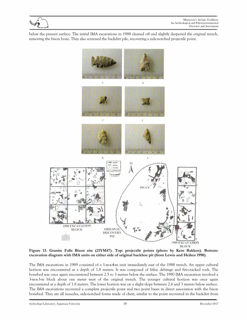
Minnesota’s Archaic Tradition:
An Archeological and Paleoenvironmental Overview and Assessment
Archeology Laboratory, Augustana University 29 December 2017
below the present surface. The initial IMA excavations in 1988 cleaned off and slightly deepened the original trench, removing the bison bone. They also screened the backdirt pile, recovering a side-notched projectile point.
Figure 13. Granite Falls Bison site (21YM47). Top: projectile points (photo by Kent Bakken). Bottom: excavation diagram with IMA units on either side of original backhoe pit (from Lewis and Heikes 1990). The IMA excavations in 1989 consisted of a 1-m-x-4-m unit immediately east of the 1988 trench. An upper cultural horizon was encountered at a depth of 1.8 meters. It was composed of lithic debitage and fire-cracked rock. The bonebed was once again encountered between 2.5 to 3 meters below the surface. The 1990 IMA excavation involved a 3-m-x-3-m block about one meter west of the original trench. The younger cultural horizon was once again encountered at a depth of 1.8 meters. The lower horizon was on a slight slope between 2.6 and 3 meters below surface. The IMA excavations recovered a complete projectile point and two point bases in direct association with the bison bonebed. They are all isosceles, side-notched forms made of chert, similar to the point recovered in the backdirt from

Minnesota’s Archaic Tradition:
An Archeological and Paleoenvironmental Overview and Assessment
Archeology Laboratory, Augustana University 30 December 2017
the original trench (see Figure 13). A large Tongue River silica biface was also recovered in situ in the initial 1988 excavation. Other artifacts from the bonebed include a hammerstone, two basalt chopping tools, and lithic debitage. Most of the debitage appeared to be associated with a lithic workshop area. No diagnostic material was found in the upper cultural horizon. Four radiocarbon dates were obtained from the site, two from charcoal and two from bison bone; all are from the lower horizon. The corrected charcoal dates are between 8040 and 7745 BP. The corrected bone dates are between 7721 and 7078 BP. The bison appears to be Bison occidentalis (Lewis and Heikes 1990). At least five skulls were present. A late fall–early winter time of occupation was suggested based on the maturity of one adolescent. The bison were probably killed at the site location, perhaps by driving them against the bedrock outcrop. Sandy Lake Dam (21AK11)
The Old Copper complex was originally defined on the basis of a few Late Archaic cemetery sites in Wisconsin and Michigan, as well as extensive surface collections. Intact habitation sites for Old Copper have proved elusive. The best known Old Copper site in Minnesota is the Petaga Point site (21ML11) mentioned above, but its Late Archaic component was severely disturbed prior to professional excavation (Bleed 1969). It has yielded no subsistence remains or Archaic radiocarbon dates. The other well-known Minnesota Old Copper site is Fowl Lake (21CK1), located on the Canadian border in northeastern Minnesota, but it is only known from surface collections by avocational archeologists (Platcek 1965) and is largely destroyed. The Sandy Lake Dam site (21AK11) is located on a peninsula formed by the Sandy River on the north and west and Big Sandy Lake on the southeast. The Mississippi River junction is about one-half-mile to the west. A fur post was established there about 1830, followed by a protestant mission to the Ojibwe two years later. The mission was abandoned in 1855. The USACE built a timber dam on the Sandy River at the north edge of the site in 1891. It was replaced with a concrete dam 20 years later. The USACE now maintains a recreation area on either side of the dam. The archeological site was originally reported by Warren Upham (1899). Stone and copper tools had been found at the location by local settlers and during construction of the original dam in the 1890s. The site was first tested by Elden Johnson of the University of Minnesota in 1975 to determine the extent of disturbance caused by the recent construction of a variety of USACE facilities. Additional testing for the USACE was done by Joe Hudak of the Science Museum of Minnesota in 1977 and by private consultant Christina Harrison in 1985. The site was known to contain Late Archaic, Late Woodland, and early historic components. In 2001, Frank Florin, a private consultant, was hired by the USACE to test areas of proposed new construction for recreational facilities. In 2004, the USACE again hired Florin to conduct mitigation excavations for the expansion of a comfort station. Unfortunately, the contract did not include completion of a detailed final report so only a preliminary letter report was completed (Florin 2005). Some additional detail is provided in an article describing the radiocarbon date from 21AK11 (Bradford 2013). The 2004 Florin excavation was done in a 4-m-x-8-m unit with soil removed in arbitrary 10 cm levels by 1 meter squares, and most of the soil was screened through ¼-inch mesh. The depth of the 1-m-x-1-m units varied between 50 and 90 cm, with most units going to 70 cm. Features were excavated with trowels and the soil was saved for later processing. Twelve (12) features were identified, all apparently fire hearths. At least one feature (F10) was Late Archaic in age and contained copper artifacts (Figure 14). About 8,000 artifacts were recovered from the Phase III excavations, including 36 lithic tools, 3,478 pieces of lithic debitage, 363 ceramic sherds, 1,879 pieces of bone, 1,894 pieces of fire-cracked rock, 270 historic period artifacts, and 33 pieces of copper. The feature with the six copper artifacts also contained 276 calcined bone fragments, including 59 fish bones, five turtle bones, two muskrat bones, and two unidentified small mammal bones. The light fraction of the soil from this feature has not been analyzed.

Minnesota’s Archaic Tradition:
An Archeological and Paleoenvironmental Overview and Assessment
Archeology Laboratory, Augustana University 31 December 2017
Figure 14. Sandy Lake Dam site (21AK11). Top: tanged copper knife. Bottom: Frank Florin pointing at Archaic feature that contained copper artifacts and Oxbow point (photos by Florin Cultural Resources). The copper artifacts from the site included 9 formal tools and 24 scraps. Seven of the tools are piercing instruments (1 punch, 1 awl, 5 awl fragments). Using the Wittry (1951) and Steinbring (1975) system, Bradford (2013) classified the other two copper tools as a tanged knife (see Figure 14) and a projectile point. A small side-notched projectile point similar to an Oxbow point was also recovered from the Archaic horizon. A radiocarbon date on a calcined bone fragment returned an age of 5690 + 30 14C yr BP, or about 4520 BC (Bradford 2013). Although the Sandy Lake Dam site has been severely disturbed by modern activities, small portions of the site still retain some integrity. The 2013 excavations document the only Archaic site in Minnesota to have yielded copper artifacts in direct association with a feature, subsistence remains, and a diagnostic stone projectile point. The radiocarbon date places the Archaic component at the site significantly earlier than the standard starting date of 5000 BP for the Old Copper complex (Gibbon 1998), but the date is on calcined bone. Bone dates, especially those of aquatic species in areas of high carbonate content surface water, may be subject to significant age depression (Scott Cummings 2017). The bone dated at 21AK11 is identified only as a vertebral fragment. 21CR155
In 2012, MnDOT conducted a cultural resource survey in association with plans to replace the bridge over the Minnesota River at Shakopee and attendant plans to rebuild CSAH 61 (Flying Cloud Drive) in Carver and Hennepin counties along the north side of the river. MnDOT hired Florin Cultural Resources Associates (FCRA) to survey

Minnesota’s Archaic Tradition:
An Archeological and Paleoenvironmental Overview and Assessment
Archeology Laboratory, Augustana University 32 December 2017
CSAH 61 in Carver County. FCRA found several sites and evaluated sites 21CR154, 21CR155, and 21CR156. Site 21CR155 was determined to be eligible and could not be avoided by the project. In 2013, Carver County hired FCRS to complete the Phase III mitigation excavation of site 21CR155 that was required by USACE under Section 106 of the National Historic Preservation Act. FCRS began the Phase III excavations in mid-November 2013 and completed the excavations in early May 2014. The final report (Florin et al. 2015) includes a summary of the site’s geomorphology written by personnel from Minnesota State University, Mankato. Site 21CR155 is in the Minnesota River Valley bottom almost one mile north of the current river channel and 700 feet south of the valley wall. The site’s surface elevation is about 37 feet above the current river level and 150 feet below the crest of the valley wall. Most of the site sits on and beneath an alluvial fan created by Bluff Creek. The fan extends south of the site for about 700 feet. The western portion of the site is also on a small fan created by an intermittent stream immediately to the west of the Bluff Creek fan. Most of the fans were created by historic-period deposition. The prehistoric portion of the Bluff Creek Fan was first created about 7,000 years ago. There is also considerable recent historic-period colluvium on the western portion of the site and intentional recent fill was mechanically placed on the eastern portion of the site. The FCRS mitigation began with machine removal of historic alluvium, colluvium, and fill in nine trenches adjacent to the roadway east-west across site 21CR155. These were labeled Areas A through H moving west to east. Shovel testing was then conducted in the trench bottoms to direct the placement of 71 square meters of formal archeological test units. The units were shovel skimmed in 1–2-cm levels and most of the soil was screened through ¼-inch mesh. About 10 percent of the excavation unit soil was water-screened through 1/8-inch mesh. The site contains Archaic and Woodland occupations, with the Archaic horizons being the most prominent. The Archaic horizons were classified by FCRS as Early Plains Archaic (8500–6300 BP) and Late Archaic (5000–2700 BP). The Early Plains Archaic was subdivided into initial (ca. 8000 BP) and terminal (ca. 7100 BP) components. The Early Plains Archaic I horizon was found only in Area C, in about the middle of the prehistoric Bluff Creek Alluvial Fan. The Early Plains Archaic II component was widespread throughout the site. The Late Archaic horizon was only found at the west edge of the site (Area A). The assignment of the early Archaic components to the Plains Archaic tradition rather than Eastern Archaic tradition was not based on diagnostic artifacts, but on the predominance of bison remains and the assumed upland environment being prairie. Although a number of turtle, bird, snake, beaver, and small mammal bones were recovered from the Early Archaic horizons, the only definitive cultural subsistence remains are bison bone. The only diagnostic projectile point found in the Early Plains Archaic I horizon at 21CR155 was classified as a Delong point. The only diagnostic artifacts from the Early Plains Archaic II horizon were the basal portion of a side-notched point (Figure 15) and a small unnotched point that resembles a Late Woodland form. This unnotched point could be an unfinished Archaic point or a Late Woodland specimen that was somehow displaced from an upper horizon. No diagnostics were found in the limited Late Archaic component. Site 21CR155 is important in that it is the only extensive excavation of an intact Archaic site in the lower Minnesota River Valley, and, besides King Coulee (21WB56), the only extensive Archaic site excavation in southeastern Minnesota. It was thoroughly studied in terms of its geomorphology and absolute chronology. The Phase II excavations produced seven radiocarbon dates of which all but one are Archaic in age, and the Phase III excavations produced 10 radiocarbon dates of which all but three are Archaic. The geomorphology and dating provide insight into the Archaic occupation of the Minnesota River Valley, and also help to fine-tune a predictive model for Archaic site locations in the valley.

Minnesota’s Archaic Tradition:
An Archeological and Paleoenvironmental Overview and Assessment
Archeology Laboratory, Augustana University 33 December 2017
Figure 15. Site 21CR155. Top: Archaic projectile point (from Florin et al. 2015). Bottom: 2012 Area A unit looking west. Jeffers (21CO3) The Jeffers site (21CO3) is the most extensive collection of prehistoric petroglyphs in Minnesota and one of the most extensive petroglyph sites in North America, with an estimated 5,000 individual glyphs. This number is based on only some of the petroglyphs being exposed, since an unknown number of others have been covered with naturally encroaching prairie sod. The petroglyphs were made by hammerstone pecking in a hard red quartzite ridge that extends for 23 miles, mostly in Cottonwood County. The area of petroglyphs at Jeffers is about 150 feet by 900 feet (Figure 16). Other areas of the ridge in Cottonwood and Brown counties also exhibit some petroglyphs, but only the Jeffers site has a large concentration. The Jeffers site was first noted by Warren Upham in a geological survey report in 1884. T. H. Lewis visited Jeffers in 1889 and made tracings of 30 of the petroglyphs. Lloyd Wilford from the University of Minnesota visited the site in

Minnesota’s Archaic Tradition:
An Archeological and Paleoenvironmental Overview and Assessment
Archeology Laboratory, Augustana University 34 December 2017
1941, noting that lichen growth was obscuring some of the petroglyphs. Also in 1941, MHS archeologist G. Hubert Smith along with several members of the Minnesota Archaeological Society (MAS) visited Jeffers. MAS member and professional photographer Paul Klammer took black and white photos of the site.
Figure 16. Jeffers Petroglyph site (21CO3). Top: images of weapons and bison (from Lothson 1976). Bottom: view of rock ledge looking northeast. In 1966, the MHS purchased 40 acres of land from the Warren Jeffers estate that included the main petroglyph concentration. A small interpretive center was then built at the site. Many of the petroglyphs were painted with marine varnish to enhance their visibility for visitors. The varnishing continued over the next 15 years and was present when MHS archeologist Gordon Lothson undertook the first comprehensive mapping of the petroglyphs in 1971. He recorded over 2,000 individual glyphs. Lothson’s small crew did photography, rubbings, and line drawings. Five years later, MHS published Lothson’s study of the Jeffers site (Lothson 1976). In 1999, MHS archeologist Bob Clouse conducted a field school at Jeffers. Clouse used a new petroglyph recording technique by placing sheets of Mylar over the glyphs and then reproducing individual peck marks to accurately show the images without modern artistic interpretation. Rock art conservator Clair Dean also analyzed the preservation needs at the site. A small excavation at the base of the rock ledge found that some petroglyphs documented by Lothson 28 years earlier were already buried by wind-blown sediment.

Minnesota’s Archaic Tradition:
An Archeological and Paleoenvironmental Overview and Assessment
Archeology Laboratory, Augustana University 35 December 2017
In 2006, a new effort was started by site manager Tom Sanders. Sanders not only included professionals on the team, but Indian elders to assess interpretation and preservation needs. This resulted in a formal conservation and interpretive plan. This plan included recommending the careful removal of lichen that was obscuring many of the petroglyphs. The result was an increase in the number of known petroglyphs from 2,000 to 5,000. In 2011, the University of Minnesota joined the effort, utilizing laser scanning to document some of the glyphs. Recent archeological work in the Jeffers area includes Hamline University’s 2011–2012 testing of the Gruenig site (21CO68), although it yielded very little useful information. Lothson (1976) was the first to attempt a comprehensive understanding of the Jeffers site. Lothson identified 207 clusters of petroglyphs and described 23 in detail in his publication. He then divided the glyphs into five major classes: Human Forms, Weapons and Tools, Thunderbirds, Animal Figures, and Geometrics. He attempted to interpret and date the carvings by subject matter. Based on the representations of atlatls and stemmed projectile points perhaps representing Old Copper forms (see Figure 16), Lothson suggested many of the glyphs dated to the Late Archaic between 3500 and 2500 BP. As for function, Lothson suggested hunting magic, sacred ceremonies, and a record of events. More recently, Steinbring (2013) has also suggested the presence of copper point representations at Jeffers. Tom Sanders, the longtime site manager at Jeffers, has been the most vocal and active supporter for careful study of the Jeffers petroglyphs. His 2014 paper, available online on the MHS website, used a system developed by Keyser and Klassen (2001) in the northwest Plains to interpret and date the Jeffers glyphs (Sanders 2014). Sanders believes the most common petroglyph tradition present at Jeffers is what Keyser and Klassen call the Early Hunting tradition. This may suggest that the earliest glyphs at Jeffers are as old as 7,000 years. The lack of glyphs belonging to the Biographic Tradition of early historic times (e.g., firearms, horses) suggests that the last aboriginal glyphs at Jeffers were carved prior to AD 1750. While we may never know just how early Indians began to carve glyphs at Jeffers, an Archaic presence is very likely. Atlatl use appears to have lasted into Woodland times and the bow and arrow may have originated in Archaic times so the presence of these weapon systems alone is not necessarily an accurate dating method. What Jeffers does document is use of the site by groups coming from, or influenced by contact with people from, a wide geographic area. The site not only provides possible insight into Archaic economic, social, and spiritual life, but demonstrates a worldview not limited to southwestern Minnesota. CONCLUSIONS
There has been little fame or fortune to be found in the study of Minnesota’s Archaic. Of Minnesota’s first three professional archeologists, Jenks was only concerned with the earliest human arrivals, and Wilford and Johnson were most interested in the ceramic cultures at the other end of the prehistoric period. Their successors at the University of Minnesota looked to the Late Prehistoric and the Ethnographic period for questions of importance. At the State Universities, only Mike Michlovic followed the elusive Archaic dream, finally having to fully realize it across the border in North Dakota. Most new Archaic research in Minnesota has been due to Archaic sites being discovered inadvertently during construction projects that required environmental review. This would include the recent excavations at the Sandy Lake Dam site (21AK11), which helped to expand our knowledge of the Old Copper complex, and excavations at site 21CR155 that demonstrated the extension of focal bison hunting into southeastern Minnesota during the prairie maximum. What remains to be addressed are some major excavations at single-component Archaic sites or multicomponent Archaic sites with intact stratigraphy, particularly in the southeast, the northeast, and the center of the state.

Minnesota’s Archaic Tradition:
An Archeological and Paleoenvironmental Overview and Assessment
Archeology Laboratory, Augustana University 36 December 2017
3. PALEOENVIRONMENTS OF MINNESOTA DURING THE ARCHAIC PERIOD
INTRODUCTION The Archaic tradition in Minnesota spans a period from about 7500–500 radiocarbon years BC, or about 9450–2450 radiocarbon years BP, which translates to about 10,700–2500 calendar years BP.1 Thus, the tradition begins in the early Holocene, spans the middle Holocene, and ends in the late Holocene. The Archaic period encompasses a time of great vegetation and climate change, which would have greatly influenced resources available to human populations. At the time of European settlement in the nineteenth century, tallgrass prairie occurred in southern and western Minnesota, while a mosaic of conifer and hardwood forests covered northeastern Minnesota. Deciduous forest and woodlands occurred in southeastern Minnesota and between prairie and the northeastern conifer/hardwood forest (Marschner 1974; Wendt and Coffin 1988) (Figure 17). In the nineteenth century, the prairie-forest border was typically sharp, formed in many places by waterbodies (rivers and lakes) or physiographic breaks between level ground moraine, glacial lake plain, or outwash plain and more rugged stagnation or end moraine, often with many lakes. Prairie covered the level Lake Agassiz lake basin in northwestern Minnesota, the Minnesota River Valley (Blue Earth and Olivia till plains) in southwestern Minnesota, and the Rochester Till Plain in southeastern Minnesota. Not only are these physiographic units level, they have few lakes to stop the spread of fire. A mosaic for oak-scrub and prairie occurred on Des Moines lobe end moraines south of the Big Woods and on the Alexandria Moraine in westcentral Minnesota. Isolated islands of forest occurred on the Alexandria Moraine in Kandiyohi County, with prairie to the west on the level ground moraine of the Olivia Till Plain and to the east on the Bonanza Valley Outwash Plain. The main prairie-forest border is sharply defined along the east side of the Bonanza Valley Outwash Plain by the North Fork Crow River (Marschner 1974). Within the band of deciduous forest and woodlands, mesic forest dominated by fire-sensitive trees such as Ulmus americana (American elm), Acer saccharum (sugar maple), and Tilia americana (basswood), occurred in areas well protected by firebreaks, such as rivers and lakes. This vegetation included the Big Woods in southcentral Minnesota (Daubenmire 1936; Grimm 1984) as well as other smaller areas. Fire-tolerant trees such as Quercus macrocarpa (bur oak) and Populus tremuloides (aspen) occurred in areas more exposed to fire (Grimm 1984). Quercus macrocarpa dominated this vegetation in the southern half of the state, while Populus tremuloides predominated in the northwestern part. The physiognomy of this vegetation varied, but much of it was scrub woodland, thickets, or parkland rather than true savanna, which implies widely spaced trees with a grassland understory (Grimm 1984). The nineteenth century public land surveyors did not use the term savanna, but rather described much of this vegetation as oak openings, oak barrens, thicket, or brush prairie (Grimm 1984; Marschner 1974). In this paper, the term savanna will be used to generically refer to oak-grassland vegetation. The western and southern limits of the northern conifer/hardwood forest are marked by the range limits of pine. The boreal conifers Abies balsamea (balsam fir) and Picea (spruce) become more common northward. Within the conifer/hardwood forest, rich, loamy soils supported northern hardwoods such as Acer saccharum, Quercus rubra (red oak), and Betula papyrifera (paper birch), and conifers such as Pinus strobus (white pine), Picea glauca (white spruce), and Abies balsamea. Pinus banksiana (jack pine) dominated sandy outwash plains. Large areas of peatlands dominated by Picea mariana (black spruce) and Larix laricina (tamarack) covered old glacial lake plains. The northern conifer/hardwood forest is transitional between the eastern deciduous forest and boreal forest. It contains a mixture of eastern deciduous trees near their northern range limits, such as Acer saccharum and Quercus rubra, and boreal trees near their southern range limits, including the conifers Picea glauca, Picea mariana, Larix laricina, Abies balsamea, and Pinus banksiana and the deciduous trees Populus tremuloides and Betula papyrifera (paper birch). Several tree species are restricted to this floristic region, including Pinus strobus, Pinus resinosa (red pine), and Thuja occidentalis (arborvitae). In the first half of the twentieth century, soil scientists and ecologists recognized that some soils in the forested region of Minnesota had prairie profiles. They surmised that at some time in the postglacial period, prairie had advanced well into the forested region, although exactly when the prairie incursion occurred was unknown (e.g., Daubenmire 1936).
1 Ages here are reported in cal years BP unless otherwise stated; ka (kiloannus) will refer to 1000 calibrated radiocarbon years.

Minnesota’s Archaic Tradition:
An Archeological and Paleoenvironmental Overview and Assessment
Archeology Laboratory, Augustana University 37 December 2017
Figure 17. Minnesota’s generalized presettlement vegetation and pollen core sites discussed in text.

Minnesota’s Archaic Tradition:
An Archeological and Paleoenvironmental Overview and Assessment
Archeology Laboratory, Augustana University 38 December 2017
The seminal paper by Wright et al. (1963) presented pollen diagrams from Kirchner Marsh and Lake Carlson on the St. Croix Moraine south of St. Paul that showed a major prairie incursion in the mid-Holocene ~8000–6000 cal yr BP. Over the next two decades, a number of studies further documented the northeastward advance and subsequent retreat of prairie during the mid-Holocene. Of particular importance is the classic paper by McAndrews (1966), who investigated a transect of sites (the “Itasca transect”) in northwestern Minnesota from prairie through deciduous forest to conifer/hardwood forest, wherein he documented the time-transgressive advance and retreat of prairie. Moreover, he showed that, as analogous to the modern landscape, sites in the conifer/hardwood region passed from prairie through a deciduous forest phase before conifers appeared. In a series of papers, H. E. Wright emphasized the time-transgressive nature of climate and vegetation change in Minnesota (Watson and Wright 1980; Wright 1976, 1981). Wright (1976) discussed the term “Hypsithermal,” which referred to a warm, dry period in the mid-Holocene, but which he considered to be a time-transgressive phenomenon rather than a time-stratigraphic unit as originally defined. Wright (1976) also used the more informal term “prairie period” and in later papers used only this term (e.g., Wright 1992) for the time-transgressive advance and retreat of prairie into Minnesota. Wright (1976) specifically rejected attempts of Bryson and Wendland (1967) and Bryson et al. (1970) to apply the typological Blytt-Sernander sequence to North America, which emphasized synchronous changes. Bernabo and Webb (1977) and Webb et al. (1983) mapped the Holocene advance of prairie with “isopoll” maps, which they interpreted as depicting the time-transgressive movement of the prairie-forest ecotone, but which they also referred to as the prairie border. Wright (1992) noted the asymmetric pattern of forest before and after the prairie period, with the more mesic, fire-sensitive Ulmus dominating before the prairie period and the more xeric, fire-tolerant Quercus after the prairie period. Umbanhowar et al. (2006) and Nelson and Hu (2008) also noted an asymmetric response, but in terms of rapidity of change across geographic space, with rapid expansion of prairie in the early Holocene and a more gradual reforestation in the late Holocene. Williams et al. (2009) also noted the asymmetrical pattern of abrupt prairie expansion in the early Holocene with more gradual reforestation. However, whereas Umbanhowar et al. (2006) describe asymmetrical response at individual sites, Williams et al. (2009) describe spatial asymmetry, i.e., rapid deforestation and eastward prairie advance in the early Holocene in contrast with more gradual reforestation and prairie retreat westward in the late Holocene. While the sites studied by Umbanhowar et al. (2006) do exhibit an asymmetrical pattern, it should be noted that many do show rapid reforestation, albeit at different times (Almendinger 1992; Grimm 1983). The existing data show that forest covered most of Minnesota at the beginning of the Archaic period, but prairie was already established in the western part of the state. Prairie rapidly expanded 9000–8000 years ago and began retreating after about 7,000 years ago. Despite the large number of pollen sites in Minnesota, few are well-dated, which hampers detailed reconstruction. Many of these sites were studied before the advent of accelerator mass spectrometry (AMS) radiocarbon dating, and chronologies for most of the sites are based on conventional bulk-sediment radiocarbon dates, which can have significant old-carbon reservoirs of hundreds or even thousands of years. Moreover, the reservoir effect at a single site can vary through time (Grimm et al. 2009). Classic age models involve fitting a line or curve through a series of age controls, typically radiocarbon dates, to provide point estimates of sample ages with no estimates of error. However, a radiocarbon date is not a single age, but rather a probability distribution, and new age modeling methods consider the probability distributions of calibrated ages and provide estimates of the confidence limits of estimated ages. This chapter employs a Bayesian age modeling technique to provide estimates of error to better distinguish synchronous versus time-transgressive vegetation change. POLLEN DATASETS AND CHRONOLOGIES
All pollen datasets from Minnesota available from the Neotoma Paleoecology Database (www.neotomadb.org) that encompass all or most of the Archaic period were considered for analysis. Some sites (e.g., Wolsfeld Lake, Pogonia Bog Pond, Reidel Lake, Rice Lake) were rejected because they have very high Poaceae values that probably represent aquatic grasses, such as Zizania (wild rice), Calamagrostis (bluejoint, reedgrass), Glyceria (mannagrass), and Leersia oryzoides (rice cutgrass) (Almendinger 1992; Almquist-Jacobson et al. 1992; Grimm 1983; McAndrews 1969). The final dataset includes 24 sites (Table 2; see Figure 17).

Minnesota’s Archaic Tradition:
An Archeological and Paleoenvironmental Overview and Assessment
Archeology Laboratory, Augustana University 39 December 2017
Table 2. Sites Used in this Study with the Numbers of Conventional and AMS Radiocarbon Dates.
The pollen sites are arranged in four transects (Figure 18). The northcentral transect includes 12 sites from west to east across northcentral Minnesota from Thompson Pond in the prairie to Kotiranta Lake in the northern hardwoods/conifer forest. This transect includes the sites in McAndrews’ (1966) transect but extends farther east. The sites occur on a variety of glacial landforms, but most are on ground, stagnation, or end moraines. Two sites, Lake Minnie and Kotiranta Lake, lie on sandy outwash plains. Lake Minnie is on the Lake George outwash plain that was dominated by Pinus banksiana at the time of European settlement (Almendinger 1992), whereas Kotiranta Lake lies on the Sawyer outwash plain, which was covered by Picea mariana bogs and Populus/Betula forest (Marschner 1974; Wright and Watts 1969). The northeastern transect includes three sites from Myrtle Lake near the eastern edge of the Glacial Lake Agassiz Lowland eastward to Lake of the Clouds on the Laurentian Shield, through the northern hardwoods/conifer forest in northeastern Minnesota. The central transect includes four sites from West Olaf Lake on the prairie-forest border southeast to Lily Lake near the Wisconsin border. This transect passes mainly through deciduous forest and woodland, although Billy’s Lake lies just within the southwestern limit of Pinus. For some analyses, Myrtle Lake from the northeastern transect and Billy’s Lake from the central transect are included with the northcentral transect. Five sites comprise a southwest-to-northeast southern transect from Fox Lake near the Iowa border to Kirchner Marsh south of St. Paul. Fox Lake, which is in the tallgrass prairie, is farther from the prairie-forest border than any other site in this study. Two sites on this transect, Rutz Lake and Kimble Pond, lie within the Big Woods, which was the largest contiguous area of mesic, fire-sensitive deciduous forest in Minnesota (Daubenmire 1936; Grimm 1984). Sharkey Lake and Kirchner Marsh were in oak woodland, dominated by Quercus macrocarpa, east of the Big Woods.
Coordinates Radiocarbon Dates
Site Lat. Long. Conventional AMS Reference Billy’s Lake 46.2706 -94.5516 6 – Jacobson and Grimm 1986 Bog D 47.1775 -95.1627 4 – McAndrews 1966 Deep Lake 47.6838 -95.3984 – 7 Hu et al. 1997; Nelson and Hu 2008Fox Lake 43.6774 -94.6981 – 5 Commerford et al. 2016 Irvin Lake 47.1356 -93.6436 5 – Alwin 1982Jacobson Lake 46.4169 -92.7169 2 – Wright and Watts 1969 Kimble Pond 44.2190 -93.8402 – 9 Camill et al. 2003 Kirchner Marsh 44.7709 -93.1226 6 – Wright et al. 1963 Kotiranta Lake 46.7142 -92.5872 3 – Wright and Watts 1969 Lake Ann 45.4250 -93.6875 2 – Keen and Shane 1990 Lake Minnie 47.2448 -95.0077 4 – Almendinger 1992 Lake of the Clouds 48.1426 -91.1125 31 – Amundson and Wright 1979; Craig 1972Lily Lake 45.0482 -92.8239 7 – Brugam et al. 1988 Little Bass Lake 47.2860 -93.6005 5 – P. C. Swain, unpublished Martin Pond 47.1740 -94.9440 – – McAndrews 1966 Myrtle Lake 47.9826 -93.3853 5 – Janssen 1968Portage Lake 47.0810 -94.1130 3 – J. H. McAndrews, unpublished Quallen Lake 47.1932 -95.7866 1 – McAndrews 1966 Rutz Lake 44.8708 -93.8590 8 – Waddington 1969 Sharkey Lake 44.5924 -93.4132 – 11 Camill et al. 2003 Steel Lake 46.9732 -94.6814 – 35 Wright et al. 2004 Third Lake 48.0988 -92.0105 – – Swain 1979Thompson Pond 47.1948 -96.0933 – – McAndrews 1966 West Olaf Lake 46.5986 -96.1868 – 10 Nelson et al. 2004; Nelson and Hu 2008

Minnesota’s Archaic Tradition:
An Archeological and Paleoenvironmental Overview and Assessment
Archeology Laboratory, Augustana University 40 December 2017
Fig
ure
18.
Sim
plif
ied
com
pos
ite
pol
len
dia
gram
s ar
ran
ged
in f
our
tran
sect
s. B
oun
dar
ies
are
show
n a
s d
ash
ed w
hit
e lin
es f
or s
ites
wit
h m
ajor
ear
ly a
nd
late
H
oloc
ene
zon
es i
den
tifi
ed b
y st
rati
grap
hic
ally
con
stra
ined
clu
ster
an
alys
is. F
or s
ites
wit
hin
th
e ra
nge
of P
inus
str
obus
wh
ere
the
sub
gen
era
of P
inus
wer
e d
isti
ngu
ish
ed, t
he
curv
e fo
r P
inus
su
bg.
Str
obus
is s
how
n a
s a
wh
ite
line
wit
hin
th
e b
lue
curv
e fo
r P
inus
.

Minnesota’s Archaic Tradition:
An Archeological and Paleoenvironmental Overview and Assessment
Archeology Laboratory, Augustana University 41 December 2017
Only six of the 24 sites are reliably dated, those with AMS radiocarbon dates on terrestrial macrofossils (see Table 2). Radiocarbon dates from the other sites are on bulk sediments, which invariably have an old-carbon reservoir (Grimm et al. 2009). However, most of the publications for these sites have not considered this reservoir in their age models. Published reservoir corrections for sites included in this study are 740 years at Billy’s Lake (Jacobson and Grimm 1986), 1,000 years at Rutz Lake (Waddington 1969), 250 years at Lily Lake (Brugam et al. 1988), and 340 years at Lake of the Clouds (Stuiver 1971). In general, reservoir corrections made to Minnesota sites range from 200 to 1,000 years, with a median value of 468 years (Table 3).
Table 3. Old Carbon Reservoir Corrections Published for Radiocarbon Dates from Minnesota Lake Cores.
Site Name Reservoir Correction (years) Reference
Big John Pond 195 Almendinger 1992 Pogonia Bog Pond 200 Swain 1979 Lily Lake 250 Brugam et al. 1988 Hostage Lake 275 Almendinger 1992 Lake of the Clouds 340 Stuiver 1971 Wentzel’s Pond 435 Almendinger 1992 Reidel Lake 500 Almquist-Jacobson et al. 1992 Wolsfeld Lake 530 Grimm 1983 Peterson Slough 730 Almendinger 1992 Billy’s Lake 740 Jacobson and Grimm 1986 Mud Lake 810 Almendinger 1992 Rutz Lake 1,000 Waddington 1969
For most of these sites, the corrections were based on a radiocarbon date of sediment just below the European settlement horizon; the correction for Lake of the Clouds was based on varve counts. Problems with this procedure are 1) precision: the 95 percent confidence intervals of the uncalibrated dates are typically 200 years or more, while the confidence intervals of the calibrated ages for this time period are even greater; 2) accuracy: with one date, outlier probability cannot be assessed; and 3) the reservoir, even if accurately and precisely determined for the time of European settlement, may nevertheless vary through time (Grimm et al. 2009). In a study of four sites in the Midwest with both bulk-sediment conventional dates and AMS dates on terrestrial plant macrofossils, Grimm et al. (2009) documented that the reservoir is typically several hundred to a thousand years or more and that, indeed, it does vary through time, as long suspected. At one site, Chatsworth Bog in Illinois, the reservoir varied from near zero at the top, to 1,000 years at 7 m depth, to near zero at 10 m depth, and to over 1,000 years at 12 m depth. Moreover, despite dissolved carbonate rocks being a major source of old carbon, no clear relationship existed between carbonate content of the sediment and magnitude of the error. In addition to radiocarbon dates, pollen stratigraphic changes may be used for age controls. For Minnesota, where changes may be time-transgressive, these age controls should be used with caution. The timing of marked pollen stratigraphic changes even at nearby sites can vary greatly (e.g., Almendinger 1992). Nevertheless, for marked changes in nearby sites on similar parent material and landform, use of such controls may be justified in the absence of other age controls. Blois et al. (2011) evaluated pollen cores in the Neotoma Paleoecology Database from across eastern North America and determined that only 22 of them met “benchmark” criteria for high accuracy and precision, namely high-resolution age control with AMS radiocarbon dates on terrestrial plant macrofossils. Only two of these sites were in Minnesota, Steel Lake and Sharkey Lake, both of which are used in this study. Blois et al. (2011) used Bayesian change-point analysis to identify widespread pollen stratigraphic events, and then spatially interpolated these events to non-benchmark sites. Thus, this analysis could assign ages to time-transgressive stratigraphic events, although somewhat limited by the small number of benchmark sites. Blois et al. (2011) constructed clam age models (Blaauw 2010) based on the IntCal09 calibration curve (Reimer et al. 2009) for most of the sites in this study using the available radiocarbon dates and the benchmark pollen stratigraphic ages. However, for these age models, reservoir corrections were made for only the few cores that already had them for existing age models.

Minnesota’s Archaic Tradition:
An Archeological and Paleoenvironmental Overview and Assessment
Archeology Laboratory, Augustana University 42 December 2017
For this study, new age models were constructed for all sites using the Bayesian age modeling program Bacon (Blaauw and Christen 2011) and the IntCal13 calibration curve (Reimer et al. 2013). For sites with insufficient or no radiocarbon control, pollen stratigraphic age controls were used from either the Blois et al. (2011) clam age models or from nearby sites. In some cases, however, the Blois et al. (2011) pollen stratigraphic ages, determined from the “benchmark” sites, were assigned to different depths than in the Blois et al. (2011) age models. Reservoir corrections were applied to all bulk-sediment radiocarbon dates. For Billy’s Lake and Lily Lake, the published corrections were used (Brugam et al. 1988; Jacobson and Grimm 1986). For most other cores, a 300-year reservoir was applied. This correction is likely somewhat too small for some of the cores but is probably not an overestimate. For Rutz Lake and Kotiranta Lake, a 500-year reservoir was subtracted. Waddington’s (1969) reservoir estimate of 1,000 years for Rutz Lake appears too large when compared to the Blois et al. (2011) pollen stratigraphic ages, while a 500-year reservoir brings the Kotiranta dates in better alignment with the Blois et al. (2011) age for the Picea decline. Given a median reservoir of 468 years (see Table 3), a 500-year correction is not unreasonable. The varve chronology for Lake of the Clouds is problematical because the core started in the sediment, and the uppermost varves are missing. Craig (1969) estimated the missing number to be 200, whereas Stuiver (1971) estimated that 600 varves were missing. Craig (1972), citing a personal communication from Swain, estimated that 260 varves were missing, which appears to be the best estimate. If so, Stuiver’s estimate of 340 years for the reservoir is too small. For this study, the 260-year estimate was used. The varve age was established for the radiocarbon-dated sections based on the lamination counts in Craig’s (1969, Appendix 1) thesis. The radiocarbon dates were calibrated with OxCal 4.2.4 (Bronk Ramsey and Lee 2013) using the IntCal13 calibration curve (Reimer et al. 2013). A reservoir correction was made for each date based on the difference between the varve age and mean calibrated age. However, because calibrated ages are probability distributions, not point estimates, these corrections are overly precise. Except for the two upper dates, the mean reservoir is 1086 years, with little trend. The mean reservoir of the upper two dates is 781 years. These reservoirs were applied to the radiocarbon dates. In contrast to simple age models wherein a curve is fit to a set of age controls, the Bacon age models consider the probability distributions of the calibrated ages and assign 95 percent higher post density (HPD) confidence intervals (Bayesian confidence intervals) to the interpolated ages produced by the modeling procedure. For cores with limited age control, these ranges can be quite large. These probability estimates are used in this study to evaluate the evidence for synchronous versus time-transgressive change. The uncertainty in the reservoir correction implies that the Bacon estimates of error in interpolated ages are minimal. Ages given in this paper and used for the pollen diagrams (see Figure 18) are the weighted mean ages from the HPD functions. For some ages, the 95 percent HPD interval (Bayesian confidence limit) will be listed in parentheses following the weighed mean age. POLLEN DIAGRAMS AND NUMERICAL METHODS A simplified, stacked pollen diagram of nine taxa or taxa groups was created for each site (see Figure 18). The diagrams were truncated at 11,000 cal yr BP and 0 cal yr BP. Most of the sites extend to 11,000 cal yr BP, but a few begin later than that, either because the record begins after 11,000 cal yr BP (e.g., Third Lake, Lake of the Clouds) or because the basal part of the core was not analyzed (e.g., West Olaf Lake, Fox Lake). Pollen percentages for these diagrams were based on the sum of these nine types. A combined curve is shown for the mesic deciduous trees Acer saccharum, Ostrya/Carpinus, Tilia, and Ulmus. It would have been desirable to have separated the two subgenera of Pinus (subg. Pinus, which includes P. banksiana and P. resinosa, and subg. Strobus, which includes P. strobus), but for intersite comparison, this was not possible because the Pinus subgenera were not separated for all sites. However, for those sites within the range of Pinus for which the subgenera were separated, the subg. Strobus curve is overlaid on the total Pinus curve. For this curve, the ratio of subg. Strobus/subg. Pinus was multiplied times the number of Pinus undifferentiated and added to the identified subg. Strobus for a total estimate of subg. Strobus. The nine taxa were subjected to constrained incremental squares cluster analysis (CONISS) (Grimm 1987) to objectively determine major pollen-zone boundaries. In addition to major zone boundaries, the ages of three other palynological events were determined in the northcentral transect: 1) the maximum value of prairie types (Artemisia, Ambrosia-type, Amaranthaceae, and Poaceae);

Minnesota’s Archaic Tradition:
An Archeological and Paleoenvironmental Overview and Assessment
Archeology Laboratory, Augustana University 43 December 2017
2) the maximum value of prairie types plus Quercus; and 3) the age at which prairie types first exceed 30 percent. For each site, the depth at which prairie types first reach 30 percent was interpolated linearly between the two samples with <30 percent prairie types and >30 percent prairie types. The age of this depth was obtained from the Bacon age model with the Bacon.hist() function (Blaauw and Christen 2011). The maximum value of prairie types represents the maximum development of prairie. The maximum value of prairie types plus Quercus represents the maximum development of oak savanna. The 30 percent value of prairie types represents a significant development of prairie near the site and significantly exceeds the percentages of prairie types in the pre-European settlement pollen spectra at sites east of the modern prairie-forest border. The intersite synchrony of pollen-zone boundaries and events are assessed by weighted least-squares linear regression of the zone or event ages from the Bacon age models. The weighting factor was 1/w2, where w = one-half of the 95 percent HPD interval. If the p value is not significant, the null hypothesis of synchrony cannot be rejected, whereas a significant p value indicates a time-transgressive change. RESULTS Northcentral Transect
For all sites on the northcentral transect, CONISS reveals a tripartite Holocene zonation: an early Holocene zone dominated by Pinus, a mid-Holocene zone in which Quercus and prairie types expanded, and a late Holocene zone in which Pinus, Betula, and mesic deciduous trees expanded. Regression analysis indicates that the early/middle Holocene zone boundary is time-transgressive, while the middle/late Holocene zone boundary is synchronous across northcentral Minnesota, dating to ~4.0 ka (Figure 19). The age of the early/middle boundary is about 9.2 ka in the west and 7.9 ka in the east, a span of about 1,300 years. The age at which prairie types exceeds 30 percent is also time-transgressive, about 9.6 ka in the west to 7.9 ka in the east, a span of about 1,700 years (Figure 20C). Thus, expansion of prairie and oak savanna eastward was time-transgressive in the early Holocene. At most sites on the northcentral transect, prairie types increased gradually throughout the early Holocene, and then increased abruptly at the early/middle Holocene zone boundary as Pinus abruptly declined (see Figure 18). At the two westernmost sites, the increase in prairie types and decline in Pinus was more gradual, and the zone boundary does not mark such abrupt change as farther east. At the easternmost site, Kotiranta Lake, the zone boundary marks the final demise of Picea, which was gradually declining throughout the early Holocene. Some of the increase in prairie types at more easterly sites probably represents long-distance transport from developing prairies farther west. In North Dakota, prairie expanded rapidly at the end of the Pleistocene ~11.8–11.5 ka (Grimm et al. 2011; Laird et al. 1998). At Kotiranta Lake, prairie and Quercus never expanded beyond background levels, and throughout the mid-Holocene, the region around this site remained forested, dominated by Pinus, although with Betula becoming somewhat more abundant after 6 ka. Although Pinus greatly dominates the early Holocene zone, Betula and mesic trees occur in percentages approaching those in the late Holocene, suggesting that they were also important components of the early Holocene forest. The amount of deciduous tree pollen varies among sites, suggesting that, as today, a vegetation mosaic occurred, probably varying with soil type and landform. At some sites, Picea is high at the very bottom of the sequence and soon declines, marking the rapid demise of the late-glacial Picea forest. After an abrupt decline, lower values of Picea persist at some
Figure. 19. Weighted mean calibrated ages of early and late Holocene zone boundaries at sites on the northcentral transect. The error bars indicate the 95 percent HPD confidence intervals. Red lines show the fit from weighted least-squares regression.

Minnesota’s Archaic Tradition:
An Archeological and Paleoenvironmental Overview and Assessment
Archeology Laboratory, Augustana University 44 December 2017
sites (e.g., Martin Pond) but at values still higher than seen in the late Holocene. At Kotiranta Lake, the easternmost site of the northcentral transect, Picea does not show an abrupt decline, but declines gradually throughout the early Holocene zone. In contrast to the time-transgressive expansion of prairie, the middle Holocene maximum values of prairie types and of prairie types plus Quercus were synchronous across the northcentral transect (Figure 20A and 20B). At most sites, the maximum of prairie types (mean age = 8.0 ka) slightly precedes the maximum of prairie types plus Quercus (mean age = 7.7 ka) (Figure 20D). At only two sites, Quallen Lake and Martin Pond, does the maximum of prairie types postdate the maximum of prairie types plus Quercus. However, at both of these sites, prairie types and Quercus dominate the mid-Holocene zone, and at both sites a maximum of prairie types at ~8 ka precedes the maximum of prairie types plus Quercus, but a later maximum in prairie types at ~6.5–6.0 ka exceeds the early maximum. If for these two sites, the maximum of prairie types before the maximum of prairie types plus Quercus is used (red symbols on Figure 20), the mean age for the prairie maximum is 8.2 ka. In any case, although the expansion of prairie was time-transgressive across northcentral Minnesota, the maximal development of prairie and oak savanna was synchronous at about 8.2–7.7 ka. At the western sites, the sum of prairie types plus Quercus remains high throughout the mid-Holocene zone. Although the values of Quercus and prairie types fluctuate, other deciduous trees and Pinus show little recovery. However, from Steel Lake eastward, Pinus, Betula, and mesic tree taxa show a gradual increase after ~7.5 ka, but with some major fluctuations. Several sites, especially on the eastern half of the transect, show two major peaks of forest trees (Pinus, Betula, and mesic deciduous) within the mid-Holocene zone, at ~7.5–7.0 ka and around 6 ka. These peaks vary in character among sites. For example, at ~7.5–7.0 ka, a peak at Jacobson Lake, is primarily Pinus, but mainly Betula at Irvin Lake, and a combination of Pinus, Betula, and mesic deciduous trees at Portage Lake. The western sites, except for Thompson Pond, do not exhibit corresponding peaks in Pinus, Betula, and mesic trees, but do show possibly coeval peaks in Quercus. An abrupt shift in vegetation occurred at ~4.0 ka at all sites on the northcentral transect except Thompson Pond, which lies west of the modern prairie-forest border. However, even at Thompson Pond, CONISS indicates a major zone boundary at this time; increasing tree pollen may indicate long-distance transport from the expanding forest east of the modern prairie-forest border. The nature of the vegetation shift varies from east to west; at all sites within the modern forested region, tree pollen
Figure 20. Weighted mean calibrated ages of palynological features: A) Maximum value of prairie herbs plus Quercus; B) Maximum value of prairie herbs; C) Age at which prairie herbs first exceed 30 percent; D) Curves from graphs A, B, and C plotted together. In graphs A–C, the error bars indicate the 95 percent HPD confidence intervals, and black lines show the fit from weighted least-squares regression.

Minnesota’s Archaic Tradition:
An Archeological and Paleoenvironmental Overview and Assessment
Archeology Laboratory, Augustana University 45 December 2017
increases, indicating forest closure and expansion. On the eastern end of the transect from Portage Lake eastward, Pinus increases at 4 ka. Based on sites where the subgenera of Pinus were separated, an increase in Pinus strobus is indicated. Although the area around the easternmost site, Kotiranta Lake, remained forested throughout the Holocene, Pinus, presumably P. strobus, increased at ~4 ka, while Betula declined. From Steel Lake westward, deciduous trees first increased, followed by a later increase in Pinus, again P. strobus, based on the sites where the Pinus subgenera were identified. At Steel Lake and Martin Pond, in the center of the transect, Betula first increased, followed by an increase in Pinus. At Bog D and Quallen Lake, Betula and mesic deciduous trees show marked increases at ~4 ka. Pinus strobus increased at ~2 ka at Bog D, but never reached Quallen Lake, which today lies west of the range of Pinus in Minnesota. Thus, a time-transgressive westward expansion of Pinus strobus over a 2,000-year period (Jacobson 1979) is overlaid on the abrupt shift from prairie/oak savanna to forest at ~4 ka. Lake Minnie, which lies on the Lake George outwash plain, represents a deviation from other sites, which mostly lie on either more rugged moraines or heavier soils. CONISS places the middle-late Holocene zone boundary at 3.3 (3.7–2.9) ka, the youngest age for this boundary of any site on the northcentral transect. However, Quercus and Betula rise significantly at ~4.4 (5.3–3.6) ka. Probably because Quercus is a major component of the mid-Holocene zone, CONISS places the major zone boundary at the increase in Pinus rather than at the increase in Quercus. CONISS does include the samples from 4.4 ka to 3.3 ka in a cluster or subzone distinct from the rest of the mid-Holocene samples. Almendinger (1992) included Lake Minnie in his study of the development of Pinus banksiana forests on northcentral Minnesota outwash plains, and his interpretation of this subzone is that it represents a period when brush prairie, probably with considerable Populus (aspen), which is poorly represented in the pollen rain, became established. Thus, arguably, the middle-late Holocene boundary should be placed at 4.4 ka, where the 95 percent HPD interval would include 4.0 ka. In the data available from the Neotoma Paleoecology Database, Pinus is not separated into subgenera; however, they are in the pollen diagram published by Almendinger (1992). In Almendinger’s (1992) diagram, subg. Strobus shows a pattern very similar to Steel Lake, wherein subg. Strobus rises rapidly to a peak, and then declines gradually as subg. Pinus increases. For Lake Minnie, Almendinger’s (1992) interpretation is that Pinus strobus initially increased on adjacent moraines, followed by establishment of Pinus banksiana on the Lake George outwash plain. The same scenario is plausible for Steel Lake, which lies on the edge of the Itasca Moraine with extensive outwash plains to the west (Hobbs and Goebel 1982) that were covered with Pinus banksiana (Marschner 1974). Pinus banksiana invaded outwash plains in northcentral Minnesota asynchronously over a 3,000-year period beginning about 3.3 ka, with the most recent invasion only about 300 years ago. Pinus banksiana did not invade prairie directly, but rather colonized a Populus-Quercus community that initially invaded prairie (Almendinger 1992), with the earliest of these invasions immediately following the 4 ka shift. Thus, the late Holocene in northcentral Minnesota is characterized by an abrupt shift at ~4 ka from prairie and oak savanna to Pinus forest in the east and to deciduous forest in the west. Following this shift, Pinus strobus spread westward from eastern Minnesota reaching its western range limit about 2 ka (Jacobson 1979). On the other hand, Pinus banksiana colonized scattered sandy outwash plains asynchronously depending on local conformation of firebreaks and rising water tables (Almendinger 1992). Whereas Pinus strobus spread from east to west and apparently represents a westward migration of the species (Jacobson 1979), Pinus banksiana did not colonize outwash plains in a uniform geographical direction, but rather hopscotched across the landscape, seemingly haphazardly, but depending on local factors (Almendinger 1992), suggesting that Pinus banksiana was already present in the region and expanded as local conditions became favorable. Northeastern Transect The northeastern transect includes three sites, Myrtle Lake, Third Lake, and Lake of the Clouds, in the far northeastern part of the state near the Canadian border (see Figure 17). The western site, Myrtle Lake, lies in the very level Beltrami arm of the Lake Agassiz Lowland, which is covered by extensive peatlands (Glaser 1992; Glaser et al. 1981; Marschner 1974). Myrtle Lake lies in the Myrtle Lake peatland near the eastern extremity of the Beltrami arm surrounded by a variety of wetland types including bog and swamp forest with Picea mariana, Larix laricina, and Thuja occidentalis (Janssen 1968, 1992). Despite the local dominance of these conifers, Pinus and Betula from extralocal upland forests dominate the pollen spectra (see Figure 18). Third Lake and Lake of the Clouds are on the Laurentian Shield.
Minnesota’s Archaic Tradition:
An Archeological and Paleoenvironmental Overview and Assessment
Archeology Laboratory, Augustana University 46 December 2017
Similar to Kotiranta Lake on the eastern end of the northcentral transect, all three sites on the northeastern transect show a gradual decline of Picea throughout the early Holocene. This decline occurs more rapidly earlier on and then becomes more gradual, representing a forest with considerable Picea with an admixture of Pinus and Betula. Picea falls to background levels at 8–7 ka. At Myrtle Lake, prairie types and Quercus increase during the mid-Holocene, similar to sites on the northcentral transect. Also similarly, CONISS identifies a tripartite Holocene zonation, and Myrtle Lake is included with the northcentral sites for the regression analyses of zone boundary and event timing (see Figures 19 and 20). Prairie types and Quercus rise abruptly at 8.1 ka, then decline gradually throughout the zone, more rapidly until ~6.5 ka, then more slowly. This indicates a rapid extension of oak savanna across the Lake Agassiz Lowland to at least Myrtle Lake, then gradual expansion of Pinus strobus-Betula forest. Peatlands with peat depths mostly 1.5–4.0 m in depth cover the Beltrami arm of the Lake Agassiz Lowland (Almendinger et al. 1986; Glaser et al. 1997) with basal dates mainly 4.0–2.0 ka (Glaser et al. 1997; Glaser et al. 1981). In the Red Lake Peatland, north of Red Lake and west of Myrtle Lake, prairie soils occur below the peatlands, indicating former occupation by prairie or savanna (Griffin 1977). Unfortunately, there are no full Holocene pollen diagrams available from the Lake Agassiz Lowland west of Myrtle Lake. However, existing data suggest that prairie or savanna extended across the entire lake basin during the mid-Holocene. A reasonable hypothesis would be that the physiographic boundary between the level Lake Agassiz Basin, with few lakes, and the Laurentian Highlands, with many lakes, formed the mid-Holocene savanna-forest boundary. Large lakes, such as Pelican Lake and Lake Vermillion on the western edge of the highlands, would have been effective firebreaks. The pollen profiles from Third Lake and Lake of the Clouds are quiescent throughout most of the Holocene, dominated by Pinus and Betula. However, Pinus strobus expands during the middle Holocene at ~7.3 ka at Myrtle Lake and ~6.7 ka at Lake of the Clouds. The rise is placed somewhat earlier at Third Lake, but because the chronology of this site is based entirely on pollen stratigraphic dates, that date is uncertain. Picea rises gradually to values of ~10 percent at all three sites in the Late Holocene after ~4 ka. The 4-ka zone boundary at Myrtle Lake is marked by shifts in Pinus and Betula, as well as the reappearance of Picea. CONISS does place a zone boundary in the late Holocene at Third Lake and Lake of the Clouds, but at quite different times, 1.5 ka at Third Lake and 3.5 ka at Lake of the Clouds. Increasing values of Picea appear to be responsible, but the low sample density combined with the gradual increase in Picea suggests that these boundaries are probably not very robust. Central Transect
The central transect bears southeastwardly from West Olaf Lake on the west to Lily Lake on the east, with Billy’s Lake and Lake Ann between them. These sites lie on different landforms and soils and in different presettlement vegetation types. West Olaf Lake lies on the Alexandria Moraine in a patch of oak woodland west of, and disjunct from, the main prairie-forest border. Billy’s Lake lies on the St. Croix Moraine, just inside the southwestern limit of Pinus in Minnesota. Lake Ann lies on the Anoka Sand Plain in oak savanna. Lily Lake is located in the city of Stillwater on the St. Croix Moraine. CONISS places middle/late Holocene zone boundaries at 3.3 (3.5–3.1) ka at West Olaf Lake, 3.8 (4.2–3.4) ka at Billy’s Lake, 4.4 (4.8–4.0) ka at Lake Ann, and 3.9 (4.2–3.6) ka at Lily Lake. The low sample resolution at Lake Ann and Lily Lake adds increased uncertainty. Quercus, Betula, and mesic trees rise at all three sites; however, except for Billy’s Lake, Betula was not abundant near any of these sites and probably represents long-distance transport from farther north and east. The 95 percent HPD interval for the middle/late boundary at West Olaf Lake does not overlap with the other sites, indicating that the patch of woodland around this site developed ~700 years after the 4 ka shift at the other sites. The diagram for West Olaf Lake is truncated at 8.6 ka, and a possible early/middle Holocene shift is not recorded. At the other sites, a gradual decline in Pinus and increase in prairie types characterizes the early Holocene. Lily Lake has higher values of mesic trees than the other sites. Pinus and prairie types are higher at Lake Ann, possibly indicating more xeric conditions on the Anoka Sand Plain than on the St. Croix Moraine. Billy’s Lake is farther north and resembles sites on the northcentral transect, which have low values of mesic trees during the middle Holocene. CONISS places the early/middle Holocene zone boundary at 9.1 (9.9–8.3) ka at Billy’s Lake, 8.8 (9.8–8.2) ka at Lake

Minnesota’s Archaic Tradition:
An Archeological and Paleoenvironmental Overview and Assessment
Archeology Laboratory, Augustana University 47 December 2017
Ann, and 9.1 (9.7–8.5) ka at Lily Lake. Thus, all sites show evidence of a shift at ~9 ka, similar in timing to the western end of the northcentral transect. However, most sites on the northcentral transect show a much more abrupt decline in Pinus at the zone boundary than the more gradual shift seen at sites on the central transect, where the gradual decline in Pinus resembles the gradual decline in Picea at sites on the northeastern transect. The sample resolution for the early Holocene at Lake Ann and Lily Lake is very low, and a higher resolution pollen stratigraphy might revise this observation and the temporal placement of the early/middle Holocene zone boundary. Billy’s Lake was included in the regression analysis of zone boundaries (see Figure 19) but not of events (see Figure 20) as it exhibits greater mid-Holocene development of prairie and is much closer to the range limit of Pinus than sites of similar longitude on the northcentral transect. In fact, the pollen profile of Billy’s Lake resembles that midway between Thompson Pond and Quallen Lake on the western end of the northcentral transect, with greater mid-Holocene development of prairie and less Quercus than Quallen Lake, but more Quercus than Thompson Pond. In the late Holocene at Billy’s Lake, Quercus and Betula increased initially, with expansion of Pinus strobus at ~1.5 ka. Prairie types declined throughout the late Holocene, probably as local prairie patches were invaded by forest and as the main prairie-forest border advanced southwestward away from the site. Comparison with pollen surface samples indicates that the area around Billy’s Lake transitioned from prairie to oak savanna or parkland at ~3.8 ka and to forest at ~2 ka, when Pinus strobus arrived (Jacobson 1979; Jacobson and Grimm 1986). An analysis of the rate-of-change in pollen spectra indicates a shift at ~4 ka, coeval with the zone boundary identified by CONISS. The sites on the central transect show gradual decline of Pinus with expansion of prairie in the early Holocene. The mid-Holocene is characterized by extensive development of prairie, with probably some Quercus groves or savanna, especially around Lily Lake, which has higher values of Quercus. The late Holocene is characterized by increasing Quercus and decreasing prairie types, as Quercus groves expanded, or canopies closed. By 2 ka, a more mixed forest developed around Billy’s Lake and Pinus strobus became established. Southern Transect
The southern transect comprises five sites bearing northeasterly from Fox Lake in southwest Minnesota to Kirchner Marsh south of St. Paul. Fox Lake is located well out into the tallgrass prairie and is the site farthest from the modern prairie-forest border. Rutz Lake and Kimble Pond are in the Big Woods; and Sharkey Lake and Kirchner Marsh are in oak woodland east of the Big Woods. The Big Woods was a large extension of mesic, fire-sensitive deciduous forest, dominated by Ulmus, Acer saccharum, Tilia americana, and the mesic oaks Quercus alba and Quercus rubra. Surrounding the Big Woods was a buffer zone of more fire-tolerant Quercus and Populus, with prairie to the west, south, and east. Firebreaks, particularly waterbodies (lakes and rivers), sharply defined the prairie-forest border around the Big Woods (Grimm 1984). From a transect of short cores, McAndrews (1968) suggested that the development of mesic forest had occurred only a few hundred years ago during the Little Ice Age. Sites in the northern Big Woods (north of the Minnesota River) confirm this hypothesis (Grimm 1983; Swain 1979; Umbanhowar 2004). Only Kirchner Marsh and Kimble Pond extend to 11 ka with reasonable sample resolution. Rutz Lake has only two samples between 11 ka and 9 ka, and Sharkey Lake has 5, with an 1100-year gap from 9.9 ka to 8.8 ka. Fox Lake extends to only 9.1 ka. At Kirchner Marsh and Kimble Pond, a major shift occurs at 10.6–10.5 ka, with an abrupt decline of mesic trees (mainly Ulmus). Pinus also falls at Kirchner Marsh, but is not present above background levels at Kimble Pond. Kirchner Marsh is the southernmost site with Pinus values high enough to indicate local presence in the early Holocene, but its presence is short-lived in contrast to sites farther north where Pinus persists until the early/late Holocene zone boundary 8–9 ka. After 10.5 ka at Kirchner Marsh and Kimble Pond, mesic trees declined gradually while prairie types increased gradually. At Kirchner Marsh, CONISS places a major zone boundary at 10.5 (11.2–9.6) ka; the next split is at 9.2 (10.1–8.4) ka. As the 10.5 ka boundary is related to shifts at the Pleistocene/Holocene boundary, the late/middle Holocene boundary is placed at 9.2 ka. At Kimble Pond, CONISS places a major zone boundary at 8.0 (8.3–7.7) ka. The next level splits in the CONISS cluster analysis are 7.8 (7.5–8.2) ka at Kirchner Marsh and 9.3 (9.9–8.9) ka at Kimble Pond. Thus, Kirchner Marsh has boundaries at 9.2 ka and 7.8 ka, while Kimble Pond has boundaries at 9.3 ka and 8.0 ka. The pollen stratigraphy is quite similar at the two sites, but placement of the primary and secondary boundaries is reversed. The zone between these two boundaries is transitional at each site, and minor differences cause

Minnesota’s Archaic Tradition:
An Archeological and Paleoenvironmental Overview and Assessment
Archeology Laboratory, Augustana University 48 December 2017
it to be clustered with either the zone above or below. Thus, the analysis indicates a shift at 9.3–9.2 ka when prairie types began to increase more rapidly and at 8.0–7.8 ka when mesic trees declined, particularly Ulmus and Ostyra/Carpinus. These shifts are synchronous within the errors of the age models. CONISS places a major zone boundary at 9.3 (9.8–8.8) ka at Rutz Lake, 7.8 (8.1–7.6) ka at Sharkey Lake, and 8.2 (8.7–7.7) ka at Fox Lake, all of which are synchronous within the errors of the age models, with one or the other zone boundaries at Kirchner Marsh and Kimble Pond. The truncation of the record from Fox Lake and the low sample resolution at Rutz Lake and Sharkey Lake preclude the determination of additional boundaries at these sites. Moreover, low sample resolution lends uncertainty to the credence of the identified zone boundaries and their ages. Finally, although the age model of Sharkey Lake is based on AMS radiocarbon dates on terrestrial macrofossils, the terminal Pleistocene Picea decline and the early Holocene Betula peak are significantly younger than other sites in the region, suggesting redeposition, sedimentary hiatuses, or other problems. Thus, the synchrony or asynchrony of the early/middle Holocene zone boundaries cannot be reliably evaluated. At Kimble Pond, CONISS places a major zone boundary at 8.0 ka, but in contrast to other sites, a late Holocene cluster is not separated from the middle Holocene, and all samples above this boundary are within a single cluster. Several higher-level clusters are distinguished within the middle/late Holocene. The first break is at 6.8 (7.1–6.5) ka, the second at 4.3 (4.5–4.0) ka. The zone boundary at 8.0 ka is characterized by a sharp decline in mesic trees (primarily Ulmus) and increases in Quercus and Tilia. Somewhat paradoxically, Ambrosia-type peaked before 8.0 ka while values of mesic trees remained high. Tilia throughout the mid-Holocene represents a feature that is unique to Kimble Pond. Tilia is also fire-sensitive, but grows on better drained soils than Ulmus, so the shift from Ulmus to Tilia may indicate drier conditions, yet sufficient humidity to support mesic trees if protected from fire. Such conditions may have resembled those of the present-day Prairie Coteau in northeastern South Dakota and the Devils Lake region of northeastern North Dakota. These areas contain patches of forest, which include Tilia, around lakes (Herman and Chaput 2003; Watts and Bright 1968). Kimble Pond is well-protected from fire. It lies amid a cluster of large lakes, with the Minnesota River to the west and the Le Sueur River to the south, which were very effective firebreaks that formed the southwestern border of the Big Woods (Grimm 1984). The values of mesic trees throughout the mid-Holocene at Kimble Pond after 8 ka are as high as those in the presettlement Big Woods, although Quercus is lower, and prairie types are higher. The concurrence of mesic trees and high Ambrosia-type, which typically marks the driest conditions of the Holocene (e.g., Camill et al. 2003; Grimm et al. 2011; McAndrews 1966), suggests that an island of mesic forest persisted around Kimble Pond through the driest phase of the Holocene, similar to the disjunct islands of mesic forest that occur today around groups of lakes on the Alexandria Moraine north of Willmar and west of Alexandria (see Marschner 1974). At Sharkey Lake, charcoal begins to increase at 8.1–7.9 ka, just below the zone boundary at 7.8 ka. However, charcoal does not show a corresponding increase at Kimble Pond and remains low (Camill et al. 2003; Umbanhowar 2004). The >180-μm charcoal fraction used for these studies is derived from local fires (Clark et al. 1998; Clark and Royall 1996). Thus, the charcoal data indicate frequent fires around Sharkey Lake during the mid-Holocene, but not around Kimble Pond. Together, the charcoal and pollen data suggest a substantial island of mesic forest persisting throughout the mid-Holocene in the southwestern Big Woods in an area very well-protected by natural firebreaks—lakes and rivers. The data also indicate a patchy landscape with forest in protected areas and prairie or oak savanna in less protected areas. The 6.8-ka zone boundary at Kimble Pond is characterized by a sharp decline in Ambrosia-type and increases in Quercus and Poaceae, indicating regional expansion of oak savanna at the expense of prairie. The 4.3-ka boundary is marked by an abrupt increase in Quercus followed by a later increase in mesic trees. Total tree pollen (mesic trees + Quercus) remains high after 4.3 ka. A reasonable interpretation is that this zone boundary marks a shift from oak savanna to denser coverage of oak. Charcoal also increased at ~4.3 ka, and together with the rises in tree pollen, suggests an increased fuel load (Camill et al. 2003). The 4.3-ka boundary corresponds with a shift in sediment magnetic properties that indicates a shift to a more humid climate. The combined pollen, charcoal, and magnetic data indicate that the 4.3-ka shift is more prominent than that at 6.8 ka. The Kimble data are very high resolution and display great variability throughout the Holocene. Nevertheless, the data indicate the driest period to be ~8.0–6.7 ka, an expansion of oak savanna at 6.7 ka, and a prominent shift to more woodland at 4.3 ka.

Minnesota’s Archaic Tradition:
An Archeological and Paleoenvironmental Overview and Assessment
Archeology Laboratory, Augustana University 49 December 2017
For the other sites on the southern transect, CONISS places a major middle-late Holocene zone boundary. At three sites, this boundary is placed at 3.5–3.1 ka: 3.5 (3.8–3.2) ka at Sharkey Lake, 3.2 (3.7–2.7) ka at Fox Lake, and 3.1 (3.5–2.7) ka at Rutz Lake. These are synchronous with the errors of the age models, but about a thousand years later than Kimble Pond. At Kirchner Marsh, the boundary is even earlier: 5.2 (5.7–4.5) ka. Thus, the middle-late Holocene zone boundary is asynchronous across the southern Minnesota transect, and there is no apparent latitudinal or longitudinal trend. DISCUSSION Vegetation Synthesis – Early Holocene
In northeastern Minnesota, Pinus dominated the landscape during the early Holocene. Pinus subg. strobus (P. strobus) does not occur above background levels, thus Pinus banksiana and Pinus resinosa are the possible pines represented. Although Picea declined precipitously across the region around 11 ka, it remained an important component of the vegetation in northeastern Minnesota, where it declined gradually throughout the early Holocene. Picea is common in northeastern Minnesota today, and, in fact, dominates the tree flora around Myrtle Lake and Kotiranta Lake. Although declining during the early Holocene, Picea values were higher than in the late Holocene, and Picea remained a forest dominant in northeastern Minnesota until ~8 ka. It was probably the dominant tree, given the much lower pollen productivity of Picea relative to Pinus (Broström et al. 2008; Webb et al. 1981). In northcentral Minnesota, Picea declined to a minor component at the end of the Pleistocene and is not detectable above background levels in the early Holocene at most sites. Pinus, either P. banksiana or P. resinosa or both, dominated the vegetation, with significant Betula and some mesic trees. The amount of Betula varies among sites and probably represents variable soils and landforms. For example, Betula values are low at Lake Minnie, which is on sandy outwash and today supports Pinus banksiana forest (Almendinger 1992). In southern Minnesota, the early Holocene vegetation was deciduous forest, dominated by mesic taxa, including Acer saccharum, Ostrya/Carpinus, Tilia, Carya, and especially Ulmus, which attains values higher than anywhere in the late Holocene. This Ulmus-dominated forest occurred across the Midwest south of pine forest (Jacobson, Jr. et al. 1987; Webb et al. 1983; Williams et al. 2001; Williams et al. 2004) and indicates warm, humid conditions, especially high summer precipitation (Gonzales et al. 2009). The pollen data show that a major ecotone existed across central Minnesota during the early Holocene, between pine forest to the north and deciduous forest to the south. Pine forest occurred at Billy’s Lake and at Lake Ann on the Anoka Sand Plain, but apparently did not cross the Mississippi River onto the loamy soils of the Altamont Moraine Association, as it does not occur at Pogonia Bog Pond (Swain 1979) or Wolsfeld Lake (E. C. Grimm, unpublished data in the Neotoma Paleoecology Database) in the northern Big Woods west of Minneapolis. Lily Lake is unique in that it had high values of Pinus and mesic trees throughout the early Holocene. At Kirchner Marsh, Pinus had a short-lived peak after the Picea decline, and then disappeared. Thus, the ecotone between deciduous and pine forest approximately followed the Mississippi River from St. Paul to about St. Cloud, then northwestwardly between Billy’s Lake and West Olaf Lake to Thompson Pond and Quallen Lake. Pinus pollen is much reduced at Thompson Pond on the western end of the northcentral transect and may represent long-distance transport from the east, but Pinus did occur locally around Quallen Lake 20 km to the east. Pinus did not cross the Lake Agassiz basin into North Dakota (Laird et al. 1998; Yansa and Ashworth 2005). Stratigraphically constrained cluster analysis identifies a major time-transgressive zone boundary across northcentral Minnesota, trending from ~9.2 ka in the west to ~7.9 ka in the east. At most sites, this boundary is marked by an abrupt decline in Pinus and concomitant increase in Quercus and prairie types, indicating a time-transgressive expansion eastward of oak savanna or prairie. The decline in Pinus was more gradual in the early Holocene in northwesternmost Minnesota. In northeastern Minnesota, Pinus did not decline, and oak savanna or prairie never developed, but Picea finally fell to background levels. This time-transgressive trend is part of a broader-scale trend across the American midcontinent with increasing aridity beginning in the western prairies and proceeding eastward (Williams et al. 2009; Williams et al. 2010). At the very well-dated Kettle Lake site in northwestern North Dakota, a major shift occurred at 9.2 ka, possibly triggered by a sudden drawdown and retreat of Lake Agassiz (Grimm et al.

Minnesota’s Archaic Tradition:
An Archeological and Paleoenvironmental Overview and Assessment
Archeology Laboratory, Augustana University 50 December 2017
2011). This date corresponds with the age of the early/middle Holocene zone boundary in western Minnesota. Williams et al. (2010) ascribed the time-transgressive mid-Holocene drying trend to a combination of increasing summer insolation, Laurentide ice sheet retreat, and Lake Agassiz drainage. For most sites in central and southern Minnesota, CONISS places a zone boundary at ~9 ka, but closer to 8 ka at a few sites, including Kimble Pond and Sharkey Lake in the Big Woods. However, the sample and dating resolution for most sites is poor, the zone boundary ages have large uncertainties, and some of the pollen profiles are truncated. Thus, considerable uncertainty exists as to the synchrony or asynchrony of early Holocene change across the southern half of the state. At the two sites with sufficient sample resolution, Kirchner Marsh and Kimble Pond, mesic trees, primarily Ulmus, decline sharply at 10.6–10.5 ka, then continue to decline gradually as prairie types gradually increase. Vegetation Synthesis – Middle Holocene
Although the expansion of prairie and oak savanna across northern Minnesota was time transgressive, the maximum development of prairie and oak savanna was synchronous across the region, at 8.2–7.7 ka. Prairie reached its maximum development at 8.2 ka, which is coeval with the 8.2 ka isotopic event in the Greenland ice cores (Alley et al. 1997) that is thought to have resulted from catastrophic drainage from Lake Agassiz or Ojibway (Barber et al. 1999; Clarke et al. 2004; Wiersma and Renssen 2006). At Deep Lake, Hu et al. (1999) identified the 8.2 ka event as a marked increase in varve thickness, which they ascribe to increased aeolian input resulting from greater drought intensity. Thus, during a time of already intensifying aridity, this short-lived event lasting a couple of centuries may have caused the most intensive drought of the Holocene. Following this event, Quercus recovered somewhat, and the Holocene maximum of Quercus plus prairie types was attained. At sites east of the modern prairie-forest border, the maximum of prairie types never attained values as high as at Thompson Pond or Fox Lake, which are in prairie today. Fox Lake is well out into the prairie, but Thompson Pond is only about 20 km to the west. In addition, at sites within the modern forest, values of Quercus in the mid-Holocene are higher than in prairie sites today. Thus, the mid-Holocene vegetation of northcentral Minnesota was probably not extensive prairie, but rather oak savanna, or more likely, a mosaic of prairie, savanna, and woodland that varied with soil type and landform. At the time of European settlement, prairie covered the vast level Lake Agassiz plain and Minnesota River Valley, which feature few firebreaks and areas of rougher topography. East of the modern prairie-forest border, the topography is more varied, with extensive areas of stagnation and end moraines (Hobbs and Goebel 1982) (see Figure 18) and with many lakes to serve as firebreaks. Sandy soils, especially on outwash plains, probably supported prairie, while oak savanna and woodland occupied moraines and areas around lakes. Lake Minnie, which is on the Lake George outwash plain, has less Quercus pollen than the other sites, suggesting that it was occupied by prairie. In fact, some outwash plains east of the main prairie-forest border were still prairie in the nineteenth century (Almendinger 1992). Whereas the prairie forest border in the nineteenth century was quite sharply defined by waterbodies and topographic breaks, the mid-Holocene prairie-forest border was probably much wider and more diffuse. The prairie-forest mosaics on the Alexandria Moraine north of Willmar and on the Altamont Moraine Association south of the Big Woods from Mankato and Northfield south into Iowa, may be approximate analogs. In the southern half of Minnesota, prairie and oak savanna replaced the early Holocene deciduous forest, attaining its maximum extent 8–7 ka. However, the remarkable record from Kimble Pond in the southwestern Big Woods shows that substantial patches of forest or woodland persisted in areas well-protected from fire. In the northern Big Woods, the pollen record from Pogonia Bog Pond, also in an area well-protected from fire by several large lakes, shows persistence of substantial woodland throughout the mid-Holocene. Thus, woodland patches persisted in protected areas throughout the mid-Holocene and, similar to northern Minnesota, the prairie-forest border was probably less sharp and more diffuse than it was in the nineteenth century. The very detailed pollen record from Kimble Pond, as well as the less detailed records from Pogonia Bog Pond (Swain 1979) and Wolsfeld Lake, indicate substantial variability in mid-Holocene vegetation with major fluctuations in Quercus, mesic trees, and prairie types. The prairie-woodland mosaic must have been constantly shifting, reacting to multi-decadal scale climate variations with important interactions with fire, as fuel loads and climate change. The detailed record from the prairie site Fox Lake does not show such great variability, in contrast to sites in the modern mixedgrass prairie in North Dakota (Grimm et al. 2011; Laird et al. 1998). This is an indication that drought intensity and the amplitude of the drought cycle were not as great, and prairie vegetation in southwestern Minnesota was

Minnesota’s Archaic Tradition:
An Archeological and Paleoenvironmental Overview and Assessment
Archeology Laboratory, Augustana University 51 December 2017
relatively complacent. In northern Minnesota, sites on the eastern half of the northcentral transect show the greatest variability during the mid-Holocene, probably because they were near the tipping point between prairie/savanna and forest. Sites in northeastern Minnesota show little response to mid-Holocene climate change. The mid-Holocene prairie differs from modern tallgrass prairie in Minnesota by having more Artemisia and Ambrosia-type and less Poaceae. These assemblages are similar to the modern mixedgrass prairie farther west in North Dakota (Grimm et al. 2011; Nelson and Hu 2008). Therefore, the prairie and oak savanna of the mid-Holocene is not an exact analog of the oak savanna and prairie of nineteenth century Minnesota. A comparison of fossil pollen spectra from Billy’s Lake with presettlement spectra from Minnesota revealed that the mid-Holocene spectra had no modern analogs in Minnesota, and possibly nowhere else either, as values of Quercus are higher than seen today in the mixedgrass prairie region. However, one possible modern analog is the Devils Lake region in northeastern North Dakota, where pollen spectra from the past millennium have values of Artemisia and Quercus approaching those at Billy’s Lake (Jacobson and Engstrom 1989; J. H. McAndrews, unpublished data in the Neotoma Paleoecology Database). Devils Lake is very large and has extensive woodland groves around it (Herman and Chaput 2003). In Minnesota, Artemisia increased at many sites during the mid-Holocene, whereas in North Dakota, Artemisia declined. Grimm et al. (2011) argue that the decline in Artemisia in North Dakota was due to reduced winter precipitation, as Artemisia relies heavily on deep soil moisture derived from winter precipitation and does not compete well with grasses for summer precipitation. In contrast to sites in North Dakota, Artemisia shows little trend throughout the Holocene at Fox Lake, which lies in prairie. Mid-Holocene values of Artemisia are higher than Fox Lake at some northern sites that are now within the range of Pinus. Some of the highest values of Artemisia were attained at Lake Minnie, which is on an outwash plain (Almendinger 1992), and at Billy’s Lake, which is on sandy to gravelly ice contact deposits, with level outwash plains within a few kilometers (Jacobson, Jr. 1979; Jacobson, Jr. and Grimm 1986). Thus, Artemisia fared well on sandy soils, where competition with grasses may have been reduced and moisture percolated downward more quickly. Vegetation Synthesis – Late Holocene During the late Holocene, prairie retreated westward as forest expanded. In northern Minnesota, a synchronous shift occurred about 4 ka, as forest rapidly expanded. Sites on the eastern end of the northcentral transect show some recovery of forest during the mid-Holocene, with reoccupation of prairie or savanna by Pinus and Betula at 4 ka. Sites on the western half of the transect show a more abrupt shift between prairie/savanna and forest at 4 ka. On the western end of the transect, mesic trees also increase at 4 ka. At Lake Minnie, the zone boundary is placed at 3.3 ka, corresponding with an increase in Pinus, but oak/aspen scrub or brush prairie invaded the outwash plain at about 4 ka, and Pinus then colonized this vegetation (Almendinger 1992). A reasonable hypothesis is that at 4 ka, Pinus and Betula first invaded more rugged morainic areas that were occupied by woodland or savanna during the mid-Holocene, while Quercus and Populus invaded outwash plains that were occupied by prairie, as Pinus was not capable of invading prairie directly (Almendinger 1992). The abrupt, simultaneous increase in Pinus across northern Minnesota at 4 ka indicates that Pinus was present in the local vegetation, probably in isolated protected habitats, and had persisted through the mid-Holocene. Although the pollen records from northern Minnesota indicate a broad-scale state shift at 4 ka, this change triggered cascading time-transgressive changes. One was the westward migration of Pinus strobus, which had arrived in eastern Minnesota by the beginning of the mid-Holocene; however, its westward migration then stalled. After 4 ka, Pinus strobus migrated to the west and southwest, reaching its modern range limits 2.0–1.5 ka (Jacobson, Jr. 1979). Another time-transgressive trend was the invasion of outwash plains by Pinus banksiana. Almendinger (1992) investigated six different outwash plains, each of which was invaded by Pinus banksiana at a different time, beginning with the Lake George outwash plain about 3 ka, and the most recent being during the Little Ice Age only about 300 years ago. In all cases, Pinus banksiana invaded Populus/Quercus brush prairie, which had initially invaded prairie a millennium or more earlier. There was no latitudinal or longitudinal trend to the afforestation of outwash plains. The determining factor was the local distribution of lakes and peat-filled depressions that served as firebreaks and when rising watertables filled these depressions (Almendinger 1992).

Minnesota’s Archaic Tradition:
An Archeological and Paleoenvironmental Overview and Assessment
Archeology Laboratory, Augustana University 52 December 2017
In contrast to the synchronous middle/late Holocene zone boundary in northern Minnesota and the implied climatic shift, in southern Minnesota this boundary is asynchronous, as forest invaded prairie at different times in different places: 5.2 ka at Kirchner Marsh, 4.3 ka at Kimble Lake, and 3.5–3.0 ka at several other sites. The latest forest expansion documented was ~2.4 ka at French Lake in the northwestern Big Woods (Grimm 1983). Fire and the distribution of firebreaks controlled the forest invasion of prairie (Camill et al. 2003; Grimm 1983; Umbanhowar et al. 2006). The sharp prairie-forest border that existed in the nineteenth century along waterbodies, especially rivers, demonstrates the importance of fire in maintaining prairie and the possibility of two different vegetation states existing under the same climatic conditions (Grimm 1983, 1984; Umbanhowar et al. 2006). The forest invasion in southern Minnesota resembles that of the Pinus invasion of outwash plains in northcentral Minnesota, but on a broader scale. It is possible that an earlier shift in climate triggered the cascading vegetation changes. At Kimble Pond and Sharkey Lake, sedimentary changes in charcoal, organic matter, and magnetic properties occurred at ~4 ka. Grassland transitioned from mixedgrass prairie to tallgrass prairie during the latter part of the mid-Holocene (Nelson and Hu 2008), and charcoal increased around 5–4 ka (Camill et al. 2003; Commerford et al. 2016; Nelson and Hu 2008; Nelson et al. 2004). Increasing moisture probably engendered the transition to tallgrass prairie, but also increased fuel loads and the probability of fire. So, while increasing moisture may have favored trees, an increase in fire frequency inhibited woodland invasion of prairie. At the beginning of the mid-Holocene, mesic forest transitioned directly to mixedgrass prairie, but at the end of the Holocene a period of tallgrass prairie intervened (Nelson and Hu 2008) and prairie transitioned to oak forest. Even the area around Kimble Pond that supported mesic forest during the mid-Holocene transitioned to oak forest. The mesic forest that characterized the Big Woods in the nineteenth century did not develop until the Little Ice Age during the last millennium (Grimm 1983; McAndrews 1968; Umbanhowar 2004). Afforestation at Kirchner Marsh began before 4 ka. The zone boundary is placed at 5.3 ka, but Quercus began increasing several hundred years prior. Several sites in Minnesota show evidence of an increase in humidity around 6 ka, especially sites on the eastern half of the northcentral transect, but then oak savanna reexpanded. In Canada, major reforestation began at ~6 ka. In Minnesota, a climate shift at 6 ka was not generally great enough to trigger formational vegetation changes, except for the region around Kirchner Marsh, where the shift was a tipping point. Time-transgressive versus Synchronous Change
The Holocene vegetation history of Minnesota shows both time-transgressive trends and synchronous shifts, presumably associated with climatic shifts. In some cases, a regional climatic shift may trigger a time-transgressive biotic response. From the perspective of a single pollen diagram, in which changes may be abrupt, it is difficult to determine whether an abrupt change indicates a coeval climate shift or the delayed response to a prior climatic event. However, with transects or arrays of sites, synchronous versus time-transgressive changes may be detected. The evidence from Minnesota indicates time-transgressive changes overlaid on major shifts that, in turn, triggered a new pattern of cascading time-transgressive changes. Time-transgressive change may track gradually changing forcing factors, such as orbital forcing or retreat of the Laurentide Ice Sheet. Abrupt changes may be related to sudden drainages of proglacial lakes and outbursts of meltwater affecting global thermohaline circulation (Williams et al. 2010). For example, a major regime shift on the northern Great Plains has been related to a sudden drawdown of Lake Agassiz during the early Holocene maximum in summer insolation, whereupon the mesoclimatic effect of Lake Agassiz was diminished and the region was thrust into an insolation-controlled regime at 9.2 ka (Grimm et al. 2011). Prairie types gradually increased in the early Holocene, perhaps tracking summer insolation. The late/middle Holocene zone boundary is dated to ~9.2 ka at the western end of the northcentral transect, the same time as the major shift documented at Kettle Lake in northwestern North Dakota (Grimm et al. 2011). An open question is to what extent the time-transgressive eastward advance of prairie and oak savanna was owed to the gradual forcings, such as orbitally forced insolation or retreat of the Laurentide Ice Sheet, versus a dynamic interplay between fire and vegetation, with fires starting in more flammable prairie and slowly burning into and degrading forests over time. The maximum advance of prairie and oak savanna is temporally associated with the Greenland 8.2-ka event and was synchronous across northern Minnesota. The middle/late Holocene zone boundary is also synchronous across northern Minnesota. The forcing for this boundary is elusive, but a possibility is an abrupt shift from sustained La Niña-like conditions during the mid-Holocene in the Pacific to the cyclic La Niña/El Niño pattern characterizing the late Holocene (Barron and Anderson 2011; Conroy et al. 2008; Koutavas et al. 2006). The timing of this shift has been documented to ~4.2 ka from the

Minnesota’s Archaic Tradition:
An Archeological and Paleoenvironmental Overview and Assessment
Archeology Laboratory, Augustana University 53 December 2017
well-dated record from El Junco Crater Lake in the Galápagos Islands (Conroy et al. 2008). La Niña is associated with drought in the northern Great Plains (see Grimm et al. 2011 for a review). Whatever the cause of the 4-ka shift, it triggered a series of cascading time-transgressive events, including the westward migration of Pinus strobus and the episodic invasion of outwash plains by Pinus banksiana. In southern Minnesota, the 4-ka event is not strongly evident in the pollen records, yet other stratigraphic data show a shift at this time. The vegetation had considerable inertia because of the propensity of prairie to burn, thereby preventing the invasion of forest. Considerable decadal to multi-decadal scale variability in climate is overlaid on the long-term trend. These excursions may have been sufficient to surpass the tipping points to local vegetation change. Asymmetric Vegetation Change Wright (1992) was the first to note asymmetry in Holocene vegetation change. The asymmetry he noted was the dominance of Ulmus in the early Holocene before the prairie period, but dominance of Quercus in the late Holocene after the prairie period. He explained this asymmetry by invoking enhanced monsoonal precipitation owing to the maximum of summer insolation during the early Holocene, which favored Ulmus. Another factor may also have been that the position of the Laurentide Ice Sheet, which still existed in the early Holocene, fixed the polar front over southern Minnesota. Thus, enhanced zonal flow of moisture-laden Gulf air collided with the polar front, producing ample precipitation (Gonzales and Grimm 2009). These conditions did not exist during the late Holocene. The gradually retreating Laurentide Ice Sheet could explain the gradual decrease in Ulmus during the early Holocene, as well as the gradually decreasing Picea in northeastern Minnesota. Since Wright’s (1992) paper, other authors have identified other kinds of asymmetry. Umbanhowar et al. (2006) observed temporal asymmetry whereby many sites show synchronous changes during the early Holocene, but response is more time-transgressive during the late Holocene. This pattern is true in southern Minnesota, upon which Umbanhowar et al. (2006) focused, but is not true in northern Minnesota, where the middle/late Holocene boundary is synchronous. This paper invokes fire as a possible explanation for delaying forest advance even though climatic conditions are otherwise favorable. Nelson and Hu (2008) describe a third asymmetric response, which was the early Holocene transition from mesic forest to mixedgrass prairie in contrast to the late Holocene transition to tallgrass prairie, to Quercus forest, and finally mesic forest in some locations. All of these asymmetries may have been the product of different forcings combined with the interplay of fire, landscape, and vegetation. Another factor not mentioned by these authors is possible anthropogenic forcing, although humans were probably an extremely important source of fire ignition (Grimm 1984). Nelson et al. (2006) observed that fire activity in Illinois preceded the full establishment of prairie at ~6.2 ka by between 500 and 1,000 years, and that Native Americans may have been the ignition source. This, however, is a difficult hypothesis to test. Implications for Human Subsistence
The Archaic period spanned much of the Holocene from ~10.7 ka to ~2.5 ka. This was a period of tremendous vegetation and environmental change and of resources available for human subsistence. People of the early Archaic lived in forest with prairie slowly expanding. The mid-Holocene was drier, but not as dry as the modern Great Plains, and much of the state was a mosaic of prairie and woodland that offered a rich variety of resources. In particular, the prairie-forest edge environment should have been ideal habitat for deer. However, not only are deer an important resource, prime habitats may become zones of conflict (Hickerson 1965; Watrall 1968). Another question is the extent to which bison may have occupied the prairie-savanna region of Minnesota during the Archaic. Humans did exploit bison at the well-known Itasca Bison site (Shay 1971; Widga 2014) and other sites, but the number of these known Archaic bison sites remains small (Widga 2014). A compilation of Archaic faunal materials could greatly assist the understanding of human-animal-vegetation interactions during the Archaic. As the high-resolution pollen data from Kimble Lake show, the mid-Holocene experienced substantial climatic variability on a decadal to multi-decadal scale. These changes are the scale of a human lifespan. It would be incorrect to view the mid-Holocene as uniformly dry, as wetter periods certainly occurred. Finally, fire was one of the primary controls on vegetation, and may have been the primary factor controlling vegetation change throughout much of the Holocene. To the extent that humans used fire for hunting or other activities, or even have used fire to consciously manage the landscape, they may have exerted considerable influence over the vegetation and vegetation change (Clark et al. 2001; Grimm 1984; Nelson et al. 2006). Disentangling climate, fire, and human activities is challenging, and they may be inextricably linked. Nevertheless, a better understanding of Archaic population dynamics and subsistence patterns coupled with detailed paleoenvironmental analyses of strategically located sites may shed light on the problem.

Minnesota’s Archaic Tradition:
An Archeological and Paleoenvironmental Overview and Assessment
Archeology Laboratory, Augustana University 54 December 2017
4. ARCHAIC SOCIETIES OF THE MIDWEST: A REGIONAL PERSPECTIVE
Austin A. Buhta and Scott F. Anfinson
The area known today as Minnesota experienced dynamic and dramatic changes to the environmental and ecological landscape at the onset of the Holocene and during most of the Archaic timeframe. These changes would have presented key challenges as well as new opportunities for those who inhabited the region. The unique position of Minnesota, at the transition zone between the eastern woodlands and expansive western prairies, gives archeologists a glimpse into the convergence of differing Archaic lifeways in a relatively limited geographic area. Evidence of both Plains-adapted and Woodland-adapted Archaic groups has been identified in the state; however, intact, stratified sites with diagnostic artifacts and firmly established chronologies have thus far remained elusive. As a result, much of our understanding of Archaic technological innovations, subsistence strategies, and settlement patterns continues to be drawn from sites elsewhere in the region. When did Archaic groups first arrive in Minnesota and where did they come from? How did climate change and the expansion and contraction of the prairie-forest border affect their movements and settlement patterns through time? The intent of this chapter is to offer additional insight into these questions. A broader, regional view of the Archaic will hopefully provide context within which Minnesota’s Archaic cultures may be better understood. The first section of this chapter offers a brief discussion on the origins of the North American Archaic cultural concept and how that concept was both adopted and adapted by midwestern archeologists. The second section provides a discussion of Archaic cultures from different areas of the Midwest, highlighting some of the more significant Archaic sites (Figure 21) identified. ARCHEOLOGICAL ORIGINS OF THE NORTH AMERICAN ARCHAIC The first definition of the Archaic as a North American cultural complex came from William Ritchie in 1932 following his excavations at the Lamoka site in central New York:
An old culture…underlies the mounds in part of the Great Lakes region…They [the sites] seem to have been scattered by large nomadic bands…Until the exploration of the great village site at Lamoka Lake…only objects of stone were known from this period…The most characteristic type implement of the Archaic Algonkin is the faceted or beveled adze…the following articles which may be accepted as the criteria of the Archaic Algonkin Period: the plano-convex adze, rectangular and triangular celts, celt-like scraper, cylindrical pestle, shallow mortar and muller, pitted and unpitted hammerstones, anvil stone, notched net-sinker, straight stemmed and notched arrow, spear and javelin heads...The dog was used and probably baskets, but pottery, steatite, worked shell, native copper, polished slate, and carbonized agricultural products were totally lacking…[Ritchie 1932a:407–408].
In 1936, following the initial release of the Midwestern Taxonomic Method (MTM) by Will McKern in the mid-1930s (McKern 1939), Ritchie renamed his preceramic Archaic period as an Archaic pattern. In the late 1930s, Depression Era programs of the Roosevelt administration included extensive archeological excavations both for mitigation and employment purposes. This greatly increased professional archeological knowledge of many areas. Some of the sites were assigned to the Archaic because of artifactual similarities with Ritchie’s Archaic pattern: a lack of finely made lanceolate points and pottery and the presence of groundstone tools. By the end of the 1940s, Archaic complexes were defined throughout the eastern United States and on the Plains. Prior to the mid-1950s, many archeologists in the Midwest essentially ignored prehistoric cultural developments between Early Man/Big Game Hunters and the ceramic cultures. Some archeologists even called the in-between manifestation the “pre-pottery horizon” (e.g., Mayer-Oakes 1951). They certainly were aware of Ritchie’s definition of the Archaic, but without intact stratigraphic sequences showing a clear progression from ceramic to preceramic horizon, the baffling array of projectile points and lack of absolute dating made an Archaic period almost impossible to define.

Minnesota’s Archaic Tradition:
An Archeological and Paleoenvironmental Overview and Assessment
Archeology Laboratory, Augustana University 55 December 2017
Fig
ure
21.
Som
e im
por
tan
t m
idw
este
rn A
rch
aic
site
s di
scu
ssed
in t
he
text
.

Minnesota’s Archaic Tradition:
An Archeological and Paleoenvironmental Overview and Assessment
Archeology Laboratory, Augustana University 56 December 2017
Many prominent archeologists in the 1940s were not fans of the Archaic concept (e.g., Griffin 1946; Sears 1948). Noting a lack of fluted points associated with extinct fauna at known sites east of the Mississippi River, Ford and Willey (1941) stated:
It appears to be justifiable to apply the name “archaic” to the earliest known cultural horizon in the East. The cultures of this period were “archaic” in the true sense; horticulture was lacking, pottery is either absent or makes its appearance late in the stage, and the abundance, variety and quality of artifacts do not compare with the more complex later developments. On the other hand the archaic cultures established a complex containing many elements which lasted on into later periods. This stage appears to provide a sort of foundation cultural pattern for the East into which new traits and complexes were intruded to form the later cultural stages [Ford and Willey 1941:332].
The advent of radiocarbon dating in 1950 changed everything. Not only did it provide the first absolute ages for cultural horizons at archeological sites, but it required new taxonomic schemes that included a time scale. Gordon Willey, Phillip Phillips, and James Ford attempted to develop a cultural-historical scheme for all of the New World, while James Griffin was only interested in one for eastern North America. Griffin (1952) defined an Archaic period in 1952, while Willey and Phillips (1955, 1958) defined an Archaic stage. In 1959, American Antiquity published an issue containing five articles focused on the Archaic that included Douglas Beyers’s (1959) overview of the Eastern Archaic and Melvin Fowler’s overview of the Modoc Rock Shelter site in western Illinois. In his Modoc site report, Fowler (1959a) had subdivided the Archaic into three discrete periods, Early, Middle, and Late, based on the stratigraphy at the site. Lacking numerous radiocarbon dates at that time, Fowler made the periods of equal time duration: the Early Archaic from 10,000–8000 BP, the Middle Archaic from 8000–6000 BP, and the Late Archaic from 6000–4000 BP. Also in the mid-twentieth century, archeologists in Wisconsin began to recognize an association of Archaic stone industries with the use of cold-hammered copper tools. In 1942, McKern (1942) described an Old Copper industry. Nine years later, in 1951, Wittry (1951) classified Old Copper tools into functional groupings. An Old Copper complex was defined by Wittry and Rizenthaler (1957). Griffin renamed it the Old Copper culture in 1964. Old Copper artifacts have been found from southeastern Ontario to southeastern Alberta and from northern Illinois to Winnipeg. The complex is centered on the western Great Lakes, with the greatest concentration of copper artifacts in eastern Wisconsin. The majority of excavated sites are cemeteries (e.g., Oconto, Osceola, Reigh, Riverside). Radiocarbon dates indicate that the complex started in the late Middle Archaic (ca. 6000 BP) and lasted throughout the Late Archaic. Archeologists who personally witnessed the effects of the 1930s drought applied the effects of rapid climatic change to understanding prehistoric cultural change, although initially this was focused on the ceramic period and effects on horticultural peoples (e.g., Baerreis et al. 1976; Griffin 1960; Henning 1968; Wedel 1953). The impact of long-term post-glacial climate change on prehistoric cultures in the western United States had first been proposed by Ernst Antevs in 1948. Of particular importance to the Archaic was what Antevs (1950) called the Altithermal period, a northern hemisphere warming and drying maximum dating between 7,000 and 4,500 years ago. Deevey and Flint (1957) expanded the concept to include the entire post-glacial warming trend, which they called the Hypsithermal, dating between 9,500 and 2,500 years ago, essentially the whole Archaic period. Speculation about a post-glacial climatic maximum led some archeologists (e.g., Wedel 1961:254) to suggest that much of the Plains had been largely abandoned during most of the Archaic, as conditions would have been much drier than historic times, making water and subsistence resources scarce. This was countered by Reeves (1973), who demonstrated that large bison herds remained on the northern Great Plains even during the driest times. There was no cultural hiatus caused by the increased warming and drying peaking in the Altithermal between 7,000 and 5,000 years ago. Focal bison hunting sustained human populations. While radiocarbon dating revolutionized archeology in the 1950s, the combination of radiocarbon dating with pollen analysis revolutionized paleoenvironmental reconstruction in the 1960s. Wright et al. (1963) provided the first detailed post-glacial environmental reconstruction for the eastern Midwest. During Archaic times in southeastern Minnesota, it showed a maple-basswood-elm forest being replaced by oak forest. After 7,000 years ago, the oak forest was gradually replaced by prairie. Oak once again increased after 5,000 years ago, resulting in the oak savanna present at the time of Euroamerican settlement in the early 1800s. The Wright et al. (1963) study demonstrated a deciduous

Minnesota’s Archaic Tradition:
An Archeological and Paleoenvironmental Overview and Assessment
Archeology Laboratory, Augustana University 57 December 2017
forest in the Early Archaic, a tallgrass prairie in the Middle Archaic, and basically modern conditions (oak savanna) in the Late Archaic. It has since been discovered that most organic samples submitted for radiocarbon assay from the Wright et al. (1963) and similar studies were derived from bulk sediment samples that yielded erroneous ages due to the hardwater effect (see Grimm 2011). So, although we have an idea of the vegetational transition from these sites, a precise understanding of the chronology remains elusive (see Grimm, this volume). Beginning in 1969, excavations at the Koster site on the Illinois River in southwestern Illinois fleshed out almost the entire Archaic sequence in that part of the Midwest. Koster contained 23 discrete cultural components, of which the majority are Archaic components dating between 9,000 and 3,000 years ago. Koster also contained abundant features, artifacts, and subsistence remains. It was the first site where large-scale intensive waterscreening flotation was employed. The projectile point sequence (Figure 22) was counterintuitive, with small side-notched, stemmed, and corner-notched points dominating the Early Archaic levels, followed by medium-sized notched and stemmed points in the Middle Archaic, and large corner-notched, stemmed, and lanceolate points dominating the Late Archaic. The site demonstrated a gradual shift towards sedentism and horticulture in the late Middle Archaic, apparently due to an increase in slackwater environments in the adjacent Illinois River Valley (Brown and Vierra 1983).
Figure 22. Koster site projectile point sequence (from Brown and Vierra 1983:182).

Minnesota’s Archaic Tradition:
An Archeological and Paleoenvironmental Overview and Assessment
Archeology Laboratory, Augustana University 58 December 2017
Over the past 20 years, information about the Archaic period/tradition in the Midwest has gradually increased, mainly due to surveys and excavations required by cultural resource management (CRM) laws. In the western Midwest (i.e., the eastern Great Plains), the Archaic is viewed more as an environmental adaptation centered on bison procurement with limited cultural change (Frison 1998). The major changes in this lifeway were brought about first by intensive corn horticulture about 1,000 years ago and then the introduction of the horse about 500 years ago. In the eastern Midwest, the Archaic is still viewed as a specific period that demonstrates discrete subdivisions and substantial economic and technological changes moving towards increased sedentism and horticulture (Emerson et al. 2009). It lies firmly between the Paleoindian big game hunters and the Woodland cultures that used pottery and burial mounds. It is as Joseph Caldwell (1958) characterized it: a divergent set of economic patterns manifested as regional cultural traditions whose people gradually filled-in the landscape. Geographically, Minnesota falls in the middle of these interpretations. All but the northeast and southeast are in the Plains for much of the Archaic, with bison hunting eventually spreading into the eastern reaches of the central part of the state at the peak of the post-glacial warming and drying about 6,000 years ago. Only the southeast corner can be divided into Early, Middle, and Late subdivisions and presumably participates in the Late Archaic economic revolution. In the northeast, the Shield Archaic is poorly known, but like the southeast, is expected to be more eastern than western in its technology, economic practices, and cultural relationships. GREAT PLAINS AREA Archaic cultural groups occupied the vast expanses of the Great Plains from approximately 8,500 years ago (Frison 2001:131; Kay 1998:173). However, Kay (1998:173) correctly points-out that this date is really one of convenience as there is little deviation in material culture between the earliest Archaic and terminal Paleoindian groups. A rough terminus of 2,000 years ago is assigned for the Plains Archaic (Frison 2001:131); however, in areas of Nebraska and the southern Black Hills, documented sites reveal evidence of the tradition extending an additional 500 or more years (e.g., Carlson 1994:102; Kruse et al. 2008). The majority of Plains Archaic sites reveal evidence of hunting and gathering subsistence economies focused on bison hunting. There is also evidence for the exploitation of deer and other land mammals, as well as aquatic riverine species such as mussels and fish. Various floral resources were also exploited. Evidence for dwelling structures at Plains Archaic sites is typically ephemeral, if present at all, though pit houses are common further west and stone circles are present throughout the High Plains. Hearth features exhibit a great degree of diversity in form and function throughout the Archaic, from shallow, unlined basins to deep, stone slab-lined baking or roasting pits (e.g., Hannus 2017; Kruse et al. 2008). Diagnostic artifacts are typically limited to hafted bifaces in Plains Archaic assemblages, though Frison (1998:151) cites sandstone manos and metates as being diagnostic of Late Archaic sites in the northwestern Plains. The range and variety of hafted biface types observed among Plains Archaic assemblages is extensive. Specimens include small, medium, and large-sized unnotched (McKean, Nebo Hill), side-notched (Logan Creek, Oxbow), stemmed (Munker’s Creek), and corner-notched (Pelican Lake) types. Some particularly significant Plains Archaic sites include Cherokee Sewer (13CK405), Logan Creek (25BT3), Coffey (14PO1), Rustad (32RI775), and Signal Butte (25SF1). These sites are discussed below, as is a unique, Archaic-period cultural landscape on the southwestern edge of the Black Hills (see Figure 21). This landscape includes a series of sites consisting of hundreds of hearth features with associated artifacts that date to the Middle and Late Archaic. Collectively, the above-listed sites include habitation and processing areas spanning the entire Archaic timeline. The majority of these sites yielded firm absolute chronologies with accompanying diagnostics from well-preserved, stratified contexts. Cherokee Sewer The Cherokee Sewer (13CK405) site is an extensive, stratified, multicomponent habitation that was discovered in an alluvial fan in the Little Sioux River valley of northwestern Iowa (Hoyer 1980). Excavations were conducted at the site during the 1973 and 1976 field seasons. The site consisted of four stratigraphically discrete cultural horizons, two of which are associated with Archaic occupations (Anderson and Semken 1980). The Archaic occupations of the site occurred between approximately 7250 and 6400 14C yr BP.

Minnesota’s Archaic Tradition:
An Archeological and Paleoenvironmental Overview and Assessment
Archeology Laboratory, Augustana University 59 December 2017
The Archaic horizons at Cherokee Sewer exhibited evidence of extensive bison processing and included artifact assemblages consisting of stone scrapers, choppers, bifaces, and flake tools, as well as a suite of utilitarian bone implements. Many of the bone tools are representative of hide preparation activities. The recovered lithics were largely derived from local sources and many exhibited evidence of thermal alteration (Alex 2000:64; Anderson 1998:146). Also present were substantial floral and faunal assemblages and features (Anderson 1998:146). The site yielded medium-sized hafted bifaces alternately classified as Little Sioux (Morrow 1984:61), Simonsen (Morrow 2016:162), and Logan Creek (Anderson et al. 1980:261–267; Kay 1998:176–177), among other names (see Morrow 2016:162). Logan Creek The Logan Creek (25BT3) site is a stratified, repeatedly occupied habitation in an alluvial fan in the Logan Creek valley of northeastern Nebraska (Carlson 1994; Kivett 1962). The Nebraska State Historical Society conducted extensive excavations at the site between 1957 and 1963; it was revisited in 1991 by Nebraska State Historical Society and University of Nebraska, Omaha archeologists. The site consists of eight stratified occupation zones. The four uppermost zones, Zones A–D, are associated with the Archaic-period Logan Creek complex; Zones E and F may also be affiliated with this complex (Carlson 1998:469). The Archaic occupations of the site are early, occurring from roughly 8000–5000 14C yr BP. The Archaic horizons at Logan Creek included a variety of hearth features, as well as some evidence of storage pits and isolated postholes that suggest temporary shelters. The complex is defined largely on the basis of its small to medium-sized side-notched scrapers and bifaces. Other artifacts comprising the site assemblage consist of unnotched stone scrapers, ovoid and triangular bifaces, drills, grinding stones, hammerstones, and abraders. Identified bone and antler implements include awls, punches, flakers, fleshers, tube beads, a fishhook, and a needle. The faunal assemblage is dominated by bison, but mussel shell is also abundant. A total of 29 taxonomic groupings, including mammals and fish, were ultimately identified (Carlson 1998:469). Coffey The Coffey (14PO1) site is a deeply stratified Archaic habitation in the Big Blue River valley of northeastern Kansas (Schmits 1978). The site reflects a series of short-term habitations that produced a wide variety of artifacts as well as diverse assemblages of faunal and floral remains indicative of a broad spectrum hunting-gathering economy but with a focus on bison hunting (Schmits 1978). Excavations at the Coffey site began after the landowner brought it to the attention of the University of Kansas in 1970. The university continued excavations at the site for several years. The site consists of stratified occupation horizons with Paleoindian, multiple Archaic, and possible Woodland components. During the Archaic, the site appears to have been occupied several times for brief periods over an approximately 200+ year timespan between 5270 and 5055 14C yr BP (Kay 1998:178). The Coffey site’s Archaic horizons reveal evidence of multiple hearths and isolated postholes suggestive of temporary dwelling structures. The artifact assemblage consists, predominantly, of a variety of lithic and bone specimens. Lithic items are largely produced from local sources and include large to medium-sized hafted bifaces with parallel-sided stems, long knives, often curved with a distinctive silica polish present across the midsection, bifacial adzes, and bifacial gouges. The stemmed bifaces have been typologically classified as diagnostic of the Middle Plains Archaic-period Munkers Creek phase (Witty 1982). Other artifacts comprising the site assemblage consist of stone scrapers, bifaces, retouched flakes, grinding stones, and hammerstones. Identified bone and antler implements include awls, punches, flakers, fleshers, and tubes. A baked clay bead was also discovered at the site (Schmits 1978:108). The faunal assemblage is dominated by bison, followed by deer and other mammals; however, evidence for the exploitation of fish and waterfowl is also present. The well-preserved floral assemblage revealed the use of lamb’s-quarter, hackberry, bulrushes, grape, knotweed, and Solomon’s seal (Kay 1998:178). Rustad The Rustad (32RI775) site is a stratified habitation preserved in an alluvial fan on the south bank of the Sheyenne River valley in southeastern North Dakota (Michlovic and Running IV 2005). Investigations were initiated at the Rustad site in 1992 and continued through the 1998 field season; work at the site was conducted by archeologists and students from North Dakota State University and Minnesota State University, Moorhead. The site is a

Minnesota’s Archaic Tradition:
An Archeological and Paleoenvironmental Overview and Assessment
Archeology Laboratory, Augustana University 60 December 2017
multicomponent habitation with Paleoindian, Archaic, and Woodland components, the most significant being an Early Plains Archaic manifestation dating to an average of 7450 14C yr BP (Michlovic 2005:69). The Rustad site Archaic component includes a series of hearth features, as well as evidence of a single, small shelter; most of the artifacts were concentrated around the hearth features. The Archaic component artifact assemblage consists of lithic end and side-scrapers, bifacial cutting and projectile tools, expedient flake tools, spokeshaves, and awls. The projectile points recovered from the site are morphologically similar to those recovered from the Logan Creek site. Swan River chert was the predominant lithic material type observed at the site; however, Knife River flint items were also present in the assemblage (Michlovic and Sather 2005:135–158). Animal bone constitutes the majority of the component artifact assemblage; most has been identified as bison. Other fauna include two canids and individual beaver, muskrat, skunk, marten, and fish specimens. Limited numbers of birds, reptiles, and amphibians were also identified at the site (Haury 2005:91–133). Signal Butte Signal Butte (25SF1) is a stratified, butte-top habitation and processing site overlooking the Kiowa Creek valley in the western Nebraska Panhandle (Bozell and Ludwickson 1998:768). Primary excavations at the site were conducted by the University of Nebraska, Lincoln and Smithsonian Institution in 1931 and 1932 (Strong 1935); the site was revisited in the late 1940s and 1950s (Bliss (1950). The site consists of three stratified cultural horizons buried 2.4 meters beneath loess deposits atop the butte. The two earliest horizons, I and II, are associated with Middle and Late-period Archaic occupations, respectively; Horizon III includes a Late Prehistoric component (Bozell and Ludwickson 1998:768). The Late Archaic occupation (Horizon II) of the site is associated with an approximate timeframe of 3950–1450 14C yr BP; although no ceramics were discovered, it may also contain a Woodland component. The Middle Archaic occupation at Signal Butte represents one of the richest collections of McKean complex material yet identified. McKean groups occupied the butte between roughly 4450 and 3950 14C yr BP (Bozell and Ludwickson 1998:768). Horizon II at Signal Butte included a variety of corner-notched projectile points identified at several other late-period Plains Archaic sites; however, it also contained styles typically associated with later Woodland-period sites. Horizon I contained numerous hearths and storage or roasting pit features, some of which were lined with flat rock slabs. It also contained a series of projectile point forms attributable to the Middle Plains Archaic McKean complex. These specimens include small to medium-sized lanceolate spear points of the McKean type, as well as stemmed varieties of the related Duncan and Hanna types (Forbis 1985). Other artifacts comprising the site assemblage consist of unnotched stone scrapers, bifaces, drills, grinding stones, hammerstones and abraders, an axe, and copious quantities of flaking debris. Identified bone and antler implements include awls, flintknapping tools, bird bone beads, and a shell pendant. Abundant faunal remains were also recovered from this horizon (Bozell and Ludwickson 1998:768; Carlson 1994:100–101). Southwestern Black Hills A cultural landscape containing numerous sites affiliated with the Middle and Late Plains Archaic periods has been identified in the southwestern Black Hills of South Dakota (Hannus 2017; Kruse et al. 2008; Rom et al. 1996; Winham et al. 2001). Investigations in an approximately 20-square-mile area along the Black Hills/Plains ecotone have identified in excess of 400 sites, many of which included shallowly buried and/or eroding hearth features. Over 420 precontact hearth features were documented in this area and the vast majority of those that were dated yielded radiocarbon ages consistent with the Middle and Late Plains Archaic periods. One extremely large site, 39CU271, contained at least 239 hearths (Kruse et al. 2008; Reher 1981). The sites seem to reflect a series of short-term habitation and/or processing camps; they produced a variety of lithic artifacts as well as faunal and floral remains indicative of a broad spectrum hunting-gathering economy (Hannus 2017; Kruse et al. 2008; Winham et al. 2001). Over 120 hearths in this area have been excavated, displaying an array of different forms and functions. Identified hearth types include shallow basin rock griddles and warming fires, and deep basin earth ovens and boiling pits; some are stone-lined while others are unlined (Hannus 2017; Kruse et al. 2008; Reher 1981; Tratebas and Vagstad 1979; Winham et al. 2001). The majority of dated hearths yielded ages between approximately 5000 and 1500 14C yr BP, consistent with Middle and Late Plains Archaic occupation of the region.

Minnesota’s Archaic Tradition:
An Archeological and Paleoenvironmental Overview and Assessment
Archeology Laboratory, Augustana University 61 December 2017
Artifacts recovered from within and around the hearth complexes include a variety of lithic and bone specimens. Lithic items are largely produced from local sources and include small to medium-sized hafted bifaces with stems, corner notches, and side notches. Many sites also contained surface scatters of ubiquitous lithic reduction detritus, expedient tools, bifaces, and fire-cracked rock. Several of the hafted bifaces are morphologically similar to Middle Plains Archaic-period McKean complex (Wheeler 1952, 1954), Oxbow (Nero and McCorquodale 1958), transitional-period Yonkee (Bentzen 1962), and Late Plains Archaic Pelican Lake specimens (Wettlaufer 1955). Other recovered artifacts include stone scrapers, grinding stones, and hammerstones. Identified bone and antler implements include awls, punches, flakers, fleshers, and tubes. Ethnobotanical and fatty acid residue studies conducted on material recovered from a sample of 77 excavated hearths revealed the presence of pine nuts, pine cones, sego lily, onion, knotweed and cheno-am, as well as multiple large herbivores, such as bison and deer, and a variety of other small mammals (Hannus 2017). MISSISSIPPI RIVER AREA The Mississippi River area encompasses archeological sites within the valley proper, as well as those along and near the upland bluffline of the valley and the primary tributaries about 10 miles upstream from their confluence with the Mississippi. Because the Archaic in Minnesota is discussed elsewhere, the Upper Mississippi in Minnesota is not addressed here. Instead, this discussion will focus on the archeology of the valley from the Minnesota-Wisconsin border south through Illinois and Missouri, with the southern extent approximating that of the American Bottom in the St. Louis, Missouri vicinity. In the Upper Mississippi area, which incorporates portions of southeastern Minnesota, southwestern Wisconsin, eastern Iowa, and northwestern Illinois, evidence suggests that deciduous hardwood forests replaced periglacial conifer forests by about 9,000 years ago (Benn and Thompson 2009:494–495). By approximately 6000 14C yr BP, the Prairie Peninsula is believed to have extended east of the Mississippi Valley (Bettis et al. 1992). At some point following about 3500 14C yr BP, prairie habitat began to recede and oak-hickory forests began to reenter the uplands, creating a patchwork pattern of prairie and woodlands (Benn and Thompson 2009:495). Stratigraphic sequences with chronological control from the Koster and Modoc Rockshelter sites suggest a timeframe of 9000–8920 14C yr BP for the earliest Archaic occupation levels. Evidence of the Archaic tradition extends through the archeological record at these sites until about 3,000 years ago (Ahler 1998:535; Brown 1998:435). In west-central Illinois, evidence of the first side-notched hafted bifaces coincides with an earlier timeframe of about 9900–9500 BP, and these ages are pushed back even earlier if ages associated with the Dalton horizon are included; the terminal Archaic extends to as late as 2600 BP in this area (Nolan and Fishel 2009:416–421). The majority of Mississippi River area Archaic sites typically reveal evidence of hunting and gathering subsistence economies adapted to relatively broad resource bases that incorporated consistent exploitation of riparian and aquatic environments. Evidence from both Koster and Modoc Rockshelter indicates a slow but steadily increasing transition from more mobile settlement systems during the Early Archaic to more logistically organized systems during Middle and Late Archaic times. An increase in reliance on aquatic resources specifically associated with backwater floodplain lakes is detected in the Middle Archaic archeological record through an increase in the density of fishbone at the sites. Following the Holocene Climatic Optimum, occupational evidence at Modoc suggests a shift to less frequent utilization of the site (Ahler 1998:536). The Early Archaic horizons at Koster reveal a strong woodland and aquatic-associated faunal assemblage, including deer, squirrel, woodchuck, raccoon, opossum, fish, freshwater mussel, turtle, and waterfowl (Wiant et al. 2009:246). During the Middle Archaic occupation of Koster, subsistence strategies reveal a substantial increase in the utilization of aquatic resources while the focus on terrestrial mammals was directed towards white-tailed deer. Other small terrestrial mammals continued to be exploited, and hickory, walnut, and pecan foraging also occurred during this time (Wiant et al. 2009:250–253). Late Archaic-period subsistence evidence at Koster and other sites in the lower Illinois Valley is scarce, owing to generally poor preservation conditions and a presumed shift to short-term, seasonal habitation of the site. White-tailed deer dominates the faunal assemblage, while the majority of aquatic animal remains at Koster are in the form of mussel shell. However, other sites in the valley with better preservation contain abundant fish remains, suggesting that filtering mechanisms may be at work. Evidence for the exploitation of hickory, walnut, pecan, and hazelnuts is present during this time (Wiant et al. 2009:264–269). There is generally limited evidence for Archaic site dwellings in the Mississippi River area. Both rockshelters and open-air camps were utilized throughout the valley, but evidence of dwelling structures remains elusive during the Archaic. Typically, when evidence of habitation is present, it assumes the form of an isolated or finite assemblage of post molds,

Minnesota’s Archaic Tradition:
An Archeological and Paleoenvironmental Overview and Assessment
Archeology Laboratory, Augustana University 62 December 2017
middens, or more generic occupation surfaces (e.g., Benn and Thompson 2009:555–557; Harl 2009:392–393; McElrath et al. 2009b:363–366). Oftentimes, activity areas defined by the presence of other features, such as hearths or knapping stations, are the only evidence of habitation. Most of the evidence of more substantial dwelling structural components (e.g., post molds) occurs in Late or Terminal Archaic contexts. Hearth feature form and function appear to be diverse throughout the Mississippi River area Archaic. Identified features range from shallow, unprepared basins and stains to deep, rock-filled basins and pits utilized for refuse, storage, and food processing (e.g., Wiant et al. 2009:273). Mississippi River area diagnostic artifacts consist of a variety of predominantly stemmed and notched hafted bifaces, and a variety of groundstone forms, such as bannerstones and elaborate polished adzes, axes, and plummets, are often associated with Middle and Late Archaic assemblages (e.g., Benn and Thompson 2009:514–517; McElrath et al. 2009b:345–353; Wiant et al. 2009:254–268). There is significant diversity among Archaic hafted biface types from the Mississippi River area. Specimens include small, medium, and large-sized unnotched (Bass knives, Nebo Hill), side-notched (Graham Cave, Thebes, Raddatz), stemmed (Etley stemmed, Karnak stemmed), corner-notched (Hardin barbed, Preston), and bifurcated base (LeCroy) varieties. As with the Great Plains, a myriad of names have been assigned to the hafted biface varieties found throughout the Mississippi Valley area (see Justice 1995; Morrow 2016).
The two significant Archaic sites in the Mississippi River area discussed below are Koster (11GE4) and Modoc Rockshelter (11R5) (see Figure 21). These sites represent deeply stratified open-air and rockshelter habitations, respectively. Stratigraphically segregated deposits from the Early, Middle, and Late Archaic periods are present at each of these sites, and diagnostic artifacts have been discovered in radiocarbon-dated contexts. Koster The Koster (11GE4) site is one of the most significant Archaic sites in North America, providing a deeply stratified, dated sequence that encompasses the entirety of the midwestern Archaic chronology. It is an open-air habitation preserved in alluvial fan deposits of the lower Illinois River valley in southwestern Illinois (Brown 1998:435). Investigations began at Koster in 1969 and continued through 1979; work at the site was conducted by archeologists and students from Northwestern University, Chicago under the direction of Stuart Struever (Struever and Holton 2000). The site is a multicomponent habitation with 23 distinct components, including 11 from the Archaic period, in approximately 10 meters of deposits. The deepest, and thus oldest, component is associated with the Early Archaic and dates to approximately 9000 14C yr BP. The shallowest and youngest Archaic component is associated with the Late Archaic and dates to about 3000 14C yr BP (Brown 1998:435).
The Archaic components at Koster contain evidence of numerous settlement features, diagnostic artifacts, and subsistence remains. Identified artifacts include a series of diagnostic hafted bifaces beginning with small side-notched, stemmed, corner-notched, and bifurcate-base specimens in the Early Archaic levels (e.g., Graham Cave, Rice, Kirk, LeCroy), medium-sized notched and stemmed specimens associated with the Middle Archaic (e.g., Table Rock, Jackie, Matanzas, Stone), and large corner-notched, stemmed, and lanceolate bifaces in the Late Archaic levels (e.g., Kampsville, Etley, Wadlow) (Justice 1995; Morrow 2016; see Figure 22). The groundstone implement assemblage is also plentiful, consisting of manos, metates, pestles, adzes, hammers, and other items. Over 70 groundstone artifacts were recovered from the Early Archaic Horizon 11 alone (Wiant et al. 2009:246). Subsistence evidence from Koster reflects an increasingly stable wetland-associated resource base that evolves into increased sedentism and horticulture by Middle Archaic times (Brown 1998:435; Brown and Vierra 1983). Modoc Rockshelter Modoc Rockshelter (11R5) is a deeply stratified rockshelter habitation located along the bluff base of the Mississippi River valley in southwestern Illinois (Ahler 1993:462; 1998:534). Investigations at Modoc Rockshelter occurred during two periods: the mid-1950s and the 1980s. Work at the site between 1952 and 1956 was conducted by crews from the Illinois State Museum and the University of Chicago under the direction of Melvin Fowler (1959a, 1959b). The Illinois State Museum revisited the site during the 1980, 1984, and 1987 field seasons; archeologists from the University of Wisconsin, Milwaukee assisted during this time (e.g., Styles et al. 1983). Excavations at the site yielded evidence of a multicomponent habitation containing stratigraphically discrete components associated with Early, Middle, and Late Archaic occupations. Archeological deposits revealed that the most intensive site use occurred during the Middle and Late Archaic periods, dating to an approximate timeframe of 8000–4500 14C yr BP (Ahler 1998:534).

Minnesota’s Archaic Tradition:
An Archeological and Paleoenvironmental Overview and Assessment
Archeology Laboratory, Augustana University 63 December 2017
Modoc Rockshelter consists of two separate shelters, designated the Main Shelter and West Shelter; both shelters include Early, Middle, and Late Archaic components. Collectively, the site contains numerous pit features and shallow hearth basins. The Archaic component artifact assemblage consists of thousands of items, including the full range of lithic and bone tool types; over 500 hafted bifaces were recovered from West Shelter alone (Ahler 1993:474). Hafted biface specimens recovered from the site include numerous defined types from each of the Early (e.g., Graham Cave, Dalton, Rice, Stanley), Middle (e.g., Cypress Creek, Jackie, Rice, Matanzas, Sartoga, Table Rock, Helton, Karnak), and Late Archaic (Helton, Etley, Matanzas, Mule Road) strata. These specimens and the associated absolute chronologies at the site are discussed in-depth by Ahler and Koldehoff (2009). Similar to Koster, faunal remains from Modoc Rockshelter seem to suggest an increase in reliance on aquatic subsistence sources later in the site’s occupational history. Fish bone densities are greater and mussel shell is only present in the uppermost horizon (Styles et al. 1983:288). Overall, fish and mammals are the most abundant resources at the site, with a significant portion of the terrestrial mammal remains represented by small animals. Limited numbers of birds, reptiles, and amphibians were also identified at the site, although these occur at a relatively low frequency (Styles et al. 1983). GREAT LAKES AREA The Great Lakes area is defined here, largely for the sake of convenience, as encompassing Wisconsin and Michigan, the northern limits of Indiana and Ohio, and northeastern Illinois. Archaic cultural groups occupied the deciduous forests of Michigan, Ohio, and Indiana and the boreal forests of the western Great Lakes from approximately 11,000 years ago (Lovis 2009:740–741; Pleger and Stoltman 2009:698). However, in Wisconsin, this timeframe is based on the association of collected diagnostic hafted bifaces with those of similar styles from dated contexts in Illinois and states further to the south. In Michigan, the timeframe is based on a radiocarbon age of 9640 ± 120 BP obtained from a piece of wood stratigraphically associated with a Kessel side-notched hafted biface at the Shelton Mastodon site (Shoshani et al. 1989:402). Hence, chronological control for the introduction of Archaic cultures in this area is poorly understood, though the earlier ages appear to be further south. Evidence of the Archaic tradition is generally absent from the archeological record of the Great Lakes area by about 2,000 years ago (Lovis 2009:740–741; Pleger and Stoltman 2009:698). An exception is found in areas along the northern margins of the Great Lakes, where Wright (1998:760) suggests that evidence of Shield Archaic groups can be traced archeologically through time to historic-period Cree, Ojibwe, Algonkin, and Montagnais tribes. The majority of Great Lakes area Archaic sites reveal evidence of hunting and gathering subsistence economies adapted to deciduous woodlands and, further north, to boreal forest environments. However, during the Middle Holocene, areas of prairie extended as far east as southern Michigan and west-central Ohio (Transeau 1935); therefore, prairie-adapted subsistence strategies and/or mixed prairie/woodland strategies can also be expected at a limited number of Archaic sites from this time. The exploitation of white-tailed deer is prevalent among Archaic groups of the Great Lakes deciduous forest area, though evidence for the acquisition of elk, squirrel and other small mammals is not uncommon. Aquatic lake and riverine species, such as fish, were an important resource, though freshwater mussels were likely not as abundant as they were further south (Styles and McMillan 2009:55–57). Other species documented from the region include beaver, muskrat, waterfowl, and raccoon (Lovis 1999:91). Further north, in the upper Great Lakes boreal forests, far less game was present and a much heavier reliance was placed on fish, though moose and caribou were present in these settings (Cleland 1982:768). Various floral resources, such as tree nuts, roots, and tubers were also exploited; however, the record for Early Archaic plant use in the Great Lakes area is sorely lacking (Simon 2009:88–94). Evidence for dwellings at Archaic sites in the Great Lakes area is generally either absent altogether or ephemeral, manifesting in the form of isolated or limited numbers of post mold features. Rockshelters were clearly utilized in areas where they are present, such as at the Durst and Raddatz sites, but open-air camp structures are more difficult to detect. Purtill (2015) notes the identification of a variety of different structure forms at Late Archaic sites in Ohio, including circular, oval, rectangular, and C-shaped patterns. However, evidence is even more elusive for earlier-period Archaic sites. In the littoral zones near the Great Lakes, part of the problem is that from about 11,000–6000 BP, lake levels were much lower than they presently are, meaning that any sites from this period would be inundated (Lovis 2009:742). Hearth feature form and function appears diverse throughout the Archaic, even within the same site. Identified features range from shallow, unlined oval basins and stains to deep basins (e.g., Pleger and Stoltman

Minnesota’s Archaic Tradition:
An Archeological and Paleoenvironmental Overview and Assessment
Archeology Laboratory, Augustana University 64 December 2017
2009:702). Great Lakes area diagnostic artifacts consist of a variety of predominantly stemmed and side-notched hafted bifaces, utilitarian copper artifacts, and some groundstone forms, such as bannerstones (see Lovis 2009; Pleger and Stoltman 2009; Theler and Boszhardt 2003:69–82). There is significant diversity among Archaic hafted biface types from the Great Lakes area. Specimens include small, medium, and large-sized unnotched (Bass knives), side-notched (Raddatz), stemmed (Durst stemmed), corner-notched (Hardin barbed, Preston), bifurcated base (LeCroy), and turkey tail (Fulton) varieties. Countless names have been assigned to the different hafted biface varieties present in the region (see Justice 1995; Morrow 2016). Significant Archaic sites from the Great Lakes area that are discussed below include Raddatz Rockshelter (47SK5), Durst Rockshelter (47SK2), and Weber I (20SA581) (see Figure 21). A brief summary of the Old Copper complex, an important Archaic development centered on the Great Lakes, is also provided below. The above-listed sites include both rockshelter and open-air habitations from the Middle and Late, and possibly Early, Archaic periods. They provide firm absolute chronologies and, with the exception of the Early Archaic level designated at Raddatz (Wittry 1959a), included accompanying diagnostics from well-preserved, stratified contexts. Raddatz Rockshelter Raddatz Rockshelter (47SK5) is a stratified, repeatedly occupied habitation site located near the headwaters of Honey Creek in the Driftless Area of southwestern Wisconsin (Wittry 1959a). The Wisconsin State Historical Society conducted extensive excavations at the site during the mid-1950s; work was overseen by Warren Wittry. The site consists of three stratified occupation zones with deposits reaching nearly 3 meters in total depth (Theler and Boszhardt 2003:82). The oldest horizon, assigned an Early Archaic designation by Wittry despite the absence of diagnostic artifacts, was believed to date between 8,000 and 9,000 years ago. However, the majority of recovered material derives from Levels 5–12 and is associated with the Middle Archaic occupation of the site (Theler and Boszhardt 2003:82). A pit feature with a diagnostic Kirk hafted biface yielded an age of 5,250 14C yr BP. The Archaic horizons at Raddatz Rockshelter included storage pit and hearth features. The rockshelter is the type-site for the Raddatz hafted biface, a small to medium-sized, side-notched biface with distinctively broad and deep side notches placed well above the base. These specimens share many morphological traits with Osceola and Madison side-notched biface types. Excavations at the rockshelter yielded 31 Raddatz projectile points and 19 large bifaces, as well as various other bone and antler tools (Wittry 1959a:Figure 5). In addition to the hundreds of lithic and bone artifacts, the Middle Archaic horizons at Raddatz yielded tens of thousands of animal bones representing at least 203 individual deer and one elk (Theler and Boszhardt 2003:82–83). Animal remains found at the site to-date include 50 vertebrate species dominated by deer (Cleland 1966). Other vertebrate species identified include passenger pigeon, turkey, elk, wolf, bobcat, fisher, marten, squirrel, and mountain lion. Several species of mollusks were also present in the assemblage. Durst The Durst (47SK2) site, another rockshelter, is located near the Raddatz site. It is a stratified, multicomponent habitation in the Driftless Area of southwestern Wisconsin. Faunal remains recovered from the site led researchers to infer that the site represented a seasonal deer hunting camp (Wittry 1959b); however, subsequent researchers have suggested that deer were exploited opportunistically on a year-round basis (Emerson 2003). The Wisconsin State Historical Society conducted extensive excavations at the site during the mid-1950s; work was overseen by Warren Wittry (Wittry 1959b). The site consists of stratified occupation zones with 3-foot-thick deposits. The oldest horizon was assigned a Middle Archaic designation by Wittry based on the presence of Raddatz side-notched hafted bifaces. Above this was the primary Late Archaic occupation, which potentially consisted of two components based on the presence of two distinct hafted biface types: Preston notched and Durst stemmed; the zone with the Durst specimens was slightly overlying the Preston zone (Pleger and Stoltman 2009:714). Overlying the Late Archaic horizon was a later Woodland occupation zone with pottery and other artifacts (Theler and Boszhardt 2003:86–87). The rockshelter is the type-site for the Durst stemmed hafted biface, a small straight to expanding stemmed biface with triangular blades and straight, oblique, or convex bases. Justice (1995:127–130) classifies Durst as part of the Late Archaic Lamoka cluster based on morphological similarities with the specimens from further east. Excavations at the rockshelter yielded a variety of lithic and bone artifacts. Among the recovered specimens were 40 Raddatz projectile

Minnesota’s Archaic Tradition:
An Archeological and Paleoenvironmental Overview and Assessment
Archeology Laboratory, Augustana University 65 December 2017
points, 25 of which were recovered from the lowest cultural horizon, attributed to the Middle Archaic. Two components comprise the Late Archaic assemblage based on the mean depth of recovered diagnostic Preston notched and Durst stemmed hafted biface types (Pleger and Stoltman 2009:714). On average, the Preston specimens were recovered from a depth 1.4 inches deeper than the Durst specimens; hence, the interpretation includes two distinct Late Archaic occupations. Additional artifacts recovered from the Archaic site components include knives, scrapers, drills, choppers, abraders, hammerstones, expedient flake tools, bone awls, antler tine flakers, and a shell pendant and bead (Wittry 1959b:Table 5). Parmalee (1960:16–17) notes that the vast majority of bone artifacts discovered at the site are awls. Animal remains found at the site include 30 vertebrate species as well as 13 mollusk types (Parmalee 1960:12). Archaic horizons at Durst yielded 6,779 animal bone items, of which the vast majority are white-tailed deer (Parmalee 1960:13). Other vertebrate species associated with the Archaic occupation levels include raccoon, beaver, muskrat, woodchuck, fisher, elk, squirrel, canid, turtle, turkey, and grouse. Parmalee (1960:15) cautions, however, that bone preservation in the Archaic horizons was poor due to the high acidity level of the associated soils. Weber I The Weber I (20SA581) site is a stratified, open-air habitation on the upland margins of the Saginaw Valley overlooking the Cass River in southeastern Michigan (Lovis 1989). Excavations at the site were conducted by Michigan State University archeologists during the mid-1980s (Lovis ed. 1989). The site contains evidence of both Middle Archaic and Late Archaic occupations separated stratigraphically by 0.5 meters of culturally sterile deposits. The lower, Middle Archaic deposit, Zone II, yielded radiocarbon ages suggestive of an occupation timeframe of 6000–4500 yr BP. Zone I yielded radiocarbon ages suggestive of an occupation timeframe of 2900–3000 yr BP, placing it within a Late Archaic range (Smith and Egan 1990:40). The Archaic horizons at Weber I contained 35 features and activity areas, including hearths, storage pits, butchering and marrow extraction areas, nut processing loci, middens, and knapping stations. Seven features were identified in association with the Middle Archaic occupation while the remaining 28 are associated with the Late Archaic horizon (Lovis and Anderson 1989:214–215). The artifact assemblage also includes unnotched stone scrapers, bifacial cutting implements, drills, grinding stones, hammer and anvil stones, and abraders. Identified bone and antler implements include awls, punches, flakers, and fleshers (Lovis ed. 1989). Analysis of the floral and faunal assemblages reveals that, during Middle Archaic times, Weber I site occupants exploited a range of resources, including acorns, walnuts, and hickory nuts, berries, mustard seed, raccoon, muskrat, goose, and fish. White-tailed deer and elk are the most heavily represented fauna. During the Late Archaic, site occupants relied on berries, acorns, walnuts, hickory nuts, tubers, turtles, fish, muskrat, elk, and white-tailed deer (Smith and Egan 1990:51). Old Copper Complex The Old Copper complex, or industry, is a technological manifestation centered on the Great Lakes area and strongly affiliated with Middle and Late Archaic groups living there (Pleger and Stoltman 2009:707–709). The complex derives from evidence that prehistoric inhabitants utilized native copper deposits in the manufacture of tools. The majority of Old Copper diagnostic artifacts are utilitarian in nature and include such forms as spear points, hooks, harpoons, gorges, axes, adzes, celts, spuds, ulus, chisels, gouges, wedges, knives, awls, punches, and drills. Far less common are items used for personal adornment, such as rings, bracelets, clasps, and pendants (Pleger and Stoltman 2009:708). Though most diagnostic Old Copper tools have been located in the Wisconsin vicinity, specimens have been identified as far west as the eastern Dakotas, Manitoba, and Alberta (Gibbon 1998:45), and as far east as Maryland (Curry 2002) and New Jersey (Veit et al. 2004). Old Copper sites have been dated to a timeframe of approximately 5950–2950 14C yr BP (Pleger and Stoltman 2009:707–709). In contrast to Old Copper site assemblages, copper artifacts from later time periods tend to be more decorative in nature and less utilitarian. Of course, there is some degree of overlap both ways, and one of the problems faced by researchers is that the majority of identified copper artifacts are surface finds with uncertain provenience; hence, assigning specimens to an absolute timeframe is often not feasible. This, coupled with the virtual absence of Old Copper-associated habitation sites, has resulted in a very limited understanding of the lifeways of groups utilizing this technology.

Minnesota’s Archaic Tradition:
An Archeological and Paleoenvironmental Overview and Assessment
Archeology Laboratory, Augustana University 66 December 2017
5. MINNESOTA’S ARCHAIC TRADITION TAXONOMY: A REVIEW AND ASSESSMENT
MINNESOTA’S ARCHAIC HISTORIC CONTEXTS In North American archeology, the Archaic timeframe is extensive, spanning over six millennia. The substantial climatic and environmental changes that occurred throughout this period profoundly impacted the lifeways of human groups occupying the landscape. The earliest Archaic groups experienced vastly different environments than their successors who lived during the Holocene Climatic Optimum, and the latter groups interacted with a landscape that varied significantly from their Archaic counterparts who preceded later Woodland groups. Much of this diversity is clearly visible in the archeological record and, in short, lumping all of this variation under one Archaic “umbrella” offers little in the way of utility. Largely in response to the need for greater utility, Fowler (1959a, 1959b) subdivided the Archaic into early, middle, and late divisions of equal (and arbitrary) 2,000-year timespans. This was initially done as a means of distinguishing the differing traits observed among defined occupation levels at Modoc Rockshelter; however, archeologists eventually came to adopt this tripartite system throughout the continent (see McElrath et al. 2009a:5–6). Despite the fact that there is now increasing evidence to suggest that these divisions are not as distinct as originally believed, they continue to be commonly employed by the North American archeological community. In Minnesota, some archeologists concluded that the conventional segregation of the Archaic into early, middle, and late divisions did not adequately reflect the extent of diversity exhibited among Archaic archeological assemblages (see Dobbs 1989; Dobbs and Anfinson 1993). Dobbs (1989) and Dobbs and Anfinson (1993) found greater utility in separating Archaic groups into historic contexts based on the variance in adaptive strategies as dictated by Minnesota’s diverse biomes. Ultimately, Dobbs and Anfinson (1993) settled on four distinct biome-based Archaic contexts: Prairie Archaic, Riverine Archaic, Lake-Forest Archaic, and Shield Archaic (Figure 23). Dobbs and Anfinson (1993) offer the following comments on these contexts:
These Archaic contexts are based on complexes that have been defined in adjacent states, complexes which occupy environmental zones similar to those in Minnesota and share cultural traits with pre-ceramic, post-Paleoindian manifestations in those zones. Because the Archaic period time span is considerable, these four contexts will be useful only if the assumption is made that they are essentially cohesive adaptions to particular environments [Dobbs and Anfinson 1993:2].
Given archeologists’ limited understanding of the Archaic tradition, recognition of some limitations in defining Archaic-related historic contexts seems necessary. Social and technological adaptations did not occur along a neat, linear timeline across the North American Archaic; adherents to the more traditional system of early, middle, and late Archaic divisions concede its limited utility in this respect. Similarly, the North American climate and, by extension, the biomes, were anything but static throughout the Archaic. Hence, archeologists utilizing Minnesota’s current biome-based division of Archaic contexts must operate under the assumption offered above by Dobbs and Anfinson (1993). This, of course, may be difficult to reconcile given ethnohistorical examples of the Sisseton-Wahpeton tribe (and others) practicing multiple, radically different subsistence strategies throughout the course of a single calendar year while exploiting both prairie and forest environments (e.g., Woolworth 1986:15–16). In other words, neither system is ideal; both are complicated by a basic lack of archeological data related to Archaic tradition sites in the state. Recognizing of this fact, the question then becomes, which approach offers a greater degree of utility? This question will be addressed in greater detail following an overview of each of Minnesota’s four biome-based Archaic contexts. Prairie Archaic Dobbs and Anfinson (1993) define the Prairie Archaic as a hunting and gathering complex adapted to the tallgrass prairies of midcontinental North America. Peoples practiced a nomadic lifeway in which bison hunting was a subsistence focal point (e.g., Michlovic 1987:59); however, groups nearer the prairie-forest ecotone undoubtedly exploited a wider array of both faunal and floral resources. Thus far, sites from the Prairie Archaic date to a timeframe that extends from approximately 8500 to 2000 14C yr BP. Although the chronology is not completely consistent, the Prairie Archaic shares many similarities with the Plains Archaic construct of the central and northern Great Plains (see Frison 2001:131–145; Kornfeld et al. 2010:106–128).

Minnesota’s Archaic Tradition:
An Archeological and Paleoenvironmental Overview and Assessment
Archeology Laboratory, Augustana University 67 December 2017
Figure 23. Statewide distribution of sites with components of Minnesota’s defined Archaic tradition contexts.

Minnesota’s Archaic Tradition:
An Archeological and Paleoenvironmental Overview and Assessment
Archeology Laboratory, Augustana University 68 December 2017
Radiocarbon ages from the Prairie Archaic component at the Cherokee Sewer site provide a range of site occupation from approximately 7,200–4,600 years ago (Anderson and Semken 1980). At the Rustad site, samples from the Archaic component yielded ages of 7675 ± 175 and 7180 ± 90 14C yr BP (Michlovic 2005:75). In Minnesota, radiocarbon ages from Prairie Archaic sites suggest an expansive timeframe extending from about 8,700 years ago until roughly 3,000 years ago. Samples processed from the Archaic component at Itasca Bison suggest two separate occupation ranges of approximately 7970–7790 and 8520–8180 14C yr BP (Widga et al. 2010). Radiocarbon ages from the Canning and Mooney sites in the Red River valley indicate a period of occupation from approximately 3000–4000 BP (Michlovic 1985). Two bone samples from the Granite Falls Bison site yielded ages of 6390 ± 110 and 6840 ± 120 14C yr BP (Lewis and Heikes 1990). Prairie Archaic material culture is largely consistent with a mobile, big game hunting subsistence economy. Dobbs and Anfinson (1993) cite the presence of side-notched projectile points, hafted knives, end and side-scrapers, choppers, and utilized flakes in the archeological record. Groundstone tools have also been identified at Prairie Archaic sites, though they are less common than in Eastern Woodland, or Riverine, Archaic complex assemblages (see below). Copper artifacts are also present in limited numbers at Prairie Archaic sites. Some significant Prairie Archaic sites in and immediately adjacent to Minnesota include: Itasca Bison (21CE1) (Shay 1970, 1971, 1978); Canning (21NR9) (Michlovic 1986); Fritsche Creek (21NL63) (Roetzel and Strachan 1992); Lins (21RO7) (Brew and Yourd 1977); Granite Falls Bison (21YM47) (Dobbs 1979); 21CR155 (Florin et al. 2015); Cherokee Sewer (13CK405) (Anderson and Semken 1980); and Rustad (32RI775) (Michlovic and Running 2005). Activities associated with these sites include bison hunting and/or processing (Itasca, Granite Falls, Fritsche Creek), habitation (21CR155, Lins), and habitation and bison processing (Canning, Cherokee Sewer, Rustad). Of the four Archaic historic contexts, the Prairie Archaic context is currently both the most abundant and the most widely distributed. Sites with Prairie Archaic components total 75 in number, accounting for 60 percent of all Archaic sites for which a specific historic context has been assigned. Geographically, Prairie Archaic sites are most common in the Prairie Lake (2) and Red River Valley (6) Archaeological Regions as these areas were principally prairie throughout the entire Archaic timespan. However, Prairie Archaic sites are distributed such that they extend from the southeastern corner of the state to the northwestern corner and from the southwest into Region 5; Prairie Archaic site have been identified in Archaeological Regions 2, 3, 4, 5, and 6 (see Figure 23). This is to be expected if Prairie Archaic cultures followed the northeasterly expansion of the prairies with the onset of warmer and drier weather associated with the middle Holocene. By the time of the Holocene Climatic Optimum, prairie would have extended to all but the northeastern corner of the state; therefore, Prairie Archaic sites from this time period should be expected as far east as the Minnesota-Wisconsin border, in all but Regions 8 and 9. As would be expected, MnDOT’s GIS data identify Prairie Archaic sites as far east as Fillmore and Olmstead counties in Region 3, and Pine County in Region 4 (Figure 24; see Figure 23); however, these are isolated incidents and the overall trend of distribution closely mirrors that of the modern prairie-forest border mapped by Marschner (1974) (see Figure 17). Riverine Archaic Riverine Archaic is Minnesota’s manifestation of the Eastern Woodlands Archaic taxonomic unit originally defined by William Ritchie (1932b) and modified by Fowler (1959b), Stoltman (1992:114), and numerous others (Dobbs and
Figure 24. Mapped Prairie Archaic sites relative to the anticipated extent of the context’s distribution (after Dobbs and Anfinson 1993).

Minnesota’s Archaic Tradition:
An Archeological and Paleoenvironmental Overview and Assessment
Archeology Laboratory, Augustana University 69 December 2017
Anfinson 1993). The Eastern Archaic, and by extension, the Riverine Archaic, represent an adaptive hunting and gathering lifeway uniquely positioned to exploit the resources of the midwestern United States’ vast deciduous forests. Originally described as a Pattern by Ritchie (1932b), the Eastern Archaic assumed an ambiguous, placeholder role defined more by an absence of unique traits than by those it possessed. In one of the more critical reviews of Ritchie’s definition, Sears (1948:123) summarized the Archaic as “…a complex which is non-ceramic, non-horticultural, old, and has a hunter-fisher-collector culture pattern.” Later, Stoltman (1992:114) offered a revised definition of the Eastern Woodlands Archaic as consisting of “cultures with Foraging or Cultivating ecosystem types…whose technological inventories are characterized by the presence of post-Paleoindian projectile point styles and the absence of true Woodland pottery.” Settlement and subsistence patterns of Riverine Archaic groups are poorly understood; however, Wilford (1954) notes the exploitation of riverine resources such as deer, fish, mussels, turtles, and tree nuts at La Moille Rockshelter (21WN6), and these resources were also identified at King Coulee (21WB56), along with some evidence of bird remains and squash seeds (Perkl 1998). Hypothesized habitation sites include rockshelters and seasonal, open-air campsites (Dobbs and Anfinson 1993). Gibbon (2012:61) suggests a shift towards an annual cycle of settlement and subsistence focused more on a “home-range” concept. Although the Eastern Woodlands Archaic is well-dated in the lower Midwest, the timeframe of Riverine Archaic occupation of Minnesota is largely unknown. Anfinson and Dobbs (1993) offer a hypothesized range of 8,000–2,000 years ago for Minnesota’s Riverine Archaic. Charcoal and squash seed samples from the Archaic horizon at King Coulee yielded uncalibrated ages of 3750 and 2565 14C yr BP, respectively. Recently processed samples of charred and uncharred bone from La Moille Rockshelter yielded uncalibrated age ranges of 6869–4160 and 7387–4558 14C yr BP, placing the two sites at different ends of the proposed timeframe. However, one of the dated bones was discovered in the same level as a walnut seed that yielded an age of 2532 ± 32 14C yr BP and Scott Cummings (2017:10) cautions that bone dates throughout Minnesota consistently yield older ages than other dated organics. In contrast to the Prairie Archaic, the Riverine Archaic represents the least abundant and most geographically restricted of the four defined Archaic contexts in Minnesota. Only nine sites with Riverine Archaic components have thus far been designated in MnDOT’s GIS dataset; this makes-up just over 7 percent of Minnesota’s defined Archaic context site assemblage. However, it is important to note that neither Dutchman’s Coulee nor La Moille Rockshelter are listed specifically as Riverine Archaic in the site database. Riverine Archaic sites are almost all confined to Archaeological Region 3; outliers present in Regions 2 and 4 are directly associated with two of the state’s most significant river valleys, the Minnesota and Mississippi (Figure 25; see Figure 23). If, as Dobbs and Anfinson (1993) proposed, Riverine Archaic groups were uniquely adapted to a deciduous woodland lifestyle, then it follows that their archeological remains should only manifest during times when the deciduous forests were present in the state. Following this hypothesis, Dobbs and Anfinson (1993) suggest that “…there may be archaeological complexes that are similar to Early Eastern Archaic in southern and southeastern Minnesota prior to perhaps 7,500 years ago, but that Eastern Archaic will disappear and not be found again until the re-expansion of the deciduous forest into the state after perhaps 4,000 years ago.” Not unlike the distribution of Prairie Archaic sites in the state, the identified Riverine Archaic sites are largely coincident with Marschner’s (1974) mapped distribution of pre-settlement deciduous woodlands (see Figure 17). Riverine Archaic material culture is expected to closely mirror that of Eastern Woodlands Archaic groups from the lower Midwest. Such assemblages are known to include a variety of notched and stemmed projectile points,
Figure 25. Mapped Riverine Archaic sites relative to the anticipated extent of the context’s distribution (after Dobbs and Anfinson 1993).

Minnesota’s Archaic Tradition:
An Archeological and Paleoenvironmental Overview and Assessment
Archeology Laboratory, Augustana University 70 December 2017
groundstone tools such as fully grooved and three-quarter grooved axes, mauls, adzes, gouges, and other items. A variety of shell, bone, and copper tools have also been identified among these assemblages (Dobbs and Anfinson 1993). Important Riverine Archaic sites from Minnesota include: La Moille Rockshelter (21WN1) (Wilford 1954); King Coulee (21WB56) (Johnson and Breakey 1994; Perkl 1996, 1998, 2002); and Dutchman’s Coulee (21WB55) (Peterson et al. 1988). Activities associated with these sites include deer hunting, fishing, foraging, habitation (La Moille, Dutchman’s Coulee, and King Coulee), and horticulture (King Coulee). Lake-Forest Archaic
Dobbs and Anfinson (1993) describe the Lake-Forest Archaic as a hunting and gathering complex distributed across, and adapted to, the mixed deciduous-coniferous forest and lake districts of central and northern Minnesota. The lake-forest biome covers a vast area, extending from the prairie-forest border eastward to New York State; it is bounded to the north by the boreal forests and to the south by the hardwood forests. Because the biome extends further east, the Lake-Forest Archaic groups of Minnesota appear to share more traits with eastern Archaic groups than with groups to the south and west (Dragoo 1976; Mason 1981). The Lake-Forest Archaic chronology is poorly established in Minnesota due to a paucity of absolute dates; however, Dobbs and Anfinson (1993) theorize an approximate time span of 5000–2500 BP for the context. Interestingly, this is roughly coincident with the general timeframe of 5800–3200 BP established for sites associated with the Old Copper complex (Gibbon 1998, 2012), a material culture manifestation strongly affiliated with Lake-Forest Archaic sites. Absolute dates from Minnesota Lake-Forest Archaic sites are few and far between; however, a sample from the Archaic component at the McKinstry site yielded an age of 2260 14C yr BP (Dobbs and Anfinson 1993) and a sample from the Moore Lake East site, associated with copper artifacts, yielded an age of 2530 14C yr BP (Peterson and Yourd 1987:94–111). A sample from Feature 10 at the Sandy Lake Dam site, which also included copper artifacts, yielded an age of 5690 ± 30 14C yr BP (Bradford 2013:11). Note that two of the three above-listed dates fall outside the theorized Lake-Forest Archaic timespan initially proposed by Dobbs and Anfinson (1993). Like the other Archaic contexts, settlement and subsistence patterns of Lake-Forest Archaic groups are poorly understood. In Minnesota, the lake-forest biome would have harbored resources such as deer, fish, raccoon, black bear, waterfowl, and a variety of tree nuts and berries for forage. Wild rice would have been present during later times, while bison and elk likely populated the area earlier on (Dobbs and Anfinson 1993). Turtle and muskrat were discovered along with fish at the Sandy Lake Dam site (21AK11) (Bradford 2013:10–11), suggesting an appropriate setting for the Lake-Forest Archaic context. Expected site-types include seasonal, open-air base camps, fishing and kill sites, and mortuary sites (Dobbs and Anfinson 1993). Implicit for the Lake-Forest Archaic context is the significance of lakes in settlement and subsistence practices, and many of these sites have been identified on islands. During the Archaic, water levels in lakes would have fluctuated greatly such that early-period sites are likely to be on relict beach ridges removed from current shorelines while sites from the Holocene Climatic Optimum are now probably either inundated or destroyed by wave-action. As noted, Lake-Forest Archaic material culture frequently includes native copper artifacts. Copper artifacts associated with this historic context are typically more functional than ornamental in nature. Examples of identified copper artifact types include wedges, chisels, awls, drills, socketed and tanged knives and spear points, harpoons, hooks, gorges, adzes, ingots, bracelets, and beads (e.g., Bradford 2013:6–8; Gibbon 2012:83; Steinbring 1974:68). Other noted artifacts in Lake-Forest Archaic site assemblages include a variety of side-notched and stemmed projectile points and knives, other ubiquitous chipped stone tools, such as scrapers and expedient flake specimens, and a multitude of groundstone items (Dobbs and Anfinson 1993). The presence of adzes at many Lake-Forest Archaic sites, coupled with the number of sites identified on islands, implies the use and manufacture of dugout canoes. Some important Lake-Forest Archaic habitation sites in Minnesota include: Petaga Point (21ML11) (Bleed 1969); Sandy Lake Dam (21AK11) (Bradford 2013; Florin 2005); McKinstry (21KC2) (Wilford 1952:10–14); Houska Point (21KC6) (Steinbring 1975); and Moore Lake East (21OT87) (Peterson and Yourd 1987:94–111).

Minnesota’s Archaic Tradition:
An Archeological and Paleoenvironmental Overview and Assessment
Archeology Laboratory, Augustana University 71 December 2017
After Prairie Archaic, the Lake-Forest Archaic context is the next-most abundant and widely distributed of the four defined Archaic contexts in Minnesota. To-date, 25 sites with Lake-Forest Archaic components have been identified in MnDOT’s GIS database; this number accounts for 20 percent of specifically assigned Archaic historic contexts statewide. The distribution of Lake-Forest Archaic sites is fairly broad, though they are predominantly associated with Archaeological Regions 4 and 5 while being largely absent from the southwestern and westernmost portions of the state. Lake-Forest Archaic sites have thus far been identified in Archaeological Regions 2, 3, 4, 5, and 8 (Figure 26; see Figure 23). Shield Archaic The final of Minnesota’s four Archaic historic contexts is the Shield Archaic, a lifeway adapted to the boreal forests of northern Minnesota and Canada. Dobbs and Anfinson (1993) provide the following insight into the origins of the Shield Archaic in their historic context review:
The Shield Archaic is a northern hunting and gathering complex that takes its name from the Canadian Shield geological formation. The Shield Archaic was initially defined by Wright (1972) in his discussion of Ontario prehistory. The Shield Archaic is mainly known from north of the Great Lakes, but it[s] territory includes the entire north shores of Lake Superior and Lake Huron (Mason 1981:133). Most Shield Archaic sites date to late Archaic times, although some sites suggest that it may date to early Archaic times and developed out of a Late Paleoindian base [Dobbs and Anfinson 1993:19].
The archeological record reveals little in the way of Minnesota’s Shield Archaic settlement and subsistence patterns. However, the boreal forest’s vast array of lakes and waterways would, undoubtedly, have been of paramount significance to the region’s inhabitants. Dobbs and Anfinson (1993) identify important resources of the Canadian Shield boreal forests as caribou, moose, bear, fish, and other small woodland mammals; they suggest that reliance on plant resources is inversely proportional to an increase in latitude. Moose, caribou, and loon remains were discovered at the Victoria Day site (Brownlee 2005:14). Suggested site types are limited to seasonal, open-air basecamps, mortuary sites, and fishing stations (Dobbs and Anfinson 1993). Absolute dates are lacking from Shield Archaic sites in Minnesota, though Dobbs and Anfinson (1993) provide a timeframe of roughly 8,000–2,500 years ago for the context. Samples from the Victoria Day site in northern Manitoba yielded ages of 3700 ± 60 and 3920 ± 60 14C yr BP (Brownlee 2005:12). Wright (1998:760) and Mason (1981:133) suggest a Late Paleoindian origin for Shield Archaic peoples. Wright (1998:760) further notes that archeological and inferential evidence of technological, settlement, and subsistence continuity implies a Shield Archaic ancestral correlate with historic Cree, Ojibwe, Algonkin, and Montagnais peoples. Shield Archaic material culture is described as consisting, principally, of chipped stone projectile points, knives, and scrapers; stone adzes have also been discovered at some sites. Projectile point specimens are of the notched, stemmed, and unnotched varieties with straight and concave bases. Knives are described as elongated and unifacially flaked. Scrapers are reportedly common (Dobbs and Anfinson 1993). Groundstone tools are conspicuously absent from most assemblages and copper artifacts are also considered rare (Dobbs and Anfinson 1993). Evidence of bone tools and other organics is almost entirely lacking due to the highly acidic nature of the conifer forest soils. However, a unique exception to this was discovered at the Victoria Day burial site in northern Manitoba, where a substantial cache of well-preserved bone and antler tools was discovered in association with inhumations (Brownlee 2005). Excavations at the site yielded 39 bone and antler tools, including harpoon heads, fish spear points, adzes, chisels, picks, awls, knives, a birch bark peeling tool, and a ladle (Brownlee 2005:11–12). This implies that the absence of organics at Shield Archaic sites is likely more a product of depositional environment than it is of cultural exclusion.
Figure 26. Mapped Lake-Forest Archaic sites relative to the anticipated extent of the context’s distribution (after Dobbs and Anfinson 1993).

Minnesota’s Archaic Tradition:
An Archeological and Paleoenvironmental Overview and Assessment
Archeology Laboratory, Augustana University 72 December 2017
Dobbs and Anfinson (1993) cite Fowl Lake (site 21CK1) as an important Shield Archaic site in Minnesota, and a number of sites designated as Shield Archaic have been identified in the Reservoir Lakes area north of Duluth. However, many of these sites, including Fowl Lake, are known for their Old Copper complex association, which is more often a Lake-Forest Archaic trait. Shield Archaic site distribution is largely relegated, geographically, to the northeastern corner of the state, and site numbers are fairly limited. There are presently 16 identified sites with Shield Archaic components, accounting for just under 13 percent of Minnesota’s specifically assigned Archaic historic contexts. Although sites classified as Shield Archaic have been identified as far west as Archaeological Region 6, the majority are confined to Regions 5 and 8 in the northeastern corner of the state; two additional outliers were identified in Region 7 south of Lake of the Woods. Wright’s (1972) description of the Shield Archaic suggests that sites should also be present along the north shore of Lake Superior in Region 9; however, no such sites are currently in MnDOT’s mapped GIS database for the region (Figure 27; see Figure 23). Mulholland et al. (2011:94) note the presence of an Archaic-style projectile point that was discovered on the shores of Lake Superior near Grand Marais (21CK364) and another Durst-like point (21SL1119) from the region, though these properties are not included in MnDOT’s GIS layer. Additionally, multiple Shield Archaic sites are recorded in the Reservoir Lakes area of southern St. Louis County; however, many of these are notable for their copper artifacts, which are noted to be more common among Lake-Forest Archaic site assemblages (see Anfinson and Dobbs 1993). ASSESSING THE UTILITY OF MINNESOTA’S ARCHAIC HISTORIC CONTEXTS Taxonomic designation is a useful tool for archeologists. It facilitates communication among researchers and offers a basic means of conceptualizing particular timeframes and/or culture units. These designations can be useful even for constructs such as the Archaic that lack basic datasets, provided we recognize the extent of their limitations. The original tripartite segregation of the Archaic became increasingly problematic as it was applied over a larger geographic area. Researchers repeatedly discovered that diagnostic materials did not always adhere to designated timeframes, and depended on where the sites were identified (e.g., McElrath et al. 2009a:5). This was also the case in Minnesota, where transitions to and from Archaic material culture seem to have occurred at different times in different archaeological regions (Gibbon 2012:66). This, of course, was a major impetus for the adoption of the biome-based taxonomic system in the state. However, Minnesota’s biome-based Archaic historic context taxonomy is also not without flaws. Among them is the presupposition, pointedly addressed by Mason (1998b:440), that the geographic distribution of a given culture area is necessarily coincident with that of a particular biotic area boundary. This is particularly noteworthy in Minnesota, where the prairie-forest ecotone played such a significant role during the Archaic timeframe. Furthermore, historical, archeological, and ethnological evidence suggests that the exploitation of resources from different ecological regions by particular cultural groups was not an uncommon practice. A clear example is provided in ethnohistorical accounts of the Sisseton-Wahpeton, who maintained different villages or camps depending on the time of year and exploited both prairie and woodland environments as resources became available (Woolworth 1986:15–16).
Figure 27. Mapped Shield Archaic sites relative to the anticipated extent of the context’s distribution (after Dobbs and Anfinson 1993).

Minnesota’s Archaic Tradition:
An Archeological and Paleoenvironmental Overview and Assessment
Archeology Laboratory, Augustana University 73 December 2017
With these issues in mind, the evaluation of Minnesota’s Archaic historic contexts prompts the question: How do we reconcile the possibility of groups exploiting more than one biotic zone? If we assign these designations only on an individual, or site-by-site, basis, then the issue becomes less problematic. However, this narrow view has the potential to greatly restrict our ability to gain a more complete understanding of a particular cultural group. For instance, ubiquitous, medium-sized side-notched hafted biface types (e.g., Raddatz, Osceola, etc.) have been identified at sites as far west as the Plains of eastern Nebraska, Kansas, and Oklahoma and as far east as western New York and Pennsylvania (Justice 1995:67–70). They have also been discovered in association with Old Copper complex artifacts at sites in Wisconsin (e.g., Stoltman 1997). If these biface types are in some way reflective of cultural continuity (but see McElrath et al. 2009a:10–13 for thoughts on this issue), then the people manufacturing these tools could conceivably be classified as Prairie Archaic, Lake-Forest Archaic, or Riverine Archaic, depending on a given site locality. For archeologists, a more immediate related issue is: How likely is it that material evidence of any of this will manifest in the archeological record? Based on current site records, the answer is ‘unlikely.’ Faced with an absence of conclusive evidence, are archeologists then tempted to assign a site to a particular context based more on the biome prevailing at the time of discovery then the one prevailing at the time the site was occupied? Perhaps; a comparison of Archaic historic context site distribution (see Figure 23) with mapped presettlement vegetation in Minnesota (Marschner 1974; see Figure 17) suggests a strong correlation. However, it is impossible to determine the degree to which coincidence is involved. Of the approximately 700 sites in the OSA database classified as Archaic, less than 18 percent (n=125) are identified in MnDOT’s GIS database with a specific historic context designation (compare Figures 8 and 23). The assignment of an Archaic historic context is complicated by the extensive shifting of the prairie-forest border during the Archaic time period and the generally ephemeral nature of most Archaic sites. Perhaps more critical, however, is the frequent absence in Archaic site assemblages of datable organics in conjunction with material that would allow for a reconstruction of the paleoenvironment. Without this information, an Archaic-style hafted biface discovered on a lakeshore in Archaeological Region 4 cannot be classified as a Prairie Archaic site or a Lake-Forest Archaic site, despite the fact that it could conceivably represent either. Inconsistencies in taxonomic designation have also been problematic. Over two decades after the biome-based division of Archaic contexts was introduced, Gibbon (2012) summarized Minnesota’s Archaic cultures in his Archaeology of Minnesota volume. In it, he (Gibbon 2012:65) defines Minnesota’s Archaic tradition as “…one that lacks both Paleoindian projectile points and pottery and that dates roughly before 500 BC.” He then opts for the use of the more conventional early, middle, and late descriptors in dividing the Archaic. Perhaps, then, the traditional tripartite system makes the most sense? It is certainly more widely recognized and utilized. McElrath et al. (2009a) retain the use of the chronological taxonomic division for the Archaic in their volume on Archaic societies in the midcontinent. However, they then caution readers on its limitations, noting:
It seems reasonable, therefore, to retain the tripartite system as an arbitrary division of the Archaic for purposes of identifying the time frame with which one is dealing; but…it seems unwise to link temporal boundaries to perceived technological “progress,” adaptational “advances,” or changing climatic episodes for the simple reason that…they were, by definition, regionally experienced and highly variable. Virtually all of the technological innovations that have been enlisted to define the Archaic either by inclusion or exclusion…have proven to be, if not outright inapplicable, at least equivocal [McElrath et al. 2009a:6].
In Minnesota, however, the utility of the more traditional early, middle, and late Archaic divisions is diminished by the paucity of chronological control among documented Archaic sites. The RFP notes that there are currently 128 radiocarbon ages from archeological sites with Archaic components in Minnesota. Several of these ages are from the same site and most lack accompanying diagnostic artifacts. Compounding this issue is the recent revelation that radiocarbon ages determined on bone from Minnesota are both consistently and significantly older than that of charred annuals from the same context (Scott Cummings 2017). This is unfortunate in that the chronologies of a number of high-profile Archaic sites in the state are based on absolute ages acquired from bone (e.g., Itasca, Granite Falls, La Moille). In a similar vein, there is a dearth of chronological control at pollen sites in Minnesota and nearby areas. A number of pollen sites have yielded lakebed sediment cores from which complete sequences of pollen counts have been obtained; however, the radiocarbon samples from these cores were acquired from bulk sediment carbon, a substantial portion of which often derives from ancient carbonate or carbonaceous rocks. These sources frequently yield ages hundreds or even thousands of years too old (Grimm 2011:75).

Minnesota’s Archaic Tradition:
An Archeological and Paleoenvironmental Overview and Assessment
Archeology Laboratory, Augustana University 74 December 2017
Complications exist whether one employs a biome-based taxonomic approach or the more conventional tripartite system to subdivide Minnesota’s Archaic. Nevertheless, the beneficial value of taxonomic classification is recognized on several levels. The question then becomes: which of these systems holds more utility for researchers? While the biome-based system has been employed in some cases (e.g., Tuck 1978; Wright 1972, 1998), the more traditional system of early, middle, and late divisions remains more commonly utilized in the Plains and Upper Midwest. But, is the tripartite system a more viable choice for classifying Archaic sites in Minnesota, where differing biomes played a far more significant role in Archaic prehistory then they did, say, in Nebraska? Perhaps insofar as regional comparisons and recognition of terminology are concerned. Of course, the timing of the Archaic occupation of Minnesota was likely later than elsewhere in the Midwest, and some evidence exists that demonstrates a northward-trending distribution of Early Archaic diagnostics along the Mississippi valley and its primary tributaries (e.g., Benn and Thompson 2009:513). This, alone, limits the utility of the tripartite system in Minnesota. Unfortunately, the issue may be irrelevant until we can generate enough data to reconcile the poor chronological control and limited datasets that are presently available for study.

Minnesota’s Archaic Tradition:
An Archeological and Paleoenvironmental Overview and Assessment
Archeology Laboratory, Augustana University 75 December 2017
6. ARCHAIC TRADITION MATERIAL CULTURE IN MINNESOTA INTRODUCTION As previously noted, the North American Archaic tradition is oftentimes better understood by noting those traits or characteristics it lacks (e.g., burial mounds, ceramics) rather than those it exhibits. The Archaic in North America does not include an abundance of clearly diagnostic specimens or characteristics that set it apart from preceding and succeeding traditions. Indeed, mounting evidence from recent research indicates that Early Archaic and Late Paleoindian groups were coeval; the same appears evident for terminal Archaic and Early Woodland peoples (e.g., McElrath et al. 2009a; Morrow 2017). Though an increase in the number and diversity of formal pecked or groundstone tools is considered a hallmark of the Middle Archaic in the Upper Midwest (Morrow 2016:280), a cadre of pecked and groundstone tools has also been documented in later Woodland, Plains Village, and protohistoric site assemblages. The same can be said for copper tools. While copper tool use is generally presumed to have its origins in the Great Lakes area during the Middle Archaic (Wittry 1951), copper is also present among later assemblages in the region and, thus far, only one secure Archaic-period age has been obtained from a feature directly associated with copper artifacts in Minnesota (Bradford 2013). The dearth of associated radiocarbon ages is also problematic in identifying hafted bifaces diagnostic of the Archaic in Minnesota. As Anfinson (this volume, pg. 16) notes, “few Archaic sites in Minnesota have projectile points in association with radiocarbon dates and there are many basic projectile point forms (e.g., small side-notched) that are found in complexes associated with both Archaic and Woodland cultures.” Despite these problems, evidence from throughout Minnesota and elsewhere in the Upper Midwest does suggest a series of artifact types that can be classified as Archaic with some certainty. This chapter examines various “hallmark” Archaic tradition artifact types identified in Minnesota and assesses their general diagnostic value. Diagnostic Archaic-period hafted bifaces and other chipped stone tools, as well as various copper and pecked or groundstone specimens are discussed. The chapter also presents Archaic artifacts in the MHS and OSA collections from the Itasca Bison (21CE1) and Granite Falls Bison (21YM47) sites. ARCHAIC ARTIFACT TYPES Research results from Archaic sites across Minnesota have yielded an array of artifact types. Documented assemblages include general refuse and reduction detritus, as well as both formal and informal tools; specimens range from faunal and floral remains to copper and chipped and groundstone items. However, the majority of finds from Archaic sites in Minnesota are not solely diagnostic of the Archaic. Those artifact types that do appear to reflect the Archaic are limited and, unfortunately, much of the evidence derives from contexts outside of Minnesota. Nevertheless, a brief overview of artifact types with some modicum of diagnostic value is provided below. This is not a comprehensive discussion of Archaic-period diagnostics; rather, it provides a sample of some of the more common items associated with Archaic groups in Minnesota’s archeological record. While, as noted, much of the diagnostic evidence derives from beyond the state, all of the items discussed below have been identified in Minnesota site assemblages. Descriptions that follow draw from the previously compiled works of Justice (1995), Kornfeld et al. (2010), Morrow (2016), and others. Chipped Stone Artifacts Chipped stone artifacts are present throughout the Archaic timeframe in Minnesota, though few specimen types offer true diagnostic value. Chipped stone artifacts generally considered diagnostic of Minnesota’s Archaic consist of three main formal tool types: adzes, hafted scrapers, and hafted bifaces. Discussion of tools specifically designated as knives and projectile points is incorporated under the more generalized hafted biface category because of the growing corpus of evidence indicative of the multipurpose use-lives, including both cutting and piercing, of many of these implements. Adzes Chipped stone adzes are an early form of woodworking tool that predates the appearance of groundstone grooved axes in the Upper Midwest (see below). These specimens were hafted and used primarily for wood splitting, felling trees, and likely in the manufacture of dugout canoes, houses, bowls, masks, and other items (Morse 1997:128; Nolan and

Minnesota’s Archaic Tradition:
An Archeological and Paleoenvironmental Overview and Assessment
Archeology Laboratory, Augustana University 76 December 2017
Fishel 2009:418; Yerkes and Gaertner 1997:59–66). Most chipped stone adzes are heavy tools with tabular, lenticular, or plano-convex cross sections. They exhibit convex bit edges with beveled, primarily flat undersides. Heavy lateral margin grinding typifies these tools and closely defines the hafting area. Specimens were hafted to wooden handles shaped like the number 7 with cordage or rawhide (see Morrow 2016:100). Among the earliest such tools in the archeological record is a distinctive type identified as the Dalton adze. The name “Dalton” is applied because of its common co-occurrence with the transitional Late Paleoindian/Early Archaic Dalton hafted biface. As Morrow (2016:100) points-out, however, Dalton adzes are also frequently discovered within subsequent Early Archaic and early Middle Archaic site assemblages (e.g., Morrow 1996; Nolan and Fishel 2009:418; Stoltman et al. 1984). These implements are uncommon in the overall archeological record of Minnesota, and are even rarer among assemblages from the northern part of the state. The diagnostic value of Dalton adzes is tenuous due to the enigmatic, transitional nature of the Dalton technocomplex and its exceptionally early timeframe, which begins around 10,500 BP (Morse 1998:195). These items are present among Midwestern Archaic assemblages until the introduction of groundstone adzes sometime after 7500 BP. Hafted Scrapers A unique form of hafted end scraper identified in limited numbers in southern Minnesota is attributable to the Early Archaic Logan Creek complex. The Logan Creek complex was defined from the Early Plains Archaic component recovered at the stratified Logan Creek site (25BT3) in eastern Nebraska (Kivett 1959, 1962). In addition to the unique hafted scrapers, the Early Archaic component at Logan Creek produced a series of small- to medium-sized diagnostic hafted bifaces. The Archaic component at the type-site yielded radiocarbon ages ranging from approximately 8000 to 5000 BP (Carlson 1998:469). Logan Creek scrapers have been identified in limited numbers across eastern Nebraska, southern Minnesota, Iowa, and Illinois (Morrow 2016:71). Technologically, Logan Creek scrapers are plano-convex, side-notched endscrapers with straight to slightly concave bases. Grinding evidence is sometimes present on the hafting area, which often exhibits bifacial flaking; flaking of the distal ends of these specimens is unifacial (Carlson 1998:469; Morrow 2016:71). Hafted Bifaces The hafted biface category includes a number of specimens generally considered diagnostic of the Archaic tradition. Again, the use of hafted biface as a general category simply reflects the frequency with which these tools were used as both projectile weapons and cutting implements during their use-lives. This is especially true with regard to Early Archaic diagnostics such as Dalton, St. Charles, Hardin, and others (Morrow 2016:83). In instances where usewear evidence suggests only a single function for a particular type, that type will be designated accordingly. Two Early Archaic bifaces that only evidence use as cutting implements are Thebes knives and Bass knives. Thebes knives are described by Morrow (2016:89) as large- to medium-sized, relatively thick notched tools with broad, flat blades and proportionately long and wide bases. Most specimens exhibit deep, diagonal, upward-oriented side notches and rounded basal corners. Bases are typically heavily ground. Blades often exhibit beveled resharpening and can have straight, excurvate, or incurvate forms (Morrow 2016:89). Per Justice (1995:54), Thebes cluster bifaces are typically placed in a timeframe between 8000 and 6000 BC. They are rare in Minnesota, being confined to limited numbers in the southeastern part of the state. Bass knives are named from the Bass type-site in southwestern Wisconsin (Stoltman et al. 1984) where they were discovered in association with Early Archaic Hardin hafted bifaces. Bass knives are described as large- to medium-sized, relatively flattened, unnotched teardrop-shaped knives with random flaking patterns (Morrow 2016:92). Bases are typically concave to straight and are usually unground. Blade forms can include straight and concave forms. Resharpened specimens exhibit unifacial alternate beveling retouch. They are manufactured from both local and nonlocal materials. Given their association with Hardin hafted bifaces, Bass knives are estimated to span a timeframe from about 9000 to 8500 BP (Morrow 2016:92). Various hafted biface forms attributable to the Archaic tradition have been discovered in Minnesota. These range from varieties typically associated with the Eastern Woodlands Archaic to forms more commonly attributable to the Great Plains (Figure 28). Broadly speaking, classification of hafted biface specimens is most simply segregated into

Minnesota’s Archaic Tradition:
An Archeological and Paleoenvironmental Overview and Assessment
Archeology Laboratory, Augustana University 77 December 2017
clusters similar to those utilized by Justice (1995) and Morrow (2016). Clusters merely represent groupings of defined hafted biface types that are associated in their general morphological characteristics, as well as in their temporal and geographic distribution. The traditional tripartite division of the Archaic is in many cases inappropriate for use with clusters, as several clusters span lengths of time that overlap multiple periods. Table 4 identifies Minnesota’s Archaic hafted biface clusters as described by Morrow (2016:119–122) and their generally accepted temporal ranges.
Table 4. Classification of Archaic Hafted Biface Clusters by Temporal Association. Archaic Hafted Biface Clusters (general timespan BC)
Dalton (8500–7500)
Archaic Side-notched (6500–1000) Sedalia/Nebo Hill (2500–1500)
Thebes (7500–6700)
McKean (3000–500) Large Plains Notched (3000–1000)
Early Archaic Bifurcated Base (7000–5800)
Late Archaic Stemmed (3000–1000)
Dalton Cluster The Dalton cluster (Justice 1995:35–43; Morrow 2016:119–120) is representative of one of the earliest Archaic-associated groups to occupy the landscape. Dalton is an enigmatic technocomplex often defined as a transitional terminal Paleoindian/Early Archaic manifestation. Difficulty in defining Dalton stems from the combination of its radiocarbon-dated timeframe (8500–7500 BC) and the amalgamation of both Late Paleoindian and Archaic traits (e.g., Koldehoff and Walthall 2009; Morrow 2017; Morse 1998:194–196). Morrow provides the following general description of Dalton hated bifaces:
…lanceolate to triangular blade and a concave base. The haft element ranges from parallel sided to incurvate, often with flaring basal ears. Some Dalton points exhibit a distinct shoulder, but this feature is commonly removed by resharpening. Bases are usually moderately to markedly concave. The bases on most examples have multiple long pressure thinning flakes. A minority of them exhibits true fluting on one or both faces, a trait retained from the earlier fluted points from which they developed. The sides and base edges are usually moderately to heavily ground. These points generally exhibit careful workmanship with most having a combination of even percussion and selective pressure trimming to smooth blade surfaces. Resharpening was most commonly done by alternate beveling, giving the blades a rhomboidal cross section. This beveling is visible on either the left or right side when the tip is oriented upward…Blade edges are also commonly serrated. Blade morphology changes considerably through point resharpening from initially convex-sided lanceolate to steeple-shaped triangle to blades with an incurvate, drill-like appearance…Many Dalton points found in Minnesota and Wisconsin are made of Burlington Chert, but in general, exotic raw materials are rare [Morrow 2016:140].
Florin (1996) reports that specimens identified as Dalton have been documented in Minnesota from Houston County in Region 3 to Roseau County in Region 6 and from Anoka and Aitken counties in Regions 4 and 5 to Lac Qui Parle County in Region 2. Morrow (2016:120) notes that specific types classified as Dalton and Hi-Lo represent the Dalton cluster in Minnesota; however, numerous other morphological correlates, such as Greenbrier, Hardaway, Holland (see Figure 28a), and Sloan, have been incorporated into this cluster (Justice 1995:42). Thebes Cluster The Thebes cluster (Justice 1995:54–60; Morrow 2016:120) is a collection of medium- to large-sized, well-made notched bifaces representative of the Early Archaic. Various radiocarbon assays associate Thebes cluster specimens with a timeframe between roughly 7500 and 6700 BC (Morrow 2016:120). Specific hafted biface types incorporated in the Thebes cluster include Thebes, St. Charles, Lost Lake, and Calf Creek (Justice 1995:54–60). Morrow (2016:120) suggests an association between the Thebes cluster and Hardin hafted bifaces, whereas Justice (1995:51–53) views Hardin as its own cluster. St. Charles hafted bifaces are generally described as:
…medium to large, well-made, corner-notched point with a leaf-shaped blade and a rounded, fan-shaped base (Chapman 1975:148). The flaking pattern consists of even percussion work with selective pressure trimming to smooth blade surfaces, giving them a smooth lenticular cross section when freshly made. This flaking pattern is useful in distinguishing them from the sometimes similar but flatter and more randomly flaked Thebes knives. Many specimens were used as knives in addition to being projectile points and these were resharpened by left alternate beveling, giving them a more rhomboidal cross section. The blade edges are also occasionally serrated. Corner notches tend to be well made, deep, and narrow. Some St. Charles points have more open V-shaped notches, and these tend to grade into convex-based Hardin points. The broad, rounded base is often heavily ground, as is the very interior edge of each notch…St. Charles points are typically made of high-quality raw materials such as Burlington Chert and Hixton Silicified Sandstone [Morrow 2016:148].

Minnesota’s Archaic Tradition:
An Archeological and Paleoenvironmental Overview and Assessment
Archeology Laboratory, Augustana University 78 December 2017
Figure 28. Archaic-classified hafted bifaces in MHS collections. Sample includes specimen catalog numbers 17.124.4 (a), 25.22.1 (b), 1988.120.15.34 (c), 3497.A2578.1 (d), 948.A368.1 (e), and 1991.248.7 (f). Morrow (2016) describes Hardin (see Figure 28b) hafted biface specimens as:
…large to medium-sized stemmed points with characteristically barbed shoulders…they exhibit refined workmanship consisting of even percussion flaking with selective pressure trimming. Blades are initially somewhat lanceolate with convex sides but become more triangular with repeated resharpening. Resharpening was typically done by left alternate beveling, giving well-used points a rhomboidal cross section. A well-made stemmed point that often has pronounced shoulders or barbs. Stems are typically slightly expanding, but on some Hardins the stem is nearly straight sided. Many examples of Hardin points found in the northern part of their distributional range exhibit small knobs or ears on their basal corners (Behm 1985). The basal edge may be slightly convex, straight, slightly concave or somewhat recurved. Bases are evenly tapered in side view and often exhibit pronounced basal thinning pressure flakes. The sides of the stem and the basal edge are typically moderately to heavily ground. A distinctive feature that helps distinguish Hardin points from superficially similar barbed and stemmed points is the sharp V-shaped angle commonly formed at the shoulder/stem intersection, often accompanied by a distinctive semicircular flake scar. Because of extensive resharpening, points of this type vary widely in length…Hardin points were made from a variety of Midwestern raw materials including Burlington Chert, Galena Chert, Prairie du Chien Chert, and Hixton Silicified Sandstone [Morrow 2016:150].
a b
c d
e f

Minnesota’s Archaic Tradition:
An Archeological and Paleoenvironmental Overview and Assessment
Archeology Laboratory, Augustana University 79 December 2017
In Minnesota, Morrow (2016:120) notes that limited numbers of St. Charles and Hardin specimens were observed in collections from extreme southern and southeastern Minnesota, respectively (Regions 2 and 3). Early Archaic Bifurcated Base Cluster Morrow (2016:120–121) notes that the specimens associated with this cluster make up the latest of the Early Archaic hafted biface types in the eastern United States, ranging from approximately 7000–5800 BC. As the name implies, specimens in this cluster exhibit deep notching in the center of the base. Though widely distributed across the eastern United States, specimens in this cluster grow less prevalent west of Tennessee and the lower Great Lakes. Morrow (2016:120–121) cites the following as representative types of the cluster: MacCorkle, Rice Lobed, St. Albans, LeCroy, Lake Erie Kanawha, and Fox Valley Bifurcated Base. The LeCroy type is noted to have a limited presence in southeastern Minnesota (Region 3). The general description of this hafted biface type is as follows:
…small, thin, broad, points with a straight to slightly contracting stem and a notched or bifurcated base (Justice 1987:91–92; Waldorf and Waldorf 1987:99–103; DeRegnaucourt 1991:99–103). Flaking is random pressure over percussion. Blades on LeCroy points are generally triangular, with the blade being about twice as long as it is wide. But these can also be squat points with stubby triangular blades. Blade edges may be serrated. Basal ears may be pointed, but most are rounded. There may be light basal grinding on the stem. The bifurcating basal notch can be relatively shallow but is often half the length of the total stem…These points are so scarce in the Upper Mississippi River Valley that it is difficult to draw any conclusion about raw material use and heat treatment [Morrow 2016:159].
Interestingly, the specimen identified in Figure 28c as a “McCorkle” [sic] type biface is classified by Morrow (2016:175) as a Middle Archaic Oxbow specimen. This specimen is noted to have been discovered in the Mille Lacs area (Region 4). Archaic Side-notched Cluster The extensive side-notched cluster appears at the end of the Early Archaic (approximately 6500 BC) and extends several millennia into the Late Archaic (about 1000 BC). Among the more commonly recognized types in North American artifact assemblages are Graham Cave, Simonsen, Raddatz, Osceola, Godar, Reigh, Matanzas, and Oxbow. Morrow (2016:121) describes this cluster as “nebulous” and exhibiting “tremendous variation” over time due, in part, to the diminishing level of craftsmanship observed among the various defined types. He suggests that some of the different “types” from this cluster recovered from single-component contexts may actually represent the range of variation within a single type (Morrow 2016:121). Justice (1995:68) echoes this sentiment in noting that the Godar “type” is, by definition, subsumed by the Raddatz type. Pleger and Stoltman (2009:705–706) discuss the inability to meaningfully differentiate between Raddatz and Osceola specimens, noting that Raddatz morphologically overlaps with most Matanzas specimens as well. Morphologically, these specimens also share similarities with Reigh (aka, Madison side-notched) and Graham Cave types to the extent that Morrow (2016:170, 172) describes them as “similar or identical types.” The classificatory nomenclature within this cluster might, in several instances, really reflect the normal range of variation among individual specimens of the same biface type. Morrow (2016) describes several of the above-listed “types;” however, as many are morphologically indistinguishable, only three descriptions are presented here. The three types described below are Simonsen (5500–4000 BC), Raddatz (6500–2000 BC), and Oxbow (2700–1000 BC).
[Simonsen bifaces]…are medium-sized, typically squat, side-notched dart points with a broad, often slightly concave base. These points have a distinctly triangular blade with straight to slightly convex blade edges. They are widest at the base or the shoulders. Workmanship ranges from fairly even to somewhat rough with a mix of random percussion and pressure flaking. They have a width-thickness ratio of around 3:1 or 4:1. The side notches on many points are about as wide as they are deep but may be much shallower in resharpened points. The basal corners are typically square and taper downward toward the base. Basal edges are usually somewhat concave but may be nearly straight. Bases were shaped by the removal of long pressure thinning flakes, but many exhibit short pressure retouch. Basal grinding is often present…A wide variety of materials were used to make these points, and heat treatment is common among those made of locally available cherts [Morrow 2016:162]. [The Raddatz biface]…is a medium-sized point with an elongated to triangular planview and moderately deep side notches an[d] ovate to almost parallel-ovate blade shape. Flaking is typically random and consists of a mix of percussion a[nd] pressure retouch. The side notches tend to be U-shaped and are commonly about as deep as they are wide. The basal ears are commonly somewhat squared and are aligned with the sides of the shoulder above them. Bases are straight to slightly concave and are often thinned by the removal [of] one or more long pressure flakes. Basal and notch grinding is common but not universal. This grinding is usually on the light to moderate side, rarely is it heavy grinding…Raddatz points are generally made of local available chert varieties and heat treatment is common [Morrow 2016:164].

Minnesota’s Archaic Tradition:
An Archeological and Paleoenvironmental Overview and Assessment
Archeology Laboratory, Augustana University 80 December 2017
Oxbow is a small to medium, side-notched point with pronounced concave to notched base (Dyck 1977:72–86). The blade is roughly triangular in shape with relatively straight to convex sides. Side notches may be moderately deep or shallow and almost indistinct. The base is sharply concave and sometimes appears almost notched or bifurcated. Bases are frequently ground…Oxbow points in Minnesota appear to have been made of a variety of local raw materials, and many are heat treated [Morrow 2016:174].
As noted above, MHS Specimen No. 1988.120.15.34 (see Figure 28c), originally attributable to the Early Archaic “McCorkle” type, was classified by Morrow (2016:175) as a Middle Archaic Oxbow type. The specimen reportedly derives from the Mille Lacs area of Region 4. McKean Cluster Extending from the Middle Archaic (3000 BC) into the Late Archaic (500 BC) on the Northern Plains is a widespread and well-known cultural manifestation identified as the McKean complex (see Mulloy 1954; Wheeler 1996). The McKean complex incudes an array of biface types that seem to represent an evolutionary, morphological shift from lanceolate to stemmed haft element design through time (Figure 29; see Kornfeld et al. 2010:114). The McKean, Mallory, Duncan, Hanna, and Yonkee biface types comprise the McKean cluster. Chronologically, the McKean lanceolate types appear first in the archeological record around 3000–1500 BC; these are followed closely by, and partially overlap with, Duncan types (ca. 2000–1500). Hanna types appear in the archeological record between roughly 1500 and 1000 BC and are followed by Yonkee types from about 1000 to 500 BC. Morrow (2016:121) notes that only McKean, Duncan, and Hanna types have been identified in Minnesota. Morrow’s descriptions of the McKean, Duncan, and Hanna biface types are provided below.
McKean is a lanceolate point with a deeply indented base and convex blade edges; it is usually made of local materials (Wheeler 1952; Syms 1969; Kornfeld 1998). The manufacturing technology is generally random percussion and pressure flaking. The widest part of the blade is toward its midsection…McKean points in the northeastern sector of their distribution in southeastern Manitoba often appear in a “fish-shaped” variant (Buchner 1979:95) [Morrow 2016:176]. [Duncan types]…are small to medium stemmed points with a lanceolate-shaped blade and a concave base. Stems are tapering to straight and the points have weak, sloping shoulders. The stems are often ground along the edges. Stems are generally one-fourth to one-third the total length of the point…Some Minnesota and Iowa examples are made of Knife River Flint [Morrow 2016:178]. [The Hanna type]…is a long, stemmed, lanceolate point that is lenticular or plano-convex in cross section (Wheeler 1954; Syms 1969). Blade edges are convex. Shoulders are straight or slightly barbed. The expanding stem has a straight or slightly notched base that is thinned…with the stem one-fifth to almost one-half the total length of the point…Stem edges are usually smoothed by grinding or retouch…Hanna points are usually made of local materials and exhibit moderate workmanship [Morrow 2016:180].
Morrow (2016:176) reports that McKean lanceolate specimens are rare in Minnesota; they are largely confined to the central (Region 4) and westernmost portions (Regions 2 and 6) of the state. Duncan type specimens are also comparatively rare in Minnesota. Duncan specimens were documented in the Blueberry Lake (Region 4) and Shingobee Island (Region 5) site assemblages, as well as in the Owen Johnson collection from Freeborn County (Region 2) (Morrow 2016:178). Morrow (2016:180) notes the presence of Hanna biface types among collections from Lincoln, Kandiyohi, and Norman counties in Minnesota (Regions 2 and 6). Additionally, Hanna specimens were recovered from the Canning site and elsewhere along the Red River in Region 6 (e.g., Michlovic 1986). Sedalia/Nebo Hill Cluster The Sedalia/Nebo Hill cluster is a Late Archaic manifestation dating to an approximate timeframe of 2500 to 1500 BC. Morrow (2016:121) includes lanceolate and stemmed biface types associated with defined phases and complexes from the Illinois, Missouri, and eastern Kansas areas in this cluster. Among these are types associated with the Titterington phase (Cook 1976), the Sedalia complex (Seelen 1961), and the Nebo Hill phase (Shippee 1948). Morrow (2016:121) cites a common manufacturing style of “bold random percussion flaking” as justification for grouping Titterington phase and Sedalia complex types in the same cluster. Nebo Hill specimens also exhibit random flaking patterns. Specific defined types attributable to this cluster include Etley, Nebo Hill, Sedalia, Smith Stone Square-
Figure 29. McKean lanceolate (a), Duncan (b), and Hanna (c) specimens from the McKean type-site (from Kornfeld et al. 2010:Figure 2.57).

Minnesota’s Archaic Tradition:
An Archeological and Paleoenvironmental Overview and Assessment
Archeology Laboratory, Augustana University 81 December 2017
stemmed, and Wadlow. Types associated with this cluster are generally rare in Minnesota. Morrow (2016) describes the Sedalia, Nebo Hill, and Etley types as follows:
[Sedalia bifaces]…are long lanceolate points (Perino 1968; Morrow 1984:19; Justice 1987:143). Like other bifaces in the Titterington Phase and Sedalia Complex, Sedalia points exhibit bold random percussion flaking with minimal pressure retouch. These points are often heavy and quite thick. Blades are typically excurvate and widest near the middle. Some Sedalia points exhibit a very subtle flaring toward the base. The base edge is usually straight or slightly convex but may be slightly concave. Haft grinding is usually absent, but a small number of Sedalia points do exhibit lateral grinding on the lower portions of the blade toward the base…In their core area in western Illinois and east-central Missouri, Sedalia points are commonly made of raw (unheated) Burlington chert [Morrow 2016:184]. [Nebo Hill specimens]…are long, narrow lanceolate points (Perino 1968; Morrow 1984:20; Justice 1987:139–142). These points exhibit a random flaking pattern with considerable pressure retouch. These points are typically thick and have a nearly diamond-shaped cross section. Blades are typically excurvate and widest near the middle. Some Nebo Hill points exhibit a very subtle flaring toward the base and some appear to be weakly stemmed. The base edge may be straight, slightly convex or slightly concave. Haft grinding is characteristically absent…Nebo Hill points were made of a variety of local cherts and some are heat treated [Morrow 2016:186]. [Etley bifaces]…are long points with elongated blades, short stems, and prominent barbed shoulders (Bell 1960; Perino 1968:98; Morrow 1984:47; Justice 1987:146–149). Like other bifaces in the Titterington Phase and Sedalia Complex, Etley points exhibit bold random percussion flaking with minimal pressure retouch. Blades range from parallel sided to somewhat recurved. The distinctive basally or laterally projecting barbs can be as long as 0.7 to 1 cm (0.3 to 0.4 inches). The widest part of the point is generally at barbed shoulders. Stems are somewhat contracting, straight or slightly expanding and relatively short. Bases are slightly convex or straight. Haft grinding is absent. Etley points range in length from about 8 to 23 cm (3 to almost 9 inches), making them one of the longest Archaic point types…In their core area in western Illinois and east-central Missouri, Etley points are commonly made of raw (unheated) Burlington chert [Morrow 2016:182].
Morrow (2016:182, 184, 186) reports that Etley, Sedalia, and Nebo Hill biface types are all extremely rare in Minnesota. Despite this, MHS collections at the Fort Snelling History Center include specimens identified as Nebo Hill (see Figure 28d) and Etley (see Figure 28e). No provenience information is provided for the Nebo Hill specimen beyond “Minnesota;” the Etley specimen depicted in Figure 28e reportedly derives from Douglas County, in either Region 2 or 4. A separate Etley specimen in the MHS collections derives from Le Sueur County in Region 2. Morrow (2016:185) depicts a Sedalia specimen from the Mankato vicinity in Region 2. Late Archaic Stemmed Cluster Hafted bifaces assigned to this cluster include small and medium-sized stemmed specimens affiliated with a Late Archaic timeframe (approximately 3000–1000 BC). Stem forms among types in this cluster are described as predominantly straight or expanding. Morrow (2016:121) assigns four specific types to this cluster: Table Rock, Durst, Merom, and Kampsville. All four types, to greater or lesser degrees, have been identified among artifact assemblages from Minnesota. The Lamoka biface type depicted in Figure 28f, above, is considered extremely similar morphologically to Durst. Morrow’s (2016) descriptions of these types are provided here.
[Table Rock]…is a generally well-made medium- to large-sized stemmed point (Justice 1987:124– 125; DeRegnaucourt 1991:136–139; Morrow 1984:45; Waldorf and Waldorf 1987:168–169). Flaking pattern is typically random percussion with invasive pressure trimming and retouch. Blades are commonly convex sided. The shoulders are weak and sloping. The stem is relatively narrow and flares slightly at the base. The basal edge is typically straight to slightly convex. The stem form resembles the shape of an old-style stoppered bottle, hence the common name “bottleneck points.” The entire stem is usually heavily ground, and this grinding continues up the shoulders. This characteristic can allow for the identification of a Table Rock point even when its stem is broken off…Many exhibit evidence of extensive resharpening, which reduced the width and length of the blade. Table Rock points were made from a variety of raw materials, and heat treatment is common. In Iowa there seems to have been a preference for heat-treated Maynes Creek Chert and heat-treated Prairie du Chien Chert [Morrow 2016:188]. [The Durst type]…is a roughly flaked, small, thick, narrow point with very weak shoulders and an expanding stem. Flaking is characteristically a mix of random percussion and pressure, and these points are commonly thick for their size. The blade is excurvate, and the base usually convex. The stem, which is about one-third the length of the point, is often ground…Durst points were made from a variety of local cherts, and heat treatment is common [Morrow 2016:190]. [Merom specimens]…are small, corner notched to expanding stem points (Justice 1987:130–132). They commonly exhibit mediocre workmanship with a combination of random percussion and pressure flaking. Side or corner notches are generally shallow, forming an expanding stem. Stems may be nearly as wide as the shoulders of the point or may be considerably narrower. The bases are straight to convex and basal corners are most commonly rounded. Basal grinding, sometimes heavy, is very typical…Merom points were made from a variety of local cherts and heat treatment is common [Morrow 2016:192]. Kampsville points are medium-sized stemmed points with prominently barbed shoulders (Perino 1968). The blades are covered with random percussion scars with some pressure retouch. Blades are generally convex to straight sided and somewhat triangular in plan view.
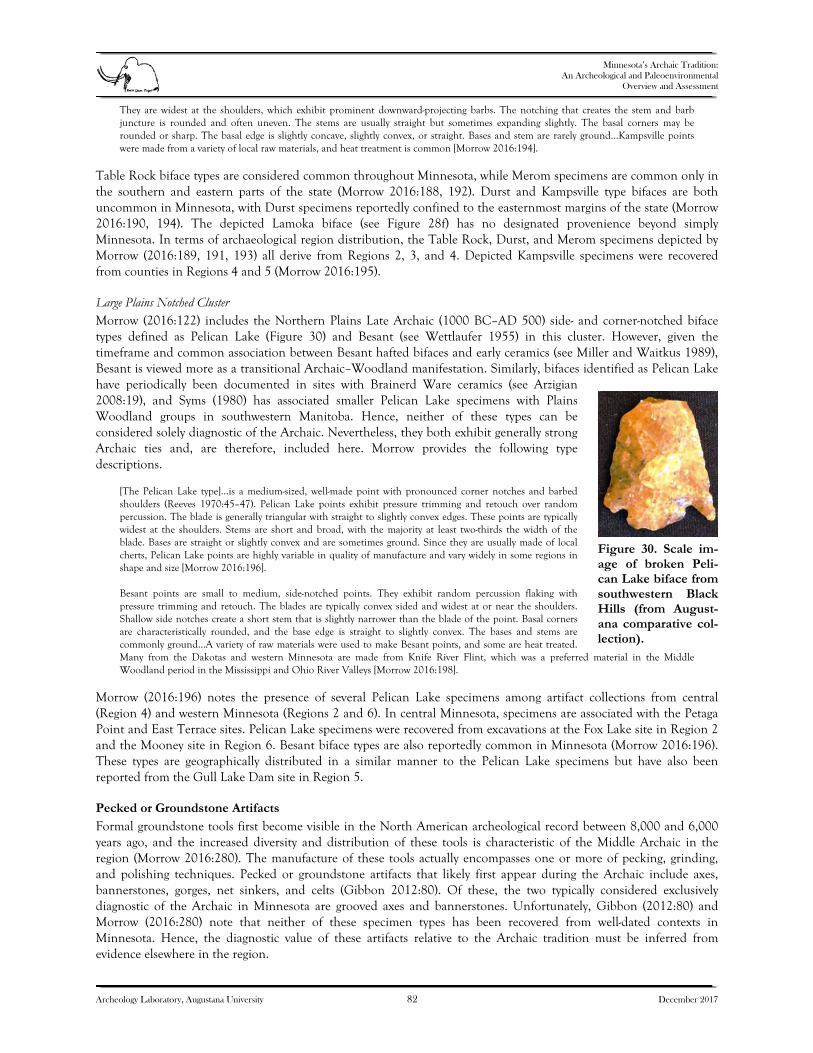
Minnesota’s Archaic Tradition:
An Archeological and Paleoenvironmental Overview and Assessment
Archeology Laboratory, Augustana University 82 December 2017
They are widest at the shoulders, which exhibit prominent downward-projecting barbs. The notching that creates the stem and barb juncture is rounded and often uneven. The stems are usually straight but sometimes expanding slightly. The basal corners may be rounded or sharp. The basal edge is slightly concave, slightly convex, or straight. Bases and stem are rarely ground…Kampsville points were made from a variety of local raw materials, and heat treatment is common [Morrow 2016:194].
Table Rock biface types are considered common throughout Minnesota, while Merom specimens are common only in the southern and eastern parts of the state (Morrow 2016:188, 192). Durst and Kampsville type bifaces are both uncommon in Minnesota, with Durst specimens reportedly confined to the easternmost margins of the state (Morrow 2016:190, 194). The depicted Lamoka biface (see Figure 28f) has no designated provenience beyond simply Minnesota. In terms of archaeological region distribution, the Table Rock, Durst, and Merom specimens depicted by Morrow (2016:189, 191, 193) all derive from Regions 2, 3, and 4. Depicted Kampsville specimens were recovered from counties in Regions 4 and 5 (Morrow 2016:195). Large Plains Notched Cluster Morrow (2016:122) includes the Northern Plains Late Archaic (1000 BC–AD 500) side- and corner-notched biface types defined as Pelican Lake (Figure 30) and Besant (see Wettlaufer 1955) in this cluster. However, given the timeframe and common association between Besant hafted bifaces and early ceramics (see Miller and Waitkus 1989), Besant is viewed more as a transitional Archaic–Woodland manifestation. Similarly, bifaces identified as Pelican Lake have periodically been documented in sites with Brainerd Ware ceramics (see Arzigian 2008:19), and Syms (1980) has associated smaller Pelican Lake specimens with Plains Woodland groups in southwestern Manitoba. Hence, neither of these types can be considered solely diagnostic of the Archaic. Nevertheless, they both exhibit generally strong Archaic ties and, are therefore, included here. Morrow provides the following type descriptions.
[The Pelican Lake type]…is a medium-sized, well-made point with pronounced corner notches and barbed shoulders (Reeves 1970:45–47). Pelican Lake points exhibit pressure trimming and retouch over random percussion. The blade is generally triangular with straight to slightly convex edges. These points are typically widest at the shoulders. Stems are short and broad, with the majority at least two-thirds the width of the blade. Bases are straight or slightly convex and are sometimes ground. Since they are usually made of local cherts, Pelican Lake points are highly variable in quality of manufacture and vary widely in some regions in shape and size [Morrow 2016:196]. Besant points are small to medium, side-notched points. They exhibit random percussion flaking with pressure trimming and retouch. The blades are typically convex sided and widest at or near the shoulders. Shallow side notches create a short stem that is slightly narrower than the blade of the point. Basal corners are characteristically rounded, and the base edge is straight to slightly convex. The bases and stems are commonly ground…A variety of raw materials were used to make Besant points, and some are heat treated. Many from the Dakotas and western Minnesota are made from Knife River Flint, which was a preferred material in the Middle Woodland period in the Mississippi and Ohio River Valleys [Morrow 2016:198].
Morrow (2016:196) notes the presence of several Pelican Lake specimens among artifact collections from central (Region 4) and western Minnesota (Regions 2 and 6). In central Minnesota, specimens are associated with the Petaga Point and East Terrace sites. Pelican Lake specimens were recovered from excavations at the Fox Lake site in Region 2 and the Mooney site in Region 6. Besant biface types are also reportedly common in Minnesota (Morrow 2016:196). These types are geographically distributed in a similar manner to the Pelican Lake specimens but have also been reported from the Gull Lake Dam site in Region 5. Pecked or Groundstone Artifacts
Formal groundstone tools first become visible in the North American archeological record between 8,000 and 6,000 years ago, and the increased diversity and distribution of these tools is characteristic of the Middle Archaic in the region (Morrow 2016:280). The manufacture of these tools actually encompasses one or more of pecking, grinding, and polishing techniques. Pecked or groundstone artifacts that likely first appear during the Archaic include axes, bannerstones, gorges, net sinkers, and celts (Gibbon 2012:80). Of these, the two typically considered exclusively diagnostic of the Archaic in Minnesota are grooved axes and bannerstones. Unfortunately, Gibbon (2012:80) and Morrow (2016:280) note that neither of these specimen types has been recovered from well-dated contexts in Minnesota. Hence, the diagnostic value of these artifacts relative to the Archaic tradition must be inferred from evidence elsewhere in the region.
Figure 30. Scale im-age of broken Peli-can Lake biface from southwestern Black Hills (from August-ana comparative col-lection).

Minnesota’s Archaic Tradition:
An Archeological and Paleoenvironmental Overview and Assessment
Archeology Laboratory, Augustana University 83 December 2017
Grooved Axes Grooved axes are woodworking tools designed for splitting logs and felling trees. They are heavy implements that are also typically large and produced from resilient, igneous rock (though not exclusively igneous). Axes have a sharpened bit end and a pecked groove designed to accommodate a haft element. In the evolutionary timeline of woodworking tools, grooved axes appear to have replaced chipped stone adzes by the Middle Archaic. There are two principal forms of grooved axe, the full-grooved variety and the three-quarter-grooved variety. Full-grooved axes preceded the three-quarter-grooved forms and, as implied, are distinguished by a pecked groove that extends around the entire tool. These implements represent the principal woodworking tool in the archeological record of the Upper Midwest between approximately 7500 and 5000 BP (Cook 1976; Frankforter and Agogino 1960; Morrow 2016:302; Pope et al. 2014). After this time, evidence demonstrates a shift from full-grooved axes to three-quarter-grooved specimens. In the Upper Midwest, three-quarter-grooved axes supplant full-grooved forms as the dominant woodworking tool by about 5000 BP. However, evidence in the archeological record indicates that these implements were in use as early as approximately 6,000 years ago (Morrow 2016:306). By about 4,000 years ago, axes exhibiting flatter bases begin to replace round-bottom forms regionally (Morrow 2016:306; see also Benn and Thompson 2009; Nolan and Fishel 2009; Wiant et al. 2009). Three-quarter-grooved axes were ultimately replaced by small, rectangular ungrooved celts during the Woodland and Late Prehistoric periods (Morrow 2016:306). Bannerstones Bannerstones are believed to have served as counterweights for atlatls. Very few have been discovered in Minnesota and none derive from well-dated contexts. In the Midwest, most bannerstones are manufactured from resilient igneous rock (Figure 31); however, at least one specimen from Minnesota was produced from catlinite. They were typically pecked into form and the surfaces were then polished smooth. In the Midwest, bannerstones from well-documented contexts are often associated with a Middle Archaic timeframe; they have been discovered with Godar, Matanzas, and Raddatz hafted biface types (Morrow 2016:332).
Figure 31. Bannerstone specimen 2013.27.1 from MHS collection, lateral (left) and dorsal (right) views. Discovered in Anoka County along the Mississippi River.
Copper Artifacts
Artifacts attributable to the Old Copper complex have been identified at numerous Minnesota sites (see Anfinson, this volume, pp. 16–17). Copper artifacts associated with the Archaic were originally viewed as more utilitarian than ornamental (see Gibbon 1998:40–43). Conversely, after about 1200 BC, most copper artifacts seem to be for personal adornment (Gibbon 2012:84). Old Copper artifact assemblages, which are generally attributable to Middle or Late Archaic timeframes (ca. 4950–2950 BP), include socketed and tanged spear points, tanged asymmetrical knives, crescent and ulu-like knives, adzes,

Minnesota’s Archaic Tradition:
An Archeological and Paleoenvironmental Overview and Assessment
Archeology Laboratory, Augustana University 84 December 2017
tanged and barbed harpoons, gouges, hooks, spuds, celts, wedges, chisels, drills, spatulas, and awls (Figure 32) (Gibbon 2012:83; Mason 1998a:606–607). Wittry (1951) created a type classification system for copper projectile points and knives; examples of these type forms are illustrated by Bowe (1999:100–120). Although most ornamental copper artifacts are associated with later groups, items such as tubular and spherical beads, pendants, C-shaped bracelets, and other decorative objects have also been documented in Archaic-period assemblages (Gibbon 2012:83). To date, the only radiocarbon-dated Archaic site in Minnesota containing copper artifacts in direct association with an intact feature is Sandy Lake Dam (21AK11). Feature 10 at the site yielded copper awls, a tanged projectile point and knife, and 24 pieces of copper scrap refuse. A piece of calcined bone, also recovered from Feature 10, yielded a radiocarbon age of 5690 ± 30 BP (Bradford 2013:10–11). This would be a very early age relative to other dated Old Copper sites. However, bone is notorious in Minnesota for yielding older radiocarbon ages relative to other materials due to the hardwater effect (see Scott Cummings 2017). The close proximity of the site to water and the high number of aquatic-based fauna derived from Feature 10 suggest that the hardwater effect may, at least to some extent, be responsible for the comparatively early age of the Sandy Lake Dam site (21AK11) copper component. SPECIMENS FROM THE ITASCA BISON (21CE1) AND GRANITE FALLS BISON (21YM47) SITES
Augustana personnel photodocumented a small selection of artifacts recovered from the Itasca Bison (21CE1) and Granite Falls Bison (21YM47) sites while examining MHS collections at the Fort Snelling History Center, St. Paul, Minnesota. These specimens are briefly presented here with the intention of simply providing the data in one current reference report. Other specimens from these sites are depicted by Anfinson (this volume, Figures 8 and 13), Peterson (1996:4), and Shay (1971). Technical details pertaining to individually documented specimens are not included. The specimens are depicted here as a means of alerting researchers to the general composition and location of the resources in the event that they might wish to pursue future study. Scale photographs and catalog numbers are provided. Itasca Bison Site (21CE1) Specimens
Seven hafted bifaces from the Itasca Bison site (21CE1) were observed in the MHS collections at the Fort Snelling History Center, St. Paul (Figure 33). Two of the specimens are unnotched (see Figures 33a and 33f) and five are side-notched (see Figures 33b, 33c, 33d, 33e, and 33g). Specimens a–d were recovered from the hill locality at the site, whereas specimens e–g were discovered in the bog locality (see Anfinson, this volume, Figure 8; Shay 1971). Several of the side-notched specimens from the early component at the site are morphologically similar to side-notched types recovered from the Granite Falls Bison site (Peterson 1996:4) and Horizon II at the Cherokee Sewer site (Anderson 1980) in northwestern Iowa. They also exhibit similarities to, and share a similar timeframe with, side-notched hafted biface types identified at the Logan Creek site (25BT3) in eastern Nebraska (Carlson 1998:469). Morrow (2016:162) classifies these as the Simonsen biface type included in the Archaic Side-notched cluster discussed above; he previously classified them as the Little Sioux type (Morrow 1984:61). The specific items recovered from site 21CE1 are described in greater detail by Shay (1971).
Figure 32. Copper artifacts from MHS collections: projectile point specimen A827 (top); projectile point specimen 1984.41.21.2 (middle); and awl specimen 88.85 (bottom).

Minnesota’s Archaic Tradition:
An Archeological and Paleoenvironmental Overview and Assessment
Archeology Laboratory, Augustana University 85 December 2017
Figure 33. Specimens 176.1.1 (a), 571.196 (b), 571.151 (c), 571.108.1 (d), 540.594 (e), 540.37.1 (f), and 540.1813 (g),site 21CE1.
a b
c d
e f
g

Minnesota’s Archaic Tradition:
An Archeological and Paleoenvironmental Overview and Assessment
Archeology Laboratory, Augustana University 86 December 2017
Granite Falls Bison Site (21YM47) Specimens
Two hafted bifaces attributable to the Granite Falls Bison site (21YM47) were identified in the MHS collections at the Fort Snelling History Center (Figure 34; see also Anfinson, this volume, Figure 13). Peterson (1996:4) illustrates and briefly describes three biface specimens recovered from this site.
Figure 34. Specimens 91.4.14.(5) (left) and 91.4.15.0.1 (right), site 21YM47.

Minnesota’s Archaic Tradition:
An Archeological and Paleoenvironmental Overview and Assessment
Archeology Laboratory, Augustana University 87 December 2017
7. SYNTHESIS AND RECOMMENDATIONS RESEARCH OBJECTIVES AND INVESTIGATION RESULTS
The objectives of the current study, as defined in the project RFP, were “…to describe the environmental conditions during the Archaic throughout Minnesota, to investigate the timing of Archaic origins and demise in the various regions of the state, and to examine the nature of Archaic cultural manifestations in Minnesota, especially with regard to material culture and subsistence-settlement patterns.” Three primary tasks were identified as requisite for the successful completion of the project:
1) Review the archeological, geographical, and environmental literature pertinent to the Archaic tradition in Minnesota, including an examination of suspected Archaic artifacts in major Minnesota museum collections. Based on preliminary investigations, develop hypotheses to better understand the Archaic in Minnesota and to better focus future research.
2) Organize and participate in a symposium on the Archaic tradition.
3) Complete an analytical and descriptive report summarizing the results of the research. Minnesota’s environmental conditions during the Archaic should be addressed, as should insight into the timing of Archaic origins and demise in the various regions of the state, and the nature of Minnesota’s Archaic cultural manifestations with regard to material culture and subsistence-settlement patterns. The report should evaluate the validity of Minnesota’s four current Archaic tradition historic contexts (Dobbs and Anfinson 1993). This reassessment will incorporate an evaluation of the validity of Minnesota’s SHPO Archaeological Regions with respect to the Archaic, as these regions were originally designed primarily with Woodland and Late Prehistoric groups in mind (Anfinson 1990). Finally, important unanswered research questions, and suggestions for answering these questions, should be posited, including known sites or discrete areas that could be productively examined.
In addressing Task 1, background investigations were conducted at the Minnesota OSA, Ft. Snelling History Center on February 22–23, 2017. Records for significant sites with Archaic components were examined, and relevant reports and site forms were copied. Additionally, artifacts from comparative collections were photodocumented, as were diagnostic specimens from the Itasca Bison (21CE1) and Granite Falls Bison (21YM47) site collections. Meetings were held with MHS and OSA staff concerning various aspects of the project. Finally, Archaic site locational shapefile data were provided by Michael Bergervoet, Minnesota Department of Transportation. The second task outlined in the RFP was to “organize and participate in a symposium on the Archaic.” A symposium entitled Minnesota’s Archaic Tradition was organized for the 2017 Council for Minnesota Archaeology conference; it was held on February 24, 2017 in Hamline University’s Anderson Center in St. Paul. The seven papers were presented at the symposium; they addressed topics such as projectile point range and variety, paleoenvironmental and geomorphological considerations, site reports, and regional overviews. Archeologists presenting at the symposium were Scott F. Anfinson, Rolfe D. Mandel, Toby Morrow, L. Adrien Hannus, Kent E. Bakken, and Michael G. Michlovic. This document represents the results of Task 3. What follows is a brief discussion of the project findings and recommendations for future research. MINNESOTA’S ARCHAIC TRADITION IN CONTEXT Origins and Demise
There is little in the way of conclusive evidence that demonstrates the timing of Archaic tradition beginnings in Minnesota; however, it seems clear that the entrada of Archaic-period inhabitants occurred at different times in different regions of the state (e.g., Gibbon 2012:66). The specific timing remains elusive; chronological control is simply lacking for this part of the continent. Much of our knowledge concerning the timing of Archaic occupation of the state is inferred from other regional sources of evidence. Within the context of North America’s Archaic tradition, Minnesota appears to be a point of convergence rather than one of origin, with evidence of various groups or technocomplexes moving into the area from places beyond. This concept is best illustrated by the hafted biface styles derived from dated contexts. Most of the associated ages are from sites outside of Minnesota; however, the pattern is

Minnesota’s Archaic Tradition:
An Archeological and Paleoenvironmental Overview and Assessment
Archeology Laboratory, Augustana University 88 December 2017
demonstrated through the time-transgressive nature of sites relative to their geographic proximity to the state. Benn and Thompson (2009:513) discuss diffusion of Early Archaic projectile point styles northward up the Mississippi valley and its tributaries into Iowa; the discussed projectile point types, including Dalton, St. Charles, and Hardin, have also been identified in Minnesota. A similar pattern is evident among Plains Archaic hafted biface types, such as Oxbow. Oxbow specimens are most prolific in the Winnipeg River drainage; they are believed to have generally spread east and south from a more westerly or northwesterly point of origin. Some Oxbow sites to the west and north have Early Archaic dates but sites with dates that extend well into Middle Archaic times have been discovered further south and east (Bowe 1999:53; Kornfeld et al. 2010:113–114). Because of the aforementioned lack of chronological control, we know equally little about the timing of the demise of Minnesota’s Archaic tradition. Though, again, this appears to have been regionally variable. Broadly speaking, following the Holocene Climatic Optimum, the regional climate began to transition to a cooler, more mesic regime. Coincident with this transition was a westward shift of the prairie-forest border in Minnesota and, with it, a westward shift of the expansive bison herds that populated the state. Anfinson (1997:42) argues that this climatic change resulted in a shift in the economic and settlement patterns of Archaic inhabitants of the Prairie Lake region by around 3000 BC; evidence is presented in the form of the terminal Archaic Mountain Lake phase (Anfinson 1997:42–47). This implies that the Archaic tradition extended longer on the Plains where the more nomadic bison hunting economies persisted. The much later Plains Archaic sites located further west in the Great Plains and Black Hills (e.g., Hannus 2017; Kornfeld et al. 2010:122–129; Kruse et al. 2008; Rom et al. 1996; Winham et al. 2001) provide evidence to support this proposition. Many of these Late Archaic sites are coeval with Minnesota’s earlier Woodland-period settlements (e.g., Arzigian 2008:19–34; Johnson and Buhta 2014:6–14). Though the Archaic does seem to extend later on the Northern Plains and High Plains, the small sample size of dated sites leaves this an untested theory in Minnesota. Paleoenvironments
The Archaic tradition in Minnesota, which began in the early Holocene and terminated in the late Holocene, spanned a period of great vegetation and climate change. In the early Holocene, Ulmus-dominated deciduous forest covered much of southern Minnesota, while Pinus forest prevailed in northern Minnesota. The ecotone between deciduous and conifer forest approximately followed the Mississippi River from St. Paul to St. Cloud, then angled more sharply to the northwest. The preeminent vegetation trend during the Archaic period was the eastward advance of prairie and oak savanna into the forested region and the subsequent readvance of forest in the late Holocene. The advance of prairie and oak savanna was time-transgressive, slow initially, then rapidly expanding eastward for a millennium beginning about 9.2 ka. The advance of prairie was asynchronous across the northcentral Minnesota region; it reached maximum development at about 8.2 ka. Although prairie and oak savanna advanced far to the east and north, a sharp prairie-forest border was not maintained. Large islands of forest or woodland persisted west of the eastwardly advancing prairie in areas well-protected from fire by waterbodies or rough topography, and the mid-Holocene prairie-forest border was broader and more diffuse than that which existed at the time of Euroamerican settlement. At about 4.0 ka, forest suddenly expanded throughout northern Minnesota. At the eastern extent of prairie advance, Pinus expanded initially, while deciduous trees first expanded in the west, with Pinus invading later. Pinus strobus migrated westward, colonizing morainic areas, reaching its western and southern limits by about 2,000–1,500 years ago. Concurrently, Pinus banksiana invaded outwash plains after initial colonization of prairie by Quercus and Populus. Pinus banksiana probably had persisted across the region in small populations throughout the mid-Holocene. In contrast to Pinus strobus, which shows an orderly east-to-west migration, Pinus banksiana exhibits no latitudinal or longitudinal trends; rather, it invaded different outwash plains at different times from 3.3 ka to 0.5 ka. In southern Minnesota, the expansion of forest was time-transgressive, from 5.2 ka to 2.4 ka, at the sites studied. At all sites in southern Minnesota, Quercus woodland first replaced prairie or oak savanna. In the Big Woods, mesic forest developed only a few hundred years ago. The dynamic nature of vegetation and climate change during the Archaic period would have impacted resources available for human subsistence, particularly animals, although the relationships between vegetation and animal populations are not well-understood during this time. Fire was a major factor controlling vegetation in Minnesota throughout the Holocene. To the extent that Native Americans used fire for hunting or other activities, or even used fire to consciously manage the landscape, humans may have exerted considerable influence over the vegetation and
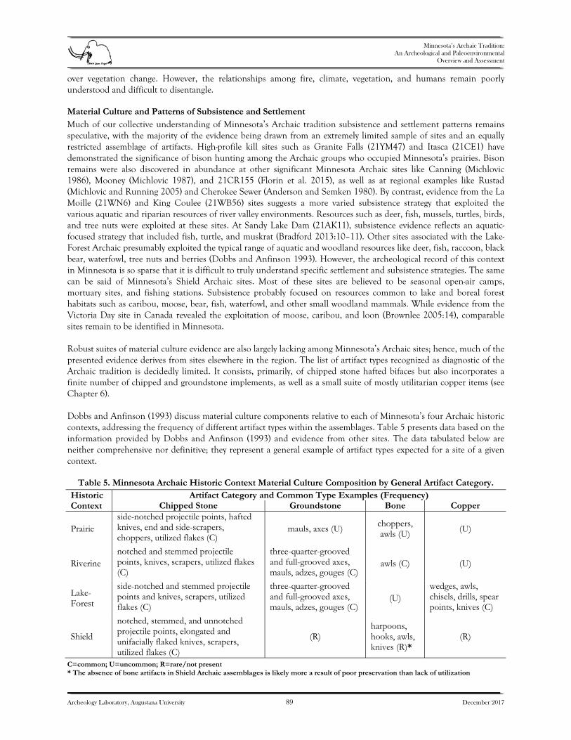
Minnesota’s Archaic Tradition:
An Archeological and Paleoenvironmental Overview and Assessment
Archeology Laboratory, Augustana University 89 December 2017
over vegetation change. However, the relationships among fire, climate, vegetation, and humans remain poorly understood and difficult to disentangle. Material Culture and Patterns of Subsistence and Settlement
Much of our collective understanding of Minnesota’s Archaic tradition subsistence and settlement patterns remains speculative, with the majority of the evidence being drawn from an extremely limited sample of sites and an equally restricted assemblage of artifacts. High-profile kill sites such as Granite Falls (21YM47) and Itasca (21CE1) have demonstrated the significance of bison hunting among the Archaic groups who occupied Minnesota’s prairies. Bison remains were also discovered in abundance at other significant Minnesota Archaic sites like Canning (Michlovic 1986), Mooney (Michlovic 1987), and 21CR155 (Florin et al. 2015), as well as at regional examples like Rustad (Michlovic and Running 2005) and Cherokee Sewer (Anderson and Semken 1980). By contrast, evidence from the La Moille (21WN6) and King Coulee (21WB56) sites suggests a more varied subsistence strategy that exploited the various aquatic and riparian resources of river valley environments. Resources such as deer, fish, mussels, turtles, birds, and tree nuts were exploited at these sites. At Sandy Lake Dam (21AK11), subsistence evidence reflects an aquatic-focused strategy that included fish, turtle, and muskrat (Bradford 2013:10–11). Other sites associated with the Lake-Forest Archaic presumably exploited the typical range of aquatic and woodland resources like deer, fish, raccoon, black bear, waterfowl, tree nuts and berries (Dobbs and Anfinson 1993). However, the archeological record of this context in Minnesota is so sparse that it is difficult to truly understand specific settlement and subsistence strategies. The same can be said of Minnesota’s Shield Archaic sites. Most of these sites are believed to be seasonal open-air camps, mortuary sites, and fishing stations. Subsistence probably focused on resources common to lake and boreal forest habitats such as caribou, moose, bear, fish, waterfowl, and other small woodland mammals. While evidence from the Victoria Day site in Canada revealed the exploitation of moose, caribou, and loon (Brownlee 2005:14), comparable sites remain to be identified in Minnesota. Robust suites of material culture evidence are also largely lacking among Minnesota’s Archaic sites; hence, much of the presented evidence derives from sites elsewhere in the region. The list of artifact types recognized as diagnostic of the Archaic tradition is decidedly limited. It consists, primarily, of chipped stone hafted bifaces but also incorporates a finite number of chipped and groundstone implements, as well as a small suite of mostly utilitarian copper items (see Chapter 6). Dobbs and Anfinson (1993) discuss material culture components relative to each of Minnesota’s four Archaic historic contexts, addressing the frequency of different artifact types within the assemblages. Table 5 presents data based on the information provided by Dobbs and Anfinson (1993) and evidence from other sites. The data tabulated below are neither comprehensive nor definitive; they represent a general example of artifact types expected for a site of a given context.
Table 5. Minnesota Archaic Historic Context Material Culture Composition by General Artifact Category. Historic Context
Artifact Category and Common Type Examples (Frequency) Chipped Stone Groundstone Bone Copper
Prairie side-notched projectile points, hafted knives, end and side-scrapers, choppers, utilized flakes (C)
mauls, axes (U) choppers, awls (U) (U)
Riverine notched and stemmed projectile points, knives, scrapers, utilized flakes (C)
three-quarter-grooved and full-grooved axes, mauls, adzes, gouges (C)
awls (C) (U)
Lake-Forest
side-notched and stemmed projectile points and knives, scrapers, utilized flakes (C)
three-quarter-grooved and full-grooved axes, mauls, adzes, gouges (C)
(U) wedges, awls, chisels, drills, spear points, knives (C)
Shield
notched, stemmed, and unnotched projectile points, elongated and unifacially flaked knives, scrapers, utilized flakes (C)
(R) harpoons, hooks, awls, knives (R)*
(R)
C=common; U=uncommon; R=rare/not present * The absence of bone artifacts in Shield Archaic assemblages is likely more a result of poor preservation than lack of utilization

Minnesota’s Archaic Tradition:
An Archeological and Paleoenvironmental Overview and Assessment
Archeology Laboratory, Augustana University 90 December 2017
Historic Contexts and Archaeological Regions
In the late 1980s/early 1990s, the traditional tripartite Archaic divisions of early, middle, and late were abandoned in Minnesota in favor of a biome-based taxonomy. The result parsed Minnesota’s Archaic into the Prairie Archaic, Riverine Archaic, Lake-Forest Archaic, and Shield Archaic historic contexts irrespective of timeframe. These changes were implemented when it was realized that the transitions between traditional Archaic timeframes in Minnesota were inconsistent across different regions of the state; they were also, as it happens, inconsistent with the timing of many Archaic developments elsewhere in the Midwest. Part of the current project involved assessing the validity of Minnesota’s Archaic historic contexts relative to the original tripartite classificatory system (see Chapter 5). Findings, however, are anything but straightforward. Frankly, one could argue that the application of either designation system is premature given our meager understanding of Minnesota’s Archaic. Distribution of the four defined Archaic historic contexts largely correlates well with Minnesota’s established archaeological regions; however, the validity of this correlation was not explored and, as previously noted, the regional infrastructure was originally developed to address subsistence and settlement issues related to the Woodland tradition, not the Archaic (see Anfinson 1990). The significance of this cannot be overstated since the regions were formulated around the environmental parameters prevalent from Woodland times onward, when climatic conditions were largely coincident with those encountered at the time of European settlement. As demonstrated by Grimm (this volume), Minnesota’s Archaic paleoenvironments differed greatly from those of the Late Prehistoric and contact periods. For instance, during the Holocene Climatic Optimum, prairie covered almost the entire state with the exception of the northeastern corner. Thus, Prairie Archaic sites dating to the Middle Holocene could easily be present throughout the whole of Archaeological Region 4 despite the fact that it has largely been a lake and deciduous forest biome for several millennia. This greatly restricts the utility of Minnesota’s Archaeological Regions when analyzing site distribution, settlement, and subsistence patterns of Archaic inhabitants. Insofar as the historic context validity is concerned, neither option is particularly useful until we are able to expand Minnesota’s Archaic site database and address the issue of poor chronological control. The tripartite divisions could facilitate dating from a relative reference point, but the value diminishes greatly with respect to precise timelines. The biome-based contexts are problematic in their inability to account for subsistence and settlement practices that encompass more than one biome. Examples of precisely this type of activity―ecotonal or multiple biome exploitation strategy―are present in ethnohistorical accounts of the Sisseton-Wahpeton (Woolworth 1986:15–16) in the Minnesota area, an area in which the prairie-forest border played a prominent role historically and prehistorically. Similar subsistence and settlement practices have also been documented archeologically among Archaic groups occupying the foothills of the southwestern Black Hills, a transitional zone between the alpine environments of the hills and the surrounding Plains (see Hannus 2017; Kruse et al. 2008; Rom et al. 1996; Winham et al. 2001). RECOMMENDATIONS FOR FUTURE STUDY
A series of avenues suitable for further exploring Minnesota’s Archaic tradition are discussed below. Included are cogent issues and future research targets presented from the perspectives of both paleoecology and archeology. Although the majority of the issues associated with future paleoecological research were presented earlier in this report, they are reiterated here. Paleoecological Outlook
Through his leadership of the Limnological Research Center at the University of Minnesota, H. E. Wright, Jr. instigated and supported an impressive body of paleoenvironmental research by, and in collaboration with, students, postdoctoral fellows, and visiting scientists. With its many lakes and prominent ecotones, Minnesota was especially suited for this avenue of research. This work, beginning in the early 1960s, not only established the basic framework of vegetation and climate change in Minnesota, but also influenced and stimulated paleoenvironmental research both nationally and internationally. Early studies, notably those at Kirchner Marsh (Wright et al. 1963) and the Itasca transect (McAndrews 1966), established the postglacial expansion of plant species into Minnesota, the existence of past vegetation communities with no modern analog, and the mid-Holocene expansion and subsequent retreat of prairie. With this basic outline, many future studies focused on specific problems or hypotheses, for example the development of peatlands in northern Minnesota (Janssen 1968), late-glacial forest changes (Amundson and Wright

Minnesota’s Archaic Tradition:
An Archeological and Paleoenvironmental Overview and Assessment
Archeology Laboratory, Augustana University 91 December 2017
1979), the late Holocene migration of Pinus strobus across the state (Jacobson, Jr. 1979), the time-transgressive invasion of outwash plains by Pinus banksiana (Almendinger 1992), and the recent development of the Big Woods (Grimm 1983; Umbanhowar 2004). Many of these later studies focused on only parts of the complete record, such as the late glacial or late Holocene. However, much of the paleoenvironmental work in Minnesota was done before the advent of AMS radiocarbon dating and a full appreciation of the errors present in bulk-sediment dates (Grimm et al. 2009). Moreover, as radiocarbon dates were expensive and often had long waiting periods, many sites were inadequately dated with few or no dates or with dates that incorporated large and unknown old-carbon reservoirs. This situation is a major impediment to establishing accurate chronologies and for inter-site comparisons. New age modeling techniques such as Bacon (Blaauw and Christen 2011) can provide estimates of the error in modeled ages, but with 95 percent confidence intervals often exceeding a thousand years and with uncertain reservoir corrections, these age models, while adding a dose of reality, cannot ameliorate the problem. Thus, future lines of research for more fully understanding the paleoenvironmental history of the Archaic period, which spans much of the Holocene, would involve acquiring more well-dated, full-Holocene records from strategically located sites. Some important questions, among others, would include the location and dynamics of the early-Holocene Ulmus-Pinus ecotone across Minnesota and the different lifeways that may have existed on either side, and the location and extent of mid-Holocene forest islands and their utilization by, and importance to, Archaic peoples. An example of such a site is Elkhorn Lake in Kandiyohi County, which both lies near the early Holocene Ulmus-Pinus ecotone and lies in a modern-day forest island west of the main prairie-forest border. Questions would include: 1) when did this island develop and what was its importance to perhaps late-Archaic peoples, but possibly farther back into time?; and 2) how appropriate is this site as an analog for mid-Holocene forest islands in terms of extent and composition? Developing accurate and precise chronologies for a wider array of full Holocene records would permit better evaluation of synchronous versus asynchronous environmental shifts. Widespread synchronous shifts imply abrupt climate shifts that may have impacted human populations. Another avenue of research that has not received much attention involves the interplay among vegetation, animal populations, and humans. In addition to better-dated palynological records, data required to address this question include: 1) much better chronological control of both Archaic archeological sites and of faunal remains; and 2) creation of a database of faunal remains. Radiocarbon dating of faunal remains from archeological sites can fulfill both purposes. Fortunately, it is now possible to obtain reliable, precise, and accurate radiocarbon dates from purified collagen extracted from bones or teeth (e.g., Widga et al. 2017). The Neotoma Paleoecology Database provides the cyberinfrastructure for such a dataset. Archeological Outlook
Although the accumulation of basic locational data for previously undocumented Archaic sites remains a priority, perhaps a more pressing need is the establishment of better chronological control. There are virtually no well-dated Archaic sites in Minnesota and the majority of ages derived to-date are from bone―a substance known to be susceptible to contamination via the hardwater effect in the state (Scott Cummings 2017). We cannot hope to understand how, where, and why these people occupied the landscape and interacted with its environs if we cannot understand when they were there. Unfortunately, preserved, intact features with datable organics are extremely scarce in sites from the Archaic timeframe and, when present, are oftentimes in settings that are difficult to access through conventional archeological practices. Hence, when features are discovered, maximum recovery should be accomplished, when feasible, and the fill should be subjected to flotation or some other form of fine-screen data recovery methodology. Fine-screen sampling should also be employed elsewhere at Archaic site excavations, thereby increasing the probability of recovering botanicals, which will aid in chronological control and paleoenvironmental reconstruction. Advances in luminescence dating provide an intriguing option for a chronological alternative in certain, specific instances. Potential targets for optically stimulated luminescence (OSL) include paleosols harboring single-component Archaic sites and certain groundstone implements with the required crystalline composition, provided these objects are protected from exposure to sunlight when collected (see Mahan 2015). Likely candidates for thermal luminescence (TL) would predominantly consist of lithics recovered from hearth settings (i.e., FCR and discarded debitage) where
Minnesota’s Archaic Tradition:
An Archeological and Paleoenvironmental Overview and Assessment
Archeology Laboratory, Augustana University 92 December 2017
they have been subjected to sufficiently high temperatures. Though heat-treated specimens would seem, at face value, relatively abundant and easily recognizable targets, most of these items were never subjected to temperatures above 300 to 400 degrees centigrade―an insufficient range for TL dating. A focus on FCR is likely to be the most fruitful avenue to explore for TL dating. Because of the limitations inherent in absolute dating thus far, the most likely avenue for both expanding the Archaic database and refining the chronological control of the period seems to be the identification of previously undocumented Archaic sites and a basic understanding of the make-up of the landforms most likely to harbor them. This simply means more testing of areas with the potential to contain buried sites from the Early and Middle Holocene. Mandel (2015) recently prepared a simplified model of the late-Quaternary landscape evolution of the Minnesota River valley. Combining data derived from deep soil cores with previous findings from the MN/Model geomorphological study (Hudak and Hajic 1999), the Minnesota Deep Test Protocol (Monaghan et al. 2006), and other sources, Mandel devised a buried site probability model for the major landform sediment assemblages (LfSA’s) of the valley (Mandel 2015:139). Findings revealed that valley margin LfSA’s, such as alluvial fans and colluvial slopes, are highly likely to harbor buried Archaic-aged surfaces in the Minnesota River valley. The T-1 terrace complex of the Minnesota River valley was found to possess moderate potential for harboring buried surfaces dating to the Archaic period (Mandel 2015:139). A similar study conducted by Mandel along the Red Lake River found that:
…there is high potential for stratified Middle Archaic, Late Archaic, and Initial Woodland cultural deposits in the T-1 fill [of the Red Lake River]. Middle Archaic cultural deposits also are likely to occur beneath the T-2 terrace, and Early Archaic and Late Paleoindian archeological materials may be deeply buried in the T-3 and T-4 fills. However, only narrow remnants of the high terraces (T-2, T-3, and T-4) occur in the project area…Hence, it is likely that much of the Late Paleoindian and Early and Middle Archaic record was removed from the valley [Mandel 2012:161].
Mandel (2012:161) further concluded that potential for buried Early Archaic deposits exists in deposits associated with the Campbell Beach Ridge in Red Lake County. Investigations along Agassiz beach ridges in Marshall County also yielded Archaic-aged settlement features (Kluth and Hudak 2004). Finally, Mandel (2012:161) notes that the development of upland peat deposits in Archaeological Region 7 began about 2,000 years ago and that sites predating this formation may be present beneath the peat. In Lac Qui Parle County, Mandel (2017) conducted geomorphological studies of the Lac Qui Parle and Yellow Bank rivers. Findings relating to Archaic-period site potential by LfSA in these valley settings concluded that:
…there is high potential for buried cultural resources in the Yellow Bank and Lac Qui Parle river valleys. Specifically, Middle Archaic cultural deposits are likely to be on and within a buried soil (Soil 2) that typically occurs 100–180 cm below the T-1 surface, and Late Archaic and Woodland archeological materials may occur within the cumulic soil developed in the top stratum of the T-1 fill. Although there is high potential for buried cultural deposits in the T-1 fill of the Lac Qui Parle River valley, there is moderate to low potential for in situ cultural deposits in the T-2 fill. The fine-grained alluvium comprising the upper ~2 m of the T-2 fill probably aggraded during the early Holocene and, therefore, has some potential for containing archeological materials. The top stratum of the T-2 fill, however, lacks buried soils, and coarse-grained alluvium below a depth of 2 m accumulated in a high-energy channel or near-channel depositional environment [Mandel 2017:289].
While Mandel (2012, 2015, 2017) has investigated the precontact site potential of a limited number of Minnesota’s river valleys, the MN/Model geomorphological study (Hudak et al. 2002) developed similar models for other major river valleys in the state, including the Mississippi Valley north to Bemidji, and the valleys of the Rainy, Red, Rock, Root, and St. Croix rivers. Although basic terrace complexes vary throughout the different river valleys, findings are quite consistent with respect to site probability by LfSA. Valley margin settings (alluvial fans, colluvial slopes), by virtue of their composition, generally have higher potential for harboring buried precontact archeology, including Archaic-aged deposits. Certain terraces possess this potential as well. Models were also developed for various upland landscapes throughout the state, as well as for unique settings such as the Red Lake Bog, Anoka Sand Plain, and Lake Agassiz Plain areas (see Hudak et al. 2002). Monaghan et al. (2006) provide a thorough set of guidelines for the investigation of sites in deeply buried settings. Although these previous studies provide a preliminary groundwork for the identification of additional Archaic sites in the state, the models are all in need of testing and refinement. Our future focus should, therefore, be directed towards the systematic exploration of a variety of these landform settings in an attempt to identify additional Archaic sites, as well as continued efforts to identify landforms with the potential to harbor such sites. Of course, the level of funding necessary to implement these undertakings is often sorely lacking.

Minnesota’s Archaic Tradition:
An Archeological and Paleoenvironmental Overview and Assessment
Archeology Laboratory, Augustana University 93 December 2017
Geographically, Minnesota’s occupies a unique central position on the continental landscape, and the number and variety of hafted biface styles attributable to both eastern and western North American technocomplexes indicate a commingling of cultural groups that is largely unseen elsewhere. Therefore, the research potential of future Archaic tradition studies in Minnesota is considered both singular and promising. However, existing site locational models are coarse-grained and chronological control is severely lacking, as are sufficient numbers of high-resolution palynological records. Archaic sites are, by their nature, often ephemeral, poorly preserved, and/or in settings that are difficult to access, which further complicates matters. In spite of this, prior research clearly demonstrates that Archaic groups maintained a lasting presence across the state, and additional sites are assuredly awaiting discovery. Technological advances in the realm of absolute dating should facilitate opportunities for understanding Minnesota’s Archaic chronologies, and baseline probability models should offer a clearer path to the discovery of additional sites. What remains, then, is the incorporation of these advances into our collective methodological practices and an increasing implementation in both field and laboratory settings.

Minnesota’s Archaic Tradition:
An Archeological and Paleoenvironmental Overview and Assessment
Archeology Laboratory, Augustana University 94 December 2017
8. REFERENCES CITED
Ahler, S. R. 1993 Stratigraphy and Radiocarbon Chronology of Modoc Rockshelter, Illinois. American Antiquity
58(3):462–489. 1998 Modoc Rock Shelter. In Archaeology of Prehistoric Native America: An Encyclopedia, edited by G. E.
Gibbon, pp. 534–536. Garland Publishing, Inc., New York. Ahler, S. R., and B. Koldehoff 2009 Dated Projectile Point Sequences from Modoc Rock Shelter and Applications of Assemblage-Based
Analysis. In Archaic Societies: Diversity and Complexity Across the Midcontinent, edited by T. E. Emerson, D. L. McElrath, and A. C. Fortier, pp. 199–227. State University of New York Press, Albany.
Alex, L. M. 2000 Iowa’s Archaeological Past. University of Iowa Press, Iowa City. Alley, R. B., P. A. Mayewski, T. Sowers, M. Stuiver, K. C. Taylor, and P. U. Clark
1997 Holocene Climatic Instability: A Prominent, Widespread Event 8200 yr Ago. Geology 25:483–486. Almendinger, J. C.
1992 The Late Holocene History of Prairie, Brush-prairie, and Jack Pine (Pinus banksiana) Forest on Outwash Plains, North-central Minnesota, USA. The Holocene 2:37–50.
Almendinger, J. C., J. E. Almendinger, and P. H. Glaser
1986 Topographic Fluctuations Across a Spring Fen and Raised Bog in the Lost River Peatland, Northern Minnesota. Journal of Ecology 74:393–401.
Almquist-Jacobson, H., J. E. Almendinger, and S. Hobbie
1992 Influence of Terrestrial Vegetation on Sediment-forming Processes in Kettle Lakes of West-central Minnesota. Quaternary Research 38:103–116.
Alwin, B. C.
1982 Vegetation History of the Sugar Hills Area, Itasca Co., Minnesota. Unpublished Master’s thesis, Department of Botany, University of Minnesota, Minneapolis.
Amundson, D. C., and H. E. Wright, Jr.
1979 Forest Changes in Minnesota at the End of the Pleistocene. Ecological Monographs 49:1–16. Anderson, D. C.
1980 Stone Tool Assemblages from the Cherokee Site. In The Cherokee Excavations: Holocene Ecology and Human Adaptation in Northwestern Iowa, edited by D. C. Anderson and H. A. Semken, Jr., pp. 197–238. Academic Press, New York.
1998 Cherokee Sewer Site. In Archaeology of Prehistoric Native America, edited by G. E. Gibbon, pp. 145–146. Garland, New York.
Anderson, D. C., and H. A. Semken, Jr. (editors) 1980 The Cherokee Excavations: Holocene Ecology and Human Adaptations in Northwestern Iowa. Academic
Press, New York. Anderson, D. C., R. Shutler, Jr., and W. M. Wendland 1980 The Cherokee Sewer Site and the Cultures of the Atlantic Climatic Episode. In The Cherokee
Excavations: Holocene Ecology and Human Adaptations in Northwestern Iowa, edited by D. C. Anderson and H. A. Semken, Jr., pp. 257–274. Academic Press, New York.

Minnesota’s Archaic Tradition:
An Archeological and Paleoenvironmental Overview and Assessment
Archeology Laboratory, Augustana University 95 December 2017
Anfinson, S. F. 1987 The Prehistory of the Prairie Lake Region in the Northeastern Plains. Unpublished Ph.D. dissertation,
Department of Anthropology, University of Minnesota, Minneapolis. 1990 Archaeological Regions in Minnesota and the Woodland Period. In The Woodland Tradition in the
Western Great Lakes, edited by G. E. Gibbon, pp. 135–166. Publications in Anthropology No. 4. University of Minnesota, Minneapolis.
1997 Southwestern Minnesota Archaeology: 12,000 Years in the Prairie Lake Region. Minnesota Historical Society, St. Paul.
Anfinson, S. F., and H. E. Wright, Jr. 1990 Climatic Change and Culture in Minnesota. In The Woodland Tradition in the Western Great Lakes, edited
by G. E. Gibbon, pp. 213–232. Publications in Anthropology No. 4. University of Minnesota, Minneapolis.
Antevs, E. 1950 Postglacial Climatic History of the Great Plains and Dating the Records of Man. In Proceedings of the
Sixth Plains Archaeological Conference: 1948, edited by J. Jennings, pp. 46–50. Anthropological Papers 11. University of Utah, Salt Lake City.
Anttila, O. N. 2009 Ancient Copper Crosses Borders: Copper Toolmakers Migrate out of Minnesota into Northwestern
Ontario. The Minnesota Archaeologist 68:107–119. Artz, J. A. 1995 Geologic Contexts of the Early and Middle Holocene Archaeological Record in North Dakota and
Adjoining Areas of the Northern Plains. In Archaeological Geology of the Archaic Period in North America, edited by E. A. Bettis, III, pp. 67–86. Special Publication 297. Geological Society of America, Boulder.
Arzigian, C.
2008 Minnesota Statewide Multiple Property Documentation Form for the Woodland Tradition. Mississippi Valley Archaeology Center, University of Wisconsin-La Crosse. Submitted to Minnesota Department of Transportation, St. Paul, Minnesota.
Baerreis, D. A., R. Bryson, and J. Kutzbach 1976 Climate and Culture in the Western Great Lakes Region. Midcontinental Journal of Archaeology 1(1):39–
57. Bakken, K. E. 1985 Lithic Raw Materials in Northwest Minnesota. The Minnesota Archaeologist 44:34–46. 1997 Lithic Raw Material Resources in Minnesota. The Minnesota Archaeologist 56:49–83. 2011 Lithic Raw Material Use Patterns in Minnesota. Unpublished Ph.D. dissertation, Department of
Anthropology, University of Minnesota, Minneapolis. Barber, D. C., A. Dyck, C. Hillaire-Marcel, A. E. Jennings, J. T. Andrews, M. W. Kerwin, G. Bilodeau, R. McNeely, J. Southon, M. D. Morehead, and J. M. Gagnon
1999 Forcing of the Cold Event of 8,200 Years Ago by Catastrophic Drainage of Laurentide Lakes. Nature 400:344–348.
Barron, J. A., and L. Anderson 2011 Enhanced Late Holocene ENSO/PDO Expression along the Margins of the Eastern North Pacific.
Quaternary International 235:3–12. Behm, J. A.
1985 A Stylistic Analysis of Hardin Barbed Points. Unpublished Ph.D. dissertation, Department of Anthropology, University of Wisconsin, Madison.

Minnesota’s Archaic Tradition:
An Archeological and Paleoenvironmental Overview and Assessment
Archeology Laboratory, Augustana University 96 December 2017
Bell, R. E. 1960 Guide to the Identification of Certain American Indian Projectile Points. Special Bulletin No. 2. Oklahoma
Anthropological Society, Oklahoma, City. Benn, D. W., and J. B. Thompson 2009 Archaic Periods in Eastern Iowa. In Archaic Societies: Diversity and Complexity Across the Midcontinent,
edited by T. E. Emerson, D. L. McElrath, and A. C. Fortier, pp. 491–561. State University of New York Press, Albany.
Bentzen, R. C. 1962 The Powers- Yonkee Bison Trap. Plains Anthropologist 7(18):113–118. Bernabo, J. C., and T. Webb, III
1977 Changing Patterns in the Holocene Pollen Record of Northeastern North America: A Mapped Summary. Quaternary Research 8:64–96.
Bettis, E. A., III, R. G. Baker, W. Green, M. K. Whelan, and D. W. Benn 1992 Late Wisconsinan and Holocene Alluvial Stratigraphy, Paleoecology, and Archaeological Geology of East-Central
Iowa. Guidebook Series No. 12, Iowa Quaternary Studies Group Contribution No. 51. Iowa Geological Survey Bureau, Iowa City.
Bettis, E. A. III, and E. R. Hajic 1995 Landscape Development and the Location of Evidence of Archaic Cultures in the Upper Midwest. In
Archaeological Geology of the Archaic Period in North America, edited by E. A. Bettis III, pp. 87–113. Special Publication 297. Geological Society of America, Boulder.
Beyers, D. 1959 The Eastern Archaic: Some Problems and Hypotheses. American Antiquity 24(3):233–256. Binford, L. 2001 Constructing Frames of Reference. University of California Press, Berkeley. Blaauw, M.
2010 Methods and Code for ‘Classical’ Age-modelling of Radiocarbon Sequences. Quaternary Geochronology 5:512–518.
Blaauw, M., and J. A. Christen
2011 Flexible Paleoclimate Age-depth Models Using an Autoregressive Gamma Process. Bayesian Analysis 6:457–474.
Bleed, P. 1966 Petaga Point Site (21ML11). Minnesota Archaeological Society Newsletter, Nos. 10–11. 1967 The Archaeology of Petaga Point: The Preceramic Component. Unpublished Master’s thesis,
Department of Anthropology, University of Minnesota, Minneapolis. 1969 The Archaeology of Petaga Point: The Preceramic Component. Minnesota Prehistoric Archaeology Series No.
2. Minnesota Historical Society, St. Paul. Bliss, W. L.
1950 Early and Late Lithic Horizons in the Plains. In Proceedings of the Sixth Plains Anthropological Conference: 1948, edited by J. Jennings, pp. 108–116. Anthropological Papers 11. University of Utah, Salt Lake City.

Minnesota’s Archaic Tradition:
An Archeological and Paleoenvironmental Overview and Assessment
Archeology Laboratory, Augustana University 97 December 2017
Blois, J. L., J. W. Williams, E. C. Grimm, S. T. Jackson, and R. W. Graham 2011 A Methodological Framework for Assessing and Reducing Temporal Uncertainty in Paleovegetation
Mapping from Late-Quaternary Pollen Records. Quaternary Science Reviews 30:1926–1939. Boszhardt, R. F. 1998 Newly Discovered Lithic Resources in Western Wisconsin. The Minnesota Archaeologist 57:86–98. 2003 A Projectile Point Guide for the Upper Mississippi River Valley. University of Iowa Press, Iowa City. 2005 Triangular Cross-Section Adzes from the Upper Mississippi River Valley: The Liska Cache. The
Minnesota Archaeologist 64:91–103. Bowe, H. R. 1999 A Legacy of Stone: Projectile Point and Hafted Knife Forms from Eastern Manitoba. Anthropology
Museum, University of Winnipeg. Bower, J. R. F., Z. Jing, G. Rapp, Jr., S. C. Mulholland, S. H. Valppu, S. L. Mulholland, and J. K. Huber
1996 Limited Phase II Investigations at the J Squared Site (21RW53) Redwood County, Minnesota. Report No. 96–16. Archaeometry Laboratory, University of Minnesota, Duluth. Submitted to Minnesota Department of Transportation, St. Paul, Minnesota.
Bozell, J. R., and J. Ludwickson 1998 Signal Butte. In Archaeology of Prehistoric Native America: An Encyclopedia, edited by G. E. Gibbon, pp.
768–769. Garland Publishing, Inc., New York. Bradford, M. 2013 Research Note: Radiocarbon Date from the Old Copper Component at Site 21AK1. The Minnesota
Archaeologist 72:5–14. Brew, A., and W. Yourd 1977 Intensive Archaeological Testing of the Lins Site. Bemidji State University, Bemidji, Minnesota. Submitted to
U.S. Army Corps of Engineers, St. Paul District. DACW37-76-C-0180. Bronk Ramsey, C., and S. Lee
2013 Recent and Planned Developments of the Program OxCal. Radiocarbon 55:720–730. Broström, A., A. B. Nielsen, M. J. Gaillard, K. Hjelle, F. Mazier, H. Binney, J. Bunting, R. Fyfe, V. Meltsov, A. Poska, S. Räsänen, W. Soepboer, H. von Stedingk, H. Suutari, and S. Sugita
2008 Pollen Productivity Estimates of Key European Plant Taxa for Quantitative Reconstruction of Past Vegetation: A Review. Vegetation History and Archaeobotany 17:461–478.
Brown, J. A. 1998 Koster. In Archaeology of Prehistoric Native America: An Encyclopedia, edited by G. E. Gibbon, pp. 435–
436. Garland Publishing, Inc., New York. Brown, J. A., and R. Vierra 1983 What Happened in the Middle Archaic? Introduction to an Ecological Approach to Koster Site
Archaeology. In Archaic Hunters and Gatherers in the American Midwest, edited by J. Phillips and J. Brown, pp. 165–196. Academic Press, New York.
Brown, M. K. 1971 A Late Archaic Bone Point from Minnesota. The Minnesota Archaeologist 31(4):128–130.

Minnesota’s Archaic Tradition:
An Archeological and Paleoenvironmental Overview and Assessment
Archeology Laboratory, Augustana University 98 December 2017
Brownlee, K. M. 2005 Bone and Antler Tools from the Victoria Day Site (Manitoba): Building Bridges with First Nation
Communities through Experimental Archaeology. Unpublished Master’s thesis, Department of Anthropology, University of Manitoba, Winnipeg.
Brugam, R. B., E. C. Grimm, and N. M. Eyster-Smith
1988 Holocene Environmental Changes in Lily Lake, Minnesota Inferred from Fossil Diatom and Pollen Assemblages. Quaternary Research 30:53–56.
Bryan, K., H. Retzek, and F. T. McCann 1938 Discovery of Sauk Valley Man of Minnesota with an Account of the Geology. Texas Archaeological Society
10:114–135. Bryson, R. A., D. A. Baerreis, and W. M. Wendland
1970 The Character of Late-glacial and Post-glacial Climatic Changes. In Pleistocene and Recent Environments of the Central Great Plains, edited by W. Dort, Jr. and J. K. Jones, Jr., pp. 53–74. The University Press of Kansas, Lawrence.
Bryson, R. A., and W. M. Wendland
1967 Tentative Climatic Patterns for Some Late Glacial and Post-glacial Episodes in Central North America. In Life, Land and Water: Proceedings of the 1966 Conference on Environmental Studies of the Glacial Lake Agassiz Region, edited by W. J. Mayer-Oakes, pp. 271–298. University of Manitoba Press, Winnipeg.
Buchner, A. P.
1979 The 1978 Caribou Lake Project, Including a Summary of the Prehistory of East-Central Manitoba. Papers in Manitoba Archaeology, Final Report No. 8. Department of Cultural Affairs and Historical Resources, Historic Resources Branch, Winnipeg.
Cain, L. K. 1969 Some Probably Late Paleo-Indian Early Archaic Projectile Points from East Central Minnesota. The
Minnesota Archaeologist 30(2):45–48. Caine, C. 1974 The Archaeology of the Snake River Region in Minnesota. In Aspects of Upper Great Lakes Anthropology:
Papers in Honor of Lloyd A. Wilford, edited by E. Johnson, pp. 55–63. Minnesota Prehistoric Series 11. Minnesota Historical Society, St. Paul.
Caine, C., and G. Goltz 1988 Spirit of the Headwaters. Mississippi Headwaters Project Report Number 1. On file, Minnesota Historical
Society, St. Paul. Caldwell, J. 1958 Trend and Tradition in the Prehistory of Eastern United States. Memoir 88. American Anthropological
Association and the Illinois State Museum, Springfield. Camill, P., C. E. Umbanhowar, Jr., R. Teed, C. E. Geiss, J. Aldinger, L. Dvorak, J. Kenning, J. Limmer, and K. Walkup
2003 Late-glacial and Holocene Climatic Effects on Fire and Vegetation Dynamics at the Prairie–Forest Ecotone in South-central Minnesota. Journal of Ecology 91:822–836.
Carlson, G. F. 1994 The Foragers: Diversified Lifestyle. In The Cellars of Time. Nebraska History 75(1):95–106. 1998 Logan Creek Complex. In Archaeology of Prehistoric Native America, edited by G. E. Gibbon, pp. 469–470.
Garland, New York.

Minnesota’s Archaic Tradition:
An Archeological and Paleoenvironmental Overview and Assessment
Archeology Laboratory, Augustana University 99 December 2017
Chapman, C. H. 1975 The Archaeology of Missouri I. University of Missouri Press, Columbia. Christianson, G. 1990 A Preliminary Report on the 1990 Test Excavations at the Peterson Site (21YM47), Yellow Medicine County,
Minnesota. Institute for Minnesota Archaeology. On file, State Historic Preservation Office, St. Paul, Minnesota.
Clark, J. S., E. C. Grimm, J. Lynch, and P. G. Mueller
2001 Effects of Holocene Climate Change on the C4 Grassland/Woodland Boundary in the Northern Plains, USA. Ecology 82:620–636.
Clark, J. S., J. Lynch, B. J. Stocks, and J. G. Goldammer
1998 Relationships Between Charcoal Particles in Air and Sediments in West-central Siberia. The Holocene 8:19–29.
Clark, J. S., and P. D. Royall
1996 Local and Regional Sediment Charcoal Evidence for Fire Regimes in Presettlement North-eastern North America. Journal of Ecology 84:365–382.
Clarke, G. K. C., D. W. Leverington, J. T. Teller, and A. S. Dyke
2004 Paleohydraulics of the Last Outburst Flood from Glacial Lake Agassiz and the 8200 BP Cold Event. Quaternary Science Reviews 23:389–407.
Clayton, W. J., and H. M. Hoffman 2009 Not Just for Canada Anymore: Recent Discoveries of Knife Lake Siltstone Quarries and Workshop Sites
on Knife Lake in the Superior National Forest, Lake County, Minnesota. The Minnesota Archaeologist 68:7–20.
Cleland, C. E. 1966 The Prehistoric Animal Ecology and Ethnozoology of the Upper Great Lakes Region. Anthropological Papers 29.
Museum of Anthropology, University of Michigan, Ann Arbor. 1982 The Inland Shore Fishery of the Northern Great Lakes: Its Development and Importance in Prehistory.
American Antiquity 47:761–784. Coghlin, N. H. 1952 The Prehistory of the Hammer (reprint). The Minnesota Archaeologist 18(3):3–14. Commerford, J. L., B. Leys, J. R. Mueller, and K. K. McLauchlan
2016 Great Plains Vegetation Dynamics in Response to Fire and Climatic Fluctuations During the Holocene at Fox Lake, Minnesota (USA). The Holocene 26:302–313.
Conroy, J. L., J. T. Overpeck, J. E. Cole, T. M. Shanahan and M. Steinitz-Kannan
2008 Holocene Changes in Eastern Tropical Pacific Climate Inferred from a Galápagos Lake Sediment Record. Quaternary Science Reviews 27:1166–1180.
Cook, T. G.
1976 Koster: An Artifact Analysis of Two Archaic Phases in West-central Illinois. Prehistoric Records 1, Koster Research Reports 3. Northwestern Archaeological Project, Evanston, Illinois.
Craig, A. J.
1969 Absolute Pollen Analysis of Laminated Sediments from Northeastern Minnesota. Unpublished Master’s thesis, Department of Botany, University of Minnesota, Minneapolis.
1972 Pollen Influx to Laminated Sediments: A Pollen Diagram from Northeastern Minnesota. Ecology 53:46–57.

Minnesota’s Archaic Tradition:
An Archeological and Paleoenvironmental Overview and Assessment
Archeology Laboratory, Augustana University 100 December 2017
Cummings, J. n.d. Petaga Point Archaeological Site. Electronic document,
http://files.dnr.state.mn.us/publications/state_parks/petaga_point.pdf, accessed July 13, 2017. Curry, D. C. 2002 The Old Copper in Maryland? Maryland Archeology 38(2):33–34. Daubenmire, R. F.
1936 The “Big Woods” of Minnesota: Its Structure, and Relation to Climate, Fire, and Soils. Ecological Monographs 6:233–268.
DeRegnaucourt, Tony
1991 A Field Guide to the Prehistoric Point Types of Indiana and Ohio. Occasional Monograph Series No. 1. Upper Miami Valley Archaeological Museum, Arcanum, Ohio.
Deevey, E., and R. Flint 1957 Postglacial Hypsithermal Interval. Science 125(3240):182–184. Dobbs, C. A. 1979 Archaic Subsistence in Southwestern Minnesota: The View from Granite Falls. Unpublished Master’s
thesis, Department of Anthropology, University of Minnesota, Minneapolis. 1989 Outline of Historic Contexts for the Prehistoric Period (ca. 12,000 B.P.–A.D. 1700). Reports of Investigations
No. 37. Institute for Minnesota Archaeology, Minneapolis, Minnesota. Submitted to Minnesota Historical Society, St. Paul.
Dobbs, C. A., and S. F. Anfinson 1993 Archaic Tradition (8000 BP – 2500 BP). Outline of Pre-Contact Historic Contexts (9500 B.C. – A.D. 1650).
Institute for Minnesota Archaeology. Submitted to State Historic Preservation Office, St. Paul, Minnesota.
Doperalski, M. 2013 An Assessment of the Limitations of Macroscopic Lithic Raw Material Identification and Parent Nodule
Assignment within Archaeological Contexts in Minnesota and an Analysis of Lithic Raw Material Utilization at 21LN2. Unpublished Master’s thesis, Department of Anthropology, University of Minnesota, Minneapolis.
Dragoo, D. W. 1976 Some Aspects of Eastern North American Prehistory: A Review 1975. American Antiquity 41(1):3–27. Dudzik, M. J. 1995 Visions in Stone: The Rock Art of Minnesota. The Minnesota Archaeologist 54:98–108. Dyck, I. G.
1977 The Harder Site: A Middle Period Bison Hunter’s Campsite in the Northern Great Plains. Paper No. 67. Archaeological Survey of Canada, National Museum of Man, Ottawa.
Emerson, T. E. 2003 Observations on Prehistoric White-Tailed Deer Hunting Practices in Southwestern Wisconsin. Illinois
Archaeology 15 & 16:12–29. Emerson, T. E., D. L. McElrath, and A. C. Fortier (editors) 2009 Archaic Societies: Diversity and Complexity across the Midcontinent. State University of New York Press,
Albany.

Minnesota’s Archaic Tradition:
An Archeological and Paleoenvironmental Overview and Assessment
Archeology Laboratory, Augustana University 101 December 2017
Flaskerd, G. A. 1940 A Schedule of Classification, Comparison and Nomenclature for Copper Artifacts in Minnesota. The
Minnesota Archaeologist 6(2):35–50. 1945 Copper Axe: Willow River, Aitkin County, Minnesota. The Minnesota Archaeologist 11(2):48. 1958 Minnesota Atlatl Weights. The Minnesota Archaeologist 22(2):11–12. Fleming, E. 2002 The St. Croix Watershed Research Station III Site (21WA93): A Basalt Procurement and Workshop
Site on the St. Croix River, Washington County, Minnesota. Unpublished Master’s thesis, Department of Anthropology, University of Minnesota, Minneapolis.
Florin, F. 1996 Late Paleo-Indians of Minnesota and Vegetation Change from 10,500–8000 BP. Unpublished
Master’s thesis, Department of Anthropology, University of Minnesota, Twin Cities. On file, Office of the State Archaeologist, Ft. Snelling History Center, St. Paul, Minnesota.
2005 Letter Report – Phase III Mitigation (Data Recovery) for Comfort Station Expansion and Phase II Testing of Proposed Beach Expansion at the Sandy Lake Recreation Area, Aitkin County, Minnesota. Florin Cultural Resource Services, Boyceville, Wisconsin. Submitted to U.S. Army Corps of Engineers, St. Paul District.
Florin, F., K. E. Bakken, J. Lindbeck, and B. Wergin 2015 Phase III Data Recovery at Site 21CR155 for the TH101/CSAH 61 Reconstruction Project in Carver County,
Minnesota. Florin Cultural Resource Services, Boyceville, Wisconsin. Submitted to Minnesota Department of Transportation, St. Paul.
Florin, F., B. Wergin, T. Schirmer, and D. Mather 2001 Phase I Cultural Resources Investigation and Phase II Testing at the City of East Grand Forks, Polk County,
Minnesota. Florin Cultural Resource Services, Boyceville, Wisconsin. Submitted to U.S. Army Corps of Engineers, St. Paul District.
Forbis, R. G. 1985 The McKean Complex As Seen from Signal Butte. In McKean/Middle Plains Archaic: Current Research, edited
by M. Kornfeld and L. C. Todd, pp. 21–29. Occasional Papers on Wyoming Archaeology No. 4. Wyoming Office of the State Archaeologist, Laramie.
Ford, J., and G. Willey 1941 An Interpretation of the Prehistory of the Eastern United States. American Anthropologist 43(3):325–363. Forsberg, D., T. Madigan, M. Murray, and C. Haury 1999 Alliance Pipeline: Phase II Cultural Resource Evaluations at Twelve Archaeological Sites in Traverse, Stevens,
Nicollet, Le Sueur, Blue Earth, Freeborn, and Mower Counties, Minnesota. Contract Completion Report 509. Institute for Minnesota Archaeology Consulting, Minneapolis, Minnesota. Submitted to Alliance Pipeline L.P., Calgary, Alberta, Canada.
Fowler, M. 1959a Summary Report of Modoc Rock Shelter 1952–1953, 1955, 1956. Reports of Investigations 8. Illinois State
Museum, Springfield. 1959b Modoc Rock Shelter: An Early Archaic Site in Southern Illinois. American Antiquity 24(3):257–270. Frankforter, W. D., and G. A. Agogino 1960 The Simonsen Site: Report for the Summer of 1959. Plains Anthropologist 5(10):65–70. Fregni, G. 2009 A Study of the Manufacture of Copper Spearheads in the Old Copper Complex. The Minnesota
Archaeologist 68:121–130.

Minnesota’s Archaic Tradition:
An Archeological and Paleoenvironmental Overview and Assessment
Archeology Laboratory, Augustana University 102 December 2017
Frison, G. C. 1998 The Northwestern and Northern Plains Archaic. In Archaeology on the Great Plains, edited by W. R.
Wood, pp. 140–172. University Press of Kansas, Lawrence. 2001 Hunting and Gathering Tradition: Northwestern and Central Plains. In Plains, edited by Raymond
J. DeMallie, pp. 131–145. Handbook of North American Indians, Vol. 13, Part 1, W. C. Sturtevant, general editor. Smithsonian Institution, Washington D.C.
Frison, G. C., and D. N. Walker (editors) 2007 Medicine Lodge Creek: Holocene Archaeology of the Eastern Big Horn Basin, Wyoming, vol. I. Clovis Press,
Colorado Springs. Fryklund, P. O. 1941 A Catalogue of Copper from Roseau County, Minnesota. The Minnesota Archaeologist 7(3):4–16. Gibbon, G. E. 1998 Old Copper in Minnesota: A Review. Plains Anthropologist 43(163):27–50. 2012 Archaeology of Minnesota: The Prehistory of the Upper Mississippi River Region. University of Minnesota Press,
Minneapolis. Glaser, P. H.
1992 Peat Landforms. In The Patterned Peatlands of Minnesota, edited by H. E. Wright, Jr., B. A. Coffin, and N. E. Aaseng, pp. 3–14. University of Minnesota Press, Minneapolis.
Glaser, P. H., D. I. Siegel, E. A. Romanowicz, and Y. P. Shen
1997 Regional Linkages Between Raised Bogs and the Climate, Groundwater, and Landscape of North-western Minnesota. Journal of Ecology 85:3–16.
Glaser, P. H., G. A. Wheeler, E. Gorham, and H. E. Wright, Jr.
1981 The Patterned Mires of the Red Lake Peatland, Northern Minnesota: Vegetation, Water Chemistry and Landforms. Journal of Ecology 69:575–599.
Goldstein, L., and S. Osborn 1988 A Guide to Common Prehistoric Projectile Points in Wisconsin. Milwaukee Public Museum, Milwaukee.
Gonsior, L. 1992 Lithic Materials of Southeastern Minnesota. The Platform 4:1–4. 1996 Investigation of the Cedar Valley Chert Source Area in Minnesota: Patterns of Regional Use. The
Minnesota Archaeologist 55:7–14.
Gonsior, L., L. Schuster, J. Myster, and M. Edwards 1994 A Study of Six Galena Chert Acquisition Sites in Fillmore County. Minnesota Trunk Highway Archaeological
Reconnaissance Survey, Minnesota Historical Society, St. Paul. Submitted to Minnesota Department of Transportation, St. Paul.
Gonzales, L. M., and E. C. Grimm 2009 Synchronization of Late-glacial Vegetation Changes at Crystal Lake, Illinois, USA with the North
Atlantic Event Stratigraphy. Quaternary Research 72:234–245.
Gonzales, L. M., J. W. Williams, and E. C. Grimm 2009 Expanded Response-surfaces: A New Method to Reconstruct Paleoclimates from Fossil Pollen
Assemblages that Lack Modern Analogues. Quaternary Science Reviews 28(27–28):3315–3331.
Griffin, J. 1946 Culture Change and Continuity in Eastern United States Archaeology. In Man in Northeastern North
America, edited by F. Johnson, pp. 37–95. Papers of the Robert S. Peabody Foundation for Archaeology, Vol. 3. Phillips Academy, Andover, Massachusetts.

Minnesota’s Archaic Tradition:
An Archeological and Paleoenvironmental Overview and Assessment
Archeology Laboratory, Augustana University 103 December 2017
Griffin, J. (continued) 1952 Culture Periods in Eastern United States Archeology. In Archeology of Eastern United States, edited by J.
Griffin, pp. 352–364. University of Chicago Press, Chicago. 1960 Climatic Change: A Contributory Cause of the Growth and Decline of Northern Hopewellian Culture.
The Wisconsin Archaeologist 41(1):23–31. 1967 Eastern North American Archaeology: A Summary. Science 156:175–191. Griffin, K. O.
1977 Paleoecological Aspects of the Red Lake Peatland, Northern Minnesota. Canadian Journal of Botany 55:172–192.
Grimm, E. C.
1983 Chronology and Dynamics of Vegetation Change in the Prairie-woodland Region of Southern Minnesota, U.S.A. New Phytologist 93:311–350.
1984 Fire and Other Factors Controlling the Big Woods Vegetation of Minnesota in the Mid-nineteenth Century. Ecological Monographs 54:291–311.
1987 CONISS: A FORTRAN 77 Program for Stratigraphically Constrained Cluster Analysis by the Method of Incremental Sum of Squares. Computers & Geosciences 13:13–35.
2011 Vegetation & Climate of Southwestern Minnesota During the Paleoindian Period. In Investigating the Earliest Human Occupation of Minnesota: A Multidisciplinary Approach to Modeling Landform Suitability & Site Distribution Probability for the State’s Early Paleoindian Resources, by A. A. Buhta, J. L. Hofman, E. C. Grimm, R. D. Mandel, and L. A. Hannus, pp. 75–89. Archeological Contract Series No. 248. Archeology Laboratory, Augustana College, Sioux Falls, South Dakota. Submitted to Minnesota Historical Society, St. Paul, Minnesota.
Grimm, E. C., J. J. Donovan, and K. J. Brown
2011 A High-resolution Record of Climate Variability and Landscape Response from Kettle Lake, Northern Great Plains, North America. Quaternary Science Reviews 30:2626–2650.
Grimm, E. C., and G. L. Jacobson, Jr.
2004 Late-Quaternary Vegetation History of the Eastern United States. In The Quaternary Period in the United States, edited by A. R. Gillespie, S. C. Porter, and B. F. Atwater, pp. 381–402. Elsevier, Amsterdam.
Grimm, E. C., L. J. Maher, Jr., and D. M. Nelson
2009 The Magnitude of Error in Conventional Bulk-sediment Radiocarbon Dates from Central North America. Quaternary Research 72:301–308.
Hannus, L. A. 2017 What’s Baking: Culinary Techniques of Archaic Chefs from the Southern Black Hills. Paper presented
at the 2017 Council for Minnesota Archaeology Conference, February 24, 2017, Hamline University, Saint Paul, Minnesota.
Harl, J. L. 2009 Archaic Period of East-Central Missouri. In Archaic Societies: Diversity and Complexity Across the
Midcontinent, edited by T. E. Emerson, D. L. McElrath, and A. C. Fortier, pp. 377–400. State University of New York Press, Albany.
Haury, C. 2005 Analysis of Fauna from the Rustad Site. In Archaeology and Paleoenvironment at the Rustad Site
(32RI775), edited by M. G. Michlovic and G. Running IV, pp. 91–134. Memoir 37 Plains Anthropologist 50(196).

Minnesota’s Archaic Tradition:
An Archeological and Paleoenvironmental Overview and Assessment
Archeology Laboratory, Augustana University 104 December 2017
Hawley, M., M. G. Hill, and C. Widga 2013 New Deal Era Discovery and Investigation of Middle Holocene Bonebeds in the Upper Midwest. SAA
Archaeological Record 13(4):29–35. Henning, D. (editor) 1968 Climatic Change and the Mill Creek Culture of Iowa. Journal of the Iowa Archaeological Society 15 (Part I)
and 16 (Part II). Herman, D. E., and L. J. Chaput
2003 Trees and Shrubs of North Dakota. Extension Bulletin. North Dakota State University Extension Service, Fargo.
Hickerson, H.
1965 The Virginia Deer and Intertribal Buffer Zones in the Upper Mississippi Valley. In Man, Culture, and Animals: The Role of Animals in Human Ecological Adjustments, edited by A. Leeds and A. P. Vayda, pp. 43–65. Publication 78. American Association for the Advancement of Science, Washington, D.C.
Hobbs, H. C., and J. E. Goebel
1982 Geologic Map of Minnesota: Quaternary Geology. Minnesota Geological Survey, Minneapolis. Hoffman, B., and J. Myster 1992 Data Recovery of the St. Croix River Access Site, 21WA49: A Multicomponent Archaic and Woodland Habitation
Site. 2 Vols. Minnesota Trunk Highway Archaeological Reconnaissance Survey, Minnesota Historical Society, St. Paul. Submitted to Minnesota Department of Transportation, St. Paul.
Hoyer, B. E.
1980 The Geology of the Cherokee Sewer Site. In The Cherokee Excavations: Holocene Ecology and Human Adaptations in Northwestern Iowa, edited by D. C. Anderson and H. A. Semken, Jr., pp. 21–66. Academic Press, New York.
Hu, F. S., D. Slawinski, H. E. Wright, Jr., E. Ito, R. G. Johnson, K. R. Kelts, R. F. McEwan, and A. Boedigheimer
1999 Abrupt Changes in North American Climate During Early Holocene Times. Nature 400:437–440. Hu, F. S., H. E. Wright, Jr., E. Ito, and K. Lease
1997 Climatic Effects of Glacial Lake Agassiz in the Midwestern United States During the Last Deglaciation. Geology 25:207–210.
Hudak, C. M., and E. R. Hajic 1999 Landscape Suitability Models for Geologically Buried Precontact Cultural Resources: Minnesota
River Model, with Contributions by P.A. Trocki and R. A. Kluth. In Mn/Model: A Predictive Model of Precontact Archaeological Site Location for the State of Minnesota, edited by G. J. Hudak, E. Hobbs, A. Brooks, C. Sersland, and C. Phillips, Chapter 12, and Appendix E. Minnesota Department of Transportation, St. Paul, Minnesota. Web version published in 2002. Electronic document, http://www.mnmodel.dot.state.mn.us/pages/final_report.html, accessed January 21, 2014.
Hudak, G. J., E. Hobbs, A. Brooks, C. Sersland, and C. Phillips (editors)
2002 Mn/Model: A Predictive Model of Precontact Archaeological Site Location for the State of Minnesota. Minnesota Department of Transportation, St. Paul. Electronic document, http://www.mnmodel.dot.state.mn.us/pages/final_report.html, accessed January 21, 2014.
Hudak, G. J., and E. Johnson 1975 An Early Woodland Pottery Vessel from Minnesota. Scientific Publications of the Science Museum of
Minnesota 2(4).

Minnesota’s Archaic Tradition:
An Archeological and Paleoenvironmental Overview and Assessment
Archeology Laboratory, Augustana University 105 December 2017
Jacobson, G. L., Jr. 1979 The Palaeoecology of White Pine (Pinus strobus) in Minnesota. Journal of Ecology 67:697–726.
Jacobson, G. L., Jr., and E. C. Grimm
1986 A Numerical Analysis of Holocene Forest and Prairie Vegetation in Central Minnesota. Ecology 67:958–966.
Jacobson, G. L., Jr., T. Webb, III, and E. C. Grimm
1987 Patterns and Rates of Vegetation Change During the Deglaciation of Eastern North America. In North America and Adjacent Oceans During the Last Deglaciation, edited by W. F. Ruddiman and H. E. Wright, Jr., pp. 277–288. The Geology of North America. Vol. K-3. Geological Society of America, Boulder.
Jacobson, H. A., and D. R. Engstrom
1989 Resolving the Chronology of Recent Lake Sediments: An Example from Devils Lake, North Dakota. Journal of Paleolimnology 2:81–97.
Janssen, C. R.
1968 Myrtle Lake: A Late- and Post-glacial Pollen Diagram from Northern Minnesota. Canadian Journal of Botany 46:1397–1408.
1992 The Myrtle Lake Peatland. In The Patterned Peatlands of Minnesota, edited by H. E. Wright, Jr., B. A. Coffin, and N. E. Aaseng, pp. 223–235. University of Minnesota Press, Minneapolis.
Jenks, A. 1936 Pleistocene Man in Minnesota: A Fossil Homo Sapiens. University of Minnesota Press, Minneapolis. 1937 A Minnesota Kitchen Midden with Fossil Bison. Science 86:243–244. Jennings, J. D. 1980 Cowboy Cave. Anthropological Papers No. 104. University of Utah Press, Salt Lake City. Jensen, P. 1962 The J. F. Norman Collection of Copper Artifacts. The Wisconsin Archaeologist 43(3). Jenson, P. S., and J. Birch 1963 Archaeological Survey of Southeastern Minnesota. The Minnesota Archaeologist 25(2):46–85. Johnson, C. M. 1994 Analysis: Stone Tool Assemblage. In Geoarchaeological Data Recovery, East Terrace Site (21BN6) and
Gardner Site (21SN14), Benton and Stearns Counties, Minnesota, edited by C. M. Johnson, pp. 4-50–4-62. BRW, Inc., Minneapolis, Minnesota. Submitted to Minnesota Department of Transportation, St. Paul, Minnesota.
Johnson, C. M., and K. Breakey 1994 National Register Nomination King Coulee Site. On file, Minnesota State Historic Preservation Office, St.
Paul. Johnson, C. M., and A. A. Buhta 2014 West-Central Minnesota’s Woodland Tradition: A Background and Summary. In On the Periphery?:
Archeological Investigations of the Woodland Tradition in West-Central Minnesota, by A. A. Buhta, C. M. Johnson, E. C. Grimm, L. A. Hannus, and T. V. Gillen, pp. 6–14. Archeological Contract Series No. 269. Archeology Laboratory, Augustana College, Sioux Falls, South Dakota. Submitted to the Minnesota Historical Society, St. Paul, Minnesota.

Minnesota’s Archaic Tradition:
An Archeological and Paleoenvironmental Overview and Assessment
Archeology Laboratory, Augustana University 106 December 2017
Johnson, E. 1959 An Archaic Horizon Cache from Southern Minnesota. Minnesota Academy of Science Proceedings 27:3–5. 1962a The Prehistory of the Red River Valley. Minnesota History 31(4):151–164. 1962b An “Archaic” Burial Site in Minnesota, Site 21PO3. The Minnesota Archaeologist 23(3):52–81. 1964a Twenty New Radiocarbon Dates from Minnesota. The Minnesota Archaeologist 26(2):5. 1964b Copper Artifacts and Glacial Lake Agassiz Beaches. The Minnesota Archaeologist 26(1):5–22. 1964c An Archaeology Program for Minnesota. Minnesota Outdoor Recreation Resources Commission, St. Paul. 1969 The Prehistoric Peoples of Minnesota. Minnesota Historical Society Press, St. Paul. 1988 The Prehistoric Peoples of Minnesota. 3rd ed. Minnesota Historical Society Press, St. Paul. Jones, R. 2013 On the Border: A Pre-Contact Butchering Site in the Prairie-Forest Ecotone in Northwestern
Minnesota. The Minnesota Archaeologist 72:28–52. Justice, N. D. 1987 Stone Age Spear and Arrow Points of the Midcontinental and Eastern United States: A Modern Survey and
Reference. Indiana University Press, Bloomington. 1995 Stone Age Spear and Arrow Points of the Midcontinental and Eastern United States: A Modern Survey and
Reference. First paperback ed. Indiana University Press, Bloomington. Justice, N. D., and S. Kudlaty 1999 Field Guide to Projectile Points of the Midwest. Indiana University Press, Bloomington. Kammerer, J. J. 1943 This May Be the First Birdstone Found in Minnesota. The Minnesota Archaeologist 9(3):84. Kay, G., and M. Leighton 1938 Geological Notes on the Occurrence of Minnesota Man. Journal of Geology 46:268–278. Kay, M. 1998 The Central and Southern Plains Archaic. In Archaeology on the Great Plains, edited by W. R. Wood, pp.
173–200. University Press of Kansas, Lawrence. Keen, K. L., and L. C. K. Shane
1990 A Continuous Record of Holocene Eolian Activity and Vegetation Change at Lake Ann, East-central Minnesota. Geological Society of America Bulletin 102:1646–1657.
Keyser, J. D., and M. A. Klassen 2001 Plains Indian Rock Art. University of Washington Press, Seattle. Kivett, M. F. 1959 Logan Creek Complex, Site 25 Bt 3. On file, Nebraska State Historical Society, Lincoln. 1962 Logan Creek Complex. Paper Presented at the Twentieth Plains Anthropological Conference, Lincoln,
Nebraska. Klawiter, B. N., and S. L. Mulholland 2009 A Proposed Revised Lithic Nomenclature for Northeastern Minnesota. The Minnesota Archaeologist
68:39–50. Kluth, D., and C. Hudak 2004 Phase III Archaeological Mitigation and Geoarchaeological Investigation of the Donarski Site (21MA33), Marshall
County, Minnesota. Foth and Van Dyke and Associates, Inc., Eagan, Minnesota. Submitted to Marshall County Highway Department, Warren, Minnesota.

Minnesota’s Archaic Tradition:
An Archeological and Paleoenvironmental Overview and Assessment
Archeology Laboratory, Augustana University 107 December 2017
Koldehoff, B., and J. A. Walthall 2009 Dalton and the Early Holocene Midcontinent. In Archaic Societies: Diversity and Complexity Across the
Midcontinent, edited by T. E. Emerson, D. L. McElrath, and A. C. Fortier, pp. 137–151. State University of New York Press, Albany.
Kornfeld, M.
1998 McKean. In Archaeology of Prehistoric Native America: An Encyclopedia, edited by G. E. Gibbon, pp. 505–507. Garland Publishing, New York.
Kornfeld, M., G. C. Frison, and M. L. Larson 2010 Prehistoric Hunter-Gatherers of the High Plains and Rockies. 3rd ed. Left Coast Press, Inc., Walnut Creek. Koutavas, A., P. B. deMenocal, G. C. Olive, and J. Lynch-Stieglitz
2006 Mid-Holocene El Niño–Southern Oscillation (ENSO) Attenuation Revealed by Individual Foraminifera in Eastern Tropical Pacific Sediments. Geology 34:993–996.
Kruse, J. M., T. V. Gillen, J. R. Bozell, L. Palmer, and A. A. Buhta
2008 A Level III Cultural Resources Evaluation of Powertech (USA) Incorporated’s Proposed Dewey-Burdock Uranium Project Locality within the Southern Black Hills, Custer and Fall River County, South Dakota. Archeological Contract Series No. 216. Archeology Laboratory, Augustana University, Sioux Falls, South Dakota. Submitted to Powertech (USA) Incorporated, Centennial, Colorado.
Kuehn, S. R.
1998 New Evidence for Late Paleoindian―Early Archaic Subsistence Behavior in the Western Great Lakes. American Antiquity 63(3):457–476.
2000 The Granite Falls Site (21YM47): A Prairie Archaic Bison Kill in Southwestern Minnesota. Paper presented at Joint Plains Anthropological – Midwest Archaeological Conference, St. Paul, Minnesota.
Laird, K. R., S. C. Fritz, B. F. Cumming, and E. C. Grimm
1998 Early-Holocene Limnological and Climatic Variability in the Northern Great Plains. The Holocene 8:275–285.
Landon, R. H. 1940 The Mining and Fabrication of Copper by the Aborigines of the Lake Superior Region. The Minnesota
Archaeologist 6(2):27–33. Lewis, S., and P. Heikes 1990 A Preliminary Report on the Peterson Site (21YM47): A Paleo-Indian Bison Kill Site in Southwestern Minnesota.
Occasional Papers in Paleobiology 3(6). Reprinted in Institute for Minnesota Archaeology Quarterly Newsletter 5(3):4–5.
Lofstrom, E. 1981 Minnesota Statewide Archaeological Survey – Summary: 1977–1980. Minnesota Historical Society, St. Paul. 1988 A Possible Altithermal Habitation Site in Faribault County. The Minnesota Archaeologist 47(2):19–24. Lothson, G. 1976 The Jeffers Petroglyphs Site: A Survey and Analysis of the Carvings. Minnesota Prehistoric Archaeology Series
No. 12. Minnesota Historical Society, St. Paul. Lovis, W. A. 1989 The Archaic of the Saginaw Valley: The View from Weber I. In Archaeological Investigations at the Weber I
(20SA581) and Weber II (20SA582) Sites, Frankenmuth Township, Saginaw County, Michigan, edited by W. A. Lovis, pp. 217–223. Michigan Cultural Resource Investigation Series Volume 1. State of Michigan.

Minnesota’s Archaic Tradition:
An Archeological and Paleoenvironmental Overview and Assessment
Archeology Laboratory, Augustana University 108 December 2017
Lovis, W. A. (continued) 1999 The Middle Archaic: Learning to Live in the Woodlands. In Retrieving Michigan’s Buried Past: The
Archaeology of the Great Lakes State, edited by J. R. Halsey, pp. 83–94. Bulletin 64. Cranbrook Institute of Science, Bloomfield Hills, Michigan.
2009 Hunter-Gatherer Adaptations and Alternative Perspectives on the Michigan Archaic: Research Problems in Context. In Archaic Societies: Diversity and Complexity Across the Midcontinent, edited by T. E. Emerson, D. L. McElrath, and A. C. Fortier, pp. 725–754. State University of New York Press, Albany.
Lovis, W. A. (editor) 1989 Archaeological Investigations at the Weber I (20SA581) and Weber II (20SA582) Sites, Frankenmuth Township,
Saginaw County, Michigan. Michigan Cultural Resource Investigation Series Volume 1. State of Michigan.
Lovis, W. A., and M. Anderson 1989 Description of Features at the Weber I Site. In Archaeological Investigations at the Weber I (20SA581) and
Weber II (20SA582) Sites, Frankenmuth Township, Saginaw County, Michigan, edited by W. A. Lovis, pp. 190–215. Michigan Cultural Resource Investigation Series Volume 1. State of Michigan.
Lukens, P. 1963 Some Ethnozoological Implications of Mammalian Faunas from Minnesota Archaeological Sites.
Unpublished Ph.D. dissertation, Department of Anthropology, University of Minnesota, Minneapolis. 1964 The Mammals and Mollusks from the La Moille Rock Shelter. The Minnesota Archaeologist 26:50–54. McAndrews, J. H.
1966 Postglacial History of Prairie, Savanna, and Forest in Northwestern Minnesota. Torrey Botanical Club Memoir 22:1–72.
1968 Pollen Evidence for the Protohistoric Development of the “Big Woods” in Minnesota (U.S.A.). Review of Palaeobotany and Palynology 7:201–211.
1969 Paleobotany of a Wild Rice Lake in Minnesota. Canadian Journal of Botany 47:1671–1679. McElrath, D. L., A. C. Fortier, and T. E. Emerson 2009a An Introduction to the Archaic Societies of the Midcontinent. In Archaic Societies: Diversity and
Complexity Across the Midcontinent, edited by T. E. Emerson, D. L. McElrath, and A. C. Fortier, pp. 3–21. State University of New York Press, Albany.
McElrath, D. L., A. C. Fortier, B. Koldehoff, and T. E. Emerson 2009b The American Bottom: An Archaic Cultural Crossroads. In Archaic Societies: Diversity and Complexity
Across the Midcontinent, edited by T. E. Emerson, D. L. McElrath, and A. C. Fortier, pp. 317–375. State University of New York Press, Albany.
McKern, W. C. 1939 The Midwestern Taxonomic Method as an Aid to Archaeological Culture Study. American Antiquity
4(4):301–313. 1942 The First Settlers of Wisconsin. Wisconsin Magazine of History 25(2):153–169. McLoughlin, P. 2011 Research Note: A New Site and New Dates from the Red River Valley. The Minnesota Archaeologist
70:17–20. Mahan, S.
2015 U.S. Geological Survey Luminescence Dating Laboratory Optically Stimulated Luminescence (OSL) Sampling Instructions. Information Handout, May 2015. U.S. Department of the Interior, Geological Survey, Luminescence Geochronology Laboratory, Denver, Colorado. Electronic document, http://gec.cr.usgs.gov/projects/lumlab/docs/USGS-OSL-sampling-instructions-508.pdf, accessed June 14, 2016.

Minnesota’s Archaic Tradition:
An Archeological and Paleoenvironmental Overview and Assessment
Archeology Laboratory, Augustana University 109 December 2017
Mandel, R. D. 1995 Geomorphic Controls of the Archaic Record in the Central Plains of the United States. In
Archaeological Geology of the Archaic Period in North America, edited by E. A. Bettis III, pp. 37–66. Special Publication 297. Geological Society of America, Boulder.
2006 The Effects of Late Quaternary Landscape Evolution on the Archaeological Record of Kansas. In Kansas Archaeology, edited by R. J. Hoard and W. E. Banks, pp. 28–45. University Press of Kansas, Lawrence.
2008 Buried Paleoindian-age Landscapes in Stream Valleys of the Central Plains, USA. Geomorphology 101:342–361.
2012 Geomorphological Investigation. In Red Lake County Minnesota: An Archeological & Geomorphological Resources Inventory & Appraisal, by A. A. Buhta, R. D. Mandel, L. Palmer, and L. A. Hannus, pp. 136–161. Archeological Contract Series No. 258. Archeology Laboratory, Augustana University, Sioux Falls, South Dakota. Submitted to the Minnesota Historical Society, St. Paul, Minnesota.
2015 The Effects of Late-Quaternary Landscape Evolution on the Archeological Record of the Minnesota River Valley. In The Minnesota River Trench: An Archeological and Geomorphological Study of Its Prehistory and Settlement, by A. A. Buhta, R. D. Mandel, M. G. Michlovic, E. C. Grimm, and L. A. Hannus, pp. 133–149. Archeological Contract Series No. 274. Archeology Laboratory, Augustana University, Sioux Falls, South Dakota. Submitted to the Minnesota Historical Society, St. Paul, Minnesota.
2017 Geomorphological Investigation. In Lac Qui Parle County Minnesota: An Archeological and Geomorphological Resources Inventory and Appraisal, by A. A. Buhta, R. D. Mandel, J. M. Kruse, T. V. Gillen, E. J. Lueck, and A. Mayer, pp. 267–289. Archeological Contract Series No. 288. Archeology Laboratory, Augustana University, Sioux Falls, South Dakota. Submitted to the Minnesota Historical Society, St. Paul, Minnesota.
Marschner, F. J. 1974 The Original Vegetation of Minnesota. U.S. Department of Agriculture, Forest Service, North Central
Forest Experiment Station, St. Paul, Minnesota. Scale 1:500,000. Mason, R. J. 1981 Great Lakes Archaeology. Academic Press, New York. 1998a Old Copper Culture. In Archaeology of Prehistoric Native America, edited by G. E. Gibbon, pp. 606–608.
Garland, New York. 1998b Lake Forest Archaic. In Archaeology of Prehistoric Native America, edited by G. E. Gibbon, pp. 440–442.
Garland, New York. Mather, D. 2000 Archaeological Overview of the Mille Lacs Locality. Loucks Associates, Maple Grove, Minnesota. Submitted
to Minnesota Department of Transportation, St. Paul. Mattson, M. 2015 Experiments in the Construction of Old Copper Complex Tools. The Minnesota Archaeologist 74:122–
129. Mayer-Oakes, W. J. 1951 Starved Rock Archaic: A Prepottery Horizon from Northern Illinois. American Antiquity 16:313–24. Michlovic, M. G. 1980 Ecotonal Subsistence and Settlement in the Northern Midwest. Midcontinental Journal of Archaeology
5:151–168. 1982 Report on the Red River Archaeological Survey of Norman County. The Minnesota Archaeologist
41(2):53–72. 1983 The Red River Valley in the Prehistory of the Northern Plains. Plains Anthropologist 28(99):23–31. 1985 The Archaeology of the Mooney Site (21NR29) on the Red River in Minnesota. Department of Sociology and
Anthropology, Minnesota State University, Moorhead. Submitted to U.S. Army Corps of Engineers, St. Paul District.
1986 The Archaeology of the Canning Site. The Minnesota Archaeologist 45(1):3–36.

Minnesota’s Archaic Tradition:
An Archeological and Paleoenvironmental Overview and Assessment
Archeology Laboratory, Augustana University 110 December 2017
Michlovic, M. G. (continued) 1987 The Archaeology of the Mooney Site (21NR29). The Minnesota Archaeologist 46(2):39–66. 2005 Excavations, Stratigraphy, and Cultural Components. In Archaeology and Paleoenvironment at the
Rustad Site (32RI775), edited by M. G. Michlovic and G. Running IV, pp. 69–89. Memoir 37 Plains Anthropologist 50(196).
2017 The Prairie Archaic in Minnesota and Adjacent Areas. Paper presented at the 2017 Council for Minnesota Archaeology Conference, February 24, 2017, Hamline University, Saint Paul, Minnesota.
Michlovic, M. G., and G. Running IV (editors)
2005 Archaeology and Paleoenvironment at the Rustad Site (32RI775). Memoir 37 Plains Anthropologist 50(196).
Michlovic, M. G., and D. T. Sather 2005 Lithic Artifacts from the Early Archaic Component. In Archaeology and Paleoenvironment at the
Rustad Site (32RI775), edited by M. G. Michlovic and G. Running IV, pp. 135–158. Memoir 37 Plains Anthropologist 50(196).
Miller, M. E., and B. R. Waitkus 1989 The Butler-Rissler Site: Plains Woodland Occupation along the North Platte River, Wyoming. The
Wyoming Archaeologist 32(1–2):1–37. Monaghan, G. W., K. C. Egan-Bruhy, M. J. Hambacher, D. R. Hayes, M. F. Kolb, S. R. Kuehn, S. Peterson, J. A. Robertson, and N. R. Schaffer 2006 Minnesota Deep Test Protocol Project. Commonwealth Cultural Resources Group, Inc., Jackson,
Michigan. Submitted to Minnesota Department of Transportation, St. Paul, Minnesota. Morrow, T. A. 1984 Iowa Projectile Points. Office of the State Archaeologist, University of Iowa, Iowa City. 1996 Lithic Refitting and Archaeological Site Formation Processes: A Case Study from the Lower Illinois
River Valley. In Stone Tools: Theoretical Insights into Human Prehistory, edited by G. H. Odell, pp. 345–373. Plenum Press, New York.
2017 Not Quite that Simple: Early Holocene Hunter-Gatherers in the Upper Midwest. Paper presented at the 2017 Council for Minnesota Archaeology Conference, February 24, 2017, Hamline University, Saint Paul, Minnesota.
Morrow, T. A. (editor) 2016 Stone Tools of Minnesota. Wapsi Valley Archaeology, Inc., Anamosa, Iowa. Submitted to Minnesota
Historical Society, St. Paul, Minnesota. Morse, D. F.
1997 Sloan: A Paleoindian Dalton Cemetery in Arkansas. Smithsonian Institution Press, Washington, D.C. 1998 Dalton. In Archaeology of Prehistoric Native America: An Encyclopedia, edited by G. E. Gibbon, pp.
194–196. Garland Publishing, New York. Mulholland, S. C., S. L. Mulholland, J. R. Hamilton, and S. Stark 2011 Points and Pits: Archaeological Investigations in Minnesota’s Region 9, The Lake Superior Shore, Carlton, Cooke,
Lake, and St. Louis Counties, Minnesota. Report No. 11-22. Duluth Archaeology Center, Duluth, Minnesota. Submitted to Minnesota Historical Society, St. Paul, Minnesota.
Mulholland, S. L., and B. N. Klawiter 2009 The Lithic Resources of Northeastern Minnesota. The Minnesota Archaeologist 68:51–70. Mulloy, W. T. 1954 The McKean Site in Northeastern Wyoming. Southwestern Journal of Anthropology 10(4):432–460.

Minnesota’s Archaic Tradition:
An Archeological and Paleoenvironmental Overview and Assessment
Archeology Laboratory, Augustana University 111 December 2017
Murray, M. L. (contributions by J. D. Anderson, K. Bakken, J. K. Huber, D. L. Maki, G. Jones, D. Mather, S. C. Mulholland, and S. H. Valppu) 2000 Alliance Pipeline Project: Data Recovery at 21SE16 (Van Zomeren Site), A Prairie Archaic Occupation in the
Prairie Lake Region, Stevens County, Minnesota. The 106 Group, St. Paul, Minnesota. Submitted to Natural Resource Group, Inc., Minneapolis, Minnesota.
Myster, S. 2001 Ten Thousand Years of Population Relationships at the Prairie-Woodland Interface: Cranial
Morphology in the Upper Midwest and Contiguous Areas of Manitoba and Ontario. Unpublished Ph.D. dissertation, Department of Anthropology, University of Tennessee, Knoxville.
Nelson, D. M., and F. S. Hu
2008 Patterns and Drivers of Holocene Vegetational Change Near the Prairie–Forest Ecotone in Minnesota: Revisiting McAndrews’ Transect. New Phytologist 179:449–459.
Nelson, D. M., F. S. Hu, E. C. Grimm, B. B. Curry, and J. E. Slate
2006 The Influence of Aridity and Fire on Holocene Prairie Communities in the Eastern Prairie Peninsula. Ecology 87:2523–2536.
Nelson, D. M., F. S. Hu, J. Tian, I. Stefanova, and T. A. Brown
2004 Response of C3 and C4 Plants to Middle-Holocene Climatic Variation Near the Prairie–Forest Ecotone of Minnesota. Proceedings of the National Academy of Sciences of the United States of America 101:562–567.
Nero, R. W. and B. A. McCorquodale 1958 Report on an Excavation at the Oxbow Dam Site. The Blue Jay 16(2):82–92. Nolan, D. J., and R. L. Fishel 2009 Archaic Cultural Variation and Lifeways in West-Central Illinois. In Archaic Societies: Diversity and
Complexity Across the Midcontinent, edited by T. E. Emerson, D. L. McElrath, and A. C. Fortier, pp. 401–490. State University of New York Press, Albany.
Parmalee, P. W. 1960 Animal Remains from the Durst Rockshelter, Sauk County, Wisconsin. The Wisconsin Archeologist
41:11–17. Perino, G.
1968 Guide to the Identification of Certain American Indian Projectile Points. Special Bulletin No. 3. Oklahoma Anthropological Society, Oklahoma City.
Perkl, B. 1996 King Coulee (21WB56): A Stratified Multicomponent Habitation Site on Lake Pepin, Wabasha
County, Minnesota. Unpublished Master’s thesis, Department of Anthropology, University of Minnesota, Minneapolis.
1998 Cucurbita pepo from King Coulee, Southeastern Minnesota. American Antiquity 63(3):279–288. 2002 King Coulee (21WB56): A Multicomponent Habitation Site on Lake Pepin, Wabasha County,
Minnesota. The Minnesota Archaeologist 61:62–116. 2009 The Late Archaic-Early Woodland Transition in Southeastern Minnesota. Unpublished Ph.D. dissertation,
Department of Anthropology, University of Minnesota, Minneapolis. Peterson, C.
1996 Three Lithic Artifacts from Bison Kill Site 21YM47 near Granite Falls. In Discovering Our Hidden Past, edited by T. Early. Information Booklet distributed during Minnesota Archaeology Week, 1996. University of Minnesota Printing Services, Minneapolis.

Minnesota’s Archaic Tradition:
An Archeological and Paleoenvironmental Overview and Assessment
Archeology Laboratory, Augustana University 112 December 2017
Peterson, L. 1973 An Early Prehistoric Stone Workshop Site in Northwestern Minnesota. The Minnesota Archaeologist
32(3&4):1–57. Peterson, L., and W. Yourd 1987 Minnesota Trunk Highway Archaeological Reconnaissance Survey Annual Report – 1986. Minnesota Historical
Society, St. Paul. Peterson, L., W. Yourd, and L. Gonsior 1988 Minnesota Trunk Highway Archaeological Reconnaissance Survey Annual Report – 1987. Minnesota Historical
Society, St. Paul. Platcek, E. 1965 A Preliminary Survey of a Fowl Lakes Site. The Minnesota Archaeologist 27(2):51–92. Pleger, T. C., and J. B. Stoltman 2009 The Archaic Tradition in Wisconsin. In Archaic Societies: Diversity and Complexity Across the Midcontinent,
edited by T. E. Emerson, D. L. McElrath, and A. C. Fortier, pp. 697–723. State University of New York Press, Albany.
Pope, M. K., W. E. Whittaker, and A. Collins (editors)
2014 The Palace Site (13PK966): A Middle Archaic Habitation and Burial Site in Des Moines. Contract Completion Report 2000. Office of the State Archaeologist, Iowa City, Iowa.
Pulford, M. H. 2009 Copper Types of Northeastern Minnesota. The Minnesota Archaeologist 68:93–106.
Purtill, M. P. 2015 Dwelling on the Past: Late Archaic Structures of the Ohio Region. In Building the Past: Prehistoric Wooden
Post Architecture in the Ohio Valley-Great Lakes, pp. 8–28, edited by B. G. Redmond and R. A. Genheimer. University Press of Florida, Gainesville.
Quimby, G. 1960 Indian Life in the Upper Great Lakes 11,000 BC to AD 1800. University of Chicago Press, Chicago.
Rapp, G., J. Albert, and G. Peters 1990 The Origin of Copper in Three Northern Minnesota Sites: Pauly, River Point, and Big Rice. In The
Woodland Tradition in the Western Great Lakes, edited by G. E. Gibbon, pp. 233–238. Publications in Anthropology No. 4. University of Minnesota, Minneapolis.
Reeves, B. O. K. 1970 Culture Change on the Northern Plains, 1000 B.C.–A.D. 1000. Unpublished Ph.D. dissertation,
Department of Archaeology, University of Calgary. 1973 The Concept of an Altithermal Cultural Hiatus in Northern Plains Prehistory. American Anthropologist
75:1221–1250.
Reher, C. A. 1981 Summary Report: Archaeological Survey and Testing Project for the Silver King Mine―Tennessee Valley
Authority: Fall River County, South Dakota and Weston County, Wyoming. Submitted to Tennessee Valley Authority, Casper, Wyoming.
Reimer, P. J., M. G. L. Baillie, E. Bard, A. Bayliss, J. W. Beck, P. G. Blackwell, C. B. Ramsey, C. E. Buck, G. S. Burr, R. L. Edwards, M. Friedrich, P. M. Grootes, T. P. Guilderson, I. Hajdas, T. J. Heaton, A. G. Hogg, K. A. Hughen, K. F. Kaiser, B. Kromer, F. G. McCormac, S. W. Manning, R. W. Reimer, D. A. Richards, J. R. Southon, S. Talamo, C. S. M. Turney, J. van der Plicht, and C. E. Weyhenmeyer
2009 IntCal09 and Marine09 Radiocarbon Age Calibration Curves, 0–50,000 Years cal BP. Radiocarbon 51:1111–1150.

Minnesota’s Archaic Tradition:
An Archeological and Paleoenvironmental Overview and Assessment
Archeology Laboratory, Augustana University 113 December 2017
Reimer, P. J., E. Bard, A. Bayliss, J. W. Beck, P. G. Blackwell, C. Bronk Ramsey, C. E. Buck, H. Cheng, R. L. Edwards, M. Friedrich, P. M. Grootes, T. P. Guilderson, H. Haflidason, I. Hajdas, C. Hatté, T. H. Heaton, D. L. Hoffmann, A. G. Hogg, K. A. Hughen, K. F. Kaiser, B. Kromer, S. W. Manning, M. Niu, R. W. Reimer, D. A. Richards, E. M. Scott, J. R. Southon, R. A. Staff, C. S. M. Turney, and J. Van der Plicht
2013 IntCal13 and Marine13 Radiocarbon Age Calibration Curves 0–50,000 Years cal BP. Radiocarbon 55:1869–1887.
Ritchie, W. A. 1932a The Algonkin Sequence in New York. American Anthropologist 34(3):406–414. 1932b The Lamoka Lake Site: The Type Station of the Archaic Algonkin Period in New York. New York State
Archaeological Association 7:79–134. 1936 New Evidence Relating to the Archaic Occupation of New York. New York State Archaeological Association
8:1–23. Roetzel, K., and R. Strachan 1992 An Archaeological Survey of Two Prehistoric Sites Adjacent to Fritsche Creek, Nicollet County, Minnesota. Impact
Services, Inc., Mankato, Minnesota. Submitted to Minnesota State Historic Preservation Office, St. Paul.
Roetzel, K., R. Strachan, and C. Broste 1992 An Archaeological Report of a Limited Phase III Mitigation of the Fritsche Creek Bison Kill Site in Nicollet
County, Minnesota. Impact Services, Inc., Mankato, Minnesota. Submitted to Minnesota State Historic Preservation Office, St. Paul.
Rom, L., T. Church, and M. Church (editors) 1996 Black Hills National Forest Cultural Resources Overview. Black Hills National Forest Supervisor’s Office,
Custer, South Dakota. Sackett, R. R. 1940 Unusual Copper Artifacts in Collection of the Minnesota Historical Society. The Minnesota Archaeologist
6(2):54–55. Sanders, T. 2014 Jeffers Petroglyphs: A Recording of 7000 Years of North American History. Electronic document,
http://sites.mnhs.org/historic-sites/sites/sites.mnhs.org.historic-sites/files/docs_pdfs/Jeffers-Petroglyphs-%20history.pdf, accessed July 13, 2017.
Schmits, L. J.
1978 The Coffey Site: Environment and Cultural Adaptation at a Prairie Archaic Site. Special Paper No. 1. Midcontinental Journal of Archaeology 3(1):69–185.
Scott Cummings, L. 2017 Investigating Poorly Known Historic Contexts: Dating Minnesota’s Prehistory. PaleoResearch Institute, Inc.,
Golden, Colorado. Submitted to Minnesota Historical Society, St. Paul. Sears, W. 1948 What is the Archaic? American Antiquity 14(2)122–124. Seelen, R. M.
1961 A Preliminary Report of the Sedalia Complex. Newsletter of the Missouri Archaeological Society 153:3–11.
Sharkey, E. 2016 Twin Lakes Site: A Look into Prehistoric Minnesota. Unpublished Master’s thesis, Department of
Anthropology, St. Cloud State University, St. Cloud, Minnesota.

Minnesota’s Archaic Tradition:
An Archeological and Paleoenvironmental Overview and Assessment
Archeology Laboratory, Augustana University 114 December 2017
Shay, C. T. 1965 Postglacial Vegetational Development in Northwestern Minnesota and Its Implications for Prehistoric
Human Ecology. Unpublished Master’s thesis, Department of Anthropology, University of Minnesota, Minneapolis.
1970 The Itasca Site: An Early Bison Kill Site in Northwestern Minnesota. Unpublished Ph.D. dissertation, Department of Anthropology, University of Minnesota, Minneapolis.
1971 The Itasca Bison Kill Site: An Ecological Analysis. Minnesota Historical Society, St. Paul. 1978 Bison Procurement on the Eastern Margin of the Plains: The Itasca Site. Plains Anthropologist 23(82, Part
2):140–150. Memoir 14 – Bison Procurement and Utilization: A Symposium, edited by L. B. Davis and M. Wilson.
Shippee, J. M. 1948 Nebo Hill: A Lithic Complex in Western Missouri. American Antiquity 14(1):29–32. Shoshani, J. D. C. Fisher, J. M. Zawiskie, S. J. Thurlow, L. Shoshani, W. S. Benninghoff, and F. H. Zoch 1989 The Shelton Mastodon Site: Multidisciplinary Study of a Late Pleistocene (Twocreekan) Locality in
Southeastern Michigan. The University of Michigan Contributions from the Museum of Paleontology 27(14):393–436.
Simon, M. L. 2009 A Regional and Chronological Synthesis of Archaic Period Plant Use in the Midcontinent. In Archaic
Societies: Diversity and Complexity Across the Midcontinent, edited by T. E. Emerson, D. L. McElrath, and A. C. Fortier, pp. 81–114. State University of New York Press, Albany.
Smith, B. A., and K. C. Egan 1990 Middle and Late Archaic Floral and Faunal Exploitation at the Weber I Site (20SA581), Michigan.
Ontario Archaeology 50:39–54. Soulen, H. H. 1936 Prehistoric Copper Mining: A Summary from the Report of the McDonald-Masse, Isle Royal
Expedition of 1928. The Minnesota Archaeologist 2(2):1–5. 1940 Some Minnesota Copper Artifacts. The Minnesota Archaeologist 6(2):34. Steinbring, J. 1970a The 1970 Excavations at the Houska Point Site (21KC6). Minnesota Archaeology Newsletter 15:4–5. 1970b Evidences of Old Copper in a Northern Transitional Zone. In Ten Thousand Years, edited by W. M.
Hlady, pp. 47–75. Manitoba Archaeological Society, Winnipeg. 1971 The Little Fork Burial: New Light on Old Copper. Journal of the Minnesota Academy of Science 37(1):8–15. 1974 The Preceramic Archaeology of Northern Minnesota. In Aspects of Upper Great Lakes Anthropology: Papers
in Honor of Lloyd A. Wilford, edited by E. Johnson, pp. 64–73. Minnesota Prehistoric Series 11. Minnesota Historical Society, St. Paul.
1975 Taxonomic and Associational Considerations of Copper Technology During the Archaic Tradition. Unpublished Ph.D. dissertation, Department of Anthropology, University of Minnesota, Minneapolis.
2013 Projectile Point Imagery at the Jeffers Petroglyph Site. The Minnesota Archaeologist 72:15–18. Steinbring, J., and J. B. Whelan 1971 Test Excavations at the Fish Lake Dam Site, Minnesota. The Minnesota Archaeologist 31(1):3–40. Stoltman, J. B. 1992 The Concept of Archaic in Eastern North America Prehistory. Revista de Arqueología Americana
5:101–118. 1997 The Archaic Tradition. The Wisconsin Archeologist 78:112–139.

Minnesota’s Archaic Tradition:
An Archeological and Paleoenvironmental Overview and Assessment
Archeology Laboratory, Augustana University 115 December 2017
Stoltman, J. B., J. A. Behm, and H. A. Palmer 1984 The Bass Site: A Hardin Quarry/Workshop in Southwestern Wisconsin. In Prehistoric Chert
Exploitation: Studies from the Midcontinent, edited by B. M. Butler and E. E. May, pp. 197–224. Center for Archaeological Investigations, Southern Illinois University at Carbondale, Carbondale.
Strong, W. D. 1935 An Introduction to Nebraska Archeology. Miscellaneous Collections, Vol. 93, No. 10. Smithsonian
Institution, Washington, D.C. Struever, S., and F. A. Holton 2000 Koster: Americans in Search of Their Prehistoric Past. Waveland Press, Inc., Prospect Heights. Stuiver, M.
1971 Evidence for the Variation of Atmospheric C14 Content in the Late Quaternary. In The Late Cenozoic Glacial Ages, edited by K. K. Turekian, pp. 57–70. Yale University Press, New Haven.
Styles, B. W., S. R. Ahler, and M. L. Fowler
1983 Modoc Rock Shelter Revisited. In Archaic Hunters and Gatherers in the American Midwest, edited by J. L. Philips and J. A. Brown, pp. 261–297. Academic Press, New York.
Styles, B. W., and R. B. McMillan 2009 Archaic Faunal Exploitation in the Prairie Peninsula and Surrounding Regions of the Midcontinent. In
Archaic Societies: Diversity and Complexity Across the Midcontinent, edited by T. E. Emerson, D. L. McElrath, and A. C. Fortier, pp. 39–80. State University of New York Press, Albany.
Swain, P. C.
1979 The Development of Some Bogs in Eastern Minnesota. Unpublished Ph.D. dissertation, Department of Geology, University of Minnesota, Minneapolis.
Syms, E. L.
1969 The McKean Complex as a Horizon Marker in Manitoba and the Northern Great Plains. Unpublished Master’s thesis, Department of Anthropology, University of Manitoba, Winnipeg.
1980 The Co-Influence Sphere Model: A New Paradigm for Plains Developments and Plains-Parkland-Woodland Processual Interrelationships. In Directions in Manitoba Prehistory, edited by L. R. Pettipas, pp. 111–140. Manitoba Archaeological Society, Winnipeg.
Theler, J. L., and R. F. Boszhardt 2003 Twelve Millennia: Archaeology of the Upper Mississippi River Valley. University of Iowa Press, Iowa City. Transeau, E. N. 1935 The Prairie Peninsula. Ecology 16:423–437. Tratebas, A. M., and K. Vagstad 1979 Archaeological Test Excavations of Four Sites in the Black Hills National Forest, South Dakota. Contract
Investigations Series No. 6. State Archaeological Research Center, Rapid City, South Dakota. Submitted to U.S. Department of Agriculture, Forest Service, Black Hills National Forest. Purchase Order No. 462-03-77.
Tuck, J. A. 1978 Regional Cultural Developments, 3000 to 300 B.C. In Northeast, edited by B. G. Trigger, pp. 28–43.
Handbook of North American Indians, Vol. 15. W. C. Sturtevant, general editor. Smithsonian Institution, Washington, D.C.

Minnesota’s Archaic Tradition:
An Archeological and Paleoenvironmental Overview and Assessment
Archeology Laboratory, Augustana University 116 December 2017
Umbanhowar, C. E., Jr. 2004 Interaction of Fire, Climate and Vegetation Change at a Large Landscape Scale in the Big Woods of
Minnesota, USA. The Holocene 14:661–676. Umbanhowar, C. E., Jr., P. Camill, C. E. Geiss, and R. Teed
2006 Asymmetric Vegetation Responses to Mid-Holocene Aridity at the Prairie–Forest Ecotone in South-central Minnesota. Quaternary Research 66:53–66.
Upham, W. 1899 The Geology of Aitkin County. In The Geology of Minnesota, Volume IV, edited by N. H. Winchell, pp.
25–54. Pioneer Press, St. Paul. Valentine, J. 1969 An Archaic Burial and Workshop Site Near New Ulm, Minnesota. The Minnesota Archaeologist,
30(3):72–75. Veit, R., G. D. Lattanzi, and C. A. Bello 2004 More Precious than Gold: A Preliminary Study of the Varieties and Distribution of Pre-Contact Copper
Artifacts in New Jersey. Archaeology of Eastern North America 32:73–88. Waddington, J. C. B.
1969 A Stratigraphic Record of the Pollen Influx to a Lake in the Big Woods of Minnesota. Geological Society of America Special Paper 123:263–282.
Waldorf, D. C., and V. Waldorf 1987 Story in Stone: Flint Types of the Central and Southern U.S. Mound Builder Books, Branson, Missouri. Watson, R. A., and H. E. Wright, Jr.
1980 The End of the Pleistocene: A General Critique of Chronostratigraphic Classification. Boreas 9:153–163.
Watrall, C. R.
1968 Virginia Deer and the Buffer Zone in the Late Prehistoric-Early Protohistoric Periods in Minnesota. Plains Anthropologist 13(40):81–86.
Watts, W. A., and R. C. Bright
1968 Pollen, Seed, and Mollusk Analysis of a Sediment Core from Pickerel Lake, Northeastern South Dakota. Geological Society of America Bulletin 79:855–876.
Webb, T., III, E. J. Cushing, and H. E. Wright, Jr.
1983 Holocene Changes in the Vegetation of the Midwest. In The Holocene, edited by H. E. Wright, Jr., pp. 142–165. University of Minnesota Press, Minneapolis.
Webb, T., III, S. E. Howe, R. H. W. Bradshaw, and K. M. Heide
1981 Estimating Plant Abundances from Pollen Percentages: The Use of Regression Analysis. Review of Palaeobotany and Palynology 34:269–300.
Wedel, W. 1953 Some Aspects of Human Ecology in the Central Plains. American Anthropologist 55:499–514. 1961 Prehistoric Man on the Great Plains. University of Oklahoma Press, Norman. Wendt, D., and A. D. Romano 2008 The Effectiveness of Replicated Copper Socketed Hammers and Percussion Inserts as Percussion
Flintknapping Tools. The Minnesota Archaeologist 67:24–38.

Minnesota’s Archaic Tradition:
An Archeological and Paleoenvironmental Overview and Assessment
Archeology Laboratory, Augustana University 117 December 2017
Wendt, D., and A. D. Romano (continued) 2009 Experimental Application of Hammer and Bar Flint Knapping to Knife Lake Siltstone from Northern
Minnesota The Minnesota Archaeologist 68:21–38. Wendt, K. M., and B. A. Coffin
1988 Natural Vegetation of Minnesota at the Time of the Public Land Survey: 1847–1907. Biological Report No. 1. Natural Heritage Program, Minnesota Department of Natural Resources, St. Paul.
Wettlaufer, B. 1955 The Mortlach Site in the Besant Valley of Central Saskatchewan. Anthropological Series No. 1. Saskatchewan
Department of Natural Resources, Regina. Wheeler, R. P. 1952 A Note on the “McKean Lanceolate Point.” Plains Anthropological Conference Newsletter 4(4):39–44. 1954 Two New Projectile Point Types: Duncan and Hanna Points. Plains Anthropologist 1:7–14. 1996 Archeological Investigations in Three Reservoir Areas in South Dakota and Wyoming, Part II, Keyhole Reservoir.
Reprints in Anthropology Vol. 47. J & L Reprint Company, Lincoln. Wiant, M. D., K. B. Farnsworth, and E. R. Hajic 2009 The Archaic Period in the Lower Illinois River Basin. In Archaic Societies: Diversity and Complexity Across
the Midcontinent, edited by T. E. Emerson, D. L. McElrath, and A. C. Fortier, pp. 229–285. State University of New York Press, Albany.
Widga, C. 2006 Bison, Bogs, and Big Bluestem: The Subsistence Ecology of Middle Holocene Hunter-Gatherers in the
Eastern Great Plains. Unpublished Ph.D. dissertation, Department of Anthropology, University of Kansas, Lawrence.
2014 Middle Holocene Taphonomy and Paleozoology at the Prairie–Forest Border, the Itasca Bison Site, MN. Midcontinental Journal of Archaeology 39(3):251–279.
Widga, C., S. N. Lengyel, J. Saunders, G. Hodgins, J. D. Walker, and A. D. Wanamaker
2017 Late Pleistocene Proboscidean Population Dynamics in the North American Midcontinent. Boreas 46(4):772–782.
Widga, C., J. D. Walker, and L. D. Stockli 2010 Middle Holocene Bison Diet and Mobility in the Eastern Great Plains (USA) Based on δ13C, δ18O, and
87Sr/86Sr Analyses of Tooth Enamel Carbonate. Quaternary Research 73:449–463. Wiersma, A. P., and H. Renssen
2006 Model-data Comparison for the 8.2 ka BP Event: Confirmation of a Forcing Mechanism by Catastrophic Drainage of Laurentide Lakes. Quaternary Science Reviews 25:63–88.
Wilford, L. 1937 Minnesota Archaeology with Special Reference to the Mound Area. Unpublished Ph.D. dissertation,
Department of Anthropology, Harvard University, Cambridge, Massachusetts. 1941 A Tentative Classification of the Prehistoric Cultures of Minnesota. American Antiquity 6(3):231–249. 1942 Minnesota Archaeology: Current Exploration and Concepts. Minnesota Academy of Science Proceedings
10:20–26. 1944 The Prehistoric Indians of Minnesota. Minnesota History 25(2):153–157. 1952 McKinstry Mounds of the Rainy River Aspect. The Minnesota Archaeologist 18(2):10–14. 1954 The La Moille Rock Shelter. The Minnesota Archaeologist 19(2):17–21. 1955 A Revised Classification of the Prehistoric Cultures of Minnesota. American Antiquity 21(2):130–142. 1960 The First Minnesotans. In Minnesota Heritage, edited by L. M. Brings, pp. 40–79. T. S. Denison,
Minneapolis.

Minnesota’s Archaic Tradition:
An Archeological and Paleoenvironmental Overview and Assessment
Archeology Laboratory, Augustana University 118 December 2017
Willey, G., and P. Phillips 1955 Method and Theory in American Archaeology II. American Anthropologist 57(4):723–819. 1958 Method and Theory in American Archaeology. University of Chicago Press, Chicago. Williams, J. W., B. Shuman, and P. J. Bartlein
2009 Rapid Responses of the Prairie–Forest Ecotone to Early Holocene Aridity in Mid-continental North America. Global and Planetary Change 66:195–207.
Williams, J. W., B. Shuman, P. J. Bartlein, N. S. Diffenbaugh, and T. Webb, III
2010 Rapid, Time-transgressive, and Variable Responses to Early Holocene Midcontinental Drying in North America. Geology 38:135–138.
Williams, J. W., B. N. Shuman, and T. Webb, III
2001 Dissimilarity Analyses of Late-Quaternary Vegetation and Climate in Eastern North America. Ecology 82:3346–3362.
Williams, J. W., B. N. Shuman, T. Webb, III, P. J. Bartlein, and P. L. Luduc
2004 Late-Quaternary Vegetation Dynamics in North America: Scaling from Taxa to Biomes. Ecological Monographs 74:309–334.
Winchell, N. H. 1911 The Aborigines of Minnesota. Minnesota Historical Society, St. Paul. Winham, R. P., E. J. Lueck, L. Palmer, and F. Sellet 2001 An Intensive (Class III) Cultural Resources Inventory Survey of the Dacotah Cement Land Exchange Proposal with
the Bureau of Land Management in Southwestern Custer County, South Dakota. Archeological Contract Series No. 164. Archeology Laboratory, Augustana College, Sioux Falls, South Dakota. Submitted to Dacotah Cement, Rapid City, South Dakota.
Witty, T. A., Jr. 1982 The Slough Creek, Two Dog and William Young Sites, Council Grove Lake, Kansas. Anthropological Series
No. 10. Kansas State Historical Society, Topeka. Wittry, W. 1951 A Preliminary Study of the Old Copper Complex. The Wisconsin Archaeologist 32(1):1–18. 1959a The Raddatz Rockshelter, Sk 5, Wisconsin. The Wisconsin Archeologist 40:33–69. 1959b Archeological Studies of Four Wisconsin Rockshelters. The Wisconsin Archeologist 40:137–267. Wittry, W., and R. Ritzenthaler 1957 The Old Copper Complex: An Archaic Manifestation in Wisconsin. American Antiquity 21(3):244–254. Woolworth, N. L. 1986 The Sisseton Wahpeton Dakota Indian Fur Trades, 1820–1838. In The Prairie: Past, Present, and Future,
Proceedings of the Ninth North American Prairie Conference, pp. 15–20. North Dakota State University, Fargo.
Wormington, M. 1957 Ancient Man in North America. Denver Museum of Natural History, Denver. Wright, H. E., Jr.
1976 The Dynamic Nature of Holocene Vegetation: A Problem in Paleoclimatology, Biogeography, and Stratigraphic Nomenclature. Quaternary Research 6:581–596.
1981 Holocene Chronostratigraphy for United States and Southern Canada. In Chronostratigraphic Subdivision of the Holocene, edited by J. Mangerud, H. J. B. Birks, and K. D. Jäger, pp. 53–55. Societas Upsaliensis pro Geologia Quaternaria, Uppsala.

Minnesota’s Archaic Tradition:
An Archeological and Paleoenvironmental Overview and Assessment
Archeology Laboratory, Augustana University 119 December 2017
Wright, H. E., Jr. (continued) 1992 Patterns of Holocene Climatic Change in the Midwestern United States. Quaternary Research
38:129–134. Wright, H. E., Jr., I. Stefanova, J. Tian, T. A. Brown, and F. S. Hu
2004 A Chronological Framework for the Holocene Vegetational History of Central Minnesota: The Steel Lake Pollen Record. Quaternary Science Reviews 23:611–626.
Wright, H. E., Jr., and W. A. Watts
1969 Glacial and Vegetational History of Northeastern Minnesota. Special Publication Series SP-11. Minnesota Geological Survey, St. Paul.
Wright, H. E., Jr., T. Winter, and H. Patten 1963 Two Pollen Diagrams from Southeastern Minnesota: Problems in the Regional Late-Glacial and
Postglacial Vegetational History. Geological Society of America Bulletin 74:1371–1396. Wright, J. V.
1972 Ontario Prehistory: An Eleven-thousand Year Archaeological Outline. National Museum of Canada, Ottawa.
1998 Shield Culture. In Archaeology of Prehistoric Native America: An Encyclopedia, edited by G. E. Gibbon, pp. 760–761. Garland Publishing, Inc., New York.
Yansa, C. H., and A. C. Ashworth
2005 Late Pleistocene Palaeoenvironments of the Southern Lake Agassiz Basin, USA. Journal of Quaternary Science 20(3):255–267.
Yerkes, R., and L. M. Gaertner 1997 Microwear Analysis of Dalton Artifacts. In Sloan: A Paleoindian Dalton Cemetery in Arkansas, edited by
D. F. Morse, pp. 58–71. Smithsonian Institution Press, Washington, D.C.

Minnesota’s Archaic Tradition:
An Archeological and Paleoenvironmental Overview and Assessment
Archeology Laboratory, Augustana University 120 December 2017
APPENDIX A
BIBLIOGRAPHY OF MINNESOTA ARCHAIC TRADITION SOURCES

BIBLIOGRAPHY OF MINNESOTA ARCHAIC TRADITION SOURCES Anfinson, Scott F. 1987 The Prehistory of the Prairie Lake Region in the Northeastern Plains. Unpublished Ph.D. dissertation,
Department of Anthropology, University of Minnesota, Minneapolis. 1990 Archaeological Regions in Minnesota and the Woodland Period. The Woodland Tradition in the Western
Great Lakes, edited by G. E. Gibbon, pp. 135–166. Publications in Anthropology No. 4. University of Minnesota, Minneapolis.
1997 Southwestern Minnesota Archaeology: 12,000 Years in the Prairie Lake Region. Minnesota Historical Society, St. Paul.
Anfinson, Scott F., and Herbert Wright, Jr. 1990 Climatic Change and Culture in Minnesota. In The Woodland Tradition in the Western Great Lakes, edited
by G. E. Gibbon, pp. 213–232. Publications in Anthropology No. 4. University of Minnesota, Minneapolis.
Anttila, Oliver N.
2009 Ancient Copper Crosses Borders: Copper Toolmakers Migrate out of Minnesota into Northwestern Ontario. The Minnesota Archaeologist 68:107–119.
Bakken, Kent E. 1985 Lithic Raw Materials in Northwest Minnesota. The Minnesota Archaeologist 44:34–46. 1997 Lithic Raw Material Resources in Minnesota. The Minnesota Archaeologist 56:49–83. 2011 Lithic Raw Material Use Patterns in Minnesota. Unpublished Ph.D. dissertation, Department of
Anthropology, University of Minnesota, Minneapolis. Bleed, Peter 1966 Petaga Point Site (21ML11). Minnesota Archaeological Newsletter, Nos. 10–11. 1967 The Archaeology of Petaga Point: The Preceramic Component. Unpublished Master’s thesis,
Department of Anthropology, University of Minnesota, Minneapolis. 1969 The Archaeology of Petaga Point: The Preceramic Component. Minnesota Prehistoric Archaeology Series No.
2. Minnesota Historical Society, St. Paul. Boszhardt, Robert F. 1998 Newly Discovered Lithic Resources in Western Wisconsin The Minnesota Archaeologist 57:86–98.
2005 Triangular Cross-Section Adzes from the Upper Mississippi River Valley: The Liska Cache. The Minnesota Archaeologist 64:91–103.
Bower, John R. F., Z. Jing, G. Rapp, Jr., S. C. Mulholland, S. H. Valppu, S. L. Mulholland, and J. K. Huber 1996 Limited Phase II Investigations at the J Squared Site (21RW53), Redwood County, Minnesota. Contract
completion report. Archaeometry Laboratory, University of Minnesota, Duluth. Bradford, Michael 2013 Research Note: Radiocarbon Date from the Old Copper Component at Site 21AK1. The Minnesota
Archaeologist 72:5–14. Brew, Alan, and William Yourd
1977 Intensive Archaeological Testing of the Lins Site. Contract completion report on file, State Historic Preservation Office.

Brown, Margaret Kimball 1971 A Late Archaic Bone Point from Minnesota The Minnesota Archaeologist 31(4):128–130. Bryan, Kirk, Henry Retzek, and F. T. McCann 1938 Discovery of Sauk Valley Man of Minnesota with an Account of the Geology. Texas Archaeological Society
10:114–135. Cain, L. K. 1969 Some Probably Late Paleo-Indian Early Archaic Projectile Points from East Central Minnesota. The
Minnesota Archaeologist 30(2):45–48. Caine, Christy 1974 The Archaeology of the Snake River Region in Minnesota. In Aspects of Upper Great Lakes Anthropology:
Papers in Honor of Lloyd A. Wilford, edited by E. Johnson, pp. 55–63. Minnesota Prehistoric Series 11. Minnesota Historical Society, St. Paul.
Caine, Christy, and Grant Goltz 1988 Spirit of the Headwaters. Mississippi Headwaters Project Report Number 1. On file, Minnesota Historical
Society, St. Paul. Cassell, A. B. 1942 This is the Second Largest Collection of Bird Stones in the World. The Minnesota Archaeologist 8(1):8–9. 1942 Bird Stones: A Study of These Strange and Interesting Effigy Forms. The Minnesota Archaeologist 8(1):11–
21. 1943 Examination and Comment on the Minnesota Birdstone. The Minnesota Archaeologist 9(3):85. Christianson, George 1990 A Preliminary Report on the 1990 Test Excavations at the Peterson Site (21YM47), Yellow Medicine
County, Minnesota. Institute for Minnesota Archaeology. Clayton, William J., and Heather M. Hoffman 2009 Not Just for Canada Anymore: Recent Discoveries of Knife Lake Siltstone Quarries and Workshop Sites
on Knife Lake in the Superior National Forest, Lake County, Minnesota. The Minnesota Archaeologist 68:7–20.
Coghlin, N. H. 1952 The Prehistory of the Hammer (reprint) The Minnesota Archaeologist 18(3):3–14. Dobbs, Clark A. 1978 Archaic Subsistence in Southwestern Minnesota: the View from Granite Falls. Unpublished Master’s
thesis, Department of Anthropology, University of Minnesota, Minneapolis. Dobbs, Clark A., and Scott F. Anfinson 1993 Archaic Tradition (8000 BP–2500 BP). Outline of Pre-Contact Historic Contexts. Institute for
Minnesota Archaeology for Minnesota SHPO. Doperalski, Mark 2013 An Assessment of the Limitations of Macroscopic Lithic Raw Material Identification and Parent Nodule
Assignment within Archaeological Contexts in Minnesota and an Analysis of Lithic Raw Material Utilization at 21LN2. Unpublished Master’s thesis, Department of Anthropology, University of Minnesota, Minneapolis.

Dudzik, Mark J. 1995 Visions in Stone: The Rock Art of Minnesota. The Minnesota Archaeologist 54:98–108. Flaskerd, George A. 1940 A Schedule of Classification, Comparison and Nomenclature for Copper Artifacts in Minnesota. The
Minnesota Archaeologist 6(2):35–50. 1945 Copper Axe: Willow River, Aitkin County, Minnesota. The Minnesota Archaeologist 11(2):48. 1958 Minnesota Atlatl Weights. The Minnesota Archaeologist 22(2):11–12. Fleming, Edward 2002 The St. Croix Watershed Research Station III Site (21WA93): A Basalt Procurement and Workshop
Site on the St. Croix River, Washington County, Minnesota. Unpublished Master’s thesis, Department of Anthropology, University of Minnesota, Minneapolis.
Florin, Frank, Kent Bakken, James Lindbeck, and Beth Wergin 2015 Phase III Data Recovery at Site 21CR155 for the TH101/CSAH 61 Reconstruction Project in Carver County
Minnesota. Contract Completion Report. Florin Cultural Resource Services. Florin, Frank, B. Wergin, T. Schirmer, and D. Mather 2005 Phase III Mitigation (Data Recovery) for Comfort Station Expansion and Phase II Testing of Proposed Beach
Expansion at the Sandy Lake Recreation Area, Aitkin County, Minnesota. Contract Completion Report for US Army Corps of Engineers, Florin Cultural Resource Services.
2001 Phase I Cultural Resources Investigation and Phase II Evaluations of Four Prehistoric Sites at the City of East Grand Forks, Polk County, Minnesota. Contract Completion Report for US Army Corps of Engineers, Florin Cultural Resource Services, Boyceville, Wisconsin.
Forsberg, Drew, Thomas Madigan, Mathew Murray and Cherie Haury
1999 Alliance Pipeline: Phase 11 Cultural Resource Evaluations at Twelve Archaeological Sites in Traverse, Stevens, Nicollet, Le Sueur, Blue Earth, Freeborn, and Mower Counties, Minnesota. Contract Completion Report. IMAC.
Fregni, Giovanna
2009 A Study of the Manufacture of Copper Spearheads in the Old Copper Complex. The Minnesota Archaeologist 68:121–130.
Fryklund, P.O. 1941 A Catalogue of Copper from Roseau County, Minnesota. The Minnesota Archaeologist 7(3):4–16. Gibbon, Guy 1998 Old Copper in Minnesota: A Review: Plains Anthropologist 43(163):27–50.
2012 Archaeology of Minnesota: The Prehistory of the Upper Mississippi River Region. University of Minnesota Press, Minneapolis.
Goltz, Grant
1993 Horseshoe Bay Site 09-03-05-351: Preliminary Field Report. Contract Completion report for Chippewa National Forest. Soils Consulting.
Gonsior, LeRoy 1992 Lithic Materials of Southeastern Minnesota. The Platform 4:1–4.
1996 Investigation of the Cedar Valley Chert Source Area in Minnesota: Patterns of Regional Use. The Minnesota Archaeologist 55:7–14.

Gonsior, LeRoy, Lynn Schuster, and James Myster 1994 A Study of Six Galena Chert Acquisition Sites in Fillmore County. Minnesota Trunk Highway Archaeological
Reconnaissance Survey, St. Paul. Hawley, Martin, Mathew Hill, and Chris Widga
2013 New Deal Era Discovery and Investigation of Middle Holocene Bonebeds in the Upper Midwest. SAA Archaeological Record 13(4):29–35.
Hoffman, Brian, and James Myster
1992 The St. Croix River Access Site, 21WA49: A Multicomponent Archaic and Woodland Habitation. Contract Completion Report. Minnesota Historical Society.
Jenks, Albert 1936 Pleistocene Man in Minnesota: A Fossil Homo Sapiens. University of Minnesota Press, Minneapolis. 1937 A Minnesota Kitchen Midden with Fossil Bison. Science 86:243–244. Jensen, Peter 1962 The J. F. Norman Collection of Copper Artifacts. The Wisconsin Archaeologist 43(3). Jenson, Peter S., and Jeffrey Birch 1963 Archaeological Survey of Southeastern Minnesota. The Minnesota Archaeologist 25(2):46–85. Johnson, Elden
1959 An Archaic Horizon Cache from Southern Minnesota. Minnesota Academy of Science Proceedings 27:3–5.
1962a The Prehistory of the Red River Valley. Minnesota History 31(4):151–164. 1962b An "Archaic" Burial Site in Minnesota, Site 21PO3. The Minnesota Archaeologist 23(3):52–81. 1964a Twenty New Radiocarbon Dates From Minnesota. The Minnesota Archaeologist 26(2):5. 1964b Copper Artifacts and Glacial Lake Agassiz Beaches. The Minnesota Archaeologist 26(1):5–22. 1964c An Archaeology Program for Minnesota. Minnesota Outdoor Recreation Resources Commission, St. Paul. 1969 Prehistoric Peoples of Minnesota. (Revised 1978, 1988), Minnesota Historical Society Press, St. Paul. Johnson, C. M.
1994 Analysis: Stone Tool Assemblage. In Geoarchaeological Data Recovery, East Terrace Site (21BN6) and Gardner Site (21SN14), Benton and Stearns Counties, Minnesota, edited by C. M. Johnson, pp. 4-50–4-62. BRW, Inc., Minneapolis, Minnesota. Submitted to Minnesota Department of Transportation, St. Paul, Minnesota.
Jones, Rhiannon
2013 On the Border: A Pre-Contact Butchering Site in the Prairie-Forest Ecotone in Northwestern Minnesota. The Minnesota Archaeologist 72:28–52.
Kammerer, John J. 1943 This may be the First Birdstone Found in Minnesota. The Minnesota Archaeologist 9(3):84. Kay, G. and M. Leighton 1938 Geological Notes on the Occurrence of Minnesota Man. Journal of Geology 46:268–278. Klawiter, Brian N., and Stephen L. Mulholland
2009 A Proposed Revised Lithic Nomenclature for Northeastern Minnesota. The Minnesota Archaeologist 68:39–50.

Kluth, David, and Curtis Hudak 2004 Phase III Archaeological Mitigation and Geoarchaeological Investigation of the Donarski Site (21MA33), Marshall
County, Minnesota. Contract completion report. Foth and Van Dyke. Landon, Ray Horace
1940 The Mining and Fabrication of Copper by the Aborigines of the Lake Superior Region. The Minnesota Archaeologist 6(2):27–33.
Lofstrom, Edward 1988 A Possible Altithermal Habitation Site in Faribault County. The Minnesota Archaeologist 47(2):19–24. Lothson, Gordon
1976 The Jeffers Petroglyphs Site: A Survey and Analysis of the Carvings. Minnesota Prehistoric Archaeology Series No. 12, Minnesota Historical Society.
Lukens, Paul
1963 Some Ethnozoological Implications of Mammalian Faunas from Minnesota Archaeological Sites. Unpublished Ph.D. dissertation, Department of Anthropology, University of Minnesota, Minneapolis.
1964 The Mammals and Mollusks from the La Moille Rock Shelter. The Minnesota Archaeologist 26:50–54. McLoughlin, Patrick
2011 Research Note: A New Site and New Dates from the Red River Valley. The Minnesota Archaeologist 70:17–20.
Mather, David
2000 Archaeological Overview of the Mille Lacs Locality. Contract completion report for MnDOT, Loucks Associates.
Mattson, Mathew
2015 Experiments in the Construction of Old Copper Complex Tools. The Minnesota Archaeologist 74:122–129.
Michlovic, Michael
1980 Ecotonal Subsistence and Settlement in the Northern Midwest. Midcontinental Journal of Archaeology 5:151–168.
1983 The Red River Valley in the Prehistory of the Northern Plains. Plains Anthropologist 28(99):23-31. 1985 The Archaeology of the Mooney Site (21NR29) on the Red River in Minnesota. U.S. Army Corps of
Engineers, St. Paul, Minnesota. 1986 The Archaeology of the Canning Site. The Minnesota Archaeologist 45(1):3–36. 1987 The Archaeology of the Mooney Site (21NR29). The Minnesota Archaeologist 46(2):39–66. Monaghan, G. William, et al.
2006 Minnesota Deep Test Protocol. Contract Completion report for MnDOT by Commonwealth Cultural Resources Group.
Morrow, Toby (editor)
2016 Stone Tools of Minnesota. Report for Minnesota Statewide Survey of Historical and Archaeological Sites. Wapsi Valley Archaeology.
Mulholland, Stephen L. & Brian N. Klawiter 2009 The Lithic Resources of Northeastern Minnesota. The Minnesota Archaeologist 68:51–70.

Mulholland, Susan, Stephen Mulholland, and Robert Donahue 2008 The Archaeology of the Fish Lake Dam Site. Minnesota Archaeological Society, St. Paul. Murray, Mathew
2000 Alliance Pipeline Project: Data Recovery at 21SE16 (Van Zomeren Site), a Prairie Archaic Occupation in the Prairie Lake Region, Stevens County, Minnesota. Contract completion report. The 106 Group.
Myster, Susan
2001 Ten Thousand Years of Population Relationships at the Prairie-Woodland Interface: Cranial Morphology in the Upper Midwest and Contiguous Areas of Manitoba and Ontario. Ph.D. dissertation, University of Tennessee, Knoxville.
Neumann, Thomas
1979 Test Excavations at Fish Lake Dam: A Supplement to Steinbring and Whelen. The Minnesota Archaeologist 38(1):32–51.
Perkl, Bradley E. 1998 Cucurbita pepo from King Coulee, Southeastern Minnesota. American Antiquity 63(3):279–288.
2002 King Coulee (21WB56): A Multicomponent Habitation Site on Lake Pepin, Wabasha County, Minnesota. The Minnesota Archaeologist 61:62–116.
Peterson, Leslie, William Yourd and LeRoy Gonsior
1988 Minnesota Trunk Highway Archaeological Reconnaissance Survey Annual Report – 1987. Minnesota Historical Society, St. Paul.
Platcek, Elden 1965 A Preliminary Survey of a Fowl Lakes Site. The Minnesota Archaeologist 27(2):51–92. Pulford, Mary H. 2009 Copper Types of Northeastern Minnesota. The Minnesota Archaeologist 68:93–106. Rapp, George, J. Albert, and Gordon Peters
1990 The Origin of Copper in Three Northern Minnesota Sites: Pauly, River Point, and Big Rice in The Woodland Tradition in the Western Great Lakes, edited by G. Gibbon, pp. 233–238. University of Minnesota Publications in Anthropology No. 4, Minneapolis.
Roetzel, Kathleen and Richard Strachan
1992 An Archaeological Survey of Two Prehistoric Sites Adjacent to Fritsche Creek, Nicollet County, Minnesota. Contract completion report on file, State Historic Preservation Office, St. Paul, Minnesota.
Roetzel, Kathleen, Richard Strachan, and Charles Broste
1992 An Archaeological Report of a Limited Phase III Mitigation of the Fritsche Creek Bison Kill Site in Nicollet County, Minnesota. Contract completion report on file, State Historic Preservation Office.
Sackett, Richard R. 1940 Unusual Copper Artifacts in Collection of the Minnesota Historical Society. The Minnesota Archaeologist 6(2):54-55 Scott Cummings, Linda 2017 Investigating Poorly Known Historic Contexts: Dating Minnesota’s Prehistory. Contract completion report,
PaleoResearch Institute, Inc.
Sharkey, Elizabeth 2016 Twin Lakes Site: A Look into Prehistoric Minnesota. Unpublished master’s thesis, St. Cloud State
University. Shay, C. Thomas
1965 Postglacial Vegetational Development in Northwestern Minnesota and Its Implications for Prehistoric Human Ecology. Unpublished master’s thesis, Department of Anthropology, University of Minnesota.
1970 The Itasca Site: An Early Bison Kill Site in Northwestern Minnesota. Unpublished Ph.D. dissertation, Department of Anthropology, University of Minnesota, Minneapolis.
1971 The Itasca Bison Kill Site: An Ecological Analysis. Minnesota Historical Society, St. Paul. 1978 Bison Procurement on the Eastern Margin of the Plains: The Itasca Site. Plains Anthropologist 23(82 Part
2):140–150. Memoir 14 – Bison Procurement and Utilization: A Symposium, edited by L. B. Davis and M. Wilson.
Soulen, Harvey H.
1936 Prehistoric Copper Mining: A Summary from the Report of the McDonald-Masse, Isle Royal Expedition of 1928. The Minnesota Archaeologist 2(2):1–5.
1940 Some Minnesota Copper Artifacts. The Minnesota Archaeologist 6(2):34.
Steinbring, Jack 1970 Evidences of Old Copper in a Northern Transitional Zone. In Ten Thousand Years, edited by W. M.
Hlady, pp: 47–75. Manitoba Archaeological Society. 1970 The 1970 Excavations at the Houska Point Site (21KC6). Minnesota Archaeology Newsletter 15:4–5. 1971 The Little Fork Burial: New Light on Old Copper. Journal of the Minnesota Academy of Science 37(1):8–15.
1974 The Preceramic Archaeology of Northern Minnesota. In Aspects of Upper Great Lakes Anthropology: Papers in Honor of Lloyd A. Wilford, edited by E. Johnson, pp. 64–73. Minnesota Prehistoric Series 11, Minnesota Historical Society, St. Paul.
1975 Taxonomic and Associational Considerations of Copper Technology During the Archaic Tradition. Unpublished Ph.D. dissertation, Department of Anthropology, University of Minnesota, Minneapolis.
2013 Projectile Point Imagery at the Jeffers Petroglyph Site. The Minnesota Archaeologist 72:15–18.
Steinbring, Jack, and J. B. Whelan 1971 Test Excavations at the Fish Lake Dam Site, Minnesota. The Minnesota Archaeologist 31(1):3–40.
Valentine, James 1969 An Archaic Burial and Workshop Site Near New Ulm, Minnesota. The Minnesota Archaeologist 30(3):72–
75.
Wendt, Dan, and Anthony D. Romano 2008 The Effectiveness of Replicated Copper Socketed Hammers and Percussion Inserts as Percussion
Flintknapping Tools. The Minnesota Archaeologist 67:24–38. 2009 Experimental Application of Hammer and Bar Flint Knapping to Knife Lake Siltstone from Northern
Minnesota The Minnesota Archaeologist 68:21–38.
Widga, Chris, J. Douglas Walker, and Lisa D. Stockli 2006 Bison, Bogs, and Big Bluestem: The Subsistence Ecology of Middle Holocene Hunter-Gatherers in the
Eastern Great Plains. Unpublished Ph.D. dissertation, Department of Anthropology, University of Kansas, Lawrence.
2010 Middle Holocene Bison Diet and Mobility in the Eastern Great Plains (USA) Based On δ13C, δ18O, and 87Sr/86Sr Analyses of Tooth Enamel Carbonate. Quaternary Research 73:449–463.
2013 New Deal Era Discovery and Investigation of Middle Holocene Bonebeds in the Upper Midwest. SAA Archaeological Record 13(4):29–35.
2014 Middle Holocene Taphonomy and Paleozoology at the Prairie-Forest Border, the Itasca Bison Site, Minnesota. Midcontinental Journal of Archaeology 39(3):251–279.

Wilford, Lloyd 1937 Minnesota Archaeology with Special Reference to the Mound Area. Unpublished Ph.D. dissertation, Harvard
University. 1941 A Tentative Classification of the Prehistoric Cultures of Minnesota. American Antiquity 6(3):231–249.
1942 Minnesota Archaeology: Current Exploration and Concepts. Minnesota Academy of Science Proceedings 10:20–26.
1944 The Prehistoric Indians of Minnesota. Minnesota History 25(2):153–157. 1954 The La Moille Rock Shelter. The Minnesota Archaeologist 19(2):17–21. 1955 A Revised Classification of the Prehistoric Cultures of Minnesota. American Antiquity 21(2):130–142.
1960 The First Minnesotans. In Minnesota Heritage, edited by L. M. Brings, pp. 40–79. T. S. Denison, Minneapolis.

Minnesota’s Archaic Tradition:
An Archeological and Paleoenvironmental Overview and Assessment
Archeology Laboratory, Augustana University 129 December 2017
APPENDIX B
A TIMELINE OF MINNESOTA ARCHAIC ARCHEOLOGY

A TIMELINE OF MINNESOTA ARCHAIC ARCHEOLOGY
1930S
1931 “Minnesota Man” skeleton found by road crew near Pelican Rapids 1933 Albert Jenks, University of Minnesota (U-of-M) test excavations near Minnesota Man site (21OT3); Jenks
excavates Torpet site (21PL1) 1935 Jenks (U-of-M) examines Sauk Valley Man site (21TO1) 1936 Minnesota Archaeological Society founded 1937 Lloyd Wilford finishes Ph.D. at Harvard; Itasca Bison site (21IC1) discovered by county highway bridge
construction and U-of-M (Jenks) excavates trench 1938 Jenks retires; Wilford takes over U-of-M archaeology 1939 Minnesota Antiquities Act; Wilford (U-of-M) excavates La Moille Rockshelter site (21WN1) 1940S
1940 Wilford (U-of-M) excavates White Oak Point site (21IC1) 1941 Wilford’s first prehistoric cultural classification appears in American Antiquity 1950S 1951 Wilford (U-of-M) excavates Leslie Cave site (21WA5) 1953 Elden Johnson to Science Museum of Minnesota (SMM), St. Paul 1954 Wilford (U-of-M) excavates Pelican Lake site (21PO3); Cooper (SMM) excavates Ranelius site (21DK4) 1955 Wilford’s revised prehistoric cultural classification appears in American Antiquity; Johnson (SMM) excavates
Ranelius site 1956 Johnson (SMM) excavates at Lee Mill Cave site (21DK2) 1957 Wilford (U-of-M) excavates at Mountain Lake site (21CO1); Elden Johnson starts assigning Smithsonian site
numbers and maintaining site file; Houska (Am) examines Little Fork Burial site (21KC7) 1958 Wilford (U-of-M) excavates Franz site (21CO2) with Johnson 1959 Wilford retires at U-of-M and is replaced by Elden Johnson; Johnson (U-of-M) Lake Agassiz survey; Jensen (U-
of-M) excavates Rooney site (21PO13) 1960S
1960 Johnson (U-of-M) Lake Agassiz survey and testing of Lins site (21RO7); Evans (U-of-M) excavates Sather site (21PL8); Wilford “The First Minnesotans” publication
1961 Fiske and Hume (U-of-M) excavate Voight site (21WN15) 1963 Minnesota Field Archaeology Act; Elden Johnson appointed first State Archaeologist; Shay (U-of-M) begins
excavations at Itasca Bison site; Wright et al. Two Pollen Diagrams from Southeastern Minnesota 1964 Johnson’s MORRC archaeology report; Shay (U-of-M) excavations at Itasca Bison and Albert Lea Lake
(21FE1); Platcek (Am) studies Fowl Lake site (21CK1); Anderson (Am) examines Peterson Lake site (21GR4) 1965 State funds archaeological work in state parks; Shay (U-of-M) at Itasca Bison; Cooper (U-of-M) tests Petaga
Point site (21ML11) and Vach site (21PN8); Valentine (U-of-M) excavates Runck site (21BW5/7) 1966 National Historic Preservation Act 1967 Cooper (U-of-M) tests Winter site (21PN17); Cooper and Lindeman (U-of-M) excavate Vach site (21PN8);
Johnson excavates Petaga Point site (21ML11) 1968 Minnesota Trunk Highway Archaeological Reconnaissance Survey (MTHARS) 1969 MHS begins Prehistoric Archaeology Series publications: P. Bleed Petaga Point, E. Johnson Prehistoric Peoples of
Minnesota; Mori (UW) excavates at Fish Lake Dam (21SL15); Steinbring (U-of-M) excavations at Houska Point site (21KC6)
1970S 1971 Lothson (MHS) Jeffers Petroglyph (21CO3) survey; Council for Minnesota Archaeology (CMA) incorporates;
Johnson (U-of-M) excavates Winter site (21PN17); Shay – Itasca Bison Kill; Nystuen (MHS) excavation at Greenbush Borrow site (21RO11); Steinbring (U-of-M) excavations at Houska Point site (21KC6); Streiff (U-of-M) excavates Vach site (21PN8)

1970S (continued)
1972 Birk and George (MHS) Central Minnesota archaeological survey; Streiff - Roster of Excavated Prehistoric Sites 1973 Guy Gibbon to U-of-M; G. J. Hudak to SMM and excavates Pedersen site (21LN2) 1974 Hudak (SMM) at Pedersen site; E. Johnson Aspects of Upper Great Lakes Anthropology; Steinbring excavations at
Houska Point (21KC6) 1975 Scott Anfinson hired by MHS to start Municipal-County Highway Survey (MCH); Michael Michlovic to
Minnesota State University, Moorhead (MSU) 1976 G. Lothson The Jeffers Petroglyphs; Hudak (SMM) excavation at Mountain Lake site; Brew (BSU) excavations at
Lins site (21RO7) 1977 MHS/SHPO Statewide Archaeological Survey (SAS) begins under direction of Ted Lofstrom―Carver, Isanti,
and Anoka county surveys; Hudak (SMM) excavations at Hildahl site (21YM35); CMA issues first archaeological survey standards including shovel testing
1978 Elden Johnson resigns as State Archaeologist and is replaced by Christy Caine (Hamline); SAS―Brown, Redwood, Dakota, Goodhue, Crow Wing, Clay, Pine, Chisago, and Washington county surveys
1979 SAS―Rock, Nobles, Pipestone, Faribault, Blue Earth, Winona, Fillmore, and Houston county surveys 1980S
1980 SAS―Itasca and Kandiyohi county surveys; Lofstrom (MHS) CMA paper on Goodrich site (21FA36); Michlovic (MSU) excavations at Canning site (21NR9)
1981 Statewide Archaeological Survey ends with final surveys in Douglas and Koochiching counties and publication of summary report; Michlovic excavation at Canning site
1982 Institute for Minnesota Archaeology (IMA) founded; Scott Anfinson (MHS) computerizes state site file; Michlovic excavation at Canning site
1983 Michlovic (MSU) excavation at Mooney site (21NR29) 1986 Michlovic Canning site report in Minnesota Archaeologist 1987 Elden Johnson retires from U-of-M, joins IMA as Director; Anfinson dissertation (U-of-M) defines three
Prairie Lake Region Archaic phases; MTHARS excavation at King Coulee site (21WB54) 1988 Granite Falls Bison site (21YM47) discovered 1989 IMA excavations at Granite Falls Bison site 1990S
1990 IMA excavations at Granite Falls Bison site; IMA (Dobbs) excavations at Nushka Lake site (21CA169) 1991 SHPO Traverse County survey 1992 Christy Hohman-Caine resigns as State Archaeologist; Scott Anfinson (SHPO) starts radiocarbon database 1993 Goltz and Caine (SNF) excavations at Horseshoe Bay site (21CA201); Clark Dobbs and Anfinson Outline of
Pre-Contact Historic Contexts define four Archaic contexts (Prairie, Eastern, Lake Forest, Shield) 1994 Mark Dudzik appointed State Archaeologist; Strachan excavations at Fritsche Creek site (21NL63) 1995 MnDOT MN/Model project begins; UMD (Brower) excavations at J Squared site (21RW54) 1997 Anfinson’s Southwestern Minnesota Archaeology (last MHS Prehistoric Series publication) 1999 U-of-M artifact collections to MHS 2000S
2000 106 Group excavations at Van Zommeran site (21SE16) 2001 MN/Model final report 2002 “Rip” Rapp retires at UMD and Archaeometry Lab closes; Foth and Van Dyke (Kluth) excavations at
Donarski site (21MA33) 2003 IMA files for bankruptcy; OSA Indian burials publication (Arzigian and Stevenson) 2004 MnDOT deep site testing project begins; Florin excavations at Sandy Lake Dam (21AK11) 2006 Scott Anfinson appointed State Archaeologist; MnDOT Deep Testing report 2008 Legacy Amendment 2009 Legislature grants $500,000 Legacy Amendment funding for Statewide Survey of Historical and
Archaeological Sites (SSHAS);

2010S
2010 SSHAS surveys of Swift County, Olmsted County, Lake Superior Region; Mather (2010) test excavations near Sauk Valley Man site
2011 SSHAS granted $500,000 by Legislature; SSHAS Paleoindian Survey 2012 SSHAS survey of Steele, McLeod, and Red Lake counties; Gibbon’s Archaeology of Minnesota published 2013 SSHAS granted $500,000 by Legislature 2014 SSHAS Le Sueur County Survey, Hennepin County Survey, Minnesota River Valley Survey and 21LP11
testing; MnDOT Lithic Scatter Study begins; Florin excavation at 21CR155 2015 SSHAS Radiocarbon Dating Project, Stone Tool Handbook project, Mike Michlovic retires at Moorhead;
George Holley (MSU) excavation at Glyndon site; SSHAS granted $600,000 by Legislature 2016 Scott Anfinson retires as State Archaeologist in February; Amanda Gronhovd appointed 5th State
Archaeologist in March; SSHAS Lac Qui Parle County survey and 21LP11 excavation; 16 radiocarbon dates for La Moille Rockshelter
2017 SSHAS granted $800,000 by Legislature; SSHAS surveys of Dakota and Pope counties; CMA Archaic symposium