august 27, 197*. our reports 279-fr; 557-ln 367-hi 569-*i ... · page 5, canadian johns-hanville...
TRANSCRIPT

42B81NE0eS2 2.1566 REEVES010
August 27, 197*.
Canadian Johns-Manvllle Co., Ltd., Box 1500, Asbestos, Quebec.
Attention t Mr, I|.K. Cgpn.
Dear Mr. Conn:
Our Reports 279-fr; 557-ln 367-hi 569-*i 6oi-*u 6l6-*.
Ve have determined, sonevhat belatedly, I fear, that ve ara getting an enhancement of a consistent 5 ppm. silver by atomic absorption on biogeochemical specimens in the reports noted. Whan the silver continued consistently high, ve became suspicious and ran a random selection of ashes using background correction. Without further extensive investigation ve are assuming that the enhancement is due to an unusually high concentration of alkali metal or metals in the ash.
In any case ve have a mutual choice. Ve can run any future such sampleB tviee, vith and vlthout correction; or use a normal technique and report silver as found less 5 ppm. Since the latter course is quicker and cheaper, and ve know that the pickup is consistent, this is what ve suggest. Ve vi11, of course, check enhancement on each order on a random basis to be sure that it is consistent.
The effect on other metals has been found to be absent, or at vorst negligible. Only silver is affected. Whether or not this rffeet vas present in 197? ve have no vay of fcnovlng. A check of our files shovs lover total silver values during that period, so the indication is that these came from a different terrain, or at least that alkali concentration vas much lover for some reason.
telephone.Mr. Ivelegh has been notified of the situation Vjr
Yours truly
BOWDAR-CLIOO a COMPACT, LTD.
e.e.-F.J. EveleghC.J.M., Matheson.
X.9. Beals Branch Manager.

os oz
09 os
J* oe
oz
rt i :-^m
OS
09
' CH
C3
06
26
86
66
S 66
3'66
-. -'
o '-J

*
liHiiltiUliilil HiiiMWiiiu
fill f*' frrvrt'* mMHL'-JL-AVj^i——— -••••m (Iff H
: ^

o o
f9 O
i-*~o o
LE^ufiNC-f b\Sji i*yCDoi01
ifiOt
i^/S

S
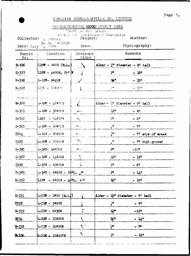
CANADIAN JOHNS-NANVILLE CO. LIMITED
HIO GEOCKEMICAL-XXXDK 3UKV^Y DATA
Page 1,
Collector: ; .•'roo K ir is. 1). i-ve l o ph
Date: July .', ^7';
ae-v/;; '.iroup - V'nrio rv.'o^d Townships; Project: Weather:
Area: Physiography:
Sample No.
Location Drainage' Remarks
D-J16
U-317
U-33fi
0-319
0-320
0-321
0-322
0-323-
U324
U325
U-32^,
'J- 327
U328
U-329
0-330
0-331
0332
0-333. ——— - ——0334
0-335
B.1V,
L315W - 0*00 (B^U
L15W - 4*OON, 25*
L-15W- 8*40N
U5iv - :^oc..r;
L-lJ8?r - 42* DON
i^-"3^o7 H— — -* —
L187f - 34*OOW
L- 187/ - 30*nON
'
L-3J8W - 22*OON
L-18H- 18* 00 S
L-18t? - 14* DON
L-J8W - 10* DON
L- 1^7? - 5*80N - 3(
L1BW - 2*OON - 4C
L-21ST - 0*00 (B-L.
L-21H - 3J'90N. ..... . ......
L-2W - 12*OON
L-23B - 36*OON
l,-2Ut . lQt7fr*N
\* 1
xI
* —
"x
*^^,..— -""-~*""~ -J
\
i"K., s•E. r-*
) l
1
\
V
\
Ald*r - |* dian*t*r - 8* tall
2" - 12*
ty" - 32'
; -H ^ V)|
Aldtr - 1" di*raftt*r - 8 1 tall
lA-"' -8*
1" - 8*
i" - 7*
4* - 7* edg* oT ervvk
(i 11" -7* high grourri
2" -10*
3*" - 32'
1" - 8*
21* - 141*
3i^n - 10*
Ald*r - ty* dian*t*r - 9' tall
J" -9*
IJ* -12*
Ip -14*
2-* - 7*
1" - 32*

PagoCANADIAN JOHHS-KANVILL:;: .co. LIIIITI-:;)Mil Gr,GCKi^TCAL DATA
Collector:
Date: T.., V 7".t-U.J^ y l
0 okn Project:
Area:
ov/rv.hiWeather:
Physiography:
Sample No.
Location Drainage Slope
Remark3
U-337
H338
U-339
•J-3U
U-342
U-343
U3U
U345
U3A6
L-21K - 24* DON
L23K - 27*OON
L23W - 32-iQON ---•-- '
L2Mf - 3f)*OON
L23jf/ - 4D*QON
[ . -. . . . . . . . .... ..r
L?^ - 37*00:1
12.& - 33*OON..-....-.l....-.......^
rij,3 Ajl ** *c ^-*\)^ .'j^
L?y;f ~ .?5*w)N
\4 —
*r-
•*\x
-. ..- ....... ...xh" -- ------- ---
s
*--~
Ald*r - l"1 d
•? it4
^*
P
i'lt 4
Aid -r - 1" r
14-"rriwi*
i*iMt*r -,,10* tall
- *7f •d'g* of trxk
-Ut
- 7'
- 8 *
livMtw - 9 r tall
- 12* *,
. 91
- 8*
-T*
U347 - 8*l
. ,— 4-.
U350
U351
U352
12/^ -
- 9*00 N
- 10*
2"
l" - 8'
T"
^ 9*
^__L t

Page 5,CANADIAN JOHNS-HANVILLE CO. LIMITED
BKSEGGHEMICAL X3QE& SURVEY DATAWe p.t Reeves Gr.
Reeves k Penhorwood Twps. Collector: A. hrooks Project: Weather:
B. lj. Kvelegh Date: July 4tb, 1974 Area: Physiography:
Sample No.
-rU355
U356
IT357
U358
U359 ;
U360
U361
D362
11363TT*3^ M \Jjfo 1^
U365
U366
0367
0368
Location
id-mx.
*KX)N
3*50 N - 0*50*
12* DON
15*5 ON - 0*10K
19*70N
j^JM**\J[ J J l|
^Q t f^O KJ
36*OON"""~ 39*2 ON
42*OON
T 4 v^ ^AA/W JJJ.JJ0 ^LA^vAJrf
37*OON
33*OON
28JOON
25*5 ON
U369 22*OON
0370
0372
1B*OON
U*50N
1WOOS
Drainage Slope
"7v4-
?
1
t
\
S
^
y
^
^
,^
Lrss4—
t
Remarks
Ald*r - 8* X 1*10* X 2*
12* X IV9* X 1*
15* X 2V
7* X 1*
High ground
High ground
High grouact
High ground
Trmetor road
Plat ar*a
6* X 1" Swamp
8* X IV
9* X IV
8* X y
6* X 1"
8* X IV
Crack - Swamp
Swamp
Swamp
Swamp
Sprue* art a
Aldtwr* - 9* X 2*
10* X 2*
12* X 2V
8* X W10* X 2*
10* X IV8* X 1"
High ground
Swamppr
Rigit grotMd
Kdg* of Mtaap
Sffg* of OTMap
BM* af rldg* to Uft
JUld*r Swamp9* X 1"

Page
CANADIAN JOHNS-MANVILLE CO. LIMITED
Collector:
Date: July 5* t 1974
BIO GEOCHEMICAL- BCEPC SURVEY DATA West Reeves tiroup"~
Reeves and Penhorwood Townships A. Brooks Project: B. D. Evelegh
Area:
Weather:
Physiography:
Sample No.
trmom0775
0376
B3777
037*
0379
0380
0381
0362
0383
038A
0385
0386
987
Q3B8-
1089
0390
Location
Ida* 30*00ff7*OON
4AOON
0*00 (B*!,*)
LI* 39109
0*00 (a.u)4*OON
9*OON
22*OON
is*80N1WON
23*30N
27*10N
30*OON
34WON
38*001! - 0*605
40*7*91 - J*50f
Id*B 36*001
40*0011-0*30*1
36KXW- 0*10*
33*3011
Drainage Slope
f
l4-
4-
^
t
^
i
f
|
4-
;
^^
^
^fv
\
Remarks
Altar* - 12' X 2* Kick gcomd
14* X 2* Ufb (piound
10* X V Hlfh cnoind
Aldtrs - 8* X 1"
10* 11^ Bifb crowd
7* X 1* High fromd^ 0*0. at 8*
6* X 1* Bdf* of imp
6* X ^
Bawl - ft* X #* Traator trail - H* ald*s
AldNra -7* X 1* Flat awa - •lop* vouth
9* X 1!* Swxap - araaJc
11* X Ifr* Ktfh jprmnri
12* X 1* Cr**k d 33H
10* X li* S3kv9K aavt Vr avaak
14* X 2* Ujffa pnmad o* al* H*
* **' *i - - - — %'ftfc ^^ 4M *a* -a, _ , ^ - — *JLaflNMfV "*" JK P A f ^ 'P* C?(XWKI
K)* x if* Hiffh pomda* x v Ufb poMi

Page 5,CANADIAN JOHNS-MANVILLE CO. LIMITED
BKSEOCHEMICAL-flQEtt SURVEY DATAWest Reeves Group
Reeves and Penhorwood Townships Collector: A. Brooks Project: Weather:
B. D. Evelegh Date: July 6^,1974 Area: Physiography:
I..•r ?-
Sample No.
0391
U392'
U393
0394
•395
U396
0397
039*
0399
0400
0931
0932
0933
934^irj^Fy
W6
1
Location
Ida. 36*00*
27'OON
25*OOK
2WQON - 0*3CK
15*OON
1WOOM
8*OON
4*OON
0*00 - o*50ir
Ua* 27.* OOW
4JOQB - 0*301
7*503
114003
14*003
LI. 30*00*
3*203
8*603
12*003
LM003
. - 1-
Drainage Slope
X^r-
S
*t
.^*-
ri
^/
tVii
Remarks
Aldtae* -9*11^* Big* of vmop - crMk
9* Ti 1" S* *Af* of •map
8* J. 1&" Hlf^t grouaf - Spna* v**at X 1* Sand hill 9 17*OON
6' X 1* S* otff* of cadar aaaap
9* X 2* od** of twfar ***ap
8* X I* awaap
7* X 1* S prut* mump
Ald*r* - 12* I 2"- Kgh grouaf
9* X Ip •df* of cwaap
10* x 2* Smap
10' X 3}* Swap
AIoMf* - 8* X 1* Ufa groual
14* X 2J" Ufa frovri - fpatte .lop.10' X Ifr* *f^ frouad
7* X Ir Mtfo (rouad

lPage 6
CANADIAN JOHNS-MANVILLE CO. LIMITED
GSDCHEMICALoqflflIX SURVEY DATA ~ West Reeves Group ""
Reeves and Penhorwood Townships Collector: A. Brooks Project: Weather;
B. D. Evelegh , ^ . . Date: juiy etb, 197/4- Area: Physiography:
Sample No,
tl^JCT
0952
0955
0954
0937
0938
0939
0940
D941
D942
3943
09441
194*
0946
0947
0948
0949
0990
Location
Lb* 33100V
41003 - 0120181003
12*003
171003 - WOOt
20*003
Lil* 36100W
1918CB
171003
121503
91003
51003
HOGS
Llm 39*001
0100 (B^L*)
3^005
61803
10KXB
14400B
161003 - 0*KE
ro*oo3
Drainage Slope
\•S
yyi
ss^\^s
^S
*~•~*-sS
Remarks
A-WfWPB ** o I MgT^ ^TMfi' CHOUHv
JwJ A 2^ fluLffft flFOUMn
Hu*l 6* X P* Hffr erauaff - Ifa AldanAlttar 10* X 34*
10* X 1&* G*BtiU .lop.
Alter 12* X 2* OMtl* 3,1* .lap*
K* X li* G**tl* S JT* ftloF*
16* X f Rtfit grouMfi
XO X i?* ZlxCfl CCOtUKl
8* X V C*dw )W*mp
6* X V* SpXTOM VMMD
8* X 2?* 8nraM 0Muip
8* X 34* fetar wwip
v JL ^j^^ fif T3Kt^lBI^ flMMBJIHft
6* X F Spratt OTMP6* X F SpBUtt MM|p
10* X 2* SpBOtt) M*W

Page 7CANADIAN JOHNS-HANVILLS CO. LlllITiJD
SCOffi SURVEY DATAWest He e ve K 'Jroup
He P ve s (x. Penhorwood Awn ship s Collector: A. Brooks Project:
B. D. Kvele^h July 9^' Se 10, 1974Date: Area:
Weather:
Physiography:
Sample . No. i
Location Drainage Remarks
W55
W56
U95T
U958
U959
D960
0961
U962
U96J
U964
U965
13966
U967
U968
TJ969
vrno0971
B972
Lint 42*OOH
WOO (B J,.)
3*003
7*OCB
naooG13*OOB
17*OCB
20*0(8
Lim 45*OOW
19-* OCR
1*)AOQS
11*2 CB - 0*5 OP,
7*OOS
3*OCB
0*00 (B^L*)
Lin* ^8*OOW
2*OQS
6*005
10*005
3^*005
36*003
S Js*\S
S
*— *
4-^
S
r——J. -JY
4^
\
S
^sJi^
Aider* 10* X ty
32* X 2^*
8* X 1*
U* X 2"'
7* X 1*
8* X 2^'
7f X 2F
Alctan 15* X 2^'
12* X 2*
10* X ty*
8* X 1"
10* X tt*
8* X 1*
Ald*r* 10* X 1^-*
8* X 1*
10* X 1*
7* X i*
9* X 1*
Bdf* of high ground to K
Kdg* of vwamp
Swamp
Cedar manp
Cedar aiutmp
Ctdar nuuip
Cedar nwap
High ground
High ground
High groundf
High grouvJ
High groiud
High ground
High ground
High ground
High ground
High ground
Higti grounf

Page 8
CANADIAN JOHNS-MANVILLE CO. LIMITED
Collector:
Date:
BIO GEOGHEniCAL-BOCL SURVEY DATA.Vest Reeves Group
Reeves k Penhorwood Townships P. Brown Project: A. Brooks
-1974 Area:
Weather: Physiography:
r'.'i
Sample No.
0975
0974
0975
0976
0977
0386
OB8T
0888
0389
0390
0891
U892
0393
i Location
Ida* 53**OOI
X4JOC8
10*005
6*005
21005
0*00 (B*U)
Li* 39*009
0*00 (H*i*)
4*OON
8*OON
23*OON
16/OON
20*OON
*t i 1 fc Q^KT
28*0011
Drainage Slope
lS4-
•k
^
N,^
^^^^,o
#-
Remarks
Alrften 7* X Ifc* Klf fa powl
6* X V Kfffa frocnda* x i*D* X 2* Hifh frauri6* X 1*
JLlcPMfv o X t Riift) frotod
JiU* X 5^^ ffTyft fQTQQBHi
**^- fa TfM V TlJI Iff * — *- -. - -..- *ncLimi ' jwC JL Jip^ 'K"i IU^QWI
Jlldwr. 5 1 XJr* Bdf* or Iwrf* ooUrop
5* X i* Swnp9* X I* SwMip
9* X 34* Hl*b croutfrvA -.j 3 M ^* L
.

Page 9p
CANADIAN JOHNS-MANVILLE CO. LIMITED
BIOGEOCHEMICAL- SPOKE SURVEY DATAWest Reeves Group
Reeves k Penhorwood Townships Collector: P. Brown Project:
A. BrooksWeather:
Date: July 12, 1974 Area: Physiography:
Sample Location
p--''
Drainage' RemarksNo.
U894
U895
0896
K97TM^QOUD jT'O^
0899
V)ca
0991
D992
W*
U994
U995
Lta* 42*00127*0011
23*50N
20/OON
36AOQN
12*OON
d*OON
4MON
Ma* 45*00*
20*50N
35*50N
12*50N
8*0011
3*OON
Slope
*-*-
-,*-
\*~
v^
trfiV
Alctan 10* X y Kfh grcmrf
12* X 2- Bif h frond
It* X 2* SMMP
10* X ^r* Suup
7* X 3P OuUrop *r*a
** X 1"
S* X 1^
Ald*za 100* 1* of Rlwr
Sparta* A Mdnr 0raap
8* X i*
6* X i* CUff 0 9*50 H.
15* X 2*
1

PagelO
CANADIAN JOHNS-MANVILLE CO. LIMITED
BTOEOCHEMICAL- XBTK SURVEY DATA West Reeves (jroup "~"
Reeves Se. Penhorwood Townships Collector: p. Brown Project:
A. BrooksPate: juiy 1974 Area:
Weather:^ . , Physiography;
Sample Location Drainage RemarksNo.
V#*
B986
0987?
098&0989
0990
F6569
P656d
0981
0982
0983
W.
P6571
F6570
J6572
F4513F 4 514
IdJ* 48*001
0*00 (1*L.)
4*50N
8*OON
12*OON
16JK)ON
19^60N
aykX)N28JIOON
LI** 51**OOW
0*00 (HvL*)
4*OON
8*OON
12*OON
20* OON
24^00N
27*80N
i d no 'i^+OOW P8+OON
(d no /-K'+OOW P4+OON
Slope
H.t.
N^r*N*t.
w^Njr*N
w^N^,
JUf*
NJI..-*
-*
— r
E
SE
Alton 13* X !*E* X i"
9* X i*
10* X p
8* X ^
8' X^"^ xi*9* X 1*
AMwr* 7* X J*32* X 1*
10* X 1*
T* xi*9'XV
12* X 2*
8* X**
Alders 9' x W
Alders 8' x #"
Oufarop tor TiMaHo
C*dV 0MUtp
C*dwr 0iaap
C*d*r BIMIBP
0*C* BTMl
SlMMp
S* of Net Rltwr
H* of Ifat Riwr
Swajnpy area along Nat RiverSwampy area along Nat River

BONDAR-CLEGG S COMPANY LTD.
Extraction
Method - . ..
Fraction Used
764 BELFAST ROAD. OTTAWA. ONTARIO. K1G OZ5 PHONE: S37-311O TELEX: O53-354B
Geochemical Lab ReportAB - BNO,-HC10.
Cu,Zn,Nl tAg - HNO^-HCl
A,A., ColorimttrieReport No.
From.C&QProject Ho. 22
Date .-. ...-. ....—. ..-. - ..
* Co.
19jk
SAMPLE NO.
u - 316
......... .... 17...................IS
.-. .... ...-.1.9..
20
21
22j
23
21*
25
26
i 2728
29
30
31
32!
33
31*
35
36
37
38
39
ho1*1
1*2
1*3
1*1.
, ..-. ^u - 31*6
Cu ppm
228
115
265
2l*7
279
127
200
210
172
3b7
223
281
259
115
216
27 J*
195
237
276
160
359
157
183
ll*0
230
380
237
302
135
138109
?,n pptn
^2555
750
2296
7H7
1906
1765
19l*0
I960
875
2563
2050
6692300
71*8
2850
1315
1500
2696
513
2000
1910
1610
1700
1650
2h97
2030
201*0
2980
2070
2215129!*
Ni ppm
.85...
195
82
138
9V
61
108
67
55
201
129
122
113
10U
100
101
80
12k
88
126
120
87
85
83
100
TO
78
90
93
8479
Ag ppm
13 1 6
li*, Q
13.8
ll*.l*
16.5
Ifc t 2
12.1*
13.1*
16.1*
21.9
17.2
17.71C. 6
13.2
ll*.l*
15.5
16.2
15.7
17.1*
16.2
13.8
17.0
13.8
1H.O
3l4.6
li*. 8
li*, 2
ll*,0
13,2
12.2
12.6
AB ppm
H. D.
jr. P...H*P.
N.P.
2
N.P,
If. P.
N.D.
N.D.
N.D.
N.D.
N.D.
N.D.
N.D.
N.D.
N.D.
N.D.
2
N.D.
N.P.
1
H. D.
1
1
1
1
1
2
2
1H. D.
REMARKS
B. P. - not dettctad
. - . ,
- - - - . ..
. . ...... . .
...-
....... . ... . ....-.
. .- ....
. . . .. -. - . - -. - .... . .
. .
. \

BONDAR-CLEGG QL COMPANY LTD.
Report No. -"Geochemical Lab Report
Page No. —
SAMPLE NO.
M - -3^7
48**9
5051
U - 352
— ---- ------ -
— . ..,. — .......... .. ..........
—— . — ...,. ... ...., ... . .
. -- .
Cu PI**
190 -
150
la*
^527370
292
*
Zn .-...EP*?-
2639
V025 -
23W
^28102175
2225
. -.. .-
Ri-EP? -
-10Q
M185...
10k112
72
Ag.JZWL-
15.1
-46*1-19. li
15,917.3
19.1
- -
At^J?^
N.D.
K+JX.N.D.
. Z JLR. D.
N.D.
- - -----
- - - --
. . -. ..
REMARKS
... .. .-.. —
- - -.- —
- - -- - -- - -- ' - -— - - —
- - -- - - - -- -- -- - - -.— -——
\

BDNDAR-CLEGG S, COMPANY LTD.764 BELFAST ROAD. OTTAWA, ONTARIO, K1Q OZB PHONE: S37-311O TELEX: OS3-3B4B
Geochemical Lab ReportExtraction^—^
Method ___-
Fraction Used —
- HKO -HC1
ASK
Report No.,
From.ProJtott tt
Date __________AugUlt 22, 19 jk.
SAMPLE NO.
U - 353
5*
55
56
57
58
59
60
61
Ci
63
61*
65
66
67
66
..... 69
70
. .........7i. -
72
73
7H
75
76
77
78
79
80
61
8883
Cu -VS* —
2V2
315
273
250
230
305
110
80
210
1?5
270
90
300
130
160
2U2
180
220
uo280
3*0
...ITO..
180
AHO...
235.
160
155
.-2flk....
^-21(L
250150
Zn — W
1V90
12kO
2070
1290
930
2H20
857
1716
2950
1025
2525
1535
2630
1780
970
3250
2175
1165
. 17H5
3010
985
1620
1*00
1850
1815.
1^70
1230
1*500
2385
8301990
Viw*90
87
90
80
53
60
60
65
85
50
90
Co
75
60
70
75
70
70 .
1*0
JTQ
55
70
60
AL-
50
-jAo. .^^0^
-50
-90
11070
As H*10.0
13.0
11.0
12.1
12.2
10.5
10.2
11.0
13.2
10.5
12.0
11.5
12.6
10.0
11.0
11.0
9.0
13.0
13.0
15.0
15.3
11.0
12. J
L JJ^i
.. 13x7
. JA.D
15.5
-.15*5.
43*3
18.313.0
REMARKS

BONDAR-CLEBG Si COMPANY LTD.
Report No.Geochemical Lab Report
Page No..
SAMPLE NO.
U - 38HB?
06
8T88
^ ——— a^—90
91
—————— 9293
9*
95
9*
—————— 97 ———U - 398
——— Hk- ———————————————————————
CttVMIMM-W —830
2HO
33kM93TO
3008H2
2T3
1BO195
200
130
2kO
210130
In -W" —1000
2665kasoS050
UHO
106919tO
1365
fifOO560
3375
l&O
3000
28001970
•ira*7060
8070
60
6A70
506050
556060
60 ,50 .
AI Inn
mm (
ACw*13.0
11.0
Ik. JU.I
11,614.6
11.0
11.0
12.5Ifc.t
12.0
11.5
12.0
12.012.0
ill to
OPIM 8
rollo*.
BIT OOT MR* Bt
MR. F.
REMARKS
-
c. comr (i) 'L IfrVkLEOH (2)
. ————————————————————— 1 iHni^i
;. jii
\ - '''-^ m
^
•i
i5

BONDAR-CLEGG SL COMPANY LTD,BELFAST ROAD, OTTANA/A, ONTARIO. K1B OZ5 PHONE: 237-311O TELEX: O53-3B4B
Geochemical Lab ReportExtraction
Method
Fraction Used
As - HHO.-HCIO,
Colorimetric
trea pulp
Report No. 567-1*
From Canadian Johns-Manrillt, Oo. Ltd, Project"i 22
. Date
SAMPLE NO.
V - 353
54 55
5758596061
62
63
65
66
67
68
69 70
71
72
73
Ik
75 76
n78
7960
61
82
U- 363
ABppn
1
1
9.D.
1
1
1
1
2
3
31
l
1l•t
H.D.
H.D. 1
3 1
2
1
1
N.D.
1
1
H.D.
H J).
a.D. l l
.
REMARKS
V.P. - not d*t*ot*d*
^
. .. . m,. ^
. . . .^—
- .,.....
... .....
, - -. .- —
- . - — — —
. — . - . ,
. . . —
. . . .. — . ,
. . . - .-.., -. ——
- ——
\
-1a

BONDAR-CLEGG S COMPANY LTD.
Report No.Geochemical Lab Report
Page No..
f :
1fi
, -
ii,#.;.M~t
SAMPLE NO.
f .381*K8687888990919*
939k9?9697
H . J98
*
kUfeijtf
AB
1.9.
1.9.K.B.
1.9.
IA1,9.
1.9,
1.9.
1.9.
1.9.1
V.9.N.D.
H.O.
H.D.'
i
REMARKS,
Z/

BONDAR-CLEGG S COMPANY LTD.BELFAST ROAD, OTTAWA. ONTARIO. K1G OZO PHONE: S37-311O TELEX: O53-3548
Geochemical Lab ReportExtraction J2l*ZBL^*if * AHLeHQl _ Al f HJCLdPlflk Report No.
Fraction Used A ah Date
SAMPLE NO.
V . tt*
B *ljOOf - 93*™ V V
932
933
93k935936
937938
9399l*o9W91*2
9U39W*91*59U6
9U791*6
91*93-950
1
Ott HP i
2S3iao.-.160
23.lliO
2QL2UO
226
2772U6260
20523717013^11*8
J^l-1*-
18J
202*
-JtSL.-JiD-
2n KP
JI1Q
1125l^iO
2215
770
59226531120
2371
1700
2000
11*751181*
1800
J800
2000
U!!L8151100
8JOO
2300,2800
liM* i
~U9J2- -j86
.-SO-..
959U92
957082
8981
79739590*JL-
72,87
85100200
ACppaJ3O12.0
-I2^i
13*313.0
15.515.316.7li*.913.012.5u*.o12.6
11.512.0
11.8
11.0
12.0
1J*2
10^
. iliO-
-i5*o
iswmmfi*H^fi.
HA
I.D.
H.D.
MJ).N.D.
1
1
1
H.fi.
H.D.
I.D.
V.9.
I.D.
1
1
1
1
HjDt
1
H J).
REMARKS
1.2. * aot dftt*oi*A.
1•"';
'

BONDAR-CLEBG Si COMPANY LTD.
JELFAST ROAD. OTTAWA, ONTARIO. K1O OZO PHONE: B37-311O TELEX: O63-3B4B
Geochemical Lab ReportExtraction —CU)
l' Method __A?A
At - HH00-HC10, f Hi, Ag-* -HMOfriHDl —
: Fraction Used ^... ^
Report No.———————
From 0*nftM*n ^^^^l^i. 00 * ****
Date ___________^^_ -.-_* _______19 71*
SAMPLE NO.
V * 866
878889
90
___ 91 92
........ . 89391*
.- —85..
... .^ .i*
9798
899U- 900tf-951
52
tt
... . -^4.55r^
tt5158
59X^
60
61/CO———————— (M ————
———————— ~
^65
V- 966
di — W*-
?JS
-210- -
300
289
100
120
165
276
232
281;
190
120
311185
-.403...180
266
1S5330
.250
..585. -122
..81
^^110
95265*wj*
2BS•WJ
297*~i
200
215
ZnM*i 1
2900
1105161+10
2700 .
121)0
1265
815
1250 .
19UO930U47523501020
890
1J10
610
102512301290-
1060
2320
13851300126517202iiOO '•••f ****
h-W)-1190••Jn* --
o A to***JV
1325
2000
KiPP*
-6*--
-4^1U7187
7572 886080
68
7872102
86
70
101*
15310383 -
7386738270
73BO
--6540r*
(A — -Ow- --
108
96
A*ppa
11.513*212.919.711.510.0 11.8
1?.*.1?.0
10.0
10.0
11.0
.11,711.0
10.5.11.0
11,7.1Q.O
12.0 .
9*0
9,5U.310.0
11.0
-10,0
10*5-15.5*y.J?
10.0
-12.812.8
12.0
ABM*
JL J
lK.]).
1
1
1
1
1
V.D.
1
1
1
1
1
S. D.
1
i ..
fi*B.
1
U,SA -li.fi*D.D.
HA.
Ji*a.-1I*B.
O.B.•w ••'W
TT-JV
ll
REMARKS '
V.D. - not d*t*ot*d.
. . . . . .. ..-... — —
. . ,, . —— ji* .

BONDAR-CLEGG S COMPANY LTD.
Rtport No.-Geochemical Lab Report
Pag. No.-
SAMPLE NO. REMARKS
tt 1270 10.0
2910 10.2 i.i.
—7t- 72 U.5 1,1.
75M-
180 2700 16.0 1.9.
m J&&. J&2.
47- J&70JL
81 255 2200 50 11.0 1,9.
82 252 2380 .50. ilii.
JX Ut JL385L 43- ^0*1. JLA.
^30- -40- .11*8-85
86
200 it*) 68 U.9 I.D.
230 1395 98 12.0 1.9,
87
69ll^CL
262 2200 70 15.090 liiO 2710 78 12.2 I.*.
92 120 1510 87 12.0 I.B,
93 1U5 1605 75 12.2
^11-
H* -.•fi

f— f BONDAR-CLEGG S COMPANY LTD. l•1 — i
764 BELFAST ROAD, OTTAWA, ONT/
GeocheiExtraction A* * HWOyHClO^
Method. Coloriattrio
Fraction Used . tr*e P111?
SAMPLE NO.
T - 6568
-- ...... J*
-.... ....70.
,. ...........71 . 72
73
P - 65714
r
————— . .. . .
—————— . ..^....... . . ....
Asppa
W,D.
l
H. P.
1
N.D.
1
H.J).
*RIO, K1
nicalB OZB
LabReport N
From .J f-
Date- .
PHONE: S37-3110 TELEX: O53-3548 1
Report 1 aw* 1
uiadlan Johns-Jfcmville Co* Ltd* |roj*oti 22 1
August 27, . 19 71* 1
.
REMARKS
I.D. . not (Wt*ot*d.
- . . ,. . . .-. ...- —..—. —
. -. - —
. .- .. ..-.-. -. . ...... ...—.. —————

BONDAR-CLEGG S COMPANY LTD.73* BELFAST ROAD. OTTAWA, ONTARIO, K1Q OZ5 PHONE: S37-311O TELEX: O53-354B
Geochemical Lab ReportExtraction.
Method _ - -
Fraction Usedr
A.A.
-_ Report No. ______.
Canadian Johns-Manrillt Co. LtA-Mr.ConaFrom
Date- August
SAMPLE NO.
F - ^5^*8
69
70
71
72
73
F - 6J7*
\-
— ----- - -- -
---— - - - -. ---- ---
Se
. . . . -. -
m
190
173
135
195
188
180
31?
Vv^\P
- — -- -
TJrtJljl
^0
920
2150
1970
7*50
7000
13*00
Ax
HiTO" -85
6?
50
62
1*3
75
139
Aa Pt*1
7
Ag -W* —
10.0
9.0
5.5
11.8
9.0
9.0
15.P
at B to:opira t
follow.
FJT OUT yp. H
tr-j V- 9 f '
- - ' -
-
•—— "
REMARKS
-. . . . . . .. . . .,-.-.. .-—..--...-^..-..
K. COJfN (1)
j. rvniTOH (r)
. -.. ...— ...—..-... ————
- .. ...- .- ............. ————
.........- — - . ..-.. —— — ——
••t'

Geological Legetyl
Quartz diabase, diabase
Diorite 4a; Gabbro diabase ^b.
Peridotite ft Dunite (Serpentinizyd)
Pyi'oxenite
Rhyolite fragmental lava
basalt piDlow lava 2aj Diabfisic lava 2b; Spherulitic lavn 2c; Fragmental lava 2d; Talc-ohlorite schist 2f; Amphibolite 2g.
Greywacke laj Arkose Ibj Quartzite le; Ai'gillite or shale Id; Conglomerate le; Iron formi schist lg,
Carbonate rock.
Direction in which lava flows face, indicated by shape of pillows
Outcrop
Swamp or muskeg
Scarp
Creek
Drill hole
D FOp D^TAILEp GKOLOGICAL MAPPINGAbbreviations '
AsbestosBrecciated
y 5-bl; Feldspar Carbonatede 5c; Lamprophyre Chalcopyriteuartz diorite 5h. Disseminated
DarkFeldsparFoliatedGrained - fine
- medium- coarse
GraphiteGneissGneissic
c lava 2b; Hornblende; Tuff S Chert 2e; Lipht. Magnetite
ModeratelyAi'gillite or Mediumon If j Chlorite Massive
TOPOGRAPHIC SYMBOLS
AsbBrec'dCarb 'dcpyDi ssDkFpFol'dF tfr'dM gr 'dC gr'dGraphGnGn'oH'blLtMagnModHedMass
^X'' Bush road ~ ~-
f*- .s H igh ground
M C abin
a Shaft*^*(^ Pit or trench
77? Esker
,^.^•*~-~-~-*. —
^.-v^
—wi*~
^l—--i-1-*—
Oxidised ' Ox 'dPyrite PyPyrrhotite PoPeridotite Perid -Pyroxenite - PyroxQuartz QtzSerpentinite SerpSheared Sh'dSerpent! nized Serp'dStrongly StrSchistose Sch'seStringers StrsSchist SchSericitized Ser'dTypical TypThread vein T.V.Texture TextTrace TTVolcanics Volefleakly Wk
Geological Contact - assumed- definite
Swamp border
Shear zone
Fault - assumed '- definite
Attitudes - bedding- shearing- jointing
SEP -6 1974

ow
c h o
GEOPHYSICAL - GEOLO TECHNICAL DA
42B0 , NEees a t see REEVES
TO BE ATTACHED AS AN APPENDIX TO TECHNICAL REPORT ^FACTS SHOWN HERE NEED NOT BE REPEATED IN REPORT
TECHNICAL REPORT MUST CONTAIN INTERPRETATION, CONCLUSIONS ETpR( (fCTS
900
11974UNIT
etmi f. aType of Survey. Township or ,Claim HniHerM Canadian Johns-Man vi Ile Co i
Reeves 8t PenhorwoodLimited
Author of Report P. Brown and F. J. fivftl figh AHHrpss P* 0. Box 610, Matheson^ Ontario Covering Dates of s,.™^, June 1fltb - July 13tb t 1974
(linccutting to office) Total Miles of Line cut 11t90—-—--————————————
SPECIAL PROVISIONS CREDITS REQUESTED
ENTER 40 days (includes line cutting) for first survey.ENTER 20 days for each additional survey using same grid.
Geophysical—Electromagnetic.—Magnetometer———Radiometric———Other—————-
DAYS per claim
Geological.Geochemical.
AIRBORNE CREDITS (Special provision credits do not apply to airborne lurvcyi)
Magnetometer. .Electromagnetic(enter days per claim)
rtATF.-Sept 6, 1Q?4 SIGNATURE:
PROJECTS SECTION Res. Geol.
•s-ST 2. -
Previous Surveys
Checked by. .date.
GEOLOGICAL BRANCH
Approved by
GEOLOGICAL BRANCH.
Approved by. -date.
MINING CLAIMS TRAVERSED, List numerically' o
(prefix).272Q2JS. ........2:1
(number)........22,
i
.360233..
TOTAL CLAIMS.

Show instrument technical data in each space for type of survey submitted or indicate "not applicable'
GEOPHYSICAL TECHNICAL DATA
GROUND SURVEYS
Number of Stations_____________________________Number of Readings. Station interval____________________________________:————————Line spacing____________———————————————————————————————————— Profile scale or Contour intervals——————————I——————————————
(specify for each type of lurvey)
MAGNETIC
Instrument _________________________________;Accuracy - Scale constant — Diurnal correction method. Base station location———
ELECTROMAGNETIC
Instrument———————Coil configuration. Coil separation —— Accuracy-————.Method: CD Fixed transmitter CD Shoot back D In line CD Parallel line Frequency^^^^^^^^^^^^^^^^^^^^^^^^^^^^^^^^^^^^^^^^.^^^^^^^^^^^^^^^^^.^^^^.^^^^^^^^^^.^^^
(specify V.L.F. station)
Parameters measured________________________________________________________ GRAVITY
Instrument__________________________________________________________Scale constant.Corrections made.
Base station value and location.
Elevation accuracy-————.———-.^^-..^——- INDUCED POLARIZATION - RESISTIVITY
Instrument——-^—^———————^.—^——^—^Time domain___________________________ Frequency domain. Frequency____________________________ Range————^—,Power.^-———-———-——————-——————^——^^^^^———————————Electrode array—— Electrode spacing, Type of electrode,

SELF POTENTIAL
Instrument.———————————————————————————————————————— Range.Survey Method ——————————————————————————————————————————
Corrections made.
RADIOMETRIC
Instrument ———Values measured.
Energy windows (levels)-———————^^—-——————.——————————....——Height of instrument____________________________Background Count. Size of detector——^^————————————————^——...-.-^—^—-—.—.—..—^.Overburden —————^———————.-—————^—^—..—^^——..—.—^———.—....^^^—
(type, depth - include outcrop map)
OTHERS (SEISMIC, DRILL WELL LOGGING ETC.)
Type of survey———————————————————————————————— Instrument ———————————————————————————————————Accuracy^———————^—^-^————————^^^——————————Parameters measured.
Additional information (for understanding results).
AIRBORNE SURVEYS
Type of survey(s)——————————————.———————————————Instrument(s) —————————————————————————————————
(specify for each type of survey)
Accuracy—————^——.————^^—(specify for each type of survey)
Aircraft used————.-^—-—.-.-—..—————^^^^^—.————-.
Sensor altitude-Navigation and flight path recovery method.
Aircraft altitude_______________________________Line Sparing Miles flown over total area________________________Over claims only.

GEOCHEMICAL SURVEY - PROCEDURE RECORD
Numbers of claims from which samples t 372078, 372079, 372080, 380230 t 380231, 580252. 380233—————-—-———————
Total Number of Samples. Type of SampleJ-Jnd-^
169sterna
(Nature of Material)
Average Sample Weight 2 to 3 OZSMethod of Collection4-QQ ' spacing on pi lines; cutting by pruning shearsSoil Horizon Sampled ——— ™ —————————Horizon Development ——— r Sample Depth _______ "
Generally flat except for an E- W scarp at about 12N of Twp. Line
ANALYTICAL METHODS
Values expressed in: per cent p.p. m. p. p. b.
D D D
@) Pb,
Others_
Co, (^g^ Mo, ^s))(circle)
Field Analysis (. .tests)Extraction Method.Analytical Method-j. Reagents Used———
vdth swampy sections Field Laboratory Analysis
Estimated Range of Overburden Thickness ________ No. ( ————————— : — ______________ 0-80' ____________ Extraction Method
.tests)
SAMPLE PREPARATION{Includes drying, screening, crushing, ashing)
Mesh size of fraction used for analysis.———
Analytical Method. Reagents Used ——
Commercial Laboratory 645 .tests)Name of T.ahm-a tnry BondaT-Clegg of Ottawa Extraction M^thnH Controlled acid digestior Analytical Method Atomic Absorbtion Reagents rkfH HNO, HOI-—————————
General- General .

Melrose Twp.(M.861) THE TOWNSHIP OF
DISTRICT OF SUDBURY
PORCUPINEMINING DIVISION
SCALE: 1-INCH-4O
LEGEND
PATENTED LANDCROWN LAND SALELEASESLOCATED LANDLICENSE OF OCCUMTIQMTMINING RIGHTS ^"SURFACE RIGHTS, ONLYROADSIMPROVED JC&DSKING'S HIGHWAYSRAILWAYSPOWER LINESMAflSH OR MUSKEGMINESCANCELLED
NOTES400 SURFACE RIGHTS RESERVATION
ALL LAKES AND RIVERS.
Areas withdrawn from staking under Section 43 of the Mining Act (R. s O, 1970)
File Date Ditpocitioji -27/7/72
DEC 27,1972 S.RO.VT*.* ':r *"' : \t ~-
** .
JAN. 17 1973'-' '3
S.R O.WitMrawn f rom S lofciny See 3 4{ct)Mg.Art ' 163006
PLAN. NO.27590 \|?M69 \ y73ee 1 37314
MINISTRY OF NATURAL RESOURCESSURVEYS AND MAPPING BKANCHPenhorwood Twp.( M. 1055)
'*1

pro ro
o o o
OsLJ
Reeves Twp. (M. 1074)
7J/2M- - 7/2 M
6M
C\J CD O)
Q.
x: "o)
P ip p
362 166 ' 382 l 64 '38216;;
l 06024
r Jehann Lake s."~~"1060E Z
"r "r" \ '7960/71107986,108004 ' t08../.L. -i—-4--y&LMlioi yIt IT, A. o .^
C.L.M? 108 V"T998 ,.-.. 4 II ' 1080E V l 108019 (OTOB020 \ — .__l——'---——--'- .."""""'s." -s. s.106006 .
s, Ts. "1 "~~"/107961 ' 107982I07983/ V0798T 108001 1108003
l l 8,. ..— - -- — -— *
08OQ3H079861 107967 ,' 107988109717 109718 | /©MR
IO9509 \ ! If 's; c s sIM7I4 . . . ,
IU7I2 ' 109496 , 109497 l 109498 MiriBl C l
i (D j 109678 ' ' * ft ' ..-"".?76 \ * 1"""^--* 10*679 II09S80; 109681 --. /" -Xi '"; • Vi!A-^-4-----T"'~"t"'"---^-^----
' __±'f*-T' ^ l - ^- J* C
XV fi ' 109691 l -X ,109690 109689 109668
IM5S9 .//IM587 111585 - IM583
g) MRO. y MROy7 MRO. /S.67755
- : . ;.-- fy ,\; ..\ ,-.- 1 ,::. ;,^. -
TIONAGA STA.
(Ac.
Tionaga Lake
Boo t hou s e Slta 1.7/Ac File-77094 Vot ; 5 -^
CD
4X2 M
Q.5
EoocO)
Hardiman Twp. ( M. 916)
THE TOWNSHIP OF
PENHORWOODDISTRICT OF
SUDBURY
PORCUPINEMINING D IVISIOIS
SCALE: 1 -INCH ^ 4O CHAINS
LEGEND
PATENTED LANDCROWN LAND SALELEASESLOCATED LANDLICENSE Of OCCUPATION
MINING RIGHTS ONLYSURFACE RIGHTS ONLYROADSIMPROVED ROADSKING'S HIGHWAYS
RAILWAYSPOWER LINESMARSH OR MUSKEGMINESCANCELLEDPATENTED FOR S.R.O
NOTES
400' S urface Rights Reservation ashores of all lakes and r ivers
Flooding Rights On Horwood L ake Re To Contour 117.' L .O. 7 746.
ng the
erved
SAND and GRAVEL
Grovel File 38729
G r ave l Pu " l 3 55 5 v 6
Grovel File 106274
*j 4 Q O' Reserve File 1355•'f*z) withdrawn from S1 o k ' n g F i l
-MINING LANDS lDATE O F ISSUE
SIP 11 1874MINISTRY
OF NATURAL RESOURCES
PLAN NO.. |055)ONTARIO
MINISTRY OF NATURAL RESOURCESSURVEYS AND MAPPING BRANCH
9.1566 REEVES S10
135537
oa
O"
ms x o o:oo o
f-cr-
CU OJo

ADJOINS SHEET NO,
O Z
UJ uj X (A
h
6zO enUiX
QJ
O Otd-J
5z
D < Z <a
HW Y. J O!
--——r - i
JEHANNTALC CARB iONES REEVES TWP.
PENHORWOOD TWP.
JEHANN FIBRE ZONE
LHPOfVf FIBRE i
REEVES GROUPWEST REEVES GROUP WEST JEHANN GR.*1 WEST JEHANN GR.*2 CHUB LAKE GR. JEHANN GROUP JEHANN SOUTH EXT. GR. MONTGOMERY LAKE GR. BROMLEY-NIB GROUP
'*' 'T *71 l
TALC CARB ZONES FIBRE ZONES
I.F. IRON FORMATION
2.1566 REEVES 220
SEP - 61974

CA
NA
DIA
N
JOH
NS
M
AN
VIL
LE
C
o.
LTD
. --
MAT
HES
ON
. O
NT
AD
JO
INS
S
HE
ET
N
o.
D u 0 tn (A z m m H z o
-Q
U^L
—[i J
OIN
S
SH
EE
"!
No
.

A-0 JOINS SHSCT NO
jf.
V D
.d
is-s
/y LEGEND
BACKGROUND 0-12.9 PPM
) POSSIBLY ANOMALOUS 13-15.4 PPM
-;1 PROBABLY ANOMALOUS 15.5-18.5 PPM
ANOMALOUS ^18-5 PPM
42BelNE0052 2 .1566 REEVES'240
. t
.J SURVEY PLAN - AG.ON

i. -* : ~ swr'-iH",'i.-^SIr
42B81NE0C52 2.1566 REEVES
LEGEND
COLOUR SCHEME ON BASIS OF PPM
N.D.
1 PPM
2 PPM
3 PPM
BIOGEOCHEM SURVEY PLAN - ASON!.- 1-200 sEP-61974 REEVFS - PENHORWOOD

SHE*TT ~io
LEGEND
BACKGROUND 0-190 PPM
POSSIBLY ANOMALOUS 191-250 PPM
PROBABLY ANOMALOUS 251 -300 PPM
ANOMALOUS ^300 PPM
42B01NE0052 2.1566 REEVES x260
BIOGEOCHEM SURVEY PLAN-CU.ON X33 DN 00' SEP. r e 1974 RffvTS PENHORWOOD

S^^-S?^^'^^ '" **- - ,~"" ''- , " -..'- f ' - ' •." J** - "*:-*i" , " . ' ' -, . '
MoOi
Oruofoo!
———l
D
54,00:1
\
BACKGROUND 0-1700 PPM
POSSIBLY ANOMALOUS 1701 -2200 PPM
PROBABLY ANOMALOUS 2201 -2850 PPM
ANOMALOUS ^851 PPM
2.1566 REEVES 270BIOGEOCHEM SURVEY PLAN- - ZN.ON T. f-200' SEP-61974 ReeVtS P i WPS

2,000^, i- ~
•- H ' ^'*'i'
LEGEND
BACKGROUND 0-70 PPM
POSSIBLY ANOMALOUS 71-94 PPM
PROBABLY ANOMALOUS 95-127 PPM
ANOMALOUS M27 PPM
OGEOCHHii PLAN - Ml.5EP-61974 REEVES -PENH42B01NEaa52 2 .1566 REEVES 280 I WPS