august 15th, 2013 t-1 day nick kyper wallops island, va hs3 weather brief
TRANSCRIPT
August 15th, 2013T-1 Day
Nick Kyper
Wallops Island, VAHS3 Weather Brief

Current Analysis
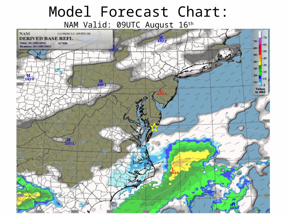
Model Forecast Chart: NAM Valid: 09UTC August 16th
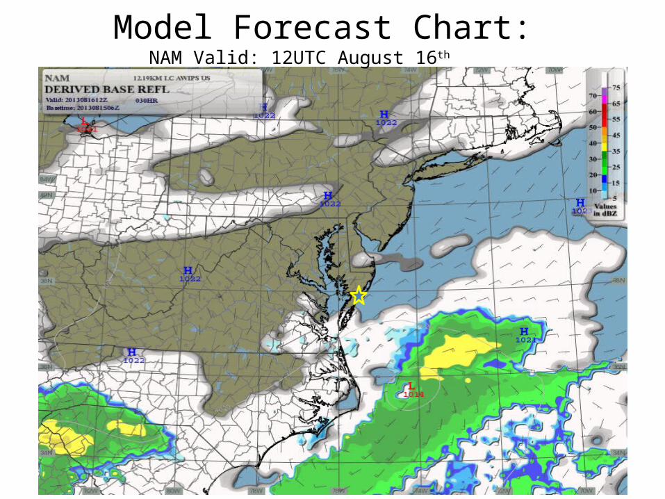
Model Forecast Chart: NAM Valid: 12UTC August 16th

Model Forecast Chart: NAM Valid: 15UTC August 16th
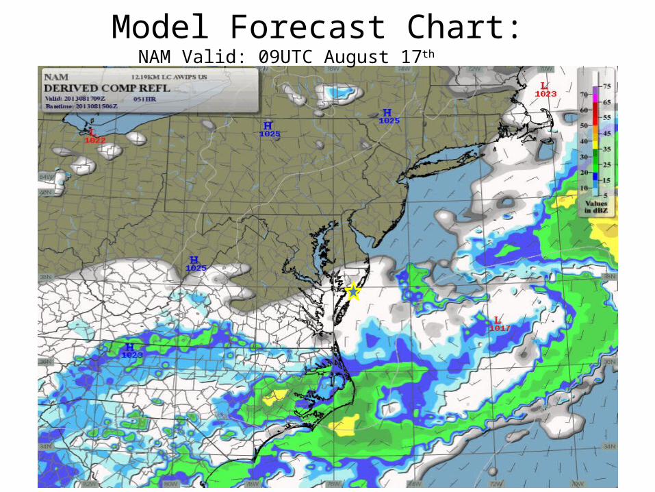
Model Forecast Chart: NAM Valid: 09UTC August 17th

Model Forecast Chart: NAM Valid: 12UTC August 17th

Model Forecast Chart: NAM Valid: 15UTC August 17th

48 Hour Forecast Issued 1500L 08/15/2013
SYNOPTIC OUTLOOK: High pressure will center over the Mid-Atlantic today, providing dry and cool weather through tomorrow afternoon. High pressure will shift off the coast tonight as a frontal boundary well to our south begins to move north as warm front tomorrow afternoon. Southerly flow aloft will develop over the region tonight, allowing for an abundance of moisture to overspread the region. A combination of the moisture combined with warm-air advection will overrun the warm front allowing for scattered showers to develop over the region tomorrow afternoon into the evening. Showers will become more widespread Saturday, especially during the afternoon as several upper-level shortwaves interact with the front. An upper-level trough will remain over the eastern US, allowing for unsettled weather to continue into early next week.
48 HR TERMINAL FCST: FRI 05L SCT050 BKN250 P6SM.FRI 11L FEW020 SCT050 BKN250 P6SM.FRI 18L FEW020 BKN050 BKN180 BKN250 P6SM.CHC SCT020 BKN040 BKN070 BKN150 5SM –SHRA BR.SAT 02L SCT020 BKN050 BKN130 P6SM.CHC SCT020 BKN040 BKN070 OVC120 5SM –SHRA BR. SAT 10L SCT020 BKN040 BKN070 BKN130 P6SM.CHC SCT020 BKN035 BKN050 OVC100 5SM –SHRA BR.
WIND: FRI 05L NORTHEAST 4 TO 8 KNOTS.FRI 08L NORTHEAST 8 TO 13 KNOTS.SAT 08L NORTHEAST 10 TO 15 KNOTS.
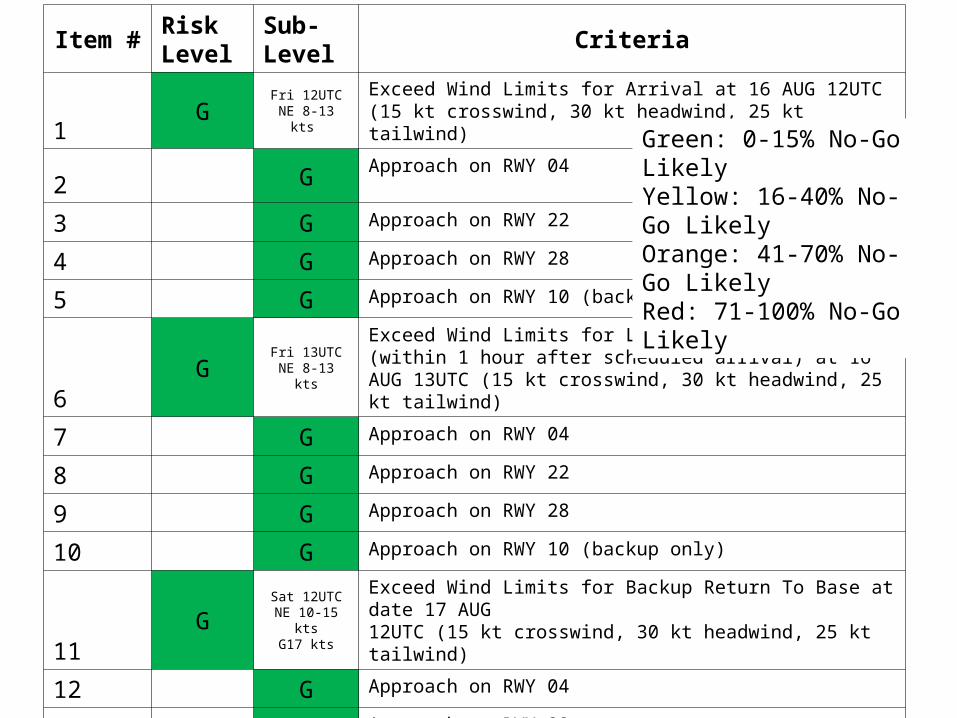
Item # Risk Level
Sub-Level Criteria
1 G Fri 12UTCNE 8-13 kts
Exceed Wind Limits for Arrival at 16 AUG 12UTC (15 kt crosswind, 30 kt headwind, 25 kt tailwind)
2 G Approach on RWY 04
3 G Approach on RWY 22
4 G Approach on RWY 28
5 G Approach on RWY 10 (backup only)
6G Fri 13UTC
NE 8-13 kts
Exceed Wind Limits for Late Return To Base (within 1 hour after scheduled arrival) at 16 AUG 13UTC (15 kt crosswind, 30 kt headwind, 25 kt tailwind)
7 G Approach on RWY 04
8 G Approach on RWY 22
9 G Approach on RWY 28
10 G Approach on RWY 10 (backup only)
11 GSat 12UTC
NE 10-15 ktsG17 kts
Exceed Wind Limits for Backup Return To Base at date 17 AUG 12UTC (15 kt crosswind, 30 kt headwind, 25 kt tailwind)
12 G Approach on RWY 04
13 G Approach on RWY 22
14 G Approach on RWY 28
15 G Approach on RWY 10 (backup only)
Green: 0-15% No-Go Likely Yellow: 16-40% No-Go LikelyOrange: 41-70% No-Go Likely Red: 71-100% No-Go Likely
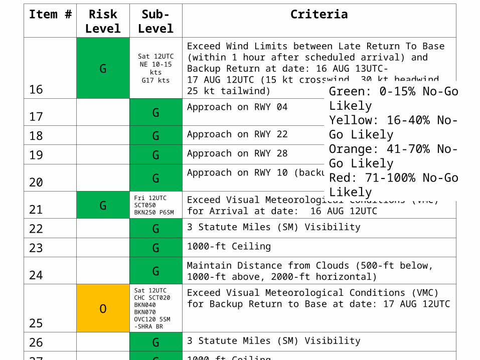
Item # Risk Level
Sub-Level
Criteria
16G
Sat 12UTCNE 10-15 kts
G17 kts
Exceed Wind Limits between Late Return To Base (within 1 hour after scheduled arrival) and Backup Return at date: 16 AUG 13UTC-17 AUG 12UTC (15 kt crosswind, 30 kt headwind, 25 kt tailwind)
17 G Approach on RWY 04
18 G Approach on RWY 22
19 G Approach on RWY 28
20 G Approach on RWY 10 (backup only)
21 GFri 12UTCSCT050 BKN250 P6SM
Exceed Visual Meteorological Conditions (VMC) for Arrival at date: 16 AUG 12UTC
22 G 3 Statute Miles (SM) Visibility
23 G 1000-ft Ceiling
24 G Maintain Distance from Clouds (500-ft below, 1000-ft above, 2000-ft horizontal)
25O
Sat 12UTCCHC SCT020 BKN040 BKN070 OVC120 5SM-SHRA BR
Exceed Visual Meteorological Conditions (VMC) for Backup Return to Base at date: 17 AUG 12UTC
26 G 3 Statute Miles (SM) Visibility
27 G 1000-ft Ceiling
28 O Maintain Distance from Clouds (500-ft below, 1000-ft above, 2000-ft horizontal)
Green: 0-15% No-Go Likely Yellow: 16-40% No-Go LikelyOrange: 41-70% No-Go Likely Red: 71-100% No-Go Likely

Item # Risk Level Sub-Level Criteria
29O
Sat 12UTCCHC SCT020 BKN040 BKN070 OVC120 5SM-SHRA BR
Exceed Visual Meteorological Conditions (VMC) between Arrival and Backup return at date: 16 AUG 12UTC – 17 AUG 12UTC
30 G 3 Statute Miles (SM) Visibility
31 G 1000-ft Ceiling
32 O Maintain Distance from Clouds (500-ft below, 1000-ft above, 2000-ft horizontal)
33 G Lightning in op area for Arrival at date: 16 AUG 12UTC
34 G Precipitation in op area for Arrival at date: 16 AUG 12UTC
35 G Lightning in op area for Backup Return To Base at date: 17 AUG 12UTC
36 Y Precipitation in op area for Backup Return To Base at date: 17 AUG 12UTC
37 G Lightning in op area between Arrival and Backup return at date: 16 AUG 12UTC – 17 AUG 12UTC
38 Y Precipitation in op area between Arrival and Backup return at date: 16 AUG 12UTC - 17 AUG 12UTC
39 Y Clouds/Winds Key West, FL (Weather associated with risk level)
40 Y Clouds/TSRA KSC (Weather associated with risk level)
41 Y TSRA Mayport, FL (Weather associated with risk level)
42 O Clouds/TSRA Beaufort , SC (Weather associated with risk level)
43 O Clouds/TSRA Tyndall, FL (Weather associated with risk level)
44 R Clouds/Winds Cherry Point, NC (Weather associated with risk level)
45 G Pax River, VA (Weather associated with risk level)
Green: 0-15% No-Go Likely Yellow: 16-40% No-Go LikelyOrange: 41-70% No-Go Likely Red: 71-100% No-Go Likely

7 DAY FORECAST
High pressure will center over the Mid-Atlantic today, providing dry and cool weather through tomorrow afternoon. High pressure will shift off the coast tonight as a frontal boundary well to our south begins to move north as warm front tomorrow afternoon. Southerly flow aloft will develop over the region tonight, allowing for an abundance of moisture to overspread the region. A combination of the moisture combined with warm-air advection will overrun the warm front allowing for scattered showers to develop over the region tomorrow afternoon into the evening. Showers will become more widespread Saturday, especially during the afternoon as several upper-level shortwaves interact with the front. An upper-level trough will remain over the eastern US, allowing for unsettled weather to continue into early next week.