auger drilling defines two major new targets at the
TRANSCRIPT
1
2 3 A p r i l 2 0 2 0 A S X R E L E A S E / M E D I A R E L E A S E
AUGER DRILLING DEFINES TWO MAJOR NEW TARGETS AT THE MBENGUÉ GOLD PROJECT IN CÔTE D’IVOIRE WITH PEAK VALUES UP TO 23.6G/T GOLD
Summary:
• Two substantial mineralised zones >1.5km long identified, open to depth and along strike.
• Best individual assays include 2m @ 23.6g/t Au, 2m @ 9.1g/t Au and 2m @ 6.7g/t Au.
• Results reported for the first of six major IP geophysical anomalies to be tested.
• Remaining IP anomalies to be tested with auger drilling once Covid-19 restrictions are lifted.
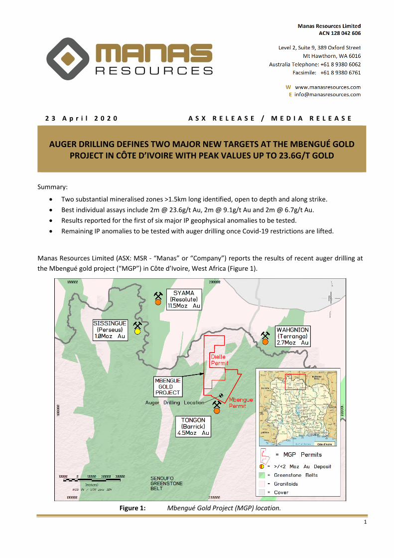
Manas Resources Limited (ASX: MSR - “Manas” or “Company”) reports the results of recent auger drilling at
the Mbengué gold project (“MGP”) in Côte d’Ivoire, West Africa (Figure 1).
Figure 1: Mbengué Gold Project (MGP) location.
2
The Company began a 4,000m auger drilling programme to test six major IP geophysical anomalies discovered
previously (see Company release dated 27th February 2020). Fieldwork was suspended in Côte d’Ivoire due to
the ongoing Covid-19 Pandemic and associated in-country restrictions (ASX Company release 25th March 2020),
with the programme being ~25% complete.
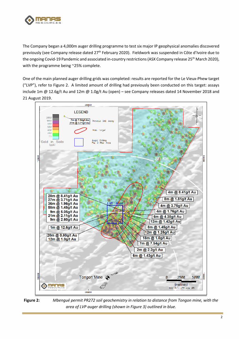
One of the main planned auger drilling grids was completed: results are reported for the Le Vieux-Phew target
(“LVP”), refer to Figure 2. A limited amount of drilling had previously been conducted on this target: assays
include 1m @ 12.6g/t Au and 12m @ 1.0g/t Au (open) – see Company releases dated 14 November 2018 and
21 August 2019.
Figure 2: Mbengué permit PR272 soil geochemistry in relation to distance from Tongon mine, with the
area of LVP auger drilling (shown in Figure 3) outlined in blue.

3
The LVP grid has maximum dimensions of 1,800m by 1,100m (Figure 3). A total of 132 holes (MBAG0001 to
MBAG0132) were drilled for 791 metres. Significant results (>0.1g/t Au in 2m samples) were recorded in 15
holes as reported in Table I. Holes targeted the “mottled zone” beneath the lateritic surface soil cover and
averaged 6m deep. Drilling was conducted on a wide-spaced (300m x 50m) grid to identify large-scale drill
targets for detailed follow-up drilling.
The auger drilling identified two major parallel mineralised structures with grades of up to 23.6g/t Au in
individual 2m samples. Each zone is 50m – 150m wide with strike lengths over 1,500m long. Both mineralised
zones are open to the northeast and to depth. The zones are 300m apart and coincide with the main IP targets
and historical drill intercepts. They remain largely untested by deeper drilling and the exploration potential is
considered high.
Figure 3: LVP Auger Grid showing results to date (new auger drilling intercepts in red).
4
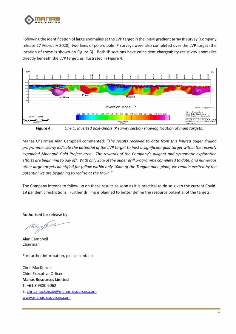
Following the identification of large anomalies at the LVP target in the initial gradient array IP survey (Company
release 27 February 2020), two lines of pole-dipole IP surveys were also completed over the LVP target (the
location of these is shown on Figure 3). Both IP sections have coincident chargeabilty-resistivity anomalies
directly beneath the LVP target, as illustrated in Figure 4.
Figure 4: Line 1: Inverted pole-dipole IP survey section showing location of main targets.
Manas Chairman Alan Campbell commented: “The results received to date from this limited auger drilling
programme clearly indicate the potential of the LVP target to host a significant gold target within the recently
expanded Mbengué Gold Project area. The rewards of the Company’s diligent and systematic exploration
efforts are beginning to pay off. With only 25% of the auger drill programme completed to date, and numerous
other large targets identified for follow within only 10km of the Tongon mine plant, we remain excited by the
potential we are beginning to realise at the MGP. ”
The Company intends to follow up on these results as soon as it is practical to do so given the current Covid-
19 pandemic restrictions. Further drilling is planned to better define the resource potential of the targets.
Authorised for release by:
Alan Campbell Chairman
For further information, please contact:
Chris MacKenzie
Chief Executive Officer
Manas Resources Limited
T: +61 8 9380 6062
www.manasresources.com
5
Forward Looking Statements:
Statements regarding Manas’s plans with respect to its mineral properties are forward-looking statements. There can be no assurance that Manas’s plans for the exploration or development of its mineral properties will proceed as currently expected. There can also be no assurance that Manas will be able to confirm the presence of any mineral deposits, that any mineralisation will prove to be economic or that a mine will be successfully developed on any of Manas’s mineral properties.
Manas Resources Limited - Company Overview:
Manas is a well-funded gold explorer focused on early-stage exploration acquisitions and project generation in West Africa. Manas has either staked for itself or entered into earn-in arrangements over a total area of over 1,030km2 covering highly prospective Birimian greenstones in the southwest and central-east and northern Côte d’Ivoire. Manas is actively seeking further opportunities to grow its exploration portfolio in the region. Manas also continues to review other advanced opportunities which have the potential to further expand the Company’s project portfolio.
The MGP consist of two contiguous permits covering ~647km2 of the highly prospective Senoufo greenstone belt (Figure 1) of northern Côte d’Ivoire, in close proximity to some of the region’s largest mines. It is located 6km north of Barrick’s Tongon mine (~4.5Moz Au), ~27km SE of Terranga’s Wahgnion mine (~2.7Moz Au), 40km southeast of Perseus Mining Limited’s (ASX: PRU “Perseus”) Sissingué mine (~1Moz Au) and 45km southeast of Resolute Mining Limited’s (ASX: RSG) world-class Syama mine (11.5 Moz Au).
Competent Person’s Statement: The scientific and technical information contained within this ASX Release is based on, and fairly represents
information prepared by Mr. Christopher MacKenzie, a Competent Person who is a Chartered Geologist and a
Fellow of The Geological Society of London. Mr. MacKenzie is the Chief Executive Officer of Manas Resources
Limited and has sufficient experience that is relevant to the style of mineralisation and type of deposit under
consideration and to the activity being undertaken to qualify as a Competent Person as defined in the 2012
Edition of the “Australasian Code for Reporting of Exploration Results, Mineral Resource and Ore Reserves”.
Mr MacKenzie consents to the inclusion in this report of the matters based on his information in the form and
context in which it appears.
Technical information in this report that relates to the Mbengué Gold Project, other than the results the subject of this release, has been previously reported by the Company in compliance with JORC 2012 in various releases between 8 August 2018 and 27th February 2020. The Company confirms that it is not aware of any new information or data that materially affects the information included in these earlier market announcements.

6
Table I: Auger drill hole results for the LVP target, Mbengue permit PR272
Hole_ID Easting
(m) Northing
(m) Elevation
(m) Depth
(m) Azimuth Dip
From (m)
To (m)
Au_g/t*
MBAG0008 204878 1111108 358 6 360 -90 0 6 3.386
including 0 2 0.518
and 2 4 9.062
and 4 6 0.59
MBAG0009 204912 1111076 356 6 360 -90 0 2 0.103
MBAG0018 205261 1110785 374 6 360 -90 2 4 0.104
and 4 6 23.6
MBAG0033 204760 1110813 370 6 360 -90 0 2 0.198
MBAG0035 204686 1110878 371 6 360 -90 2 4 0.108
MBAG0062 204607 1110557 358 6 360 -90 4 6 0.109
MBAG0063 204648 1110524 358 6 360 -90 2 4 0.137
and 4 6 0.124
MBAG0069 204876 1110332 359 6 360 -90 0 2 0.243
MBAG0077 204723 1110075 355 6 360 -90 2 4 6.726
MBAG0078 204683 1110101 353 6 360 -90 0 2 0.126
and 2 4 0.142
and 4 6 0.21
MBAG0084 204456 1110293 360 6 360 -90 2 4 0.103
MBAG0099 204452 1109907 347 6 360 -90 2 4 0.121
MBAG0106 204186 1110134 352 6 360 -90 4 6 0.19
MBAG0107 204143 1110162 352 6 360 -90 0 2 0.867
and 2 4 0.119
MBAG0121 204220 1109716 344 6 360 -90 4 6 0.451
*All samples >0.1g/t Au are reported.
7
JORC Code 2012 Table 1
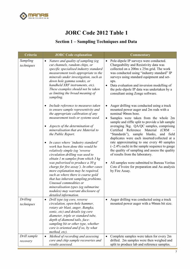
Section 1 – Sampling Techniques and Data
Criteria JORC Code explanation Commentary
Sampling
techniques
• Nature and quality of sampling (eg cut channels, random chips, or specific specialised industry standard measurement tools appropriate to the minerals under investigation, such as down hole gamma sondes, or handheld XRF instruments, etc). These examples should not be taken as limiting the broad meaning of sampling.
• Include reference to measures taken to ensure sample representivity and the appropriate calibration of any measurement tools or systems used.
• Aspects of the determination of mineralisation that are Material to the Public Report.
• In cases where ‘industry standard’ work has been done this would be relatively simple (eg ‘reverse circulation drilling was used to obtain 1 m samples from which 3 kg was pulverised to produce a 30 g charge for fire assay’). In other cases more explanation may be required, such as where there is coarse gold that has inherent sampling problems. Unusual commodities or mineralisation types (eg submarine nodules) may warrant disclosure of detailed information.
• Pole-dipole IP surveys were conducted. Chargeability and Resistivity data was collected on a 200m x 25m grid. The work was conducted using “industry standard” IP surveys using standard equipment and set-ups.
• Data evaluation and inversion modelling of the pole-dipole IP data was undertaken by a consultant using Zonge software.
• Auger drilling was conducted using a truck mounted power auger and 2m rods with a nominal 90mm bore.
• Samples were taken from the whole 2m sample and riffle split to provide a lab sample averaging 3kg. QA/QC samples, comprising Certified Reference Material (CRM – “Standards”), sample blanks, and field duplicates were each inserted/collected at a rate approximating to one every 40 samples (~2.4% each) in the sample sequence to gauge the quality of sampling and assess the quality of results from the laboratory.
• All samples were submitted to Bureau Veritas Cote d’Ivoire for preparation and Au analysis by Fire Assay.
Drilling
techniques
• Drill type (eg core, reverse circulation, open-hole hammer, rotary air blast, auger, Bangka, sonic, etc) and details (eg core diameter, triple or standard tube, depth of diamond tails, face-sampling bit or other type, whether core is oriented and if so, by what method, etc).
• Auger drilling was conducted using a truck mounted power auger with a 90mm bit size.
Drill sample
recovery
• Method of recording and assessing core and chip sample recoveries and results assessed.
• Complete samples were taken for every 2m drilled. 2m samples were then weighed and split to produce lab and reference samples.

8
Criteria JORC Code explanation Commentary
• Measures taken to maximise sample recovery and ensure representative nature of the samples.
• Whether a relationship exists between sample recovery and grade and whether sample bias may have occurred due to preferential loss/gain of fine/coarse material.
No major issues with recoveries or representativeness arose.
Logging • Whether core and chip samples have been geologically and geotechnically logged to a level of detail to support appropriate Mineral Resource estimation, mining studies and metallurgical studies.
• Whether logging is qualitative or quantitative in nature. Core (or costean, channel, etc) photography.
• The total length and percentage of the relevant intersections logged.
• Logging was conducted to identify the presence of quartz veining etc.
• All samples were subjected to qualitative logging.
Sub-sampling
techniques and
sample
preparation
• If core, whether cut or sawn and whether quarter, half or all core taken.
• If non-core, whether riffled, tube sampled, rotary split, etc and whether sampled wet or dry.
• For all sample types, the nature, quality and appropriateness of the sample preparation technique.
• Quality control procedures adopted for all sub-sampling stages to maximise representivity of samples.
• Measures taken to ensure that the sampling is representative of the in situ material collected, including for instance results for field duplicate/second-half sampling.
• Whether sample sizes are appropriate to the grain size of the material being sampled.
• All of the 2m samples were taken and riffle split, in the dry. Samples averaged ~3kg. Reference samples were retained in the Company offices.
• QA/QC samples, comprising Certified Reference Material (CRM – Standards), sample blanks, and field duplicates were each inserted/collected at a rate approximating to one every 40 samples (~2.5% each) in the sample sequence gauge the representativeness and quality of results from the laboratory.
• At the Bureau Veritas laboratory (Abidjan), samples were weighed, dried for a minimum of 8hrs at 105°C and crushed to -2mm in a jaw crusher. A 1kg split of the crushed sample was subsequently pulverised in a disk mill to achieve a nominal particle size of 85% passing 75um.
• Sampling techniques, sample sizes and laboratory preparation techniques are considered to be appropriate for this stage of gold exploration.
9
Criteria JORC Code explanation Commentary
Quality of
assay data and
laboratory
tests
• The nature, quality and appropriateness of the assaying and laboratory procedures used and whether the technique is considered partial or total.
• For geophysical tools, spectrometers, handheld XRF instruments, etc, the parameters used in determining the analysis including instrument make and model, reading times, calibrations factors applied and their derivation, etc.
• Nature of quality control procedures adopted (eg standards, blanks, duplicates, external laboratory checks) and whether acceptable levels of accuracy (ie lack of bias) and precision have been established.
• All samples were submitted to the Bureau Veritas laboratory in Abidjan, Cote d’Ivoire for preparation and analysis. Gold assaying was by 50g Fire Assay with an AAS finish, to a lower detection limit of 5ppb (FA451). Any assays greater than 10,000ppb = 10g/t Au were analysed by Fire Assay with a gravimetric finish (FA550). The assay methods employed are considered to be an industry-standard total analysis.
• No geophysical tools or other non-assay instruments were used in the analyses reported.
• CRM samples (standards) were inserted into sample batches at an approximate rate of 1 standard per 40 samples. Blank samples were inserted into batches at an approximate rate of 1 blank sample per 40 samples. Field duplicates were submitted at an approximate rate of 1 duplicate per 40 samples.
• Internal QA / QC was completed by the Company. No significant issues were present in the analysis of Standards, Blanks and Duplicate samples, which were all within the range to expected ranges.
Internal laboratory QA / QC checks are reported by the laboratory in the sample batches. Reviews of the laboratory’s QA / QC samples suggests the laboratory is performing within acceptable limits.
Verification of
sampling and
assaying
• The verification of significant intersections by either independent or alternative company personnel.
• The use of twinned holes.
• Documentation of primary data, data entry procedures, data verification, data storage (physical and electronic) protocols.
• Discuss any adjustment to assay data.
• Drill hole data was captured by the Company’s in-house geologist at the drill rig and logging area and manually entered into a digital database.
• The digital data was verified and validated by the Company’s Database Manager before loading into a master drill hole database on a regularly backed-up computer system.
• Reported individual sample assays and weighted average drill hole intercepts were verified by the Company’s CEO.
• No adjustments to assay data have been made other than conversion of Au ppb results to Au

10
Criteria JORC Code explanation Commentary
ppm results by dividing the former by 1,000.
• Twin holes have not been drilled to verify results.
Location of
data points
• Accuracy and quality of surveys used to locate drill holes (collar and down-hole surveys), trenches, mine workings and other locations used in Mineral Resource estimation.
• Specification of the grid system used.
• Quality and adequacy of topographic control.
• Sample localities were set out in UTM grid WGS84 Zone30N.
• Sample sites were positioned using hand held GPS, accurate to +/- 2-3m in the horizontal and 3-6m in the vertical direction. The SRTM topography Digital Terrain Model (1 Arc-second) was used to correct and control the vertical component.
Data spacing
and
distribution
• Data spacing for reporting of Exploration Results.
• Whether the data spacing and distribution is sufficient to establish the degree of geological and grade continuity appropriate for the Mineral Resource and Ore Reserve estimation procedure(s) and classifications applied.
• Whether sample compositing has been applied.
• Geophysical Pole-Dipole IP surveys were conducted on lines 600m apart using n,1,2,3,4,5,6,7,8, = 25m spacing.
• Auger drilling was conducted on a 300m x 50m grid.
• The data are insufficient for establishing any Mineral Resource/Ore Reserve.
• No compositing of samples was undertaken
Orientation of
data in
relation to
geological
structure
• Whether the orientation of sampling achieves unbiased sampling of possible structures and the extent to which this is known, considering the deposit type.
• If the relationship between the drilling orientation and the orientation of key mineralised structures is considered to have introduced a sampling bias, this should be assessed and reported if material.
• The auger drilling using vertical holes may introduce bias, but this cannot be assessed at this stage
• Further drilling is required.
Sample
security
• The measures taken to ensure sample security.
• Samples were processed at the drill site then stored in a fenced and secured exploration camp compound located in Mbengué town, prior to samples being dispatched by secure road transport by Bureau Veritas to their laboratory in Abidjan.
Audits or
reviews
• The results of any audits or reviews of sampling techniques and data.
• The Company employed industry-standard protocols. No independent audit has been conducted.
11
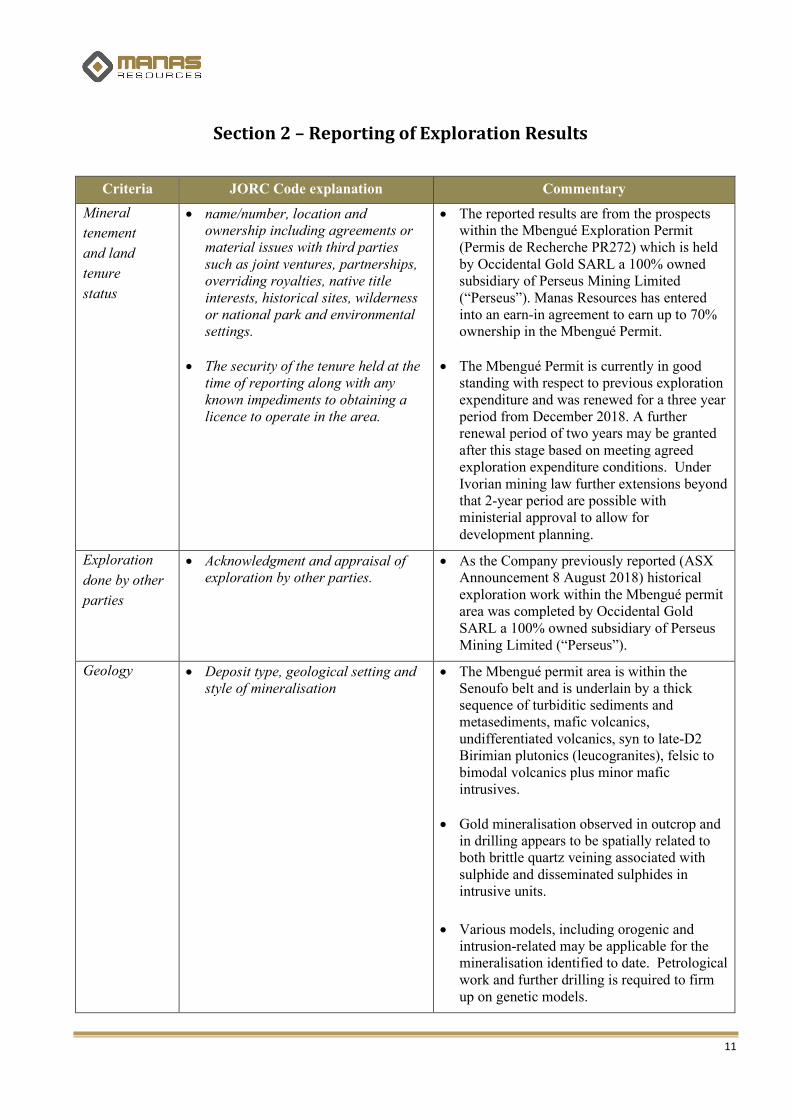
Section 2 – Reporting of Exploration Results
Criteria JORC Code explanation Commentary
Mineral
tenement
and land
tenure
status
• name/number, location andownership including agreements or material issues with third parties such as joint ventures, partnerships,overriding royalties, native title interests, historical sites, wilderness or national park and environmentalsettings.
• The security of the tenure held at the time of reporting along with any known impediments to obtaining a licence to operate in the area.
• The reported results are from the prospects within the Mbengué Exploration Permit (Permis de Recherche PR272) which is held by Occidental Gold SARL a 100% owned subsidiary of Perseus Mining Limited (“Perseus”). Manas Resources has entered into an earn-in agreement to earn up to 70% ownership in the Mbengué Permit.
• The Mbengué Permit is currently in good standing with respect to previous exploration expenditure and was renewed for a three year period from December 2018. A further renewal period of two years may be granted after this stage based on meeting agreed exploration expenditure conditions. Under Ivorian mining law further extensions beyond that 2-year period are possible with ministerial approval to allow for development planning.
Exploration
done by other
parties
• Acknowledgment and appraisal of exploration by other parties.
• As the Company previously reported (ASX Announcement 8 August 2018) historical exploration work within the Mbengué permit area was completed by Occidental Gold SARL a 100% owned subsidiary of Perseus Mining Limited (“Perseus”).
Geology • Deposit type, geological setting and style of mineralisation
• The Mbengué permit area is within the Senoufo belt and is underlain by a thick sequence of turbiditic sediments and metasediments, mafic volcanics, undifferentiated volcanics, syn to late-D2 Birimian plutonics (leucogranites), felsic to bimodal volcanics plus minor mafic intrusives.
• Gold mineralisation observed in outcrop and in drilling appears to be spatially related to both brittle quartz veining associated with sulphide and disseminated sulphides in intrusive units.
• Various models, including orogenic and intrusion-related may be applicable for the mineralisation identified to date. Petrological work and further drilling is required to firm up on genetic models.

12
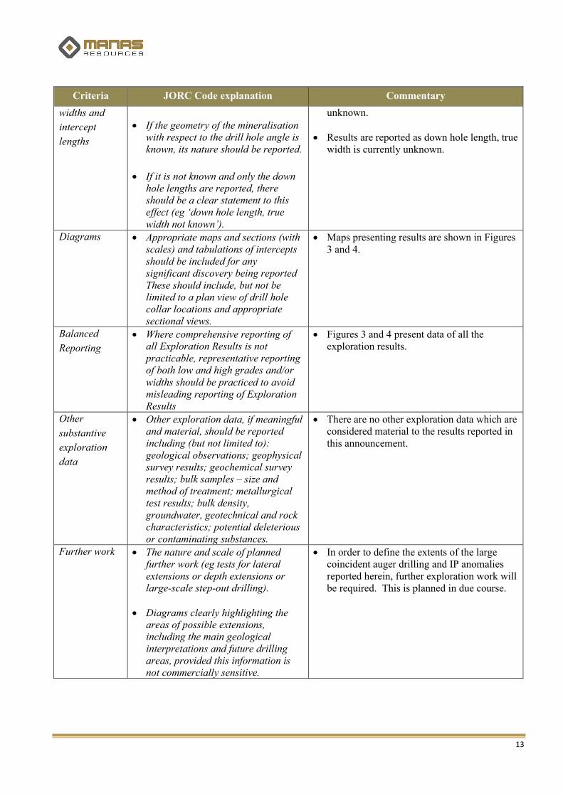
Criteria JORC Code explanation Commentary
Drill Hole
Information
• A summary of all information material to the understanding of the exploration results including atabulation of the following information for all Material drill holes:
o easting and northing of the drill hole collar
o elevation or RL (Reduced Level – elevation above sea level in metres) of the drill hole collar
o dip and azimuth of the hole
o down hole length and interception depth
o hole length
• If the exclusion of this information is justified on the basis that the information is not Material and thisexclusion does not detract from the understanding of the report, the Competent Person should clearlyexplain why this is the case.
• Reported results are summarised in the body of the attached announcement. All holes reported are shown on the attached image Figure 3. All significant intercepts from these auger drilling holes are reported in Table I.
• The drill holes reported in this announcement have the following parameters: o Grid co-ordinates are UTM Zone 30N
with a WGS84 Datum. Easting and Northing have been defined by handheld GPS.
o Collar elevation is defined as height above sea level in metres (RL) and has been defined by the SRTM topography DTM model (1 arc-second = 30m) to ensure consistency with the project DTM.
o Auger holes are all drilled vertical o Down hole length of the hole is the
distance from the surface to the end of the hole, as measured along the drill trace, usually 6m
Data
aggression
methods
• In reporting Exploration Results, weighting averaging techniques, maximum and/or minimum grade truncations (eg cutting of high grades) and cut-off grades are usually Material and should bestated.
• Where aggregate intercepts incorporate short lengths of high grade results and longer lengths oflow grade results, the procedure used for such aggregation should be stated and some typical examples of such aggregations should be shown in detail.
• The assumptions used for any reporting of metal equivalent values should be clearly stated.
• All results are shown on Figure 3.
• All significant assays and drill hole intercepts are reported in Table I.
• Any intercepts longer than the individual 2m sample length are reported as weighted averages using a minimum cut-off grade of 0.5 g/t Au applied to the first and last sample of the reported intercept.
• No grade top cut off has been applied.
• All three of the individual assays over 5g/t Au are reported.
• No metal equivalent reporting has been applied.
Relationship
between
mineralisation
• These relationships are particularly important in the reporting of Exploration Results.
• The reported results are from early stage auger drilling and the orientation of mineralising structures and geological controls is currently
13
Criteria JORC Code explanation Commentary
widths and
intercept
lengths
• If the geometry of the mineralisation with respect to the drill hole angle is known, its nature should be reported.
• If it is not known and only the down hole lengths are reported, there should be a clear statement to thiseffect (eg ‘down hole length, true width not known’).
unknown.
• Results are reported as down hole length, true width is currently unknown.
Diagrams • Appropriate maps and sections (with scales) and tabulations of intercepts should be included for anysignificant discovery being reported These should include, but not be limited to a plan view of drill holecollar locations and appropriate sectional views.
• Maps presenting results are shown in Figures 3 and 4.
Balanced
Reporting
• Where comprehensive reporting of all Exploration Results is not practicable, representative reporting of both low and high grades and/or widths should be practiced to avoid misleading reporting of Exploration Results
• Figures 3 and 4 present data of all the exploration results.
Other
substantive
exploration
data
• Other exploration data, if meaningful and material, should be reported including (but not limited to):geological observations; geophysical survey results; geochemical survey results; bulk samples – size andmethod of treatment; metallurgical test results; bulk density, groundwater, geotechnical and rockcharacteristics; potential deleterious or contaminating substances.
• There are no other exploration data which are considered material to the results reported in this announcement.
Further work • The nature and scale of planned further work (eg tests for lateral extensions or depth extensions orlarge-scale step-out drilling).
• Diagrams clearly highlighting the areas of possible extensions, including the main geologicalinterpretations and future drilling areas, provided this information is not commercially sensitive.
• In order to define the extents of the large coincident auger drilling and IP anomalies reported herein, further exploration work will be required. This is planned in due course.