attachment spatial plan for the german ex- clusive ... plan for the german ex-clusive economic zone...
TRANSCRIPT

1
Attachment
Spatial Plan for the German Ex-clusive Economic Zone in
the Baltic Sea- Text section
unofficial translation

2
Contents
1 Introduction ....................................................................................................................................... 3
2 Guidelines for spatial development in the EEZ................................................................................. 32.1 Securing and strengthening maritime traffic .............................................................................................. 32.2 Strengthening economic capacity through orderly spatial development and optimisation of spatial use... 42.3 Promotion of offshore wind energy use in accordance with the Federal Government's sustainability
strategy ..................................................................................................................................................... 42.4 Long-term sustainable use of the properties and potential of the EEZ through reversible uses, economic
use of space, and priority of marine uses.................................................................................................. 42.5 Securing natural resources by avoiding disruptions to and pollution of the marine environment .............. 5
3 Regulations made in the Marine Spatial Plan................................................................................... 53.1 Shipping .................................................................................................................................................... 5
3.1.1 Targets and principles .............................................................................................................................................53.1.2 Justification ..............................................................................................................................................................5
3.2 Exploitation of non-living resources........................................................................................................... 73.2.1 Targets and principles .............................................................................................................................................73.2.2 Justification ..............................................................................................................................................................8
3.3 Pipelines and submarine cables................................................................................................................ 93.3.1 Targets and principles .............................................................................................................................................93.3.2 Justification ............................................................................................................................................................11
3.4 Marine scientific research........................................................................................................................ 143.4.1 Principles ...............................................................................................................................................................143.4.2 Justification ............................................................................................................................................................14
3.5 Energy production, wind energy in particular .......................................................................................... 153.5.1 Targets and principles ...........................................................................................................................................153.5.2 Justification ............................................................................................................................................................15
3.6 Fisheries and mariculture ........................................................................................................................ 183.6.1 Principles ...............................................................................................................................................................183.6.2 Justification ............................................................................................................................................................19
3.7 Marine environment................................................................................................................................. 203.7.1 Principles ...............................................................................................................................................................203.7.2 Justification ............................................................................................................................................................21
4 Consideration of other concerns ..................................................................................................... 224.1 Military use .............................................................................................................................................. 224.2 Leisure and tourism................................................................................................................................. 234.3 Fehmarn Belt crossing ............................................................................................................................ 234.4 Ammunition dump sites and sediment deposition ................................................................................... 23
5 Summary environmental statement plus a description of the measures to be taken in the course ofmonitoring the impact on the environment...................................................................................... 235.1 Summary environmental statement in compliance with § 7 para. 8 sentence 2 ROG 1998 .................... 235.2 Monitoring measures according to § 7 para. 8 sentence 2 ROG 1998.................................................... 24
6 Co-ordinates and transnational pipelines ....................................................................................... 266.1 Co-ordinates............................................................................................................................................ 26
6.1.1 Shipping ................................................................................................................................................................266.1.2 Pipelines and Submarine Cables ..........................................................................................................................286.1.3 Marine Scientific Research....................................................................................................................................296.1.4 Windenergy ...........................................................................................................................................................30
6.2. Transnational Pipelines and Submarine Cables in the Baltic Sea ........................................................... 31

3
1 IntroductionIn order to co-ordinate the growing conflict of maritime uses, in particular between developing and space intensive offshore windfarms and marine environmental protection goals as well as traditional maritime uses such as shipping and fisheries, an integra-tive and sustainable approach is needed for the development of the German Exclusive Economic Zone (EEZ). The Spatial Plansets up as a statutory ordinance due to § 18a Federal Spatial Planning Act, which was introduced by the act of June 24 2004into the Federal Spatial Planning Act, for the first time targets and principles of spatial planning in the EEZ regarding economicand scientific uses, ensuring the safety and efficiency of navigation, as well as protection of the marine environment.
Note: the applicable legal basis § 18a Federal Spatial Planning Act of August 18th 1997 (BGBl. I p. 2081, 2102), which was lastamended by Art. 10 of the act of December 9th 2006 (BGBl. I, p. 2833 - hereinafter called ROG 1998), is applicable because ofthe transitional provision in § 29 para. 1 Federal Spatial Planning Act of December 22nd 2008 (BGBl. I p. 2986 - hereinaftercalled ROG). Under § 29 para. 1 ROG procedures for the establishment of spatial plans for the EEZ initiated formally prior toDecember 31st 2008 may be completed under the superseded version of the Federal Spatial Planning Act. The provisions ofthe new ROG are quoted in the Spatial Plan for comparison.
The Spatial Plan formulates guidelines for spatial development (chapter 2), sets targets and principles, especially areas, forfunctions and uses (chapter 3). For the German EEZ in the Baltic Sea the Spatial Plan contains provisions aimed at co-ordinating the individual uses and functions of shipping, the exploitation of resources, laying of pipelines and submarine cables,scientific marine research, wind power production, fisheries and mariculture, as well as protection of the marine environment.Chapter 4 deals with other interests that need to be taken into account as well. Chapter 5 describes the use of the results of theenvironmental assessment report. Chapter 6 contains the co-ordinates concerning the regulations and maps with transnationalpipelines and cables in the Baltic Sea region.
The areas for wind power production have been designated in implementation of the Federal Government's strategy for windenergy use at sea, 2002, which is part of its overall sustainability strategy and is aimed at creating framework conditions allo-wing the offshore wind energy potential to be exploited. Also the Federal Government's Energy and Climate Programme (IEKP)of December 2007 formulates the goal of increasing the proportion of renewable energies in electricity production.
The Spatial Plan also contributes to the implementation of the Federal Government's national marine strategy for sustainableuse and protection of the seas (national strategy for the seas) of 1 October 2008, which is aimed at achieving sustainable de-velopment and better co-ordination of marine uses and marine environmental protection interests and which sees Spatial Plan-ning as an important tool to solve an increasing number of conflicts in coastal and offshore waters.
A Strategic Environmental Assessment according to SEA Directive 2001/42/EC on the impact of certain plans and programmeson the environment has been carried out in connection with the establishment of this Spatial Plan, in compliance with § 7 para. 5ROG 1998 (cf. § 9 ROG). The objective of the SEA Directive, as stated in Art. 1, is "to provide for a high level of protection ofthe environment and to contribute to the integration of environmental considerations into the preparation and adoption of plansand programmes with a view to promoting sustainable development, by ensuring that, in accordance with this Directive, an envi-ronmental assessment is carried out of certain plans and programmes which are likely to have significant effects on the envi-ronment". The provisions of the Spatial Plan (see chapter 3) have been made taking into account the results of the StrategicEnvironmental Assessment (see chapter 5).
The spatial planning designations of the German coastal states Mecklenburg-Western Pomerania and Schleswig-Holstein con-cerning the territorial sea have been taken into account. Relevant provisions in the spatial report coast and sea of Schleswig-Holstein, issued in February 2006, have been considered as well. The state of Schleswig-Holstein's 2009 development planincluding provisions for its coastal waters is being revised currently. The spatial development programme of Mecklenburg-Western Pomerania of May 2005, which includes provisions concerning wind turbines, nature conservation, pipeline routeingand use of resources, has been considered as well.
The Spatial Plan Baltic Sea does not cover the charted area showing the northern approaches to the harbours of Świnoujście(Swinemünde) and Szczecin (Stettin) and anchorage no. 3 because of contradictory legal opinions. Due to German opinion thisarea is part of the German EEZ, whereas in relation to Poland no rights or sovereign powers are exercised. Due to polish opini-on this area is part of the Polish territorial sea.
2 Guidelines for spatial development in the EEZ In order to achieve a sustainable spatial development applying the principles of the Spatial Planning Act, the following guideli-nes have been formulated for spatial development in the EEZ.
2.1 Securing and strengthening maritime trafficThe Federal Republic of Germany is one of the leading export nations, with most of its exports transported by sea. According tothe 2007 annual report of "Flottenkommando", shipping represents an important sector of the economy in Germany, with about500,000 people directly or indirectly employed by the shipping industry and a turnover of more than 54 billion Euro. Moreover,the North and Baltic Seas are of great importance for international transit shipping. Already now, the shipping routes off theGerman coasts – in particular in the Baltic Sea – are among the most heavily travelled routes in the world, with more growthpredicted. A dynamic development has been predicted for the German seaports as well. According to the Maritime TransportForecast 2025, commissioned by the Federal Ministry of Transport, Building and Urban Affairs, the volume of cargo handled inGerman seaports will more than double by 2025. Against this background, there is great national and international interest inavoiding restrictions to maritime traffic and, where possible, granting it priority and achieving a maximum level of safety. At thesame time, the United Nations Convention on the Law of the Sea of 10 December1982 (BGBl. 1994, p. 1798, 1799) (UNCLOS)confers special status on shipping by guaranteeing its freedom and granting priority to the main navigation routes. Artificial is

4
lands, installations and structures and the surrounding safety zones are not allowed to be constructed in areas where they mayimpede the use of recognised shipping routes which are important to international trade (see Chapter 3.1.2).
In the course of spatial planning, it is important to give voice to this economic importance and pre-eminence under internationallaw, and to maintain the competitiveness of the shipping industry. Thus the main navigation routes, which comprise the trafficseparation schemes (TSS) as well as frequently travelled routes, form the basic framework for overall planning. Other uses inthe EEZ must align themselves with this framework. By minimising barriers to shipping, this procedure contributes toward in-creasing the safety and efficiency of navigation.
2.2 Strengthening economic capacity through orderly spatial development and optimisation of spatialuse
The introduction of a spatial plan for the EEZ in the Baltic Sea opens up the possibility viewing and coordinating possibly com-peting uses in a comprehensive overview and thus creating a reconciliation of interests. This serves to provide orderly spatialdevelopment in the EEZ.
Orderly spatial development is an important basis for future economic development and takes into account the importance of thedomestic resources sand, gravel, and hydrocarbons as well as fisheries. Investment security can be improved by co-ordinatingthe various planned uses in an optimal way and giving the individual uses sufficient space for development. Furthermore, opti-mised spatial use ensures that the most suitable location is found for each use, and negative effects on other uses are avoided,which also contributes toward creating added value.
2.3 Promotion of offshore wind energy use in accordance with the Federal Government's sustainabilitystrategy
The Spatial Plan is based i.a. on the "Strategy of the Federal Government for the Use of Wind Energy at Sea" of January 2002,which is part of its sustainability strategy. In the Strategy, the Federal Government has formulated the goal of creating the fra-mework conditions allowing the potential of offshore wind energy to be exploited as quickly as possible. This approach, alongwith other measures, is designed to reduce dependence on imports and further improve environmental compatibility, especiallyunder climate protection aspects. The goal of the 2002 Strategy is to install a capacity of 2,000 – 3,000 MW by the year 2010 inan initial development phase. 20,000 to 30,000 MW are planned to be installed by 2030. This Strategy is planned to make animportant contribution toward achieving the goals of the Renewable Energy Act of 25 October 2008 (BGBl. I, p. 2074) (EEG).Against this background, three priority areas for wind farm development had been designated by 31 December 2005, under §3a Seeanlagenverordnung (SeeAnlV, Marine Facilities Ordinance) (see Chapter 3.5).
Within the framework of the Federal Government's Integrated Energy and Climate Programme (IEKP) of December 2007, § 1para. 2 EEG states that, in the interest of climate protection, the share of renewables in electricity supply should be at least 30%by the year 2020, to be increased continually thereafter. According to IEKP, offshore wind power will make a substantial contri-bution toward achieving that goal (approx. 25,000 MW by 2030).
Both the sustainability strategy of 2002 and the IEKP of 2007 constitute the basis of the Spatial Plan. Under spatial planning andother aspects, the preferred areas defined in the SeeAnlV were found to be particularly suitable for wind farm development aswell on the level of spatial planning. These preferred areas under § 3a SeeAnlV are now included as targets of spatial planning,in compliance with § 18a para. 3 ROG 1998, and are adopted as goals for spatial planning and designated as priority areas.This gives additional planning security to investors in offshore wind energy. Provisions are made concerning the transmission ofelectricity produced in the EEZ (see Chapter 3.3).
Thereby the Spatial Plan for the German Exclusive Economic Zone shall play an important role in the implementation of theFederal Government's resolutions concerning offshore wind energy use (see Chapter 3.5).
At the Fifth Maritime Conference in December 2006, the maritime and wind energy industries expressed their expectation thatby the end of 2011 offshore wind farms with an overall capacity of about 1.500 MW would be either in operation or under con-struction.
2.4 Long-term sustainable use of the properties and potential of the EEZ through reversible uses, eco-nomic use of space, and priority of marine uses
The sea is a special planning environment and habitat characterised in particular by its vastness, openness, and freedom frombarriers. Spatial planning must ensure that the configuration and design of uses does not conflict with the preservation of thesecharacteristics. Furthermore, the special three-dimensionality of the sea must be taken into account. The sea surface, watercolumn, seabed, subsoil and the airspace above it may require different provisions regarding their protection and use.
The basic premise is that stationary uses must be reversible, i.e. they are allowed only for limited periods of time. This require-ment is in line with national and international regulations according to which structures and technical facilities must be restoredto their original condition and/or removed after termination of use.
In order to secure and exploit the potential of the EEZ for the long term, the available space should be used economically. Thisis also in accord with the guiding concept of sustainable spatial development. By limiting area designations to certain sectors,vast areas of the sea can be kept free of stationary structures, thus reducing dissecting effects. An important contribution towardprotecting and conserving the natural environment can be made by limiting use of space in this way.
Furthermore, in order to use space efficiently, multiple use of space should be sought where uses can be combined. When con-sidering multiple uses, it is important to ensure that the priority use is not impaired. For example, locations exist where windenergy use and production of oil and gas may be realised at the same time without conflict. This concept also takes account of

5
the characteristic three-dimensionality of the sea, which allows combinations of various uses of, e.g., the seabed and the seasurface.
Besides, onshore problems should not be shifted offshore. An accumulation of uses at sea that are undesirable on land shouldbe avoided. Uses that are dependent on the sea should have priority over other uses.
2.5 Securing natural resources by avoiding disruptions to and pollution of the marine environment To secure natural resources as a responsibility toward future generations, we must strive to preserve, protect and promote natu-ral functions, systems and processes. Disruptions to and pollution of the ecosystem sea and the related natural functions, sy-stems and processes must be avoided; biological diversity must be promoted and preserved.
The oceans are irreplaceable for the sustainment of life and must be secured in a national and international context. To do ju-stice to this circumstance, it is the task of spatial planning to secure the natural environment and to minimise additional negativeimpacts on the marine environment. Since the effects of human intervention on the natural interrelationships of life at sea are asyet only incompletely understood, the precautionary principle is of special importance in the EEZ, the more so as the highlydynamic nature of the sea makes this natural environment highly vulnerable. The aim must be to use the area with as muchcare as possible. This also means that every use should be as compatible with nature as possible and designed in accordancewith current state-of-the-art technology. For example, as a source-related approach toward marine environmental protection, anumber of uses are subject to the requirement that any damage to or destruction of sandbanks, reefs, as well as habitats ofbenthic communities that are of conservation concern and are considered particularly vulnerable should be avoided. Thatapplies also outside Natura2000 areas.
The focus of marine environmental protection is on marine fauna and flora including their biotopes and habitats and on the birdmigration routes. Regenerability and sustainable use of natural resources must be ensured for the long term. Also sea waterquality, hydrography, and sediment conditions are part of the marine environment.
The Spatial Plan for the EEZ in the Baltic Sea is a contribution to the Marine Strategy Framework Directive of 17 June 2008(Directive 2008/56/EC), which is aimed at achieving or maintaining good environmental status by the year 2020 at the latest.
3 Regulations made in the Marine Spatial PlanPriority areas have been designated for shipping and wind energy development; other uses are prohibited in such areas unlessthey are compatible with the priority uses. The designation of areas for shipping takes account of the principle of internationallaw attributing priority to this use; recognised shipping routes that are indispensable for international shipping constitute theframework of the overall planning concept. Reservation areas have been designated for shipping, pipeline, and research usesthat are considered particularly important when balancing with spatially significant competing uses.
The targets of spatial planning are shown in bold print and are marked (Z).
3.1 Shipping3.1.1 Targets and principles
(1) Shipping is granted priority over the other spatially significant uses in the priorityareas for shipping as indicated in the map. To the extent spatially significant plan-ning, measures and projects are not compatible with the function of the shippingpriority area in these areas they are not permitted. (Z)
Priority areasshipping
(2) Special consideration is given to shipping in the reservation areas for shipping as indica-ted in the map. This needs to be taken into account in a comparative evaluation with otherspatially significant planning tasks, measures and projects.
Reservation areasshipping
(3) Pollution of the marine environment by shipping shall be reduced. Besides applicable re-gulations of the International Maritime Organisation (IMO), the "best environmental prac-tice" according to the Helsinki Commission for the Protection of the Marine Environment ofthe Baltic Sea Area of 9 April 1992 (BGBl. 1994 II p. 1355, 1397) (HELCOM-Convention)and the respective state-of-the-art technology shall be taken into account.
Protection of themarine environment
3.1.2 Justification
Legal background
The legal situation of shipping is influenced to a great extent by international regulations. These include in particular UNCLOS inwhich the freedom of navigation is guaranteed under Art. 58. Art. 60 para. 7 UNCLOS also states that artificial islands, installa-tions and structures and the surrounding safety zones may not be established where they may cause interference with the useof sea lanes that are recognised and important for international shipping.
In addition, IMO establishes internationally recognised rules and standards. The establishment of traffic separation schemes isof particular importance for spatial planning. At potential points of risk, they prescribe binding sea lanes in traffic with separatelanes for opposing streams of traffic.

6
The Seeaufgabengesetz of 26 July 2002 (SeeAufgG - Federal Maritime Responsibilities Act, BGBl. I. p. 2876) as well as thevarious regulations adopted on the basis of this act, in particular, form the legal basis for measures taken to avert risks to thesafety and efficiency of navigation as well as the prevention of hazards resulting from maritime shipping, including harmful envi-ronmental effects.
The SeeAufG – to the extent permissible under international law – also applies to the EEZ.
Ad (1) and (2): Under UNCLOS, shipping has a special status in the EEZ and enjoys freedom guaranteed under Article 58 UN-CLOS. Accordingly, shipping in principle is also possible anywhere outside the areas designated for its use. Area designationsdo not establish new shipping routes. Only IMO would have the jurisdiction to do so.
The particular purpose of the spatial planning regulations concerning shipping is to additionally safeguard navigational minimumrequirements in the area of important shipping routes on a spatial planning level. Any further navigational requirements (enlar-gement of navigation channels / manoeuvring areas) remain unaffected and need to be considered by the responsible authori-ties.
The designations of priority and reservation areas for shipping are the result of an extensive comparative evaluation on spatialplanning level. Since the regulations thus are not based exclusively on navigational considerations – which have been the mostimportant aspect, though - they may deviate from actual shipping routes and from the navigation and safety areas considerednecessary from the nautical point of view.
The points of departure for establishing a sophisticated system of priority and reservation areas for shipping included the TSS inparticular as well as the main navigation routes, based on an evaluation of current traffic flows. In some cases, these main navi-gation routes were – where necessary – adjusted to existing and planned structural facilities, sometimes at variance with currenttraffic conditions.
The width of the designated areas was based on the basic requirement for spatial planning to secure a routeing network forshipping. Nautical considerations were one important concern. The priority areas represent the framework that must be kept freeof all incompatible uses, high-rise structures in particular. Reservation areas are also designated alongside as a supplementalmeasure in which the needs of shipping are given special consideration when taking into account the various requirements, inparticular with respect to the construction of stationary facilities.
Since shipping in the EEZ enjoys guaranteed freedom under Art. 58 UNCLOS, the designation of priority areas in particular withrespect to the traffic separation schemes involves an additional spatial planning assurance of the needs of shipping. Art. 60para. 7 UNCLOS states that artificial islands, installations and structures, and the safety zones surrounding them may not beestablished where they may hinder the use of recognised sea lanes that are essential to international navigation. By designatingpriority areas for the main shipping routes outside the traffic separation schemes, it is ensured that these areas are kept free ofuses – especially structures - that are incompatible with shipping, so that the effect of Art. 60 para. 7 UNCLOS is achieved hereas well. Reference is made to the establishment of 500 m security zones around marine facilities in accordance with § 7 See-AnlV, guaranteeing security of shipping as well as of marine facilities.
The safety and efficiency of navigation thus will also be secured for the future on a spatial planning level, which means thatnavigation will continue to be possible on all regularly used shipping lanes and that any disturbances will be largely avoided.Because of the described pre-eminence of shipping based on UNCLOS and the designation of areas taking into account exi-sting uses, the regulations of the Spatial Plan will not cause any new conflicts with military uses.
Owing to a tight web of spatial uses in this region, the German EEZ in the Baltic Sea constitutes a heavily travelled shippingzone.
- Its complete western part (no. 15) has been designated a reservation area because traffic in this area is moderate.
- Characteristic features in area no. 16 are the international shipping routes bound to and from Kiel Canal and the T and Hroutes with 50,000 vessel operations per year. This area has therefore been designated as a priority area.
- The complete area no. 17, analogous to no. 15, has been designated a reservation area. International shipping routespass immediately north of the area. This narrow sea area is used primarily by vessels bound to and from Rostock, andby pleasure craft.
- In the area of the Kadetrinne (no. 18), the entire EEZ has been designated a priority area. This is a very narrow subsec-tion with heavy traffic, so that further differentiation is not necessary. The subsection adjacent to area no. 17 has beenincluded in the priority area, especially because of its importance to vessels bound to and from Lübeck.
- In the eastern part of the EEZ (no.19), a priority area of the same width as the traffic separation schemes has been de-signated extending from the Traffic Separation Scheme 'North of Rügen', along its imagined elongation, to the Born-holmsgat Traffic Separation Scheme, comparable to a designation made in the North Sea. Analogously, a safety distan-ce of 2 nm (1 nm equals 1,852 km) plus 500 m has been designated alongside as a reservation area.
- A priority area of 1 nm width has been designated for the section of the ferry route Świnoujście - Ystad that runs in theGerman EEZ (no. 20). A 1 nm wide reservation area for shipping has been established at its western side. The reserva-tion area east of the priority area is 0.8 nm wide because of the proximity of the wind energy priority area "WestlicherAdlergrund". In concrete projects for extraction only techniques may be carried out in this priority area for shipping whichdo not hinder the navigation within the meaning of international maritime law. No designation has been made on thisroute for the area of the northern approach of Świnoujście (Swinemünde), which has been excluded from the SpatialPlan due to contradictory legal views
- In the area south of Adlergrund (no. 21), a priority area has been designated for shipping which covers the width of theplanned TSS and will accommodate vessel traffic from several directions. A safety distance of 1 nm has been designa-ted to either side of the TSS.
Ad (3):International agreements for the prevention of harm to the marine environment, especially the International Conventionfor the Prevention of Pollution from Ships of 2 November 1973, as modified by the Protocol of 17 February 1978 relating thereto

7
(BGBl. 1982 II, p. 2, 4) (MARPOL), and the Helsinki Commission for the Protection of the Marine Environment of the Baltic SeaArea of 9 April 1992 (BGBl. 1994 II p. 1355, 1397) (HELCOM)), are designed to reduce pollution of the marine environmentcaused by shipping to a minimum. Besides applicable regulations of IMO, the "best environmental practice" according to theHELCOM Convention and the respective state-of-the-art technology shall be taken into account.
Figure: Numbering of designated areas for shipping in the Baltic Sea
3.2 Exploitation of non-living resources3.2.1 Targets and principles
1 The exploration for and exploitation of non-living resources should be rendered possibleand developed on a large scale under guidance of the sectoral law.
Principle
2 To secure future supply in the long term, information about resource deposits - in particu-lar hydrocarbons - should be documented and evaluated systematically by the responsibleauthorities.
Continuous documen-tation
3 After termination of use, structural installations for resource exploitation must bedismantled. (Z)
Dismantling
4 The exploitation of raw material resources should be concentrated in an area and shouldbe as small-scale as possible. Existing sand and gravel sites should be exploited to themaximum extent practicable, provided this is compatible with marine environmental con-cerns and this obtains a remaining sediment layer, which is required for recovery ofbenthic communities; an expansion of these sites should be preferred to the search fornew deposits.
Concentrationof exploitation
5 The exploration for and exploitation of resources shall not unduly impede the safety andefficiency of navigation.
Traffic
6 When exploiting resources, due consideration shall be given to existing pipelinesand submarine cables and an appropriate distance from them shall be maintained.(Z)
Pipelines and submari-ne cables
7 In areas where wind energy production and the exploration for and exploitation of resour-ces are carried out at the same time, the different needs should be co-ordinated as bestpossible in accordance with criteria to be developed by the responsible authorities.
Wind energy
8 The needs of fisheries shall be taken into account when exploring for and exploiting non-living resources.
Fisheries
9 Negative impacts of the exploration for and exploitation of non-living resources on the ma-rine environment, in particular its natural functions and importance as an ecosystem, shallbe avoided. The "best environmental practice" according to the HELCOM Convention andstate-of-the-art technology shall be taken into account.
The effects of resource exploitation on the marine environment shall be examined and
Protection of themarine environment

8
documented within the framework of project-specific monitoring according to specificationsof the approval authority. Dispersion processes and large-scale ecological interactionsbetween marine fauna and flora shall be taken into consideration when selecting sites forresource exploitation. Any damage to or destruction of sandbanks, reefs, and delimitableareas with occurrences of benthic communities of conservation concern, which constituteparticularly sensitive habitats, shall be avoided during resource exploitation.
10 Known underwater cultural heritage sites shall be taken into account when selecting sitesfor resource exploitation. If unknown cultural heritages are discovered in the seabed whileexploring for or exploiting resources, adequate measures shall be taken to protect them.
Cultural heritage sites
3.2.2 Justification
Legal background
The exploration for, safeguarding and demand-based exploitation of deposits of non-living resources in the German EEZ is ofhigh significance to the public interest and constitutes an important basis for Germany's future economic development. This factis also accounted for in the clause on safeguarding mineral resources under Article 48 para.1 p.2 Bundesberggesetz of 13 Au-gust 1980 (BGBl. I, p. 1310) (BBergG - Federal Mining Act), which states that other competent authorities shall apply non-mining related legal provisions in such a way that the exploration for and exploitation of resources are impaired as little as pos-sible. This is counterbalanced by detailed provisions in BBergG, from § 48 pp., which have to be complied with in any explorati-on activities and in the approval of operating plans for projects in the area of the continental shelf in order to protect shipping,fisheries, the laying and operation of cables and pipelines, and the marine environment.
A relatively large number of mining licences for resource exploitation at sea has been issued up to now because this use has along tradition. A distinction has to be made between exploration licences and production licences.
Exploration licences under § 7 BBergG grant, in particular, the exclusive right to explore for mineral resources in a particularfield. In contrast, a production licence grants the exclusive right under § 8 BBergG to exploit minerals. § 11 and 12 BBergGcontain provisions governing the denial of both types of licence. If resources are discovered during exploration, a productionlicence under § 12 para. 2 BBergG can only be denied if one of the reasons for denial as listed in § 12 para. 1 BBergG obtainsand the facts justifying the denial have not been apparent before the exploration licence was granted. The State Authority ofMining, Energy and Geology at Clausthal-Zellerfeld (North Sea and Schleswig-Holstein part of the Baltic Sea) and the StralsundMining Authority (Mecklenburg-Western Pomerania part of the Baltic Sea) are responsible for issuing mining licences.
If a duty exists to conduct an environmental impact assessment (EIA) for the planned activity in accordance with the regulationgoverning environmental impact assessments for mining projects of 13 July 1990 (BGBl. I, p. 1420) (UVP-V Bergbau), a masteroperation plan must be prepared and a site location and plan approval process incl. EIA shall be conducted (§ 52 para. 2aBBergG). This is required, for example, in connection with the construction and operation of production platforms and with majorsand and gravel extraction activities (from a size of 10 hectares). Under § 52 para. 2 BBergG, operators are required to restoresites to their original condition after termination of use of any facilities built during the exploration for and/or exploitation of re-sources. Additional regulations can be found in the Festlandsockel-Bergverordnung of 21 March 1989 (BGBl. I, p. 554)(FlsBergV - Mining Ordinance for the Continental Shelf).
Going beyond the sectoral law regulations, the principles of spatial planning state that "suitable spatial conditions shall be crea-ted to safeguard and conduct an orderly exploration for and exploitation of site-specific resources" (§ 2 para. 2 no. 9 ROG 1998,cf. § 2 para. 2 no. 4 ROG).
Reference is made to the Communication from the Commission to the European Parliament and the Council of 4 November2008, “The raw materials initiative – meeting our critical needs for growth and jobs in Europe“ (COM(2008) 699 final).
Ad (1): Resources such as sand, gravel, and hydrocarbons are valuable economic assets. Their offshore production encountersconditions that are not comparable to production on land. Under spatial planning aspects, large areas are available in the EEZfor the exploration for and production of resources. The exploration for and the exploitation of resources shall be enabled anddeveloped comprehensively under guidance of the sectoral law (mining law, environmental law).
Ad (2): Up to now, there has been very little research into resource deposits in the EEZ, especially hydrocarbons. A variety ofexploration activities are being conducted in vast exploration fields. The responsible authorities should systematically collect andevaluate the knowledge gained from these activities. It is only on the basis of sufficient knowledge that the Spatial Plan canbecome an instrument that develops governance capacity. To secure areas for resource exploitation – i.e. in particular keepingthem clear of uses that could have an adverse effect on later exploitation – reliable knowledge of resource deposits is necessa-ry. This knowledge may then form the basis for future updates to the Spatial Plan and, beyond this, for a long-term and su-stainable safeguarding of the resource deposits in the interest of future generations.
Ad (3): In accordance with the basic premise of spatial planning that stationary uses must be reversible, i.e. they are only allo-wed to be carried out for a limited period of time, any structures related to the exploitation of resources must be dismantled bythe operator after termination of use. This regulation is in accordance with applicable international and national regulations, e.g.Art. 60 para. 3 UNCLOS, the IMO resolution concerning offshore installations, § 55 para. 2 BBergG, § 29 FlsBergV and OSPARDecision 98/3 on the Disposal of Disused Offshore Installations (BGBl. 1999 II, p.618, 619). According to these regulations,disused offshore installations for the exploration for and production of hydrocarbons are not allowed to be dumped or to be leftwholly or in part in the marine environment. This is the reason for formulating a different regulation in comparison with the re-gulations for dismantling of pipelines and submarine cables as well as wind turbines .The dismantling is ordered by the compe-tent authority following consideration of the individual case.
Ad (4): Exploitation of resources at sea usually requires more space than on land, thus the potential for conflict with other usesis relatively high. In addition, natural resources are finite, local and not renewable. For this reason, the exploitation of resourcesshould be concentrated in as compact an area as possible. Existing deposits should be exploited to the maximum extent practi-cable, provided this is compatible with marine environmental concerns and this obtains a remaining sediment layer, which is

9
required for recovery of benthic communites. In this way, unavoidable disturbances associated with the exploitation of resourcesand the development of new deposit sites can be reduced. This also conforms to the guiding concept of economical use ofspace (see Chapter 2.4).
Ad (5): The safety and efficiency of navigation should not be unduly impeded by the exploration for and exploitation of resour-ces.
Ad (6): To reduce any risk of damage to pipelines and submarine cables and in order not to impede the feasibility of repair, anyresource exploitation activities shall appropriately consider existing pipelines and submarine cables, and maintenance opera-tions shall be carried out at an adequate distance from them. The definition of an adequate distance has to be clarified on acase-by-case basis taking into account specific site conditions, e.g. water depth. This target is also supported by the designationof reservation areas for pipelines (see Chapter 3.3.1).
Ad (7): In case an area is used at the same time for wind energy production and for the exploration for and exploitation of re-sources, interests should be co-ordinated as best possible. This shall be done on the basis of criteria for the compatibility ofdifferent uses that are yet to be developed and co-ordinated by the responsible authorities.
Ad (8): Fisheries are a traditional use of the sea, but currently specific spatial designations for this particular use are very difficultto establish (see Chapter 3.6.2). Thus, the interests of fisheries in which this will not be possible in the future by the reason ofhigh variability have to be considered in the framework of regulations for other uses. This also applies to regulations for theexploitation of resources.
Ad (9): In accordance with the guiding concept for the protection of the marine environment, negative impacts of the explorationfor and exploitation of non-living resources on the marine environment, in particular its natural functions and importance as anecosystem, shall be avoided. "Best environmental practice" according to the HELCOM Convention and state-of-the-art techno-logy shall be taken into account.
To ensure environmentally compatible exploitation, any project-specific impact of the extraction of resources on the marine envi-ronment shall be investigated and documented as part of a monitoring process carried out in accordance with specifications ofthe approval authority. Monitoring specifications may be included in the approval documents, as is common practice at the com-petent technical authorities. The results of project-specific monitoring will be used in monitoring of the implementation of theMarine Spatial Plan.
§ 2 para. 2 no. 8 ROG 1998 (cf. § 2 para. 2 no. 6, ROG) combines the protection, care, and development of nature and land-scape with the requirements of a biotope network. It has not yet been sufficiently researched to what extent marine ecosystems,which are more permeable than terrestrial ecosystems and largely barrier-free, may be equally dependent on biotope networksto be defined in a Spatial Plan, and how possible components can be delineated. Against this background and taking into ac-count available knowledge, detailed designations for a biotope network cannot yet be made presently. However, when selectingsites for resource exploitation, measures should be taken to ensure that dispersion processes and large-scale ecological inter-actions of species and habitats are taken into account.
The structures specified in principle 9 are habitats which should not be damaged or destroyed, also in areas outside Natura2000. According to information currently available, such structures may also occur outside the Natura 2000 areas, but no exactlocations are known presently. If such structures are found during detailed investigations, e.g. in the approval procedures forresource exploitation projects, these structures shall be granted special consideration in the decision-making process.
Ad (10): Cultural heritage sites of archaeological interest, e.g. ground monuments, traces of ancient settlements, and historicshipwrecks, may exist in the seabed. Numerous sites of shipwrecks are already known and listed in the underwater data base ofBundesamt für Seeschifffahrt und Hydrographie (BSH, Federal Maritime and Hydrographic Agency). Information available at thecompetent authorities should be taken into account when designating an exploitation site. However, it cannot be ruled out thatunknown cultural heritage sites may be found during the exploration for or exploitation of resources. Adequate protective mea-sures should be taken in co-ordination with the responsible authority in order to prevent any damage to such cultural heritagesites.
3.3 Pipelines and submarine cables 3.3.1 Targets and principles
Pipelines
(1) Special consideration is given to the laying, operation and maintenance of pipelines in thereservation areas for pipelines in the Baltic Sea as indicated in the map. This needs to betaken into account when considering other spatially relevant plannings, measures and pro-jects.
Reservation areaspipelines
Pipelines and submarine cables (incl. submarine cables for the transmission of electricitygenerated in the EEZ)
(2) Submarine cables for the transport of power generated in the EEZ shall cross priorityareas for shipping by the shortest route possible if they cannot be run parallel toexisting structures. (Z)
Pipelines and other submarine cables should cross priority areas for shipping by the shor-test route possible if they cannot be run parallel to existing structures. Reservation areasdesignated for shipping should be crossed by the shortest route possible if parallel laying toexisting structures is impossible.
Crossing areas forshipping
10
(3) After termination of use, pipelines and submarine cables shall be dismantled. If dis-mantling would cause greater environmental harm than leaving them in place, thedismantling requirement may be waived wholly or in part unless dismantling is requi-red to ensure the safety and efficiency of navigation. (Z)
In the event they remain in place, suitable monitoring measures should be provided withrespect to possible future hazards.
Dismantling
(4) The laying, operation, maintenance and dismantling of pipelines and submarine cablesshould not impair the safety and efficiency of navigation. Pipelines and submarine cablesshould not be laid parallel to areas designated for shipping.
Traffic
(5) When routeing pipelines and submarine cables, consideration should be given to existinguses and rights of use, protected area designations and the interests of fisheries. Whereverpossible, submarine cables should be laid in parallel using existing routes. Besides, subma-rine cables should be routed parallel to existing structures and facilities if possible. Subma-rine cables should not cross other existing or planned pipelines or submarine cables if thiscan be avoided.
When routing new pipelines and submarine cables, due consideration shall be givento existing pipelines and submarine cables and an appropriate distance from themshall be maintained. (Z)
Consideration of exi-sting uses /rights of use
(6) To minimise possible negative impacts on the marine environment when laying pipelinesand submarine cables, sensitive habitats should not be crossed during periods of high vul-nerability of particular species.
Negative impacts of the laying, operation, maintenance and dismantling of pipelines andsubmarine cables on the marine environment, in particular its natural functions and im-portance as a marine ecosystem, shall be avoided to the extent possible. Best environ-mental practice according to the HELCOM Convention and state-of-the-art technology shallbe taken into account. Dispersion processes and large-scale ecological interactions of mari-ne fauna and flora species shall be considered when routing pipelines and submarinecables.
Any damage to or destruction of sandbanks, reefs, and delimitable areas with occurrencesof benthic communities of conservation concern, which constitute particularly sensitive ha-bitats, shall be avoided during the laying and operation of pipelines and submarine cables.
Restrictions on layingperiods / Protection ofthe marine environment
(7) Known cultural heritage sites shall be taken into account when routeing pipelines and sub-marine cables. If unknown cultural heritage sites are discovered on the seabed while plan-ning or laying pipelines or submarine cables, adequate measures should be taken to protectsuch cultural heritage sites.
Cultural heritage sites
Submarine cables for the transport of power generated in the EEZ
(8) The transport of power generated in the EEZ to suitable transition points on theboundary of the territorial sea shall be ensured. (Z)
At the transition to the territorial sea submarine cables for the transport of powergenerated in the EEZ shall be routed along the cable corridor shown in the map. (Z)
The cable corridor in the transitional area to the territorial sea is allocated as followsto submarine cables for the transport of power generated in the EEZ:
- routeing towards Lubmin (Mecklenburg-Western Pomerania): map section A. (Z)
In case of capacity depletion of the corridors with the above routings, any additional cablesystems required preferably should be bundled and routed along common corridors to sui-table transition points on the boundary of the territorial sea, in co-ordination with the coastalstate concerned.
The above cable corridors and regulations shall apply accordingly to any other tech-nical solutions used or to be used to connect offshore wind farms to the electricitygrid. (Z)
Transition to the territo-rial sea/Definition of cable cor-ridors
(9) Submarine cables for the transport of power generated in the EEZ should be bundled, i.e.laid parallel, as far as possible. In addition, the routeing should be parallel to existing struc-tures. Submarine cables for the transport of power generated in the EEZ should not crosseach other or any other existing and planned pipelines and submarine cables where thiscan be avoided.
Bundling and parallelrouteing of cables /Avoidance of crossings
(10) When selecting the burial depth of submarine cables for the transport of power generated inthe EEZ, special attention should be paid to the interests of shipping and fisheries as well asthe protection of the marine environment.
Cable burial depths
(11) To avoid and/or minimise any cumulative effects, all time schedules for the laying of subma-rine cables for the transport of power generated in the EEZ should be co-ordinated.
Co-ordination of timeschedules

11
(12) To protect the marine environment, the most environmentally compatible procedure shouldbe selected for the laying of submarine cables for the transport of power generated in theEEZ.
Laying procedures
3.3.2 Justification
Legal background
The laying of submarine cables and pipelines on the continental shelf enjoys, in principle, the freedom it has been granted underArt. 58 UNCLOS. Under Art. 79 para. 2, the coastal State, subject to its right to take reasonable measures for the exploration ofthe continental shelf, the exploitation of its natural resources and the prevention, reduction and control of pollution from pipeli-nes, may not impede the laying or maintenance of such cables or pipelines. The delineation of the course for the laying of suchpipelines on the continental shelf is subject to the consent of the coastal State (Art. 79 para. 3 UNCLOS). Furthermore, underArt. 79 para. 4 UNCLOS, the coast State may establish conditions for cables or pipelines entering its territory or territorial seaand its jurisdiction over submarine cables and pipelines constructed or used in connection with the scientific or economic use ofthe continental shelf or the EEZ. In addition, Art. 79 para. 5 UNCLOS states that when laying submarine cables and pipelines,States shall have due regard to submarine cables or pipelines already in position. In particular, possibilities of repairing existingcables or pipelines shall not be prejudiced.
With respect to the approval procedure, a further differentiation among the pipelines and submarine cables is necessary. Whe-reas pipelines and transnational submarine cables are approved under § 133 BBergG, submarine cables for the transport ofpower generated in the EEZ are "equipment serving other economic purposes", which have to be approved under § 1 para. 2no. 2 SeeAnlV. An environmental impact assessment (EIA) has to be conducted for pipelines from a certain length and circum-ference under the Umweltverträglichkeitsgesetz of 25 June 2005 (BGBl. I, p. 1757, 2797) (UVPG - Environmental Impact As-sessment Act) in conjunction with § 133 para. 2a Bundesberggesetz (Federal Mining Act).
Under § 17 para. 2a Energiewirtschaftsgesetz of 7 July 2005 (BGBl. I, p.1970, 3621) (EnWG - Federal Energy ManagementAct), the grid operators in whose control area offshore installations are to be connected to the grid are responsible for the layingand operation of cables from the transformer station of the offshore installations to the technically and economically most favou-rable connection point of the closest transmission grid or distribution network. The grid connection must be available by the timethe offshore installations are ready for operation. After the cable has been laid, it becomes part of the energy grid. Under § 118para.3 EnWG, this provision in § 17 para. 2a EnWG applies only to offshore installations the construction of which has beenstarted by 31 December 2015.
Regulation requirements for pipelines and submarine cables differ in part. This is due particularly to the higher regulatory effortrequired for cables transporting energy from the EEZ. Although every single cable bears very little potential for conflict in itself,the planned expansion of offshore wind energy will lead to an increase in the number of power cables, triggering the need forregulation. Additional spatial planning regulations will, therefore, be necessary in order to minimise potential conflicts concerningcable routeing and competing other uses and to ensure orderly transmission to the onshore power grid.
In the chosen system, regulations 1 to 7 apply to pipelines and regulations 2 to 12 to submarine cables, with regulations 8 to 12applying only to export cables from wind farms in the EEZ.
Ad (1): A reservation area including a safety margin of 500 m to either side has been designated along the Baltic Gas Intercon-nector (BGI) pipeline, for which an application procedure is under way. This is to ensure that other uses take into account thespecial protection needs of this planned pipeline. This is necessary because the route of the line in the Danish EEZ has beenestablished and the German EEZ in this area is extremely narrow (approximately 6 km), allowing for the intended route onlyslight spatial variation. This regulation is supported – after realization of BGI - by regulation no. 5 and the regulations concer-ning other uses which require that special attention is given to existing pipelines and submarine cables when carrying out ce-tain measures.
Ad (2):To minimise the potential for conflict, it is desirable in principle that priority areas for shipping should be crossed by theshortest route possible. Because of the large number of cable systems expected to be laid, that applies particularly to electricityexport cables from the EEZ, for which the target should be set to cross such priority areas by the shortest route possible unlessthe cables can be run parallel to existing structures. This target need not be set for other submarine cables at the moment whichdo not export electricity from the EEZ. Parallel laying to existing structures can reduce use of space. As anchoring, for example,has already been banned on both sides of a pipeline, this does not impose major additional restrictions on shipping. Cablesalready approved under SeeAnlV when the Spatial Plan entered into force are exempt from meeting these targets; the sameapplies to any renewal of such approvals. Because of different technical specifications (e.g. bend radius, pressure conditions),pipelines only have to conform to the principle of crossing priority areas for shipping by the shortest route possible. Therefore,they should also cross reservation areas for shipping by the shortest route possible unless they can be laid parallel to existingstructures and facilities. The above targets and principles are covered by the provisions of UNCLOS.
Ad (3): Pipelines and submarine cables must be dismantled after the end of use, in accordance with the spatial planning premi-se that stationary uses must be reversible, i.e. they should be of a temporary nature and for a limited period of time. The remo-val is ordered by the competent authority, based on a consideration of the individual case. If the removal of pipelines or subma-rine cables would cause greater environmental harm than to leave them in place, the dismantling requirement may be waivedwholly or in part unless dismantling is required to ensure the safety and efficiency of navigation. Dismantling is also required if acable or pipeline left in place would release harmful quantities of toxic substances into the marine environment. Besides, if pipe-lines or cables are left in place, the operator should remain responsible for carrying out suitable monitoring to ensure that anypipelines or submarine cables left in the seabed will not pose any hazards to other uses. For example, their position and burialdepth should be routinely monitored. This regulation is in accordance with the corresponding international as well as nationalregulations, in particular Art. 79 para. 4 UNCLOS, under which the coastal State may establish conditions for cables entering itsterritory or territorial sea.
Pipelines and submarine cables (excluding cables transporting power from EEZ)
12
Dismantling is required in particular if a pipeline or submarine cable remaining in place may endanger persons' lives or health ortheir property, or if prevailing public interests may be impaired and such impairment cannot be prevented or compensated byimposing conditions and obligations. This results from the regulations in § 133 para. 2 BBergG which apply to transit pipelines interms of § 4 para. 10 BBergG, i.e. to pipelines running from another state's continental shelf or territory to the German conti-nental shelf or across it. The basic issues apply to other pipelines and submarine cables as well, though.
Under § 132 para. 2 no. 3 BBergG, it would be an impairment of prevailing public interest, in particular, if
(a) the operation and effect of navigation facilities or aids to navigation are impaired;
(b) use of shipping routes and airspace, shipping, fisheries, flora and fauna are unreasonably impaired;
(c) the laying, maintenance and operation of other submarine cables and pipelines as well as oceanographic or other rese-arch are impaired more than inevitable under the circumstances;
(d) there is a risk of marine pollution;
(e) the security of the Federal Republic of Germany is endangered.
Power transporting cables
Under § 12 SeeAnlV, comparable regulations apply to the power export cables of offshore wind farms. This regulation requiresthe removal of cables for the transport of power generated in offshore wind farms inasmuch as they constitute a hindrance toshipping or their removal is necessary under marine environmental or spatial planning aspects or other prevailing public inte-rests. Furthermore, under §12 para. 2 SeeAnlV, the generally accepted international standards for dismantling shall be appliedas a minimum standard. Appropriate provisions for dismantling (e.g. additional requirements) shall be included in the individualapproval procedures.
Ad (4): The laying, operation, maintenance, and leaving in place of pipelines and submarine cables, as well as their possibledisposal or dismantling after the end of operation, should be carried out without impairing the safety and efficiency of navigation.This means that areas designated for shipping should be touched as little as possible. Routing parallel and close to such areasshould be avoided. The regulations in no. 2 also serve the purpose of reducing possible impairments to shipping by pipelinesand submarine cables.
Ad (5): In order to avoid conflicts when routeing pipelines and submarine cables, existing uses/rights of use, rights similar toownership and protected area designations (especially Natura 2000 areas) should be considered as early as possible. Routingoutside these areas is desirable. The interests of fisheries should also be taken into account at an early stage. Fisheries are atraditional use of the sea, but currently specific spatial designations for this particular use are very difficult to establish (seeChapter 3.6.2). Thus, the interests of fisheries in which this will not be possible in the future by the reason of high variabilityhave to be considered in the framework of regulations for other uses.
In order to minimise impacts on other uses and necessary co-ordination with other cables and uses, and to create as few re-strictions to future uses as possible, submarine cables should be bundled if possible. Bundling in the sense of parallel layingwould also avoid excessive cutting across areas. It would be reduced even more by laying cables parallel to existing structures.With parallel laying, crossings of submarine cables and of submarine cables with pipelines should be avoided as far as possible.Crossings increase the risk of malfunctions, leading to higher maintenance requirements and, consequently, to increased trafficof maintenance/repair vessels, which should be avoided.
To reduce any risk of damage to existing pipelines and submarine cables and avoid impairing possibilities of repair, due consi-deration must be given to existing routes when selecting the routing of new pipelines and submarine cables and an appropriatedistance from them must be maintained. The appropriate distance has to be defined on a case-by-case basis, since it will bebased on the specific on-site conditions. This objective is also supported by the designation of priority and reservation areas forpipelines (no. 1).
Ad (6): The laying of submarine cables for the transport of power generated in the EEZ inevitably disturbs various habitats. Tolimit negative impacts on sensitive habitats, cables should not be laid in times when populations affected are in a particularlyvulnerable phase of life. The determination of such periods is the responsibility of the competent authority.
In line with the guiding concept for the protection of the marine environment, negative impacts on the natural functions and eco-system of the sea caused by the laying, operation, maintenance, leaving in place after the end of operations, or dismantling ofpipelines and submarine cables shall be avoided as far as possible. In case pipelines are left in the seabed after the end ofoperations, they shall be cleared of environmental pollutants. To reduce such impacts further, best environmental practice ac-cording to the HELCOM Convention and state-of-the-art technology shall be applied.
§ 2 para. 2 no. 8 ROG 1998 (cf. § 2 para. 2 no. 6 ROG) combines the protection, care, and development of nature and land-scape with the requirements of a biotope network. It has not yet been sufficiently researched to what extent marine ecosystems,which are more permeable than terrestrial ecosystems and largely barrier-free, may be equally dependent on biotope networksdefined in a Spatial Plan, and how possible components can be delineated. Against this background and taking into accountavailable knowledge, detailed designations for a biotope network cannot yet be made. However, when deciding on the routing ofpipelines and submarine cables, measures should be taken to ensure that dispersion processes and large-scale ecologicalinteractions of species and habitats are taken into account.
The structures specified in this principle are habitats the damage or destruction of which must be avoided also outside the Natu-ra 2000 sites. According to information currently available, the specified structures may occur outside the Natura 2000 sites aswell. But no concrete locations can be delimited at the current time. But if such structures are found during detailed investiga-tions, e.g. in the course of the procedure for the approval of pipelines and submarine cables, these structures shall be givenspecial consideration in the decision-making process.
Ad (7): Cultural heritage sites of archaeological interest, e.g. ground monuments, traces of settlements or historic shipwrecks,may exist on the seabed. Numerous sites of shipwrecks are already known and listed in the BSH's underwater data base. In

13
formation available at the competent authorities should be taken into account when deciding on suitable routeing for pipelinesand submarine cables. However, it cannot be ruled out that unknown cultural heritage sites may be found in the course of de-tailed route investigations prior to or during the laying of pipelines and submarine cables. Adequate protective measures shouldbe taken in co-ordination with the responsible authority in order to prevent any damage to such cultural heritage sites.
Ad (8): Since cables for the transport of power generated in the EEZ have to be connected to the onshore power grid, it is ne-cessary to ensure that the cables are routed to suitable transition points on the boundary of the territorial sea. This is done inconcert with the requirements in the territorial sea, which in particular consist of suitable grid connection points into the onshorehigh voltage/extra high voltage power supply.
In areas where this is possible according to current knowledge, a cable corridor for the planned bundling of submarine cables isestablished in the transition zone to the territorial sea, through which power export cables from the EEZ must be routed. In thisway, cables in this area are concentrated to the extent possible and are bundled for the transport of power to the onshore grid.Depending on the transmission technology used, several cable systems may be required for offshore electricity transmission.One cable system may consist of several single cables within a sheath. For a better overview, the position of the cable corridoris shown in a larger scale in map section A.
The location of the cable corridor at the transition to the territorial sea is in accordance with spatial planning regulations or otherplanning considerations of the coastal state Mecklenburg-Western Pomerania. These include the designated marine reservationarea for pipelines and cables in the Greifswalder Bodden in Mecklenburg-Western Pomerania, which takes into account thetechnical conditions of the high voltage/ extra high voltage grid with suitable grid connection points.
According to regulation no. 2, traffic separation schemes should be crossed by the shortest route possible – i.e. at right angles -unless routeing parallel to existing structures is possible.
The width of the target corridor at the transition to the territorial sea has been determined by adding the distances between thecable systems, which depend on operators' technical requirements and space available at the transition to the territorial sea,and safety distances to either side of the cables. All cable systems that have to be co-ordinated in the foreseeable future havebeen taken into account, comprising 6 cable systems routed toward Lubmin.
When determining suitable distances between cable systems at the transition point to the territorial sea, it has to be ensured thatmutual thermal impacts are avoided and there is sufficient space for possible repairs.
Once the capacity of the designated target corridors is depleted, any additionally required cable systems preferably shall bebundled and routed to suitable transition points on the boundary of the territorial sea, in co-ordination with the coastal state con-cerned. This will allow flexible reaction to possible future, as yet unforeseeable, changes in the situation. It also ensures conti-nued application of the principle of spatial concentration.
The above target corridor and regulations shall apply accordingly to other technical solutions that may be implemented by e.g.an operator responsible for connecting a wind farm to the onshore grid under § 17a para. 2a in conjunction with § 118 para. 3EnWG, e.g. in terms of bundling. They also can constitute the basis for future transboundary developments, e.g. the constitutionof a European offshore wind energy grid.
Ad (9): In order to minimise impact on other uses and needs for co-ordination with other cables and uses, and to create as fewrestrictions to future uses as possible, submarine cables should be bundled if possible. Bundling, i.e. parallel laying, would alsoavoid excessive cutting across areas. Such cutting of areas could be reduced even more by laying cables parallel to existingstructures or facilities, also outside areas designated for shipping (cf. no. 4). When determining suitable distances betweencable systems, it has to be ensured that mutual thermal impacts are avoided and there is sufficient space for possible repairs. Ifpossible joint use of cables by several operators would be desirable, which would decrease the number of cable systems. Thus,the space required and the environmental impacts during laying and dismantling can be minimized. Planning for a commonEuropean wind energy grid to connect offshore wind farms to the power grid, envisaged to be laid in the coastal waters, has notyet reached a mature stage and thus has been excluded from the Plan. With parallel laying as a matter of principle, crossings ofsubmarine cables and of submarine cables with pipelines should be avoided to the extent possible. Crossings increase the riskof malfunctions, leading to higher maintenance requirements and, consequently, to increased traffic of maintenance/repair ves-sels, which should be avoided.
Ad (10): When choosing the cable burial depth of submarine power export cables from the EEZ, various needs must be weighedagainst each other. Especially the needs of shipping, fishing vessels and marine environmental protection must be considered.
On the one hand, deeper cable burial reduces the potential for conflict with other uses, for example risks of damage posed byanchoring or by trawl nets/trawl doors. Cables are less likely to be exposed and damaged, which means that maintenance costsare lower and impairments to traffic and the environment resulting from repair work can be reduced considerably. With deeperburial, a possible increase in temperature in the sediment can be limited and the effects of electromagnetic fields can be redu-ced, which also has to be taken into account on the level of admission. On the other hand, increased burial depths lead to in-creased structural engineering expenditures. As more material must be moved during excavation, there is an increased risk ofnegative effects on the environment and of potential disruptions to shipping. An optimal balance between these needs must besought.
Ad (11): The time schedules for the laying of adjacent cable systems should be well co-ordinated. This will allow the number ofdisruptive interventions to be reduced and possible cumulative effects to be avoided or reduced to a minimum.
Ad (12): To minimise possible negative effects on the marine environment due to the laying of submarine power export cablesfrom the EEZ, the least invasive laying method should be chosen which has the lowest impact on the marine environment.

14
3.4 Marine scientific research3.4.1 Principles
(1) Special consideration is given to the conduct of scientific research activities in reservationareas for research as indicated in the map. This needs to be taken into account in a compa-rative evaluation with other spatially significant planning tasks, measures and projects.
Reservation areas re-search
(2) To safeguard long-term measurement series, planned uses should maintain an appropriatedistance from existing monitoring stations.
Distance from monito-ring stations
(3) To obtain the most comprehensive explanation of ecosystem interrelationships possible, theresults of marine scientific research should be continuously collected and made accessiblewith a view to creating an important basis for sustainable development of the EEZ.
Data collection to ex-plain ecosystem inter-relationships in largeareas
(4) The safety and efficiency of navigation shall not be impaired by the conduct of scientificresearch activities.
Traffic
(5) When conducting marine scientific research, harmful effects on the marine environment, inparticular its natural functions and the marine ecosystem, should be avoided to the extentpossible. The best environmental practice according to the HELCOM Convention and state-of-the-art technology shall be taken into account.
Protection of themarine environment
(6) Known cultural heritage sites shall be taken into account when selecting sites for marinescientific research. If hitherto unknown cultural heritages are discovered in the seabed whileconducting research activities, adequate measures shall be taken to protect them.
Cultural heritage sites
3.4.2 Justification
Legal background
The right to conduct marine scientific research in the EEZ is guaranteed under Art. 238 UNCLOS. Under Art. 240 UNCLOS it issubject, however, to the restriction that it shall not unjustifiably interfere with other legitimate uses of the sea. Vice versa, rese-arch activities have to be taken into account in other uses. Under Art. 245 UNCLOS, coastal states have the right to regulatemarine scientific research. Therefore, research activities on the continental shelf are subject to authorisation under § 132BBergG.
A wide variety of marine research activities are conducted in the EEZ. Only some of them involve the installation of stationaryfacilities which, because of their small size, are not spatially significant and therefore do not require further regulation becausethey normally are of a temporary nature. Accordingly, in the future, temporary usage permits will also be possible without alengthy prior determination of sites.
Ad (1): The areas designated as reservation areas for research are those in which large-scale, long-term research data seriesare collected, in particular to study fish stocks, the continuation of which could be endangered by incompatible uses, especiallyby the erection of structures. Studies conducted in the same areas for many years are required to obtain data on changes in thefish fauna, e.g. in connection with climate change. Against this background, research is granted special consideration over otheruses to ensure the continuation of such research activities.
Ad (2): Monitoring stations operated by authorities and research institutions generally collect long-term data series. Uses thatmight impair such measurements should maintain an appropriate distance, to be determined on a case-by-case basis, so as notto jeopardise the monitoring series and render them useless.
Ad (3): The sea as a habitat and natural seascape still is insufficiently known in terms of the processes and interactions takingplace. Forecasts about possible effects, interactions or cumulative effects of, e.g., certain uses on the marine environment oftenare made without a reliable data basis. Therefore, it is necessary to collect marine data in order to increase our knowledge ofinteractions taking place in large ecosystems. This knowledge shall be used to monitor implementation of the Marine SpatialPlan. Moreover, general accessibility of the results of marine research should be ensured. It is only with a sufficient level ofknowledge that sustainable development of the EEZ will be possible.
Ad (4) and (5): Research, in principle, enjoys freedom in the EEZ under Art. 238 UNCLOS, but under the premise that otherauthorised uses may not be unjustifiably impaired (Art. 240 UNCLOS, see above). Against this background, in accordance withthe guiding concept for the protection of the marine environment, negative impacts of scientific research activities on the marineenvironment, in particular on its natural functions and the marine ecosystem, should be avoided. To further minimise impacts,best environmental practice according to the Convention and the state-of-the art technology shall be taken into account. In addi-tion, research activities must be conducted in a way that the safety and efficiency of navigation is not impaired.
Ad (6): Cultural heritage sites of archaeological interest, e.g. ground monuments, traces of settlements, or historic shipwrecks,may exist in the seabed. Numerous sites of shipwrecks are already known and listed in the BSH's underwater data base. Infor-mation available at the competent authorities should be taken into account when choosing sites for marine research. However, itcannot be ruled out that unknown cultural heritage sites may be found in the course of research activities. Adequate protectivemeasures should be taken in co-ordination with the responsible authority in order to prevent any damage to such cultural herita-ge sites.

15
3.5 Energy production, wind energy in particular3.5.1 Targets and principles
(1) The production of wind energy is granted priority over other spatially significant usesin the priority areas for wind energy shown in the map. To the extent that spatiallysignificant planning, measures and projects are not compatible with the function ofthe wind energy priority area in these areas, they shall be prohibited. (Z)
Priority areas forwind energy
(2) The construction and operation of power production facilities in the priority areas forwind energy shall not impair the safety and efficiency of navigation. (Z)
Traffic I
(3) Offshore wind turbines outside the designated priority areas are not allowed in Na-tura 2000 areas. Offshore wind farms already approved and those having reached anadvanced stage in the approval procedure when the Spatial Plan entered into forceare exempted from this regulation. (Z)
(4) After termination of use, offshore wind energy turbines shall be dismantled. If dis-mantling would cause greater environmental harm than leaving them in place, thedismantling requirement may be waived wholly or in part unless dismantling is re-quired to ensure the safety and efficiency of navigation. (Z)
Dismantling
(5) The arrangement of the individual turbines in the wind farms should be as economical in theuse of space as possible.
Arrangement ofwind turbines
(6) The safety and efficiency of navigation shall not be impaired by the construction and opera-tion of installations for energy production.
Traffic II
(7) The hub height of offshore wind turbines shall be limited to 125 m above mean sealevel. This limitation applies only to offshore turbines that are visible from the coastor from islands. (Z)
Height limitation
(8) In the event an area is used simultaneously for wind energy production and for the explora-tion for and exploitation of resources, interests should be co-ordinated as best possible inaccordance with criteria to be developed by the responsible authorities.
Resources
(9) During energy production activities, due regard shall be given to existing pipelinesand submarine cables and an appropriate distance from them shall be maintained. (Z)
Pipelines and submari-ne cables
(10) The interests of fisheries and military defence shall be taken into account during planning,operation and construction of energy production facilities.
Fisheries and defence
(11) In planning and designing for the construction and operation of energy production facilities,negative impact on the marine environment, in particular its natural functions and the marineecosystem, shall be avoided. Best environmental practice according to the HELCOM Con-vention and the state-of-the-art technology shall be taken into account.
The effects of energy production on the marine environment shall be examined and docu-mented within the framework of project-specific monitoring according to specifications of theapproval authority.
Dispersion processes and large-scale ecological interactions between marine fauna andflora species shall be taken into account when selecting sites for energy production.
Any damage to or destruction of sandbanks, reefs, and delimitable areas with occurrencesof benthic communities of conservation concern, which constitute particularly sensitive ha-bitats, shall be avoided during energy production.
Protection of themarine environment
(12) Known cultural heritage sites shall be taken into consideration when selecting sites for offs-hore wind farms. If unknown cultural heritage sites are found on the seabed while planningor erecting offshore wind farms, adequate measures should be taken to protect them.
Cultural heritage sites
3.5.2 Justification
Legal background
The priority areas for wind energy production designated in the Spatial Plan, which constitute spatial planning goals within themeaning of § 3 no. 2 ROG 1998 (cf. § 3 para. 1 no. 2 ROG), are legally binding under § 4 ROG 1998 (cf. § 4 ROG). Any usesthat are not compatible with wind energy production thus are not allowed in wind energy priority areas. The priority area is re-served for the particular priority use and has precedence over other, conflicting uses.
Under the spatial planning clause included in § 2 para. 2 SeeAnlV, spatial planning targets shall be taken into account and dueconsideration shall be given to the principles of spatial planning and to the spatial planning targets being established when deci-ding on wind farm planning applications.
Priority areas under § 7 para. 4 ROG 1998 (cf. § 8 para. 7 ROG), comparable to preferred areas under § 3a SeeAnlV, are desi-gnated after their suitability for the priority use has been confirmed. This depends, in particular, on the outcome of an strategicenvironmental assessment and an evaluation of other interests that may be affected by the priority-use designation. The requi-rement to carry out an Environmental Impact Assessment is not be affected thereby.

16
Offshore wind turbines in the EEZ need a project approval in accordance with SeeAnlV. Under § 2 para. 1 SeeAnlV, the obliga-tion to need a permit attends the protection against hazards for the safety and efficiency of navigation, the marine environment,and other predominant public interests.
Reference is made to the Communication from the Commission to the European Parliament, the Council, the European Econo-mic and Social Committee and the Committee of the Regions of 13 November 2008, “Offshore Wind Energy: Action needed todeliver on the Energy Policy Objectives for 2020 and beyond“ (COM(2008) 768 final).
Offshore wind energy is to be promoted for climate protection reasons and for the further development of sustainable energysupply. On the basis of the Federal Government's integrated energy and climate programme of 5 December 2007, the share ofrenewable energies in electricity production is to be increased to at least 30 % by 2020, with a continuous further increase afterthat year, according to the amended EEG which entered into force on 1 January 2009. Offshore wind energy is to contributesubstantially toward achieving this goal (up to 25,000 MW by 2030, see Chapter 2.3).
As early as 2002, the Federal Government developed a strategy for wind energy use at sea in which, with participation of allcompetent government departments, low-conflict areas were identified as suitable areas for wind energy under § 3a SeeAnlV.These areas were investigated more closely during the designation procedure, especially with regard to shipping and marineenvironmental concerns. By 31 December 2005, designations had entered into effect for the areas 'Kriegers Flak' and 'West ofAdlergrund' in (about 32 km north-west and north-east of the island of Rügen, respectively). Taking into account other interestsand after final evaluation, these areas were considered suitable for wind energy production also on a spatial planning level andhave been included in the Spatial Plan as priority areas for wind energy as this is stipulated by § 18a para. 3 sentence 2 ROG1998.
Ad (1): In the priority areas for wind energy, priority is given to the construction of wind turbines; this has to be taken into ac-count when considering other spatially relevant uses.
The priority status of an area for the production of wind power comprises the erection of wind turbines, necessary ancillary facili-ties such as converter platforms, transformer substations, and monitoring platforms, and the laying of power export cables fromthe particular priority area and, possibly, from other priority areas for wind energy. Reference is made to the target in 3.3.1, no.5, which states that when routing new submarine cables, due consideration shall be given to existing pipelines and submarinecables and an appropriate distance from them shall be maintained.
The designated priority areas in the Baltic Sea cover a total area of approx. 130 km². Up to now, 3 wind farms comprising 240turbines have been approved for installation in the priority areas (status: October 2009). No wind turbines have been installed sofar. Applications for another 4 wind farms comprising 61 turbines have been received by the BSH. This adds up to 301 windturbines with a rated capacity of 1,505 MW (based on 5 MW turbines). These priority areas constitute an important contributiontowards achieving the Federal Government's short- to medium-term development goals. The designation of priority areas doesnot affect existing wind farm permits outside these areas and, in particular, does not in any way affect the obligation under § 17para. 2a EnWG, to connect wind farms to the power grid irrespective of whether or not they are located inside or outside priorityareas. The designation of priority areas shall not in any way prejudice a sequence in which offshore wind farms should be con-nected to the electricity grid.
Total size(km²)
Approvedwindfarms(turbines)
Max. MW(approvedwindfarms)*
Windfarmapplications(turbines)
Max MW(windfarmapplica-tions)*
Percent ofcapacity ***
North Sea priority areas 880 13 (809) 4,045 9 (544) 2,720 42 %
Baltic Sea priority areas 130 3 (240) 1,200 4 (61) 305 71 %
Windfarms outside prio-rity areas 9 (720) 3,600 2 (90)** 450
Total 1,010 25 (1,769) 8,845 15 (695) 3,475 46 %
* = rated capacity based on use of 5 MW turbines ** = solely wind farm projects that have reached an advanced stage in the approval process
(31 October 2009)*** = approved wind farm projects and those that have reached an advanced stage in the approval process
(31 October 2009)
Table: Area designations as well as status quo concerning plans and approvals for offshore wind farms (figures on North Sea just for information)
Military interests were also taken into account when deciding on area designations for wind energy. In detail this was done asfollows:
- "Kriegers Flak": This priority area for wind energy does not lead to major interference with military interests, as hasbeen concluded in an assessment carried out as part of the procedure for the designation of a suitable area underSeeAnlV. The Federal Ministry of Defence (BMVg) abandoned the submarine diving area Bravo 1 and a small part ofsubmarine diving area Bravo 2 in favour of the wind farm priority area. During the construction phase of the wind tur-bines, submarine exercises will be restricted in the remaining Bravo 2 area. However, BMVg does not object in prin-ciple to the installation of wind turbines in this area.
- "West of Adlergrund": This priority area for wind energy does not interfere with military interests, as has been conclu-ded in an assessment carried out as part of the procedure for the designation of a suitable area under SeeAnlV. Theairspace above the priority area is aircraft danger area ED-D47 C which, according to information from the military

17
administration (Wehrbereichsverwaltung Nord), in future will be increasingly used by the airforce at a height between2,100 and 9,200 m. No firing exercises will be conducted in aircraft danger area ED-D 47C. According to the militaryadministration's comment in the designation procedure for the suitable area "West of Adlergrund", there are no objec-tions to the development of offshore wind farms in this area if it is ensured that unrestricted military flight exercises willcontinue to be possible in firing exercise areas ED-D 47A and B. It should be noted, therefore, that no designationsare allowed to be made for spatially significant uses that could possibly interfere with military exercises of the Bun-deswehr in aircraft danger areas ED-D 47 A and B, and in the Pomeranian Bight artillery firing area.
Ad (2): The safety of navigation shall not be impeded by energy production in the priority areas; this particularly applies to peri-pheral constructions. To guarantee the security of shipping as well as of marine facilities, the approval authority establishessecurity zones around the marine facilities in accordance with § 7 SeeAnlV, especially with regard to adjacent priority or reser-vation areas. The priority areas for wind energy have been selected after large-scale investigation of the area taking into ac-count the interests of shipping. Shipping that is properly operated according to the rules of good seamanship will continue to bepossible without any risk, although the erection of an offshore installation always constitutes a barrier to shipping and thereforealways represents a potential hazard (cf. designation of priority areas acc. to § 3a SeeAnlV, e.g. "West of Adlergrund", from p.13). Besides, risk analyses and evaluations shall be made for individual projects and for projects involving several wind farmsinstalled in close proximity, taking into account concrete wind farm configurations, and shall be considered by the approvalauthority when deciding on the project. This complies with the current code of practice of the approval authority. The require-ment to hold ready certain capacities of emergency tugboats may be included in the notice of approval if necessary (cf. desi-gnations of preferred areas under § 3a SeeAnlV, e.g. "West of Adlergrund", p. 15).
Ad (3): Outside the priority areas for wind energy, offshore wind turbines are not allowed to be installed in Natura 2000 areas,with the exception of wind farms already approved and projects that have reached an advanced stage in the approval procedurebefore the Marine Spatial Plan entered into force. In this way, about 56 % of the German EEZ in the Baltic Sea is kept free ofoffshore wind farm uses.
Projects are considered to have reached an advanced stage in the approval procedure when the application documents and thedocuments according to § 6 UVPG (normally in the form of an Environmental Impact Assessment report) have been laid openfor public inspection in accordance with § 9 para. 1b UVPG. Besides, when being assessed as to whether or not it has reachedan advanced stage, the project also must have a realistic chance of being approved in principle under material aspects.
As has been pointed out under 1 above, planning for offshore wind farms with a total rated capacity of 1,505 MW is under way inthe priority areas in the Baltic Sea at the time the Marine Spatial Plan enters into force. In order to achieve the Federal Govern-ment's goal of installing about 25,000 MW capacity by 2030, the Spatial Plan does not exclude wind farm development projectsoutside the designated priority areas - with the exception of Natura 2000 areas. That applies particularly to the white areas in thePlan. The applicable approval procedure is described in the Marine Facilities Ordinance (SeeAnlV); it includes issues concer-ning the safety and efficiency of navigation, the marine environment, and other prevailing public interests.
Designations of new areas for wind energy in the course of any future amendment to the Marine Spatial Plan have to be distri-buted over a wide area in order to avoid or minimise barrier effects. That applies both to seaspace – particularly with regard toshipping – and to airspace, especially with regard to bird migration. Long-distance connecting routes will be required for ship-ping. Particular attention has to be paid to areas with strong bird migration, e.g. between Lolland and Fehmarn, and betweenScania and Mecklenburg-Western Pomerania.
Ad (4): In accordance with the basic spatial planning premise that stationary uses must be reversible, i.e. they should be of atemporary nature, also energy production facilities have to be removed after the end of use. This obligation also applies tostructures used for electricity transport, e.g. transformer stations and infield cables. In this way, possible future uses planned forthe area will not be hindered. The removal of structures including its technical details will be ordered by the responsible authori-ty. If a removal of structures would cause greater environmental harm than leaving them in place, the dismantling requirementmay be waived wholly or in part unless dismantling is required to ensure the safety and efficiency of navigation; hereby the con-cern of the safety of fishing vessels is preserved as well. The safety and efficiency of navigation probably will not require com-plete a removal of all foundations buried in the seabed, the less so as this would be more likely to have negative impacts on themarine environment than to leave parts of the foundations in place.
The required removal of structures opens up long-term options for use of space because re-use is facilitated, which contributesto sustainability. It also contributes to the protection of the marine environment.
Ad (5): In accordance with the guiding concept of economical use of space , wind turbines should be concentrated in relativelysmall areas within a wind farm in order to minimise use of space.
Ad (6): Because of the vital importance of marine transport, also power generation facilities outside the priority areas for windenergy should not interfere with the safety and efficiency of navigation. Risk-free navigation according to the rules of good se-amanship will continue to be possible also in the future.
Ad (7): To minimise any impairment to the characteristic seascape as it is perceived from land and protect the interests of tou-rism, the hub height of offshore wind turbines shall be limited to 125 m above sea level. This limitation shall only apply to offsho-re wind turbines which are visible from the coast or from islands. Details will be settled in the approval procedure under See-AnlV. The visibility distance is determined taking into account touristic views such as coastal promenades.
Ad (8): In case an area is used at the same time for wind energy production and for the exploration for and exploitation of re-sources, the different uses should be co-ordinated as best possible. This shall be done on the basis of criteria for mutually com-patible uses to be developed and co-ordinated by the responsible authorities. Co-ordination is required in particular when offs-hore wind farms are built outside the priority areas for wind energy because, in case of incompatibility, its interests take prece-dence over the exploitation of resources in such areas due to the priority status accorded to wind energy.
Ad (9): To reduce any risk of damage to pipelines and submarine cables and in order not to interfere with maintenance measu-res, the presence of existing pipelines and submarine cables shall be duly considered in any energy producing activities, and anappropriate distance shall be maintained. The definition of what constitutes an appropriate distance shall be clarified on a case-by-case basis because it will be based on specific on-site conditions. This objective is also supported by the designation of re-servation areas for pipelines (see Chapter 3.3.1).

18
Ad (10): Fisheries and defences are a traditional use of the sea, but currently specific spatial designations for this particular useare difficult (for Fishery see Chapter 3.6.2) or cannot be established (for defence see Chapter 4.1). Nonetheless these uses areallowable in the EEZ and have to be taken into account by other ueses. Accordingly principle no.10 doesn’t establish any (auto-nomous) regulations in favour of the interests of fishery or military defence at the level of spatial planning. Based on the legalfoundation of § 18a para. 1 sentence 1 ROG 1998 (§ 17 para. 3 ROG), wind energy is rather set as an economic use in theEEZ. In the context of this regulation reference is made to the legal situation in the relevant field of law and at the project levelrespectively: wind turbines in the EEZ require a project approval. Under § 2, para. 1, SeeAnlV, the obligation to need an appro-val attends the protection against hazards for the safety and efficiency of navigation, the marine environment, and other predo-minant public interests. The interests of fisheries and military defence are other public interests in particular; thus, when appro-ving projects, the interests of fisheries and military defence should be taken into account by the approval authority, respectively,when planning, constructing and operating wind turbines for energy production, by the wind energy branch.
Ad (11): In line with the basic concept of marine environmental protection, energy production facilities shall be installed andoperated in such a way that negative impacts on the marine environment, in particular the natural functions of the area, areavoided. Concrete measures to implement the concept, e.g. in order to protect noise-sensitive marine mammals, will be deter-mined by the approval authority at project level taking into account specific conditions in the particular project area. To furtherminimise possible impacts, best environmental practice according to the HELCOM Convention and state-of-the-art technologyshall be applied.
To ensure that electricity production is as environmentally friendly as possible, its impacts on the marine environment shall beexamined and described within the framework of a project-based monitoring programme. With respect to wind energy produc-tion, appropriate project-based investigations into the impacts of offshore wind turbines on the marine environment based onspecifications in the valid approval document shall be conducted. The results of the investigations shall be used to monitor im-plementation of the Marine Spatial Plan.
§ 2 para. 2 no. 8 ROG 1998 (cf. § 2 para. 2 no. 6 ROG) relates the protection, care, and development of nature and landscapeto the possible need for a biotope network. It has not yet been researched in detail whether the permeable, largely barrier-freemarine ecosystems also require biotope networks anchored in a Spatial Plan, comparable to terrestrial ecosystems, and howparts of it should be delineated. Against this background and in view of available knowledge, detailed designations of a biotopenetwork cannot be made at present. However, when selecting sites for energy production, it should be made sure that dispersi-on processes and large-scale ecological interactions of species and their habitats are adequately considered.
The structures specified in principle 11 above are habitats that should not be destroyed or damaged, also outside the Natura2000 sites. According to information currently available, such structures may also exist outside the Natura 2000 sites. However,no concrete locations are currently known. In case such structures are found during detailed investigations, e.g. in the course ofan approval procedure for energy production facilities, they shall be given special consideration in the decision-making process.
Ad (12): Cultural heritage sites of archaeological interest, e.g. ground monuments, traces of settlements, and historic ship-wrecks, may exist in the seabed. Numerous sites of shipwrecks are already known and listed in the BSH's underwater database. Information available at the competent authorities should be taken into account when designating sites for the erection ofoffshore wind farms. However, it cannot be ruled out that unknown cultural heritage sites may be found during detailed investi-gations prior to the erection of offshore wind farms. Adequate protective measures shall be taken in such cases, in co-ordinationwith the responsible authority, in order to prevent any damage to such cultural heritage sites.
3.6 Fisheries and mariculture3.6.1 Principles
Fisheries and mariculture
(1) Fisheries are a traditional commercial sector which is practised in the Baltic Sea area forhundreds of years and is socially deep-seated. The EEZ is an area with a high economicpotentiality for fisheries and the manufacturing fishery. Mariculture is seen as a meaningfulcommercial sector in the future.
(2) Negative impacts of fisheries and maricultural activities on the marine environment, in parti-cular its natural functions and the marine ecosystem, shall be avoided. The ecological spe-cifications for aquacultures as stated in Council Regulation no. 834/2007 of June 2007 onorganic production and labelling of organic products and repealing Regulation (EEC) No2092/91 (ABl. L189 of 20 July 2007, p.19) shall be taken into account. Best environmentalpractice according to the HELCOM Convention and state-of-the-art technology shall betaken into account.
Protection of themarine environment
Fisheries
(3) To safeguard long-term viability of fisheries, fish stocks should be managed in a sustainableway. The communication from the EU Commission on implementing sustainability in EUfisheries through maximum sustainable yield of 4 July 2006 (COM (2006) 360) shall betaken into consideration in this regard. This also applies to the communication from theCommission regarding the role of the Common Fisheries Policy in the course of implemen-ting an ecosystem approach to marine management of 11 April 2008 (COM (2008) 187)
Sustainable manage-ment
(4) Any known cultural heritage sites shall be taken into consideration when fishing. Cultural heritage sites
Mariculture

19
(5) Facilities for mariculture shall be established preferably in combination with existing installa-tions. Maintenance and operation of existing installations shall not be impaired by the esta-blishment and operation of maricultures.
Site combination withexisting installations
(6) The safety and efficiency of navigation shall not be unduly impaired by the establishmentand operation of maricultures.
Traffic
3.6.2 Justification
Legal background
International law:
Under Art. 56 UNCLOS, coastal states have the sovereign right to use the living aquatic resources in the EEZ. Under Art. 61ff.UNCLOS this right is linked to the general duty to take conservation and management measures ensuring sustainable use ofthe fish stocks.
On the international level, the code of conduct for responsible fisheries of the Food and Agriculture Organization of the UnitedNations (FAO) is also relevant. Although this code is not directly binding, it formulates the principles and rules of conduct forresponsible fisheries practices with a view to ensuring effective conservation, management and development of living aquaticresources giving due regard to the ecosystems and biological diversity.
Community law
The Common Fisheries Policy (CFP) was introduced by Council Regulation (EEC) No 170/83 of 25 January 1983 establishing aCommunity system for the conservation and management of fishery resources (Abl. L24 of 27 January 1983, p.1). Since then,the CFP has been revised several times. The objective of the Common Fisheries Policy (CFP) is to protect and conserveavailable and accessible living aquatic resources and to ensure that under economically and socially appropriate conditions theyare managed efficiently, responsibly and in a sustainable way taking into account their effects on the marine ecosystem andconsidering the interests of both producers and consumers.
The legal framework is established mainly by Council Regulation (EC) No 2731/02 of 20 December 2002 on the conservationand sustainable exploitation of fisheries resources under the Common Fisheries Policy (Abl. L358 of 31 December 2002, p.59)and by Council Regulation No 894/97 (EC) of 29 April 1997 laying down certain technical measures for the conservation of fis-hery resources (Abl. L132 of 23 May 1997, p.1). Total allowable catches and applicable harvesting conditions are determined inaddition to the above regulations. Within the 200-mile zone under EC jurisdiction, there is a sea area to which all Member Stateshave free access. The Council of the European Union annually determines total allowable catches, quotas, and fish stock con-servation measures.
Besides management and conservation, the CFP also controls marketing for the common organisation of the markets for fishe-ries products as well as the products of aquaculture. Within the CFP a plaice box with rules of cultivation has been establishedby the Council Regulation (EEC) No 3094/86 of 7 October 1986 laying down certain technical measures for the conservation offishery resources.
Furthermore, in order to achieve sustainability in the fisheries sector, the European Commission decided to implement the con-cept of maximum sustainable yield (communication from the Commission to the Council and European Parliament of 4 July2006 implementing sustainability in EU fisheries through maximum sustainable yield, COM (2006) 360). According to the Com-mission, the Common Fisheries Policy shall also contribute to the implementation of an ecosystem-based approach to marinemanagement (communication from the Commission to the Council and European Parliament of 11 April 2008 on the role of theCFP in implementing an ecosystem approach to marine management, COM (2008) 187). In its guideline "Fisheries Measuresfor Marine Natura 2000 Sites" published in 2008, which is not legally binding, the Commission provides guidance on how toapply for and implement fisheries management measures in marine Natura 2000 areas in the EEZ.
Federal law
The German fisheries policy was completely integrated into the CFP in 1983. Therefore, the EU has almost exclusive legislativecompetence in the fisheries sector. This essentially reduces national legislation to the implementation of Community regulationson resource management and to provisions relating to non-compliance. Additional regulations may be imposed on fisheriesunder aspects of nature conservation and species protection, to the extent these regulations are in compliance with the CFP.
The Seefischereigesetz of 6 July 1998 (BGBl. I, p.1791) (SeeFischG - Marine Fisheries Act) regulates the tasks and authority ofthe Federal Government and of the German Federal States regarding the control of fisheries activities. It is also the legal basisof the Marine Fisheries Ordinance allowing fisheries to be controlled in terms of catch quantities, time, or in other ways, andregulations regarding fishing grounds and bans on harvesting certain fish species can be issued.
Mariculture
Mariculture facilities serving commercial purposes are subject to approval under SeeAnlV. To avoid the spreading of non-indigenous species, Council Regulation (EC) No. 708/2000 of 11 June 2007 concerning use of alien and locally absent speciesin aquaculture should be complied with, in conjunction with Commission Regulation (EC) No. 506/2008 of 6 June 2008 amen-ding Annex IV to the above Regulation. Attention is invited to the specifications of the regulation about the determination of thenature reserve Pomeranian Bight of 15 September 2005 (BGBl. I, p. 2782).
Restrictive area designations for fisheries cannot be made because of the regulatory competence of the EU; it is also little con-vincing to delineate fishing grounds spatially especially because of the current common fishery policy of the EU. Regulationstaking into account the interests of fisheries are being established in first place as part of the regulations for the uses of resourceexploitation, pipelines and submarine cables as well as the generation of power (see Chapter 3.2, 3.3 and 3.5). Fisheries shallbe taken into account with these uses particularly.

20
Ad (1): Fisheries are a traditional commercial sector which is practised in the North Sea area for hundreds of years and is so-cially deep-seated. The EEZ is an area with a high economic potential for fisheries and the manufacturing fishery. Mariculture isdistinguished as a meaningful commercial sector in the future.
Ad (2): Based on the guiding concept of marine environmental protection, fisheries and the construction and operation of mari-culture facilities shall not have any negative impacts on the marine environment, in particular on the area's natural functions andthe marine ecosystem. To minimise such impacts, best environmental practice according to the HELCOM Convention and state-of-the-art technology shall be taken into account. In practice this is realised inter alia by appliance of the technical methods ofthe CFP. A high level of environmentally compatible fisheries is demanded from the fishery companies by the aimed and par-tially already reached certification. The findings of the EMPAS (Environmentally Sound Fishery Management in ProtectedAreas) research project of the International Council for the Exploration of the Sea should be taken into account. Furthermore,maricultures should be operated in a sustainable way. Therefore, the ecological standards for aquaculture in EC Regulation No834/2007 of 28 June 2007 on organic production and labelling of organic products and repealing Regulation(ECC) No 2092/91(Abl. L 189 of 20 July 2007, p. 19) should be met. The Regulation 708/2007 of 11 June 2007 concerning use of alien and locallyabsent species in aquaculture (Abl. L 168 of 28 June 2007, p.1) and Commission Regulation 506/2008 of 6 June 2008 amen-ding Annex IV to Council Regulation (EC) No 708/2007 concerning use of alien and locally absent species in aquaculture (Abl. L149 of 7 June 2008, p.36) should contribute toward avoiding the spreading of alien species through mariculture in the BalticSea.
Ad (3): The conservation of natural resources is a prerequisite to their use. Therefore, to safeguard fish stocks for the long term,they should be managed in a sustainable way. An important factor in this regard is an orientation toward the concept of maxi-mum sustainable yield. This concept defines the maximum sustainable yield of a fish stock without reducing its future perfor-mance. This approach via the concept of maximum sustainable yield, according to communication from the EU Commission onthe realisation of sustainability in the fisheries sector, corresponds to the EU objectives. In addition, at the World Summit onSustainable Development in Johannesburg 2002, the EU Member States committed themselves to implement the principle ofsustainability in fisheries by 2015. In the future, measures aimed at increasing fish stocks via sustainable use under the CFP willinclude reduced catch quotas and further measures such as designating fisheries sanctuaries and introducing regulations aimedat minimising by-catch and discards. The above mentioned FAO code of conduct for responsible fisheries provides guidance fordesigning sustainable management. According to the Communication of the Commission the Common Fisheries Policy shallalso contribute to the implementation of an ecosystem approach to marine management (Communication from the Commissionto the Council and European Parliament, COM (2008) 187 of 11 April 2008 on the roe of the CFP in implementing an ecosystemapproach to marine management). CFP implies inter alia a sophisticated area management, such as with the so-called plaicebox.
Ad (4): Cultural heritage sites of archaeological interest, e.g. ground monuments, historic shipwrecks, or traces of settlementsmay exist in the seabed. Numerous sites of shipwrecks are already known and listed in the BSH's underwater data base. Infor-mation available at the responsible authorities should be taken into account when fishing.
Ad (5): Mariculture is a rapidly growing industry worldwide, and its development is to be seen against the background of stagna-ting and/or declining fisheries yields.
Although the establishment of maricultures in the EEZ is not yet envisaged, a framework for possible future developmentsshould be given at this early stage. To create synergy effects in the establishment of maricultures, one might consider the use ofexisting installations – such as the foundations of offshore wind turbines – as possibilities for affixing aquaculture systems. The-se are needed to fasten mussel lines or cages, for example. Concentration on areas with existing installations and combinationof uses are intended as a contribution toward reducing use of space. Maricultures must ensure that existing installations can beeasily maintained and operated.
Ad (6): Maricultures shall not impair the safety and efficiency of navigation. Principle 4 concerning a combination of maricultureswith existing installations contributes to this goal by avoiding the creation of additional obstructions to navigation.
3.7 Marine environment3.7.1 Principles
Marine ecosystem
(1) The EEZ should be permanently safeguarded and developed further as an ecosystem withits typical features, interrelationships and interactions in order to preserve its biological di-versity. In accordance with the guiding concept of sustainability, the natural resourcesshould be used economically and with care. Negative impacts on the ecosystem should beavoided and minimised in accordance with the precautionary principle and ecosystem-based management.
Protection and care ofthe marine ecosystem
(2) In permanently unused areas, the functions of the ecosystem should be restored to theiroriginal condition or should be preserved in a condition of ecological balance that is adaptedto the new living conditions.
Permanently disusedareas
Seascape / open space
(3) The seascape should be safeguarded in its natural character and its typical vast openspaces should be preserved.
The large spaces of the EEZ should be permanently preserved, developed and safeguardedas an ecologically intact open space, acknowledging their importance to a functional sea-bed, the water budget, fauna and flora (biodiversity), and climate.
Protection and care ofseascape / openspaces

21
(4) The open spaces should be kept free of uses - in particular free of structures that would alsobe possible on land in a comparable way. This does not apply to uses which are, in prin-ciple, feasible on land but have particularly suitable site conditions at sea.
Excluding certainuses
3.7.2 Justification
Legal background
The Federal Republic of Germany is a contracting party to all relevant international conventions on marine environmental pro-tection.
Internationally operative conventions that serve the purpose of marine environmental protection either in their entirety or in part:
- UN Convention on the Law of the Sea of 10 December 1982 (BGBl. 1994 II, p.1798, 1799)
- International Convention of 1973 for the Prevention of Pollution from Ships of 2 November 1973, as modified by the Proto-col of 1978 of 17 February 1978 (BGBl. 1982 II, p.2, 4, 24) (MARPOL 73/78)
- Convention on the Prevention of Marine Pollution by Dumping of Wastes and Other Matter of 29 December 1972 (BGBl.1977 II, p.165, 180) and the Protocol of 7 November 1996 to the Convention on the Prevention of Marine Pollution byDumping of Wastes and Other Matter of 29 December 1972 (BGBl. 1998 II, p.1345, 1346).
- International Convention Relating to Intervention on the High Seas in Cases of Oil Pollution Casualties of 29 November1969 (BGBl. 1975 II, p.137, 139)
- International Convention of 1990 on Oil Pollution Preparedness, Response and Cooperation in the Area of Oil Pollution(OPRC) of 30 November 1990 (BGBl. 1994 II, p.3798, 3799)
Regional conventions on marine environmental protection:
- Convention of 1992 for the Protection of the Marine Environment of the Baltic Sea Area of 9 April 1992 (BGBl. 1994 II,p.1355, 1397) (Helsinki Convention )
Agreements relating to features of conservation interest:
- Convention on the Conservation of Migratory Species of Wild Animals of 23 June 1979 (BGBl. 1984 II, p.569, 571) (BonnConvention)
Agreements concluded in connection with this convention:- Agreement on the Conservation of Small Cetaceans in the Baltic and North Seas of 31 March 1991 (BGBl. 1993 II, p.1113,
1114) (ASCOBANS)- Agreement on the Conservation of the European Bat Population of 4 December 1991 (BGBl. 1993 II, p.1106, 1107)- Agreement on the Conservation of African-Eurasian Migratory Waterbirds of 16 June 1995 (BGBl. 1998 II, p.2498, 2500)- Convention on Biological Diversity (CBD) of 5 June 1992 (BGBl. 1993 II, p.1741, 1742)
Community and federal law
Besides the Directive 200/60/EC of the European Parliament and Council establishing a framework for Community action in thefield of water policy of 23 October 2000 (Abl. L 327 of 22 December 2000, p. 1) (Water Framework Directive) and the regula-tions for sustainable fisheries under the CFP, also the Habitats Directive (Council Directive 92/43/EEC of 21 May 1992 on theconservation of natural habitats and of wild fauna and flora - FFH Directive) (Abl. L 206 of 22 July 1992, p. 7) and the Birds Di-rective (Council Directive 79/409/EEC of 2 April 1979 on the conservation of wild birds) (Abl. L 103 of 25 April 1979, p. 1) areapplicable at Community level. These directives make it obligatory to establish a network of ecologically valuable conservationareas throughout the Community (Natura 2000).
The Natura 2000 system of conservation areas comprises areas of common importance (Special Areas of Conservation – SAC)under the Habitats Directive and the European bird sanctuaries (Special Protected Areas – SPA) in accordance with the EUBirds Directive. The purpose of this network is the preservation of biological diversity on land, in freshwater and in the sea.
The Marine Strategy Framework Directive (Regulation 2008/56/EC of the European Parliament and Council of 17 June 2008establishing a framework for community action in the field of marine environmental policy) (Abl. L 164 of 25 June 2008, p. 19)aims to maintain or achieve good environmental status of the EU's marine waters by 2020.
The revision of BNatSchG (Federal Nature Conservation Act) in April 2002 created the legal basis for implementing the Natura2000 conservation area system in the marine areas of the EEZ. Under § 38 BNatSchG, marine protected areas can be desi-gnated. Any restrictions on uses in these areas must comply with the provisions of UNCLOS. In its principles, the ROG postu-lates that nature and landscape, including the marine areas, shall be permanently protected, cared for, developed and restoredto the extent necessary, possible, and adequate (§ 2 para. 2 no. 8 ROG 1998 - cf. § 2 para. 2 no. 6 ROG).
Reference is also made to the national strategy for biological diversity of 7 November 2007 and the national strategy for su-stainable use and protection of the oceans (national maritime strategy) of 1 October 2008.
The Spatial Plan for the EEZ establishes comprehensive spatial planning regulations for the benefit of the marine environment.The needs of the marine environment are protected, on the one hand, by provisions for marine environmental protection inclu-ded in the regulations applying to the individual uses and, on the other hand, by dedicated regulations for the protection of themarine environment in chapter 3.7.
European bird sanctuaries and areas listed under the Habitats Directive in the EEZ enjoy comprehensive protection under na-ture conservation law. Since these areas are of importance to overall spatial planning considerations, they have been includedin the Spatial Plan for information in order to enable the spatial requirements of individual uses to be co-ordinated. Based on the

22
environmental report, bird sanctuaries and the Sites of Community Importance in the EEZ have been taken into account in theprovisions of the Spatial Plan.
Ad (1): The principles of nature conservation are listed in § 2 para. 2 no.8 ROG 1998 (cf. § 2 para. 2 no. 6 ROG). They are onlypartly applicable to marine areas. Some of them have to be adapted to the planning area, others do not apply to the EEZ.
Thus § 2 para. 2 no. 8 ROG 1998 (cf. § 2 para. 2 no. 6 ROG) includes the following provisions which, adapted to conditions inthe EEZ, can be found in this principle:
- Nature and landscape, including the sea areas, shall be permanently protected, cared for, developed and restored to theextent necessary, possible, and adequate.
- Natural resources shall be used economically and with care.
- The soils of permanently disused areas shall be preserved in their productivity and restored.
Furthermore, the preservation of biological diversity and of the characteristic habitats and functions that define them as well asthe consideration of negative, cumulative impacts, interactions, and interrelations constitute components of sustainable planningwithin the meaning of the guiding concept under § 1 para. 2 ROG 1998 (cf. § 1 para. 2 ROG) including its ecosystem based,holistic approach.
Ad (2): In permanently disused areas, the functions of the ecosystem in principle have to be restored to their original condition (§2 para. 2 no. 8 ROG 1998 - cf. § 2 para. 2 no. 6 ROG). Since the marine environment quickly returns to its ecological balancefollowing intrusive measures, the conservation and/or restoration of the soil after permanent termination of use may not alwaysbe advisable. Rather, one should consider whether the new condition might be equally worthy of protection because restorationto the original condition might involve additional harmful effects.
Additional regulations on marine environmental protection are given under the individual uses.
Ad (3): According to § 2 para. 2 no. 8 ROG 1998 (cf. § 2 para. 2 no. 6 ROG), nature and landscape, including the sea areas,shall be permanently protected, cared for, developed and restored to the extent necessary, possible, and adequate. This isreflected – adapted to the conditions in the EEZ – in this principle.
In addition, in § 2 para. 2 no. 3 ROG 1998 (cf. § 2 para. 2 no. 2 ROG), there are general formulations concerning open spaceswhich, in terms of applicability, are subject to the same rules as § 2 para. 2 no. 8 ROG 1998 (see justification of principle no.1).Thus, § 2 para. 2 no. 3 ROG 1998 (cf. § 2 para. 2 no. 6 ROG) includes the following provisions which, adapted to conditions inthe EEZ, can be found in this principle:
- The large-scale open spaces shall be preserved and developed further.
- The importance of open spaces with respect to functional soils, water budget, fauna and flora, and climate shall be safe-guarded or their functions shall be restored.
Thus the main goal of this principle is the preservation of the characteristic wide expanses of the EEZ. The seascape, characte-rised by its open spaces and largely free of disturbances as perceived especially from land, shall be left as undisturbed as pos-sible.
Against this background, large areas of the EEZ in the Baltic Sea have been kept free from designations. Uses shall be concen-trated in a few suitable areas. In this context, offshore wind farms will no longer be allowed in Natura 2000 areas, which compri-se about 56 % of the German EEZ in the Baltic Sea.
Ad (4): To safeguard the open spaces, they should be kept free from uses which would also be possible, in a comparable way,on land. Typical onshore uses should not be transferred to the marine environment. That applies in particular to structures suchas high-rises for hotels, etc. The purpose of this precautionary provision is to prevent the transfer of problems from land to sea.On the other hand, this does not apply to uses which, in principle, would also be possible on land but for which special conditi-ons exist at marine sites which are not comparable to conditions on land. This applies particularly to resource exploitation andenergy production.
4 Consideration of other concerns
4.1 Military useMilitary uses in the EEZ are not expressly regulated in UNCLOS and are not covered by §18a ROG 1998 (cf. § 17 para. 3ROG); thus, no regulations have been established for military use in the present Plan. However, it is of great national importan-ce to safeguard the functional effectiveness of the Bundeswehr. Therefore, existing military exercise areas have been includedin the Marine Spatial Plan for information and taken into consideration in the area designations for other uses (see Chapter3.5.2). Besides, the majority of area designations are based on current uses (as for example shipping and pipelines) or arebeing adopted from other legal designations (preferred areas for wind energy under SeeAnlV). Thus no additional interferencewith military uses is to be expected (see Chapter 3.1.2) By the way, wind turbines in the EEZ basically require a project appro-val. Under § 2 para. 1 SeeAnlV, the obligation to obtain an approval attends the protection against hazards for the safety andefficiency of navigation, the marine environment, and other predominant public interests. The interests of military defence areother public interests in particular.

23
4.2 Leisure and tourismThe Spatial Plan does not include regulations for leisure and tourism. The relationship between offshore wind energy and smallcraft use will have to be clarified by the competent authorities.
The erection of offshore wind farms in priority areas for wind energy in the EEZ is not expected to interfere with coastal tourism,mainly because of their distance of at least 32 km from the coast and from the islands. Wind turbines in the wind farm priorityareas will only be perceived in good visibility conditions. Their visibility will be limited additionally by a maximum hub height of125 m prescribed for turbines that are visible from the coast or from the islands (cf. designation 3.5.7 and detailed explanation inthe environmental report). This view is supported by several current expert opinions and studies dealing with the impacts ontourism in the North and Baltic Sea regions. In these studies, reference is made, for example, to the areas near the offshorewind farms Horns Rev in the North Sea (some 14- 20 km off the coast of Jutland) and Roedsand in the Baltic Sea (some 10 kmfrom Nystedt), where no decline in the number of overnight stays has been observed.
4.3 Fehmarn Belt crossingThe area of the Fehmarn Belt crossing has been included for information in the designation map for the Baltic Sea EEZ. Thetreaty on the construction of a bridge between Puttgarden and Rödbyhavn was signed by the German and Danish transportministers on 3 September 2008. The law on the treaty of 3 September 2008 between the Federal Republic of Germany and theKingdom of Denmark on a Fehmarn Belt crossing entered into force in 24 July 2009 (BGBl II 2009 p. 799).The Fehmarn Beltbridge is scheduled for completion in 2018 (cf. press release of BMVBS no. 235/2008 of 3 September 2008).
4.4 Ammunition dump sites and sediment depositionThere are no consolidated pieces of information concerning ammunition dump sites existent in the EEZ of the Baltic Sea. Addi-tional provisions in the Spatial Plan are not required. The same applies to sediment dumping in the German EEZ, which is neit-her being carried out currently nor being planned.
5 Summary environmental statement plus a description of the measures to be taken in thecourse of monitoring the impact on the environment
5.1 Summary environmental statement in compliance with § 7 para. 8 sentence 2 ROG 1998An environmental assessment according to the SEA Directive has been carried out in connection with the establishment of thisSpatial Plan, in compliance with § 7 para 5 ROG 1998 (cf. § 9 ROG). The purpose of the SEA Directive as stated in Art. 1 is "toprovide for a high level of protection of the environment and to contribute to the integration of environmental considerations intothe preparation and adoption of plans and programmes with a view to promoting sustainable development by ensuring that inaccordance with the provisions of this Directive an environmental assessment is carried out of certain plans and programmeswhich are likely to have significant effects on the environment".
The scope and amount of detail of the environmental report (scoping) were discussed, in co-operation with the Federal Agencyfor Nature Conservation (BfN), at 10 May 2005 with representatives of authorities and associations.
Based on the scoping carried out, an environmental report was prepared according to the criteria in Annex I to the StrategicEnvironmental Assessment Directive. The report includes contributions made by the Federal Agency for Nature Conservationwhich describe the biological features of protection as well as the anticipated development in case the plan is not implemented.The Baltic Sea planning region was subdivided further into part areas taking into account biotopic and geological conditions.The environmental report focuses on the description and evaluation of any substantial impacts on the marine environment thatare likely to be caused by the implementation of the Spatial Plan, using the existing description and assessment of the marineenvironmental status as a basis. At the same time, measures are described which are aimed at preventing, reducing, or com-pensated such substantial impact on the marine environment as best possible. Besides giving a brief explanation of the reasonsfor choosing the alternatives reviewed, the report lists planned measures by which the substantial impacts of an implementedSpatial Plan are to be monitored, as well as the results of compatibility assessments regarding FFH areas and bird sanctuaries.
The Plan is the outcome of this comprehensive environmental assessment. Environmental concerns and knowledge gained inpreparing the environmental report have been taken into account in the designations made in the draft Plan. The findings in thestrategic environmental assessment concerning the importance of part areas for biological features of conservation interesthave been taken into account in deciding on the designation of areas for particular uses, especially offshore wind energy pro-duction. At the same time, while drafting the Plan, the spatial designations made were continuously checked for their environ-mental impact and adapted as appropriate. The expected substantial negative effects of individual uses discussed in the envi-ronmental report led to general and source-related regulations in the Spatial Plan aimed at avoiding and reducing such effects.These regulations, which are aimed at avoiding and reducing substantial negative effects, and the special consideration of partareas that are important to biological features of conservation interest ensure that no substantial negative impacts will becaused by implementation of the Spatial Plan and, in comparison with the development of the marine environment in the ab-sence of an implemented Spatial Plan, that detrimental effects are avoided. In the Spatial Plan, only such area designationshave been made which will not have any substantial impacts on the protection and conservation goals of the FFH and birdsanctuary areas or which will meet the requirements of the United Nations Convention on the Law of the Sea in conjunction with§ 38 BNatSchG (Federal Nature Conservation Act).From the promulgation of the Spatial Plan on, the environmental report isopen to public inspection at Federal Maritime and Hydrographic Agency (BSH), Bernhard-Nocht-Straße 78, 20359 Hamburg andNeptunallee 5, 18057 Rostock as well as at the website of the BSH.

24
The environmental report including compatibility assessments and the results of the public hearing, especially any commentsreceived, have been taken into account in the establishment of the Spatial Plan under § 7 para 7 ROG 1998 (cf. § 7 para. 2ROG).
In the course of the participation procedures the spatial plan draft and the environmental report were open to the bordering sta-tes, the German authorities and the public in two participation rounds, giving the opportunity to issue statements. Oral hearingshave taken place with the bordering states at 24/25 September respectively 12 December 2008 and 29 September 2009, withthe authorities and the public at 30 September 2008. Following the analysis of the oral and the written statements, a modificati-on of the results of the environmental report regarding the spatial planning determinations was not necessary.
Following the implementation and evaluation of the first participation round, the draft of the spatial plan has been modified in twosectors:
A first modification affects the designation of areas for wind energy. In order to achieve the Federal Government's goal of instal-ling about 25,000 MW capacity by 2030, the linkage of priority areas for wind energy with the exclusion of wind energy for theremaining planning area, as designated by the first draft of the Spatial Plan, has been dropped - with the exception of Natura2000 areas. The conclusion of the Environmental Report that no significant impacts on marine environment are connected withthe (unmodified) designation of the priority areas for wind energy “Kriegers Flak” and “West off Adlergrund” remains unaffectedby this modification.
As a second modification two new priority areas for navigation in the Baltic Sea (south of Adlergrund shipping route betweenSwinemünde (Swinoujscie) and Ystad are insert after consultations with the adjoining states.
In summarising it can be stated that enforcing the determinations of the Spatial Plan in regard to shipping, exploitation of non-living resources, pipelines and submarine cables, marine scientific research and energy (especially wind energy) as well asfisheries and mariculture – especially because of the general and source-related determinations on avoiding and decreasing theimpacts – will not impact the marine environment in a significant way. According to the Environmental Impact Assessment, thespatial planning designations of areas for pipelines and submarine cables as well as wind energy aren’t impacting the protectionand preservation goals of the FFH areas and bird sanctuaries.
As an overall result it can be stated that – compared to the future development of the EEZ without implementation of the SpatialPlan – positive impacts on the environment can be expected because of the co-ordinating and concentrating effects of the spa-tial planning determinations.
5.2 Monitoring measures according to § 7 para. 8 sentence 2 ROG 1998As a measure for monitoring the significant impacts of implementation of the Maritime Spatial Plan on the environment it is in-tended, to access existing national and international monitoring programms in the Baltic Sea. Additionally, in order to ensure anenvironment-friendly exertion of the uses „exploitation of non-living resources” and „wind power production”, the Spatial Plandetermines that the impacts on the environment have to be consolidated and analysed within the framework of a project-relatedmonitoring, cf. determination 3.2.1 (9) and 3.5.1 (11). This also applies for the event of remaining pipelines and submarinecables after the termination of their use, cf. determination 3.3.1 (3). The plan-related monitoring will merge and evaluate theseresults.
The analysis will also refer to the unforeseen significant effects of the implementation of the Maritime Spatial Plan on the marineenvironment as well as the examination of the predictions and assumptions of the Environmental Report. In this connection andin accordance with § 14 m Para. 4 UVPG, the BSH will query the monitoring results – which are required for safeguarding ofmonitoring measures – on hand with the responsible authorities.
In summary, the intended plan-related monitoring measures in the Baltic Sea can be presented as follows:
- Consolidation and analysis of project-related impact monitoring efforts implemented at the project level and any accom-panying research;
- Analysis of national and international monitoring programmes, in particular:
- National BLMP monitoring programme
- BSH marine environmental monitoring network “MARNET”
- Monitoring programme within the scope of HELCOM
- Monitoring programme within the scope of ICES
- Monitoring of the preservation status of specific species and habitats according to Art. 11 FFH Directive
- Management plans for the SPA “Pommerian bight” (European bird sanctuary) respectively for the FFH areas „Feh-marnbelt“, „Kadetrinne“, „West of Rönnebank“, „Adlergrund“ and „Pommerian bight with Oderbank“
- Environmental monitoring according to § 6 BNatSchG
- Measures according to the EU Marine Strategy Directive
- Measures according to the EU Water Framework Directive
Initial findings for the monitoring at the spatial planning level are expected from the effect monitoring at the project level prescri-bed according to the standard for analysis of the impact of offshore wind energy on the marine environment (BSH standardassessment concept [StUK]), and from the accompanying ecological research by the Foundation of German Business on thetest field project located in the priority area for wind energy “North off Borkum” (offshore wind park “alpha ventus” with 12 windenergy facilities), sponsored by BMU research funds. In 2009, this wind farm was the first German wind farm constructed. Aseries of measures for monitoring the impact on the marine ecosystem has been prepared during the designation of the project-

25
specific scope for the impact monitoring and development of a concept for accompanying research for the test field project. Formonitoring the implementation of the Maritime Spatial Plan, there are also certain measures planned that shall help to verifyassumptions made with regard to significant impacts of offshore wind energy, and, wherever necessary, help to adapt use stra-tegies and planned preventative and mitigating measures, or help to verify evaluation criteria, particularly those concerning cu-mulative effects.

26
6 Co-ordinates and transnational pipelines6.1 Co-ordinates6.1.1 Shipping
Numbering of shipping routes

27
Description on the substantial co-ordinates
No. x co-ordinate y co-ordinate No. x co-ordinate y co-ordinate
1 10°29'53,84"E 54°35'8,644"N 22 14°14'18,49"E 54°35'01,14"N
2 11°27'08,12"E 54°29'33,91"N 23 14°23'56,27"E 54°33'30,13"N
3 12°58'12,53"E 54°51'49,19"N 24 14°34'20,17"E 54°34'14,70"N
4 13°02'15,56"E 54°55'07,54"N 25 14°32'42,48"E 54°35'07,08"N
5 13°34'06,63"E 55°01'01,33"N 26 14°24'00,00"E 54°34'30,00"N
6 13°47'31,37"E 55°01'07,20"N 27 14°14'30,00"E 54°36'00,00"N
7 13°58'50,28"E 54°57'57,60"N 28 14°16'30,00"E 54°40'00,00"N
8 14°01'28,68"E 54°56'04,02"N 29 14°24'18,00"E 54°38'30,00"N
9 13°35'56,56"E 54°51'21,01"N 30 14°26'12,01"E 54°38'42,00"N
10 13°29'59,05"E 54°52'37,69"N 31 14°24'47,45"E 54°39'33,41"N
11 11°24'58,16"E 54°28'00,43"N 32 14°24'46,98"E 54°39'27,86"N
12 10°26'34,34"E 54°33'51,14"N 33 14°24'20,77"E 54°39'30,60"N
13 13°42'06,62"E 54°48'39,85"N 34 14°16'42,35"E 54°40'58,76"N
14 13°46'09,08"E 54°46'44,51"N 35 14°02'35,45"E 54°44'06,86"N
15 13°58'18,70"E 54°39'44,21"N 36 13°57'09,14"E 54°45'12,13"N
16 13°59'29,26"E 54°38'07,33"N 37 13°53'57,16"E 54°54'40,79"N
17 14°04'39,83"E 54°26'34,19"N 38 13°58'39,65"E 54°55'32,74"N
18 14°05'19,90"E 54°26'33,47"N 39 13°56'31,02"E 54°57'31,86"N
19 14°07'09,62"E 54°26'29,80"N 40 13°54'49,93"E 54°57'13,03"N
20 14°08'34,40"E 54°26'26,77"N 41 11°38'39,77"E 54°19'50,66"N
21 14°04'56,32"E 54°37'10,88"N 42 11°40'16,46"E 54°21'54,40"N

28
6.1.2 Pipelines and Submarine Cables
No. x co-ordinate y co-ordinate
1 12°30'20,63"E 54°42'10,52"N
2 12°28'10,64"E 54°38'19,06"N
3 12°27'41,68"E 54°37'53,40"N
4 12°29'15,38"E 54°38'29,91"N
5 12°31'28,90"E 54°42'27,45"N

29
6.1.3 Marine Scientific Research
No. x co-ordinate y co-ordinate
1 12°27'00,00"E 54°40'00,01"N
2 12°27'00,00"E 54°37'37,84"N
3 12°33'06,78"E 54°40'00,01"N
4 13°30'00,00"E 55°00'00,00"N
5 13°30'00,00"E 54°52'37,61"N
6 13°33'55,91"E 54°51'57,82"N
7 13°36'32,22"E 54°51'10,12"N
8 13°38'31,70"E 54°50'21,56"N
9 13°43'29,83"E 54°48'00,00"N
10 13°48'00,00"E 54°48'00,00"N
11 13°48'00,00"E 55°00'00,00"N
12 14°01'21,85"E 54°35'35,82"N
13 14°03'30,94"E 54°29'42,61"N
14 14°31'0,01"E 54°31'59,99"N
15 14°06'00,00"E 54°36'00,00"N
16 14°04'30,27"E 54°27'00,00"N
17 14°04'39,72"E 54°26'34,07"N
18 14°06'51,98"E 54°26'31,60"N
19 14°06'24,25"E 54°20'06,35"N
20 14°06'43,62"E 54°19'02,89"N
21 14°09'29,99"E 54°18'11,99"N
22 14°10'01,99"E 54°15'51,98"N
23 14°12'03,74"E 54°15'07,88"N
24 14°13'07,92"E 54°11'35,99"N
25 14°20'24,00"E 54°11'35,99"N
26 14°15'36,00"E 54°27'00,00"N

30
6.1.4 Windenergy
No. x co-ordinate y co-ordinate
1 13°08'57,78"E 55°00'28,01"N
2 13°09'02,88"E 55°00'29,17"N
3 13°09'32,04"E 55°00'35,72"N
4 13°13'05,09"E 55°00'39,33"N
5 13°13'14,52"E 55°00'17,70"N
6 13°13'23,99"E 55°00'03,49"N
7 13°13'23,99"E 54°59'45,73"N
8 13°13'11,39"E 54°59'24,41"N
9 13°12'39,90"E 54°59'19,08"N
10 13°12'24,18"E 54°59'06,64"N
11 13°12'17,88"E 54°58'52,42"N
12 13°11'11,76"E 54°58'18,65"N
13 13°10'11,93"E 54°57'55,54"N
14 13°09'59,33"E 54°57'55,54"N
15 13°09'37,32"E 54°58'00,88"N
16 13°09'21,54"E 54°58'07,98"N
17 13°08'46,92"E 54°58'07,98"N
18 13°08'21,70"E 54°58'07,98"N
No. x co-ordinate y co-ordinate
19 13°07'53,40"E 54°58'02,65"N
20 13°07'40,80"E 54°58'04,43"N
21 13°07'06,17"E 54°58'06,20"N
22 13°06'34,67"E 54°58'02,65"N
23 13°06'12,67"E 54°57'59,09"N
24 13°05'43,80"E 54°57'52,39"N
25 13°08'38,69"E 55°00'12,70"N
26 14°05'14,43"E 54°52'50,36"N
27 14°10'13,78"E 54°48'40,68"N
28 14°11'11,35"E 54°48'40,67"N
29 14°09'54,50"E 54°44'41,70"N
30 14°06'38,78"E 54°44'54,62"N
31 14°04'03,84"E 54°45'48,26"N
32 14°02'15,38"E 54°46'53,80"N
33 14°01'18,56"E 54°48'14,19"N
34 14°01'03,07"E 54°49'49,42"N
35 14°01'44,38"E 54°51'06,74"N
36 14°02'51,52"E 54°52'12,14"N
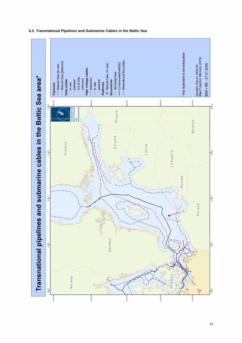
31
6.2. Transnational Pipelines and Submarine Cables in the Baltic Sea