attachment f transportation management plan · 01-dn-101-13.4/22.8 january 22, 2016 01-0f280k/01...
TRANSCRIPT

ATTACHMENT F Transportation Management Plan
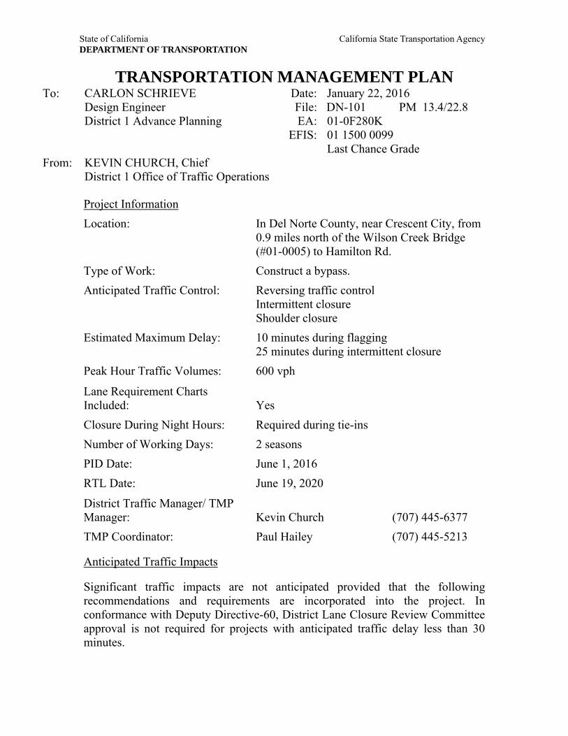
State of California California State Transportation Agency DEPARTMENT OF TRANSPORTATION
TRANSPORTATION MANAGEMENT PLAN To: CARLON SCHRIEVE Date: January 22, 2016 Design Engineer File: DN-101 PM 13.4/22.8 District 1 Advance Planning EA: 01-0F280K EFIS: 01 1500 0099 Last Chance Grade From: KEVIN CHURCH, Chief District 1 Office of Traffic Operations
Project Information Location: In Del Norte County, near Crescent City, from
0.9 miles north of the Wilson Creek Bridge (#01-0005) to Hamilton Rd.
Type of Work: Construct a bypass. Anticipated Traffic Control: Reversing traffic control
Intermittent closure Shoulder closure
Estimated Maximum Delay: 10 minutes during flagging 25 minutes during intermittent closure
Peak Hour Traffic Volumes: 600 vph
Lane Requirement Charts Included: Yes Closure During Night Hours: Required during tie-ins Number of Working Days: 2 seasons PID Date: June 1, 2016
RTL Date: June 19, 2020
District Traffic Manager/ TMP Manager: Kevin Church (707) 445-6377 TMP Coordinator: Paul Hailey (707) 445-5213
Anticipated Traffic Impacts
Significant traffic impacts are not anticipated provided that the following recommendations and requirements are incorporated into the project. In conformance with Deputy Directive-60, District Lane Closure Review Committee approval is not required for projects with anticipated traffic delay less than 30 minutes.

01-DN-101-13.4/22.8 January 22, 2016 01-0F280K/01 1500 0099 Page 2 Last Chance Grade Hours of Work
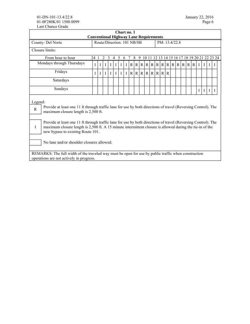
See Chart no. 1 “Conventional Highway Lane Requirements” for work hour restrictions.
The full width of the traveled way must be open for use by public traffic for the following Special Days:
Event Event Date Special Days
Sea Cruise First Weekend in October Friday through Sunday
The contractor must verify the actual dates for this Special Event. See Chart no. 2 “Lane Closure Restrictions for Designated Holidays and Special Days” for work day restrictions.
Public Notice
Upon receipt of notice that the total roadway width, including paved shoulder, will be narrowed to less than 16 ft or there is a change in vertical clearance, the Resident Engineer must promptly notify the HQ District 1 Construction Liaison D’Ann Watanabe-Gulling at (916) 322-4822 so annual permit holders can be notified of restrictions.
The District Public Information Office, (707) 445-6444, must be contacted two weeks in advance of the start of construction.
Each closure must be entered in the Lane Closure System (LCS; http://lcs.dot.ca.gov/lcsprod/).
Every Monday by noon, submit a schedule of planned closures for the next week period. The next week period is defined as Friday midnight through the following Friday midnight.
Closures must be statused daily with first cone down (1097) and last cone up (1098) or cancelled (1022). Statusing can be accomplished through:
Status With Day Time Contact Number LCS Any Any -
District 1 Dispatch Monday-Friday 6am-6pm (707) 441-5747
District 3 Dispatch Monday-Friday 6pm-6am (916) 859-7900
District 3 Dispatch Saturday and Sunday Any (916) 859-7900
To access the LCS you will need an account. Contact Jeannette Candalot at (707) 445-7807 to get set up with an account.

01-DN-101-13.4/22.8 January 22, 2016 01-0F280K/01 1500 0099 Page 3 Last Chance Grade
Any emergency service agency whose ability to respond to incidents will be affected by any lane closure must be notified prior to that closure.
Impacts to tribal land during the construction phase must be coordinated with the affected local tribal government and other entities during the design phase. Contact Jaime Hostler, District 1 Native American Liaison, (707) 441-5815.
Work must be coordinated with the local busing system (including school buses and public systems) to minimize impact on their bus schedules.
The Resident Engineer must provide information to residents and businesses before and during project work that may represent a negative impact on commerce and travel surrounding the zone of construction. Funding must be included in supplemental funds for public information (Item 066063 Traffic Management Plan – Public Information; consider $70,000).
Consider incorporating supplemental funds into the cost estimate for this project for an open house public meeting prior to the construction phase.
Regarding Traffic Management System (TMS) elements, provide Traffic Electrical and Traffic Census representatives 14 days notice before the pre-construction and post-construction operational status checks. Contact Traffic Electrical at (707) 445-5360 and Traffic Census at (707) 496-0553.
Traffic Control
One lane closure is permitted within the project limits.
If stationary mounted construction area signs are used, the W11-1 vehicular traffic sign (bicycle symbol) and the W16-1p supplemental plaque (SHARE THE ROAD) must be placed, in each direction of travel, prior to the construction zone.
Reversing traffic control must be in conformance with the attached traffic handling plan, “Reversing Control THP.”
A minimum of 11 ft of paved roadway must be open for use by public traffic.
The maximum length of a reversing traffic control closure is 2,500 ft.
Advance flaggers are required during daylight hours. All flaggers must have continuous radio contact with personnel in the work area. Full matrix PCMS boards with the capability of displaying a flagger symbol must be used during hours of darkness when advance flaggers are not present.
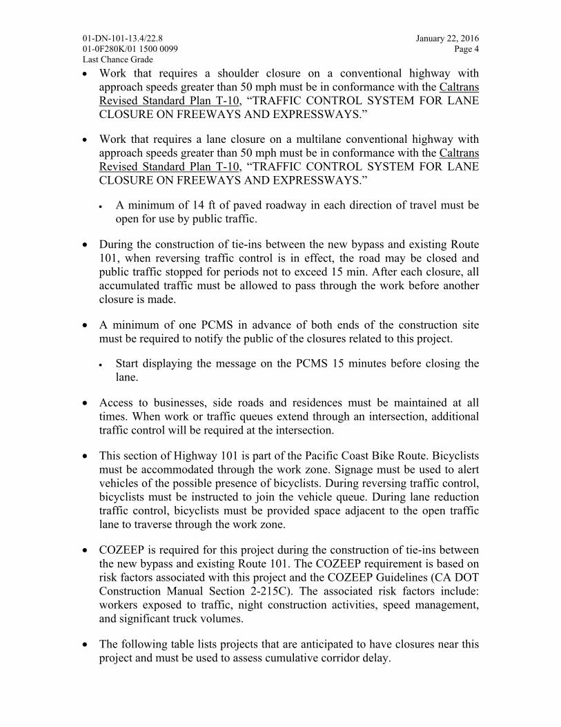
01-DN-101-13.4/22.8 January 22, 2016 01-0F280K/01 1500 0099 Page 4 Last Chance Grade Work that requires a shoulder closure on a conventional highway with
approach speeds greater than 50 mph must be in conformance with the Caltrans Revised Standard Plan T-10, “TRAFFIC CONTROL SYSTEM FOR LANE CLOSURE ON FREEWAYS AND EXPRESSWAYS.”
Work that requires a lane closure on a multilane conventional highway with approach speeds greater than 50 mph must be in conformance with the Caltrans Revised Standard Plan T-10, “TRAFFIC CONTROL SYSTEM FOR LANE CLOSURE ON FREEWAYS AND EXPRESSWAYS.”
A minimum of 14 ft of paved roadway in each direction of travel must be open for use by public traffic.
During the construction of tie-ins between the new bypass and existing Route 101, when reversing traffic control is in effect, the road may be closed and public traffic stopped for periods not to exceed 15 min. After each closure, all accumulated traffic must be allowed to pass through the work before another closure is made.
A minimum of one PCMS in advance of both ends of the construction site must be required to notify the public of the closures related to this project.
Start displaying the message on the PCMS 15 minutes before closing the lane.
Access to businesses, side roads and residences must be maintained at all times. When work or traffic queues extend through an intersection, additional traffic control will be required at the intersection.
This section of Highway 101 is part of the Pacific Coast Bike Route. Bicyclists must be accommodated through the work zone. Signage must be used to alert vehicles of the possible presence of bicyclists. During reversing traffic control, bicyclists must be instructed to join the vehicle queue. During lane reduction traffic control, bicyclists must be provided space adjacent to the open traffic lane to traverse through the work zone.
COZEEP is required for this project during the construction of tie-ins between the new bypass and existing Route 101. The COZEEP requirement is based on risk factors associated with this project and the COZEEP Guidelines (CA DOT Construction Manual Section 2-215C). The associated risk factors include: workers exposed to traffic, night construction activities, speed management, and significant truck volumes.
The following table lists projects that are anticipated to have closures near this project and must be used to assess cumulative corridor delay.

01-DN-101-13.4/22.8 January 22, 2016 01-0F280K/01 1500 0099 Page 5 Last Chance Grade
Contract No. Co-Rte-PM Type of Work Est. Delay (min) 01-0B0904 DN-101-R8.2/8.7 Replace 2 Bridges 10
01-0C6604 DN-101-25.8/27.3 Crescent City Gateway TBD
01-0F3104 DN-101-39.8 Construct Bridge 10
01-0F6104 DN-101-2.2 Construct bridge 0 (Lane Reduction)
01-436404 DN-101-35.8/36.5 Bridge Replacement 10
Contingency Plan
The contractor must prepare a contingency plan for reopening closures to public traffic. The Contractor must submit the contingency plan for a given operation to the Engineer within one working day of the Engineer’s request. Contingencies for unanticipated delays, emergencies, etc. must be coordinated between the RE and the Contractor.
Approval
Approved by: ____________________________________________ Transportation Management Plan Coordinator
Approved by: ____________________________________________ District Traffic/ TMP Manager
KBC/jnl
CC: 1)KBChurch, 2)JCandalot SCohen THodgson JMcGee Traffic Safety PIO
01-DN-101-13.4/22.8 January 22, 2016 01-0F280K/01 1500 0099 Page 6 Last Chance Grade
Chart no. 1 Conventional Highway Lane Requirements
County: Del Norte Route/Direction: 101 NB/SB PM: 13.4/22.8
Closure limits:
From hour to hour 24 1 2 3 4 5 6 7 8 9 10 11 12 13 14 15 16 17 18 19 20 21 22 23 24Mondays through Thursdays I I I I I I I R R R R R R R R R R R R R I I I I
Fridays I I I I I I I R R R R R R R R
Saturdays
Sundays I I I I
Legend:
R Provide at least one 11 ft through traffic lane for use by both directions of travel (Reversing Control). The maximum closure length is 2,500 ft.
I Provide at least one 11 ft through traffic lane for use by both directions of travel (Reversing Control). The maximum closure length is 2,500 ft. A 15 minute intermittent closure is allowed during the tie-in of the new bypass to existing Route 101.
No lane and/or shoulder closures allowed.
REMARKS: The full width of the traveled way must be open for use by public traffic when construction operations are not actively in progress.

01-DN-101-13.4/22.8 January 22, 2016 01-0F280K/01 1500 0099 Page 7 Last Chance Grade
Chart no. 2: Lane Closure Restrictions for Designated Holidays and Special Days
Thu Fri Sat Sun Mon Tues Wed Thu Fri Sat Sun
xx H xx
SD xx
xx
H xx
SD xx
xx
H xx
xx
SD xx
xx
H xx
xx
H xx
xx
H xx
xx
H xx
xx
Legend:
Refer to lane requirement charts xx The full width of the traveled way must be open for use by public traffic. H Designated Holiday
SD Special Day

01-DN-101-13.4/22.8 January 22, 2016 01-0F280K/01 1500 0099 Page 8 Last Chance Grade

ATTACHMENT G Preliminary Geotechnical Report

State of California Business, Transportation and Housing Agency
DEPARMENT OF TRANSPORTATION
“Provide a safe, sustainable, integrated and efficient transportation system to enhance California’s economy and livability”
M e m o r a n d u m Serious drought. Help Save Water!
To: Talitha Hodgson Date: April 08, 2016
File: 01-DN-101-PM 12.0/15.5 EA: 01-0F280K EFIS ID: 0115000099
Last Chance Grade Bypass
Attn: Jeffrey Pimentel, Project Engineer Advance Planning From: DEPARTMENT OF TRANSPORTATION DIVISION OF ENGINEERING SERVICES
GEOTECHNICAL SERVICES OFFICE OF GEOTECHNICAL DESIGN WEST
Subject: Preliminary Geotechnical Report for Last Chance Grade Bypass
1. Introduction
This memorandum summarizes the results of a preliminary geotechnical evaluation of six alternative alignments of Highway 101 currently being considered in order to bypass Last Chance Grade in Del Norte County. The bypass alternatives are A-1, A-2, F, C-3, C-4, and C-5. A map showing the location of the proposed alternatives is provided in Attachment A. A layout and profile of the existing alignment is provided in Attachment B. Plan maps and profiles of the six alternatives are provided in Attachments C, D, E, and F1 through F4.
The information contained in this memorandum is based on a review of existing Caltrans reports, California Geological Survey Special Report 184 (Wills, 2000), existing geomorphic maps, a landslide map provided by Green Diamond Resource Company, and plan maps, profiles and typical cross sections of the proposed alignments. No field investigation was conducted in preparation of this Memorandum.
Preliminary foundation recommendations for the bridges along the proposed alignments are provided in the Structures Preliminary Geotechnical Report for Last Chance Grade Bypass dated February 24th, 2016.
Project Manager

Talitha Hodgson 01-DN-101-PM 12.0-15.5 April 08, 2017 EFIS: 0114000066
“Provide a safe, sustainable, integrated and efficient transportation system to enhance California’s economy and livability”
2. Site Geology
California Geological Survey Special Report 184, Landslides in the Highway 101 Corridor between Wilson Creek and Crescent City, Del Norte County, California (2000) includes geologic and landslide maps that encompass the proposed alignments. The maps are based on a compilation of previous mapping, interpretation of aerial photographs and field mapping.
The landslides identified in the landslide map are classified and mapped based on their geomorphology. Detailed geotechnical data required to evaluate the probability of movement of the landslides was not collected as part of the investigation.
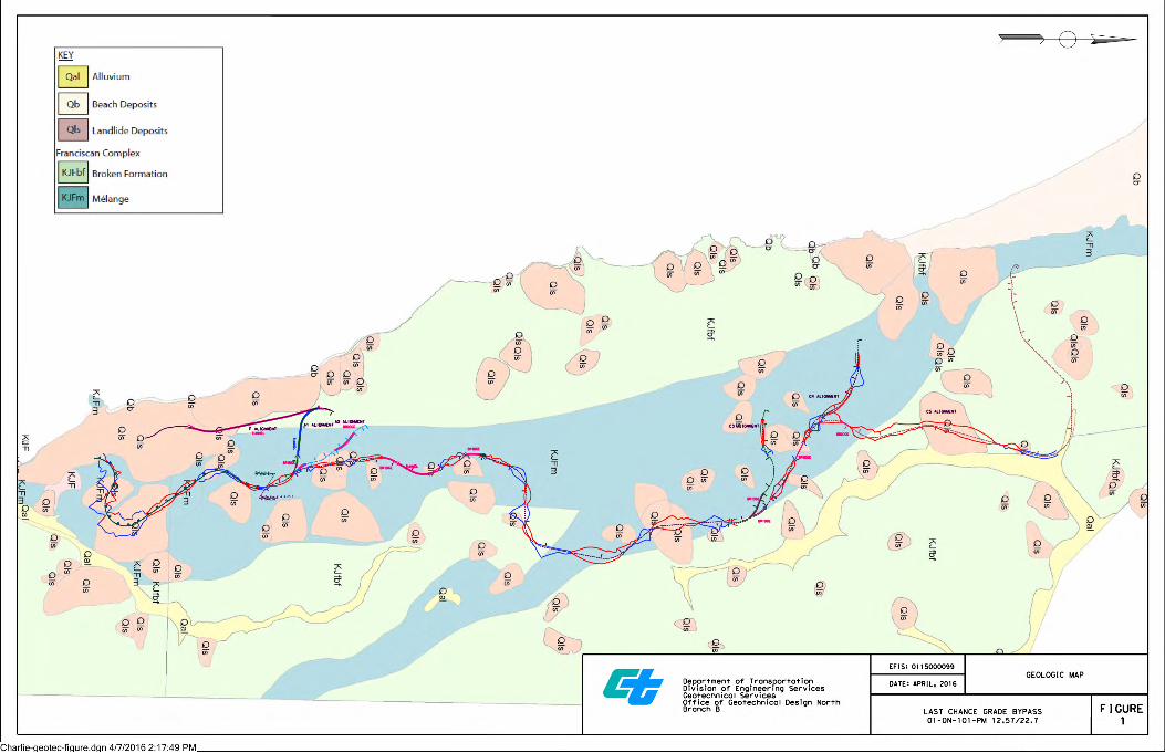
A geologic map showing the proposed alignments is provided in Figure 1. The geologic map indicates bedrock beneath the proposed alignments is either Franciscan Complex Broken Formation or Melange. The Broken formation typically consists of hard sandstone blocks separated by weak beds of shale and shear zones. Landslides within the Broken formation tend to be deep seated. The Northern and Southern Last Chance Grade Landslides along the existing alignment are located within the Broken Formation. The Melange typically consists of highly sheared shale and argillite. Landslides in the Melange are typically earthflows. The existing alignment between Wilson Creek (PM 12.7) and approximately PM 14.4 is located within the limits of an active earthflow.
A geologic map showing geomorphic features related to landsliding is provided in Figure 2. The map shows the locations of what are interpreted to be landslides as well as amphitheater slopes, features formed by landslide processes. The map also depicts disrupted ground, irregular ground surfaces formed by complex landsliding.
3. Geotechnical Investigation
A preliminary geotechnical investigation will be required in order to evaluate the feasibility of the proposed alignments based on geotechnical considerations and develop preliminary recommendations. Initially the investigation will be focused in areas of known or probable instability to aid in determining the extent to which landslide mitigation may be required. Geotechnical information collected during the preliminary investigation will aid in determining the preferred alternative or alternatives. Additional field investigation will be required during the design phase of the project in order to develop final geotechnical recommendations for the planned alternative.
The geotechnical investigation will include field mapping, geotechnical drilling, instrumentation and monitoring, seismic refraction surveys, and laboratory testing. Where possible, geotechnical drilling will occur on existing park and logging roads that intersect or are in close proximity to the alternative alignments. Temporary access roads will be constructed to access some locations. Helicopters will be required to transport drilling equipment to areas where access is restricted. We recommend that airborne Lidar be collected along the alignments of the proposed alternatives. High-resolution digital elevation maps generated by airborne Lidar will facilitate
Talitha Hodgson 01-DN-101-PM 12.0-15.5 April 08, 2017 EFIS: 0114000066
“Provide a safe, sustainable, integrated and efficient transportation system to enhance California’s economy and livability”
geologic and geomorphic mapping and identifying areas where detailed field investigations are warranted.
A resource estimate for Geotechnical Services for the preliminary geotechnical investigation will be provided in a separate memorandum.
4. Discussion of Alternatives
Existing Alignment
The existing alignment between Wilson Creek (PM 12.7) and approximately PM 14.4 is within the limits of an active earthflow and requires frequent grinding and paving due to ongoing deformation of the roadway. The proposed alternatives do not bypass the earthflow. The existing alignment within the limits of the earthflow will still need to be maintained after the bypass is constructed. Geologic mapping of this area and a subsurface investigation including instrumentation and monitoring should be considered in order to evaluate options for mitigation of the earthflow.
Alternatives A-1, A-2 and C3-C5
All the alternatives with the exception of Alternative F, have the same alignment between Station 0+00 and approximately Station 124+00. Between Station 0+00 and approximately Station 16+00, Alternatives A-1, A-2, and C3-C5 are located within the limits of an active earthflow. The proposed roadway will be prone to deformation similar to what is occurring along the existing alignment between PM 12.7 and 14.4. Investigation of this area will be required in order to evaluate options for mitigation of the earthflow.
Alternatives A-1, A-2, and C3-C5 between approximately Station 26+00 and Station 76+00 are located within the limits of what are mapped as probable dormant mature landslides. Large cuts and fills are proposed throughout this section. In addition to the landslides located between Stations 26+00 and 76+00, alternatives A-1, A-2 and C3-C5 traverse numerous mapped landslides along the proposed alignments.
With the exception of the existing active earthflow located between Stations 0+00 and 16+00, almost all the landslides that the proposed alignments traverse are mapped as probable or questionable, dormant-mature, deep ( >50 feet) rockslides.
Whether or not landslide mitigation will be required for a given landslide will depend on the stability of the existing slope, the magnitude of the proposed cuts and fills within the limits of the mapped landslide and the location of the cuts and fills with respect to the head or toe of the landslide. Areas of known or probable instability along the proposed alignments will be investigated in order to determine if landslide mitigation is required.
Based on existing geologic mapping and review of preliminary cross sections, the alignment of the tunnel proposed in Alternative A-1 is outside the limits of the Northern Last Chance Grade

Talitha Hodgson 01-DN-101-PM 12.0-15.5 April 08, 2017 EFIS: 0114000066
“Provide a safe, sustainable, integrated and efficient transportation system to enhance California’s economy and livability”
Landslide. A detailed field investigation will be required in order to verify the location of the proposed tunnel with respect to the Northern Last Chance Grade Landslide.
Alternative F
Alternative F is a tunnel alignment that parallels the existing highway. Alternative F departs the existing alignment at approximately PM 14.2. Based on existing geologic mapping and a review of preliminary cross sections, the tunnel is outside the limits of the Wilson Creek Landslide and the Southern and Northern Last Chance Grade Landslides. However, the southern portal and a portion of the tunnel are within the limits of an active earthflow. A detailed field investigation will be required in order to verify the location of the tunnel with respect to the aforementioned landslides and to evaluate options for stabilization the earthflow. This alternative may not be viable unless the potential impacts of the earthflow can be mitigated.
If you have any questions or require additional assistance, please contact me at (707) 445-6036.
CHARLIE NARWOLD Senior Engineering Geologist Office of Geotechnical Design West Branch F
References
Davenport, C.W., 1984, DMG Open-File Report 84-07, Geology and Geomorphic Features Related to Landsliding, Childs Hill 7.5' Quadrangle, Del Norte County, California Scale 1:24,000.
Davenport, C.W., 1984, DMG Open-File Report 84-08, Geology and Geomorphic Features Related to Landsliding, Requa 7.5' Quadrangle, Del Norte County, California Scale 1:24,000.
Wills, C. J., “California Geological Survey Special Report 184, Landslides in the Highway 101 Corridor between Wilson Creek and Crescent City, Del Norte County, California,” 2000.
List of Figures
Figure 1 - Geologic Map.
Figure 2 - Geomorphic Map.

Talitha Hodgson 01-DN-101-PM 12.0-15.5 April 08, 2017 EFIS: 0114000066
“Provide a safe, sustainable, integrated and efficient transportation system to enhance California’s economy and livability”
Attachments
Attachment A - Location Map
Attachment B - Layout and Profile of Existing Grade
Attachment C - Layout and Profile Alternative A-1
Attachment D - Layout and Profile Alternative A-2
Attachment E - Layout and Profile Alternative F
Attachment F1 - Layout and Profile Alternatives C3, C4, and C5 Sheet 1 of 4
Attachment F2 - Layout and Profile Alternative C3, C4, and C5 Sheet 2 of 4
Attachment F3 - Layout and Profile Alternative C3, C4, and C5 Sheet 3 of 4
Attachment F4 - Layout and Profile Alternative C3, C4, and C5 Sheet 4 of 4
C: Project File

LastChanceGEO2-t.dgn 4/7/2016 6:26:25 PM