attachment d l-14-399 agency correspondence - section...
TRANSCRIPT

Attachment D L-14-399
Agency Correspondence - Section 4

Agency Correspondence – Section 4 USACE has issued a Preliminary Jurisdictional Determination for Department of Army Application No. 2014-00108 (see Appendix 4.1). In addition, USACE has prepared a Public Notice for this project (see Appendix 4.2). Additional agencies or background literature review has been conducted with the following agencies: Ohio Department of Natural Resources (ODNR), United States Fish and Wildlife Service (USFWS), Ohio Historic Preservation Office (OHPO), ODNR Office of Coastal Management. Below is a summary of these communications and literature reviews. The ODNR has been notified of the Minor Stream Project. Coordination was initiated with ODNR on February 3, 2014 (see Appendix 4.3). A response letter was received from ODNR on February 10, 2014 (see Appendix 4.4). In the response letter, ODNR indicated that there are two records within the Perry Nuclear Power Plant (PNPP) Minor Stream Project area. These records are for the state threatened spotted turtle (Clemmys guttata) which was reported to be in swampy areas during the 1986 Annual Report of the Perry Plan Ecological Monitoring Program. In addition, the site was described as a notable Mixed Mesophytic Forest by the Division of Natural Areas & Preserves in 1981. The letter indicated that there are no records for the Indiana bat (Myotis sodalis) capture locations within a five mile radius or hibernacula within a ten mile radius of the project area. FENOC contracted Gregory Lipps LLC to perform an endangered spotted turtle survey for the project area. This survey was conducted during April through June 2014 for the presence of endangered spotted turtle habitat and individuals. No state or federally listed amphibian or reptile species were found at the trap locations. Since the survey was completed, the project area has changed, Gregory Lipps concluded that the survey results would extend to the current project area. A copy of the report and the communication about the survey area extent are included in Appendix 4.5. Tree and shrub clearing will be required to complete the Minor Stream Project. Approximately 14 acres of trees, will be cleared during implementation of this project. Coordination for tree removal with the USFWS was initiated on February 12, 2014 (see Appendix 4.6). A response was received on February 27, 2014 from USFWS (see Appendix 4.7). In the response, USFWS indicated that trees exhibiting characteristics of potential Indiana bat habitat should “be saved wherever possible. However, if these trees cannot be avoided, they should only be cut between October 1 and March 31...If there is a Federal nexus for the project...then no tree clearing on any portion of the parcel should occur until consultation under section 7 of the Endangered Species Act of 1973, as amended, between the Service and the Federal action agency is complete. We recommend that the Federal action agency submit to this office a determination of effects to the Indiana bat for our review and concurrence.” A copy of this communication is included in Attachment C. FirstEnergy proposes seasonal clearing (between October 1, 2014 and March 31, 2015) of the potential roost trees once section 7 consultation with USFWS has concluded. The ODNR Office of Coastal Management has been contacted regarding the Minor Stream Project. To complete the project, the outlet of the New UNT will empty from an outlet into Lake Erie. Three components are required to be submitted to the Office of Coastal Management to permit for

stream connection to Lake Erie. These components include the Coastal Consistency Certification Statement, modification (if necessary) to the existing Submerged Land Lease Agreement, and a Shore Structure Permit. The Office of Coastal Management performed a Site Assessment Report (see Appendix 4.8) for the area in which the New UNT is proposed to outlet. Coordination with the Office of Coastal Management on the above components is in progress. EnviroScience performed an initial OHPO data review of cultural resources for the Minor Stream Project. The area searched included the study area location and a surrounding 1,000-foot buffer. The literature review included a search for records of National Register Listed Properties, National Register Listed Districts, Ohio Archaeological Inventory Properties, Ohio Historic Inventory Properties, Determinations of Eligibility, and Phase 1, 2, or 3 Survey Areas. Results are shown on the mapping and data spreadsheet located in Appendix 4.9. According to the records search, no National Register Listed Properties, National Register Listed Districts, Ohio Archaeological Inventory Properties, Ohio Historic Inventory Properties, Determinations of Eligibility, and Phase 1, 2, or 3 Survey Areas were identified within the project area or 1,000 foot buffer area.

REPLY TO
Regulatory Branch
DEPARTMENT OF THE ARMY BUFFALO DISTRICT, CORPS OF ENGINEERS
1776 NIAGARA STREET
BUFFALO, NEW YORK 14207-3199
September 12, 2014
SUBJECT: Preliminary Jurisdictional Dete1mination for Department of the Aimy Application No. 2014-00108
Kristin Susick Senior Scientist 76 South Main Street Akron, Ohio 44332
Dear Ms. Susick:
I have reviewed the wetland delineation map you submitted for the parcel located east of the Perry Nuclear Plant at 10 Center Road, in the Village of Perry, Lake County, Ohio.
I have evaluated your submitted wetland delineation map and have determined that the wetland and water boundaries shown on the map accurately represent on-site conditions. Please note that this is a Preliminary Jurisdictional Determination (JD). Preliminmy JDs are nonbinding written indications that there may be waters of the United States on your parcel and approximate locations of those waters. Preliminmy JDs are advismy in nature and may not be appealed.
Pursuant to Regulatory Guidance Letter 08-02, any permit application made in reliance on this Preliminm·y JD will be evaluated as though all wetlands or waters on the site are regulated by the Corps. Further, all waters, including wetlands will be used for purposes of assessing the area of project related impacts and compensatory mitigation. If you require a definitive response regarding Department of the Anny jurisdiction for any or all of the waters identified on the submitted drawings, you may request an approved jurisdictional determination from this office. If an approved jurisdictional determination is requested, please be aware that this is often a lengthy process and we may require the submittal of additional info1mation.
I have enclosed the Preliminmy JD Form with this letter. The foim and attached table identifies the extent of waters on the site and specific terms and conditions of the Preliminary JD. Please sign and return a copy of this form to my attention so that I may complete my evaluation of your file. If you do not respond within fifteen days of this letter, I will assume you no longer wish to pursue the jurisdictional dete1mination and will withdraw your application.
-2-
Regulatory Branch SUBJECT: Jurisdictional Detennination for Depmiment of the Almy Application No. 2014-00108
In accordance with Regulatory Guidance Letter 05-02, "Preliminmy jurisdictional dete1minations are not definitive determinations of areas within regulatory jurisdiction and do not have expirations dates." However, I strongly recommend that the boundaries of waters of the United States be re-evaluated by a qualified wetland biologist after five years of the date of this letter. This will ensure that any changes are appropriately identified and you do not inadve1tently incur a violation of Federal law while constructing your project or working on your project site.
Lastly, this determination has been conducted only to identify the limits of waters that may be subject to Corps Clean Water Act or Rivers and Harbors Act jurisdiction. This delineation/dete1mination may not be valid for the wetland conservation provisions of the Food Security Act of 1985, as amended. If you or your tenant are USDA programpmiicipants, or anticipate participation in USDA progrmns, you should request a ce1iified wetland determination from the local office of the Natural Resource Conservation Service prior to starting work.
Questions pe1iaining to this matter should be directed to me at (716) 879-4363, by writing to the following address: U.S. Army Corps of Engineers, 1776 Niagara Street, Buffalo, New York 14207, or by e-mail at: [email protected]
Enclosures
Sincerely,
SIGNED Peter J. Krakowiak Biologist

ATTACHMENT
PRELIMINARY JURISDICTIONAL DETERMINATION FORM
BACKGROUND INFORMATION
A. REPORT COMPLETION DATE FOR PRELIMINARY JURISDICTIONAL DETERMINATION (JD): September 11, 2014
B. NAME AND ADDRESS OF PERSON REQUESTING PRELIMINARY JD: Kristin Susick Senior Scientist 76 South Main Street Akron, Ohio 44332
C. DISTRICT OFFICE, FILE NAME, AND NUMBER: LRB, FirstEnergy Corporation - Perry Nuclear Plant Stream Relocation, DA No. 2014-00108
D. PROJECT LOCATION(S) AND BACKGROUND INFORMATION: (USE THE ATTACHED TABLE TO DOCUMENT MULTIPLE WATERBODIES AT DIFFERENT SITES)
State: Ohio County/parish/borough: Lake City: Perry Center coordinates of site (laUlong in degree decimal format):
Lat. 41.80161 Long. -81.13694
Universal Transverse Mercator:
Name of nearest waterbody: Lake Erie
Identify (estimate) amount of waters in the review area: Non-wetland waters: 7,557 linear feet: Variable width (ft) and/or acres. Cowardin Class: Riverine Stream Flow: Ephemeral, intermittent, and perennial Wetlands: 46.11 O acres. Cowardin Class: PEM, PSS, PFO
Name of any water bodies on the site that have been identified as Section 10 waters:
Tidal: NA Non-Tidal: NA
E. REVIEW PERFORMED FOR SITE EVALUATION (CHECK ALL THAT APPLY):
D Office (Desk) Determination. Date:
~ Field Determination. Date(s): April 24, 2014, June 25, 2014

FILE NAME, AND NUMBER: FirstEnergy Corporation - Perry Nuclear Plant, DA No. 2014-00108
1. The Corps of Engineers believes that there may be jurisdictional waters of the United States on the subject site, and the permit applicant or other affected party who requested this preliminary JD is hereby advised of his or her option to request and obtain an approved jurisdictional determination (JD) for that site. Nevertheless, the permit applicant or other person who requested this preliminary JD has declined to exercise the option to obtain an approved JD in this instance and at this time.
2. In any circumstance where a permit applicant obtains an individual permit, or a Nationwide General Permit (NWP) or other general permit verification requiring "preconstruction notification" (PCN), or requests verification for a non-reporting NWP or other general permit, and the permit applicant has not requested an approved JD for the activity, the permit applicant is hereby made aware of the following: (1) the permit applicant has elected to seek a permit authorization based on a preliminary JD, which does not make an official determination of jurisdictional waters; (2) that the applicant has the option to request an approved JD before accepting the terms and conditions of the permit authorization, and that basing a permit authorization on an approved JD could possibly result in less compensatory mitigation being required or different special conditions; (3) that the applicant has the right to request an individual permit rather than accepting the terms and conditions of the NWP or other general permit authorization; (4) that the applicant can accept a permit authorization and thereby agree to comply with all the terms and conditions of that permit, including whatever mitigation requirements the Corps has determined to be necessary; (5) that undertaking any activity in reliance upon the subject permit authorization without requesting an approved JD constitutes the applicant's acceptance of the use of the preliminary JD, but that either form of JD will be processed as soon as is practicable; (6) accepting a permit authorization (e.g., signing a proffered individual permit) or undertaking any activity in reliance on any form of Corps permit authorization based on a preliminary JD constitutes agreement that all wetlands and other water bodies on the site affected in any way by that activity are jurisdictional waters of the United States, and precludes any challenge to such jurisdiction in any administrative or judicial compliance or enforcement action, or in any administrative appeal or in any Federal court; and (7) whether the applicant elects to use either an approved JD or a preliminary JD, that JD will be processed as soon as is practicable. Further, an approved JD, a proffered individual permit (and all terms and conditions contained therein), or individual permit denial can be administratively appealed pursuant to 33 C.F.R. Part 331, and that in any administrative appeal, jurisdictional issues can be raised (see 33 C.F.R. 331.5(a)(2)). If, during that administrative appeal, it becomes necessary to make an official determination whether CWA jurisdiction exists over a site, or to provide an official delineation of jurisdictional waters on the site, the Corps will provide an approved JD to accomplish that result, as soon as is practicable. This preliminary JD finds that there "may be" waters of the United States on the subject project site, and identifies all aquatic features on the site that could be affected by the proposed activity, based on the following information:
FILE NAME, AND NUMBER: FirstEnergy Corporation - Perry Nuclear Plant, DA No. 2014-00108
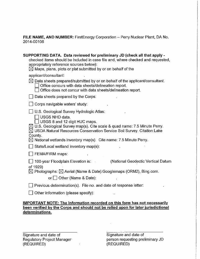
SUPPORTING DATA. Data reviewed for preliminary JD (check all that apply -checked items should be included in case file and, where checked and requested, appropriately reference sources below): ~ Maps, plans, plots or plat submitted by or on behalf of the
applicant/consultant: ~ Data sheets prepared/submitted by or on behalf of the applicant/consultant.
D Office concurs with data sheets/delineation report. D Office does not concur with data sheets/delineation report.
D Data sheets prepared by the Corps:
D Corps navigable waters' study:
D U.S. Geological Survey Hydrologic Atlas:
D USGS NHD data. D USGS 8 and 12 digit HUG maps.
~ U.S. Geological Survey map(s). Cite scale & quad name: 7.5 Minute Perry. ~ USDA Natural Resources Conservation Service Soil Survey. Citation: Lake County. ~ National wetlands inventory map(s). Cite name: 7.5 Minute Perry.
D State/Local wetland inventory map(s):
D FEMA/FIRM maps:
D 100-year Floodplain Elevation is: (National Geodectic Vertical Datum
of 1929) ~ Photographs: ~Aerial (Name & Date):Googlemaps (ORM2), Bing.com.
or D Other (Name & Date):
D Previous determination(s). File no. and date of response letter:
D Other information (please specify):
IMPORTANT NOTE: The information recorded on this form has not necessarily been verified by the Corps and should not be relied upon for later jurisdictional determinations.
Signature and date of Regulatory Project Manager (REQUIRED)
Signature and date of person requesting preliminary JD (REQUIRED)
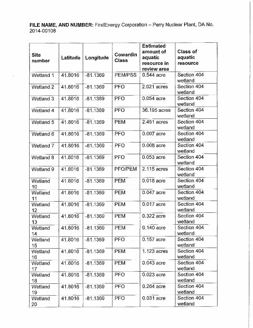
FILE NAME, AND NUMBER: FirstEnergy Corporation - Perry Nuclear Plant, DA No. 2014-00108
Estimated
Site Coward in amount of Class of
number Latitude Longitude Class
aquatic aquatic resource in resource review area
Wetland 1 41.8016 -81.1369 PEM/PSS 0.544 acre Section 404 wetland
Wetland 2 41.8016 -81.1369 PFO 2.021 acres Section 404 wetland
Wetland 3 41.8016 .-81.1369 PFO 0.054 acre Section 404 wetland
Wetland 4 41.8016 -81.1369 PFO 36.195 acres Section 404 wetland
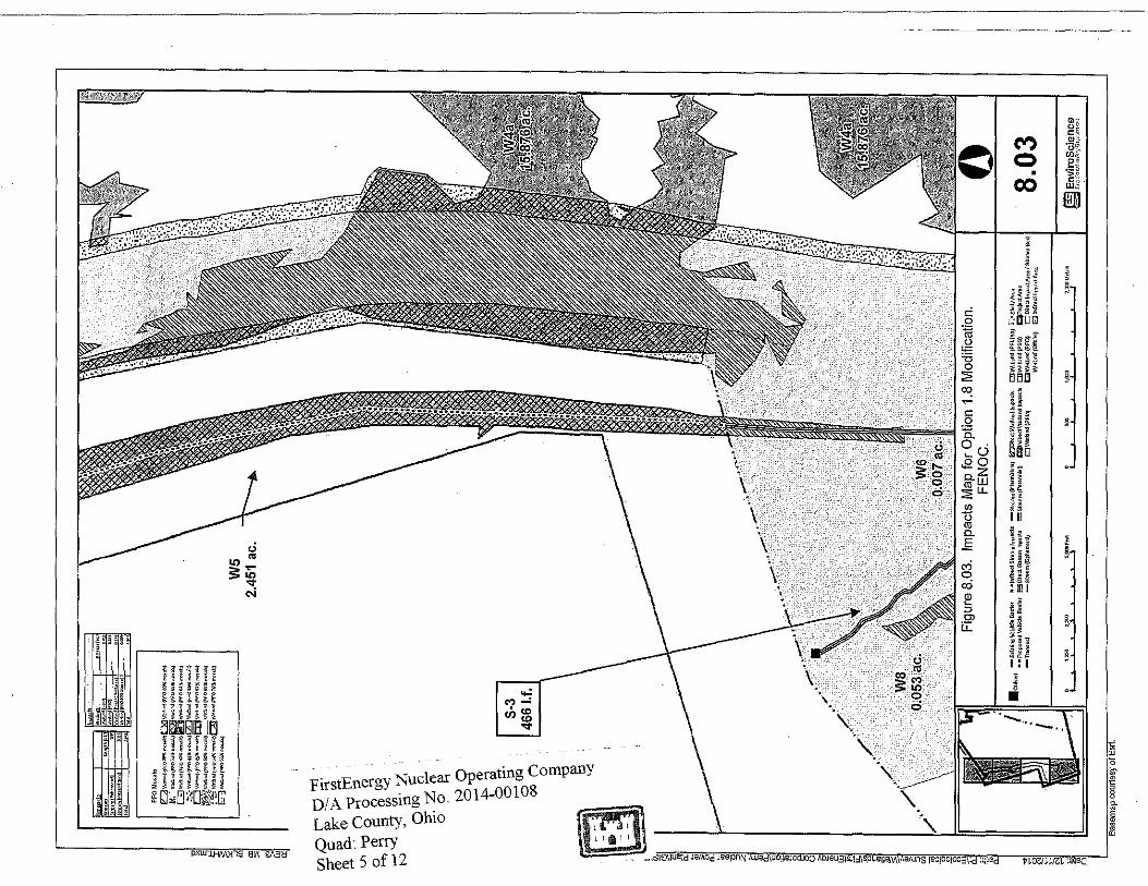
Wetland 5 41.8016 -81.1369 PEM 2.451 acres Section 404 wetland
Wetland 6 41.8016 -81.1369 PFO 0.007 acre Section 404 wetland
Wetland 7 41.8016 -81.1369 PFO 0.008 acre Section 404 wetland
Wetland 8 41.8016 -81.1369 PFO 0.053 acre Section 404 wetland
Wetland 9 41.8016 -81.1369 PFO/PEM 2.115 acres Section 404 wetland
Wetland 41.8016 -81.1369 PEM 0.018 acre Section 404 10 wetland Wetland 41.8016 -81.1369 PEM 0.047 acre Section 404 11 wetland Wetland 41.8016 -81.1369 PEM 0.017 acre Section 404 12 wetland Wetland 41.8016 -81.1369 PEM 0.322 acre Section 404 13 wetland Wetland 41.8016 -81.1369 PEM 0.140 acre Section 404 14 wetland Wetland 41.8016 -81.1369 PFO ' 0.157acre Section 404 15 wetland Wetland 41.8016 -81.1369 PEM 1.123 acres Section 404 16 wetland Wetland 41.8016 -81.1369 PEM 0.043 acre Section 404 17 wetland Wetland 41.8016 -81.1369 PFO 0.023 acre Section 404 18 wetland Wetland 41.8016 -81.1369 PFO 0.264 acre Section 404 19 wetland Wetland 41.8016 -81.1369 PFO 0.031 acre Section 404
I 20 ' wetland
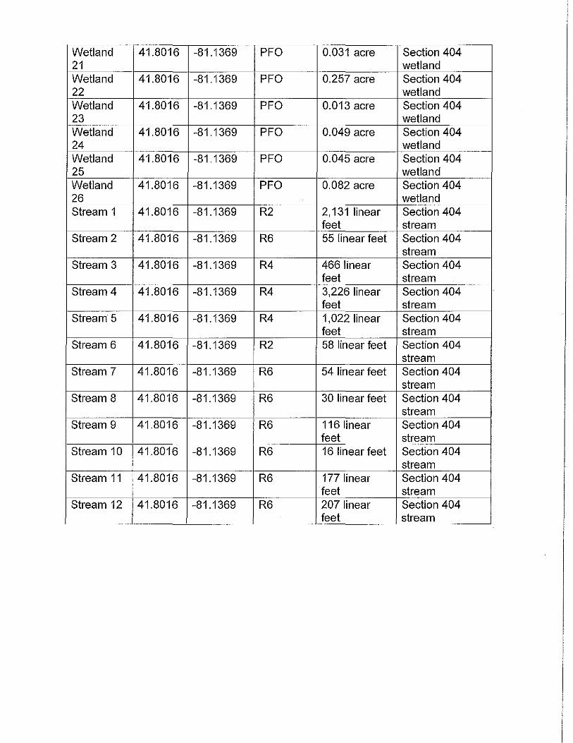
Wetland 41.8016 -81.1369 PFO 0.031 acre Section 404 21 wetland Wetland 41.8016 -81.1369 PFO 0.257 acre Section 404 22 wetland Wetland 41.8016 -81.1369 PFO 0.013 acre Section 404 23 wetland Wetland 41.8016 -81.1369 PFO 0.049 acre Section 404 24 wetland Wetland 41.8016 -81.1369 PFO 0.045 acre Section 404 25 wetland Wetland 41.8016 -81.1369 PFO 0.082 acre Section 404 26 . wetland Stream 1 41.8016 -81.1369 R2 2, 131 linear Section 404
feet stream Stream 2 41.8016 -81.1369 R6 55 linear feet Section 404
stream Stream 3 41.8016 -81.1369 R4 466 linear Section 404
feet stream Stream 4 41.8016 -81.1369 R4 3,226 linear Section 404
feet stream Stream 5 41.8016 -81.1369 R4 1,022 linear Section 404
feet stream Stream 6 41.8016 -81.1369 R2 58 linear feet Section 404
stream Stream 7 41.8016 -81.1369 R6 54 linear feet Section 404
stream Stream 8 41.8016 -81.1369 R6 30 linear feet Section 404
stream Stream 9 41.8016 -81.1369 R6 116 linear Section 404
feet stream Stream 10 41.8016 -81.1369 R6 16 linear feet Section 404
stream Stream 11 41.8016 -81.1369 R6 177 linear Section 404
feet stream Stream 12 41.8016 -81.1369 R6 207 linear Section 404
feet stream

FirstEnergy Corporation - Perry Nuclear Plant DI A Processing No. 2014-00 I 08 Lake County, Ohio Quad: Perry Sheet I of2
Figure 2. USGS 7.5-minute Topographic Map of Perry Quadrangle.
First Energy Coropora!lon.
I
l
2,000 1,000 2,ooO Feot ..... iiC:==D ............ f-~ EnviroScience
~ Excellence In />,r.y Enviro~rnent oooD .. o'i'oo'===:J. ... ..,,....,.;;l.\OOMe!eis

FirstEnergy Corporation - Perry Nuclear Plant DIA Processing No. 2014-00108 Lake County, Ohio Quad: Perry Sheet 2 of2
Figure 6. Site Map of Wetlands and Other Water Resources.
First Energy Corporation.
Bamnap <OU~O>Y or OSIP (i<l1\).
!!ii CUivert
$ S;rnpla Location
Tra"sec\
-- Shearn (Ephem~ral)
'" 1$(1
-- Stream (loterrnitteol)
--S!ream (~~nnial)
1'1ream (O~sito)
i!B \\l>tlar.d (PEM)
\\~tlar.d(PEl.ISS)
lllllw.tlar.d(PFO)
~Vl~tlar.d(PSS)
/ /. W<lbr>J {PFO )5\1 ...,,.,~)//I' W"bod{ffOWol """")
/ // \'.;t"°" (PFO;a\\ ""'"'~) '/ / \'Mbrd(f'f00l% rr<»I<)
'/ /1'.\,t~r>J{PFO<<EI ""'"'<! / /.;1',0"'c.1(Ffll'"'"""''°) / // \' ... t.nd(PF0~4% """") ~ // \'M~o0 (Pi'O 05% <M,,\e)
.; / / \','2U•r>J{PF04''!1 mo=<J / /, \',~t~nd (PFOOI~\ m:<>k)
/ /, \W!L>..S{PFO '°II mo"\:) / // \'.EtEnd1Pf009'\ mo=-"o)
. \',"and (PFO 5'\! n;o.a'c) / /. \',~"3cA(Pf'O JO:\ mxi\e)
://1'. .. bod{PF0"8\'"''"""l
Vll>U•n:!(Offslte)
c·.~::'J Study Area 0
0Projec!Area

U.S. Army Corps of Engineers Buffalo District CELRB-TD-R
Public Notice Applicant: FirstEnergy Nuclear Operating Company
Published: December 23, 2014 Expires: January 21, 2015
Application No: 2014-00108 Section: OH
All written comments should reference the above Application No. and be addressed to: US Army Corps of Engineers, Buffalo District Regulatory Branch (Attn:) Peter Krakowiak 1776 Niagara Street Buffalo, NY 14207
THE PURPOSE OF THIS PUBLIC NOTICE IS TO SOLICIT COMMENTS FROM THE PUBLIC REGARDING THE WORK DESCRIBED BELOW. NO DECISION HAS BEEN MADE AS TO WHETHER OR NOT A PERMIT WILL BE ISSUED AT THIS TIME.
Application for Permit under Authority of Section 10 of the Rivers and Harbors Act of 1899 and Section 404 of the Clean Water Act (33 U.S.C. 1344).
APPLICANT: FirstEnergy Nuclear Operating Company
WATERWAY & LOCATION: Numerous wetlands and streams located on a 125-acre property located east of the existing Perry Nuclear Plan at 10 Center Road, Village of North Pe11"y, Lake County, Ohio
LATITUDE & LONGITUDE: Latitude North: 41.800981 Longitude West: -81.135455
EXISTING CONDITIONS: The project site consists of primarily high quality wetland and forested vegetative communities with several streams flowing through the area. The area along the existing nuclear plant consists of an incised, straightened stream with an emergent buffer. Description of delineation of waters of the US, if applicable: Nine wetlands and five streams were identified within the project area (see PJD dated September 12, 2014. Note: PJD encompasses a larger area and depicts more aquatic resources). The shoreline of Lake Erie at the project location is a very steep bluff and is currently eroding.

-2-
PROPOSED WORK: The proposed project includes the discharge of fill into federally jurisdictional wetlands and streams in association with a stream relocation project. As a result of Nuclear Regulatory Commission (NRC) requirements, the applicant was required to re-evaluate flood and seismic hazards at their facility. The re-evaluation resulted in the need to relocate and expand the capacity of an existing stream that currently flows along the east boundary of the facility. The proposed relocation (referred to as Modified Option 1.8) will result in permanent impacts to 4.944 acres of federal wetlands (1.488 acres of PEM and 3.456 acres of PFO) and 3 ,242 linear feet of stream (206 linear feet of ephemeral and 3,036 linear feet of intermittent). The permanent wetland impacts include estimated indirect impacts (calculated by adding a 20-65 foot area along impacted wetland areas) that may occur as a result of dewatering adjacent wetland areas. The relocated stream will outlet at Lake Erie, well above the Ordinary High Water Mark. The shoreline in this area is proposed to be graded back with a gentler slope and stabilized.
PROJECT PURPOSE Basic: Flood Risk Abatement Overall: Containment of floodwaters during a Probable Maximum Flood event pursuant to federal requirements
Water Dependency Determination (describe only if project affecting Special Aquatic Site): The proposed project is not a water dependent activity.
AVOIDANCE AND MINIMIZATION INFORMATION: Several alternatives were evaluated to help avoid and minimize wetland and stream impacts, including various stream relocation alignments, changes to the existing facility, use of pipe/culverts bored to Lake Erie, use of upstream water detention methods, and taking no action. The no action alternative would not fulfill the project purpose. Changes to the existing facility would negatively impact operation and security, and is contrary to the plant's design and license. Boring a pipe or pipes to Lake Erie is not a viable option due to the potential for blockage by debris during storm events. Use of upstream detention basins was evaluated and determined to not be viable. The basins would need to be placed far upstream to avoid high quality wetlands which would result in a relatively large watershed still contributing to the existing stream. The diversion of water to the Major Stream located to the west was evaluated and determined not to be viable due to elevation differences, impacts to existing wetlands, and potential back-up issues.
Four viable options were considered. These included diverting water to an east stream, modifying the existing stream in-place, and re-routing the stream to the north/east (2 configurations - Option 1.8 and Modified Option 1.8). The diversion of the existing stream to connect with the east stream would result in a larger amount of high quality wetland impacts, bisect wetland areas, and possibly impact the lower reaches of the east stream due to higher flows. The modification of the existing stream would result in a larger amount of wetland impacts. The re-route of the existing stream to the north/east using the preferred route (Option 1.8) would result in greater wetland impacts and slightly less stream impacts. Modified Option 1.8 is the proposed option.

-3-
PROPOSED MITIGATION: The applicant proposes to mitigation for 3,242 linear feet of stream impacts and 4.944 acres of wetland impacts through a combination of on-site preservation, inlieu fee credits, and mitigation bank credits. The existing stream will be re-routed resulting in 2, 780 linear feet of stream, which is proposed as partial stream mitigation. Approximately 2, 131 linear feet of stream, 20 acres of upland buffer, and 0.744 acre of wetland will be preserved onsite through a deed restriction. Additionally, the applicant proposes to pmchase 5 credits from The Natme Conservancy In-Lieu Fee Program and 7.4 credits from the Pine Brook Wetland Mitigation Bank, a preservation-only mitigation bank.
Location and details of the above described work are shown on the attached maps and drawings.
Comments or questions pertaining to the work described in this notice should be reference the Application Number and be directed to the attention of Peter Krakowiak, who can be contacted at the above address, by calling (716) 879-4363, or by e-mail at: [email protected] A lack of response will be interpreted as meaning that there is no objection to the work as proposed.
The applicant has ce1iified that the proposed activity complies with Ohio's approved Coastal Zone Management Program and will be conducted in a manner consistent with that program. Any comments on the consistency of the proposed activity with Ohio's Coastal Zone Management Program should be fmwarded to:
Mr. John Kessler Ohio Depmiment of Natural Resources Office of Real Estate 2045 Morse Rd. Columbus, OH 43229-6605 phone: 614-265-6621 email: [email protected]
The following authorization is required for this project:
Water Quality Certification (or waiver thereof) from the Ohio Environmental Protection Agency
Based on preliminm·y findings, there do not appear to be any properties listed in, or eligible for listing in, the National Register of Historic Places within the permit m·ea as shown on Sheet 1 of 5. Therefore, the Corps has determined that the proposed project will have no affect on historic prope1iies. This notice constitutes initiation of consultation with the Ohio Historic Preservation Office (SHPO) per Section 106 of the National Historic Preservation Act. All currently available historic resource information pertaining to this proposed project if any has been provided to the SHPO. Additional information concerning historic properties should be submitted to the Corps before the end of the comment period of this notice. The Corps will forward that information to the SHPO for their review.

-4-
Pursuant to Section 7 of the Endangered Species Act (16 U.S.C. 1531), the Corps of Engineers is consulting, under separate cover, with the USFWS to evaluate any potential impacts to: Indiana bat (Myotis soda/is), Northern Long-eared Bat (Myotis septentrionalis), Kirtland's Warbler (Setophaga kirtlandii), Piping Plover (Charadrius melodus), Snuffbox (Epioblasma triquetra), Rufa Red Knot (Calidris canutus rufa), and Bald Eagle (Haliaeetus leucocephalus), and to ensure that the proposed activity is not likely to jeopardize their continued existence or result in the destruction or adverse modification of critical habitat.
This notice is promulgated in accordance with Title 33, Code of Federal Regulations, paits 320-330. Any interested paity desiring to comment on the work described herein may do so by submitting their comments, in writing, so that they are received no later than 4:30 pm on the expiration date of this notice.
Comments submitted in response to this notice will be fully considered during the public interest review for this pe1mit application. All written comments will be made a part of the administrative record which is available to the public under the Freedom of Information Act. The Administrative Record, or portions thereof may also be posted on a Corps of Engineers internet web site. Due to resource limitations, this office will normally not acknowledge the receipt of comments or respond to individual letters of comment.
Any individual may request a public hearing by submitting their written request, stating the specific reasons for holding a heai·ing, in the same manner and time period as other comments.
Public hearings for the purposes of the Corps permit program will be held when the District Commander dete1mines he can obtain additional information, not available in written comments, that will aid him in the decision making process for this application. A Corps hearing is not a source of information for the general public, nor a forum for the resolution of issues or conflicting points of view (witnesses are not sworn and cross examination is prohibited). Heai'ings will not be held to obtain information on issues um·elated to the work requiring a pe1mit, such as prope1iy ownership, neighbor disputes, or the behavior or actions of the public or applicant on upland property not regulated by the Department of the Army. Information obtained from a public hearing is given no greater weight than that obtained from written comments. Therefore, you should not fail to make timely written comments because a heai'ing might be held.
The decision to approve or deny this permit request will be based on an evaluation of the probable impact, including cumulative impacts of the proposed activity on the public interest. That decision will reflect the national concern for both protection and utilization of important resources. The benefits which reasonably may be expected to accrue from the proposal must be balanced against its reasonably foreseeable detriments. All factors which may be relevant to the proposal will be considered including the cumulative effects thereof; among these are conservation, economics, aesthetics, general environmental concerns, wetlands, historic properties, fish and wildlife values, flood hazards, flood plain values, land use, navigation, shoreline erosion and accretion, recreation, water supply and conservation, water quality, energy needs, safety, food and fiber production, mineral needs, considerations of property ownership, and in general, the needs and welfare of the people.
-5-
The Corps of Engineers is soliciting connnents from the public; Federal, state and local agencies and officials; Indian Tribes; and other interested parties in order to consider and evaluate the impacts of this proposed activity. Any connnents received will be considered by the Corps of Engineers to determine whether to issue, modify, condition or deny a permit for this proposal. To make this decision, connnents are used to assess impacts on endangered species, historic prope1iies, water quality, general environmental effects, and the other public interest factors listed above. Connnents are used in the preparation of an Environmental Assessment and/or an Environmental Impact Statement pursuant to the National Environmental Policy Act. Connnents me also used to determine the need for a public hearing and to dete1mine the overall public interest of the proposed activity.
Diane C. Kozlowski Chief, Regulatory Branch
NOTICE TO POSTMASTER: It is requested that this notice be posted continuously and conspicuously for 30 days from the date of issuance.

FirstEnergy Nuclear Operating Company DIA Processing No. 2014-00108 Lake County, Ohio Quad: Perry Sheet I of !2
Flgure 2. USGS 7.5.mfnute TopographloMapol PeriyQuadrangle.
Ffrst Energy Coropora!lon.
""iiil..,.o''<oo'::::::::io"""""'"""iiii""""
"'mmo'iioo:::::::;..,.,...,,..,.;too11.111Js
··,.
.. ..t ·~ ' ' \
l'il3 EnviroScience ~ Excetei"icelnAnyE'swi<)rlroo11t

FirstEnergy Nuclear Operating Company DIA Processing No. 2014-00108 Lake County, Ohio Quad: Perry Sheet 2 ofl2
. ', "\ \ \
8.0
Figure 8. Impacts Map Overview for Option
1.8 Modification. FENOC.
Basemap courtesy of Esrl.
··~ ·- ·-.. \ ..
- .-.-, Minor Stream Indirect Impact Area
136'.J Indirect Impact Area
~ Direct Impact Area I Stream Bed
c:::J Study Area
[_~Project Area
150 300
I I I I I
I I I I I
0 50 100
I
I
I I
I
I I
600 Feet I
200 Meters
{
I I I
I I
0 tE EnviroScience -~ Excellencn fn Any E:nvlronrnl3rn
• "
·-'""'""'"''""" '''""''"""'""'"' '""
.. ,,,...,,, ·~· ""'" ·~··.,; .......... ,.,. ....... '°,.,....,,_,.., ,_,
PFO Mo,alo
IZJv-"{Fl'Ol5ll......ijl2S]\\'<'"''11''0"1ll-"'! :-··v."'-"(FTO>S"""'ill!ilQl""""'t?fOO>I•~ c:JWKW\PiO""'"""""fi51"""""(Pf""'"""""' €~': V."'1>.-rl!PfO«"""""li::::Zl"""""f"'005'/,""'''I QvMW(l"O<S"""'"'lQi!iliJ-f'l'0""'""'°'4 !r~'Zw.&><r/'f0,,,,...,..'1_w.t1oM11'F0""""""'1 Oii•...,W(N05',...,.""JCCJw .. o.,;(FT01'Pll""""! g.,,,,,,,,(PFO .. ""'°'""
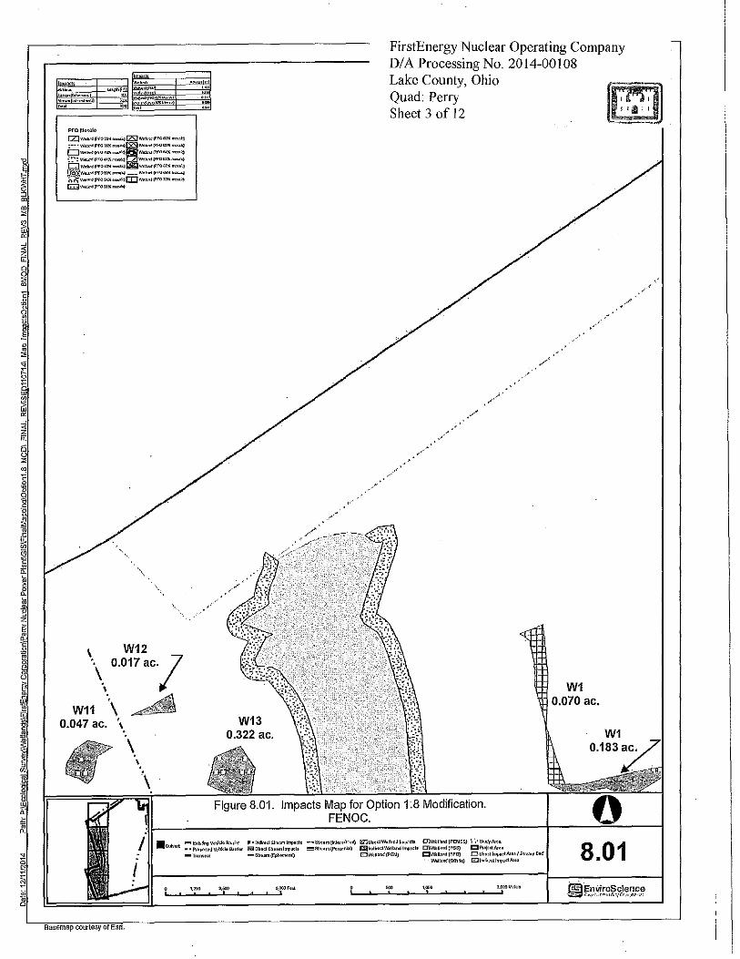
'. W12 \ 0.017ac.l
W11 0.047 ac.
\ " .A \
'· \
......... 1
W13 0.322 ac.
FirstEnergy Nuclear Operating Company DIA Processing No. 2014-00108 Lake County, Ohio Quad: Perry Sheet 3 of 12
W1 0.070 ac.
0 .Cufv•rt ::~:!r:~z~i:loBa~:, ~~~:~<!!~:~~::,~:!< ;;:;;~~::~)~;:::> ~:::~:~~:.~ls ~:=~i~:~JSS) ~~~~<IAr,:.
-Tr>r1><d -S~••m{Ep!lotn.,.Q 12JW.Uao<l{PEM) CJW.U.n<l(!'fO} DDh<llmp>olAroo/S~<•m Bod 8.01
Basemap courtesy of Esri.
5.000F«I '--~~~~~~~~
W.l"nd[Olfsilo) G'.Jlod"•octlmp>dArH
, ..
• "
9 ..
• 0
W10 0.018 ac.
\ \
\ W13 o·i~22 ac.
\ \
\ ' \
PfOMo•a!c
o"-"IPf0$ .. _t:Zl"""""f'fO""'""''"' ~,._:; \'o\'tb,><{Pfo .... .,,..:q!S:511w.r._,.;!Pf00>5""""1
G""""'"f'l'""""""""'li!ll..,..,..,.{Pfo .... _ :· •• w.. .... f'f0<<1<••><i<liz:::l1....-1"f'O"""""'>"i ~1""'-"!PFO<Oll""'"<lEfll\<"•-'"l"fOO!ll""""I
~J!::::::rn=::~:;:: G""'""f'f" .. """'""
\
·. \
\
\ ' \ '
. -·~, . ' • • . . . . . •
\ '\, .-\
,, __ J
--/.-•'
I
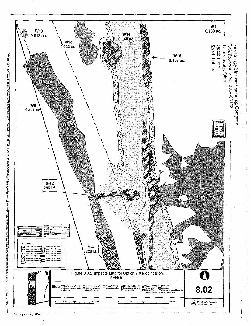
Figure 8.02. Impacts Map for Option 1.8 Modification. FENOC.
W15 0.157 ac.
·C~J•rt -io.~~ngVohlelo llardet ~ •U>f .. <IS~•amlmj>><I• -s~oam{!n!om'dte") llZJ~•ctW.U.r>dJrnpo<I> Dll'lk~•od{PEJ.lSS) ! ~ -slud-(At•• " • PrcpoHd \1;.!U;lo Barrio< E3 Ohct S!reom 1'1'•<!0 !""!Slt••m (f'mnnbQ 1:l3!odlmt'ol\>U.M lorpa'b 011'\M•n<l (PSS) CIPO>!e<t!Voo
Basemap courtesy of Esri.
-T,.n••ct -s~oom(Epl>Olnm~ c,::)V.~Ua/'l<l(flOI.!) CJl'lklbod(f'FO) E:IDh<l!~a<l/lso•/S~oama•d
•.m G,OOOF«l ,____~~~~~~~~
\\r.U.nd{Ol'l'11.o) G'.lJodl'ect!orpa<tAt ..
W1 0.183 ac.
8.02
0 Lt) .,
s: ~ ... c-i
mlfl r----HHH! ~~;~~~~ tt[[tt~
~~i~i~~ Ell<JlilQB IB HHHH ~m~'.1c~~~m HHHH 1' "2 1l 1l 1' 1' 1 1'
~~~~~~~~ ,-,. r.l ''0"1JH'1 b.l::iu• 1 ~~-lJ
PXW'lHNO!l8 811\J 8/\3(:1
...: .., ....: ch <D
~
\ ... \ \ • \ \·
\ • \
···-, ·.
\... .,
. ·: ,.u._ :co ··.ca:: S:" ... ,_,g.
t,): :.·(ti·
co.-·--S: ra
0 0,
ci
c<i 0 cri £'! "' Ol
U::
M 0
• co
' ! j~
•lU itll ~DOG
§~o~ w "' .... 5 ii it ~ ;g ;!I ,!'I
HH BBD
il i 1-'l! 'l! :r ,!~~ ~"' .,, ;3]~ 81l8
II iJ Ill
1] E' e _@' 11
~i~ "" ' i] 1l ~mi ~~ •• d ., "o Ii~ ;:j J: ~ I : I
J • ---...... .. ,..._.
!ll ~o • cO !!}!::
~{ ]~
{%]
i
~
!
! ~
~
~
FirstEnergy Nuclear Operating Company DIA Processing No. 2014-00108
Lake County, Ohio Quad'. Perry Sheet 5of12 f10~HR:~ :alea
(1:!11 _ _.\ _____ , __ _::~~" II
l·i:O ~ 0
f g.
~ ~

8
\.
W9c 0.015 ac.
W9d 0.084 ac.
PfOMosa!o
[Zl"""""!Pf"W>l""'"'I
:!.~.·"''°'"'"'""""'
W9e 0.024 ac.
E:]..,,..M(l'<O((ll! ""'""""<! •• ':\::"""""'l"f04<h».. /M;-~ GD,.,_..,.{Pi,,.,,..,,, ""!PF"'""""'"" i¥,:s.t:.'"""'"'!1'"'""'""'"'1-""""'(PFO-•••>•••<I f'"hv""""!"fO"'~~c:il""""'"""""'""'»i c::;:)1•"''""l"f0 .... _
W9a 45'/o tl'IQsaic
o,118 ac.
W26 0.082 ac.
W7 0.008 ac.
Figure 8.04. Impacts Map for Option 1.8 Modification. FENOC.
•CIJ!.l•d -El<l•ti"'.1\%1:!oEllolor ··~~oo!Str .. nlmp•ol• -str .. m~t<rmllol'll) E:lJOh<IWotloMinp.><I< t:!JWoUand(PEMSS) i ·, Si<Jd)'AI•• • •Propo,ed Ve~lo E».rll•r 8 0•«1 S~oarn!mp•<" !!!!!! Strum (P<<0nr'll>~ i:£11oa'l'•<I Vl~l~nd lmpools DIW.1,.nd (PSS) QPr<f«IAroa -Tran,.tl -Slr••m(Ef4io:noraij DWoU;rnd(PEl.I) CIWoUond(PFO) DO~o<llJl'l>O<IArea/SkoamB•d
Wet,.nd(<:.'h~•) 0!11<1;oellmpo<IAte•
Basemap courtesv of Esrl.
W4a 15.876 ac.
W4a 40'/o mosaic
0.098 ac.
W4i 0.526 ac.
0 8.04

<O
I ['--Ii
I I I I
' I I
~·- >3~ . "''H'in
' ' ,.
!~-!~-' ' i : l : ~ I ~ I!~ ~
. . I / 1 ll j Jm
I "' Ii 'llPi !! II I ~ I t_: !l1
I~: •1 1i'l1 11 i ! i ! 0
11 ii,. ,1 ,._ s l! !! I !! ' . "~ ~sll:~ ;; ~~1~li~ ! " "!!! . ll 11 ii ' jll'l a~ ~g I !'''! ' ~ ~~~~ ~
i ! ~ 2g c> "'
~ ~~ r ~ ; . 0 () OJ
FirstEnergy Nuclear Operating Company DI A Processing No. 2014-00108
Lake County, Ohio ([R''I] Quad Perry : 'ill': Sheet 8 ofl2
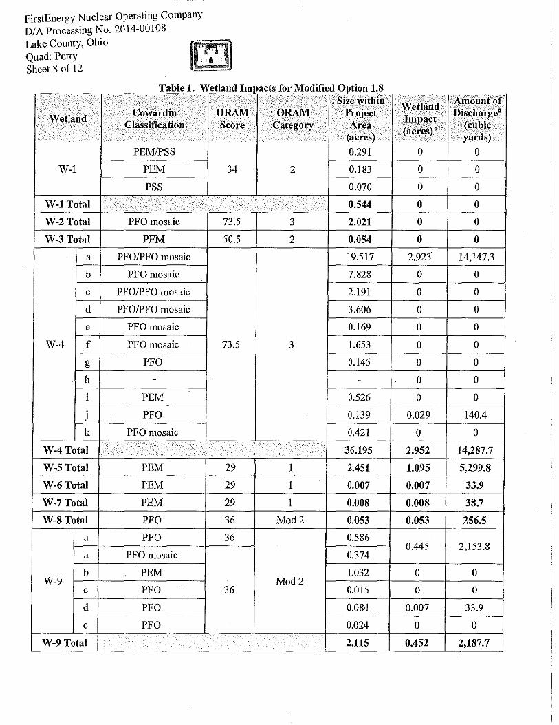
T bl 1 W ti d I a e . e an fi M dT d 0 . 18 mJlacts or o 11e 1pt10n ..
' .
Size within Cowardin ORAM ORAM Project Wetland .
Classification .
Score Category Area . . . . ·. . (aeres) .
PEM/PSS 0.291
W-1 PEM 34 2 0.183
PSS 0.070
W-1 Total .. ·. .
0.544 .. ·. . • . .
W-2 Total PFO mosaic 73.5 3 2.021
W-3 Total PEM 50.5 2 0.054
a PFO/PFO mosaic 19.517
b PFOmosaic 7.828
c PFO/PFO mosaic 2.191
d PFO/PFO mosaic 3.606
e PFO mosaic 0.169
W-4 f PFOmosaic 73.5 3 1.653 .
g PFO 0.145
h - -.
i PEM 0.526
j PFO 0.139
k PFO mosaic 0.421 .
W-4Total 36.195 .
W-5Total PEM 29 I 2.451
W-6Total PEM 29 I 0.007
W-7Total PEM 29 I 0.008
W-8Total PFO 36 Mod2 0.053
a PFO 36 0.586
a PFOmosaic 0.374
b PEM 1.032 W-9 Mod2
c PFO 36 0.015
d PFO 0.084
e PFO 0.024 .
W-9 Total 2.115 .
.·· Amo.untof
Wetland Discharge# Impact
(cubic (acres)* ·· . . . yards)
0 0
0 0
0 0
0 0
0 0
0 0
2.923 14,147.3
0 0
0 0
0 0
0 0
0 0
0 0
0 0
0 0
0.029 140.4
0 0
2.952 14,287.7
1.095 5,299.8
0.007 33.9
0.008 38.7
0.053 256.5
0.445 2,153.8
0 0
0 0
0.007 33.9
0 0
0.452 2,187.7

Size within Wetland . . Coward in . ORAM ORAM Project Wetland
Classification Score Category Area . Impact
. (acres) . (acres)* . .
W-lOTotal PEM 29 I 0.018 0
W-11 Total PEM 29 I 0.047 0
W-12 Total PEM 29 I 0.017 0
W-13 Total PEM 27 I 0.322 0
W-14 Total PEM 27 I 0.140 0.140
W-15 Total PEM 27 I 0.157 0.157
W-16 Total PEM 27 I 1.123 0
W-17 Total PEM 27 I 0.043 0
W-18 Total PEM 27 I 0.023 0
W-19 Total PEM 50.5 2 0.264 0
W-20 Total PEM 50.5 2 0.031 0
W-21 Total PEM 50.5 2 0.031 0
W-22 Total PEM 50.5 2 0.257 0
W-23 Total PFO 50.5 2 0.013 0
W-24Total PEM 50.5 2 0.049 0
W-25Total PEM 50.5 2 0.045 0
W-26Total PEM 38 2 0.082 0.082
Total PEM Wetlands 6.910 1.488
Total PEM/PSS Wetlands 0.291 0
Total PSS Wetlands 0.070 0
Total PFO/PFO mosaic Wetlands 38.839 3.456
Total Wetland 46.110 4.944" *accounts for both dll'ect and 1ndirect impacts Adue to rounding error, total Wetland Impact sums to 4.946 acres but is actually 4.944 acres #total cubic yards greater when added than multiplied due to rounding
FirstEnergy Nuclear Operating Company DI A Processing No. 20 I 4-00108 Lake County, Ohio Quad: Perry Sheet 9of12
Amonntof Discharge#
(cubic yards)
0
0
0
0
677.6
759.9
0
0
0
0
0
0
0
0
0
0
396.9
7,202.0
0
0
16,731.9
23,933.9

FirstEnergy Nuclear Operating Company DIA Processing No. 2014-00108 Lake County, Ohio m Quad: Perry Sheet 10of12
Table 2. Stream Impacts for Modified Option 1.8
I . .. .. Stream
... . . ... Stream Stream Water
Length Area · Impacts- Impacts:~ Impacts- I Amountof
I Depth at· Within .
Stream Type Bankfull Time of·
.. Within ,. Project Length of Widtnof Area of Discharge
Width (feet) •. Project Area Proposed Proposed 1
·Proposed (cubic Survey Qinear feet) .
Area · ·.• .. '· Impacts Impacts* yards) (inch) .. (acres) .. , Impacts ··
•· . mnear feet) , . (feet) (acres) . ·. . . ... . .
S-1 perennial 7 6 2,131 0.342 0 0 0 I 0
S-2 ephemeral 0.4 0.5 55 0.001 0 0 0 0
S-3 intermittent 4.5 3 466 0.048 466 4.5 0.048 233.0
S-4 intermittent 4.3 5 3,226 0.318 2,571 4.3 0.254 1,428.3
S-5 intermittent 3.5 3.5 1,022 0.035 0 0 0 0
S-6 perennial 4 4 58 0.005 0 0 0 I 0
S-7 ephemeral 1 0 54 0.001 0 0 0 I 0
S-8 ephemeral 0.5 0 30 0.001 0 0 0 I 0
S-9 I ephemeral 1 I 116 0.003 0 0 0 I 0
S-10 I ephemeral 1.5 0 16 0.001 0 0 0 I 0
S-11 I ephemeral 0.5 1 177 0.002 I 0 I 0 I 0 I 0 -
S-12 I ephemeral I 1.5 I 4 206 0.007 206 1.5 0.007 34.3
Total Ephemeral Stream 653 0.016 206 - 0.007 34.3
Total Intermittent Stream 4,714 0.401 3,036 - 0.302 1,661.3
Total Perennial 2,189 0.347 0 - 0 0
Total Stream I 7,556 0.764 3,242 - 0.309 1,695.6
*accounts for both direct and indirect impacts A due to rounding error, total intermittent stream impacts is 2,090 linear feet instead of2,091 linear feet

-0
" E "' c: c:
:::>
~ z -0
" "' 0 c. 2
o._
N ~ ::> .21 LL
FirstEnergy Nuclear Operating Company DIA Processing No. 2014-00108
Quad: Perry , , Lake County, Ohio fl' fi]J Sheet 11 of 12 · ' ' lit' '
·."! ',_'' \
·~
'• I ,.
:~
·' --)
I
/
'-' - ::.'../
'•,, .
r.;.
.' -.. . < >'-
·,:' -~~ . •.
"S
~~ .. "\._'":
. ~ '-0' "';"
.... "''
'/ /
.)-.
•·I
. "''
' '
. ·,
..
·~-.
.·
- ' :·
_\-.'
\-.·

FirstEnergy Nuclear Operating Company D/AProcessingNo. 2014-00108
Lake County, Ohio ll'.'f;1II]. Quad: Perry ' , Sheet 12 of 12 ' ' 11 ' '
2:1 or 3:1 grade out
I I I I
'Topsol! 0.5ft to finish grade
Figure 3. Typical Cross Section
Proposed Typical Cross section
Bankfull Width 11 ft
/ Gravel SubS!rate 0.75ft I I I I
TcipSOiro.stttOfiiifSh grade
I t
1-------------------------------------------------------------------------------------1 Floodplain Width 32ft
Conceptual Minor Creek
width=11.0 area=8.33 mean depth= 0.75 w/d=14.66 max depth 1.3

February 3, 2014 Biodiversity Database Program Division of Wildlife Ohio Department of Natural Resources 2045 Morse Road, Building G-3 Columbus, OH 43229-6693
Re: Data Request Perry Nuclear Plant Property Lake County, Ohio
To Whom it May Concern: Please find attached information regarding the Perry Nuclear Plant Property. Please perform a records search and respond with any information regarding ecological important species or habitat associated with the property or within the adjacent properties. The information will be used to complete the ORAM evaluation for wetlands within the project area located in the City of Perry, Lake County, Ohio. If you have any questions I can be reached at (330) 688-0111 or email [email protected]. Respectfully,
Emmalisa Kennedy Wetland Ecologist Attachment

DATA REQUEST FORM
OHIO DEPARTMENT OF NATURAL RESOURCES DIVISION OF WILDLIFE OHIO NATURAL HERITAGE PROGRAM 2045 MORSE RD., BLDG. G-3 COLUMBUS, OHIO 43229-6693 PHONE: 614-265-6452; EMAIL: [email protected]
INSTRUCTIONS:Please complete both pages of this form, sign and return it to the address or email address above along with: (1) a brief letter describing your project, and (2) a map detailing the boundaries of your project site. A copy of the pertinent portion of a USGS 7.5 minute topographic map is preferred but other maps are acceptable. Data requests will be competed within approximately 30 days. If you email your request you do not need to mail the original unless otherwise requested.
FEES:As of June 2010, we have temporarily suspended charging a fee until a review of the data request process has been completed.
WHAT WE PROVIDE: The Natural Heritage Database is the most comprehensive source of information on the location of Ohio's rare species and significant natural features. Records for the following will be provided: plants and animals (state and federal listed species), high quality plant communities, geologic features, breeding animal concentrations and unprotected significant natural areas. We also provide locations for managed areas including federal, state, county, local and non-profit sites, as well as state and national scenic rivers. A minimum one mile radius around the project site will automatically be searched. Because the data is sensitive information, it is our policy to provide only the data needed to complete your project.
**************************************************************************************************** 12/04/13 EnviroScience, Inc. Date: _____________________ Company name: __________________________________
Name of person response letter should be addressed to: Mr. Ms. Emmalisa Kennedy____________________________________________________________________________
5070 Stow Road Address: ____________________________________________________________________
City/State/Zip: ________________________________________________________________ Stow, Ohio 44224
Phone: ________________________________ Fax: ________________________________ 330-688-0111 330-688-3858
E-mail address: ______________________________________________________________ [email protected]
Project Name: ________________________________________________________________ FlavorSeal Site
Project Number: ______________________________________________________________ 6301

Project Site Address: __________________________________________________________
Project County: _______________________________________________________________
Project City/Township: __________________________________________________________
Project site is located on the following USGS 7.5 minute topographic quad(s): ______________
____________________________________________________________________________
____________________________________________________________________________
Project Latitude and Longitude if available (decimal degrees is preferred): ________________
____________________________________________________________________________
Description of work to be performed at the project site: ________________________________
____________________________________________________________________________
____________________________________________________________________________
How do you want your data reported? (Both formats provide exactly the same data. The only difference is in the format of our response. The manual search is most appropriate for small scale projects or for those who do not have GIS capabilities. Please choose only one option.)
Printed list and map (manual search) ______ OR GIS shapefile (computer search) __________
Additional information you require: ________________________________________________
____________________________________________________________________________
____________________________________________________________________________
How will the information be used? ________________________________________________
____________________________________________________________________________
____________________________________________________________________________
I certify that data supplied by the Ohio Natural Heritage Program will not be published without crediting the ODNR Division of Wildlife as the source of the material. In addition, I certify that electronic datasets will not be distributed to others without the consent of the Division of Wildlife, Ohio Natural Heritage Program.
Signature ________________________
Date: ____________________________
DNR 5203 REV 8/2010
35179 Avon Commerce Parkway
Lorain
Avon
Avon Quadrangle
The project area is the site for a new industrial building.
41.475225 oN,-82.001359
oW
1. Indiana bat records within 5 miles
3. date of each record
ORAM evaluation
12/04/2013
2. Indiana bat hibernacula within 10 miles
X

qFigure 2. USGS 7.5-minute
Topographic Map of
Perry Quadrangle.
First Energy Coroporation.
Date: 1/30/2014 Path: P:\Ecological Survey\W
etlands\First Energy Corporation\G
IS\M
ap2_Topo.m
xd
Basemap courtesy of National Geographic Society (2013).
Project Area
1,000 0 1,000500 Feet
300 0 300150 Meters

Ohio Division of Wildlife Scott Zody, Chief
2045 Morse Rd., Bldg. G Columbus, OH 43229-6693
February 10, 2014 Emmalisa Kennedy EnviroScience, Inc. 5070 Stow Road Stow, OH 44224 Dear Ms. Kennedy After reviewing the Natural Heritage Database, I find the Division of Wildlife has two records in the Perry Nuclear Plant Property project area in the City of North Perry, Lake County, Ohio. The state threatened spotted turtle (Clemmys guttata) was reported from swampy areas in the 1986 Annual Report of the Perry Plant Ecological Monitoring Program. The site was described as a notable Mixed Mesophytic Forest by the Division of Natural Areas & Preserves in 1981. We have no records for Indiana Bat (Myotis sodalis) capture locations within a five mile radius or hibernacula within a ten mile radius of the project site.
Our inventory program has not completely surveyed Ohio and relies on information supplied by many individuals and organizations. Therefore, a lack of records for any particular area is not a statement that rare species or unique features are absent from that area. Although we inventory all types of plant communities, we only maintain records on the highest quality areas. This letter only represents a review of rare species and natural features data within the Ohio Natural Heritage Database. It does not fulfill coordination under the National Environmental Policy Act (NEPA) or the Fish and Wildlife Coordination Act (48 Stat. 401, as amended; 16 U.S. C. 661 et seq.) and does not supersede or replace the regulatory authority of any local, state or federal agency nor relieve the applicant of the obligation to comply with any local, state or federal laws or regulations.
Please contact me at 614-265-6452 if I can be of further assistance. Sincerely,
Greg Schneider, Administrator Ohio Natural Heritage Database Program
GREGORY LIPPS, LLC 1 4 7 3 C o u n t y R o a d 5 - 2 | D e l ta , O h i o | 4 3 5 1 5 | P h o n e : 4 1 9 . 3 7 6 . 3 4 4 1 | G r e g L i p p s @ g m a i l . c o m | G r e g L i p p s . c o m
A m p h i b ia n a n d R e p t i l e S u r v e y s | G I S S o l u t io n s | C o n s e r v a t io n
August 25, 2014 Bi l l Beach Environmental Department First Energy Corp 76 S Main St. Akron, OH 44308 Re: Results of Spotted Turt le surveys at the Perry Nuclear Power Plant, Lake County, Ohio Dear Mr. Beach: This letter provides the results of a survey for the Spotted at a project si te located on the property of First Energy's Perry Nuclear Power Plant (PNPP) in Lake County, Perry Township, Ohio (Figs. 1 and 2). The survey was requested by the Ohio Division of Wildl i fe in response to a proposed project to develop addit ional drainage to the east of the PNPP faci l i t ies. The Spotted Turt le is a small freshwater turt le that inhabits shal low-water wetlands of the east coast and the Great Lakes Region. These wetlands may include bogs, fens, wet prair ies, vernal pools, the margins of ponds and lakes, or even roadside ditches. Individuals often use mult iple small seasonal wetlands and may spend as much as 74% of their t ime in upland areas. Seasonal act ivi ty is greatest in May and Apri l , al though individuals may occasional ly be active as early as January, i f condit ions permit. Nesting activi ty peaks in early June and is usual ly fol lowed by a period of summer dormancy (estivat ion). During this t ime, Spotted Turt les usually create and crawl into “forms,” depressions in heavy organic soi ls, leaf l i t ter, stump holes or other such areas where they remain mostly inactive. The Spotted Turt le is l isted as a threatened species by the Ohio Division of Wildl i fe. A previous investigat ion of Spotted Turt les at PNPP from 1981 to 1986 reported 154 captures of 66 individual turt les, with an estimated populat ion of 148 individuals in 19861. At the t ime, this was bel ieved to be the largest populat ion of Spotted Turt les in the state. A map showing the general location of the “Spotted Turt le Study Area” of the 1980s surveys was georecti f ied and overlaid on a current aerial image (Fig. 3). This shows that most of the current survey area is located north of the area previously
1 Friday, G.P., D.E. Collins, A.M. Hale. 1986. Annual Report of Perry Plant Ecological Monitoring Program. NUS Corporation, Gaithersburg, Maryland.
Gregory Lipps, LLC. Page 2 of 10
identi f ied as being occupied by Spotted Turt les. The two overlap along the transmission l ine r ight-of-way. The “abandoned f ield” ident i f ied in the 1980s is behind a securi ty fence and could not be accessed for the current survey. METHODS On 2 Apri l 2014, the project area was visi ted to examine the wetlands and other habitat found on the si te. As this was prior to the leaf-out of the vegetat ion, a thorough inspect ion was possible (Fig. 4). The goal of this visi t was to identi fy areas within the project area that may be suitable for support ing Spotted Turt les. Special attent ion was given to locations that appeared to have a longer hydroperiod, and are more l ikely to support a diverse aquatic community. This included looking for obl igate wetland vegetation, l istening for cal l ing frogs, and noting salamander eggs and spermataphores. Also noted were wetlands having an open or part ial ly open canopy, where Spotted Turt les are l ikely to remain after leaf-out, and also small streams, especial ly those that connect lent ic habitats. Spotted Turt les are known to use such streams extensively, especial ly to travel between wetlands. On 13 May 2014, 24 aquatic funnel traps (36" X 12", Promar TR-502) were deployed throughout the project area (Fig. 2). These traps were placed so that a port ion of the trap was out of the water to prevent drowning of trapped organisms. Each trap was baited with canned sardines along with a decoy Spotted Turt le made from a toy turt le. Previous studies have shown that decoys increase Spotted Turt le captures2. At each locat ion, traps were placed to maximize the l ikel ihood of capturing turt les. This included using structures in the water such as logs or grass hummocks as natural dr i f t fences to guide animals to the trap entrances. The ambient (air) and water temperature was recorded at each deployment or check of the traps. Traps were checked dai ly. Organisms captured were ident i f ied, recorded, and released at the point of capture. Bait was replaced as needed. Visual encounter surveys (VES) were conducted by slowly walking through the wetlands and scanning logs and the banks for basking turt les. In addit ion, polarized sunglasses al lowed for observations of turt les in the water. VES occurred during the ini t ial visi t to the si te and during trap placement, checking, and retr ieval. RESULTS Trapping occurred from 13 May–16 May and 3–5 June 2014 for a total of 120 trap-days (5 days X 24 traps). The ambient temperature ranged from 8.7–28.6oC (mean: 19.0oC). Water temperature ranged from 12.9–23.4oC (mean: 17.4oC). A summary of the amphibians, repti les, and crayf ish captured in the traps is provided in Table 1 and photographs are provided in Figure 6. No state or federal ly l isted amphibian or rept i le species - including Spotted Turt les - were found at any of the three si tes. Other amphibian species observed but not captured in the traps include the Spotted Salamander (Ambystoma maculatum , eggs and larvae), Jefferson Salamander (Ambystoma jeffersonianum , eggs), Wood Frogs (Lithobates sylvat icus) , and Spring
2 Mansfield, P., E.G. Strauss, and P.J. Auger. 1998. Using decoys to capture spotted turtles (Clemmys guttata) in water funnel traps. Herpetological Review 29:157-158.
Gregory Lipps, LLC. Page 3 of 10
Peepers (Pseudacris crucifer). An Eastern Gartersnake (Thamnophis sir tal is sir tal is) is the only other rept i le observed during the survey. Table 1. Amphibians, reptiles, and crayfish captured in aquatic funnel traps at the Perry Nuclear Power Plant. Numbers indicate the number of observations and not necessarily the number of distinct individuals; some individuals may have been captured more than once.
The only turt le species detected at the PNPP was the Snapping Turt le. The three individuals captured in the traps included two yearl ing turt les and one juvenile. In addit ion to those three, an addit ional two small adult Snapping Turt les were observed during VES, one in a wetland along the transmission l ine r ight-of-way and one in a small stream within the forested tract north of the r ight-of-way. CONCLUSION No Spotted Turt les were detected within the PNPP project area. Trapping and VES took place during mid-May, when Spotted Turt le activ i ty is greatest in Ohio, and also in early June, when turt les are l ikely to begin nesting and prior to their summer dormancy3. Using the same techniques, the author has captured over 100 Spotted Turt les across northern Ohio. The previous Spotted Turt le surveys of PNPP from 1981–1986 using VES alone resulted in an average of nearly 26 captures per year (range: 20–40). The survey area of the 1980s, however, only sl ightly overlapped that of the current survey. I t appears that most of the previous captures came from an area south of current survey, in an area of old f ield and shrub-scrub. This area is inside of a securi ty fence and permission to access this area could not be obtained for the current survey. There are three plausible explanations for the di f ference in the previous versus the current survey: 3 Lovich, J.E. 1988. Geographic variation in the seasonal activity cycle of spotted turtles, Clemmys guttata. Journal of Herpetology 22(4):482-485.
Species Total Number Captured
Snapping Turt le (Chelydra serpentina)
3
American Toad (Anaxyrus americanus)
1
Green Frog (Lithobates clamitans)
11
Tadpole (Lithobates sp.)
2
Crayf ish 73

Gregory Lipps, LLC. Page 4 of 10
1) Spotted Turt les at PNPP do not ut i l ize the forested area north of the transmission l ine r ight-of-way, and the results of the current survey say nothing of the populat ion previously surveyed;
2) Use of the project area by Spotted Turt les is rare, perhaps only occurr ing under specif ic environmental condit ions not experienced during the current survey; or,
3) Spotted Turt les have been extirpated from PNPP. Determining which of these explanations describes the current si tuation at PNPP would require expanding surveys to include the areas covered in the 1980s surveys. While this area is outside of the current project area, future surveys in the area would be important to further our understanding of the status of Spotted Turt les in the state and could also be useful in natural resource management plans for PNPP and potent ial mit igat ion opportunit ies. At the completion of the 1980s surveys, the PNPP Spotted Turt le population was bel ieved to be the largest in the state. The current survey did not detect Spotted Turt les uti l iz ing the project area investigated during May and June of 2014. I t is therefore my opinion that the project is unl ikely to directly impact the Spotted Turt le. I appreciate the opportunity to provide my services to First Energy. Please do not hesitate to contact me by email (GregLipps@gmail .com) or by phone (419-376-3441) should you have any further questions or wish to discuss this further. Sincerely, Gregory Lipps Attachments: figures

Gregory Lipps, LLC. Page 5 of 10
Figure 1. USGS 7.5 minute topographic map showing the location of the proposed project area at the Perry Nuclear Power Plant.
Gregory Lipps, LLC. Page 6 of 10
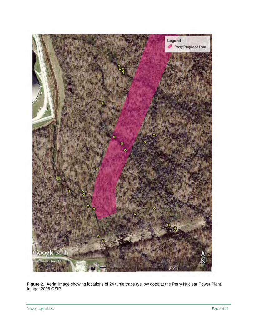
Figure 2. Aerial image showing locations of 24 turtle traps (yellow dots) at the Perry Nuclear Power Plant. Image: 2006 OSIP.

Gregory Lipps, LLC. Page 7 of 10
Figure 3. The area of Spotted Turtle habitat identified in the 1980s is shown overlaid on a Google Earth aerial image. Trapping locations of the current survey are indicated with yellow dots. The overlaid image was originally included as Figure 9 in the 1986 report with the caption “Habitat Interspersion at the Spotted Turtle (Clemmys guttata) Study Area, 1986.” The text of the report states that the “principle study area for the spotted turtle on the PNPP…includes the…transmission line right-of-way, and the ephemeral pools and streams adjoining it to the south (Figure 9).” Most of this area is south of the current project area and behind a security fence and was not included in the current survey.

Gregory Lipps, LLC. Page 8 of 10
Figure 4. Examples of the wetlands observed within the project area on 2 April 2014 (top), prior to leaf-out of the vegetation and on 13 May 2014 (bottom).

Gregory Lipps, LLC. Page 9 of 10
Figure 5. Aquatic funnel traps in place in a small woodland stream (top) and in wetlands along the transmission line right-of-way (bottom). Traps were baited with sardines and a decoy (toy) Spotted Turtle.

Gregory Lipps, LLC. Page 10 of 10
Figure 6. Amphibians and reptiles observed during the survey, include Snapping Turtle (Chelydra serpentina) young (A) and adult (B); Green Frog (Lithobates clamitans, C); American Toad (Anaxyrus americanus, D); Eastern Gartersnake (Thamnophis sirtalis sirtalis, E); Spotted Salamander (Ambystoma maculatum) eggs (F); and, Ambystoma sp. spermataphores (G).
A B
CDE
F
G
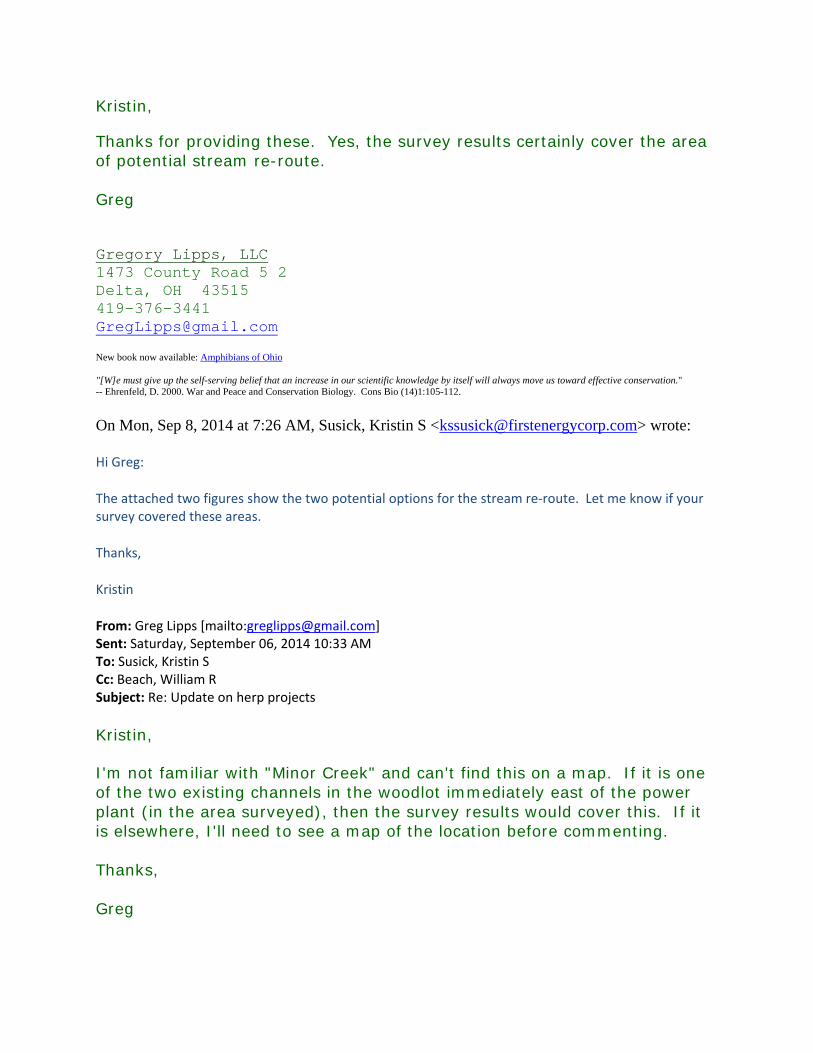
Kristin,
Thanks for providing these. Yes, the survey results certainly cover the area of potential stream re-route. Greg Gregory Lipps, LLC 1473 County Road 5 2 Delta, OH 43515 419-376-3441 [email protected]
New book now available: Amphibians of Ohio "[W]e must give up the self-serving belief that an increase in our scientific knowledge by itself will always move us toward effective conservation." -- Ehrenfeld, D. 2000. War and Peace and Conservation Biology. Cons Bio (14)1:105-112. On Mon, Sep 8, 2014 at 7:26 AM, Susick, Kristin S <[email protected]> wrote:
Hi Greg:
The attached two figures show the two potential options for the stream re‐route. Let me know if your survey covered these areas.
Thanks,
Kristin
From: Greg Lipps [mailto:[email protected]] Sent: Saturday, September 06, 2014 10:33 AM To: Susick, Kristin S Cc: Beach, William R Subject: Re: Update on herp projects
Kristin,
I'm not familiar with "Minor Creek" and can't find this on a map. If it is one of the two existing channels in the woodlot immediately east of the power plant (in the area surveyed), then the survey results would cover this. If it is elsewhere, I'll need to see a map of the location before commenting. Thanks, Greg

Gregory Lipps, LLC 1473 County Road 5 2 Delta, OH 43515 419-376-3441 [email protected]
New book now available: Amphibians of Ohio
On Mon, Aug 25, 2014 at 2:12 PM, Susick, Kristin S <[email protected]> wrote:
Thanks Greg. We are looking at two other potential options for the Perry project. One option would have the new stream created just east of the east of the existing Minor Creek channel, the other would be a widening of the existing Minor Creek channel. With that in mind, would the results of your survey change at all/would you see a need to do additional sampling?
Thank you,
kristin
February 12, 2014
Angela Boyer United States Fish and Wildlife Service Ohio Field Office Ecological Services Field Office 4625 Morse Road, Suite 104 Columbus, Ohio 43230 (614) 416-8993 [email protected] Re: Section 7 Endangered Species Act Consultation
Perry Nuclear Plant Property Lake County, Ohio
Dear Ms. Boyer:
EnviroScience Inc. (ES) was contracted by FirstEnergy to coordinate endangered species project review for the Perry Nuclear Plant Property located in the City of North Perry, Lake County, Ohio. The latitude and longitude coordinates for the center point of the project area are 41.800742°N and -81.135022°W. To assist with your review several resource maps are included (Attachment A).
Project Purpose and Location
The purpose of FirstEnergy’s Perry Nuclear Plant Property project is in response to the Nuclear Regulatory Commission’s requirement to implement flood control measures at nuclear facilities in preparation for 500+ year flood event. The project includes diverting some flow from Minor Creek to create a new stream (S-1) running northeast and draining into East Stream (a perennial stream). S-1 will be approximately 3,800 feet and will drain northeastward into East Stream (a perennial stream) located along the eastern portion of the property. S-1 will be approximately 100 feet wide which includes the riparian corridor. A preliminary site reconnaissance has been conducted and the project area of approximately 4,200 lf by 200 lf will be surveyed following snow melt this spring. The 4,200 lf of project area to be surveyed includes two options for S-1 to enter East Stream.
Site Description
An aerial map (Attachment A; Figure 1) and a topographic map (Attachment A; Figure 2) of the project area are included for review. The maps show the project area as predominately forested with a small portion of new field in the northern portion of the project area. Four (4) streams are shown on the topographic map. These streams are indicated as perennial streams on the topographic map.

A preliminary sight reconnaissance of the project area was conducted in December 2013. The majority of the project area is composed of immature forested property with pockets of vernal pool wetland. Minor Creek (an intermittent stream) was observed flowing north to Lake Erie along the eastern edge of the Perry Nuclear Plant facility. East Creek (a perennial stream) was observed flowing northwest into Lake Erie. In order to complete the project, an area of approximately 8.7 acres (3,800 lf by 100 feet) will need to be cleared.
ES coordinated the site with the ODNR Division of Natural Areas and Preserves to obtain information on threatened and endangered species. ES requested records of rare, threatened and endangered species, unique ecological sites, geological features, animal assemblages, state wildlife areas, scenic rivers, nature preserves, parks and forests and other protected natural areas from the ODNR’s Natural Heritage Database. ES also requested information on Indiana bat capture locations within a five mile radius or hibernacula within a ten mile radius of the project area. The ODNR’s record results are located Attachment B.
Please consider the information above and respond with any potentially adverse effects to any federally listed, threatened, or endangered species within project area. A response to this request is appreciated prior to April 2014.
Please direct any questions and your response to Emma Kennedy at (330) 688-0111 and [email protected].
Respectfully,
Emmalisa Kennedy Wetland Ecologist
Enclosures
Emmalisa Kennedy EnviroScience, Inc. 5070 Stow Road Stow, Ohio 44224
United States Department of the Interior
FISH AND WILDLIFE SERVICE
Ecological Services 4625 Morse Road, Suite 104
Columbus, Ohio 43230 (614) 416-8993 I FAX. (614) 416-8994
February 27, 2014
Re: First Energy, Perry Nuclear Plant Property, Lake County, Ohio
Dear Ms. Kennedy, TAILS# 03El5000-2014-TA-0787
We have received your recent correspondence requesting information about the subject proposal. There are no Federal wilderness areas, wildlife refuges or designated critical habitat within the vicinity of the project area. The following comments and recommendations will assist you in fulfilling the requirements for consultation under section 7 of the Endangered Species Act of 1973, as amended (ESA).
The Service recommends that proposed developments avoid and minimize water quality impacts and impacts to high quality fish and wildlife habitat (e.g., forests, streams, wetlands). Additionally, natural buffers around streams and wetlands should be preserved to enhance beneficial functions. If streams or wetlands will be impacted, the Corps of Engineers should be contacted to determine whether a Clean Water Act section 404 permit is required. Best management practices should be used to minimize erosion, especially on slopes. All disturbed areas should be mulched and revegetated with native plant species. Prevention of non-native, invasive plant establishment is critical in maintaining high quality habitats.
ENDANGERED SPECIES COMMENTS: All projects in the State of Ohio lie within the range of the Indiana bat (Myotis soda/is), a federally listed endangered species. Since first listed as endangered in 1967, their population has declined by nearly 60%. Several factors have contributed to the decline of the Indiana bat, including the loss and degradation of suitable hibernacula, human disturbance during hibernation, pesticides, and the loss and degradation of forested habitat, particularly stands of large, mature trees. Fragmentation of forest habitat may also contribute to declines. During winter, Indiana bats hibernate in caves and abandoned mines. Summer habitat requirements for the species are not well defined but the following are considered important: ·
(1) dead or live trees and snags with peeling or exfoliating bark, split tree trunk and/or branches, or cavities, which may be used as maternity roost areas;

(2) live trees (such as shagbark hickory and oaks) which have exfoliating bark; (3) stream corridors, riparian areas, and upland woodlots which provide forage sites.
It appears that habitat exhibiting the characteristics described above may be present in the project area. Therefore, we recommend that any trees exhibiting any of the characteristics listed above, as well as surrounding trees, be saved wherever possible. However, if these trees cannot be avoided, they should only be cut between October 1 and March 31 . Alternatively, a summer survey could be conducted to determine presence or probably absence of this species. Surveyors must have a valid Federal permit.
If there is a Federal nexus for the project (Federal funding provided, Federal permits required to construct, etc.) then no tree clearing on any portion of the parcel should occur until consultation under section 7 of the Endangered Species Act of 1973, as amended, between the Service and the Federal action agency is completed. We recommend that the Federal action agency submit to this office a determination of effects to the Indiana bat for our review and concurrence.
If the applicant plans to clear trees prior to issuance of a 404 and/or 401 permit the following two conditions must be adhered to: 1) Section 7 consultation for the Indiana bat between the Service and the Corps of Engineers must be completed; and 2) No tree clearing on any portion of the parcel should occur until both the Corps and the Ohio EPA anticipate that issuance of both a 404/NWP and a 401 permit authorizing the project as a whole is imminent. This will ensure that clearing will be limited to the footprint of whichever alternative is ultimately permitted, and that no unnecessary clearing will occur. No tree clearing should occur until these two conditions have been satisfied.
All projects in the State of Ohio lie within the range of the northern long-eared bat (Myotis septentrionalis), a species that is currently proposed for listing as federally endangered. Recently white-nose syndrome (WNS), a novel fungal pathogen, has caused serious declines in the northern long-eared bat population in the northeastern U.S. WNS has also been documented in Ohio, but the full extent of the impacts from WNS in Ohio are not yet known.
During winter, northern long-eared bats hibernate in caves and abandoned mines. Summer habitat requirements for the species are not well defined but the following are considered important:
(1) Roosting habitat in dead or live trees and snags with cavities, peeling or exfoliating bark, split tree trunk and/or branches, which may be used as maternity roost areas; (2) Foraging habitat in upland and lowland woodlots and tree lined corridors; (3) Occasionally they may roost in structures like barns and sheds.
Should the proposed site contain trees or associated habitats exhibiting any of the characteristics listed above, we recommend that the habitat and surrounding trees be saved wherever possible. If the trees must be cut, further coordination with this office is requested to determine if surveys are warranted. Any survey should be designed and conducted in coordination with the Endangered Species Coordinator for this office.

The proposed project lies within the range of the Kirtland's warbler (Setophaga kirtlandii), a federally listed endangered species. The Kirtland's warbler is a small blue-gray songbird with a bright yellow breast. This species migrates through Ohio in the spring and fall, traveling between its breeding grounds in Michigan, Wisconsin, and Ontario and its wintering grounds in the Bahamas. While migration occurs in a broad front across the entire state, approximately half of all observations in Ohio have occurred within 3 miles of the shore of Lake Erie. During migration, individual birds usually forage in shrub/scrub or forested habitat and may stay in one area for a few days.
Migration is energetically demanding for birds of all species. During stop-over, birds are often faced with the need to acquire food in a short period of time, in unfamiliar surroundings, and while avoiding predators and competing with other migrants and resident birds for limited resources. Studies with captive migrants suggest that individuals in migratory disposition compensate for lost nighttime sleep by increasing the frequency of daytime sleep-like behaviors, potentially rendering them less able to quickly respond to disturbance.
In the spring, migrating Kirtland's warblers stopping over in Ohio will have traveled thousands of miles, will be immediately in need of food to satisfy energetic demands, and are thought to be racing to the breeding grounds to establish territories as early as possible. While fall migration is typically not as fast-paced as spring migration, it appears that fall migrating Kirtland's warblers do not build up fat reserves prior to initiating migration, and therefore nearby stopover habitat would be increasingly important for this species. Because so much of the southern Lake Erie shoreline is already developed, and stopover habitat is already so fragmented, a conservative approach such as avoiding impacts to suitable stopover habitat during the migratory period is appropriate to avoid and minimize potential adverse effects to Kirtland's warbler, as well as other migratory song birds.
Based on migration records ofKirtland's warbler in Ohio, as well as documented phenological patterns across the species' range, we recommend that suitable migration stopover habitat (scrub/shrub and forest habitat) within 3 miles of the shoreline of Lake Erie should be preserved whenever possible. If clearing of suitable habitat cannot be avoided, to preclude adverse effects to Kirtland' s warblers, clearing within 3 miles of the shoreline of Lake Erie should not occur from April 22nd_ June 15
\ or from August 15th _ October 15th.
BALD EAGLE COMMENTS: The project lies within the range of the bald eagle (Haliaeetus leucocephalus). Bald eagles are protected under the Migratory Bird Treaty Act (16 U.S.C. 703-712; MBTA), and are afforded additional legal protection under the Bald and Golden Eagle Protection Act (16 U.S.C. 668-668d, BGEPA). BGEPA prohibits, among other things, the killing and disturbance of eagles. To evaluate your project's potential to affect bald eagles, please visit: http://www.fws.gov/midwest/MidwestBird/EaglePermits/baeatake/index.html.
While our database of nest locations may not be complete because new nests are built each year, we currently have no records of bald eagle nests within 1h mile of your proposed project area. In order to avoid take of bald eagles, we recommend that no tree clearing occur within 660 feet of a bald eagle nest or within any woodlot supporting a nest tree. Further we request that work within 660 feet of a nest or within the direct line-of-site of a nest be restricted from January 15 through
July 31. This will prevent disturbance of the eagles from the egg-laying period until the young fledge, which encompasses their most vulnerable times.
Ifthese recommendations cannot be implemented and take of bald eagles is likely, a bald eagle take permit for this project may be necessary. Further information on eagle take permits can be found at: http://www.fws.gov/midwest/MidwestBird/EaglePermits/index.html.
Due to the project type, size, and location, we do not anticipate adverse effects to any other federally endangered, threatened, proposed, or candidate species. Should the project design change, or during the term of this action, additional information on listed or proposed species or their critical habitat become available, or if new information reveals effects of the action that were not previously considered, consultation with the Service should be initiated to assess any potential impacts.
These comments have been prepared under the authority of the Fish and Wildlife Coordination Act (48 Stat. 401, as amended; 16 U.S.C. 661 et seq.), the Endangered Species Act of 1973 (ESA), as amended, and are consistent with the intent of the National Environmental Policy Act of 1969 and the U. S. Fish and Wildlife Service's Mitigation Policy. This letter provides technical assistance only and does not serve as a completed section 7 consultation document. We recommend that the project be coordinated with the Ohio Division of Wildlife due to the potential for the project to affect state listed species. Contact Nathan Reardon, Environmental Review Coordinator with the Division of Wildlife, at (614) 265- 6741 or at [email protected].
If you have questions, or if we may be of further assistance in this matter, please contact Angela Boyer at extension 22 in this office.
cc: Nathan Reardon, ODNR, Division of Wildlife Jennifer Norris, ODNR, Division of Wildlife
Sincerely,
/n&Mf'~ Mary Knaa , Ph.D. ·Field Supervisor

Ohio Department of Natural Resources JOHN R. KASICll. GOVERNOR
October 1, 2014
Sent via e-mail
FirstEnergy Corporation Attn: Kristin S. Susick 76 South Main Street Akron, Ohio 44308 [email protected]
JAMES ZEHRINGER. DIRECTOR
Re: Site Visit Report for 10 Center Road, North Perry, Lake County, 14-T ALA-002
Dear Ms. Susick:
Thank you for meeting with the Ohio Department of Natural Resources, Office of Coastal Management to review your proposed project along the shore of the located at I 0 Center Road in North Perry, Lake County. Enclosed with this letter is a copy of the Site Assessment Report which includes observations made during the site visit, background information about the site, proposed project description and a summary of our discussions.
The Site Assessment Report also includes several recommendations regarding your proposed project and for submitting an application(s) for a Shore Structure Pennit and/or Submerged Lands Lease.
If you have any questions regarding this letter please contact either of us at ( 419) 626-7980. Thank you for your cooperation in helping to protect Lake Erie, Ohio's greatest natural resource.
Sincerely,
~i, /?~~~ Virginia Bahs
Natural Resources Engineer Property Management Specialist
Enclosure: Site Visit Assessment Report
ec: Scudder D. Mackey, Ph.D., Chief, Office of Coastal Management Steve Holland, Federal Consistency Administrator, Office of Coastal Management Saadat 0. Rouhani, FirstEnergy Nuclear Operating Company Emmalisa Kennedy, EnviroScience, Inc.
cc: File
OFFICE OF COAST AL MANAGEMENT 10!1 WFST SHORFI INF nRJVF SANnJ JSKY OH 44R7() 14Hl\ R?R-7!'.!R() I IRRR\ n44-R?n7

Technical A
Inspection Photographs
2012 USAbulkhead an
2012 USACchannel w
Assistance Si
Photos, Plats that best re
ACE obliquend basin cul
CE oblique awill outlet to
w
ite Assessme
t & Aerial Iepresent the
e aerial photvert. The proof bluff are
aerial photo oo Lake Erie awhereas the
ent Report –
Imagery site are attac
tograph of thoposed chan
ea to outlet th
of the projecalong this aretill material
First Energy
ched to this r
he project arennel spillwayhe landward
ct area east oea. The uppeis grey or da
y, 14-TALA
report.
ea along they option wou
basin to Lak
of the existiner bluff sandarker brown
Eastern tip
A-002
e eastern exteuld be constrke Erie.
ng bulkhead.d layer is lighn in color.
of the Bulkh
Page
ent of the exructed along
The proposht brown in c
head
e 8 of 13
xisting g the top
sed open color,

Technical Assistance Site Assessment Report – First Energy, 14-TALA-002 Page 9 of 13
2011 aerial imagery with the County Auditor’s 2010 parcel overlay. Site conditions and approximate
project locations identified.
1986 aerial imagery with the County Auditor’s 2010 parcel overlay. Site conditions after installation of the existing bulkhead. Note the erosion that has occurred east of the bulkhead based on a comparison
with the 2011 imagery.
N
N
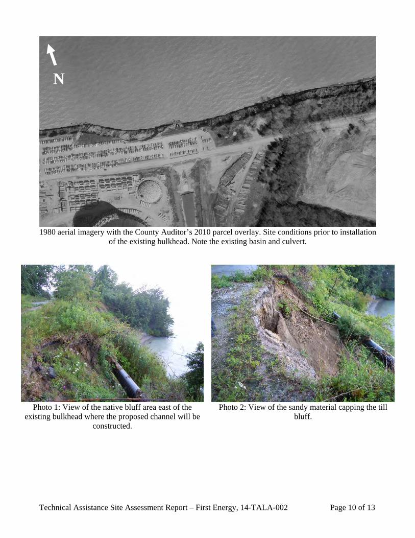
Technical Assistance Site Assessment Report – First Energy, 14-TALA-002 Page 10 of 13
1980 aerial imagery with the County Auditor’s 2010 parcel overlay. Site conditions prior to installation
of the existing bulkhead. Note the existing basin and culvert.
Photo 1: View of the native bluff area east of the
existing bulkhead where the proposed channel will be constructed.
Photo 2: View of the sandy material capping the till
bluff.
N

Technical Assistance Site Assessment Report – First Energy, 14-TALA-002 Page 11 of 13
Approximate locations of existing Submerged Lands Lease (red) & Minerals Non-Extraction Lease
(cyan)

Technical A
Project DraDesign and/
Assistance Si
awings & O/or permit dr
ite Assessme
ODNR Authorawings alon
Shore
ent Report –
orizations ng the area o
e Structure P
First Energy
f the propos
Permit 83-02
y, 14-TALA
ed project.
2 (Page 1 of 2
A-002
2)
Page 112 of 13
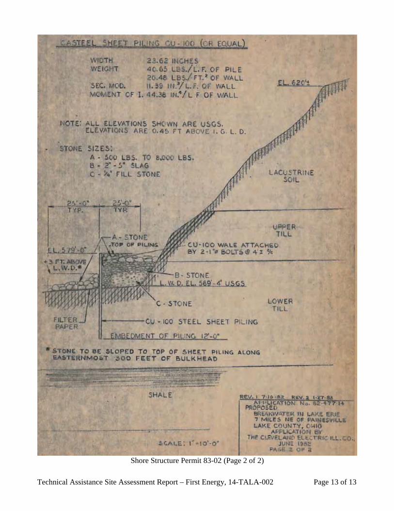
Technical A
Assistance Siite Assessme
Shore
ent Report –
e Structure P
First Energy
Permit 83-02
y, 14-TALA
2 (Page 2 of 2
A-002
2)
Page 113 of 13

Map created using the OHPO Online Mapping System. The Ohio Historic Preservation Office provides onlinedata for preliminary research and data gathering only. No guarantee is made concerning data accuracy,quality or timeliness. Oct 23, 2014
41-49 N
41-4
9 N
41-48 N
41-4
8 N
41-47 N
41-4
7 N
81-7 W
81-7 W
81-6 W
81-6 W
81-10 W
81-10 W
81-8 W
81-8 W
81-11 W
81-11 W
81-9 W
81-9 W
FirstEnergy Corporation
0 1300 2600 3900 m.
Legend
This map is a user generated static output from an Internet mapping site and is for generalreference only. Data layers that appear on this map may or may not be accurate, current, orotherwise reliable. THIS MAP IS NOT TO BE USED FOR NAVIGATION.
Notes: FirstEnergy Corporation (Perry Quadrangle, Lake County).
Date Created: 10/23/2014
Scale: 1:44,355Map center: 488620, 4627649 (UTM 17N)

Site Name: FirstEnergy Corporation
County: Lake
Quadrangle: Perry
Ohio Archaeological Inventory (Archaeological Sites) TOTAL: 0NUMBER SITE NAME UTM ZONE EASTING NORTHING
No resources found within radius
Ohio Historic Inventory (Historic Structures) TOTAL: 0NUMBER PRESENT NAME OTHER NAME ADDRESS UTM ZONE EASTING NORTHING
No resources found within radius
National Register Listed Properties (National Register Listings) TOTAL: 0NUMBER RESOURCE NAME ADDRESS UTM ZONE EASTING NORTHING
No resources found within radius
Determinations of Eligibility (NR Determinations of Eligibility) TOTAL: 0SER NO PROJECT NAME ADDRESS UTM ZONE EASTING NORTHING
No resources found within radius
Phase 1, 2, and 3 Surveyed Areas (Phase 1, 2, and 3) TOTAL: 0NUMBER PHASE AUTHOR YEAR TITLE
No resources found within radius
National Register Listed Districts (National Register Boundaries) TOTAL: 0NUMBER NAME OTHER NAME PROPERTIES
No resources found within radius