atershed audit identi fi cati on correction … audit identi fi cati on & correction of sediment...
TRANSCRIPT

WATERSHED AUDIT
IDENTIFICATION & CORRECTION OF
SEDIMENT POLLUTION SOURCES WITHIN
THE CUCKOLD CREEK WATERSHED
Prepared By
Richard D. Klein
Community & Environmental Defense Services
811 Crystal Palace Court
Owings Mills, Maryland 21117
410-654-3021
At The Request Of The
POTOMAC RIVER ASSOCIATIONStar Route, Box 56
Leonardtown, Maryland 20650
potomacriverassociation.org/

CONTENTS
SUMMARY . . . . . . . . . . . . . . . . . . . . . . . . . . . . . . . . . . . . . . . . . . . . . . . . . . . . . . . . . . . . . . . . . . . 1
INTRODUCTION . . . . . . . . . . . . . . . . . . . . . . . . . . . . . . . . . . . . . . . . . . . . . . . . . . . . . . . . . . . . . . . 1
WHY MUD POLLUTION IS A PROBLEM . . . . . . . . . . . . . . . . . . . . . . . . . . . . . . . . . . . . . . . . . . . . . 2
CURRENT SOURCES OF MUD POLLUTION IN THE CUCKOLD CREEK WATERSHED . . . . . . . . . . . . 4
Construction . . . . . . . . . . . . . . . . . . . . . . . . . . . . . . . . . . . . . . . . . . . . . . . . . . . . . . . . . . . 5
Cropland . . . . . . . . . . . . . . . . . . . . . . . . . . . . . . . . . . . . . . . . . . . . . . . . . . . . . . . . . . . . . . 5
Gullies . . . . . . . . . . . . . . . . . . . . . . . . . . . . . . . . . . . . . . . . . . . . . . . . . . . . . . . . . . . . . . . . 5
Mining . . . . . . . . . . . . . . . . . . . . . . . . . . . . . . . . . . . . . . . . . . . . . . . . . . . . . . . . . . . . . . . . 8
Other Mud Pollution Sources . . . . . . . . . . . . . . . . . . . . . . . . . . . . . . . . . . . . . . . . . . . . . . 9
FUTURE SOURCES OF MUD POLLUTION . . . . . . . . . . . . . . . . . . . . . . . . . . . . . . . . . . . . . . . . . . . . . 9
153-Acre Site . . . . . . . . . . . . . . . . . . . . . . . . . . . . . . . . . . . . . . . . . . . . . . . . . . . . . . . . . 11
Hollywood Business Center . . . . . . . . . . . . . . . . . . . . . . . . . . . . . . . . . . . . . . . . . . . . . . 16
Other Proposed Development Projects . . . . . . . . . . . . . . . . . . . . . . . . . . . . . . . . . . . . 16
Public Notice & Public Participation In The Development Review Process . . . . . . . 16
RECOMMENDATIONS . . . . . . . . . . . . . . . . . . . . . . . . . . . . . . . . . . . . . . . . . . . . . . . . . . . . . . . . . . 17
AN EXAMPLE OF WHAT CUCKOLD CREEK RESIDENTS COULD ACCOMPLISH . . . . . . . . . . . . . . 19

SUMMARY
In the Cuckold Creek watershed mud pollution is primarily a result of excessive soil erosionoccurring on construction sites, cropland, and in gullies. Mud pollution threatens the important andsensitive aquatic organisms inhabiting Cuckold Creek and its tributaries. It can also lower thevalue of homes located within 2,000 feet of the creek by 11%.
In an effort to curb the impact of current and future mud pollution, the Potomac RiverAssociation formed a partnership with those who live along the creek and elsewhere in thewatershed. Through this partnership a plan was drafted for identifying and correcting existingsources of mud pollution. Work completed thus far under this plan will eliminate the first andthird largest sources of mud pollution in the watershed. But future growth could easily undo thesesuccesses.
At this point in time there are 14 proposed development sites located within the CuckoldCreek watershed. Without greater care than has been exercised in the past each of these projectscould severely damage the Creek. Fortunately there are a number of steps which can be taken thatwill not only prevent harmful effects, but could actually use future growth as a tool to curb currentsources of mud pollution.
It would be a mistake to assume that mud pollution prevention measures will be fullyimplemented. In fact, the experience with current and past development argues against thisassumption. Nevertheless, there are excellent examples of how a mobilized citizen constituencyhas provided government with the support needed to fully protect a sensitive aquatic resource suchas Cuckold Creek. In other words, the future of the creek depends upon the actions of those whotreasure this unique waterway.
INTRODUCTION
In July, 1994, the Potomac River Association (PRA) retained Community & EnvironmentalDefense Services (CEDS) to prepare an assessment of the impact of existing and future land useupon the quality of the 57 tidal creeks and rivers located in Saint Mary’s County, Maryland. Thiseffort was funded through a grant from The A.S. Abell Foundation and other sources. The productwas a 203-page report entitled Opportunities to Preserve & Enhance the Quality of the SaintMary’s River and the County’s Tidal Creeks. While the report showed that future developmentcould have a devastating impact upon the County’s tidal waterways, it also showed that alternativemanagement policies would accommodate the need for growth while minimizing adverseenvironmental effects. In many cases, growth could actually improve water quality.
The Association recognized that implementing the alternative growth management policieswould require some rather substantial changes. Bringing these changes about would necessitatedramatic shifts in the development review process administered by the Saint Mary’s CountyDepartment of Planning & Zoning. Rather than calling for immediate implementation of thepolicies countywide, the Association opted for a more gradual and focused approach.
Cuckold Creek, one of five waterways addressed in detail in the report, was selected asthe testing ground for the alternative growth management policies. This is one of the highestquality tidal creeks in the County. The 7.5-square mile watershed of the creek is also slated for aconsiderable amount of growth. The creek also benefits from an active constituency which hasbeen working for many years to preserve its quality. These factors prompted the Association tofocus its efforts on Cuckold Creek.

2
1 Funderburk, S.L., S.J. Jordan, J.A. Mihursky, and D. Riley, 1991. Habitat requirementsfor Chesapeake Bay living resources. Chesapeake Bay Program, U.S. Environmental ProtectionAgency, 401 Severn Avenue, Annapolis, MD 21401.
Beginning on June 20, 1995, a series of meetings were held at Hollywood ElementarySchool. Every resident of the Cuckold Creek watershed was invited to the meetings. Approximately 10% of all watershed residents attended the first meeting. This tremendousshowing of interest clearly demonstrated widespread public concern about the future of the creek.
After reviewing what was known about the values and problems of Cuckold Creek, theAssociation asked the watershed residents to consider what specific issues were of greatestconcern. To facilitate this process a questionnaire was circulated to all those in attendance aswell as to those who could not make the first meeting. During subsequent meetings the residentsreviewed the responses to the questionnaire. Eventually the residents decided to focus upon mudpollution as the principle issue of concern. They felt that this issue impaired the quality ofCuckold Creek more so than any other.
The Association directed CEDS to develop a plan for identifying and correcting mudpollution sources impacting Cuckold Creek. The CEDS plan was set forth in a letter to ErikJansson, president of the Potomac River Association, dated February 15, 1996. The planconsisted on 14 specific actions and was funded through another grant from The A.S. AbellFoundation. The plan focused on the watershed of two tributaries to Cuckold Creek. One of thetributaries is known as Back Creek and the other is unnamed. The location of both watersheds isshown in Figure 1.
The results of the 14 actions are set forth in this report. But before getting into the findingsit would be helpful to review why mud pollution is such a concern to those who treasure CuckoldCreek
WHY MUD POLLUTION IS A PROBLEM
Mud pollution occurs when eroded soil or other sediment particles enter a waterway in quantitiesinjurious to aquatic life and other values. Mud pollution is primarily a product of excessive soilerosion, but it can also be caused by any other factor which increases the quantity of particlessuspended in a waterway or the rate at which these particles accumulate upon the bottom.
Mud pollution has been cited as a primary factor in the decline of a number of importantliving resources inhabiting the Chesapeake Bay system. Living resources impacted by mudpollution include submerged aquatic vegetation, oysters, shad, herring, perch, striped bass, andothers.1 Mud pollution also robs boating channels of depth.
Weems Creek, located in Annapolis, provides a startling example of the harm mudpollution can do. In the mid 1980's U.S. Route 50/301 was upgraded where it crossed theheadwaters of Weems Creek. Poor erosion and sediment control on the highway construction siteallowed thousands of tons of mud to enter the creek. Channels which formally had six feet of depthwere reduced to just a few inches of water.

3
Figure 1: Watershed of the Tributaries to Cuckold Creek

4
2 Location, Neighborhood Most Important Factors When Buying A Home, Housing NewsService, National Housing Center, 1201 15th Street, N.W., Washington, D.C. 20005-2800.
3 Economic Importance of the Chesapeake Bay, Office of Research, MarylandDepartment of Economic & Employment Development, 217 East Redwood Street, Baltimore, MD21202.
4 The effects of San Francisco Bay water quality on adjacent property values, Journal ofEnvironmental Management, 27:263-274.
5 Effects of sediment pollution upon the aquatic environment, Klein, R.D., MarylandTidewater Administration, Tawes State Office Building, Annapolis, MD 21401.
Homes located near a high quality waterway, such as Cuckold Creek and its tidaltributaries, enjoy enhanced value. But mud pollution can cause a dramatic decline in the value ofthese properties.
A recent study by the National Association of Home Builders found that homes locatedwithin 300 feet of a waterway sell for 28% more than comparable homes located elsewhere.2 TheMaryland Department of Economic & Employment Development found that homes located within2,000 feet of the Chesapeake Bay were worth $50,000 more than other homes.3 Many of thevirtues which increase the value of homes located near the Bay likely apply to properties locatedwithin view of Cuckold Creek and its tributaries.
While proximity to a high quality waterway adds to property value, homes located near apolluted waterway suffer a loss. If a waterway is noticeably “polluted” then the value of nearbyhomes will decline by 11%.4 Mud pollution is very noticeable. It imparts a cloudiness to awaterway which is obvious long after the last rain has occurred. If mud pollution is severe, as inthe case of Weems Creek, then the economic impact can far exceed an 11% decline in propertyvalue.
CURRENT SOURCES OF MUD POLLUTION IN THE CUCKOLD CREEK WATERSHED
Though soil erosion occurs on all lands, not all lands are sources of mud pollution. The soilerosion occurring in forests and on pasture land is generally low enough that no significant harm isdone.5 In fact, this “natural” rate of soil erosion is essential to preserving the overall integrity ofaquatic systems.
Studies conducted in Maryland and elsewhere have shown that, in general, only cropland,timber harvesting sites, construction sites, and mining sites release sufficient eroded soil to causemud pollution.5 The soil erosion occurring on well-managed cropland does not appear to cause asignificant impact, but cropland under conventional tillage or located upon steep or highly-erodible soils can release sufficient eroded soil to cause mud pollution. It is also possible toapply control measures to timber harvesting, construction, and mining sites which will eliminatemuch of the adverse effects of mud pollution. But it would be a mistake to assume that thesemeasures are effectively applied at all sites.
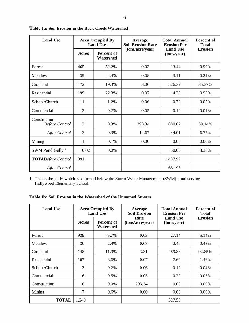
In Table 1a and 1b, a comparison is provided of the various land uses within the watershedof the two tributaries to Cuckold Creek.

5
ConstructionTable 1a, shows that one land use, construction, accounted for 59% of the soil erosion occurringwithin the watershed of Back Creek. When CEDS encountered the 3-acre construction site, whichis located off of Clarks Landing Road, we found a lack of erosion and sediment control measures. CEDS reported this violation to the Maryland Department of the Environment (MDE). Afterinvestigating the complaint, MDE issued a warning to the owner of the site and directed theimmediate application of a number of control measures. These measures were applied shortlythere after and reduced the soil erosion and mud pollution rate from the site by approximately 90%to 95%. The rate of soil erosion occurring on the site is probably no longer pollutional, though itremains far higher than the rate for forest and other land uses.5 By winning corrective action onthis construction site, the Association has eliminated the largest single source of mud pollution inthe Back Creek watershed.
CroplandBoth Table 1a and Table 1b shows that cropland is the dominant source of eroded soil afterconstruction. In the watershed of the unnamed stream cropland accounts for 12% of the land areaand 93% of the soil erosion. Much of the soil in the two watersheds is located on soils consideredhighly susceptible to erosive forces. Since most of the watershed soils are highly erodible muchof the cropland is also located on highly erodible soils. In fact, 78% of the croplands are onhighly erodible soils (see Table 2).
A number of options are available for minimizing soil loss from cropland. One of theseoptions involves the method used to till the soil. Conventional tillage methods result in substantialdisturbance of the soil and leaves little residue on the surface, both of which increases the erosionrate. Conservation tillage methods require minimal disturbance and tend to leave substantialamounts of crop residue and other plant parts on the soil. Conservation tillage methods can reducesoil erosion by up to two-thirds when compared to conventional tillage. About 40% of thecropland in the Cuckold Creek watershed benefits from conservation tillage.
Another option that must be considered is to take cropland out of production if it is locatedon highly-erodible soils. Converting cropland to hay, residential lots, or pasture would reduce theerosion rate by 50 times. Allowing cropland to revert to forest would slash the erosion rate bymore than 300 times!
The Association should meet with the District Conservationist for the Saint Mary’s NaturalResources Conservation District to explore options for shifting more cropland to conservationtillage and taking highly-erodible soils out of crop production. The Association will likely learnthat the District has embarked on a long term plan for achieving this goal, but that it will take anumber of years to fully implement. By lobbying for better funding of the District, the Associationcould accelerate implementation of the plan.
GulliesNext to construction and cropland, gullies are the most significant source of mud pollution in thewatershed. CEDS surveyed both watersheds in search of active gullies. During the survey we
6
Table 1a: Soil Erosion in the Back Creek Watershed
Land Use Area Occupied ByLand Use
AverageSoil Erosion Rate(tons/acre/year)
Total AnnualErosion PerLand Use(tons/year)
Percent ofTotal
ErosionAcres Percent of
Watershed
Forest 465 52.2% 0.03 13.44 0.90%
Meadow 39 4.4% 0.08 3.11 0.21%
Cropland 172 19.3% 3.06 526.32 35.37%
Residential 199 22.3% 0.07 14.30 0.96%
School/Church 11 1.2% 0.06 0.70 0.05%
Commercial 2 0.2% 0.05 0.10 0.01%
ConstructionBefore Control 3 0.3% 293.34 880.02 59.14%
After Control 3 0.3% 14.67 44.01 6.75%
Mining 1 0.1% 0.00 0.00 0.00%
SWM Pond Gully 1 0.02 0.0% 50.00 3.36%
TOTALBefore Control 891 1,487.99
After Control 651.98
1. This is the gully which has formed below the Storm Water Management (SWM) pond servingHollywood Elementary School.
Table 1b: Soil Erosion in the Watershed of the Unnamed Stream
Land Use Area Occupied ByLand Use
AverageSoil Erosion
Rate(tons/acre/year)
Total AnnualErosion PerLand Use(tons/year)
Percent ofTotal
ErosionAcres Percent of
Watershed
Forest 939 75.7% 0.03 27.14 5.14%
Meadow 30 2.4% 0.08 2.40 0.45%
Cropland 148 11.9% 3.31 489.88 92.85%
Residential 107 8.6% 0.07 7.69 1.46%
School/Church 3 0.2% 0.06 0.19 0.04%
Commercial 6 0.5% 0.05 0.29 0.05%
Construction 0 0.0% 293.34 0.00 0.00%
Mining 7 0.6% 0.00 0.00 0.00%
TOTAL 1,240 527.58

7
Table 2: Cropland Erosion In The Watershed of Back Creek & the Unnamed Stream
MapSymbol
Soil NameAverageSlope
Length/Slope
Factor 1
Erodibility
Factor 2
SoilErosionRate 3
(tons/acre/year)
Acres of Croplandon Each Soil in the
Watershed of...
TotalCropland
SoilErosion
(tons/year)
Percent ofTotal
CroplandSoil
Erosion
Total SoilErosion With
All Cropland InConservation
TillageBackCreek
UnnamedStream
Aa Alluvial land 1% 0.16 0.37 0.65 4.6 3 0 0.98
BlA Beltsville silt loam 1% 0.16 0.43 0.75 10.4 7.8 0.7 2.58
BlB2 Beltsville silt loam 3.5% 0.58 0.43 2.74 57.3 39.0 263.3 25.8 86.64
BlB3 Beltsville silt loam 3.5% 0.58 0.43 2.74 3.9 10.6 1.0 3.51
BlC2 Beltsville silt loam 7.5% 1.40 0.43 6.60 6.5 2.6 60.0 5.9 19.76
BlC3 Beltsville silt loam 7.5% 1.40 0.43 6.60 2.2 3.9 40.2 3.9 13.25
ChA Chillum loam 1% 0.16 0.43 0.75 11.7 1.0 9.5 0.9 3.15
ChB2 Chillum loam 4% 0.67 0.43 3.16 44.2 3.9 151.9 14.9 49.99
ChC3 Chillum loam 9% 1.72 0.43 8.11 1.6 2.2 30.8 3.0 10.14
CrC2 Croom gravelly sandy loam 9% 1.72 0.43 8.11 2 16.2 1.5 5.34
CrD3 Croom gravelly sandy loam 12.5% 2.77 0.43 13.06 5.9 77.0 7.5 25.35
EvC Evesboro loamy sand 11.5% 2.45 0.17 4.57 9.1 41.5 4.0 13.67
EwC2 Evesboro-Westphalia 9% 1.72 0.49 9.24 4.6 42.5 4.1 13.99
KrA Keyport silt loam 1% 0.16 0.43 0.75 2.1 1.5 0.1 0.52
MnB2 Matapeake silt loam 3.5% 0.58 0.49 3.12 22.1 16.9 121.5 11.9 39.98
MuB2 Mattapex silt loam 1% 0.16 0.43 0.75 0.0 0.0 0.00
SaB2 Sassafras sandy loam 3.5% 0.58 0.28 1.78 3.0 44.1 83.8 8.2 27.59
SaC2 Sassafras sandy loam 7.5% 1.40 0.28 4.30 2.0 8.6 0.8 2.83
SaC3 Sassafras sandy loam 7.5% 1.40 0.28 4.30 10.8 46.4 4.5 15.27
SfA Sassafras loam 1% 0.16 0.28 0.49 2.6 1.2 0.1 0.42
Total 172 148.2 1018.3 100.0 334.971. The Length/Slope Factor was determined from the table headed “Cropland: Moderate Ratio of Rill to Interrill Erosion”, presented on page 2, Section I-D, Erosion Prediction,in the Revised Universal Soil Loss Equation - Maryland Technical Guide, March 1995, published by the USDA Natural Resources Conservation Service. 2. The erodibility factor for each soil was obtained from a table headed “Physical and Chemical Properties of the Soils - St. Mary’s County, MD Survey Area”, dated 3/15/95.3. A Cover (C) Factor of 0.152 was used and assumed all cropfields are in a five-year rotation consisting of 2 years corn, 1 year small grains, and 2 years soybeans. It was alsoassumed that 40% of the cropland is in no-till and 60% in clean tillage. A Practice (P) Factor of 0.37 was used assuming all cropfields are in field strip-cropping.

8
attempted to examine all areas where gullying was most likely to occur. These areas includecropland and developed land abutting steep, highly-erodible slopes.
The Cuckold Creek watershed contains two soils which are uniquely susceptible to erosion -Matapeake and the Evesboro/Westphalia complex. Both soils tend to occur on steep slopes belowflatter hilltops and ridges. Converting forest on the hilltops and ridges to cropland increases theamount of runoff flowing onto the steep, highly-erodible soils. This causes gullying. Convertingthe cropland to intensively developed lands causes a further increase runoff and, therefore,increased gullying. Gullying can also be caused by collecting runoff from a large area andconcentrating the flow onto highly-erodible soils.
During the survey of the two watersheds, CEDS identified ten active gullies. An active gully isdefined as an area in which erosion is occurring at a rapid pace and is evidenced by exposedsoils, recent slumping of trees into the gully, along with other indicators. An inactive gully tendsto be covered with leaves, moss, or other vegetation and may have trees growing from within itsrelatively gently sloping sides.
Of the 10 gullies, four drain cropfields, five drain developed lands or roadways, and one drainsa gravel pit. The length, width, and depth of the gullies average about 60 feet by 6 feet by 4 feet. The volume of soil eroded from the ten gullies totals 22,510 cubic feet or about 1,100 tons. If thisvolume of soil were all delivered to and deposited within the two branches of Cuckold Creekadjoining Joy Chapel Road, then it would reduce the water depth by about a tenth of an inch.
The largest and most active gully is located below the stormwater management pond serving thenew Hollywood Elementary School located on Joy Chapel Road. On April 18, 1996, CEDS metwith school officials and the District Conservationist for the USDA Natural ResourcesConservation Service to identify options for correcting the gullying. The school is nowconsidering modifications to the pond which will halt the gullying. These modifications willreduce the rate at which stormwater runoff is released from the pond. This action should drop therate of runoff release below that which will cause erosion. The District Conservationist hasobserved that gullies tend to stabilize once erosive velocities are eliminated. The school will alsobegin monitoring two other gullies located on the campus to determine just how rapidly they areeroding.
Once the pond modifications are completed the third largest single source of mud pollution inthe Back Creek watershed will be eliminated.
MiningCEDS identified five mining sites within the two watersheds. Only one of the five sites is beingactively mined. Four of the five gravel pits are clearly self-contained. In other words, water canonly exit the pits by soaking into the very sandy and gravelly soils on the pit bottom. Furthermore,two of the four self-contained pits have completely reverted to forest with no soil exposed toerosive forces.
The one pit which may be a problem is located to the northeast of Joy Chapel. There are abouttwo acres of exposed soil at this site. Although one can trace the path that surface runoff wouldfollow to transport eroded soil from the site, there is very little evidence that significant quantitiesof sediment have washed from the site. There are at least two explanations for this. First, that thesandy-gravelly soils of the area are so permeable that it is rare for surface runoff to occur. Without surface runoff, erosion and sediment transport cannot take place. The second possible

9
explanation is that when a rare, severe storm occurs runoff leaves the site so rapidly that most ofthe eroded soil is transported far downstream and, thus, leaving little evidence that material iswashing from the site.
Regardless of which explanation is correct, it is in the best interest of Cuckold Creek tostabilize the exposed soil located on the mining site. The Association should contact the owner ofthe site, which is the MIMA Partnership, and explore their interest in voluntarily stabilizing thesite. I believe the District Conservationist and/or the Maryland Department of the Environment(MDE) would provide technical assistance. If the owner refuses to take the necessary action, thenI believe MDE also has the authority to force corrective action.
Other Mud Pollution SourcesThere are several other potential sources of mud pollution which were not listed in Table 1a and1b. These sources include timber harvesting sites and the numerous trails located throughout thetwo watersheds.
During the survey of the watersheds CEDS did encounter several recent timber harvesting sites. Erosion was not a problem at any of these logging sites.
Much of the 20 miles covered during the survey was on horse/hiker/ORV trails. Erosion wassignificant on perhaps 400 feet of three trails.
The first trail is located on the campus of Hollywood Elementary School and is near thestormwater management pond. I understand the school is exploring options for stabilizing the trail.
The other two eroded trails are located along the east side of Back Creek, opposite HollywoodElementary School. Both of these trails appear to have been made by off road vehicles (ORVs). The Association should contact those who own the property on which these two trails are locatedand explore their interest in stabilizing the trails. I believe simply discontinuing ORV use of thetrails is all that is needed to achieve stabilization.
FUTURE SOURCES OF MUD POLLUTION
Land development poses the greatest potential for causing additional mud pollution in the CuckoldCreek watershed. But future development also offers an opportunity to shift current sources ofmud pollution, such as cropland located on highly erodible soils, to more benign land uses.
CEDS requested a listing from the Saint Mary’s County Department of Planning & Zoning ofproposed development projects located in the Cuckold Creek watershed. Table 3, provides asummary of the 14 projects identified by the Department. On April 15, 1996, CEDS visited theoffices of the Department of Planning & Zoning to review the file compiled for most of the 14projects.

10
Table 3: Proposed Development Projects Located in the Cuckold Creek Watershed
Project Name Project Description Location on Tax Maps
Page Block Parcel
Markle/Smith Subdivision Two lots 27 21 171
P.H. Scriber Subdivision One lot 27 13 476
The Neck Subdivision Resubdivision of one lot 27 13 877
Bowling Subdivision Six lots 27 4 29
Nicholas J. Smith Subdivision Two farmsteads 27 16 139
Resurrection Manor Three lots 27 22 523
Breezy Acres Estates Three lots 27 22 346
Shanti II Medical Facility 29 acre commercial project 27 19 421
Phillip E. Clarke Estate Five lots 27 12 159
Angela D. Jones Subdivision Two lots 27 12 369
Hollywood Business Center 34 acre commercial project 27 19 431
Page Subdivision Three lots 27 23 884/885
Carter Manor Four lots 27 3 879/473
MIMA Partnership 153 acres 27 14 435

11
Table 4: Soil Erosion on the 153-Acre Proposed Development Site
Soil Name Map Symbol
Acres On SitePresently
in...AverageSlope
Length/SlopeFactor
Erodibility
Factor
Soil Erosion Rate(tons/acre/year)
Subtotal for CurrentSoil Erosion(tons/year)
TotalCurrent
SoilErosion
(tons/year)
Forest Cropland Forest Cropland Construction
Forest Cropland
Bibb silt loam Bm 15.1 0% 0.05 0.28 0.0014 0.1 2.7 0.02 0 0.02
Evesboro-Westphalia complex EwE2 57.3 1.3 32.5% 6.83 0.49 0.3263 36.7 652.6 18.69 47.71 66.41
Matapeake fine sandy loam MmB2 2.9 3.5% 0.58 0.37 0.0209 2.3 41.8 0.00 6.82 6.82
Matapeake silt loam MnB2 15.9 3.5% 0.58 0.49 0.0277 3.1 55.4 0.00 49.55 49.55
Matapeake silt loam MnC3 1.0 0.7 7.5% 1.40 0.49 0.0669 7.5 133.7 0.06 5.26 5.33
Mattapex silt loam MuB2 30.2 3.5% 0.58 0.43 0.0243 2.7 48.6 0.00 82.60 82.60
Sassafras sandy loam SaB2 2.6 3.5% 0.58 0.28 0.0158 1.7 31.6 0.00 4.63 4.63
Sassafras sandy loam SaC2 23.7 7.5% 1.40 0.28 0.0382 4.2 76.4 0.90 0 0.90
Sassafras sandy loam SaC3 2.6 7.5% 1.40 0.28 0.0382 4.2 76.4 0.00 11.17 11.17
97.1 56.2 19.7 207.8 227.5

12
Figure 2: Location of the 153-Acre Site

13
Table 5: Soil Erosion Resulting From Various Options for Developing the 153-Acre Site
OptionTotal SoilErosion
(tons/year)
Present conditions 227.5
Conventional Development of Site: 51 2.1-acre lots; 50% of forest removed;all existing cropfields developed; no stormwater management.
Construction Phase with No Control 11,363.0
With Conventional Control 1 5,681.5
With Optimum Control 2 1,136.3
Post-Construction 40.0
Cluster Development of Site: 51 half-acre lots clustered on 29 acres locatedon least erodible soils; 23.7 acres of forest removed during construction phase,but then 48-acres of cropland allowed to revert to forest once development iscompleted for a net increase in woodland of 31 acres when compared tocurrent conditions; stormwater management would be required.
Construction Phase with No Control 1,935.4
With Conventional Control 1 967.7
With Optimum Control 2 193.5
Post-Construction 25.4
1. Conventional control measures include silt fence and sediment traps which retain an average of50% of the eroded soil on the construction site.2. Optimum control measures include protecting exposed soil with a thick layer of straw mulchand or seeding with grass. These measures reduce soil erosion by 90% to 95%.

14
Figue 3: Soil Erosion Resulting from Various Options for Developing the 153-
Acre Site
194968
1,935
1,1365,682
11,363
228
0 4,000 8,000 12,000
Optimum Control
Conventional Controls
No Controls
WITH CLUSTERING
Optimum Control
Conventional Controls
No Controls
WITHOUT CLUSTERING
Existing Conditions
Tons Per Year

15
These 14 projects range from a single residential lot to a 34-acre office complex to a 153-acreresidential subdivision. All of these projects could create a substantial amount of mud pollution. After all, the 3-acre construction site presented in Table 1a, is a single residential lot. This onelot accounted for more than half the potential mud pollution in the watershed. If a single, 3-acresite could pose such a massive threat to the creek, then the potential impact of 14 projects of equalor far greater size is staggering.
153-Acre SiteThe project which poses the greatest potential mud pollution impact is the 153-acre site owned bythe MIMA Partnership. This site is located on Joy Chapel Road opposite Joy Chapel andHollywood Elementary School (see Figure 2).
The only document contained in the County’s file for this site was a tentative assessment ofenvironmental constraints on the development of the site. The owner may be seeking an opinion onthese constraints so a determination can be made of the development potential. There was noindication of the type of development MIMA Partnership is considering. The proposedHollywood Business Center is also located on property owned by MIMA Partnership. TheBusiness Center site is located about a half-mile away at Joy Chapel Road and Old Three NotchesRoad.
The 153-acre site will be used to illustrate the options open to the Association in their effort tominimize the mud pollution caused by future development in the Cuckold Creek watershed. Forthe purposes of this illustration it will be assumed MIMA Partnership hopes to develop the site asa residential subdivision. The site is zoned Rural Preservation District (RPD) and may besubdivided into one lot for every three acres. Thus the maximum number of lots permitted on the153-acre site would be 51.
Table 4, lists the nine soils which occur on the site. About two-thirds of the soils are in forestand most of the remainder is in cropland, with the exception of the two-acre mining site describedabove. The table shows that the soil erosion rate on the 153-acre site is presently 227.5 tons peryear, 91% of which comes from the third of the site that is in crop production.
Table 5, provides a comparison of the effects of two options for developing the site - a conventional option versus a clustered subdivision. The effect of these options are graphicallydepicted in Figure 3.
Conventional Development Option: Forest conservation requirements would likely preventthe removal of more than 50% of the 97 acres of forest located on the site. The forest retainedwould likely be that located in the wetland soils (Bibb) and on the steeper slopes (Evesboro-Westphalia soils). If the 51 lots each had an area of more than two-acres the project would likelybe exempt from stormwater management requirements.
Table 5 and Figure 3, shows four different scenarios under the conventional developmentoption. The first scenario presumes that erosion and sediment control measures would not beapplied to the site during the construction phase. Though this happened on the three-acreconstruction site on Clarks Landing Road, it is unlikely that control would be totally lacking on the153-acre site. It is far more probable that conventional sediment trapping measures would beapplied. Yet even with these conventional measures the annual erosion rate would rise from the

16
current level of 227.5 tons per year to 5,681.5 tons per year - an increase of 25 times. The use ofstraw mulching, seeding with grass, and other optimum control measures would reduce the soilloss to 1,136.3 tons per year; a rather dramatic decrease. Once the site is fully developed and thecropfields are taken out of production, the erosion rate would drop to 40 tons per year versus thecurrent 227.5 tons per year - a decrease of 82%!
Clustered Development Option: This option would confine the 51 lots to just 29 acres. Theclustered lots would be located on soils with a low erosion potential. These soils (Sassafras) arealso located about 700 feet from Joy Chapel Road. Thus it may be possible to screen the lots fromthe view of those traveling Joy Chapel Road. Instead of removing nearly 50 acres of forest only24 acres would be felled. But once development is completed and the cropfields are allowed torevert to woodland, the area of forest on the site would increase by 31 acres when compared tocurrent conditions.
With optimum control measures construction phase mud pollution would be about one-tenth ofthat occurring during conventional development of the site. Once development is completed theerosion rate would be just 25 tons per year, or 37% lower than in the conventional scenario and89% lower than the current erosion rate on the 153-acre tract.
One caveat must be noted with regard to erosion on the site if it is developed. If the developedareas are served by a stormwater management facility, then it is vitally important that the designerand County review officials take into consideration the potential for gullying. The stormwaterfacilities must be designed to release runoff at non-erosive velocities. Normal design practicewould only dictate releasing runoff at the rate it presently flows from the site. It is likely that therate of release from the existing cropfields on the site is erosive. To effectively control erosionrunoff should be released at the rate associated with forest, not cropland. The Association shouldurge the Saint Mary’s County Department of Public Works and the Department of Planning &Zoning to adopt this design criteria for all future stormwater facilities discharging to highlyerodible soils.
There are a number of other options available to the Association for reducing mud pollutionfrom the 153-acre site. The clustering approach presented above is just one of the options. Following are some of the other alternatives the Association may wish to consider.
A. Preserve the 153-acre site in its current condition and seek to reduce mud pollution byconverting cropland to more benign land uses. Preservation may be achieved through acquisitionas parkland, the County’s transferrable development rights program, or other mechanisms.
B. Seek to reduce the number of lots that may be created on the site. This may beachieved by working voluntarily with the applicant or by convincing the County PlanningCommission or the County Commissioner’s to limit the number of lots.
C. Attempt to block any development of the site by opposing the approvals the ownerneeds from the County.
Of these three options B is the most viable. If the owner believes that a reduction in the numberof lots would eliminate opposition, then they may be willing to agree to this. If they do not agree,then the Association must convince the Planning Commission or the County Commissioners toimpose a restriction on the number of lots. This approach will likely cost a minimum of $5,000 inlegal fees and other expenses. Ultimately the cost could run as high as $20,000 to $50,000. These

17
same costs would apply to option C. Option A is the least likely. Preservation funds areextremely limited and are directed to those tracts with values far more significant than those of the153-acre site.
CEDS views the clustering option as the most likely path for minimizing mud pollution from the153-acre site. We urge the Association to meet with MIMA Partnership to explore their interest inpursuing this option. If they refuse to consider this very reasonable option, then I believe theAssociation stands a good chance of convincing County officials to impose clustering.
Hollywood Business CenterNext to the 153-acre site, the largest proposed development project in the Cuckold Creekwatershed is the Hollywood Business Center. This 34-acre site is also owned by the MIMAPartnership. This site is located on highly erodible soils, though the erosion hazard is a bit lesssevere when compared to the 153-acre site. Initial plans for the project show a stormwatermanagement pond. It is imperative that the pond be designed to prevent erosive velocities. If theMIMA Partnership is open to working with the Association on the 153-acre site, then theAssociation should request an opportunity to review a complete set of plans for the HollywoodBusiness Center. Recommendations may then emerge for minimizing the impact of developing thesite.
Other Proposed Development ProjectsIn addition to the 153-acre site and the Hollywood Business Center, Table 3 lists 12 otherproposed development projects. The Association should contact the owners of each of theseprojects and request an opportunity to work with them in minimizing mud pollution. TheAssociation should begin with the largest sites and those located on the most erodible soils. Ingeneral, the following recommendations will minimize mud pollution.
A. Direct growth to the least erodible soils on the site.
B. Allow the most erodible soils on the site to remain in or revert to forest.
C. Design stormwater management facilities to release runoff at non-erosive velocities.
D. To the maximum extent possible, minimize the amount of time that soil is exposed toerosive forces during the construction phase. Plan site development so initial clearance and roughgrading is quickly completed, then stabilize all areas of exposed soil with straw mulch or mulchand grass seed.
E. Avoid initial clearance of the site between October and March when runoff is greatestand it is most difficult to apply mulch and seed.
Public Notice & Public Participation In The Development Review ProcessWhen compared to other Maryland jurisdictions, the development review process in Saint Mary’sCounty is not very citizen friendly. It is difficult for citizens to learn of proposed developmentprojects. And even if citizens do hear about a project they lack sufficient time to consider theproposal and a reasonable means for influencing decision-making on the proposal.
In Saint Mary’s County public notice for routine subdivision proposals is limited to anewspaper announcement one week prior to the date on which the Planning Commission willconsider the project. It is unlikely that those living near the site and other affected parties will

18
catch the notice in the newspaper. One week is a ridiculously short period of time for citizens toreview project plans, research impacts, then prepare logical arguments for presentation to thePlanning Commission. If the Planning Commission approves the project over citizen objections,then the only recourse is to file an appeal to the County Commissioners.
Public notice for other (non-routine) projects is far better. If a subdivision requires aConditional Use Permit, a variance, or some similar action, then the Planning Commission musthold a hearing on the project. A sign is posted on the site announcing the date, time, place, andpurpose of the hearing and all adjoining property owners receive a letter of notification. Plus anadvertisement appears twice in the newspaper. These notifications begin at least three weeksbefore the date of the hearing. Though this is still a rather short amount of time for preparation, itis better than just one week.
In contrast to the process in Saint Mary’s County, the Baltimore County government holds aCommunity Input Meeting (CIM) well in advance of the hearing on a development project. A signgiving the date, time, and location of the CIM is posted on the proposed development site at least21 days in advance. Copies of the applicant’s Concept Plan are available at, and frequently before,the CIM. The applicant must attend the CIM. Citizens may request that a representative of anyCounty agency attend the CIM to answer questions. The CIM is informational, not a public hearing,so there is a lot more opportunity to brain-storming along with give and take negotiating. At theDevelopment Plan stage a public hearing is held by a County Hearing Officer. The hearing isadvertised solely with a sign posted on the proposed development site. The Hearing Officer’sdecision on the Development Plan may be appealed to the County Board of Appeals.
Though the process in Baltimore County is not perfect, it provides citizens with a far betteropportunity to learn of and consider how a proposed development project may impact theirinterests. The extensive feed-back provided through the process allows citizens to prepare moreconstructive input to decision-makers. But it is important to remember that the Baltimore CountyCIM process does require a fair amount of staff time. It is unlikely Saint Mary’s County couldadopt a similar process without a budget increase or by taking funds from some other function.
We urge the Association to meet with the Director of the Department of Planning & Zoning toexplore options for improving public notice and public participation in decisions regarding routinesubdivision proposals.
RECOMMENDATIONS
Following is a summary of all the recommendations set forth in the preceding report.
1. The Association should contact the owners of all lands on which active gullies arelocated. The Association should assist the owners in halting further erosion at each active gully. The experience gained through the Hollywood Elementary School gullies provides an excellentmodel of how to constructively work with the owners.
2. The Association should contact the MIMA Partnership, which owns the mining sitelocated near Joy Chapel, and explore their interest in voluntarily stabilizing the site. This shouldbe done in concert with recommendation #6, below.
3. Two eroding Off Road Vehicle trails are located on the east side of Back Creek. TheAssociation should contact those who own the property on which these two trails are located and

19
explore their interest in stabilizing the trails. I believe simply discontinuing ORV use of the trailsis all that is needed to achieve stabilization.
4. The Association should meet with the District Conservationist for the Saint Mary’sNatural Resources Conservation District to explore options for shifting more cropland toconservation tillage and taking highly-erodible soils out of crop production.
5. The Association should urge the Saint Mary’s County Department of Public Works andthe Department of Planning & Zoning to adopt special design criteria for stormwater managementfacilities discharging to highly erodible soils. The criteria must ensure that runoff released fromthe facilities does not expose the soils to an erosive velocity.
6. The Association should meet with the MIMA Partnership to explore options forminimizing the impact of developing the 153-acre site. If they are considering development of thesite as a residential subdivision, then the Association should urge MIMA Partnership to considerthe clustering option presented in this report.
7. If the MIMA Partnership is open to working with the Association on the 153-acre site,then the Association should request an opportunity to review a complete set of plans for theHollywood Business Center. Recommendations may then emerge for minimizing the impact ofdeveloping the site.
8. The Association should contact the owners of the 12 other proposed developmentprojects and request an opportunity to work them in minimizing mud pollution. The Associationshould begin with the largest sites and those located on the most erodible soils. In general, thefollowing recommendations will minimize mud pollution.
A. Direct growth to the least erodible soils on the site.
B. Allow the most erodible soils on the site to remain in or revert to forest.
C. Design stormwater management facilities to release runoff at non-erosivevelocities.
D. To the maximum extent possible, minimize the amount of time that soil isexposed to erosive forces during the construction phase. Plan site development so initialclearance and rough grading is quickly completed, then stabilize all areas of exposed soil withstraw mulch or mulch and grass seed.
E. Avoid initial clearance of the site between October and March when runoff isgreatest and it is most difficult to apply mulch and seed.
9. We urge the Association to meet with the Director of the Department of Planning &Zoning to explore options for improving public notice and public participation in decisionsconcerning routine subdivision proposals.
AN EXAMPLE OF WHAT CUCKOLD CREEK RESIDENTS COULD ACCOMPLISH
The preceding nine recommendations may appear rather intimidating. One might think that anawful lot of work is involved and that the tremendous forces of the development industry would

20
frustrate our efforts at each step. Yes, there is a fair amount of work involved and we will faceopposition, but the task is far from insurmountable. In fact, there are many examples of howcitizens, such as the residents of the Cuckold Creek watershed, have organized into an effectiveand highly successful force for preserving quality of life. Following is one of these manyexamples.
In late 1983, a series of storms occurred in Anne Arundel County which turned many of thetidal creeks muddy. Two activists, Peg Burroughs and Lina Vlavianos, became deeply concernedby the increasing muddiness of their creeks. They believed the mud was coming from the hundredsof construction sites active throughout the County. At that time Anne Arundel was the most rapidlydeveloping County in the United States.
Peg and Lina met with Richard Klein, the author of this report, who was then the directorof Save Our Streams (SOS). Together they mapped out a strategy for learning if mud pollutioncontrol measures were being effectively applied to construction sites.
In January, 1984, Peg and Lina recruited about 50 other volunteers to attend a four hourSOS training session on the evaluation of mud pollution control quality. Like Peg and Lina, few ofthe volunteers had prior experience in the control technology or advocacy. They all simply sharedPeg and Lina’s concerns for the health of the County’s waters.
After the training session the volunteers formed into two person teams and each teamagreed to evaluate the quality of mud pollution control on two construction sites. By February,1984, the volunteers completed their survey and met to share the results. They found that only 23%of the 50 construction sites had effective control measures in place. Many of the other sites hadlittle or no mud pollution preventative measures.
Peg and Lina released the results to the newspapers and TV stations. The press had a fieldday with this novel citizen investigation. Reporters made life rather miserable for the CountyExecutive. They wanted to know why his inspectors were not keeping more sites in compliancewith County laws requiring full and effective use of mud pollution control measures. TheExecutive responded by announcing that he would double the number of inspectors and that wouldsurely correct the problem. This was Peg and Lina’s first victory.
Eight months later, in October, 1984, Peg and Lina did something the County Executivenever anticipated. They got the 50 volunteers together again, did a refresher training session, andwent our to inventory 50 different construction sites. They found that after the County had doubledthe number of inspectors (and the amount of tax-dollars going to mud pollution inspection) thepercentage of construction sites with good control went from 23% down to 17%! That’s right. Control got worse.
You can imagine what the press did with these findings. At one point it looked like theCounty Executive might be impeached. But the Executive brought a very skilled bureaucrat onboard to fix the mud pollution control program. For the next six months the bureaucrat workedwith the inspectors, their supervisors, other County officials, the development industry, and manyothers. In April, 1985, the bureaucrat got wind that Peg and Lina were going to get the 50volunteers together again for a third survey. He met with both activists to ask that they hold off foranother month or two. He said that he knew they’d find that control quality had improved and thatthe favorable publicity might prompt the County to slacken the support he needed to make somefinal and crucial improvements. Peg and Lina agreed to postpone the survey.

21
In June, 1985, they got the volunteers together again for another refresher training session. The 25 teams went out to inspect 50 new construction sites. They found that the percentage of siteswith good mud pollution control had risen from 17% to 61%! This tremendous success wasachieved without spending any more tax-dollars or passing any new laws. The County simply tookwhat it had in October 1984 and improved it for six months. And this victory could not havehappened without the support provided by Peg, Lina, and their 50 volunteers.
Peg and Lina did it. We can do it. But only if we call upon all those who treasure CuckoldCreek to join with us in supporting more responsible land use management in the watershed.