asx release maiden exploration · pdf filewigetty maiden exploration target february 2014 3...
TRANSCRIPT
Wigetty Maiden Exploration Target February 2014 1
MAIDEN EXPLORATION TARGET Wigetty titanium-iron-phosphate
project
UraniumSA Limited (ASX: USA) is pleased to announce a maiden
Exploration Target of mineralisation in the Company’s Muckanippie
project in northern South Australia. The Wigetty prospect has multi-
commodity mineralisation with potential for the development of an
open-pit operation to produce mineral concentrates of ilmenite
(titanium) with co-product magnetite (iron) and apatite (phosphate).
Cautionary statement. The Exploration Target is an estimation of the
conceptual quantity and grade of mineralisation at the Wigetty prospect
based on prior work by third parties. There has been insufficient
exploration to estimate a Mineral Resource and it is uncertain if further
exploration will result in the determination of a Mineral Resource.
There are a significant and increasing number of mining operations in the
Coober Pedy – Tarcoola district in South Australia, with several iron ore
projects trucking product from mine site to the Adelaide-Darwin broad
gauge rail connection (map next page). The Muckanippie project
(Exploration Licence 4694, 100% UraniumSA) is located 44km west of the
Adelaide-Darwin broad gauge rail connection and covers a large portion of
the Muckanippie Anorthosite Complex.
UraniumSA has estimated an Exploration Target of ilmenite-magnetite-
apatite mineralisation at Wigetty comprising a global target of
170 - 230Mt of mineralisation at
11% ilmenite (range 9.9% to 12.3%)
13% magnetite (range 11.4% to 14.0%)
2.5% apatite (range 2.3% to 3.1%)
within which there is a target zone for higher grade material of
14 - 35Mt of mineralisation at
12% ilmenite (range 9.9% to 12.3%)
14% magnetite (range 11.4% to 14.0%)
3.0% apatite (range 2.3% to 3.1%)
This estimation is based on a reinterpretation of the results of iron ore only
exploration by Aztec Mining Company Limited (1998, a subsidiary
Normandy Mining Limited) and of ilmenite only exploration by Iluka
Resources Limited (2002). NOTE. Grades are estimated at a 7.6% ilmenite cut-off rounded to the nearest ½%. Global
targets are rounded to the nearest 10MT; target zones are rounded to the nearest 1Mt.
ASX RELEASE 13 February 2014
UraniumSA Limited (“UraniumSA”) ASX Code: USA ABN 48 119 978 013 32 Beulah Road Norwood SA 5067 Phone +61 8 8132 0577 Fax +61 8 8132 0766 www.uraniumsa.com.au [email protected]
BOARD OF DIRECTORS Alice McCleary Chairman Russel Bluck Director & Geoscience Manager David Paterson Director & Acting CEO
PROJECTS South Australia Samphire ELs 4979, 4242 Pine Hill EL 4787 Wild Horse Plains EL 4693 Muckanippie EL 4694
ISSUED CAPITAL Shares on Issue: 147,274,756 Quoted shares: 147,274,756 Unlisted Options: 7,550,000
INVESTOR INQUIRIES [email protected] Inquiries regarding this report
and company business may be
directed to:
David Paterson – Acting CEO
+61 8 8132 0577
+61 417 823 654
VISIT OUR WEBSITE www.uraniumsa.com.au
For
per
sona
l use
onl
y

Wigetty Maiden Exploration Target February 2014 2
BACKGROUND
The Wigetty prospect is a well define aeromagnetic feature located on the western margin of
Exploration Licence 4694, some 74km north of Tarcoola and 44km west of the Adelaide-Darwin
broad gauge rail connection. The license is within the Woomera Prohibited Area (WPA) south of the
Defence Periodic Use Zone 2 corridor. UraniumSA have a Deed of Access for exploration and mining
for the WPA and a current PEPR (Program for Environment Protection and Rehabilitation) issued by
DMITRE (Department for Manufacturing, Innovation, Trade, Resources and Energy).
Commencing late 2013 UraniumSA has examined the Wigetty prospect as a hard-rock ilmenite play
with potential magnetite and apatite co-product credits. Integrating geophysical, geological and assay
data from prior Aztec (iron ore exploration) and Iluka (ilmenite exploration) work interpretive models
of the mineralisation have been created and JORC compliant Exploration Targets estimated for a
conceptual operation producing ilmenite with co-product magnetite and apatite.
PRIOR EXPLORATION
The Wigetty prospect (the origin of the name is not known) was recognised in PIRSA regional
exploration drilling (1991), evaluated as an iron ore play by Aztec (a Normandy subsidiary, 1998) and
subsequently examined as an ilmenite play by Iluka (in Joint Venture, up to 2002). There have been
43 holes drilled at and in the immediate environs of the Wigetty prospect; 3 drilled by
DMITRE/PIRSA during a regional reconnaissance program, 34 drilled by Aztec, and 6 drilled by
Iluka. Iluka informally estimated a resource of ilmenite mineralisation at Wigetty (2002): the estimate
does not comply with JORC 2012 and is not reported herein.
For
per
sona
l use
onl
y

Wigetty Maiden Exploration Target February 2014 3
Iron rich metamorphic rocks of the Mulgathing Complex in the Tarcoola – Coober Pedy district are
host to various magnetite dominated iron ore prospects and plays and these appear to have been the
model for the Aztec exploration (samples were assayed for Fe - iron but not Ti - titanium). Examples
from within the district are Hawkes Nest (35% Fe, equivalent to 48% magnetite), Mount Woods (27%
Fe, equivalent to 37% magnetite) and the adjacent Cairn Hill mine. Magnetite iron ore mines and
prospects within South Australia average 22% Fe, equivalent to 30% magnetite (raw tonnage
weighted, various PIRSA publications).
High Fe/Ti values occur at the Wigetty prospect associated with mafic rocks of the Muckanippie
Anorthosite Complex. Previous tenement holders, Platsearch, recognised the hard-rock ilmenite
possibilities and Iluka Joint Ventured into the prospect to explore for high grade hard rock
mineralisation.
GEOLOGY
Exploration Licence 4694 covers the majority of the Muckanippie Anorthosite Complex (MAC)
emplaced in Archaean rocks of the Mulgathing Complex (MC). The MAC was identified and
informally named by PIRSA from the results of regional drilling, supported by geochemistry and
petrology. It comprises anorthosite, gabbroic-anorthosite, gabbro, diorite, syenite, granodiorite and
granites. The limits of the MAC are not geologically well constrained but interpretation of
aeromagnetic imaging indicates an area in the range of 500km2, with no estimates of thickness.
Wigetty is located on the northwest edge of the Exploration Licence at the margins of the MAC and
within a clearly defined magnetic feature. Rock types comprise gabbro intruded into metamorphic
granulite. The magnetic stratigraphy strikes to the northeast, inferred dips are steeply southeast.
At Wigetty, titanium, iron and phosphorous mineralisation is associated with mafic intrusive activity
and largely hosted by granulite, but the extent, geological controls and grade distribution of
mineralisation within the granulite is poorly constrained.
GEOPHYSICS
Aztec helicopter aeromagnetic surveys defined the Wigetty aeromagnetic anomaly and Iluka
conducted detailed magnetic and gravity ground surveys across a northwest trending belt across it.
The Iluka geophysical consultant interpretation was for steep southeast dipping bodies (perpendicular
to line direction of 315 degrees (AMG) and a profile of six drill holes was drilled to test this model.
Mineralisation is known from outcrop sampling and drilling over ~1.2km of strike and the geophysics
indicates that it can be projected out to ~2.5km at reasonable levels of confidence.
GEOLOGICAL INTERPRETATION
The best-fit to the regional and detailed geophysical, geological and drilling data is of northeast
trending, steeply east dipping complex of gabbro bodies and granulite metamorphic rocks. The
geology of the Wigetty prospect is divisible into a Western Granulite Zone (WGZ) corresponding to
the peak aeromagnetic response, with separate Central Granulite Zone (CGZ) and Eastern Granulite
Zone (EGZ) zones corresponding with lower aeromagnetic response profiles. The WGZ is bounded to
the east by unnamed metamorphic rocks, and to the east by a MAC Gabbro (Central Gabbro, CG).
Repetitions of MAC Gabbro separate the CGZ and EGZ.
For
per
sona
l use
onl
y

Wigetty Maiden Exploration Target February 2014 4
Composite Profile through the Wigetty Prospect
Unscaled magnetic profile from Iluka ground survey data, refer to the section line and plan location below
Geological shapes interpreted by UraniumSA from drill logs and the Iluka geophysical interpretation
Wigetty Prospect - footprint of WGZ on aeromagnetic contours
Magnetic contour map is a Helimag survey
reported by Aztec. The coloured outlines are
interpretations by UraniumSA of the footprint of
mineralised WGZ.
Red outline is at the outer trace of the upper
range estimation of global tonnage (herein)
Brown outline is the outer trace of the lower
range estimation of global tonnage (herein)
Green outline is the outer trace of the upper range
estimation of target tonnage (herein). The lower
range estimation of target tonnage assumes a
strike extent of 1.1km (not shown).
Blue line is the position and extent of the
composite profile (above) with the Iluka drill holes.
Purple dashed line is the EL. The cross-hatched
area has been excluded from the estimation of an
Exploration Target.
Plan view, north to top, graticules are 500m
Western Granulite Zone Central
Gabbro
Central
Granulite
Zone
Eastern
Granulite
Zone
TA0001 TA0004 TA0002 TA0005 TA0003 TA0006
Drill hole profiles central line is the geology from Iluka field logs
left side is %TiO2, orange >5%
right side is %Fe, orange >20%
Section 315AMG perpendicular to strike.
Scale as shown. No vertical exaggeration.
EL 5195
Marmota Energy Ltd
EL 4694
UraniumSA Ltd
Composite Profile
section line above For
per
sona
l use
onl
y

Wigetty Maiden Exploration Target February 2014 5
From the interpretive Composite Profile it is inferred that the WGZ is the source of the magnetic high.
The various outlines (above) tracing aeromagnetic contours are an empirical approximation of the plan
footprint of various parts of the WGZ rock unit. The Iluka drill data and assay results show that the
Western Granulite Zone hosts broadly disseminated titanium/iron mineralisation.
The assay data indicates that the WGZ is extensively mineralised at potentially economic grades.
Bulk grade increases east to west within the WGZ (from drill hole TA0003 in the east through
TA0002 to TA0001 in the west) and if this trend is sustained there is a possibility that better than
deposit-average grades will occur along the western footwall.
Ilmenite Mineralisation
Mineralisation in the WGZ (TA0001, 2, 3) is relatively continuous down the length of the holes and
overall titanium and iron grades are at potentially significant levels throughout the WGZ. Drill
samples were assayed for Ti and have been converted to ilmenite assuming stoichiometric
compositions. Iluka commissioned Scanning Electron Microscopy (SEM) on ilmenite grains indicates
near stoichiometric Ti:Fe:Mn compositions.
On the available drill assay data and petrology neither the Gabbro (TA0004), the CGZ (TA0005) nor
the EGZ (TA0006) are host to potentially significant titanium-iron mineralisation.
Iron Mineralisation
Petrology descriptions of the WGZ semi-quantitatively estimated both magnetite and ilmenite as major
components. The Fe values from the Iluka drilling are interpreted to be distributed between ilmenite,
as a component in ferromagnesian silicates, and as magnetite. For the present purpose, it is assumed
that a stoichiometric portion of Fe (~37%) is incorporated with Ti in ilmenite, and that the balance is
equally distributed between magnetite and ferromagnesian minerals. These assumptions give an
outcome which is in line with the petrology; there is no other supporting data at this time. An iron cut-
off grade is not applied; magnetite is assumed as a co-product of the processing of the mineralisation
and not a primary determinant of material mined.
Apatite Mineralisation
Apatite was consistently reported in the Iluka petrology and rock chip sampling returned phosphate
P2O5 grades averaging 2.5% (median 2.8%, range 0.2% to 5.73%). Assuming the phosphate is in
apatite and stoichiometric composition, these results are equivalent to ~6.0% apatite (median 6.6%,
range 0.5% to 13.7%). No drill samples were assayed for phosphorous.
The rock chip samples were collected along a magnetic strike extent of ~1.2km and across the
magnetic stratigraphy. There is a linear relationship between P2O5 and TiO2 (r2 = 0.725) in the data
which is consistent with that seen in other mineralised mafic systems reported in the literature. The
relationship is accepted as an indicative approximation for the present purpose, and has been used to
infer an apatite credit for the Exploration Target estimation. A phosphorous cut-off grade is not
applied; apatite is assumed as a co-product of the processing of the mineralisation and not a primary
determinant of material mined.
For
per
sona
l use
onl
y

Wigetty Maiden Exploration Target February 2014 6
METALLURGY
Iluka composited two samples for initial metallurgical test work; one from TA0001 in the Western
Granulite Zone; a second from TA004 in the Central Gabbro. Drill cuttings were processed using
standard heavy mineral sands flow sheets and methods. The Iluka report (ENV09624, pp 107) notes
that the “bulk results are not very meaningful because a large portion of host rock gangue was attached
to the oxide grains”.
Despite limitations in the processing and the incomplete results available, the reported magnetic
separation work indicated that;
a magnetite product separates cleanly.
iron-titanium products separate over the range 300 -500rpm (drum rotation).
phosphorous is concentrated into the >200rpm (drum rotation) non-magnetic fraction.
The available metallurgical work has been examined by Simon Hall, the UraniumSA Metallurgical
Manager. Overall, the work has provided very limited and only indicative information which does not
materially assist in the effective metallurgical investigation of the Wigetty prospect hard rock
mineralisation.
ESTIMATES OF MINERALISATION
Cautionary statement
This work has relied upon historic data from open file reports and the information relied upon cannot
be duplicated or otherwise verified by UraniumSA. The estimate made here is an Exploration Target
under JORC 2012 Clause 17.
The Exploration Target estimation is of the potential of the Wigetty prospect based on prior work by
third parties and interpretation of that data by UraniumSA. There has been insufficient exploration to
estimate a Mineral Resource and it is uncertain if further exploration will result in the determination of
a Mineral Resource.
Iluka Resources Limited
Iluka made an estimate of mineralisation based on their data and interpretations (ENV09624, pp176,
no JORC classification). The estimate does not conform to JORC 2012 and is not provided herein.
The Iluka work was focussed on a “Lac Tio” model targeting a massive high grade titanium-in-
ilmenite mineralisation in a mafic host rock. Associated magnetite and apatite was identified but not
investigated. The Iluka estimate is separated into an “Oxide Resource” with “Fresh Rock” and “High
Grade” categories. For
per
sona
l use
onl
y

Wigetty Maiden Exploration Target February 2014 7
UraniumSA Limited
Classification of the estimation
UraniumSA has acquired data from the SARIG database and from available public domain reports.
The data has been collated, copied or converted where necessary into electronic formats, and imported
into MapInfo/Discover. All data is in MGA94, having been converted where necessary. The entire
raw data set is generated by third parties and obtained from DMITRE/PIRSA open file reports and
UraniumSA cannot verify that the work has been done to current standards or that the results have
been correctly captured and reported.
Basis of the estimation
The estimations rely on the geological interpretations and evaluation of analytical data provided
previously, principally;
mineralisation comprises ilmenite with potential co-product magnetite and apatite.
the WGZ has an associated distinctive aeromagnetic signature which is used to empirically
outline a footprint for the rock unit and mineralisation.
the estimation extends between the base of saprolite at ~19m to the depth of deepest drill
intersection, a length of ~111m.
mineralisation is disseminated through the WGZ with a possible grade break in the range
between 4 – 5% TiO2 .
a bulk density of 2.5 is assumed (Iluka assumed 3.0 for granulite).
For
per
sona
l use
onl
y

Wigetty Maiden Exploration Target February 2014 8
PROPOSED EXPLORATION
The work required to improve the confidence level of the Wigetty prospect Exploration Target
estimation comprises;
1. Soil sampling across the inferred extent of the WGZ to map the surface plan projection of
ilmenite-iron-phosphate mineralisation. The drilling completed indicates that much of the inferred
area of the WGZ is overlain by a lag or saprolite weathering surface potentially amenable to
standard soil geochemical methods. Soil geochemical work by UraniumSA in other parts of the
tenement has detected both iron and titanium in soils (phosphorous not determined).
2. Integrating the magnetic data from airborne surveys with drill samples susceptibility
measurements and the present geological interpretations to re-model source bodies.
3. Targeted RC/core drilling to obtain samples of mineralised material to investigate the tenor and
distribution of the targeted ilmenite-magnetite-apatite assemblage, to provide feedstock for
indicative metallurgical testing, and enable an assessment of potential mining characteristics.
4. Initial investigation of the potential marketability and range of values of mineralisation
concentrates produced by the metallurgical test work.
5. Broad spaced RC /core drilling investigate variations in mineralisation and metallurgical
performance within the WGZ target.
6. Systematic drilling, assaying, metallurgy to increase confidence levels within selected areas.
Phases 1, 2 are anticipated to be completed by UraniumSA in the first half of 2014.
Phases 3, 4 will be designed using Phase 1, 2 outcomes and delivered over a 12 -18 month period
subject to the availability of funding.
Phases 5, 6 are significant programs the design, cost and delivery of which are subject to the outcomes
of the preceding work and to the availability of funding.
For
per
sona
l use
onl
y
Wigetty Maiden Exploration Target February 2014 9
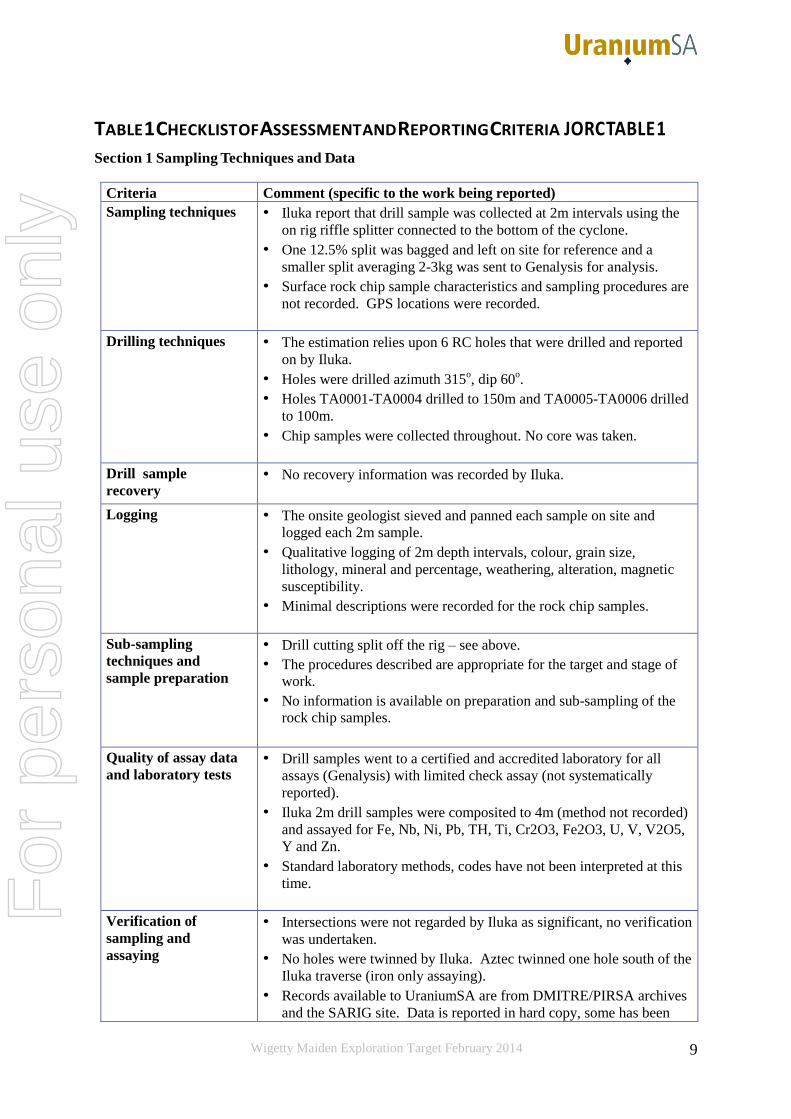
TABLE 1 CHECKLIST OF ASSESSMENT AND REPORTING CRITERIA JORC TABLE 1
Section 1 Sampling Techniques and Data
Criteria Comment (specific to the work being reported)
Sampling techniques • Iluka report that drill sample was collected at 2m intervals using the
on rig riffle splitter connected to the bottom of the cyclone.
• One 12.5% split was bagged and left on site for reference and a
smaller split averaging 2-3kg was sent to Genalysis for analysis.
• Surface rock chip sample characteristics and sampling procedures are
not recorded. GPS locations were recorded.
Drilling techniques • The estimation relies upon 6 RC holes that were drilled and reported
on by Iluka.
• Holes were drilled azimuth 315o, dip 60
o.
• Holes TA0001-TA0004 drilled to 150m and TA0005-TA0006 drilled
to 100m.
• Chip samples were collected throughout. No core was taken.
Drill sample
recovery • No recovery information was recorded by Iluka.
Logging • The onsite geologist sieved and panned each sample on site and
logged each 2m sample.
• Qualitative logging of 2m depth intervals, colour, grain size,
lithology, mineral and percentage, weathering, alteration, magnetic
susceptibility.
• Minimal descriptions were recorded for the rock chip samples.
Sub-sampling
techniques and
sample preparation
• Drill cutting split off the rig – see above.
• The procedures described are appropriate for the target and stage of
work.
• No information is available on preparation and sub-sampling of the
rock chip samples.
Quality of assay data
and laboratory tests • Drill samples went to a certified and accredited laboratory for all
assays (Genalysis) with limited check assay (not systematically
reported).
• Iluka 2m drill samples were composited to 4m (method not recorded)
and assayed for Fe, Nb, Ni, Pb, TH, Ti, Cr2O3, Fe2O3, U, V, V2O5,
Y and Zn.
• Standard laboratory methods, codes have not been interpreted at this
time.
Verification of
sampling and
assaying
• Intersections were not regarded by Iluka as significant, no verification
was undertaken.
• No holes were twinned by Iluka. Aztec twinned one hole south of the
Iluka traverse (iron only assaying).
• Records available to UraniumSA are from DMITRE/PIRSA archives
and the SARIG site. Data is reported in hard copy, some has been
For
per
sona
l use
onl
y

Wigetty Maiden Exploration Target February 2014 10
able to be captured through OCR and cross-check.
Location of data points • Collars were located on the geophysical traverses used for gravity
surveying. GPS is assumed but not recorded. Collar elevations are
assumed to be from this data. All coordinates were recorded in AGD
66 Zone 53 and were reprojected to MGA94 Zone 53.
Data spacing and
distribution • Drillhole spacing varied from 140 to 300m and was appropriate for the
stage of work.
• Each Iluka 2m sample was composited to 4m for assay.
Orientation of data in
relation to geological
structure
• The regional strike of the magnetic body is approximately 45oN with
interpreted steep dips toward 135oN.
• Interpretation of the drill logs assuming these orientations gave the
best fit to all of the data – this is the only verification available at this
stage.
Sample security • N/A
Audits or reviews • In house reviews by UraniumSA of its data transcriptions,
interpretations and documentation. No external review considered to
be required.
Section 2 Reporting of Exploration Results
(Criteria listed in the preceding section also apply to this section.)
Criteria Comment (specific to the work being reported)
Mineral tenement
and land tenure
status
• The Wigetty prospect is contained within EL 4694 held by Fatjack Pty
Ltd, a wholly owned subsidiary of UraniumSA Ltd.
• EL 4694 is located on both the Mulgathing and Bulgunnia pastoral
stations. Wigetty is located within Mulgathing Station.
• No national parks or conservation reserves are located within the
tenement.
• The tenement is located entirely within the Woomera Prohibited Area.
• An Exploration PEPR (Program for Environment Protection and
Rehabilitation) for the entirety of EL 4694 has been approved by
DMITRE (Department for Manufacturing, Innovation, Trade, Resources
and Energy).
Exploration done by
other parties • The Wigetty prospect was first recognised by PIRSA in the 1991 regional
exploration drilling. It was later evaluated by Aztec (Normandy
subsidiary) as an iron ore play and by Iluka as an ilmenite play. The
Iluka work is the basis of this work.
Geology • Wigetty is a NE striking, linear magnetic anomaly located within
Mulgathing complex granulite, intruded by gabbro on the margins of the
Muckanippie Anorthosite Complex.
• The feature is located on the edge of the Muckanippie Anorthosite
For
per
sona
l use
onl
y

Wigetty Maiden Exploration Target February 2014 11
Complex which has an area of approximately 500km2.
• Disseminated titanium, iron and phosphorous grades of potential
economic interest are present within the granulite.
Drill hole
Information • TA0001, 410962E 6662158N, RL 186m, Dip -60, Azimuth 315, EOH
150m
• TA0002, 411098E 6662024N, RL 186m, Dip -60, Azimuth 315, EOH
150m
• TA0003, 411196E 6661926N, RL 186m, Dip -60, Azimuth 315, EOH
150m
• TA0004, 411302E 6661821N, RL 186m, Dip -60, Azimuth 315, EOH
150m
• TA0005, 411499E 6661622N, RL 186m, Dip -60, Azimuth 315, EOH
100m
• TA0006, 411703E 6661421N, RL 186m, Dip -60, Azimuth 315, EOH
150m
Data aggregation
methods • No exploration results are being reported
• No metal equivalents are reported
Relationship between
mineralisation widths
and intercept lengths
• On the basis of the present interpretation drill holes are inclined to the
fabric of the host rock.
• Mineralisation lengths are drill hole intercept lengths.
Diagrams • Diagrams and sections appropriate to the work are contained in the body
of the text.
Balanced reporting • The Exploration Target is estimated to appropriate upper and lower limits
and across a range of grade using the information and interpretations that
are available.
Other substantive
exploration data • Commentary is provided on the methodology used in the estimation of
the various components of the mineralisation.
• The available metallurgical work has been reviewed and commented on
by the UraniumSA Metallurgical Manager.
Further work • Commentary is provided in the body of the text.
• The range of extensions is adequately represented in the range of
estimations given in the body of the text.
For
per
sona
l use
onl
y

Wigetty Maiden Exploration Target February 2014 12
ABOUT URANIUMSA LIMITED UraniumSA is an Adelaide based explorer specialising in uranium mineralisation within a substantial portfolio of properties
in South Australia’s Gawler Craton.
The Company has discovered sediment hosted
uranium mineralisation within Exploration Licence
4979, Samphire, which is located 20km south of the
industrial city of Whyalla on the eastern Eyre
Peninsula in South Australia. The exploration
Licence is owned and operated by Samphire
Uranium Pty Ltd, a wholly owned subsidiary of
UraniumSA Limited.
The Samphire project contains the:
Blackbush deposit with an estimated inferred
resource 64.5 million tonnes of mineralisation at a
bulk grade of 230ppm containing 14,850 tonnes
U3O8 at a 100ppm eU3O8 cut-off grade (JORC
2012).
Plumbush deposit with an estimated inferred
resource 21.8 million tonnes of mineralisation at a
bulk grade of 292ppm containing 6,300 tonnes
U3O8 at a 100ppm eU3O8 cut-off grade (JORC
2004).
The estimated mineralisation is predominantly
sediment hosted in Eocene age Kanaka Beds.
Exploration has discovered uranium mineralisation
in other geological settings and exploration is
continuing.
An evaluation of mining methods to optimise the recovery of uranium from the identified resources of mineralisation is in
progress. Application has been made for a Retention Lease for an in-situ recovery field trial at the Blackbush deposit.
Consideration of open cut options for the sediment-hosted and granite basement hosted uranium mineralisation is underway.
Through its own tenure and by joint venture UraniumSA has exploration control over what it considers the most prospective
portions of the Pirie Basin.
David Paterson
Acting Chief Executive Officer
UraniumSA Limited
The exploration results mineral resources reported herein, insofar as they relate to mineralisation, are based on
information compiled by Mr Russel Bluck a Director of UraniumSA Limited and Member of the Australian
Institute of Geoscientists with sufficient experience relevant to the style of mineralisation and type of deposits
being considered, and to the activity which is reported to qualify as a Competent Person as defined by the
Australasian Code for Reporting of Exploration Results, Mineral Resources and Ore Reserves (the JORC Code,
2012 Edition). Mr Bluck consents to the inclusion in the report of matters based on his information in the form
and context in which it appears. It should be noted that the abovementioned exploration results are preliminary.
For
per
sona
l use
onl
y