asx announcement 28 july 2016 high grade gold ... · asx announcement 28 july 2016. high grade gold...
TRANSCRIPT

44 Kings Park Road, West Perth WA 6005 PO Box 778, Claremont WA 6910
Telephone: (61-8) 6263 4423 Facsimile: (61-8) 9284 5426 www.catalystmetals.com.au ABN 54 118 912 495
ASX ANNOUNCEMENT 28 JULY 2016
HIGH GRADE GOLD INTERSECTIONS CONTINUE FROM RC DRILLING AT FOUR EAGLES GOLD PROJECT
• Further high grade gold mineralisation intersected at Hayanmi Gold Prospect
5m @ 6.1g/t Au, 2m @ 13.9g/t Au, 1m @ 14.6g/t Au, 1m @ 9.5g/t Au • Bulk Leach assays not yet received • Drilling programme will not resume until after grain harvesting in December 2016 • Full data review and interpretation in progress
___________________________________________________________________________________ Catalyst Metals Limited (Catalyst or the Company) (ASX: CYL) is pleased to advise that initial gold assays from a RC Blade/Hammer programme carried out at the Company’s Four Eagles Gold Project during May and June 2016 further confirms the presence of significant gold mineralisation. Although only 2,331 metres (17 holes) were drilled before the onset of wet winter weather, intersections of greater than 1g/t Au were present in fourteen (14) of the completed holes. Most of the drilling was done at the northern end of the Hayanmi Gold Zone and generally confirmed previously reported mineralised zones. Catalyst retains a 50% interest in the Four Eagles Gold Project whilst Gold Exploration Victoria Pty Ltd (GEV) is earning up to a 50% interest from Providence Gold and Minerals Pty Ltd by spending $4.2 million on exploration. To date, GEV has already earned a 25% interest in the Four Eagles Gold Project by spending $2.1 million. The Four Eagles Gold Project is situated in the Whitelaw Gold Fault Corridor where Catalyst controls tenements over a 75 kilometre strike length north of Bendigo in Victoria (Figure 1). RC BLADE/HAMMER DRILLING This programme involved the drilling of angled large diameter air core holes (RC Blade/Hammer) on the Hayanmi Structure and was a continuation of the programme commenced in January 2016. The Hayanmi Gold Zone is one of three gold trends identified at the Four Eagles Gold Project (Figure 2a and 2b). The overall objective of the programme is to complete drill traverses every 50 to 100 metres along the mineralised corridor to enable geological modelling of the gold mineralisation. Hayanmi Prospect A programme of approximately 4,000 metres of RC Blade/Hammer was planned but only 2,331 metres was completed between 17 May 2016 and 7 June 2016 before successive rain events and grain sowing caused the programme to be curtailed. The following significant gold intersections have been recorded and are shown diagrammatically on the plan and longitudinal projection in Figures 3 and Figure 4.
• 10.0m @ 3.7g/t Au including 2.0m @ 13.9g/t Au from 61 metres (FERC043) • 4.0m @ 4.15g/t Au including 1.0m @ 14.6g/t Au from 65 metres (FERC042)
For
per
sona
l use
onl
y

2
• 5.0m @ 6.1g/t Au including 1.0m @ 20.6g/t Au from 71 metres (FERC058) • 4.0m @ 2.8g/t Au including 1.0m @ 7.9g/t Au from 116 metres (FERC041) • 1.0m @ 9.5g/t Au from 111 metres and 2.0m @ 3.5g/t Au from 123 metres (FERC054) • 5.0m @ 2.34g/t Au from 73 metres including 1.0m @ 7.91g/t Au (FERC061) • 1.0m @ 8.4g/t Au from 73 metres (FERC057) • 6.0m @ 1.52g/t Au from 130 metres (FERC056) • 1.0m @ 4.8g/t Au from 110 metres (FERC064) • 4.0m @2.6g/t Au from 106 metres including 1.0m @ 6.04g/t Au (FERC059)
The longitudinal projection in Figure 4 suggests that the gold mineralisation has a generally flat or gentle plunge, possibly to the south but this cannot be confirmed without diamond drilling. These flat or gentle plunges are a characteristic of the total Bendigo-Fosterville district because the mineralisation is generally related to the intersection of steep fault structures with gently plunging anticlines. It is informative to look at this early stage information at Hayanmi in comparison to known gold mineralisation structures at Bendigo and Fosterville. On Figures 5 and 6, the current longitudinal projection at Hayanmi is shown at the same scale as the Bendigo New Chum lode and Fosterville respectively. Each of these known ore deposits contained gently plunging shoots that contained greater than one million ounces of gold over similar strike lengths to that observed at Hayanmi. It is hoped that further drilling at Hayanmi will better define the ore shoots within this 2.9 kilometre long structure. It is also likely that the Boyd’s Dam and Discovery gold zones at the Four Eagles Gold Project will have similar plunging morphology but additional future drilling will be required to establish this. All of the assays quoted above have been obtained using a 25 gram sub-sample and an Aqua Regia digest followed by ICP-MS analysis but anomalous assays are being re-assayed by bulk leaching the total ± 2 kilogram sample. This provides an excellent check of the variability of gold at the Four Eagles Gold Project which tends to be fine grained and shows a low “nugget effect” compared to the Bendigo Goldfield. Mr Bruce Kay, Catalyst’s Technical Director, stated, “It is disappointing that more drilling could not be completed before the start of the wet season but the Four Eagles Joint Venture will be well placed to resume drilling on this prospective trend after the crops have been harvested in December 2016”. Full location data on the 17 RC Blade/hammer holes is shown on Table 1 and a Summary of Sampling Techniques and Reporting of Exploration Results according to the JORC Code 2012 Edition are tabulated in Appendix 1. Previous intersections shown on Figures 2a, 2b and 3 have been reported under the 2004 JORC Code. Maximum gold values in each hole are tabulated in Appendix 1. For further information contact:
Steve Boston Bruce Kay Chairman Technical Director Telephone: +61 409 574 515 +61 400 613 180
For
per
sona
l use
onl
y

3
Competent person’s statement The information in this report that relates to exploration results is based on information compiled by Mr Bruce Kay, a Competent Person, who is a Fellow of the Australasian Institute of Mining and Metallurgy. Mr Kay is a non-executive director of the Company and has sufficient experience that is relevant to the style of mineralisation and type of deposit under consideration and to the activity being undertaken to qualify as a Competent Person as defined in the 2012 Edition of the Australasian Code for Reporting of Exploration Results, Mineral Resources and Ore Reserves (the JORC Code). Mr Kay consents to the inclusion in the report of the matters based on his information in the form and context in which it appears. Much of the historical information relating to the Four Eagles project was prepared and first disclosed under the JORC Code 2004. This information has not been updated since to comply with the JORC Code 2012 on the basis that the information has not materially changed since it was reported.
For
per
sona
l use
onl
y

4
Figure 1: Four Eagles Gold Project Location Map
For
per
sona
l use
onl
y

5
Figure 2a: Four Eagles Gold Project showing gold zones and drill intersections >1.0g/t Au
For
per
sona
l use
onl
y
6
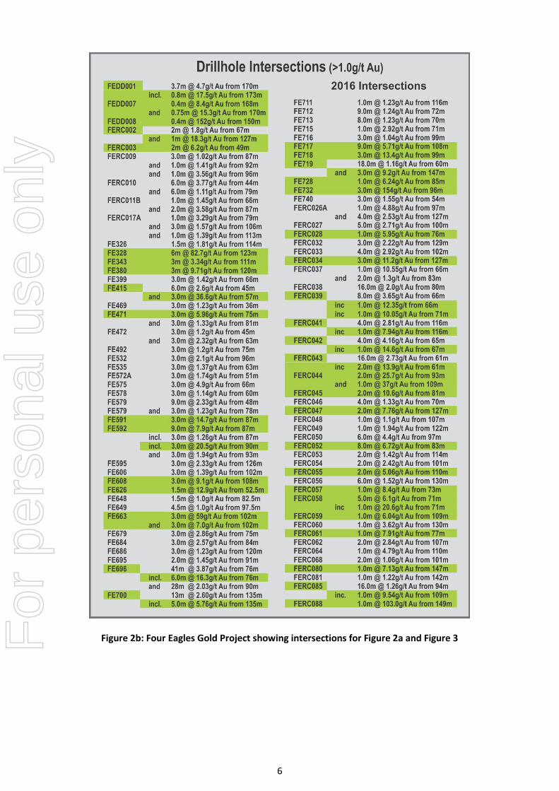
Figure 2b: Four Eagles Gold Project showing intersections for Figure 2a and Figure 3
For
per
sona
l use
onl
y

7
Figure 3: Plan View of Hayanmi Prospect showing recent and historic drillholes. Gold intersections are listed on Table 2b
For
per
sona
l use
onl
y

8
Figure 4: Longitudinal Projection of Hayanmi Prospect showing interpreted plunges of gold mineralisation and recent drill intersections
Figure 5: Isometric View of the New Chum gold zone at Bendigo compared to the current mineralised trend at Hayanmi (same scale). Note the “stacking” of flat plunging lodes at Bendigo
For
per
sona
l use
onl
y

9
Figure 6: Longitudinal Projection of Hayanmi compared to the Fosterville Gold Zones (at the same scale). Courtesy Newmarket Gold Inc.
F
or p
erso
nal u
se o
nly

10
APPENDIX 1: RC BLADE/HAMMER DRILLING
Table 1 RC Drill hole Collars
Hole East (MGA)
North (MGA)
RL (AHD) Depth (m) Grid
Azimuth Declination
FERC040 244657.812 5991417.201 95.57 123 270 -60 FERC041 244687.32 5991417.168 95.48 160 270 -60 FERC042 244665.014 5991369.827 95.49 138 270 -60 FERC043 244697.821 5991369.413 95.57 163 270 -60 FERC054 244670.267 5991293.973 95.63 142 270 -60 FERC055 244695.252 5991294.699 95.62 160 270 -60 FERC056 244714.786 5991294.634 95.61 149 270 -60 FERC057 244665.422 5991269.279 95.65 120 270 -60 FERC058 244666.973 5991244.563 95.65 141 270 -60 FERC059 244693.094 5991244.853 95.63 157 270 -60 FERC060 244714.246 5991246.728 95.70 149 270 -60 FERC061 244670.551 5991194.33 95.77 139 270 -60 FERC062 244694.169 5991194.463 95.64 154 270 -60 FERC063 244705.908 5990815.141 96.02 105 270 -60 FERC064 244730.305 5990816.994 95.96 127 270 -60 FERC067 244716.78 5990721.073 96.08 99 270 -60 FERC068 244740.088 5990719.959 95.96 129 270 -60
Samples of approximately 20 kilograms were collected from the rig cyclone at one-metre intervals and logged. Assay laboratory samples were selected using Jones riffle splitter into calico sample bags to a mass of >2kg (if sufficient sample is available) and <3kg. All samples were sent to ALS-Minerals Adelaide for sample preparation and pulverisation and then a 25 gram sub-sample analysed by ALS-Minerals Perth by ICP-MS via aqua regia digestion.
A duplicate sample was taken in the field for every hole, and sent for analysis, as were commercial certified reference materials (CRMs). The duplicate sample pairs commonly demonstrated an observable correlation for gold, providing confidence in the on-site sample collection-compositing method. There were some instances of significant difference which is expected in a coarse gold environment. The laboratory returned gold assays for CRMs slightly above, slightly below, and on-spec. The data does not reveal a systematic bias, and there were no occurrences of substantial outliers, and as such there is no evidence that the dataset is problematic.
Due to the limited depth of investigation, the RC drilling program does not definitively verify the dip of the mineralisation in a cross-sectional sense; and thus true thicknesses is not determined; and downhole intersections only are reported.
For
per
sona
l use
onl
y

11
Table 2 Drill Assay Results RC Blade/Hammer
Hole ID From
(m downhole) To
(m downhole) Intersection
(m) Au
(ppm)
FERC040 91 93 2 0.94 FERC040 91 93 2 0.94 FERC041 105 110 5 0.73 FERC041 including
116 120 4 2.81
116 117 1 7.94 FERC041 142 143 1 0.69 FERC041 151 152 1 2.48 FERC042 including
65 69 4 4.16
67 68 1 14.6 FERC042 77 78 1 1.58 FERC042 81 82 1 1.63 FERC042 103 109 6 0.79 FERC042 111 112 1 0.53 FERC043 including
61 77 16 2.73
61 63 2 13.9 FERC043 112 113 1 0.5 FERC043 120 122 2 0.62 FERC043 136 137 1 0.73 FERC043 143 146 3 1.57 FERC054 71 72 1 1.6 FERC054 80 81 1 0.51 FERC054 including
101 103 2 2.42
101 102 1 3.91 FERC055 110 112 2 5.06 including 111 112 1 9.48 FERC055 114 115 1 0.56 FERC055 including
123 126 3 2.53
123 124 1 5.9 FERC056 69 70 1 0.6 FERC056 87 88 1 1.07 FERC056 94 95 1 0.97 FERC056 120 121 1 0.59 FERC056 Including
130 136 6 1.52 130 131 1 4.11
135 136 1 2.61 FERC057 73 74 1 8.4 FERC057 86 87 1 3.42 FERC057 90 91 1 0.69 FERC057 96 97 1 3.46 FERC057 99 101 2 0.68
For
per
sona
l use
onl
y

12
Hole ID From
(m downhole) To
(m downhole) Intersection
(m) Au
(ppm)
FERC057 105 106 1 0.67 FERC058
including
71 76 5 6.11 71 72 1 20.58 74 75 1 6.91
FERC058 90 91 1 0.72 FERC058 93 94 1 0.56 FERC058 96 97 1 0.66 FERC058 99 100 1 0.81 FERC059 106 107 1 3.77 FERC059 including
109 112 3 2.43
109 110 1 6.04 FERC059 120 121 1 1.98 FERC060 117 118 1 0.89 FERC060 130 131 1 3.62 FERC061 including
73 78 5 2.41 73 74 1 2.09
77 78 1 7.91 FERC061 86 87 1 0.5 FERC061 93 94 1 0.76 FERC061 99 100 1 2.07 FERC061 106 108 2 1.09 FERC062 95 96 1 1.12 FERC062 including
107 109 2 2.84
108 109 1 3.86 FERC062 115 116 1 0.76 FERC063 78 79 1 0.57 FERC063 101 102 1 0.97 FERC064 51 52 1 0.57 FERC064 75 76 1 0.75 FERC064 110 111 1 4.79 FERC067 79 81 2 0.96 FERC068 101 103 2 1.06
For
per
sona
l use
onl
y

13
JORC 2012 Edition, Table 1 Checklist RC Blade/Hammer
RC Sampling Techniques and Data Criteria Explanation Sampling techniques • Samples collected at cyclone at one-metre intervals with no sub-
sampling. • Cover sequence samples collected in buckets and arranged as piles on
the ground; basement material samples collected in individual numbered plastic bags; chip trays collected by hand from piles and bags (uncomposited)
• Assay laboratory samples selected using Jones riffle splitter into calico sample bags to a mass of >2kg (if sufficient sample is available) and <3kg.
• Cover sequence is understood to be unmineralised and thus not sampled for laboratory submission.
Drilling techniques • Holes are initiated using 120mm air core blade drilling. This method
provides reverse-circulation face sampling of sufficiently soft material. • On bit-refusal, a four-inch diameter RC hammer with 110mm button
bit is utilised to progress the hole to design depth or where groundwater inflows compromise sample quality.
• All drilling utilises three-metre reverse circulation drill rods; truck-mounted drill rig; 400psi 900cfm compressor and booster; plus auxiliary compressor where dictated by water in-flows.
• No drillhole casing is used.
Drill sample recovery • Where sample volumes at cyclone were unduly affected by groundwater, holes terminated (by inspection) where sample compromised
• Sample water content assessed by rig geologist as being dry/wet • Sample bags collected at the rig were weighed prior to sample
splitting. Sample weight was used to assess the splitting requirements (number of riffles required) to deliver a sub-sample to the desired mass constraints (>2kg and <3kg). Calico bag masses recorded by laboratory contractor
• Geological control maintained at the drill site at all times, to ensure drilling and sampling was to standard.
Logging • Chip samples were geologically logged at one-metre intervals for
lithology, alteration, quartz veining and to a standard acceptable for subsequent interpretation for use in estimation.
• Logging aspects are qualitative with exception of quartz vein content which is estimated semi-quantitatively
• All logged intervals represent entire one-metre sample segregation intervals
Sub-sampling techniques and sample preparation
• Lab submission samples collected as described – any mass reduction required for assay purposes performed by laboratory contractor; consisting of drying and riffle-splitting.
• Samples dispatched to ALS Pty Ltd (Adelaide); samples dried and pulverised in entirety, with 25g aliquot split for analysis (laboratory repeat splits historically demonstrate acceptable reproducibility and hence accuracy for this mineralisation)
For
per
sona
l use
onl
y

14
RC Sampling Techniques and Data Criteria Explanation Quality of assay data and laboratory tests
• Gold assay determined by ICPMS via aqua regia digestion (ALS code Au-OG43). Experience has shown this method to be applicable for fine grained gold population of the mineralisation due to the completion of digestion. There is a technical constraint in that coarse-grained gold may not completely enter solution resulting in conservative assay.
• Laboratory and client certified reference materials (3 x standards plus blanks) generally demonstrate on-par and a spread of positive and negative outliers. No systematic bias nor substantial outlers.
Verification of sampling and assaying
• Data management procedures are under development. Data management has been performed by an experienced individual and not by several individuals.
• There has been no verification of significant intersections by independent nor alternative company personnel.
• Drillhole sampling and geological data logged onto paper in preparation for database data entry.
• There have been no adjustments to data as provided by the commercial assay laboratory.
Location of data points • All drillhole location coordinates were measured using differential
GPS to MGA94 and AHD estimated from terrain model created from publicly-available land survey data
• Collar locations to within an estimated precision of 1m, and reported to mm accuracy as provided by surveying contractor.
• All drillholes were downhole surveyed. Drilling orientation established prior to collaring with clinometer and compass.
Data spacing and distribution • RC holes drilled on sections located between existing RC and air core
traverses providing 50-metre spacing or 25-metre spacing in places along the strike of mineralisation.
• The sections consist of holes spaced at a nominal 25m • This spacing is designed to be of a sufficient density to ultimately be
included in the estimation of a mineral resource. • For the purpose of reporting, assays have been aggregated to reflect
continuously sampled zones of significant anomalism for gold.
Orientation of data in relation to geological structure
• Drillhole sections were aligned approximately normal to the strike of mineralisation. Holes were generally inclined 60 degrees to the west to provide cross-strike investigation within holes and to establish continuity of sub-vertical mineralisation between holes. A number of west-azimuth holes were drilled to test assumptions.
Sample security • All samples were controlled by the responsible geologist, and stored
in secured facility prior to despatch to laboratory. • Samples were transported directly to laboratory by a commercial
transportation contractor with chain-of-custody protocols in place. • Sample number receipt information from laboratory cross-referenced
and rationalised against sample number dispatch information.
For
per
sona
l use
onl
y

15
RC Sampling Techniques and Data Criteria Explanation Audits or reviews • No processes or data used in developing the release of exploration
results have been subject to audit or review by non-company personnel or contractors so as to reduce costs and timelines for reporting. Catalyst Metals Limited currently reserve this process for release of Mineral Resource and Ore Reserve estimates.
Reporting of Exploration Results Criteria Explanation Mineral tenement and land tenure status
• The Four Eagles Project is within EL4525 in the vicinity of Mitiamo Victoria, 50% owned by Catalyst Metals Ltd., 50% owned by Providence Gold and Minerals
• EL4525 is valid and due for renewal/retention in January 2017 • Exploration activities were confined to free-hold farm land and road-
side easements. • As of 2015, activities are funded with Gold Exploration Victoria Ltd
(GEV) through a farm-in agreement.
Exploration done by other parties
• None in the area drilled
Geology • Gold-arsenic bearing narrow veins in Ordovician sandstone in the vicinity of a regional-scale anticline.
• Deposit assessed as being northern extension of Bendigo Goldfield, with potential for post-mineralisation influence/redistribution by proximal granitic intrusion.
• Potential for some supergene gold enrichment in paleo-weathering profile.
Drill hole Information • All information material to the understanding of the exploration
results of all last-phase drill holes are tabulated: • Appendix 1, Table 1: Collar location coordinates, downhole depths,
azimuths, declinations • Appendix 1, Table 2: Downhole intervals of significance, gold grade of
intervals
Data aggregation methods • Data aggregation using downhole length-weighting • No top-cutting applied to assay data • Zones of significance identified as those with assays in excess of 0.5g/t
and internal dilution of two consecutive assays or less. • Reported zones are continuous, with no sample or assay gaps.
Relationship between mineralisation widths and intercept lengths
• The strike of mineralisation is demonstrated to be generally north-south and sub-parallel with grid.
• The dip of mineralisation is expected to be sub-vertical and sub-parallel with bedding as was the case in the Bendigo Goldfield.
• Drillholes were oriented with a dip to the west to provide effective geometry in the context of the eastern limb of an anticline.
• As there is only one cross-sectional pair of holes where mineralisation dip may inferred, the dip of mineralisation has not been proven, and the true width of mineralisation has not been resolved. As such, significant mineralised intersections have been reported as downhole intervals.
For
per
sona
l use
onl
y

16
Reporting of Exploration Results Criteria Explanation Diagrams • Figures 2 and 3 show the plan of recent drillhole collars including
previous drillholes.
Balanced reporting • Figures 2 and 3 show all new drilling inclusive of holes which did not encounter significant mineralisation
Other substantive exploration data
• No other exploration results that have not previously been reported, are material to this report. The assay results for three RC drillholes in the adjacent Hayanmi prospect are pending.
Further work • Planning for further drilling is in progress, anticipated to start in
December quarter subject to grain cropping.
For
per
sona
l use
onl
y