associations between riverine landscape patches and ... · ence the river profile as principal...
TRANSCRIPT
copy 2017 E Schweizerbartrsquosche Verlagsbuchhandlung Stuttgart Germany wwwschweizerbartdeDOI 101127fal20171035 1863 - 9135171035 $ 375
Associations between riverine landscape patches and internal and external environmental determinants are scale dependent evidence from the Scioto River USA
Paradzayi Tagwireyi 1 2 S Mažeika P Sullivan 1 and Kaiguang Zhao 1
With 6 figures 5 tables and 1 appendix
Abstract Associations between riverine landscapes ndash the integrated ecological unit including the riverscape and the floodplain ndash and their surrounding catchment landscapes remain largely unresolved In an exploratory study we investigated relationships between site-specific riverine landscape patterns and catchment land use and land cover (LULC) at twelve reaches distributed along an urban-to-rural gradient of the Scioto River Ohio USA We calcu-lated patch metrics (area edge diversity shape and density) for each riverine landscape and measured LULC ( agriculture forest open water and urban) of the catchment landscape at three nested spatial extents (1000 3000 and 6000 m) To consider potential internal drivers of riverine landscape patchiness we estimated drainage area (as a proxy for river size) and proximity to the nearest impoundment (as a proxy for flow heterogeneity) Drainage area and proximity to impoundment were strong predictors of patch shape (R 2 = 046 negative relationship) and patch area (R 2 = 067 positive relationship) respectively However evidence was almost equally as strong for catchment LULC predictors of both of these patch metrics at the 1000 and 3000-m extents forest coverage for patch size ur-ban and agriculture coverage for patch area Higher patch diversity was related to greater catchment forest coverage at 3000 and 6000-m extents Our observations implicate both external (LULC characteristics) and internal (flow dynamics) controls as potentially important environmental determinants of riverine landscape patchiness Our re-sults suggest that management and conservation of the Scioto River basin and potentially other river systems should integrate both aquatic and terrestrial factors not just at one scale but rather across a range of spatial extents
Keywords Akaike Information Criterion catchment landscape patch metrics riverine landscape pattern
Introduction
Scientists have recognized for some time that fluvial systems are embedded in and highly influenced by their surrounding landscapes (Hynes 1975 Gregory et al 1991 Wiens 2002) This notion has led to a holistic and detailed ecological view of river ecosystems that reflects the diversity of spatiotemporal and ecologi-cal dimensions of a river system including the river-floodplain-riparian gradient of vegetation and physical
habitat patches and the recognition of rivers as both internally heterogeneous and tightly linked to their surrounding landscapes via boundary dynamics (Ward 1997 Malard et al 2000 Fausch et al 2002 Sullivan et al 2007) The complex relationships among these dimensions have in part promoted the application of principles and approaches of landscape ecology including the ldquoriverine landscaperdquo concept which re-fers to the ecological unit consisting of the riverscape (sensu Fausch et al 2002 Wiens 2002) the sub-bank-
Authorsrsquo addresses1 School of Environment amp Natural Resources The Ohio State University Columbus Ohio USA2 Department of Geography and Environmental Science Geo-information and Earth Observation Centre University of
Zimbabwe Harare Zimbabwe Corresponding author tagwireyi1buckeyemailosuedu
E Fundam Appl Limnol 1903 (2017) 235ndash249 Articlepublished online 21 June 2017 published in print August 2017
eschweizerbart_XXX
236 P Tagwireyi S M P Sullivan and K Zhao
full inundation areas and the supra-bankfull inunda-tion zones and permanently-wetted floodplain water-bodies (sensu Ward et al 2002 Thorp et al 2006)
Patterns of riverine landscapes are often character-ized by landscape patch metrics Patchiness refers to both patch composition (patch types and their rela-tive abundance) and spatial configuration (patch size shape density diversity edge and shape) (Rotenberry amp Wiens 1980 Wu amp Loucks 1995) Patchiness can be related to ecosystem structure and function in a vari-ety of systems (Ries et al 2004 Fletcher et al 2007 Orrock et al 2011) Recent studies have shown that patterns of riverine landscape patches exert strong influences on riverine ecosystem productivity biodi-versity and the material fluxes within and between channels riparian zones and adjacent terrestrial land-scapes (Allan 2004 Moore amp Thorp 2008 Southwell amp Thoms 2011) Tagwireyi amp Sullivan (2015) for ex-ample found that combinations of patch edge shape and density were important predictors of ant assem-blage richness and density in riverine landscapes of the Scioto River Ohio
As riverine landscapes increasingly become rec-ognized as complex landscape mosaics in their own right identification of those environmental factors regulating riverine landscape patchiness will be criti-cal for conservation and management (Wu amp Loucks 1995 Ward et al 2002 Wiens 2002) Further concep-tual advances in spatial ecology (Wiens 1989 Levin 1992) have spurred considerable investigation of the relative influences of catchment landscape character-istics on rivers across spatial scales (eg Ward 1989 Townsend et al 2003 Allan 2004 Lowe et al 2006) River systems are hierarchically structured (Frissel et al 1986 Wiens 1989) therefore patterns at one scale may be affected by processes operating at a different scale or even at multiple spatial extents (OrsquoNeill et al 1989 Dollar et al 2007 Parsons amp Thoms 2013) Thus a river segment must be considered as part of an inte-grated system whose characteristics are influenced by both upstream (eg discharge delivery of sediment and water) and downstream (eg downstream insta-bility that may migrate upstream) processes over time (Schumm amp Lichty 1965 Schumm 1977 Petts amp Amo-ros 1996 Lane amp Richards 1997) Riverine landscapes then might be expected to respond to both external terrestrial (ie from the surrounding uplands) and internal aquatic (upstream river parameters includ-ing flow sediment and size) domains For example Thorp et al (2006) present a conceptual understanding of the effects of terrestrial conditions on biocomplex-ity within functional process zones (ie the ecological
analog to hydrogeomorphic patches) as mediated by discharge of water sediments inorganic nutrients and organic matter
Multi-scale investigations improve our ability to target and interpret scale-dependent patterns and may be particularly useful in understanding environ-mental controls on riverine landscapes For exam-ple Notebaert amp Pieacutegay (2013) applied a conceptual model to identify lithology and parameters that influ-ence the river profile as principal environmental driv-ers of floodplain width of the Rhone catchment river network Eroumls et al (2011) propose a network-based analysis emphasizing how riverscape connectivity can provide a quantitative and spatially-implicit model with direct implications to conservation applications Hydrological connectivity between the various ele-ments of riverine landscapes (eg floodplain waters abandoned meanders etc) operates across spatial scales and is critical in the maintenance of riverine landscape diversity (Ward et al 2002)
River systems can also be affected dramatically by changes in land use and land cover (LULC) (Al-lan 2004 Trautwein et al 2012) Burcher et al (2007) for instance introduced the land-cover cascade as a framework to quantify the effects of land-cover dis-turbance across spatial extents on aquatic biota Be-cause of adjacency to the river riparian LULC has of-ten emerged as a significant driver of river responses (eg Sponseller et al 2001) The combined effects of both riparian and broad catchment-scale LULC pat-terns may be most predictive (Esselman amp Allan 2010 Kautza amp Sullivan 2012)
Catchment changes that interrupt fluvial action (transport erosion deposition) can impede natural disturbance regimes essential for a high level of river-ine landscape diversity (Marston et al 1995 Ward et al 2002) and might be expected to alter the spatial or-ganization and function of riverine landscape patches (Molnar et al 2002 Marchetti amp Acenolaza 2011) Ur-banization for example increases impervious surface area drainage density and discharge thereby altering flow erosion and sediment regimes and accelerating rates of hydrogeomorphic change (Paul amp Meyer 2001 Walsh et al 2005) Likewise agriculture can alter flow and sediment regimes (Gordon et al 2008) that may limit the diversity of riverine landscape patchiness
Despite the initial advances in understanding the effects of controls on riverine landscapes empirical evidence is still lacking (Molnar et al 2002) As an initial step in this direction the objective of this study was to combine remotely-sensed and field data to ex-plore relationships between riverine landscape pattern
eschweizerbart_XXX
237Scale dependent riverine landscape patches and environmental determinants
and catchment LULC at multiple spatial scales We also considered fluvial-floodplain dynamics (as cap-tured through drainage area and proximity to nearest impoundment) given their importance in maintaining riverine landscapes (Junk et al 1989 Magilligan amp Nislow 2005 Thorp et al 2006 OrsquoHanley 2011 Ibi-sate et al 2013)
To that end we conducted an exploratory study aimed at identifying potential relationships between riverine landscape patch metrics ndash representing area density diversity edge and shape ndash and catchment LULC at three hierarchically-nested spatial scales (extending to 1000 3000 and 6000 m) of twelve river reaches distributed along an urban-rural gradi-ent of the Scioto River Ohio USA a multiuse river
typical of the American Midwest Because these patch metrics are expected to be governed by both external (catchment landscape features) and internal (fluvial dynamics) processes we anticipated that they would be sensitive to alterations in LULC and flow as out-lined in our conceptual model (Fig 1)
Material and methods
Study area and reach selection
The Scioto River is a mixed-use 6th-order river system of the Ohio River that drains a 16882-km2 basin Typical width of valley bottoms within the basin spans ~25 km forming rich agricultural plains (Scheifer 2002) Mean channel gradient in free-flowing sections is low (4 m kmndash1) with pool-riffle mor-
Fig 1 A conceptual model of hypothesized responses of riverine landscape patch heterogeneity to external and internal drivers Light gray wedges represent gradients in external and internal environmental drivers of riverine landscape patchiness (dark gray wedge) Urbanization and agriculture are anticipated to limit riverine landscape patchiness whereas larger river size and increased lateral flow connectivity are expected to augment patchiness 1000 3000 and 6000 m represent the nested spatial extents of land use and land cover (LULC) considered in this study Adjacent LULC at 1000 m is expected to have the greatest impact on riverine landscape patchiness but influences are expected across spatial extents Stylized riverine landscape patch metrics are presented in order of hypothesized sensitivity to external and internal influences (least to greatest from left to right)
eschweizerbart_XXX
238 P Tagwireyi S M P Sullivan and K Zhao
phology dominant in unmodified sections (Scheifer 2002) The Scioto River lies predominantly in a humid continental climate (Karl amp Koss 1984) receiving 900 ndash1100 mm of precipitation per year on average (Rogers 1993) LULC in the basin is domi-nated by cropland and pasture (59 by area) but supports mul-tiple other LULC types 23 deciduous forest 128 urban 14 grassland 07 evergreen forest 08 open water and 07 shrubland (NLCD 2006) The Scioto River flows through multiple urban centers including Columbus Ohio with a popu-lation of 787000 (US Census Bureau 2011) Dominant vegeta-tion in the riparian zones is presented in Appendix 1
The study area encompasses twelve 1500-m long riverine landscapes along approximately 200 km of the Scioto and its major tributary the Olentangy River of central and southern Ohio (Fig 2) In order to represent the gradient in land cover found from urban to rural areas (ie developedurban to for-ested and agricultural) of the study system we first used the US Geological Survey (USGS) National Land Cover Data
(NLCD) 2006 maps (NLCD 2006) in ArcGIS 101 (ESRI Red-lands CA USA) to characterize LULC within a 500-m buffer from both sides of the main channel From this initial survey we used stratified random sampling to select twelve reaches (ie riverine landscapes) within urban and rural land-use types which represented the dominant land cover in the basin The study reaches were separated by an average distance of 183 river kilometers (km) although there was significant variability (σ = 154 km)
Riverine landscape patch metrics
To delineate riverine landscape patches and their configuration we used a combination of field observations and the 2006 30-cm resolution natural color Digital Orthophoto Quarter Quad-rangles imagery (OSIP 2012) with ArcGIS 101 and ArcPad 80 (ESRI Redlands California USA) Using the guidelines from the US Fish and Wildlife Service for mapping riparian areas
Fig 2 The Scioto River basin (Ohio USA) with the locations of the twelve study riverine landscapes
eschweizerbart_XXX
239Scale dependent riverine landscape patches and environmental determinants
(NWI 2009) we digitized the orthophotos to obtain patch-level land cover at each of the twelve reaches The accuracies of our fine-scale reach maps were checked through field visits aided by a Personal Digital Assistant (Pharos 565 PDA Pharos Sci-ence and Applications Inc California USA) with ArcPad 80 This approach enabled us to identify and digitize patch bounda-ries of fifteen patch types (Table 1 Fig 3) within our riverine landscapes We then used ArcGISrsquos Patch Analyst extension (Elkie et al 1999) to compute seventeen patch metrics that characterized the landscape patterns at each of the twelve study reaches (Table 2) Detailed explanations and formulae for each metric are provided by McGarigal et al (2012)
Catchment landscape
We compiled our catchment LULC data from the USGS 2006 1 250000 land-cover data (NLCD 2006) which provide fifteen
Anderson Level 2 classes (Andersen et al 1976) We then used ArcGIS 101 to aggregate the NLCD 2006 data to seven Ander-son Level I classes [Table 3 see (Homer et al 2007) for detailed NLCD class definitions] Although eight Level 1 classes exist for our study catchment herbaceous was synonymous with pasture in our study system so we aggregated herbaceous and cropland into one ldquoagriculturerdquo class We also obtained percent-age imperviousness data from the NLCD (2006) data archive We then used ArcGIS 101 to measure percentage land cover for each of the seven classes and percentage imperviousness at three nested spatial extents of radii 1000 3000 and 6000 m extending out from and upstream of each of the twelve study reaches (Fig 4) The spatially-nested sectors are such that each larger landscape domain (eg 6000 m) contains all smaller domains (eg 1000 and 3000 m) Shrub wetland and barren classes represented only a small fraction of the overall land-scape (collectively 169 for 1000 m 042 for 3000 m and
Table 1 Summary of riverine landscape patch types at the twelve study reaches along the Scioto River based on authorsrsquo interpreta-tion of field and remote-sensing data Adapted from USFWS (2009) and Johansen et al (2010)
Patch Type DescriptionBarren land (gravel bar) Bare soil gravel or sandBarren land (mudflat) Exposed mud (wet soil) particularly at the edges of open waterCropland Land tilled for cropsHerbaceous vegetation Erect rooted vegetation with herbaceous stemsGrassland PastureGrass (lawn) Managed ornamental grass particularly in recreational parksFallow Uncultivated croplandIsland Terrestrial landscape patches bordered by open water Open water (stream) Water of the main channel or with direct surface connection to the streamOpen water (artificial) Water in artificial waterbodiesOpen water (floodplain waterbody) Water in natural floodplain waterbodies Shrub Shrubs and young trees lt 6 m in heightUrbanbuilt-up land Urban residential commercial transportation or industrial land coverSwamp Herbaceous and wooded swampsWoody vegetation Trees gt 6 m in height
Fig 3 An example of riverine landscape patches delineated within a portion of one of the study reaches
eschweizerbart_XXX
240 P Tagwireyi S M P Sullivan and K Zhao
066 for 6000 m) so we excluded these LULC types from further analysis
Drainage area and distance from impoundment
Because of the strong relationships between artificial impound-ments and channel-floodplain connectivity (Magilligan amp Ni-slow 2005 Ibisate et al 2013) and river size and floodplain
development (Salisbury 1980 Vannote et al 1980) we used drainage area and proximity of the study reach from the near-est impoundmentdam (all lowhead dams eg see Dorobek et al 2015) as proxies for river size and lateral flow heterogene-ity Dams alter river flow regimes (Nilsson et al 2005 Csiki amp Rhoads 2010) by reducing flood-pulse variability Because floodplains are typically more developed in larger rivers river size is linked to lateral flow connectivity between the main channel and the floodplain with consequences for vegetation patches in floodplains (Junk et al 1989 Hughes amp Rood 2003 OrsquoHanley 2011)
We used the hydrology tools in ArcGIS 101 to delineate catchments of each of the twelve reaches from a 10-m reso-lution digital elevation model (DEM) of the Scioto Riverrsquos catchment We used the approximate location of the thalweg at the downstream end of each reach as the pour point thereby including the study reach in the calculation of drainage area We used the linear referencing tools in ArcGIS 101 to estimate the distance (river km) of each reachrsquos centroid to the nearest upstream dam
Statistical analysis
Our primary statistical analysis was based on a theoretic model-selection approach using ordinary least-squares regression and the Akaike Information Criterion (AIC) AIC provides a means for model selection from a pool of possible statistical models by estimating an index of the relative quality of each model for a given set of data (Burnham amp Anderson 2002 Burnham amp Anderson 2004) To identify candidate predictor variables we used a correlation matrix to examine potential correlations among independent variables ( urban forest agricul-ture open water) at each of the three spatial extents No vari-ables with |r| gt 080 were included in the same model (eg Sul-
Table 2 Metrics used to quantify the composition and configuration of riverine landscapes of Scioto River study reaches Ohio USA Metric descriptions are adapted from McGarigal et al (2012) Italicized font denotes metrics used in the statistical analysis to represent their respective descriptors
Descriptor Abbreviation Units DescriptionArea TLA Ha Total Landscape Area Total area encompassed by the riverine landscapeEdge ED mha Edge Density The length of patch edge per unit area
MPE m Mean Patch Edge Average edge length of all patches TE m Total Edge Total edge length of patches
MPAR ndash Mean Perimeter Area Ratio Average perimeter to area ratio for all patchesRichness SEI ndash Shannon Evenness Index Patch evenness within the riverine landscape (ie relative
abundance and distribution of patch types) SDI ndash Shannon Diversity Index Patch diversity within the riverine landscape
Shape AWMSI ndash Area Weighted Mean Shape Index Average perimeter-to-area ratio for a landscape weighted by the size of its patches
MSI ndash Mean Shape Index Compares the patch shape to a square standardMPAR ndash Mean Perimeter Area RatioMPFD ndash Mean Patch Fractal Dimension
AWMPFD ndash Area Weighted Mean Patch Fractal DimensionSize MedPS ha Median Patch Size The median patch size in the landscape
MPS Ha Mean Patch Size Average of the size of all patchesNP Num Number of Patches Total number of patches in the landscape
PSCoV Patch Size Coefficient of Variation Population coefficient of variation in patch size relative to the mean patch size for a landscape
PSSD Ha Patch Size Standard Deviation Population standard deviation for patch sizes of a landscape
Table 3 Summary of land-use and land-cover (LULC) classes used to characterize the surrounding catchment landscape at the twelve study reaches along the Scioto River The National Land Cover Data (NLCD 2006) available in 15 Anderson Level 2 classes was aggregated to seven Anderson Level 1 classes Adapted from the NLCD (2006) legend
Level 1 Class Level 2 ClassWater Open WaterUrban Developed Open Space
Developed Low Intensity Developed Medium Intensity Developed High Intensity
Barren Barren Land (RockSandClay) Forest Deciduous Forest
Evergreen Forest Mixed Forest
Shrub ShrubScrub
Agriculture PastureHay Cultivated Crops GrasslandHerbaceous
Wetlands Woody Wetlands
eschweizerbart_XXX
241Scale dependent riverine landscape patches and environmental determinants
Fig 4 Riverine landscape of an exam-ple study reach showing the three spa-tial extents (1000 3000 and 6000 m) used to quantify the adjacent catchment landscape
Table 4 Correlation matrix of independent variables Bold font indicates r gt |08|
Agr_1 For_1 Urb_1 Wat_1 Agr_3 For_3 Urb_3 Wat_3 Agr_6 For_6 Urb_6 Wat_6 Area DistAgr_1 100For_1 029 100Urb_1 ndash 095 ndash 055 100Wat_1 ndash 011 009 ndash 004 100Agr_3 093 033 ndash 091 ndash 005 100For_3 051 079 ndash 067 ndash 010 039 100Urb_3 ndash 093 ndash 056 098 002 ndash 094 ndash 068 100Wat_3 009 003 ndash 020 094 013 ndash 001 ndash 016 100Agr_6 084 025 ndash 078 ndash 013 094 024 ndash 083 ndash 001 100For_6 055 061 ndash 065 ndash 001 040 094 ndash 070 014 020 100Urb_6 ndash 091 ndash 053 095 007 ndash 092 ndash 070 099 ndash 011 ndash 084 ndash 070 100Wat_6 015 038 ndash 033 077 025 024 ndash 034 087 005 036 ndash 027 100Area 064 064 ndash 076 014 061 085 ndash 082 030 042 091 ndash 082 053 100Dist 056 067 ndash 068 002 052 089 ndash 075 016 034 093 ndash 077 042 097 100
Agr = Agriculture For = Forest Urb = Urban Wat = Water Area = Drainage area Dist = Distance from nearest impoundment _1 _3 and _6 = 1000 3000 and 6000 m spatial extents respectively
eschweizerbart_XXX
242 P Tagwireyi S M P Sullivan and K Zhao
livan et al 2007 Allen amp Vaughn 2010) (Table 4) To constrain the analysis we selected five patch indices that we considered adequately represented the seventeen patch descriptors (Table 2) and subsequently used these as dependent variables For ex-ample we chose median patch size rather than other patch size metrics because of the strong skewness of patch size distribu-tions and the lower sensitivity of medians to skewness and po-tential outliers For similar reasons area-weighted mean shape index was chosen to minimize the influences of extreme shapes from small patches and obtain a better overall representation of the whole landscape We considered Shannon evenness index to quantify landscape patch diversity because it is a well-known metric that has widely been used for characterizing landscape compositions and biodiversity (Uuemaa et al 2009 McGarigal et al 2012)
For each competing model set AIC with correction for small sample size AICc (Burnham amp Anderson 2002 Burnham amp Anderson 2004) was calculated The model with the lowest AICc is considered the strongest model in its set However any model with ∆i lt 2 is strongly supported (Burnham amp Anderson 2000) We also calculated each modelrsquos Akaike weight or nor-malized model likelihood (wi) The Akaike weight wi represents a probability of a particular model being the best model in its set We also included the null model (ie intercept only) for comparison in each set of competing models All variables were tested to meet parametric statistical assumptions and were transformed if necessary We performed all analyses using JMP 90 (SAS Institute Inc Cary North Carolina)
Results
Drainage area of the study reaches ranged from 13481 to 146763 km2 and three of the twelve study reaches were within 100 m of upstream impoundments Per-centage developedurban land was largely invariant
across the spatial extents We observed that percentage forest increased from finer to broader spatial extents whereas percentage agriculture exhibited the converse pattern (Fig 5) We observed substantial variability in both riverine landscape patchiness and adjacent land-scape characteristics along the urban-rural gradient Patches described as open water and woody vegeta-tion were found at all study reaches cropland grass-land fallow and shrubland were present only in river-ine landscapes embedded in agricultural landscapes while grass (lawn) occurred only in urban reaches Patch metrics varied widely ndash SEI micro = 076 σ = 08 AWMSI micro = 307 σ = 06 ED micro = 1571 m σ = 631 m MedPS micro = 174 ha σ = 101 ha and TLA micro = 5446 m2 σ = 3333 m2
The best-supported models were represented by sin-gle-variables only (∆i lt 2 Table 5) although multiple-predictor models received moderate support ∆i = 2ndash4 (models not displayed) Internal drivers related to flow variability and river size constituted the top models for the patch size and patch shape model sets respectively However the weight of evidence suggested that for both of these variables external LULC-drivers were equally plausible models (Table 5) Urban land cover was a key predictor for patch shape and edge metrics whereas forest best predicted patch size and diversity The null model was the strongest model in its set for patch area indicating that our predictor variables inad-equately captured variation in the total area of riverine landscape patches Additionally patch shape increased with catchment imperviousness in our study (Fig 6)
0
10
20
30
40
50
0 1000 2000 3000 4000 5000 6000
Land
use
land
cove
r (
)
Extent of catchment area from study reaches (m)
Agriculture Forest DevelopedFig 5 Proportion (percent means) of primary land use and land cover types by spatial extent (ie distance from riverine land-scapes) Error bars represent plusmn 1 standard deviation from the mean Symbols jittered for visual clarity
eschweizerbart_XXX
243Scale dependent riverine landscape patches and environmental determinants
Land-use and land-cover predictors at the 1000- and 3000-m spatial extents were equally represented (by number of supported models) in the model sets whereas predictors at 6000 m were least represented and received the weakest support (Table 5) For ex-
ample urban development emerged as a predictor of edge density across all three spatial extents with ur-banization at 6000 m (∆i = 186 wi = 015) receiving considerably less support than at 1000 m (∆i = 000 wi = 039) Overall LULC variables at fine and interme-
Table 5 Riverine landscape pattern model sets (∆i lt 2) and AICc statistics The reported parameters are the coefficient of determi-nation (R2) AIC corrected for small sample size (AICc) relative AICc (∆i) and Akaike weight (wi) ldquo+rdquo and ldquondashrdquo indicate direction of relationship ldquoAreardquo = drainage area ldquoDistrdquo = distance from the nearest impoundment ldquoForrdquo = forest ldquoUrbrdquo = urban ldquoAgrrdquo = agriculture _1 _3 and _6 = 1000 3000 and 6000 m spatial extents respectively
Patch Metric Model AICc ∆i wi R2
Median Patch Size (size) Dist (+) 8646 000 050 069For_3 (+) 8649 003 049 056
Null 9388 742 001 000
Area Weighted Mean Shape Index (shape) Area (ndash) 2195 000 026 046Urb_1 (+) 2198 003 025 046Agr_1 (ndash) 2220 025 023 045Urb_3 (+) 2224 029 022 044
Null 2560 365 004 000
Edge Density (edge) Urb_1 (+) 13416 000 039 046Urb_3 (+) 13545 129 020 039Agr_1(ndash) 13557 141 019 039Urb_6 (+) 13602 186 015 037
Null 13781 365 006 000
Shannon Evenness Index (diversity) For_3 (+) ndash 2356 000 037 039Null ndash 2330 026 033 000
For_6 (+) ndash 2312 044 030 037
Total Landscape Area (area) Null 17812 ndash ndash 000
Fig 6 Relationship between catchment imperviousness () and Area Weighted Mean Shape Index (R 2 = 052 p = 0002) Dashed lines represent confidence curves at α = 005
eschweizerbart_XXX
244 P Tagwireyi S M P Sullivan and K Zhao
diate extents received the greatest model support for patch size edge and density whereas patch diversity was best predicted at the intermediate and broad ex-tents
Discussion
Our study though largely exploratory in nature docu-ments important initial evidence of environmental and anthropogenic controls on riverine landscape patterns and dynamics in the Scioto River basin Understanding these controls and interactions is of particular value to riverine ecosystem management Despite growing rec-ognition of the role of riverine landscape patchiness in regulating biodiversity and function in river corridors many important questions remain especially the one examined in this study How environmental pertur-bations such as LULC changes and flow alterations will influence riverine landscapes Our analyses also embraced a multiscale view in an attempt to tackle the long-recognized challenge of disentangling patterns and processes in hierarchical river systems into spatial domains of influence
Riverine landscape patterns of our study system were linked with both internal and external drivers Patterns in riverine landscape patches were largely explained by multiple catchment landscape variables operating across nested spatial extents (1000 3000 and 6000 m) Urban development best predicted patch edge and shape while forest coverage best predicted patch diversity and size Our models also revealed differences in operational spatial extents of LULC influences For example the influence of urban and agricultural land cover appeared most relevant at lo-cal to intermediate spatial extents (1000 and 3000 m) whereas forest was influential at intermediate to broader extents (3000 and 6000 m) This observed variation across scales can be explained largely by the contrasting regimes in how different land systems and activities alter landscape processes Urbanization pro-cesses and agricultural activities directly affect their immediate surroundings with strong local effects for-ests show more long-ranging indirect effects probably due to their dominant influences on hydrologic path-ways over large scales Our models also point to both the impact of dams (eg on patch size) and river size (eg on patch shape) on riverine landscape patchi-ness Collectively our results from this case study may be used as a basis to investigate potential mechanisms driving riverine landscape patterns and make predic-tions relative to riverine responses to LULC change
Internal and external drivers of riverine landscape configurationKnown relationships among sediment flow and river-ine landscape patches (Church 2002 Ward et al 2002 Benda et al 2004) suggest that internal processes re-lated to fluvial dynamics are critical in shaping patchi-ness and support our finding that flow variability can be an important driver of patch size and shape (Table 5) Multiple mechanisms have been postulated to ex-plain how flood disturbances affect riparian vegeta-tion structure and by extension patchiness Flooding can saturate the root zone (Kozlowski 1984 Bendix 1999) thereby removing or destroying vegetation cover Because plant species vary in their resilience to flood disturbance flood events differentially affect vegetation structure and ground cover leading to a mosaic of vegetation patches across the riverine land-scape (Bendix 1999) In addition to removing vegeta-tion flood pulses also deposit patches of fresh alluvial surfaces woody debris and other organic matter in riparian zones resulting in patchy vegetative growth (Malanson amp Butler 1990 Auble amp Scott 1998) These mechanisms act in concert to influence the distribu-tion diversity and size of patches via the interactions between fluvial and successional dynamics
The impacts of impoundments on river systems is a globally-common conservation and management concern (Nilsson et al 2005) The physical influ-ences of dams on rivers can be profound both within the impounded area as well as downstream whereby channel morphology flow and sediment regimes and longitudinal (upstream to downstream) and lateral (overbank flows onto riparian areas) connectivity are altered (Baxter 1977 Csiki amp Rhoads 2010) For exam-ple we generally observed a more complex mosaic of patches both in terms of patch type and distribution at reaches where floodplains were wider and over-bank flows were more common Increasing distance from an upstream impoundment was strongly associ-ated with greater patch size and in fact represented our strongest model (R 2 = 069) Thus dam removal or other mechanisms of reestablishing environmental flows might be expected to be of appreciable benefit to riverine landscape patch dynamics
Our findings also suggest that riverine landscape patchiness is influenced by external factors related to catchment LULC thereby supporting the notion that riverine landscapes are tightly linked to their surround-ing landscape (Ward 1989 Wiens 1989 Mertes et al 1995 Fausch et al 2002) LULC dynamics ( urbani-zation forest agriculture) in the catchment land-scape potentially influence the composition of the riv-
eschweizerbart_XXX
245Scale dependent riverine landscape patches and environmental determinants
erine patch mosaic partly via adjustments in overland flow and sediment entrainment from the catchment For example Kim (2011) showed that doubling urban imperviousness in the White Rock Watershed Texas USA increased precipitation runoff by 26 and Nel-son amp Booth (2002) observed that urbanization was related to a ~50 increase in sediment yield in the Issaquah Creek Watershed Washington USA Given that the transport and storage of river sediment and water shape riverine landscapes (Hudson amp Heitmul-ler 2003) it is not surprising that we found positive associations between urban land and both patch shape and patch edge High runoff rates altered flow regimes (increased frequency and flashiness) and increased flood peaks that follow an increase in catchment im-perviousness (Walsh et al 2005 White amp Greer 2006) can lead to increased homogenization of the riverine landscape through changes in vegetation coverage and type For example White amp Greer (2006) found that the area occupied by riparian vegetation doubled along an urban California stream as a result of a combination of elevated flow rates from imported municipal water supplies and increases in flood size Consistent with these results patch shape increased with catchment imperviousness in our study (Fig 6) In particular ur-ban reaches in the Scioto River basin are characterized by high density non-native Amur honeysuckle (Loni-cera maackii) an invasive woody shrub in the region that outcompetes native vegetation and forms large homogenous patches
Agricultural activities on the landscape can simi-larly alter runoff patterns typically generating more surface flow and sediment yield than natural land-scapes because tillage and grazing deplete the protec-tive effects of vegetation cover and reduce the infiltra-tion rate of precipitation (Knox 2001) The increased yield may lead to analogous amplification of sedi-mentation in the riparian zone that can bury surface organic horizons and result in a loss of hydric soils (Groffman et al 2003) Channelization is also typi-cal of agricultural rivers limiting natural flood pulses and the development of a diverse riverine landscape (Vought amp Lacoursiegravere 2010) Thus implications for riverine patchiness may include an increased abun-dance of upland plant species (Groffman et al 2003) and a homogenization of the riparian zone In our study increasing percentage agriculture was associ-ated with simple patch shapes (those that were closer in resemblance to circles and squares) and decreas-ing patch edge although these models were not the strongest in their respective sets (Table 5)
Scale matters
The inherent associations among patch metrics and LULC measured at both local and broader spatial scales have been emphasized in recent studies (eg Wang et al 1997 Burnett et al 2006) and are consist-ent with our findings that underscore the associations between multiscale LULC characteristics and riverine landscape configuration This observation generally aligns with the hierarchical nature of river systems whereby physical and biological features are spatially nested from smaller to larger units (Allen amp Starr 1982 Frissel et al 1986)
Identifying the land-cover variables that strongly influence riverine landscape pattern and determining the most appropriate scale at which to draw inference are key steps in developing effective and sustainable conservation and management strategies For instance in the Scioto River basin managers may benefit from understanding that the influence of urban and agricul-tural land cover appears to be most relevant at local to intermediate extents whereas forest was most predic-tive at broader spatial extents In tangent with estab-lished theories of river system organization which re-gard riparian areas as ecotones between terrestrial and aquatic systems (Deacutecamps amp Naiman 1990) or littoral zones created by the flood pulse (Junk et al 1989) these relationships also support the contention that the catchment landscape influences the configuration of the riverine landscape at multiple spatial extents im-plicating scale-dependent mechanisms in patch regu-lation (Wiens 2002) and suggesting that management efforts at the local scale alone may prove ineffective For example increases in runoff and sediment at-tributed to LULC change in the headwaters may lead to appreciable effects on low-gradient downstream reaches (Parsons amp Thoms 2013) and riverine land-scape configuration Thus the cumulative nature of the effects of LULC on riverine landscape pattern calls for management at both fine and broad spatial extents in the Scioto River and other similar basins
Conclusions
Consistent with our conceptual model (Fig 1) we found compelling evidence from the Scioto River ba-sin that patterns of riverine landscape patches were related to gradients in both river size and flow vari-ability as well as in LULC and that these relationships were spatially dependent Our approach is only an ini-tial step in predicting how LULC interacts with flu-vial action to generate patterns of patches in riverine
eschweizerbart_XXX
246 P Tagwireyi S M P Sullivan and K Zhao
landscapes and thus future research is needed In our study for example we treated the urban-to-rural gradi-ent as a separate entity from the river-size gradient yet they inversely covaried (as shown by the high correla-tions between catchment area and forest agriculture and urban LUCL Table 4) suggesting that separat-ing the independent and joint effects of environmental gradients on riverine landscape form and function will be an important next step
Understanding environmental controls on riverine landscapes extends beyond the physical habitat In natural settings riverine landscapes comprise com-plex mosaics of patches characterized by high levels of spatio-temporal heterogeneity (Ward et al 2002) Habitat heterogeneity influences biodiversity (MacAr-thur et al 1966 Tews et al 2004) as greater variety in habitat leads to greater variety in species Alterations in both internal (eg fluvial dynamics) and external factors (eg LULC) can fundamentally alter riverine landscape heterogeneity with serious consequences for river-riparian biodiversity For example Salek et al (2007) found that diversified riparian habitat (relic meanders) supported significantly higher bird com-munity diversity and richness than homogenous (sec-ondary) riparian forests Because complex ecological processes are intimately linked to intact riverine land-scapes the ramifications of river regulation and land-scape change have important restoration and manage-ment implications for river corridors
Although we did not test the influence of underly-ing landscape features (eg gradient elevation and valley geomorphic properties) on riverine landscape patch patterns we recognize their potential roles in shaping habitat heterogeneity (Bendix 1999 Benda et al 2004) Additionally our LULC analyses reported here were based on a space-for-time substitution fu-ture research could leverage long-term observations especially those obtained from historical aerial and satellite imagery to explicitly track LULC dynamics and examine their interactions with riverine landscapes over time Such explicit investigations are more likely to help unveil the exact biophysical and ecological mechanisms that drive changes in riverine landscape configuration Overall this study offers valuable em-pirical evidence that both terrestrial and aquatic fac-tors across multiple spatial extents should be inte-grated into conversation and management activities aimed at maintaining or enhancing riverine ecosystem productivity and diversity of the Scioto River basin Although our study system represents a typical mid-size midwestern US river work across multiple basins and broader spatial scales will be required to broadly apply these findings
Acknowledgments
Research support was provided by state and federal funds ap-propriated to The Ohio State University Ohio Agricultural Re-search and Development Center We would like to thank Adam Kautza Jeremy Alberts and other members of the STRIVE Lab for their help in the field Additionally we extend our gratitude to Dr Katie Hossler for her careful critiques of draft manuscript versions
Author contributions
P Tagwireyi and SMP Sullivan conceived and designed the experiments P Tagwireyi performed the experiments P Tagwireyi SMP Sullivan and K Zhao analyzed the data SMP Sullivan contributed materialsanalysis tools P Tag-wireyi and SMP Sullivan wrote the paper with contributions from K Zhao
Conflicts of interests
The authors declare no conflict of interest The funding spon-sors had no role in the design of the study in the collection analyses or interpretation of data in the writing of the manu-script and in the decision to publish the results
References
Allan J D 2004 Landscapes and riverscapes the influence of land use on stream ecosystems ndash Annual Review of Ecology Evolution and Systematics 35 257ndash 284
Allen D C amp Vaughn C C 2010 Complex hydraulic and sub-strate variables limit freshwater mussel species richness and abundance ndash Journal of the North American Benthological Society 29 383 ndash 394
Allen T H F amp Starr T B 1982 Hierarchy perspectives for ecological complexity ndash University of Chicago Press Chi-cago
Andersen J R Hardy E E Roach J T amp Witmer R E 1976 A land use and land cover classification system for use with remote sensor data Geological Survey Professional Paper 964 ndash Edited by NJDEP OIRM BGIA 1998 http wwwstatenjusdepgisdigidownloadmetadatalulc02ander-son2002html Accessed May 28 2016
Auble G T amp Scott M L 1998 Fluvial disturbance patches and cottonwood recruitment along the upper Missouri River Montana ndash Wetlands 18 546 ndash 556
Baxter R M 1977 Environmental effects of dams and im-poundments ndash Annual Review of Ecology and Systematics 8 255 ndash 283
Benda L Poff N L Miller D Dunne T Reeves G H Pess G amp Pollock M 2004 The network dynamics hypothesis how channel networks structure riverine habitats ndash Biosci-ence 54 413 ndash 427
Bendix J 1999 Stream power influence on southern Califor-nian riparian vegetation ndash Journal of Vegetation Science 10 243 ndash 252
Burcher C L Valett H M amp Benfield E F 2007 The land-cover cascade relationships coupling land and water ndash Ecol-ogy 88 228 ndash 242
Burnett K M Reeves G H Clarke S E amp Christiansen K R 2006 Comparing riparian and catchment influences on stream habitat in a forested montane landscape ndash In Hughes R M Wang L amp Seelbach P W (eds) Landscape
eschweizerbart_XXX
247Scale dependent riverine landscape patches and environmental determinants
influences on stream habitats and biological assemblages Symposium 48 ndash American Fisheries Society Bethesda Maryland pp 175 ndash197
Burnham K P amp Anderson D R 2000 Model selection and multimodel inference a practical informationtheoretic ap-proach ndash Springer-Verlag New York New York
Burnham K P amp Anderson D R 2002 Model selection and inference a practical information-theoretic approach 2nd ed ndash Springer-Verlag New York
Burnham K P amp Anderson D R 2004 Multimodel infer-ence understanding AIC and BIC in model selection ndash So-ciological Methods and Research 33 261ndash 304
Church M 2002 Geomorphic thresholds in riverine land-scapes ndash Freshwater Biology 47 541ndash 557
Csiki S amp Rhoads B L 2010 Hydraulic and geomorphologi-cal effects of run-of-river dams ndash Progress in Physical Ge-ography 34 755 ndash780
Deacutecamps H amp Naiman R J 1990 Towards an ecotone per-spective ndash Ecology and Management of Aquatic-Terrestrial Ecotones 4 1ndash 5
Dollar E S J James C S Rogers K H amp Thoms M C 2007 A framework for interdisciplinary understanding of rivers as ecosystems ndash Geomorphology 89 147ndash162
Dorobek A Sullivan S M P amp Kautza A 2015 Short-term consequences of lowhead dam removal for fish assemblages in an urban river system ndash River Systems 21 125 ndash139
Elkie P Rempel R amp Carr A 1999 Patch analyst userrsquos manual ndash Ontario Ministry of Natural Resources Northwest Science amp Technology Thunder Bay Ontario TMndash 002 16
Eroumls T Schmera D amp Schick R S 2011 Network thinking in riverscape conservation a graph-based approach ndash Bio-logical Conservation 144 184 ndash192
Esselman P C amp Allan J D 2010 Relative influences of catchment and reach-scale abiotic factors on freshwater fish communities in rivers of northeastern Mesoamerica ndash Ecol-ogy of Freshwater Fish 19 439 ndash 454
Fausch K D Torgersen C E Baxter C V amp Li H W 2002 Landscapes to riverscapes bridging the gap between re-search and conservation of stream fishes ndash Bioscience 52 483 ndash 498
Fletcher R J Ries L Battin J amp Chalfoun A D 2007 The role of habitat area and edge in fragmented landscapes defin-itively distinct or inevitably intertwined ndash Canadian Journal of Zoology-Revue Canadienne De Zoologie 85 1017ndash1030
Frissel C A Liss W J Warren C E amp Hurley M D 1986 A hierarchical framework for stream habitat classification viewing streams in a watershed context ndash Environmental Management 10 119 ndash 214
Gordon L J Peterson G D amp Bennett E M 2008 Agricul-tural modifications of hydrological flows create ecological surprises ndash Trends in Ecology amp Evolution 23 211ndash 219
Gregory S V Swanson F V McKee W A amp Cummins K W 1991 An ecosystem perspective of riparian zones ndash Bioscience 41 540 ndash 551
Groffman P M Bain D J Band L E Belt K T Brush G S Grove J M Pouyat R V Yesilonis I C amp Zipperer W C 2003 Down by the riverside urban riparian ecology ndash Frontiers in Ecology and the Environment 1 315 ndash 321
Homer C Dewitz J Fry J Coan M Hossain N Larson C Herold N McKerrow A VanDriel J N amp Wickham J 2007 Completion of the 2001 National Land Cover Database for the Conterminous United States ndash Photogrammetric En-gineering and Remote Sensing 73 337ndash 341
Hudson P F amp Heitmuller F T 2003 Local- and watershed-scale controls on the spatial variability of natural levee de-posits in a large fine-grained floodplain Lower Panuco Ba-sin Mexico ndash Geomorphology 56 255 ndash 269
Hughes F M R amp Rood S B 2003 Allocation of river flows for restoration of floodplain forest ecosystems a review of approaches and their applicability in Europe ndash Environmen-tal Management 32 12 ndash 33
Hynes H B N 1975 The stream and its valley ndash Verhandlun-gen der Internationalen Vereinigung fuumlr Theoretische und Angewandte Limnologie 19 1ndash 5
Ibisate A Diaz E Ollero A Acin V amp Granado D 2013 Channel response to multiple damming in a meandering river middle and lower Aragon River (Spain) ndash Hydrobio-logia 712 5 ndash 23
Junk W J Bayley P B amp Sparks R E 1989 The flood pulse concept in river-floodplain systems ndash Canadian Special Pub-lication of Fisheries and Aquatic Sciences 106 110 ndash127
Karl T R amp Koss W J 1984 Regional and national monthly seasonal and annual temperature weighted by area 1895 ndash1983 ndash National Climatic Data Center Asheville North Carolina
Kautza A amp Sullivan S M P 2012 Relative effects of local-and landscape-scale environmental factors on stream fish assemblages evidence from Idaho and Ohio USA ndash Funda-mental and Applied Limnology 180 259 ndash 270
Kim N W Won Y S Lee J Le J E amp Jeong J 2011 Hy-drological impacts of urban imperviousness in White Rock Creek Watershed ndash Transactions of the Asabe 54 1759 ndash1771
Knox J C 2001 Agricultural influence on landscape sensi-tivity in the Upper Mississippi River Valley ndash Catena 42 193 ndash 224
Kozlowski T T 1984 Responses of woody plants to flooding ndash In Kozlowski T T (ed) Physiological ecology a series of monographs texts and treatises flooding and plant growth ndash Academic Press Inc Orlando London pp 129 ndash164
Lane S N amp Richards K S 1997 Linking river channel form and process time space and causality revisited ndash Earth Sur-face Processes and Landforms 22 249 ndash 260
Levin S A 1992 The problem of pattern and scale in ecology ndash Ecology 73 1943 ndash1967
Lowe W H Likens G E amp Power M E 2006 Linking scales in stream ecology ndash Bioscience 56 591ndash 597
MacArthur R Recher H amp Cody M 1966 On the relation between habitat selection and species diversity ndash The Ameri-can Naturalist 100 319 ndash 332
Magilligan F J amp Nislow K H 2005 Changes in hydrologic regime by dams ndash Geomorphology 71 61ndash78
Malanson G P amp Butler D R 1990 Woody debris sediment and riparian vegetation of a sub-alpine river Montana USA ndash Arctic and Alpine Research 22 183 ndash194
Malard F Tockner K amp Ward J V 2000 Physicochemical heterogeneity in a glacial riverscape ndash Landscape Ecology 15 679 ndash 695
Marchetti Z Y amp Acenolaza P G 2011 Vegetation communi-ties and their relationship with the pulse regime on islands of the Middle Parana River Argentina ndash Iheringia Serie Bo-tanica 66 209 ndash 225
Marston R A Girel J Pautou G Piegay H Bravard J P amp Arneson C 1995 Channel metamorphosis floodplain dis-turbance and vegetation development Ain River France ndash Geomorphology 13 121ndash131
eschweizerbart_XXX
248 P Tagwireyi S M P Sullivan and K Zhao
McGarigal K Cushman S amp Ene E 2012 FRAGSTATS V4 Spatial pattern analysis program for categorical and con-tinuous maps computer software program produced by the authors at the University of Massachusetts Amherst Mas-sachusetts ndash http wwwumassedulandecoresearchfrag-statsfragstatshtml Accessed June 23 2016
Mertes L A K Daniel D L Melack J M Nelson B Mar-tinelli L A amp Forsberg B R 1995 Spatial patterns of hy-drology geomorphology and vegetation on the floodplain of the Amazon River Basin in Brazil from a remote sensing perspective ndash Geomorphology 13 215 ndash 232
Molnar P Burlando P amp Ruf W 2002 Integrated catchment assessment of riverine landscape dynamics ndash Aquatic Sci-ences 64 129 ndash140
Moore S L amp Thorp J H 2008 Coping with hydrogeomor-phic variations in a prairie river resiliency in young-of-the-year fishes ndash River Research and Applications 24 267ndash 278
Nelson E J amp Booth D B 2002 Sediment sources in an ur-banizing mixed land-use watershed ndash Journal of Hydrology 264 51ndash 68
Nilsson C Reidy C A Dynesius M amp Revenga C 2005 Fragmentation and flow regulation of the worldrsquos large river systems ndash Science 308 405 ndash 408
NLCD 2006 National Land Cover Database 2006 ndash httpwwwmrlcgovnlcd2006php Accessed June 4 2016
Notebaert B amp Pieacutegay H 2013 Multi-scale factors control-ling the pattern of floodplain width at a network scale the case of the Rhone basin France ndash Geomorphology 200 155 ndash171
National Wetland Inventory (NWI) 2009 A system for map-ping riparian area in the Western United States ndash US Fish and Wildlife Service Division of Habitat and Resource Con-servation Branch of Resource and Mapping Support Arling-ton Virginia pp 1ndash 42
OrsquoNeill R V Johnson A R amp King A W 1989 A hierarchi-cal framework for the analysis of scale ndash Landscape Ecology 3 193 ndash 205
Orrock J L Curler G R Danielson B J amp Coyle D R 2011 Large-scale experimental landscapes reveal distinctive effects of patch shape and connectivity on arthropod com-munities ndash Landscape Ecology 26 1361ndash1372
OSIP 2012 Ohio Statewide Imagery Program Columbus Ohio ndash httpgis3oitohiogovgeodata Accessed June 14 2016
OrsquoHanley J R 2011 Open rivers barrier removal planning and the restoration of free-flowing rivers ndash Journal of Envi-ronmental Management 92 3112 ndash 3120
Parsons M amp Thoms M C 2013 Patterns of vegetation greenness during flood rain and dry resource states in a large unconfined floodplain landscape ndash Journal of Arid Environments 88 24 ndash 38
Paul M J amp Meyer L L 2001 Streams in the urban land-scape ndash Annual Review of Ecology and Systematics 32 333 ndash 365
Petts G E amp Amoros C 1996 Fluvial hydrosystems ndash Chap-man and Hall London
Ries L Fletcher R J Battin J amp Sisk T D 2004 Ecological responses to habitat edges mechanisms models and vari-ability explained ndash Annual Review of Ecology Evolution and Systematics 35 491ndash 522
Rogers J C 1993 Climatological aspects of drought in Ohio ndash Ohio Journal of Science 93 51ndash 59
Rotenberry J T amp Wiens J A 1980 Habitat structure patchi-ness and avian communities in North American steppe veg-etation a multivariate analysis ndash Ecology 61 1228 ndash1250
Salek M Svobodova J amp Zasadil P 2007 Diversity loss to bird communities after regulation of riverine meanders is it compensated by growing oaks on fishpond dams ndash Acta Or-nithologica 42 89 ndash 97
Salisbury N E 1980 Thresholds and valley widths in the South River Basin Iowa ndash In Coates D R amp Vitek J D (eds) Thresholds in geomorphology ndash George Allen amp Un-win London pp 103 ndash129
Scheifer M C 2002 Basin descriptions and flow character-istics of Ohio streams ndash Ohio Department of Natural Re-sources Division of Water Columbus Ohio Bulletin 47 pp 1ndash161
Schumm S A 1977 The fluvial system ndash John Wiley and Sons New York
Schumm S A amp Lichty R W 1965 Time space and causal-ity in geomorphology ndash American Journal of Science 263 110 ndash119
Southwell M amp Thoms M C 2011 Patterns of nutrient con-centrations across multiple floodplain surfaces in a large dry-land river system ndash Geographical Research 49 431ndash 443
Sponseller R A Benfield E F amp Valett H M 2001 Relation-ships between land use spatial scale and stream macroinver-tebrate communities ndash Freshwater Biology 46 1409 ndash1424
Sullivan S M P Watzin M C amp Keeton W S 2007 A river-scape perspective on habitat associations among riverine bird assemblages in the Lake Champlain Basin USA ndash Land-scape Ecology 22 1169 ndash1186
Tagwireyi P amp Sullivan S M P 2015 Riverine landscape patch heterogeneity drives riparian ant assemblages in the Scioto River Basin USA ndash Plos One 10 (4) e0124807
Tews J Brose U Grimm V Tielborger K Wichmann M C Schwager M amp Jeltsch F 2004 Animal species di-versity driven by habitat heterogeneitydiversity the impor-tance of keystone structures ndash Journal of Biogeography 31 79 ndash 92
Thorp J H Thoms M C amp Delong M D 2006 The river-ine ecosystem synthesis biocomplexity in river networks across space and time ndash River Research and Applications 22 123 ndash147
Townsend C R Doleacutedec S Norris R Peacock K amp Ar-buckle C 2003 The influence of scale and geography on relationships between stream community composition and landscape variables description and prediction ndash Freshwater Biology 48 768 ndash785
Trautwein C Schinegger R amp Schmutz S 2012 Cumula-tive effects of land use on fish metrics in different types of running waters in Austria ndash Aquatic Sciences 74 329 ndash 341
US Census Bureau 2011 Guide to state and local census ge-ography ndash httpwwwcensusgovgeowwwguidestlocpdfAll_GSLCGpdf Accessed June 23 2016
Uuemaa E Antrop M Roosaare J Marja R amp Mander Uuml 2009 Landscape metrics and indices an overview of their use in landscape research ndash Living Reviews in Landscape Research 3 1ndash 28
Vannote R Minshall G W Cummins K W Sedell J R amp Cushing C E 1980 The river continuum concept ndash Cana-dian Journal of Fisheries and Aquatic Sciences 37 130 ndash137
Vought L B M amp Lacoursiegravere J O 2010 Restoration of streams in the agricultural landscape ndash In Eiseltovaacute M (ed) Restoration of lakes streams floodplains and bogs in Europe Principles and case studies Wetlands ecology con-servation and management vol 3 ndash Springer Netherlands pp 225 ndash 242
eschweizerbart_XXX
249Scale dependent riverine landscape patches and environmental determinants
Walsh C J Roy A H Feminella J W Cottingham P D Groffman P M amp Morgan R P 2005 The urban stream syndrome current knowledge and the search for a cure ndash Journal of the North American Benthological Society 24 706 ndash723
Wang L Z Lyons J Kanehl P amp Gatti R 1997 Influences of watershed land use on habitat quality and biotic integrity in Wisconsin streams ndash Fisheries 22 6 ndash12
Ward J V 1989 The 4-dimensional nature of lotic ecosystems ndash Journal of the North American Benthological Society 8 2 ndash 8
Ward J V 1997 An expansive perspective of riverine land-scapes pattern and process across scales ndash Gaia 6 52 ndash 60
Ward J V Tockner K Arscott D B amp Claret C 2002 Riv-erine landscape diversity ndash Freshwater Biology 47 517ndash 539
White M D amp Greer K A 2006 The effects of watershed urbanization on the stream hydrology and riparian vegeta-tion of Los Penasquitos Creek California ndash Landscape and Urban Planning 74 125 ndash138
Wiens J A 1989 Spatial scaling in ecology ndash Functional Ecology 3 385 ndash 397
Wiens J A 2002 Riverine landscapes taking landscape ecol-ogy into the water ndash Freshwater Biology 47 501ndash 515
Wu J G amp Loucks O L 1995 From balance of nature to hier-archical patch dynamics a paradigm shift in ecology ndash Quar-terly Review of Biology 70 439 ndash 466
Manuscript received 13 February 2017Revisions required 28 March 2017Revised version received 24 April 2017Manuscript accepted 08 May 2017
Appendix 1 Dominant vegetation in Scioto River riparian zones
Classification Common name Scientific nameWoody species Sugar maple Acer saccharum
Silver maple Acer saccharinumNorthern catalpa Catalpa speciosaBoxelder Acer negundoAmerican elm Ulmus americanaEastern cottonwood Populus deltoidesAmerican sycamore Platanus occidentalisCommon pawpaw Asimonia trilobaAmur honeysuckle Lonicera maackiiBlack willow Salix nigraWhite willow Salix alba
Grasses Barnyard grass Echinochloa crus-galliFragrant flatsedge Cyperus odoratusReed canary grass Phalaris arundinaceaJohnson grass Sorghum halepense
Herbaceous Dock weed Rumex sppPig weed Amaranthus palmeriCup plant Silphium perfoliatumStinging nettle Urtica dioica
Climbers Poison ivy Toxicodendron radicansHedge binder Calystegia sepium
Raw data available online at httpsfigsharecoms6f2c18ef170871863804
eschweizerbart_XXX
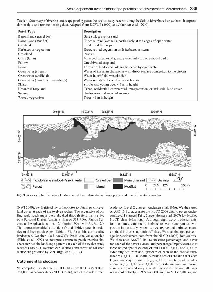
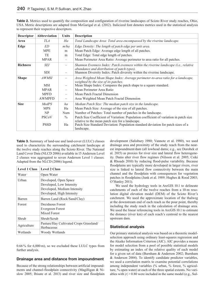
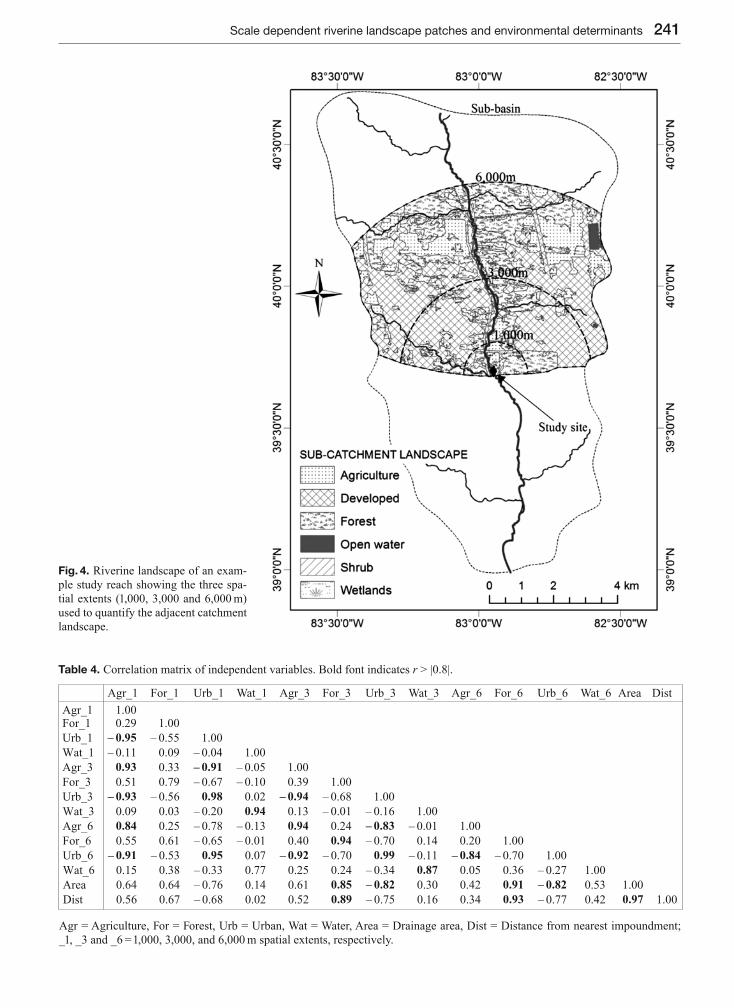
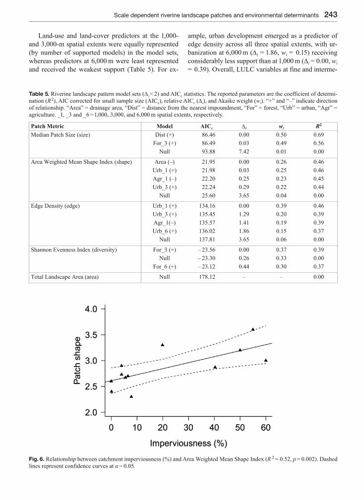
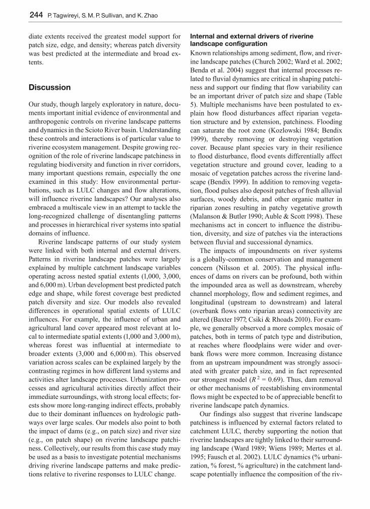