assisting the michigan wildlife action plan: relevant ......assisting the michigan wildlife action...
TRANSCRIPT

Assisting the Michigan Wildlife Action Plan: Relevant Information and Tools for Incorporating Plants
Prepared by: Michael R. Penskar
Michigan Natural Features Inventory
Stevens T. Mason Bldg. P.O. Box 30444
Lansing, MI 48909-7944
For: NatureServe
Arlington, VA
Grant/Agreement #DDF-OF-001
Report Number 2013-02
January 31, 2013

Suggested Citation:
Penskar, M.R. and A.L. Derosier. 2012. Assisting the Michigan Wildlife Action Plan: Tools and
Information for Incorporating Plants. Final Report to NatureServe. Michigan Natural Features Inventory
Report No. 2012-, Lansing, MI. 26 pp. + appendices.
Copyright 2013 Michigan State University Board of Trustees.
Michigan State University Extension programs and materials are open to all without regard to
race, color, national origin, gender, religion, age, disability, political beliefs, sexual orientations,
marital status or family status.
Cover photographs clockwise from upper left: Four rare plant species endemic to Great Lakes shores:
the federal and state threatened Houghton’s goldenrod (Solidago houghtonii), the federal and state
threatened dwarf lake iris (Iris lacustris), the federal and state threatened Pitcher’s thistle (Cirsium
pitcheri), and the federal and state endangered Michigan monkey-flower (Mimulus michiganensis).
Michigan Natural Features Inventory photo library.
Abstract
Plants perform numerous critical ecosystem services and are essential to wildlife, yet despite their
important role, they are poorly recognized in most state Wildlife Action Plans (WAPs). The creation and
implementation of WAPs in 2005 signaled a new era in conservation, yet as developed and formally
funded these plans can reference only free-ranging fauna and the definition of species of greatest
conservation need (SGCN) specifically exclude plants. A recent study and analysis of state WAPs by
NatureServe verified the currently limited role for plants, but recommended that plants could achieve a
greater role by continuing to develop and add plant-specific components to existing wildlife plans. To
that end, the purpose of this project was to take part in a multi-state effort through NatureServe to
improve the incorporation of plant-specific components and plant conservation strategies into the
Michigan WAP. The thrust of the Michigan project was to provide information on Michigan’s rare flora
that would promote the role of plants by focusing on climate change and additional tools to assist the state
WAP. This project was designed to complement similar efforts taking place in North Dakota, New
Jersey, Montana, and Colorado. The first component of this project was comprised of determining climate
change vulnerabilities for a set of priority rare plant taxa and additional species important to wildlife as
suggested by DNR biologists. The second component of the project consisted of augmenting the
landscape features crosswalk created by the state WAP by expanding the crosswalk to include the state’s
420 listed rare taxa. The third basic component of the project was a spatial analysis to aid in highlighting
conservation gaps to assist in identifying potential future priority areas and to augment the information
assembled in the expanded landscape features crosswalk. For the climate component, 76 species were
assessed using the NatureServe Climate Change Vulnerability Assessment (CCVI) calculator. A majority
of the species assessed was determined to be vulnerable to climate change, include more than half of the
common species assessed. The landscape features crosswalk was incorporated into a database, and then
joined to a rare plant species-natural community crosswalk embedded in the Michigan Natural Features
Inventory (MNFI) Rare Species Explorer. This database was then augmented with information on each
rare plant species, primarily with regard to describing habitat but also incorporated conservation and
management considerations. Selected spatial analyses indicated that defined high quality areas contribute
disproportionately to rare plant richness and diversity in Michigan and thus are worthy of strong
consideration for contributing to WAP activities and goals. In concert with the currently proposed
Biodiversity Stewardship Areas, these delineated landscapes can contribute significantly to the Michigan
WAP.


Table of Contents page
Abstract ................................................................................................................................ i
Introduction ..........................................................................................................................1
Methods................................................................................................................................2
Results and Discussion ......................................................................................................10
Climate Change Vulnerability Assessment .....................................................................10
Landscape Features Crosswalk ........................................................................................15
Spatial Analysis ...............................................................................................................16
Conclusions and Summary ................................................................................................23
Acknowledgements ............................................................................................................24
Literature Cited ..................................................................................................................25
List of Tables and Figures Table 1. Climate change vulnerability index and confidence scores .................................11
Table 2. Summary of CCVI calculations ...........................................................................13
Table 3. Examples of output from landscape features crosswalk .....................................17
Table 4. Results of screening the Michigan rare plant database
against high quality state footprint by land ownership and rank class ..............................22
Table 5. Results of screening the Michigan rare plant database
against high quality state footprint by land ownership and EO rank class ........................22
Figure 1. Identified high ranking natural communities and designated
state natural areas. ................................................................................................................3
Figure 2a. Lower Peninsula contiguous forest patches in areas of unchanged
vegetation (circa 1800-1978 ................................................................................................4
Figure 2b. Upper Peninsula contiguous forest patches in areas of unchanged
vegetation (circa 1800-1978 ................................................................................................5
Figure 3a. Lower Peninsula contiguous wetland patches in areas of unchanged
vegetation (circa 1800-1978 ................................................................................................6
Figure 3b. Upper Peninsula contiguous wetland patches in areas of unchanged
vegetation (circa 1800-19787 ..............................................................................................7
Figure 4. Unchanged vegetation circa 1800-1978, against which forest and
wetland blocks were filtered ................................................................................................8
Figure 5. Total spatial state footprint of all high quality sites ............................................9
Figure 6. Biodiversity stewardship areas map (MDNR 2012) .........................................20
Figure 7. Rare plant occurrences intersecting the high quality state footprint .................21
Appendix
Attachment 1. CCVI Calculator with results. ....................................................................26
Attachment 2. Landscape features crosswalk database .....................................................26

1
Introduction
Plants comprise much of the fabric and framework of our environment, perform numerous critical
ecosystem services, and are unarguably essential to all animal life. Given their obvious importance, it is
logical to assume that the role of plants should be carefully considered and incorporated into wildlife
conservation efforts, particularly with the advent of wildlife action plans (WAPs) nationwide. Wildlife
action plans, according to the review and analysis by Stein and Gravuer (2008), signaled a new era in
conservation in 2005 through their collective effort to formulate a strategic blueprint to prevent wildlife
from becoming endangered, as conceptualized by the Association of Fish and Wildlife Agencies (2006).
As developed and funded, the definition of “wildlife” references only free-ranging fauna, and with regard
to species of greatest conservation need (SGCN), the guidelines specifically exclude plants. Stein and
Gravuer (2008) noted that states were allowed a high degree of flexibility in devising their wildlife action
plans such that they could be adapted to local needs and conditions. Although according to federal
guidelines states were not able to use federal funds to consider plant species in the plans, they were at the
same time not specifically prevented from addressing plant species of concern in their plans.
Despite the ability to be more expansive and comprehensive in state wildlife action plans by addressing
plant species of concern, relatively few states have thus far done so to more than a modest degree.
Among the several recommendations provided in the thoughtful assessment by Stein and Gravuer was the
suggestion to continue to develop and add “plant-specific components to existing wildlife plans”. This is
particularly important and timely as the first generation of wildlife action plans are updated, creating
opportunities to subsequently incorporate plants, by directly including plant-specific components and/or
by including and implementing actions and strategies that would benefit both wildlife and plant species of
concern (Stein and Gravuer 2008). There are compelling reasons for incorporating plant species of
concern into the Michigan WAP beyond the general imperative noted above. In terms of plant diversity
as expressed by the number of native plant species, Michigan is relatively low in comparison to other
states with a total of just over 1800 taxa. However, in terms of the proportion of plant species at risk,
Michigan ranks among the highest in the Midwest (Stein and Gravuer 2008), which is perhaps a stronger
basis for general comparison. More specifically, with 420 vascular plant taxa classified as rare (i.e.
endangered, threatened, special concern, or extirpated), this means that more than 23% of the state’s
native flora is comprised of species of concern. The inherent rarity of such a high proportion of the native
flora has many implications for wildlife, and in several cases there are direct linkages with SGCN, such as
insects that have obligate relationships with rare plant species required for food, nectar sources, or
breeding sites (e.g. the Northern blue butterfly and the state threatened dwarf bilberry).
The purpose of this project was to take part in a multi-state effort through NatureServe to improve the
incorporation of plant-specific components and plant conservation strategies in state wildlife action plans.
The thrust of the Michigan effort was to provide pertinent and detailed information on Michigan’s rare
flora to both promote and facilitate the integration of plant conservation, including climate change
considerations, into the state WAP and related conservation activities. This project was designed to
complement similar, concurrent projects in New Jersey, Montana, Colorado and North Dakota, and was
focused on developing a suite of plant information products compatible for potential inclusion in the state
WAP, working in collaboration with the Michigan WAP Coordinator. The first component of the project
focused on calculating Climate Change Vulnerability Indices (CCVIs), according to the methodology
developed by NatureServe, for a selected set of high priority rare plant species as well as an additional set
of common taxa. The second component of the project was designed to provide pertinent information on
plant species of concern to help further develop a landscape feature-natural community crosswalk as
developed by the WAP. The third component of the project was to conduct a spatial analysis of the
Michigan rare plant database to help highlight conservation gaps for assisting in the identification of
potential priority areas and to augment the information provided in the landscape features crosswalk.

2
Methods
The project was initiated by consultation with the Michigan WAP Coordinator, who had assisted in
proposal conceptualization and development and thus helped define the objectives and outcomes from the
inception of this effort. For the first component of the project, the calculation of selected CCVI indices,
the primary taxa were identified as all of Michigan’s G3 and rarer taxa, including species with range-
ranks and sub-specific taxa T3 and rarer, with the intention of adding additional rare taxa to this core list
as time permitted and through related projects. The core list was expanded by running several series of
queries on natural communities using the Michigan Natural Features Inventory (MNFI) Rare Species
Explorer (see http://mnfi.anr.msu.edu/explorer/search.cfm ), focusing on rare and other high priority
natural communities, such as the diverse types of Great Lakes coastal areas, to identify additional plant
species of interest. The core list was also expanded in consultation with the WAP Coordinator, who
queried Wildlife Division biologists for suggested additional plant species, such as taxa considered
important for game management, including species critical for food or cover and also competitive
invasive species often dealt with in habitat management activities. The several suggestions from wildlife
biologists were passed along and compiled into a list. CCVI training was initiated through Go-To
meetings/presentations and cached training sessions on the NatureServe Web page. In addition,
additional consultation and training was sought and completed with Kimberly Hall of the Michigan
Chapter Office of The Nature Conservancy, a co-designer of the CCVI. Additional detailed training on
the CCVI was acquired through a scheduled session with NatureServe staff at the initiation of a
concurrent Michigan Department of Environmental Quality (MDEQ) Coastal Zone Management (CZM)
funded project. CCVIs were methodically calculated following the protocols provided through training
sessions and the written guidelines, beginning with version 2.0 and then converting to Release 2.1 (Young
et al. 2011).
The second component of the project consisting of augmenting a landscape feature-natural community
crosswalk completed for the WAP by incorporating rare plant species and including pertinent information
where appropriate, with an emphasis on habitat and management comments. This was done by first
linking plant species of concern to natural community types via the embedded species-community
crosswalk in the MNFI Rare Species Explorer. The landscape feature-natural community crosswalk was
essentially reformatted or expanded to first incorporate the linkage to associated rare plant species and
then provide selected comments on rare plant species for the benefit of WAP users. The intent of
augmenting this crosswalk was to illustrate to WAP users and others the strong relationship of rare plants
to landscape features, natural communities, and by implication their relevancy to wildlife species of
concern and how management activities can be potentially beneficial to both wildlife and plants.
The third component of the project was as a spatial analysis of the MNFI rare plant database, primarily to
identify conservation gaps, such that it could be demonstrated how activities conducted through the
Michigan WAP (e.g. such as the identification of priority areas) could be shown to be mesh with and
contribute to plant conservation. To accomplish this, the MNFI rare plant database was screened against
a set of spatially explicit criteria, which were developed during a previous project to study the value of
using rare plant species as environmental indicators (Pearman et al. 2006, Penskar et al. 2003), with the
goal of identifying and delineating areas in which plant species would likely be the most viable. The four
spatial criteria collectively applied to delineate an ecological “footprint” of the high quality habitats of the
state included a GIS layer of high ranking natural communities and state designated natural areas,
contiguous forest patches no smaller than 100 ha within areas of unchanged vegetation (circa 1800-1978),
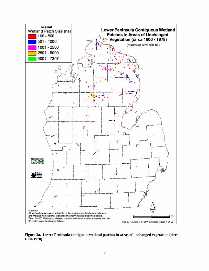
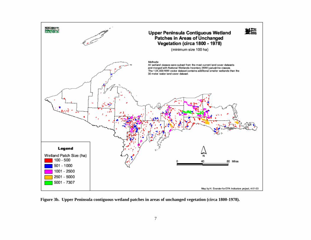
contiguous wetland patches no smaller than 100 ha in areas of unchanged vegetation (circa 1800-1978),
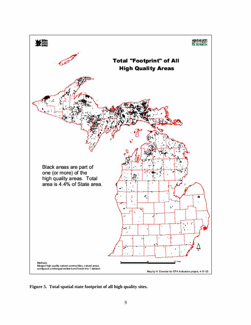
and unchanged vegetation circa 1800-1978 (Figures 1, 2a, 2b, 3a, 3b, 4, and 5). The plant database was
also screened against an additional available layer, a set of potential biodiversity stewardship areas
delineated in a statewide planning effort to identify intact, high priority landscapes (Cohen 2011).

3
Figure 1. Identified high ranking natural communities and designated state natural areas.

4
Figure 2a. Lower Peninsula contiguous forest patches in areas of unchanged vegetation (circa
1800-1978).

5
Figure 2b. Upper Peninsula contiguous forest patches in areas of unchanged vegetation (circa 1800-1978).
6
Figure 3a. Lower Peninsula contiguous wetland patches in areas of unchanged vegetation (circa
1800-1978).
7
Figure 3b. Upper Peninsula contiguous wetland patches in areas of unchanged vegetation (circa 1800-1978).

8
Figure 4. Unchanged vegetation circa 1800-1978, against which forest and wetland blocks were
filtered.
9
Figure 5. Total spatial state footprint of all high quality sites.

10
Results and Discussion
Climate Change Vulnerability Assessment
CCVI calculations were conducted for a total of 76 species, including all but two of Michigan’s globally
rare and rarer taxa (35 taxa)1 and a selected group of common (unlisted) species as well two well-known,
noxious invasive taxa, the latter two sets of species drawn from a list of plant taxa suggested by wildlife
biologists via the state WAP Coordinator (Table 1). Overall, the plant species selected for the
vulnerability assessment were both taxonomically diverse (including ferns and fern allies, conifers,
orchids, sedges, grasses, and numerous dicots) and highly varied in terms of state distribution, ecology,
morphology, and life history. This group of species is collectively associated with several natural
community types occurring in Michigan and throughout the Great Lakes region, and included one
mycoheterotrophic (i.e. “saprophytic”) taxon (Orobanche fasciculata) and two insectivorous species,
butterwort (Pinguicula vulgaris) and English sundew (Drosera anglica).
The majority of the vascular plant species assessed were determined to be extremely, highly, or
moderately vulnerable to climate change, as summarized in Tables 1 and 2. Of the 76 species scored, 57
species (75%) were predicted to be vulnerable to climate change, of which 14 (18%) were found to be
“Extremely Vulnerable,” 24 (32%) were found to be “Highly Vulnerable,” and 19 (25%) were found to be
“Moderately Vulnerable”. Of the 19 species (25 %%) not found to be vulnerable to climate change, 16
species (21%) were scored as “Presumed Stable” and 3 (4%) were scored as “Not Vulnerable/Increase
Likely” (Tables 1 and 2). Specific factor scoring for all plant species that were assessed are provided in
Attachment 1.
Conservation status and vulnerability to climate change appear to be strongly related for the plant species
assessed. Table 2 presents a summary of the vulnerability assessments ordered hierarchically by both
global and state rank within each vulnerability category, and also provides both state and federal listing
status. For the 65 state listed plant taxa assessed, 52 species (80%) were found to be vulnerable. Of the
subset of 33 globally rare listed species assessed, 27 species (82%) scored as vulnerable, and this was also
similar for the globally secure (G4-G5) listed species assessed, with 25 of the 32 species (78%) found to
be vulnerable. However, despite a similarity in the overall percentage of vulnerable taxa between the
globally rare and the globally secure species assessed, there was a marked difference in the distribution of
the species among the vulnerability categories. For the globally rare listed species, 22 of the 27 species
assessed were scored as extremely vulnerable and highly vulnerable, whereas for globally secure species,
23 of the 25 species assessed were scored in the highly vulnerable to moderately vulnerable categories. A
single listed species, the Midwest endemic and globally rare Cirsium hillii (Hill’s thistle), was assessed as
“increase likely”, which is highly tenable for this oak barrens species of fire-prone habitats in future
climate warming scenarios.
For the 9 unlisted native species assessed, 5 (56%) were assessed as vulnerable to climate change,
whereas 4 were assessed as remaining stable. Thuja occidentalis (Northern white cedar), a species
extremely important for wildlife as food and thermal cover, was scored as extremely vulnerable, and
Fagus grandifolia (American beech) and Tsuga canadensis (Eastern hemlock), both also important to a
variety of wildlife for food, thermal cover, and/or as breeding (e.g. nesting) sites , were scored as highly
vulnerable. The remaining vulnerable species consisted of Populus grandidentata (Bigtooth aspen) and
P. tremuloides (Trembling aspen), both of which are critical species for wildlife (e.g. upland game birds).
Unlisted species assessed to be stable included Lupinus perennis (Wild lupine), an obligate plant for the
Karner blue butterfly, Lemna minor (Duckweed), and important waterfowl food, Pinus banksiana (Jack
1 Data were not available for two of these taxa, one consisting of a state extirpated species and the other a newly
listed taxon.

11
pine), which comprises the obligate nesting habitat for the endemic Kirtland’s warbler, and Vallisneria
americana (Wild-celery), whose tubers are a critically important waterfowl food source. Phragmites
australis (common reed) and Lythrum salicaria (purple loosestrife) comprised the two exotic, invasive
species assessed to likely increase, which is not unexpected given their current status as aggressive
competitors.
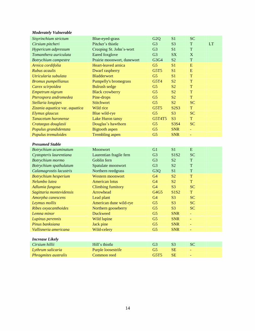
Table 1. Climate change vulnerability index and confidence scores for plant species assessed using
the NatureServe Climate Change Vulnerability Index (CCVI). Species highlighted in bold
comprise those taxa selected from a list of species suggested by MDNR wildlife biologists, including
important food and cover plants and two noxious, invasive species as noted by their respective state
ranks of “SNR” and “SE”.
Species
Scientific Name
Species
Common Name
Global
Rank
State
Rank
Vulnerability
Index Score
Confidence
Score
Agalinis skinneriana Skinner's agalinis G3G4 S1 Extremely Vulnerable Very High
Amerorchis rotundifolia Small round-leaved orchis G5 S1 Extremely Vulnerable Very High
Besseya bullii Kitten-tails* G3 S1 Extremely Vulnerable Very High
Betula murrayana Murray birch G1Q S1 Extremely Vulnerable Very High
Bromus nottowayanus Satin brome G3G5 S3 Extremely Vulnerable Moderate
Isotria medeoloides Smaller whorled pogonia G2 SX Extremely Vulnerable Very High
Listera auriculata Auricled twayblade G3 S2S3 Extremely Vulnerable Very High
Mimulus michiganensis Michigan monkey-flower G5T1 S1 Extremely Vulnerable Very High
Panax quinquefolius Ginseng G3G4 S2S3 Extremely Vulnerable Moderate
Poa paludigena Bog bluegrass G3 S2 Extremely Vulnerable Very High
Prosartes maculata Nodding mandarin G3G4 SX Extremely Vulnerable Very High
Saxifraga paniculata Encrusted saxifrage G5 S1 Extremely Vulnerable Moderate
Schoenoplectus hallii Hall's bulrush G2G3 S2 Extremely Vulnerable Low
Thuja occidentalis Northern white cedar G5 SNR Extremely Vulnerable Very High
Asclepias hirtella Tall green milkweed G5 S2 Highly Vulnerable Low
Asclepias sullivantii Sullivant's milkweed G5 S2 Highly Vulnerable Low
Asplenium scolopendrium American hart's tongue fern G4T3 S1 Highly Vulnerable Very High
Aster furcatus Forked aster G3 S1 Highly Vulnerable Very High
Cacalia plantaginea Prairie Indian-plantain G4G5 S3 Highly Vulnerable Low
Calypso bulbosa Calypso orchid G5 S2 Highly Vulnerable Low
Carex richardsonii Richardson's sedge G4 S3S4 Highly Vulnerable Very High
Cypripedium arietinum Ram's head lady's-slipper G3 S3 Highly Vulnerable Very High
Drosera anglica English sundew G5 S3 Highly Vulnerable High
Fagus grandifolia American beech G5 SNR Highly Vulnerable Very High
Gymnocarpium
robertianum Limestone oak fern G5 S2 Highly Vulnerable Moderate
Hymenoxys herbacea Lakeside daisy G3 S1 Highly Vulnerable Very High
Iris lacustris Dwarf lake iris G3 S3 Highly Vulnerable Very High
Lycopodiella margueritae Northern prostrate clubmoss G2 S2 Highly Vulnerable Very High
Lycopodiella subappressa
Northern appressed
clubmoss G2 S2 Highly Vulnerable Very High
Orobanche fasciculata Fascicled broom-rape G4 S2 Highly Vulnerable Very High
Pinguicula vulgaris Butterwort G5 S3 Highly Vulnerable Very High
Platanthera leucophaea
Eastern prairie fringed-
orchid G3 S1 Highly Vulnerable Moderate
Potamogeton hillii Hill’s pondweed G3 S2 Highly Vulnerable Moderate

12
Saxifraga tricuspidata Prickly saxifrage G4G5 S2 Highly Vulnerable Low
Solidago houghtonii Houghton’s goldenrod G3 S3 Highly Vulnerable Very High
Triphora trianthophora Three birds orchid G3G4 S1 Highly Vulnerable Low
Tsuga canadensis Eastern hemlock G5 SNR Highly Vulnerable Very High
Valerianella umbilicata Corn salad G3G5 S2 Highly Vulnerable Moderate
Arnica cordifolia Heart-leaved arnica G5 S1 Moderately Vulnerable Moderate
Botrychium campestre Prairie moonwort, dunewort G3G4 S2 Moderately Vulnerable Very High
Bromus pumpellianus Pumpelly's bromegrass G5T4 S2 Moderately Vulnerable Very High
Carex scirpoidea Bulrush sedge G5 S2 Moderately Vulnerable Very High
Cirsium pitcheri Pitcher's thistle G3 S3 Moderately Vulnerable Very High
Crataegus douglasii Douglas's hawthorn G5 S3S4 Moderately Vulnerable Moderate
Elymus glaucus Blue wild-rye G5 S3 Moderately Vulnerable Very High
Empetrum nigrum Black crowberry G5 S2 Moderately Vulnerable Low
Hypericum adpressum Creeping St. John's-wort G3 S1 Moderately Vulnerable Very High
Populus grandidentata Bigtooth aspen G5 SNR
Moderately
Vulnerable Very High
Populus tremuloides Trembling aspen G5 SNR
Moderately
Vulnerable Very High
Pterospora andromedea Pine-drops G5 S2 Moderately Vulnerable Moderate
Rubus acaulis Dwarf raspberry G5T5 S1 Moderately Vulnerable Moderate
Sisyrinchium strictum Blue-eyed-grass G2Q S2 Moderately Vulnerable Very High
Stellaria longipes Stitchwort G5 S2 Moderately Vulnerable Very High
Tanacetum huronense Lake Huron tansy G5T4T5 S3 Moderately Vulnerable Very High
Tomanthera auriculata Eared foxglove G3 SX Moderately Vulnerable Moderate
Utricularia subulata Bladderwort G5 S1 Moderately Vulnerable Very High
Zizania aquatica var.
aquatica Wild rice G5T5 S2S3 Moderately Vulnerable Very High
Adlumia fungosa Climbing fumitory G4 S3 Presumed Stable Moderate
Amorpha canescens Leadplant G5 S2S3 Presumed Stable Very High
Botrychium acuminatum Moonwort G1 S1 Presumed Stable Very High
Botrychium hesperium Western moonwort G4 S2 Presumed Stable Low
Botrychium mormo Goblin fern G3 S2 Presumed Stable Moderate
Botrychium spathulatum Spatulate moonwort G3 S2 Presumed Stable Low
Calamagrostis lacustris Northern reedgrass G3Q S1 Presumed Stable Low
Cystopteris laurentiana Laurentian fragile fern G3 S1S2 Presumed Stable Very High
Lemna minor Duckweed G5 SNR Presumed Stable Very High
Leymus mollis American dune wild-rye G5 S3 Presumed Stable Very High
Lupinus perennis Wild lupine G5 SNR Presumed Stable Moderate
Nelumbo lutea American lotus G4 S2 Presumed Stable Low
Pinus banksiana Jack pine G5 SNR Presumed Stable Very High
Ribes oxyacanthoides Northern gooseberry G5 S3 Presumed Stable Very High
Sagittaria montevidensis Arrowhead G4G5 S1S2 Presumed Stable Very High
Vallisneria americana Wild-celery G5 SNR Presumed Stable Very High
Cirsium hillii Hill’s thistle G3 S3 Increase Likely Very High
Lythrum salicaria Purple loosestrife G5 SE Increase Likely Very High
Phragmites australis Common reed G5T5 SE Increase Likely Very High

13
Table 2. Summary of CCVI calculations by assessed vulnerability category and stratified by global
and state status. Taxa shaded in green comprise globally rare to rarer taxa, whereas taxa shaded in
yellow represent globally secure species. SNR = state non-ranked, SE = state exotic
Scientific Name Common Name
Global
Rank
State
Rank
State
Status
US
Status
Extremely Vulnerable
Isotria medeoloides Smaller whorled pogonia G2 SX X LT
Mimulus michiganensis Michigan monkey-flower G5T1 S1 E LE
Betula murrayana Murray birch G1Q S1 SC
Schoenoplectus hallii Hall's bulrush G2G3 S2 T
Poa paludigena Bog bluegrass G3 S2 T
Besseya bullii Kitten-tails G3 S1 E
Listera auriculata Auricled twayblade G3 S2S3 SC
Prosartes maculata Nodding mandarin G3G4 SX X
Agalinis skinneriana Skinner's agalinis G3G4 S1 E
Panax quinquefolius Ginseng G3G4 S2S3 T
Bromus nottowayanus Satin brome G3G5 S3 SC
Amerorchis rotundifolia Small round-leaved orchis G5 S1 E
Saxifraga paniculata Encrusted saxifrage G5 S1 T
Thuja occidentalis Northern white cedar G5 SNR -
Highly Vulnerable
Lycopodiella margueritae Northern prostrate clubmoss G2 S2 T
Lycopodiella subappressa Northern appressed clubmoss G2 S2 SC
Aster furcatus Forked aster G3 S1 T
Hymenoxys herbacea Lakeside daisy G3 S1 E LT
Platanthera leucophaea Eastern prairie fringed-orchid G3 S1 E LT
Potamogeton hillii Hill's pondweed G3 S2 T
Cypripedium arietinum Ram's head lady's-slipper G3 S3 SC
Iris lacustris Dwarf lake iris G3 S3 T LT
Solidago houghtonii Houghton's goldenrod G3 S3 T LT
Triphora trianthophora Three birds orchid G3G4 S1 T
Valerianella umbilicata Corn salad G3G5 S2 T
Asplenium scolopendrium American hart's tongue fern G4T3 S1 E LT
Orobanche fasciculata fascicled broom-rape G4 S2 T
Carex richardsonii Richardson’s sedge G4 S3S4 SC
Saxifraga tricuspidata Prickly saxifrage G4G5 S2 T
Cacalia plantaginea Prairie Indian-plantain G4G5 S3 SC
Asclepias hirtella Tall green milkweed G5 S2 T
Asclepias sullivantii Sullivant's milkweed G5 S2 T
Calypso bulbosa Calypso orchid G5 S2 T
Gymnocarpium robertianum Limestone oak fern G5 S2 T
Drosera anglica English sundew G5 S3 SC
Pinguicula vulgaris Butterwort G5 S3 SC
Fagus grandifolia American beech G5 SNR -
Tsuga canadensis Eastern hemlock G5 SNR -
14
Moderately Vulnerable
Sisyrinchium strictum Blue-eyed-grass G2Q S1 SC
Cirsium pitcheri Pitcher’s thistle G3 S3 T LT
Hypericum adpressum Creeping St. John’s-wort G3 S1 T
Tomanthera auriculata Eared foxglove G3 SX X
Botrychium campestre Prairie moonwort, dunewort G3G4 S2 T
Arnica cordifolia Heart-leaved arnica G5 S1 E
Rubus acaulis Dwarf raspberry G5T5 S1 E
Utricularia subulata Bladderwort G5 S1 T
Bromus pumpellianus Pumpelly's bromegrass G5T4 S2 T
Carex scirpoidea Bulrush sedge G5 S2 T
Empetrum nigrum Black crowberry G5 S2 T
Pterospora andromedea Pine-drops G5 S2 T
Stellaria longipes Stitchwort G5 S2 SC
Zizania aquatica var. aquatica Wild rice G5T5 S2S3 T
Elymus glaucus Blue wild-rye G5 S3 SC
Tanacetum huronense Lake Huron tansy G5T4T5 S3 T
Crataegus douglasii Douglas’s hawthorn G5 S3S4 SC
Populus grandidentata Bigtooth aspen G5 SNR -
Populus tremuloides Trembling aspen G5 SNR -
Presumed Stable
Botrychium acuminatum Moonwort G1 S1 E
Cystopteris laurentiana Laurentian fragile fern G3 S1S2 SC
Botrychium mormo Goblin fern G3 S2 T
Botrychium spathulatum Spatulate moonwort G3 S2 T
Calamagrostis lacustris Northern reedgrass G3Q S1 T
Botrychium hesperium Western moonwort G4 S2 T
Nelumbo lutea American lotus G4 S2 T
Adlumia fungosa Climbing fumitory G4 S3 SC
Sagittaria montevidensis Arrowhead G4G5 S1S2 T
Amorpha canescens Lead plant G4 S3 SC
Leymus mollis American dune wild-rye G5 S3 SC
Ribes oxyacanthoides Northern gooseberry G5 S3 SC
Lemna minor Duckweed G5 SNR -
Lupinus perennis Wild lupine G5 SNR -
Pinus banksiana Jack pine G5 SNR -
Vallisneria americana Wild-celery G5 SNR -
Increase Likely
Cirsium hillii Hill’s thistle G3 S3 SC
Lythrum salicaria Purple loosestrife G5 SE -
Phragmites australis Common reed G5T5 SE -

15
One of the principal risk factors contributing to the determination of climate change vulnerability for
plants was historical hydrological regime, which was scored as “greatly increase” for more than 50% of
the species assessed. For all but one of the remaining species (which was scored as “somewhat
increase”), this factor was scored as “increase”, and in no case did historical hydrological regime score as
low as “neutral.” Thus, it was clearly a significant factor. One of the other prominent risk factors for
plants was the allied category of physiological hydrological niche, which indicates that several of the taxa
included have a strong wetland affinity, particularly those species that inhabit ecotones and/or depend on
seasonal flooding and drawdown cycles, although in general most wetland-related species would be
expected to experience more adverse and disrupted conditions owing to the projected drier, warmer
conditions for 2050. Approximately 50% of the species assessed for this factor were scored from
“slightly increase” or higher, with more than half of those scored as “greatly increase”.
Other prominent risk factors included the category of natural barriers and dispersal/movement, as in both
of these categories well over 50% of the species assessed were scored above neutral (i.e. as “increase” or
higher). For natural barriers, many of the shoreline species will be impeded by the inability to migrate
northward over the portions of the Great Lakes, particularly, for example, for species along the southern
shore of Lake Superior. Although it is expected that several species would migrate lakeward, following
the water’s edge as basins presumably retract, and thus ostensibly continue to occupy available habitat,
long-distance dispersal will still be problematical. In addition, plant species in southern Michigan may
have formidable barriers with regard to dispersing north over the largely agricultural interior in the
southern Lower Peninsula, where there is extensive and often contiguous unsuitable habitat. For the
category of dispersal/movement, the scores largely indicate the relatively limited short-dispersal distances
that many plants have, especially those species that have few or no animal vectors (particularly for
graminoids) and thus can only scatter seeds very locally (i.e. less then about 100 meters), although this is
necessarily qualified. Many small seeds, such as the tiny, dust-like propagules produced by orchids, may
be carried considerable distances via wind, whereas other species may have the ability to be dispersed
fairly long distances via stream and river transport.
Additional notable risk factors included physical habitat (restriction to uncommon geological features or
derivatives) and reliance on interspecific interactions. For the former category, about 50% of the species
assessed were scored as “increase” or higher, indicating the dependence several of the assessed species
have on such habitats as dunes, certain wetland types, and specialized substrates such as those that are
found on bedrock shorelines (e.g. limestone/alvar, volcanic, etc.). With regard to interspecific
interactions, more than 10 species were scored as “increase” or “slightly increase,” including several
orchids and one saprophyte which have obligate relationships with fungi, and thus, due to this
dependence, such species have a greater vulnerability to climate change.
Landscape Features Crosswalk
As described above, an existing landscape features-natural community crosswalk developed for the
Michigan WAP was used to provide a linkage to all of Michigan’s rare plant taxa. A spreadsheet of this
crosswalk, provided by the Michigan WAP Coordinator, was first converted into a database, and then this
table was joined to the natural community-rare species crosswalk embedded within the MNFI Rare
Species Explorer. Following the joining of these tables, which then linked all the natural community
types of each landscape feature to every associated rare plant species, a comments field was created. This
field was then methodically populated within Microsoft Access. The original intention was to include
information only for selected, highlighted species regarding management needs and related comments on
rarity and vulnerability, etc. As the species were reviewed and considered, it became apparent that a
primary need for the table was to provide a brief habitat description for each species, which is a logical
extension of the linkage from landscape feature to natural community to each particular taxon. To
accomplish this, the species were subsequently reviewed in concert with the MNFI Rare Species Explorer

16
(http://mnfi.anr.msu.edu/explorer/search.cfm) through which summarized habitat descriptions were drawn
and modified accordingly as needed for each species, thus this was necessarily a methodical, manual
procedure. As the comments field was populated, selected management and conservation notes were
included where appropriate. Habitat and management information could not be included for every
species, such as for species listed as extirpated and/or known only via vague historical records; in these
cases, information on the paucity of the species was given as well as knowledge of the known habitat
elsewhere. The completed crosswalk as a WAP related resource can thus be queried as needed and
possibly further developed with additional information, as well as updated as needed following periodic
technical list reviews. Tables 3, 4, and 5 were prepared to provide selected examples of the landscape
features-natural community-rare species crosswalk. It is anticipated that this crosswalk will be added to
the Wildlife Action Plan database such that users will be able to create summaries on SGCN, their
habitats, and key plant species. By including plant species in the updated WAP, it will be possible to
show how priority actions help the full breadth of biodiversity in the state – animals (SGCN and game
species), plants, and natural communities.
Spatial Analysis
The spatial analysis conducted is only one of many possible ways to explore the pattern of rare plant
occurrences in Michigan, the purpose of which was to provide the potential means of identifying priority
areas likely to support the most viable rare plant populations. This analysis took advantage of several
existing GIS layers (Figures 1-4) developed for an indicator species project (see Pearman et al. 2006,
Penskar et al. 2003) such that a high quality ecological “footprint” (Figure 5) of the state could be
constructed based on rigorous, spatially explicit criteria. The Michigan rare plant database was screened
against this high quality footprint to determine what was captured in terms of both representation and
quality and serve as a basis for suggesting potential priority areas where WAP activities would convey a
high value for plant species of concern. Unlike the species indicator project, this effort also included
screening the rare plant database against a layer unavailable at that time, consisting of using the MDNR
draft biodiversity stewardship areas (BSA) layer (Figure 6) such that an additional spatial aspect could be
examined for rare plant occurrence relationships.
Screening the rare plant database against the ecological footprint and the BSA layer resulted in several
spreadsheets that were examined and summarized. The MNFI rare plant database at the time of the
ecological footprint and BSA screening consisted of 5,938 element occurrences. Screening the database
against the ecological footprint intersected a total of 1,535 rare plant occurrences, representing nearly
26% of the state rare plant database, as shown in Figure 7. Given that the ecological footprint, as shown
in Figure 5, delineates only 4.4% of Michigan’s land area based on the strict requirements to identify high
quality sites, the intersection with 26% of the state’s rare plant occurrences is highly disproportionate. In
terms of representation with respect to species, 252 of Michigan’s 420 rare vascular plant taxa occurred in
the high quality footprint, including 20 of the state’s 35 G1-G3 (globally rare) taxa (57%) and 232 of the
state’s 385 G4-G5 (globally secure) taxa (60%).
The occurrences captured by this screening were reviewed and then summarized with regard to their
breakdown by ownership and global rank class (i.e. globally rare versus globally secure taxa), which after
examination of the intersection data appeared to be the most meaningful way to consider and depict the
results, as shown in Tables 3 and 4. In Table 3, the ecological footprint screening data are summarized by
ownership and number of occurrences by the respective global rank classes. In terms of rank class, of the
1,535 occurrences within the high quality state footprint, 300 (20%) were comprised of globally rare taxa
whereas 1,235 (80%) were comprised of globally secure species occurrences. With regard to ownership,
nearly 50% of the globally rare EOs was found to occur on state land, with 17% on federal lands, and
23% occurring on private land. For globally secure taxa, the ownership breakdown is somewhat similar,

17
Table 3. Examples of output from landscape feature-natural community-rare species crosswalk.

18
Table 3 continued. Examples of output from landscape feature-natural community-rare species crosswalk.

19
Table 3 continued. Examples of output from landscape feature-natural community-rare species crosswalk.

20
Figure 6. Biodiversity stewardship areas map (MDNR 2012).

21
Figure 7. Rare plant occurrences intersecting the high quality ecological footprint.

22
Table 4. Results of screening the Michigan rare plant database against the high quality state
footprint, summarized by land ownership and global rank classes.
Ownership
G1-G3
Plant Occurrences
G4-G5
Plant Occurrences
Totals
Federal 53 (17%) 123 (10%) 176 (11%)
State 139 (46%) 461 (38%) 600 (39%)
County 3 (1%) 15 (1%) 18 (1%)
Local 11 (4%) 43 (3%) 54 (4%)
NGO 25 (8%) 138 (11%) 163 (11%)
Private/Likely Private 69 (23%) 455 (37%) 524 34%)
Totals 300 occurrences 1235 occurrences 1535 occurrences
Table 5. Results of screening the Michigan rare plant database against the high quality state
footprint, summarized by land ownership and Element Occurrence Rank classes.
Ownership
A-B Rank
Plant Occurrences
C-E Rank
Plant Occurrences
Totals
Federal 104 (13%) 72 (10%) 105 (13%)
State 312 (40%) 284 (38%) 313 (40%)
County 10 (1%) 8 (1%) 10 (1%)
Local 26 (3%) 27 (4%) 28 (4%)
NGO 100 (13%) 68 (9%) 100 (13%)
Private/Likely Private 236 (30%) 288 (38%) 232 (29%)
Totals 788 occurrences 747 occurrences 1535 occurrences
with the majority of EOs occurring on state land, but nearly as many found on private, and relatively
similar proportions are shown in the total column.
Table 4 provides the same ownership summary but in this case via a breakdown by rank class with respect
to the quality of occurrences when classed according their assigned EO ranks. Here the A to B ranked
occurrences constitute the largest and most viable EOs in contrast to the C to E ranked EOs.
Interestingly, there were roughly equal numbers of occurrences within the higher and lower quality
occurrence rank classes. Of the 788 high quality occurrences, the majority (40%) were found to occur on
state land, with 30% occurring on private land. For the 747 C-E ranked occurrences, the majority (76%)
was virtually split evenly between state and private land. Overall, the majority of occurrences (40%) was
on state land, followed by private land (29%) and then federal land (13%) and NGO lands (13%).
Overall, the high number of occurrences with respect to the footprint reflects the high proportion of state
land ownership in northern Lower Michigan and the Upper Peninsula, which contain most of the state’s
intact and most extensive ecosystems and landscapes.
The last portion of the spatial analysis consisted of briefly screening the rare plant database against the
draft map of the state’s biodiversity stewardship area system (Figure 6), a project in progress to identify a
set of exemplary, ecological reference areas within Michigan. Using a version of the currently drafted
boundaries, 357 rare plant occurrences were found to intersect it, consisting of 102 globally rare
occurrences and 255 globally secure occurrences. The different approach and criteria employed for the
BSA system may be very useful to the Michigan WAP, as indicated in a comparison with the high quality
footprint, as the BSA map depicts considerably more areas delineated in southern Lower Michigan.

23
Conclusions and Summary
Climate change vulnerability assessments for Michigan demonstrated that there is a strong correlation
between global rarity and vulnerability, although most of the other taxa assessed, including selected
common species, were also assessed as being vulnerable to climate change. This may have been due to
the fact that many of the listed, globally secure species assessed consisted of those selected from
relatively rare Great Lakes natural communities, including several wetland habitats likely to impacted in
future climate change scenarios. There are significant migration barriers for many plant species, though it
was presumed that many coastal species would be able to follow successional pathways along the Great
Lakes assuming that lake basins would steadily retract and provide colonization habitat. Although
Michigan supports a comparatively small proportion of globally rare species, there is strong merit in
continuing assessments on the remainder of the state’s tracked taxa. Several common plant species
known to be significant to wildlife were also found to be vulnerable, and although the number of species
assessed was not large, the results indicated that further assessments on additional species important to
wildlife should be conducted and considered, especially plant species important to SGCN
The landscape features-natural community-rare plant species crosswalk, originally conceived for
providing comments on selected species, was developed into larger and more comprehensive tool by
adding general to specific habitat information for all species where known. It is anticipated that this
expanded crosswalk will be added to the Wildlife Action Plan database such that enhanced summaries
can be created for SGCN, their habitats, and key plant species. Moreover, the crosswalk can continue to
be developed around this framework as necessary to add further relevant information on plants, such as
management activities that promote both SGCN and rare and common plant taxa.
Selected spatial analyses indicated that defined high quality areas contribute disproportionately to rare
plant richness and diversity in Michigan and thus are worthy of strong consideration for contributing to
WAP activities and goals. In concert with the currently proposed Biodiversity Stewardship Areas, these
delineated landscapes can contribute significantly to the Michigan WAP.

24
Acknowledgements
This project would not have been possible with funding from NatureServe via the Doris Duke foundation,
and Michigan Natural Features Inventory is indebted for the opportunity to take part in this interesting,
multi-state effort to begin to better incorporate plants into state Wildlife Action Plans. Much appreciation
is extended to past and present NatureServe staff members, including Kelly Gravuer, Judy Soule, and
Leah Oliver. Kelly worked on the design the Climate Change Vulnerability Index, co-authored versions
of its manuals, and trained many of us in its reliable use. Her assistance in the initial portion of this
project was extremely helpful, both in administration and in technical issues. Judy Soule provided
guidance in preparing our proposal and setting up a contract with her former program in Michigan. Leah
Oliver served as the NatureServe project officer for the majority of this effort, and kindly, knowledgeably,
and patiently managed all that needed to be done, arranging and overseeing our conference calls,
answering financial and other administrative matters, and advising and coaching all the way through. I
would also like to thank Kimberly Hall of The Nature Conservancy for taking the time to review the
CCVI and provide further training, tips, and encouragement. Several colleagues in MNFI provided
important help as well, including Helen Enander, for supplying her abundant GIS analyst skills, Kraig
Korrock, for his daily technical wizardry that always gets us through, and Becca Rogers, for assistance
with everything from Biotics and the database to the inevitable problems with report preparation and
layout.

25
Literature Cited
Cohen, J.G. 2011. Natural community surveys of potential biodiversity stewardship areas. Submitted to
Michigan Dept. of Natural Resources, Wildlife Division and Forest Management Division. MNFI
Report Number 2011-08. Lansing, MI. 21 pp.
Cuthrell, D.L. and M.R. Penskar. 2005. Animal, plant, and natural community relationship table.
Unpublished crosswalk. Michigan Natural Features Inventory, Lansing, MI. 9 pp.
Lee, Y.M., M.R. Penskar, P.J. Badra, B.J. Klatt, and E.H. Schools. Climate Change Vulnerability
Assessment of Natural Features in Michigan’s Coastal Zone – Phase I: Assessing Rare Plants and
Animals. Submitted to Michigan Coastal Management Program, Office of the Great Lakes, Michigan
Dept. of Environmental Quality. MNFI Report Number 2011-18. Lansing, MI. 80 pp.
Pearman, P.B., M.R. Penskar, E.H. Schools, and H.D. Enander. 2006. Identifying potential indicators of
conservation value using natural heritage occurrence data. Ecological Applications 16: 186-201.
Penskar, M.R., E.H. Schools, H.D. Enander, M.A. Kost, D.L. Cuthrell, P.B. Pearman. 2003. The
Potential for Using Rare Species as Environmental Indicators: A Methodology Using Natural
Heritage Program Data. Submitted to Great Lakes National Program Office, U.S. Environmental
Protection Agency. MNFI Report Number 2003-20. Lansing, MI. 42 pp. + appendices.
Stein, B.A. and K. Gravuer. 2008. Hidden in Plain Sight: The Role of Plants in State Wildlife Action
Plans. Arlington, VA: NatureServe. 27 pp.
Voss, E.G. and A.A. Reznicek. 2012. Field Manual of the Michigan Flora. University of Michigan
Press, Ann Arbor, MI. 990 pp.
Add citation for Michigan Flora Web page
Young, B., E. Byers, K. Gravuer, K. Hall, G. Hammerson, and A. Redder. 2011. Guidelines for Using
the NatureServe Climate Change Vulnerability Index. Release 2.1, 7 April 2011. Arlington, VA. 58
pp.

26
Appendices
Attachment 1: CCVI calculator with results
Attachment 2: Landscape Feature Crosswalk