assessment work report poupore, … · assessment work report on poupore, smeenk, hemsworth mining...
TRANSCRIPT

. 35
ASSESSMENT WORK REPORT
ON
POUPORE, SMEENK, HEMSWORTH MINING CLAIMS
SCHOLES TWP, NTS 41-1116, SUDBURY MINlNG DIVISION
WORK CARRIED OUT ON CLAIMS: 3014444,3017117, 3017138,420979 1, 4209792,
4209793, 420974,4209799, 4215614 AND 42]5615 .
"RE-ESTABLISHED EXPLORATION CONTROL BASE LINE, GRID LAYOUT CONFIGURATION AND GROUND MAGNETOMETER SURVEY".
Prepared by: Ed A. Rose Aug/2007
RECEIVED AUG 2 0 2007
GEOSCIENCE ASSESSMENT OFFICE
+EdROse
~ 49 CaroUne Ct
Sudbury ON P3A 4HZ

TABLE OF CONTENTS:
SUMMARY: ........................................................................................................................................ 1
INTRODUCTION! TERMS OF REFERENCE: .................................................................................. 3
LOCATION AND ACCESS: ................................................................................................................ 3
TOPOGRAPHY : .................................................................................................................................... 3
PREVIOUS WORK: .............................................................................................................................. 3
REGIONAL GEOLOGy: ...................................................................................................................... 4
PROPERTY GEOLOGY (SYNOPSIS): .............................................................................................. .4
WORK CARRIED OUT (METHOD! APPROACH): .......................................................................... .4
PHASE 1 (FIELD TRAVERSES AND RECONNAISSANCE): .................................. .4
PHASE2: ........................................................................................................................ 5
PHASE2 (SEE APPENDIX 1)
PHASE3 ......................................................................................................................... 5
PHASE3 (SEE APPENDIX 2)
PROJECT COST ................................................................................................................................... 6
CONCLUSION ...................................................................................................................................... 6
REFERENCES ...................................................................................................................................... 6
LOCATION MAP ................................................................................................................................. 7
FIGURE 1 ..... "::: ...... ~-.~.~:.!.~ ...... ~~ .. :::.~ ........................................................................ 8
FIGURE 2 (FIELD DATA BASE MAP) .............................................................................................. 9
APPENDIX 1 (BASELINE RE-EST ABLISHMENT)
APPENDIX 2 (MAG SURVEY)
11
SUMMARY: Located some 154 km East-North East of Sudbury, the Poupore, Smeenk, Hemsworth property
consists of 149 contiguous claim units in Scholes and Belfast Township with a sliver in Phyllis Twp.
The position of the claims is detailed in this report on page 4 of the mag survey (appendix 2) section
and on an attached claim map.
The property is underlain by pre-cambrian Keewatin greenstone which contains iron formation,
(acid/basic volcanic flows), granite and granodiorite; overlaid by cobalt sediments (huronian), then
nipissing diabase sills (keweenawan).
1956-57 drill reports show a body of iron formation (Magnetite) measuring over 7, 000 ft by a
minimum of 500 ft and depth of plus 1,000 ft. This deposit is reported to contain 327.9 millions tons
at 26.9% Sol. Fe. Based on (some) compilation of the results of previous exploration and drilling, the
property owners commissioned a field program to locate and re-established the 1956 exploration and
D.D.H. control based line in preparation for the layout of a grid configuration for a 2007 ground mag
survey.
After evaluation of previous field work, an exploration compilation plan was developed to show the
"plotted" locations of drill hole sites, topo features, geophysical signatures and geology. A phase 1
program was then designed to locate and flag the position of the old based line tied into the drill hole
sites and other topographical features.
Based on data control information plotted, field traverses were carried out on pace/compass/GPS lines
in search of this 1956 exploration control lines (the base line), and/or old D.D.H. location(s) which
could be used for tie reference(s).
Evidence in the field suggested that the area was burnt over at least twice and was logged sometime
after the 1956-1957 exploration programs. Trees in the area were determined to be not much older
than 20 years and lake shoreline features changed over the period 1956 to present. D.D.H. #9 was
found but the baseline could not be referenced. Another method was used in the search for the old
baseline, as none of the other plotted features were fOlmd (located). A flag line was established to run
north from the center of an old shaft to drill hole #9. A pace and compass traverse was established
Page 1
from this drill hole location to calculated points which should represent the locations of other holes
tied to the old base and grid lines (centers). This exercise failed to locate the drill hole location,
therefore accurate ties to the old base line location could not be established. As the old base line was
used as the control line for previous work and as its location is relevant for present and feature
exploration endeavours, a surveyor was engaged to layout and re-established this line. This task was
successfully accomplished and facilitated the layout of a grid plan for the ground mag survey.
Page 2

INTRODUCTIONI TERMS OF REFERENCE: Poupore, Smeenk and Hemsworth the owners of a group of claims (shown of the location map
contained in this report) initiated a work program to include the re-estabHshment of an old control
baseline, a grid line survey and a ground mag survey. Field work was carried out between June 27-
August 10,2007 by Ed Rose, Jerry Shyminsky and Miller Usro Surveying Inc. all of Sudbury, Ontario
and Meegwich Consultants Inc. of Temagami, Ontario.
LOCATION AND ACCESS: Access to the area is via highway 17 East from Sudbury to Verner a distance of 63 km; then on to
highway 539 for 19 km to Field; thence 15 km to River Valley, then North for 37 km to a bridge, then
East on Highway 805. Tum right (note a sign 4 km to Obabika Lake Lodge). Travel East 3 km further
on this road to Greenrod Lake. Continue on this road 3 km further. At this locating tum right. The road
is in poor condition and from this point an A TV or 4wd is recommended. The coordinates at this
junction are (NAD27 UTMI7 0555771E 5201302N). Travel this road to a small lake and continue one
kilometre to coordinates (NAD27 UTM17 0559647E 5201109N). Then south on poor gravel road (to
Gull Lake) for a distance of approximately 13 km.
TOPOGRAPHY: Vegetation in the area is second growth jackpine, cedar, alder, birch, poplar and spruce. The area is
rugged with intermittent swamps, hills and wide distribution of Nip is sing Diabase outcrops.
PREVIOUS WORK: MDM assessment files show that between 1952-1961 the following companies carried out work over
the claim area:
• Dominion Golf Co (mag survey);
• Tamicon Mines Ltd (mag survey and dd);
• North American Rear Metals Ltd; the Rio Tinto Mining Co of Canada Ltd; Rio Algom Mines
Ltd; Tinto Iron Mines Ltd; Homestake Exploration Limited and Eagle Rock Iron Mines Ltd
(dd, bulk sampling, met. Testing, Aero mag, electromag, underground development and shaft
development. )
Page 3

REGIONAL GEOLOGY: Rocks in the area are of pre-Cambrian age. The oldest rocks are greenstone and schists, aged
Keewatin. Bands of iron formation, consisting of banded magnetite with some hematite are also
classified as Keewatin (Moore 1936). Overlying the Keewatin are Temiskaming sediments
(conglomerate, arkose, quartzite and greywacke). Algoma age feldspar pmphyries intrude the above
rocks. All were subsequently overlain by cobalt sediments (Huronian), then by Nipissing Diabase sills.
Gold massive and disseminated sulfites were reported as commodities found in Scholes Township.
The former Golden Rose goldmine property is located less than 6 miles west of Scholes Townsip.
PROPERTY GEOLOGY (SYNOPSIS): The rocks are aU Precambrian in age. The oldest formations are acid and basic Keewatin volcanics,
including some sediments and iron formation. These rocks have been folded, faulted, and intruded by
Algoman granitic rock types, and dikes and sills of diabase and diorite.
The older rocks are overlain unconformably by later sediments of Cobalt age and the Keweenawan
Nipissing diabase sill. These rocks cover all of Scholes township except a window on the Scholes
Afton boundary. West of Cummings Lake the differential weathering of the columnar-jointed
Nipissing diabase sill in the anomalous area above the iron deposit has produced very rugged
topography with precipitous cliffs.
WORK CARRIED OUT (METHOD/APPROACH):
PHASE1: A phase 1 program, part of a planned systematic exploration program was undertaken to research,
locate and re-establish an old base line used by previous workers as the control line for field
exploration programs. Plans were made to use this 2,350 metres long (approx.) line as the control line
for a grid layout to be followed by a field mag survey. Initial work was carried out by Ed Rose and
Jerry Shyminsky both of Sudbury, Ontario. This work included the following tasks:
• June 2i\ MNDM file research I start layout offield compilation details (1.5 hour)
Page 4

• June 30th, field reconnaissance survey (11 Hrs)
• July 1_51\ Layout I drafting offield data I details (12.5 Hrs)
• July 19th, Field traverse / layout and flagged lines from old Shaft location North East to
DDH #67 Location and reconnaissance in the area (12.75 Hrs)
The crew was not successful in finding enough evidence to locate and tie this old base line, therefore a
phase two program (plan) was initiated and a surveyor was put in the field to work with the crew to
establish and layout the control baseline. In order to accelerate the program, the phase 1 crew prepared
a "FIELD DATA BASE MAP", to show, 1956 and present claim boundaries; old drill hole locations
and numbers; shaft locations, topo features; road; trails; plotted location of the old base line ?; ore
body projected to surface; anomalies and old grid layout.
• July 20th, field layout and traverse to approximate old base line locations and grid lines to
locate drill holes # 17, 4 and 14 as ties to locate the exact location of the baseline. Hole # 14
was the only hole found (12.75 Hrs)
• July 16-20t\ miscellaneous field details and related calculations (1.5 Hour)
• July 27th, traverse filed layout of approximate location for West section grid area and locate
drill #11 (as tie for baseline locations) (12.SHrs)
• August 2nd, field layout of approximate location for East grid area and locate holes #2, 3
and 8. (as tie for baseline locations) (12SHrs)
• August 3-15 t\ Detailing of project maps / plans with surveyor / field mag crew and report
preparation. (12 Hrs)
PHASE2: JULY 12TH AUGUST 2ND
, 2007
Information gathered from phase 1 could not be properly referenced. Therefore, no proper tie could be
established to accurately layout the location of the control baseline. This line grid configuration was
established by the surveyor crew with support from the phase 1 crew. Part 2 of this report details the
activities and finding of this phase.
PHASE3: AUGUST 1ST 10TH
, 2007
Page 5

Having established the baseline and the grid area configuration, a ground mag survey was carried out
over 35 km of grid lines by Meegwich Consultants Inc. Part 3 of this report details the activities and
finding of this phase.
PROJECT COST: The project cost totalled $40,630.00.
CONCLUSION: The phase 1 and 2 coordinated field program successfully established the 1956 baseline. This
controlled baseline is now tied to the found drill hole locations and to the center line of the old shan ..
A survey grid was established and tied to this baseline and a (phase 3) ground mag survey was carried out.
REFERENCES:
Files from MNDM Sudbury, office for Scholes and Belfast townships.
Respectfully submitted August l]'h, 2007,
i\
EdA. Rose
Page 6

Location Map
Page <7

laim Map
A Figur I
· '
Report on Exploration Baseline Re-establishment Geographic Township of Scholes District of Nipissing Sudbury Mining District
Prepared by:
Miller & Usro Surveying Inc. Our File: 5633
August 13, 2007
Background
Miller & Urso Surveying Inc. was approached in early July by the Temagami Iron Corporation acting on behalf of Thomas Henry Poupore, Hubert Barry Hemsworth and Frank Comelis Smeenk, the claim holders of several active mining claims in Scholes Township. The claims are in the vicinity of Cummings Lake and in an area in which numerous claims had been surveyed and brought to lease in the late 50's and early 60's. The leases have long since expired, the claims had reverted to the Crown and the ground has since been restaked.
The current claim holders wished to conduct further investigations with respect to the mineral potential of the abandoned deposit and wanted to be able to integrate any new work with the previous exploration activity that had been done in the vicinity so as to be better able to interpret the nature and extent of the potential ore body.
The focus of this assignment was to re-establish the circa 1957 baseline (established by North American Rare Metals Ltd.), for use as the control line for an August 2007 magnetometer field survey program. No accurate information was found in the Assessment Files or on the ground to determine where the control baseline should be placed. It was therefore determined that a field search should be carried out to locate old drill hole locations, then reverse engineer the locations in order to re-establish the control baseline. Having carried out this work to establish the said control baseline, the claim holders commissioned Meegwich Consultants Inc. to carry out a field magnetometer survey.
The client's geologist had undertaken an initial search of the Assessment Records to determine what files existed and to ascertain whether there was enough information in the files to permit resurrection of a previously existing baseline to which a drill hole program had been referenced. The initial documentary research was unable to find much information regarding the baseline. Field visits were undertaken but the client was unable to determine the existence of any physical evidence of the baseline on the ground, although the abandoned shaft and some other workings were found.
Since conSiderable survey work had been undertaken in the 60's when the claims were brought to lease, we were approached to see if we could complete a more extensive search of historical
Page 1 of 5

survey records in the hopes of finding ties from the surveyed claims and/or topographic ties to the lost exploration baseline.
If the documentary research proved unsuccessful, then we were asked to conduct fie!ld investigations to see if we could uncover the baseline and/or use previous drill hole locations (if they could be found) to re-establish the baseline location.
Documentary Research
We reviewed the information provided from the Assessment Files which included: 1) An 8.5 by 11 inch index sketch showing very rough locations of the earlier drill holes
referenced to the surveyed claim limits from the 60's. 2) A plan for North American Rare Metals Ltd., dated October 30, 1957 at a scale of 1 \\ =
400 ' showing the approximate location of 21 drill holes, the approximate missing baseline location and the results of a magnetometer survey.
3) Sketches of about a half dozen claims purporting to show accurate ties from the claim limits to the drill holes.
4) A Plan of Survey by W.E.G. Taylor, O.L.S. dated August 25, 1960 prepared for the Rio Tinto Mining Company of Canada showing a separate, nearby East-West gridline pattern; a surveyed connection to the shaft and ties to a few of the surveyed claim boundaries as well as a tie to a north/south surveyed line established through the middle of Scholes Township by E.L. Moore, O.L.S. in 1945.
5) Several other plans and reports, none of which provided any actionable information with respect to re-establishing the baseline.
Although we had several pieces of information, purporting to show the interrelationship between the potential ore body, the earlier exploration work and the underlying survey fabric, the reality was that none of this information had been properly referenced to anything existing today, including any identifiable topographic features in the area that would allow the reconstruction of the earlier work and its integration with any new exploration initiatives to be undertaken.
In a final attempt at avoiding a costly field survey to attempt to reestablish the baseline, we conducted an extensive search of the survey records of the three separate survey firms we knew had worked in the area at around the time the drill program was undertaken. The purpose of this records search was to attempt to find if any surveyed ties had been made to either the missing baseline and/or the drill holes shown on the previous plans. After reviewing the notes provide!d, we were unable to find any new information or surveyed connections.
Having found no other information relating to the missing baseline, we determined that the only way to resurrect the line was to visit the field to see if there was evidence of the line on the ground or alternatively, to find enough drill holes to "reverse engineer" the baseline based on the 1" 400 \ plan as being the best possible indicator of how to position and orient the previous work.
Page 2 of 5

· .
Summary of Work Performed on Project (all dates 2007):
Office Calculations and Data Processing:
Performed on: July 7,10,11,25,30,31 August 1,3,10,13
Total Days: 5.5 days
Field Survey:
Performed on: July 12,19,20,26,27 August 2
Total Days: 6.0 days
Research. Supervision and Report Preparation:
Performed on: July 1,3,5,7,17,18,19,21,29 August 9,11,12,13
Total Days: 4.0 days
Personnel:
Field Survey Personnel:
Office Personnel:
Consultant's Address:
Steve Gossling Ryan Seguin Patrick Grout
Steve Gossling Todd Neider Ryan Seguin
289 Cedar Street, Suite 102 Sudbury, ON P3B 1M8
Page 4 of 5

" I I •
Summary of Findings
Our findings are summarized in the attached sketch dated August 12, 2007.
The final direction for the baseline was established by holding the scaled offset distance from the baseline to DH 2 of 152.4 metres (as derived from the October 30, 1957 plan, referenced earlier) and joining to the most northerly found point on the baseline, that being DH 17.
This gave a final bearing for the baseline of N 59 degrees, 15 minutes and 40 seconds E (grid bearing, as opposed to astronomic or magnetic) as shown on the attached sketch.
We were unable to set new permanent markers on the final location of the baseline due to satellite coverage and radio problems experienced on the final day in the field. We have, however, provided offset ties from permanent features in the vicinity of the shaft to the baseline as shown in Detail A in the sketch provided.
This report respectfully submitted, August 13, 2007,
Page 5 of 5
I I I I I I I I I I I I I I I I I I I
GROUND GEOPHYSICAL SURVEYS Magnetometer Surveys Assessment Report
Scholes Twp.
NTS 41 P/16
POUPORE, SMEENK, HEMSWORTH PROPERTY
August 2007.
Meegwich Consultants Inc. P.o. Box 482, Temagami, Ontario POll 2110 Tel (705) 569- 2904 Fax. (705) 569-2817

I I I I I I I I I I I I I I I I I I I
Scholes Tp. - Poupore, Smeenk, Hemsworth Property Page 2
TABLE OF CONTENTS
1.0 Summary
2.0 Property Description
3.0 Location and Access
4.0 Magnetometer Survey
4.1 Instrumentation
4.2 Survey Results and Interpretation
5.0 Conclusions and Recommendations
LIST OF FIGURES
Figure 1 Claim and Grid Sketch
LIST OF MAPS
Total Field Contours 1:5000
Meegwich Consultants Inc. P.o. Box 482, Temagami, Ontario POH 2HO Tel (705) 569- 2904 Fax. (705) 569-2817
I I I I I I I I I I I I I I I I I I I
Scholes Tp. - Poupore, Smeenk, Hemswolth Property Page 3
1.0 SUMMARY:
From August 1 to 10, 2007 a program of grid establishment and detail
magnetometer surveying was carried out on the Poupore, Smeenk, Hemsworth
Property located in northern Scholes and southern Belfast Townships. The
property contains a substantial iron deposit 2.5 km in length. The purpose of
the work was to define the limits of the deposit on the ground. The property is
held by Poupore, Smeenk and Hemsworth, of 2200-181 University Street,
Toronto, Ontario M5H 3M7.
The grid establishment and magnetometer surveying was done by Kevin Picard
and Curtis Charlton on behalf of Meegwich Consultants Inc. P.O. Box 482,
Temagami, Ontario POH 2HO. David Laronde was the field supervisor and
the author of this work report. There was a grand total of 35 km of grid lines
established and surveyed with magnetometer. The lines of the grids were
located with WAAS enabled GPS units using the UTM NAD 83 co-ordinate
system to help ensure precise location. Stations were flagged at 25 meter
intervals.
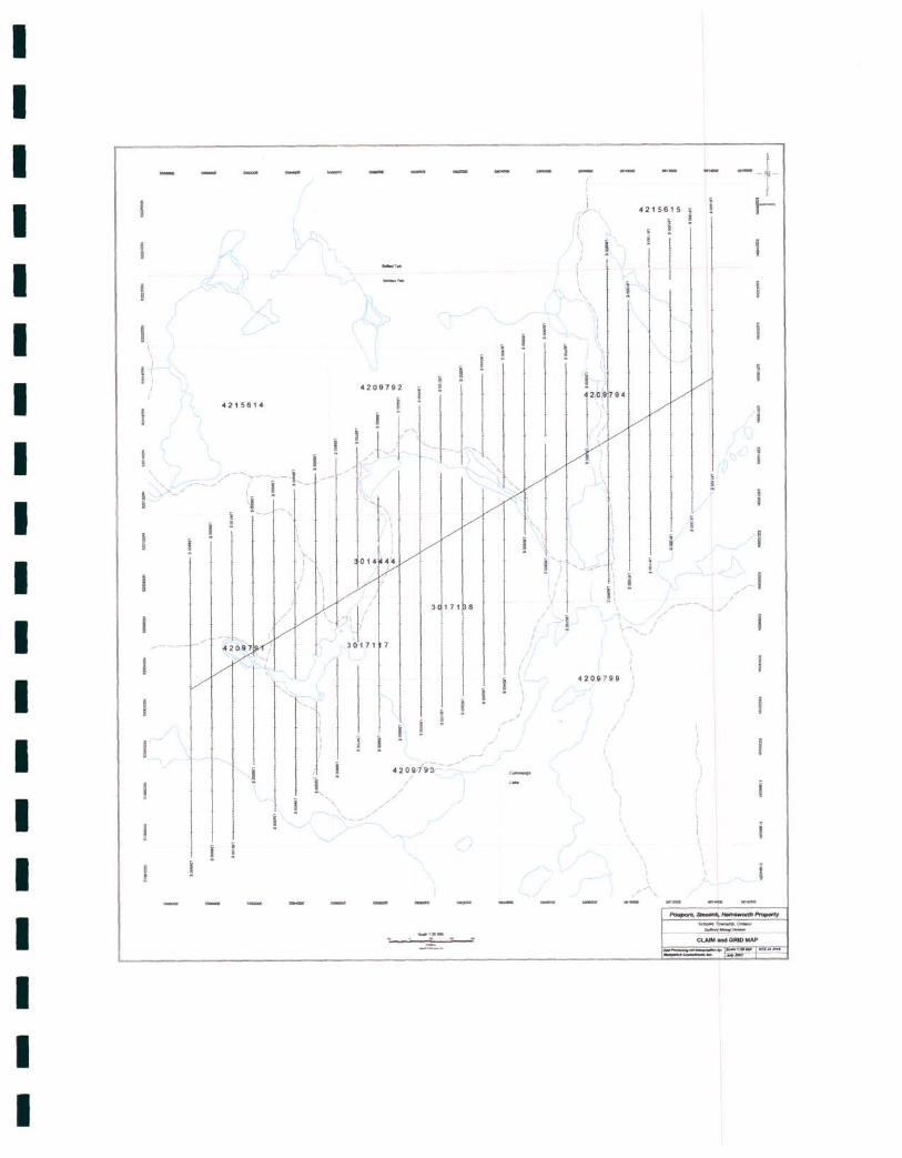
2.0 PROPERTY:
The work was done on contiguous mining claims that are part of an extensive
land holding of 149 claim units situated in unsurveyed Scholes and Belfast Tp.
There is a total area of 2384 hectares covered by 17 mining claims numbered
as follows:
Meegwich Consultants Inc. P.o. Box 482, TemagmnI.. Ontario POH 2HO Tel. (705) 569- 2904 I'ax. (705) 569-2817

I I I I I I I I I I I I I I I I I I I
Scholes Tp. - Poupore, Smeenk, Hemsworth Property Page 4
CLAIM NO. DUE DATE UNITS
3014444 January 17, 200~ 1
3017117 August 19, 2007 1
3017138 August 19, 2007 2
4209100 March 29, 2008 4
4209791 " " 16
4209792 " " 4
4209793 " 4
4209794 16
4209795 " 8
4209796 " " 16
4209797 " " 6
4209798 " " 6
4209799 " " 15
4209801 " " 16
4209802 " " 4
4209803 " " 4
4209804 " 16
4215615 August 7, 2009 2
4215614 August 14,2009 8
Note that claim 4209795 and 4215615 are the only claims in Belfast Tp.. The
remainder of the claims are in Scholes Tp. with a sliver of 4209794 in Phyllis
Tp ..
The topography on the property is rugged in general with jackpine, poplar and
birch on ridges. Much of the area had been cutover about 20-30 years ago and
regeneration is poplar and birch.
Meegwicb Consultants Inc. P.o. Box 482, Temagami, Onlario POH 2HO Tel (705) 569-2904 Fax. (705) 569-2817

I I I I I I I I I I I I I I I I I I I
Scholes Tp. - Poupore, Smeenk, Hemsworth Property PageS
3.0 LOCATION AND ACCESS:
The grid is located 30 km southwest of Temagami as the crow flies. Road
access to the property is by taking Hwy 805 north from River Valley for 40 km.
From this point near Rachel Lake a rough logging road heads east for another 4
km onto the claim group.
4.0 MAGNETOMETER SURVEY:
4.1 Instrumentation: Gem Systems GSM-19 overhauser magnetometers
serial no. 58479 and 712776 were used for field units measuring in nanoteslas
(nT) with an accuracy of +1-1/100th nT. These instruments have an excellent
gradient tolerance at 10,000 nT/m.
A Scintrex EDA Omni IV proton precession magnetometer ser. No. 255228 was
used for a base station to monitor the diurnal variation. The base station cycled
at 20 second intervals. This instrument has an accuracy of 1/10th nT.
Survey Results and Interpretation: The results are presented in
contour format on plans at 1 :5000 scale. Quality control was monitored by
comparing several readings at a common base station. This referencing
technique confirms good data and checked out on these surveys. A total of 35
km of line was surveyed (2800 readings) at 12.5 meter intervals throughout the
surveys.
Meegwich Consultants Inc. P.o. Box 482, T emagami. Ontario POH 2HO Tel ('705) 569- 2904 Fax. ('705) 569--2817
I I I I I I I I I I I I I I I I I I I
Scholes Tp. - Poupore, Smeenk, Hemsworth Property Page 6
In general the survey has outlined a massive, intensely magnetic feature with a
strike length of 2500 meters and a width of 500 meters. Readings range up to
10,000 nT over background near the core of the body and gradually decrease
further from the centre outwards. There are two zones about the same size that
could be referred to as east and west. These are basically identical in intensity
and size. A steep dip to the south is apparent.
5.0 CONCLUSIONS AND RECOMMENDATIONS:
The survey has achieved the goal of defining the limits of a massive, intensely
magnetic body 2.5 km in length and +/- 500 meters wide.
Further work should focus on evaluating the economics of the magnetic feature
by drilling and metallurgical study.
Meegwich Consultants Inc. P.o. Box 482, Temagami., Ontario POH 2HO Tel (705) 569- 2904 Fax. (705) 569-.2817
I I I I I I I I I I I I I I I I I I I
Scholes Tp. - Poupore, Smeenk, Hemsworth Property
References
Ontario Geologic Survey Map 2361 Geological Compilation Series
1:250,000
Page 7
Meegwich Consultants Inc. P.o. Boll. 482, Tanagami., Ontario POH 1110 TeL (705) 569- 2904 Fu. (705) 569-1817

I I I I I I I I I I I I I I I I I I I
Scholes Tp. - Poupore, Smeenk, Hemsworth Property Page 8
CERTIFICATE OF AUTHOR
I, David Laronde of the town of T emagami, Ontario hereby certify:
1. That I am a geology engineering technologist and have been
engaged in mineral exploration for the past 27 years.
2. That I am a graduate of Cambrian College in Sudbury
with a diploma in Geology Engineering Technology
1979.
3. That my knowledge of the property described herein
was acquired by field work and documentation.
Dated at Temagami this 14th day of August 2007.
( ... /C:~_ David Laronde
Meegwicb Consultants Inc. P.O. Box 482, Temagami, Ontario POR 2RO Tel. (705) 569- 2904 Fax. (705) 569-2817
I I I I I I I I I I I I I I I I I I I
4215614
.-----
I /
/
i \
'" I' I ,
I \ I 1
1 ;
\. '1\4// 3 1)-171 7
3 171 8
/~
420 Q1"9'; - -~/- ~ /
/ /
I
I
I
I I
I
.. I
/
\ -- -I-
1 . / 4215615 • I-I f \
f 1
\ I
I
4209 7 99 i I
I
/ /
I
1 \
\ \
\ \
/-"',
11
------""'"' ClAIM MIl GRJO MAP