assessment work report on trenching, sampling i nts …
TRANSCRIPT

I I I I I I I I I I
a.ieaes BROOKS LAKE
ASSESSMENT WORK REPORT
ON
TRENCHING, SAMPLING
AND
GEOLOGICAL MAPPING (1986)
KAKAGI LAKE GOLD PROSPECT
KENORA MINING DIVISION
NTS 52F-4
FOR
LARAMIDE RESOURCES LTD.
<*(!
010
I
I
I
I
February 28, 1987. North Bay, Ontario
By R.M. Blais, P.Fng.

I I I I I I I I I I I I I I I I I I I
TABLE OF CONTENTS
a.leess BROOKS LAKE 010C
PAGE NO.
1ntroduction ............................................. 1
Summary and Conclusions .................................. 2 , 3
Locat i on, Access and Topography .......................... 4
Location Map .............................................. 5
Claim Map ................................................. 6
Exploration History ....................................... 7-9
Mining Claim Status ........................................ 10
Previous Drilling .......................................... 11
Regiona1 Geology ............................................ 12, 13
Geology of Gold Rearing Zone ................................ 14-16
Exploration Program 1986 - 1987
(a) Prospect i ng ............................................. 17
(h) Trenching ............................................... 18
(c) Sampling and Assay Results .............................. 19
(d) Line Cutting and Surveying .............................. 20
(e) Geological Mapping of Property .......................... 21-23
(f) Geophysical Surveys and Results ......................... 24
Recommendations ............................................. 25-26
Certificate ................................................. 27

TABLE OF CONTENTS - Cont'd.
APPENDICES
I I I• A. References
B. Assay Certificate
I C. Sample and Assay Locations
_ D. Personnel
' E. Drawings:
• 86-01 Geology Plan - 1" = 400'
86-02 Geology Plan - 1" = 100'
I 86-03 Assay Plan - 3 " = 400'
I
I
I
I
I
I
I
I
I
I
I

I I
I
INTRODUCTION
• I.aramide Resources Ltd. of Vancouver, B.C. staked 41 claims in
August and October of 1986. These claims were staked at the eastern
end of Kakagi Lake. Kakagi Lake is located near Nestor Falls, Ontario
in the Kenora Mining Division. Claim group covers an extensive zone
of sheared and mineralized volcaniclastic rocks in a branch fault off
• the Cameron Lake "Break" on which a gold deposit is presently being
developed underground by Echo Bay.I« From September 12 to October 28, 3986, field work was carried out
along this sheared and mineralized zone. Prospecting, line cutting,
I trenching, sampling and geological mapping was carried out on several
islands and a large peninsula at west end of claim group.
I_ In January-February 1987 a program consisting of line cutting,
• Magnetometer Survey, VLF-EM Survey and Induced Polarisation was
I completed on a 400 foot line spacing.
I
I
I
I
I
I
I
I I
SUMMARY AND CONCLUSIONS
IThe La ram i do claim group lies at the east end of a geologically
B important structure which appears to extend along a seven and one-half
• mile strike length from Chase Point Peninsula eastward t.o within one
mile of Otterskin Lake. Claim group covers approximately 3 miles of
I
I
I
I
I
I
I
I
I
I
this structure from East Island to within one mile of Otterskin Lake.
From previous exploration work which consisted of limited
surface sampling and diamond drilling, a more or less continuous
zone with an average true thickness of 100 feet and an average gold
• concentration of 300 parts per billion was outlined along a strike
length of 6500 feet. Laramide claim group covers the easterly 3000
feet of this strike length. The best section averaged 0.03 07./ton
• gold over a width of 48 feet, including seven feet 0.10 o?./ton gold
The gold bearing unit is a near vertical bed of felsic to rhyolitic
lapilli tuff containing up t.o 25% handed and disseminated pyrite.
Purpose of 1986 program of trenching, sampling, assaying and
geological mapping was to continue to explore along this important_
™ geological structure. Geophysical surveys were- carried out over
lake and island portions of claim group in Winter 1987.

I
ISUMMARY AND CONCLllSTONP - Cont ' d .
The above-related geological work outlined several new shear
zones to he further explored by trenching. The induced polarization
survey has furl her delineated the main shear in lake bottom to be•
tested by drilling.
I
I
I
I
I
I
I
I
I
I
I
I
I
I

I I I I I I I I I I I I I I I I I I I
LOCATION, ACCESS AND TOPOGRAPHY
The property is located in Northwestern Ontario about. 50 miles
southeast, of Kenora and 42 miles north of Fort Frances on the
the International Boundary. The Village of Nestor Falls on Highway
#71 lies about .11 miles southwest of the claim block. The claims
cover a series of islands and peninsula near the east end of Kakagi
Lake.
Access is by road from either Winnipeg (5 hours) or Kenora to the
west end of Kakagi Lake. It is approximately 10 miles from west end
of the lake to centre of the claim group. During summer it is a
20-25 minute boat ride from Lake.view Camp.
During winter of 3987, access was by an ice road from Hanson's
Camp.
The topography consists of high rock ridges and swamp areas.
Large diameter white pine dominate these high ridges. Other
areas are covered by mixed bush of poplar, birch, spruce. Cedar
predominates in the swamps.

Lake
Winnipeg
ONTARIO
MANITOBA
Lake . ... Nipigon -'\
THUNDER BAY;
LARAMIDE CLAIM GROUP
Lake
Superior
NORTH
DAKOTAMINNESOTA
LOCATION MAPKAKAGI LAKE-(CROW)
GOLD PROSPECT
KENORA MINING DIVISION. ONTARIO.
I inch : 61 miles
Figure No I
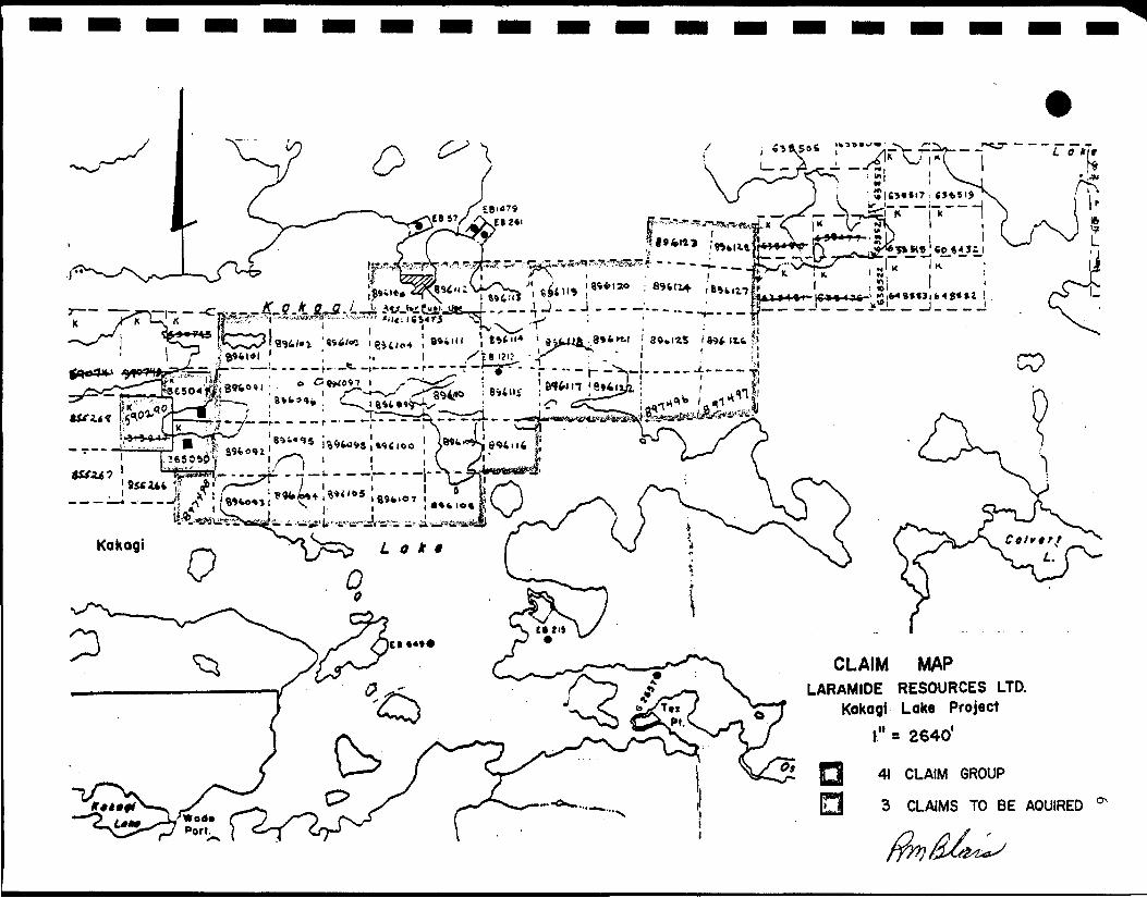
CLAIM MAPLARAMIDE RESOURCES LTD.
Kokagi Lake Projectl" = 2640*
41 CLAIM GROUP
». • 3 CLAIMS TO BE AOUIRED
fffy/&C&i^

I I I I I I I I I I I I I I I I I I I
EXPLORATION HISTORY
Gold was discovered on the west, end of East Island by Noranda
Mines prospectors in August 3944. Three trenches were reported as
foJlows:
Trench No. 1 0.30 oz . Au over 11.5 feet
Trench No. 2 0.16 oz. Au over 14 feet
Trench No. 3 0.35 oz; Au over 18 feet
In 1973, the area was mapped by the Ontario Department of Mines
and two samples taken from a rusty schist zone on Hay Island, about
5000 feet vest of the original discovery, returned values of 0.04 oz.
Au and 0.34 o?. Au.
In 1974, the property was optioned by Roy Martin to a joint
venture consisting of Noranda, Newconex and Tombill Mines. Geological
mapping was carried out during the summer of 1974. Geophysical
surveys and a diamond drilling program was completed during February
and March 1975. Seven holes, totalling 2016 feet were drilled; six of
these at the East Island showings and one at the Hay Island
occurrence.
In February and March of 1983, Barrier Reef Resources drilled
seven holes totalling 3877 feet along an east-west trending zone 6500
feet in length which included Hay Island, East Island and the
intervening lake bottom.

I I I I I I I I I I I I I I I I I I I
FXPI.ORATTON HISTORY - Cent ' d .
A survey was carried out to detail the topography of the lake
bottom and to recover Jake sediment samples which were analyzed for
gold and arsenic.
During late summer and early fall of 1986, Laramide Resources
Ltd. of Vancouver, B.C. carried out an exploration program on a claim
group covering East Island, Bert Island, Ruth Island, Don Island and a
Peninsula to west of claim group. Four old trenches ], 2, 3, and 4 on
East Island were cleaned out and re-sampled. New trenches f>, 6, and 7
on Fast. Island were drilled, blasted and sampled.
Five new trenches were drilled, blasted and sampled on Ruth
Is 1 and.
One trench was completed on Jack Island, and one trench on Don
Island.
A grid was completed on the Peninsula and Mainland, and a number of
chip samples were taken.
Geological mapping was completed on all above-named Islands, and
the mainland at east end of claim group.

III
EXPLORATION HISTORY - Cont'd.
In winter of 1987, Proton Magnetometer, VLF-EM and Induced
Polarization surveys were carried out over the islands and water
portion of claim group up to the Peninsula at east end of the•
claim group.
I
I
I
I
I
I
I
I
I
I
I
I
I
I

I I I I I I I I I I I I I I I I I I I
10
MINING CLAIM STATUS
Laramide Resources Ltd., Prospector License Number T.4731, of
Vancouver, B.C. holds 41 contiguous, unpatented mining claims as
1i st ed be)ow:
C3 aim Numbers
K.896091 - D.896128
K.897496
K.897497
K.897498
No. of Claims
38
1
Expi ry Date
August 1, 1987
October 2.1, 1987
October 21, 1987
October 21, 1987
41 claims
The following three mining claims are held by Calnor Resources
Ltd. of Vancouver, B.C. Laramide has an interest in Calnor. These
three claims will be acquired later.
K.590290 (unpatented) 1 July 27, 1987
K.365049 (Mining Lease #104037)
K. 365050 (Mining Lease #104037)
Total claim group totals 44 claims.
The address of Laramide Resources I.tcl. is:
904-675 West Hastings Street, Vancouver, B.C. V6B 1N2

II •PREVIOUS DRTT.T.TNG
ITn 3944, Noranda bored six X-ray diamond drill holes on East
• Island, and in 1975, seven holes, numbers 1-7, totalling 2016 feet.
• A description of this work is contained in a report by G.W. Adams,
filed at the Mining Recorder's office in Kenora, Ontario.
I• Barrier Reef Resources of Vancouver, B.C. drilled seven holes,
numbered 8 to 14, for a total 3877 feet completed in winter of
• 1983. Details of this drilling program are filed at the Mining
Recorder's office at Kenora, Ontario.
I
I
I
I
I
I
I
I
I
I

I I I I I I I I I I I I I I I I I I I
32
REGTONAL GROIjQGY
The general area o f Kakagi Lake is underlain by a complex
assemblage of mafic to felsic metavolcanic and metasedimentary units
which are locally intruded by differentiated basic to ultrabasic
sills. All units are strongly affected by large scale, east trending,
tight isoclinal folds which plunge north to north-northeast. Shearing
is common and faulting is widespread.
On the subject claim block, felsic volcanics are by far the most
abundant rock type. An east, trending lense of intermediate to basic
volcanics is found on the west part of the large island immediately
north of Hay Island. Tn addition, similar rocks occur in an east-
northeasterly trending band near the east end of the property. Areas
of metamorphosed mafic to ultramafic intrusive rocks are found on the
island north of Hay Island.
Shearing is common on the property. Recent mapping by the Ontario
Department of Mines has outlined a strong zone of shearing and
deformation extending from Hay Island, through East Island to the
mainland, a distance of about three miles. The two presently known
gold showings are located in this /one of deformation and a third

I• W 1 3
REGIONAL GEOLOGY - Cont'd.
Ishowing lies on strike with the first two, approximately 2.5 miles
• east of the East Island and a mile west of Otterskin Lake. (Claim
• K.896327). A fourth showing is located on strike approximately fbur
miles west of the Hay Island occurrence in the vicinity of Blacky Bay
• on Chase Point Peninsula.
IAssociated with the shear zone and gold showings are a series of
| fel sic, quartz and feldspar porphyry sills. They appear
• intermittently along the shear zone and are metamorphosed to about the
™ same degree as their volcanic host rocks.
I
I
I
I
I
I
I
I
I
I

I I I
14
GEOLOGY OF THE GOLD BEARING ZONE - Cont'd.
_ The 1983 drilling program carried out by Barrier Reef Resources
• Ltd. of Vancouver, B.C. explored an east-west shear zone with a strike
I length of 6500 feet across a maximum width of 3000 feet. This shear
zone contains a gold bearing zone that appears to be a bed of
• volcanic-sedimentary material identifiable principally by its gold and
• pyrite content. Most of the gold bearing zone is covered by lake
• water and the geological interpretation is based on drill core from
• this program. The new 44 claim group explored by Laramide Resources
Ltd. only covers east half (3000 feet) of previous 1983 strike length.
• The 3000 foot strike length includes diamond drill holes 1, 2, 3, 5,
6, 7, 9, 12, 13. For complete details of 1983 drill program, refer to
» Summary Report dated April 20, 1983 by R.M. Blais, P.Eng., filed at
• Kenora, Ontario.
• The explored area is underlain by an assemblage of Archean
• volcaniclastic rocks. Low grade metamorphism has produced textures
varying from weak foliation with stretched fragments to strongly
• foliated schist bands. The average strike is N 85 deg. E with dips of
85 deg. N to 90 deg. The isoclinal fold pattern is not wel'l known so
• the local stratigraphic top and bottom has not been determined.
I
I
I
I

I
•
I• V 15
GEOLOGY OF THE GOLD BEARING ZONE - Cont'd.
IThe volcanic sequence is divided into two genera] parts; a group
• of mafic to intermediate metavolcanics (intermediate group) to the
• north and a group of felsic to intermediate metavolcanics (felsic
groups) to the south. Textural and compositional variations of these
• units were detailed when logging the core. These variations are more
prevalent in the felsic units.
• Within the Felsic group, adjacent to the Intermediate group
contact, is located a gold bearing zone approximately 200 feet in
• average width. The richest part of this zone carries 3.00 ppb gold
over an average width of 1 00 feet . It is composed of felsic to
• rhyolitic clastic material sparsely flecked with fuchsite mica and up
to 25% banded and disseminated pyrite.
• Bands of Quart z Sericite Schist (QSS) locally divide the Felsic
group and intermediate groups. The schist band appears to be
| structurally controlled and partly overprints itself on the gold
• bearing unit.
I
I
I
I
I
IGEOLOGY OF THE GOLD BEARING ZONE - Cont'd.
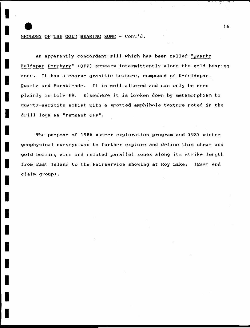
IAn apparently concordant sill which has been called "Quart?,
I Fe] dspar Porphyry" (QFP) appears intermittently along the gold bearing
• zone. It has a coarse granitic texture, composed of K-feldspar,
Quart? and Hornblende. It is well altered and can only be seen
I plainly in hole #9. Elsewhere it is broken down by me tamo rph ism to
quartz-sericite schist with a spotted amphibole texture noted in the
| drill logs as "remnant QFP".
™ The purpose of 1986 summer exploration program and 1987 winter
• geophysical surveys was to further explore and define this shear and
gold bearing zone and related parallel zones along its strike length
I from East Island to the Fairservice showing at Roy Lake. (East end
claim group) .
I
I
I
I
I
I
I
I

II •EXPLORATION PROGRAM 1986-1987 - Cont'd.
I<a) PROSPECTING
Following staking of the 41 claim group from August 1 - August 5,
• 1987, claims were covered by grass roots prospecting by D. Woito for a
ten-day period.
• Emphasis was on locating any old workings (pits, trenches, etc.)
shear zones, mineralization and other pertinent geological features.
I During this reconnaissance, 25 grab samples were taken at various
locations on claim group.
• A summary of these results are listed under Grab Samples - 1986
on plan showing Assay Results, drawing #86-03. These samples were
I assayed for gold, silver, arsenic, barium and mercury. Samples were
assayed by AA Method at Bell-white labs in Haileybury. Pulps and
| rejects are stored at Store-It-Yourself unit #39, North Bay, Ontario.
I
I
I
I
I
I
I

I• 18
EXPLORATION PROGRAM 19B6-1987 - Cont'd.
I<b) TRENCHING
During 3986 summer program, a total of four old trenches (Noranda
• 1945) were cleaned out and re-sampled. These trenches are numbered 1,
_ 2, 3, and 4, and are located on West end of East Island. Results of
• sampling are discussed under Sampling and Assaying Results.
ITHE NEW TRENCHES were completed on various islands throughout the
• claim group. Listed below are locations of NEW TRENCHES:
]. East Island trenches #5, 6, and 7.
I 2. Ruth Island trenches #1, 2, 3 f 4 and 5.
3. Jack Island trench #1.
4. Don Island trench #1.
ITrenches were drilled, blasted, mucked by hand, mapped and
• samp]ed.
| Locations of trenches and results of assays are shown on drawings
• 86-01, 86-02 and 86-03. Assay Results are discussed under Sampling
and Assay Results.
I
I
I
I
I
I

II • ] C)
EXPLORATION PROGRAM 1986-1987 - Cont'd.
I<c) SAMPLING AND ASSAY RESULTS
IA total of 100 samples were taken from old trenches, new trenches
• and various locations on claim group.
I
I
All assaying was performed by Bell-White Labs, Haileybury,
Ontario. Results are tabulated on Certificate of Analysis appendixed
to this report. Samples were assayed for gold and silver. Assay
I method was 'AA' and Fire Assay.
I
I
The rejects and pulps are stored at Store-Tt-Yourself, Unit #39,
North Bay, Ontario.
I Location of assays and results are shown on drawings 86-02 and
86-03. Sample numbers, width of sample, location of sample,
| description and assay results are tabulated under Sample and Assay
M Results appendixed to this report.
• Discussion of results will be covered under Geological Mapping.
I
I
I
I
I

I•
I
I
20
EXPLORATION PROGRAM 1986-1987 - Cont'd.
<d) LINE CUTTING AND SURVEYING
During late summer and fall of 1986 program, a grid was
established on the east end of claim group, A baseline was
surveyed with transit and tape survey. Crosslines were turned off_
™ by transit and established by picket lines. Grid lines had a 400
I foot spacing with stations at 50 foot intervals.
On islands within the claim group, control for mapping was
• maintained by grid on each individual island.
A baseline for the 1987 winter grid was established by transit
and tape survey. The grid was tied to legal surveys of patented
mining claims K.365049, K.365050 and K.590290.
IAll existing grids on islands and mainland were tied to 1987
| winter surveyed baseline.
I
I
I
I
I
I

I
I
I
I
I
I
I
I
I
I
I
I
I
I
I
I
EXPLORATION PROGRAM 3986-1987 - Cont'd.
(e) GEOLOGICAL MAPPING
The purpose of the 3986 geological program was to further define
the gold bearing zone indicated by previous exploration work, and also
to identify any potential new ones.
Because previous work indicated that gold bearing zone is
directly related to sets of near vertical, parallel and on echelon
shears associated with the Kakagi Lake Fault and Pipestone-Cameron
Lake Fault, the known shear zones were mapped in greater detail.
During traverses of claim group, new genera] shear zone boundaries were
also identified. Geological mapping also included identification of
genera] rock types, alteration patterns, and mineralization.
The near vertical Kakagi Lake Fault and shear zone strike N 80
deg. F for approximately 3000 feet within the mapped area from the west
end of Fast Island to Poy Lake. Although intensity of shearing is not
continuous along the entire trend, continuity can be established if it
is assumed that the trend has been somewhat offset to the south in the
vicinity of Don Island, and minor shearing indicated along the
projected trend on the mainland is associated with this zone.

EXPLORATION PROGRAM 3 986-1987 - Cont ' d ,
(e) GEOLOGICAL MAPPING - Cont ' d .
II«
IDiscussions were held with C. Blackburn, Regional Geologist who
• visited property and shared his expertise as it related to shears and
gold bearing zone on this property and immediate area.
• Other geological work was done in order to define the gold
bearing zone. This included mapping and re-sampling four old
• mineralized trenches at the west end of East Island. Results from
this sampling are recorded on drawing 86-02. New trenches were
I completed across portions of the various shear zones.
Three new trenches were completed on East Island numbers 15, 6,
• and 7. Trench #5 was located near shoreline at east end of East
Island. Samples were taken at 5 foot intervals where rock could be
| reached through overburden. A length of 175* exposed a highly
_ sheared zone, but no significant gold values were returned. Best
assay in trench #6 was 754 ppb over 5 foot width. Trench #7 had one 5
I foot width assay of 0.03 07 . /ton gold.
I
I
I
I
I

I
I• V 23
EXPLORATION PROGRAM 3986-1987 - Cont'd
<e) GEOLOGICAL MAPPING - Cont'd.
IOn Ruth Island, five trenches were completed in moderate shearing
| with no significant gold values reported. Results from trenches on
_ Jack Island and Don Island returned no gold values of any
™ significance.
IMapping, sampling, and assaying of outcrops along a previously
• unknown 100 foot wide shear zone that parallels a splay of the
_ Pipestone-Cameron Lake Fault, provide us with a new exploration target
area. This zone is located between L16E to L40E at south end of grid
1i nes.
• Previous and recent information gathered at Fast Island indicates
that the shear zone is very irregular (laterally and vertically), both
I in configuration, degree and type of alteration and mineralization. We
• believe that gold values found to date on East Island are randomly
dispersed within the shear zone and associated with pyritization and
• si 1icification in the form of minor quartz veining. Therefore,
future work should concentrate on these indicators for guides.
• Preliminary information indicates that the other rocks showing
• alteration in the form of seri t.i zat ion , carbonization and chlori-
tization do not appear to be favorable hosts.
I
I
I

I•
(f) GEOPHYSICAL SURVEYS
I
24
EXPLORATION PROGRAM 1986-19B7 - Cont ' d .
Geophysical surveys were carried out i n January and February 1987
by Exsics Exploration Limited of Timmins, Ontario. The purpose of the
surveys was to delineate areas of known mineralization and locate new
zones of interest.
• ™
IThree areas of special interest were delineated by the gradient
• I. P. survey. Recommendations are outlined in a Geophysical Report on
_ the Kakagi Lake Project, Kenora Mining Division for Laramide Resources
• Ltd. by R.J. Meikle, dated February 28, 1987.
IThese I. P. targets are marked on Geology Plan, 86-01.
I
I
I
I
I
I
I
I
I

I• 25
RECOMMENDATIONS
IThe Kakagi Lake Fault and shear zone is a geologically iroportant
I structure and extends for a seven and one-half mile strike length.
• The mineralization is generally similar in character to auriferous
volcanic sediments which occur in the Detour Lakes, Hemlo and
• Val d'Or Districts, suggesting potential for a large tonnage gold
deposit at some point along the projected strike of the gold
I bearing unit.
The 1986 exploration program has added geological information
• to the main shear zone and adjacent shears. Induced polarization
survey has delineated shear zone on East Island and into lake
gj bottom to the east of the Island.
Continued exploration work is required to test this extensive
I geological target.
I
I
I
I
I
I
I

I I I I I I I I I I I I I I I I I I I
26RECOMMENDATIONS - Cont'd.
Following exploration program is recommended:
1. Extend trenching and sampling at following locations:
(i) Along main shear and It P. target (south main shear)
on East Island,
(ii) New shear zone located by mapping between L20E - L40E
along south boundary of claims K.896125 and K.896126.
(iii) Along mapped shears on Ruth Island.
<.iv) More detailed work in quartz strewn area of
claim K.896119.
A small backhoe could be barged to area for trenching.
2. Proposed Diamond Drilling (Winter 1987-1988)
(i) Along main shear zone as outlined by recent geological
and I.P. surveys (East Island into lake at east end -
BaselJne at L80W).
(ii) I.P. target south of main shear on East Island,
(iii) I.P. target at L40W to L48W just north of Baseline.
3. Geophysics
(i) Induced polarization survey extended to cover shear
zones outlined on Ruth Island, Don Island and main
land at east end of claim group.

27
CERTIFICATE
I I I I I I
I, Ronald Murray Blais, Professional Engineer, of 14 Kadi Court,
I North Bay, Ontario PlB 9C8, do declare that:
1. I am a graduate of the Haileybury School of Mines - 1959,
• Haileybury, Ontario.
2. I have actively practiced my profession for 17 years.
| 3. I am a Registered Professional Engineer in the Province
_ of Ontario.
™ 4. I directly planned and supervised the exploration program
I described in this report.
I
I• Dated at North Bay, Ontario
February 28, 1987
IR.M. Blais, P.Eng.
I
I

A. REFERENCES

I I I I I I I I I I I I I I I I I I I
REFERENCES
Mart i n , Roy :
MacCormack, L.V. (1974)
Adams, G.W. (3 975):
Edwards, G.R. (1975)
Kay, I,. (3974) :
Dawson, J.M. (3982)
APPENDIX 'A'
Various private files of Roy Martin.
Report on Geological Survey of the
Roy Martin Claim Group, Kakagi Lake,
Kenora Mining Division, Ontario;
Private report, to Noranda Mines Ltd.
Summary Report, Diamond Drilling
Programme, Martin Option - Crow
Lake Joint Venture, Kenora Mining
Division, Ontario - Private Report
to Noranda Mines Ltd.
Geology of the Schistose Lake Area,
Dist. of Kenora; Ontario Geological
Survey Report #194.
Crow Lake Area (Eastern Part). Dist.
of Kenora; Ontario Div. Mines Prelim.
Map p. 923 Geol. Series.
Report on the Kakagi Gold Prospect,
Kenora Mining Division, Ontario for
Barrier Reef Resources Ltd.

I I I I I I I I I I I I I I I I I I I
REFERENCES - Cont'd.
Clark, G.
Beard, R.C.
Blais, R.M. (1983)
Camphe]], J.W. (1983)
APPENDIX 'A'
Kenora area mineral potential sponsored
by: Tri-Municipal Economic Development
Commission compiled by: Mining Sector
Work Program Staff
Editor: G. Clark.
Assessment Record Files, Resident
Geologist Office, Kenora Mining
Division, Kenora, Ontario.
Gold Deposits of Kenora-Fort Francis
Area, Districts of Kenora and Rainy
Riverby
Richard G. Beard and Glen L. Garratt
Mineral Deposit Circular 16, 1976,
Ministry of Natural Resources.
Report on Crow (Kakagi) Lake Drilling;
Programme by R.M. Blais, P.Eng.
April 20, 1983. ;
Report on the Optioned Robert Fairservice
Property held by Falcon Resources Inc.;
situated between Otterskin and Kakagi
Lakes, District of Kenora.
September 12, 1983.

I I I I I I I I I I I I I I I I I I I
REFERENCES - Cont'd.
Blais, R.M. (1983>
Johns, G.W. <1986)
Trowell, N.F. (1986)
Meikle, R.J. (3987)
APPENDIX 'A*
Assessment. Work Report, Fairservice
Option, Kenora Mining Division.
November 28, 1983.
O.G.S. Miscellaneous Paper 132
Summary of Field Work and Other
Activities 1986.
009. Kakagi Lake - Rowan Lake
Regional Geology, District of Kenora.
O.G.S. Miscellaneous Paper 129
Volcanology and Mineral Deposits
Chapter 3 - Stratigraphic
Correlation of the Western
Wabigoon subprovince,
Northwestern Ontario.
Geophysical Report on Kenora Mining
Division for Laramide Resources Ltd.
February 28, 1987.

I I I I I I I I I I I I I I I I I I I
B. ASSAY CERTIFICATES
I I
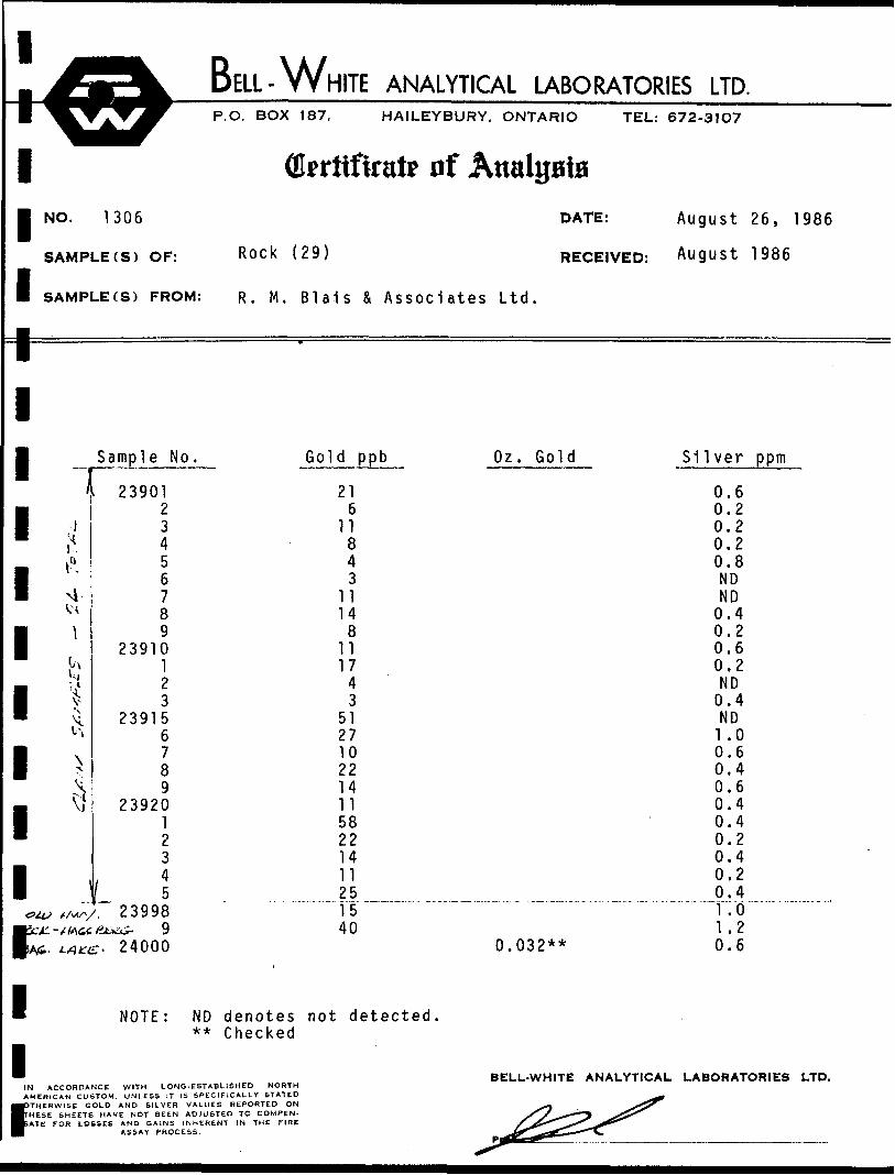
BELL-WHITE ANALYTICAL LABORATORIES LTD.P.O. BOX 187, HAILEYBURY, ONTARIO TEL: 672-31O7
NO. 1306
SAMPLE(S) OF:
SAMPLE (S) FROM:
Certificate of Attalgate
Rock (29)
R. M. Blais & Associates Ltd.
DATE:
RECEIVED:
August 26, 1986
August 1986
1
Sample No.I1 23901
« ti \
<a
I \
i"
i !*A
1 ^
1 "
1<?U> X /v(/V
2 3 45•J6 789
2391012 3
2391567 89
23920 1 23
f I. 2 3998
week- - tfa&c fi&&z- 9 BA*. LA^- 2 4000
» NOTE: ND**
1IN ACCORDANCE WITH LONG-ESTABAMERICAN CUSTOM. UNLESS IT IS SPEC
PTHERWISE GOLD AND SILVER VALUE HESE SHEETS HAVE NOT BEEN ADJUS1 ATE FOR LOSSES AND GAINS INHERE
ASSAY PROCESS.
Gold ppb Oz. Gold Silver ppm
216
11843
11148
111743
51271022141158221411251540
0.032**
0.60.20.20.20.8NDND0.40.20.60.2ND0.4ND1 .00.60.40.60.40.40.20.40.20.41 .01.20.6
ND denotes not detected ** Checked
ISHED NORTH ICALLY STATED REPORTED ON
:D TO COMPEN- T IN THE FIRE
BELL-WHITE ANALYTICAL LABORATORIES LTD.

1I11111111111111111
^!53L BELL- WHITE ANALYTICAL LABORATORIES LTD.^^^^^^•^^^^^^^^^^^^^^L.— ̂ — _ —————————————— • —— " — ——_______— —————————————————— ._..^^WT^^y P.O. BOX 187. HAILEYBURY. ONTARIO
Qlprttfiratr of AttalptaNO. 1412 DATE:
TEL: 672-31O7
September 15, 1986
SAMPLE.S) OF: R ock < 27 > RECEIVED: September 1986
SAMPUE(S) FROM: Mr. R. M. Blais, R. M. Blais & Assoc
Sample Nu. As
239012 3456 789
2391012 3
239156789
239201 2345
239989
24000
NOTE: ND denotes not detected.
iates Ltd.
pprn
NDND NDNDNDND NDNDNDNDNDND
5NDND1020ND15ND NDNDNDNDNDND10
BELl.-WHITE ANALYTICAL LABORATORIES LTD.:oi.r«'.ci WITH ID-;.-. r'.'TM.i TITD f.onn
Vt- * •, c TO'-' .. M. tCi ^T , .-. L- ; i': '..Mil' iTATfPT... .-. -i -.Ol'.- A-.:, t .l.iH . »!..!; HM'OKTID ON ^^1 -*~~ ~\.
,,:• . il". . .'. ' '.OT i'lr-, »: ilil 10 'OM"-'CN. S^^'^ ^f.i . c.i L0st.ii. A\r' ,;*.N- ••..•iiic.st IN 1.1! i uif >^^__— ̂ ^-*
»^i. *» .-KCsi.-u ^— jids^^^*^^^

BELL-WniTE ANALYTICAL LABORATORIES LTD.P.O. BOX 187, HAILEYBURY, ONTARIO TEL: 672-31O7
1
• NO. 1
SAMPLE
1 SAMPLEr=iiiiiiiiiiii
IN ACCORDANCE
Qkritfirate of Attaints626
(S) OF: P ul P (27)
(S) FROM: R. M. BlaiS
Sample No.
23901 234 56789
239101 23
23915 6789
2392012 345
239989
24000
< denotes less
WITH LONO. ESTABLISHED NORTH
& Associates
Barium
440 210440280
20230210240450640430 480380250no900440290 930490470 900
1100110300210
30
than
DATE: October 9, 1986
RECEIVED: October 1986
Ltd.
ppm Mercury ppm
0.01 0.02
<0.010.63
<0.010.01
<0.010.03
<0.010.010.02
<0.010.01
<0.01 0.110.060.060.14 0.010.040.06 0.01
<0.010.020.010.020.16
BELL-WHITE ANALYTICAL LABORATORIES LTD.AMERICAN CUSTOM, UNLESS IT IS SPECIFICALLY STATEDOTHERWISE GOLD AND SILVER VALUES REPORTED ON
fHESE SHEETS HAVE NOT BEEN ADJUSTED TO COMPEN- ATE FOR LOSSES AND GAINS INHERENT IN THE FIRE
ASSAY PROCESS.
J^ ^&
4&2^

BELL-WHITE ANALYTICAL LABORATORIES LTD.P.O. BOX 187, HAILEYBURY, ONTARIO TEL: 672-31O7
1 Qferttftrate nf Analgate NO. 1823
SAMPLE (
I SAMPLE (
1
I
I
I
I
I
I
I
I
I
I
I
IIN ACCORDANCEAMERICAN CUSTOM,
fHERWISE GOLD
S) OF: Rock (TOO)
S) FROM: Mr. R. M. Bl
Sample No.
8212 34
237012345 6789
2371012 345 6789
2372012 34567
239267 8
NOTE: ND denotes not** Checked
WITH LONG- ESTABLISHED NORTHUNLESS IT IS SPECIFICALLY STATED
AND SILVER VALUES REPORTED ON
Page 1 of 3DATE:
RECEIVED:
ais, R. M. Blais & Associates
Gold ppb Sil
306 8
1588864
3211
8866
12 14
733 293021
5 141812 27
8453**
70937**
237 4
detected.
BELL-WHITE ANALYTICAL
S&~^ ^
November 4, 1986
October 1986
Ltd.
ver ppm
0.8ND ND0.2ND0.20.60.20.2 0.2NDNDNDNDNDND 0.40.2ND
1 .20.40.60.6 1 .00.81.0 0.20.60.80.20.40.20.2 0.2
LABORATORIES LTD.
ESE SHEETS HAVE NOT BEEN ADJUSTED TO COMPEN. ^^^ ̂ •*** ̂ 7~ T£ FOR LOSSES AND GAINS INHERENT IN THE FIRE .̂ ^f^"^^^^"^ ̂
ASSAY PROCESS. ^^SCS^^*""^

BELL-WHITE ANALYTICAL LABORATORIES LTD.P.O. BOX 187, HAILEYBURY, ONTARIO TEL: 672-31O7
1
1
1
1
1
1
1
1
1
1
1
1
1
1
1IN
QkrJtfirat? of AttalijaiaNO. 1823
SAMPLE(S) OF: Rock (1
SAMPLE(S) FROM: Mr. R.
Sample No.
2392923930
1 23935
6789
239401 23456789
239501 2345678 9
239601234
NOTE: ND denotes** Checked
ACCORDANCE WITH LONG -ESTABLISHED NORTH
Page 2
00)
M. Blais, R. M.
Gold ppb
177 4
127
897
108
4411
81012
6301514
7 8
1425121040
not detected.
of 3DATE: November 4, 1986
RECEIVED: October 1986
Blais & Associates Ltd.
Oz. Gold Silver ppm
0.40.20.2 0.20.20.20.20.20.40.2 0.20.2ND0.2NDND0.2ND0.40.2 0.40.40.40.40.20.4
0.184** ND 0.114** 0.20.048** ND0.114** 0.20.042** 0.20.074** 0.60.052** 0.4
BELL-WHITE ANALYTICAL LABORATORIES LTD.AMERICAN CUSTOM, UNLESS IT IS SPECIFICALLY STATED ^X^L— ̂ ^̂
HESE SHEETS HAVE NOT BEEN ADJUSTED TO COMPEN- &0^ _^^ ^**7^ ATE FOR LOSSES AND GAINS INHERENT IN THE FIRE sfS^*^^ ̂.r*^^ V
ASSAY PROCESS. 6̂^5^^^"^Pra rf -~~^

BELL-WHITE ANALYTICAL LABORATORIES LTD.P.O. BOX 187, HAILEYBURY, ONTARIO TEL: 672-3107
| (Erritfirat? of AnalgaiaPage 3 of 3
• NO. 1823
SAMPLE(S) OF: Rock { 1
I SAMPLE (S) FROM: M r - R-
00)
M. Blais, R.
Sample No. Gold ppb
1 239656
1 789
23970
1 123
1 456
_ 71 8• 9
23980
1 I3
1 '• 6
7
1 8 9
23990
1 1234
1• 67
1** Checked
1IN ACCORDANCE WITH LONG -ESTABLISHED NORTHAMERICAN CUSTOM, UNLESS IT IS SPECIFICALLY STATED
1 THEN WISE GOLD AND SILVER VALUES REPORTED ONHESE SHEETS HAVE NOT BEEN ADJUSTED TO COMPEN- ATE FOR LOSSES AND GAINS INHERENT iN THE FIRE
ASSAY PROCESS.
369
448
219754**122891**
324025415423
3312221460112610
250
DATE:
RECEIVED:
M. Blais & Associates L
Oz. Gold
0.494**0.316**0.216**0.168**0.040**
0.100**0.070**
0.256**0.190**0.620**0.210**
0.030**
BELL-WHITE ANALYTICAL
<3^
November 4, 1986
October 1986
td.
Silver ppm
1.01 .20.80.80.40.40.60.61.01.01.01.21 .20.60.60.60.8 0.40.20.60.40.60.20.6 0.40.80.40.40.40.60.80.40.2
LABORATORIES LTD.

I I I I I I I I I I I I I I I I I I I
C. SAMPLE AND ASSAY LOCATIONS

SAMPLE AND ASSAY RECORD SHEET
K.PROPERTY -k DATE OCT- qs PAGE NO.
SAMPLE NO.
WIDTH OF SAMPLE
DESCRIPTION ASSAYAU Ag f'lo Cu
23926
A ''S-lo
lo-ls'
0--2.
c.'2-AU_
\
\
- CRAB - CHAMME! - BULK

AND ASSAY RECORD SHEET
1.9 OPROPERTY LAWS- DATE OCt PAGE NO.
SAMPLE NO.
UIDTH OFSnf'lPLE
DESCRIPTION ASSAYAg ^ No Cu
3-Cp Z!wy£ A, CM64 K40
TV? o.-i
42.-S NO
SAj-T •<- - ifc-5 o. H4- o-'i, wesr12 S - 15. S o/Z-7o —
.Cs e/s-sr FAC& 9-fc,- * 1.2. o. 052 0.40.-2. - n. "2. 0-494 l-o
•2 39 I -2 0.070 Co
* - GRAFI A - CHIP - CHANNEL D - BULK

OuD SAMPLE AND ASSAY RECORD SHEET
PROPERTY DATE <x..T OS/fefe P AGE NO.
SAMPLE NO.
'Z'?**) fc &
l^^t-7•Z^^t-8
1^0 fc9a^^-70-
-
T
«
«-r
=.ssa
•sss
UIOTH OF SAflPLEa'-b4'-o
4-?^•°&°
DESCRIPTION
Cp-TZ. . «5<2^? > C. ^ T1^WSfts^^Y f^.
*
Si«-. SAuT •*• fGPPSIZ- Cf-rz. -^£f> iciTiS scwf ^~fa&s^, cess^j -Sit-. &A.CITIC.T<J/=j= \«/TH DiSSTSM • Pvy .
i£>Vi* ( V-AC**-3-5 -£,.0EA.ST R^Co4..o — io -oEAST vwc4S\0.0 — 'KiV- 0S^ST FAjO= \A-o- 18- O
S«S.ST TAsC«
ASSAYO.P.T AU
0<"Sl(t>
o-'ZKb
o-Hc^o.c-4-oO- OM
Ag pp.n
\.zo-b0-&
0-4O.4-
Ro Cu
- QRAB A - CMTP - CHAHHFL Cl - BULK

OUD SAMPLE AND ASSAY RECORD SHEET
KPROPERTY DATE QC7 2.S/&. PAGE NO.
SAMPLE NO.
UIDTH OF SAMPLE
DESCRIPTION ASSAY
fpQT)Ag f-1o Cu
L-T- ce«?»j o — 2. . J.C
UT- WEST T*ACiS-
0- 1-0
4
77 SIL. -To
- GRAB A - - CHANNEL Q - BULK

SAMPLE AND ASSAY RECORD SHEET
K-PROPERTY DATE oc- PAGE NO. \
SAMPLE NO.
UIDTH OF SAMPLE
DESCRIPTION ASSAYppb Mo Cu
5' «.'- s' 0-4
239 1 0.-2.
2^934o-Z
-23937
5'S 1
-239384s' -So1
69 0--2.o-Z
S' 56 - 10 o-40.'2-
•2-3942. A. P 44 0/2.
-2-2.944 MP
OTZ. 80-6S 10 0/2.'BOpp NO
'2.3047TO
UT NO
3o 0--2.loo-log' NO
- CRAB A - CHIP - CHANNEL LI - BULK
SAMPLE AND ASSAY RECORD SHEET
PROPERTY DATE OCT- O.S/gfa PAGE NO.
SAMPLE NO..
UIOTH OF SAMPLE
DESCRIPTION ASSAYppb Ag Mo Cu
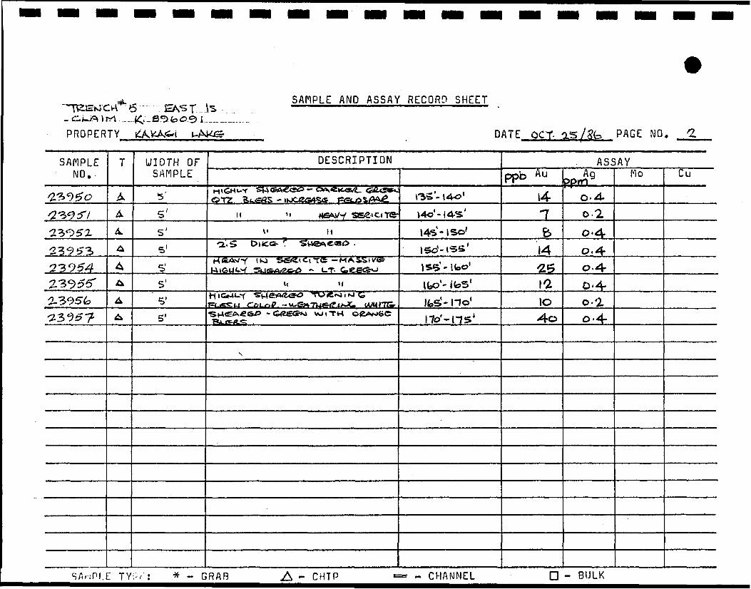
OT2 0.4.5' 0.25' H \4S-lSo' b 0-4
1423954 0-4-
5' O-4-2-3956 1 - no1 10^23 95 ? 5' 0-4-
Sfli-iPLE - GRAB A - CHIP - CHANNEL D - BULK

SAMPLE AND ASSAY RECORD SHEET
PROPERTY DATE PAGE NO.
SAMPLE NO.
UIDTH OF SAMPLE
DESCRIPTION ASSAYO.P.T.
AU Ag Mo Cu•DACrriC TUFF - n- 1C o-t?
5' 16'- 21' 0-02.7.SUCMT
M00.o.oo30-^2.6 0-8
11 - 32' 0.4.
- GRAO A - CHIP - CHANNEL - BULK

TRENCH NO. CLAIM NO.-PROPERTY
** i-s SAMPLE AND ASSAY RECORD SHEET
DATE QCT- OST/Bb PAGE NO.
SAMPLE NO.
/239£53239*M-139S5^^Sk•2398723«;>8S
T
A
A
4
A.
A
A
UIDTH OF SAMPLE
&
f5'
5'
3'
.4'
DESCRIPTION
C^Z<53Aj OA.C^TiC_ T0!=p- •SCHIST M\»Oo<2- Py ,
1. If
(SJ&SSo «'U-. DAciTiC. Tofp
5'- to1
to'- l«5'
l&'-2cl '2o'-25'
25- 26'28'- 32'
ASSAYppb" u
>4o25-415423
0.0300. P.T-
Ag £pflQ ——
0-2
O-(f?
0-4O'(?
0--2.
Mo Cu
- GRAB A - CHIP - CHANNEL - BULK

SAMPLE AND ASSAY RECORD SHEET
CLAIM fPROPER
SAMPLE . NO.
'2^9& <523<5>o>o
•23^^ j
TY KA>KA<3 1 UA^e DATE QCT -OS /6k
T
^
A
^
UIDTH OF SAMPLE
&
\£}
\£)
DESCRIPTION
Siu. 'SU&UTt-Y ^neA.e«c> T^Ft*-
^ulSa^^sSSSSto "^PP
Ir W . v
o'2 €»-o
4,'°-a'°^
a'0-;^' 0^
PAGE NO . 1
ASSAYppb. A u
33I^La-z
R>^^ 90.4.0-8,
0-4-
Mo Cu
- GRAB A - CHIP - CHANNEL D - BULK

TRENCH NO. CLAIM NO.-
PROPERTY
JS SAMPLE AND ASSAY RECORD SHEET
*
DATE QCT OS/g4 P AGE NO
SAMPLE NO.
WIDTH OF SAPIPLE
DESCRIPTION ASSAYppb Au no Cu
S"ev2-i G-I TICL 14- 0-4-
115' II
0-6
-2SUC,
•• -:•» . T" r. * - GRAB A - CHIP - CHANNEL D - BULK

SAMPLE AND ASSAY RECORD SHEET
CLAIM VPROPER
SAMPLE NO.
a3<59G^3, 0,9-7
m\s 0 ^^^^^™»™>^^^^^^™IM«««™^™«
TY £AkiAGt UAKS. DATE OCT- OS /eCa
T
A
A
WIDTH OF SAMPLE
5'.5'
DESCRIPTION
popp TAKi -^T^ SC.HCS:T.
MSrzC! e^u(T^Kir°-Cc; 06,'°- M'°
PAGE NO . 3
ASSAYppb A u
10
250
PPrn 90-4-
0--2.
Mo Cu
- GRAB A - CHIP - CHANNEL D - BULK

TRENCH NO. CLAIM NO.-PROPERTY
SAHPLE AND ASSAY RECORD SHEET
DATE QCT- 2S/84 P AGE NO. 4-
SAMPLE NO.
UIDTH OF SAMPLE
DESCRIPTION ASSAYno Cu
2^-703"704- 0.2.
o-'Z
326'(1
£'
- GRAB A - CHIP - CHANNEL - BULK

SAMPLE AND ASSAY RECORD SHEET
CLAIM NPROPER
SAMPLE NO.
ae>~7ocfI'VT \ O7S*> "7 l i
TY KXKAv&\ UMCE DATE OCT 2S/J?4
T
^A
^
UIOTH OF SAflPLE
5'5lG'
DESCRIPTION
-Ssij^^r.^is'80??^ Qe<s^t. ««ti tr
A-^-S- 05'°- io- °
e>°- is 10
PAGE NO . 5
ASSAYPpt> A u
-s<&
4
PP^AQ
k!>0
KJO
NO
No Cu
* - GRAR A - CHIP - CHANNEL - BULK

I- DONi IS,SAMPLE AND ASSAY RECORD SHEET
CLAIM bPROPER
SAMPLE NO.
a3Tia
1W • ™^^™ H^^^VMHBKB^^^^B^^^
in K ' vv?tv O9^)
T Y i^/^^/sS t UA^Hl.^- DATE OCT. 2S/S4,
T
^
UIDTH OF SAMPLE
2>'
DESCRIPTION
£?.p.P. W iTM MiKio«£- PV, ^'-^
PAGE NO . i
ASSAYppb A u
12.
Ag ppm
KJD-
Mo Cu
A - CHIP - CHANNEL D - BULK
SAMPLE AND ASSAY RECORD SHEET
CLAIM NPROPER
SAMPLE NO.
&2.I
10 . — &. &tZie&L2£>. ———TY kj\KA».G. | L.G\\4£p
T
^
UIOTH OF SAMPLE
DATE ecrr. -2S/5^ PAGE NO * *
DESCRIPTION | ASSAY
L52 5, I-4H-60W ± SH«^e 2x>«a-bob IDD^
•
3o o.&
Mo Cu
- GRAB A - CHIP - CHANNEL - BULK

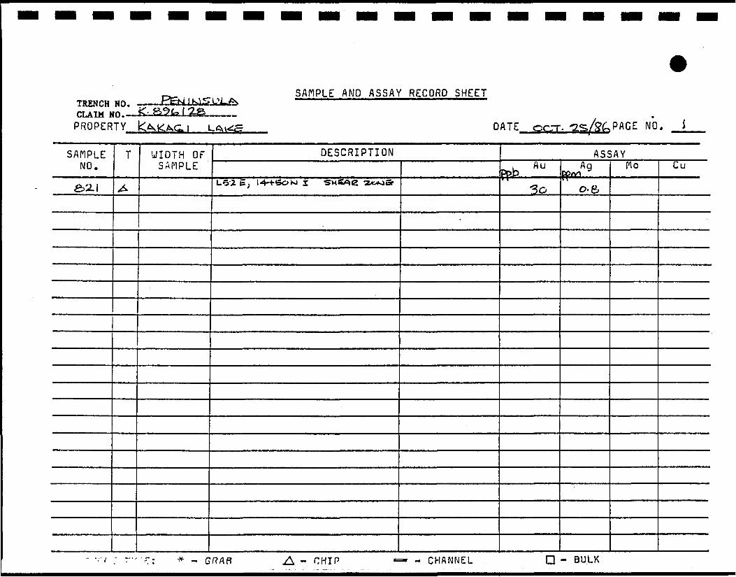
SAMPLE AND ASSAY RECORD SHEET
CLAIM hPROPER
SAMPLE NO.
e>a-2_8-2-382-4-
T* V I/ A I.X A ^* 1 t IL. t S *"• *1 Y ICAt— A.& 1 L-A^i^E- DATE OCT. 2S/S4,
T
A
^•*r
UIDTH OF SAMPLE
<bo'(4oi
DESCRIPTION
TSI.SIC. -"BopP WITM Py-fetoi^-I^^^T-W PuL.^4- 1-*- 1 6 E ^ '2c>'fCt@9 F^EUfSic- ftiOpp- VA^iiTM Py •
o'-c^o'
^o'-ico'
CCACb
rPAGE NO » ^-«
ASSAYu Au I Ag
ppD IpP^^» fcJD.
e wo.15 o.-Z
Mo Cu
* - GRAB - CHIP - CHANNEL - BULK

SAMPLE AND ASSAY RECORD SHEET
CLAIM DPROPER
SAMPLE NO.
a3 7 1 3a^-n-4-•2^715
TY KA^AGJ L/^kij=- DATE CC.T Z5/S*4
T
A^^
UIDTH OF SAMPLEas'-25'
2>'
DESCRIPTION
l» *2-7 *4~ <2>c> i^ * \^ ̂ <cr^4^»s^^*^,^ W 1 ^Tc»^£- T^OP^L -.Z-H-feo E, .^2SS,SH(5«C^ -
MVSPWUY -sne**f«*-»- •
PAGE NO. 3
ASSAY. Auppb
14-1
"$*>
Ag
o.AO.-T-KJD
Mo Cu
•• -:M ; -.-•• r . * _ GRAB .A - CHIP — - CHANNEL D - BULK

I I I I I I I I I I I I I I I I I I I
D. PERSONNEL
'• •' . ,i v:i.'„-"-..-."' "'.""r. I-'^^'-'"f'j iif 1^*'
''::r:;i:^:5i:lillill

I I I I I I I I I I I I I I I I I I I
X
PERSONNEL 1 986
1. A.P. REEVE - GEOLOGIST904-675 West Hastings St.Vancouver, B.C. V6B 1N2 604-688-3584
2. R.M. BLAIS - GEOLOGIST 528 Cassells St. North Bay, Ontario PlB 3Z7 705-474-4110
EMMETT FAULKNER - GEOLOGIST3275 South Eaton CourtLakewood, Colorado 80226 303-935-1575
JIM BOWEN - DRAFTSMAN 655 Norman Ave., North Bay, Ontario
BECKY BLATS - TYPING14 Kadi CourtNorth Bay, Ontario PlB 9C8
6. DON WOITO - PROSPECTOR P.O. Box 4 34 North Bay, Ontario PlB 8H5
LARRY PETERSON - HELPERP.O. Box 3 03Nestor Falls, Ontario POX 1KO
RICK BIRD - LINE CUTTER 1106 1st Street, East Fort Frances, Ontario
DAN SCHEIRER - LINE CUTTER 1267 Idylwild Drive Fort Frances, Ontario

I I I I I I I I I I I I I I
I I
Ontario
Ministry of Natural Resources
GEOPHYSICAL - GEOLOGICAL - GEOCHEMICAL TECHNICAL DATA STATEMENT
File.
TO BE ATTACHED AS AN APPENIFACTS SHOWN HERE NEED NOT
TECHNICAL REPORT MUST CONTAIN INI£.10865 BROOKS LAKE 900
Type of Survey(s) L inecuttine ^nd Geological Mapping
ry, , . . Brooks Lake Area, Kenora Mining Division 1 ownship or Area ______________'__________°_______
Claim Holder(s).Laramide Resources Ltd.
Vancouver, B.C.
R.M. Blais & Associates Ltd.Survey Company.* .u fT> 4 R- M - Blais, P. Eng.Author of Report _________!____°______________AJJ rA »u 5 28 Casse]ls St., North Bay, Ontario Address 01 Author ______________.________________ . _. f c S ept. 16, 1986 - Oct. 22, 1986 Covering Dates oi Survey..
Total Miles of Line Cut.(linecutting to office)
9.0 miles
SPECIAL PROVISIONS CREDITS REQUESTED
ENTER 40 days (includes line cutting) for first survey.
ENTER 20 days for each additional survey using same grid.
Geophysical—Electromagnetic.
—Magnetometer_—Radiometric——
—Other______
DAYS per claim
Geological.
Geochemical.
40
AIRBORNE CREDITS (Special provision credits do not apply to airborne surveys
Magnetometer. .Electromagnetic. . Radiometric
DATE:.May 12, 1987
(enter days per claim)
SIGNATURE:.'ufhof of Report or Agent
Res. Geol.. .Qualifications
Previous Surveys File No. Type Date Claim Holder
MINING CLAIMS TRAVERSED List numerically
K 896091
(prefix)K
(number)896092
K................89609?..
K 896094
K
K
K
K
K
K
K
K
K
K
K
K
K
K
K
896096
896097
896099
896109
896110
896114
896118
896119
896120
896121
896122
896123
896124
896125
896126
896127
TOTAL CLAIMS-
837 (5/791

GEOPHYSICAL TECHNICAL DATA
more than one survey, specify data for each type of surveyI
INDUCED POLARIZATION
RFCTSTTVTTY GRAVITY ELECTROMAGNETIC MAGNETIC
Numher of Stations. NnrnHpr nf Readinps
Station interval Line spacing
Profile srale
Contour interval
Instrument
Accurary — Scale constant
Diurnal correction method
Rase Station check-in interval (hours)
Base Station location and value
Instrument
Coil ronfignration
Coil separation
Arrnrary
Method: D Fixed transmitter CD Shoot back CD In lineFreqiienry
(specify V.L.F. station)
Parameters measured .
Instrument
Scale constant ..........Cnrrertinns made
Base station value and location . ............... ......
Elevation accuracy —— _ ———————————————————————————————————————————
Instrument ——————————————————————————————————— - ——————————————
Method D Time Domain D Frequency Domain
4
* Delay time.4
5 Integration time . . , .i °j Power __ _____________ ____ ——————————————————————————— — ————————i
Electrode array ——————— - ——————————— — —————————————————— — — -—— ——Electrode spacing ————————— — ———— — ——————————————————— — ——————————Tvoe of electrode .. ————————————— - ____—————— — ————— — —————————
1—————— 1
1
1
1—————— 1
1
1D Parallel line
1
1—————— 1
1
1
1
1
1
11

I I I I
SELF POTENTIAL
Instrument_________________________________________________ Range.
Survey Method _____________________________________________
Corrections made
RAD1OMETR1CInstrument
Values measured.
I
I
I
Energy windows (levels)________________________________________
Height of instrument____________________________Background Count.
Size of detector_____________________________________________Overburden ____________________________________________________
(type, depth — include outcrop map)
01 HERS (SEISMIC, DRILL WELL LOGGING ETC.)Type of survey_________________________ Instrument ___________________________
I
I
I
Parameters measured.
Additional information (for understanding results).
AIRBORN E .SURVEY S
Type of survey(s) ————
Instrument(s) ——————
I
1
I
I
(specify for each type of survey) Accuracy___________________
(specify for each type of survey) Aircraft used.__________________________________
Sensor altitude.Navigation and flight path recovery method.
Aircraft altitude__________________________________Line Sparing Miles flown over total area__________________________Over claims only_

GEOCHEMICAL SURVEY
Numbers of claims from which samples taken.
Total Number nf Samples
Type nf Sample(Nature of Material)
Average Sample Weight
MethoH of Collection
Soil Horizon Sampler!
Horizon Development
Sample Depth
Terrain
Drainage Development
Estimated Range of Overhnrrlen Thickness
SAMl'LK PREPARATION(Includes drying, screening, crushing, ashing)
Mesh siye of fraction used for analysis
General
- PROCEDURE RECORD A
ANALYTICAL METHODS
Values expressed in: per cent D p. p. m, Q p.p. b. C3
Cu, Pb, Zn, Ni, Co, Ag, Mo, As,-(circle)
Others
Field Analysis (. fsts)
Extraction Method
Analytical Method
Reagents Used
Field Laboratory AnalysisNo. ( tests)
Extraction MethoH
Analytiral Method
Reagents Used
Commercial Laboratory ( t«"«:t«)
Name of Laboratory.
Extraction Method
Analytical Method.Reagents Used
General — —————————————————————————
1
1
1
1
1
1
1
1
1
1
1
1
1
1
1
1
1 1

Ontario
Ministry ofNorthern Developmentand Mines
July 6, 1987 Your File:94 Our File:2.10065
Mining RecorderMinistry of Northern Development and Mines808 Robertson StreetBox 5050Kenora, OntarioP9N 3X9
Dear Sir:
RE: Notice of Intent dated June 10, 1987 Geological Survey on Mining Claims K 896091, et al, in Brooks Lake Area
The assessment work credits, as listed with the above-mentioned Notice of Intent, have been approved as of the above date.
Please inform the recorded holder of these mining claims and so indicate on your records.
Yours sincerely,
Gary L. Weatherson, Manager Mining Lands Section Mineral Development and Lands Branch Mines and Minerals Division
Whitney Block, Room 6610 Queen's Park Toronto, Ontario M7A 1W3
Telephone: (416) 965-4888
AB/mccc: Laramide Resources Ltd
Suite 904675 West Hastings StreetVancouver, B.C.V6B 1N2
Mr. G.H. FergusonMining & Lands CommissionerToronto, Ontario
R.M. Blais 528 Cassells Street North Bay, Ontario P1B 327
Resident Geologist Kenora, Ontario
Encl.

Ministry ofNorthern Development
<1inesOntario
aru^irTechnical Assessment Work Credits
Date
June 10, 1987
File
2.10065Mining Recorder'* Report of Work No,
94
Recorded Holder
LARAMIDE RESOURCES LTDTownship or Area
BROOKS LAKEType of survey and number of
Assessment days credit per claimGeophysical
Electromagnetic Hays
Magnetometer . days
Rariiometric , , days
Inrinrert po|ari'f>tion , ,. flays
Section 77 (19) See "Mining Claims Assessed" column
Geological 31 Hays
Genchemina! Hays
Man days Q Airborne Q
Special provision f~] Ground |X]
JT1 Credits have been reduced because of partial coverage of claims.
|~| Credits have been reduced because of corrections to work dates and figures of applicant.
Mining Claims Assessed
K 896091 to 94 Inclusive 896096 - 97 - 99 896109 - 10 - 14 - 18 to 28 incl .
Special credits under section 77 (16) for the following mining claims
\)o credits have been allowed for the following mining claimsI I not sufficiently covered by the survey | | insufficient technical data filed
'he Mining Recorder may reduce the above credits if necessary in order that the total number of approved assessment days recorded on each claim does not xceed the maximum allowed as follows: Geophysical - 80; Geologocal • 40; Geochemical • 40; Section 77(19) • 60.
28 (85/12)

oi_L
J_i
M.J s/A/J, V I ! i
I
¥2V.hh
•c >s 6 C
xi

ROWAN LAKE AREA- G-2S96
0 f i e r s t, • n ' \
r-^ i _ - - _ : _ - - - TtT^:4* _._"
£? A o o /r s Lake : r.
.' -"
__L__ — ---- — —__i__ t_ ^_
GODSON TVVR
67g—TiO-W- '^S.-—--—• ^t'C" ' ^fO-"1 ' ,n^-__j-l.P-
5S -teV%>t*5s* ^i t%0 ,.^g^e--7p ,S^f
1 .^p, - ^ O .f- t, ftPb,& r -£'r ?e^A
'••T71 j -^ -. s~i~^~. *
__ ____ ___ _ __, __ J-
DASH LAKE- G-2671
COo(M
i
I
LJ
LU
<
oCLa.LL.z> -JCD
LEGEND_. t_> W U, t _ !»>
52F«4NE««12 2.1»«6S BROOKS LAKE 200
HIGHWAY AND ^OLJ'E NOOTHER PCAD5
TRAILS
SURVEYED LINES70W\'SH:F'P. BASE LINES. E LOTS, MIMNG CLAIMS. PAI; c; c: T r
LO T L'NfS
PARCF-- BOUNDARYMINING CLA'VS t'TC
UTILITY LINES
NON PFFENNiAL STREAM
FLOODING OR FLOODING RIGHTS SUBDIVISION OR COMPOSITE PLAN
ORIGINAL SHORELINE
MARSH OR MUSKEG
MINES
TRAVERSE
K OF CROWN LAIRDS
TYPE OF DOCUMENT
PATENT, SURFACE & MINING RIGHTS
, SURFACE RIGHTS ONLY.._._
.MINING RIGHTS ONLY ______
LEASE SURFACE & MINING RIGHTS..
" .SURFACE RIGHTS ONLY ..__..
" , MINING RIGHTS ONL V .
LICENCE OF OCCUPATION ____.. .. . .
ORDER'iN-COUNCIL .. . . ..... _ ._ ._
RESERVATION ____ _..._.._ _.CANCELLEDSAND & GRAVEL _.__..._.. ........
SYMftQ
NOTE W,N iNG RIGHTS ^N C6RCL'_S PA'tNTE'." 1 PBIORTOM*T •fia VEF: T ED i** OUT, .NA.. PflTE^,"Et BV THE PwBi. ..ANI.'S AC" "SO ' S^C CH A'' 3RQ, SF C 63 S'JGSEC
R R E N C E SMr. ± - lv> \
/..R.O
•/".' FRO!," DlSPOSITtG\l
SCALE 1 INCH - 40 CHAINS
AREA
ROOKS i AKI \ W WE \O !—/—\i \
M.«.R ADMtMSTHATivE DISTRICT
F H R T F R & fa ^ P Q rvT\ i rAfHi\iWfc«.OM i N i N G DiVISlOM
KENORALAND TITUS / F.EGlSTRr D!VIS!Ch
KENORA
/:/ Le':0
f v" ti n :-) c t; m e r T-^b 1
Pesc-j-cesOntario

i—F
airs
ervi
ce
Grid
- !
983
K59
074!
^•^s^
-*^''^
KA
KA
GI
LAK
EF
AB
RIC
A
ND
S
TR
UC
TU
RE
N
OTA
TIO
N
(F)
Deg
ree
of F
aOric
Dev
elop
men
t
Mas
sive
to w
eakl
y tc
naie
d f
Wea
kly t
o m
ocer
atel
y fo
«ate
d
ff
Stro
ngty
folia
ted
to sc
usto
se
:ff
Kink
edan
ocon
rane
dscr
ifstz
cnea
Gou
oe v
xl/o
r ore
ccat
ed la
te ta
ufts
. fau
Cod
*F
l
F2 F3 F4 GV
Z
FZ
GE
OLO
GY
LE
GE
ND
SH
EA
R
ZON
ES
Ao
SIL
VE
R
AU
GO
LD
po
PY
RR
HO
TITE
py
PY
RIT
E
fl Q
UA
RTZ
GE
OLO
GIC
AL
BO
UN
OA
RT.
OB
SE
RV
ED
NB:
By fl
elin
itton
. litt
ioto
gic
units
3c.
2fl
ana
10 (s
chist
s) a
re c
ode
F3 to
r lao
nc d
»vek
5p-
mem
.
BLD
R
TIN
TRE
NC
H
STRI
KE
S DI
P
I. P.
TARG
ETS
- CH
ARGE
ABILI
TY
BOUL
DERS
DRIL
L HO
LE :
(VER
TICA
L, IN
CLIN
ED).
LOCA
TION
APPR
OXIM
ATE.
ALT
ER
AT
ION
(A)
Alte
ratio
n T
ypes
sena
te
caro
onat
e
Cfit
orrte
eoid
ott
Alte
ratio
n In
tens
ity
we>K
mod
erat
e
stro
ng
Cod
*
MT
cart)
det
sri
ept
A1 A2 A3
MA
FIC
IN
TR
US
IVE
DIA
BA
SE
ME
TAM
OR
PH
OS
ED
FE
LSlC
IN
TRU
SIV
E R
OC
KS
O.F
. P
- Q
UA
RT
Z-F
EL
DS
PA
R
PO
RP
HY
RY
ME
TA
MO
RP
HO
SE
D
MA
FIC
AN
D U
LTR
A M
AF
IC
INTR
US
IVE
S
GA
8BR
O
FE
LSlC
TO
IN
TE
RM
ED
IAT
E
ME
TA
VOLC
ANIC
S
QU
AR
TZ
SE
RK
TITE
S
CH
IST
(O.S
.5.)
*N
D
TUFF
S
MA
FIC
TO
IN
TE
RM
ED
IAT
E
ME
TA
VO
LCA
NIC
S
LAV
A
FLO
W
AN
D
TUFF
(u
NS
UB
OtV
IDE
O)
52F
04N
E0«
12
2.1
8065
BR
OO
KS
LA
KE
210
LAR
AM
IDE
R
ES
OU
RC
ES
LT
D.
KA
KA
GI
LAK
E
PR
OJE
CT
GE
OLO
GY
P
LAN
OF
CLA
IM
GR
OU
PSH
OWIN
G
DIA
MO
ND
D
RIL
L H
OLE
S,
TREN
CH
ES A
ND
ASSA
Y D
ATA
KE
NO
RA
M
ININ
G
DIV
ISIO
N, O
NTA
RIO
TE
CH
NIC
AL
WO
RK
BY
:R.
M.
B.
DR
AWN
BY
:J-
RA
B
APPR
OVE
D
BY=
M.B
.
SC
ALE
:I"
= 40
0'
DA
TE :
FEB
RU
AR
Y.
1987
DR
AW
ING
N
O.
'86-0
1

UJ
~o 10 o h- f- LLJ
UJ
CO CD I
TRE
NC
H
SE
CTI
ON
S
—
1986
AS
SAYS
I".
10'
qj
AV
ER
AG
E
O. I
**-
WES
T F
AC
E-T
RE
NC
H(
0-11
413
3-,
0.0*
3.i-f
cVA
U
0*-
00
O '£
26
•AVE
RAG
E TW
O
FAC
ES
-- A
U
AVER
AGES
VC_Q
7± o
Of?
o
4^4
l-a'»
t'-*
l——
—**
-
EA
ST
FACE
-T
RE
NC
H
I0-^
tg
10-2
AUe.
494
AU
Ot2
0V
O-I
68
O.O
*O
O-O
46
0
EA
ST
FACE
-T
RE
NC
H
2AV
ERAG
ES
to*i»
^A
U
52F
04N
EW
12 2.1
«065
BRO
OKS
LA
KE
£2
0
0 + 3
8
EAST
FA
CE
- TR
ENC
H
3
AV
ER
AG
ES
..
.
TRE
NC
H
SE
CTI
ON
S -
1986
A
SS
AY
Si"=
20'
NO
TE
ALL
F
IGU
RE
S
ON
D
RA
WIN
G
AR
E
GO
LD
VA
LUE
S
TR
EN
CH
* 6
TR
EN
CH
** 7
PB
- A
u
I — I —
IL
2400E
PP
B-
Au
DIA
BA
SE
FE
LS
IC/I
NT
ER
ME
D1A
TE
IN
TR
US
IVE
S
MA
FIC
/IN
TE
RM
ED
IAT
E
INT
RU
SIV
ES
(DIK
E)
SE
DIM
EN
TS
FAB
RIC
A
ND
S
TRU
CTU
RE
N
OTA
TIO
N
(F)
4 A
46
4C
4D
4E
tl«
o(f
«d
Im
fl
(orm
illo
n*
till *
t o
n«
i
gr *in
tc
k t
t
Mas
sive
;o w
eawy
io«a
iea
ff
///
/77
-*•
o
PA
RTS
PE
R
8ILL
K3N
5 ^
PA
RTS
PE
R
BIL
LIO
NP
PB
OVERBURDEN
OVE
RBU
RD
EN
I ——
ii —
— i —
i ——
ii—
—i
! ——
— -I
16*
wo
iao
wu>
HO
»o
90
60
70
«*
TR
EN
CH
ES
(L
OO
KIN
G
WE
ST
) A
LONG
E
AST
EN
D
OF
EA
ST
IS
LAN
D
10
•it* 8LO
R
RO
CK
CH
IP
SA
MP
LE
GE
OLO
GIC
AL
80U
NO
AR
V .
OB
SE
RV
ED
SWA
MP
BUILD
ING
TREN
CH
STR
IKE
ft
DIP
IP
TARG
ETS
- C
HA
RG
EAB
tLIT
Y -
(DW
G.N0
86-
01)
BOUL
DERS
DRILL
HOL
E : (V
ERTI
CAL,
INCL
INED
). LO
CWIO
N AP
PROX
IMAT
E.
fona
iec :
a sc
ntst
os*
Kini
ceca
naco
nton
ecsc
nisi
zonw
O
uanr
vein
zon
es (•
25 %
ov
sand
'3m
)
Gou
ge a
nO/o
rore
ccia
teot
ate
faul
ts, t
auttr
ooes
Coo
*
F i F2 F3 F* OV
Z
FZ
FE
LS
IC
VO
LC
AN
ICS
3*
IB
3C
!•»•*
, (l
a»
(do
m«
) ro
ck I
I*fl
el(
*-Q
a«rt
i tc
hlitt
,
Hfl
elt
•-f h
lQilt*
-qn
>i li
teh
tvll
NB
: 3y
cen
nmon
. .iin
oioc
ic u
nits
2=.
2c
and
icis
ciii
tsl
are
code
F3!
orfa
onco
evei
oc-
INT
ER
ME
DIA
TE
V
OL
CA
NIC
S
ALT
ER
ATI
ON
<A)
Alte
ratio
n T
ypes
sena
te
(•p
llll
in
«
i>h
lu
ift
n o
n-
» O
fD h
ffi
lte
!•
>•>
Cod*
caro
CM
Alte
ratio
n In
wn
tiiy
Strc
ng
A: A2
A3
3 A
J6
1C
p
orp
hy
rlH
c It
vil
ID
l*rl
cH
**ch
lorl
l«
MA
FIC
V
OL
CA
NIC
S
'*
llp
tlll
«n
d n
h
t«lt
<
1C to
LAR
AMID
E R
ES
OU
RC
ES
LT
D.
KA
KA
GI
LAK
E
PRO
JEC
T
GE
OLO
GY
P
LAN
OF
EA
ST
IS
LAN
DSH
OWIN
G
DIA
MO
ND
DR
ILL
HO
LES
AN
D
ASS
AY
DA
TA
KE
NO
RA
M
ININ
G
DIV
ISIO
N ,
ON
TAR
IO
TE
CH
NIC
AL
WO
RK
BY :
R. M
. B,
DRAW
N BY
:J-
RA
B
AP
PR
OV
SO
B
Y:
R.M
.B.
SC
ALE
:11
= 10
0'
DA
TE
:N
OV
EM
BE
R ,
1986
DR
AWIN
G
NO.
=86
- 0
2

BE
CK
Y
IS
K89
6.'2
! \
Lf N
OA
M'S
SA
MP
LE
4pp
b A
u
X S
AM
PLE
237
13
« 14
ppb
*S
AM
PLE
2
37
14
7ppb
Au
SAM
PLE.
823
^S
AM
PLE
8
22
8 pp
bX
5AM
PLE
8
2*
15 p
pb
DO
N
\ IS
a
DE
BB
IEIS
.
EM
ME
7T
IS
.R
UTH
IS
GR
AB
S
AM
PLE
S
-
1986
KA
KA
GI
LA
KE
EA
ST
IS
LA
ND
T
RE
NC
H
SE
CT
ION
S
—
(98
6
AS
SA
YS
• 20
'
TRE
NC
H #
6
SA
MP
LE N
O.
TREN
CH
#7
PLA
N
86-0
2
RU
TH
IS.
AS
SA
YS
LOO
KIN
G
WE
ST
I——
I——
I, i.
i I
L2+
OO
E
21
16
II 7
3'0
26
II 60
14
,
i—H
—t*
i-i—
H
65
5
6
38
4 6
8 OB
23
0PA
RTS
P
ER
B
ILLI
ON
160'
15
0' 14
0'
130'
120'
HO
' IC
O'
90'
80*
70'
60'
50'
40'
SHO
WS
ASSA
Y R
ESU
LTS
FOR
E
AS
T IS
LAN
D.
ppb
Au
ppb
Au
H——
—1—
——
(
30'
20'
10'
TR
EN
CH
*5
(L
OO
KIN
G
WE
ST)
A
LON
G
EA
ST
E
ND
O
F E
AS
T
ISLA
ND
LAR
AM
IDE
R
ES
OU
RC
ES
LT
D.
KA
KA
GI
LAK
E
PR
OJE
CT
PLA
N
SHO
WIN
G
AS
SA
Y
RE
SU
LT
S
1986
P
RO
GR
AM
KE
NO
RA
M
ININ
G
DIV
ISIO
N,
ON
TAR
IO
TE
CH
NIC
AL
WO
RK
BY
:R
.M.
B.
DR
AWN
BY
:J
- R
AB
APPR
OVE
D
SC
ALE
:I"
-- 4
00
'
DATE
: FE
BR
UA
RY
, 19
87
DR
AW
ING
NO
. :
86
-03