assessment report title page and summary
TRANSCRIPT

ASSESSMENT REPORT TITLE PAGE AND SUMMARY TITLE OF REPORT: Geology, Geochemistry and Geochronology on Claims 918869 & 918870 TOTAL COST: $5,432.38 AUTHOR(S): Jacques Houle, P.Eng. SIGNATURE(S): NOTICE OF WORK PERMIT NUMBER(S)/DATE(S): STATEMENT OF WORK EVENT NUMBER(S)/DATE(S ): 5411296/ 2012/oct/17 YEAR OF WORK: 2012 PROPERTY NAME: Angel & Cisco CLAIM NAME(S) (on which work was done): 918869 and 918870 COMMODITIES SOUGHT: Au, Ag, Cu, Mo, Pb, Zn MINERAL INVENTORY MINFILE NUMBER(S),IF KNOWN: Angel MINFILE 092F200 & Cisco MINFILE 092F327 MINING DIVISION: Nanaimo NTS / BCGS: 092F09W / 092F059 LATITUDE: __________° __________’ __________" LONGITUDE: __________° __________’ __________" (at centre of work) UTM Zone: 10N EASTING: 410525 NORTHING: 5492125 OWNER(S): Northstar Mining Ltd. MAILING ADDRESS: 4520 Franklin Ave, Powell River, B.C. V8A 3E3 OPERATOR(S): Northstar Mining Ltd. MAILING ADDRESS: 4520 Franklin Ave, Powell River, B.C. V8A 3E3 REPORT KEYWORDS (lithology, age, stratigraphy, structure, alteration, mineralization, size and attitude.) volcanics, diorite, limestone, Devonian, Permian, Triassic, Jurassic, Cretaceous, faulting, quartz vein, porphyry, sulphides, chalcopyrite, pyrite, molybdenite, gold, silver, copper, lead, zinc REFERENCES TO PREVIOUS ASSESSMENT WORK AND ASSESSMENT REPORT NUMBERS: 7559, 10065, 14916, 16013, 17301, 17685, 18671, 19509, 29720, 30820

Page 2 of 2
TYPE OF WORK IN
EXTENT OF WORK
ON WHICH CLAIMS
PROJECT COSTS
THIS REPORT (in metric units) APPORTIONED (incl. support)
GEOLOGICAL (scale, area)
Ground, mapping
0.01 ha 918869, 918870
2269.60
Photo interpretation
GEOPHYSICAL (line-kilometres)
Ground
Magnetic
Electromagnetic
Induced Polarization
Radiometric
Seismic
Other
Airborne
GEOCHEMICAL (number of samples analysed for …)
Soil
Silt
Rock
2 918869, 918870
90.05
Other
DRILLING (total metres, number of holes, size, storage location)
Core
Non-core
RELATED TECHNICAL
Sampling / Freight
2 918869, 918870
20.10
Petrographic
Geochronology
2 918869, 918870
675.36
Metallurgic
PROSPECTING (scale/area)
PREPATORY / PHYSICAL
Line/grid (km)
Topo/Photogrammetric (scale, area)
Legal Surveys (scale, area)
Road, local access (km)/trail
Trench (number/metres)
Underground development (metres)
Other - reports
918869, 918870
2377.27
TOTAL COST
5432.38

2012 Assessment Report for
Geology, Geochemistry and
Geochronology
October, 2012
On Claims 918869 and 918870 of the
Texada Property
Nanaimo Mining Division
BCGS 092F059 NTS 092F09W
UTM Zone 10N 5492125N 410525E
For
Northstar Mining Ltd. and Coast Minerals Corp.
Report written by
Jacques Houle, P.Eng.
March 27, 2013

2
Contents Page Introduction Property location, access and physiography 3 Property definition, owner, operator, geology and history 3 List of claims and work completed 6 Technical data, interpretation, conclusions and recommendations 7 Author’s Qualifications 9 References 9 Tables: Table 1 – Cell Mineral Claims & Status as of January 15, 2013 3 Table 2 – ARIS Reports for work filed on the area of the Property 4 Table 3 – Proposed Work Program for the Texada Property 8 Figures: Mineral Tenure (MTO) – 1:20,000 scale Figure 1 Infrastructure (MapPlace) - 1:20,000 scale Figure 2 Geology (MapPlace BCGS 2005) – 1:20,000 scale Figure 3 Aeromagnetics (MapPlace) – 1:20,000 scale Figure 4 2012 Rock Sample Location, Details – 1:10,000 scale Figure 5 Appendices: 2012 Rock Sample Location, Description and Geochemistry Appendix 1 AGAT Laboratories Analytical Certificate 12V660112 portion Appendix 2 PCIGR Geochronology Report Appendix 3 2012 Cost Report for Assessment Work Program Appendix 4 Mineral Titles Online Statement of Work Event 5411296 Appendix 5 ARIS Title Page for 2012 Assessment Report Attached

3
Introduction Property location, access and physiography Cell mineral claims 918869 and 918870 of the Texada Property are located in the Nanaimo Mining Division, on southern Texada Island in the Strait of Georgia, BC, Canada. The contiguous claims are 25 kilometres southeast of Van Anda, B.C. and are centred at UTM Zone 10N, 5492925N 410525E situated on BCGS map sheet 092F059, and NTS map sheet 092E09W. The claims are part of Coast Minerals Corp.’s Texada Property, which at the time of this report consists of 71 mineral claims covering 16,675 hectares on Texada Island, held beneficially by Alexandra Resources Inc. for Coast Minerals Corp. The all-weather Gillies Bay Road provide access year round to the claims from Van Anda (1 hour) and Gillies Bay (45 minutes), both which have basic services. The provincial power grid is within 10 km. northwest of the claims. The topography of the claims is forested swampy meadows between rolling hills with elevations ranging from 350 to 750 metres. The claims are covered by a small ponds drained by radiating creeks which drains Kirk Lake to the west to Malaspina Strait to the northeast, and to Georgia Strait to the southeast. The claims are covered by first or second growth forest of several ages of regeneration, and logging roads at different stages of degeneration. The area of the claims is temperate rainforest, with heavy rain in the autumn to spring period, warm dry summers, and snow at higher elevations in the winter. Relatively mild coastal climate and low elevation generally allows year round fieldwork to be carried out. Property definition, owner, operator, geology and history The claim owner is Northstar Mining Ltd., and the property operator who paid for the work is Coast Minerals Corp., both privately held B.C. corporations. See Figure 1 for the mineral tenure map of claims 918869 and 918870 at 1:20,000 scale, and Figure 2 for the infrastructure map of the claims at 1:20,000 scale, including locations of MINFILE occurrences and ARIS reports. The claims cover approximately 587 hectares and consist of 2 cell mineral claims totaling 28 cells, with details and status listed in Table 1: Table 1 – Cell Mineral Claims and Status as of March 27, 2013:
Tenure Number
Claim Name Owner Tenure Type
Map Number Issue Date
Good To Date Status
Area (ha)
918869 DANDT 143663 (100%) Cell Mineral Claim 092F 2011/oct/19 2014/aug/19 GOOD 523.7318 918870 TAKE 143663 (100%) Cell Mineral Claim 092F 2011/oct/19 2014/aug/19 GOOD 62.8510 Totals 2 Claims 586.5828
Claims 918869 and 918870 are underlain by mafic volcanics of the Triassic Karmutsen Formation, probably representing the basal part of the unit, and includes thin dioritic dikes probably of the Jurassic Island Intrusive Suite. The northeast portion of the claims has been documented by some workers to host meta-volcanics and interbedded limestones interpreted as part of the Devonian Sicker Group and possibly Permian Buttle Lake Group, respectively. The WNW-trending Marble Bay fault is a steeply dipping, major structure which runs the length of Texada Island, bisects the claims, and becomes

4
a braided structure west of the claims. See Figure 3 for the geological map of the claims at 1:20,000 scale. The following geology legend lists rocks found on southern Texada Island on or near claims 918869 and 918870, taken from the BCGS 2005 Geology layer in BC MapPlace, which applies to Figure 3: EARLY JURASSIC TO MIDDLE JURASSIC Island Plutonic Suite EMJIgd granodioritic to diorite intrusive rocks UPPER TRIASSIC Vancouver Group Karmutsen Formation uTrK mafic volcanics, limestone and siltstone MIDDLE PERMIAN Buttle Lake Group MPBN limestone UPPER DEVONIAN Sicker Group uDSiM mafic volcanics Figure 4 shows contoured first derivative aeromagnetic data for the area of claims 918869 and 918870, taken from BC MapPlace. Sedimentary limestone and iron/copper skarn deposits have historically been the main sources of mineral production from the northern part of Texada Island as documented in BC MINFILE including the 2 currently operating limestone quarries Imperial 092F394 and Gillies Bay 092F395, the 2 largest past producers of iron (magnetite) +/- copper-gold-silver Prescott 092F106 and Yellow Kid 092F258; and the 3 largest past producers of copper-gold-silver Little Billie 092F105, Cornell 092F112 and Marble Bay 092F270. From 1896 to 1976, 14 past producers extracted a total of about 21 million tonnes of ore averaging 45% iron, 0.17% copper, 1.9 g/t silver and 0.16 g/t gold. Claim 918869 covers the MINFILE showings 092F327 Angel and 092F200 Cisco. A summary of the history of previous work filed in the immediate area of claims 918869 and 918870 follows, taken from old BC Minister of Mines, BC Property File, plus some of the BC ARIS reports listed in Table 2 below: Table 2 – ARIS Reports submitted as of March 27, 2013:
Report# Year Author Owner/Operator Work Program / MINFILE # 30820 2009 McLelland,
D. Northstar Mining Ltd. / Auracle Geospatial Science Inc.
Prospecting, Geophysical – Radiometric / 092F059 – May, 092F200 – Cisco, 092F276 – Tex, 092F327 – Angel, 092F504 – Long B, 092F505 – Dave’s, 092F506 - Frisky
29720 2007 McLelland, D.
Northstar Mining Ltd. / Auracle Geospatial Science Inc.
Prospecting, Geophysical – Spectral Analysis / 092F059 – May, 092F200 – Cisco, 092F276 – Tex, 092F327 – Angel, 092F504 – Long B, 092F505 – Dave’s, 092F506 - Frisky
19509 1989 Benvenuto, G.
Rhyolite Resources Inc. / Nexus Resource Corp.
Diamond Drilling, Geochemical, Geological / 092F276 – Tex, 092F327 – Angel, 092F504 – Long B, 092F505 – Dave’s, 092F506 - Frisky

5
Report# Year Author Owner/Operator Work Program / MINFILE # 18671 1989 Sargeant,
P.T., Morris, D.L.
Rhyolite Resources Inc. / Echo Bay Mines Ltd.
Geological, Geochemical / 092F276 – Tex, 092F327 – Angel, 092F504 – Long B, 092F505 – Dave’s, 092F506 - Frisky
17685 1988 Kowalchuk, J.M.
Rhyolite Resources Inc.
Prospecting / 092F276 – Tex, 092F327 – Angel, 092F504 – Long B, 092F506 - Frisky
17301 1987 Perry, R.A. Silvester, D.R. / Perry, R.A.
Geological, Geophysical (Self Potential), Geochemical / 092F506 - Frisky
16013 1987 Newman, J.E.
Johanson, E., Duker, R., Mickle, R., Newman, J.
Prospecting / 092F059 – May, 092F200 – Cisco, 092F276 – Tex, 092F327 – Angel, 092F504 – Long B
14916 1985 Shearer, J.T.
Johansen, E., Duker, R., Mickle, R., Newman, J./ Caribou Gold Corporation
Diamond Drilling, Geochemical / , 092F276 – Tex, 092F327 – Angel, 092F504 – Long B
10065 1981 Brennan, F.J.
Brennan, F.J. / self Diamond Drilling, Prospecting / 092F276 – Tex, 092F327
7559 1979 Brennan, F.J.
Brennan, F.J. / self Diamond Drilling, Prospecting / 092F276 – Tex, 092F327
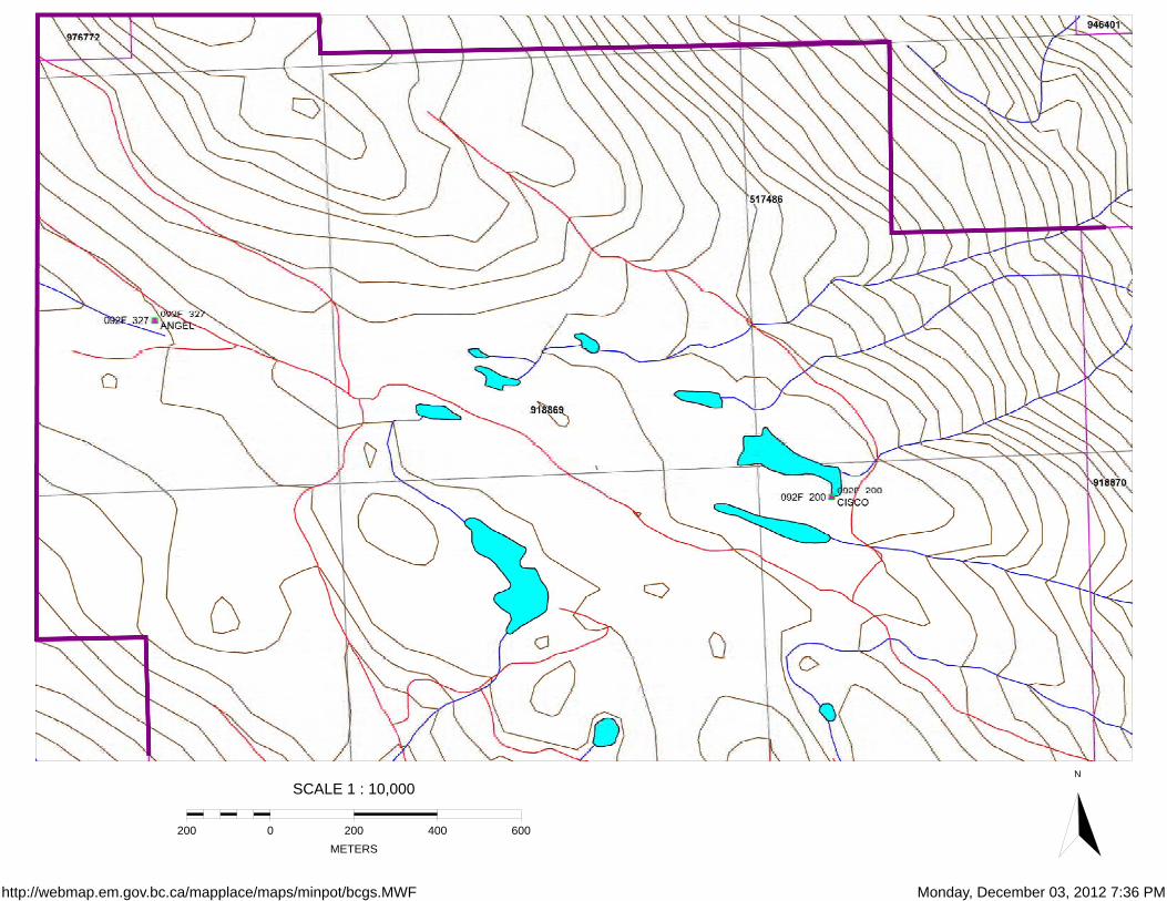
The first documented mining activity in the general area of claims 918869 and 918870 is from 1970 (Property File ID 2674, Wares, R.,1971), after Falconbridge Nickel Mines Ltd. optioned the Tex and Bob claims (MINFILE 092F276 – Tex) 5 km. to the northwest from local prospectors R. Mickle and R. Samuelson. Falconbridge completed systematic geological, geochemical, geophysical and diamond drilling work on the claims documenting fracture-controlled porphyry copper-molybdenum mineralization, but abandoned the option and did not file the work for assessment. In 1979 (ARIS 7559) to 1981 (ARIS 10065), local prospector F.J. Brennan completed very limited work in the area of the Tex MINFILE 092F276. The Angel MINFILE 092F200 gold occurrence with values in outcrop of up to 16 g/t gold, was discovered by local prospectors E. Johansen, R. Duker, R, Mickle and J. Newman in 1985, who optioned the claims at and around the occurrence to Caribou Gold Corp. In 1986 (ARIS 14916) Jo Shearer working for Caribou drilled a 137 m. core hole which yielded an intercept of 1 m. @ 16 g/t gold from 25.5 to 26.5 m. In 1987 (ARIS 16013) the same group of local prospectors discovered the Cisco MINFILE 092F327 gold occurrence with values up to 880 ppb gold in rocks and 1350 gold in soils located 1 to 2 km. southeast of Angel. The same prospectors also discovered the May MINFILE 092F059 occurrence in possible Paleozoic rocks with values >1% zinc and 1820 ppm lead in outcrop, located about 5 km. southeast of Angel. Also in 1987(ARIS 17301), another group of prospectors discovered the Frisky MINFILE 092F506 about 2 km. north of Angel, with values up to 1165 ppb gold, 26 ppm silver, 1055 ppm Cu, >1% lead and 4310 ppm Zn in outcrop. They also obtained a stream silt sample about 1 km north of Cisco which yielded 24,000 ppb gold. In early 1988 Rhyolite Resources Inc. (ARIS 17685) acquired the Angel claims previously held by Caribou and obtained values up to 5.5 g/t gold in outcrop from the Angel occurrence. In 1988 Echo Bay Mines Ltd. (ARIS 18671) acquired the Angel claims, and completed extensive soil sampling, trenching and channel sampling at the Angel occurrence, plus systematic prospecting, mapping and geochemical sampling over the entire property mainly west of Angel. Results included many intercepts up to 1.3 m. @ 15.9 g/t gold in trenched outcrops at Angel, and up to 4662 ppm copper, 17.3

6
g/t silver and 242 ppb gold in outcrops at the Geochem occurrence, located about 2 km. northwest of Angel. In 1989, Nexus Resources Corp. (ARIS 19509) acquired the Angel claims, and completed additional focused work at Angel including 5 core holes totaling 540 m., which yielded up to 0.15 m. @ 10.8 g/t gold, plus multiple other gold intercepts. In 2005 (EMBC 2005 p.85) Pathfinder Resources Ltd. completed geochemistry, ground geophysics (I.P.) and diamond drilling at Tex MINFILE 092F276, optioned from Northstar Mining Ltd. Pathfinder established the presence of gold in the fracture-controlled porphyry copper-molybdenum-gold mineralization previously discovered by Falconbridge, but abandoned the option and did not file the work for assessment. In 2007 (ARIS 29720) and 2009 (ARIS 30820) Northstar Mining Ltd. completed prospecting, ground geophysics (radiometrics) and spectral remote sensing on portions of their southern Texada Island properties. List of claims and work completed On October 16, 2012, the author accompanied by D. McLelland, R. Duker and D. Clark, traveled to and visited the sites of the old trenches of MINFILE 092F327 Angel and MINFILE 092F200 Cisco on cell mineral claim 918869, and extracted select rock grab samples in triplicate from mineralized bedrock at each of the 2 locations. The sample locations are shown in Figure 5 at 1:10,000 scale. The author subsequently prepared and shipped one each of the triplicate samples to AGAT’s laboratory facility in Burnaby, B.C., and one each of the samples to PCIGR’s geochronology laboratory facility at UBC in Vancouver, B.C., and completed rock sawing and microscopic examination of the other rock samples. Sample location, description and geochemistry results appear in Appendix 1. The geochemistry (Appendix 2) and geochronology (Appendix 3) reports were received and compiled, and the technical assessment report was written by the author. The mineral tenure assessment cost report (Appendix 4), and the MTO filing SOW 5411296 (Appendix 5) were also completed. The rock samples taken by the author are best described as select grab samples, and were taken to help characterize the mineralization at each location, but should not be considered representative of that mineralization. A geotul and moil was used to extract the samples, which were placed in new poly ore bags fastened with cable ties to prevent spilling, and portions of pre-numbered 3-part sample tags were placed in each bag. At each sample site, the rock sample was taken in triplicate, one of which the author cut with a rock saw, and inspected and described using a binocular microscope. At each sample site, site characteristics were recorded on a pre-printed, waterproof, loose-leaf sample record form in a field notebook, and the sample number was recorded in triplicate: on the form, on a metal tag tied near the sample site and marked with flagging tape, and as a waypoint number in a hand-held Garmin 60CSx GPS. Two shipments of rock samples were shipped, one to AGAT’s laboratory sample preparation facility in Burnaby, B.C., and one to the Pacific Centre for Isotopic and Geochemical Research (PCIGR) geochronology facility at UBC in Vancouver, B.C., both by Greyhound from Nanaimo, B.C. on November 2, 2012. AGAT prepared the samples using package 211001, and then transferred the pulps to their laboratory in Mississauga,

7
Ont. where they utilized multi-element metals package 201701, plus trace gold package 202051 for analysis of the rock samples. PCIGR utilized lead isotopes from sulphides extracted from the samples to determine the age of the sulphide mineralization. Technical Data, Interpretation and Conclusions The rock sample collected from a trenched outcrop in the area of the Angel MINFILE occurrence consists of altered, foliated and brecciated mafic volcanics containing quartz-calcite-sulphide stringers and about 10% fine grained sulphides, mainly pyrite. Geochemistry results yielded an elevated value of 2.54 g/t gold, but no elevated values of base metals, suggesting that the sulphides are mainly pyrite. It is not known if the pyrite mineralization is contemporaneous with either the gold mineralization in the sample, or with the precious metal mineralization documented by previous workers in the immediate area of the Angel MINFILE occurrence. The rock sample collected from an outcrop exposure in the area of the Cisco MINFILE occurrence consists of altered mafic volcanics containing quartz-calcite-sulphide stockwork and minor sulphides, mainly chalcopyrite. Unfortunately, geochemistry results from the sample failed to yield elevated values of precious or base metals, and the sites of mineralized exposures found by previous workers could not be re-located in the field. The geochronology samples were combined with other samples taken from elsewhere on Texada Island and on Vancouver Island, and submitted to Dr. J.K. Mortensen at the Pacific Centre for Isotopic and Geochemical Research (PCIGR) at the University of British Columbia in Vancouver, B.C. The combined geochronology report including the samples taken from the claims 918869 and 918870 appears in Appendix 3. Geochronology results suggest that the ages of sulphide mineralization at these two sites are similar, and possibly younger than that found in quartz-sulphide veins farther north on Texada Island which are interpreted to be genetically related to Early Jurassic intrusions. It is therefore possible that the quartz-calcite-sulphide veins at Angel and Cisco are genetically related to Cretaceous intrusions on south-central Texada Island. Systematic exploration work is appropriate and warranted to test the area of claims 981869 and 981870 as well as the surrounding area for additional precious/base metal quartz-calcite-sulphide veins, as well as genetically related porphyry copper-molybdenum-gold mineralization, culminating in trenching and initial shallow diamond drilling of any priority targets. Acquisition of additional mineral tenures surrounding claims 981869 and 981870 is recommended prior to initiating any further ground exploration work.
8
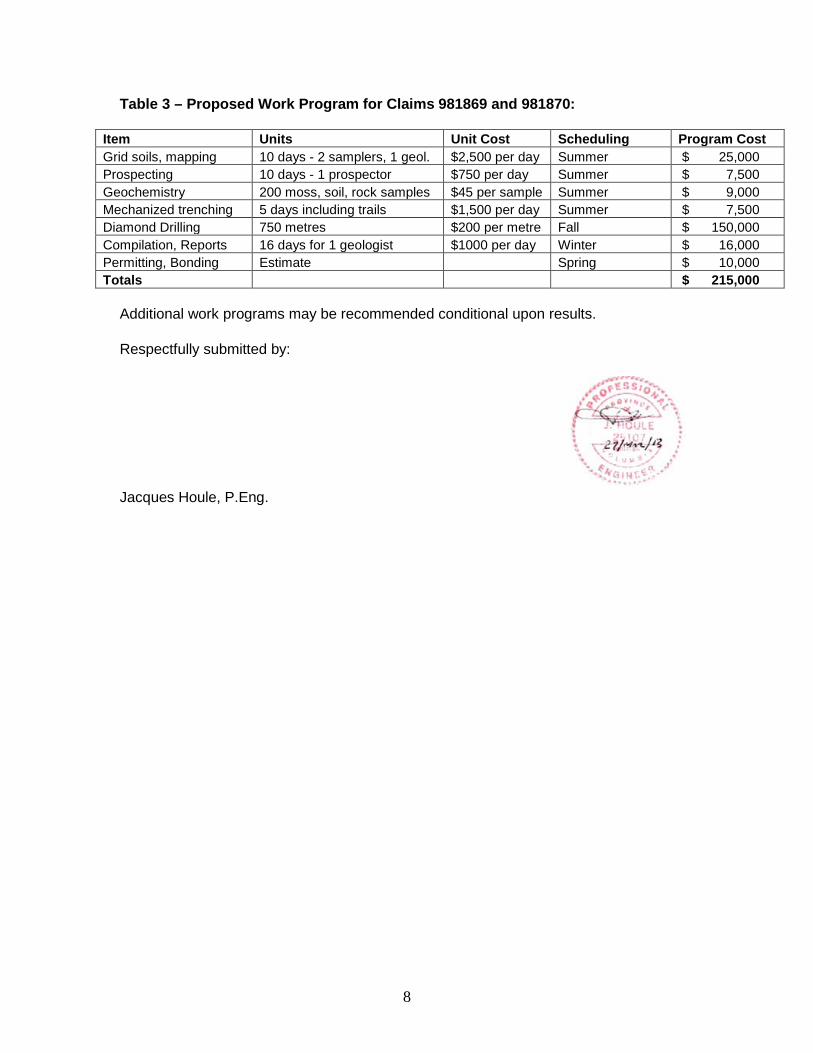
Table 3 – Proposed Work Program for Claims 981869 and 981870:
Item Units Unit Cost Scheduling Program Cost Grid soils, mapping 10 days - 2 samplers, 1 geol. $2,500 per day Summer $ 25,000 Prospecting 10 days - 1 prospector $750 per day Summer $ 7,500 Geochemistry 200 moss, soil, rock samples $45 per sample Summer $ 9,000 Mechanized trenching 5 days including trails $1,500 per day Summer $ 7,500 Diamond Drilling 750 metres $200 per metre Fall $ 150,000 Compilation, Reports 16 days for 1 geologist $1000 per day Winter $ 16,000 Permitting, Bonding Estimate Spring $ 10,000 Totals $ 215,000
Additional work programs may be recommended conditional upon results. Respectfully submitted by:
Jacques Houle, P.Eng.
9
Author’s Qualifications I, Jacques Houle, P.Eng. Do hereby certify that: I am currently self-employed as a consulting geologist by: Jacques Houle, P.Eng. Mineral Exploration Consulting 6552 Peregrine Road, Nanaimo, British Columbia, Canada V9V 1P8 I graduated with a Bachelor’s of Applied Science degree in Geological Engineering with specialization in Mineral Exploration from the University of Toronto in 1978. I am a member in good standing with the Association of Professional Engineers and Geoscientists of British Columbia, the Society of Economic Geologists, the Association for Mineral Exploration British Columbia, and the Vancouver Island Exploration Group; I am also a member of the Technical Advisory Committee for Geoscience B.C., and of the advisory committee for the Earth Science Department of Vancouver Island University. I have worked as a geologist for 35 years since graduating from university, including 5 years as a mine geologist in underground gold and silver mines, 15 years as an exploration manager, 3 years as a government geologist and 10 years as a mineral exploration consultant. I have previously visited the site of claims 918869 and 918870 in 2000 as the Southwest Regional Geologist for the B.C. government. I am independent of Alexandra Resources Inc., Northstar Mining Ltd. and Coast Minerals Corp., and hold no interest in the subject property of this report. References B. C. Ministry of Energy, Mines and Petroleum Resources websites: Assessment Reports http://www.empr.gov.bc.ca/Mining/Geoscience/ARIS/Pages/default.aspx MapPlace http://www.empr.gov.bc.ca/Mining/Geoscience/MapPlace/Pages/default.aspx Mineral Deposit Profiles http://www.empr.gov.bc.ca/Mining/Geoscience/MineralDepositProfiles/Pages/default.aspx MINFILE http://www.em.gov.bc.ca/Mining/Geolsurv/Minfile/ Ministry Publications http://www.empr.gov.bc.ca/Mining/Geoscience/PublicationsCatalogue/Pages/default.aspx Mineral Titles Online https://www.mtonline.gov.bc.ca/mtov/home.do

Angel & Cisco Area Texada Island
0 350 700 m.
Legend
This map is a user generated static output from an Internet mapping site and is for generalreference only. Data layers that appear on this map may or may not be accurate, current, orotherwise reliable. THIS MAP IS NOT TO BE USED FOR NAVIGATION.
Scale: 1:20,000Map center: 49° 34' 33" N, 124° 14' 19" W

http://webmap.em.gov.bc.ca/mapplace/maps/minpot/bcgs.MWF Monday, December 03, 2012 7:24 PM
SCALE 1 : 20,000
0500 500 1,000 1,500METERS
N

http://webmap.em.gov.bc.ca/mapplace/maps/minpot/bcgs.MWF Monday, December 03, 2012 7:27 PM
SCALE 1 : 20,000
0500 500 1,000 1,500METERS
N

http://webmap.em.gov.bc.ca/mapplace/maps/minpot/bcgs.MWF Monday, December 03, 2012 7:29 PM
SCALE 1 : 20,000
0500 500 1,000 1,500METERS
N
http://webmap.em.gov.bc.ca/mapplace/maps/minpot/bcgs.MWF Monday, December 03, 2012 7:36 PM
SCALE 1 : 10,000
0200 200 400 600METERS
N

Appendix 1
2012 Rock Sample Locations, Descriptions and Geochemistry

2008, 2012 Rock Sample Locations for Texada ProjectSample # Date Sampler Property Location Details UTM Zone Easting Northing ElevationE5123091 15-Oct-12 J.Houle Victoria Texada Island - Victoria shaft area south wall 5 m. south of shaft Select outcrop grab of 0.5 m. thick sulphidic volcanic? Breccia w/ shearing @ 075/90 & 115/90 10N 386287 5510844 175E5123092 16-Oct-12 J.Houle Angel Texada Island - Angel trench area adjacent to channel sample 100m. north of main road and ddh Select outcrop grab of quartz-carb-sulphide stringers in shear zone @ 155/65 10N 409593 5492478 618E5123093 16-Oct-12 J.Houle Cisco Texada Island - Cisco pit area small knoll north of pit north of old logging road Select outcrop grab of qtz-carb-sulph stockwork stringers @ 070/90 w/shearing @305/65 10N 411461 5491735 555

2008, 2012 Rock Sample Descriptions for Texada ProjectSample # Microscopic DescriptionsE5123091 Grey, green, black and bronze, silicified, chloritic, biotitic and sulphidic intermediate intrusive breccia with 75% medium grained matrix, 25% coarse mainly tuffaceous volcanic fragments, 25% medium quartz eyes, 10% medium chlorite/biotite crystals, 10% disseminated to clustered fine sulphides, mainly pyrite with traces chalcopyrite, sphaleriteE5123092 Cream, green, grey and tan, silicified, sericitic and chloritic foliated and brecciated mafic volcanic with 30% quartz-calcite-siderite-sulphide stockwork stringers, 1% fine clustered and rust-rimmed sulphides mainly pyrite, minor chalcopyrite, trace borniteE5123093 Green, white and cream, chloritic, sericitic and silicified, massive mafic volcanic with 15% quartz-calcite-siderite-sulphide stockwork stringers, 0.1% fine sulphides, mainly chalcopyrite, clustered locally in quartz stringers

4 Acid Digest - Metals Package, ICP/ICP-MS finish (201071)Fire Assay - Trace Au, AAS finish (202051)
Analyte: Sample
Login Au Ag Al As Ba Be Bi Ca Cd Ce Co Cr Cs Cu Fe Ga Ge Hf In K La Li Mg Mn Mo Na Nb Ni P Pb Rb Re S Sb Sc Se Sn Sr Ta Te Th Ti Tl U V W Y Zn Zr Sample Description: kg ppm ppm % ppm ppm ppm ppm % ppm ppm ppm ppm ppm ppm % ppm ppm ppm ppm % ppm ppm % ppm ppm % ppm ppm ppm ppm ppm ppm % ppm ppm ppm ppm ppm ppm ppm ppm % ppm ppm ppm ppm ppm ppm ppm
AGAT WOR Sample D RDL: 0.01
0.002 0.01 0.01 0.2 1 0.05 0.01 0.01 0.02 0.01 0.05 0.5 0.01 0.2 0.01 0.05 0.05 0.1
0.005 0.01 0.5 0.1 0.01 1 0.05 0.01 0.1 0.2 10 0.1 0.1
0.002 0.01 0.05 0.1 0.5 0.2 0.2 0.05 0.01 0.1 0.01 0.01
0.005 0.5 0.1 0.1 0.5 0.5 12V660112 E5123091 2.06 0.01 0.37 4.1 4.6 194 0.64 0.44 2.81 0.4 15.9 32.6 89.5 0.16 25.2 5.79 14 0.28 1.4 0.07 0.53 6.6 5.2 2.34 872 1.5 1.95 15.6 51.2 871 5.4 8.7 0.01 3.53 0.89 24.2 1.5 1.5 349 1.04 0.82 0.6 0.63 0.13 0.44 257 0.4 14.4 62.9 35.412V660112 E5123092 1.58 2.54 0.3 1.96 6.7 52 0.49 0.11 0.26 0.13 6.85 25.8 159 0.42 24.4 6.61 12.7 0.36 0.2 0.05 0.95 2.9 19.6 1.15 163 1.15 0.13 4.1 54.7 338 3.9 14.5 0.01 3.4 2.03 17.2 4.1 0.5 36.7 0.28 0.24 0.1 0.33 0.15 0.05 279 0.1 2.7 37.3 4.512V660112 E5123093 1.83<0.002 0.29 5.14 5.3 36 0.27 0.01 3.64 0.33 10.1 34.7 146 0.11 228 5.9 14.6 0.27 0.6 0.04 0.16 4 28.6 2.85 1150 0.33 2.18 6.4 79.8 450 4.1 2 0 0.02 1.4 26.1 0.5 0.6 223 0.48 0.02 0.3 0.28 0.02 0.08 212 0.1 8.3 96.8 12.9

Appendix 2
AGAT Laboratories Analytical Certificate 12V660112 portion

CLIENT NAME: JACQUES HOULE MINERAL EXPLORATION 6552 PEREGRINE ROADNANAIMO, BC V9V1P8 (250) 390-3930
5623 McADAM ROADMISSISSAUGA, ONTARIO
CANADA L4Z 1N9TEL (905)501-9998FAX (905)501-0589
http://www.agatlabs.com
Yufei Chen, AnalystSOLID ANALYSIS REVIEWED BY:
DATE REPORTED:
PAGES (INCLUDING COVER): 8
Nov 27, 2012
Should you require any information regarding this analysis please contact your client services representative at (905) 501-9998
12V660112AGAT WORK ORDER:
ATTENTION TO: JACQUES HOULE
PROJECT NO: 2012 Assay Pricing
Laboratories (V1) Page 1 of 8
All samples are stored at no charge for 90 days. Please contact the lab if you require additional sample storage time.
*NOTES
Results relate only to the items tested and to all the items tested

Ag Al As Ba Be Bi Ca CsCe Co CrCdAnalyte: FeCu
ppm % ppm ppm ppm ppm % ppmppm ppm ppmppmUnit: %ppm
Sample Description RDL: 0.01 0.010.2 1 0.05 0.01 0.01 0.02 0.01 0.05 0.5 0.01 0.20.01
0.37 4.10 4.6 194 0.64 0.44 2.81 0.1615.9 32.6 89.50.40E5123091 25.2 5.79
0.30 1.96 6.7 52 0.49 0.11 0.26 0.426.85 25.8 1590.13E5123092 24.4 6.61
0.29 5.14 5.3 36 0.27 0.01 3.64 0.1110.1 34.7 1460.33E5123093 228 5.90
18.6 0.03 >10000 <1 <0.05 4.71 0.21 0.063.32 0.32 9.83070E5123094 1710 25.5
0.26 0.19 144 7 0.08 0.04 10.4 0.062.21 15.8 25.521.8E5123095 8.5 4.47
0.08 0.10 20.6 12 0.08 0.01 18.5 0.061.07 1.75 14.82.39E5123096 63.6 2.24
Ga Ge Hf In K La Li NbMn Mo NaMgAnalyte: PNi
ppm ppm ppm ppm % ppm ppm ppmppm ppm %%Unit: ppmppm
Sample Description RDL: 0.05 100.1 0.005 0.01 0.5 0.1 0.01 1 0.05 0.01 0.1 0.20.05
14.0 0.28 1.4 0.069 0.53 6.6 5.2 15.6872 1.50 1.952.34E5123091 51.2 871
12.7 0.36 0.2 0.046 0.95 2.9 19.6 4.1163 1.15 0.131.15E5123092 54.7 338
14.6 0.27 0.6 0.044 0.16 4.0 28.6 6.41150 0.33 2.182.85E5123093 79.8 450
2.22 0.49 <0.1 38.3 0.02 3.9 0.3 2.2>10000 0.76 <0.010.22E5123094 <0.2 112
0.55 1.85 <0.1 0.251 0.01 2.6 15.2 0.51260 0.94 <0.013.12E5123095 34.8 552
0.16 <0.05 <0.1 0.029 <0.01 1.8 0.5 0.2555 1.04 <0.010.19E5123096 4.1 234
Pb Rb Re S Sb Sc Se ThSr Ta TeSnAnalyte: TlTi
ppm ppm ppm % ppm ppm ppm ppmppm ppm ppmppmUnit: ppm%
Sample Description RDL: 0.1 0.010.002 0.01 0.05 0.1 0.5 0.2 0.2 0.05 0.01 0.1 0.010.1
5.4 8.7 0.008 3.53 0.89 24.2 1.5 0.6349 1.04 0.821.5E5123091 0.63 0.13
3.9 14.5 0.009 3.40 2.03 17.2 4.1 0.136.7 0.28 0.240.5E5123092 0.33 0.15
4.1 2.0 0.004 0.02 1.40 26.1 0.5 0.3223 0.48 0.020.6E5123093 0.28 0.02
69.6 0.4 0.004 16.5 76.8 0.2 6.1 <0.14.6 0.18 0.051.2E5123094 <0.01 0.01
3.9 0.4 0.004 0.09 5.21 2.8 <0.5 <0.1174 <0.05 <0.01<0.2E5123095 <0.01 <0.01
1.1 0.6 0.003 0.16 0.32 0.4 <0.5 <0.195.0 <0.05 0.01<0.2E5123096 <0.01 <0.01
Results relate only to the items tested and to all the items tested
DATE RECEIVED: Nov 05, 2012
Certificate of Analysis
ATTENTION TO: JACQUES HOULECLIENT NAME: JACQUES HOULE MINERAL EXPLORATION
AGAT WORK ORDER: 12V660112
4 Acid Digest - Metals Package, ICP/ICP-MS finish (201071)
DATE SAMPLED: Nov 05, 2012 DATE REPORTED: Nov 27, 2012 SAMPLE TYPE: Rock
PROJECT NO: 2012 Assay Pricing
5623 McADAM ROADMISSISSAUGA, ONTARIO
CANADA L4Z 1N9TEL (905)501-9998FAX (905)501-0589
http://www.agatlabs.com
CERTIFICATE OF ANALYSIS (V1)
Certified By:Page 2 of 8

U V W Y Zn Zr Mn-OL Zn-OLAnalyte:
ppm ppm ppm ppm ppm ppm % %Unit:
Sample Description RDL: 0.005 0.1 0.1 0.5 0.5 0.01 0.010.5
0.437 257 0.4 14.4 62.9 35.4E5123091
0.050 279 0.1 2.7 37.3 4.5E5123092
0.080 212 0.1 8.3 96.8 12.9E5123093
0.037 0.6 <0.1 5.1 >10000 2.5 2.33 13.4E5123094
0.466 81.5 0.3 10.2 571 2.4E5123095
0.296 13.0 0.2 2.8 57.0 2.4E5123096
RDL - Reported Detection LimitComments:
3893823-3893828 As, Sb values may be low due to digestion losses.
Results relate only to the items tested and to all the items tested
DATE RECEIVED: Nov 05, 2012
Certificate of Analysis
ATTENTION TO: JACQUES HOULECLIENT NAME: JACQUES HOULE MINERAL EXPLORATION
AGAT WORK ORDER: 12V660112
4 Acid Digest - Metals Package, ICP/ICP-MS finish (201071)
DATE SAMPLED: Nov 05, 2012 DATE REPORTED: Nov 27, 2012 SAMPLE TYPE: Rock
PROJECT NO: 2012 Assay Pricing
5623 McADAM ROADMISSISSAUGA, ONTARIO
CANADA L4Z 1N9TEL (905)501-9998FAX (905)501-0589
http://www.agatlabs.com
CERTIFICATE OF ANALYSIS (V1)
Certified By:Page 3 of 8

SampleLogin
WeightAuAnalyte:
kg ppmUnit:
Sample Description RDL: 0.01 0.002
2.06 0.008E5123091
1.58 2.54E5123092
1.83 <0.002E5123093
1.47 0.015E5123094
0.29 <0.002E5123095
0.96 <0.002E5123096
RDL - Reported Detection LimitComments:
Results relate only to the items tested and to all the items tested
DATE RECEIVED: Nov 05, 2012
Certificate of Analysis
ATTENTION TO: JACQUES HOULECLIENT NAME: JACQUES HOULE MINERAL EXPLORATION
AGAT WORK ORDER: 12V660112
Fire Assay - Trace Au, AAS finish (202051)
DATE SAMPLED: Nov 05, 2012 DATE REPORTED: Nov 27, 2012 SAMPLE TYPE: Rock
PROJECT NO: 2012 Assay Pricing
5623 McADAM ROADMISSISSAUGA, ONTARIO
CANADA L4Z 1N9TEL (905)501-9998FAX (905)501-0589
http://www.agatlabs.com
CERTIFICATE OF ANALYSIS (V1)
Certified By:Page 4 of 8

Fire Assay - Trace Au, AAS finish (202051)
Au 1 3893823 0.008 0.008 0.0% < 0.002 102% 90% 110%0.269 0.263
4 Acid Digest - Metals Package, ICP/ICP-MS finish (201071)
Ag 1 3893823 0.37 0.27 0.01 89% 80% 120%11.5 13.0
Al 1 3893823 4.10 4.10 0.0% 0.01 80% 120%
As 1 3893823 4.57 3.91 15.6% 0.2 80% 120%
Ba 1 3893823 194 214 9.8% < 1 80% 120%
Be
1 3893823 0.64 0.71 10.4% < 0.05 102% 80% 120%0.4 0.4
Bi 1 3893823 0.44 0.42 4.7% < 0.01 80% 120%
Ca 1 3893823 2.81 3.24 14.2% < 0.01 80% 120%
Cd 1 3893823 0.399 0.331 18.6% < 0.02 80% 120%
Ce 1 3893823 15.9 16.0 0.6% < 0.01 80% 120%
Co
1 3893823 32.6 34.9 6.8% < 0.05 80% 120%
Cr 1 3893823 89.5 90.9 1.6% < 0.5 80% 120%
Cs 1 3893823 0.16 0.16 0.0% < 0.01 80% 120%
Cu 1 3893823 25.2 26.3 4.3% < 0.2 97% 80% 120%5826 6000
Fe 1 3893823 5.79 6.50 11.6% < 0.01 80% 120%
Ga
1 3893823 14.0 16.0 13.3% < 0.05 80% 120%
Ge 1 3893823 0.283 0.352 21.7% < 0.05 80% 120%
Hf 1 3893823 1.4 1.3 7.4% < 0.1 80% 120%
In 1 3893823 0.069 0.080 14.8% < 0.005 80% 120%
K 1 3893823 0.53 0.59 10.7% 0.01 80% 120%
La
1 3893823 6.62 6.53 1.4% < 0.5 80% 120%
Li 1 3893823 5.2 5.4 3.8% < 0.1 80% 120%
Mg 1 3893823 2.34 2.52 7.4% < 0.01 80% 120%
Mn 1 3893823 872 1010 14.7% < 1 80% 120%
Mo 1 3893823 1.50 1.43 4.8% 0.05 87% 80% 120%331 380
Na
1 3893823 1.95 2.28 15.6% < 0.01 80% 120%
Nb 1 3893823 15.6 12.5 22.1% 0.1 80% 120%
Ni 1 3893823 51.2 55.7 8.4% < 0.2 80% 120%
P 1 3893823 871 977 11.5% < 10 98% 80% 120%588 600
Pb 1 3893823 5.4 5.8 7.1% 0.1 80% 120%
Rb
1 3893823 8.73 6.83 24.4% < 0.1 80% 120%
Re 1 3893823 0.0078 0.0086 9.8% < 0.002 80% 120%
S 1 3893823 3.53 3.75 6.0% < 0.01 80% 120%
Sb 1 3893823 0.889 0.936 5.2% < 0.05 80% 120%
Sc 1 3893823 24.2 22.9 5.5% < 0.1 80% 120%
Se
1 3893823 1.5 1.6 6.5% < 0.5 80% 120%
Sn 1 3893823 1.51 1.33 12.7% < 0.2 80% 120%
Sr 1 3893823 349 400 13.6% < 0.2 98% 80% 120%382 390
Ta 1 3893823 1.04 0.85 20.1% < 0.05 80% 120%
Te 1 3893823 0.825 0.943 13.3% < 0.01 80% 120%
Th
1 3893823 0.6 0.5 18.2% 0.1 80% 120%
Ti 1 3893823 0.63 0.69 9.1% < 0.01 80% 120%
Results relate only to the items tested and to all the items tested
AGAT WORK ORDER: 12V660112
ResultValue
Quality Assurance
ATTENTION TO: JACQUES HOULE
CLIENT NAME: JACQUES HOULE MINERAL EXPLORATION
PROJECT NO: 2012 Assay Pricing
Rep #1 RPDLower Upper
Acceptable LimitsRecovery
ExpectValue
REFERENCE MATERIAL
BatchPARAMETER Sample Id Original
RPT Date: Nov 27, 2012 REPLICATE
Method Blank
Solid Analysis
5623 McADAM ROADMISSISSAUGA, ONTARIO
CANADA L4Z 1N9TEL (905)501-9998FAX (905)501-0589
http://www.agatlabs.com
QUALITY ASSURANCE REPORT (V1) Page 5 of 8
Tl 1 3893823 0.13 0.15 14.3% < 0.01 80% 120%
U 1 3893823 0.437 0.461 5.3% < 0.005 80% 120%
V 1 3893823 257 283 9.6% < 0.5 80% 120%
W
1 3893823 0.36 0.32 11.8% < 0.1 80% 120%
Y 1 3893823 14.4 13.4 7.2% < 0.1 80% 120%
Zn 1 3893823 62.9 68.0 7.8% 0.5 80% 120%
Zr 1 3893823 35.4 27.7 24.4% < 0.5 80% 120%
Certified By:
Results relate only to the items tested and to all the items tested
AGAT WORK ORDER: 12V660112
ResultValue
Quality Assurance
ATTENTION TO: JACQUES HOULE
CLIENT NAME: JACQUES HOULE MINERAL EXPLORATION
PROJECT NO: 2012 Assay Pricing
Rep #1 RPDLower Upper
Acceptable LimitsRecovery
ExpectValue
REFERENCE MATERIAL
BatchPARAMETER Sample Id Original
RPT Date: Nov 27, 2012 REPLICATE
Method Blank
Solid Analysis (Continued)
5623 McADAM ROADMISSISSAUGA, ONTARIO
CANADA L4Z 1N9TEL (905)501-9998FAX (905)501-0589
http://www.agatlabs.com
QUALITY ASSURANCE REPORT (V1) Page 6 of 8

Solid Analysis
Ag MIN-200-12020 ICP-MS
Al MIN-200-12020 ICP/OES
As MIN-200-12020 ICP-MS
Ba MIN-200-12020 ICP-MS
Be MIN-200-12020 ICP-MS
Bi MIN-200-12020 ICP-MS
Ca MIN-200-12020 ICP/OES
Cd MIN-200-12020 ICP-MS
Ce MIN-200-12020 ICP-MS
Co MIN-200-12020 ICP-MS
Cr MIN-200-12020 ICP/OES
Cs MIN-200-12020 ICP-MS
Cu MIN-200-12020 ICP-MS
Fe MIN-200-12020 ICP/OES
Ga MIN-200-12020 ICP-MS
Ge MIN-200-12020 ICP-MS
Hf MIN-200-12020 ICP-MS
In MIN-200-12020 ICP-MS
K MIN-200-12020 ICP/OES
La MIN-200-12020 ICP-MS
Li MIN-200-12020 ICP-MS
Mg MIN-200-12020 ICP/OES
Mn MIN-200-12020 ICP/OES
Mo MIN-200-12020 ICP-MS
Na MIN-200-12020 ICP/OES
Nb MIN-200-12020 ICP-MS
Ni MIN-200-12020 ICP-MS
P MIN-200-12020 ICP/OES
Pb MIN-200-12020 ICP-MS
Rb MIN-200-12020 ICP-MS
Re MIN-200-12020 ICP-MS
S MIN-200-12020 ICP/OES
Sb MIN-200-12020 ICP-MS
Sc MIN-200-12020 ICP-MS
Se MIN-200-12020 ICP-MS
Sn MIN-200-12020 ICP-MS
Sr MIN-200-12020 ICP-MS
Ta MIN-200-12020 ICP-MS
Te MIN-200-12020 ICP-MS
Th MIN-200-12020 ICP-MS
Ti MIN-200-12020 ICP/OES
Tl MIN-200-12020 ICP-MS
U MIN-200-12020 ICP-MS
V MIN-200-12020 ICP/OES
W MIN-200-12020 ICP-MS
Y MIN-200-12020 ICP-MS
Zn MIN-200-12020 ICP-MS
Zr MIN-200-12020 ICP-MS
Mn-OL AA
Results relate only to the items tested and to all the items tested
AGAT WORK ORDER: 12V660112
Method Summary
ATTENTION TO: JACQUES HOULE
CLIENT NAME: JACQUES HOULE MINERAL EXPLORATION
PROJECT NO: 2012 Assay Pricing
AGAT S.O.P ANALYTICAL TECHNIQUELITERATURE REFERENCEPARAMETER
5623 McADAM ROADMISSISSAUGA, ONTARIO
CANADA L4Z 1N9TEL (905)501-9998FAX (905)501-0589
http://www.agatlabs.com
METHOD SUMMARY (V1) Page 7 of 8
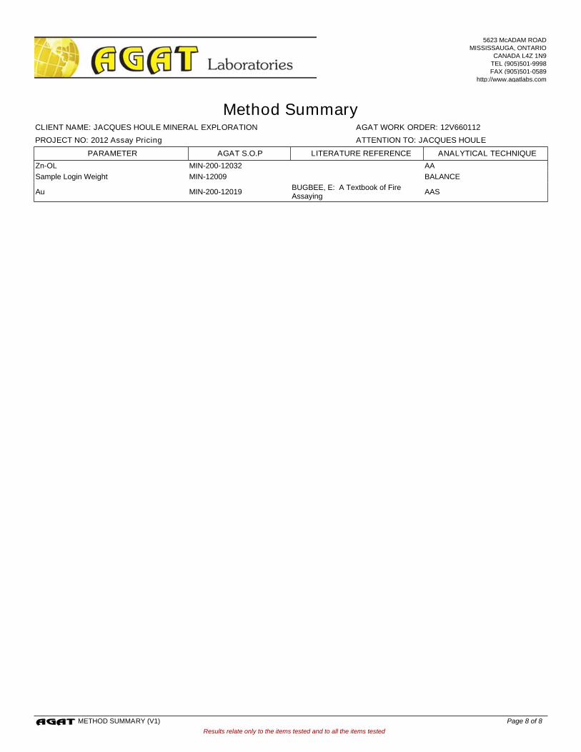
Zn-OL MIN-200-12032 AA
Sample Login Weight MIN-12009 BALANCE
Au MIN-200-12019BUGBEE, E: A Textbook of Fire Assaying
AAS
Results relate only to the items tested and to all the items tested
AGAT WORK ORDER: 12V660112
Method Summary
ATTENTION TO: JACQUES HOULE
CLIENT NAME: JACQUES HOULE MINERAL EXPLORATION
PROJECT NO: 2012 Assay Pricing
AGAT S.O.P ANALYTICAL TECHNIQUELITERATURE REFERENCEPARAMETER
5623 McADAM ROADMISSISSAUGA, ONTARIO
CANADA L4Z 1N9TEL (905)501-9998FAX (905)501-0589
http://www.agatlabs.com
METHOD SUMMARY (V1) Page 8 of 8

Appendix 3
PCIGR Geochronology Report

Lead Isotopic Analysis of Sulphide Samples from Vancouver Island (report prepared for J. Houle; March 26, 2013)
J.K. Mortensen, PhD, PEng
Introduction Six samples of sulphide-bearing rock from Vancouver Island for Pb isotopic analysis were submitted to the Pacific Centre for Isotopic and Geochemical Research (PCIGR) at the University of British Columbia by J. Houle. Analytical Methodology Clean sulphide samples were separated from five of the six samples by hand-picking under a binocular microscope. The sulphide grains were very finely disseminated in one sample (E5123095) and it was therefore impossible to prepare a clean sulphide concentrate. Instead fine fragments of whole rock with relatively abundant fine grained sulphides were subjected to a partial leach in order to selectively dissolve the contained sulphides. Isotopic analyses were done using methods as described in Mortensen et al. (2008). Sulphides were dissolved in dilute nitric acid and Pb for analysis was separated and purified using ion exchange methods. Isotopic compositions were measured on a modified VG-54R thermal ionization mass spectrometer. All measured isotopic ratios were corrected for instrumental mass fractionation of 0.12%/amu based on repeated measurements of the NBS 981 standard and the values recommended by Thirwall (2000). Errors were numerically propagated throughout all calculations and are reported at the 2σ level (Table 1). Results Analytical results for the six samples are listed in Table 1, together with previously published Pb isotopic analyses of galenas from a suite of veins that cut Quatsino Limestone and Texada Formation (Karmutsen Group) mafic volcanic rocks on Texada Island (from BC Leadtable; Godwin et al., 1988). Results are plotted on Figure 1, along with fields of Pb isotopic compositions of sulphides from volcanogenic massive sulphide (VMS) deposits in the Myra Falls camp on Vancouver Island (from Godwin et al., 1988). The data is plotted in two formats: as 207Pb/204Pb vs. 206Pb/204Pb (Fig. 1A) and as 208Pb/206Pb vs. 207Pb/206Pb (Fig. 1B). The latter diagram is used in order to avoid the larger analytical errors associated with measurement of the relatively weak 204Pb peak. The results of the work are interpreted below, incorporating information on the specific occurrences that was provided by J. Houle. The PD trench sample (Table 1) is from a replacement deposit adjacent to exposures of Permian Buttle Lake Group (Mt. Mark Formation) limestone. Mafic dykes that are interpreted to be related to the Middle Triassic Mt. Hall gabbro have been mapped nearby. The Pb isotopic composition of this sample falls within the field of Late

Devonian VMS deposits in the Myra Falls camp (Fig. 1); however, the mineralization clearly cannot be of this age, since the host rocks are much younger than this. It is not clear what the sulphide mineralization is related to – it is possible that it may have formed from mineralizing fluids emanating from the gabbro; however, such bodies typically have low water contents, and there is no evidence for skarn or replacement mineralization associated with Mt. Hall gabbros anywhere else on Vancouver Island. The geological setting of the taconite and breccia samples from the PD property (Table 1) and the relationship, if any, with the PD trench sample (above) have not yet been established. These two samples yielded much more radiogenic compositions than the PD trench sulphide sample, suggesting either that they resulted from a somewhat younger mineralizing event, or that the Pb in these samples represented a mixture of Pb of similar composition to that in the PD trench sample and much more radiogenic Pb, perhaps derived from the host rocks. The Victoria sample (Table 1) is from a quartz vein in mafic volcanic rocks of the Middle Triassic Texada Formation on northern Texada Island. The Victoria pyrite Pbs plot within the field of Pb isotopic compositions of galenas from other quartz veins that cut the Texada Formation and Quatsino Limestone on Texada Island and have been interpreted to be genetically related to Early Jurassic intrusions in the vicinity (J. Houle, personal communication, 2013). The Pb isotopic compositions of the Victoria sulphides are consistent with this interpretation. The Angel and Cisco samples (Table 1) are from quartz veins that cut Texada Formation volcanics in south-central Texada Island. These samples give somewhat more radiogenic compositions than the Victoria occurrence and other vein occurrences on northern Texada Island (Fig. 1). The Pb isotopic compositions of these two occurrences suggest that they are younger than the Early Jurassic veins from farther north. They could be genetically related to Cretaceous granodiorite intusions that have been mapped nearby (J. Houle, personal communication, 2013).

Figure 1. Lead isotopic compositions of sulphides from mineral occurrences north of Horne Lake area (red circles) and from Texada Island (green circles). Fields of Pb isotopic compositions of galenas from veins on Texada Island and from VMS deposits in the Myra Falls camp on Vancouver Island, along with the Stacey and Kramer (1975) average upper crustal growth curve, are also shown for reference.

References Godwin, C.I., Gabites, J.E. and Andrew, A., 1988, Leadtable – a galena lead isotope
database for the Canadian Cordillera, with a guide to its use by explorationists: B.C. Mineral Resources Division, Geological Survey Branch, Paper 1988-4, 188 p.
Mortensen, J.K., Hall, B.V., Bissig, T., Friedman, R.M., Danielson, T., Oliver, J., Rhys, D., Ross, K.V., and Gabites, J.E., 2008, Age and paleotectonic setting of volcanogenic massive sulfide deposits in the Guerrero Terrane of central Mexico: Constraints from U-Pb age and Pb isotopic studies: Economic Geology, v. 103, p. 117-140.
Stacey J.S. and Kramer, J.D. 1975, Approximation of terrestrial lead isotope evolutionby a two-stage model: Earth and Planetary Science Letters, v. 26, p. 207-221.
Thirwall, M.F. 2000, Inter-laboratory and other errors in Pb isotope analyses investigated using a 207Pb-204Pb double spike: Chemical Geology, v. 163, p. 299-322.

Table 1. Lead isotopic compositions of sulphides from mineral occurrences on the PD property north of Horne Lake, and on central and northern Texada Island. Isotopic compositions of galenas from other vein occurrences on Texada Island are also listed (from Godwin et al., 1988).
Sample Locality Lithology Mineral 206Pb/ Error 207Pb/ Error 208Pb/ Error 207Pb/ Error 208Pb/ Error Latitude Longitude
Number 204Pb % 2σ 204Pb % 2σ 204Pb % 2σ 206Pb % 2σ 206Pb % 2σ
Trace Pb isotopic analyses (this study)
E5123091 Victoria (Texada) - 092F264 pyrite 18.6772 0.06 15.5640 0.05 38.2762 0.06 0.8333 0.016 2.0494 0.023
E5123091 Victoria (Texada) - 092F264 pyrite 18.6871 0.02 15.5725 0.02 38.2890 0.02 0.8333 0.005 2.0490 0.004
E5123092 Angel (Texada) - 092F327 pyrite 18.8166 0.02 15.5645 0.01 38.2998 0.02 0.8272 0.007 2.0354 0.006
E5123093 Cisco (Texada) - 092F200
pyrite and chalco 18.8512 0.02 15.5457 0.01 38.2598 0.02 0.8247 0.007 2.0296 0.008
E5123094 PD occurrence - 092F271 Trench sample pyrite 18.4961 0.08 15.5996 0.07 38.2150 0.09 0.8434 0.036 2.0661 0.048
E5123095 Bountiful property (PD) - 092F271 Breccia sample mixed sulphides 19.2500 0.04 15.6370 0.04 38.2796 0.04 0.8123 0.010 1.9886 0.008
E5123096 Bountiful property (PD) - 092F271 Taconite sample pyrite 18.6541 0.01 15.5998 0.00 38.1914 0.01 0.8363 0.005 2.0474 0.004
Galena Pb isotopic analyses (Godwin et al., 1988)
30560 SHOWING30560 Quatsino vein galena 18.763 0.01 15.587 0.01 38.371 0.02 0.8307 0.01 2.0450 0.01 49.75 124.53
30560 SHOWING30560 BY Copper Queen Quatsino vein galena 18.777 0.04 15.606 0.04 38.430 0.05 0.8311 0.01 2.0466 0.02 49.75 124.53
30561 SHOWING30561 Quatsino vein galena 18.776 0.02 15.596 0.02 38.415 0.02 0.8306 0.01 2.0459 0.01 49.75 124.54
30563 ALLADIN Quatsino vein galena 18.791 0.06 15.605 0.04 38.381 0.07 0.8305 0.04 2.0425 0.04 49.72 124.52
30563 ALLADIN Quatsino vein galena 18.766 0.02 15.583 0.02 38.330 0.02 0.8304 0.01 2.0426 0.01 49.72 124.52
30564 SENTINEL Quatsino vein galena 18.748 0.02 15.580 0.02 38.351 0.02 0.8310 0.01 2.0457 0.01 49.72 124.53
30564 SENTINEL Quatsino vein galena 18.749 0.02 15.582 0.02 38.341 0.03 0.8310 0.01 2.0449 0.02 49.72 124.53
30565 SANDY Quatsino vein galena 18.763 0.02 15.579 0.02 38.365 0.03 0.8303 0.01 2.0448 0.01 49.71 124.53
30565 SANDY Quatsino vein galena 18.761 0.01 15.581 0.02 38.344 0.02 0.8305 0.01 2.0439 0.01 49.71 124.53
30566 SILVER TIP Texada Fm vein galena 18.650 0.02 15.571 0.02 38.276 0.03 0.8349 0.01 2.0523 0.02 49.73 124.59
30566 SILVER TIP Texada Fm vein galena 18.650 0.02 15.571 0.02 38.273 0.02 0.8349 0.01 2.0522 0.01 49.73 124.59
30567 STURT POINT (OKE) Quatsino vein galena 18.673 0.05 15.550 0.05 38.160 0.06 0.8328 0.02 2.0436 0.03 49.77 124.56
30568 NANCY BELL Texada Fm vein galena 18.654 0.06 15.580 0.06 38.301 0.06 0.8352 0.01 2.0533 0.02 49.72 124.59
30569 VICTORIA Texada Fm vein galena 18.680 0.01 15.583 0.02 38.277 0.02 0.8343 0.01 2.0492 0.01 49.74 124.58
30571 HOLLY FAULT Quatsino vein galena 18.693 0.03 15.585 0.03 38.335 0.03 0.8337 0.01 2.0507 0.01 49.73 124.56
30571 HOLLY FAULT Quatsino vein galena 18.694 0.01 15.581 0.01 38.311 0.02 0.8335 0.01 2.0494 0.01 49.73 124.56
30571 HOLLY FAULT Quatsino vein galena 18.676 0.02 15.564 0.02 38.261 0.02 0.8334 0.01 2.0486 0.01 49.73 124.56
30571 HOLLY FAULT Quatsino vein galena 18.690 0.02 15.579 0.02 38.307 0.02 0.8335 0.01 2.0496 0.01 49.73 124.56
30571 HOLLY FAULT Quatsino vein galena 18.689 0.02 15.572 0.02 38.291 0.03 0.8332 0.01 2.0489 0.02 49.73 124.56
30572 RETRIEVER Texada Fm shear zone galena 18.707 0.02 15.585 0.02 38.339 0.02 0.8331 0.01 2.0495 0.01 49.72 124.57

Appendix 4
2012 Cost Statement for Assessment Work Program

Exploration Work type Comment Days Totals
Personnel (Name)* / Position Field Days (list actual days) Days Rate Subtotal*Jacques Houle /Geologist October 15-16, 2012 2 $806.40 $1,612.80David McLelland / Prospector October 15-16, 2012 2 $448.00 $896.00
$2,508.80 $2,508.80Office Studies List Personnel (note - Office only, do not include field daysReport preparation estimate 4 days - Jacques Houle 4.0 $806.40 $3,225.60
estimate 4 days - Houle office use 4.0 $80.64 $322.56$3,548.16 $3,548.16
Geochemical Surveying Number of Samples No. Rate SubtotalRock estimate 3 rock samples by AGAT 3.0 $44.80 $134.40Other (specify) 3 Pb isotope age dates by MDRU 3.0 $336.00 $1,008.00
$1,142.40 $1,142.40Transportation No. Rate Subtotaltruck rental Houle 4x4 pickup truck hourly rate 7.50 $40.32 $302.40Other Ferry Comox-Powell R.-Texada $222.80
$525.20 $525.20Accommodation & Food Rates per day No. RateHotel 1 night for 2 people @ Gillies Bay 2.00 $134.40 $268.80
$268.80 $268.80Equipment Rentals No. RateField Gear (Specify) Houle field gear hourly rate for 2 4.00 $16.13 $64.51Other (Specify) Houle office use hour rate 2.50 $8.06 $20.16
$84.67 $84.67Freight, rock samples
estimate 3 samples to AGAT labs $15.00estimate 3 samples to MDRU $15.00
$30.00 $30.00
TOTAL Expenditures $8,108.03
Filing Distribution: Tenure Number Ha Area % Filing % Cost AllocationVictoria 918829 83.5 0.124642 33% $2,675.65Dandt 918869 523.7Take 918870 62.9Totals 670.1 100.0% 100.0% $8,108.03
Texada Project October 2012 Cost Statement
67% $5,432.380.875358