assessment of the effects of biophysical and … 1 assessment of the effects of biophysical and...
TRANSCRIPT
1
Assessment of the effects of biophysical and anthropogenic factors on 1 woody plant encroachment in dense and sparse mountain grasslands 2
based on remote sensing data 3 4 Authors: Maite Gartzia*1, Concepción L Alados2 and Fernando Pérez-Cabello3 5 6 1Maite Gartzia 7 (Instituto Pirenaico de Ecología) CSIC, Spain 8 2Concepción L. Alados 9 (Instituto Pirenaico de Ecología) CSIC, Spain 10 3Fernando Pérez-Cabello 11 (Department of Geography and Spatial Management) University of Zaragoza, Spain 12 13 Corresponding author: 14 Maite Gartzia, Instituto Pirenaico de Ecología (CSIC), Avda de Nuestra Señora de la Victoria s/n, P. O. 15 Box 64, Jaca, E- 22700 Huesca, Spain. 16 Email: [email protected] 17
18 Abstract 19 Land abandonment exacerbated by climate change has led to increased woody plant 20 encroachment of mountain grasslands in many regions of the world. The present study assessed 21 woody plant encroachment below potential tree line in the Central Pyrenees of Spain and the 22 association of this encroachment with changes in land use. Remote sensing data from Landsat-5 23 Thematic Mapper (TM) from the mid-1980s and mid-2000s were analyzed by supervised 24 classification for identification of land cover types. The transition matrix indicated that 25 shrublands were the most dynamic plant communities. Consequently, 21% of cultivated areas, 26 19% of dense grasslands, and 24% of sparse grasslands became shrublands during the period 27 analyzed, and 35% of shrublands became forest. Generalized Additive Mixed Models (GAMM) 28 was used to identify biophysical and anthropogenic factors that were significantly correlated with 29 woody plant encroachment of dense and sparse grasslands. Distance to the nearest woody plant 30 habitat (shrub or forest) was the most strongly correlated factor with woody plant encroachment 31 of both types of grasslands. This factor explained 69% and 71% of the variance in models of 32 dense and sparse grasslands, respectively. Besides this factor, anthropogenic factors had larger 33 effects on woody plant encroachment of dense grasslands, regions that were more productive and 34 accessible. However, biophysical and especially topographic factors had slightly greater effects 35 on woody plant encroachment of sparse grasslands, regions that were less productive and 36 accessible. The changes in land cover that we observed indicated that land cover has become 37 more homogeneous. There have been reductions in the variety, functions, and services of 38 grasslands, particularly in areas below the potential tree line that are vulnerable to the 39 development of woody plant habitats. 40 41 Keywords: Land cover change, mountain grassland, land abandonment, woody plant 42 encroachment, remote sensing, Spanish Pyrenees. 43
44 I. Introduction 45
Woody plant encroachment of natural and semi-natural mountain grasslands is a widespread and 46 acute problem throughout the world (Brandt et al., 2013; Fernández-Giménez and Fillat, 2012b; 47 Ratajczak et al., 2012; Naito and Cairns, 2011; Stueve et al., 2011; Sitko and Troll, 2008; 48 Lasanta-Martínez et al., 2005; Vicente-Serrano et al., 2005; Molinillo et al., 1997). Most of these 49 habitats, especially mountain grasslands below the potential tree line, were created by the 50 removal of shrubs and forests, and their persistence depends heavily on traditional land-use 51

2
practices such as livestock grazing and woody plant removal by fire or mechanical means (Wehn 52 et al., 2011; Sitko and Troll, 2008; Holtmeier and Broll, 2007; Sankey et al., 2006; Didier, 2001). 53 In the absence of these activities, these man-made habitats undergo ecological succession toward 54 shrub- or tree-dominated vegetation (Schirmel et al., 2011; Lasanta-Martínez et al., 2005), 55 leading to a reduction in the amount of mountain grasslands. Recent changes in human 56 demographics and agricultural policies have led to these changes (Pôças et al., 2011), and global 57 warming has exacerbated this problem (Batllori and Gutiérrez, 2008; Bolli et al., 2007; Holtmeier 58 and Broll, 2007; Vicente-Serrano et al., 2005). Thus, a combination of social, economic, and 59 natural processes, which operate from local to global scales, has altered the environments of 60 mountainous regions (Gerard et al., 2010; Liverman and Cuesta, 2008; Mottet et al., 2006; Roura-61 Pascual et al., 2005). More studies on the extent of these changes and the factors that drive them 62 are vital because these regions contain some of the best preserved natural communities and are 63 protected by the European Union Habitats Directive. 64 Woody plant encroachment of grasslands reduces biodiversity (Ratajczak et al., 2012), increases 65 the risk of fire (Lloret et al., 2002; Moreira et al., 2001), affects ecosystem functions by reducing 66 the amount of productive grazing habitats for domestic and wild herbivores (Fernández-Giménez 67 and Fillat, 2012b), and alters the culturally significant features and aesthetics of the landscape 68 (Antrop, 2005). Nevertheless, woody plant encroachment can minimize landslides and soil 69 erosion (García-Ruiz et al., 1996) and, in semi-arid grasslands, can reverse desertification 70 (Maestre et al., 2009). In addition, woody plant encroachment of areas with high annual 71 precipitation can increase carbon storage due to the increased net primary production (Knapp et 72 al., 2008). 73 Since the Middle Ages, humans in the Pyrenees have increased the amount of cultivable land and 74 summer grasslands by removal of forest and shrublands (Kouba and Alados, 2012; Roura-Pascual 75 et al., 2005; Montserrat-Martí, 1992; Daumas, 1976). These man-made and natural mountain 76 ecosystems provided a variety of resources, and for centuries, high-elevation grasslands were 77 used for extensive livestock grazing in summer. However, after the 1930s, livestock (mainly, 78 sheep) densities declined coinciding with an important decrease in the human population (IAE, 79 2012; Lasanta-Martínez et al., 2005). The Pyrenees experienced a substantial reduction in the 80 number of agropastoral workers (mainly shepherds), many of whom migrated to large 81 industrialized cities. Human depopulation, a reduction in livestock density, and changes in land 82 use led to the abandonment of many areas, and this has led to changes in the composition of the 83 vegetation. In particular, native shrubs have encroached the grasslands and cultivated areas and 84 this process was followed by afforestation of the shrublands (Bartolome et al., 2005; Roura-85 Pascual et al., 2005; Molinillo et al., 1997). Previous studies have assessed the biophysical and 86 anthropogenic factors that contribute to woody plant encroachment, especially the encroachment 87 of cultivated areas and mountain grasslands (Brandt et al., 2013; Kouba and Alados, 2012; Schulz 88 et al., 2011; Grau et al., 2008; Sitko and Troll, 2008; Gellrich et al., 2007; Lasanta-Martínez and 89 Vicente-Serrano, 2007; Millington et al., 2007). However, few studies have compared woody 90 plant encroachment in different types of mountain grasslands (Montané et al., 2010), such as the 91 sparse and dense grasslands of the Pyrenees. 92 Remote sensing data are valuable and cost-effective source for quantification of spatial-temporal 93 changes in vegetation cover (Boyd and Danson, 2005; Stow et al., 2004). In particular, Landsat 94 imagery have been used to measure changes in land cover over the last decades (Brandt et al., 95 2013; Pôças et al., 2011; Schulz et al., 2011; Grau et al., 2008; Shalaby and Tateishi, 2007; Stow 96 et al., 2004; Tømmervik et al., 2004; Gautam et al., 2003). 97 The general objective of our research is to identify factors that promoted woody plant 98 encroachment of dense and sparse mountain grasslands in Aragón, Central Pyrenees, Spain. The 99 two grassland types under study differ in plant composition, biomass production, and geographic 100 location, so are expected to respond differently on woody plant encroachment to biophysical and 101 anthropogenic factors. Dense grasslands occur on low slopes and have deep soils, leading to high 102

3
grass coverage. Conversely, sparse grasslands occur on steep slopes and have shallow soils, 103 leading to low grass coverage (Fillat et al., 2008). Sheep and goats are the primary grazers of 104 sparse grasslands and cattle and horses of dense grasslands, which are more accessible and have 105 higher biomass production (Fernández-Giménez and Fillat, 2012a). 106 Our specific purposes are to (i) use remote sensing data to identify the types of land cover in the 107 mountainous areas in Aragón, Central Pyrenees and quantify the spatial and temporal changes in 108 these habitats, especially the loss of dense and sparse grasslands due to woody plant 109 encroachment; and (ii) identify biophysical and anthropogenic factors that have led to woody 110 plant encroachment of dense and sparse grasslands in Aragón, Central Pyrenees. 111 112
II. Methods 113 1. Study area 114
The study area (138,363 ha) was in Aragón, Central Pyrenees, Spain, at 42º 36´ N, 0º 00´E 115 (Figure 1), which is within the Alpine Mountain region (600-3340 m a.s.l.). The area has a 116 mountain climate that is characterized by equinoctial precipitation and a continental influence 117 strongly affected by elevation. At 2200 m, near the potential tree line, the average annual 118 precipitation is 1657 mm and the average daily maximum and minimum temperatures are 8.6ºC 119 and 1.4ºC, respectively (AEMET, 2012 ; Cuadrat et al., 2007). 120 In the study area, climate has a strong influence on vegetation physiognomy along an elevation 121 gradient (Gartzia et al., 2013). At high elevations (> 2100 m), the vegetation is mostly sparse 122 grasslands that are dominated by Festuca gautieri. Plants in these grasslands are adapted to harsh 123 climatic conditions, the slopes are steep, the soil is very shallow, rocky outcrops are common, and 124 vegetation cover is less than 50% (Fillat et al., 2008). In flatter areas, where the soils are deeper, 125 there are dense grasslands that have grass coverage of more than 50%. These grasslands include 126 various communities of a variety of pasture grasses, sedges, and leguminous species, and Festuca 127 nigrescens and Agrostis capillaris, or Nardus stricta, Festuca eskia or F. paniculata are the 128 dominant species (Fillat et al., 2008). Dense grasslands are adjacent to sparse grasslands at high 129 elevations and adjacent to shrublands and forests at low elevations. 130 Typically, sheep and goats graze the sparse grasslands and cattle and horses graze the dense 131 grasslands (Fernández-Giménez and Fillat, 2012a). Ecological succession from dense grassland to 132 sparse grassland or vice versa is uncommon because of topographical limitations, which do not 133 change. However, succession from grassland to woody community is common when 134 anthropogenic pressures are reduced, especially below the potential tree line (2100 m a.s.l.) 135 (Camarero and Gutiérrez, 2004), where forest is almost always the potential vegetation. In the 136 shrublands, almost all of which are in transition to forest, Buxus sempervirens is predominant, 137 along with Echinospartum horridum on basic soils and Juniperus communis or Rhododendron 138 ferrugineum on acidic soils. Coniferous trees (mostly Pinus sylvestris or P. uncinata), beech 139 (Fagus sylvatica), or a variety of oaks (Quercus spp.) are predominant in the forests. At the 140 bottoms of valleys, where the slopes are shallow and the soils are deep, the land was cultivated 141 for crop production, particularly potatoes and cereals. However, these regions are currently 142 meadows (Fernández-Giménez and Fillat, 2012a). Many cultivated areas have been abandoned in 143 recent decades, and this has led to a transition to Genista scorpius or Rosa spp. shrub 144 communities and forests. 145 146
2. Supervised classification of land cover using remote sensing data 147 Remote sensing data acquisition and processing 148 Remote sensing data can be used to quantify spatial and temporal changes in the landscape (Boyd 149 and Danson, 2005; Stow et al., 2004). Multi-temporal datasets, such as those from Landsat-5 TM, 150 which began in 1984 until 2011, have allowed the study of changes in land cover in mountain 151 areas (Brandt et al., 2013; Pôças et al., 2011; Schulz et al., 2011; Grau et al., 2008; Shalaby and 152 Tateishi, 2007; Stow et al., 2004; Tømmervik et al., 2004; Gautam et al., 2003). 153

4
We added phenological information to increase the accuracy of the land cover classification by 154 using multi-date imagery in the supervised classification (Brandt et al., 2013; Kuemmerle et al., 155 2006). We used cloud-free Landsat-5 TM imagery acquired on 3 July 1984 (early summer) and 156 14 September 1987 (late summer) for the first period and for the second period 4 August 2007 157 and 5 September 2007 (early-late summer) to identify and quantify the types of land cover (forest, 158 shrubland, dense grassland, sparse grassland, and cultivated areas) in the study area. The imagery 159 were provided by the USGS at level 1T (ortho-rectified image) and correspond to Landsat-5 TM 160 scene 199-30. Prior to classification we used the ATCOR-2/3 (v 9.3), an atmospheric correction 161 algorithm created by Dr. Richter of the German Aerospace Center, to convert the digital value 162 into reflectance (expressed as a percentage) and to remove atmospheric and topographic effects 163 (based on the Lambertian assumption). 164 165 Land cover supervised classification approach 166 We used 21 layers in each time period for the supervised classification of land cover (Figure 2) 167 (Gartzia et al., 2013). There were six bands from the Landsat-5 TM imagery, except the thermal 168 band (Kuemmerle et al., 2006), acquired in early summer and another six bands in late summer, 169 and there were two vegetation indices per image derived from these imagery (Normalized 170 Difference Vegetation Index (NDVI) and the Soil-Adjusted Vegetation Index (SAVI) (Baret and 171 Guyot, 1991)). There were five topographical features (elevation, slope, north-south aspect, east-172 west aspect, insolation) that were derived from the 30 m resolution Digital Elevation Model 173 (DEM) (SITAR, 2012) using ArcGis 9.3 software. North-south and east-west aspects were 174 cosine- and sine-transformed, respectively (Felicísimo, 1994). 175 The training data used in the supervised classification were based on 1000 randomly selected 176 pixels (Gartzia et al., 2013) from imagery acquired in mid-2000s. Each of the pixels was assigned 177 to a land cover category based on a vegetation map in the area, field inspections, and ortho-178 photographs acquired in 1997 and 2006 (SITAR, 2012). The supervised classification was based 179 on the non-parametric random forest (RF) classifier (Gartzia et al., 2013; Rodriguez-Galiano et 180 al., 2012) using the randomForest package in the R software environment (R Development Core 181 Team, 2011; Liaw and Wiener, 2002). The RF is not constrained by parametric restrictions and is 182 not sensitive to collinearity and overfitting of the data (Breiman, 2001), allowing the use of layers 183 with collinearity issues. This is useful for mountainous habitats, where topographic factors tend 184 to be highly collinear (Gartzia et al., 2013; Shi et al., 2009; De la Riva, 1997). 185 Dense grasslands and cultivated areas were difficult to distinguish with the method used for 186 supervised classification, so we initially classified both land cover types as dense grasslands. 187 After the supervised classification, the crop and land use maps of 1978 and 2008 (MAGRAMA, 188 2010) were used to distinguish cultivated areas from dense grasslands. 189 The accuracy of the classified map from the mid-2000s was tested using another 1000 randomly 190 selected pixels. These pixels are identified using the same methodology described in the training 191 data identification. We calculated Cohen’s Kappa Index of Agreement (Cohen, 1960), a standard 192 method in remote sensing research (Congalton and Green, 2009). After confirming the adequate 193 accuracy of the supervised classification of the mid-2000s land cover map (Cohen´s Kappa= 194 0.91), mid-1980s imagery were classified based on the random forest parameters derived from 195 mid-2000s supervised classification (Figure 2) using 1980s remote sensing data and ancillary 196 data. 197 198
3. Quantification of changes in land covers below the potential tree line (2100 m a.s.l.) 199 The primary objective of this study was to assess changes in land cover due to the ecological 200 succession of vegetation, specifically the extent of woody plant encroachment of dense and sparse 201 grasslands and cultivated areas, and the afforestation of shrublands. To minimize the potentially 202 confounding effects of climate change, our analysis was restricted to below the potential tree line 203 (Gellrich et al., 2007), where changes in land use are believed to have had a greater impact than 204

5
global warming (Bryn, 2008; Gehrig-Fasel et al., 2007). 205 We used Chi-square test to measure the significant difference in the land covers between the two 206 periods. Then, we used a transition probability matrix based on the two supervised classification 207 maps to quantify the extent and direction of changes in vegetation (Brandt et al., 2013; Kouba and 208 Alados, 2012; Mottet et al., 2006; Roura-Pascual et al., 2005). The probability (Pij) of transition 209 from one cover class (i) to another cover class (j) was calculated as: Pij = (Aj 2000s/Ai 1980s), 210 where Aj 2000s is the area of class j in the mid-2000s that was class i in the mid-1980s, and Ai 211 1980s is the total area of cover class i in mid-1980s. 212 213
4. Identification of the main factors affecting woody plant encroachment in dense and 214 sparse grasslands below the potential tree line (2100 m a.s.l.) 215
Biophysical factors and anthropogenic factors were used to identify the causes of changes of 216 dense and sparse grasslands cover (Table 1): 217
1) The biophysical factors were: (a) topographical factors derived from the DEM (SITAR, 218 2012): elevation (m), slope (º), north-south aspect (cosine of the aspect), east-west aspect 219 (sine of the aspect), and insolation; (b) abiotic factors: lithology (basic, acidic, or 220 quaternary materials) (SITAR, 2012), resistance to erosion of the geological materials 221 (SITAR, 2012), and distance to the nearest river (SITAR, 2012); (c) biotic factors: 222 distance to the nearest woody plant habitat that was present in mid-1980s (based on the 223 map prepared in this study); and (d) climatic factors: precipitation and temperature 224 (Cuadrat et al., 2007). 225
2) The anthropogenic factors were: (a) distance to the nearest main road and any passable 226 road (IGN, 2012; SITAR, 2012); (b) distance to the nearest building or town (IGN, 2012; 227 SITAR, 2012); (c) ownership of the land (private or public) (SITAR, 2012); and (d) 228 depopulation in each historical municipality between the 1930s and the 1980s 229 (municipalities with more than 50% depopulation or municipalities with less than 50% 230 depopulation) (IAE, 2012). 231
Generalized Additive Mixed Models (GAMMs) were used to identify factors that significantly 232 correlated with woody plant encroachment of dense and sparse grasslands. The GAMM models 233 can accommodate spatial autocorrelation and non-linearity in the data (Zuur et al., 2009). In most 234 cases, there was spatial autocorrelation in the landscape data and some of the explanatory factors 235 included in the models had non-linear responses. Pixel identity was included as a random factor 236 to avoid the effects of spatial autocorrelation. Examination of the residuals from the GAMMs 237 (Zuur et al., 2009) confirmed that the assumptions of the model were met (normality, 238 independence, and heteroscedasticity of the variance of the residuals). The GAMMs were 239 assessed using the mgcv and nlme packages in R software environment (Pinheiro et al., 2011; R 240 Development Core Team, 2011; Wood, 2011). The adequacy of the model was based on 241 calculation of the Akaike Information Criteria (AIC), which considers goodness-of-fit and model 242 complexity (Zuur et al., 2009). To selected the optimal model, we choose the one with lowest 243 AIC, always deleting the not significant factors from the models. 244 The models included 500 randomly selected pixels from areas that were grasslands in mid-1980s 245 and in the mid-2000s (absence of change in the grasslands), and 500 randomly selected pixels 246 from areas that had changed from grasslands to woody plant communities (presence of the change 247 in the grasslands). The data for dense and sparse grasslands were analyzed separately. Only 248 factors with low collinearity (Pearson r < 0.7 (Schulz et al., 2011)) were included in the models. 249 250 III. Results 251
1. Supervised classification maps and land cover changes in the Central Pyrenees. 252 In the mid-1980s, the land cover above 2100 m a.s.l. (24% of the total study area) was 25% dense 253 grassland and 75% sparse grassland. The land cover below 2100 m a.s.l. (76% of the total study 254 area) was 28% forest, 38% shrubland, 23% dense grassland, 8% sparse grassland, and 3% 255

6
cultivated areas (Figure 3a). Between the mid-1980s and the mid-2000s, the amount of forest 256 increased by 13,904 ha (Figure 3). Over the same time, shrubland decreased by 6708 ha, dense 257 grassland decreased by 4100 ha, sparse grassland decreased by 2438 ha, and cultivated areas 258 decreased by 658 ha. 259 The results of the chi-square test for the comparison of land cover types between mid-1980s and 260 mid-2000s periods showed significant differences between both periods (chi-squared = 9.82, p-261 value = 0.04). The 96% of the changes in land cover occurred below 2100 m a.s.l. Shrubs 262 colonized grasslands and cultivated areas after they were abandoned (Figure 3c), and the amount 263 of forest increased, particularly in shrublands. Between these two periods, 35% of the shrublands 264 became forest, and only 5% of dense grasslands and 8% of cultivated areas were afforested 265 (Figure 4). In sparse grasslands, afforestation was very limited, but shrub encroachment was 266 24%. In dense grasslands shrub encroachment was 19% and 21% in cultivated areas (Figure 4). 267 Overall, woody plant encroachment, from grasslands or cultivated areas to shrublands or forests, 268 was greater in cultivated areas (29%) than in dense and sparse grasslands (24% each). 269 270
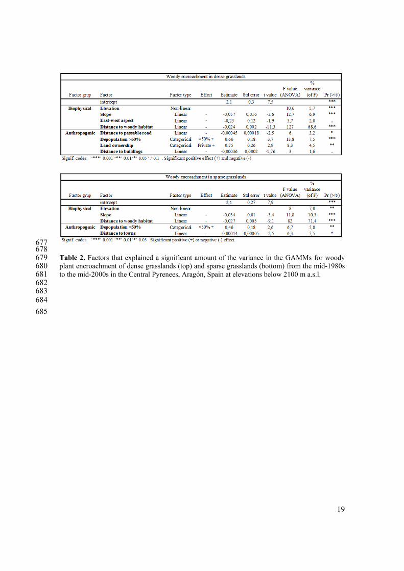
2. Factors influencing woody plant encroachment in dense and sparse grasslands 271 In the GAMMs, distance to the nearest woody plant habitat (shrub or forest) was the most 272 strongly correlated factor with the extent of woody plant encroachment in dense grasslands 273 (explained 69% of the variance in the model) and sparse grasslands (explained 71% of the 274 variance) (Figure 5, Table 2). In dense and sparse grasslands, 90% and 94% of the woody plant 275 encroachment, respectively, occurred in the first 90 m from the shrub or forest habitat that existed 276 in the mid-1980s. Beyond 330 m from the nearest woody plant habitat, less than 1% of the 277 grasslands had been encroached from the mid-1980s to the mid-2000s. Slope explained 7% and 278 10% of the variance in the models of woody plant encroachment in dense and sparse grasslands, 279 respectively (Table 2). About 75% of the woody plant encroachment occurred in areas where the 280 slope was 15º-35º in dense grasslands and 15º-40º in sparse grasslands (Figure 6a). In areas 281 where the slope was less than 5º, 60% of the sparse grasslands had been encroached (Figure 6b), 282 corresponding to regions at elevations of 800-900 m a.s.l. (Figure 6d). These low-elevation areas 283 which were woody encroached were close to rivers. 284 The other factors that correlated with woody plant encroachment each explained less than 10% of 285 the variance in the models (Table 2). In both types of grasslands, elevation correlated with woody 286 plant encroachment in a non-linear manner. The extent of encroachment varied with elevation, in 287 that 75% of the woody plant encroachment occurred at 1400-1900 m a.s.l. in dense grasslands, 288 and at 1500-2100 m a.s.l. in sparse grasslands (Figure 6c). At lower elevations, however, the 289 percentage of grasslands that had been encroached was higher. In dense grasslands, encroachment 290 was more than 50% at 1000-1500 m a.s.l., 25% at 1500-1900 m a.s.l., and less than 3% near 2100 291 m a.s.l. (Figure 6d). In sparse grasslands, encroachment was more than 60% at riverbanks and 292 eroded hillsides at 800-900 m, 40% at 1100-1400 m, and 4% near 2100 m. In addition, a westerly 293 aspect was positively correlated with woody plant encroachment in dense grasslands. 294 Although anthropic factors do not explain a high proportion of the variance in the models, there 295 are anthropic variables with significant correlation with the woody plant encroachment, 296 particularly in dense grasslands (Table 2). There was extensive depopulation of the study area 297 from the 1930s to the 1980s, and municipalities with high rates of depopulation (> 50%) had the 298 greatest amount of woody plant encroachment. In dense and sparse grasslands, 73% and 63% of 299 the woody plant encroachment, respectively, occurred in municipalities that had high 300 depopulation. In those areas, 22% and 18% of the dense and sparse grasslands, respectively, had 301 woody plant encroachment. However, in areas that experienced less severe depopulation, 11% 302 and 14% of the dense and sparse grasslands had transformed into woody plant habitats. 303 Finally, encroachment of dense grasslands was more likely to happen in private than public lands 304 (Table 2). In addition, the extent of woody plant encroachment and distance to the nearest 305 passable road or building were negatively correlated. In sparse grasslands, the distance to the 306
7
nearest town explained a small but significant amount of the variance in the model. Distance to 307 the nearest river, lithology, and resistance to erosion of the geological material did not explain 308 significant amounts of variance in the GAMMs for woody plant encroachment of dense or sparse 309 grasslands. 310 311 IV. Discussion 312
The analysis showed that there has been a change in land cover types in Central Pyrenees since 313 mid-1980s. A high woody plant encroachment of dense and sparse mountain grasslands below the 314 potential tree line is occurring in grasslands created by human activities several centuries ago in 315 the area. This ecological succession in the grasslands is a natural process and, without human 316 intervention, will continue until these grasslands become forests or shrublands (Lasanta-Martínez 317 and Vicente-Serrano, 2007; Lasanta-Martínez et al., 2005). Although these grasslands are semi-318 natural habitats, they are highly valued and the need for their conservation is widely recognized. 319 The loss of grasslands began in the 1930s, when rural abandonment of the Pyrenees began (IAE, 320 2012). 321 Our results indicate that proximity to a woody cover is the main factor associated with succession 322 of grasslands to shrublands or forests. In grasslands where the nearest woody habitat was more 323 than 330 m away, the probability of woody plant encroachment was less than 1%, even if human 324 activity had ceased decades earlier. Similar phenomena have been observed in other mountainous 325 areas, such as the Alaska Range, the Ukrainian Carpathian Mountains, and the Swiss Alps 326 (Stueve et al., 2011; Sitko and Troll, 2008; Bolli et al., 2007; Gellrich et al., 2007). In the Swiss 327 Alps (Bolli et al., 2007) and Tierra de Fuego, Chile (Cuevas, 2000), the seed-rain and micro-328 environmental factors were important in the expansion of woody plant communities that were 329 near pre-existing shrublands or forest habitats. This is consistent with “shrub autocatalysis”, a 330 feedback mechanism in which shrub encroachment is greatest in areas where woody plant 331 vegetation is already present (Brandt et al., 2013). 332 In our study area, woody plant encroachment progressed from low elevations to high elevations, 333 especially in patches of grassland that were surrounded by woody plant habitats. Similar 334 phenomena have occurred in the Swiss Alps and the Himalayas (Brandt et al., 2013; Gehrig-Fasel 335 et al., 2007; Gellrich et al., 2007). In our study and in other studies, slope is the topographic factor 336 that had the greatest effect on woody plant encroachment, particularly on mean slopes (Schulz et 337 al., 2011; Molinillo et al., 1997), which are not suitable for human or livestock activities (Schulz 338 et al., 2011). However, these areas have been used when human and livestock densities were 339 higher. In addition, mean steep slopes are more easily colonized by shrubs than shallow slopes, 340 where there is competition with grassland species (Komac et al., 2011; Guerrero et al., 1999). In 341 contrast, steep slopes are less favorable for woody plant species (Gellrich et al., 2007), and this 342 slows the rate at which woody plants can invade these habitats. In the dense grasslands of the 343 Central Pyrenees, woody plant encroachment was most strongly correlated with a westerly aspect, 344 a topographic factor that was strongly associated with human activities in the past (Poyatos et al., 345 2003). Areas facing the west were most productive because they did not have the harsh climate 346 that is characteristic of north-facing slopes. But many of the west-facing slopes have been 347 abandoned (Molinillo et al., 1997), and this might explain the more substantial woody plant 348 encroachment of these areas. 349 Dense grasslands and sparse grasslands have been managed differently for many centuries, and 350 these different management practices have influenced the nature and extent of woody plant 351 encroachment. In particular, anthropogenic factors have had a greater influence in dense 352 grasslands than sparse grasslands as our results demonstrated. Humans have used dense 353 grasslands more intensively because these areas offered the best topography, soil, and plant 354 productivity for herding animals. Recent declines in human activities have contributed to an 355 increase in woody plant encroachment of these dense grasslands. In sparse grasslands, however, 356 slope and elevation have had a greater influence on woody plant encroachment than 357
8
anthropogenic factors as our results reveal. Thus, there are different patterns of woody plant 358 encroachment in different grassland habitats (Montané et al., 2010). 359 In the Central Pyrenees, dense grasslands on private lands were more likely to have suffered from 360 woody plant encroachment than those on public lands. This phenomenon was also observed on 361 savannas in North America (Archer et al., 1989). Livestock pressure on private lands has usually 362 been low to favor high productivity, which has led to an increased risk of woody plant 363 encroachment. On the contrary, the communal pastures are intensively used, which are often 364 overgrazed because individual self-interest can lead to misuse of a commonly held resource 365 (Hardin, 1968). In addition, public lands have experienced less abandonment. Even when there 366 was no local livestock within the municipality to grazing the public lands, the pastures were 367 rented to others who brought livestock from outside the municipality. 368 The negative correlations that we observed between woody plant encroachment and the distances 369 to the nearest building, town, or passable road suggest that human pressure on grasslands near 370 these infrastructures has decreased and this has led to woody plant encroachment. This 371 phenomenon has been observed elsewhere (Brandt et al., 2013; Schulz et al., 2011; Grau et al., 372 2008; Gellrich et al., 2007). For example, use of wood as a source of energy for cooking and 373 heating was much more common in the past (Roura-Pascual et al., 2005), when the demand for 374 wood led to harvesting of shrub and trees of the most accessible areas. Nevertheless, the negative 375 correlations that we observed are contrary to our initial expectation that the most remote sites 376 were more likely to experience shrub encroachment and afforestation (Kouba and Alados, 2012; 377 Schulz et al., 2011). 378 We found a relevant relationship between rural abandonment and woody plant encroachment of 379 sparse and dense grasslands. Municipalities that had a greater woody plant encroachment were 380 those that experienced the greatest depopulation between 1930s and 1980s. Since the 1980s, the 381 population of this region has actually grown slowly (IAE, 2012), but agro-pastoral activity has 382 continued to decline because the agricultural economy has become secondary to the tourism 383 economy. Similar demographic changes occurred in the Italian Alps (Motta et al., 2006), and an 384 increase in immigration to the Swiss Alps did not retard the trend of increased woody plant 385 encroachment because farms continued to be abandoned (Gellrich et al., 2007). 386 387
V. Conclusions 388 Significant woody plant encroachment has occurred in the mountain grasslands of the Central 389 Pyrenees since the mid-1980s. This has been particularly severe below the potential tree line, 390 where one-quarter of the dense and sparse grasslands have been lost due to woody plant 391 encroachment. Proximity to shrublands or forest habitats was the most significant factor 392 associated with woody plant encroachment of both types of grasslands. In the dense and sparse 393 grasslands which have been managed differently for many centuries, the anthropogenic factors 394 had greater influence on woody plant encroachment of dense grasslands, while topographic 395 factors had more influence on woody plant encroachment of sparse grasslands. 396 These grasslands are under protection of the European Union Habitats Directive and woody plant 397 encroachment of these grasslands cannot be reversed naturally, and human interventions, such as 398 mechanical clearing and fires, have not always produced satisfactory results. Furthermore, the 399 reversion of a woody plant system to grassland takes much more time than succession from 400 grassland to shrubland. Thus, we expect that in the current socio-economic and natural 401 circumstances, the woody plant encroachment of grasslands will continue. Therefore, if the 402 objectives are to preserve the landscape, plant communities, biodiversity, and ecosystem 403 functions and services, prompt action should be taken to preserve mountain grasslands. Our 404 results provide a scientific basis for making political decisions on the management of these 405 important regions. 406 407 408
9
Funding 409 This research was funded within the framework of the research project CGL2011-27259 (Spanish 410 Ministry of Economy and Competitiveness and Innovation), co-financed by the FEDER, project 411 DIPA 125/2010 MMAMRM (Spanish National Park organization), and project FW7 412 ENV.2009.2.1.3.2 - LEDDRA (European Community). 413 414 Acknowledgements 415 We thank S. Benitez, H. Saiz, F. Fillat, and A. Aldezabal for assistance with the bibliographic 416 search, for providing information about the study area, and for provided suggestions for 417 improving earlier versions of the manuscript. Bruce MacWhirter and Scott Butler provided 418 helpful suggestions on the penultimate version of manuscript. 419 420 References 421 AEMET. (2012 ) Spanish Meteorological Agency. Available at: http://www.eamet.es. 422 Antrop M. (2005) Why landscapes of the past are important for the future. Landscape 423
and urban planning 70: 21-34. 424 Archer FM, Hoffman MT and Danckwerts JE. (1989) How economic are the farming 425
units of Leliefontein, Namaqualand? Journal of the Grassland Society of southern 426 Africa 6: 211-215. 427
Baret F and Guyot G. (1991) Potentials and limits of vegetation indices for LAI and 428 APAR assessment. Remote sensing of environment 35: 161-173. 429
Bartolome J, Plaixats J, Fanlo R and Boada M. (2005) Conservation of isolated Atlantic 430 heathlands in the Mediterranean region: effects of land-use changes in the 431 Montseny biosphere reserve (Spain). Biological Conservation 122: 81-88. 432
Batllori E and Gutiérrez E. (2008) Regional tree line dynamics in response to global 433 change in the Pyrenees. Journal of Ecology 96: 1275-1288. 434
Bolli JC, Rigling A and Bugmann H. (2007) The influence of changes in climate and 435 land-use on regeneration dynamics of Norway spruce at the treeline in the Swiss 436 Alps. Silva Fennica 41: 55-70 437
Boyd DS and Danson FM. (2005) Satellite remote sensing of forest resources: three 438 decades of research development. Progress in Physical Geography 29 (1): 1–26. 439
Brandt JS, Haynes MA, Kuemmerle T, Waller DM and Radeloff VC. (2013) Regime 440 shift on the roof of the world: Alpine meadows converting to shrublands in the 441 southern Himalayas. Biological Conservation 158: 116-127. 442
Breiman L. (2001) Random forests. Machine Learning 45: 5-32. 443 Bryn A. (2008) Recent forest limit changes in south-east Norway: Effects of climate 444
change or regrowth after abandoned utilisation? Norsk Geografisk Tidsskrift - 445 Norwegian Journal of Geography 62: 251-270. 446
Camarero JJ and Gutiérrez E. (2004) Pace and Pattern of Recent Treeline Dynamics: 447 Response of Ecotones to Climatic Variability in the Spanish Pyrenees. Climatic 448 Change 63: 181-200. 449
Cohen J. (1960) A coefficient of agreement for nominal scales. Educational and 450 psychological measurement 20: 37-46. 451
Congalton RG and Green K. (2009) Assessing the Accuracy of Remotely Sensed Data: 452 Principles and Practices: CRC Press. 453
Cuadrat JM, Saz MA and Vicente-Serrano SM. (2007) Atlas Climático de Aragón: 454 Gobierno de Aragón. 455
10
Cuevas JG. (2000) Tree recruitment at the Nothofagus pumilio alpine timberline in Tierra 456 del Fuego, Chile. Journal of Ecology 88: 840-855. 457
Daumas M. (1976) La vie rurale dans le haut Aragon oriental. Instituto de Estudios 458 Oscenses y de Geografía Aplicada, Madrid: CSIC. 459
De la Riva JR. (1997) Los montes de la Jacetania. Caracterización física y explotación 460 forestal, Zaragoza: Consejo de Protección de la Naturaleza de Aragón. 461
Didier L. (2001) Invasion patterns of European larch and Swiss stone pine in subalpine 462 pastures in the French Alps. Forest ecology and management 145: 67-77. 463
Felicísimo AM. (1994) Modelos Digitales del Terreno. Introducción y aplicaciones en 464 las ciencias ambientales, Oviedo, Spain: Pentalfa Ediciones. 465
Fernández-Giménez M and Fillat F. (2012a) Pyrenean pastoralists’ ecological 466 knowledge: documentation and application to natural resource management and 467 adaptation. Human Ecology 40: 287-300. 468
Fernández-Giménez M and Fillat F. (2012b) Pyrenean pastoralists’ observations of 469 environmental change: an exploratory study in Los Valles Occidentales of 470 Aragón. Pirineos. Revista de Ecología de Montaña 167: 143-163. 471
Fillat F, García-González R, Gómez D and Reiné R. (2008) Pastos del Pirineo, Madrid: 472 Departamento de publicaciones – CSIC. 473
García-Ruiz J, Lasanta T, Ruiz-Flano P, Ortigosa L, White S, González C and Martí C. 474 (1996) Land-use changes and sustainable development in mountain areas: A case 475 study in the Spanish Pyrenees. Landscape Ecology 11: 267–277. 476
Gartzia M, Alados CL, Pérez-Cabello F and Bueno CG. (2013) Improving the accuracy 477 of vegetation classifications in mountainous areas. Mountain Research and 478 Development 33 (1): 63-74. 479
Gautam A, Webb E, Shivakoti G and Zoebisch M. (2003) Land use dynamics and 480 landscape change pattern in a mountain watershed in Nepal. Agriculture, 481 Ecosystems and Environment 99: 83-96. 482
Gehrig-Fasel J, Guisan A and Zimmermann NE. (2007) Tree line shifts in the Swiss 483 Alps: Climate change or land abandonment? Journal of Vegetation Science 18: 484 571-582. 485
Gellrich M, Baur P, Koch B and Zimmermann NE. (2007) Agricultural land 486 abandonment and natural forest re-growth in the Swiss mountains: A spatially 487 explicit economic analysis. Agriculture, Ecosystems and Environment 118: 93-488 108. 489
Gerard F, Petit S, Smith G, Thomson A, Brown N, Manchester S, Wadsworth R, Bugar 490 G, Halada L, Bezák P, Boltiziar M, De badts E, Halabuk A, Mojses M, Petrovic 491 F, Gregor M, Hazeu G, Mücher CA, Wachowicz M, Huitu H, Tuominen S, 492 Köhler R, Olschofsky K, Ziese H, Kolar J, Sustera J, Luque S, Pino J, Pons X, 493 Roda F, Roscher M and Feranec J. (2010) Land cover change in Europe between 494 1950 and 2000 determined employing aerial photography. Progress in Physical 495 Geography 34: 183-205. 496
Grau HR, Hernández ME, Gutierrez JG, N. I., Casavecchia MC, Flores-Ivaldi EE and 497 Paolini L. (2008) A peri-urban neotropical forest transition and its consequences 498 for environmental services. Ecology and Society 13: 35. 499
11
Guerrero JC, Alberto F, Hoddgson J, García-Ruiz JM and Montserrat GM. (1999) Plant 500 community patterns in a gypsum area of NE Spain. Interactions with topographic 501 factors and soil erosion. Journal of Arid Environments 41 401-410. 502
Hardin G. (1968) The tragedy of the commons. Science 162: 1243-1248. 503 Holtmeier FK and Broll G. (2007) Treeline advance - driving processes and adverse 504
factors. landscape Online 1: 1-33. 505 IAE. (2012) Aragón Institute of Statistics. Available at: http://www.aragon.es. 506 IGN. (2012) Spanish National Institute of Geographic. Available at: http://www.ign.es. 507 Knapp AK, Briggs JM, Collins SL, Archer SR, Bret-Harte MS and Ewers BE. (2008) 508
Shrub encroachment in North American grasslands: shifts in growth form 509 dominance rapidly alters control of ecosystem carbon inputs. Global Change 510 Biology 14: 615–623. 511
Komac B, Alados CL and Camarero JJ. (2011) Influence of topography on the 512 colonization of subalpine grasslands by Echinospartum horridum. Arctic, 513 Antarctic, and Alpine Research 43: 601-611. 514
Kouba Y and Alados C. (2012) Spatio-temporal dynamics of Quercus faginea forests in 515 the Spanish Central Pre-Pyrenees. European Journal of Forest Research 131: 516 369-379. 517
Kuemmerle T, Radeloff VC, Perzanowski K and Hostert P. (2006) Cross-border 518 comparison of land cover and landscape pattern in Eastern Europe using a hybrid 519 classification technique. Remote sensing of environment 103: 449–464. 520
Lasanta-Martínez T and Vicente-Serrano SM. (2007) Cambios en la cubierta vegetal en 521 el Pirineo aragonés en los últimos 50 años. Pirineos. Revista de Ecología de 522 Montaña 162: 125-154. 523
Lasanta-Martínez T, Vicente-Serrano SM and Cuadrat-Prats JM. (2005) Mountain 524 Mediterranean landscape evolution caused by the abandonment of traditional 525 primary activities: a study of the Spanish Central Pyrenees. Applied geography 526 25: 47-65. 527
Liaw A and Wiener M. (2002) Classification and Regression by randomForest. R News 528 2(3): 18-22. 529
Liverman DM and Cuesta RMR. (2008) Human interactions with the Earth system: 530 people and pixels revisited. Earth Surface Processes and Landforms 33: 1458-531 1471. 532
Lloret F, Calvo E, Pons X and Díaz-Delgado R. (2002) Wildfires and landscape pattern 533 in the Eastern Iberian Peninsula. Landscape Ecology 17: 745–759. 534
Maestre FT, Puche MD, Bowker MA, Hinojosa MB, Martínez I, García-Palacios P, 535 Castillo AP, Soliveres S, Luzuriaga AL, Sánchez AM, Carreira JA, Gallardo A 536 and Escudero A. (2009) Shrub encroachment can reverse desertification in semi-537 arid Mediterranean grasslands. Ecology Letters 12: 930–941. 538
MAGRAMA. (2010) Crop and land use maps. http://www.magrama.gob.es. 539 Millington J, Perry G and Romero-Calcerrada R. (2007) Regression Techniques for 540
Examining Land Use/Cover Change: A Case Study of a Mediterranean 541 Landscape. Ecosystems 10: 562-578. 542
Molinillo M, Lasanta T and García-Ruiz JM. (1997) Managing Mountainous Degraded 543 Landscapes After Farmland Abandonment in the Central Spanish Pyrenees. 544 Environmental Management 21: 587-598. 545

12
Montané F, Casals P, Taull M, Lambert B and Dale M. (2010) Spatial patterns of shrub 546 encroachment in neighbouring grassland communities in the Pyrenees: floristic 547 composition heterogeneity drives shrub proliferation rates. Plant Ecology 211: 548 267-278. 549
Montserrat-Martí JM. (1992) Evolución Glaciar y postglaciar del Clima y la vegetación 550 en la vertiente sur del Pirineo: Estudio Palinológico (Evolution of Glacial and 551 Postglacial climate in the meridional Pyrenees), Zaragoza: Monografías del 552 Instituto Pirenaico de Ecología, C.S.I.C. 553
Moreira F, Rego F and Ferreira P. (2001) Temporal (1958–1995) pattern of change in a 554 cultural landscape of northwestern Portugal: Implications for fire occurrence. 555 Landscape Ecology 16: 557–567. 556
Motta R, Morales M and Nola P. (2006) Human land-use, forest dynamics and tree 557 growth at the treeline in the Western Italian Alps. Annals of Foresrt Science 63: 558 739-747. 559
Mottet A, Ladet S, Coqué N and Gibon A. (2006) Agricultural land-use change and its 560 drivers in mountain landscapes: A case study in the Pyrenees. Agriculture, 561 Ecosystems and Environment 114: 296-310. 562
Naito AT and Cairns DM. (2011) Patterns and processes of global shrub expansion. 563 Progress in Physical Geography 35 (4): 423-442. 564
Pinheiro J, Bates D, DebRoy S, Sarkar D and R Development Core Team. (2011) nlme: 565 Linear and Nonlinear Mixed Effects Models. R package version 3.1-102. 566
Pôças I, Cunha M, Marcal ARS and Pereira LS. (2011) An evaluation of changes in a 567 mountainous rural landscape of Northeast Portugal using remotely sensed data. 568 Landscape and urban planning 101: 253-261. 569
Poyatos R, Latron J and Llorens P. (2003) Land use and land cover change after farmland 570 abandonment. The case of a mediterranean mountain area (Catalan Pre-571 Pyrenees). Mountain Research and Development 23: 362-368. 572
R Development Core Team. (2011) R: A language and environment for statistical 573 computing. R Foundation for Statistical Computing, Vienna, Austria. ISBN 3-574 900051-07-0, URL http://www.R-project.org/. 575
Ratajczak Z, Nippert JB and Collins SL. (2012) Woody encroachment decreases diversity 576 across North American grasslands and savannas. Ecology 93(4): 697-703. 577
Rodriguez-Galiano VF, Ghimire B, Rogan J, Chica-Olmo M and Rigol-Sanchez JP. 578 (2012) An assessment of the effectiveness of a random forest classifier for land-579 cover classification. ISPRS journal of photogrammetry and remote sensing 67: 580 93-104. 581
Roura-Pascual N, Pons P, Etienne M and Lambert B. (2005) Transformation of a Rural 582 Landscape in the Eastern Pyrenees Between 1953 and 2000. Mountain Research 583 and Development 25: 252-261. 584
Sankey TT, Montagne C, Graumlich L, Lawrence R and Nielsen J. (2006) Lower forest–585 grassland ecotones and 20th Century livestock herbivory effects in northern 586 Mongolia. Forest ecology and management 233: 36–44. 587
Schirmel J, Mantilla-Contreras J, Blindow I and Fartmann T. (2011) Impacts of 588 succession and grass encroachment on heathland Orthoptera. Journal of Insect 589 Conservation 15: 633-642. 590

13
Schulz JJ, Cayuela L, Rey-Benayas JM and Schröder B. (2011) Factors influencing 591 vegetation cover change in Mediterranean Central Chile (1975-2008). Applied 592 Vegetation Science 14: 571-582. 593
Shalaby A and Tateishi R. (2007) Remote sensing and GIS for mapping and monitoring 594 land cover and land-use changes in the Northwestern coastal zone of Egypt. 595 Applied geography 27: 28-41. 596
Shi Q, Zhang X, Shi Q and Gao W. (2009) Investigations on methods of land cover 597 classification of TM image in mountain area In: Zhang X, Li J, Liu G, et al. (eds) 598 The International Society for Optical Engineering. Second International 599 Conference on Earth Observation for Global Changes. 600
SITAR. (2012) Land Information System of Aragón. Available at: http://www.sitar.es. 601 Sitko I and Troll M. (2008) Timberline changes in relation to summer farming in the 602
western Chornohora (Ukrainian Carpathians). Mountain Research and 603 Development 28: 263-271. 604
Stow DA, Hope A, McGuire D, Verbyla D, Gamon J, Huemmrich F, Houston S, Racine 605 C, Sturm M, Tape K, Hinzman L, Yoshikawa K, Tweedie C, Noyle B, Silapaswan 606 C, Douglas D, Griffith B, Jia G, Epstein H, Walker D, Daeschner S, Petersen A, 607 Zhou L and Myneni R. (2004) Remote sensing of vegetation and land-cover 608 change in Arctic Tundra Ecosystems. Remote sensing of environment 89: 281-609 308. 610
Stueve KM, Isaacs RE, Tyrrell LE and Densmore RV. (2011) Spatial variability of biotic 611 and abiotic tree establishment constraints across a treeline ecotone in the Alaska 612 Range. Ecology 92: 496-506. 613
Tømmervik H, Johansen B, Tombre I, Thannheiser D, Høgda KA, Gaare E and 614 Wielgolaski FE. (2004) Vegetation changes in the nordic mountain birch forest: 615 the influence of grazing and climate change Arctic, Antarctic, and Alpine 616 Research 36: 323-332. 617
Vicente-Serrano SM, Lasanta T and Romo A. (2005) Analysis of Spatial and Temporal 618 Evolution of Vegetation Cover in the Spanish Central Pyrenees: Role of Human 619 Management. Environmental Management 34: 802-818. 620
Wehn S, Pedersen B and Hanssen SK. (2011) A comparison of influences of cattle, goat, 621 sheep and reindeer on vegetation changes in mountain cultural landscapes in 622 Norway. Landscape and urban planning 102: 177-187. 623
Wood SN. (2011) Fast stable restricted maximum likelihood and marginal likelihood 624 estimation of semiparametric generalized linear models. Journal of the Royal 625 Statistical Society (B) 73(1): 3-36. 626
Zuur AF, Leno EN, Walker NJ, Saveliev AA and Smith GM. (2009) Mixed effects 627 models and extensions in ecology with R, Berlin: Springer. 628
629
630 631

14
632 Figure 1. Study area in the Central Pyrenees of Aragón, Spain, where the potential tree line is 633 around 2100 m a.s.l. 634 635
636
Figure 2. Protocol used for supervised classification of land cover in the study area (Aragón, 637 Central Pyrenees), based on satellite images taken during the mid-1980s and mid-2000s (two 638 images per period), two neocanals, and topographic data derived from the Digital Elevation 639 Model (DEM). Random Forest (RF) was used as a classifier. 640

15
641 Figure 3. Supervised classification of the main land covers in the study area (Central Pyrenees, 642 Aragón, Spain) in the mid-1980s (a) and the mid-2000s (b). The percent of cover type refers to 643 land cover below 2100 m asl. The ‘mask’ category includes all areas that did not fall within any 644 of the prescribed land cover types used in the study (e.g. lakes, main rivers, main roads, towns, 645 and shaded areas). (c) Grasslands and cultivated areas that had encroachment by woody plants. 646

16
647 Figure 4. The probability (expressed as a percentage) that a land cover type underwent ecological 648 succession to another type of vegetation. These values were measured for mid-1980s to mid-649 2000s in the Central Pyrenees, Aragón, Spain, below 2100 m a.s.l. 650 651
652 Figure 5. Spatial representation of woody plant encroachment in mountain grasslands in the 653 Central Pyrenees, Aragón, Spain from the mid-1980s to mid-2000s. This image shows a small 654 portion of the total study area and indicates that woody plant encroachment mostly occurred in 655 grasslands near woody plant habitats that were present in the mid-1980s, at mid-elevation 656 regions, and near roads and towns. The “mask” represents cultivated areas, lakes, main rivers and 657 roads, towns, and shaded areas. 658
17
659
660 Figure 6. Woody plant encroachment as a function of slope (a and b) and elevation (c and d) in 661 regions below 2100 m a.s.l. in the Central Pyrenees, Aragón, Spain. Percentage encroachment is 662 given as a proportion of total area encroached (a and c) and as a proportion at each slope or 663 elevation range (b and d). 664 665 666 667 668
18
669 670 Table 1. Biophysical and anthropogenic factors included in the GAMMs to assess the causes of 671 woody plant encroachment of mountain grasslands of the Central Pyrenees, Aragón, Spain. 672 Abbreviations: IGN, Spanish National Geographic Institute (IGN, 2012); IAE, Aragón Institute of 673 Statistics (IAE, 2012); SITAR, Land Information System of Aragon (SITAR, 2012); CAA, 674 Climatic Atlas of Aragón (Cuadrat et al., 2007). 675 676
19
677 678 Table 2. Factors that explained a significant amount of the variance in the GAMMs for woody 679 plant encroachment of dense grasslands (top) and sparse grasslands (bottom) from the mid-1980s 680 to the mid-2000s in the Central Pyrenees, Aragón, Spain at elevations below 2100 m a.s.l. 681 682 683 684
685