assessment of groundwater quality for ......hisar ccs hau, hisar preface water is vital for...
TRANSCRIPT
ASSESSMENT OF GROUNDWATER QUALITY FORIRRIGATION OF MAHENDRAGARH DISTRICT, HARYANA
l l l l Sanjay Kumar S.K. Sharma Vinod Phogat Satyavan R.P. Mor J.P. Singh R.P. Narwal S.K. Guptal l l l
DEPARTMENT OF SOIL SCIENCECCS HARYANA AGRICULTURAL UNIVERSITY
HISAR-125 004 (HARYANA)
2011
Without GypsumRSC-13.8 me/l
With GypsumRSC-13.8 me/l
Quality of groundwater in Nangal Chaudhary block
Quality of groundwater in Mahendragarh block
Quality of groundwater in Narnaul block
ASSESSMENT OF GROUNDWATERQUALITY FOR IRRIGATION OF
MAHENDRAGARH DISTRICT, HARYANA
Sanjay KumarS.K. SharmaVinod Phogat
SatyavanR.P. MorJ.P. Singh
Department of Soil ScienceCCS Haryana Agricultural University, Hisar-125 004
R.P. NARWALDirector of Research
CCS Haryana Agricultural University, Hisar-125 004
S.K. GUPTAProject Co-ordinator
AICRP on Management of Soil Affected Soils and Use of Saline Water in AgricultureCentral Soil Salinity Research Institute, Karnal-132 001
20112011201120112011
DEPARTMENT OF SOIL SCIENCECCS HARYANA AGRICULTURAL UNIVERSITY
HISAR-125 004 (HARYANA)
The Authors:
Sanjay Kumar, Scientist (SWE)Department of Soil Science, CCS HAU, Hisar
S.K. Sharma, Senior Soil ScientistDepartment of Soil Science, CCS HAU, Hisar
Vinod Phogat, ScientistDepartment of Soil Science, CCS HAU, Hisar
Satyavan, AgronomistDepartment of Soil Science, CCS HAU, Hisar
R.P. Mor, Senior Soil ScientistDepartment of Soil Science, CCS HAU, Hisar
J.P. Singh, Prof. and HeadDepartment of Soil Science, CCS HAU, Hisar
R.P. Narwal, Director of ResearchCCS HAU, Hisar
S.K. Gupta, Project Co-ordinatorCentral Soil Salinity Research Institute, Karnal
Correct Citation: Kumar, Sanjay; Sharma, S.K.; Phogat, Vinod; Satyavan; Mor, R.P.; Singh,J.P.; Narwal, R.P. and Gupta, S.K. 2011. Assessment of Groundwater Quality for Irrigation ofMahendragarh District, Haryana. Research Bulletin. pp 43. Department of Soil Science, CCSHaryana Agricultural University, Hisar.
No part of this bulletin may be translated or reproduced in any form without the written permissionof the authors or the Professor and Head, Department of Soil Science, CCS HAU, Hisar.

CONTENTSCONTENTSCONTENTSCONTENTSCONTENTS
FOREWORD
PREFACE
MAHENDRAGARH DISTRICT AT A GLANCE
1. INTRODUCTION 1-3
1.1 Location 11.2 Rainfall and climate 21.3 Major crops 31.4 Geomorphology and soils 3
2. GROUNDWATER SCENARIO 4-7
2.1 Groundwater resources of the district 42.2 Groundwater fluctuation study of the district 4
3. BLOCKWISE CHEMICAL COMPOSITION OF GROUNDWATER 8-34
3.1 Ateli block 83.2 Kanina block 143.3 Mahendragarh block 193.4 Nangal Chaudhary block 233.5 Narnaul block 28
4. GROUNDWATER QUALITY OF MAHENDRAGARH DISTRICT 35-39
4.1 Sampling points in the district 354.2 Electrical conductivity 354.3 Sodium adsorption ratio 354.4 Residual sodium carbonate 354.5 Classification of groundwater 38
5. GROUNDWATER MANAGEMENT STRATEGY 40-43
5.1 Strategies for groundwater management 405.2 Reclamation of sodic soil and sodic water 415.3 Guidelines for using saline and alkali waters 41


FOREWORDFOREWORDFOREWORDFOREWORDFOREWORD
Water is the most important natural input not only for producing food and sustainable socio-economic development but important for existence of life as well. The present trends of populationdynamics and shrinking land holding call for harnessing the available poor quality groundwaterby evolving suitable technology and proper management practices. Moreover, the depletingwater resources owing to over exploitation of ground water in Haryana state poses major threatfor sustainable crop production. In the state, groundwater accounts for 50 per cent of the irrigatedarea and more than half of these waters (55 per cent) are of poor quality.
The total annual replenishable ground water resources of the country have been estimated as433 billion cubic meter (BCM). Out of this, the net annual ground water availability for the entirecountry is 399 BCM. The annual ground water draft is 231 BCM which indicates that only 58per cent of the available groundwater is being used by the country. Whereas, in Haryana state,the total annual replenishable ground water resources have been estimated to 9.31 BCM andout of this about 8.63 BCM is the net annual available groundwater. The annual groundwaterdraft is 9.45 BCM which indicates that 110 per cent of the available groundwater is being usedby the state. The groundwater of southern part of Haryana especially Mahendragarh district isgenerally brackish and declining at a rate of 164 cm annually. In order to plan managementstrategies in this area, there has been requirement of detailed survey of groundwater quality.Hence the present bulletin on “Assessment of Groundwater Quality for Irrigation of MahendragarhDistrict, Haryana” is very timely and would prove to be a stepping stone for enhancing the cropproduction and management of poor quality water in the district.I complement the authors for bringing out this compilation of survey work with beautiful spatialgraphical portrait relevant to groundwater depth and its characteristics. I hope this publicationwill prove useful to students, teachers, researchers and farmers for enhancing the crop productionthrough judicious use of available poor quality waters. This bulletin will also provide technicalguidelines to formulate spatial strategies for efficient management of the water resources in thedistrict.
Dr. K.S. KhokharApril 2011 Vice-ChancellorHisar CCS HAU, Hisar


PREFACEPREFACEPREFACEPREFACEPREFACE
Water is vital for realizing the full potential of the agricultural sector and country’s development.
One of the major obstacles to increase food production in arid and semi-arid regions is the lack
of fresh water resources. With the advancement in modern technologies and irrigation system,
there is a tremendous pressure on groundwater quantity and quality. As a consequence,
groundwater depth and quality are deteriorating at a alarming rate in many parts of the state,
particularly in Mahendragarh district. The district is under semi-arid climate with a long dry hot
weather, having an average annual rainfall of 407 mm. Due to very limited canal network, rainfall
is the only source for recharge of groundwater. The over exploitation of groundwater in the
district has been increased from 119 per cent (in year 1978) to 136 per cent (in year 2010).
Keeping all this in view and to combat these problems, this bulletin is prepared in comprehensive
form which contains considerable information regarding the fluctuation and quality of groundwater
being used by the farmers for irrigation purpose in the Mahendragarh district. The purpose of
this bulletin is to update the relevant information so that the latest synthesized knowledge becomes
easily accessible to research workers, teachers, students, planners and policy makers as well as
farmers who can utilize it profitably with the better management and development of water
resources for enhancing crop production.
We are extremely grateful to Dr. K.S. Khokhar, the hon’ble Vice-Chancellor, CCS Haryana
Agricultural University, Hisar for encouraging and appreciating the work.
The words are nor eloquent enough to express our special feelings for our family members for
their moral support, deep affections and encouragement during preparation of this bulletin.
We wish to record the gratitude to our field staff, office staff and all who rendered their support
and services in various capacities throughout the preparation of this document.
Authors

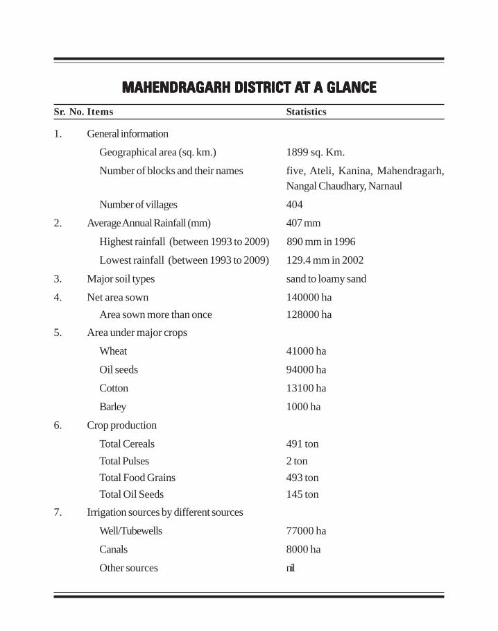
Sr. No. Items Statistics
1. General information
Geographical area (sq. km.) 1899 sq. Km.
Number of blocks and their names five, Ateli, Kanina, Mahendragarh,Nangal Chaudhary, Narnaul
Number of villages 404
2. Average Annual Rainfall (mm) 407 mm
Highest rainfall (between 1993 to 2009) 890 mm in 1996
Lowest rainfall (between 1993 to 2009) 129.4 mm in 2002
3. Major soil types sand to loamy sand
4. Net area sown 140000 haArea sown more than once 128000 ha
5. Area under major crops
Wheat 41000 ha
Oil seeds 94000 ha
Cotton 13100 ha
Barley 1000 ha
6. Crop production
Total Cereals 491 tonTotal Pulses 2 tonTotal Food Grains 493 tonTotal Oil Seeds 145 ton
7. Irrigation sources by different sources
Well/Tubewells 77000 ha
Canals 8000 ha
Other sources nil
MAHENDRAGARH DISTRICT AMAHENDRAGARH DISTRICT AMAHENDRAGARH DISTRICT AMAHENDRAGARH DISTRICT AMAHENDRAGARH DISTRICT AT A GLANCET A GLANCET A GLANCET A GLANCET A GLANCE
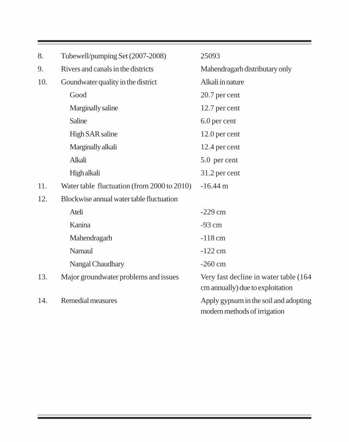
8. Tubewell/pumping Set (2007-2008) 25093
9. Rivers and canals in the districts Mahendragarh distributary only
10. Goundwater quality in the district Alkali in nature
Good 20.7 per cent
Marginally saline 12.7 per cent
Saline 6.0 per cent
High SAR saline 12.0 per cent
Marginally alkali 12.4 per cent
Alkali 5.0 per cent
High alkali 31.2 per cent
11. Water table fluctuation (from 2000 to 2010) -16.44 m
12. Blockwise annual water table fluctuation
Ateli -229 cm
Kanina -93 cm
Mahendragarh -118 cm
Narnaul -122 cm
Nangal Chaudhary -260 cm
13. Major groundwater problems and issues Very fast decline in water table (164cm annually) due to exploitation
14. Remedial measures Apply gypsum in the soil and adoptingmodern methods of irrigation
1
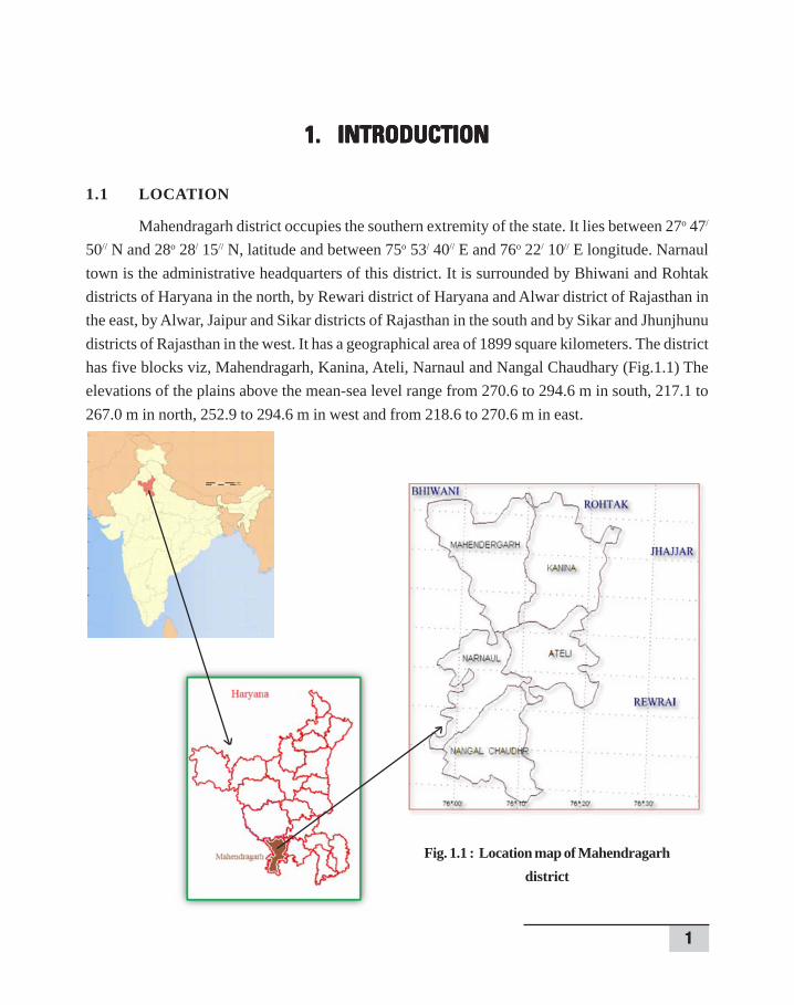
1. INTRODUCTION1. INTRODUCTION1. INTRODUCTION1. INTRODUCTION1. INTRODUCTION
1.1 LOCATION
Mahendragarh district occupies the southern extremity of the state. It lies between 27o 47/
50// N and 28o 28/ 15// N, latitude and between 75o 53/ 40// E and 76o 22/ 10// E longitude. Narnaultown is the administrative headquarters of this district. It is surrounded by Bhiwani and Rohtakdistricts of Haryana in the north, by Rewari district of Haryana and Alwar district of Rajasthan inthe east, by Alwar, Jaipur and Sikar districts of Rajasthan in the south and by Sikar and Jhunjhunudistricts of Rajasthan in the west. It has a geographical area of 1899 square kilometers. The districthas five blocks viz, Mahendragarh, Kanina, Ateli, Narnaul and Nangal Chaudhary (Fig.1.1) Theelevations of the plains above the mean-sea level range from 270.6 to 294.6 m in south, 217.1 to267.0 m in north, 252.9 to 294.6 m in west and from 218.6 to 270.6 m in east.
Fig. 1.1 : Location map of Mahendragarhdistrict
2
Assessment of Groundwater Quality
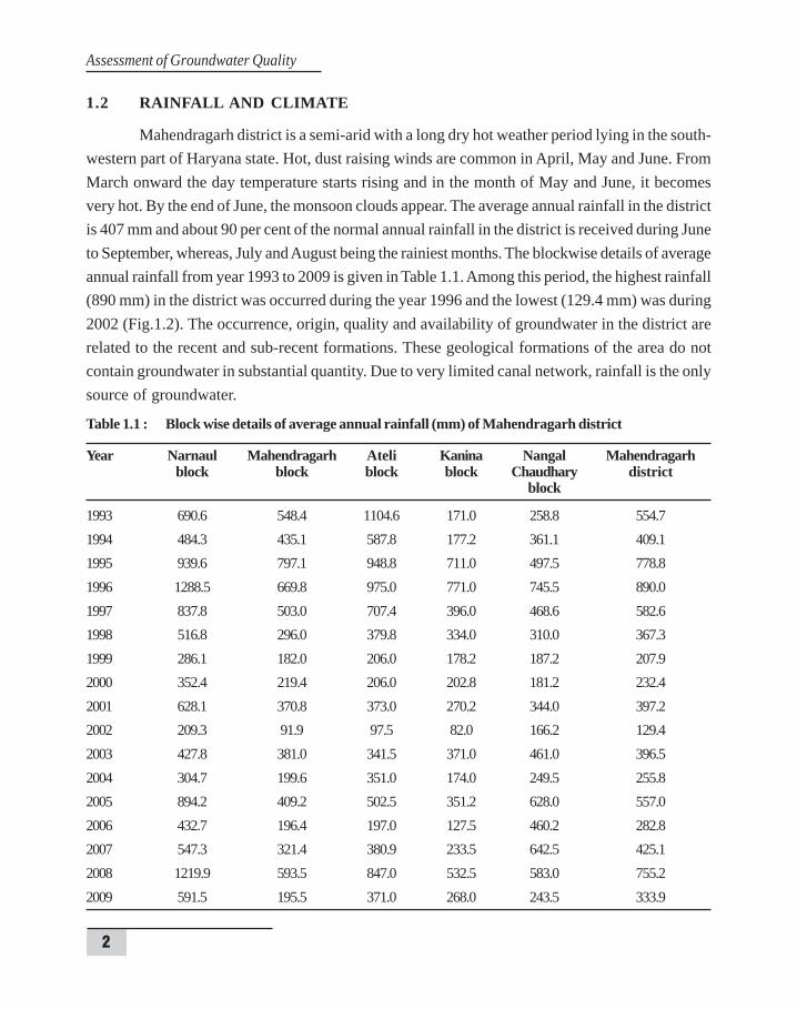
1.2 RAINFALL AND CLIMATE
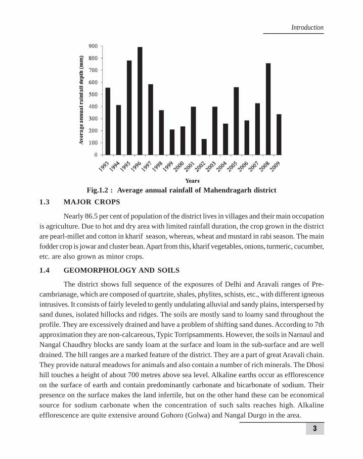
Mahendragarh district is a semi-arid with a long dry hot weather period lying in the south-western part of Haryana state. Hot, dust raising winds are common in April, May and June. FromMarch onward the day temperature starts rising and in the month of May and June, it becomesvery hot. By the end of June, the monsoon clouds appear. The average annual rainfall in the districtis 407 mm and about 90 per cent of the normal annual rainfall in the district is received during Juneto September, whereas, July and August being the rainiest months. The blockwise details of averageannual rainfall from year 1993 to 2009 is given in Table 1.1. Among this period, the highest rainfall(890 mm) in the district was occurred during the year 1996 and the lowest (129.4 mm) was during2002 (Fig.1.2). The occurrence, origin, quality and availability of groundwater in the district arerelated to the recent and sub-recent formations. These geological formations of the area do notcontain groundwater in substantial quantity. Due to very limited canal network, rainfall is the onlysource of groundwater.
Table 1.1 : Block wise details of average annual rainfall (mm) of Mahendragarh district
Year Narnaul Mahendragarh Ateli Kanina Nangal Mahendragarhblock block block block Chaudhary district
block
1993 690.6 548.4 1104.6 171.0 258.8 554.71994 484.3 435.1 587.8 177.2 361.1 409.11995 939.6 797.1 948.8 711.0 497.5 778.81996 1288.5 669.8 975.0 771.0 745.5 890.01997 837.8 503.0 707.4 396.0 468.6 582.61998 516.8 296.0 379.8 334.0 310.0 367.31999 286.1 182.0 206.0 178.2 187.2 207.92000 352.4 219.4 206.0 202.8 181.2 232.42001 628.1 370.8 373.0 270.2 344.0 397.22002 209.3 91.9 97.5 82.0 166.2 129.42003 427.8 381.0 341.5 371.0 461.0 396.52004 304.7 199.6 351.0 174.0 249.5 255.82005 894.2 409.2 502.5 351.2 628.0 557.02006 432.7 196.4 197.0 127.5 460.2 282.82007 547.3 321.4 380.9 233.5 642.5 425.12008 1219.9 593.5 847.0 532.5 583.0 755.22009 591.5 195.5 371.0 268.0 243.5 333.9
3
1.3 MAJOR CROPS
Nearly 86.5 per cent of population of the district lives in villages and their main occupationis agriculture. Due to hot and dry area with limited rainfall duration, the crop grown in the districtare pearl-millet and cotton in kharif season, whereas, wheat and mustard in rabi season. The mainfodder crop is jowar and cluster bean. Apart from this, kharif vegetables, onions, turmeric, cucumber,etc. are also grown as minor crops.
1.4 GEOMORPHOLOGY AND SOILS
The district shows full sequence of the exposures of Delhi and Aravali ranges of Pre-cambrianage, which are composed of quartzite, shales, phylites, schists, etc., with different igneousintrusives. It consists of fairly leveled to gently undulating alluvial and sandy plains, interspersed bysand dunes, isolated hillocks and ridges. The soils are mostly sand to loamy sand throughout theprofile. They are excessively drained and have a problem of shifting sand dunes. According to 7thapproximation they are non-calcareous, Typic Torripsamments. However, the soils in Narnaul andNangal Chaudhry blocks are sandy loam at the surface and loam in the sub-surface and are welldrained. The hill ranges are a marked feature of the district. They are a part of great Aravali chain.They provide natural meadows for animals and also contain a number of rich minerals. The Dhosihill touches a height of about 700 metres above sea level. Alkaline earths occur as efflorescenceon the surface of earth and contain predominantly carbonate and bicarbonate of sodium. Theirpresence on the surface makes the land infertile, but on the other hand these can be economicalsource for sodium carbonate when the concentration of such salts reaches high. Alkalineefflorescence are quite extensive around Gohoro (Golwa) and Nangal Durgo in the area.
Fig.1.2 : Average annual rainfall of Mahendragarh district
Introduction
4
Assessment of Groundwater Quality
2. GROUNDW2. GROUNDW2. GROUNDW2. GROUNDW2. GROUNDWAAAAATER SCENARIOTER SCENARIOTER SCENARIOTER SCENARIOTER SCENARIO
The total annual replenishable groundwater resources of the country have been estimatedas 433 billion cubic meter (BCM). Out of this, the net annual groundwater availability for the entirecountry is 399 BCM. The annual groundwater draft is 231 BCM which indicates that only 58 percent of the available groundwater is being used by the country. This reflects that the availableresources of groundwater in the country as a whole is under exploited. Whereas, in Haryana state,the total annual replenishable groundwater resources have been estimated as 9.31 BCM and out ofthis about, 8.63 BCM is the net annual available groundwater. The annual groundwater draft is9.45 BCM which indicates that 110 per cent of the available groundwater is being used by thestate, means over exploited. The flow of groundwater in the state is generally towards southwest.
2.1 GROUNDWATER RESOURCES OF THE DISTRICT
In Mahendragarh district, according to assessment of groundwater potential approved byNABARD in year 1978, the total useable recharge was 379.70 million cubic metre (MCM) andout of it 451.78 MCM was being utilized which indicates that 119 per cent of the available groundwaterwas being used. Now in year 2010, according to Central Ground Water Board, utilizable groundwaterresources in the district is 193 MCM and net groundwater draft is 262 which indicates that 136 percent of the available groundwater was being used. This means over exploitation of groundwaterhas been increased by 17 per cent in the last 32 years. In the district, shallow aquifers occur in thealluvial deposit down to a depth of 60 m to 100 m. Wells in these areas yield 30 to 50 m3/hr formoderate drawdown. In some parts of the district, aquifers in the weathered/fractured quartzitesand cavernous limestone have yield potential of 5 to 50 m3/hr for moderate to high drawdown.
2.2 GROUNDWATER FLUCTUATION STUDY OF THE DISTRICT
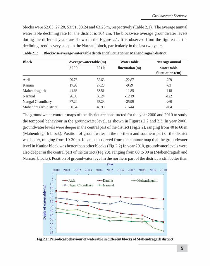
The groundwater data reveal that the level of water table in whole district is beyond thecritical level of 10 metres. In the year 2000, the highest water table was 3.0 m in Chhitroli villageof Kanina block due to Mahendragarh distributory passes very near to this village. But the averagewater table for this block was 17.98 m (Table 2.1). The lowest water table in this year was 83.45m in Nithalawas village of Mahendragarh block. But the average water table of this block was41.66 m. Whereas, the average water table in Ateli, Narnaul and Nangal Chaudhary blocks were29.76, 26.05 and 37.24 m, respectively. During the year 2010, the highest (7.45 m) and the lowestwater table (100.0 m) were remained in same villages Chhitroli and Nithalawas, respectively.Whereas, the average water table in Ateli, Kanina, Mahendragarh, Nangal Chaudhary and Narnaul
5
blocks were 52.63, 27.28, 53.51, 38.24 and 63.23 m, respectively (Table 2.1). The average annualwater table declining rate for the district is 164 cm. The blockwise average groundwater levelsduring the different years are shown in the Figure 2.1. It is observed from the figure that thedeclining trend is very steep in the Narnaul block, particularly in the last two years.
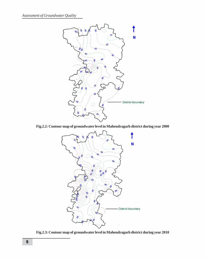
The groundwater contour maps of the district are constructed for the year 2000 and 2010 to studythe temporal behaviour in the groundwater level, as shown in Figures 2.2 and 2.3. In year 2000,groundwater levels were deeper in the central part of the district (Fig.2.2), ranging from 40 to 60 m(Mahendragarh block). Position of groundwater in the northern and southern part of the districtwas better, ranging from 10-30 m. It can be observed from the contour map that the groundwaterlevel in Kanina block was better than other blocks (Fig.2.2) In year 2010, groundwater levels werealso deeper in the central part of the district (Fig.23), ranging from 60 to 80 m (Mahendragarh andNarnaul blocks). Position of groundwater level in the northern part of the district is still better than
Table 2.1: Blockwise average water table depth and fluctuation in Mahendragarh district
Block Average water table (m) Water table Average annual2000 2010 fluctuation (m) water table
fluctuation (cm)
Ateli 29.76 52.63 -22.87 -229Kanina 17.98 27.28 -9.29 -93Mahendragarh 41.66 53.51 -11.85 -118Narnual 26.05 38.24 -12.19 -122Nangal Chaudhary 37.24 63.23 -25.99 -260Mahendragarh district 30.54 46.98 -16.44 -164
Fig.2.1: Periodical behaviour of waterable in different blocks of Mahendragarh district
Groundwater Scenario
6
Assessment of Groundwater Quality
Fig.2.2: Contour map of groundwater level in Mahendragarh district during year 2000
Fig.2.3: Contour map of groundwater level in Mahendragarh district during year 2010

7
other parts of the district, ranging from 20-40 m (Fig.2.3). From the contour map of year 2010, it isobserved that groundwater level in southern part changed drastically in ten years (from 2000).Earlier in year 2000, it was ranging from 20-30 m but now in 2010, it is from 20-60 m. From thecontour maps, it can be predicted that overall position of groundwater level in the district is veryvulnerable as the range of groundwater level of the district has been changed from 10-60 m to 20-80 m from year 2000 to 2010. This may occur due to the deficit in rainfall in recent years and overexploitation of groundwater. According to a report of Central Ground Water Board, all the blocksin the district are over-exploited for groundwater and water table is going down at very high rate.
Groundwater Scenario
8
Assessment of Groundwater Quality
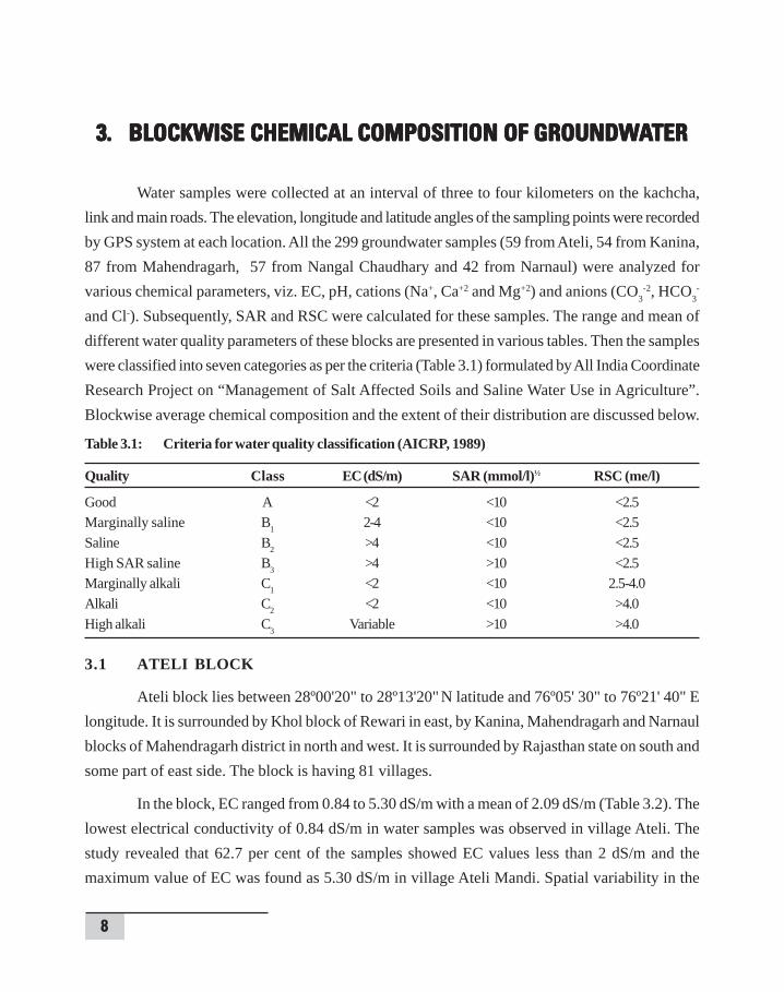
3. BLOCKWISE CHEMICAL COMPOSITION OF GROUNDW3. BLOCKWISE CHEMICAL COMPOSITION OF GROUNDW3. BLOCKWISE CHEMICAL COMPOSITION OF GROUNDW3. BLOCKWISE CHEMICAL COMPOSITION OF GROUNDW3. BLOCKWISE CHEMICAL COMPOSITION OF GROUNDWAAAAATERTERTERTERTER
Water samples were collected at an interval of three to four kilometers on the kachcha,link and main roads. The elevation, longitude and latitude angles of the sampling points were recordedby GPS system at each location. All the 299 groundwater samples (59 from Ateli, 54 from Kanina,87 from Mahendragarh, 57 from Nangal Chaudhary and 42 from Narnaul) were analyzed forvarious chemical parameters, viz. EC, pH, cations (Na+, Ca+2 and Mg+2) and anions (CO3
-2, HCO3-
and Cl-). Subsequently, SAR and RSC were calculated for these samples. The range and mean ofdifferent water quality parameters of these blocks are presented in various tables. Then the sampleswere classified into seven categories as per the criteria (Table 3.1) formulated by All India CoordinateResearch Project on “Management of Salt Affected Soils and Saline Water Use in Agriculture”.Blockwise average chemical composition and the extent of their distribution are discussed below.
Table 3.1: Criteria for water quality classification (AICRP, 1989)
Quality Class EC (dS/m) SAR (mmol/l)½ RSC (me/l)
Good A <2 <10 <2.5Marginally saline B1 2-4 <10 <2.5Saline B2 >4 <10 <2.5High SAR saline B3 >4 >10 <2.5Marginally alkali C1 <2 <10 2.5-4.0Alkali C2 <2 <10 >4.0High alkali C3 Variable >10 >4.0
3.1 ATELI BLOCK
Ateli block lies between 28º00'20" to 28º13'20" N latitude and 76º05' 30" to 76º21' 40" Elongitude. It is surrounded by Khol block of Rewari in east, by Kanina, Mahendragarh and Narnaulblocks of Mahendragarh district in north and west. It is surrounded by Rajasthan state on south andsome part of east side. The block is having 81 villages.
In the block, EC ranged from 0.84 to 5.30 dS/m with a mean of 2.09 dS/m (Table 3.2). Thelowest electrical conductivity of 0.84 dS/m in water samples was observed in village Ateli. Thestudy revealed that 62.7 per cent of the samples showed EC values less than 2 dS/m and themaximum value of EC was found as 5.30 dS/m in village Ateli Mandi. Spatial variability in the
9
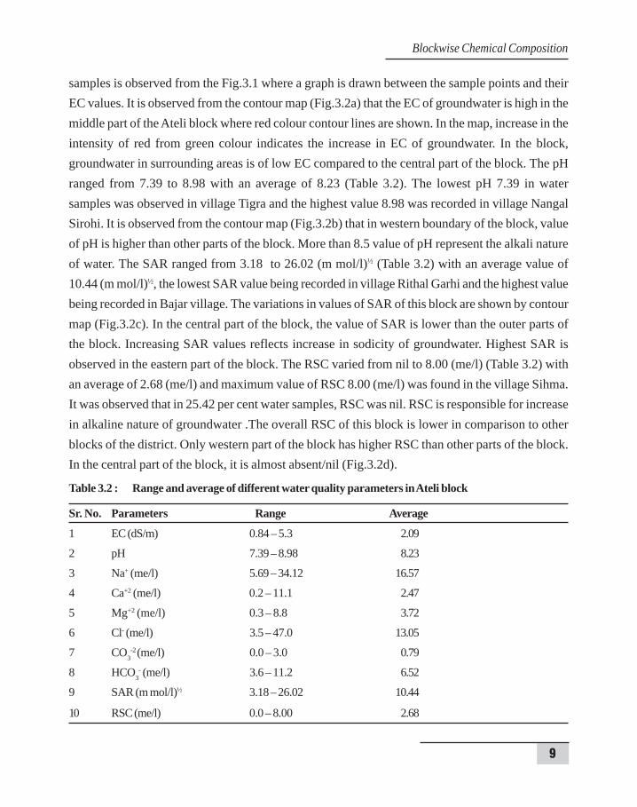
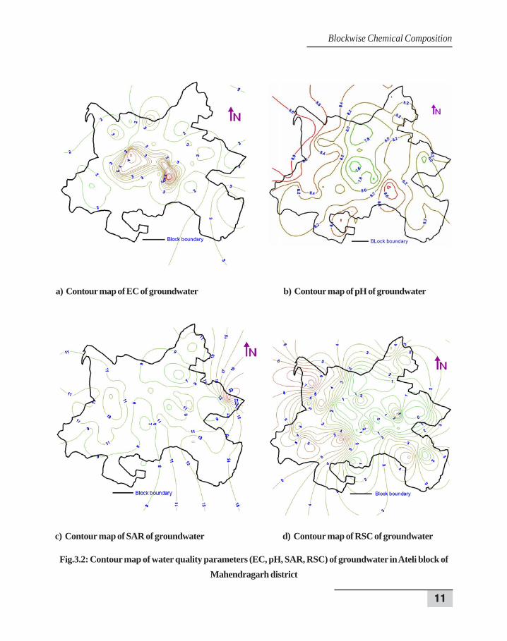
samples is observed from the Fig.3.1 where a graph is drawn between the sample points and theirEC values. It is observed from the contour map (Fig.3.2a) that the EC of groundwater is high in themiddle part of the Ateli block where red colour contour lines are shown. In the map, increase in theintensity of red from green colour indicates the increase in EC of groundwater. In the block,groundwater in surrounding areas is of low EC compared to the central part of the block. The pHranged from 7.39 to 8.98 with an average of 8.23 (Table 3.2). The lowest pH 7.39 in watersamples was observed in village Tigra and the highest value 8.98 was recorded in village NangalSirohi. It is observed from the contour map (Fig.3.2b) that in western boundary of the block, valueof pH is higher than other parts of the block. More than 8.5 value of pH represent the alkali natureof water. The SAR ranged from 3.18 to 26.02 (m mol/l)½ (Table 3.2) with an average value of10.44 (m mol/l)½, the lowest SAR value being recorded in village Rithal Garhi and the highest valuebeing recorded in Bajar village. The variations in values of SAR of this block are shown by contourmap (Fig.3.2c). In the central part of the block, the value of SAR is lower than the outer parts ofthe block. Increasing SAR values reflects increase in sodicity of groundwater. Highest SAR isobserved in the eastern part of the block. The RSC varied from nil to 8.00 (me/l) (Table 3.2) withan average of 2.68 (me/l) and maximum value of RSC 8.00 (me/l) was found in the village Sihma.It was observed that in 25.42 per cent water samples, RSC was nil. RSC is responsible for increasein alkaline nature of groundwater .The overall RSC of this block is lower in comparison to otherblocks of the district. Only western part of the block has higher RSC than other parts of the block.In the central part of the block, it is almost absent/nil (Fig.3.2d).
Table 3.2 : Range and average of different water quality parameters in Ateli block
Sr. No. Parameters Range Average
1 EC (dS/m) 0.84 – 5.3 2.09
2 pH 7.39 – 8.98 8.23
3 Na+ (me/l) 5.69 – 34.12 16.57
4 Ca+2 (me/l) 0.2 – 11.1 2.47
5 Mg+2 (me/l) 0.3 – 8.8 3.72
6 Cl- (me/l) 3.5 – 47.0 13.05
7 CO3-2 (me/l) 0.0 – 3.0 0.79
8 HCO3- (me/l) 3.6 – 11.2 6.52
9 SAR (m mol/l)½ 3.18 – 26.02 10.44
10 RSC (me/l) 0.0 – 8.00 2.68
Blockwise Chemical Composition
10
Assessment of Groundwater Quality
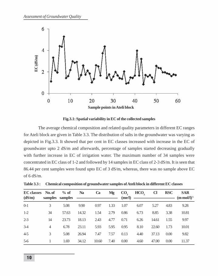
Fig.3.1: Spatial variability in EC of the collected samples
The average chemical composition and related quality parameters in different EC rangesfor Ateli block are given in Table 3.3. The distribution of salts in the groundwater was varying asdepicted in Fig.3.3. It showed that per cent in EC classes increased with increase in the EC ofgroundwater upto 2 dS/m and afterwards, percentage of samples started decreasing graduallywith further increase in EC of irrigation water. The maximum number of 34 samples wereconcentrated in EC class of 1-2 and followed by 14 samples in EC class of 2-3 dS/m. It is seen that86.44 per cent samples were found upto EC of 3 dS/m, whereas, there was no sample above ECof 6 dS/m.
Table 3.3 : Chemical composition of groundwater samples of Ateli block in different EC classes
EC classes No. of % of Na Ca Mg CO3 HCO3 Cl RSC SAR(dS/m) samples samples (me/l) (m mol/l)½
0-1 3 5.08 9.90 0.97 1.33 1.07 6.07 5.27 4.83 9.28
1-2 34 57.63 14.32 1.54 2.79 0.86 6.73 8.85 3.38 10.81
2-3 14 23.73 18.13 2.43 4.77 0.71 6.26 14.61 1.55 9.97
3-4 4 6.78 23.11 5.93 5.95 0.95 8.10 22.60 1.73 10.01
4-5 3 5.08 26.94 7.47 7.57 0.13 4.40 37.13 0.00 9.82
5-6 1 1.69 34.12 10.60 7.40 0.00 4.60 47.00 0.00 11.37
Sample points in Ateli block
EC (d
S/m
)
11
Fig.3.2: Contour map of water quality parameters (EC, pH, SAR, RSC) of groundwater in Ateli block ofMahendragarh district
a) Contour map of EC of groundwater b) Contour map of pH of groundwater
c) Contour map of SAR of groundwater d) Contour map of RSC of groundwater
Blockwise Chemical Composition

12
Assessment of Groundwater Quality
Fig.3.3: Per cent samples in different EC classes
In case of anions, chloride was the dominant anion with maximum value of 47.0 me/l,observed in village Ateli Mandi and minimum 3.5 me/l was recorded in village Nangal Sirohi.Bicarbonate (HCO3
-) ranged from 3.6 to 11.2 me/l, the maximum value was observed in the watersamples of village Sihma and minimum value was found in village Bajar. The average values forCO3
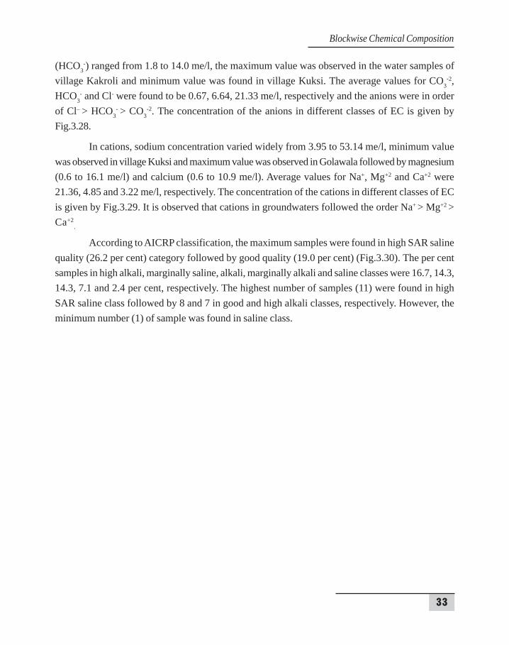
-2, HCO3- and Cl- were found to be 0.79, 6.52, 13.05 me/l, respectively and the anions were in
order of Cl– > HCO3- > CO3
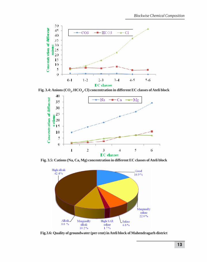
-2. The concentration of the anions in different classes of EC is givenby Fig.3.4.
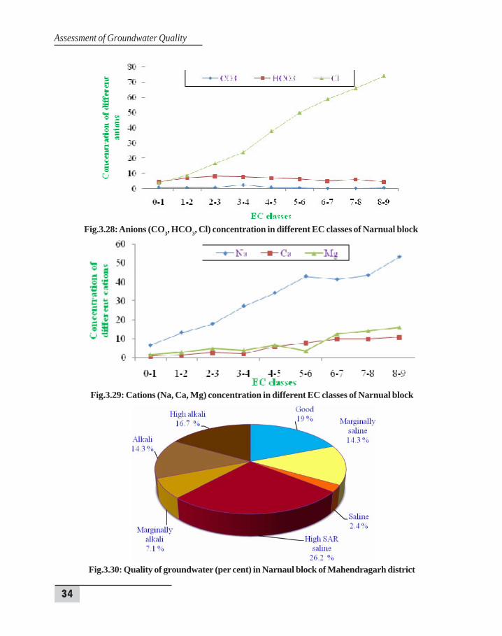
In cations, sodium concentration varied widely from 5.69 to 34.12 me/l, minimum valuewas observed in village Rithal Garhi and maximum value was observed in Ateli Mandi followed bymagnesium (0.3 to 8.8 me/l) and calcium (0.2 to 11.1 me/l). Average values for Na+, Mg+2 and Ca+2
were 16.57, 3.72 and 2.47 me/l, respectively. The concentration of the cations in different classesof EC is given by Fig.3.5. It is observed that cations in groundwaters followed the order Na+ >Mg+2 > Ca+2
.
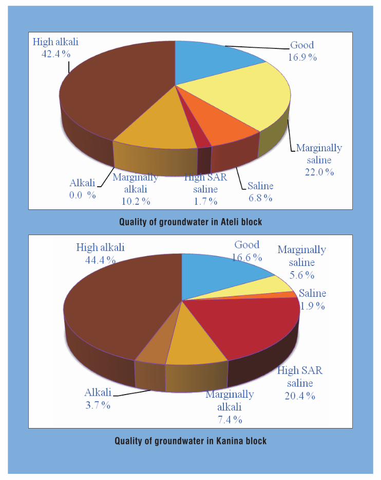
According to AICRP classification, the maximum samples were found in high alkali quality(42.4 per cent) category followed by marginally saline (22.0 per cent) (Fig. 3.6). The per centsamples in good, marginally alkali, saline and high SAR saline classes were 16.9, 10.2, 6.8 and 1.7per cent, respectively. The highest number of samples (25) was found in high alkali class followedby 13 and 10 in marginally saline and good classes, respectively. However, no sample was found inalkali class.
13
Fig. 3.4: Anions (CO3, HCO3, Cl) concentration in different EC classes of Ateli block
Fig. 3.5: Cations (Na, Ca, Mg) concentration in different EC classes of Ateli block
Fig.3.6: Quality of groundwater (per cent) in Ateli block of Mahendragarh district
Blockwise Chemical Composition

14
Assessment of Groundwater Quality
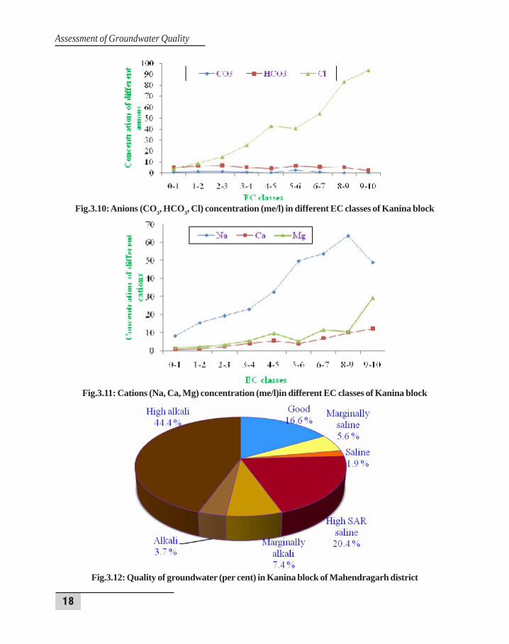
3.2 KANINA BLOCK
Kanina block lies between 28º10/20// to 28º28/15// N latitude and 76º09/45// to 76º22/00// Elongitude. It is surrounded by Nahar, Jatusana and Khol blocks of Rewari district on north-eastside, by Dadri block of Bhiwani district in north, by Mahendragarh and Ateli blocks of Mahendragarhdistrict in west and south sides respectively. The block is having 63 villages.
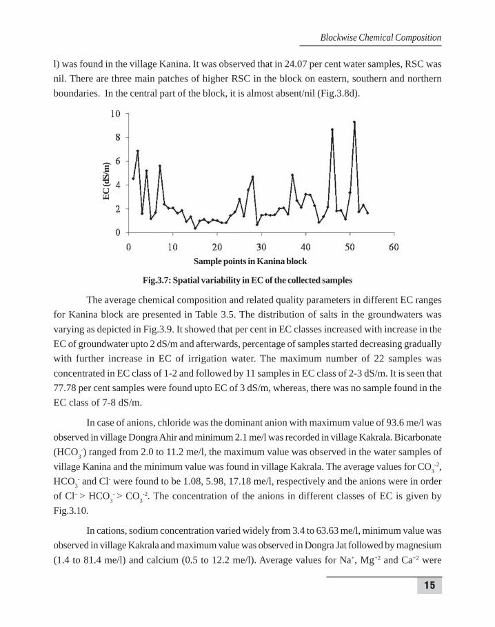
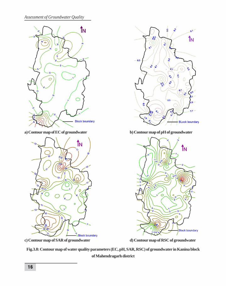
In the block, EC ranged from 0.35 to 9.29 dS/m with a mean of 2.37 dS/m (Table 3.4). Thelowest electrical conductivity of 0.35 dS/m in water samples was observed in village Kakrala. Thestudy revealed that 85.2 per cent of the samples showed EC less than 4 dS/m and the maximumEC was found as 9.29 dS/m in village Dongra Ahir. Spatial variability in the samples is observedfrom the Fig.3.7 where a graph is drawn between the sample points and their EC values. It isobserved from the contour map (Fig.3.8a) that the EC of groundwater is high in the northern andsouthern parts of the block where red colour contour lines are shown. In the block, EC ofgroundwater in the central as well as eastern and western parts of the block is very low whichreflects that groundwater of the most part of the block is having EC less than or equal two. The pHranged from 7.53 to 9.37 with an average of 8.51. The lowest pH (7.53) in water samples wasobserved in village Pota and the highest pH (9.37) was recorded in village Kharana. It is observedfrom the contour map (Fig.3.8b) that in central and southern parts of the block, pH is higher thanother parts of the block. The value of pH in the whole block is more than 8.5 except some patches.The SAR ranged from 3.98 to 25.04 (m mol/l)½ with an average value of 12.36 (m mol/l)½, thelowest SAR value was recorded in village Unhani and the highest value recorded in Chhitrolivillage. The variations in values of SAR of this block are shown by contour map (Fig.3.8c). In thecentral part of the block, the value of SAR is lower than the outer parts of the block. The RSCvaried from nil to 13.0 (me/l) with an average of 3.10 (me/l) and maximum value of RSC 13.0 (me/Table 3.4: Range and average of different water quality parameters in Kanina block
Sr. No. Parameters Range Average
1 EC (dS/m) 0.35 – 9.29 2.372 pH 7.53 – 9.37 8.513 Na+ (me/l) 3.4 – 63.63 20.044 Ca+2 (me/l) 0.5 – 12.2 2.45 Mg+2 (me/l) 1.4 – 81.4 14.796 Cl- (me/l) 2.1 – 93.6 17.187 CO3
-2 (me/l) 0.0 – 4.0 1.088 HCO3
- (me/l) 2.0 – 11.2 5.989 SAR (m mol/l)½ 3.98 – 25.04 12.3610 RSC (me/l) 0.0 – 13.0 3.10
15
l) was found in the village Kanina. It was observed that in 24.07 per cent water samples, RSC wasnil. There are three main patches of higher RSC in the block on eastern, southern and northernboundaries. In the central part of the block, it is almost absent/nil (Fig.3.8d).
Fig.3.7: Spatial variability in EC of the collected samples
The average chemical composition and related quality parameters in different EC rangesfor Kanina block are presented in Table 3.5. The distribution of salts in the groundwaters wasvarying as depicted in Fig.3.9. It showed that per cent in EC classes increased with increase in theEC of groundwater upto 2 dS/m and afterwards, percentage of samples started decreasing graduallywith further increase in EC of irrigation water. The maximum number of 22 samples wasconcentrated in EC class of 1-2 and followed by 11 samples in EC class of 2-3 dS/m. It is seen that77.78 per cent samples were found upto EC of 3 dS/m, whereas, there was no sample found in theEC class of 7-8 dS/m.
In case of anions, chloride was the dominant anion with maximum value of 93.6 me/l wasobserved in village Dongra Ahir and minimum 2.1 me/l was recorded in village Kakrala. Bicarbonate(HCO3
-) ranged from 2.0 to 11.2 me/l, the maximum value was observed in the water samples ofvillage Kanina and the minimum value was found in village Kakrala. The average values for CO3
-2,HCO3
- and Cl- were found to be 1.08, 5.98, 17.18 me/l, respectively and the anions were in orderof Cl– > HCO3
- > CO3-2. The concentration of the anions in different classes of EC is given by
Fig.3.10.
In cations, sodium concentration varied widely from 3.4 to 63.63 me/l, minimum value wasobserved in village Kakrala and maximum value was observed in Dongra Jat followed by magnesium(1.4 to 81.4 me/l) and calcium (0.5 to 12.2 me/l). Average values for Na+, Mg+2 and Ca+2 were
Sample points in Kanina block
EC (d
S/m
)
Blockwise Chemical Composition
16
Assessment of Groundwater Quality
a) Contour map of EC of groundwater b) Contour map of pH of groundwater
c) Contour map of SAR of groundwater d) Contour map of RSC of groundwater
Fig.3.8: Contour map of water quality parameters (EC, pH, SAR, RSC) of groundwater in Kanina blockof Mahendragarh district
17
20.04, 14.79 and 2.4 me/l, respectively. The concentration of the cations in different classes of ECis given by Fig.3.11. It is observed that cations in groundwaters followed the order Na+ > Mg+2 >Ca+2
.
According to AICRP classification, the maximum samples were found in high alkali quality(44.4 per cent) category followed by high SAR saline (20.4 per cent) (Fig.3.12). The per centsamples in good, marginally alkali, marginally saline, alkali and saline classes were 16.6, 7.4, 5.6,3.7 and 1.9 per cent, respectively. The highest number of samples (24) were found in high alkaliclass followed by 11 and 9 in high SAR saline and good classes, respectively. However, the leastnumber of samples (1) was found in saline class.
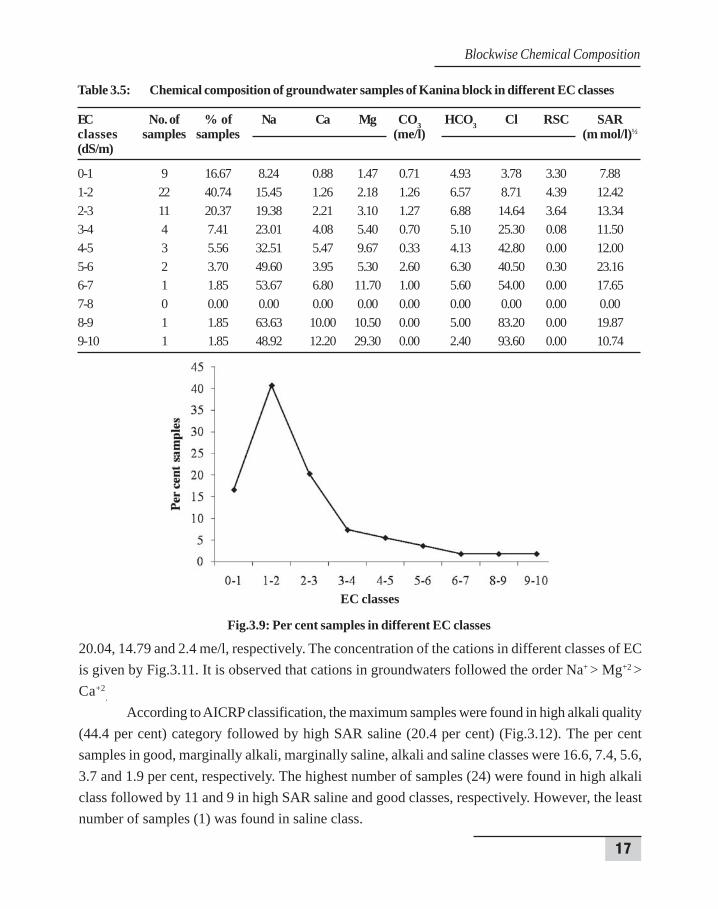
Table 3.5: Chemical composition of groundwater samples of Kanina block in different EC classes
EC No. of % of Na Ca Mg CO3 HCO3 Cl RSC SARclasses samples samples (me/l) (m mol/l)½
(dS/m)
0-1 9 16.67 8.24 0.88 1.47 0.71 4.93 3.78 3.30 7.881-2 22 40.74 15.45 1.26 2.18 1.26 6.57 8.71 4.39 12.422-3 11 20.37 19.38 2.21 3.10 1.27 6.88 14.64 3.64 13.343-4 4 7.41 23.01 4.08 5.40 0.70 5.10 25.30 0.08 11.504-5 3 5.56 32.51 5.47 9.67 0.33 4.13 42.80 0.00 12.005-6 2 3.70 49.60 3.95 5.30 2.60 6.30 40.50 0.30 23.166-7 1 1.85 53.67 6.80 11.70 1.00 5.60 54.00 0.00 17.657-8 0 0.00 0.00 0.00 0.00 0.00 0.00 0.00 0.00 0.008-9 1 1.85 63.63 10.00 10.50 0.00 5.00 83.20 0.00 19.879-10 1 1.85 48.92 12.20 29.30 0.00 2.40 93.60 0.00 10.74
Fig.3.9: Per cent samples in different EC classes
EC classes
Blockwise Chemical Composition
18
Assessment of Groundwater Quality
Fig.3.10: Anions (CO3, HCO3, Cl) concentration (me/l) in different EC classes of Kanina block
Fig.3.11: Cations (Na, Ca, Mg) concentration (me/l)in different EC classes of Kanina block
Fig.3.12: Quality of groundwater (per cent) in Kanina block of Mahendragarh district
19
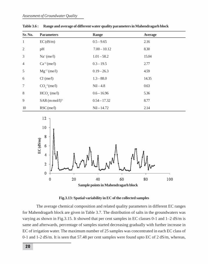
3.3 MAHENDRAGARH BLOCK
Mahendragarh block lies between 28º09/30// to 28º27/50// N latitude and 75º53/40// to76º12/30// E longitude. It is surrounded by Kanina block of Mahendragarh district in the east,by Dadri and Loharu blocks of Bhiwani district in the north-west directions and by Narnaulblock in south side. On west-south side, it is surrounded by Rajasthan state. The block ishaving 99 villages.
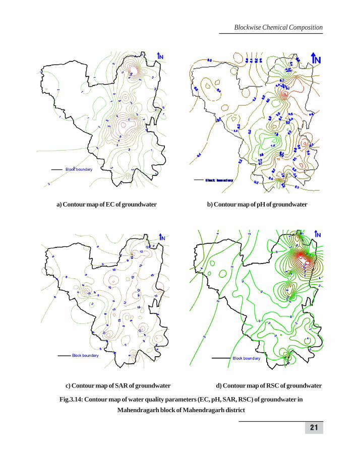
In the block, electrical conductivity (EC) ranged from 0.5 to 9.65 dS/m with a meanof 2.16 dS/m (Table 3.6). The lowest EC of 0.50 dS/m in water samples was observed invillage Gadharwas. The study revealed that 85.06 per cent of the samples showed EC valuesless than 4 dS/m. The maximum EC (9.65 dS/m) was found as in village Khudana near themain road. Spatial variability in the samples is observed from the Fig.3.13 where a graph isdrawn between the sample points and their EC values. It is observed from the contour map(Fig.3.14a) that the EC of groundwater is high in the middle and upper (northern) part of theblock where red colour contour lines are shown. No particular trend in the variation of EC ispresent in the block. In Mahendragarh block, groundwater in surrounding areas is of low ECcompared to the central part of the block. The pH ranged from 7.00 to 10.12 with an averageof 8.30 (Table 3.6). The lowest pH of 7.00 in water samples was observed in village Khatodand the highest pH (10.12) was recorded in village Khudana. It is observed from the contourmap (Fig. 3.14b) that eastern parts of block have higher pH than the western parts of theblock. Contour map reflects that the value of pH is highly spatially variable and the lowestvalue 7.4 is represented in the centre of the block. The SAR ranged from 0.54 to 17.32 (mmol/l)½ with an average value of 8.77 (m mol/l)½ (Table 3.6), the lowest SAR value recordedin village Palri and the highest recorded in Gahri Khudana village. The variations in values ofSAR of this block are shown by contour map (Fig.3.14c). In the central part of the block, thevalue of SAR is higher than the outer parts of the block. In most parts of the block, SAR isranging from 6-10 (m mol/l)1/2. The RSC varied from nil to 14.72 (me/l) with an average of2.14 (me/l) (Table 3.6) and maximum value of RSC (14.72 me/l) was found in the villageBhurjat. It was observed that in 42.53 per cent water samples, RSC was nil. In the north-eastern corner of the block, RSC is higher and in the central part of the block, it is almostabsent/nil (Fig.3.14d). In most part of block, RSC is ranging from 0-2 me/l.
Blockwise Chemical Composition
20
Assessment of Groundwater Quality
Table 3.6 : Range and average of different water quality parameters in Mahendragarh block
Sr. No. Parameters Range Average
1 EC (dS/m) 0.5 – 9.65 2.16
2 pH 7.00 – 10.12 8.30
3 Na+ (me/l) 1.01 – 58.2 15.04
4 Ca+2 (me/l) 0.3 – 19.5 2.77
5 Mg+2 (me/l) 0.19 – 26.3 4.59
6 Cl- (me/l) 1.3 – 88.0 14.35
7 CO3-2 (me/l) Nil – 4.8 0.63
8 HCO3- (me/l) 0.6 – 16.96 5.36
9 SAR (m mol/l)½ 0.54 – 17.32 8.77
10 RSC (me/l) Nil – 14.72 2.14
Fig.3.13: Spatial variability in EC of the collected samples
The average chemical composition and related quality parameters in different EC rangesfor Mahendragarh block are given in Table 3.7. The distribution of salts in the groundwaters wasvarying as shown in Fig.3.15. It showed that per cent samples in EC classes 0-1 and 1–2 dS/m issame and afterwards, percentage of samples started decreasing gradually with further increase inEC of irrigation water. The maximum number of 25 samples was concentrated in each EC class of0-1 and 1-2 dS/m. It is seen that 57.48 per cent samples were found upto EC of 2 dS/m, whereas,
Sample points in Mahendragarh block
EC (d
S/m
)
21
a) Contour map of EC of groundwater b) Contour map of pH of groundwater
c) Contour map of SAR of groundwater d) Contour map of RSC of groundwater
Fig.3.14: Contour map of water quality parameters (EC, pH, SAR, RSC) of groundwater inMahendragarh block of Mahendragarh district
Blockwise Chemical Composition
22
Assessment of Groundwater Quality
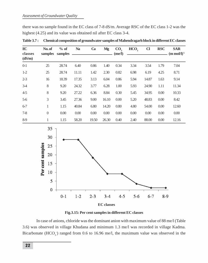
there was no sample found in the EC class of 7-8 dS/m. Average RSC of the EC class 1-2 was thehighest (4.25) and its value was obtained nil after EC class 3-4.
Table 3.7 : Chemical composition of groundwater samples of Mahendragarh block in different EC classes
EC No. of % of Na Ca Mg CO3 HCO3 Cl RSC SARclasses samples samples (me/l) (m mol/l)½
(dS/m)
0-1 25 28.74 6.40 0.86 1.40 0.34 3.34 3.54 1.79 7.04
1-2 25 28.74 11.11 1.42 2.30 0.82 6.98 6.19 4.25 8.71
2-3 16 18.39 17.35 3.13 6.04 0.86 5.94 14.87 1.63 9.14
3-4 8 9.20 24.32 3.77 6.28 1.00 5.93 24.90 1.11 11.34
4-5 8 9.20 27.22 6.36 8.84 0.30 5.45 34.95 0.00 10.33
5-6 3 3.45 27.36 9.00 16.10 0.00 5.20 48.83 0.00 8.42
6-7 1 1.15 40.84 6.80 14.20 0.80 4.80 54.00 0.00 12.60
7-8 0 0.00 0.00 0.00 0.00 0.00 0.00 0.00 0.00 0.00
8-9 1 1.15 58.20 19.50 26.30 0.40 2.40 88.00 0.00 12.16
Fig.3.15: Per cent samples in different EC classes
In case of anions, chloride was the dominant anion with maximum value of 88 me/l (Table3.6) was observed in village Khudana and minimum 1.3 me/l was recorded in village Kadma.Bicarbonate (HCO3
-) ranged from 0.6 to 16.96 me/l, the maximum value was observed in the
EC classes
23
water samples of village Bhurjat and minimum value was founded in village Digrota. The averagevalues for CO3
-2, HCO3- and Cl- were found to be 0.63, 5.36, 14.35 me/l, respectively and the
anions were in order of Cl– > HCO3- > CO3
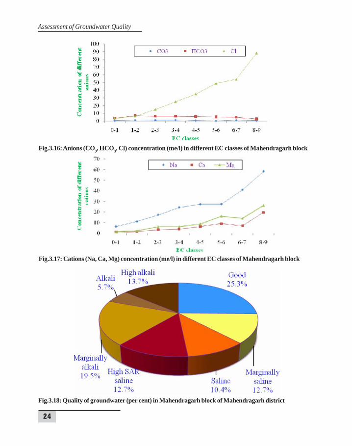
-2. The concentration of the anions in different classesof EC is depicted in Fig.3.16.
In cations, sodium concentration varied widely from 1.01 to 58.2 me/l (Table 3.6), minimumvalue was observed in village Palri and maximum value was observed in Khudana followed bymagnesium (0.19 to 26.3 me/l) and calcium (0.3 to 19.5 me/l). Average values for Na+, Mg+2 andCa+2 were 15.04, 4.59 and 2.77 me/l, respectively. The concentration of the cations in differentclasses of EC is given by Fig.3.17. It is observed that cations in groundwaters followed the orderNa+ > Mg+2 > Ca+2
.
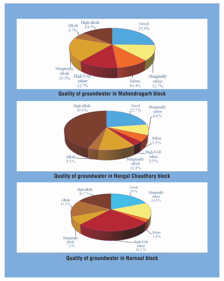
According to AICRP classification, the maximum samples were found in good quality(25.3 per cent) category followed by marginally alkali (19.5 per cent) (Fig.3.18). The per centsamples in high alkali, marginally saline, high SAR saline, saline, and alkali classes were 13.7, 12.7,12.7, 10.4 and 5.74 per cent, respectively. The highest number of samples (22) were found in goodquality class followed by 17 and 12 in marginally alkali and high alkali classes, respectively. However,the minimum number of sample (5) were found in alkali class.
3.4 NANGAL CHAUDHARY BLOCK
Nangal Chaudhary lies between 27º47/30// to 28º20/00// N latitude and 75º58/20// to 76º13/
40// E longitude. Most part of this block is surrounded by Rajasthan state except some parts innorth and west side which is surrounded by Narnaul block of Mahendragarh district. The block ishaving 90 villages.
In Nangal Chaudhary block, EC ranged from 0.71 to 5.25 dS/m with a mean of 1.87 dS/m(Table 3.8). The lowest electrical conductivity of 0.71 dS/m in water samples was observed invillage Rai Malikpur and the maximum EC of 5.25 dS/m was found Nangal Nuniya. The studyrevealed that 89.47 per cent of the samples showed EC values less than 3 dS/m. Spatial variabilityin the samples is observed from the Fig.3.19 where a graph is drawn between the sample pointsand their EC values. It is observed from the contour map (Fig.3.20a) that the EC of groundwateris high in the sorthern part of the block. In this block, overall EC of groundwater is low as comparedto other blocks. Most of the area of the block is having EC less 2 dS/m. Contour map is showingonly one contour of 5 dS/m EC at the boundary of the southern part of the block (Fig.3.20a). ThepH ranged from 7.45 to 9.37 with an average of 8.52. The lowest pH of 7.45 in water samples wasobserved in village Nilaja and the highest value 9.37 was recorded in village Poshwali Dhani. It isobserved from the contour map (Fig.3.20b) that eastern part of block has higher pH than the
Blockwise Chemical Composition
24
Assessment of Groundwater Quality
Fig.3.17: Cations (Na, Ca, Mg) concentration (me/l) in different EC classes of Mahendragarh block
Fig.3.16: Anions (CO3, HCO3, Cl) concentration (me/l) in different EC classes of Mahendragarh block
Fig.3.18: Quality of groundwater (per cent) in Mahendragarh block of Mahendragarh district
25
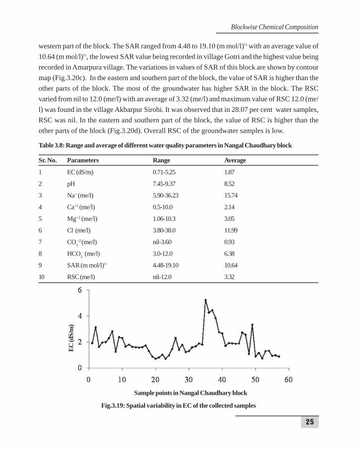
western part of the block. The SAR ranged from 4.48 to 19.10 (m mol/l)½ with an average value of10.64 (m mol/l)½, the lowest SAR value being recorded in village Gotri and the highest value beingrecorded in Amarpura village. The variations in values of SAR of this block are shown by contourmap (Fig.3.20c). In the eastern and southern part of the block, the value of SAR is higher than theother parts of the block. The most of the groundwater has higher SAR in the block. The RSCvaried from nil to 12.0 (me/l) with an average of 3.32 (me/l) and maximum value of RSC 12.0 (me/l) was found in the village Akbarpur Sirohi. It was observed that in 28.07 per cent water samples,RSC was nil. In the eastern and southern part of the block, the value of RSC is higher than theother parts of the block (Fig.3.20d). Overall RSC of the groundwater samples is low.
Table 3.8: Range and average of different water quality parameters in Nangal Chaudhary block
Sr. No. Parameters Range Average
1 EC (dS/m) 0.71-5.25 1.87
2 pH 7.45-9.37 8.52
3 Na+ (me/l) 5.90-36.23 15.74
4 Ca+2 (me/l) 0.5-10.0 2.14
5 Mg+2 (me/l) 1.06-10.3 3.05
6 Cl- (me/l) 3.80-38.0 11.99
7 CO3-2 (me/l) nil-3.60 0.93
8 HCO3- (me/l) 3.0-12.0 6.38
9 SAR (m mol/l)½ 4.48-19.10 10.64
10 RSC (me/l) nil-12.0 3.32
Fig.3.19: Spatial variability in EC of the collected samples
Sample points in Nangal Chaudhary block
EC (d
S/m
)
Blockwise Chemical Composition

26
Assessment of Groundwater Quality
26
c) Contour map of SAR of groundwater d) Contour map of RSC of groundwater
Fig.3.20: Contour map of water quality parameters (EC, pH, SAR, RSC) of groundwater in NangalChaudhary block of Mahendragarh district
a) Contour map of EC of groundwater b) Contour map of pH of groundwater

27
The average chemical composition and related quality parameters in different EC ranges for NangalChaudhary block are given in Table 3.9. The distribution of salts in the groundwaters was varyingas shown in Fig.3.21. It showed that per cent in EC classes increased with increase in the EC ofgroundwater upto 2 dS/m and afterwards, percentage of samples started decreasing graduallywith further increase in EC of irrigation water. The maximum number of 32 samples wasconcentrated in EC class of 1-2 and followed by 10 samples in EC class of 0-1 dS/m. It is seen that89.47 per cent samples were found upto EC of 3 dS/m, whereas, there was no sample above ECof 6 dS/m.
Table 3.9 : Chemical composition of groundwater samples of Nangal Chaudhary block in different ECclasses
EC No. of % of Na Ca Mg CO3 HCO3 Cl RSC SARclasses samples samples (me/l) (m mol/l)½
(dS/m)
0-1 10 17.54 8.62 1.03 1.77 0.32 4.98 5.24 2.66 7.561-2 32 56.14 15.28 1.63 2.29 1.08 6.70 9.15 4.11 11.552-3 9 15.79 20.14 3.33 3.62 1.60 7.13 16.31 3.47 11.673-4 3 5.26 20.74 5.83 8.07 0.00 4.20 28.67 0.00 8.254-5 2 3.51 21.19 4.20 9.10 0.20 5.80 33.60 0.00 8.245-6 1 1.75 36.23 3.6 7.9 0.4 10.8 38 0 15.11
Fig.3.21: Per cent samples in different EC classes of Nangal Chaudhary
In case of anions, chloride was the dominant anion with maximum value of 38.0 me/l wasobserved in village Nangal Nuniya and minimum 3.8 me/l was recorded in village Dhani Kodinja.Bicarbonate (HCO3
-) ranged from 3.0 to 12.0 me/l, the maximum value was observed in the water
EC classes
Per c
ent s
ampl
es
Blockwise Chemical Composition
28
Assessment of Groundwater Quality
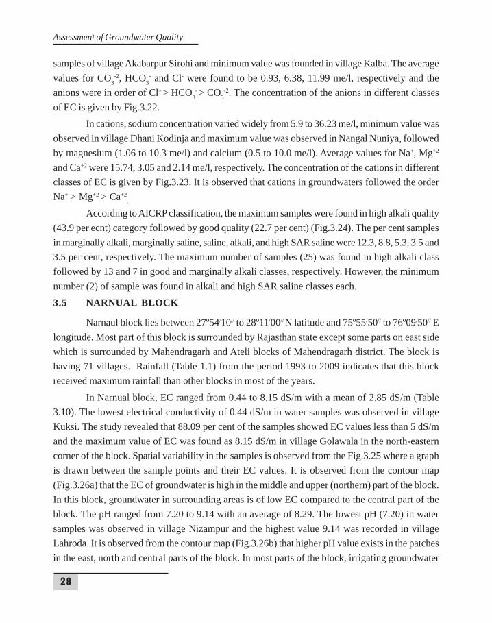
samples of village Akabarpur Sirohi and minimum value was founded in village Kalba. The averagevalues for CO3
-2, HCO3- and Cl- were found to be 0.93, 6.38, 11.99 me/l, respectively and the
anions were in order of Cl– > HCO3- > CO3
-2. The concentration of the anions in different classesof EC is given by Fig.3.22.
In cations, sodium concentration varied widely from 5.9 to 36.23 me/l, minimum value wasobserved in village Dhani Kodinja and maximum value was observed in Nangal Nuniya, followedby magnesium (1.06 to 10.3 me/l) and calcium (0.5 to 10.0 me/l). Average values for Na+, Mg+2
and Ca+2 were 15.74, 3.05 and 2.14 me/l, respectively. The concentration of the cations in differentclasses of EC is given by Fig.3.23. It is observed that cations in groundwaters followed the orderNa+ > Mg+2 > Ca+2
.
According to AICRP classification, the maximum samples were found in high alkali quality(43.9 per ecnt) category followed by good quality (22.7 per cent) (Fig.3.24). The per cent samplesin marginally alkali, marginally saline, saline, alkali, and high SAR saline were 12.3, 8.8, 5.3, 3.5 and3.5 per cent, respectively. The maximum number of samples (25) was found in high alkali classfollowed by 13 and 7 in good and marginally alkali classes, respectively. However, the minimumnumber (2) of sample was found in alkali and high SAR saline classes each.
3.5 NARNUAL BLOCK
Narnaul block lies between 27º54/10// to 28º11/00// N latitude and 75º55/50// to 76º09/50// Elongitude. Most part of this block is surrounded by Rajasthan state except some parts on east sidewhich is surrounded by Mahendragarh and Ateli blocks of Mahendragarh district. The block ishaving 71 villages. Rainfall (Table 1.1) from the period 1993 to 2009 indicates that this blockreceived maximum rainfall than other blocks in most of the years.
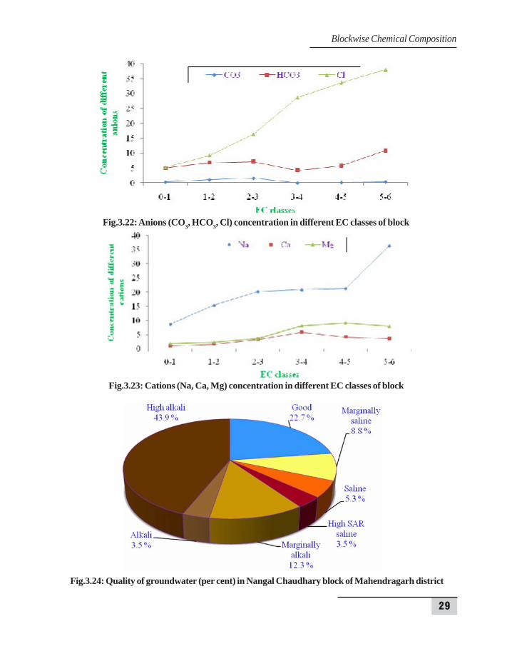
In Narnual block, EC ranged from 0.44 to 8.15 dS/m with a mean of 2.85 dS/m (Table3.10). The lowest electrical conductivity of 0.44 dS/m in water samples was observed in villageKuksi. The study revealed that 88.09 per cent of the samples showed EC values less than 5 dS/mand the maximum value of EC was found as 8.15 dS/m in village Golawala in the north-easterncorner of the block. Spatial variability in the samples is observed from the Fig.3.25 where a graphis drawn between the sample points and their EC values. It is observed from the contour map(Fig.3.26a) that the EC of groundwater is high in the middle and upper (northern) part of the block.In this block, groundwater in surrounding areas is of low EC compared to the central part of theblock. The pH ranged from 7.20 to 9.14 with an average of 8.29. The lowest pH (7.20) in watersamples was observed in village Nizampur and the highest value 9.14 was recorded in villageLahroda. It is observed from the contour map (Fig.3.26b) that higher pH value exists in the patchesin the east, north and central parts of the block. In most parts of the block, irrigating groundwater
29
Fig.3.23: Cations (Na, Ca, Mg) concentration in different EC classes of block
Fig.3.24: Quality of groundwater (per cent) in Nangal Chaudhary block of Mahendragarh district
Fig.3.22: Anions (CO3, HCO3, Cl) concentration in different EC classes of block
Blockwise Chemical Composition

30
Assessment of Groundwater Quality
is normal in relation to alkalinity. The SAR ranged from 3.28 to 18.03 (m mol/l)½ with an averagevalue of 10.98 (m mol/l)½, the lowest SAR value was recorded in village Kuksi and the highestvalue was recorded in Golawala village. The variations in values of SAR of this block are shownby contour map (Fig.3.26c). In the central and Northern part of the block, the value of SAR ishigher than the other parts of the block. Increasing SAR values reflects increase in sodicity ofgroundwater. Red clour is dominating more than green colour, reflects that the most of thegroundwater has higher SAR in the block. The RSC varied from nil to 13.6 (me/l) with an averageof 2.36 (me/l) and maximum value of RSC 13.6 (me/l) was found in the village Karoli. It wasobserved that in 50 per cent water samples, RSC was nil. The variations in values of RSC of thisblock are shown by contour map (Fig.3.26d). Central and north-eastern parts of the block hashigher RSC than other parts of the block. In the western part of the block, it is almost absent/nil.Table 3.10 : Range and average of different water quality parameters in Narnual block of Mahendragarh
district
Sr. No. Parameters Range Average
1 EC (dS/m) 0.44 – 8.15 2.852 pH 7.2 – 9.14 8.293 Na+ (me/l) 3.95 – 53.17 21.364 Ca+2 (me/l) 0.6 – 10.9 3.225 Mg+2 (me/l) 0.9 – 16.1 4.856 Cl- (me/l) 0.0 – 4.8 0.677 CO3
-2 (me/l) 1.8 – 14.0 6.648 HCO3
- (me/l) 2.6 – 74.0 21.339 SAR (m mol/l)½ 0.0 – 13.6 2.3610 RSC (me/l) 3.28 – 18.03 10.98
Fig.3.25: Spatial variability in EC of the collected samples
Sample points in Narnaul block
EC (d
S/m
)
31
a) Contour map of EC of groundwater b) Contour map of pH of groundwater
c) Contour map of SAR of groundwater d) Contour map of RSC of groundwater
Fig.3.26: Contour map of water quality parameters (EC, pH, SAR, RSC) of groundwater in Narnualblock of Mahendragarh district
Blockwise Chemical Composition
32
Assessment of Groundwater Quality
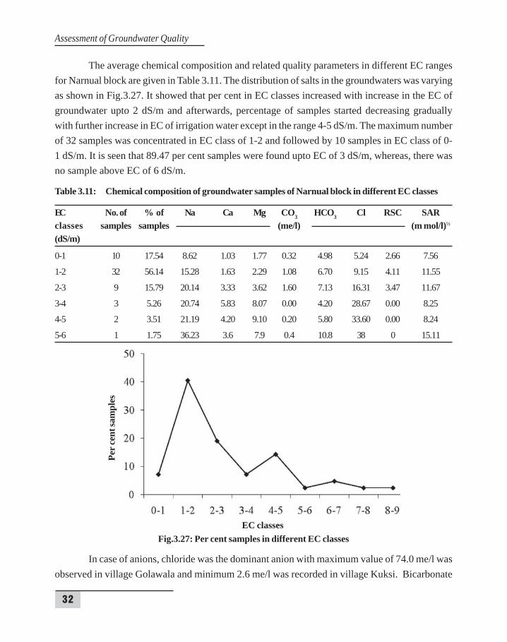
The average chemical composition and related quality parameters in different EC rangesfor Narnual block are given in Table 3.11. The distribution of salts in the groundwaters was varyingas shown in Fig.3.27. It showed that per cent in EC classes increased with increase in the EC ofgroundwater upto 2 dS/m and afterwards, percentage of samples started decreasing graduallywith further increase in EC of irrigation water except in the range 4-5 dS/m. The maximum numberof 32 samples was concentrated in EC class of 1-2 and followed by 10 samples in EC class of 0-1 dS/m. It is seen that 89.47 per cent samples were found upto EC of 3 dS/m, whereas, there wasno sample above EC of 6 dS/m.
Table 3.11: Chemical composition of groundwater samples of Narnual block in different EC classes
EC No. of % of Na Ca Mg CO3 HCO3 Cl RSC SARclasses samples samples (me/l) (m mol/l)½
(dS/m)
0-1 10 17.54 8.62 1.03 1.77 0.32 4.98 5.24 2.66 7.56
1-2 32 56.14 15.28 1.63 2.29 1.08 6.70 9.15 4.11 11.55
2-3 9 15.79 20.14 3.33 3.62 1.60 7.13 16.31 3.47 11.67
3-4 3 5.26 20.74 5.83 8.07 0.00 4.20 28.67 0.00 8.25
4-5 2 3.51 21.19 4.20 9.10 0.20 5.80 33.60 0.00 8.24
5-6 1 1.75 36.23 3.6 7.9 0.4 10.8 38 0 15.11
Fig.3.27: Per cent samples in different EC classes
In case of anions, chloride was the dominant anion with maximum value of 74.0 me/l wasobserved in village Golawala and minimum 2.6 me/l was recorded in village Kuksi. Bicarbonate
EC classes
Per c
ent s
ampl
es
33
(HCO3-) ranged from 1.8 to 14.0 me/l, the maximum value was observed in the water samples of
village Kakroli and minimum value was found in village Kuksi. The average values for CO3-2,
HCO3- and Cl- were found to be 0.67, 6.64, 21.33 me/l, respectively and the anions were in order
of Cl– > HCO3- > CO3
-2. The concentration of the anions in different classes of EC is given byFig.3.28.
In cations, sodium concentration varied widely from 3.95 to 53.14 me/l, minimum valuewas observed in village Kuksi and maximum value was observed in Golawala followed by magnesium(0.6 to 16.1 me/l) and calcium (0.6 to 10.9 me/l). Average values for Na+, Mg+2 and Ca+2 were21.36, 4.85 and 3.22 me/l, respectively. The concentration of the cations in different classes of ECis given by Fig.3.29. It is observed that cations in groundwaters followed the order Na+ > Mg+2 >Ca+2
.
According to AICRP classification, the maximum samples were found in high SAR salinequality (26.2 per cent) category followed by good quality (19.0 per cent) (Fig.3.30). The per centsamples in high alkali, marginally saline, alkali, marginally alkali and saline classes were 16.7, 14.3,14.3, 7.1 and 2.4 per cent, respectively. The highest number of samples (11) were found in highSAR saline class followed by 8 and 7 in good and high alkali classes, respectively. However, theminimum number (1) of sample was found in saline class.
Blockwise Chemical Composition
34
Assessment of Groundwater Quality
Fig.3.28: Anions (CO3, HCO3, Cl) concentration in different EC classes of Narnual block
Fig.3.29: Cations (Na, Ca, Mg) concentration in different EC classes of Narnual block
Fig.3.30: Quality of groundwater (per cent) in Narnaul block of Mahendragarh district
35
4. GROUNDW4. GROUNDW4. GROUNDW4. GROUNDW4. GROUNDWAAAAATER QUALITY OF MAHENDRAGARH DISTRICTTER QUALITY OF MAHENDRAGARH DISTRICTTER QUALITY OF MAHENDRAGARH DISTRICTTER QUALITY OF MAHENDRAGARH DISTRICTTER QUALITY OF MAHENDRAGARH DISTRICT
4.1 SAMPLING POINTS IN THE DISTRICT
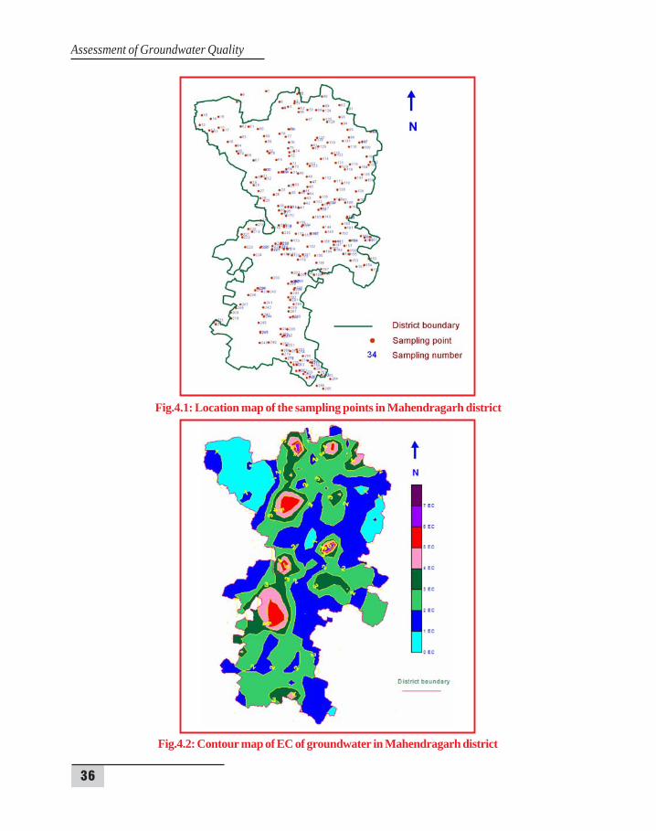
Total 299 water samples have been collected with the spatial points through GPS for allthe blocks of Mahendragarh district and a location map for the these sampling points is prepared(Fig.4.1). Each sample was a representative of the discrete sampling point within the samplingnetwork. Sampling frequency and the location of discrete sampling points was considered carefullyto resolve spatial distributions of groundwater quality and to minimize the random error. Thesamples were collected uniformly through all the blocks except some parts of Nangal Chaudharyand Narnual blocks due to presence of small hills in that area.
4.2 ELECTRICAL CONDUCTIVITY (EC)
In Mahendragarh district, EC ranged from 0.44 to 8.15 dS/m with a mean of 2.85 dS/m.The lowest electrical conductivity of 0.44 dS/m in water samples was observed in village Kuksi.The study revealed that 88.09 per cent of the samples showed EC values less than 5 dS/m and themaximum value of EC was found as 8.15 dS/m in village Golawala in the north-east corner of theblock. It is observed from the contour map (Fig.4.2) that the EC of groundwater is high in themiddle and upper (Northern) part of the block where red colour contour are shown. In the mostpart of the district, EC of groundwater remained in the range of 2-3 dS/m.
4.3 SODIUM ADSORPTION RATIO (SAR)
In Mahendragarh district, SAR ranged from 0.54 to 26.02 (m mol/l)1/2 with a mean of10.41 (m mol/l)1/2. The lowest SAR of 0.54 (m mol/l)1/2 in water samples was observed in villagePalri in Mahendragarh block and the maximum value of SAR was found as 26.02 (m mol/l)1/2 invillage Bajar in Ateli block. It is observed from the contour map (Fig.4.3) that the SAR of groundwateris highly variable and higher values of SAR is observed in the patches through red colour in thecontour map. In the most part of the district, SAR of groundwater remained in the range of 9-11 (mmol/l)1/2.
4.4 RESIDUAL SODIUM CARBONATE (RSC)
In Mahendragarh district, RSC ranged from nil to 14.72 me/l with a mean of 2.67 me/l.The highest RSC of 14.72 me/l in water samples was observed in village Bhurjat of Mahendragarhblock. It is observed from the contour map (Fig.4.4) that the RSC of groundwater is high in thedifferent patches though out the district where red colour contour are shown. In most parts of the
36
Assessment of Groundwater Quality
Fig.4.2: Contour map of EC of groundwater in Mahendragarh district
Fig.4.1: Location map of the sampling points in Mahendragarh district

37
Fig.4.4: Contour map of RSC of groundwater quality in Mahendragarh district
Fig.4.3: Contour map of SAR of groundwater of Mahendragarh district
Groundwater Quality of Mahendragarh
38
Assessment of Groundwater Quality
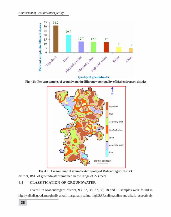
Fig. 4.5 : Per cent samples of groundwater in different water quality of Mahendragarh district
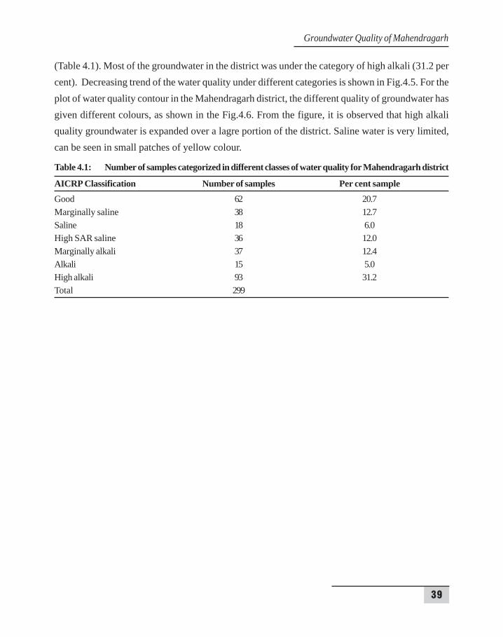
Fig. 4.6 : Contour map of groundwater quality of Mahendragarh districtdistrict, RSC of groundwater remained in the range of 2-3 me/l.
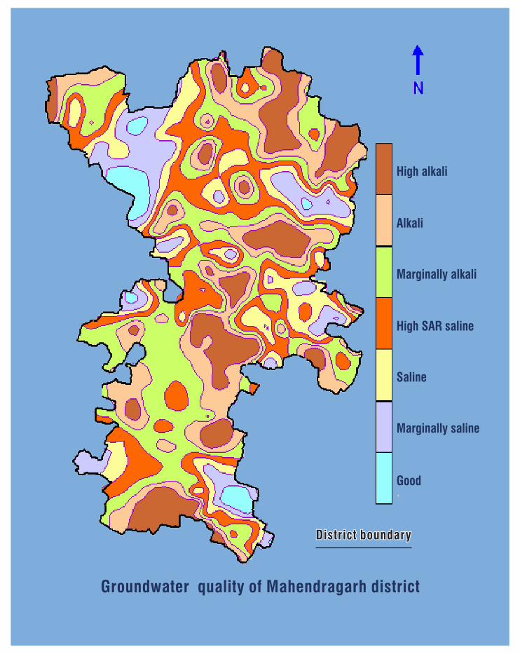
4.5 CLASSIFICATION OF GROUNDWATER
Overall in Mahendragarh district, 93, 62, 38, 37, 36, 18 and 15 samples were found inhighly alkali, good, marginally alkali, marginally saline, high SAR saline, saline and alkali, respectively
High alkali
Alkali
Marginally alkali
High SAR saline
Saline
Marginally saline
Good
39
(Table 4.1). Most of the groundwater in the district was under the category of high alkali (31.2 percent). Decreasing trend of the water quality under different categories is shown in Fig.4.5. For theplot of water quality contour in the Mahendragarh district, the different quality of groundwater hasgiven different colours, as shown in the Fig.4.6. From the figure, it is observed that high alkaliquality groundwater is expanded over a lagre portion of the district. Saline water is very limited,can be seen in small patches of yellow colour.
Table 4.1: Number of samples categorized in different classes of water quality for Mahendragarh district
AICRP Classification Number of samples Per cent sampleGood 62 20.7Marginally saline 38 12.7Saline 18 6.0High SAR saline 36 12.0Marginally alkali 37 12.4Alkali 15 5.0High alkali 93 31.2Total 299
Groundwater Quality of Mahendragarh
40
Assessment of Groundwater Quality
5. GROUNDW5. GROUNDW5. GROUNDW5. GROUNDW5. GROUNDWAAAAATER MANAGEMENT STRATER MANAGEMENT STRATER MANAGEMENT STRATER MANAGEMENT STRATER MANAGEMENT STRATEGYTEGYTEGYTEGYTEGY
5.1 STRATEGIES FOR GROUNDWATER MANAGEMENT
The following practical and feasible strategies need to be adopted for optimal use of availablewater resources for higher water productivity and correcting emerging hydrological imbalances inMahendragarh district.
Propagating efficient on-farm water management practices including modern methods ofirrigation (sprinkler, drip, furrow, etc.) by imparting regular training to farmers and fieldfunctionaries.
Reduction in canal water supply by about 25 percent between mid July to mid Septemberand December to February in the districts having sufficient water or waterlogged area.The canal water, thus saved, should be diverted to water deficit areas and lift canal systemlike Mahendragarh district.
Adoption of recommended cropping practices in flood affected areas under existing situationduring the post-monsoon period.
Forming water users’ associations/societies for effective and efficient management ofavailable water resources.
Lining of remaining canals and water courses and their periodic maintenance for checkingseepage losses.
Constructing storage reservoirs in the foothill areas of the district at appropriate sites.
Maximizing conjunctive use of saline water with canal water in the problem area bychanging over from the existing ‘warabandi’ to ‘warimetric’ so that the farmers areencouraged to use saline groundwater.
The farmers should also be encouraged to raise agro-horti, agro-forestry plantation andgrasses (in wind erosion area) for which adequate subsidy may be provided.
Introduction of groundwater legislation to regulate the groundwater exploitation as perpotential available and to check further growth of tubewells in district.
Diversification of cropping pattern to effect reduction in water requirement.
Exploring the possibility of artificial groundwater recharge during monsoon period in theareas facing groundwater decline.
41
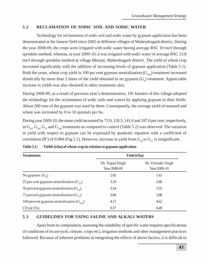
5.2 RECLAMATION OF SODIC SOIL AND SODIC WATER
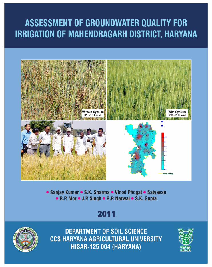
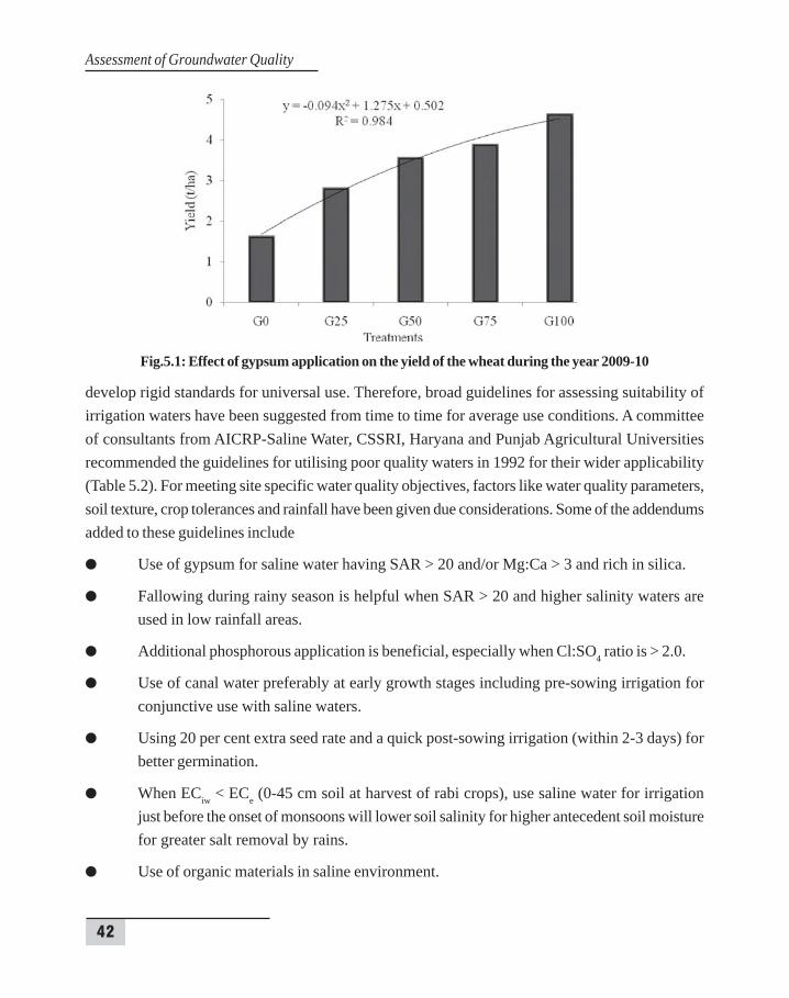
Technology for reclamation of sodic soil and sodic water by gypsum application has beendemonstrated at the famers’field since 2005 in different villages of Mahendragarh district. Duringthe year 2008-09, the crops were irrigated with sodic water having average RSC 10 me/l throughsprinkler method, whereas, in year 2009-10, it was irrigated with sodic water of average RSC 13.8me/l through sprinkler method at village Bhurjat, Maherdragarh district. The yield of wheat cropincreased significantly with the addition of increasing levels of gypsum application (Table 5.1).Both the years, wheat crop yield in 100 per cent gypsum neutralization (G100) treatment increaseddrastically by more than 2 times of the yield obtained in no gypsum (G0) treatment. Appreciableincrease in yields was also obtained in other treatments also.
During 2008-09, as a result of previous year’s demonstration, 191 farmers of this village adoptedthe technology for the reclamation of sodic soils and waters by applying gypsum in their fields.About 200 tons of the gypsum was used by them. Consequently, the average yield of mustard andwheat was increased by 8 to 10 quintals per ha.
During year 2009-10, the mean yield increased by 73.9, 120.5, 141.0 and 187.0 per cent, respectively,in G25, G50, G75 and G100 treatments as compared to control (Table 5.2) was observed. The variationin yield with respect to gypsum can be expressed by quadratic equation with a coefficient ofcorrelation (R2) of 0.984 (Fig.5.1). However, increase in yield from G50 to G75 is insignificant.
Table 5.1: Yields (t/ha) of wheat crop in relation to gypsum application
Treatments Yield (t/ha)
Sh. Tejpal Singh Sh. Virender SinghYear 2008-09 Year 2009-10
No gypsum (G0) 2.05 1.61
25 per cent gypsum neutralization (G25) 3.19 2.80
50 percent gypsum neutralization (G50) 3.54 3.55
75 percent gypsum neutralization (G75) 3.84 3.88
100 percent gypsum neutralization (G100) 4.17 4.62
CD (at 5%) 0.27 0.49
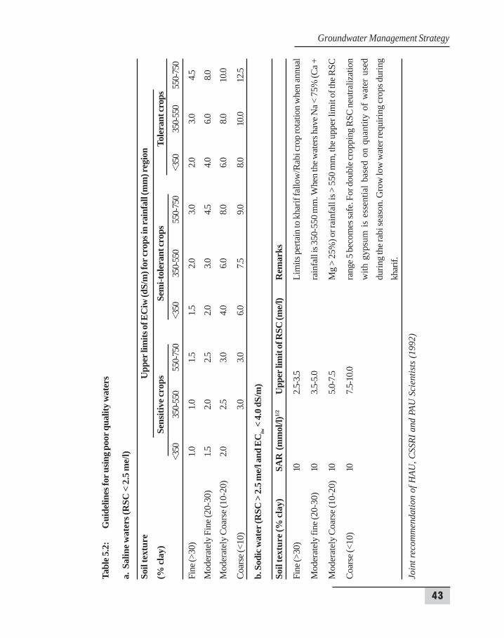
5.3 GUIDELINES FOR USING SALINE AND ALKALI WATERS
Apart from its composition, assessing the suitability of specific water requires specificationsof conditions of its use (soil, climate, crops etc), irrigation methods and other management practicesfollowed. Because of inherent problems in integrating the effects of above factors, it is difficult to
Groundwater Management Strategy
42
Assessment of Groundwater Quality
develop rigid standards for universal use. Therefore, broad guidelines for assessing suitability ofirrigation waters have been suggested from time to time for average use conditions. A committeeof consultants from AICRP-Saline Water, CSSRI, Haryana and Punjab Agricultural Universitiesrecommended the guidelines for utilising poor quality waters in 1992 for their wider applicability(Table 5.2). For meeting site specific water quality objectives, factors like water quality parameters,soil texture, crop tolerances and rainfall have been given due considerations. Some of the addendumsadded to these guidelines include
Use of gypsum for saline water having SAR > 20 and/or Mg:Ca > 3 and rich in silica.
Fallowing during rainy season is helpful when SAR > 20 and higher salinity waters areused in low rainfall areas.
Additional phosphorous application is beneficial, especially when Cl:SO4 ratio is > 2.0.
Use of canal water preferably at early growth stages including pre-sowing irrigation forconjunctive use with saline waters.
Using 20 per cent extra seed rate and a quick post-sowing irrigation (within 2-3 days) forbetter germination.
When ECiw < ECe (0-45 cm soil at harvest of rabi crops), use saline water for irrigationjust before the onset of monsoons will lower soil salinity for higher antecedent soil moisturefor greater salt removal by rains.
Use of organic materials in saline environment.
Fig.5.1: Effect of gypsum application on the yield of the wheat during the year 2009-10
43
Tabl
e 5.2
:G
uide
lines
for u
sing p
oor q
ualit
y wat
ers
a. S
alin
e wat
ers (
RSC
< 2
.5 m
e/l)
Soil
text
ure
Upp
er li
mits
of E
Ciw
(dS/
m) f
or cr
ops i
n ra
infa
ll (m
m) r
egio
n
(% cl
ay)
Sens
itive
crop
sSe
mi-t
oler
ant c
rops
Tole
rant
crop
s<3
5035
0-55
055
0-75
0<3
5035
0-55
055
0-75
0<3
5035
0-55
055
0-75
0
Fine
(>30
)1.0
1.01.5
1.52.0
3.02.0
3.04.5
Mod
erat
ely
Fine
(20-
30)
1.52.0
2.52.0
3.04.5
4.06.0
8.0
Mod
erat
ely
Coa
rse (
10-2
0)2.0
2.53.0
4.06.0
8.06.0
8.010
.0
Coar
se (<
10)
3.03.0
6.07.5
9.08.0
10.0
12.5
b. S
odic
wat
er (R
SC >
2.5 m
e/l a
nd E
Ciw
< 4.
0 dS/
m)
Soil
text
ure (
% cl
ay)
SAR
(m
mol
/l)1/
2U
pper
lim
it of
RSC
(me/
l)R
emar
ks
Fine
(>30
)10
2.5-3
.5Li
mits
per
tain
to k
harif
fallo
w/R
abi c
rop
rota
tion
whe
n an
nual
Mod
erat
ely
fine (
20-3
0)10
3.5-5
.0ra
infa
ll is
350-
550
mm
. Whe
n th
e wat
ers h
ave N
a < 7
5% (C
a +
Mod
erat
ely
Coa
rse (
10-2
0)10
5.0-7
.5M
g >
25%
) or r
ainf
all i
s > 5
50 m
m, t
he u
pper
lim
it of
the R
SC
Coar
se (<
10)
107.5
-10.0
rang
e 5 b
ecom
es sa
fe. F
or d
oubl
e cro
ppin
g RS
C ne
utra
lizat
ion
with
gyp
sum
is e
ssen
tial b
ased
on
quan
tity
of w
ater
use
ddu
ring
the r
abi s
easo
n. G
row
low
wat
er re
quiri
ng cr
ops d
urin
gkh
arif.
Join
t rec
omm
enda
tion
of H
AU, C
SSRI
and
PAU
Sci
entis
ts (1
992)
Groundwater Management Strategy
44
Assessment of Groundwater Quality
Quality of groundwater in Ateli block
Quality of groundwater in Kanina block
High alkali
Alkali
Marginally alkali
High SAR saline
Saline
Marginally saline
Good
District boundaryDistrict boundaryDistrict boundary
Groundwater quality of Mahendragarh district