ashburton district plan guidance... · operative district plan august ... summer the ^nor-west _...
TRANSCRIPT

Section 3: Rural Zones
OPERATIVE DISTRICT PLAN August 2014
Contents
Section 3: Rural Zones
3.1 Introduction ............................................................................................................................ 3-1
3.2 Issues ....................................................................................................................................... 3-4
3.3 Zone Description ................................................................................................................... 3-17
3.4 Objectives and Policies .......................................................................................................... 3-18
3.5 Anticipated Environmental Results ....................................................................................... 3-38
3.6 Methods of Implementation ................................................................................................. 3-39
3.7 Reasons for Rules .................................................................................................................. 3-40
3.8 Rules – Rural Zone ................................................................................................................. 3-52
3.9 Site Standards ....................................................................................................................... 3-56
3.10 Zone Standards ..................................................................................................................... 3-63
3.11 Assessment Matters .............................................................................................................. 3-66
Section 3 Appendices
Appendix 3-1: Setback from Stopbanks ............................................................................................. 3-76
Appendix 3-2: Areas of Significant Nature Conservation Value ........................................................ 3-78
Appendix 3-3: Geoconservation Areas and Sites ............................................................................. 3-102
Appendix 3-4: Outstanding Natural Landscapes .............................................................................. 3-109

Section 3: Rural Zones
3.1 Introduction
OPERATIVE DISTRICT PLAN June 2017
3-1
Section 3: Rural Zones
3.1 Introduction
3.1.1 Rural Plains
The Rural Plains area of the District covers approximately 335,000ha, over half of the total District,
extending from the foothills for 48-56km to the sea.
The Plains are bordered by the two important water resources of the Rakaia and Rangitata Rivers,
as well as being traversed by the Ashburton (Hakatere) and Hinds (Hekeao) Rivers and the smaller
Wakanui Stream, although 95-99% of flow is underground. These rivers, along with rainfall and
irrigation wastewater contribute to the sizeable underground aquifers of the Plains. The District
has a number of important water systems harnessing the Plain’s surface and ground water
resources for irrigation, stock and domestic water supplies and hydro-electricity production. The
main water system is the Rangitata Diversion Race (RDR) which extends for 66km from the
Rangitata to the Rakaia Rivers, feeding irrigation schemes, stockwater systems and two power
stations. The water is used for irrigation during the summer months, and is utilised by Trustpower
to produce hydroelectricity at the Montalto and Highbank power stations. The Montalto Power
Station has an installed capacity of 1.9 MW while generation from the Highbank Scheme is
dependent upon irrigation requirements which take priority during the irrigation season. The
scheme is guaranteed water for four months of the year, but typically generates for six to eight
months, increasing to eleven to twelve months in particularly wet years.
The significant water systems within the Ashburton District provide for its strong agriculturally
based economy and associated industries and services. This is important not only to the economy
of the District but also the region and the country, as the Ashburton District provides many products
reliant on these water systems such as crop seeds, dairy products and beef for export. The water
resources of Ashburton District therefore have importance beyond the boundaries of the district.
The District’s coastline extends for approximately 66km between the Rakaia and Rangitata Rivers.
The coastline is predominantly eroding coastal cliffs and gullies with gravel beaches, broken by only
by the five river mouths. Sand dunes are concentrated south of the Rakaia River mouth. The
beaches along the coast are mostly undeveloped, because of the limitations imposed by the harsh
physical environment.
The Plains support a diverse range of agricultural and horticultural activities from farms running
dairy cows to cattle feedlots; from salmon farms to horse breeding and training establishments;
and the growing of wheat and grain to evening primrose. It is the extensive irrigation schemes
which cover 122,000 hectares (48% of the Plains area) that have allowed and continue to provide
for this diversity.
In 2008 dairying accounted for 18% of plains farming with an estimated 125,000 to 130,000 cows
being run in the District. However there has been a decline in sheep farming although the District
still produces good lambing percentages; lamb weights and wool weights. The Plains also support

Section 3: Rural Zones
3.1 Introduction
OPERATIVE DISTRICT PLAN June 2017
3-2
a number of farms producing venison and deer velvet, and those that are devoted to growing and
finishing beef cattle. Recent years have also seen growth in the farming of other livestock including
alpacas, as well as intensive farming operations such as, nurseries and vineyards. The District also
has an important small seed industry, producing a significant proportion of New Zealand’s seeds
for use nationwide as well as for export. These, together with the important bulk industry, also rely
on processing plants in the rural areas.
The other main primary industries are forestry, and lime and gravel extraction. Approximately
4,000ha of the Plains are planted in exotic forest, with most being developed primarily for timber
production and shelter purposes. Timber is usually processed at private sawmills for the local
building industry. The Plains also support approximately 250 gravel pits with gravel extraction being
the predominant extractive industry.
There is limited commercial activity outside of the rural settlements, the largest being Farmers
Corner established on State Highway 1. This is a retail outlet and restaurant that provides for
tourists and visitors to the District.
The District attracts visitors because of the wide range of recreational activities available on the
Plains, especially in or on its rivers. Fishing; particularly on the Rakaia and Rangitata Rivers which
are internationally recognised for salmon and trout; jet boating, swimming, canoeing, rafting,
wildfowl shooting are a selection of the activities available.
There are established settlements within the rural area such as Staveley and Alford Forest,
comprising a few residential units. However, in recent years, the desire to live on rural lifestyle
blocks has led to allotments around the main centres of Ashburton (Kapuka), Rakaia and Methven
being subdivided to create residential properties. This has led to a gradual expansion of these towns
into the traditionally rural environment, in some cases altering its character to semi-urban with
further development anticipated over the next 10 years.
3.1.2 Rural High Country
The High Country area, as defined in this Plan includes the entire foothill and mountain ranges
through to the Main Divide, the Heron Basin, up the Rakaia River from Little River, the Ashburton
River (Hakatere) from the Stour River (Mata kou) confluence, and the Rangitata River upstream
from the lower end of its gorge. It is generally north-west of a line which varies between 450m and
500m above sea level.
The High Country experiences a climate that is cooler, wetter and windier than the Plains, although
this varies considerably across the High Country. Temperatures, like rainfall, are subject to a high
level of annual and seasonal variability. Severe winter frosts and snow falls are common with the
heaviest falls often coming in spring. The prevailing wind in the High Country is from the westerly
quarter, and in spring and summer the “nor-west” wind can rise to gale force.
The topography of the High Country is highly influenced by the presence and retreat of glaciers
during the last ice age. This process has left its mark on the landscape in the form of open basins
such as Hakatere, and wide valleys with their distinctly glacial features. It is these features that
form the geoconservation sites that are nationally important because of their presence in such an
Section 3: Rural Zones
3.1 Introduction
OPERATIVE DISTRICT PLAN June 2017
3-3
obvious glacial landscape but also the clear articulation of these features such as the kettle holes
and roche moutonnée known as Sugar Loaf in the Hakatere Basin.
High Country soils that have formed on steep mountain slopes have severe limitations for intensive
pastoral or forestry use due to poor fertility or a high erosion potential. Where soil profiles are
shallow, drought is also a limiting factor. In the valleys and basins, debris brought down by glaciers
and rivers has been deposited, and a series of younger soils have formed as a result. These soils are
often stony, but areas of finer sand and silts occur, which are not so limited in their range of uses.
Extensive pastoral farming which became established in the 1850s-1860s as the original Crown
leases were taken up continues to characterise land use over much of the High Country today.
Although variable, the average run today in the High Country is in the order of 10,000 hectares.
Due to the harsh climate and rugged terrain, merinos bred for their fine wool are the predominant
livestock type, although beef-cattle and deer are common, particularly in the valleys.
The burning of vegetation to encourage young growth, palatable to stock has meant that the
vegetation of tall and short tussock species, matagouri and Aciphylla species has been modified,
with short tussock predominating these days. On the lower elevations over-sowing and topdressing
have also led to changes in vegetation species. Introduced plants including gorse, broom, and
wilding trees are also conspicuous in many areas. These pest plants, as well as pest animals,
continue to pose threats to the vegetation patterns and natural character of the High Country.
Approximately 20,000ha of the District remains under indigenous forest vegetation, mainly in
Conservation Areas. Most of the indigenous forest is in the High Country, with some of the smaller
low-altitude remnant stands remaining in private ownership. Exotic trees have been planted as
shelter-belts in the past, largely as a result of a requirement of a lease or by those interested in
arboriculture. In addition to these planted areas of trees, there are now areas of exotic trees
establishing as a result of the spread of wilding seedlings, such as around Lakes Clearwater, Camp
and Heron, although work is being undertaken to remove these trees.
The ultimate effect of the Tenure Review process, which is transferring significant areas of land into
private ownership, is currently unknown. Although the process can facilitate the protection of areas
of significant nature conservation and indigenous vegetation through the transfer of land
management to the Department of Conservation, there may continue to be pressure for
development. Economics may cause landowners to seek alternative incomes or to adopt different
farming practices. As many stations have only recently completed Tenure Review, it is difficult to
predict if and what changes may occur.
The population of the High Country area was approximately 350 people in 2006. Residential
development is associated with High Country pastoral runs, or farming properties located around
the perimeter of the foothills. There is also a holiday home settlement of 178 huts at Lake
Clearwater (Te Puna-O Taka) that is administered by the Ashburton District Council.
The landscapes of the High Country are unique and distinctive due to its vast, open vistas with
subtle colourings. This remote, beautiful environment provides recreational opportunities for a

Section 3: Rural Zones
3.2 Issues
OPERATIVE DISTRICT PLAN June 2017
3-4
variety of different user groups; from hunters, mountaineers and trampers to skiers and hot air-
balloonists.
There is a popular camping area at Lake Clearwater (Te Puna-O Taka), with another located at
nearby Lake Heron (Oturoto), which are used over the summer. Accommodation for tourists is
available at several lodges including Mount Potts Lodge and Mt Hutt Station. Huts located
throughout the mountain ranges are used by trampers for recreational accommodation, and the
nearby settlements of Methven and Mt Somers also provide visitor accommodation.
The Mt Hutt ski field caters for approximately 180,000 people annually and serves both tourists
and the residents of Ashburton District and Canterbury. There are also other smaller ski-fields and
heli-skiers operating in the High Country.
Fishing is a very popular recreational pursuit on the District’s rivers and lakes, except on the upper
sections of the Rakaia and Rangitata Rivers, which are important for salmon spawning.
Boating provides both a means of access for fishing and a popular sport on the rivers, although of
lower use in the High Country relative to the Plains. Lake Camp is used for power boating, water
skiing and jet-skiing, and Lake Clearwater (Te Puna-O Taka) is popular for yachting, wind surfing
and canoeing.
3.2 Issues
3.2.1 Sustaining the Life Supporting Capacity of Ecosystems, Soil and Water
The continued cultivation and grazing of both the Plains and High Country requires the protection
of the existing ecosystems, water and soil resources. These three factors are intertwined and
ensure the current, and if properly managed, future of agriculture in the District. The fate of the
District’s indigenous flora and fauna are also dependent upon sustaining these resources. This is
particularly important in the High Country where farming practices and indigenous vegetation give
the area its distinctive character and landscape values. These are fundamental to the tourist
industry as well as being important to the local population.
Ecosystems and Soil
Despite continuing modification, the District still contains many diverse communities of indigenous
plants and animals in a variety of habitats, particularly in the High Country. Those areas least
modified are remnant areas of shrubland and podocarp forest; and allied alpine communities
nearer the Main Divide, and areas above the altitudinal land use line shown on the Planning Maps.
Due to thin and infertile soils and severe climatic factors, plant establishment and growth rates are
slow and are therefore particularly sensitive to modification. Large areas of beech forest and some
mixed areas of beech/podocarp forests also still remain in the foothills at Alford Forest, Staveley,
Pudding Hill and Mt Hutt. Significant examples of tall tussock grasslands, scrubland, and alpine
vegetation associations or species also occur in the District. These areas are fundamental to
retaining the existing landscape values and areas of significant nature conservation that give the
High Country its unique character and are an important draw-card for visitors.
Section 3: Rural Zones
3.2 Issues
OPERATIVE DISTRICT PLAN June 2017
3-5
The soils of the High Country are vital to the sustainability of agricultural activities, vegetation and
landscape resources. However, whilst soil nutrient status is an important issue in the High Country
when discussing sustaining life supporting capacity of the soil, it is recognised that as an issue, it
may not be as significant as it was a few years ago. The Regional Council reports that at the time of
writing this Plan, there is a halt to the decline in soil nutrient status, although this may be
dependent upon soil type, activities and management techniques.
Council considers that the health of the both indigenous and pastoral vegetation needs to be
maintained to ensure that the underlying soil is sustained in order to meet the needs of future
generations.
Sustainable management of the land resources of the High Country has importance for many
aspects of the District’s well-being. Stable and viable rural communities depend upon the
implementation and maintenance of sustainable pastoral farming systems which retain soil
quantity, fertility and health; protect water and air quality; and are energy efficient. The range of
landscape, recreational and nature conservation values associated with the District’s High Country
are also dependent on the implementation of pastoral farming systems which sustain these values.
On the Plains, the soils are considered to be capable of sustained pastoral, arable and horticultural
production. The soils are highly productive and, with irrigation, sufficient rainfall and good nutrient
management can provide for a wide range of productive land uses.
However, subdivision and the use of small rural lots for principally residential activities can result
in significant areas of the allotments being covered by buildings and hard-standing which can make
the long-term productive use of the soils and their associated irrigation resources unlikely. Given
that the present, and probably future, welfare of the people on the Plains is likely to be reliant on
primary production, the Council is concerned that the soil resource retains its productive potential
for future generations.
The District also supports a unique man-made system of shelter-belts that promote animal welfare
by providing shelter for stock as well as potentially being a habitat for indigenous and non-
indigenous flora and fauna. Whilst the Council does not intend to control the planting and removal
of such shelter-belts, it does recognise their importance to the District. However, the planting of
such shelter-belts in the Rural C zone does have the potential to adversely affect the character of
the High Country, being open and spacious and to create an artificial pattern on the landscape. The
species planted to form shelter-belts can also become an issue where wilding species are used.
Shelterbelts also have other benefits and value, depending on the type of trees that are planted,
such as improving soil quality and arable production, increasing environmental biodiversity and
aiding the pollination of crops.
Water
Within the High Country there are many streams, wetlands and lakes that are important for nature
conservation values, as they provide important habitat for indigenous and recreational fisheries,
and often have high natural character and recreational values.
Section 3: Rural Zones
3.2 Issues
OPERATIVE DISTRICT PLAN June 2017
3-6
Of significance is the Ashburton Lakes (Lakes Heron (Oturoto), Clearwater (Te Puna-O Taka), Camp,
Emma and the Maori Lakes (O Tu Whare Kai)) with its system of streams, wetlands and lakes is
widely recognised for its plant and bird life. It is important to note that Lakes Clearwater (Te Puna-
O Taka), Heron (Oturoto) and the Maori Lakes (O Tu Whare Kai) have Wildlife Refuge/Reserve
status because of their ecological importance.
It is the diversity of wetlands that provide habitats for a wide variety of wetland plants and birds,
including rare small crustaceans, the endangered southern crested grebe, bittern and several plant
species that are rare in Canterbury. These wetlands and lakes provide opportunities for scientific
study and education, are aesthetically important, and provide for a variety of recreational activities.
The best of the areas, from the point of view of vegetation condition, occurrence of native birds
and invertebrate animals, are excellent by local, regional and national standards. By contrast, Lake
Camp is almost barren of wildlife and only used by a small number of waterfowl species.
However, the lakes and wetlands are under threat. Farming activities have severely modified many
of the wetland areas, through cattle trampling, grazing, drainage, fire, pasture cultivation and top-
dressing. Such activities create changes in water nutrient levels and acidity, and invasion by weed
species. Some areas may never recover, whereas other areas could recover if protected from the
above influences. Other degrading effects include human trampling and littering, nutrient influx
from the Lake Clearwater holiday settlement, wave action from power-boating, invasion by willows
and pollution from large numbers of introduced birds. At Lakes Camp, Clearwater (Te Puna-O Taka)
and Heron (Oturoto), the Council has provided toilet and rubbish disposal facilities to mitigate some
of the adverse effects created by people utilising the lakes.
The smaller rivers are often sensitive to modification of their riparian areas and their catchments.
The margins of these rivers and lakes also have nature conservation values, some of which have
been identified as being significant to the District. The setting aside of public reserve along the
banks of lakes and rivers has the functions of providing for public access and waterfront activities,
protecting nature conservation values of the margins, and maintenance of water quality and
aquatic habitats.
These water bodies are also important recreational areas but this has to be balanced with the need
to sustain their ecological importance. For this reason, powerboats are only permitted on Lake
Camp whereas Lake Clearwater (Te Puna-O Taka) is used extensively by wind surfers and small
yachts during the summer months, and Lake Heron (Oturoto) only allows the use of boats powered
by oars and paddles. This does not remove all impacts on the flora and fauna but limits the effects
especially with regards to wave action created by powered craft, and noise levels.
The Plains, on the other hand, are dominated by braided rivers and their mouths, which are of
significant nature conservation value as they provide habitat for a wide variety of birds. The
Rangitata, Rakaia, and Ashburton (Hakatere) Rivers are regarded as nationally and internationally
important areas, providing habitats for threatened indigenous birds such as the wrybill plover,
banded dotterel, black billed gull (tara puka) and South Island pied oystercatcher (torea), as well as
providing breeding and feeding grounds for trout, salmon and waterfowl. These rivers are also of
value for recreation and the high natural character of their upper reaches.

Section 3: Rural Zones
3.2 Issues
OPERATIVE DISTRICT PLAN June 2017
3-7
The Rakaia and Rangitata Rivers are both subject to Water Conservation Orders, gazetted in 1988
and 2006 respectively. The purpose of the Water Conservation Orders are to protect the natural
state of the river, including its contribution to outstanding natural features and restrict activities
such as damming that may affect river flow and form, water quality and fish passages.
The margins of the rivers, streams, lakes and wetlands are recognised as being critical areas, not
only in providing habitat for plants and animals, but also acting as a buffer to the water bodies from
land use activities that produce nutrient-rich or sediment-rich run-off. The ways that the margins
of water bodies within the District are used and managed are particularly important in determining
the effects of land use activities on water quality and quantity.
With the growth of residential activity in the rural areas, there is an expectation that potable water
that requires no treatment will be supplied. In recent years, the increase in dairying, associated
disposal fields, use of fertilisers and general runoff from land has threatened this potable supply.
However, as at 2008, figures from the Canterbury Regional Council show that soil nitrate levels are
declining. But, it is still the Council’s intention to control land uses adjoining water bodies to
minimise the effects of such activities on the Plains water bodies; in addition to activities such as
earthworks, the clearance of vegetation and the planting of exotic trees.
These rivers are also important for both private and commercial recreational activities from jet
boating on the Rakaia River and rafting on the Rangitata River to angling, picnicking, wind-surfing,
water-skiing and swimming. These types of activities have the potential to cause adverse effects
such as: noise; degradation of river, lake and adjoining wildlife habitats; increased bank erosion
caused by wave action or activity on the banks; water contamination from exhaust fumes, and
human effluent; litter and other wastes generated in the area; and conflict with Takata Whenua
values in waahi tapu areas.
The increase in water based activities over recent years has led to greater demand for the
construction of structures and facilities alongside or in the margins of the water bodies i.e. jetties,
launching ramps, toilet and changing facilities and administrative facilities for commercial
operations. Such facilities and structures can result in adverse environmental effects relating, for
example, to their visual impact; the concentration of pedestrian, vehicle and boating activity; oil
and fuel spillages; noise; and the alienation of the foreshore from general public use.
However, the nature conservation values of the rivers in the District do not appear to have been
adversely affected by the current levels of recreational activity on the rivers and the main salmon
spawning tributary of the Rakaia River is protected from motorised boating. However, there
remains a concern to ensure that these values of the rivers are not adversely affected by future
growth in activity, particularly by more frequent commercial or organised activities.
The water bodies in the Ashburton District are also vitally important for primary industry and other
uses (such as hydro-electricity generation and community water supplies). Whilst the management
and control of environmental effects associated with the abstraction, diversion and use of water is
a function of the Canterbury Regional Council, the importance of the use of water and the ability
for this to be conveyed around the District needs to be acknowledged in the management of land
use.
Section 3: Rural Zones
3.2 Issues
OPERATIVE DISTRICT PLAN June 2017
3-8
3.2.2 Subdivision and Development
In recent years there has been a substantial increase in the number of subdivisions being
undertaken in the Rural A and B zones. This has reflected a national trend for rural-lifestyle blocks,
catering for those who wish to live in a ‘rural’ environment but with the convenience of being close
to an urban centre such as Ashburton (Kapuka). This encroachment onto productive soils makes
their long-term productive use unlikely. With water being such a precious resource and an ever
increasing awareness of the effects of fertilisers it is important to retain versatile/fertile soils for
productive use.
The Council has taken a proactive approach to this issue and has rezoned additional land for low
density living (i.e. a minimum site area of 4,000m²). The availability of appropriately zoned land for
lifestyle properties should reduce the need for residential development in the Rural A and B Zones,
unless associated with a rural activity, and minimise the loss of productive soils.
Subdivision and subsequent development in the rural zones also has the potential to create reverse
sensitivity issues as residential and rural activities increasingly adjoin each other. People moving
into these areas are often not aware of the effects created by rural activities in particular odour
and noise. The spreading of manure or pig farms and the bellowing of deer result in complaints to
the Council, and in some instances restrictions placed on the farmer. At the very least, the
expansion of farming operations is rendered difficult by neighbouring residential activities. The
Council views the District as an important agricultural area and wishes to see this maintained. The
rural area is a managed working environment and should not be limited in its ability to operate as
such.
3.2.3 Rural Character and Amenity
The rural environment has particular amenity and environmental values which are important to
rural people. These can include privacy, rural character, spaciousness openness, ease of access,
clean air and, at times, quietness. The landscapes of the District are also an integral part of this
amenity and character.
Rural A Zone
The Rural A zone adjoins the outskirts of the main settlements of the District; Ashburton (Kapuka),
Rakaia and Methven as well as the small villages of Mayfield (Te Puke Tai), Hinds (Hekeao), Mt
Somers and Chertsey. The zone is characterised by its proximity to local services and facilities as
well as providing residents with a rural lifestyle. The allotments tend to be of a smaller size than in
the Rural B zone although the zone still provides a sense of openness. Its landscape is defined by
mainly pastoral agriculture with some business development and fenced lifestyle blocks.
In recent years, this zone has come under pressure from those seeking rural lifestyle developments
particularly around Ashburton (Kapuka). Such activity has altered the character of parts of the zone
with the introduction of a more ‘urban’ environment as infrastructure is extended outward from
existing urban centres. Although allotments tend to be larger than those found in the main centres,
the building of large residential units, accessory buildings; fencing and driveways reinforce the
encroaching ‘urban’ character. Although the Zone provides for a minimum allotment of 8 hectares,

Section 3: Rural Zones
3.2 Issues
OPERATIVE DISTRICT PLAN June 2017
3-9
development can create its own effects on the sense of openness in the Zone. Furthermore whilst
sites provide for the ability to extensively landscape and plant shelter along both internal and road
boundaries, this can create its own problems. Extensive planting, which can provide a high level of
shelter and amenity to a site, may also adversely affect the openness of the zone.
There are still agricultural practices being undertaken within this zone and residential development
has created issues. There is often a difference between peoples’ expectations and the reality of
living in a rural area; they often expect a quiet environment with clean air and no odour. However,
the rural area is a managed working environment whose character can be both noisy and
malodorous. The rural areas are of great importance to the District and as such it is necessary to
ensure that residential activities do not prevent the on-going use and development of the land for
agricultural purposes.
Intensive Farming
Intensive farming usually requires extensive areas of buildings for the purpose of housing animals
and land for effluent disposal. This type of farming may expand over the next decade and Council
seeks to control any effects of such activities on the surrounding rural environment.
Intensive rural activity immediately adjacent to settlements can adversely affect the amenity values
of those settlements and reduce the quality of the surrounding rural environment, for example:
smell nuisance e.g. intensive animal stocking rates, effluent disposal;
crop spray nuisance and possible health risk;
noise nuisance e.g. traffic movements, ventilation equipment;
visual impact e.g. large buildings, bare ground, solid waste piles;
dust nuisance e.g. broiler chicken sheds, free-range piggeries.
As such, intensive farming is not anticipated within the Rural A Zone, which immediately adjoins
the residential centres of the District.
The principal complaints have been about odour and noise, which may increase, should ad hoc
residential development be permitted to be dispersed throughout the rural areas. To avoid and
mitigate these problems it is appropriate to control both the spread and location of residential
development in rural areas and to impose buffer separation distances between some rural activities
and existing residential development.
Intensive livestock development can also result in an increased number of effluent disposal fields.
Unless controlled, the proliferation of effluent disposal fields can lead to a deterioration of
groundwater quality; this is particularly of concern where the groundwater table is close to the land
surface.
Rural B Zone
The vast flat Plains interspersed by large braided rivers, with views to the Southern Alps and
foothills in the west and bounded by coastal cliffs in the east give this zone its character. However
Section 3: Rural Zones
3.2 Issues
OPERATIVE DISTRICT PLAN June 2017
3-10
these landscapes forming the Plains have been modified as a result of human settlement, reflected
in a mosaic of grassland and crops, shelterbelts, roading and settlements.
This zone is characterised by agricultural activities with associated agricultural-based industrial type
development such as the Five Star Beef feedlot at Wakanui. In general, however the zone is
anticipated to provide wide, open spaces scattered only with farm houses and associated utility
sheds, and small settlements. There can be significant noise from machinery that may operate from
early in the morning to late at night, and odour from activities such as manure spreading and pig
farming. There can be relatively low volumes of traffic although large tractors and tankers use rural
roads. However, at night it is expected that these areas are quiet with low levels of lighting and
traffic.
The increase in dairy farms has altered the character of these zones through the introduction of
irrigators, larger field sizes and milking sheds. These activities have also promoted the removal of
trees and vegetation over much of the Plains.
Activities within the rural settlements have the potential to impact upon the overall character and
amenity values of the Rural B Zone. Buildings such as those used for community activities i.e. village
halls and schools can be larger than the surrounding residential units with associated car parking
and impermeable surfacing. In addition, the use of such facilities can create adverse effects such as
noise, traffic generation and loss of privacy. Such effects will be dependent upon the type of activity
being undertaken i.e. a church may only be used once or twice a week whereas a school may
generate traffic twice a day for 5 days a week. Levels of noise will differ for different types of
activities, and the times at which peak volumes occur. However, community facilities are
recognised as being important particularly in the outlying villages, as is proximity to the population
they serve.
The settlement of Barrhill lies within the Rural B Zone adjacent to the Rakaia River. It is valued for
its heritage buildings and street layout; the four tree lined avenues and market square give the
settlement its unique character. These characteristics give a hint to the past history of this once
bustling, but short lived settlement, and the people of Ashburton District consider that it is
important to protect Barrhill. It is not intended to preserve Barrhill as a museum but to allow for
growth and sensitively designed development, in keeping with the existing buildings and retaining
the four avenues. However, it is also important to consider the wider context of Barrhill, and its
place within the surrounding rural area. Large scale buildings such as implement sheds adjacent to
Barrhill have the potential to affect the character and amenity of the settlement, as well as views
looking out from Barrhill. Council therefore seeks to provide a buffer area around Barrhill to protect
it from inappropriate development.
This zone is also characterised by a network of water conveyance infrastructure which delivers
water to farming properties (for irrigation and stockwater) and other water uses within the
Ashburton District. The most significant of this infrastructure is the Rangitata Diversion Race, which
conveys water for stockwater, irrigation and hydro-electricity generation across the plains. It is
important that this infrastructure is protected from inappropriate development and that the
potential effects associated with the maintenance, operation, upgrade and enhancement of this
infrastructure are appropriately managed.

Section 3: Rural Zones
3.2 Issues
OPERATIVE DISTRICT PLAN June 2017
3-11
Rural C Zone
The Rural C (High Country) landscape with its large-scale, dominating mountains, valleys and basins,
with typical erosion features, low vegetation, scattered lakes and wetlands give the zone its
distinctive character. These landscapes are vast and spacious with subtle colourings and vegetation
patterns, dominated by natural features and extended views.
In 2009, the Canterbury Landscape Study commissioned by the Canterbury Regional Council
identified the following areas of the High Country as Outstanding Natural Landscapes within the
context of the Canterbury Region: Upper Rangitata River Valley, Upper Rakaia River Valley, Lower
Rakaia River and Gorge, Lake Heron and Ashburton Lakes and, Mt Somers.
These areas were identified as outstanding natural landscapes on the grounds of their “natural
science” values (geomorphological and biological values, particularly glacial and fluvial features,
lakes and wetlands, and vegetation types); “legibility” (expressiveness and ease of understanding);
and “aesthetic values” (including visual character and quality, such as memorability, naturalness,
and coherence).
Subsequently, the District Council commissioned a report to assess the Ashburton High Country as
a distinct area, considering the importance of its landscapes at a district rather than a regional level.
The report, using the same factors and assessment methodology as above, identified outstanding
natural features and landscapes as follows:
the Inland Mountain Ranges cover an area of approximately 50km length of the
Southern Alps. This is a high alpine area containing highly natural landscapes with
farming limited to its eastern fringe. It is characterised by alpine ecosystems with
several geoconservation sites and highly legible geomorphological features. It has
exceptional aesthetic values with impressive peaks and the pristine headwaters of the
major braided rivers;
the Front Ranges lie between the Ashburton Plains and the High Country. The Ranges
contain a number of geoconservation sites, rocky gorges, highly legible volcanic
outcrops and a range of important ecological sites. These Ranges are prominent when
viewed from the Plains and provide a snow-capped, bush-clad contrast to the Plains;
the Hakatere Basin is located between the inland mountain ranges of the Main Divide
and the front ranges. It contains a series of sub-alpine lakes and other features such
as roches moutonnées which provide a clear expression of its glacial formation. The
Basin has historically been farmed but retains high ecological values associated with
birdlife and wetlands. It has exceptional visual diversity and aesthetic value with
extensive views to the surrounding mountains;
the valleys of the Rakaia and Rangitata Rivers (Major River Valleys) are internationally
important examples of braided river systems. They clearly express their formative
processes and have exceptional ecological values. The wide braided rivers beds
contained by high mountainous catchments have been assessed as high aesthetic
value with high recreational value.
Section 3: Rural Zones
3.2 Issues
OPERATIVE DISTRICT PLAN June 2017
3-12
Each landscape type expresses different characteristics and values but is identified for its natural
landform and biological science values; its expressiveness particularly of glacial and fluvial activity;
and its aesthetic values. The report also recognises that existing levels of modification vary greatly
within each landscape type, with the Hakatere Basin being considered to be the most vulnerable
to change and the Inland Mountain Range less so due to its isolated location. Therefore these
landscape types require different management techniques and these are reflected in the methods
used to control activities such as built development and vegetation removal.
However, it is acknowledged that the High Country is a dynamic landscape with ecological changes,
including the spread of hieracium, sweet briar and some wilding trees, and changes as result of
agricultural practices, such as shelter planting, ploughing and top-dressing particularly in the
Hakatere basin. These changes continue to have an impact on the character of the landscape. At
the same time there is a growing awareness and appreciation of the many values of largely
unmodified areas of the High Country. In particular, the visual qualities of the High Country are very
vulnerable to change by activities, particularly those involving earthworks, establishment of
buildings and structures, and the planting of trees. In the near future, the exposed slopes of the
High Country may be cited as possible locations for wind farms. The need to often locate turbines
on ridgelines or in prominent locations means that their impact on landscapes can be significant
especially where that landscape is valued for its ‘emptiness’ or provides a backdrop to a dramatic
vista. Any application for the erection of large or extensive structures will require careful
consideration, weighing up the benefits, both locally and nationally where relevant against any
effects on the environment. A landscape assessment will be considered a fundamental requirement
in this consideration.
Likewise, changes to indigenous vegetation patterns can also affect the visual qualities of the
landscape, as they contribute to the colour, texture and naturalness of an area. A change in
vegetation cover however, may not always represent a failure to protect a landscape and may not
therefore be inappropriate. The challenge is to establish what represents inappropriate use and
development in a particular environment and how protection of outstanding landscape qualities
can be achieved.
The Council under section 6 of the Act has a requirement to protect significant indigenous
vegetation and associated biodiversity values, and although a significant area of the High Country
is now under the management of the Department of Conservation, there are still areas of significant
indigenous vegetation that remain vulnerable to change and modification.
The Council has therefore identified a number of areas containing significant nature conservation
values on the Planning Maps. The values of these areas may be threatened by the spread of wilding
species, introduced predators or changing farming practices such as ploughing in the Hakatere
Basin, or the grazing of cattle along water bodies. Wetland areas, such as the Ashburton Lakes area,
are especially sensitive, and can be easily modified from in-flows of nutrient rich waters or from
stock damage.
Areas of significant nature conservation value have been identified for their:
intactness or little modification by human activity;

Section 3: Rural Zones
3.2 Issues
OPERATIVE DISTRICT PLAN June 2017
3-13
rarity of species, habitat or community of species;
representativeness of vegetation types, habitats or ecological processes;
distinctiveness or special ecological characteristics; or
a high degree of biological diversity or patterns.
The District Plan contains two groups of areas of significant nature conservation value: Group 1 and
2. Group 1 is a list of all those sites agreed at the time of the last review of the District Plan and
subsequently by Council and landowners as containing significant nature conservation values.
Group 2 is a list of sites where there remained disagreement over whether they contain significant
nature conservation values and/or the boundaries of the site.
The Council has been working with landowners to identify significant nature conservation values
on Group 2 sites and to agree site boundaries. This work cumulated in a plan change in 2009 to
transfer those sites agreed as containing such values to Group 1.
It is Council’s intention to continue to work with landowners to confirm if conservation values exist
within the remaining Group 2 sites and confirm site boundaries. A further plan change would then
be undertaken to transfer sites that have been identified as containing significant nature
conservation values to Group 1 or to remove those sites that do not contain conservation values
from the Plan. This is a lengthy process but both Group 1 and 2 sites continue to be protected by
rules in the Plan.
The District also contains a range of important geological and geomorphological features, which
provide evidence of fossils, fault lines, unusual rock formations, and fluvial, glacial or mass
movements. These are a fundamental part of the landscape and nature heritage of the District; it
is therefore Council’s intention to protect such identified features through rules in the District Plan
relating to geoconservation.
This zone is not currently under pressure from development and its overall character has changed
little in the preceding decade. It remains dominated by natural landscapes, geological /
geomorphological features and significant natural areas. Agricultural activities have however,
diversified from sheep grazing with some grazing of beef cattle to include cropping and raising of
deer. The expansive landscapes that incorporate both mountain and basin provide characteristic
wide vistas and views. There is evidence of human activity in the form of isolated hill stations, gravel
roads, holiday settlement at Lake Clearwater (Te Puna-O Taka) and the camp grounds at Lake
Clearwater (Te Puna-O Taka) and Lake Heron (Oturoto) as well as shelterbelts, agricultural buildings
and airstrips. There is potential for this character to change with increased pressure for
development. This may be in the form of lodges and/or residential units as people discover the high
level of amenity found in the High Country, in particular its spaciousness and peaceful character.
3.2.4 Business Development in the Rural Area
Commercial and General Business
Business activities in the rural area can result in loss of amenity values and other adverse effects
on the rural environment; however some business activities will need or wish to be located in rural

Section 3: Rural Zones
3.2 Issues
OPERATIVE DISTRICT PLAN June 2017
3-14
areas. This may be due to the location of raw materials i.e. gravel extraction or the business may
be closely related to agricultural facilities such as a meat processing facilities. Mt Hutt ski-field is
required to locate in the High Country as it utilises the local terrain.
Other activities may seek to locate in the rural area due to their scale. The development of activities
such as Farmers Corner, require large sites to provide for retail activities, a café and extensive car
parking. They also need to be easily accessible from the main routes through the District. A suitable
site is only likely to be found in the rural area.
Such activities, whilst providing for people’s economic well-being have the potential to create a
range of adverse effects. The visual impact of large scale buildings and ancillary structures, as well
as the likelihood of significantly increased traffic generation is likely to have a cumulative adverse
impact on amenity values such as privacy, rural outlook, spaciousness and quietness. In addition
the lack of services in the rural area would necessitate these activities to extract sufficient
quantities of water for their development and also to establish appropriate large scale onsite waste
disposal systems.
Mt Hutt Ski Field
Mt Hutt ski field is an important attraction - regionally, nationally and internationally. Development
of the ski field has continued since its establishment in the early 1970’s with additional tows,
buildings, road and car-parking improvements.
The Department of Conservation now administers the ski field lease agreements as part of its
conservation estate under the Conservation Act. The Department of Conservation and the
Canterbury Regional Council manage impacts on indigenous flora and fauna, water quality and soil
conservation. Whilst acknowledging that the Department of Conservation and the Canterbury
Regional Council will continue to have close involvement with Mt Hutt ski field on the above issues,
the Council considers it still has a responsibility under the Act to consider the wider impacts of any
ski field development.
The future development of any buildings or structures on the ski field has the potential to create a
number of effects. These may be in relation to the visual effects on the scenic qualities of the Mt
Hutt Basin, nature conservation values, social effects, cultural values, health and safety, the
economic wellbeing of surrounding communities and national tourism. The range and significance
of effects will be determined by the type and scale of development proposed and will include
positive and adverse effects which will require careful consideration. Any proposal to provide
visitor accommodation on the Mt Hutt ski field would have to overcome significant issues such as
the disposal of waste water and sewerage.
Mineral Extraction
Ashburton District has to date not been of major interest to the mineral extraction industries, but
it is important to local operators and local industry. However, this may change as gravel sources in
the region are being depleted or are fully allocated and not able to provide for new extraction
activities. For example, the Waimakariri River is fully allocated and the Selwyn River cannot provide
a continued source of gravel as it does not flood frequently. Therefore the District needs to be

Section 3: Rural Zones
3.2 Issues
OPERATIVE DISTRICT PLAN June 2017
3-15
prepared for potentially growing interest in its rivers particularly the Rakaia and land-based sites
as a source of gravel for the wider region. This will require controls over traffic generation, storage
sites and noise to preserve the amenity values enjoyed by adjoining activities.
Mineral prospecting is usually a minimum impact activity; however extraction can create adverse
effects. The extraction of minerals these days is often by an open pit method, with heavy earth
moving machines and cartage trucks being used. Blasting is sometimes required, before earth
moving machines can extract the minerals of interest. While producing economic returns and
providing employment in the District, major mineral extraction operations can have adverse
impacts on the rural amenity and environment. Poorly situated excavations can cause a loss of
visual, remoteness or conservation values; or a loss of rural amenity associated with noise, dust or
heavy traffic during extraction operations. Gravel pits can also penetrate or interfere with the
shallow water bearing gravels used for irrigation or domestic use. Poorly managed rehabilitation
and stormwater runoff can result in large quantities of sediment entering water bodies with loss of
water quality and in-stream values. Excavation on steep slopes can also affect the stability of slopes
and terraces. Larger quarries can have significant visual impacts. These impacts are dependent on
the sensitivity of the area, the scale of the operation, and how well the operation is managed.
Gravel extraction is by far the most predominant extractive mineral, being used for roading and the
building industry although lime quarrying is an increasingly significant extractive activity. Lime
quarries produce dust, noise and can increase traffic on local roads; all effects that may impact
upon neighbouring residential properties. Earthworks are also regularly undertaken throughout the
District, generally in association with subdivision, farm and forestry development and building
activity. Other mineral extraction activities may occur at various times within the rural areas.
3.2.5 Natural Hazards
The main natural hazards in the District are flooding, coastal erosion and earthquakes.
The rates of coastal erosion vary depending on a particular area of the coastline and whether many
storms have occurred over a particular time period. Over a period of 30-40 years the rate of erosion
along the coastline has ranged between 0.5 to 0.65m per year, and this is predicted to continue.
Erosion of the coastline is anticipated to be accompanied by rising sea levels. The New Zealand
Government (2008) estimates that over the next 40-50 years, sea level will rise by 30-40cm.
However, within the rural zones on the coastline, there is little development and public access is
limited, therefore it is considered that the main issue is loss of farmland.
Flooding is considered to be a risk along the major rivers especially the Ashburton (Hakatere) River.
The main threat is to the settlements; however residential units and infrastructure within the rural
area are potentially at risk too. There is an estimated 1% chance in any year of extensive floods
across rural areas, including some rural settlements. In some areas i.e. to the south of Ashburton
town (Kapuka), this risk has been reduced by the building of stopbanks along the river to retain a 1
in 200 year flood event. However, the majority of the rural area is not protected and it is anticipated
that this will continue to be the case, as the threat to people, infrastructure and services is less than
in the urban areas. Although, it is acknowledged that the loss of crops and livestock could
potentially have a significant impact on the economy of the District.

Section 3: Rural Zones
3.2 Issues
OPERATIVE DISTRICT PLAN June 2017
3-16
Overland flows (flows that are created by excess runoff and ponding) have the potential to affect
large areas of the District. Overland flows may also occur at the same time as river flooding causing
even greater damage. The area around the settlement of Hinds (Hekeao) is noted as being
particularly at risk from overland flows as has been demonstrated in 1945, 1986 and 2000; the two
latter events being a combination of local runoff and river flooding. Overland flows in 1945 flooded
14,000ha of agricultural land as well as the settlement of Hinds (Hekeao). Such significant events
have the potential to cause great damage and inflict huge losses on agricultural communities, and
are therefore considered a serious threat within the District.
Fault lines run through the Ashburton District and their existence means that the District is
vulnerable to earthquakes. Potentially an earthquake could cause devastation from the High
Country to the coastline. It is therefore important to consider this risk with regard to infrastructure
especially dams which have the potential to burst during earthquake events and, residential
activity.
3.2.6 Effects of and the Effects on High Voltage Transmission Lines
The Ashburton District is traversed by a number of high voltage transmission lines. These are
generally 220kV lines on towers, but also include the 350kV DC line. The majority of these lines
traverse the Rural Zone, although one line also traverses the Aquatic Park Zone.
High voltage transmission lines provide systems and services essential to the maintenance and
enhancement of the well-being and quality of life for communities within the Ashburton District,
the wider region and beyond. The National Policy Statement on Electricity Transmission 2008
contains an explicit requirement to manage third party risks within District Plans. Such third party
risks include:
Activities in close proximity to high voltage transmission lines can generate adverse
effects on the electric lines; and that the high voltage transmission lines can adversely
affect new land uses.
Failure to facilitate adequate provision of high voltage transmission lines can result in
the desired level of well-being and quality of life not being achieved. For example,
development close to high voltage transmission lines may result in increased actual or
perceived health, safety and operational risks.
Encroaching development and/or activities may also result in operational threats,
which may be caused by flashovers, from direct contact with the lines (which is
extremely dangerous) or a loss of physical access to infrastructure (e.g. lines being
built out).
Encroachment may also restrict future upgrading of the existing infrastructure which potentially
restricts the National Grid's ability to meet increasing energy demands. Such potential issues need
to be identified and appropriately addressed in relation to all development; however this is best
achieved at a pre-development stage.

Section 3: Rural Zones
3.3 Zone Description
OPERATIVE DISTRICT PLAN June 2017
3-17
3.3 Zone Description
3.3.1 Rural A Zone
The Rural A Zone surrounds the settlements of Methven, Mt Somers, Rakaia, Mayfield (Te Puke
Tai), Hinds (Hekeao), Tinwald, Ashburton (Kapuka) and Chertsey. The Zone also applies to the
Ashburton (Hakatere) River as it flows through Ashburton.
This Rural Zone typically adjoins residential developments and has been under pressure from those
seeking to create lifestyle blocks. As such, the Rural A Zone is characterised by residential properties
alongside a wide range of agricultural activities such as pastoral farming and cropping as well as
horticultural practices such as bulb growing.
The purpose of the Zone is to provide for existing and future farming activities, and associated
buildings including residential units. Due to the close proximity of residential activities, this zone is
not intended to provide for intensive farming and related effluent disposal. The zone will also act
as a buffer between residential activities and the Rural B Zone.
3.3.2 Rural B Zone
The Rural B Zone covers the rest of the Plains and provides for agricultural practices such as dairy
farming, cropping, sheep and deer farms etc. It is recognised that there are established business
activities located in this Zone, and these will continue to be provided for i.e. Five Star Beef. There
are also a small number of established settlements.
The Rural B Zone is a managed working environment: noise such as the use of machinery early in
the morning and late at night is not uncommon; odour can be created by the spreading of manure
and intensive farming practices such as pig rearing and there may be large vehicles such as milk
tankers utilising the roads.
Therefore it is clearly stated that the main purpose of the zone is to provide for agricultural and
horticultural activities and the diversification thereof, whether this be into new crops or methods
of farming, and a limited number of intensive farms. This zone is particularly important to the
livelihoods of many and the economy of not only the District but New Zealand.
3.3.3 Rural C Zone
The Rural C Zone applies to the High Country where agricultural activities can be restrained by the
topography, climate and soils. The Zone is renowned for its vast landscapes, wide open spaces,
vistas, geology/geomorphology and unique biodiversity. Subsequently, large areas are defined as
Outstanding Natural Landscapes, in addition to Areas of Significant Nature Conservation Value,
which seek to protect the unique flora and fauna.
The types of activities that can occur in this zone are limited by the topography and the need to
minimise adverse effects on the landscape. As such the zone is dominated by vast, empty
landscapes, scattered residential units and buildings associated with the hill stations, low noise
levels and high amenity values.
Section 3: Rural Zones
3.4 Objectives and Policies
OPERATIVE DISTRICT PLAN June 2017
3-18
The zone provides for sheep grazing, some cattle and deer grazing and limited cropping in the low
lying sheltered basins. It is also important for recreation, with the holiday settlement at Lake
Clearwater (Te Puna-O Taka) being a focal point of the area. In addition, the high country provides
for skiing at Mt Hutt and some of the outlying hill stations; walking, angling, sailing and other water
sports.
3.4 Objectives and Policies
Objective 3.1: Rural Primary Production
To enable primary production to function efficiently and effectively in the Rural A and B Zones,
through the protection and use of highly versatile and/or productive soils and the management of
potential adverse effects.
Policy 3.1A
Provide for the continued productive use through farming activities and protection of highly
productive and/or versatile soils, and their associated irrigation resources, by ensuring that such
land is not developed for intensive residential activity and/or non-rural activities and the extent of
coverage by structures or hard surfaces is limited.
Policy 3.1B
Provide for growth in the existing Residential Zones and identified areas of the District to reduce
pressure in the Rural A and B Zones for residential development, minimise the loss of productive
soils, and to avoid the potential for conflict between rural and residential activities.
Policy 3.1C
Avoid the establishment or expansion of intensive farming or other rural activities in close proximity
to settlement boundaries and residential activities; to manage any adverse effects created by such
activities for example noise, odour and dust.
Policy 3.1D
Avoid the establishment of residential activities or the expansion of urban boundaries in close
proximity to intensive farming or other rural activities, to manage reverse sensitivity effects that
can be created by such activities i.e. noise, odour and dust.
Policy 3.1E
Protect highly productive and/or versatile soils by discouraging activities such as earthworks and
extractive processes that significantly deplete the topsoil or the subsoil.
Explanation and Reasons
The Rural A and B Zones are important agricultural areas providing for the economic well-being of
the District. This importance is not anticipated to decrease and therefore it is necessary to restrict
activities that may deplete the soil resource. For reasons of resource efficiency, it is also important
to protect the versatile soils of the District thereby optimising the use of fertilisers and water.

Section 3: Rural Zones
3.4 Objectives and Policies
OPERATIVE DISTRICT PLAN June 2017
3-19
It is proposed to encourage low density residential activity to occur within the Residential D areas.
These are found adjacent to the main settlements of the District and provide for those seeking a
‘rural’ lifestyle that is in close proximity to amenities and services. Additional land has been zoned
for the purposes of residential development and should relieve pressure for subdivision and
development in the rural zones. It is the Council’s intention to clearly define the urban limits of the
major settlements of Ashburton (Kapuka), Methven and Rakaia to protect the surrounding rural
resource and promote a policy of consolidation.
The Ashburton Business Estate is anticipated to provide sufficient land for foreseeable future
business/industrial development. However, it may be necessary for some development to occur in
the rural area due to the nature of the activity. For example, Five Star Beef requires expansive
premises and large buildings to undertake its business, and it is related to agricultural activities.
Therefore, its location within the rural zone is accepted but the same may not be true of a large
out of town retail outlet or manufacturing plant. Again, it is the Council’s intention to limit
development in the rural area and any such activity will need to seek resource consent to establish,
with relationship to a rural activity or resources, and lack of suitable alternative locations being key
determining factors.
In addition, the Council considers intensive farming should be guided away from the Rural A Zone
as there is a greater potential for conflict with other farming or residential activities. Most of the
problems associated with intensive farming activities occur as a result of poorly-sited and designed
buildings and enclosures, and poor farm management practices and waste disposal methods. Given
that the adverse impacts of these activities are so dependent on the management practices used,
and the sensitivity of the surrounding environment, the Council will consider intensive farming
proposals on their merit in the Rural B Zone, and have appropriate standards attached to each
operation. While many people who live in the rural areas are willing to accept a level of noise or
smell associated with some intensive farming, these may be irritating or unacceptable to people
living in urban areas. Accordingly, these activities will be discouraged from establishing near the
urban environment. Conversely, new residential activities will be discouraged from locating close
to intensive farming operations.
Likewise, mineral extraction is only likely to occur within the rural area and the need to obtain
resource consent for large gravel extraction operations or lime quarrying will ensure that the
effects on the District’s soil resource are minimised. Likewise extensive earthworks or mineral
extraction have the potential to affect the soil resource or identified geoconservation areas and it
is Council’s intention to control this activity within the rural areas.

Section 3: Rural Zones
3.4 Objectives and Policies
OPERATIVE DISTRICT PLAN June 2017
3-20
Objective 3.2: Biodiversity
Protect, maintain and/or enhance indigenous biodiversity and ecosystems by controlling and
managing activities that have the potential to affect the life supporting capacity of soils, and water
quality in the lakes, rivers and wetlands and significant nature conservation values.
Policy 3.2A
To protect, maintain and enhance indigenous biodiversity and ecosystems, in particular areas of
significant nature conservation values or land above the altitudinal land use line shown on the
Planning Maps, by controlling vegetation clearance, the establishment of buildings, planting of
trees, earthworks, and subdivision and development.
Policy 3.2B
Use the following primary criteria to identify areas with significant nature conservation values:
Intactness – The area is little modified by human activity, comprises a predominantly
intact indigenous system and is not affected in a major way by weed or pest species.
Rarity – The area supports an indigenous species, habitat or community of species,
which is rare and vulnerable within the ecological district or threatened nationally.
Representatives – The best examples of particular vegetation types, habitats or
ecological processes which are typical of their ecological district.
Distinctiveness / Special Ecological Characteristics – The type and range of unusual
features of the area itself and the role of the area in relationship to other areas locally,
regionally or nationally, including:-
- presence of species at their distribution limit;
- levels of endemism;
- supporting protected indigenous fauna for some part of their life-cycle (e.g.
breeding, feeding, moulting, roosting), whether on a regular or infrequent basis;
- playing an important role in the life-cycle of protected migratory indigenous fauna;
- containing an intact sequence, or a substantial part of an intact sequence, of
unusual ecological features or gradients.
Diversity and pattern – areas exhibiting a high degree of biological diversity in terms
of:
- vegetation;
- habitat types;
- species;
- ecological processes.
Section 3: Rural Zones
3.4 Objectives and Policies
OPERATIVE DISTRICT PLAN June 2017
3-21
Policy 3.2C
Consider the following secondary criteria to assist in identifying areas with significant conservation
values:
scientific value – the area is a type locality or other recognised scientific reference
area;
connectivity – The extent to which the area has ecological value due to its location and
functioning in relation to its surroundings. An area may be ecologically significant
because of its connections to a neighbouring area, or as part of a network of areas of
fauna habitat, or as a buffer;
size and shape – The degree to which the size and shape of an area is conducive to it
being, or becoming, ecologically self-sustaining.
Policy 3.2D
In considering:-
whether to list in the District Plan those areas identified as having significant nature
conservation value under Policy 3.2B;
whether to include rules in the District Plan to avoid, remedy or mitigate adverse
effects on the values of those areas identified as having significant nature conservation
value under Policy 3.2B, and
resource consent applications where the Council has discretion to consider the effects
of activities on nature conservation values.
The Council shall have regard to:
the economic effects on the landholder (if these are relevant under section 7(b) of the
Act);
the threats or risks to the identified values including the presence and level of animal
pests and weeds;
the resources required to implement protection;
the extent to which existing land uses would adversely affect the ecological values on
the site;
the degree of modification of the site;
the extent to which the vegetation type, habitat or ecological process is already
protected elsewhere;
the restoration potential of the site;
the ecological sustainability of the site;
the appropriateness and range of alternative protection mechanisms available, the
resources required to implement them and their relative costs and benefits; to
ensure that ecological values are recognised and protected;
the potential benefits of including an area as an ASCV in the Plan.
Section 3: Rural Zones
3.4 Objectives and Policies
OPERATIVE DISTRICT PLAN June 2017
3-22
Policy 3.2E
Promote and encourage effective onsite treatment and disposal of effluent to protect the quality
of water in lakes, rivers and wetlands.
Policy 3.2F
Manage and encourage land uses on land adjoining lakes, rivers and wetlands to maintain or
improve water quality and maintain and/or enhance indigenous biodiversity and ecological values.
Policy 3.2G
Mitigate the adverse effects of motorised watercraft and vehicles by controlling, limiting or
avoiding their use in areas of high passive recreation use, significant natural values and known
significant wildlife habitats.
Explanation and Reasons
The vegetative cover in the Rural C Zone, which covers the area known as the High Country, is vital
to the preservation of soils and therefore areas of significant nature conservation value. It also
ensures that pastoral farming can continue to be carried out in these areas.
The District is fortunate in that it still contains a number of areas that have particular nature
conservation value; some areas of which harbour nationally significant species. Several sections of
Part II of the Act underpin the Council’s responsibilities in relation to areas of nature conservation
value.
Policies 3.2B and 3.2C set out the criteria that the Council will use to identify areas with significant
nature conservation values in the rural zones. These criteria reflect the range of important
attributes or characteristics that must be apparent in an area for it to be considered significant.
This is not a checklist which must be completed to “qualify” as a significant area nor does meeting
only one of the criteria result in a qualification of significance. The policies provide direction on the
qualities that are important in the assessment of an area.
In some instances, there remains disagreement regarding the boundaries of, and the values
encompassed by, areas that potentially have significant nature conservation values. Confirmation
as to the extent and significance of the values and the boundaries of these areas needs to be
worked out on a detailed basis jointly between the landholders, the Department of Conservation
and the Council. All parties need to be involved in the decisions as to the most appropriate long-
term protection mechanisms to be applied to these areas.
The Council undertook a Plan Change in 2009 to consider most of the previous Group 2 sites and
transfer those of the sites which were assessed as having significant nature conservation values
into Group 1. The Council has set in place a process (refer to 3.1.3.3 Implementation Methods) for
considering the remaining Group 2 sites that are awaiting completion of the Tenure Review process
and those associated freehold areas awaiting ecological assessment. In future it is anticipated that
these remaining Group 2 sites will be subject to a further Plan Change. Where sites remain as Group

Section 3: Rural Zones
3.4 Objectives and Policies
OPERATIVE DISTRICT PLAN June 2017
3-23
2, they are controlled by the relevant Group 2 rule, as well as the general indigenous vegetation
clearance rules.
In addition to the natural attributes of the area identified in Policy 3.2B, Policy 3.2D requires the
Council to have regard to other matters before listing, or applying rules to, an area as an Area of
Significant Nature Conservation Value in the District Plan. These other matters relate to such issues
as the economic and social wellbeing of affected individuals and the community, and the
practicalities and likelihood of achieving the desired environmental outcome. It is also appropriate
and necessary to consider the consequences of listing the site and imposing rules on the wellbeing
of the owner. Policy 3.2D therefore requires a balanced and comprehensive consideration to be
given to issues surrounding the protection of Areas of Significant Nature Conservation Value when
considering relevant resource consent applications.
Rules have been included in the District Plan principally for the purpose of protecting indigenous
biodiversity and maintaining indigenous vegetation, communities, and habitats generally within
the District. Activities involving vegetation clearance, land disturbance through earthworks, and
the planting of trees, can destroy indigenous plants and animals directly or indirectly through the
modification of habitat. However, these rules will also act to sustain or enhance the life-supporting
capacity of the soil resources in the High Country.
The District Plan includes rules controlling vegetation clearance and earthworks:
in areas above the altitudinal land use line;
in areas of significant nature conservation value;
in and adjoining wetlands; and
generally controlling the clearance of tall tussock grassland of the genus Chionochloa,
and forest and shrubland vegetation greater than 3m in height.
Although, the Department of Conservation has a crucial role in ensuring the long-term protection
of areas of significant nature conservation value, it is acknowledged that Council also has a vital
part to play. It is important for the integrity of ecological systems and biodiversity that large
expanses of vegetation and undeveloped areas are allowed to remain rather than just small
isolated areas. As only the Council can control and influence activities on private land, it is
important that the District Plan contain objectives, policies and rules controlling vegetation
clearance, tree planting, buildings and earthworks to protect indigenous vegetation beyond areas
of significant nature conservation value,
On the Plains indigenous vegetation occurs in scattered remnants although some work is being
undertaken to replant areas with native species. As such, any remnant is important and no
indigenous vegetation can be removed as of right, reflecting its importance in the District.
However, it is acknowledged that the introduction of a National Policy Statement and a new
Regional Policy Statement are likely to set a new planning framework for use of ecological criteria
during the lifetime of this District Plan and will potentially provide both national and regional
direction for biodiversity management, including a review of the criteria used for assessment.

Section 3: Rural Zones
3.4 Objectives and Policies
OPERATIVE DISTRICT PLAN June 2017
3-24
The quality of the waters in the District is principally of concern to the Canterbury Regional Council
in exercising its statutory responsibilities. However, the Council acknowledges that it has a role in
controlling the effects of land uses within the District which may affect water quality and the
Council is the major provider of water supplies.
Water quality can be affected by the rate and quality of domestic sewage discharges; a policy has,
therefore, been included seeking to improve the quality of these discharges.
Disturbance to the margins of water bodies and the loss of natural vegetation can adversely affect
water quality by the loss of sediment and nutrients into the water bodies. These are particular
problems amongst some of the Ashburton lakes and wetlands. In addition, rubbish, stormwater
runoff and wastewater discharges from the hut settlement at Lake Clearwater (Te Puna O Taka)
have the potential to adversely affect water quality. The Council intends to work with the
Canterbury Regional Council, other organisations, groups and the landholders, to develop methods
to improve water quality and natural habitat in these lakes and wetlands, including land
reservation, reducing effluent entering water bodies, reducing stock access to water bodies and
wetlands, reducing erosion and sediment transport within the catchments and riparian vegetation
enhancement. Many of these methods do not lend themselves to achievement through rules in a
Plan, particularly because many of the activities affecting the water bodies will have existing-use
rights under the Act and will not necessarily be affected by new rules. The methods will be better
achieved through initiatives of both the Councils involved, the other interested groups and
organisations and working closely with landowners.
To ensure that the potential adverse effects of recreational activities on the District’s lakes and
rivers are kept at a minor level with respect to wildlife, recreational and cultural values, some
controls over water-based activities are required. In areas with significant wildlife or scenic values,
such as the Ashburton lakes, the use of powerboats or other motorised craft is undesirable because
of their potential adverse effects. The Council has therefore chosen to control the use of motorised
craft in the Ashburton Lakes area. Whereas activities on Lake Hood are controlled by provisions in
the Aquatic Park Zone but it is noted that the wildlife values on this artificial lake are less significant
than in the Ashburton Lakes area.
Objective 3.3: Outstanding Natural Features and Landscapes
Enhance the landscape characteristics and values of the Outstanding Natural Features and
Landscapes of the Ashburton District and protect them from inappropriate subdivision, land use
and development.
Policy 3.3A
Maintain the landscape values of the Inland Mountain Ranges as wilderness environments where
biophysical values dominate and there is a high degree of unmodified naturalness
Policy 3.3B
Maintain and enhance existing levels of continuous indigenous vegetation cover as a significant
element of Outstanding Natural Features and Landscapes.
Section 3: Rural Zones
3.4 Objectives and Policies
OPERATIVE DISTRICT PLAN June 2017
3-25
Policy 3.3C
Avoid any development or land use change to slopes and ridgelines with a high degree of visual
prominence, including the upper slopes of the Front Ranges and the Ranges that confine and
provide the context for the Rakaia and Rangitata River Valleys
Policy 3.3D
Avoid any structures, planting or development within the Hakatere Basin which affects its openness
and uninterrupted long distance views.
Policy 3.3E
Maintain the dominance, visual and aesthetic coherence of Rakaia and Rangitata Rivers.
Policy 3.3F
Maintain the legibility and integrity of geoconservation sites as distinctive elements of the
Outstanding Natural Landscape.
Policy 3.3G
Enable pastoral farming within areas of Outstanding Natural Features and Landscapes where it has
been historically established and continuously maintained by:
encouraging any new buildings or structures to locate close to, or as part of, an existing
area of built development or modification; and
setting low thresholds for building scale and height below which small buildings
essential to extensive pastoral farming can be undertaken without further
consideration; and
setting thresholds in the standards for earthworks below which limited earthwork
activity essential to pastoral farming, including fencing, post holes and the
maintenance of existing tracks, can be undertaken without further consideration.
Policy 3.3H
For all activities, other than extensive pastoral farming or those activities which meet low
thresholds, require a comprehensive assessment of the effects of earthworks, vegetation removal,
exotic planting and the erection of structures on the values of the Outstanding Natural Features
and Landscapes
Policy 3.3I
When assessing the effects of structures in an Outstanding Natural Landscape consider the
location, size, density, height, materials and finish of the structure.
Section 3: Rural Zones
3.4 Objectives and Policies
OPERATIVE DISTRICT PLAN June 2017
3-26
Policy 3.3J
Ensure that where the effects of a land use or development on the values of the Outstanding
Natural Features and Landscapes are to be assessed, that consistent assessment matters which
address biophysical, sensory and associative values are applied; including:
natural science values;
legibility;
aesthetic values;
transient values;
tangata whenua values;
shared and recognised values;
historic values.
Policy 3.3K
Where discretionary or non-complying activities are proposed on sites adjoining an Outstanding
Natural Feature or Landscape ensure that the effects of those activities on the values of the
Outstanding Natural Feature or Landscape are assessed
Policy 3.3L
Provide for recreation activities which are associated with back-country and wilderness areas.
Explanation and Reasons
Objective 3.3 fulfils the statutory obligations of Section 6(b) of the Resource Management Act. The
Ashburton District Landscape Study 2009 identifies the Outstanding Natural Features and
Landscapes of the District and the specific values that make these landscapes outstanding. The
policies associated with Objective 3.3 provide the guidance on how the provisions of the District
Plan are intended to be developed and implemented in order to achieve the protection of these
important landscapes.
Large tracts of the Outstanding Natural Features and Landscapes are characterised as wilderness
or mountainous areas. They are predominantly pristine natural areas where the main human
activity is backcountry recreation such as tramping or hunting. Human modification is therefore
limited to structures and activities associated with this type of recreation and are generally of
limited scale and involve minimal disturbance or change in the landscape. These structures and
facilities enable the community to enjoy the mountains and wilderness and are anticipated within
the landscape.
Other parts of the Outstanding Natural Features and Landscapes have been historically developed
for pastoral farming. It is acknowledged that the pastoral cover has often assisted in the legibility
of the landform and its formative processes. In these circumstances, the farming activity has not
detracted from the values that make the particular landscape or feature outstanding and can be
maintained as a legitimate activity within the landscape. The proposed policies provide for the
continuance of extensive pastoral farming subject to limitations on the scale and location of further
development or land use change.

Section 3: Rural Zones
3.4 Objectives and Policies
OPERATIVE DISTRICT PLAN June 2017
3-27
Apart from limited recreation activities and extensive pastoral farming, new development or land
use within the Outstanding Natural Features and Landscapes is generally to be avoided. Where this
is not possible resource consent will be required in order to assess the effects of vegetation
removal, planting, earthworks and structures on landscape values. This is not to say that
development will be prohibited, but that it requires greater consideration as to its appropriateness
within a sensitive landscape.
With respect to these matters, earthworks potentially present a contrast with surrounding
vegetation and the natural contours of the land. The length and height of a cut are particularly
important considerations on hill and mountain slopes as are the placement of castings and over-
burden. Similarly, any reduction or interruption in the continuity of indigenous vegetation cover,
where this currently exists, may create adverse visual effects, as can the planting of exotic trees
where the species and layout of planting contrasts with the surrounding environment in terms of
colour, pattern and scale. Buildings and structures may detract from the predominant values in
remote wilderness areas or in locations which are dominated by natural processes. The density,
location, material finish, height and size of structures should all be subject to limitation and/or
assessment in an Outstanding Natural Landscape.
It is acknowledged that more detailed or site specific assessments of landscape values will identify
areas within the Outstanding Natural Landscapes which are capable of absorbing change. Due to
the significant variability and sensitivity of these landscapes it is unlikely that a rule would ensure
that development is located and designed appropriately. Site specific assessment for any
development is therefore required by the policies. The policies also require that any assessment
process considers those factors or matters established by case law as providing a comprehensive
basis for landscape assessment. The application of these factors in consent processes will ensure
consistency in the management of the Outstanding Natural Landscape.
Other policies seek to maintain those elements which contribute to the outstanding status of
landscapes. These include continuous indigenous vegetation cover, openness, the dominance of
natural processes and geological features and the absence of human modification. High visibility
and the function of slopes as a backdrop and contrast to the river valleys, the Hakatere Basin and
the Plains is also an important consideration.
Objective 3.4: Natural Character
Preserve the natural character of the District’s coastal environment, rivers, lakes, wetlands and
their margins, and protect such areas from inappropriate subdivision, land use and development.
Policy 3.4A
Recognise that the following natural patterns, qualities, elements, features and processes
contribute to natural character:
areas or water bodies in or close to their natural state;
water flows, levels and quality;
coastal or freshwater processes;

Section 3: Rural Zones
3.4 Objectives and Policies
OPERATIVE DISTRICT PLAN June 2017
3-28
landforms and landscapes;
indigenous biodiversity.
Policy 3.4B
Avoid modifications or development within the Rakaia and Rangitata River Valleys and the Hakatere
Basin which are inconsistent with, or disrupt the patterns, textures, colours and contours
associated with the fluvial processes of rivers, lakes and wetlands and their margins.
Policy 3.4C
Maintain and, where possible, enhance the naturalness, indigenous biodiversity and nature
conservation values of lakes, rivers, wetlands and their margins with the restoration of contours
and indigenous planting.
Policy 3.4D
Avoid modifications or development within the coastal environment which are inconsistent with,
or disrupt the patterns, textures, colours and contours created by coastal processes.
Policy 3.4E
Maintain existing areas of coherent indigenous vegetation cover in mountain, ranges and river
valley areas and avoid the establishment of exotic tree and plant species in these areas.
Policy 3.4F
Protect the integrity and setting of geological and geomorphological features identified for their
scientific importance.
Policy 3.4G
Use the following criteria to identify areas with geoconservation values:
geological significance: the importance of the feature to the understanding of the
geology or evolution of life forms in New Zealand or the Earth;
rarity: the rarity of the site type and feature;
scientific potential: the extent to which potential is there to expand information and
understanding of site geology of NZ and history of its biota through scientific
techniques;
representativeness: extent to which a landform or exposure is a good example of the
type of feature;
diversity within feature: number of different geological features or components
present;
visual contribution to landscape: the visual impact or contribution of the landform or
feature in the wider landscape;
intactness: the extent to which the intrinsic attributes of the feature have been
damaged by nature or humans;
Section 3: Rural Zones
3.4 Objectives and Policies
OPERATIVE DISTRICT PLAN June 2017
3-29
education and Interpretation value: the potential to interpret the feature and enhance
understanding and appreciation of its formation;
historical and community association: the extent to which a feature has historical
connotations or is known or valued by the community.
Policy 3.4H
In considering:
whether to list in the District Plan those areas identified as having geoconservation
value under Policy 3.3C;
whether to include rules in the District Plan to avoid, remedy or mitigate adverse
effects on the values of those areas identified as having geoconservation value under
Policy 3.3C; and
resource consent applications where the Council has discretion to consider the effects
of activities on geoconservation values.
The Council shall have regard to:
the economic effects on the landholder;
the threats or risks to the identified values;
the resources required to implement protection;
the potential benefits of including the site in the Plan;
the compatibility of the existing land use with the values identified;
the degree of modification of the site;
the remediation potential of the site;
the long term vulnerability of the site;
the range of alternative protection mechanisms available and their relative costs and
benefits.
Policy 3.4I
Require the location, design and use of structures and facilities which:
pass across or through the surface of any water body; or
are attached to the bank of a water body.
To be assessed in relation to their effects on natural character.
Policy 3.4J
Require a comprehensive assessment of the effects of earthworks, vegetation removal, exotic
planting and the erection of structures on naturalness, nature conservation and biodiversity values
within areas of high natural character.
Section 3: Rural Zones
3.4 Objectives and Policies
OPERATIVE DISTRICT PLAN June 2017
3-30
Explanation and Reasons
Objective 3.4 fulfils the statutory obligations of Section 6(a) of the Resource Management Act.
Natural character can be a component of an Outstanding Natural Landscape and also contributes
to the achievement of biodiversity objectives of the Plan.
The areas of high natural character within the District include the coast, the Rangitata and Rakaia
Rivers, the Hakatere Basin with its lakes and wetlands and the mountains and ranges. These areas
are characterised either by natural processes and/or significant indigenous vegetation. The policies
seek to avoid any change to the existing level of naturalness of these environments as well as
encouraging, where possible, to enhance the natural values of riparian margins.
Inappropriate development may involve structures, earthworks or plantings which result in the
disruption of landforms or a contrast with naturally occurring patterns, colours and textures in the
environment. These changes can be visually intrusive as well as adversely affecting biodiversity and
creating a sense of loss of naturalness. Where development or land use is unavoidable, the policies
require a resource consent process to assess the effects of the proposal on naturalness and nature
conservation values.
The policies recognise that geoconservation sites are an important element of natural character.
Importantly, such features often form part of the outstanding natural landscapes, and their
destruction could potentially have a severe impact on how these landscapes are considered i.e.
their importance and scientific values. Other geological features are areas where fossils may be
found, and although on a much smaller scale they are none the less very important aspects of the
District. Geoconservation sites are often located in Areas of Significant Nature Conservation and/or
an Outstanding Natural Landscape. In many cases the controls over the planting of trees and
earthworks that apply to these areas are sufficient to also protect sites of geoconservation value.
Criteria have been developed to assess the values of these sites and they may be listed in the
District Plan. While a range of sites and areas have been identified within the Plan, there are other
areas not yet evaluated and therefore not identified on Planning Maps or in the associated
schedule. Through the course of resource consent applications or further research, other sites and
areas may be identified and evaluated using these criteria.
Natural erosion processes along the coast and the formation of sea cliffs along most of the District’s
coastline mean that there is a distinct transition from the coastal marine area to the highly modified
rural environment. Due to the severity of much of the coastal environment, the coastal margins are
very limited and opportunities for public access are restricted. For these reasons, rules have not
been implemented to protect nature conservation values along the coastline, except for the river
mouths or particular geoconservation features. However, Council does recognise the existence of
hut settlements at Hakatere and the Rakaia and Rangitata river mouths.
Section 3: Rural Zones
3.4 Objectives and Policies
OPERATIVE DISTRICT PLAN June 2017
3-31
Objective 3.5: Rural Character and Amenity
To protect and maintain the character and amenity values of the District’s rural areas, considering
its productive uses whilst providing for non-rural activities that meet the needs of local and regional
communities and the nation.
Policy 3.5A
Maintain clear distinctions between the urban and rural areas and avoid the dispersal of residential
activities throughout the rural areas that anticipate a higher standard of amenity than rural
activities.
Policy 3.5B
Provide for the establishment of non-rural activities in the rural areas, whilst managing any
potential adverse effects on the character and amenity of the rural environment and rural
productive activities.
Policy 3.5C
Recognise the historical development of Mt Hutt ski field and its current tourism importance, and
enable further development of structures and buildings whilst controlling their location and design.
Policy 3.5D
Protect the visual qualities of the surrounding environment from any adverse effects of night
lighting of recreational and business activities.
Policy 3.5E
Retain an open and spacious character to the rural areas of the District, with a dominance of open
space and plantings over buildings by ensuring that the scale and siting of development is such that:
it will not unreasonably detract from the privacy or outlook of neighbouring
properties;
sites remain open and with a rural character as viewed from roads and other publicly
accessible places;
the character and scale of buildings is compatible with existing development within
the surrounding rural area;
the probability of residential units being exposed to significant adverse effects from
an activity on a neighbouring property is reduced.
Policy 3.5F
Ensure that the scale, siting and design and appearance of development in the Barrhill Buffer Area
(as defined on the Planning Maps) will not detract from the character, setting and historic values
associated with Barrhill.
Section 3: Rural Zones
3.4 Objectives and Policies
OPERATIVE DISTRICT PLAN June 2017
3-32
Policy 3.5G
Ensure that the use of water bodies for motorised craft and/or any other activity avoids any adverse
effects on public enjoyment, availability of the water bodies and their margins as well as its natural
character.
Explanation and Reasons
The Council considers that the continued use of the District’s valuable productive land and water
resources for a wide range of productive rural activities is essential for the continuing well-being of
the District’s community, and to meet the reasonably foreseeable needs of the District’s future
generations. It is important that the District Plan ensures that activities in the rural zones do not
make the rural land and water resources less useful for these productive purposes. Of particular
concern are the potential adverse effects of pockets of residential development throughout the
rural areas on the continued use of the rural resource. The presence of residential activities in the
rural areas can make it very difficult for productive rural activities to continue to operate, to expand
or to find new sites to establish. Consequently, this will have adverse effects on the social and
economic well-being of the present and future communities of the District.
The Council considers that the retention of the open and spacious character of the rural areas and
the avoidance of a dispersal of residential activities will enable the carrying out of a wide range of
rural land uses without noise, odour and dust effects being perceived as a nuisance.
In addition, the Council considers intensive farming should be guided away from the Rural A Zone
as there is greater potential for conflict with other farming or residential activities. Most of the
problems associated with intensive farming activities occur as a result of poorly-sited and designed
buildings and enclosures, and poor farm management practices and waste disposal methods. The
Council considered setting performance standards for all intensive farming activities. However,
given the adverse impacts of these activities are so dependent on the management practices used,
or the sensitivity of the surrounding environment, the Council will consider intensive farming
proposals on their merit in the Rural A Zone, and have appropriate standards attached to each
operation. While many people who live in the rural areas are willing to accept a level of noise or
smell associated with some intensive farming, these may be irritating or unacceptable to people
living in urban areas. Accordingly, these activities will be discouraged from establishing near the
urban environment.
Community and educational facilities within the rural settlements have the potential to impact
upon the overall character and amenity values of the rural zones. Buildings such as those used for
village halls and schools can be larger than the surrounding residential units with associated car
parking and impermeable surfacing. In addition, the use of such facilities can create adverse effects
such as noise, traffic generation and loss of privacy. It is therefore Council’s intention to control the
development of such activities in rural areas.
The Council seeks to allow a wide range of business activities in the rural area, subject to standards
and controls to avoid or mitigate any adverse effects. These include home occupations, home-stay
accommodation and some commercial activities such as retail of certain primary products grown
or reared on site or crafts made on site. In allowing these activities to occur as-of-right the Council
Section 3: Rural Zones
3.4 Objectives and Policies
OPERATIVE DISTRICT PLAN June 2017
3-33
recognises that standards are needed to protect rural amenity. However, other business activities
can have significant adverse impacts on the rural amenity and environment, irrespective of general
standards.
It is recognised that at times people will wish to establish business enterprises in the rural
environment. This may be because they have a direct association with a rural resource; are
dependent on the natural characteristics and features of the rural areas; or require large areas of
open space, remote from urban areas.
The effects of business activities on rural areas may differ from their effects in the urban
environment due to the different character, amenity values and environmental quality of the rural
environment. For example, the absence of reticulated services may require onsite disposal of
wastes, or the generation of traffic may create an unacceptable safety risk for traffic on high speed
roads. Large buildings may be visually obtrusive in the open spacious rural environment. The
Council therefore wishes to retain the ability to assess the effects of any business activity in the
Rural Zones. This particularly applies in the Rural C Zone where such activities may require the
clearance of vegetation and may adversely affect the landscapes that provide this zone with its
unique character.
Recreational activities have the potential to create a range of adverse effects; noise from
motorbikes; visual effects from signage; trampling and erosion from walkers and vehicles parked
along roads. As such, Council wishes to retain control over the establishment of non-passive
activities whereas activities such as walking can be undertaken as of right. In addition, farm visits
by limited numbers of people are also acceptable and not anticipated to create significant effects.
The Council recognises the importance of Mt Hutt ski field within the District, and its tourism role,
which is particularly significant to the economy of Methven. The Council also accepts that any
additional development within the ski field area is likely to have limited impact on landscape values
given the presence of the existing structures and its location. However, the Council would like to
ensure that any further development does take into account the landscape values with appropriate
location of buildings or structures, the appropriate design of building and structures in terms of
shape, scale, colour and materials.
The Council seeks to control night lighting of recreational and business activities as this can
adversely affect views of the night sky, disturb neighbours and affect the safety of road users. Lights
close to roads, particularly those that shine or spill onto the road can reduce driver visibility and
compromise road safety. In addition, lights that shine onto or into neighbouring properties and
residential units can reduce privacy levels and disturb residents sleep. Furthermore, within the rural
area it is anticipated that there will be extensive, clear views of the sky at night. Excessive lighting
or unshielded lights have the potential to affect such views and Council feels it is important to
address this matter when considering applications for night lighting of activities.
The Council does not want to prevent any development or non-rural activities occurring in the Rural
Zones, however it does seek to control their effects on the rural environment. The Rural A and B
Zones are characterised by wide, open spaces with scattered residential units, farm buildings, and
particularly in the Rural A Zone, industrial and service activities associated with agricultural

Section 3: Rural Zones
3.4 Objectives and Policies
OPERATIVE DISTRICT PLAN June 2017
3-34
production such as seed cleaning and farm machinery supplies. These are not quiet, tranquil
environments but working areas that provide the District with its economic stability. The character
and amenity values of the Plains are associated with its open, spacious environment and scattered
buildings, and spartan vegetation and shelterbelts that result from the agricultural and productive
activities that occur here. It is important that the amenity and outlook of existing residential units
in the rural zones is protected from activities occurring on neighbouring rural land, including
protection from unreasonable shading and enclosure by new tree planting. Requirements for tree
planting setbacks from residential units seek to protect amenity and provide for general
maintenance access to boundaries.
The Rural C Zone is unique in that it provides panoramic views, landscapes that reflect the areas
glacial past as well as the influence of agriculture activities in the form of buildings, roads,
cultivation and more recently, irrigators. This provides the Rural C Zone with its character and
amenity values, which differs from the Rural A and B Zones, where the amenity values and
character are closely associated with human activities and changes to the landscape. In the High
Country, the character and amenity values are associated with the natural environment albeit with
minor changes that have occurred, in the form of farm buildings, shelterbelt planting and the
growth of wilding pines, since the establishment of the sheep stations.
Barrhill is noted within the District as having a distinct character with important heritage values.
The Council considers that development adjacent to Barrhill has the potential to affect these values
and as such, should be subject to specific controls.
Enforcing controls through the District Plan on private recreational water users is difficult unless
such controls clearly permit or prohibit activities with simple enforceable performance standards.
It is not considered practical or sensible to require private boat owners to obtain resource consents
before they go out boating on the water bodies. In preference, controls over private water users
need to specify clearly what activities can and cannot take place on each water body without
resource consents being involved, and what performance standards must be met.
Many waahi tapu and waahi taoka of value to Takata Whenua are located in the margins of the
water bodies of the District. Activities on the surface of water bodies may result in conflicts with
these values, as a result of disturbance from wave action, noise or by providing access to previously
inaccessible parts of the water bodies. The Council has a responsibility in managing the effects of
activities on the surface of water bodies, and to increase public understanding of these types of
effects.
Objective 3.6: Extractive Activities
Provide for and manage the effects of extractive activities, including earthworks whilst protecting
the amenity values of the rural environment and rural resources.
Policy 3.6A
Control the potential effects of mineral extraction, including mineral prospecting, in order to ensure
that the operations avoid, remedy or mitigate any adverse effects on the amenity values and
environment of rural areas and on Takata Whenua values.
Section 3: Rural Zones
3.4 Objectives and Policies
OPERATIVE DISTRICT PLAN June 2017
3-35
Policy 3.6B
Ensure that during and after mineral extraction, sites are progressively rehabilitated to enable the
establishment of a land use appropriate to the area.
Policy 3.6C
Avoid, remedy or mitigate potential effects from residential activities on existing mineral extraction
activities.
Policy 3.6D
Control earthworks, including mineral extraction within the District to ensure minimal adverse
effects on amenity values and land stability, whilst protecting important geoconservation sites,
outstanding natural landscapes, riparian areas and areas of significant nature conservation value.
Explanation and Reasons
An important facet of the extractive industry is the activities of mineral prospecting and
exploration. These activities are needed to enable companies to identify mineral resources of
worth. Prospecting is usually a minimum impact activity which may include very limited rock, soil
or vegetation sampling. Exploration involves more detailed sampling of areas that have been
identified during the prospecting phase as having minerals of possible extractive potential.
Exploration may also be a minimum impact activity; although, on many occasions trenching or
drilling with explosives may be used in exploration, with up to several hundred tonnes of material
being extracted for testing purposes. As a result, substantial clearance of vegetation or earth
moving may be required and, temporary roading may also be necessary.
The Council considers that controls are necessary with respect to the extractive activities because
the scale of the operations, the sensitivity of the area, and the management of the operations may
vary considerably. Consequently the effects on amenity values such as privacy, rural outlook,
spaciousness and quietness or the effects on remoteness or recreational, landscape or
conservation values may vary considerably. For these issues to be adequately addressed Council
considers individual proposals need to be assessed on their merits. This will also enable the Council
to set conditions on the management of the operation that are appropriate to the scale of the
operation and sensitivity of the area. Controls are also considered necessary over the location of
residential activities in relation to existing mineral extraction activities to minimise adverse amenity
effects and to minimise the likelihood of complaints from residential activities limiting the
operation of established or consented quarries or gravel pits. The Plan will provide for limited
extraction as of right to allow for exploration activities that may create minimal adverse effects on
the environment.
Gravel reserves were established on sites throughout the District many years ago. The Council
considers that it is important to retain the ability for it to use a few of these gravel reserves, where
they are strategically placed and of a suitable quality gravel to be used for the carrying out of
essential public works, such as road, bridge and stopbank repairs. These gravel reserves are
designated within the Rural Zones, where their location is such that any adverse effects of their use
on the surrounding environment will be avoided, remedied or mitigated.

Section 3: Rural Zones
3.4 Objectives and Policies
OPERATIVE DISTRICT PLAN June 2017
3-36
Earthworks have the potential to create adverse effects on the environment depending upon their
size and location. Council seeks to provide for farm activities such as tracking and the digging of
farm pits whilst protecting the amenity values of the rural area. Extensive earthwork activities can
affect views, require the clearance of vegetation and increase truck movements on local roads.
Council therefore, wants to retain its discretion over large scale earthworks, so such matters can
be considered. In addition, it is intended to limit or prevent earthworks in sensitive areas such as
areas of significant nature conservation value, outstanding landscapes, riparian areas, and
geoconservation sites.
Objective 3.7: Natural Hazards in Rural Areas
Minimise loss of life or serious injury, damage to assets or infrastructure, or disruption to the
community from natural hazards.
Policy 3.7A
Ensure that buildings are located and constructed to avoid or mitigate the risks associated with
flooding.
Policy 3.7B
Ensure that new buildings, or additions to existing buildings, within close proximity to the coast,
are only constructed or extended where there is minimal likelihood of damage to these assets or
the risks can be mitigated.
Policy 3.7C
Avoid new coastal protection works or the establishment of new developments including
infrastructure such as road and rail links, which may result in a requirement for new coastal
protection works.
Policy 3.7D
Avoid adverse effects from natural hazard mitigation activities on the natural character and values
of the environment and any cultural values.
Explanation and Reasons
Council considers a co-ordinated approach with the Canterbury Regional Council is required to
address the potential risk from natural hazards and mitigation measures.
Over the years stopbanks have been constructed, riverbanks planted and stabilised, riverbed levels
lowered by gravel extraction and channels straightened to reduce the potential for flooding by the
Canterbury Regional Council. In addition, the Canterbury Regional Council has introduced flood-
warning measures. While these operations do much to avoid or mitigate flood events, the Council
recognises that some controls on building and subdivision in specific areas are required to limit or
control the nature of development in flood risk areas.
Section 3: Rural Zones
3.4 Objectives and Policies
OPERATIVE DISTRICT PLAN June 2017
3-37
The Council considers that there are net benefits to the community of Ashburton (Kapuka) town
and surrounding rural areas from the upgrading of the stopbank on the North Ashburton River from
Jessops Bend to Trevors Road to provide additional protection to the existing buildings and
infrastructure within the town that is potentially at risk from flooding. However, it is acknowledged
that, despite additional stopbank protection, there will always remain a residual risk of flooding for
Ashburton (Kapuka) town and surrounding rural areas as a result of stopbank failure due to
overtopping or breaching, or from stormwater ponding behind the stopbank. Therefore it is
important to support these mitigation measures with rules requiring minimum floor heights.
The extent of areas subject to potential coastal erosion or inundation from the sea, have been
assessed using previous erosion trends plotted from maps. This land and its assets, including
buildings and sites of cultural value to Takata Whenua (such as urupa), are potentially at risk of loss
or damage from coastal erosion and inundation over the next 200 years. Limiting development in
the area will limit the potential loss and damage to property from this potential erosion and
inundation from the sea. The Regional Coastal Plan administered by the Canterbury Regional
Council provides the primary means of control over development in the coastal area.
Past experience indicates that once assets are threatened by erosion, there is pressure to provide
physical protective works; the greater the value of the asset the greater the pressure for protective
works. Therefore it is preferable that protection for assets from coastal erosion and inundation is
achieved, where possible, by maintaining the coastal cliffs or the coastal beaches and discouraging
inappropriate land management practices and activities in the coastal margin. By limiting the range
of activities it is hoped to reduce the need for coastal protection works, which may themselves
create adverse effects. Cliffs can be susceptible to collapse if saturated from, for example, the
disposal of water or effluent near the cliff face. A beach ridge can also be de-stabilised if vegetation
is damaged by vehicles.
There may be situations where a number of assets are reliant on coastal protection works. Where
removal of these assets is unacceptable due to practical difficulties then maintenance of the
existing protection works, financed either by the people concerned or by the Council is required
depending on the circumstances.
In addition to the protection of life and assets from natural hazards, a fourth policy acknowledges
that activities and structures used to minimise the effects of a natural hazard may also create
adverse effects on the environment themselves.
Some natural features within the environment have the effect of mitigating the severity or
occurrence of a natural hazard, for example a wetland may reduce the severity of a flood
downstream. It is therefore appropriate to consider the effects of natural features as part of a
strategy to mitigate the effect of a natural hazard. It is also important to acknowledge that the
establishment of protection works has the potential to adversely affect other natural processes,
which may occur as a result of a hazardous event, or processes such as erosion. This could include
the movement of lagoons, dunes or estuaries. It is therefore appropriate to evaluate the effects of
protection works on the surrounding environment. The Council considers these adverse effects
must also be avoided, remedied or mitigated to assist in the achievement of environmental results

Section 3: Rural Zones
3.5 Anticipated Environmental Results
OPERATIVE DISTRICT PLAN June 2017
3-38
anticipated throughout the Plan and the achievement of sustainable management as defined in
section 5 of the Act.
Objective 3.8: High Voltage Transmission Lines
Provide for the sustainable, secure and efficient use and development of the high voltage electricity
transmission network that crosses the rural areas of the Ashburton District.
Policy 3.8A
Avoid, remedy or mitigate potential adverse effects from subdivision and land development within
electricity transmission corridors to ensure the safe, secure and efficient use and development of
the transmission network, as well as the safety of the community.
Explanation and Reasons
Subdivision and development within the vicinity of high voltage transmission lines and associated
infrastructure can adversely affect the efficient and safe operation of these lines, as well as
compromise the safety of the community. Several of these corridors are long established across
the district and setbacks from high voltage lines are important in ensuring that the transmission
network can continue to operate and be maintained as necessary. As such, the Council has set
minimum setback requirements for buildings and structures from all high voltage lines. This does
not prevent normal agricultural activities such as ploughing being undertaken under high voltage
lines but may affect the ability to establish large scale irrigation infrastructure as of right, where
that infrastructure may compromise the operation and/or maintenance of the line or supporting
structures.
3.5 Anticipated Environmental Results
Protection of the highly productive and versatile soils of the District.
Retention of a lower density of development in the rural areas, without undue levels
of complaints or conflicts relating to rural activities.
Retention of the amenities, quality and character of the different rural environments
within the District.
Consolidation of business activities within existing settlements, except where there is
a need to establish in the rural areas and no reasonable opportunities exist for
establishment in the settlements.
Maintenance of clear distinctions between the settlements and the rural areas.
Future development and consolidation of the Mt Hutt ski field, in a manner which
avoids or mitigates any adverse effects to the Mt Hutt basin or the wider environs.
Utilisation of mineral resources within the District, providing that the scale of each
operation and its effects, both short and long-term, are appropriate to its
environment.
Protection from natural hazards.
Avoidance of adverse effects on and of the existing high-voltage transmission lines.
Section 3: Rural Zones
3.6 Methods of Implementation
OPERATIVE DISTRICT PLAN June 2017
3-39
Protection of outstanding natural landscapes, geoconservation sites, indigenous
vegetation and habitats of indigenous fauna.
3.6 Methods of Implementation
Through the District Plan
Rules and standards in the District Plan to control subdivision and development and
their effects in all rural areas.
Rules which enable a range of land uses in the rural areas, subject to other objectives
and policies.
Rules and standards to control vegetation clearance, tree planting and earthworks
throughout the rural area.
Rules and standards to protect indigenous vegetation, areas of significant nature
conservation and outstanding landscapes.
Identification on the Planning Maps and listing in Appendix 3-2 of areas, which have
been confirmed as having significant nature conservation values in terms of Policy 3.2B
(Group 1 areas), and the provision of rules to avoid, remedy or mitigate adverse effects
on the values of these areas from earthworks, tree planting, clearance of indigenous
vegetation and the establishment of buildings. The Council undertook a Plan Change
in 2009 to consider most of the previous Group 2 sites and transfer those of the sites
which were assessed as having significant nature conservation values into Group 1.
Identification on the Planning Maps and listing in Appendix 3-2 of areas, which have
been identified as potentially having significant nature conservation values in terms of
Policy 3.2D (Group 2 areas), but which require confirmation as to the extent and
significance of the values and the boundaries of the areas.
The provision of rules to avoid, remedy or mitigate adverse effects on the values of these areas
from the clearance of indigenous vegetation whilst they await confirmation of their boundaries and
values. The Council will give strong encouragement to the reassessment of each of these areas by
the landholders, the Council and other relevant parties, in order to reach an agreed decision as to
the long-term future of each area.
The Council undertook a Plan Change in 2009 to consider most of the previous Group 2 sites and
transfer those of the sites which were assessed as having significant nature conservation values
into Group 1. Activities within these areas are now controlled by specific rules relating to Group 1
sites.
However, there are several Group 2 sites that are awaiting further assessment following the
completion of the Tenure Review process on the properties. Those remaining Group 2 sites that
are on freehold land will be assessed by a Council appointed ecologist and a report produced
identifying significant nature conservation values and the extent of the site. It is anticipated that
this work will continue and another Plan Change will be initiated once all Group 2 site values and
boundaries have been assessed.
Section 3: Rural Zones
3.7 Reasons for Rules
OPERATIVE DISTRICT PLAN June 2017
3-40
Any remaining Group 2 sites that are transferred into Crown ownership, under the Tenure Review
process and are administered by the Department of Conservation (DOC) will automatically be
transferred to Group 1, and included in a future Plan Change. Where the boundaries of Group 2
sites to be managed by DOC do not match those in the District Plan; Council may either choose to
accept the DOC boundaries following information from DOC as to the reasons for the boundaries
and produce a report explaining the change to the site boundaries, or undertake its own
assessment of the site as for any freehold land.
Where permission is not granted for a site visit then the site will be retained in the District Plan as
a Group 2 site until an agreed process is determined between the landowner and the Council, or
until the Council determines the appropriate process to be used if an agreement on process cannot
be reached. Whilst the site is retained as Group 2, it will be controlled by the relevant Group 2 rule,
as well as the general indigenous vegetation clearance rules. However, the Council anticipates that
all remaining Group 2 sites will be considered and included in a future Plan Change.
It is also anticipated that this reassessment could result in changes to the tenure or the protection
mechanisms applying to all or parts of the areas, such as:
- management agreements in terms of section 29 of the Conservation Act;
- permanent protection mechanisms registered on the title to the land in terms of
the Conservation Act or any Act in the first Schedule to the Conservation Act, the
QEII National Trust Act, or the Resource Management Act;
- procedures under the Land Act.
Through the Council’s LTP process
In conjunction with the Canterbury Regional Council, ensure that flood mitigation
measures are in place to mitigate the effects of a natural hazard.
Continue to provide for community facilities throughout the rural areas.
Removal of pine, rowan and other non-indigenous tree species which are seed sources
for wildings from Lake Camp and environs.
Other
Establish working relationships with the regional council and adjoining territorial
authorities to address issues facing the District such as water quality and loss of
biodiversity.
Encourage and promote the efficient and effective treatment and disposal of effluent.
Continue to develop and implement the Ashburton District Biodiversity Action Plan.
3.7 Reasons for Rules
3.7.1 Residential Density
Control of the density of residential development is important in rural areas as is maintenance of
the open, low density character of the rural zones.
Section 3: Rural Zones
3.7 Reasons for Rules
OPERATIVE DISTRICT PLAN June 2017
3-41
The residential density for the Rural Zones has been set at a level which is consistent with the
prevailing rural character. It is intended to retain a sense of spaciousness, rural outlook, privacy on
properties and ample opportunities for planting and a variety of rural activities, albeit small-scale
on the smallest sites. The character of the Plains, in particular the Rural B Zone, partly arises from
the density of development and patchwork of fields. It is intended to ensure this character is
maintained whilst providing some opportunity for development. Onsite sewage disposal will able
to be achieved on existing sites, although specifically designed systems may need to be used with
the approval of the Canterbury Regional Council.
3.7.2 Building Coverage
To ensure the availability of soils for productive use and retain the open character of the rural areas,
it is important to control building coverage.
The maximum building coverage for the Rural Zones have been set at levels which are consistent
with the prevailing character and retain a sense of spaciousness. Restricting building coverage limits
areas of impermeable surfaces and ensures that soils are available for productive use.
3.7.3 Height of Buildings
This rule seeks to control the height of buildings in the rural zones, so that they do not dominate
any landscape or overshadow any neighbouring property.
The height of a building can cause it to be an imposing and dominant feature in the landscape.
There is also potential for shadowing of neighbouring properties.
The maximum height of buildings has been set at a level which is in keeping with the existing
general scale and character of the rural zones, taking into account the type of rural building and
structure likely to be required in the rural areas.
3.7.4 Setback from Roads
The purpose of this rule is to provide for an attractive road outlook, adequate sunlight admission
to roads, and reasonable proximity to the road to allow connections to services.
A greater setback has been required than in the Residential Zones, in order to maintain a greater
degree of openness of sites as viewed from the roads and neighbouring properties, with ample
opportunities for tree planting of frontages, consistent with the rural character of the zone. The
rule also promotes the efficient use of land by minimising the site area required for a residential
unit thus protecting the rural resource.
A distance of 10 metres is required between buildings and road boundaries to reduce the area of
land that may be taken out of productive use. A balance is needed between protecting amenity
values and providing for rural activities. A smaller setback may create a more ‘urban’ type of
development that would not be in keeping with the rural area whereas a greater setback would
take a greater area of land out of productive use. However, the setback still allows for affordable
connections to be made to services located in the road such as power and telephone. It also
Section 3: Rural Zones
3.7 Reasons for Rules
OPERATIVE DISTRICT PLAN June 2017
3-42
prevents the need for extensive driveways, which may be gravelled or sealed, as these can detract
from the rural character.
To ensure that noise from vehicles using the state highways is effectively managed, a standard will
require residential units to be setback from the state highways and/or require noise insulation. This
will effectively protect residents from excessive levels of noise from the state highways as well as
minimising the risk of reverse sensitivity, whereby the residents try to stop any upgrading works
that may increase the capacity of the highways.
3.7.5 Setback from Neighbours
In rural zones it is intended to provide space around buildings for the purposes of:
ensuring adequate sunlight admission to buildings on the site;
ensuring a degree of visual and aural privacy and protection from noise and odour
from neighbouring properties.
A greater setback from internal boundaries has been required than in the Residential Zones. This is
due to the larger site sizes and greater opportunities to locate buildings efficiently on the site and
to meet the expectations of residents in the Rural Zones generally for greater privacy and
separation from buildings.
The setback provides for the separation of residential activities from established intensive farming
activities such as piggeries and dairy sheds. This is intended to ensure that residential properties
are buffered from potential noise and odour effects and the farm activities are not limited because
of complaints. Furthermore, the required setback is intended to minimise unusable spaces
between boundaries and buildings, thereby supporting the protection of the rural resource by
limiting the site area required for a residential unit.
3.7.6 Setback of Residential Activities from Gravel Pits and Lime Quarries
In order to protect residential properties from adverse effects that may be created by gravel and
lime extraction a buffer between proposed extractive activities and residential properties is
required.
A setback from gravel pits and lime quarries is required to protect residential properties from
potential adverse effects created by extracting gravel and lime, and to allow the gravel pit or lime
quarry to operate without complaints from adjoining residential units. Gravel and lime extraction
can be noisy and dusty; these types of effects can be disruptive to adjoining residential activities,
reducing levels of amenity previously enjoyed in the surrounding environment. Conversely, gravel
pits and lime quarries can be limited in their operations by complaints from neighbouring
residential properties and a wide setback between these activities seeks to avoid such issues.
3.7.7 Scale and Nature of Home Occupations
This rule seeks to ensure that home occupations are kept to a scale that is consistent with the
amenity and character of the rural area.
Section 3: Rural Zones
3.7 Reasons for Rules
OPERATIVE DISTRICT PLAN June 2017
3-43
The Plan recognises that home occupations are a desirable and often necessary part of residential
activity, providing an important source of employment and local services within the rural areas.
However, large scale home occupations, with large numbers of outside employees, have the
potential to impact on neighbours both in terms of traffic generation, parking congestion, noise,
vibration, glare, loss of privacy and visual effects.
Controls on the maximum floor area of buildings used for home occupations and on the location of
the activities and associated materials are a means of restricting the scale of the operation. Controls
on location of materials and the activity also restrict noise and visual impacts. These limitations are
key factors in ensuring that home occupations are compatible with the scale and effects of other
buildings and activities in the rural areas; will not result in visual dominance of buildings or outside
activities for home occupations; and will remain incidental to residential activities and buildings on
the site. Controlling these factors is intended to ensure that the rural areas of the District remain
dominated by rural, rather than non-rural, activities.
3.7.8 Setback from Stopbanks
This rule has a number of intended consequences including, to avoid or limit the vulnerability of
buildings, contents and occupants to extreme flooding events which could occur due to failure of
stopbanks, to limit the vulnerability of stopbanks to development, and to maintain separation from
water bodies to avoid flooding, enable access and provide for mechanical maintenance of water
bodies.
Stopbanks are designed to protect buildings and their occupants from flooding. However, in the
event that they fail, buildings in close proximity to them are highly vulnerable to damage due to
the surge effect of water. Failure through overtopping or breaching cannot be predicted in any
particular location. It is important therefore to anticipate this vulnerability along any stopbank and
to mitigate this by locating buildings back from the stopbank wherever practical.
Also the construction of buildings or carrying out of works in close proximity to or into/onto
stopbanks can reduce the integrity of the stopbank. In order to maintain stopbanks and water
bodies, buildings need to be set back to enable access.
3.7.9 Flood Risk
Flooding has the potential to cause loss of life, injury and serious property damage. Restricting the
construction of new residential units and other buildings, or the addition to existing residential
units in areas of high flood risk is a means to restrict intensive development in areas, particularly
where there are limited flood protection works. In areas of low flood risk location of residential
units onto high ground or the raising of floor levels should reduce the risk of damage from flooding
even further.
3.7.10 Retail Sales and Commercial Activities
The sale of goods grown, reared or produced on the site is permitted subject to standards relating
to gross floor area of the retail space. This recognises that sales of such goods may be an integral
and necessary part of farming activities or home occupations on the site and may assist in providing
home-based employment and income generation for residents or occupiers of a site. By limiting

Section 3: Rural Zones
3.7 Reasons for Rules
OPERATIVE DISTRICT PLAN June 2017
3-44
retail sales from home occupations and rural selling places to a moderate scale and to items
produced on site a limit on the potential number of customers is created. With the larger site sizes
and greater separation from neighbours, it is considered that such retail sales can be
accommodated within the Rural Zones, subject to the prescribed standards and conditions. Tours
of farm and residential gardens and properties have been found to have little adverse effect on a
rural neighbourhood, provided that they are limited to group visits and are also subject to controls
regarding traffic generation. Similarly, the sale of refreshments to group visits to sites in the zone
is often an integral part of a garden visit, for example, and has no additional adverse effects on the
surrounding environment.
Retail sales by way of vehicle access and/or vehicle crossings to State Highway 1 and 77 are strictly
limited in order to protect the safe and efficient operation of this nationally important highway that
provides for the movement of through traffic, particularly heavy traffic.
With regards to Mt Hutt, the establishment of these buildings and structures, including motorised
tows, have a significant potential to diminish landscape and nature conservation values if the
activities are located, designed or managed incorrectly. However, within the Mt Hutt ski-field, the
development of tows, buildings and other structures for skiing is now an accepted aspect of the
immediate environs. The imposition of conditions is, therefore, considered an appropriate means
of ensuring that any adverse effects on the landscape and nature conservation values are mitigated
to the extent that this is possible within that environment.
Within an otherwise dark night time rural environment, extensive lighting of a ski-field for night
skiing can be intrusive and adversely affect the visual qualities of the surrounding environment,
views of the mountain from the Plains areas and the visibility of the night sky. Prior to any such
lighting being installed, Council consideration of its extent, duration and effects is considered
necessary.
3.7.11 Indigenous Vegetation Clearance
This rule seeks to promote the protection of areas of indigenous vegetation, that contribute to the
natural character, landscape values, habitat values, biodiversity and ecosystem functioning of the
District and cultural values of Takata Whenua.
There are areas of indigenous vegetation outside the identified significant sites which are highly
natural or contribute overall to biodiversity and ecosystem functioning and amenity generally
within the District. While not as significant or valuable as others, these areas also contribute to the
colour, texture and naturalness of the landscape, consequently clearance of this vegetation can
significantly affect landscape and nature conservation values.
Clearance of vegetation has significant potential to diminish landscape or nature conservation
values. The Council therefore retains discretion to refuse consents for this activity or set conditions
to mitigate possible adverse effects to landscape and nature conservation values.
Generally, areas above the altitudinal land use line shown on the Planning Maps are the least
modified environments in the District. Due to thin and infertile soils and severe climatic factors,
plant growth rates are slow and these areas are sensitive to modification.

Section 3: Rural Zones
3.7 Reasons for Rules
OPERATIVE DISTRICT PLAN June 2017
3-45
The removal of vegetation can reduce the capacity of riparian margins to buffer water bodies or
wetlands from nutrient and sediment run-off. As the vegetation and habitat values vary
considerably and the scale and impact of these activities also vary considerably, it is considered
that each of these activities need to be subject to individual consideration by way of a resource
consent.
In the Rural A and B Zones, it is particularly important to protect remaining remnants of indigenous
vegetation as decades of farming activity has led to the removal or alteration of most indigenous
vegetation on the Plains. As such any remaining areas are very important.
3.7.12 Tree Planting
Tree planting can cause adverse effects on the landscape values in the Rural High Country,
geoconservation sites, and the cultural values of Takata Whenua. Likewise it is important to provide
for forestry in the Rural A and B Zones whilst:
a) ensuring the protection of neighbouring residential units and,
b) preventing the spread of wilding tree species.
In the case of tree planting activities, the rules recognise the greater potential for adverse effects
on the landscape value of the High Country from larger-scale tree plantings or from plantings in
areas that have not been substantially modified by intensive agricultural use. Such plantings have
significant potential to diminish landscape values, including:
adverse effects on the openness and spaciousness of the landscape, and the apparent
naturalness of the landscape;
adverse effects on the natural landscape pattern, including the underlying landform
pattern;
obscuring of landforms or natural features, including geological or geomorphological
patterns or features;
adverse effects on present vegetation patterns;
loss of, or adverse effects on, views of the District’s outstanding landscapes from
locations to which the public has access.
However, some parts of the High Country are characterised by areas of existing shelterbelts. These
have been identified on the Planning Maps as “Shelterbelt Areas” and the Council considers that
further shelterbelts can be accommodated in these areas without adversely affecting the values
identified above.
Forestry is considered to be an acceptable activity generally in the Rural A and B Zones as the focus
is upon the productive use of land rather than the protection of landscapes. However, it is
important to ensure that wilding species are not planted particularly where the Rural B Zone adjoins
the Rural C Zone where the risk to outstanding and significant landscapes is greatest.
Forestry, shelterbelts and tree planting generally can affect the residential amenity of existing
residential units when trees are planted too close to residential units, reducing the rural outlook
and causing shading on houses and a feeling of ‘enclosure’. Boundary setback requirements for

Section 3: Rural Zones
3.7 Reasons for Rules
OPERATIVE DISTRICT PLAN June 2017
3-46
trees in the rural zones, in combination with other required setbacks for residential units within
their own site will assist to achieve reasonable protection of outlook and avoid a sense of enclosure,
while also contributing to mitigating potential shading effects on houses, depending on orientation.
The rule is also intended to provide for general maintenance in many situations without the need
to use neighbouring private land for access. Furthermore, tree planting, particularly exotic trees, in
Rural A, B and C Zones needs to be managed and the type of tree species controlled to avoid the
potential for wilding tree spread. Wilding spread, if left unchecked, can affect outstanding
landscape values, as well as nature conservation values, access and water regimes. The rules specify
the tree species which create the greatest threat of wilding spread.
3.7.13 Earthworks
Earthworks have significant potential to diminish or destroy amenity values particularly where they
are located on ridgelines or other prominent locations, especially in relation to landscape or visual
values. In addition, earthworks at the margins of water bodies and within wetlands can affect water
quality and biodiversity. Earthworks can also require the removal of vegetation and this can have
adverse effects on ecosystem functioning. This is of particular concern where indigenous
vegetation is removed, especially on the Plains where only remnants remain. Geoconservation sites
can also be damaged or destroyed by earthworks. Therefore it is Council’s intention to control
earthworks within the Rural Zones.
Earthworks by necessity remove vegetation which can reduce the capacity of riparian margins to
buffer water bodies or wetlands from nutrient and sediment run-off. As the vegetation and habitat
values vary considerably and the scale and impact of these activities vary considerably, it is
considered that each of these activities need to be subject to individual consideration by way of a
resource consent.
3.7.14 Buildings
Buildings and structures have the potential to detract from the landscape values of the High
Country where they may be located on prominent ridgelines or hill tops, or when they are finished
in reflective colours. Smaller buildings located in the immediate vicinity of homesteads or farm
buildings, such as wool or hay sheds, are however less likely to be intrusive as they are screened by
the larger buildings and these areas are often surrounded by shelter trees.
Buildings should not generally be located in geoconservation sites or areas of significant nature
conservation value as they have the potential to destroy important values through the clearance
of vegetation and associated earthworks. Furthermore, land within or close to wetlands and water
bodies is unsuitable for buildings, not only for aesthetic reasons and the protection of important
values but also because these are often unstable areas subject to erosion and inundation.
3.7.15 Deposition of Clean Fill and Demolition
This rule seeks to ensure that the activities associated with deposition of clean fill and demolition
material avoid, remedy or mitigate adverse effects on the environment.
Deposition of clean fill and demolition material have the potential to create adverse impacts on
rural values particularly in relation to visual impacts, as well as land disturbance that can impact on

Section 3: Rural Zones
3.7 Reasons for Rules
OPERATIVE DISTRICT PLAN June 2017
3-47
amenity values. Accordingly the Council wishes to closely control such deposition whilst balancing
the ability to move small quantities of clean fill e.g. topsoil.
3.7.16 Setback of Farming Activities from Residential Units
Farming activities can cause unacceptable adverse effects including odour, noise and dust and this
rule seeks to manage such effects on residential units.
Whilst it is more likely that residential activities will be built adjacent to existing farm activities, it
must be anticipated that the reverse may occur. In a District, with an increasing number of dairy
farms, a new dairy shed or cow shed could be located adjacent to an existing residential property.
It is therefore necessary to protect the amenity values anticipated by the occupants of the
residential property as well as the abilities of the farm to operate without undue restriction. The
rule is intended to create large setbacks between residential and farming activities to ensure that
the potential for conflict between the two activities does not arise and to protect the residential
activity from possible nuisance effects.
3.7.17 Effluent Storage and Disposal
The intent of this rule is to clarify the status of effluent storage and disposal and make certain that
provision for the storage and disposal of effluent in the Rural Zones does not adversely affect the
amenity and environmental quality of the Zones.
Provision has been made for the storage and disposal of effluent onto land within the Rural Zones,
to allow individual property owners to spread the effluent as they would any other fertiliser or
manure. Spreading in this manner is considered to be an acceptable farming practice provided it is
undertaken in accordance with the limitations specified in the zone standard. The standard should
ensure that nuisance conditions do not prevail and that adverse effects are mitigated to an
acceptable level. A combination of management techniques and separation are considered the
most appropriate means of mitigating adverse effects.
In cases where the disposal of effluent could impact on the surrounding environment, resource
consent will be required. This will enable the effects to be considered on a site by site basis. Due to
the noxiousness of potential effects not all sites may be suitable and the Council considers it
appropriate to retain Non-complying Activity status to ensure that the amenity and environmental
quality of the area is not adversely affected.
The purpose of these rules is to control only the land-use effects of the storage and disposal of
effluent and it is noted that the control of storage and discharge of effluent in order to protect
ground and surface water, or to avoid air discharge impacts, may also require consent from the
Regional Council.
3.7.18 Lighting
It is important to limit the amount of illumination received on properties and roads from lights on
neighbouring properties whilst also protecting views of the night sky.

Section 3: Rural Zones
3.7 Reasons for Rules
OPERATIVE DISTRICT PLAN June 2017
3-48
Because illumination from lighting can interfere with the enjoyment of a property, the standard
seeks to limit light spillage onto adjacent properties. A general requirement to direct exterior
lighting away from adjacent properties is considered to give adequate protection to rural
properties, given the substantial separation required for residential units from property
boundaries. However, where rural zones adjoin settlements the degree of acceptable illumination
has been quantified in order to protect the smaller properties.
Inappropriately directed lighting can also cause traffic hazards on roads by distracting, confusing or
blinding drivers. This standard has been set to reflect the amount of illumination generally
anticipated in the residential areas of the District’s towns. Lighting from vehicles and other movable
sources has not been included in the standard, in order to give flexibility to night time vehicle and
equipment use, and in consideration of the temporary nature and therefore effect of such lighting.
Illumination from lighting can affect views of the night sky. In rural areas it is often anticipated that
there will be clear views of the stars but this can be affected by inappropriately directed lighting on
properties. By controlling the direction of lighting, it is intended to minimise the effects of
illuminating properties or businesses at night.
3.7.19 Surface of Water Bodies
Protection of the natural and recreational characteristics of the different water bodies of the
District and cultural values of Takata Whenua is of importance to the community.
Some controls over water-based activities are considered necessary to ensure that any adverse
effects on the wildlife, natural, recreational, visual, amenity and safety values of the District’s lakes
and rivers are kept at a minor level. Other than Lake Camp and any artificial lake developed in the
District, the outstanding nature conservation and wildlife values of the High Country lakes are
considered incompatible with motorised craft, the noise and wake from which can adversely affect
these values. Craft powered by wind and sail are also considered to have the potential to adversely
affect these values and have, accordingly, been excluded from all but the above lakes and Lake
Clearwater which, despite its high wildlife values, has been traditionally used for sailing.
Structures or moorings on water bodies are considered to require resource consent assessment,
because of their ability to impact upon landscape, recreational, safety and conservation values
associated with a shoreline or shore waters.
3.7.20 Sewage Treatment Plants
It is essential to protect the continued operation of public sewage treatment facilities and to ensure
that such facilities do not adversely affect the use of residential activities in their vicinity.
Although generally the District’s sewage treatment plants operate without causing any nuisance,
from time to time they can release odours which could be offensive to people living in close
proximity. These important public facilities have been located on sites which have reasonable
separation from existing residential units and the Plan seeks to maintain this separation. The
erection of residential units in close proximity to sewage treatment plants could result in nuisance

Section 3: Rural Zones
3.7 Reasons for Rules
OPERATIVE DISTRICT PLAN June 2017
3-49
for residents and difficulties in the continued operation of the plants due to complaints from
neighbouring residents.
3.7.21 Ashburton Aerodrome Flight Paths
The Ashburton Aerodrome is an important, established, public facility, which requires unimpeded
flight paths for aircraft take-off and landing, to continue operating safely and efficiently. Specific
clearances are required for aircraft above buildings, structures and vegetation. If tall buildings,
structures or vegetation are located in the take-off or landing flight paths, adequate clearance may
not be able to be obtained. This may mean that a run-way would no longer be able to be used, or
could only be used for a shorter part of its length and therefore, only by a limited range of aircraft
types. The controls over the height of buildings, structures and vegetation are intended to prevent
such restrictions on the safe and efficient operation of the aerodrome occurring.
3.7.22 Intensive Farming
To avoid unacceptable effects of odour, noise, dust, visual detraction and traffic generation it is
important to control the establishment of intensive farming facilities within the rural environment.
The high concentration of animals and the growing of mushrooms even in a rural area have the
potential to cause significant adverse impacts, such as odour, noise, dust, visual detraction and
traffic generation, particularly if located in close proximity to residential units or settlements.
Although occasional smells and other effects from farming activities can be expected in rural zones
nuisance conditions should not prevail. People in settlements also need to be protected to a level
commensurate with their expected residential amenity.
To mitigate these effects, operations need to establish away from higher density urban
environments and from neighbouring properties. Although management methods play an
important role in avoiding nuisance from intensive farming, experience has shown that some
separation from such activities is necessary to avoid nuisance conditions occurring at times. A
combination of management techniques and separation provide the most appropriate solutions to
adverse effects from intensive farming, but the most appropriate combination will vary
substantially depending on the nature and scale of the proposal and the surrounding environment.
The standards, therefore, include separation distances which allow small-scale operations to
establish as-of-right; more substantial separation distances from settlements to provide adequate
levels of amenity protection in those areas; and resource consent assessment for larger-scale
operations to enable consideration of the particular nature and scale of the proposed operation,
the management techniques proposed and the nature of the surrounding environment.
3.7.23 Recreational Activities
This rule seeks to ensure that building developments associated with recreational activity have
limited adverse effects on the amenity, landscape, or nature conservation values in rural areas and
cultural values of Takata Whenua, whilst acknowledging that due to the nature of some
recreational activities, they can only locate in rural areas.
Residents of and visitors to the District require a range of recreational opportunities to meet their
needs. These differ from more adventurous activities such heli-skiing and those requiring
Section 3: Rural Zones
3.7 Reasons for Rules
OPERATIVE DISTRICT PLAN June 2017
3-50
substantial facilities such as Mt Hutt ski field to passive types of recreation in tranquil surroundings
such as tramping. Conflicts can often occur between those seeking peace and tranquillity and those
using mechanised forms of transport or regularly bringing large numbers of people into an area.
Conflict between commercial operators involved in some forms of recreational activity can also
result in unacceptable risks to public safety, such as jet boating or heli-skiing. Consequently
commercial recreational activities are generally subject to resource consent to enable
consideration of these issues. In addition, the potential adverse effects of buildings required for
such activities also need to be considered especially where these may be located on or near
ridgelines, are large in scale or consist of several buildings clustered together.
3.7.24 Visitor Accommodation
The comparatively larger site sizes and the generally greater separation from neighbours of
residential units in the rural areas means that a greater scale of home stay and small scale
recreation lodges can be accommodated without adversely affecting the amenities of adjoining
properties.
The standards recognise that camping grounds may need to establish in a rural area, in order to
provide adequate land or to locate close to recreational resources. However, it is intended that
visitor accommodation, other than camping grounds, home stays and small lodges, shall generally
be located in the District’s towns. Within the towns the environmental effects of the
accommodation can be better managed and planned for; there is access to environmental services;
clear distinctions can be retained between the towns and the rural areas protecting the character
and qualities of the rural areas; and a range of activities can be located together with benefits in
terms of convenience and energy consumption.
3.7.25 Mineral Extraction and Quarries
The purpose of this rule is to ensure that the activities associated with mineral extraction or
quarrying activities avoid, remedy or mitigate adverse effects on amenity, landscape,
geoconservation or nature conservation values and cultural values of Takata Whenua.
Mineral extraction has the potential to create the adverse impacts on rural amenity values by
creating noise, dust and visual impacts. Mineral extraction can also result in land disturbance that
can severely impact on nature conservation, landscape, geoconservation or heritage values.
Accordingly the Council wishes to retain discretion as to whether mineral extraction or quarrying
operations should proceed, and if so, impose conditions to mitigate possible adverse effects.
Mineral prospecting is a low impact activity, as is small-scale extraction which is often an accepted
component of other activities, such as farming, roading or forestry, and can be permitted within
the Rural Zones.
3.7.26 Community Activities
Community facilities are important in the rural areas and should be provided for where it is possible
to also protect the amenity of the rural environment.
The community activity needs to be assessed against its role in meeting the needs of residents
principally within the surrounding rural environment. Further, the matter of loss of residential

Section 3: Rural Zones
3.7 Reasons for Rules
OPERATIVE DISTRICT PLAN June 2017
3-51
activity on a site through the establishment of a community activity in a rural environment is not
as relevant as it is in a residential environment, given the generally large size of properties and the
separation that already normally occurs between residential units.
3.7.27 Industrial and Service Activities
The rules seek to provide for appropriate industrial and service activities in the rural areas, whilst
protecting the amenity of the rural environment.
As there are a wide variety of industrial and service activities in terms of their effects on their
surrounding rural environment (including potential cumulative effects), it is considered that each
activity needs to be subject to individual consideration by way of a resource consent. Some types
of rural service activities such as contractors, seed cleaning and grain drying are appropriate in the
rural area but not necessarily on every site. The effects of such activities on the rural environment
may also be more difficult to predict and control, such as disposal of wastes and traffic generation.
3.7.28 Barrhill Buffer Area
This rule is designed to protect the character and amenity of Barrhill village from inappropriate
development that could impact on the historic and architectural character, setting and form of the
area.
Barrhill village is unique within the District with much of its original layout and form intact.
Development of the rural area adjacent to the village has the potential to significantly alter the
character and historic setting of the village unless there are controls to preserve its special values
for future generations.
3.7.29 Setback from High-voltage Transmission Lines
The high-voltage transmission lines provide for the critically important distribution of electricity
both within and across the District. However in doing so they also impose a corridor of constraint
within the rural areas and in order to maintain efficient and safe operation the transmission
infrastructure has to be protected from adverse effects of nearby development. These rules seek
to ensure that any development near the transmission corridor does not adversely affect and is not
adversely affected by the safe and efficient operation of the high-voltage transmission lines.

Section 3: Rural Zones
3.8 Rules – Rural Zone
OPERATIVE DISTRICT PLAN June 2017
3-52
3.8 Rules – Rural Zone
3.8.1 District Wide Rules
Attention is drawn to the following District-Wide Rules which may apply in addition to any relevant
Zone Rules to activities undertaken in the Rural Zones. If any one or more of the District-Wide Rules
is breached, the activity may require consent in respect of those rules.
Subdivision (Refer Section 9)
Transport (Refer Section 10)
Noise (Refer Section 11)
Heritage Values and Protected Trees (Refer Section 12)
Signs (Refer Section 13)
Utilities, Energy and Designations (Refer Section 14)
Relocated Buildings and Temporary Activities (Refer Section 15)
Hazardous Substances (Refer Section 16)
Definitions (Refer Section 17)
3.8.2 Permitted Activities
The following activities shall be Permitted Activities, provided that they comply with all of the
relevant Site and Zone Standards below and all relevant District-Wide Rules and, are not listed as
Controlled, Discretionary or Prohibited Activities:
a) Farming Activities
b) Intensive Farming
c) Disposal or storage of any farm-related effluent
d) Forestry Activities in the Rural A and Rural B Zones
e) Recreational Activities (other than on the surface of water bodies)
f) Residential Activities
g) Home Occupations
h) Commercial Activities; limited to:
group visits to sites used for farming or residential activities;
retail sales of farm and garden produce grown, reared or produced on the site; or
handcrafts produced on the site; or
activities within the Mt Hutt ski-field (as defined on the Planning Maps) including, but
not limited to, skiing, snowboarding, restaurant, ski-hire and associated facilities
(except where identified in the rules as a Controlled Activity).
Section 3: Rural Zones
3.8 Rules – Rural Zone
OPERATIVE DISTRICT PLAN June 2017
3-53
i) Mineral Extraction, limited to:
mineral prospecting.
j) Visitor Accommodation; limited to:
home stays accommodating no more than 10 visitors at any one time.
k) Activities on the Surface of Water Bodies; except where listed as a Discretionary or
Prohibited Activity.
l) Deposition of clean fill, not including deposition of any demolition material; limited to:
the Rural A and B zones, and
a maximum of 200m³ on any one site per annum.
m) Earthworks
n) Tree Planting in the Rural C Zone limited to shelterbelts within the “Shelterbelt Areas”
shown on the Planning Maps.
o) Indigenous Vegetation Clearance
p) Buildings
3.8.3 Controlled Activities
The following activities shall be Controlled Activities, provided that they comply with all of the
relevant Site and Zone Standards below, all relevant District-Wide Rules and that they are not listed
as a Prohibited Activity:
a) New buildings and structures, including tows, within the Mt Hutt ski-field Policy Area (as
shown on the Planning Maps) sited more than 20 metres from an existing building or
structure, with the matters to which Council’s has limited its control listed below:
location;
design;
alignment;
colour;
methods of construction;
impacts on nature conservation values.
Section 3: Rural Zones
3.8 Rules – Rural Zone
OPERATIVE DISTRICT PLAN June 2017
3-54
3.8.4 Restricted Discretionary Activities
The following activities shall be Restricted Discretionary Activities, provided that they are not listed
as a Prohibited Activity, with the exercise of the Council’s discretion being restricted to the
matter(s) specified in the assessment matters in 3.11:
a) Any Activity which is listed as a Permitted Activity or Controlled Activity and which
complies with all of the relevant Zone Standards, but does not comply with any one or
more of the relevant Site Standards.
3.8.5 Discretionary Activities
The following activities shall be Discretionary Activities, provided that they comply with all of the
relevant zone standards:
a) Forestry Activities in the Rural C Zone.
b) Mineral Extraction or Quarrying
c) Visitor Accommodation, except where listed as a permitted activity and limited to:
camping grounds in the Rural A, B and C Zones;
recreational lodges, in the Rural B and C Zones, not accommodating more than 20
visitors and located on the same site as an existing residential unit.
d) Community Facilities
e) Activities on the Surface of Water Bodies; involving structures or moorings which pass
across or through the surface of any waterway water body or are attached to the bank of
any water body, other than floodgates where fences cross streams.
f) Rural Service Activities
g) Shooting ranges, including but not restricted to rifles, shotguns and handguns.
h) Commercial Motorsport activities
i) Any other Activity, which is not listed as a Permitted, Restricted Discretionary, Non-
Complying or Prohibited Activity.
3.8.6 Non-Complying Activities
The following activities shall be Non-Complying Activities, provided that they are not listed as a
Prohibited Activity:
a) Any Activity which does not comply with any one or more of the relevant Zone Standards.
b) Commercial Activities; except where listed as a Permitted Activity or identified in the rules
as a Controlled Activity.

Section 3: Rural Zones
3.8 Rules – Rural Zone
OPERATIVE DISTRICT PLAN June 2017
3-55
c) Visitor Accommodation; except where listed as a Permitted or Discretionary Activity.
d) Meat processing and Food and Produce processing
e) Deposition of demolition material or clean fill; except where listed as a Permitted Activity.
f) Industrial and Service Activities except where listed as a Discretionary Activity.
3.8.7 Prohibited Activities
The following activities shall be Prohibited Activities:
a) Surface of Lakes
the use of motorised craft on any lake, other than on Lake Camp or Lake Hood;
the use of non-motorised craft powered by any means other than oars or paddles on
any lake, other than on Lakes Camp and Clearwater or Lake Hood.
The following activities shall be exempt from this rule:
use of any water body for emergency search and rescues;
public scientific research;
control and management of sportsfish (as defined in the Conservation Act 1987) and
game (as defined in the First Schedule of the Wildlife Act 1953) by the Fish and Game
Council or its successors, or those persons authorised in terms of the Conservation Act
1987; and control and management of indigenous fish and any other flora and fauna
by the Department of Conservation or its successors, for the purpose of exercising
their respective duties and functions under the Conservation Act 1987, the Wildlife
Act 1953 and the Fisheries Act 1983; or any replacement legislation;
resource management monitoring;
hydrological survey;
the control and management of Canada Geese.
3.8.8 Notification / Consultation / Notes
Resource consents in relation to the following matters shall not be publicly notified:
Setbacks from Stopbanks Site Standard 3.9.8
Flood Risk Site Standard 3.9.9
Consultation with the Canterbury Regional Council will be important in the assessment of
resource consent applications in relation to the following standards:
Setbacks from Stopbanks Site Standard 3.9.8
Flood Risk Site Standard 3.9.9
Consultation with Transpower New Zealand Limited will be important in the assessment of
resource consent applications in relation to the following standard:
Section 3: Rural Zones
3.9 Site Standards
OPERATIVE DISTRICT PLAN June 2017
3-56
Setback from High Voltage Transmission Lines Zone Standard 3.10.8
Notes:
No rules are included in relation to coastal hazard areas, with the rules in the Regional
Coastal Environment Plan (Canterbury Regional Council) applying to these areas. Any
persons intending to subdivide, build, develop or carry out activities within
approximately 300 metres of the coastline are advised to contact Canterbury Regional
Council to discuss this issue.
Illustrations provided to explain rules in the Residential section also apply to a number
of the rules in this section.
Please note that the Resource Management (National Environmental Standard for
Assessing and Managing Contaminants in Soil to Protect Human Health) Regulations
2011 may be applicable to your site/property.
Applicants should be aware that various activities, including any disposal or storage of
effluent, may also require consents from the Canterbury Regional Council under the
provisions of Regional Plans.
3.9 Site Standards
3.9.1 Residential Density
a) Workers accommodation shall only be provided in the Rural B and Rural C zones, on sites
of greater than 10 hectares.
3.9.2 Site Coverage
a) Maximum percentage/area of the net area of any site covered by buildings and impervious
surfaces shall be:
Rural A 10% of net site area or 2000m², whichever is the lesser
Rural B and C 5% of net site area
Except for:
Existing lots in the above zones less than 8ha in area, but greater than 2ha in area, where
the maximum percentage of the net area of the site covered by buildings and impervious
surfaces shall be 10% of the net area of the site.
3.9.3 Height of Buildings
a) Maximum height of any building shall be:
10m in Rural A and B for buildings used other than for the purposes of undertaking a
farming activity;
20m in Rural A and B for buildings for the purposes of undertaking a farming activity;
15m in Rural C for all buildings, including silos.

Section 3: Rural Zones
3.9 Site Standards
OPERATIVE DISTRICT PLAN June 2017
3-57
3.9.4 Setback from Roads
a) The minimum setback of buildings from road boundaries shall be 10m; except that:
buildings less than 5m² in gross floor area may be located within the above setbacks
from road boundaries;
for buildings used for retail sales the setback shall be 30m;
in relation to State Highway 1 and State Highway 77, any residential unit or additions
or alterations to the same shall be set back 20m from the left edge of the nearest
traffic lane.
b) Notwithstanding the above, the following activities shall be setback 50 metres from road
boundaries:
feedpads;
dairy/milking sheds;
buildings (over 100m2 in area) designed and/or used for the housing and/or shelter of
stock; or
buildings designed and/or used for the housing and/or shelter of livestock as part of
any intensive farming activity.
c) Any residential unit or additions of a habitable space or alternations resulting in additional
habitable space, erected between 20-80m from the nearest traffic lane of SH1 and SH77
shall be required to comply with the international noise guidelines outlined in AS/NZS2107:
2000.
3.9.5 Setback from Neighbours
a) Minimum setback of buildings from internal boundaries of any site held in separate
ownership shall be:
Residential units 20m
Buildings designed and used for retail, commercial, home
occupations and visitor accommodation
25m
Buildings designed and/or used for the housing and/or shelter of
livestock as part of any intensive farming activity
Buildings (over 100m2 in area) designed and/or used for the
housing and/or shelter of stock
Feedpads
Dairy/milking sheds
80m
Section 3: Rural Zones
3.9 Site Standards
OPERATIVE DISTRICT PLAN June 2017
3-58
Buildings designed and/or used for the housing of any other
animals
30m
All other buildings greater than 5m² in gross floor area 3m
Any other buildings less than 5m² in gross floor area No setback required
Note: Zone Standards 3.10.2 and 3.10.3 relate to setbacks for buildings and residential units
in relation to Intensive Farming Activities and similar activities.
3.9.6 Setback from Gravel Pits and Quarries
a) Minimum setback of residential units from the boundary of sites containing gravel pits and quarries shall be 100m.
3.9.7 Home occupations
a) No more than 40m² of the gross floor area of the buildings on the site are used for any
home occupation;
b) No goods, materials or equipment associated with a home occupation are stored outside
a building;
c) All manufacturing, altering, repairing, dismantling or processing of any goods or articles
associated with a home occupation are undertaken within a building; and
d) No more than one full-time equivalent person who resides elsewhere than on the site is
employed in undertaking any home occupation on the property.
3.9.8 Setback from Stopbanks
a) All buildings shall be set back a minimum distance of 100m from the centre line of any
stopbank erected by the Canterbury Regional Council. (Refer Appendix 3-1.)
This standard shall not apply to:
additions or alterations to existing buildings (excluding existing buildings where the
use of the building is being changed to a residential unit), where the addition or
alteration will not increase the gross floor area of the building by more than 20m²; or
the replacement of existing buildings provided the gross floor area of the building is
not increased by more than 20m².

Section 3: Rural Zones
3.9 Site Standards
OPERATIVE DISTRICT PLAN June 2017
3-59
3.9.9 Flood Risk
a) All new structures, buildings or extensions to existing buildings that are to be constructed
on a site identified as being at risk from flooding, shall have a minimum floor height of
150mm above the level of the 1 in 200 year flood event,
except for:
new buildings or extensions to buildings with a gross floor area up to, and including
60m²; or
any building with an unsealed or permeable floor.
Note: A report identifying flood risk and the height of the 1 in 200 year flood event can be obtained
from the Canterbury Regional Council or a suitably qualified expert.
3.9.10 Retail Sales and Commercial Activities
a) Retail display and sales are limited to single retail outlets, not exceeding a gross floor area
of 40m² and located within buildings.
b) Group visits to sites used for farming or residential activities shall not result in the
maximum number of vehicles visiting the site exceeding 3 buses per week and 25 cars per
week.
c) There shall be no lighting from external light sources at night (between one hour after
sunset and one hour before sunrise) of any retail sales or commercial activity.
d) Within the Mt Hutt ski-field Policy Area as shown on the Planning Maps, there shall be no
lighting from external light sources at night (between sunset and sunrise) for recreational
activities, other than lighting for snow grooming and ski field maintenance.
3.9.11 Indigenous Vegetation Clearance
a) No clearance of indigenous vegetation in the Rural C Zone, Group 2 Areas of Significant
Nature Conservation, or Hakatere, River Valley, and Front Range Outstanding Natural
Landscapes as defined on the Planning Maps shall exceed:
1,000m² in area on any site in any continuous period of 5 years; or
100m² in area in any continuous period of 2 years, where the indigenous vegetation
has a closed canopy over that area and the average maximum height of that canopy is
greater than or equal to 3m; or in the case of shrublands 1.5m; or
100m² in area of matagouri or beech (in one continuous block), in any continuous
period of 2 years, where the average maximum height of the canopy of the matagouri
is greater than or equal to 1.5m; or
500m² of Chionochloa spp (tall tussock) in any continuous period of 5 years, except
where this occurs as a secondary component within an area of improved pasture.
Section 3: Rural Zones
3.9 Site Standards
OPERATIVE DISTRICT PLAN June 2017
3-60
Except that within each area separately identified on the Planning Maps as being of
significant nature conservation value (Group 2 areas only), no clearance of Chionochloa spp
(tall tussock) shall exceed 100m² in any continuous period of 5 years.
This rule shall not apply to the Mt Hutt ski-field area.
b) In the Inland Mountain Outstanding Natural Landscapes or any Group 1 Area of Significant
Nature Conservation as defined on the Planning Maps there shall be no clearance of
indigenous vegetation.
Except that this rule shall not apply to the maintenance of existing tracks up to 6 metres in
width within Areas of Significant Nature Conservation numbers 17, 25 and 36 in the
locations identified in Appendix 3-2 (Maps 1, 2 and 5), including but not limited to
earthworks and the clearance of vegetation.
Except that within Areas of Significant Nature Conservation numbers 25 and 26 in the
location identified in Appendix 3-2 (Map 3), matagouri may be cleared as part of ongoing
scrub management for farming purposes as follows:
20,000m² (2 ha) in area where the average maximum height of the canopy is less than
1.5m, in any continuous 10 year period; and
1,000m² where the average maximum height of the canopy is equal to or greater than
1.5m, in any continuous 10 year period.
Note: The canopy height is to be determined over each area of 1 hectare where the
vegetation is greater than 1 hectare in area, or over the lesser area where the area of
vegetation is less than 1 hectare.
Except that within Areas of Significant Nature Conservation numbers 25 and 26 in the
location identified in Appendix 3-2 (Map 4), matagouri may be cleared as part of ongoing
scrub management for farming purposes as follows:
70,000m² (7 ha) in area where the average maximum height of the canopy is less than
1.5m, in any continuous 10 year period; and
1,000m² where the average maximum height of the canopy is equal to or greater than
1.5m, in any continuous 10 year period.
Note: The canopy height is to be determined over each area of 1 hectare where the
vegetation is greater than 1 hectare in area, or over the lesser area where the area of
vegetation is less than 1 hectare.
c) In, or within 100m of any lake, or 20m of any naturally occurring wetland, river or stream,
there shall be no clearance of indigenous vegetation exceeding 100m² in area in any one
hectare in any one calendar year, other than the clearance of exotic pest plants.
d) There shall be no clearance of indigenous vegetation on any sites in the Rural A and B
Zones, except where it is planted in a domestic garden or used for shelter purposes.
Section 3: Rural Zones
3.9 Site Standards
OPERATIVE DISTRICT PLAN June 2017
3-61
3.9.12 Tree planting
a) All tree planting in the Rural C Zone, other than planting for the purpose of screening
buildings and other than within the Mt Hutt ski-field area, shall be limited to within the
“Shelterbelt Areas” shown on the Planning Maps, provided that:
the establishment of trees including shelterbelts on any one site does not exceed 5ha
in any continuous period of 10 years; and
the trees shall be planted up to a maximum width of 15 metres; and
trees of the following species shall not be planted:
Lodgepole pine Pinus contorta
Scots Pine Pinus sylvestris
Corsican Pine Pinus nigra
Dwarf mountain pine Pinus uncinata
Mountain Pine Pinus mugo
Douglas fir Pseudotsuga menziesii
All poplars Salicaceae species (except Lombardy Poplars: male clones)
All larches Larix species
All alders Alnus species
All willows Salix species
Sycamore Acer pseudoplatanus
Rowan Sorbus aucuparia
Ash Fraxinus excelsior
Holly Rex aguifolium
b) Tree planting in the Rural A and B Zones:
any new tree shall be planted a minimum of 2.5 metres from any internal boundary
adjacent to an existing residential unit on a neighbouring property.
3.9.13 Earthworks
a) Earthworks in the Rural C zone shall not exceed 2000m³ (volume) or 2000m² (area) in any
one hectare in any continuous period of 5 years other than the repair and maintenance of
operational tracks. This clause shall not apply to the Mt Hutt ski-field area.
b) Earthworks in the Rural A and B zones (excluding dig and fill for drainage works), shall not
exceed a maximum volume of 5000m³ over an area no greater than 2000m² on any one
site per annum.
Except that:
Earthworks shall not be located on slopes with an angle greater than 20o (measured
as an average slope angle over any 100m length slope), other than the repair and

Section 3: Rural Zones
3.9 Site Standards
OPERATIVE DISTRICT PLAN June 2017
3-62
maintenance of operational tracks. This clause shall not apply to the Mt Hutt ski-field
area.
Earthworks identified as a geoconservation site shall not exceed 50m³ (volume) or
50m² (area) in any one hectare in any continuous period of 5 years, other than the
repair and maintenance of operational tracks
No earthworks shall occur in the areas identified on the Planning Maps as being of
significant nature conservation value, except that this shall not apply to the
maintenance of existing tracks up to 6 metres in width in Areas 17 and 36 in the
locations identified in Appendix 3-2, including but not limited to earthworks and the
clearance of vegetation, and shall not apply to any existing, permitted or consented
Rangitata Diversion Race infrastructure within riverbeds.
No earthworks shall occur in, or within 20m of any naturally-occurring wetland;
(Except as provided for under Zone Standard 3.10.7)
No earthworks shall occur within 100m of any lake, or 20m of any river or stream.
Note: “Earthworks” does not apply to digging post-holes, cultivation, tending or landscaping
gardens, planting trees or removing dead or diseased trees, or drilling bores.
3.9.14 Buildings
a) In the Rural C Zone, there shall be no buildings except for those buildings 100m² or less in
area which are to be located within 50 metres of any existing residential unit or farm
accessory buildings (which includes animal handling shed, implement shed, stock yards,
staff accommodation, hay barn or other major farm building) in any two year period.
b) Notwithstanding clause a) above no buildings shall be erected:
in any Area of Significant Nature Conservation Value as identified on the Planning
Maps;
in or within 20m of any naturally-occurring wetland; and/or within 100m of any lake,
or 20m of any river or stream;
above the Altitudinal Land Use Line shown on the Planning Maps (except within the
Mt Hutt ski-field area);
in the Inland Mountain Outstanding Natural Landscape.
3.9.15 Deposition of Clean Fill
a) Clean fill shall not be deposited:
in the areas identified on the Planning Maps or Appendix 3-3 as being a
geoconservation site;
in the areas identified on the Planning Maps as being of significant nature conservation
value;
within any naturally-occurring wetland;
within 100m of any lake, 20m of any wetland, or 20m of any river or stream.
Section 3: Rural Zones
3.10 Zone Standards
OPERATIVE DISTRICT PLAN June 2017
3-63
3.9.16 Frost Fans
a) Frost control fans shall be located no closer than 500 metres of a residential unit on a
separate lot under different ownership or within 500 metres of a residential zone; and
b) There shall be a total of no more than five frost control fans located between 500 and 1000
metres of any residential unit on a separate lot under different ownership on any other site
or of a residential zone (note: the total number includes frost control fans on all sites within
that distance, including the application site). For the purpose of this rule, “frost control fan”
includes a proposed frost control fan for which an approved building consent and/or
resource consent has been granted.
c) Frost control fans shall only operate when the local air temperature is 2°C or below. The
thermometer used to measure the air temperature shall be located at a height above
ground relevant to the height of the buds on the plants being protected.
d) Operation for maintenance purposes shall be restricted to between the hours of 9.00am
and 5.30pm weekdays. Test operation may take place only for emergency maintenance
purposes outside these hours.
e) A written log shall be maintained, clearly recording the date and length of time each frost
control fan is used. The log shall include the air temperature at which each frost control fan
started operation, and include running for maintenance purposes. A copy of the log shall
be made available to the Council upon request.
f) For the purpose of this rule, “residential unit” includes a proposed residential unit for which
an approved building consent and/or resource consent has been granted.
3.10 Zone Standards
3.10.1 Residential Density
a) Minimum net area for any one residential unit shall be:
8ha Rural A
50ha Rural B and Rural C
Except that the minimum net area for one residential unit on any allotment existing at the time of decisions on this Plan shall be 2ha, subject to compliance with all the relevant rules and standards in the District Plan.
b) There shall be only one residential unit on any land comprised in a separate site of less than 8ha in area.
Note: ECAN has requirements for septic tanks and water bores that may require resource consent.

Section 3: Rural Zones
3.10 Zone Standards
OPERATIVE DISTRICT PLAN June 2017
3-64
3.10.2 Setback of Residential Units from Intensive Farming Activities and similar
activities
a) The minimum setback for new residential units from the following activities shall be 400m:
existing feedpads;
existing dairy/milking sheds;
existing buildings designed and/or used for the housing and/or shelter stock;
existing buildings designed and/or used for any intensive farming activity; and
existing areas used for farm-related effluent storage or disposal.
Note: The standard does not apply to buildings on the same site.
3.10.3 Setback of Buildings from Residential Units
a) The following activities shall be setback at least 400m from existing residential units on a
site held in a separate title:
feedpads;
dairy/milking sheds;
buildings (over 100m² in area) designed and/or used for the housing and/or shelter of
stock;
buildings designed and/or used for any intensive farming activity;
areas used for farm-related effluent storage or disposal.
Note: The standard does not apply to buildings on the same site.
3.10.4 High Flood Hazard Areas Rural A and B Only
a) No new structures, buildings or extensions to existing buildings shall be erected on a site
identified as being at high risk from flooding.
Note: A report identifying flood risk and the height of the 1 in 200 year flood event can be
obtained from the Canterbury Regional Council or a suitably qualified expert.
3.10.5 Retail Sales
a) There shall be no retail sales from sites by way of access or vehicle crossings to State
Highway No. 1 and State Highway No. 77, except for the sale of refreshments to group visits
to sites used for farming or residential activities.
3.10.6 General Indigenous Vegetation and Tree Planting
a) In the Rural C zone, above the Altitudinal Land Use Line as shown on the Planning Maps,
there shall be no removal/clearance of indigenous vegetation except for the clearance of
amenity plantings. Except that this rule shall not apply to the Mt Hutt ski-field area.

Section 3: Rural Zones
3.10 Zone Standards
OPERATIVE DISTRICT PLAN June 2017
3-65
b) There shall be no tree planting (other than the planting of indigenous vegetation) on any
land above the Altitudinal Land Use Line (other than in the Mt Hutt ski-field) or within an
Area of Significant Nature Conservation as identified on the Planning Maps.
3.10.7 Intensive Farming and Disposal or Storage of Effluent
a) There shall be no intensive farming and/or disposal or storage of any farm-related
effluent:
within 1500m of Residential A, B and C Zones and/or
within 1200m of the Residential D Zone and/or
within 20 metres of any water body or an Area of Significant Nature Conservation
Value.
3.10.8 Setback from High-voltage Transmission Lines
Within 12 metres of any High-voltage Transmission line as shown on the Planning
Maps, no new buildings or structures shall be erected.
Note: Please also refer to the New Zealand code of practice for electrical safe distances (NZECP: 34 2001) and the Electricity (Hazards from Trees) Regulations 2003.
3.10.9 Lighting
a) All fixed exterior lighting shall be directed away from adjacent properties, roads, and
railways and angled below the horizontal.
b) No lighting from any activity shall result in a greater than 3 lux spill (horizontal and vertical)
of light onto any adjoining property within a Residential Zone, measured at any point more
than 2m inside the boundary of the adjoining property.
3.10.10 Surface of Water Bodies
a) No craft on the surface of any water body shall be used for accommodation.
3.10.11 Sewage Treatment Plants
a) No residential unit shall be constructed or relocated within 300m of any area designated
on the Planning Maps for “Sewage Treatment Plant” or identified on the Planning Maps as
“Sewage Treatment Plant”.
3.10.12 Ashburton Aerodrome Flight Paths
a) Within the areas of the Ashburton Aerodrome Flight Paths shown on the Planning Maps no
building, structure, tree or other vegetation shall penetrate the planes of the approach
surfaces defined as follows:
Within each flight path as shown on the Planning Maps, the approach surface
extends outwards from the boundary of the area scheduled as the Ashburton
Section 3: Rural Zones
3.11 Assessment Matters
OPERATIVE DISTRICT PLAN June 2017
3-66
Aerodrome, extending in the direction of the centre-line of the flight path and
splaying uniformly about the centre-line. The approach surface rises from the inner
edge at a gradient of 1:40, commencing at points 4.5m over the centre-line of the
roads adjoining the scheduled area or, where there is no adjoining road, at points
1m above the end of the runway.
3.10.13 Barrhill Buffer Area
a) No building shall be erected in the Barrhill Buffer Area as shown on the Planning Maps.
3.10.14 Mineral Extraction and Quarrying
a) No mineral extraction or quarrying shall be undertaken in:
Areas of Significant Nature Conservation Value
Geoconservation sites
3.11 Assessment Matters
In considering resource consents for land use activities, in addition to the applicable provisions of
the Act, the Council shall apply the relevant Assessment Matters set out below.
3.11.1 Residential Density and Building Coverage
a) The degree to which the residential density or building coverage has an adverse effect on
the open character of the site and the surrounding area, in particular:
in the Rural A and B Zones the extent to which building coverage on the site would
visually dominate a site which would be out of character with the local environment;
in the Rural C Zone the extent to which residential units or building coverage would
impact on the remote experience of the area, or impact on the landscape values of an
area, including the values of spaciousness, expressive landforms, extensive tussock
and grass cover, and views and panoramas.
b) The degree to which residential density or building coverage shall compromise the
productivity of Land Capability Classes I and II (New Zealand Land Resource Inventory) in
the Rural A and B Zones.
c) The necessity for a residential unit on a site with a smaller area in order to provide
management, supervision or security for a permitted rural activity.
3.11.2 Building Height
a) The extent to which there is a need for the increased height in order to undertake the
proposed activities on the site.
b) The extent to which the proposed buildings will be compatible with the character of the
local environment, including the scale of other buildings in the surrounding area.

Section 3: Rural Zones
3.11 Assessment Matters
OPERATIVE DISTRICT PLAN June 2017
3-67
c) The effect of the increased height in terms of visual dominance by buildings of the outlook
from other sites, roads and public open space in the surrounding area, which is out of
character with the local environment.
d) The extent to which the proposed building will overshadow adjoining sites and result in
reduced sunlight and daylight admission.
e) The extent to which the increased height would have any adverse effect on other sites in
the surrounding area in terms of loss of privacy through being over-looked from
neighbouring buildings.
f) The extent to which the increased building height will result in decreased opportunities for
views from properties in the vicinity, or from roads or public open space in the surrounding
area.
g) The ability to mitigate any adverse effects of increased height, such as through increased
separation distances between the building and adjoining sites or the provision of screening.
h) In the Rural C Zone the extent to which the height of the building would impact on the
landscape values of an area, including the values of spaciousness, expressive landforms,
and views and panoramas.
3.11.3 Setback from Roads
a) The extent to which the intrusion towards the road is necessary in order to allow more
efficient, practical and/or pleasant use of the remainder of the site.
b) The extent to which alternative practical locations are available for the building.
c) The extent to which the proposed building will detract from the pleasantness, coherence,
openness and attractiveness of the site as viewed from the road and adjoining sites.
d) The ability to provide adequate opportunity for garden and tree planting in the vicinity of
road boundaries, which will mitigate the effects of the building intrusion towards the road.
e) The adverse effects of the building intrusion on the outlook and privacy of people on
adjoining sites.
f) The ability to provide adequate parking and manoeuvring space for vehicles clear of the
road.
g) The extent to which the proposed building will be compatible with the appearance, layout
and scale of other buildings and sites in the surrounding area, including the setback of
existing buildings in the vicinity from road boundaries.
h) The degree to which existing or proposed landscaping, including plantings, mitigate the
effects of limited building setback from a road.

Section 3: Rural Zones
3.11 Assessment Matters
OPERATIVE DISTRICT PLAN June 2017
3-68
i) The proximity of the proposed building to the state highway and whether there would be
adverse effects on amenity values anticipated to be enjoyed on the site.
3.11.4 Setback from Neighbours
a) The extent to which the intrusion towards the internal boundary is necessary to enable
more efficient, practical and/or pleasant use of the remainder of the site.
b) The extent to which alternative practical locations are available for the building.
c) Any adverse effects of the proximity or bulk of the building, in terms of visual dominance
by buildings of the outlook from adjoining sites and buildings, which is out of character with
the local environment.
d) Any adverse effects on adjoining sites of the proximity of the building, in terms of reduced
privacy through being overlooked from or being in close proximity to neighbouring
buildings, to an extent which is inconsistent with the surrounding environment.
e) Any adverse effects of the proximity or bulk of the building in terms of loss of access to
daylight on adjoining sites.
f) The ability to provide adequate opportunities for garden and tree plantings around
buildings.
g) Any adverse effects of the proximity of the building in terms of difficulty of access to the
building or to adjoining rear sites.
h) The extent to which the use of the proposed building will detract from the pleasantness or
amenity of adjoining sites, in terms of such matters as noise, smell, dust, glare or vibration.
i) Any adverse effects of the proximity of buildings housing animals in terms of noise, smell,
flies or vermin on adjoining sites.
j) The ability to mitigate any adverse effects of the proposal on adjoining sites, including
through the provision of landscape plantings.
3.11.5 Setback from Gravel Pits and Quarries
a) Any measures proposed on the site of a residential unit to mitigate the potential for reverse
sensitivity effects i.e. landscaping and fencing, orientation of living areas and outdoor living
space;
b) The proposed life of the quarry or gravel pit and the location and extent of land remaining
to be worked;
c) Any existing mitigation within the quarry or gravel pit site such as measures to control dust
and noise, and proposed hours of operation;
d) The frequency or anticipated frequency of heavy vehicle movements to and from the
quarry or gravel pit site;
Section 3: Rural Zones
3.11 Assessment Matters
OPERATIVE DISTRICT PLAN June 2017
3-69
e) Any requirement, whether current or anticipated, for blasting within the quarry or gravel
pit site.
3.11.6 Home Occupations
a) The extent to which larger home occupations may impact on the amenity of surrounding
sites, particularly in relation to any noise, smell, flies or vermin.
b) Any adverse effects of the scale of the activity, in terms of visual dominance by buildings
of the outlook from adjoining sites and buildings, which is out of character with the local
environment.
c) Any adverse effects on adjoining sites of the scale of the activity, in terms of reduced
privacy through being overlooked from or being in close proximity to neighbouring
buildings, to an extent which is inconsistent with the surrounding environment.
d) The extent to which the use of the proposed building will detract from the pleasantness or
amenity of adjoining sites, in terms of such matters as noise, smell, dust, glare or vibration.
3.11.7 Setback from Stopbanks
a) Potential flood conditions at the site, the safety of occupants of buildings and the
vulnerability of buildings and associated property to the effects of failure of the stopbank.
b) The effects of the building on the integrity of the stopbank.
c) The ability for maintenance activities to be undertaken in or along the margins of water
bodies.
3.11.8 Flood Risk
a) The likelihood of the proposed activity, including the addition or establishment of any
residential unit, being threatened from coastal erosion, flooding or ponding.
b) Any available information regarding coastal erosion rates, flooding and ponding levels, and
frequency of flooding events, in relation to the site of the building.
c) The likelihood of the proposed activity, including the addition or establishment of any
residential unit, being inundated by the sea.
d) The value of assets that will be vulnerable to flooding, coastal erosion or inundation by the
sea, as a result of the establishment of the proposed activity.
e) The ability of buildings to be relocated, and estimated cost, and the possible destination of
a relocated building.
f) Any other matter that is relevant to an activity, or residential unit, being vulnerable to
flooding or erosion from a river, coastal erosion or inundation from the sea.

Section 3: Rural Zones
3.11 Assessment Matters
OPERATIVE DISTRICT PLAN June 2017
3-70
3.11.9 Retail Sales and Commercial Activities
a) The location, design and orientation of retail buildings and outdoor display areas are such
as to encourage vehicles to park on the site.
b) The extent to which the sale of goods or services may result in the dispersal of retail activity
within the District, affecting the character of rural areas.
c) The extent to which the activity will result in levels of traffic generation or pedestrian
activity which are incompatible with the character of the surrounding area.
d) The extent to which retail sales or commercial activities on the site are an integral and
necessary part of other activities being undertaken on the site and/or assist in providing
alternative home-based employment and income-generating opportunities for residents
or occupiers of the site.
e) Any adverse effects of the proposed activity in terms of:
noise, vibration which is incompatible with the levels acceptable in a rural
environment;
night lighting on neighbouring residential properties, traffic safety and the visibility of
the night sky from the surrounding areas;
loss of privacy; and loss of a sense of remoteness or isolation;
levels of traffic and/or parking, congestion or reduction in levels of traffic safety which
are inconsistent with the classification of the adjoining road;
litter and waste;
any cumulative effect from the activity in conjunction with other activities in the
vicinity.
f) The extent to which any proposed buildings will be compatible with the character of the
local environment, including the scale of other buildings in the surrounding area.
g) Within the Mt Hutt policy area, whether the location, design, alignment, colour and
methods of construction of buildings and structures, including tows, mitigate against the
loss of nature conservation values.
g) Within the Mt Hutt policy area, the effect of night lighting on the visual qualities of the
surrounding environment, the views of the mountain from the adjoining Plains area, and
the visibility of the night sky from the surrounding areas.
h) In addition, regard should be given to the following assessment matters as described within
this section:
height of buildings;
setback from neighbours.

Section 3: Rural Zones
3.11 Assessment Matters
OPERATIVE DISTRICT PLAN June 2017
3-71
3.11.10 Indigenous Vegetation Clearance
a) The significance of a species or community of indigenous plants and fauna at the specific
locality of the proposed activity. In particular:
the status of a particular species, whether it is rare, vulnerable, or endangered in the
District, Region or nationally;
the general rate of decline of a particular species in the District, Region or nationally;
the distinctiveness or uniqueness of a particular community, or group of communities
of plants or animals, to the District, Region or nationally;
the range or diversity of species in a particular plant or indigenous fauna community;
the importance of an area providing habitat to indigenous fauna;
the importance of the area to Takata Whenua.
b) The extent to which the activity threatens the indigenous plants or animals identified at
the site.
c) The extent to which the activity will adversely affect the overall natural character of an
area, and indigenous ecosystem integrity and functioning.
d) The degree to which the activity adversely affects mahika kai, waahi tapu, waahi taoka or
cultural values to Takata Whenua.
e) The extent to which the environment in and adjoining the site is sensitive to modification.
f) The degree to which the activity will adversely affect nature conservation and landscape
values, natural features, geological and geomorphological sites.
g) The extent of modification of the characteristics of the site.
h) the economic effects of not carrying out the proposed activity on the landholder.
i) the resources required to implement protection.
j) the compatibility of the land use with the values identified
k) the extent to which the vegetation type, habitat or ecological process is already protected
elsewhere.
l) the restoration potential of the site.
m) the ecological sustainability of the site.
n) the presence and level of animal pests and weeds.
o) the appropriateness and range of alternative protection mechanisms available and their
relative costs and benefits.
Section 3: Rural Zones
3.11 Assessment Matters
OPERATIVE DISTRICT PLAN June 2017
3-72
3.11.11 Tree Planting, Earthworks, Deposition of Clean fill and Buildings
a) The siting design, tree species and management of tree plantings and mechanisms to
prevent wilding spread.
b) Any effects of tree planting on riparian margins, geological/geomorphological areas and
nature conservation values.
c) The siting, design and methods of construction of earthworks.
d) The location of earthworks, whether these will be on a prominent ridgeline.
e) The scale or duration of the earthworks.
f) Site management i.e. control of dust and runoff.
g) Hours of operation.
h) Whether any materials will be transported from the site and potential effects on the road
network i.e. trucks movements.
i) The location, size, density, height, materials and finish of buildings and structures.
j) The location of buildings, whether these will be on a prominent ridgeline or visually
dominant within the landscape.
k) The location, size, density, height, materials and finish of the building and associated
landscape planting.
l) Any loss of, or adverse effects on, views of the District’s outstanding natural landscapes
from locations to which the public has access.
m) Any loss of, or adverse effects on, public access to the above views or viewpoints.
n) Any obscuring of landforms or natural features.
o) Any adverse effects on the natural landscape pattern, including the underlying landform
pattern.
p) Any adverse effects on present vegetation patterns.
q) Any adverse effects on the openness and spaciousness of the landscape, and the apparent
naturalness of the landscape.
r) The extent to which the activity will adversely affect the overall natural character of an
area, or indigenous ecosystem integrity and functioning.
Section 3: Rural Zones
3.11 Assessment Matters
OPERATIVE DISTRICT PLAN June 2017
3-73
s) The extent to which the activity will adversely affect the geological or geomorphological
values of the geoconservation sites listed in Appendix 3-3 and Areas of Significant Nature
Conservation Values as identified on the Planning Maps.
t) Assessment of potential impacts on biophysical, sensory and associative values including:
natural science values;
legibility;
aesthetic values;
transient values;
tangata whenua values;
shared and recognised values;
historic values
u) Effects on visual amenity, or riparian areas.
v) Effects on nature conservation and landscape values; natural hazards, Takata Whenua
values, and effects on public access, recreation and enjoyment of riparian margins, where
appropriate.
3.11.12 Riparian Management
a) The degree to which the activity will restrict public access and enjoyment of the water body
margin.
b) The degree to which the activity threatens indigenous plants or animals or their habitat
identified in the water body beds and margins.
c) The degree of significance of the indigenous plant or animal communities.
d) The extent of any alteration of a wetland and the subsequent loss of habitat.
e) The degree to which any increased nutrient levels of a lake or wetland may occur and the
effects of any such increased nutrient levels.
f) The extent to which river, lake or wetland habitat, amenity, or recreational values may be
adversely affected.
g) The extent to which the natural character of the water body margin will be retained.
h) The degree to which the activity will result in adverse effects on Takata Whenua values, in
particular mahika kai, waahi tapu and waahi taoka areas and resources.
i) The degree to which any possible alternative locations or methods for undertaking the
activity could occur.
Section 3: Rural Zones
3.11 Assessment Matters
OPERATIVE DISTRICT PLAN June 2017
3-74
3.11.13 Frost Fans
a) The degree to which any possible alternative locations or methods for undertaking the
activity could occur.
b) Any adverse effects of the proposed activity in terms of noise or vibration which is
incompatible with the levels acceptable in a rural environment.

Section 3: Rural Zones
Appendices
OPERATIVE DISTRICT PLAN June 2017
3-75
Section 3 Appendices

Section 3: Rural Zones
Appendix 3-1: Setback from Stopbanks
Click here to go back to start of Section 3: Rural Zones
OPERATIVE DISTRICT PLAN June 2017
3-76
Appendix 3-1: Setback from Stopbanks
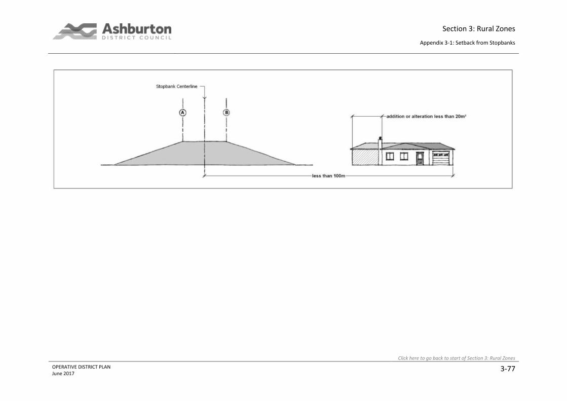
Section 3: Rural Zones
Appendix 3-1: Setback from Stopbanks
Click here to go back to start of Section 3: Rural Zones
OPERATIVE DISTRICT PLAN June 2017
3-77

Section 3: Rural Zones
Appendix 3-2: Areas of Significant Nature Conservation Value
Click here to go back to start of Section 3: Rural Zones
OPERATIVE DISTRICT PLAN August 2014
3-78
Appendix 3-2: Areas of Significant Nature Conservation Value
The following sites of known nature conservation significance have been currently identified within
Ashburton District. They represent plant and animal communities and habitats which are
representative, rare or unique within the District, or otherwise considered to be significant in terms
of Section 6(c) of the Resource Management Act. Those habitats, communities and natural features
which adjoin or encompass lakes, streams, rivers and wetlands also contribute to the natural character
and functioning of these water bodies in terms of Section 6(a).
Sites of nature conservation significance have largely been derived from the following information
sources:
1. Recommended Areas for Protection (RAP): Identified in the Heron Ecological Region PNAP
Survey Report; 1986, the Mathias and Mt Hutt Ecological District PRAP Survey Report, 1990,
and the Coleridge, Craigieburn and Cass Ecological District PNAP Report; 1990.
2. Special Sites of Wildlife Interest (SSWI): Wildlife habitat sites have been identified as follows:
a) Rangitata and Rakaia Rivers: O’Donnell, CFJ and Moore, SM, 1983; The Wildlife and
Conservation of Braided River Systems in Canterbury; - NZ Wildlife Service, Wellington.
b) Ashburton River: O’Donnell, CFJ, 1992; Birdlife of the Ashburton River, Canterbury, New
Zealand; Report prepared for Environment Canterbury. Report No. R92(36), Vol II.
c) Ashburton Lakes: Stokes, SJ, Grant, AG, 1992; Birdlife of the Upper Ashburton Catchment
and Their Habitat Requirements; - Report prepared for Environment Canterbury, No.
R92(36), Vol II.
d) Other areas: SSWI database held at Canterbury Conservancy Office, Department of
Conservation.
3. Mathias Ecological Area: Animal and Vegetation Survey 1986/86: Jane, GT, et al, 1989,
Department of Conservation.
4. Wetlands of Ecological and Representative Interest (WERI): The WERI database is an inventory
of all types of wetlands in New Zealand. It focuses on those wetlands which are ecologically
important or significant and which are representative of the natural diversity of the country.
The database is administered by the Department of Conservation.
5. Canterbury Plains Reconnaissance Survey: A survey of Plains vegetation remnants undertaken
by the Department of Conservation in 1992-93. The degree of modification of the original
indigenous vegetation has been so great that remaining areas are largely restricted to
scattered remnants, groups of plants or individual specimens. These sites are significant
because they:
a) represent the only remaining viable seed source of the indigenous vegetation of the
Plains;
b) contribute to the maintenance of genetic diversity;
Section 3: Rural Zones
Appendix 3-2: Areas of Significant Nature Conservation Value
Click here to go back to start of Section 3: Rural Zones
OPERATIVE DISTRICT PLAN August 2014
3-79
c) provide a basis for ecological restoration, particularly where they still exist on a particular
undisturbed soil type, as a basis for ecological restoration;
d) provide scientific benchmarks, contribute to landscape diversity and provide markers to
the past state of vegetation on the Plains.
6. Ecological Reports for Plan Change 10: A series of ecological reports undertaken generally
between 2006 and 2009 to review Group 2 sites for the purpose of evaluation leading to Plan
Change 10.
Only the highest ranked sites have been included here. However, retention of all remaining indigenous
vegetation remnants on the Plains, particularly those on undisturbed soils, is considered to be
important.
Where the site includes RAP(s), SSWI, or has a WERI listing, the name and/or reference number for
these is given. RAP’s are identified by Ecological District: A = Arrowsmith, H = Hakatere, MtH = Mt
Hutt, M = Mathias, C = Coleridge. References in the text to “district” are to the Ecological District.
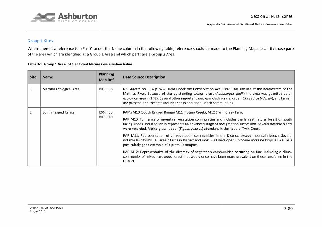
Section 3: Rural Zones
Appendix 3-2: Areas of Significant Nature Conservation Value
OPERATIVE DISTRICT PLAN August 2014
3-80
Group 1 Sites
Where there is a reference to “(Part)” under the Name column in the following table, reference should be made to the Planning Maps to clarify those parts
of the area which are identified as a Group 1 Area and which parts are a Group 2 Area.
Table 3-1: Group 1 Areas of Significant Nature Conservation Value
Site Name Planning
Map Ref Data Source Description
1 Mathias Ecological Area R03, R06 NZ Gazette no. 114 p.2432. Held under the Conservation Act, 1987. This site lies at the headwaters of the Mathias River. Because of the outstanding totara forest (Podocarpus hallii) the area was gazetted as an ecological area in 1985. Several other important species including rata, cedar (Libocedrus bidwillii), and kamahi are present, and the area includes shrubland and tussock communities.
2 South Ragged Range R06, R08, R09, R10
RAP’s M10 (South Ragged Range) M11 (Totara Creek), M12 (Twin Creek Fan):
RAP M10: Full range of mountain vegetation communities and includes the largest natural forest on south facing slopes. Induced scrub represents an advanced stage of revegetation succession. Several notable plants were recorded. Alpine grasshopper (Sigaus villosus) abundant in the head of Twin Creek.
RAP M11: Representation of all vegetation communities in the District, except mountain beech. Several notable landforms i.e. largest tarns in District and most well developed Holocene moraine loops as well as a particularly good example of a protalus rampart.
RAP M12: Representative of the diversity of vegetation communities occurring on fans including a climax community of mixed hardwood forest that would once have been more prevalent on these landforms in the District.
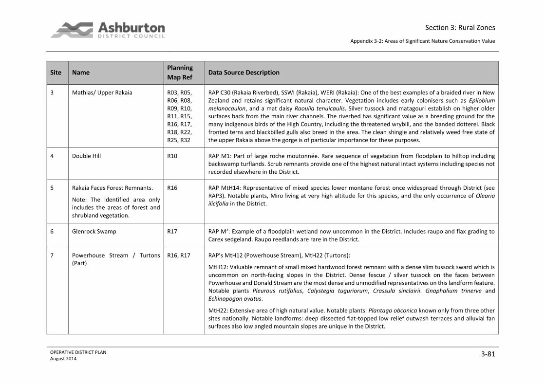
Section 3: Rural Zones
Appendix 3-2: Areas of Significant Nature Conservation Value
OPERATIVE DISTRICT PLAN August 2014
3-81
Site Name Planning
Map Ref Data Source Description
3 Mathias/ Upper Rakaia R03, R05, R06, R08, R09, R10, R11, R15, R16, R17, R18, R22, R25, R32
RAP C30 (Rakaia Riverbed), SSWI (Rakaia), WERI (Rakaia): One of the best examples of a braided river in New Zealand and retains significant natural character. Vegetation includes early colonisers such as Epilobium melanocaulon, and a mat daisy Raoulia tenuicaulis. Silver tussock and matagouri establish on higher older surfaces back from the main river channels. The riverbed has significant value as a breeding ground for the many indigenous birds of the High Country, including the threatened wrybill, and the banded dotterel. Black fronted terns and blackbilled gulls also breed in the area. The clean shingle and relatively weed free state of the upper Rakaia above the gorge is of particular importance for these purposes.
4 Double Hill R10 RAP M1: Part of large roche moutonnée. Rare sequence of vegetation from floodplain to hilltop including backswamp turflands. Scrub remnants provide one of the highest natural intact systems including species not recorded elsewhere in the District.
5 Rakaia Faces Forest Remnants.
Note: The identified area only includes the areas of forest and shrubland vegetation.
R16 RAP MtH14: Representative of mixed species lower montane forest once widespread through District (see RAP3). Notable plants, Miro living at very high altitude for this species, and the only occurrence of Olearia ilicifolia in the District.
6 Glenrock Swamp R17 RAP M²: Example of a floodplain wetland now uncommon in the District. Includes raupo and flax grading to Carex sedgeland. Raupo reedlands are rare in the District.
7 Powerhouse Stream / Turtons (Part)
R16, R17 RAP’s MtH12 (Powerhouse Stream), MtH22 (Turtons):
MtH12: Valuable remnant of small mixed hardwood forest remnant with a dense slim tussock sward which is uncommon on north-facing slopes in the District. Dense fescue / silver tussock on the faces between Powerhouse and Donald Stream are the most dense and unmodified representatives on this landform feature. Notable plants Pleurous rutifolius, Calystegia tuguriorum, Crassula sinclairii. Gnaphalium trinerve and Echinopogon ovatus.
MtH22: Extensive area of high natural value. Notable plants: Plantago obconica known only from three other sites nationally. Notable landforms: deep dissected flat-topped low relief outwash terraces and alluvial fan surfaces also low angled mountain slopes are unique in the District.

Section 3: Rural Zones
Appendix 3-2: Areas of Significant Nature Conservation Value
OPERATIVE DISTRICT PLAN August 2014
3-82
Site Name Planning
Map Ref Data Source Description
9 Hutt Stream fan R25 RAP MtH7: Contains two notable plants : prostate kowhai and Einadia allanii, both plants
10 Steepface Hill R24, R25 RAP MtH21 (Steepface Hill): Area representative of extensive very dense slim snow tussock on south facing slopes and extensive north facing broad leaved snow tussock, the latter now rare in the District.
11 Blackford Swamp R32 RAP C2: A small terrace tread flaxland wetland. One of very few on the south side of the Rakaia, and the least modified.
12 Pudding Hill/Mt Hutt (Part) R31, R32, R37, R38
RAP MtH13: Almost the entire area is contained within the Mt Hutt Conservation Area. It contains a high diversity of natural vegetation communities ranging from beech forest to subnival rocklands and fell field communities. Notable plants include Ileostylus micranthus, Gunnera densiflora, Haastia recurva, Epilobium rubromarginatum, Pseudopanax simplex, and Raoulia youngii.
13 Rakaia Gorge R32 Part RAP C1 (Rakaia Gorge and terraces): This area includes the steep faces and young alluvial terraces on the true right of the Rakaia River about the gorge bridge. The gorge contains spectacular exposures of Tertiary sediments. The face vegetation includes kowhai forest, with broadleaf, kohuhu, cabbage trees and lower montane sub-canopy species, with silver tussock and native grasses on the terrace. The site is one of the few remaining remnants of lower montane vegetation in Canterbury. Notable plants include a vulnerable native broom Carmichaelia kirkii which may still be present, the rare Hebe cupressoides and Anemanthele lessoniana on the gorge islands.

Section 3: Rural Zones
Appendix 3-2: Areas of Significant Nature Conservation Value
OPERATIVE DISTRICT PLAN August 2014
3-83
Site Name Planning
Map Ref Data Source Description
14 Alford Range (Part)
Note: resource consent/s granted provide for the following activities to be conducted within part of this area: stockpiling of lime, maintenance and realignment of quarry access roads and clearance of vegetation.
R31, R37, R43
RAP MtH1 (Alford Range Wetlands), RAP MtH5 (Grahams Creek), RAP MtH6 (Hutt Forest Remnants):
RAP MtH1: Contains red tussock and cushion bogs which are rare in the District particularly on mountain top hollows. Notable plants: Centrolepis ciliata which is uncommon in Canterbury. The moss Campylopus bicolor and liverwort Riccardia lobulata are also rare regionally.
RAP MtH5: Contains rare Canterbury pink broom in representative Olearia virgata var. rugosa shrubland.
RAP MtH6: A number of forest remnants mainly on colluvial mountain slopes in shaded gullies with frequent rock exposures above a number of steep, often cascading streams. Provides example of previous extensive forest cover from interior to High Plains Ecological District with successional distinctive features. Notable geologic feature: contact between Pudding Hill Formation and Clent Hill Group marked by Taylors Stream.
15 Middle Creek (Part) R24, R31 RAP MtH9: A relatively large catchment which has escaped recent major fires allowing forest and shrubland species to recover. Contains the most natural vegetation, and in particular, the best scrub representation, in the dry central part of the Mt Hutt District. Vegetation includes the most extensive areas of Halls totara, mountain toatoa scrub and slim snow tussock in the District. Other notable plants include Raoulia petriensis and Colobanthus buchananii.
16 Winterslow R30, R31, R36, R37
RAP MtH24: Large area of moderate to high natural value containing a diversity of landforms and vegetation representative of the District. Notable landform: Area is example of an infilled, enclosed intermontane basin unique in the District. A type sequence for the Finger Formation is found in the area as well as a reference locality for marine facies of the Clent Hills Group.
17 Mount Somers
Note: area identified on Map 1 below which provides for maintenance of an existing track to a maximum 6 metres in width.
R36, R37, R42, R43
RAP MtH 10: This RAP contains the greatest diversity of natural features in the District including over 400 vascular plants recorded, a wide range of soil parent materials, topography and vegetation communities. Notable plants: Baumea rubiginosa and several bog species rare nationally and regionally including the northern hemisphere Dicranum scoparium, Plantago obconica and Centrolepis pallida. Notable landforms include the volcanic plateau of Mt Somers with its upper surface of ignimbrite. Bird species include falcon and blue duck. An unnamed species of weta is recorded from above Woolshed Creek.

Section 3: Rural Zones
Appendix 3-2: Areas of Significant Nature Conservation Value
OPERATIVE DISTRICT PLAN August 2014
3-84
Site Name Planning
Map Ref Data Source Description
18 East branch Stour River R36 RAP MtH4: Representative of vegetation and landforms rarely represented elsewhere in the District including red tussock grassland on lateral moraine and bog pine shrubland on terraces. The northern area contains 20 bog pine.
19 Palmer Range (Part) R10, R16, R23
RAP’s MtH3 (Double Hill – Glenariffe Streams), MtH11 (Nell Stream), MtH17 (Ribbonwood Stream), MtH19 (Smite-Godley), MtH20 (Station Creek):
MtH3: Full altitudinal sequence of natural communities. Largest area of mountain beech and mixed hardwoods in Rakaia system.
MtH11: RAP contains a high diversity of very natural vegetation communities ranging from silver beech forest, through tall tussocklands and subalpine scrub, to alpine herbfields and subnival communities.
MtH17: Contains a wide range of vegetation communities in a catchment without forest cover including scrub, tall tussockland, flush, tarns, scree and fellfield.
MtH19: Contains a wide variety of vegetation communities and glacial landforms representative of the District.
MtH20: Largest diversity of vegetation types of any catchment in this part of the District, including dense slim snow tussock and extensive scrub areas.
20 Charlie Stream R15 RAP MtH2: Wide range of vegetation communities with few adventives. Notable for presence of silver beech, as well as mountain beech and species rich sub-alpine scrub.
21 Leach Stream R15 RAP MtH8: Representative of the full altitude range in the District and a large number of vegetation communities. Of note is an extensive hummocky moraine in the cirque basin and a 3ha area of forest on river terrace, an ecological unit rare in the District.
22 Shingly Creek
Note: The identified area only includes areas of forest/scrub vegetation.
R09, R10, R15, R16
RAP MtH18: Contains three large mixed hardwood forest remnants, including an area on a terrace tread, and extensive Brachyglottis cassinioides dominated scrub.

Section 3: Rural Zones
Appendix 3-2: Areas of Significant Nature Conservation Value
OPERATIVE DISTRICT PLAN August 2014
3-85
Site Name Planning
Map Ref Data Source Description
24 Lower Lake Stream / Prospect Hill R09, R15 RAP M8 (Prospect Hill), A8 (Lower Lake Stream Forest Remnants), H1 (Bush Creek Fan). RAP M8:
H1: Represents fan sequence typical of streams draining the adjacent short, steep, east facing catchments of the Arrowsmith District. Contains large areas of dry red tussock, associated cotton plant, and fescue tussocklands. Adjoins the southern part of A8.
A8: bush and scrub remnants on the lower steep sided gullies and river gorges facing Lake Stream and the Rakaia. Represents the only pre-European forest vegetation in the District (principally mountain beech) and the only silver beech. These areas provide important fauna habitat (tomtit, brown creeper, rifleman and New Zealand falcon are all found in the area). Also includes shrubland communities representing those found on the northern Rakaia faces.
M8: Comprises unusual drumlin-like terminal moraines related to Lake Stream glacial advance, many small tarns, as well as Quagmire Tarn and its margins. Notable plants include bog pine at Quagmire Tarn, and a sedge mossland, a vegetation community not known from elsewhere in the Mathias District.
25 Cameron / Middle Hill (Part)
Note: area identified on Map 2 below which provides for maintenance of an existing track to a maximum 6 metres in width.
Note: area identified on Maps 3 and 4 below which provide for removal of matagouri.
R14, R15, R21, R22
RAP’s A7 (Cameron River), A9 (Rocky Gorge), A10 (Lawsley Faces), A11 (Lawsley Red Tussock):
A7: The Cameron River valley provides the most extensive example of many of the major vegetation types identified in the ecological region, and is one of the most important representative areas in the District. Contains vegetation communities associated with recent glaciation and good examples of both altitudinal and climatic gradients. Plant associations include fell field, rock and scree communities and moraine sequences. There are extensive high altitude and valley floor tussock communities and shrublands. The catchment provides buffer for wetlands below. Blue duck and New Zealand falcon have been recorded from the area. The upper valley contains a good example of moraine loop in terminal moraine.
A9: A medium sized mountain catchment with a winding, deeply gorged stream draining into Lake Stream. Provides a good example of beech forest, tussocklands and shrublands representative of these east facing catchments. New Zealand falcon have been recorded in the area.
A10: This area represents the altitudinal variation of vegetation on the front faces. Contains tussocklands in good condition including C. rigida, and C. macra, and shrublands of Dracophyllum spp and matagouri.
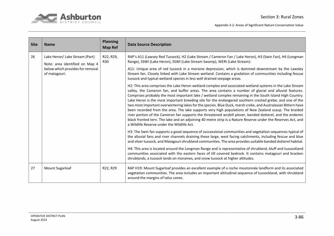
Section 3: Rural Zones
Appendix 3-2: Areas of Significant Nature Conservation Value
OPERATIVE DISTRICT PLAN August 2014
3-86
Site Name Planning
Map Ref Data Source Description
26 Lake Heron/ Lake Stream (Part)
Note: area identified on Map 4 below which provides for removal of matagouri.
R22, R29, R30
RAP’s A11 (Lawsey Red Tussock), H2 (Lake Stream / Cameron Fan / Lake Heron), H3 (Swin Fan), H4 (Longman Range), SSWI (Lake Heron), SSWI (Lake Stream Swamp), WERI (Lake Stream):
A11: Unique area of red tussock in a moraine depression, which is dammed downstream by the Lawsley Stream fan. Closely linked with Lake Stream wetland. Contains a gradation of communities including fescue tussock and typical wetland species in less well drained seepage areas.
H2: This area comprises the Lake Heron wetland complex and associated wetland systems in the Lake Stream valley, the Cameron fan, and buffer areas. The area contains a number of glacial and alluvial features. Comprises probably the most important lake / wetland complex remaining in the South Island High Country. Lake Heron is the most important breeding site for the endangered southern crested grebe, and one of the two most important overwintering lakes for the species. Blue Duck, marsh creke, and Australasian Bittern have been recorded from the area. The lake supports very high populations of New Zealand scaup. The braided river portion of the Cameron fan supports the threatened wrybill plover, banded dotterel, and the endemic black fronted tern. The lake and an adjoining 40 metre strip is a Nature Reserve under the Reserves Act, and a Wildlife Reserve under the Wildlife Act.
H3: The Swin fan supports a good sequence of successional communities and vegetation sequences typical of the alluvial fans and river channels draining these large, west facing catchments, including fescue and blue and silver tussock, and Matagouri shrubland communities. The area provides suitable banded dotterel habitat.
H4: This area is located around the Longman Range and is representative of shrubland, bluff and tussockland communities associated with the eastern faces of till covered bedrock. It contains matagouri and bracken shrublands, a tussock lands on moraines, and snow tussock at higher altitudes.
27 Mount Sugarloaf R22, R29 RAP H19: Mount Sugarloaf provides an excellent example of a roche moutonnée landform and its associated vegetation communities. The area includes an important altitudinal sequence of tussockland, with shrubland around the margins of talus zones.

Section 3: Rural Zones
Appendix 3-2: Areas of Significant Nature Conservation Value
OPERATIVE DISTRICT PLAN August 2014
3-87
Site Name Planning
Map Ref Data Source Description
28 Lake Emily (Part) R36 RAP H5 (Lake Emily), SSWI (Manuka Lake):
These areas comprise Lake Emily and the associated wetlands, tussock grassland communities on the SW face of Emily Hill, and Manuka Lake. The Lake Emily wetlands are one of the best examples of a small lake wetland system in the District. The area contains a mosaic of wetland communities merging into red tussock dominated communities on moraine surfaces. Southern crested grebe are present on Lake Emily and Manuka Lake supports a wide range of waterfowl.
29 Maori Lakes R35 RAP H6: An important small lake wetland system which includes large stands of raupo, and a wide range of other wetland species. The lakes and wetlands are slowly being infilled by natural depositional processes. The complex provides attractive habitat for waterfowl, including crested grebe, Australasian bittern, and marsh crake.
32 Upper Harding Stream R29, R35 RAP A6: Consists of gently rolling plateau area above Lake Heron with tussock associations on dry, well drained moraine surface, with some damper seepage areas. Contains the most extensive area of red tussock on dry, well drained moraine surfaces in the Arrowsmith District.
33 Upper Lawrence R14, R21 RAP A1: This catchment faces the Lawrence River and represents the forest, shrublands, and tussocklands of the higher rainfall, north-western part of the District. The RAP includes the best example of mountain totara forests in the District in addition to good examples of shrub and tussocklands and representative altitudinal sequences.
34 Hermitage Boulderfield R21 RAP A2: This site represents a unique vegetation community associated with an old stable rockfall. The rockfall is the result of a slope failure on the mountain slopes of the Jollie Range. The vegetation is characterised by areas of mountain toatoa, broadleaf, Pittosporum tenuifolium, and Phyllocladus alpinus growing amongst large boulders. There are also patches of snow totara and Dracophyllum spp.
35 Lizard Gully R27, R28 RAP A3: Includes representative examples (in altitude and aspect sequences) of several communities typical of the western ranges of the District. Contains the only example of Myrsine divaricata forest in the district, as well as good examples of Brachyglottis cassinioides / Phyllocladus alpinus shrublands, and mountain beech, with tussock grasslands in good condition at the head of the catchment.
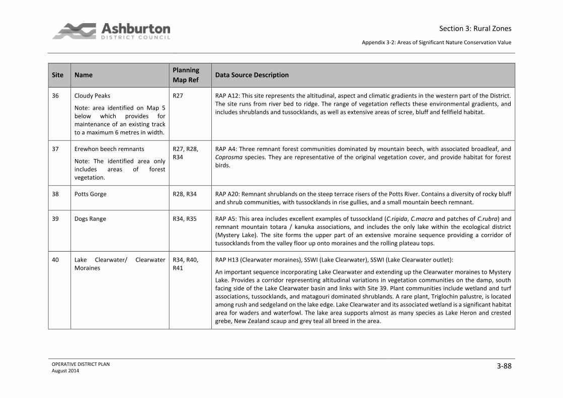
Section 3: Rural Zones
Appendix 3-2: Areas of Significant Nature Conservation Value
OPERATIVE DISTRICT PLAN August 2014
3-88
Site Name Planning
Map Ref Data Source Description
36 Cloudy Peaks
Note: area identified on Map 5 below which provides for maintenance of an existing track to a maximum 6 metres in width.
R27 RAP A12: This site represents the altitudinal, aspect and climatic gradients in the western part of the District. The site runs from river bed to ridge. The range of vegetation reflects these environmental gradients, and includes shrublands and tussocklands, as well as extensive areas of scree, bluff and fellfield habitat.
37 Erewhon beech remnants
Note: The identified area only includes areas of forest vegetation.
R27, R28, R34
RAP A4: Three remnant forest communities dominated by mountain beech, with associated broadleaf, and Coprosma species. They are representative of the original vegetation cover, and provide habitat for forest birds.
38 Potts Gorge R28, R34 RAP A20: Remnant shrublands on the steep terrace risers of the Potts River. Contains a diversity of rocky bluff and shrub communities, with tussocklands in rise gullies, and a small mountain beech remnant.
39 Dogs Range R34, R35 RAP A5: This area includes excellent examples of tussockland (C.rigida, C.macra and patches of C.rubra) and remnant mountain totara / kanuka associations, and includes the only lake within the ecological district (Mystery Lake). The site forms the upper part of an extensive moraine sequence providing a corridor of tussocklands from the valley floor up onto moraines and the rolling plateau tops.
40 Lake Clearwater/ Clearwater Moraines
R34, R40, R41
RAP H13 (Clearwater moraines), SSWI (Lake Clearwater), SSWI (Lake Clearwater outlet):
An important sequence incorporating Lake Clearwater and extending up the Clearwater moraines to Mystery Lake. Provides a corridor representing altitudinal variations in vegetation communities on the damp, south facing side of the Lake Clearwater basin and links with Site 39. Plant communities include wetland and turf associations, tussocklands, and matagouri dominated shrublands. A rare plant, Triglochin palustre, is located among rush and sedgeland on the lake edge. Lake Clearwater and its associated wetland is a significant habitat area for waders and waterfowl. The lake area supports almost as many species as Lake Heron and crested grebe, New Zealand scaup and grey teal all breed in the area.

Section 3: Rural Zones
Appendix 3-2: Areas of Significant Nature Conservation Value
OPERATIVE DISTRICT PLAN August 2014
3-89
Site Name Planning
Map Ref Data Source Description
41 Spider Lakes R41 RAP H11, SSWI: A unique set of moraine tarns and vegetation communities associated with highly varied topography. Water levels fluctuate in some tarns. The larger tarns have unique turf communities around their margins. The hummocky topography around the lakes supports areas of matagouri, dry grasslands and blue tussock. On terrace surfaces and moraines snow tussock, fescue, cotton plant and golden spaniard are present.
42 Upper Ashburton R35, R41, R42, R49
RAP H10 (Ashburton Fans) The upper Ashburton above the gorge is a significant stretch of braided river bed relatively clear of vegetation encroachment. The fan supports an important sequence of community types including cushion plants around the stream channel, and matagouri-mixed shrubland, fescue and snow and blue tussock on the terraces. It supports important bird species including wrybill plover and black fronted tern. Banded dotterel, black billed gull are also present. Bittern have also been recorded.
43 Lake Emma R41 RAP H12, SSWI (Lake Emma), SSWI (Lake Roundabout): This lake and basin wetland system is one of the most extensive in the District. Sequences of vegetation from open water to dry fans are represented. Behind the shoreline vegetation there is a mosaic of wetland communities, with matagouri dominated shrublands on the Balmacaan Stream fan. Lakes Emma and Roundabout and their linking wetlands provide excellent waterfowl habitat, with high species diversity and bird numbers. New Zealand scaup, New Zealand shoveller, grey teal and crested grebe are present. Grebe have bred in the area, bittern have been recorded, and rails may also be present.
44 Lake Denny R41, R48 RAP H22, SSWI: Lake Denny is a typical small lake system on an outwash surface. Raupo on the lake edges indicate that the lake is slowly being infilled. The lake and associated wetland support a variety of waterfowl including endangered and threatened species. Crested grebes and scaup regularly occur at the lake, and New Zealand shoveller, bittern and grey teal are present. Bittern are likely to be breeding in the area, and rails may be present.
45 Moorhouse Range R48, R49 RAP H15: A corridor representing altitudinal and aspect variations and representative vegetation communities characteristic of the Moorhouse Range. The area includes Chionochloa rigida, Poa Colensoi, Cyathodes fraseri and Dracophyllum spp. at higher altitudes.

Section 3: Rural Zones
Appendix 3-2: Areas of Significant Nature Conservation Value
OPERATIVE DISTRICT PLAN August 2014
3-90
Site Name Planning
Map Ref Data Source Description
46 North Branch Hinds River R49 RAP H16: An area of river gorge that contains good shrubland remnants, including scattered bushes of the endangered Canterbury pink broom.
47 Pudding Swamp R48 SSWI : Modified rush and sedge wetland on Pudding Stream.
48 Upper Rangitata River R33, R34 RAP H21 (Rangitata River), SSWI (Rangitata River), WERI: An extensive area of braided river which provides a range of habitats for flora and fauna. Successional sequences are well represented and are maintained by active channelling and periodic reflooding. The bed is relatively weed free and provides an important habitat for several endangered bird species including blue duck (recorded breeding in the gorge), and the wrybill plover. South Island pied oystercatcher, black fronted tern, banded dotterel, and black billed gull are also present. The Potts fan is included in this area because of its habitat value for wrybill plover, banded dotterel, and a black stilt record.
49 Lower Rangitata River R13, R19, R20, R21, R26, R27, R33, R34, R40, R47, R48, R55, R56, R62, R69, R76, R77, R82, R86, R89, R90
SSWI (Rangitata), WERI: This river is one of the largest braided rivers in Canterbury. The river supports all the typical braided river bird species of Canterbury, including the threatened wrybill and black fronted tern, and black billed gull.
50 Coldstream Plains Area R87 PLAINS SURVEY NE023: Dense Carex secta thread along a stream.
60 Note: The identified area only includes the area of forest vegetation
R43 PLAINS SURVEY NW009: Beech forest remnant.
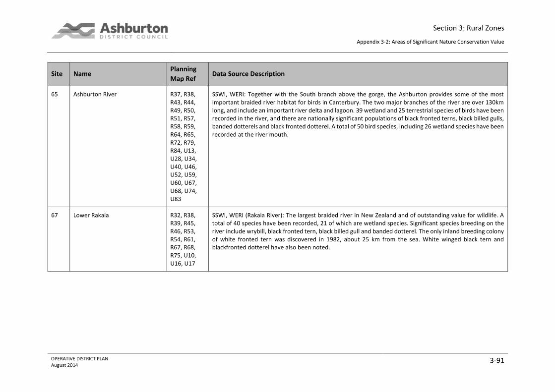
Section 3: Rural Zones
Appendix 3-2: Areas of Significant Nature Conservation Value
OPERATIVE DISTRICT PLAN August 2014
3-91
Site Name Planning
Map Ref Data Source Description
65 Ashburton River R37, R38, R43, R44, R49, R50, R51, R57, R58, R59, R64, R65, R72, R79, R84, U13, U28, U34, U40, U46, U52, U59, U60, U67, U68, U74, U83
SSWI, WERI: Together with the South branch above the gorge, the Ashburton provides some of the most important braided river habitat for birds in Canterbury. The two major branches of the river are over 130km long, and include an important river delta and lagoon. 39 wetland and 25 terrestrial species of birds have been recorded in the river, and there are nationally significant populations of black fronted terns, black billed gulls, banded dotterels and black fronted dotterel. A total of 50 bird species, including 26 wetland species have been recorded at the river mouth.
67 Lower Rakaia R32, R38, R39, R45, R46, R53, R54, R61, R67, R68, R75, U10, U16, U17
SSWI, WERI (Rakaia River): The largest braided river in New Zealand and of outstanding value for wildlife. A total of 40 species have been recorded, 21 of which are wetland species. Significant species breeding on the river include wrybill, black fronted tern, black billed gull and banded dotterel. The only inland breeding colony of white fronted tern was discovered in 1982, about 25 km from the sea. White winged black tern and blackfronted dotterel have also been noted.

Section 3: Rural Zones
Appendix 3-2: Areas of Significant Nature Conservation Value
OPERATIVE DISTRICT PLAN August 2014
3-92
Group 2 Sites
Where there is a reference to “(Part)” under the name column in the following table, reference should be made to the planning maps to clarify those parts
of the site which are identified as a Group 2 area and which parts are a Group 1 Area.
Table 3-2: Group 2 Areas of Significant Nature Conservation Value
Site Name Map Ref Data Source Description
7 Powerhouse Stream / Turtons (Part)
R17 RAP’s MtH12 (Powerhouse Stream), MtH22 (Turtons): MtH12: Valuable remnant of small mixed hardwood forest remnant with a dense slim tussock sward which is uncommon on north-facing slopes in the District. Dense fescue / silver tussock on the faces between Powerhouse and Donald Stream are the most dense and unmodified representatives on this landform feature. Notable plants Pleurous rutifolius, Calystegia tuguriorum, Crassula sinclairii. Gnaphalium trinerve and Echinopogon ovatus.
MtH22: Extensive area of high natural value. Notable plants: Plantago obconica known only from three other sites nationally. Notable landforms: deep dissected flat-topped low relief outwash terraces and alluvial fan surfaces also low angled mountain slopes are unique in the District.
8 Redcliffe R17, R24 RAP’s MtH 15 (Redcliffe Hill), 16 (Redcliffe Saddle):
MtH 15: Shaded slopes contain riparian forest that are remnants of original cover, which is no longer common in the District. A landform feature is the spectacular cliffs of eroded outwash gravels not occurring elsewhere in the District.
MtH 16: Redcliffe Saddle. This RAP contains vegetation communities which are uncommon in the District, and not represented in other RAPs including red tussock on ablation moraine and areas of dense short tussock as well as the only valley floor tarn in the District. Bog pines present were the only ones recorded in the northern sector.

Section 3: Rural Zones
Appendix 3-2: Areas of Significant Nature Conservation Value
OPERATIVE DISTRICT PLAN August 2014
3-93
Site Name Map Ref Data Source Description
12 Pudding Hill / Mt Hutt (Part) R37 RAP MtH13: Almost the entire area is contained within the Mt Hutt Conservation Area. It contains a high diversity of natural vegetation communities ranging from beech forest to subnival rocklands and fell field communities. Notable plants include Ileostylus micranthus, Gunnera densiflora, Haastia recurva, Epilobium rubromarginatum, Pseudopanax simplex, and Raoulia youngii.
15 Middle Creek (Part) R24, R31 RAP MtH9: A relatively large catchment which has escaped recent major fires allowing forest and shrubland species to recover. Contains the most natural vegetation, and in particular, the best scrub representation, in the dry central part of the Mt Hutt District. Vegetation includes the most extensive areas of Halls totara, mountain toatoa scrub and slim snow tussock in the District. Other notable plants include Raoulia petriensis and Colobanthus buchananii.
19 Palmer Range (Part) R10, R15, R16, R22, R23
RAP’s MtH3 (Double Hill – Glenariffe Streams), MtH11 (Nell Stream), MtH17 (Ribbonwood Stream), MtH19 (Smite-Godley), MtH20 (Station Creek):
MtH3: Full altitudinal sequence of natural communities. Largest area of mountain beech and mixed hardwoods in Rakaia system.
MtH11: RAP contains a high diversity of very natural vegetation communities ranging from silver beech forest, through tall tussocklands and subalpine scrub, to alpine herbfields and subnival communities.
MtH17: Contains a wide range of vegetation communities in a catchment without forest cover including scrub, tall tussockland, flush, tarns, scree and fellfield.
MtH19: Contains a wide variety of vegetation communities and glacial landforms representative of the District.
MtH20: Largest diversity of vegetation types of any catchment in this part of the District, including dense slim snow tussock and extensive scrub areas.
23 Whaleback Fans R09, R15 RAP MtH23: Two merging fans located at the mouths of two separate catchments which have been dammed behind a roche moutonnée. Representative of a natural vegetation community on large fans, which are characteristic of the District but are no longer covered in original natural vegetation. Contains dense tall matagouri, and scattered shrubs.
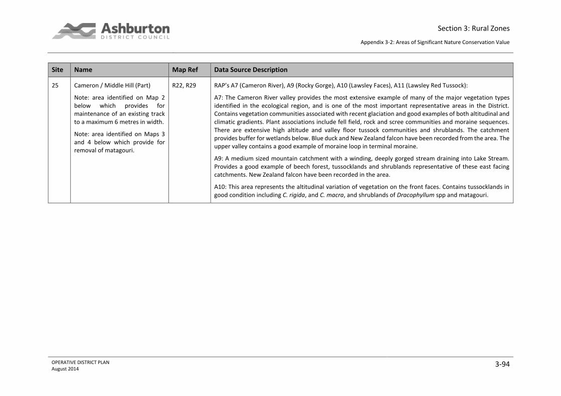
Section 3: Rural Zones
Appendix 3-2: Areas of Significant Nature Conservation Value
OPERATIVE DISTRICT PLAN August 2014
3-94
Site Name Map Ref Data Source Description
25 Cameron / Middle Hill (Part)
Note: area identified on Map 2 below which provides for maintenance of an existing track to a maximum 6 metres in width.
Note: area identified on Maps 3 and 4 below which provide for removal of matagouri.
R22, R29 RAP’s A7 (Cameron River), A9 (Rocky Gorge), A10 (Lawsley Faces), A11 (Lawsley Red Tussock):
A7: The Cameron River valley provides the most extensive example of many of the major vegetation types identified in the ecological region, and is one of the most important representative areas in the District. Contains vegetation communities associated with recent glaciation and good examples of both altitudinal and climatic gradients. Plant associations include fell field, rock and scree communities and moraine sequences. There are extensive high altitude and valley floor tussock communities and shrublands. The catchment provides buffer for wetlands below. Blue duck and New Zealand falcon have been recorded from the area. The upper valley contains a good example of moraine loop in terminal moraine.
A9: A medium sized mountain catchment with a winding, deeply gorged stream draining into Lake Stream. Provides a good example of beech forest, tussocklands and shrublands representative of these east facing catchments. New Zealand falcon have been recorded in the area.
A10: This area represents the altitudinal variation of vegetation on the front faces. Contains tussocklands in good condition including C. rigida, and C. macra, and shrublands of Dracophyllum spp and matagouri.
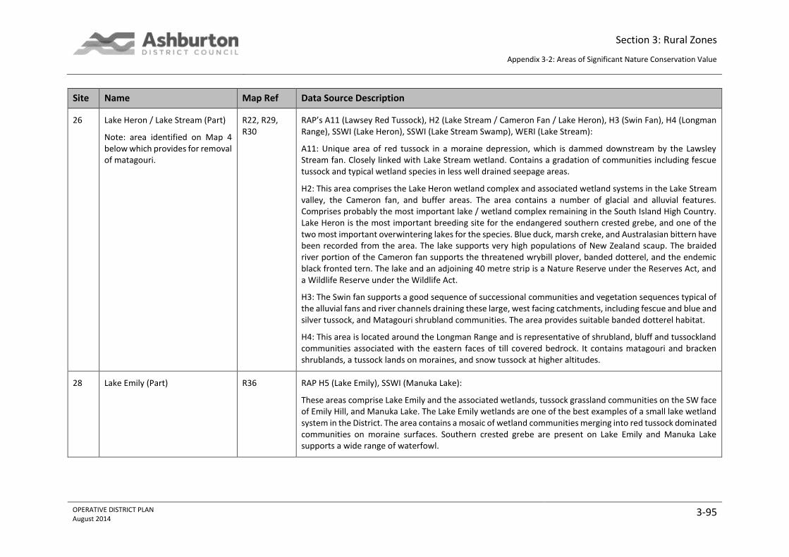
Section 3: Rural Zones
Appendix 3-2: Areas of Significant Nature Conservation Value
OPERATIVE DISTRICT PLAN August 2014
3-95
Site Name Map Ref Data Source Description
26 Lake Heron / Lake Stream (Part)
Note: area identified on Map 4 below which provides for removal of matagouri.
R22, R29, R30
RAP’s A11 (Lawsey Red Tussock), H2 (Lake Stream / Cameron Fan / Lake Heron), H3 (Swin Fan), H4 (Longman Range), SSWI (Lake Heron), SSWI (Lake Stream Swamp), WERI (Lake Stream):
A11: Unique area of red tussock in a moraine depression, which is dammed downstream by the Lawsley Stream fan. Closely linked with Lake Stream wetland. Contains a gradation of communities including fescue tussock and typical wetland species in less well drained seepage areas.
H2: This area comprises the Lake Heron wetland complex and associated wetland systems in the Lake Stream valley, the Cameron fan, and buffer areas. The area contains a number of glacial and alluvial features. Comprises probably the most important lake / wetland complex remaining in the South Island High Country. Lake Heron is the most important breeding site for the endangered southern crested grebe, and one of the two most important overwintering lakes for the species. Blue duck, marsh creke, and Australasian bittern have been recorded from the area. The lake supports very high populations of New Zealand scaup. The braided river portion of the Cameron fan supports the threatened wrybill plover, banded dotterel, and the endemic black fronted tern. The lake and an adjoining 40 metre strip is a Nature Reserve under the Reserves Act, and a Wildlife Reserve under the Wildlife Act.
H3: The Swin fan supports a good sequence of successional communities and vegetation sequences typical of the alluvial fans and river channels draining these large, west facing catchments, including fescue and blue and silver tussock, and Matagouri shrubland communities. The area provides suitable banded dotterel habitat.
H4: This area is located around the Longman Range and is representative of shrubland, bluff and tussockland communities associated with the eastern faces of till covered bedrock. It contains matagouri and bracken shrublands, a tussock lands on moraines, and snow tussock at higher altitudes.
28 Lake Emily (Part) R36 RAP H5 (Lake Emily), SSWI (Manuka Lake):
These areas comprise Lake Emily and the associated wetlands, tussock grassland communities on the SW face of Emily Hill, and Manuka Lake. The Lake Emily wetlands are one of the best examples of a small lake wetland system in the District. The area contains a mosaic of wetland communities merging into red tussock dominated communities on moraine surfaces. Southern crested grebe are present on Lake Emily and Manuka Lake supports a wide range of waterfowl.

Section 3: Rural Zones
Appendix 3-2: Areas of Significant Nature Conservation Value
OPERATIVE DISTRICT PLAN August 2014
3-96
Site Name Map Ref Data Source Description
30 Clent Hills R35, R36, R42
RAP’s H7 (Potato), H8 (Clent Hill Boulderfield):
H7: A very good example of high moraine terrace vegetation dominated by tussock grassland associations. Includes altitudinal sequences with flush zones.
H8: The largest of a number of relict screes along the western slopes of the Clent Hills. This area and its boulderfield represents the best example of tussock and shrubland communities in the District. The areas around and below the boulderfield support dense shrubland associations including mountain ribbonwood, coprosma ciliata, hebe rakaiensis, and matagouri.
31 Stour shrub remnants R36, R42 RAP H14: This area represents the mosaic of vegetation associations found on the rhyolitic and andesitic volcanic rocks on the Clent Hills. These include mixed shrub communities, snow tussock, and kanuka and mountain beech remnants which are uncommon elsewhere.

Section 3: Rural Zones
Appendix 3-2: Areas of Significant Nature Conservation Value
OPERATIVE DISTRICT PLAN August 2014
3-97
Maps
Map 1: Provision for Existing Track
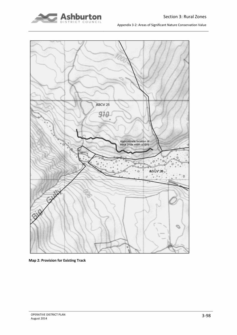
Section 3: Rural Zones
Appendix 3-2: Areas of Significant Nature Conservation Value
OPERATIVE DISTRICT PLAN August 2014
3-98
Map 2: Provision for Existing Track

Section 3: Rural Zones
Appendix 3-2: Areas of Significant Nature Conservation Value
OPERATIVE DISTRICT PLAN August 2014
3-99
Map 3: Matagouri Clearance Area

Section 3: Rural Zones
Appendix 3-2: Areas of Significant Nature Conservation Value
OPERATIVE DISTRICT PLAN August 2014
3-100
Map 4: Matagouri Clearance Area
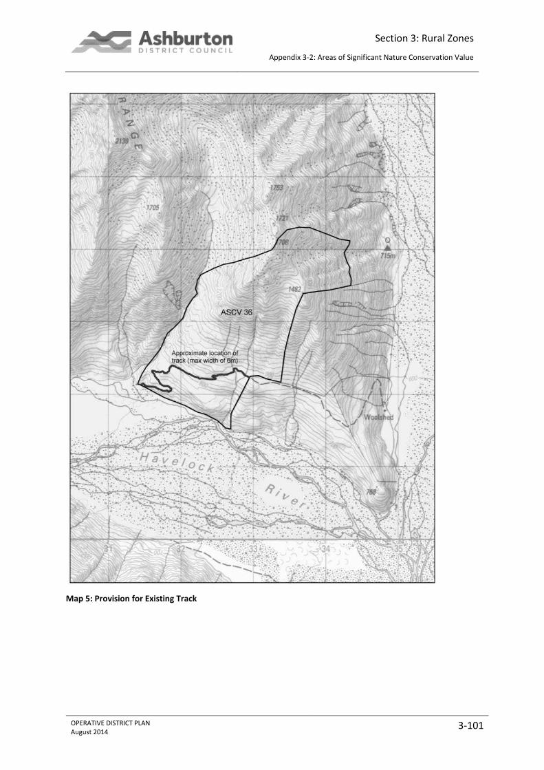
Section 3: Rural Zones
Appendix 3-2: Areas of Significant Nature Conservation Value
OPERATIVE DISTRICT PLAN August 2014
3-101
Map 5: Provision for Existing Track
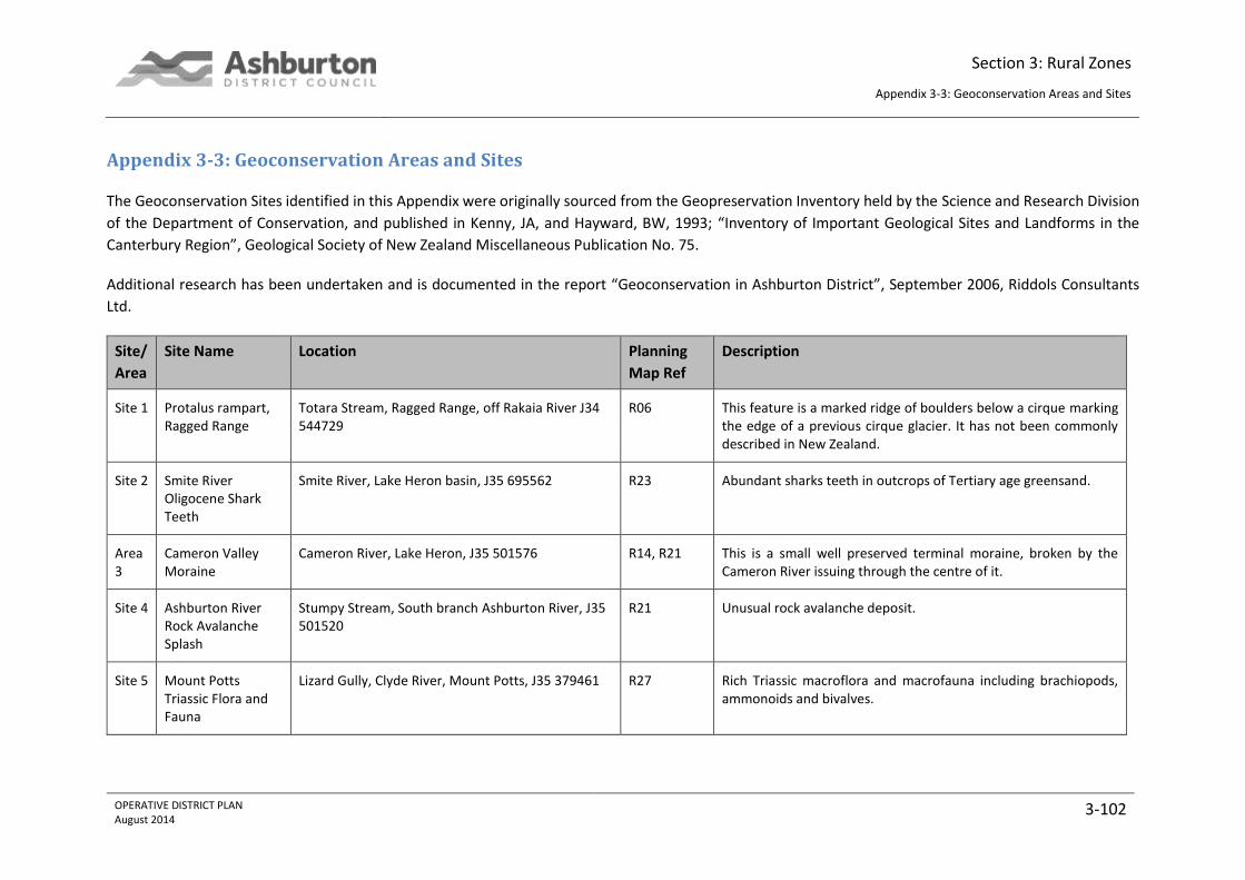
Section 3: Rural Zones
Appendix 3-3: Geoconservation Areas and Sites
OPERATIVE DISTRICT PLAN August 2014
3-102
Appendix 3-3: Geoconservation Areas and Sites
The Geoconservation Sites identified in this Appendix were originally sourced from the Geopreservation Inventory held by the Science and Research Division
of the Department of Conservation, and published in Kenny, JA, and Hayward, BW, 1993; “Inventory of Important Geological Sites and Landforms in the
Canterbury Region”, Geological Society of New Zealand Miscellaneous Publication No. 75.
Additional research has been undertaken and is documented in the report “Geoconservation in Ashburton District”, September 2006, Riddols Consultants
Ltd.
Site/
Area
Site Name Location Planning
Map Ref
Description
Site 1 Protalus rampart, Ragged Range
Totara Stream, Ragged Range, off Rakaia River J34 544729
R06 This feature is a marked ridge of boulders below a cirque marking the edge of a previous cirque glacier. It has not been commonly described in New Zealand.
Site 2 Smite River Oligocene Shark Teeth
Smite River, Lake Heron basin, J35 695562 R23 Abundant sharks teeth in outcrops of Tertiary age greensand.
Area 3
Cameron Valley Moraine
Cameron River, Lake Heron, J35 501576 R14, R21 This is a small well preserved terminal moraine, broken by the Cameron River issuing through the centre of it.
Site 4 Ashburton River Rock Avalanche Splash
Stumpy Stream, South branch Ashburton River, J35 501520
R21 Unusual rock avalanche deposit.
Site 5 Mount Potts Triassic Flora and Fauna
Lizard Gully, Clyde River, Mount Potts, J35 379461 R27 Rich Triassic macroflora and macrofauna including brachiopods, ammonoids and bivalves.

Section 3: Rural Zones
Appendix 3-3: Geoconservation Areas and Sites
OPERATIVE DISTRICT PLAN August 2014
3-103
Site/
Area
Site Name Location Planning
Map Ref
Description
Site 6 Mount Potts Triassic Plant Beds
Tank Gully, Clyde River, Mount Potts, J35 378446 R27 Well preserved fossil plant beds within weathered exposures of greywacke.
Site 7 Balmacaan Middle Triassic Faunas
Balmacaan Stream, Harper Range, J36 518283. R40 Important fossil locality used to date Torlesse Group rocks.
Site 8 Lake Heron Fault and Alluvial Terrace Offset
Hakatere Basin
R22, R29, R41
The active Lake Heron Fault trends along the west side of the Hakatere Basin from Mount Harper to west of Lake Heron. There is clear evidence of Late Quaternary faulting along several parts of its length. Three specific area of fault trace evidence have previously been proposed for inclusion in the plan.
H J36 592343 Fault displacing degradational terraces.
I J36 598357 Fault trace is clearly seen as a notch on the terrace edge of the Ashburton River and is perhaps the most visible evidence of faulting.
3A4 J36 570313 Moraine is draped over the older fault scarp. The trace is clearly visible from air photos and from any elevation around the basin.
Area 9
Swin River Alluvial Fan
Swin River, Lake Heron, J35 686 438 R30 Active fan being built out into Swin River to the north west and thus the Rakaia catchment and into Seagull lake to south west which is thought to drain into the Ashburton catchment. It is unusual for a fan to be at a catchment divide.
Site 10
Mount Somers Tidal Sand Quarry
13516 Ashburton Gorge Road, K36 727277 R42 Silica sand of Paleogene age was originally quarried to make glass, but now has other uses. The fine grained quartz sand exhibits very good cross bedding.
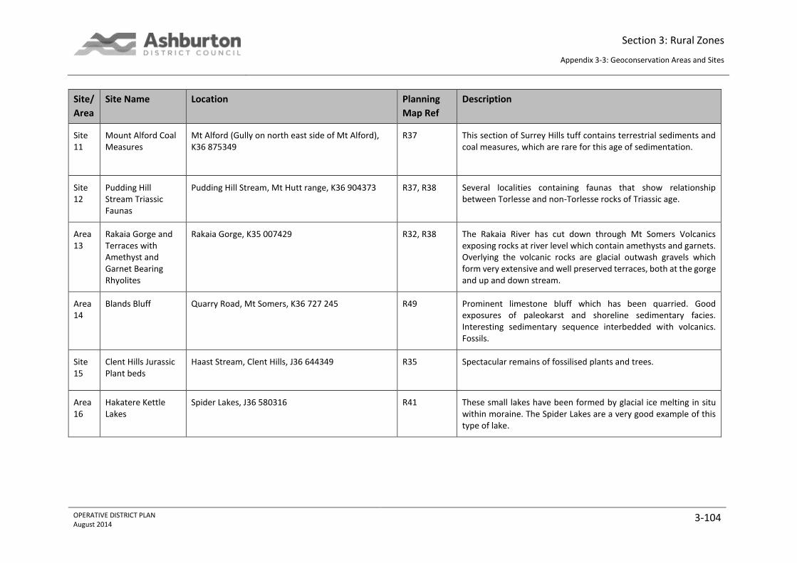
Section 3: Rural Zones
Appendix 3-3: Geoconservation Areas and Sites
OPERATIVE DISTRICT PLAN August 2014
3-104
Site/
Area
Site Name Location Planning
Map Ref
Description
Site 11
Mount Alford Coal Measures
Mt Alford (Gully on north east side of Mt Alford), K36 875349
R37 This section of Surrey Hills tuff contains terrestrial sediments and coal measures, which are rare for this age of sedimentation.
Site 12
Pudding Hill Stream Triassic Faunas
Pudding Hill Stream, Mt Hutt range, K36 904373 R37, R38 Several localities containing faunas that show relationship between Torlesse and non-Torlesse rocks of Triassic age.
Area 13
Rakaia Gorge and Terraces with Amethyst and Garnet Bearing Rhyolites
Rakaia Gorge, K35 007429 R32, R38 The Rakaia River has cut down through Mt Somers Volcanics exposing rocks at river level which contain amethysts and garnets. Overlying the volcanic rocks are glacial outwash gravels which form very extensive and well preserved terraces, both at the gorge and up and down stream.
Area 14
Blands Bluff Quarry Road, Mt Somers, K36 727 245
R49 Prominent limestone bluff which has been quarried. Good exposures of paleokarst and shoreline sedimentary facies. Interesting sedimentary sequence interbedded with volcanics. Fossils.
Site 15
Clent Hills Jurassic Plant beds
Haast Stream, Clent Hills, J36 644349
R35 Spectacular remains of fossilised plants and trees.
Area 16
Hakatere Kettle Lakes
Spider Lakes, J36 580316
R41 These small lakes have been formed by glacial ice melting in situ within moraine. The Spider Lakes are a very good example of this type of lake.
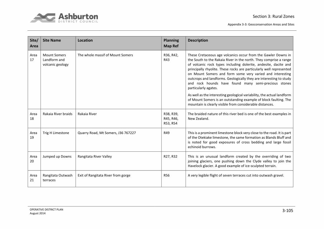
Section 3: Rural Zones
Appendix 3-3: Geoconservation Areas and Sites
OPERATIVE DISTRICT PLAN August 2014
3-105
Site/
Area
Site Name Location Planning
Map Ref
Description
Area 17
Mount Somers Landform and volcanic geology
The whole massif of Mount Somers
R36, R42, R43
These Cretaceous age volcanics occur from the Gawler Downs in the South to the Rakaia River in the north. They comprise a range of volcanic rock types including dolerite, andesite, dacite and principally rhyolite. These rocks are particularly well represented on Mount Somers and form some very varied and interesting outcrops and landforms. Geologically they are interesting to study and rock hounds have found many semi-precious stones particularly agates.
As well as the interesting geological variability, the actual landform of Mount Somers is an outstanding example of block faulting. The mountain is clearly visible from considerable distances.
Area 18
Rakaia River braids Rakaia River R38, R39, R45, R46, R53, R54
The braided nature of this river bed is one of the best examples in New Zealand.
Area 19
Trig H Limestone Quarry Road, Mt Somers, J36 767227
R49 This is a prominent limestone block very close to the road. It is part of the Otekiake limestone, the same formation as Blands Bluff and is noted for good exposures of cross bedding and large fossil echinoid burrows.
Area 20
Jumped up Downs Rangitata River Valley
R27, R32 This is an unusual landform created by the overriding of two joining glaciers, one pushing down the Clyde valley to join the Havelock glacier. A good example of ice-sculpted terrain.
Area 21
Rangitata Outwash terraces
Exit of Rangitata River from gorge
R56 A very legible flight of seven terraces cut into outwash gravel.
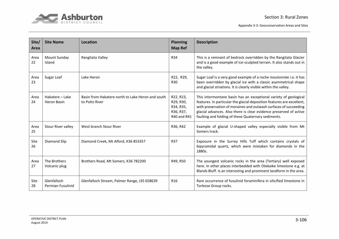
Section 3: Rural Zones
Appendix 3-3: Geoconservation Areas and Sites
OPERATIVE DISTRICT PLAN August 2014
3-106
Site/
Area
Site Name Location Planning
Map Ref
Description
Area 22
Mount Sunday Island
Rangitata Valley
R34 This is a remnant of bedrock overridden by the Rangitata Glacier and is a good example of ice-sculpted terrain. It also stands out in the valley.
Area 23
Sugar Loaf Lake Heron
R22, R29, R30
Sugar Loaf is a very good example of a roche moutonnée i.e. it has been overridden by glacial ice with a classic asymmetrical shape and glacial striations. It is clearly visible within the valley.
Area 24
Hakatere – Lake Heron Basin
Basin from Hakatere north to Lake Heron and south to Potts River
R22, R23, R29, R30, R34, R35, R36, R37, R40 and R41
This intermontane basin has an exceptional variety of geological features. In particular the glacial deposition features are excellent, with preservation of moraines and outwash surfaces of succeeding glacial advances. Also there is clear evidence preserved of active faulting and folding of these Quaternary sediments.
Area 25
Stour River valley West branch Stour River R36, R42 Example of glacial U-shaped valley especially visible from Mt Somers track.
Site 26
Diamond Slip Diamond Creek, Mt Alford, K36 853357
R37 Exposure in the Surrey Hills Tuff which contains crystals of bipyramidal quartz, which were mistaken for diamonds in the 1880s.
Area 27
The Brothers Volcanic plug
Brothers Road, Mt Somers, K36 782200 R49, R50 The youngest volcanic rocks in the area (Tertiary) well exposed here. In other places interbedded with Otekaike limestone e.g. at Blands Bluff. Is an interesting and prominent landform in the area.
Site 28
Glenfalloch Permian Fusulinid
Glenfalloch Stream, Palmer Range, J35 658639 R16 Rare occurrence of fusulinid foraminifera in silicified limestone in Torlesse Group rocks.
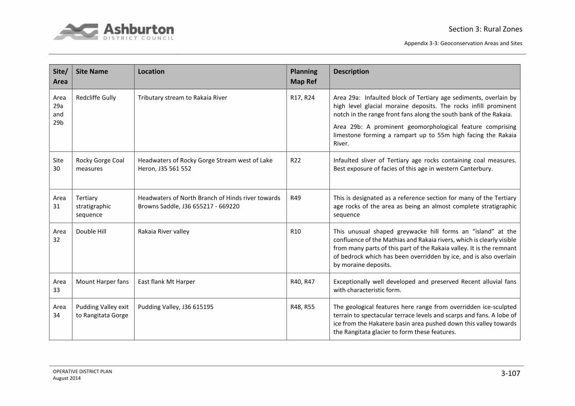
Section 3: Rural Zones
Appendix 3-3: Geoconservation Areas and Sites
OPERATIVE DISTRICT PLAN August 2014
3-107
Site/
Area
Site Name Location Planning
Map Ref
Description
Area 29a and 29b
Redcliffe Gully Tributary stream to Rakaia River
R17, R24 Area 29a: Infaulted block of Tertiary age sediments, overlain by high level glacial moraine deposits. The rocks infill prominent notch in the range front fans along the south bank of the Rakaia.
Area 29b: A prominent geomorphological feature comprising limestone forming a rampart up to 55m high facing the Rakaia River.
Site 30
Rocky Gorge Coal measures
Headwaters of Rocky Gorge Stream west of Lake Heron, J35 561 552
R22 Infaulted sliver of Tertiary age rocks containing coal measures. Best exposure of facies of this age in western Canterbury.
Area 31
Tertiary stratigraphic sequence
Headwaters of North Branch of Hinds river towards Browns Saddle, J36 655217 - 669220
R49 This is designated as a reference section for many of the Tertiary age rocks of the area as being an almost complete stratigraphic sequence
Area 32
Double Hill Rakaia River valley
R10 This unusual shaped greywacke hill forms an “island” at the confluence of the Mathias and Rakaia rivers, which is clearly visible from many parts of this part of the Rakaia valley. It is the remnant of bedrock which has been overridden by ice, and is also overlain by moraine deposits.
Area 33
Mount Harper fans East flank Mt Harper R40, R47 Exceptionally well developed and preserved Recent alluvial fans with characteristic form.
Area 34
Pudding Valley exit to Rangitata Gorge
Pudding Valley, J36 615195
R48, R55 The geological features here range from overridden ice-sculpted terrain to spectacular terrace levels and scarps and fans. A lobe of ice from the Hakatere basin area pushed down this valley towards the Rangitata glacier to form these features.
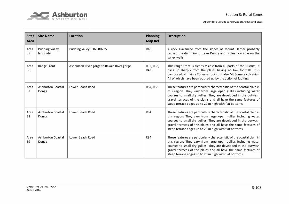
Section 3: Rural Zones
Appendix 3-3: Geoconservation Areas and Sites
OPERATIVE DISTRICT PLAN August 2014
3-108
Site/
Area
Site Name Location Planning
Map Ref
Description
Area 35
Pudding Valley landslide
Pudding valley, J36 580235 R48 A rock avalanche from the slopes of Mount Harper probably caused the damming of Lake Denny and is clearly visible on the valley walls.
Area 36
Range Front Ashburton River gorge to Rakaia River gorge
R32, R38, R43
This range front is clearly visible from all parts of the District; it rises up sharply from the plains having no low foothills. It is composed of mainly Torlesse rocks but also Mt Somers volcanics. All of which have been pushed up by the action of faulting.
Area 37
Ashburton Coastal Donga
Lower Beach Road R84, R88 These features are particularly characteristic of the coastal plain in this region. They vary from large open gullies including water courses to small dry gullies. They are developed in the outwash gravel terraces of the plains and all have the same features of steep terrace edges up to 20 m high with flat bottoms.
Area 38
Ashburton Coastal Donga
Lower Beach Road R84 These features are particularly characteristic of the coastal plain in this region. They vary from large open gullies including water courses to small dry gullies. They are developed in the outwash gravel terraces of the plains and all have the same features of steep terrace edges up to 20 m high with flat bottoms.
Area 39
Ashburton Coastal Donga
Lower Beach Road R84 These features are particularly characteristic of the coastal plain in this region. They vary from large open gullies including water courses to small dry gullies. They are developed in the outwash gravel terraces of the plains and all have the same features of steep terrace edges up to 20 m high with flat bottoms.
Section 3: Rural Zones
Appendix 3-4: Outstanding Natural Landscapes
OPERATIVE DISTRICT PLAN August 2014
3-109
Appendix 3-4: Outstanding Natural Landscapes
As outlined in the methodology of the Ashburton District Landscape Study 2009, the values of the district have been assessed against the three criteria
described below. Assessment of these three aspects of landscape is widely accepted as best practice and can be summarised as follows:
biophysical aspects, which incorporate a landscapes natural science elements, including its geological, ecological and biological elements. This
part of the analysis will involve more objective and quantifiable data to support a particular decision made;
sensory aspects, which involve aesthetics and natural beauty, as well as transient matters from a visual perception. This part of the analysis will
involve judgmental and subjective interpretations of a landscape or features aesthetics; and
associative aspects, which involves cultural (tangata whenua) and historic values as well as shared and recognised attributes.
Four different types of ONF/L have been identified within Ashburton District:
1. Inland Mountain Ranges ONL
2. Front Ranges ONL (containing Mt Somers, Mt Hutt Range, Winterslow, Black Hill and Palmer Ranges)
3. Hakatere Basin ONL
4. Major River Valley ONL (containing Upper Rangitata Valley, Upper Rakaia Valley, Lower Rakaia River and Gorge)
These four ONL areas have very different landscape characteristics and values, and within these landscapes the existing level of modification varies
significantly. The pressures for landscape change in the four ONLs are largely dependent on their accessibility and economic potential. In broad terms these
four ONL areas can be grouped as mountain and valley/basin ONLs which are likely to require different management mechanisms. In the following sections
the landscape characteristics, values, existing modification and potential threats are summarised in table format.
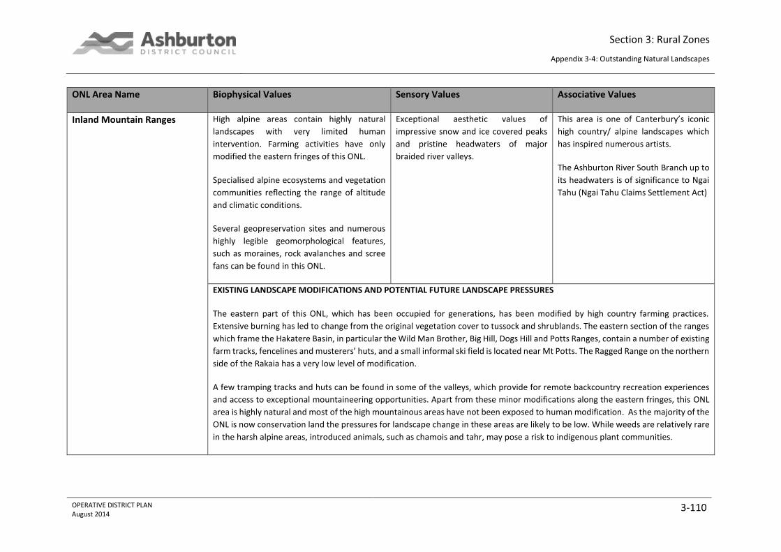
Section 3: Rural Zones
Appendix 3-4: Outstanding Natural Landscapes
OPERATIVE DISTRICT PLAN August 2014
3-110
ONL Area Name Biophysical Values Sensory Values Associative Values
Inland Mountain Ranges High alpine areas contain highly natural
landscapes with very limited human
intervention. Farming activities have only
modified the eastern fringes of this ONL.
Specialised alpine ecosystems and vegetation
communities reflecting the range of altitude
and climatic conditions.
Several geopreservation sites and numerous
highly legible geomorphological features,
such as moraines, rock avalanches and scree
fans can be found in this ONL.
Exceptional aesthetic values of
impressive snow and ice covered peaks
and pristine headwaters of major
braided river valleys.
This area is one of Canterbury’s iconic
high country/ alpine landscapes which
has inspired numerous artists.
The Ashburton River South Branch up to
its headwaters is of significance to Ngai
Tahu (Ngai Tahu Claims Settlement Act)
EXISTING LANDSCAPE MODIFICATIONS AND POTENTIAL FUTURE LANDSCAPE PRESSURES
The eastern part of this ONL, which has been occupied for generations, has been modified by high country farming practices.
Extensive burning has led to change from the original vegetation cover to tussock and shrublands. The eastern section of the ranges
which frame the Hakatere Basin, in particular the Wild Man Brother, Big Hill, Dogs Hill and Potts Ranges, contain a number of existing
farm tracks, fencelines and musterers’ huts, and a small informal ski field is located near Mt Potts. The Ragged Range on the northern
side of the Rakaia has a very low level of modification.
A few tramping tracks and huts can be found in some of the valleys, which provide for remote backcountry recreation experiences
and access to exceptional mountaineering opportunities. Apart from these minor modifications along the eastern fringes, this ONL
area is highly natural and most of the high mountainous areas have not been exposed to human modification. As the majority of the
ONL is now conservation land the pressures for landscape change in these areas are likely to be low. While weeds are relatively rare
in the harsh alpine areas, introduced animals, such as chamois and tahr, may pose a risk to indigenous plant communities.

Section 3: Rural Zones
Appendix 3-4: Outstanding Natural Landscapes
OPERATIVE DISTRICT PLAN August 2014
3-111
ONL Area Name Biophysical Values Sensory Values Associative Values
The accessibility and visual prominence from the Hakatere Basin make the eastern slopes and ridgelines more vulnerable to landscape
change. However, extensive sheep farming has historically been the predominant land use of these lower slopes to the west of the
basin and activities such as top dressing and fencing are to some degree expected in this environment.
Front Ranges
The Front Ranges contain a number of
geopreservation sites. The volcanic outcrops
around Mt Somers are particularly notable
from a landscape perspective as they
represent highly legible features.
A range of ecologically important sites are
located within the Front Range ONL. The
interior of the ranges is more natural than the
edges, apart from the extensive areas of
beech forest covering the steeply rising
eastern flanks.
The eastern slopes and peaks of the
front ranges have very high visual
resource values, as they are a prominent
landscape feature when viewed from
the plains.
The contrast of the snow-capped peaks,
beech clad eastern flanks and the plains
below are a key image within Ashburton
District.
The Rakaia faces and flanks confining the
Hakatere Basin show clear signs of
glacial scouring during the ice ages.
Visually these slopes form an important
part of the adjacent river valley and
basin landscapes.
While no permanent Maori settlement is
recorded, some rock drawings were
found around Mt Somers.
The natural resources, such as coal,
quartz sands and clays around the Mt
Somers/ Alford area have attracted early
settlers. The heritage objects, such as
lime kilns and buildings are located
along the base of the hills, and are
outside the ONL area.
EXISTING LANDSCAPE MODIFICATIONS AND POTENTIAL FUTURE LANDSCAPE PRESSURES
While the upper slopes and interior of this ONL predominantly support native vegetation, the lower slopes and parts of the river
valleys contain a variety of introduced species. Farming operations have led to a clear line between over-sown paddocks and more
extensively used farmland. This distinction is particularly visible along the Rakaia faces of the mountain ranges. Farming activities are
an integral part of this landscape and the landcover, while reducing the naturalness, makes the glacial scouring clearly visible on the
slopes. The visually exposed flanks, peaks and ridgelines of the ranges are relatively sensitive to landscape change and as a result

Section 3: Rural Zones
Appendix 3-4: Outstanding Natural Landscapes
OPERATIVE DISTRICT PLAN August 2014
3-112
ONL Area Name Biophysical Values Sensory Values Associative Values
any structures and earthworks will require careful siting to be accommodated in the landscape. The interior of the mountain ranges
is not visible from beyond the ONL area, and therefore the visual impacts of any change are likely to be lower. However, effects on
biophysical values would have to be carefully assessed in these more natural areas.
The Mt Hutt ski field is one of the key attractions in Ashburton District. The ski field road and contouring associated with the creation
of ski runs present obvious modifications to this part of the mountain range. Structures and further change associated with the ski
field, such as earthworks, lifts and buildings within the vicinity of these existing modifications would be expected in this part of the
ONL.
Hakatere Basin
A wide range of geopreservation sites are
located within Hakatere Basin, including
highly legible landscape features displaying
past fluvial and glacial shaping forces.
The lakes in the basin have high ecological
values for both their birdlife and associated
wetlands.
Pockets of remnant native vegetation
containing significant indigenous species can
be found in the basin.
The basin contains one of Canterbury’s
classic high country landscapes with vast
open space and extensive views to the
mountain slopes and snow-covered
peaks.
The visual diversity and aesthetic values
of the Ashburton lakes, rivers and
mountains within and surrounding the
basin are exceptional.
The Ashburton Lakes Area (O Tu
Whareakai) is acknowledged in the Ngai
Tahu Claims Settlement Act (1998). The
area was part of a seasonal trail for
mahinga kai and resource gathering.
EXISTING LANDSCAPE MODIFICATIONS AND POTENTIAL FUTURE LANDSCAPE PRESSURES
Large parts of the basin do not display any significant visual signs of built human modification, apart from a few farming related
buildings and structures. This means that the basin retains a high degree of intactness and aesthetic coherence.

Section 3: Rural Zones
Appendix 3-4: Outstanding Natural Landscapes
OPERATIVE DISTRICT PLAN August 2014
3-113
ONL Area Name Biophysical Values Sensory Values Associative Values
Large parts of this landscape are managed by the Department of Conservation, which includes the Hakatere Conservation Park. This
park encompasses 60,000 hectares of rugged mountain country, tussocklands and sparkling clear rivers and lakes between the Rakaia
and Rangitata rivers. It can be expected that there will be little development pressure within this and other conservation areas.
The Heron, Clearwater, Ashburton Lakes landscape is very different from the high country basins in other districts, as it is smaller in
scale than the Mackenzie and Waimakariri Basins. It does not contain any large scale infrastructure or settlements and extensive
grazing forms an integral part of this landscape. The landscape clearly reflects geological processes and the lakes and associated
wetlands are significant from an ecological perspective.
Agricultural intensification has modified some of the low lying parts of the basin, with the gradual conversion of tussock grasslands
to improved pasture and the introduction of exotic conifers for shelterbelts and woodlots.
The open nature of the basin means that each part of it contributes to the quality of the experience of the whole basin. Few areas
are experienced in isolation and most visitors build up an image of the basin as they move through it. The consequence of the
openness is that a serious adverse intrusion in one area may in reality affect the experience of the entire basin, which makes the ONL
vulnerable to change. Nonetheless, there are key areas (outlined above) that are particularly sensitive to change.
Key viewpoints are important and may be lost through planting of forests and extensive woodlots. Fence lines, shelterbelts and tracks
that do not relate to the natural landform create unnatural patterns and can have visual impact. In general farming activities and
associated buildings are expected in this landscape. The patterns of the modified parts of the basin floor (e.g. between Mt Arrowsmith
and Castleridge Stations and around Hakatere Station) contrast with the more extensively used slopes. These farming activities form
part of the existing environment. However, unsympathetically situated and designed structures and buildings can have an effect on
the natural appearance, sense of remoteness and aesthetic quality of the basin.
Major River Valley
The braided rivers are of international
importance and certainly amongst the best
examples of this river type in New Zealand.
The wide braided river beds and
mountainous catchments of the Rakaia
and Rangitata Rivers are of exceptional
beauty. The ever-changing nature of
these rivers and their impressive scale
The Rangitata River is acknowledged in
the Ngai Tahu Claims Settlement Act
(1998). The area was part of a seasonal
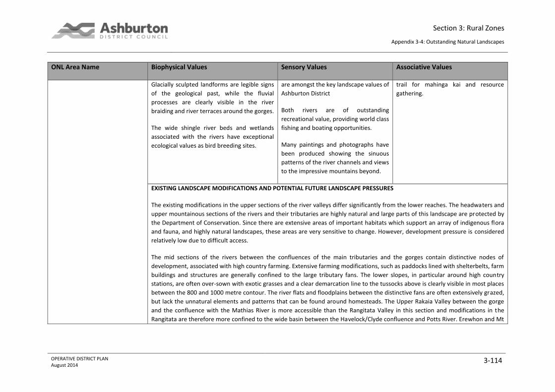
Section 3: Rural Zones
Appendix 3-4: Outstanding Natural Landscapes
OPERATIVE DISTRICT PLAN August 2014
3-114
ONL Area Name Biophysical Values Sensory Values Associative Values
Glacially sculpted landforms are legible signs
of the geological past, while the fluvial
processes are clearly visible in the river
braiding and river terraces around the gorges.
The wide shingle river beds and wetlands
associated with the rivers have exceptional
ecological values as bird breeding sites.
are amongst the key landscape values of
Ashburton District
Both rivers are of outstanding
recreational value, providing world class
fishing and boating opportunities.
Many paintings and photographs have
been produced showing the sinuous
patterns of the river channels and views
to the impressive mountains beyond.
trail for mahinga kai and resource
gathering.
EXISTING LANDSCAPE MODIFICATIONS AND POTENTIAL FUTURE LANDSCAPE PRESSURES
The existing modifications in the upper sections of the river valleys differ significantly from the lower reaches. The headwaters and
upper mountainous sections of the rivers and their tributaries are highly natural and large parts of this landscape are protected by
the Department of Conservation. Since there are extensive areas of important habitats which support an array of indigenous flora
and fauna, and highly natural landscapes, these areas are very sensitive to change. However, development pressure is considered
relatively low due to difficult access.
The mid sections of the rivers between the confluences of the main tributaries and the gorges contain distinctive nodes of
development, associated with high country farming. Extensive farming modifications, such as paddocks lined with shelterbelts, farm
buildings and structures are generally confined to the large tributary fans. The lower slopes, in particular around high country
stations, are often over-sown with exotic grasses and a clear demarcation line to the tussocks above is clearly visible in most places
between the 800 and 1000 metre contour. The river flats and floodplains between the distinctive fans are often extensively grazed,
but lack the unnatural elements and patterns that can be found around homesteads. The Upper Rakaia Valley between the gorge
and the confluence with the Mathias River is more accessible than the Rangitata Valley in this section and modifications in the
Rangitata are therefore more confined to the wide basin between the Havelock/Clyde confluence and Potts River. Erewhon and Mt

Section 3: Rural Zones
Appendix 3-4: Outstanding Natural Landscapes
OPERATIVE DISTRICT PLAN August 2014
3-115
ONL Area Name Biophysical Values Sensory Values Associative Values
Potts Station are the only high country stations within Ashburton District along this stretch of the river. However, a road provides
access along the true right of the river to Mesopotamia Station (Timaru District).
While development pressure along these mid sections of the Rakaia and Rangitata Rivers currently appears to be relatively low and
focused on farming activities, these visually and ecologically sensitive areas are considered to be of high importance. Development
and landscape change outside the existing nodes, in particular for non-farming related activities, have potential for high impact on
the highly valuable landscape. Uninterrupted long distance views along the braided rivers and to the mountains beyond are a key
value of this landscape, and their scale dwarf the existing development. Nonetheless, change that does not reflect natural processes
can have significant adverse effect.
The high sensitivity of the braided river systems, wetlands and associated flora and fauna would have to be a key consideration for
any future development. While the upper reaches of the rivers are largely weed free, invasion of weedy plants may pose a serious
future threat. Some of the mid and most of the lower reaches already contain broom, gorse and yellow tree lupin.
Before the Rangitata River enters the Canterbury Plains, part of it is diverted to the Rangitata Diversion Race (RDR) for irrigation and
hydroelectric generation. The RDR was built between 1937 and 1944 and supplies water for irrigation to the Montalto and Highbank
schemes before joining the Rakaia River. Highbank Hydro Power Station, was the second power station to be constructed on the
Rakaia River, although, like the Lake Coleridge station (which captures water from the Wilberforce and Harper Rivers), it does not
utilise the waters of the Rakaia.
The upper terraces of the gorges are intensively farmed and their naturalness has been compromised. The lower sections of the
rivers are also quite modified, in terms of water abstraction, adjacent land use and weed infestation. The economy in the district
relies on the fertility of its alluvial soil, which is washed or blown down from the Canterbury Plains. Horticulture and arable farming
are ideally suited to conditions in the area, along with sheep, deer and dairy farming. These uses form part of the cultural landscape
and are expected across the plains. They may pose a landscape threat for the rivers where they encroach onto the river floodplains.
Activities that compromise the outstanding qualities of the active braided riverbed are likely to be inappropriate.
Section 3: Rural Zones
Appendix 3-4: Outstanding Natural Landscapes
OPERATIVE DISTRICT PLAN August 2014
3-116