artificial intelligence applied to the detection and early
TRANSCRIPT

Artificial intelligence applied to the detection and early
warning of geotechnical instabilities in mining slopes
N Contador Villegas E Mining Technology S.A., Chile
H Huenchulao Catalán E Mining Technology S.A., Chile
JM Oliva Miranda E Mining Technology S.A., Chile
F Dubournais Donoso Antofagasta Minerals S.A., Chile
M Gallardo Arriagada Antofagasta Minerals S.A., Chile
Abstract
It is possible to detect and anticipate geotechnical instabilities of the slopes of an open pit from the systematic
monitoring of surface displacements induced by mining excavation. In the last few years, the detection rate
of large-scale instabilities has improved through the application of the radar interferometry technique.
However, small-scale instabilities are the most frequent and they present a low detection rate and early
warning, since they have a short activation period, and are eventually, eclipsed by environmental noise and/or
the mining operation itself. For this particular case, how to improve the detection and anticipation rate was
discussed based on the hypothesis that geotechnical instabilities show a ‘recognisable behaviour’,
well-defined and mathematically expressible. This feature makes the application of artificial intelligence (AI)
tools feasible, specifically neural networks, to generate models trained in the early detection of ‘recognisable
behaviour’, under a supervised learning approach.
To develop a predictive application based on AI tools, a collaborative work dynamic was proposed between
Minera Los Pelambres (MLP), belonging to the mining company Antofagasta Minerals S.A. (AMSA), and
E Mining Technology S.A., a mining technical services company.
The results of the training process of neural network models showed they are capable of identifying the
‘recognisable behaviour’ of a geotechnical instability at an early stage. Moreover, these models, when
complemented with a layer of geotechnical-mathematical criteria, were allowed to build an algorithm
capable of improving the overall performance of the surface displacement monitoring system. The
performance of the algorithm was evaluated over a period of eight months at the MLP open pit. In this period,
it was possible to increase the detection and early warning rate from an effectiveness of 43–82% in small-scale
instabilities and as a result, a decrease in the risk during the construction of slopes. In addition, a significant
reduction of false positives was reached by minimising the effect in the environmental noise by 80% with
respect to the performance of the current monitoring systems.
In the future, it seems reasonable to predict that with an expansion of the dataset and auscultation of new
AI models and/or architectures, it will be possible to further improve the efficiency of monitoring systems.
Keywords: slope monitoring, artificial intelligence, advanced analytics, geotechnical instabilities, early warning
1 Introduction
The ability to detect potential geotechnical instabilities early is essential for the management of geotechnical
risks during the construction of the slope in open pit mining. Early detection allows the mining operation to
be alerted of the risk of geotechnical instabilities, and it avoids or reduces the potential impact on people,
equipment, or the continuity of the operation. To this end, the mining industry has adopted—specifically, in
its geotechnical monitoring systems—the radar interferometry technique to estimate the surface
SSIM 2021 - PM Dight (ed.)© Australian Centre for Geomechanics, Perth, ISBN 978-0-6450938-1-0
SSIM 2021 227
doi:10.36487/ACG_repo/2135_13
displacements based on the gap that is produced between the emission, reflection, and reception of
electromagnetic waves when interacting with the slope face.
In the case of large-scale geotechnical instabilities, where development times are longer, monitoring systems
have performed well in sending an early warning of an imminent geotechnical instability. However, the
results have not been satisfactory in the early detection of small-scale or ‘bench scale’ geotechnical
instabilities. These types of instabilities, commonly developed in a short activation period, are the most
frequent, and are sometimes eclipsed by environmental noise or the mining operation itself.
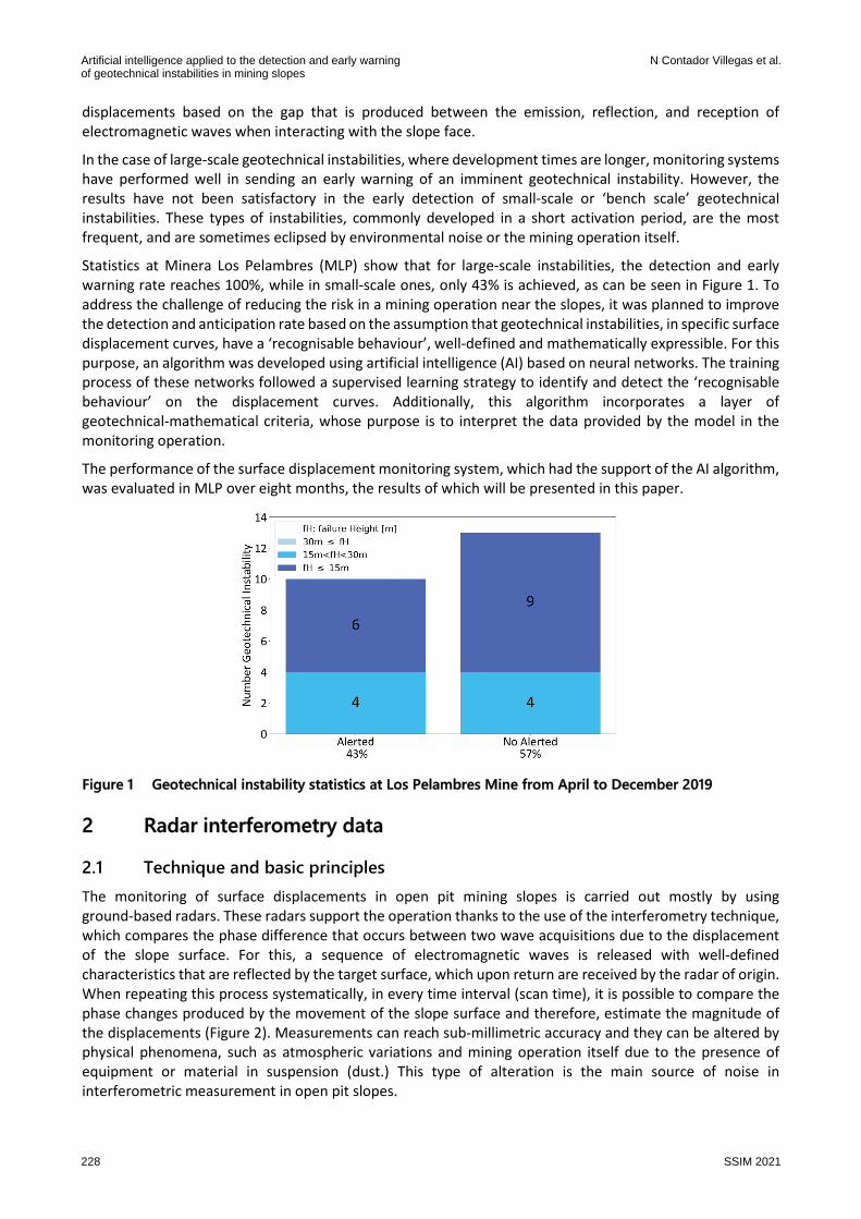
Statistics at Minera Los Pelambres (MLP) show that for large-scale instabilities, the detection and early
warning rate reaches 100%, while in small-scale ones, only 43% is achieved, as can be seen in Figure 1. To
address the challenge of reducing the risk in a mining operation near the slopes, it was planned to improve
the detection and anticipation rate based on the assumption that geotechnical instabilities, in specific surface
displacement curves, have a ‘recognisable behaviour’, well-defined and mathematically expressible. For this
purpose, an algorithm was developed using artificial intelligence (AI) based on neural networks. The training
process of these networks followed a supervised learning strategy to identify and detect the ‘recognisable
behaviour’ on the displacement curves. Additionally, this algorithm incorporates a layer of
geotechnical-mathematical criteria, whose purpose is to interpret the data provided by the model in the
monitoring operation.
The performance of the surface displacement monitoring system, which had the support of the AI algorithm,
was evaluated in MLP over eight months, the results of which will be presented in this paper.
Figure 1 Geotechnical instability statistics at Los Pelambres Mine from April to December 2019
2 Radar interferometry data
2.1 Technique and basic principles
The monitoring of surface displacements in open pit mining slopes is carried out mostly by using
ground-based radars. These radars support the operation thanks to the use of the interferometry technique,
which compares the phase difference that occurs between two wave acquisitions due to the displacement
of the slope surface. For this, a sequence of electromagnetic waves is released with well-defined
characteristics that are reflected by the target surface, which upon return are received by the radar of origin.
When repeating this process systematically, in every time interval (scan time), it is possible to compare the
phase changes produced by the movement of the slope surface and therefore, estimate the magnitude of
the displacements (Figure 2). Measurements can reach sub-millimetric accuracy and they can be altered by
physical phenomena, such as atmospheric variations and mining operation itself due to the presence of
equipment or material in suspension (dust.) This type of alteration is the main source of noise in
interferometric measurement in open pit slopes.
Artificial intelligence applied to the detection and early warningof geotechnical instabilities in mining slopes
N Contador Villegas et al.
228 SSIM 2021

Figure 2 Surface monitor diagram using radar interferometry technique
2.2 Radar data
A relevant factor that determines the capability of the system is the physical layout and configuration of the
radars. Location, orientation, and distance of the radar from the slope determine the coverage, resolution,
and accuracy of the measurement. Meanwhile, the dimensions of the area of interest to be scanned define
the frequency of scanning of the equipment, which is reflected in the number of acquisitions obtained.
The minimum spatial sampling unit in the interferometry technique is known as cell or pixel. This unit
corresponds to the lowest possible resolution that can be reached by the instrumental capability and
configuration (distance and orientation radar from the slope).
The displacement of each cell is estimated at each scanning cycle generating a sequence of displacements
that are represented in a time series:
��� = ���
� , �� , �
� , … , ���� , ��
� � (1)
where:
��� = displacement of a cell �� at the reading time �.
It should be noted that the data reading time � is the same for all cells in every scanning cycle. These
characteristics of radar data allowed conceptualising an efficient storage structure or data cube, taking
advantage that all cells present a common reading time and also spatial regularity (Figure 3). The data cube
used at the present work contains information of Los Pelambres mine, corresponding to the monitoring
period from April to December 2019. It is included geotechnical instabilities and also stable zones
information.
Figure 3 Data cube structure
3 Methodology
The work was aimed at designing, developing, and applying a methodology that would allow us to use the
extensive information available, in particular, time series of surface displacement, which collects the
historical behaviour of the rock mass recorded instrumentally by ground monitoring radars. In this sense, the
methodology contains the procedure of how to build an AI model (Figure 4a) with a supervised learning
approach and a general scheme of the AI support algorithm that involves geotechnical-mathematical criteria
(Figure 4b).
Slope monitoring and its interpretation
SSIM 2021 229
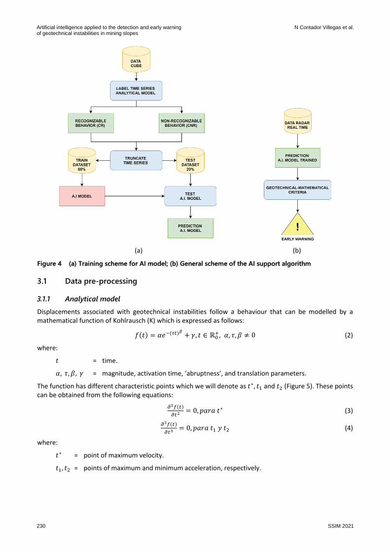
(a) (b)
Figure 4 (a) Training scheme for AI model; (b) General scheme of the AI support algorithm
3.1 Data pre-processing
3.1.1 Analytical model
Displacements associated with geotechnical instabilities follow a behaviour that can be modelled by a
mathematical function of Kohlrausch (K) which is expressed as follows:
���� = ��������� �, � ∈ ℝ�
�, �, �, � � 0 (2)
where:
� = time.
�, �, �, � = magnitude, activation time, ‘abruptness’, and translation parameters.
The function has different characteristic points which we will denote as �∗, � and � (Figure 5). These points
can be obtained from the following equations:
"#$���
"�# = 0, %&'& �∗ (3)
"($���
"�( = 0, %&'& � ) � (4)
where:
�∗ = point of maximum velocity.
�, � = points of maximum and minimum acceleration, respectively.
Artificial intelligence applied to the detection and early warningof geotechnical instabilities in mining slopes
N Contador Villegas et al.
230 SSIM 2021
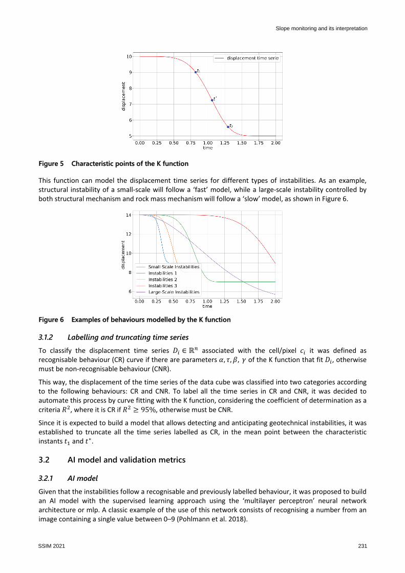
Figure 5 Characteristic points of the K function
This function can model the displacement time series for different types of instabilities. As an example,
structural instability of a small-scale will follow a ‘fast’ model, while a large-scale instability controlled by
both structural mechanism and rock mass mechanism will follow a ‘slow’ model, as shown in Figure 6.
Figure 6 Examples of behaviours modelled by the K function
3.1.2 Labelling and truncating time series
To classify the displacement time series �� ∈ ℝ* associated with the cell/pixel �� it was defined as
recognisable behaviour (CR) curve if there are parameters �, �, �, � of the K function that fit ��, otherwise
must be non-recognisable behaviour (CNR).
This way, the displacement of the time series of the data cube was classified into two categories according
to the following behaviours: CR and CNR. To label all the time series in CR and CNR, it was decided to
automate this process by curve fitting with the K function, considering the coefficient of determination as a
criteria +, where it is CR if + , 95%, otherwise must be CNR.
Since it is expected to build a model that allows detecting and anticipating geotechnical instabilities, it was
established to truncate all the time series labelled as CR, in the mean point between the characteristic
instants � and �∗.
3.2 AI model and validation metrics
3.2.1 AI model
Given that the instabilities follow a recognisable and previously labelled behaviour, it was proposed to build
an AI model with the supervised learning approach using the ‘multilayer perceptron’ neural network
architecture or mlp. A classic example of the use of this network consists of recognising a number from an
image containing a single value between 0–9 (Pohlmann et al. 2018).
Slope monitoring and its interpretation
SSIM 2021 231
To train the AI model, 80% of the truncated and labelled time series were used, while the remaining 20%
were used for validation. The model, once trained, has the ability to predict, at each time instant, the
probability or reliability (012) that a time series will develop a recognisable behaviour or non-recognisable
behaviour (0132 = 1 − 012). To quantify the performance of the trained model, the confusion matrix was
used; a classic tool that allows visualising the performance of algorithms in the field of supervised learning.
Additionally, other complementary metrics were used such as accuracy, recall, and precision of CR or CNR
classification (Raschka & Mirjalili 2017).
3.3 Geotechnical-mathematical criteria
Geotechnical-mathematical criteria allow integrating the results of AI model with physical characteristics,
spatial and/or temporal, detected by the monitoring system. The criteria are defined as bounds or thresholds
that must be reached by a cell or a cluster of cells. Table 1 shows a summary of the main criteria used in the
performance evaluation of the monitoring system with the support of the AI model.
Table 1 Main geotechnical-mathematical criteria
Criteria Observation
Reliability The reliability of cells (012) estimated by the AI model
Spatial contiguity A number of cells that are right next to each other and share
the same vertex (neighbours cells)
Persistence The minimum time that a number of active cells are above
the reliability threshold
4 Results
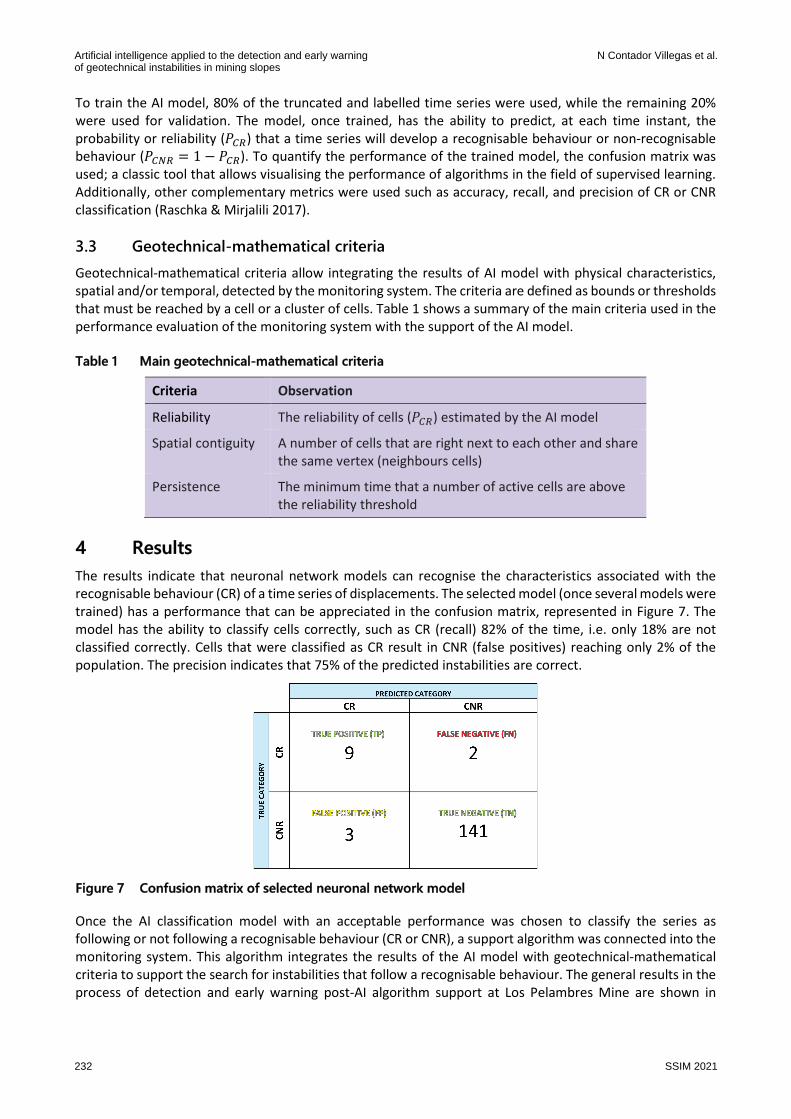
The results indicate that neuronal network models can recognise the characteristics associated with the
recognisable behaviour (CR) of a time series of displacements. The selected model (once several models were
trained) has a performance that can be appreciated in the confusion matrix, represented in Figure 7. The
model has the ability to classify cells correctly, such as CR (recall) 82% of the time, i.e. only 18% are not
classified correctly. Cells that were classified as CR result in CNR (false positives) reaching only 2% of the
population. The precision indicates that 75% of the predicted instabilities are correct.
Figure 7 Confusion matrix of selected neuronal network model
Once the AI classification model with an acceptable performance was chosen to classify the series as
following or not following a recognisable behaviour (CR or CNR), a support algorithm was connected into the
monitoring system. This algorithm integrates the results of the AI model with geotechnical-mathematical
criteria to support the search for instabilities that follow a recognisable behaviour. The general results in the
process of detection and early warning post-AI algorithm support at Los Pelambres Mine are shown in
Artificial intelligence applied to the detection and early warningof geotechnical instabilities in mining slopes
N Contador Villegas et al.
232 SSIM 2021
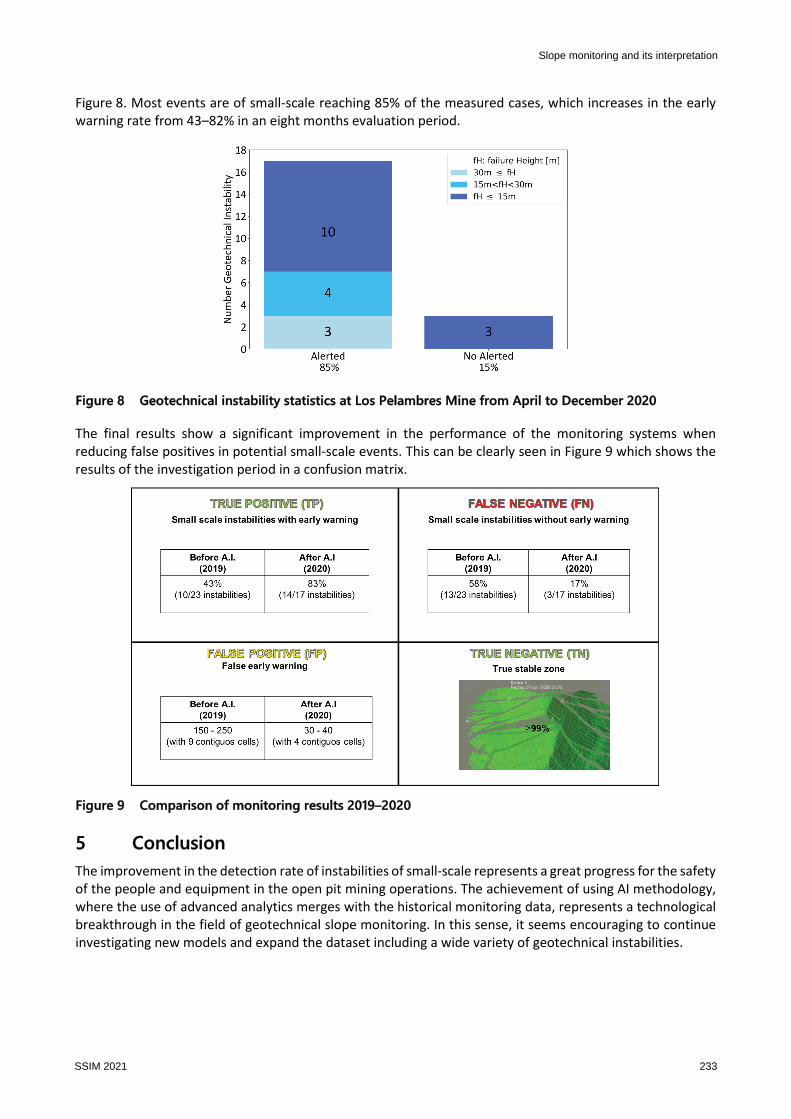
Figure 8. Most events are of small-scale reaching 85% of the measured cases, which increases in the early
warning rate from 43–82% in an eight months evaluation period.
Figure 8 Geotechnical instability statistics at Los Pelambres Mine from April to December 2020
The final results show a significant improvement in the performance of the monitoring systems when
reducing false positives in potential small-scale events. This can be clearly seen in Figure 9 which shows the
results of the investigation period in a confusion matrix.
Figure 9 Comparison of monitoring results 2019–2020
5 Conclusion
The improvement in the detection rate of instabilities of small-scale represents a great progress for the safety
of the people and equipment in the open pit mining operations. The achievement of using AI methodology,
where the use of advanced analytics merges with the historical monitoring data, represents a technological
breakthrough in the field of geotechnical slope monitoring. In this sense, it seems encouraging to continue
investigating new models and expand the dataset including a wide variety of geotechnical instabilities.
Slope monitoring and its interpretation
SSIM 2021 233
Acknowledgement
To the team of the data analysis unit of MLP, in particular to Javiera Arancibia and Mario Vergara for their
work and dedication at proposing and discussing alternative AI models.
To the geotechnical superintendency of MLP, in particular to Claudio Fernández and Michael Alvarado for
their invaluable support in understanding the challenge of detecting geotechnical instabilities and their
management throughout the project.
To Leonardo Zahr geotechnic of E Mining Technology for his help in providing the data, information and
geotechnical analysis, which allowed a better understanding of geotechnical instability mechanisms.
To Rodrigo Ojeda and Pablo Borgeaud of E Mining Technology for their management and support in the
materialisation of this project.
References
Pohlmann, F, Waldron, A & Jain, SG 2018, Advanced Deep Learning with Keras, Packt Publishing Ltd, Birmingham, pp. 6–21.
Raschka, S & Mirjalili, V 2017, Python Machine Learning Second Edition, Packt Publishing Ltd, Birmingham, pp. 206–209.
Artificial intelligence applied to the detection and early warningof geotechnical instabilities in mining slopes
N Contador Villegas et al.
234 SSIM 2021