around the world with fme - forside - norkart · around the world with fme. multilevel ... (real...
TRANSCRIPT

Around the World with FME

Multilevel Tile Cache Generation
Engine
LA RIOJA, SPAIN
Ana García de VicuñaPablo Martínez
Gobierno de La Rioja

MBTiles format
Store pre-cache tiles in a sqlite database to speed web mappingImplemented in the workbench

Mapnik
- Toolkit for making high quality raster maps- Complex styles and simbology- FME transformer since FME 2014 (MapnikRasterizer)
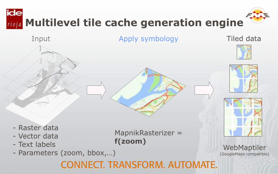
Multilevel tile cache generation engine
- Raster data- Vector data- Text labels- Parameters (zoom, bbox,…)
MapnikRasterizer = f(zoom)
Input Apply symbology
WebMaptiler(GoogleMaps compatible)
Tiled data

Multilevel tile cache generation engine
Save unique tiles
Optimizing MBTiles MBTiles database
Mbtiles f(zoom)
Output
- metadata- images- maps
tiles
Water
60%
Land
38%
Mix
2%
Tiles TMS
Tables View


Ana García de Vicuña
Pablo Martínez
Thank you very much!!!
See you in Barcelona…
View the full presentation at http://goo.gl/0dqjR4(en español)

Oracle Spatial to
SAP HANA at Alliander
NETHERLANDS
Stefan KosterBI&A Architect

Oracle Spatial to SAP HANA at Alliander
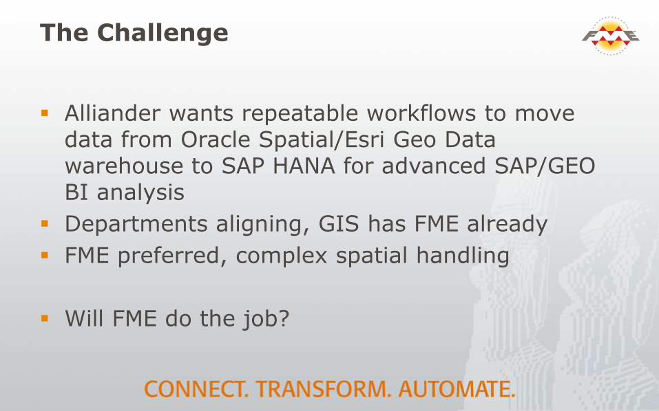
The Challenge
Alliander wants repeatable workflows to move data from Oracle Spatial/Esri Geo Data warehouse to SAP HANA for advanced SAP/GEO BI analysis
Departments aligning, GIS has FME already
FME preferred, complex spatial handling
Will FME do the job?
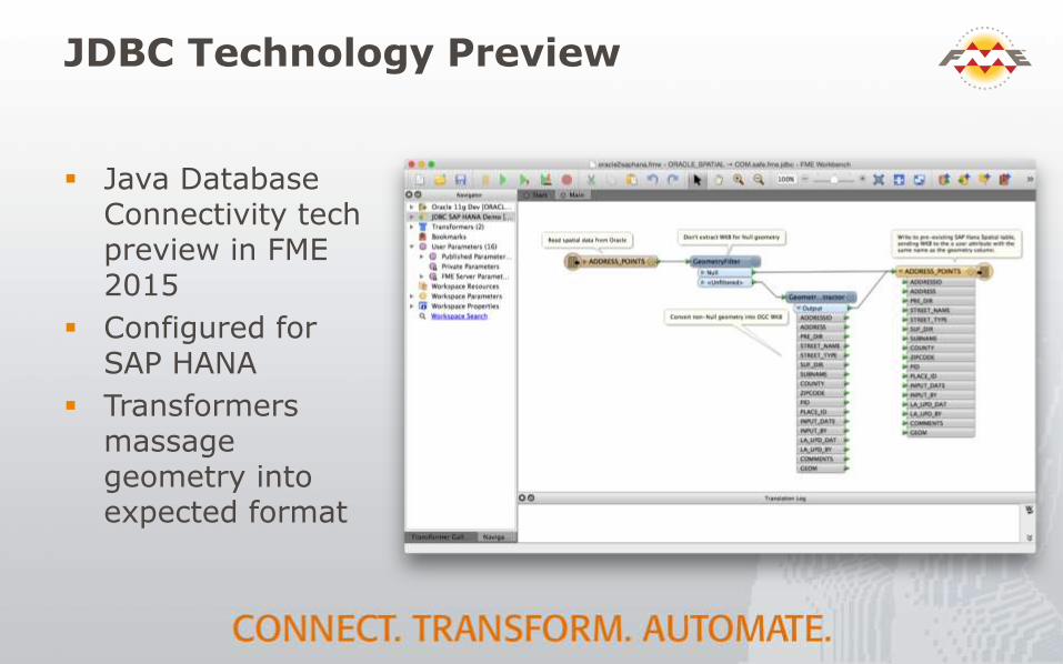
JDBC Technology Preview
Java Database Connectivity tech preview in FME 2015
Configured for SAP HANA
Transformers massage geometry into expected format
How did FME do?
Complete ETL process 2.5 to 3 times faster than the tested alternative
Advanced spatial handling of FME enables automation
ETL tasks across departments on a common platform
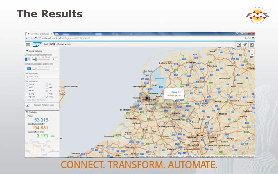
The Results

Geostor:State GIS
ClearinghouseCloud Migration
ARKANSAS, USA
Seth LeMasterTony Davis
Arkansas GIS OfficePhoto by Chriseast18/ CC BY

Overview
Arkansas GIS Clearinghouse
GIS open data portal for the state of Arkansas
1222 monthly downloads (2,358 items downloaded)
Users
108 registered
2,387 non-registered

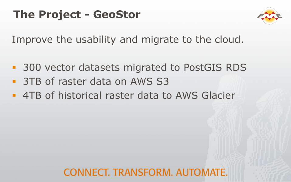
The Project - GeoStor
Improve the usability and migrate to the cloud.
300 vector datasets migrated to PostGIS RDS
3TB of raster data on AWS S3
4TB of historical raster data to AWS Glacier
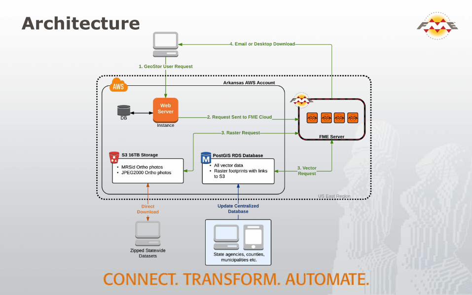
Architecture

Benefits of Cloud
Stability – Fault tolerant data storage and Safe monitor and support FME Cloud architecture.
Security – Leverage AWS compliance and FME Cloud security policies.
Simplicity – Focus on problem not the administration
Price – 3 times cheaper than on-premises

Costs: On Premises vs Cloud
On Premises Monthly Yearly Up-Front
DIS Server Space $3,200
FME Dekstop $6,000
FME Server $12,000
Dell Hardware $100,000
SQL Server
Windows Server (Software Assurance) $595
Windows Server Enterprise (Software Assurance) $385
SQL Server (Software Assurance) $270
SQL Server (Licenses) $294
MS Server Std Edition (License) $1,662
MS Windows Server (Licenses) $4,490
Symantec $680
Tape Backups (No server) $2,000
Total Recurring Montly Payment $3,200
Total Recurring Yearly Payment $26,376
Total One Time Cost (Every 3 yrs) $102,000
Total Three Year Cost $296,328
True Monthly Cost (/36 months) $8,231.33
Intangiable Costs
Hardware Maintenance Time
DIS Process
Non-Scaleable
Cloud Monthly Yearly Up-Front
FME Dekstop $6,000
FME Cloud $14,400
EC2 Instance (m3.large) $395.81
AWS Storage (EBS 780GB) $77.11
AWS Storage (S3 2TB) $61.30
AWS Storage (Glacier 4.2 TB) $42.41
Total Recurring Montly Payment $576.63
Total Recurring Yearly Payment $20,400.00
Total Three Year Cost $81,958.68
True Monthly Cost (/36 months) $2,276.63
Our rack space costs (real estate on our data center floor) $3,800 per month. Add to that the hardware costs, etc and you start to see why moving to the cloud was a no brainer for us.
Anthony Davis, State Arkansas

LeveragingFME Cloud: Near Real Time Global Web Map
Tile Generation forMeteorology
CANADAPelmorex

The Project
Produce web map tiles from a worldwide forecast meteorological model called ECMWF. Layers include:
Precipitation
Sea Surface Temperatures
Ground Temperatures
Wind speed and direction

Challenges
880,000 tiles need regenerating every 12 hours.
The maps are time sensitive so the data needs processing as quickly as possible.
Each run needs around 80 hours of compute time.
Their on-premises 10 engine FME Server did not have powerful enough hardware.

Solution
Leverage FME Cloud elastic processing workflows.
Provision FME capacity dynamically every 12 hours.
Leverage AWS services such as S3, SQS and AWS Lambda.

Solution – Dynamically Provision Capacity
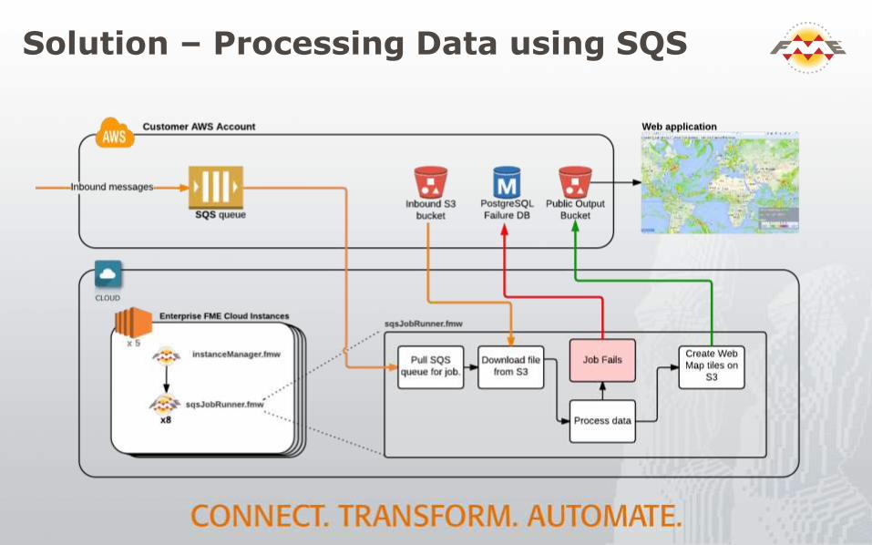
Solution – Processing Data using SQS

Cost Analysis
Costs $80 per run or $58,000 annually.
On FME Server to replicate performance they would need 40 engines (~ $300,000) and a lot of hardware.

BIM to GIS at Mount Vernon
VIRGINIA, USA
Patrick Gahagan, EsriQuinn Evans Architects
Mount Vernon Ladies’ Association

Mount Vernon
George Washington’s home, constructed between 1758 and 1778
Mount Vernon Ladies’ Association tasked with restoration, interpretation, and preservation of grounds and structures
Mansion laser scanned to create architectural-quality HBIM in Revit by Quinn Evans Architects

BIM to GIS via Data Interop
Revit: Add coordinates and rotation from project north to true north
Export to Revit Archive(.rvz) with FME Revit Exporter, attributes to spreadsheet
Import to ArcGIS with Data Interoperability Extension (FME)
Reconnect attribution

A Blended World

Viewshed Analysis
asdf
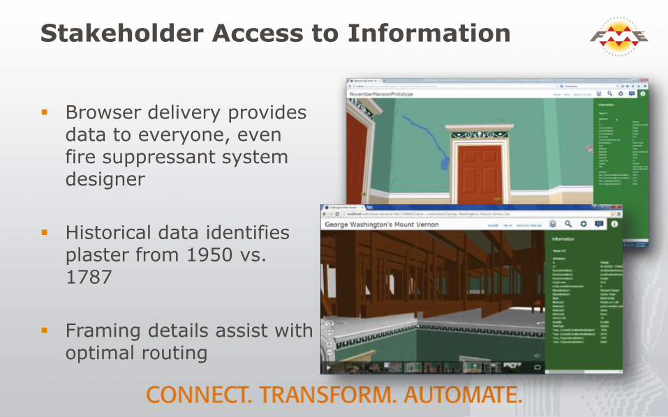
Stakeholder Access to Information
Browser delivery provides data to everyone, even fire suppressant system designer
Historical data identifies plaster from 1950 vs. 1787
Framing details assist with optimal routing
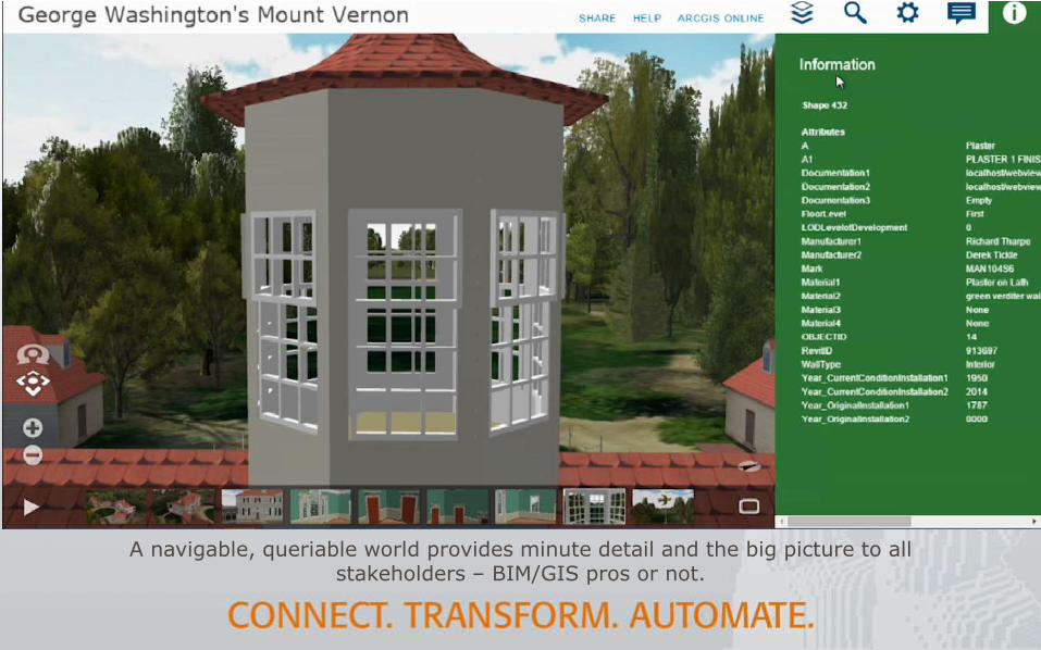
A navigable, queriable world provides minute detail and the big picture to all stakeholders – BIM/GIS pros or not.

UAV-BasedLiDAR Data Collection &
Analysis
FINLAND
Ville Koivuranta
Sharper Shape Ltd.

Next Eagle® by Sharper Shape
Our service fully automatically detects each vegetation issue that threatens the transmission network. We prioritize and visualize the vegetation observations to create ready management plans and work orders that customer could send to his subcontractors.
We identified 3-5 times more issues in the areas that our solution inspected than with traditional methods.
This enabled need based vegetation management.

UAV Solution
Sharper Shape UAV’s are capable Beyond Visual Line Of Sight flights with up to 1 hour flight time and up to 8 kg payload.
Sharper Shapes UAV’s are equipped with high performance LiDAR, High resolution cameras, onboard computer and storage unit and high precision IMU (Inertial Measurement Unit)

FME in Route Planning
Economically optimized flight routes are created using FME.
The elevation information is sourced from existing point cloud or from national DTM.
3D shape polylines are uploaded to autopilot and the UAV follows the pre programmed flight line.
Customer Data Integration
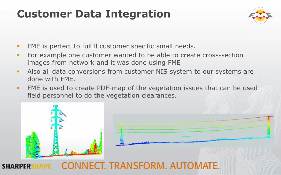
FME is perfect to fulfill customer specific small needs.
For example one customer wanted to be able to create cross-section images from network and it was done using FME
Also all data conversions from customer NIS system to our systems are done with FME.
FME is used to create PDF-map of the vegetation issues that can be used field personnel to do the vegetation clearances.
Prioritization Problem
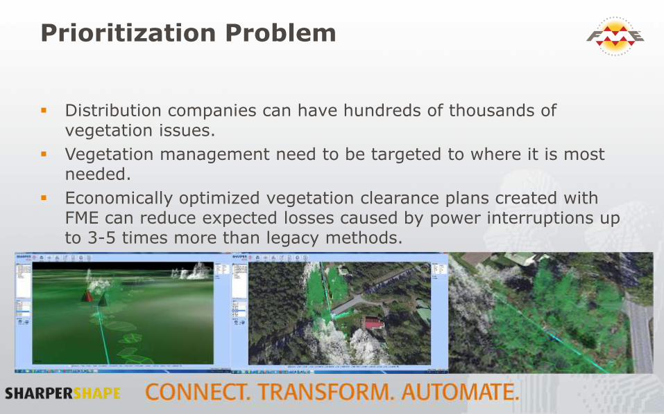
Distribution companies can have hundreds of thousands of vegetation issues.
Vegetation management need to be targeted to where it is most needed.
Economically optimized vegetation clearance plans created with FME can reduce expected losses caused by power interruptions up to 3-5 times more than legacy methods.

Vegetation Management Prioritization
Handle the areas in the priority order. Proceed with
planning.

Conclusions
Combination of these new technologies allows us to take full control of our asset management.
Our goal is to create full turn key solution that is both cheaper and more effective than any legacy method.

Thank You!
Questions?
For more information:
blog.safe.com
@kenatsafe #FMEWT

3D DGN toMultipatch
for City Engine
UNITED KINGDOM
Konrad Poplawski

Thames Tideway Tunnel
Needed:
a reliable, repeatable method to transfer 3D model data between Bentley MicroStationand Esri City Engine.
Challenges:
no direct format support
georeferencing
attribution
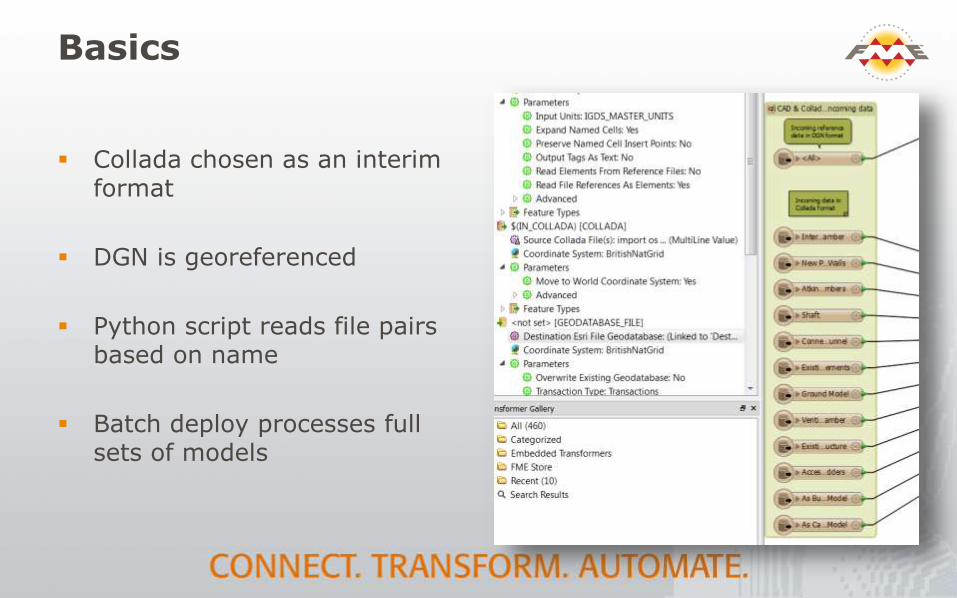
Basics
Collada chosen as an interim format
DGN is georeferenced
Python script reads file pairs based on name
Batch deploy processes full sets of models

Maintaining Georeferencing
BoundingBoxAccumulator
CenterPointReplacer

Attribute Handling
Create attribute lists from original CAD file
Generate keys for downstream re-attribution
Clean up attributes

Re-attribution
asdf

The Result: 3D Web View
Esri MultipatchFeature Classes, positioned and with attributes
Detailed planned construction available to all stakeholders in a browser

OS 3D Data Generation:
Using FME to Investigatethe Creation of Point Clouds from Imagery
UNITED KINGDOM
Nikki GoodwynPhotogrammetric Surveyor
Ordnance Survey

THE CHALLENGE
SYNCHRONISING TWO OUTPUTS: DIGITAL SURFACE MODEL (DSM) AND DIGITAL TERRAIN MODEL (DTM)
DSM DTM

METHODS
Point Cloud- No Colour Values RGB colouring brings points back to reality

SOLUTION
FME WORKBENCH
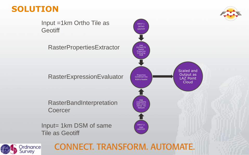
INPUT 1:
ORTHO
GEOTIFF
FME EXTRACTS
Raster Properties Including
RGB
Properties Combined into
RGB & Real64
FME CONVERTS DEM (XYZ) INT32 TO REAL64
INPUT 2:
DSM GEOTIFF
Scaled and Output as LAZ Point
Cloud
SOLUTION
Input =1km Ortho Tile as
Geotiff
Input= 1km DSM of same
Tile as Geotiff
RasterBandInterpretation
Coercer
RasterPropertiesExtractor
RasterExpressionEvaluator

RESULTSCOLOURISED IMAGE-BASED POINT CLOUD OUTPUT


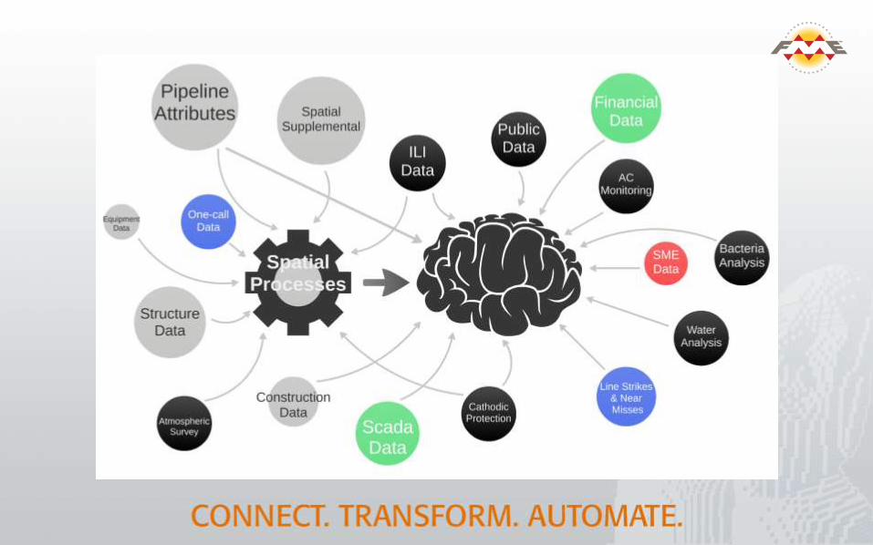
Building a Spatial DecisionSupport Systemfor Natural Gas Pipeline Risk
OKLAHOMA, USA
Matt LandryFrank Yeboah
Williams Companies
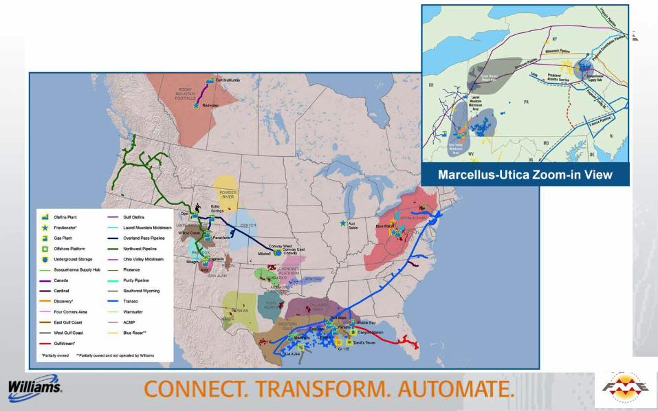

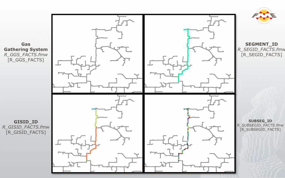
Gas Gathering SystemR_GGS_FACTS.fmw
[R_GGS_FACTS]
SEGMENT_IDR_SEGID_FACTS.fmw
[R_SEGID_FACTS]
GISID_IDR_GISID_FACTS.fmw
[R_GISID_FACTS]
SUBSEG_IDR_SUBSEGID_FACTS.fmw
[R_SUBSEGID_FACTS]
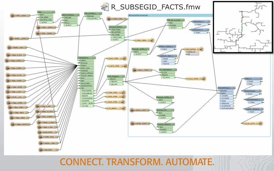
R_SUBSEGID_FACTS.fmw

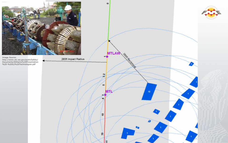
Image Source: http://www.utc.wa.gov/publicSafety/Documents/Williams%20Presentation%20-%20ILI%20Technologies.pdf

Data Migration at Irish Water
IRELAND
Patrick DalyIrish Water
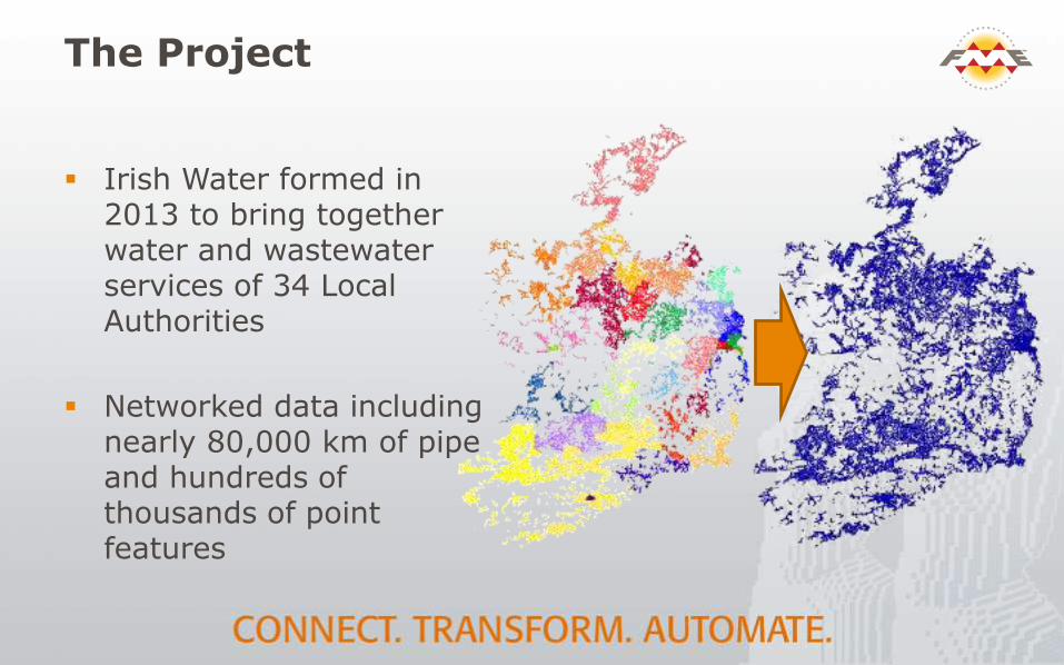
The Project
Irish Water formed in 2013 to bring together water and wastewater services of 34 Local Authorities
Networked data including nearly 80,000 km of pipe and hundreds of thousands of point features

Challenges
Source: Local authority data in CIS and MapInfo datasets
Not in consistent formats
30+ variants in format and schema
Water Below Ground
Selected Feature Class Feature Count Length /km
Air Valve 34,479
Fittings 493,798
Flow Control Valves 2,932
Hydrants 148,451
Network Meters 28,221
System Valves 229,623
Laterals (Service/Comms) 307,003 6,293
Water Mains (of which 6,055Km Private) 713,390 61,183

Solving with FME
Destination: complex ArcGIS Water Utility Data Model
30+ sets of workspaces for normalization and migration
15 hours processing time
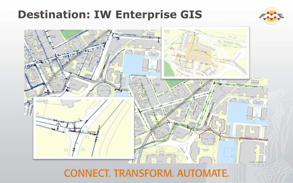
Destination: IW Enterprise GIS

Irish Water
We completed this project in 9 weeks using FME, migrating almost 80,000 km of Water & Waste Water Network data. This scale of project with this timeline would not be achievable without FME.
Patrick Daly, Asset Register & Data Aggregation Specialist
Irish Water
Irish Water GIS Migration Team
Kelly Brady – GIS Analyst North West
Sean Minogue – GIS Analyst East/Midlands
Sandra Nestor - GIS Analyst East/Midlands
Rónán O’Shea – GIS Analyst South
Mark Healy – Reporting & Information Analyst