arizona department of water resources handbook for - adwr gis
TRANSCRIPT
Arizona Department of Water Resources
Handbook for Assured and Adequate Water Supply Web Application
2010
Assured and Adequate Water Supply Web Application Handbook
Page 2 of 9
ASSURED AND ADEQUATE WATER SUPPLY WEB APPLICATION HANDBOOK
INTRODUCTION
This application was developed to allow potential applicants for Assured and Adequate Water Supply (AWS)
with a tool to make an initial identification of current and potential impacts to the aquifer within a selected
geographic area including and within proximity to the area of their proposed development or area of interest. It
identifies previously issued determinations of Assured or Adequate Water Supply (AWS), water provider
service areas, private water company franchise areas, registered wells, and underground storage or groundwater
savings (artificial recharge) facilities.
Please be aware that much of this database information is legacy information that does not reflect the complete
record of the decision. Some of the information dates back to 1973, which predates the Department’s creation,
and the information electronically recorded was collected under various statutory and regulatory rule
frameworks over the last 35 years, thus it is not always reflective of the information needed under the current
application process. While the Department continues to update the database as errors and omissions are
detected, the entire data set has not been fully scrutinized for accuracy and may contain errors or omissions.
This list is intended for general information purposes only and will not necessarily yield an accurate list of
committed demands for purposes of determining the physical availability of groundwater in any given area.
This list is intended to be used as a starting point for an estimate of the demands associated with issued
determinations in a given area. Persons using this information are strongly advised to contact the Office of
Assured and Adequate Water Supply (OAWS) for assistance in accurately determining existing and projected
water demands in a given area.
Under the Adequacy Program, this list includes both Adequate and Inadequate determinations. Under the
Assured Program, this list does not include any change of ownership applications or assignment applications; it
is limited to the first time a determination was issued for a particular subdivision. For designations of both
Assured and Adequate Water Supply, this list includes the original designation, as well as any subsequent
designation modifications for that particular water provider. For Water Reports or Certificates of Assured
Water Supply, the subdivision is listed even if the subdivision based its proof of physical availability on an
Analysis of Adequacy or Analysis of Assured Water Supply.
The Physical availability source as an Analysis or PAD (yes/no) fields may not be accurate. This list also does
not capture individual uses or rights in a given area, nor does it capture uses by lots created outside of the
assured or adequate water supply review process.
This handbook was prepared as a guide to explain each of the data fields included in the results of a user-
defined query (through clicking and dragging an area on the map) for a given area. Specific questions on how
to use the tool, or questions about the query results should be directed to the Office of Assured and Adequate
Water Supply at (602) 771-8599.
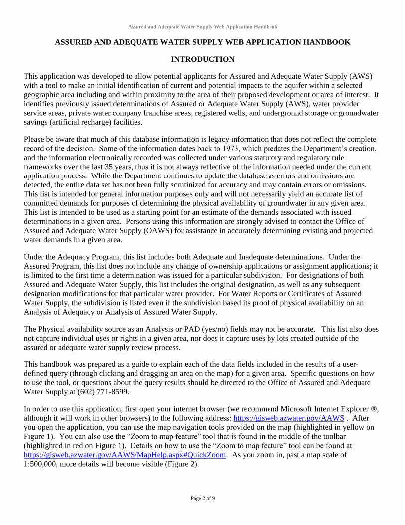
In order to use this application, first open your internet browser (we recommend Microsoft Internet Explorer ®,
although it will work in other browsers) to the following address: https://gisweb.azwater.gov/AAWS . After
you open the application, you can use the map navigation tools provided on the map (highlighted in yellow on
Figure 1). You can also use the “Zoom to map feature” tool that is found in the middle of the toolbar
(highlighted in red on Figure 1). Details on how to use the “Zoom to map feature” tool can be found at
https://gisweb.azwater.gov/AAWS/MapHelp.aspx#QuickZoom. As you zoom in, past a map scale of
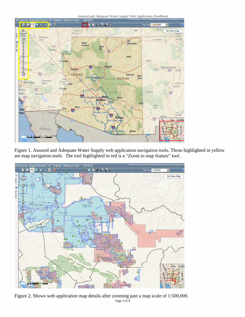
1:500,000, more details will become visible (Figure 2).
Assured and Adequate Water Supply Web Application Handbook
Page 3 of 9
Figure 1. Assured and Adequate Water Supply web application navigation tools. Those highlighted in yellow
are map navigation tools. The tool highlighted in red is a “Zoom to map feature” tool.
Figure 2. Shows web application map details after zooming past a map scale of 1:500,000.

Assured and Adequate Water Supply Web Application Handbook
Page 4 of 9
The map application contains 5 different tools that allow you to interactively query the data associated with the
Assured and Adequate Water Supply program (highlighted in yellow on Figure 3). A short description of each
tool and how to use them can be found on the following website:
https://gisweb.azwater.gov/AAWS/MapHelp.aspx.
Figure 3. Web application query tools (highlighted in yellow).
After one of the query tools is run, the results of the query appear in a window that appears over the map
(Figure 40). The query returns 6 different tables. They are as follows:
AAWS Issued Determinations
Water Provider
CCN
Wells with Pump and Recovery Data
USF
GSF
Descriptions of these tables and the fields contained within them are detailed in the rest of this document. The
application also allows you to download the query results to a Microsoft Excel ® file. Just click on the “Data
Export” button.

Assured and Adequate Water Supply Web Application Handbook
Page 5 of 9
Figure 4. Web application query results window shown over the map. To view the map, without losing your
results, just click the minimize button in the upper right hand corner of the results window (highlighted in
yellow).
TABLE DESCRIPTIONS
Listed below are the main data tables provided in the Assured and Adequate Water Supply (AWS) web
application, and a brief description of the data fields available within each.
Web Source Table Name Table Description
Details Page AWS Issued
Determinations
Issued Assured or Adequate Water Supply file data.
Details Page Water Provider Water service area right or Community Water
System data.
Details Page CCN Private water company franchise area data.
Details Page Wells Well data.
Details Page USF Underground Storage Facility data.
Details Page GSF Groundwater Savings Facility data.

Assured and Adequate Water Supply Web Application Handbook
Page 6 of 9
AWS ISSUED DETERMINATIONS TABLE FIELD DESCRIPTIONS
AWS Issued Determinations
Field Name Description
Subdivision Name of the subdivision, the master plan, the water provider, or the area for which
an application is made.
File No Unique number assigned to the application by ADWR. The first two digits of the
File No denote the application type.
File Type Description of the application type.
Water Provider Entity that will be providing water service to the area for which the application is
made.
System Name
*Sub-system of the water provider, if any, who will serve the area for which an
application is being made, or
* Name of the water provider who is establishing a water service area to serve the
subdivision, or
* “Dry lot” or similar language if the subdivision will require individual lot
purchasers to drill their own private wells, or
* “Unknown” or similar language if at the time of application it has not yet been
determined who the water provider will eventually be for a proposed development or
study area.
Secondary Provider Name of the water provider who will supply water for urban (flood) irrigation, if
applicable.
Status
All results of the query are issued determinations, however under the Adequate
Water Supply Program a water adequacy determination can be either Issued –
Adequate or Issued – Inadequate. Both types of adequacy determination count as
committed demands, however this information is provided for informational
purposes.
Rcvd Date
Date the application was received. A received date year of 1900 signifies that the
actual received date has not yet been researched and/or entered into the database
(mm/dd/yyyy).
Issued Date Date of issuance of the application (mm/dd/yyyy).
Total Demand Total demand associated with the application in acre-feet per year.
GW Portion of the total demand that will be met with groundwater.1
Effluent Portion of the total demand that will be met with effluent.1
SW Portion of the total demand that will be met with surface water.1
CAP Portion of the total demand that will be met with Central Arizona Project water.1
Colorado River Portion of the total demand that will be met with Colorado River water.1
100 Yr 100 times the Total Demand.
No of Lots Number of lots on the subdivision plat or within the master planned community.
Hydro Study Available Y/N field that indicates whether a hydrologic study has been filed that includes the
area of the application.
Locations Concatenated location township number, township direction (N or S), range number,
range direction (E or W) and section or sections.
County Name of the county in which the application is located.
AMA
If the application is located within an Active Management Area, the name of the
AMA appears. If the application is outside an AMA “Not Within Any AMA or
INA” appears.
Subbasin Full name of the groundwater subbasin in which the application is located.
1 Note that this volume may be the annual demand associated with this source of supply x 100.
Assured and Adequate Water Supply Web Application Handbook
Page 7 of 9
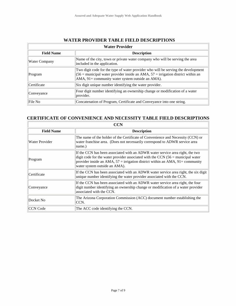
WATER PROVIDER TABLE FIELD DESCRIPTIONS
Water Provider
Field Name Description
Water Company Name of the city, town or private water company who will be serving the area
included in the application.
Program
Two digit code for the type of water provider who will be serving the development
(56 = municipal water provider inside an AMA, 57 = irrigation district within an
AMA, 91= community water system outside an AMA).
Certificate Six digit unique number identifying the water provider.
Conveyance Four digit number identifying an ownership change or modification of a water
provider.
File No Concatenation of Program, Certificate and Conveyance into one string.
CERTIFICATE OF CONVENIENCE AND NECESSITY TABLE FIELD DESCRIPTIONS
CCN
Field Name Description
Water Provider
The name of the holder of the Certificate of Convenience and Necessity (CCN) or
water franchise area. (Does not necessarily correspond to ADWR service area
name.)
Program
If the CCN has been associated with an ADWR water service area right, the two
digit code for the water provider associated with the CCN (56 = municipal water
provider inside an AMA, 57 = irrigation district within an AMA, 91= community
water system outside an AMA).
Certificate If the CCN has been associated with an ADWR water service area right, the six digit
unique number identifying the water provider associated with the CCN.
Conveyance
If the CCN has been associated with an ADWR water service area right, the four
digit number identifying an ownership change or modification of a water provider
associated with the CCN.
Docket No The Arizona Corporation Commission (ACC) document number establishing the
CCN.
CCN Code The ACC code identifying the CCN.

Assured and Adequate Water Supply Web Application Handbook
Page 8 of 9
PUMPING AND RECOVERY REGISTERED WELLS TABLE FIELD DESCRIPTIONS
Wells with Pump and Recovery Data
Field Name Description
Reg No. Unique well registration ID number. Often prefaced by "55-" in reports.
GWSI Site ID GWSI 15-digit identification number assigned to a GWSI site that has been
matched to this Well Registry well.
Legal Description 12-digit Cadastral.
Owner Name Current owner name in Well Registry database, can either be person’s first and last
name, or company name.
Well Type One of four different well type categories: exempt, non-exempt, monitor, and other.
Well Depth (ft) Depth of the well bore hole in feet.
Case Depth (ft) Depth of the casing within the well bore hole in feet.
Drill Date Date the well construction was completed.
Water Level Depth to water in feet. Typically reported when the well was drilled.
Pump Capacity (GPM) Tested pump capacity in gallons per minute. The pump used for this test could have
been installed only at the time the well was drilled then removed.
Pump Data Available YES / NO field that indicates if this well has pump data reported for it.
Completion Report Status flag for indicating the completion report (CRT) status for a well.
(X = CRT is in file, N = CRT not required, C = CRT considered complete).
Log Received Status flag for indicating the well log form status for a well.
(X = Log is in file, N = Log not required, C = Log considered complete).
UTM X (meters) X coordinate for well (NAD 83 UTM Zone 12N). Coordinates reflect centroid of
well’s reported cadastral location.
UTM Y (meters) Y coordinate for well (NAD 83 UTM Zone 12N). Coordinates reflect centroid of
well’s reported cadastral location.
UNDERGROUND STORAGE FACITILITY QUERY FIELD DESCRIPTIONS
USF Results
Field Name Description
Facility Name Name of the Underground Storage Facility (USF).
File No
Unique number including the two digit program code for the type of recharge facility
(71 = underground storage facility) and the six digit certificate number identifying
the facility permit.
Conveyance Four digit number identifying whether there has been a modification of a facility
permit.
Permittee Name of the holder of the underground storage facility permit.
Type Type of underground storage facility (managed or constructed).
AFY Volume of water in acre-feet that can be stored per year at the facility.
Status Whether the permit is active or inactive (expired).
Max Storage Total volume of water in acre-feet that can be stored over the life of the permit.
Expire Yr Year the permit will expire.
Cadastral Township, range and section (cadastral) where the facility is located (i.e.
D18013001AAA).
AMA
Three letter abbreviation for the name of the AMA in which the storage facility is
located (TUC = Tucson AMA, PHX = Phoenix AMA, PIN = Pinal AMA, PRE =
Prescott AMA).

Assured and Adequate Water Supply Web Application Handbook
Page 9 of 9
GROUNDWATER SAVINGS FACILITY QUERY FIELD DESCRIPTIONS
GSF Results
Field Name Description
Facility Name Name of the Groundwater Savings Facility (GSF).
Program Two digit code for the type of recharge facility (72 = groundwater savings facility).
Certificate Six digit unique number identifying the facility permit.
Conveyance Four digit number identifying whether there has been a modification of a facility
permit.