argus-2 wellhead environment plan summary - … · the area under which the potential risk...
TRANSCRIPT

Argus-2 Wellhead Environment Plan Summary
Exploration Division
July 2017
Revision 1

Argus-2 Wellhead Environment Plan Summary
This document is protected by copyright. No part of this document may be reproduced, adapted, transmitted, or stored in any form by any process (electronic or otherwise) without the specific written consent of Woodside. All rights are reserved.
DRIMS No: 1400437007 Revision: 1 Page 4 of 44
Uncontrolled when printed. Refer to electronic version for most up to date information.
TABLE OF CONTENTS
1. INTRODUCTION .................................................................................................... 5
1.1 Defining the Activity ............................................................................................................ 5
2. LOCATION OF THE ACTIVITY .............................................................................. 6
3. DESCRIPTION OF THE ACTIVITY ........................................................................ 7
3.1 Purpose of the Activity ........................................................................................................ 7
3.2 Timing of the Activities ........................................................................................................ 7
3.3 Argus-2 Well Exploration History ........................................................................................ 7
3.4 Well Abandonment ............................................................................................................. 7
3.4.1 Water Based Muds ............................................................................................................. 7
3.5 Options Analysis ................................................................................................................. 7
4. DESCRIPTION OF THE RECEIVING ENVIRONMENT ......................................... 9
4.1 Regional Setting ................................................................................................................. 9
4.2 Physical Environment ......................................................................................................... 9
4.3 Biological Environment ..................................................................................................... 10
4.3.1 Benthic Communities ........................................................................................................ 10
4.3.2 Plankton ............................................................................................................................ 10
4.3.3 Species ............................................................................................................................. 11
4.4 Socio-economic Environment ........................................................................................... 13
4.5 Sensitive Marine Environments ........................................................................................ 14
5. ENVIRONMENTAL IMPACTS AND RISKS ......................................................... 15
5.1 Risk Identification and Evaluation ..................................................................................... 15
5.1.1 Establish the Context ........................................................................................................ 15
5.1.2 Risk Identification ............................................................................................................. 16
5.1.3 Risk Analysis .................................................................................................................... 16
5.1.4 Risk evaluation ................................................................................................................. 19
6. ENVIRONMENTAL RISKS AND IMPACTS SUMMARY ..................................... 22
7. ONGOING MONITORING OF ENVIRONMENTAL PERFORMANCE ................. 24
7.1 Environment Plan Revisions and Management of Change .............................................. 24
8. CONSULTATION ................................................................................................. 26
8.1 Ongoing Consultation ....................................................................................................... 27
8.2 Non-Routine Events ......................................................................................................... 28
9. TITLEHOLDER NOMINATED LIAISON PERSON .............................................. 29
10. ABBEVIATIONS ................................................................................................... 30
11. REFERENCES ..................................................................................................... 31

Argus-2 Wellhead Environment Plan Summary
This document is protected by copyright. No part of this document may be reproduced, adapted, transmitted, or stored in any form by any process (electronic or otherwise) without the specific written consent of Woodside. All rights are reserved.
DRIMS No: 1400437007 Revision: 1 Page 5 of 44
Uncontrolled when printed. Refer to electronic version for most up to date information.
1. INTRODUCTION
Woodside Browse Pty Ltd (Woodside), as nominated Titleholder (on behalf of the Joint Venture comprising Woodside and BHP Billiton Petroleum) under the Offshore Petroleum and Greenhouse Gas Storage (Environment) Regulations 2009 (Cth) (referred to as the Environment Regulations), proposes to permanently leave in-situ, the wellhead of the Argus-2 appraisal well in Petroleum Retention Lease AC/RL 8 (hereafter referred to as the Petroleum Activities Program).
This Environment Plan (EP) Summary has been prepared to meet the requirements of Regulations 11(3) and 11(4) of the Environment Regulations, as administered by the National Offshore Petroleum Safety and Environmental Management Authority (NOPSEMA). This document summarises the Argus-2 Wellhead EP, accepted by NOPSEMA under Regulation 10A of the Environment Regulations.
1.1 Defining the Activity
The Petroleum Activities Program to be undertaken in Petroleum Retention Lease AC/RL 8, involves no operations and comprises of leaving the existing Argus-2 wellhead in-situ, which is a petroleum activity, as defined in Regulation 4 of the Environment Regulations. As such, an EP is required.

Argus-2 Wellhead Environment Plan Summary
This document is protected by copyright. No part of this document may be reproduced, adapted, transmitted, or stored in any form by any process (electronic or otherwise) without the specific written consent of Woodside. All rights are reserved.
DRIMS No: 1400437007 Revision: 1 Page 6 of 44
Uncontrolled when printed. Refer to electronic version for most up to date information.
2. LOCATION OF THE ACTIVITY
The proposed Petroleum Activities Program is in Petroleum Retention Lease AC/RL8 located in Commonwealth waters approximately 526 km north of Broome (Figure 2-1). Water depth at the Argus-2 wellhead location is approximately 540 m at lowest astronomical tide (LAT). Approximate location details for the Petroleum Activities Program are provided in Table 2-1.
Figure 2-1: Location of the Petroleum Activities Program
The Well Abandonment Area defines the spatial boundary of the Petroleum Activities Program, as described, risk assessed and managed by the EP. The Well Abandonment Area encompasses a 500 m radius from the Argus -2 wellhead. The Well Abandonment Area is the area under which the potential risk associated with the presence of the Argus-2 wellhead will be assessed.
Table 2-1: Approximate locations details for the Petroleum Activities Program
Activity Water Depth (Approx. m LAT)
Latitude Longitude Title
Argus-2 wellhead 540 13°12’ 35.15” 122° 37’ 13.23”
AC/RL8

Argus-2 Wellhead Environment Plan Summary
This document is protected by copyright. No part of this document may be reproduced, adapted, transmitted, or stored in any form by any process (electronic or otherwise) without the specific written consent of Woodside. All rights are reserved.
DRIMS No: 1400437007 Revision: 1 Page 7 of 44
Uncontrolled when printed. Refer to electronic version for most up to date information.
3. DESCRIPTION OF THE ACTIVITY
3.1 Purpose of the Activity
The Argus-2 well was a vertical appraisal well, to explore for potentially commercial hydrocarbon resources, drilled in June 2011. The well was plugged and abandoned in September 2011 and now Woodside proposes to leave the wellhead in-situ (refer to Section 3.5 for additional discussion).
3.2 Timing of the Activities
The proposed Petroleum Activities Program involves permanent (in perpetuity) abandonment of the Argus-2 wellhead.
3.3 Argus-2 Well Exploration History
In June 2011, Woodside drilled the appraisal well Argus-2 in the Browse Basin using the Ocean America semi-submersible drilling rig operated by Diamond Offshore. The Argus-2 well was drilled under an accepted EP.
3.4 Well Abandonment
The Argus-2 well has been abandoned with six abandonment cement plugs, including verification of the uppermost cement plug by tagging through a prescribed program. The remaining five cement plugs were either pressure tested and/or tagged. Abandonment of a lower section of the well (Argus-2) occurred prior to side tracking with two cement plugs. Following abandonment at the end of the drilling activity, the marine riser and blow out preventer (BOP) were removed. The wellhead has remained in-situ since plug and abandonment activities were executed in 2011.
The wellhead is made of steel and is approximately 1 m in diameter and extends approximately 4.5 m above the seabed. The combined weight of the wellhead is approximately 5000 kg. There is an environmental cap, made of steel, which is the same diameter of the wellhead and approximately 1.5 m long and weighs approximately 300 kg.
3.4.1 Water Based Muds
Within the well, between the last plug and the wellhead, are approximately 139 m3 of water based muds (WBM). WBMs within the well are comprised of predominantly water with small proportions of additives.
All components of the WBMs in the Argus-2 well, with one exception, are either listed as ‘E’ or ‘Gold’ category fluids under the Offshore Chemical Notification Scheme (OCNS). These rankings are based on toxicity and other relevant parameters such as biodegradation, and bioaccumulation, in accordance with one of two schemes:
Hazard Quotient (HQ) Colour Band: Gold, Silver, White, Blue, Orange and Purple (listed in order of increasing environmental hazard); or
OCNS Grouping: E, D, C, B or A (listed in order of increasing environmental hazard). Used for inorganic substances, hydraulic fluids and pipeline chemicals only.
3.5 Options Analysis
Woodside conducted an options analysis (ALARP assessment) to assess the suitable abandonment approach for the Argus-2 wellhead. Potential wellhead approach options were assessed and compared against relevant decision drivers, including Health and Safety

Argus-2 Wellhead Environment Plan Summary
This document is protected by copyright. No part of this document may be reproduced, adapted, transmitted, or stored in any form by any process (electronic or otherwise) without the specific written consent of Woodside. All rights are reserved.
DRIMS No: 1400437007 Revision: 1 Page 8 of 44
Uncontrolled when printed. Refer to electronic version for most up to date information.
(H&S), environment factors, societal impacts, and project costs. The options analysis considered leaving the wellhead in-situ and removing the wellhead. The analysis concluded that leaving the wellhead in-situ provided the most ALARP and acceptable option which would have no H&S risk (attributed to no activity being required), minimal impact to the surrounding environment (potential loss of WBM), with no associated project costs.
In contrast, attempting to remove the wellhead has been assessed as having potential for impact to people during wellhead removal activities, loss of habitat (hard substrate), loss of WBM associated with the removal of the wellhead and vessel/equipment environmental impacts associated with wellhead removal activities (waste, water quality and sediment impacts). There is also significant cost associated with mobilising a vessel or Mobile Offshore Drilling Unit (MODU) to the location for wellhead removal, and this cost is considered disproportionate to the benefit gained. Therefore, the option analysis concluded that leaving the wellhead in-situ is the ALARP option as it results in no H&S risk to personnel, no cost and has the least environmental impact when compared to removal. The environmental impacts of the wellhead assembly remaining in-situ are considered in APPENDIX A.

Argus-2 Wellhead Environment Plan Summary
This document is protected by copyright. No part of this document may be reproduced, adapted, transmitted, or stored in any form by any process (electronic or otherwise) without the specific written consent of Woodside. All rights are reserved.
DRIMS No: 1400437007 Revision 1 Page 9 of 44
Uncontrolled when printed. Refer to electronic version for most up to date information.
4. DESCRIPTION OF THE RECEIVING ENVIRONMENT
In determining the spatial extent of the environmental sensitivities that may be affected, Woodside considered the Well Abandonment Area (for planned and unplanned activities).
4.1 Regional Setting
The Well Abandonment Area is located 526 km north of Broome in the Timor Province bioregional unit, part of the Northwest Marine Region (NWMR). The NWMR encompasses Commonwealth waters from the Western Australia/Northern Territory border to Kalbarri in the south, and covers 1.07 million km2 of ocean (DEWHA, 2008). The NWMR is characterised by shallow water, tropical marine ecosystems with high species richness (DSEWPaC, 2012a). The NWMR region comprises a variety of seafloor features, currents and diversity of habitats which, together, create a complex and unique range of ecosystems (Geoscience Australia, 2013).
No listed World Heritage Properties or Commonwealth Marine Areas are adjacent or overlapping the Well Abandonment Area. The closest sensitive receptors are Seringapatam Reef approximately 73 km southwest; Scott Reef 122 km southwest; and Ashmore and Cartier Island, 107 km northeast of the Well Abandonment Area.
4.2 Physical Environment
The climate of the Well Abandonment Area has two distinct seasons, a mild, dry winter from April to September and a hot wet summer from October to March, with rapid transitional months between the main seasons generally in April and September/October. The climate is controlled by two major atmospheric pressure systems: the subtropical ridge of high pressure cells (highs or anticyclones), and a broad tropical low pressure region called the monsoon trough. The rainfall in the area is highly variable, with approximately 90% received during summer, and influenced by the monsoon and associated thunderstorms, and tropical cyclone activity. Winds in the greater vicinity of the Well Abandonment Area are typically westerly/north-westerly and humid during the summer monsoon period and drier south easterlies, which originate over the Australian mainland, during the winter months.
Currents within the region are generated by several components, including tidal-forcing, local wind-forcing, inertial oscillations, shelf waves, seiching, trapped waves and regional current systems, including the Indonesian Through flow. At a large scale, the Indian Ocean accommodates a general anticlockwise gyre, driven by global wind regimes. This circulation includes the westward flowing South Equatorial Current at 8 to 15°S latitude, driven by the South East Trade Winds. The strength and direction of tidal currents in the area strongly depends on the local bathymetry.
Water temperatures throughout the NWMR are largely derived from the influence of the Indonesian Throughflow that delivers warm, lower salinity water to the region (Brewer et al., 2007). Water temperatures are therefore warmer in the north of the region (Timor Province) ranging from maximum temperatures of around 31 °C in the summer and 27 °C in winter. However, water temperatures below 300 m water depth show little seasonal difference (Brinkman et al., 2009). Horizontal temperature gradients are also reported across the continental shelf of the NWMR, with water generally being warmer closer to the coast.
The main features in the broader vicinity of the Timor Province are Seringapatam and Ashmore Reefs (73 km southwest and 107 km northeast), a number of large emergent shelf atolls that occur along the edge of Australia’s North West Shelf including Scott Reef (122 km southwest). Bathymetry in the vicinity of the Well Abandonment Area comprises a relatively flat seabed, devoid of any significant features.

Argus-2 Wellhead Environment Plan Summary
This document is protected by copyright. No part of this document may be reproduced, adapted, transmitted, or stored in any form by any process (electronic or otherwise) without the specific written consent of Woodside. All rights are reserved.
DRIMS No: 1400437007 Revision 1 Page 10 of 44
Uncontrolled when printed. Refer to electronic version for most up to date information.
Sediments in the NWMR generally become finer with increasing water depth, ranging from sand and gravels on the continental shelf to mud on the continental slope and abyssal plain. Approximately 60-90% of the sediments in the region are carbonate-derived (skeletal remains of carbonate-secreting marine organisms) (Brewer et al., 2007).
4.3 Biological Environment
No Critical Habitats or Threatened Ecological Communities, as listed under the Environmental Protection and Biodiversity Conservation Act 1999 (EPBC Act), occur within the Well Abandonment Area.
4.3.1 Benthic Communities
The NWMR encompasses large areas of seabed dominated by soft sediments (sandy and muddy substrata with occasional patches of coarser sediments). In 2007, the Commonwealth Scientific and Industrial Research Organisation (CSIRO) conducted extensive benthic habitat mapping surveys and epifauna (living on the surface of the sediment) sampling in deep waters (100 m to 1,000 m) spanning 13 sites between Barrow Island and Ashmore Reef, running downslope across the continental shelf and continental slope of the North West Shelf (Williams et al., 2010). This research represents the most comprehensive study to date of this historically little studied region. Surveys conducted in close proximity to the Argus-2 wellhead found the area to be mostly devoid of visible signs of fauna (Williams et al., 2010). Surveys conducted at depths consistent with the Argus-2 wellhead were characterised by soft muddy, bioturbated substrata with sparse epifauna.
A study undertaken in the Browse Basin Floating Liquefied Natural Gas (FLNG) Development area (85 km southwest of the Well Abandonment Area) also found low abundances of benthic species, and provides a general description of the benthic assemblages expected to be present in the vicinity of Argus-2 wellhead. Surveys found the deep-sea seabed habitat (400 to 600 m) in this area comprised fine sand and silt with epifauna limited to isolated individual bryozoan colonies, brittlestars and basketstars, and sea anemones. The most abundant infauna, accounting for 53.4% of all infaunal assemblages, were polychaete bristleworms from the phylum Annelida.
Sea floor communities in deeper (>100 m) shelf waters receive insufficient light to sustain ecologically sensitive primary producers such as seagrasses, macroalgae or zooxanthellate scleractinian (reef building) corals. Given the depth of water in which the Argus-2 wellhead is situated (540 m), these benthic primary producer groups will not occur in the Well Abandonment Area.
4.3.2 Plankton
Plankton within the Well Abandonment Area is expected to reflect the conditions of the NWMR. Primary productivity of the NWMR appears to be largely driven by offshore influences (as reported by Brewer et al., 2007), with periodic upwelling events and cyclonic influences driving coastal productivity with nutrient recycling and advection. There is a tendency for offshore phytoplankton communities in the NWMR to be characterised by smaller taxa (e.g. bacteria), whereas, shelf waters are dominated by larger taxa such as diatoms (Hanson et al., 2007).
Plankton generally exhibit a high degree of spatial and temporal variability. For phytoplankton populations abundances are regulated by seasonal cycles, resulting in similar trends for zooplankton which rely on phytoplankton for food. In tropical regions, higher plankton populations occur during winter months (June to August) (Hayes et al., 2005). High spatial variability of plankton is found both vertically and horizontally, and can be influenced by temperature and salinity gradients, water motion, light intensity or organic matter in the water column (Omori & Hamner, 1982).

Argus-2 Wellhead Environment Plan Summary
This document is protected by copyright. No part of this document may be reproduced, adapted, transmitted, or stored in any form by any process (electronic or otherwise) without the specific written consent of Woodside. All rights are reserved.
DRIMS No: 1400437007 Revision 1 Page 11 of 44
Uncontrolled when printed. Refer to electronic version for most up to date information.
4.3.3 Species
A total of 26 species listed under the EPBC Act were identified as potentially occurring within the Well Abandonment Area (Table 4-1). Of these 15 are considered threatened marine species and 24 migratory species under the EPBC Act.
Table 4-1 Threatened and migratory marine species under the EPBC Act potentially occurring with the Well Abandonment Area
Species Name Common Name Threatened Status Migratory Status
Mammals
Balaenoptera borealis Sei Whale Vulnerable Migratory
Balaenoptera musculus Blue Whale Endangered Migratory
Balaenoptera physalus Fin Whale Vulnerable Migratory
Megaptera novaeangliae Humpback Whale Vulnerable Migratory
Balaenoptera bonaerensis Antarctic Minke Whale Migratory
Balaenoptera edeni Bryde's Whale Migratory
Orcinus orca Killer Whale Migratory
Physeter macrocephalus Sperm Whale Migratory
Reptiles
Caretta caretta Loggerhead Turtle Endangered Migratory
Chelonia mydas Green Turtle Vulnerable Migratory
Dermochelys coriacea Leatherback Turtle Endangered Migratory
Eretmochelys imbricata Hawksbill Turtle Vulnerable Migratory
Lepidochelys olivacea Olive Ridley Turtle Endangered Migratory
Natator depressus Flatback Turtle Vulnerable Migratory
Sharks and Rays
Carcharodon carcharias White Shark Vulnerable Migratory
Glyphis garricki Northern River Shark Endangered
Isurus oxyrinchus Shortfin Mako Migratory
Isurus paucus Longfin Mako Migratory
Manta birostris Giant Manta Ray Migratory
Birds
Anous tenuirostris melanops Australian Lesser Noddy Vulnerable
Calidris ferruginea Curlew Sandpiper Critically Endangered
Migratory Wetlands
Numenius madagascariensis Eastern Curlew Critically Endangered
Migratory Wetlands
Anous stolidus Common Noddy Migratory
Calonectris leucomelas Streaked Shearwater Migratory
Fregata ariel Lesser Frigatebird Migratory
Fregata minor Great Frigatebird Migratory

Argus-2 Wellhead Environment Plan Summary
This document is protected by copyright. No part of this document may be reproduced, adapted, transmitted, or stored in any form by any process (electronic or otherwise) without the specific written consent of Woodside. All rights are reserved.
DRIMS No: 1400437007 Revision 1 Page 12 of 44
Uncontrolled when printed. Refer to electronic version for most up to date information.
Seabirds
Seven EPBC listed species of birds (five seabirds and two migratory shorebirds) were identified as potentially occurring within the Well Abandonment Area. Migratory and oceanic birds may occasionally occur within the Well Abandonment Area; however, as no emergent land is present they are most likely to be present while flying through the region between important nesting or roosting habitat. As such, the Well Abandonment Area contains no known critical habitats or Biologically Important Areas (BIAs) for listed bird species.
Marine Mammals
Pygmy blue whales (Balaenoptera musculus brevicauda) are likely to infrequently occur within the Well Abandonment Area, particularly during their annual migrations. Given research has shown their preference for deeper waters and movements mainly to the west side of Scott Reef during their migrations, occurrence will be rare and restricted to one or few individuals. A foraging BIA lies 75 km to the southwest of the Well Abandonment Area, surrounding Scott Reef. The pygmy blue whale migratory pathway BIA is the only BIA to overlap the Well Abandonment Area.
Given the distance to the main breeding area for humpback whales and low occurrence of whales observed at Scott Reef, few individuals of humpback whales are likely to rarely transit through the Well Abandonment Area.
Other cetacean species may infrequently transit the Well Abandonment Area; however, the Well Abandonment Area does not represent any critical habitat (feeding, resting or breeding aggregation areas) for cetacean species that may occur in the region. Other listed marine mammals identified that may occur within the Well Abandonment Area include: sei whales, fin whales, Antarctic minke whales, Bryde’s whales, killer whales, and sperm whales.
Marine Reptiles
Of the seven species of marine turtles found globally, six were identified as potentially occurring within the Well Abandonment Area, the green turtle (Chelonia mydas), leatherback turtle (Dermochelys coriacea), loggerhead turtle (Caretta caretta), hawksbill turtle (Eretmochelys imbricata), olive ridley turtle (Lepidochelys olivacea), and the flatback turtle (Natator depressus). There is no emergent habitat within the Well Abandonment Area, therefore, nesting aggregations of marine turtles are unlikely to occur. Further, tracking data indicate the three main marine turtle species recorded for the NWMR travel and forage in coastal waters that are relatively shallow (hawksbill turtles – less than 10 m deep; green turtles – less than 25 m deep; flatback turtles – less than 70 m deep). Diving depth for leatherback turtles is related to food availability, and dives can reach greater than 1000 m in depth, thought typically restricted to less than 300 m (Dodge et al., 2014; Houghton et al., 2008).
No marine turtle BIAs overlap the Well Abandonment Area. Given the water depth and lack of suitable benthic prey, foraging adult turtles are not expected to occur within the Well Abandonment Area, with the exception of the leatherback turtle which feed predominantly on gelatinous pelagic fauna such as jellyfish. No other listed marine reptiles were identified as occurring within the Well Abandonment Area.
Sharks, Rays and Fishes
Five EPBC listed shark/ray species, including the great white shark (Carcharodon carcharias), Northern river shark (Glyphis garricki), shortfin mako (Isurus oxyrinchus), longfin mako (Isurus paucus) and giant manta ray (Manta birostris), may be present within the Well Abandonment Area for short durations when individuals infrequently transit the area. No

Argus-2 Wellhead Environment Plan Summary
This document is protected by copyright. No part of this document may be reproduced, adapted, transmitted, or stored in any form by any process (electronic or otherwise) without the specific written consent of Woodside. All rights are reserved.
DRIMS No: 1400437007 Revision 1 Page 13 of 44
Uncontrolled when printed. Refer to electronic version for most up to date information.
EPBC listed teleost fish species were identified as occurring within the Well Abandonment Area.
Additional features relating to the fish populations of the area are as follows:
The fish fauna in the NWMR region is considered to be diverse and show a trend of decreasing species richness with increasing depth. Fish species richness has been shown to correlate with habitat complexity, with more complex habitat supporting greater species richness and abundance than bare areas.
The Well Abandonment Area comprises featureless, flat soft sediment seabed, and consequently the natural fish fauna are not expected to be abundant and diversity is expected to be limited due to the lack of hard substrate/ habitat complexity.
4.4 Socio-economic Environment
There are no known sites of Indigenous or European cultural or heritage significance or known shipwreck sites within the vicinity of the Well Abandonment Area. Tourism and recreational activities are also unlikely to occur in the Well Abandonment Area, particularly at depths consistent with the Argus-2 wellhead.
The NWMR supports a number of industries including petroleum exploration and production, as well as minerals extraction. In addition, carbon capture and storage associated with the petroleum industry may become an important activity. The closest petroleum activities are the Ichthys Floating Production, Storage and Offtake vessel (FPSO) and Central Processing Facility (CPF) and Prelude FLNG (both of which are still being built), approximately 120 km southeast and approximately 100 km south east, respectively, from the Well Abandonment Area.
A number of Commonwealth and State fisheries overlap the Well Abandonment Area. The majority of fishing effort in relation to these fisheries occurs beyond the Well Abandonment Area, or not at depths consistent with the Argus-2 wellhead. There are no aquaculture activities within the Well Abandonment Area.
Commonwealth fisheries overlapping or adjacent to the Well Abandonment Area include
North West Slope Trawl Fishery
Western Tuna and Billfish Fishery
Western Skipjack Tuna Fishery
Southern Bluefin Tuna Fishery.
State fisheries overlapping or adjacent to the Well Abandonment Area include:
West Australian Mackerel Fishery
Northern Demersal Scalefish Managed Fishery
South West Coast Salmon Fishery
West Coast Deep Sea Crustacean
Pearl Oyster Managed Fishery, Pearl Leases.
Shipping activity in and around the Well Abandonment Area is sparse with the main commercial shipping routes located approximately 50 to 100 km west of Scott Reef. The main shipping activity in the NWMR relates to transits to and from Broome, transporting goods between Australian and international ports. The majority of the shipping activity within the Well Abandonment Area is related to petroleum activities.

Argus-2 Wellhead Environment Plan Summary
This document is protected by copyright. No part of this document may be reproduced, adapted, transmitted, or stored in any form by any process (electronic or otherwise) without the specific written consent of Woodside. All rights are reserved.
DRIMS No: 1400437007 Revision 1 Page 14 of 44
Uncontrolled when printed. Refer to electronic version for most up to date information.
4.5 Fisheries – Traditional
Indonesian fishers have traditionally visited reefs in the NWMR to collect target species such as trepan (sea cucumber), shark fin and other marine species that are economically significant. In 1974 the Memorandum of Understanding (MoU 74) was signed by the Governments of Australia and Indonesia that allowed Indonesian fishers to continue to fish using “methods which have been the tradition over decades of time”. These methods include reef gleaning, free-diving, hand lining and other non-mechanised methods. Traditional fishing was allowed within the 12 nautical mile (nm) fishing zones that existed around the following reefs or islets in the region at that time:
Ashmore Reef (Pulau Pasir)
Cartier Island (Pulau Baru).
Seringapatam Reef (Afringan).
Scott Reef (Pulau Dato).
Browse Island (Berselan).
In 1989 “Practical Guidelines” for implementing the MoU 74 were agreed, which resulted in the creation of the MoU Box that encloses the five areas formerly agreed. The MoU 74 Box and Practical Guidelines have remained in force since their adoption. Restrictions were introduced around Ashmore Reef and Cartier Island following their designation as Nature Reserves under the Commonwealth’s National Parks and Wildlife Conservation Act 1975 in 1983 and 2000, respectively. Ashmore Reef and Cartier Island are currently protected and managed as Commonwealth Marine Reserves under the EPBC Act, while Scott Reef is currently the principal reef in the MoU 74 Box, to which Indonesian fishers regularly sail on a seasonal basis to harvest trepang and other reef species. Browse Island is also frequently visited by shark fishers who mostly fish along the eastern margin of the MoU 74 Box.
Although the Well Abandonment Area is within the MoU 74 Box, it is outside the 12 nm permitted fishing zones associated with each of the reefs/islets. Further, permitted fishing methods are highly unlikely to reach depths consistent with the location of the Argus-2 wellhead. As a result, it is highly unlikely traditional fisheries will occur within the Well Abandonment Area.
4.6 Sensitive Marine Environments
Within the Well Abandonment Area, no Commonwealth or State sensitive areas were identified. The closest established or proposed Marine Protected Area (MPA) is the Ashmore Reef Commonwealth Marine Reserve, at a distance of 107 km from the boundary of the Well Abandonment Area. The nearest Key Ecological Feature (KEF) is the Continental Slope Demersal Fish Communities, which is 10 km northwest from the Well Abandonment Area at its closest point.

Argus-2 Wellhead Environment Plan Summary
This document is protected by copyright. No part of this document may be reproduced, adapted, transmitted, or stored in any form by any process (electronic or otherwise) without the specific written consent of Woodside. All rights are reserved.
DRIMS No: 1400437007 Revision 1 Page 15 of 44
Uncontrolled when printed. Refer to electronic version for most up to date information.
5. ENVIRONMENTAL IMPACTS AND RISKS
5.1 Risk Identification and Evaluation
Woodside undertook an environmental risk assessment to identify the potential environmental impacts and risks associated with the Petroleum Activities Program, and the control measures to manage the identified environmental impacts and risks to as low as reasonably practicable (ALARP) and an acceptable level. This risk assessment and evaluation was undertaken using Woodside’s Risk Management Framework.
The key steps of Woodside’s Risk Management Framework are shown in Figure 5-1. A summary of each step and how it is applied to the Petroleum Activities Program is provided below.
Figure 5-1: Woodside’s risk management framework
5.1.1 Establish the Context
The objective of a risk assessment is to assess identified risks and apply appropriate control measures to eliminate, control or mitigate the risk to ALARP and to determine if the risk is acceptable.

Argus-2 Wellhead Environment Plan Summary
This document is protected by copyright. No part of this document may be reproduced, adapted, transmitted, or stored in any form by any process (electronic or otherwise) without the specific written consent of Woodside. All rights are reserved.
DRIMS No: 1400437007 Revision 1 Page 16 of 44
Uncontrolled when printed. Refer to electronic version for most up to date information.
Hazard identification workshops aligned with NOPSEMA’s Hazard Identification Guidance Note were undertaken by multidisciplinary teams made up of relevant personnel with sufficient breadth of knowledge, training and experience to reasonably assure that risks and associated impacts were identified and assessed.
5.1.2 Risk Identification
The risk assessment workshop for the Petroleum Activities Program was used to identify risks with the potential to harm the environment. Risks were identified for both planned (routine and non-routine) and unplanned (accidents/incidents) activities.
5.1.3 Risk Analysis
Risk analysis further develops the understanding of a risk by defining the impacts and assessing the appropriate controls. Risk analysis for the Petroleum Activities Program considered previous risk assessments, review of relevant studies, review of past performance, external stakeholder consultation feedback and review of the existing environment.
The following key steps were undertaken for each identified risk during the Argus-2 risk assessment:
Identification of decision type in accordance with the Decision Support Framework;
Identification of appropriate control measures (preventative and mitigation) aligned with the decision type;
Calculation of the residual risk rankings.
Decision Support Framework
To support the risk assessment process, Woodside applied the Guidance on Risk Related Decision Making (Oil and Gas UK 2014) during the workshops to determine the level of supporting evidence that may be required to draw sound conclusions regarding risk level and whether the risk is acceptable and ALARP.
This is to ensure:
Activities do not pose an unacceptable environmental risk;
Appropriate focus is placed on activities where the risk is anticipated to be tolerable and demonstrated to be ALARP;
Appropriate effort is applied to the management of risks based on the uncertainty of the risk, the complexity and risk rating.
Identification of Control Measures
Woodside applies a hierarchy of control measures when considering Good Practice and Professional Judgement. The hierarchy of control is applied in order of importance as follows; elimination, substitution, engineering control measures, administrative control measures and mitigation of consequences/impacts.
Risk rating process
The current risk rating process is undertaken to assign a level of risk to each impact measured in terms of consequence and likelihood. The assigned risk level is the current risk (i.e. risk with controls in place) and is therefore determined following the identification of the decision type and appropriate control measures.

Argus-2 Wellhead Environment Plan Summary
This document is protected by copyright. No part of this document may be reproduced, adapted, transmitted, or stored in any form by any process (electronic or otherwise) without the specific written consent of Woodside. All rights are reserved.
DRIMS No: 1400437007 Revision 1 Page 17 of 44
Uncontrolled when printed. Refer to electronic version for most up to date information.
The risk rating process considers the environmental impacts and where applicable, the reputational and brand, legal/compliance and social and cultural impacts of the risk. The risk ratings are assigned using the Woodside Risk Matrix (refer to Figure 5-2).
The risk rating process is performed using the following steps:
Select the Consequence Level
Determine the most credible impacts associated with the selected event assuming some controls (prevention and mitigation) have failed. Where more than one impact applies (i.e. environmental and legal/compliance), the consequence level for the highest severity impact is selected.
Select the Likelihood Level
Select the likelihood level from the description that best fits the chance of the selected consequence actually occurring, assuming reasonable effectiveness of the prevention and mitigation controls.
Select the Residual Risk Rating
The residual risk rating is then determined by multiplying the selected consequence and likelihood levels: Residual Risk Level = Highest Selected Consequence Level x Selected Likelihood Level.

Argus-2 Wellhead Environment Plan Summary
This document is protected by copyright. No part of this document may be reproduced, adapted, transmitted, or stored in any form by any process (electronic or otherwise) without the specific written consent of Woodside. All rights are reserved.
DRIMS No: 1400437007 Revision 1 Page 18 of 44
Uncontrolled when printed. Refer to electronic version for most up to date information.
Figure 5-2: Woodside risk matrix

Argus-2 Wellhead Environment Plan Summary
This document is protected by copyright. No part of this document may be reproduced, adapted, transmitted, or stored in any form by any process (electronic or otherwise) without the specific written consent of Woodside. All rights are reserved.
DRIMS No: 1400437007 Revision 1 Page 19 of 44
Uncontrolled when printed. Refer to electronic version for most up to date information.
The Environmental Hazard Identification (ENVID) (undertaken in accordance with the methodology described above) identified four sources of environmental risk, comprising three planned, which are all assessed as having a low current risk rating, and one unplanned sources of risk, which are assessed as having a low current risk rating following the implementation of identified preventative and mitigation control measures. A summary is provided in Table 6-1 and a detailed table of environmental risks, impacts and control measures have been presented in APPENDIX A.
The risk analysis and evaluation for the Petroleum Activities Program indicate that all of the current environmental risks and impacts associated with the activity are reduced to ALARP and are of an acceptable level.
5.1.4 Risk evaluation
Environmental risks, as opposed to safety risks, cover a wider range of issues, differing species, persistence, reversibility, resilience, cumulative effects and variability in severity. The degree of environmental risk and the corresponding threshold for whether a risk/impact has been has been adapted to include principles of ecological sustainability (given as an objective in the Environment Regulations and defined in the EPBC Act), the Precautionary Principle and the corresponding environmental risk threshold decision-making principles used to determine acceptability.
Demonstration of ALARP
In accordance with Regulation 10A(b) of the Environment Regulations, Woodside demonstrates risks are reduced to ALARP where:
The current risk is Low or Moderate:
o good industry practice or comparable standards have been applied to control the risk, because any further effort towards risk reduction is not reasonably practicable without sacrifices grossly disproportionate to the benefit gained.
The current risk is High, Very High or Severe:
o good industry practice is applied for the situation/risk;
o alternatives have been identified and the control measures selected reduce the risks and impacts to ALARP. This may require assessment of Woodside and industry benchmarking, review of local and international codes and standards, consultation with stakeholders etc.
In addition, when a current risk is at a high level, it is communicated to the Senior Vice President (SVP) / Vice President (VP) of the business unit or function. A current risk level of very high or severe is communicated to the divisional Executive Vice President / SVP with concurrent communication to the VP of Risk and Compliance.
Demonstration of Acceptability
In accordance with Regulation 10A(c) of the Environmental Regulations, Woodside applies the following process to demonstrate acceptability:
Low and Moderate current risks are 'Broadly Acceptable', if they meet legislative requirements, industry codes and standards, regulator expectations, Woodside Standards and industry guidelines.

Argus-2 Wellhead Environment Plan Summary
This document is protected by copyright. No part of this document may be reproduced, adapted, transmitted, or stored in any form by any process (electronic or otherwise) without the specific written consent of Woodside. All rights are reserved.
DRIMS No: 1400437007 Revision 1 Page 20 of 44
Uncontrolled when printed. Refer to electronic version for most up to date information.
High to Severe risks are ‘Acceptable’ if ALARP can be demonstrated using good industry practice and risk based analysis, if legislative requirements are met and societal concerns are accounted for and the alternative control measures are grossly disproportionate to the benefit gained.
In undertaking this process for moderate and high current risks, Woodside evaluates the following criteria:
principles of Ecologically Sustainable Development (ESD) as defined under the EPBC Act
internal context - the proposed controls and current risk level are consistent with Woodside policies, procedures and standards
external context – consideration of the environment consequence and stakeholder acceptability
other requirements – the proposed controls and current risk level are consistent with national and international standards, laws and policies
Very high and severe current risks require further investigation and mitigation to reduce the risk to a lower and more acceptable level. If after further investigation the risk remains in the severe category, the risk requires appropriate business sign-off to accept the risk.
5.2 Potential Environment Risks not included within the Scope of the Environment Plan
The ENVID identified a number of environmental risks that were assessed as not being applicable (not credible) within or outside the Well Abandonment Area as a result of the Petroleum Activities Program, and therefore which were determined to not form part of this EP. These are described in Table 5-1 below.
Table 5-1 Environmental risks that were assessed as not being credible.
Source of Risk Justification for not being applicable (not credible)
Vessel based impacts and risks
Vessel based impacts and risks, such as discharges (e.g. sewage, grey water), acoustic emissions, atmospheric emissions and spill risks (e.g. deck and bunkering spills) were assessed as not being applicable as there are no vessel operations proposed for this Petroleum Activities Program.
Invasive Marine Species
Invasive marine species (IMS) management (i.e. hull fouling and ballast water) was assessed as not being applicable as there are no vessel operations proposed for this Petroleum Activities Program. Additionally the Petroleum Activities Program will be undertaken in an open ocean, offshore location away from shorelines and/or critical habitat in water depths of 540 m.
Shallow/Near-Shore Activities
Risks associated with shallow / near-shore activities such as anchoring and vessel grounding were assessed as not being

Argus-2 Wellhead Environment Plan Summary
This document is protected by copyright. No part of this document may be reproduced, adapted, transmitted, or stored in any form by any process (electronic or otherwise) without the specific written consent of Woodside. All rights are reserved.
DRIMS No: 1400437007 Revision 1 Page 21 of 44
Uncontrolled when printed. Refer to electronic version for most up to date information.
applicable as there are no vessel operations proposed for this Petroleum Activities Program. Additionally the Petroleum Activities Program will be undertaken in an open ocean, offshore location away from the coast, in water depths of 540 m.
Loss of Well Integrity
The Argus-2 well has been shut in, plugged and abandoned in accordance with Woodside Engineering Standards.
The well has been abandoned with cement plugs including verification of the uppermost cement plug. The loss of well integrity due to failure of the plug and abandonment process caused by degradation of the cement plugs is not considered credible.
As there is no credible hydrocarbon risk no Oil Pollution Emergency Plan has been developed to support this EP.
Cumulative impacts
Woodside has assessed the cumulative impacts of the Petroleum Activities Program in relation to other relevant petroleum infrastructure in the vicinity of the Well Abandonment Area. Leaving the wellhead in-situ resulting in cumulative impacts was determined not credible due to the remote location and lack of other infrastructure in the area. The Prelude FLNG and Ichthys LNG Project are the closest developments which are more than 100 km to the south-east of the Well Abandonment Area.

Argus-2 Wellhead Environment Plan Summary
This document is protected by copyright. No part of this document may be reproduced, adapted, transmitted, or stored in any form by any process (electronic or otherwise) without the specific written consent of Woodside. All rights are reserved.
DRIMS No: 1400437007 Revision 1 Page 22 of 44
Uncontrolled when printed. Refer to electronic version for most up to date information.
6. ENVIRONMENTAL RISKS AND IMPACTS SUMMARY
Table 6-1 presents a summary of the sources of risk, analysis and evaluation for the Petroleum Activities program, using the methodology described above in Section 5 of this EP Summary. There are two types of environmental risk sources identified for the Petroleum Activities Program which relate to activities which are planned and unplanned. These sources of risk are all low environmental consequence and either unlikely or highly unlikely to occur.
A detailed description of credible environmental risks and potential impacts together with a summary of control measures have been presented in APPENDIX A.

Argus-2 Wellhead Environment Plan Summary
This document is protected by copyright. No part of this document may be reproduced, adapted, transmitted, or stored in any form by any process (electronic or otherwise) without the specific written consent of Woodside. All rights are reserved.
DRIMS No: 1400437007 Revision 1 Page 23 of 44
Uncontrolled when printed. Refer to electronic version for most up to date information.
Table 6-1: Environmental Risk and Impacts Register Summary
Source of Risk Areas of Impact / Environmental Impacts
Residual Risk Rating
Co
nseq
uen
ce
Potential Consequence level of impact
Lik
eli
ho
od
Resid
ual
Ris
k
Planned Activities (Routine and Non-routine)
Physical presence
Wellhead left in-situ causing interference with or displacement to third party activities (commercial shipping, commercial/traditional fishing and oil and gas operators)
Isolated social impact potentially resulting from interference with other sea users (e.g. commercial and traditional fishing, oil and gas operators and shipping)
F
Reputation and brand – No lasting effect, localised impact 1 Low
Disturbance to benthic habitat from the wellhead remaining in-situ permanently
Damage to benthic habitats from scouring/burial and contamination of sediments F
Environment – No lasting effect (<1 month). Localised impact not significant to environmental receptors
2 Low
Non-routine discharges
Non-routine discharge of water based muds Localised and temporary minor effects to sediment and water quality (e.g. toxicity) and marine biota in offshore waters
F Environment – No lasting effect (<1 month). Localised impact not significant to environmental receptors
1 Low
Unplanned Activities (accidents / incidents)
Unplanned discharges
Release of water based muds from accidental removal of wellhead
Localised and temporary minor effects to sediment and water quality (e.g. toxicity) and marine biota in offshore waters
F
Environment – No lasting effect (<1 month). Localised impact not significant to environmental receptors
2 Low

Argus-2 Wellhead Environment Plan Summary
This document is protected by copyright. No part of this document may be reproduced, adapted, transmitted, or stored in any form by any process (electronic or otherwise) without the specific written consent of Woodside. All rights are reserved.
DRIMS No: 1400437007 Revision 1 Page 24 of 44
Uncontrolled when printed. Refer to electronic version for most up to date information.
7. ONGOING MONITORING OF ENVIRONMENTAL PERFORMANCE
The Petroleum Activities Program will be managed in compliance with the Argus-2 Wellhead EP accepted by NOPSEMA under the Environment Regulations, other relevant environmental legislation and Woodside’s Management System (e.g. Woodside Environment Policy).
The objective of the Argus-2 Wellhead EP is to identify and mitigate potentially adverse environmental impacts associated with the Petroleum Activities Program, for both planned and unplanned risks, to ALARP and an acceptable level.
For each environmental aspect (risk), and associated environmental impacts (identified and assessed in the Environmental Risk Assessment of the EP) a specific environmental performance outcome, environmental performance standards and measurement criteria have been developed. The performance standards are a statement of performance required of a control (available in APPENDIX A) that will be implemented to achieve the environmental performance outcomes. The specific measurement criteria provide the evidence base to demonstrate that the performance standards (control measures) and outcomes are achieved.
The implementation strategy detailed in the Argus-2 Wellhead EP identifies the roles/responsibilities and training/competency requirements for all personnel in relation to implementing controls, managing non-conformance, and meeting monitoring, auditing, and reporting requirements for the activity.
The tools and systems collect, as a minimum, the data (evidence) referred to in the measurement criteria. The collection of this data (and assessment against the measurement criteria) forms part of the permanent record of compliance maintained by Woodside and the basis for demonstrating that the environmental performance outcomes and standards are met, which is then summarised in a series of routine reporting documents.
Monitoring of environmental performance is undertaken as part of the following:
Environmental Performance Report will be submitted to NOPSEMA annually within twelve months of commencement of the activity to assess and confirm compliance with the accepted environmental performance outcomes, standards and measurement criteria outlined in the Argus-2 Wellhead EP
Woodside employees are required to report all environmental incidents and non-conformance with environmental performance outcomes and standards in the Argus-2 Wellhead EP. Incidents will be reported using an Incident and Hazard Report Form, which includes details of the event, immediate action taken to control the situation, and corrective actions to prevent reoccurrence. An internal computerised database is used for the recording and reporting of these incidents. Incident corrective actions are monitored to ensure they are closed out in a timely manner.
7.1 Environment Plan Revisions and Management of Change
Revision of the Argus-2 Wellhead EP will be undertaken in accordance with the requirements outlined in Regulations 17, 18 and 19 of the Environment Regulations. Woodside will submit a revision to the EP due to all or any of the following:
When any significant modification or new stage of the activity that is not provided for in the Argus-2 Wellhead EP
Before, or as soon as practicable after, the occurrence of any significant new or significant increase in environmental risk or impact not provided for in the Argus-2 Wellhead EP

Argus-2 Wellhead Environment Plan Summary
This document is protected by copyright. No part of this document may be reproduced, adapted, transmitted, or stored in any form by any process (electronic or otherwise) without the specific written consent of Woodside. All rights are reserved.
DRIMS No: 1400437007 Revision 1 Page 25 of 44
Uncontrolled when printed. Refer to electronic version for most up to date information.
At least 14 days before the end of each period of 5 years commencing on the day on which the original and subsequent revisions of the Argus-2 Wellhead EP is accepted under Regulation 11 of the Environment Regulations
As requested by NOPSEMA.
Management of changes relevant to the Argus-2 Wellhead EP, concerning the scope of the activity description, changes in understanding of the environment, including all current advice on species protected under EPBC Act and potential new advice from external stakeholders, will be managed in accordance with internal procedures for management of change. These provide guidance on the Environment Regulations that may trigger a revision and resubmission of the Argus-2 Wellhead EP to NOPSEMA. They also provide guidance on what constitutes a significant new risk or increase in risk. A risk assessment will be conducted in accordance with Woodside’s Environmental Risk Management Methodology to determine the significance of any potential new environmental impacts or risks not provided for in the Argus-2 Wellhead EP. Risk assessment outcomes are reviewed in compliance with Regulation 17 of the Environment Regulations.
Minor changes where a review of the activity and the environmental risks and impacts of the activity do not trigger a requirement for a revision, under Regulation 17 of the Environment Regulations, will be considered a ‘minor revision’. Minor administrative changes to the Argus-2 Wellhead EP, where an assessment of the environmental risks and impacts is not required (e.g. document references, phone numbers, etc.), will also be considered a ‘minor revision’. Minor revisions and administrative changes as defined above will be made to the Argus-2 Wellhead EP using Woodside’s document control process. Minor revisions will be tracked and incorporated during scheduled internal reviews.

Argus-2 Wellhead Environment Plan Summary
This document is protected by copyright. No part of this document may be reproduced, adapted, transmitted, or stored in any form by any process (electronic or otherwise) without the specific written consent of Woodside. All rights are reserved.
DRIMS No: 1400437007 Revision 1 Page 26 of 44
Uncontrolled when printed. Refer to electronic version for most up to date information.
8. CONSULTATION
In support of the Argus-2 Wellhead EP, Woodside conducted a stakeholder assessment and engaged with relevant stakeholders to inform decision-making and planning for this petroleum activity in accordance with the requirements of Regulation 11A and 14(9) of the Environment Regulations.
Woodside conducted an assessment to identify relevant stakeholders, based on the location of the Argus-2 wellhead and potential environmental and social impacts. A consultation fact sheet was sent to all stakeholders identified through the stakeholder assessment process prior to lodgement of the Argus-2 Wellhead EP with NOPSEMA for assessment and acceptance. Woodside provided information about the Petroleum Activities Program to the relevant stakeholders listed in Table 8-1. Woodside considers relevant stakeholders for routine operations as those that undertake normal business or lifestyle activities in the vicinity of the existing Petroleum Activities Program (or their nominated representative) or have a State or Commonwealth regulatory role.
Table 8-1: Relevant stakeholder identified for the Petroleum Activities Program
Stakeholder Relevance
Department of Industry Innovation and Science Department of relevant Commonwealth Minister
National Offshore Petroleum Titles Administrator (NOPTA)
Administration of petroleum titles in Commonwealth Waters
Australian Maritime Safety Authority (AMSA) Maritime pollution
Australian Hydrographic Service (AHS) Maritime safety
Pearl Producers Association Commercial fishery management
Department of Primary Industries and Regional Development (Formally known as Department of Fisheries (WA))
Commercial fishery management
Commonwealth fisheries
Commercial fisheries – Commonwealth
North West Slope Trawl Fishery
Western Skipjack Fishery
Western Tuna and Billfish Fishery
Southern Bluefin Tuna Fishery
Australian Fishing Management Authority (AFMA) Commonwealth fisheries
Commonwealth Fisheries Association Commonwealth fisheries
Western Australian Fisheries Commercial fisheries – State
West-Coast Deep Sea Crustacean Fishery
Mackerel Managed Fishery
South West Coast Salmon
Northern Demersal Fishery
Western Australian Fishing Industry Council (WAFIC)
Commercial fishery – State
Department of the Environment and Energy Department relevant to EPBC Act
Woodside also made available advice about the Petroleum Activities Program to other stakeholders who may be interested in the activity or who have previously expressed an interest in being kept informed about Woodside’s activities in the region. The following are stakeholders that have been identified as interested in the Petroleum Activities Program:

Argus-2 Wellhead Environment Plan Summary
This document is protected by copyright. No part of this document may be reproduced, adapted, transmitted, or stored in any form by any process (electronic or otherwise) without the specific written consent of Woodside. All rights are reserved.
DRIMS No: 1400437007 Revision 1 Page 27 of 44
Uncontrolled when printed. Refer to electronic version for most up to date information.
Australian Petroleum Production & Exploration Association (APPEA);
Department of Mines and Petroleum (WA DMP);
Australian Maritime Safety Authority (AMSA);
AMOSC;
Department of Transport;
NT Department of Minerals and Energy;
Department of Biodiversity, Conservation and Attractions (formally known as Department of Parks and Wildlife) ;
Department of Defence;
Australian Customs Service – Border Protection Command;
Recfishwest;
WWF;
Australian Conservation Foundation;
Wilderness Society;
International Fund for Animal Welfare (IFAW);
Environs Kimberley;
Save the Kimberley;
Kimberley Ports Authority;
Shire of Broome; and
City of Karratha.
Woodside received feedback on the Petroleum Activities Program from a range of stakeholders, including government agencies and commercial fishing organisations. Woodside has considered feedback from these stakeholders and does not consider any issues as material to the submission of this EP. A summary of feedback and Woodside‘s response is presented in APPENDIX B.
8.1 Ongoing Consultation
Consultation activities for the Petroleum Activities Program build upon Woodside’s extensive and ongoing stakeholder consultation for offshore petroleum activities in this area.
Feedback received through community engagement and consultation will be captured in Woodside’s stakeholder database and actioned where appropriate through the Petroleum Activities Program Project Manager. Implementation of ongoing engagement and consultation activities for the Petroleum Activities Program will be undertaken by Woodside Corporate Affairs consistent with Woodside’s External Stakeholder Engagement Operating Standard.
Woodside will continue to accept feedback from all stakeholders throughout the duration of the accepted Argus-2 Wellhead EP. Stakeholder feedback should be made to the nominated liaison person, identified in Section 9 of this EP Summary.

Argus-2 Wellhead Environment Plan Summary
This document is protected by copyright. No part of this document may be reproduced, adapted, transmitted, or stored in any form by any process (electronic or otherwise) without the specific written consent of Woodside. All rights are reserved.
DRIMS No: 1400437007 Revision 1 Page 28 of 44
Uncontrolled when printed. Refer to electronic version for most up to date information.
8.2 Non-Routine Events
Woodside recognises that the relevance of stakeholders identified in the EP to the activity may change in the occurrence of a non-routine event or emergency. Woodside also acknowledges that other stakeholders not identified in the EP may be affected.
Stakeholder groups include:
Government Ministers
Government agencies
Local governments, including representation local communities
Emergency response organisations
Border protection and defence
Fisheries
Charter boat operators
Marine and terrestrial tourism operators
Other petroleum operators
Other industry
Development commissions and industry associations
Aboriginal claimant groups
Community representative organisations
Non-Government Organisations.

Argus-2 Wellhead Environment Plan Summary
This document is protected by copyright. No part of this document may be reproduced, adapted, transmitted, or stored in any form by any process (electronic or otherwise) without the specific written consent of Woodside. All rights are reserved.
DRIMS No: 1400437007 Revision 1 Page 29 of 44
Uncontrolled when printed. Refer to electronic version for most up to date information.
9. TITLEHOLDER NOMINATED LIAISON PERSON
For further information on this Petroleum Activities Program, please contact:
Felicity Kalani
Corporate Affairs Adviser
240 St Georges Terrace
Perth WA 6000
Toll free: 1800 442 977

Argus-2 Wellhead Environment Plan Summary
This document is protected by copyright. No part of this document may be reproduced, adapted, transmitted, or stored in any form by any process (electronic or otherwise) without the specific written consent of Woodside. All rights are reserved.
DRIMS No: 1400437007 Revision 1 Page 30 of 44
Uncontrolled when printed. Refer to electronic version for most up to date information.
10. ABBEVIATIONS
Term Description / Definition
AFMA Australian Fisheries Management Authority
AHS Australian Hydrographic Service
ALARP As Low As Reasonably Practicable
AMSA Australian Maritime Safety Authority
APPEA Australian Petroleum Production & Exploration Association
BIA Biologically Important Area
BOP Blow-out Preventer
CFA Commonwealth Fisheries Association
CPF Central Processing Facility
CSIRO Commonwealth Scientific and Industrial Research Organisation
DEWHA Department of Environment, Water, Heritage and the Arts
DSEWPaC Department of Sustainability, Environment, Water, Population and Communities
ENVID Environmental hazard Identification
EP Environment Plan
EPBC Act Environment Protection and Biodiversity Conservation Act, 1999.
ESD Ecologically Sustainable Development
FLNG Floating liquefied natural gas
FPSO Floating Production, Storage and Offtake vessel
H&S Health and Safety
IFAW International Fund for Animal Welfare
KEF Key Ecological Feature
LAT Lowest Astronomical Tide
MPA Marine Protected Areas
NOPSEMA National Offshore Petroleum Safety and Environmental Management Authority
NOPTA National Offshore Petroleum Titles Administrator
NWMR North-west Marine Region
OCNS Offshore Chemical Notification Scheme
OPGGS Act Offshore Petroleum and Greenhouse Gas Storage Act
PLONOR Pose Little or No. Risk to the Environment
SVP Senior Vice President
VP Vice President
WA Western Australia
WA DMP Department of Mines and Petroleum WA DMP
WAFIC Western Australian Fishing Industry Council
WBM Water Based Mud
Woodside Woodside Browse Pty Ltd

Argus-2 Wellhead Environment Plan Summary
This document is protected by copyright. No part of this document may be reproduced, adapted, transmitted, or stored in any form by any process (electronic or otherwise) without the specific written consent of Woodside. All rights are reserved.
DRIMS No: 1400437007 Revision 1 Page 31 of 44
Uncontrolled when printed. Refer to electronic version for most up to date information.
11. REFERENCES
Australian Bureau of Agricultural and Resource Economics and Sciences (ABARES), 2016. Fishery status reports 2016. Department of Agriculture and Water Resources, Canberra.
Brewer, D., Lyne, V., Skewes, T., Rothlisberg, P., 2007. Trophic systems of the North-west Marine Region. CSIRO Marine and Atmospheric Research, Cleveland.
Department of Sustainability, Environment, Water, Population and Communities, 2012. Marine bioregional plan for the North-west Marine Region: prepared under the Environment Protection and Biodiversity Conservation Act 1999. Department of Sustainability, Environment, Water, Population and Communities, Canberra.
Department of the Environment, Water, Heritage and the Arts, 2008. The north-west marine bioregional plan: bioregional profile. Department of the Environment, Water, Heritage and the Arts, Canberra.
Geoscience Australia, 2013. Browse Basin 2013 Marine Survey (GA0340) Environment Plan Summary.
Kim, J.H., Gibb, H.J., Howe, P.D., 2006. Cobalt and inorganic cobalt compounds, Concise international chemical assessment document. World Health Organization, Geneva.
Neff, J.M., 2005. Composition, environmental fates, and biological effects of water based drilling muds and cuttings discharged to the marine environment: A synthesis and annotated bibliography (Prepared for: No. Petroleum Environmental Research Fund (PERF), American Petroleum Institute). Batelle, Duxbury.
Oil and Gas UK, 2013. Decommissioning of pipelines in the North Sea region. Oil and Gas UK, London.
Pradella, N., Fowler, A.M., Booth, D.J., Macreadie, P.I., 2014. Fish assemblages associated with oil industry structures on the continental shelf of north-western Australia: FISH ASSEMBLAGES ON OIL INDUSTRY STRUCTURES. Journal of Fish Biology 84, 247–255. doi:10.1111/jfb.12274
Valiela, I., 2015. Marine Ecological Processes. Springer New York, New York, NY. doi:10.1007/978-0-387-79070-1
Williams, A; Dunstan, P; Althaus, F; Barker, B; McEnnulty, F; Gowlett-Holmes, K; Keith, G, 2010. Characterising the Seabed Biodiversity and Habitats of the Deep Continental Shelf and Upper Slope off the Kimberley coast, NW Australia,. Report produced for Woodside Energy Ltd, CSIRO.

Argus-2 Wellhead Environment Plan Summary
This document is protected by copyright. No part of this document may be reproduced, adapted, transmitted, or stored in any form by any process (electronic or otherwise) without the specific written consent of Woodside. All rights are reserved.
DRIMS No: 1400437007 Revision 1 Page 32 of 44
Uncontrolled when printed. Refer to electronic version for most up to date information.
APPENDIX A: DETAILED ENVIRONMENTAL IMPACTS AND RISKS

Argus-2 Wellhead Environment Plan Summary
This document is protected by copyright. No part of this document may be reproduced, adapted, transmitted, or stored in any form by any process (electronic or otherwise) without the specific written consent of Woodside. All rights are reserved.
DRIMS No: 1400437007 Revision 1 Page 33 of 44
Uncontrolled when printed. Refer to electronic version for most up to date information.
PLANNED ACTIVITIES (ROUTINE AND NON-ROUTINE)
A- 1 Physical Presence: Interference with or Displacement of Third Party Activities
Source of Risk
Environmental Value Potentially Impacted Evaluation
Soil
and
Gro
undw
ate
r
Mari
ne S
edim
ent
Wate
r Q
ualit
y
Air
Qualit
y (
incl
Odou
r)
Ecosyste
ms/
Habitat
Specie
s
Socio
-Econom
ic
Con
se
qu
ence
Lik
elih
ood
Resid
ua
l R
isk
Wellhead left in-situ causing interference with or displacement to third party activities (commercial shipping, commercial/ traditional fishing and oil and gas operators).
X F 1
Low
Description of Source of Risk
The wellhead (~1 m in diameter and 4.5 m high) left permanently in-situ could potentially interfere with third party activities (in particular fishing activities). The Argus-2 wellhead has been marked on nautical charts since 2011.
There is no exclusion zone, for any activities, around the wellhead.
Potential Environmental Impacts
Value Description of Potential Environmental Impact
Socio-economic Displacement to commercial fishing activities
The Argus-2 wellhead is located in approximately 540 m of water, with four Commonwealth and five State managed fisheries overlapping the Well Abandonment Area (Section 3.4). There is no exclusion zone and therefore potential impact to commercial fishing is limited to snag hazards from fishing equipment on the wellhead, which is only relevant to trawl fisheries operating equipment along the seabed. The North-West Slope Trawl fishery is the only managed fishery which may be impact as the others are all line and/or trap methods.
The fishery is limited to one vessel since the 2012-2013 fishing season. The most recent information on fishing effort, in 2014-2015, demonstrated that no fishing occurred in the Well Abandonment Area and fishing effort was focused in waters adjacent or south of Scott Reef (122 km from the Well Abandonment Area) (ABARES, 2016). Given there has been no fishing in the vicinity of the Well Abandonment Area impacts to the commercial fishing activities, from the wellhead remaining in-situ permanently, is considered highly unlikely.
Displacement to Commercial Shipping
No recognised shipping fairways overlap or occur in the vicinity of the Well Abandonment Area. Most vessel activity in the vicinity of the Well Abandonment Area is related to oil and gas activities.
Given the water depth of the Argus-2 wellhead, in conjunction with the absence of fishing activity (including fairways) impacts to commercial shipping as a result of the wellhead remaining in-situ is remote.
Displacement to Traditional fisheries
While the Well Abandonment Area is within the MoU Box 74, fishing is limited to 12 nm of reefs or islets. These reefs and islets, including the 12 nm buffer, are outside of the Well Abandonment Area. Additionally the permitted fishing methods (e.g. non-mechanised methods such as reef gleaning, free-diving and hand) are highly unlikely to reach the water depths within the Well Abandonment Area (540 m). Therefore the likelihood of any impacts to traditional fisheries is remote.
Displacement to Petroleum Activities
The presence of the wellhead on the seabed may result in interactions with future petroleum activities. However due to small footprint (~1 m diameter) it is highly unlikely that it will displace any future oil and gas activities.

Argus-2 Wellhead Environment Plan Summary
This document is protected by copyright. No part of this document may be reproduced, adapted, transmitted, or stored in any form by any process (electronic or otherwise) without the specific written consent of Woodside. All rights are reserved.
DRIMS No: 1400437007 Revision 1 Page 34 of 44
Uncontrolled when printed. Refer to electronic version for most up to date information.
Summary of Potential Impacts to environmental values(s)
Given the adopted controls, it is considered that physical presence of the wellhead left in-situ permanently may result in minor impact third party users, in particular commercial fishing.
Summary of Control Measures
Notify relevant State and Commonwealth fisheries of wellhead left in-situ
Notify Australian Hydrographic Service (AHS) that the wellhead will remain in-situ to enable update of maritime charts

Argus-2 Wellhead Environment Plan Summary
This document is protected by copyright. No part of this document may be reproduced, adapted, transmitted, or stored in any form by any process (electronic or otherwise) without the specific written consent of Woodside. All rights are reserved.
DRIMS No: 1400437007 Revision 1 Page 35 of 44
Uncontrolled when printed. Refer to electronic version for most up to date information.
A- 2 Physical Presence: Disturbance to Benthic Habitat
Source of Risk
Environmental Value Potentially Impacted Evaluation
Soil
and
Gro
undw
ate
r
Mari
ne S
edim
ent
Wate
r Q
ualit
y
Air
Qualit
y (
incl
Odou
r)
Ecosyste
ms/
Habitat
Specie
s
Socio
-Econom
ic
Con
se
qu
ence
Lik
elih
ood
Resid
ua
l R
isk
Disturbance to seabed and benthic habitat from wellhead remaining in-situ permanently.
X X
F 2
Low
Description of Source of Risk
The physical presence of the wellhead remaining in-situ permanently has the potential to result in disturbance to benthic habitats in the following ways:
Introduction of hard substrate resulting in the creation of new habitat;
Introduction of contaminates to the sediment and surrounding fauna from the degradation/corrosion of the steel wellhead;
Scouring or burial in the area due to the hydrodynamic conditions around the wellhead.
The wellhead is ~1 m in diameter and ~4.5 m high and made from an alloy steel. Alloy steel is iron with other alloying elements such as carbon, copper and nickel.
Potential Environmental Impacts
Value Description of Potential Environmental Impact
Other Habitats & Communities
As the wellhead will remain in-situ for perpetuity it is expected that over time the steel wellhead structure will corrode, the wellhead may result in scouring and/or burial of the seabed and marine fouling will accumulate on the wellhead.
Habitat Creation
The seabed in the Well Abandonment Area and vicinity is likely to be dominated by soft sediments inhabited by infauna and sparsely distributed epifauna (Section 4.3.1). The wellhead provides an area for the potential settlement of marine organisms requiring hard substrate, such as bryozoans (Pradella et al., 2014; Valiela, 2015). This could result in a marine life structure remaining above the seafloor with fish aggregating around the structure (Pradella et al., 2014).
Sediment Contamination
The wellhead is made from alloy steel and through corrosion could introduce contaminates to the seabed and surrounding sediments. As the wellhead corrodes overtime trace amounts of metals (e.g. iron, chromium, nickel) could migrate through the sediment and have impacts on infauna. The impact of such metals depends on the rate at which they dissolve, move through the sediment and whether they are bioavailable. It also depends on water depth, temperature and oxygen level (Oil and Gas UK, 2013). It is likely that any impacts will be largely localised as the metals would be quickly diluted and the slow release over time would limit the toxicity effects to infauna.
Scouring/Burial from Wellhead
The presence of the wellhead on the seafloor can also interact with the hydrodynamics of the Well Abandonment Area resulting in scouring around the wellhead or even burial of the wellhead. Bathymetry of the area does not identify any ripples which would suggest high seabed currents and this is supported by the sediment type likely to be in the Well Abandonment Area (e.g. mud) which suggests a depositional environment. Seabed currents at this depth are unlikely to result in the movement of large amounts of sediments, therefore limiting the extent of scouring/burial.
KEF
One KEF associated with seabed features, Continental Slope Demersal Fish Communities, is 10 km from the Well Abandonment Area, at its closest point. Given all direct disturbance to benthic habitats will be restricted to within the Well Abandonment Area, no disturbance to benthic habitats within the KEF is expected to occur.
Summary of Potential Impacts to environmental values(s)

Argus-2 Wellhead Environment Plan Summary
This document is protected by copyright. No part of this document may be reproduced, adapted, transmitted, or stored in any form by any process (electronic or otherwise) without the specific written consent of Woodside. All rights are reserved.
DRIMS No: 1400437007 Revision 1 Page 36 of 44
Uncontrolled when printed. Refer to electronic version for most up to date information.
The wellhead remaining in-situ permanently is expected to have a localised impact not significant to environment receptors, with no lasting effect. No further impacts to benthic habitats and/or sediment are likely.
Summary of Control Measures
No controls adopted – no effective controls were identified. Risk is considered to be acceptable and ALARP in its inherent state

Argus-2 Wellhead Environment Plan Summary
This document is protected by copyright. No part of this document may be reproduced, adapted, transmitted, or stored in any form by any process (electronic or otherwise) without the specific written consent of Woodside. All rights are reserved.
DRIMS No: 1400437007 Revision 1 Page 37 of 44
Uncontrolled when printed. Refer to electronic version for most up to date information.
A- 3 Non-routine Discharges to the Marine Environment: Water Based Muds
Source of Risk
Environmental Value Potentially Impacted Evaluation
Soil
and
Gro
undw
ate
r
Mari
ne S
edim
ent
Wate
r Q
ualit
y
Air
Qualit
y (
incl
Odou
r)
Ecosyste
ms/
Habitat
Specie
s
Socio
-Econom
ic
Con
se
qu
ence
Lik
elih
ood
Resid
ua
l R
isk
Non-routine discharge of drilling muds (WBM) to the seabed and the marine environment.
X X X F 1
Low
Description of Source of Risk
As the wellhead will remain in-situ permanently there is the potential, over time, for the wellhead to corrode (either internal or external corrosion). This could result in the release of water based muds to the seabed and surrounding water column.
The total WBM that could potentially be released, the volume between the last plug and the wellhead, is approximately 139 m3. However in the event that the wellhead corrodes, it is unlikely that it would result in the removal of the wellhead and therefore, the release of WBM would be through small openings from corrosion which would limit the volume of WBM released. Following the full degradation of the wellhead, resulting in the WBM being exposed to the environment, it is unlikely that the full amount would be released as the specific gravity of the water based muds is higher (1.13) than seawater (1.03). Therefore, only small amounts of WBM (<1 m3) are likely to be discharged to the seabed, where the WBM is exposed to currents/turbulence resulting in mixing with the surrounding sediments.
WBMs within the well are comprised of predominantly water with additives in small proportions. The additives of the WBM contained within the Argus-2 well are of low toxicity, being listed as ‘E’ or ‘Gold’ category fluids under the OCNS, with one exception (Section 3.4.1).
The Argus-2 WBM drilling fluid and associated components were accepted for use in the Argus-2 Appraisal Well Environment Plan.
Potential Environmental Impacts
Value Description of Potential Environmental Impact
Water Quality, Marine Sediment Quality and Habitats and Communities
The identified potential impacts associated with the discharge of WBM include a localised reduction in water and seabed sediment quality, and detrimental but localised changes to benthic biota (habitats and communities).
The Argus-2 well is located in offshore waters at a water depth of ~540 m. The abiotic habitat in the area has been described as comprising a soft, unconsolidated sediment seabed likely comprised of fine sand, silts and muds. This seabed habitat supports biotic communities composed of benthic infauna (burrowing polychaetes and crustaceans) and sparse epifauna (bryzoans, brittle starts and basket stars) as is typical across the continental slope off the Kimberley coast (Section 4.3.1). Therefore the potential impacts are expected to be confined to sessile biota such as sediment burrowing infauna and epifauna where present in or on the seabed in immediate proximity to the wellhead.
Impacts from the release of WBM include the potential contamination and toxicity effects to benthic and in-water biota through sediment and water contamination. The components of the WBM contained within the Argus-2 well which form a small portion of the overall well volume, (Section 3.4.1) were found to be of low toxicity being listed as either ‘E’ or ‘Gold’ category fluids under the OCNS scheme. One chemical, OS-1, which acts as an oxygen scavenger is not ranked under the OCNS scheme.
These OCNS rankings are considered to not represent a significant impact on the environment as they are considered readily biodegradable and non-bioaccumulative and/or are the lowest environmental hazard possible for chemicals. Flowzan, barite and citric acid are listed as ‘E’ category fluids under the OCNS and considered to ‘pose little or no risk to the environment’ (PLONOR). SAFE-CIDE, SAFE-COR and DEFOAM A are listed as ‘Gold’; SAFE-CIDE has a substitution warning due to poor biodegradation, however, it is considered non-toxic with no

Argus-2 Wellhead Environment Plan Summary
This document is protected by copyright. No part of this document may be reproduced, adapted, transmitted, or stored in any form by any process (electronic or otherwise) without the specific written consent of Woodside. All rights are reserved.
DRIMS No: 1400437007 Revision 1 Page 38 of 44
Uncontrolled when printed. Refer to electronic version for most up to date information.
bioaccumulation. OS-1 is not ranked according to the OCNS scheme. The composition of OS-1 is sodium sulphite (80-100%), sodium metabisulphite (1-5%) and cobalt sulphate (<1%). Both sodium sulphite and sodium metabisulphite are listed as ‘E’ category fluids under the OCNS and considered to PLONOR. Cobalt sulphate is soluble in water and is considered slightly toxic however effects are only likely in the vicinity of a large release (Kim et al., 2006). Therefore, as <1% of OS-1 is comprised of cobalt sulphate toxicity effects are unlikely.
Impacts are not expected to be significant due to the low toxicity (or non-toxic), rapid biodegradation and dispersion of WBM drilling fluids (Terrens et al., 1998). Additionally only very small volumes of WBM may be released and the habitats/biota types present in the Well Abandonment Area have low sensitivity and are well represented in the NWMR. The dilution of solid elements of the WBM into substrate largely depends on the energy level of the local environment and the ‘mixing’ that takes place, but is expected to occur rapidly following release (Neff, 2005). The ‘mixing’ may also result in slight and temporary contamination of the water column. It is noted the impacts associated with the planned discharge of WBM were assessed and accepted for the Argus-2 well under the Argus-2 Appraisal Well Environment Plan.
Given the low sensitivity of the benthic communities/habitats within the Well Abandonment Area, combined with the low toxicity of WBM, small volumes likely to be released and the highly localised nature (within tens of metres of the wellhead) and scale of predicted impacts to benthic biota conclude that the impact is considered highly likely and of a slight environmental consequence and not significant to environmental receptors.
Summary of Potential Impacts to environmental values(s)
It is considered that the WBM discharges described may result in localised impacts to sediments and benthic habitats/communities with a slight/temporary effects to water quality.
Summary of Control Measures
No controls adopted – no effective controls were identified. Risk is considered to be acceptable and ALARP in its inherent state

Argus-2 Wellhead Environment Plan Summary
This document is protected by copyright. No part of this document may be reproduced, adapted, transmitted, or stored in any form by any process (electronic or otherwise) without the specific written consent of Woodside. All rights are reserved.
DRIMS No: 1400437007 Revision 1 Page 39 of 44
Uncontrolled when printed. Refer to electronic version for most up to date information.
Unplanned Activities (Accidents / Incidents / Emergency Situations)
A- 4 Unplanned Discharges: Water Based Muds
Source of Risk
Environmental Value Potentially Impacted Evaluation
Soil
and
Gro
undw
ate
r
Mari
ne S
edim
ent
Wate
r Q
ualit
y
Air
Qualit
y (
incl
Odou
r)
Ecosyste
ms/
Habitat
Specie
s
Socio
-Econom
ic
Con
se
qu
ence
Lik
elih
ood
Resid
ua
l R
isk
Accidental discharge of drilling fluids (WBM) to marine environment due to accidental removal of wellhead
X X X F 2
Low
Description of Source of Risk
The wellhead is proposed to be left in-situ in perpetuity and therefore has the potential to be accidentally removed by trawling activities. This in only likely to occur once the steel of the wellhead has started to degrade or corrode.
The total WBM that could potentially be released comprises, the volume between the last plug and the wellhead, equating to approximately 139 m3. However, in the event that the well, and therefore WBM, was exposed, it is unlikely that the full amount would be released as the specific gravity of the water based muds is higher (1.13) than seawater (1.03). Therefore, it is likely that only small amounts of WBM (< 1m3) may be discharged to the seabed where the WBM are exposed to currents/turbulence resulting in mixing with the surrounding sediments.
WBMs within the well are comprised of predominantly water with additives in small proportions. The additives of the WBM contained within the Argus-2 well are of low toxicity, being listed as ‘E’ or ‘Gold’ category fluids under the OCNS, with one exception (Section 3.4.1).
Potential Environmental Impacts
Value Description of Potential Environmental Impact
Water Quality, Marine Sediment Quality and Habitats and Communities
See Appendix A- 3
Summary of Potential Impacts to environmental values(s)
It is considered that the WBM discharges described may result in localised impacts to sediments and benthic habitats/communities with a slight/temporary effects to water quality
Summary of Control Measures
Notify relevant State and Commonwealth fisheries of wellhead left in-situ.
Notify Australian Hydrographic Service that the wellhead will remain in-situ and confirm it has been included on nautical charts.

Argus-2 Wellhead Environment Plan Summary
This document is protected by copyright. No part of this document may be reproduced, adapted, transmitted, or stored in any form by any process (electronic or otherwise) without the specific written consent of Woodside. All rights are reserved.
DRIMS No: 1400437007 Revision 1 Page 40 of 44
Uncontrolled when printed. Refer to electronic version for most up to date information.
APPENDIX B: SUMMARY OF STAKEHOLDER FEEDBACK AND WOODSIDE’S ASSESSMENTS AND REPONSES

Argus-2 Wellhead Environment Plan Summary
This document is protected by copyright. No part of this document may be reproduced, adapted, transmitted, or stored in any form by any process (electronic or otherwise) without the specific written consent of Woodside. All rights are reserved.
DRIMS No: 1400437007 Revision 1 Page 41 of 44
Uncontrolled when printed. Refer to electronic version for most up to date information.
Feedback from Relevant and Interested Stakeholders on the Petroleum Activities Program
Organisation Consultation Stakeholder Feedback Woodside Assessment and Response
Department of Industry Innovation and Science
Email with fact sheet Date: 07 April 2017 Feedback summary: No response at the time of submission.
The stakeholder raised no claims or objections. No further action required.
National Offshore Petroleum Titles Administrator (NOPTA)
Email with fact sheet Date: 07 April 2017 Feedback summary: No response at the time of submission.
The stakeholder raised no claims or objections. No further action required.
Australian Maritime Safety Authority (AMSA)
Email with fact sheet Date: 12 April 2017 Feedback summary: AMSA advised they had no comments that they wished to provide for this Environment Plan.
The stakeholder raised no claims or objections. No further action required.
Australian Hydrographic Service (AHS)
Email with fact sheet Date: 10 April 2017 Feedback summary: AHS confirmed receipt of Woodside’s advice via email.
The stakeholder raised no claims or objections. No further action required.
Pearl Producers Association
Email with fact sheet Date: 07 April 2017 Feedback summary: No response at the time of submission.
The stakeholder raised no claims or objections. No further action required.
Department of Primary Industries and Regional Development (formally known as Department of Fisheries (WA))
Email with fact sheet Date: 01 May 2017 Feedback summary: The Department has considered the potential impacts on WA fisheries, fish and fish habitats associated with leaving the Argus-2 appraisal wellhead in situ permanently and does not deem these as likely to be significant. The wellhead does not pose a snagging risk to the North Coast Prawn Managed Fisheries (as fishing operations are restricted to WA waters on the landward side of the 200 m depth isobath) and the Department is of the understanding that potential impacts associated with drilling fluid (water-based mud) discharge following wellhead degradation will be mitigated to the satisfaction of NOPSEMA through the compliance with industry standards on well plug and abandonment and appropriate chemical management measures. In view of the above, and provided Woodside consults with AFMA in relation to this proposal (given the AFMA-managed Northern Prawn Fishery operates in waters on
The stakeholder raised no claims or objections. No further action required.
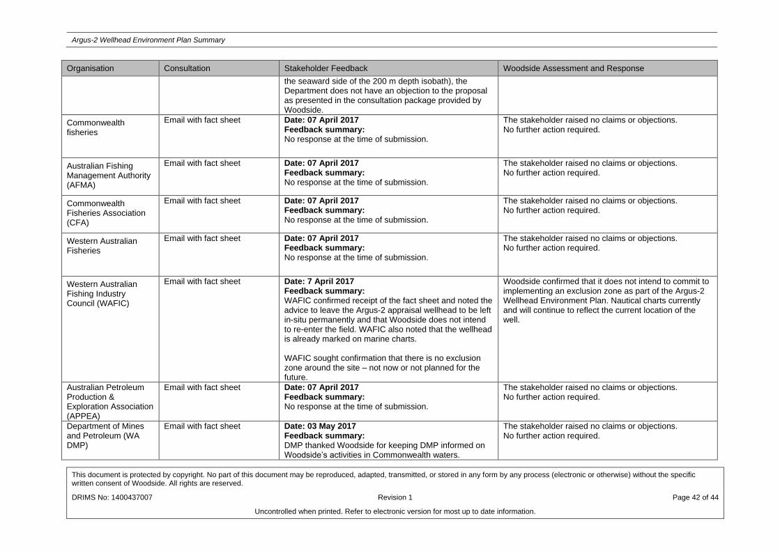
Argus-2 Wellhead Environment Plan Summary
This document is protected by copyright. No part of this document may be reproduced, adapted, transmitted, or stored in any form by any process (electronic or otherwise) without the specific written consent of Woodside. All rights are reserved.
DRIMS No: 1400437007 Revision 1 Page 42 of 44
Uncontrolled when printed. Refer to electronic version for most up to date information.
Organisation Consultation Stakeholder Feedback Woodside Assessment and Response
the seaward side of the 200 m depth isobath), the Department does not have an objection to the proposal as presented in the consultation package provided by Woodside.
Commonwealth fisheries
Email with fact sheet Date: 07 April 2017 Feedback summary: No response at the time of submission.
The stakeholder raised no claims or objections. No further action required.
Australian Fishing Management Authority (AFMA)
Email with fact sheet Date: 07 April 2017 Feedback summary: No response at the time of submission.
The stakeholder raised no claims or objections. No further action required.
Commonwealth Fisheries Association (CFA)
Email with fact sheet Date: 07 April 2017 Feedback summary: No response at the time of submission.
The stakeholder raised no claims or objections. No further action required.
Western Australian Fisheries
Email with fact sheet Date: 07 April 2017 Feedback summary: No response at the time of submission.
The stakeholder raised no claims or objections. No further action required.
Western Australian Fishing Industry Council (WAFIC)
Email with fact sheet Date: 7 April 2017 Feedback summary: WAFIC confirmed receipt of the fact sheet and noted the advice to leave the Argus-2 appraisal wellhead to be left in-situ permanently and that Woodside does not intend to re-enter the field. WAFIC also noted that the wellhead is already marked on marine charts. WAFIC sought confirmation that there is no exclusion zone around the site – not now or not planned for the future.
Woodside confirmed that it does not intend to commit to implementing an exclusion zone as part of the Argus-2 Wellhead Environment Plan. Nautical charts currently and will continue to reflect the current location of the well.
Australian Petroleum Production & Exploration Association (APPEA)
Email with fact sheet Date: 07 April 2017 Feedback summary: No response at the time of submission.
The stakeholder raised no claims or objections. No further action required.
Department of Mines and Petroleum (WA DMP)
Email with fact sheet Date: 03 May 2017 Feedback summary: DMP thanked Woodside for keeping DMP informed on Woodside’s activities in Commonwealth waters.
The stakeholder raised no claims or objections. No further action required.

Argus-2 Wellhead Environment Plan Summary
This document is protected by copyright. No part of this document may be reproduced, adapted, transmitted, or stored in any form by any process (electronic or otherwise) without the specific written consent of Woodside. All rights are reserved.
DRIMS No: 1400437007 Revision 1 Page 43 of 44
Uncontrolled when printed. Refer to electronic version for most up to date information.
Organisation Consultation Stakeholder Feedback Woodside Assessment and Response
DMP acknowledges that Woodside plan to leave the Argus-2 well head in-situ, in Retention Lease AC/RL 8 in a water depth of 540m. DMP also notes that environmental aspects associated with this proposal will be regulated by NOPSEMA under the OPGGS (E) R. DMP had no comments to provide and no further information is required relating to this proposal.
Australian Maritime Safety Authority (AMSA)
Email with fact sheet Date: 07 April 2017 Feedback summary: No response at the time of submission.
The stakeholder raised no claims or objections. No further action required.
AMOSC
Email with fact sheet Date: 07 April 2017 Feedback summary: No response at the time of submission.
The stakeholder raised no claims or objections. No further action required.
Department of Transport
Email with fact sheet Date: 07 April 2017 Feedback summary: No response at the time of submission.
The stakeholder raised no claims or objections. No further action required.
NT Department of Minerals and Energy
Email with fact sheet Date: 07 April 2017 Feedback summary: No response at the time of submission.
The stakeholder raised no claims or objections. No further action required.
Department of Biodiversity, Conservation and Attractions (formally known as Department of Parks and Wildlife)
Email with fact sheet Date: 07 April 2017 Feedback summary: No response at the time of submission.
The stakeholder raised no claims or objections. No further action required.
Department of Defence Email with fact sheet Date: 07 April 2017 Feedback summary: No response at the time of submission.
The stakeholder raised no claims or objections. No further action required.
Australian Customs Service – Border Protection Command
Email with fact sheet Date: 07 April 2017 Feedback summary: No response at the time of submission.
The stakeholder raised no claims or objections. No further action required.
Recfishwest
Email with fact sheet Date: 07 April 2017 Feedback summary: No response at the time of submission.
The stakeholder raised no claims or objections. No further action required.
WWF Email with fact sheet Date: 07 April 2017 The stakeholder raised no claims or objections.

Argus-2 Wellhead Environment Plan Summary
This document is protected by copyright. No part of this document may be reproduced, adapted, transmitted, or stored in any form by any process (electronic or otherwise) without the specific written consent of Woodside. All rights are reserved.
DRIMS No: 1400437007 Revision 1 Page 44 of 44
Uncontrolled when printed. Refer to electronic version for most up to date information.
Organisation Consultation Stakeholder Feedback Woodside Assessment and Response
Feedback summary: No response at the time of submission.
No further action required.
Australian Conservation Foundation
Email with fact sheet Date: 07 April 2017 Feedback summary: No response at the time of submission.
The stakeholder raised no claims or objections. No further action required.
Wilderness Society
Email with fact sheet Date: 07 April 2017 Feedback summary: No response at the time of submission.
The stakeholder raised no claims or objections. No further action required.
International Fund for Animal Welfare (IFAW)
Email with fact sheet Date: 07 April 2017 Feedback summary: No response at the time of submission.
The stakeholder raised no claims or objections. No further action required.
Environs Kimberley
Email with fact sheet Date: 07 April 2017 Feedback summary: No response at the time of submission.
The stakeholder raised no claims or objections. No further action required.
Save the Kimberley
Email with fact sheet Date: 07 April 2017 Feedback summary: No response at the time of submission.
The stakeholder raised no claims or objections. No further action required.
Kimberley Ports Authority
Email with fact sheet Date: 07 April 2017 Feedback summary: No response at the time of submission.
The stakeholder raised no claims or objections. No further action required.
Shire of Broome
Email with fact sheet Date: 07 April 2017 Feedback summary: No response at the time of submission.
The stakeholder raised no claims or objections. No further action required.
City of Karratha
Email with fact sheet Date: 07 April 2017 Feedback summary: No response at the time of submission.
The stakeholder raised no claims or objections. No further action required.
Department of the Environment and Energy
Meeting Date: 23 June 2017 Feedback summary: Woodside met with the DotEE to discuss the abandonment of the Argus-2 wellhead in-situ and requirements associated with a Sea Dumping Permit (SDP). DotEE has advised that it will consider whether or not a SDP is required and revert to Woodside.
Woodside will for fill all requirement under the Environment Protection (Sea Dumping) Act 1981.