argo floats in the polar regions - technology, reality, future perspective ilona goszczko institute...
TRANSCRIPT

Argo floats in the polar regions - technology, reality, future perspective
Ilona GoszczkoInstitute of Oceanology
Polish Academy of Sciences, Sopot, Poland
IARC summer school, NABOS 2013 cruise, RV „Akademik Fedorov”,22 August - 21 September 2013

4500 floats deployed, constant number of 3000 platforms, 1 mln profiles done
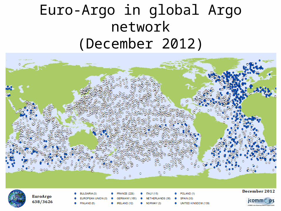
Euro-Argo in global Argo network(December 2012)

Argo floats – the sea of possibilities
SoloApex/Webb
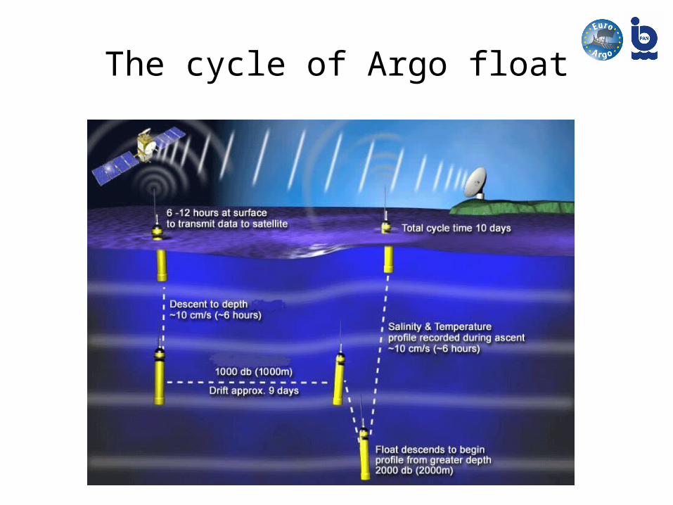
The cycle of Argo float

Argo expansions and enhancements:
• Deep Argo• Expanding Argo coverage at high latitudes • Increasing Argo coverage in western boundary
regions• Expanding Argo into the marginal seas• Bio/BioGeoChemical Argo

Can we extend Argo to the fast ice zone?
This requires consideration of alternative sampling platforms. A number of instruments have been developed for this purpose • Ice Tethered Profilers (ITP) • Polar Ocean Profiling System (POPS) • Acoustically-tracked floats with ice thickness sonars.

Banch of technical solutions applied in the high latitudes Argo floats
• Two-way communication via Iridium (Rudics protocol) allowing to modify parking depth and diving depth
• RAFOS antenna (acoustic receiver) allowing to navigate under the water and ice cover
• A passive and an active sea-ice detection capacity• Enhanced power and autonomous memory (more files
collected and stored)• Stronger antenna

Current state and future plans
• Arctic (60-90°N) – 234 Argo floats deployed since 2001 (87 declared as deployed in the Arctic Ocean)
• 3 acoustic RAFOS sources installed between 2010 and 2011 in the Fram Strait under the ACOBAR project (collaboration between NERSC, AWI, SCRIPPS, OPTIMARE and WHOI)
• Antarctic (60-90°S) – 366 Argo floats deployed since 2001• German RAFOS system installed on the underwater moorings in the
Weddel Sea. Used by University of Washington, Seattle, USA• Plans:
– 360 active floats in the Southern Ocean (85 floats in the Weddell Sea Gyre and 110 floats in the Ross Sea Gyre – instalation of RAFOS is needed).
– 300 active floats in the Arctic = 100 deployments per year (loss of 20% floats is estimated)

Limited edition of Argo floats in the Arctic Ocean (red dots in the AO show ITPs which finished transmission)
Source - (JCOMMOPS)

The Canadian 4901101 float, 1831 Days,183 cycles achieved from 2008 to 2013
Source - (JCOMMOPS)
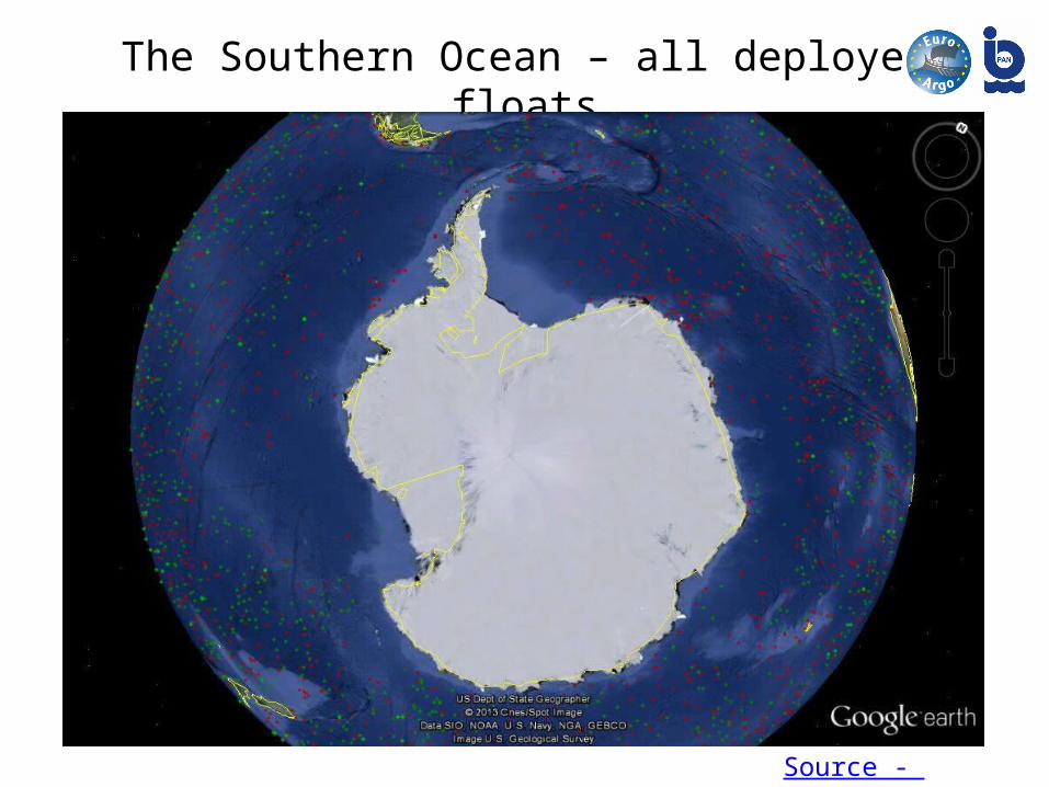
The Southern Ocean – all deployed floats
Source - (JCOMMOPS)
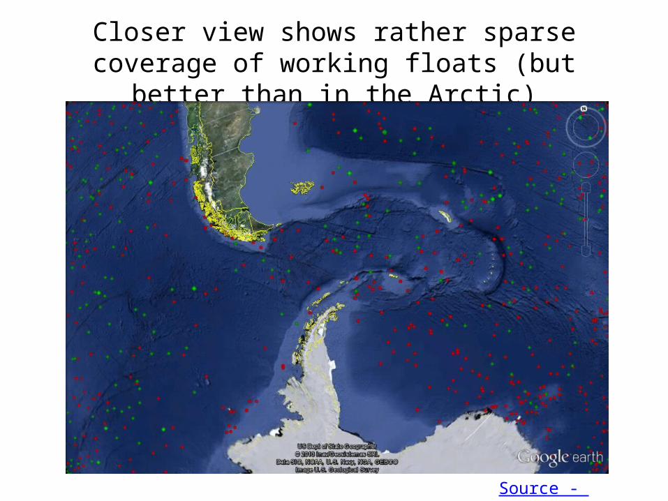
Closer view shows rather sparse coverage of working floats (but better than in the Arctic)
Source - (JCOMMOPS)

The trajectory of one float deployed in the Indian Ocean, 06/01/2005
Source - (JCOMMOPS)

The Nordic Seas - complex physical environment
• Atlantic water advection, redistribution and recirculation• sea ice drifting and melting,• air-sea-ice interaction processes,• convection and deep water formation,• dense water cascading from the shallow shelf peripheries,• mesoscale features – eddies and fronts,• interleavings and intrusions• smal scale structures

Nordic Seas water masses analysis based on the Argo profiles
Position of all Argo profiles in the Nordic Seas in the time span 2001 to 2011; the color indicates the deployment basin: green - Norwegian Basin, yellow - Lofoten Basin, red - Greenland Sea, blue - Icelandic Plateau. The yellow contur-lines define the areas of the individual basins.
Credit: Katrin Latarius, from the SIDERI paper: „Roadmap for evolution of Argo in Europe”

The Greenland Sea characteristic:
• is one of the Arctic Ocean constituent seas (IHO definitions: area 898 103 km2, volume 1418 103 km3 and mean depth 1580 m; Jakobsson, 2002),
• is at the moment a northern limit for all Argo floats deployment missions• its northern limit - the Fram Strait is the only deep connection between
Atlantic and Arctic Ocean (possible exchange in the deep and intermidiate layer)
• is covered by ice in the western side and free of ice in the eastern side due to Atlantic water inflow
• has a strong boundary currents – EGC and WSC• is sorrounded by shallow shelves areas except deep Norwegian Sea on
the south• thus has a complicated water mass structure
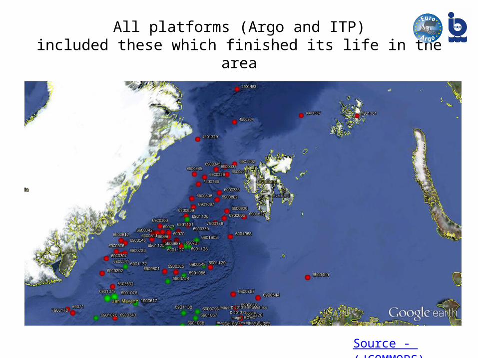
All platforms (Argo and ITP)included these which finished its life in the area
Source - (JCOMMOPS)
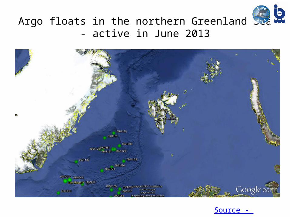
Argo floats in the northern Greenland Sea- active in June 2013
Source - (JCOMMOPS)
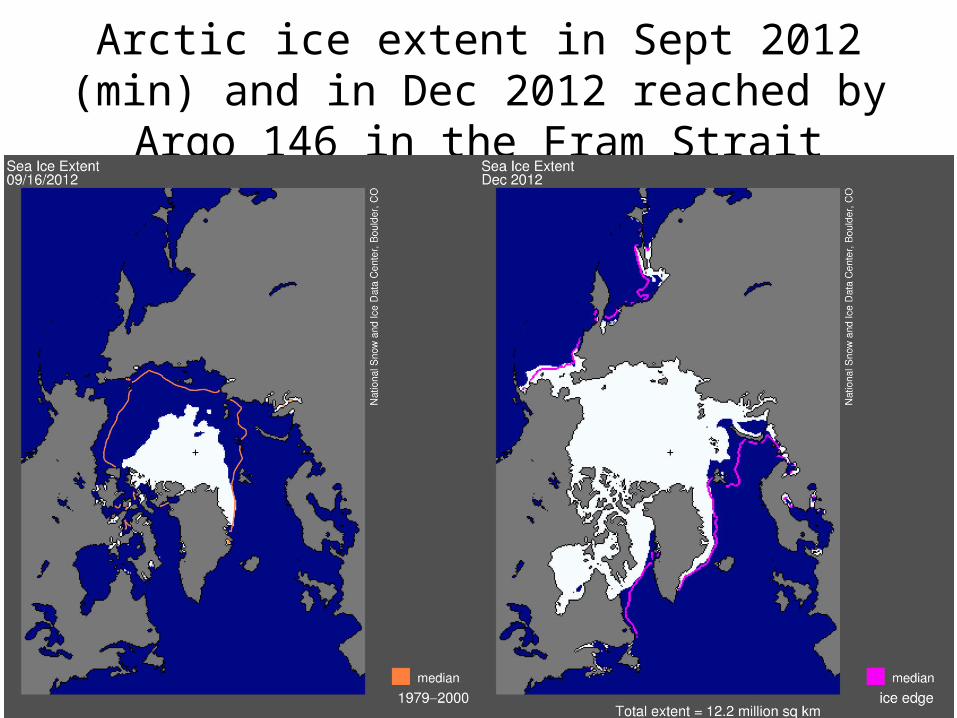
Arctic ice extent in Sept 2012 (min) and in Dec 2012 reached by Argo 146 in the Fram Strait
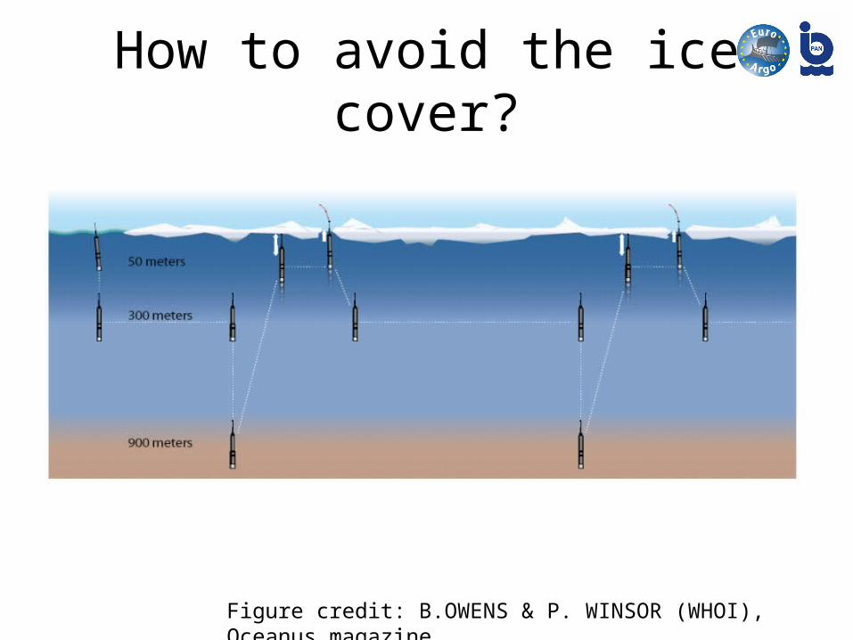
How to avoid the ice cover?
Figure credit: B.OWENS & P. WINSOR (WHOI), Oceanus magazine

Techniques used to detect the ice• Mechanical technique: When the float reaches the surface, if no satellite
communication can be established, the float considers that sea ice is preventing it from surfacing.
• Active acoustic technique: Sea -ice monitoring systems use active acoustic to measure, for example, the sea-ice draft.
• Passive acoustic technique: passive acoustic (i.e. a hydrophone listening to the ambient noise) can be used for meteorological applications. A hydrophone can be adapted and fitted on a float to detect and characterize sea ice at the surface
• Temperature based algorithm: an algorithm called ISA (Ice Sensing Algorithm) to detect sea ice at the surface. This simple algorithm estimates the median of the sea temperature measurements in a profile located between 50 m and 20 m from the sea-surface, and compares it to the freezing point of the seawater (-1.79 °C in Antarctica). If the median value is below the freezing point, then the presence of sea ice is highly probable and the float does not surface.
• Optical technique: an optical solution is currently under development

PROV - ULS by NKE during EU Damocles project (2006 – 2009)
These floats were equipped with high accuracy pressure sensors (Digiquartz Paroscientific), RAFOS (Ranging And Fixing Sound) transducers for reception and transmition, as well as an acoustic communication system Credit NKE


Our ship: RV „Oceania”
Our location: Sopot, Poland,The southern Baltic Sea coast
Institute of Oceanology Polish Academy of SciencesPhysical Oceanography Department

Our activities:AREX 1989-2013

The IO PAS deployed 9 floats (5 from Argo Poland) between 2009 and 2013 from the RV „Oceania”

Trajectories of 3 Nemo floats with ISA deployed by IOPAS which circulated in the northern Geenland Sea

Structure of the Greenland Sea water masses in the 600 dbar upper layer
T, S and density distribution from Argo 146 (111 profiles) deployed in June 2010 and Argo 223 (56 profiles) deployed in July 2012

The water masses
θS-diagrams based on data from two Argo floats deployed in 2010 and 2012 (Water masses classification based on Rudels et al, (2005): Polar Surface Water, Warm Surface Water, Atlantic Water, Arctic Atlantic Water, Arctic Intermediate Water, upper Polar Deep Water and Nordic Seas Deep Water)

Thank you!Poland in the Argo network:
• Euro-Argo RI (EU Research Infrastructure)• SIDERI – „Strengthening International Dimension of Euro-Argo Research
Infrastructure”• E-AIMS – „Euro-Argo Improvements for the GMES Marine Service”• in connection with the IO PAS Arctic Experiments AREX aboard R/V Oceania
performed in summer 2009-2012.