arfordir coastal survey 2011-12
DESCRIPTION
Annual report on the Arfordir Coastal survey project. The project was set up to monitor and survey archaeology in the coastal zone and to engage local communities and interested groups and to encourage them to take an active role in the recording of threatened sites, and the identification of new sites, on a largely independent basis following intial trainingTRANSCRIPT


GGAT 103: Arfordir Coastal Heritage 2011-12 Contents
Summary................................................................................................................................. 2 Acknowledgements................................................................................................................. 4 Copyright notice ...................................................................................................................... 4 Introduction ............................................................................................................................. 5
1.1 Project Outline .......................................................................................................... 5 1.2 Project Background .................................................................................................. 5 1.3 Aims and Objectives................................................................................................. 6 1.4 Methodology ............................................................................................................. 6
Volunteer Recruitment and Training ................................................................................ 6 Identification of Coastal Sites (both under threat and new sites)..................................... 7
2 Main activities undertaken in the course of the second year ........................................... 8 2.1 Review of baseline data and mapping of study area................................................ 8 2.2 Advertising and recruitment...................................................................................... 8 2.3 Creation of display materials, presentations, information packs and website .......... 9 2.4 Training events and meetings ................................................................................ 10 2.5 Guided walks and field visits .................................................................................. 11 2.6 Partnership with CAN Project ................................................................................. 14 2.7 Servicing HER requests ......................................................................................... 14 2.8 Equipment packs .................................................................................................... 15 2.9 NAS Training events............................................................................................... 15 2.10 Work placements on the project ......................................................................... 16 2.11 Use of social media............................................................................................. 17 2.12 Presentation of the project and results ............................................................... 18 2.13 Data verification and entry .................................................................................. 19 2.14 Identification of coastal sites ............................................................................... 20
3 Conclusions ................................................................................................................... 23 3.1 Outreach................................................................................................................. 24 3.2 Proposed work for 2012-13 .................................................................................... 25
Bibliography .......................................................................................................................... 26 Appendix 1. Recording Forms – site condition recording form ............................................ 27 Appendix 2. New sites identified by the project .................................................................... 29 Appendix 3. Known HER sites with new data ....................................................................... 61 Appendix 4. Recording of exposed stonework at Broughton Bay......................................... 63 Supplement. GGAT 116: Emergency recording and excavation of a prehistoric trackway, Swansea Bay ........................................................................................................................ 69 Figures and Plates Plate 1. Guided walk to Burry Holms at church site 00030w ................................................ 12 Plate 2. Volunteers receiving a tour of the Time Team dig at Kenfig.................................... 12 Plate 3. Site visit to Merthyr Mawr with Porthcawl U3A group .............................................. 13 Plate 4. Recording an intertidal site with CAN volunteers..................................................... 14 Plate 5. Recording a hulk site with the NAS ......................................................................... 16 Plate 6. GGAT and Arfordir Project display at the Severn Estuary Forum............................ 19 Plate 7. Arfordir Project article in the Severn Tidings ........................................................... 19 Plate 8. Shooting butt, Merthyr Mawr, showing damage to walling. Photo: Ian Hutchinson . 20 Plate 9. Oystermouth trackway ............................................................................................. 21 Plate 10. Damaged stonework, post-reformation building, Burry Holms monastic site......... 21 Plate 11. Hut site, Rhossili Down. Photo: Pete Francis ....................................................... 22 Plate 12. View to the east of Old Castle Fort showing erosion damage. .............................. 22 Plate 13. View to northwest of southernmost of stone structures. 16/12/2010 ..................... 65 Plate 14. View to east, showing northern exposure of soil layer. 12/3/12............................. 66 Plate 15. View to southeast, walls 001, 004 and 005. 12/3/12 ............................................. 66 Plate 16. View to southeast of wall 001 and soil layer 003. 12/3/12 ..................................... 67 Plate 17. View to south of walls 001 and 004 and soil layer 003. 12/3/12 ............................ 67 Figure 1. Location of the survey area ................................................................................... 64 Figure 2. Northwest facing elevation of wall 001 .................................................................. 68

GGAT 103: Arfordir Coastal Heritage 2011-12
2
Summary Climate change is recognised by the Welsh Government as one of the biggest threats facing the planet. Associated sea level rise, increased coastal erosion and increased frequency of severe weather events will have a major impact on heritage and archaeological sites in the coastal zone. This can manifest as destruction of sites, inundation of currently dry sites, or greater deposition of sand and silting of other areas.
Human responses to these issues will vary, and it is unlikely that archaeological sites will be made a priority for protection from these threats, while mitigatory measures will also impact on the archaeological resource in the coastal zone, with the creation of new sea defences in some areas, while others will be abandoned under ‘managed change’. Loss of landscape and heritage caused by this will have a negative impact on the quality of life in Wales.
The Arfordir project has been funded by Cadw both to take advantage of the dynamic environment in the coastal zone to identify new sites and monitor archaeological sites and to engage interested local people. It aims to record and monitor sites under threat of coastal erosion or other forms of damage and to involve interested individuals and community groups in taking an active role in caring for their coastal heritage on an independent and sustainable basis, with minimal professional involvement after initial training and guidance.
The project has been particularly fortunate this year in the assistance of Natasha Scullion, the Council for British Archaeology-funded Community Archaeology Trainee Placement bursary holder working at the Glamorgan-Gwent Archaeological Trust (GGAT). Natasha’s work on the project has allowed the project to have a presence at a wider variety of events throughout the year, has created an additional point of contact for the groups and volunteers and has meant that more project training events could be held.
Following on from the success of the first year of the project, which was focused on the Gower peninsula and Swansea Bay, the study area was extended to the east for the second year of work. As much of the display materials, and the project website, as well as the recording forms and guidance notes, had been created in the first year of the project, less of the second year’s work was spent on these activities.
Time was invested in contacting community history and archaeology groups, advertising the project locally, delivering presentations to existing groups, and holding meetings for volunteers who responded to the advertising. This initial contact and training was followed up with a series of guided walks and fieldwork events, held to familiarise the volunteers with recording techniques and to allow them to undertake practical recording on site.
A variety of baseline data has been used to identify sites at risk from coastal erosion; including analysis of the results of the 1990s Coastal Survey (Locock 1996) and the Swansea Bay Intertidal Survey (Nayling 1998), cartographic information, aerial photographs, information from members of the public and previous work undertaken by GGAT. A series of initial reconnaissance field visits were undertaken to assess the condition of a selection of sites, the threats facing stretches of coastline and priorities for further fieldwork.
Data generated by the project will be used to enhance and update the regional HER and to highlight archaeological sites and areas most under threat. Based on this data, management plans can be created, and programmes of regular monitoring, recording and further archaeological investigation implemented, the work to be undertaken by volunteers working independently on the project and in collaboration with professional archaeologists.
One site within the existing area has been taken forward for further work this year; a section of prehistoric trackway at Oystermouth in Swansea Bay, which has been previously investigated by GGAT. The monitoring work of the project identified that a further stretch

GGAT 103: Arfordir Coastal Heritage 2011-12
3
had been revealed by coastal erosion and was under imminent threat from tidal action. A proposal for undertaking detailed emergency recording of the exposed section along with lifting of threatened timbers for analysis and dating was submitted to Cadw and approved, and the work carried out in February 2012. The results of this work are presented here as a supplement to this report.
Further detailed recording of another site at Broughton Bay has also been undertaken, though the location of this site precluded further investigative works. The results of this work are presented in Appendix 4.
This report presents the methodologies, results and outcomes of the second year of the Arfordir project in the Glamorgan-Gwent area, and will present strategies and feedback to aid in the delivery of the project in its third year.

GGAT 103: Arfordir Coastal Heritage 2011-12
4
Acknowledgements The fieldwork has been undertaken by volunteers of the Arfordir project, by Ellie Graham BA MA AIfA, and Natasha Scullion, BA, of the Glamorgan-Gwent Archaeological Trust.
Thanks are due to all the volunteers who have taken part in the project, particularly Ian Hutchinson, Sian Charlton, Paul Griffin, Syd Howells, Jonathan Davies and Pete Francis.
The assistance of Sian Rees, Polly Groom and Louise Mees of Cadw, Claudine Gerrard and Sian Musgrave of the National Trust, Dr Scott Simmons and exchange students of UNCW, Sian Williams and all the members and leaders of Glamorgan (formerly Bridgend) YAC, James Meek, of Dyfed Archaeological Trust, Andrew Davidson and Iwan Parry of Gwynedd Archaeological Trust, Andrew Marvell, Richard Roberts, Charina Jones, Edith Evans, Rowena Hart, Andy Sherman, and Natasha Scullion, all of the Glamorgan-Gwent Archaeological Trust, is also gratefully acknowledged.
Copyright notice The copyright of this report is held by Cadw: Welsh Historic Monuments and the Glamorgan-Gwent Archaeological Trust Ltd. The maps are based on Ordnance Survey mapping provided by the National Assembly for Wales with the permission of the Controller of Her Majesty’s Stationary Office, Crown Copyright. All rights reserved. Unauthorised reproduction infringes Crown Copyright and may lead to prosecution or civil proceedings. Licence No: 100017916 (2012).
The photographs are copyright GGAT unless otherwise annotated.

GGAT 103: Arfordir Coastal Heritage 2011-12
5
Introduction
1.1 Project Outline Arfordir is a pan-Wales project funded through grant-aid to the Welsh Archaeological Trusts administered by Cadw. In South Wales it has been designed to monitor the condition and the impact of erosion on archaeological sites in the coastal zone of the Gower peninsula and Swansea Bay, extending from the mouth of the River Loughor to the mouth of the River Ogmore; and to develop community support and participation to sustain ongoing programmes of monitoring in the long-term. Furthermore, in delivering this, the Trust has also enabled members of the local community, local interest groups, history groups and university students to learn more about the coastal archaeology in the area. It has also provided them with the information and skills to allow them to take an active role in monitoring and recording sites threatened by erosion, and to identify new sites, with minimal supervision from professional archaeologists.
The primary output of the project is data entered into the regional Historic Environment Record (HER), which will enhance and update existing records held, as well as adding new records of previously unrecorded sites.
This report on the results of the second year of work undertaken on the project demonstrates its continuing success in generating site data to enhance the HER and inform conservation and management priorities and in community engagement, while also contributing to the Welsh Government’s objectives regarding climate change, and addressing research issues identified in Introducing a Research Framework for the Archaeology of Wales.
1.2 Project Background The impact of coastal erosion on heritage has been recognised in past works, both Cadw-funded projects, (Locock 1996, Nayling 1998) and National Trust commissioned studies (Poucher 2002-3, Poucher 2003, Poucher 2003-4a, Poucher 2003-4b, The Muckle Partnership 2002) which identified stretches of coastline most vulnerable to erosion. Increasing awareness of the issues of global warming and climate change has highlighted their potential effects on the historic environment in coastal areas, and the need for a sustainable programme of monitoring, with contingency to mitigate the impact in certain cases.
The rising profile of archaeology in public forums and the popularisation of the subject via a variety of media have led to an increased public awareness of the heritage of local areas, and an associated growing interest in and enthusiasm for that heritage. Increasing numbers of members of the public are taking an active role in the historic environment, and public engagement is becoming an important component in archaeological projects achieving success, which can be measured against several objectives laid out in the Cadw forward plan 2011-2016, specifically “Promoting public access, appreciation and enjoyment of the historic environment: encouraging public participation and volunteering”.
The project is run under the same pan-Wales ‘Arfordir’ identity as those run by Dyfed Archaeological Trust and Gwynedd Archaeological Trust. Its goals are based on those of the award-winning SCAPE (Scottish Coastal Archaeology and the Problem of Erosion) project run by Shorewatch in Scotland, and the Thames Discovery Programme (TPD).

GGAT 103: Arfordir Coastal Heritage 2011-12
6
1.3 Aims and Objectives The aims of the project are to monitor the condition of archaeological sites in the coastal zone, and the impact of erosion on these sites, as well as to identify new sites in the study area in order to enhance and update information held in the regional HER. The project also aims to establish and develop community involvement and engagement with coastal heritage; encouraging participation and facilitating a programme of sustainable and long-term monitoring of sites with minimal input from the professional sector. Creating and developing links with other professional bodies, educational institutions, community and local interest groups will provide interested local individuals and groups with the information, skills and tools they need to undertake monitoring of the condition of, and threats to, archaeological sites. The monitoring work can, in some areas, lead to further mitigatory measures against the impact of climate change and coastal erosion on the historic environment of the coastal zone.
The project will also update the information generated by previous survey work undertaken in the study area and add value to previous work undertaken relating to coastal heritage.
1.4 Methodology The project has adopted a variety of methodologies in different areas of the work programme, with different outcomes, results and feedback. For the purposes of the project, the coastal zone has been defined as the intertidal zone, plus a buffer 500m inland of Mean High Water. This approach was adopted for most of the first year’s study area, however, it was felt that this approach was not suitable for the eastern area and that a more flexible method was necessary to take account of the different coastal environments to the east. In the areas of Margam and Kenfig Burrows and Merthyr Mawr Warren specifically, it was felt that this definition of the coastal zone was inadequate, as dune systems, which are subject to many of the same issues of erosion and conservation and would benefit from ongoing monitoring, extend well inland beyond this arbitrary boundary. Furthermore, the industrialised sections of the coastline around Port Talbot and Swansea docks are not accessible to the public, while throughout much of the Port Talbot area, urban development extends to the edge of the foreshore. Therefore, in the eastern study area, a more reflective approach was used; in the sand dune areas, the study area was extended inland to encompass the entirety of the system, except in Kenfig where the boundary extended to the line of the M4; around Port Talbot the boundary was reduced to exclude urban areas, and the industrialised areas which are not accessible were excluded from the study area.
Volunteer Recruitment and Training A major focus of the Arfordir project is on the engagement of members of the public with the coastal heritage of their area, fostering their involvement in the monitoring of areas most vulnerable to coastal erosion, monitoring the condition of archaeological sites in these areas, and the identification of new sites. The success of the first year’s volunteer recruitment was followed up in the new area to the east by emulating the methods employed in the pilot year.
The focus of recruitment of volunteers is on local people who regularly use and visit coastal areas, as they are well-acquainted with an area and will be best-placed to notice changes to a site and monitor its condition.
Following a period of recruitment, volunteers were provided with training in archaeological recording skills to allow them to undertake recording and monitoring of sites independently, with professional input decreasing as the volunteers gain confidence and ability. This has been designed to enable work to continue beyond the supported phase of the project.
In both the existing and new study areas, field training was provided to volunteers, and volunteer groups also undertook site visits and monitoring work independently. In addition to the monitoring and survey work, this has been followed up, for one site, with detailed

GGAT 103: Arfordir Coastal Heritage 2011-12
7
recording and limited excavation to mitigate a severe and ongoing threat from erosion and tidal action.
Identification of Coastal Sites (both under threat and new sites) Previous coastal surveys undertaken within the study area (Locock 1996) were consulted in order to identify areas vulnerable to erosion and combined with HER data of known sites to identify specific priorities for monitoring.
Specific areas and stretches of the coastline were then targeted for visits and walkover surveys in order to assess the threat to known sites and to identify previously unrecorded sites. This highlighted the areas to be prioritised for further monitoring work and those which were most suitable to be targeted by volunteer groups; teams of volunteers were then assembled to undertake monitoring work in these areas.

GGAT 103: Arfordir Coastal Heritage 2011-12
8
2 Main activities undertaken in the course of the second year
2.1 Review of baseline data and mapping of study area The added study area, comprising the intertidal area and a 500m band inland of Mean High Water, with variations to accommodate the larger areas of dune systems and to exclude urban areas, was mapped in a GIS, with major waterways (i.e. the rivers Afon, Kenfig and Ogmore) being included as far inland as the lowest historical crossing point.
HER data for the study area was then extracted, and to this was added data from previous coastal surveys which had identified areas of coastline vulnerable to erosion, and which had identified both new sites and areas with a high archaeological potential.
2.2 Advertising and recruitment The advertising and recruitment stage of the project followed the successful approach adopted in the pilot year, with press releases, leaflet drops, advertising to local societies and councils and writing to volunteers from previous community projects.
Letters were written to all volunteers who had been previously involved with GGAT community projects in the Vale of Glamorgan, most of whom had joined the fieldwalking weekend at Monknash in September 2010. Four volunteers were recruited to the project as a result of this.
Promotional display materials, posters and leaflets were also produced and were distributed at various local libraries, museums and community centres as well as being taken to various outreach events the Trust attended.
Thanks to the Council for British Archaeology-funded Community Archaeology Trainee Placement at GGAT this year, the Arfordir project had a presence at a greater number of events, including:
Wick Village Fete – 4th June 2011
Swansea Museum National Archaeology Week GGAT Archaeology for All – 16th July 2011
Neath Abbey Open Day – 23rd July 2011
Betws Community Fete – 10th September 2011
Chepstow Castle Medieval Madness – 18th September 2011
Tinkinswood Excavation – 22nd & 23rd October 2011
St Lythans Excavation – 21st November 2011
Senedd HLF event – 7th December 2011
TAG Conference – 15-17th December
BBC Roy Noble Radio Show – 17th January 2012
St Fagans: BBC launch of Story of Wales – 19th January 2012
Annual Regional Heritage Forum – 20th January 2012
Cefn Cribwr Heritage Fair – 21st January 2012

GGAT 103: Arfordir Coastal Heritage 2011-12
9
A press release was issued to the South Wales media, including local radio stations and newspapers.
Letters and emails were also written to local community councils in the area and to local interest societies: to the Port Talbot Historical Society, Ogmore Valley Local History and Heritage Society, Bridgend YAC, Atlantic College, Bridgend Local History Society, the Kenfig Society, the Kenfig Local Community Group and the Kenfig National Nature Reserve Information Centre. A number of members of the Porthcawl U3A archaeology group had already volunteered with the project during its first year, and were keen to begin monitoring work in the new study area.
Following this initial contact with groups, a number of presentations were made to groups:
Coedffranc Community Council – 8th June 2011
Porthcawl U3A Archaeology Group – 10th May 2011
As a result of these, a number of further volunteers were recruited to the project.
A number of volunteers have also been recruited to the project through more informal means; members of the public have been informed of the project and the opportunity to get involved through submitting HER enquiries or through reporting sites on the foreshore outside of the Arfordir project. When told of the project by GGAT staff they have then joined it and become involved with groups monitoring the coast.
Additionally, the project was advertised on sites such as “Past Horizons”, offering volunteer opportunities on archaeological projects. This has led to a lot of interest in the project, both locally and internationally, and has led to the recruitment of several volunteers.
2.3 Creation of display materials, presentations, information packs and website
As the project is in its second year in 2011-12, much of the display material, the information packs, and the project website had already been created in the course of the pilot year.
In addition to the recording forms and guidance already created for the project, a separate Site Condition Form was also created (see Appendix 1). This was very closely modelled on the Site Recording Form but with only the site name, ID, location, condition and threats fields. These are intended for use exclusively when recording a monitoring visit or changes to a known site, rather then the Site Recording Forms which comprise a complete record of a site. These forms are intended to address an issue identified in the course of the project; it was not always clear whether volunteers were making a return visit to a site to record changes or were recording it as a ‘new’ site, nor was it always clear whether the volunteer groups were cross-referencing their records with the HER. It is also hoped that by providing a form which places a greater emphasis on the monitoring of a known site’s condition this will both emphasise the focus of the project, and make the forms less intimidating for the volunteers to use.
The GGAT version of this form has been sent to the other Trusts undertaking this project, and it is hoped that they will also find it useful and adopt it for their own volunteers’ use, in order to preserve the pan-Wales Arfordir identity and branding.
The introductory project presentation was altered slightly to account for the extended study area, replacing maps of the study area, examples of high profile sites in the area and details of the common archaeological sites in the area, along with photographs illustrating some of these sites.

GGAT 103: Arfordir Coastal Heritage 2011-12
10
2.4 Training events and meetings A number of meetings have been held with other professional bodies and stakeholders involved in the project and with other professionals working in the area.
1st April 2011 – Meeting and site visit to Old Castle fort to assess erosion damage, Sian Musgrave (National Trust) and Louise Mees (Cadw).
2nd June 2011 – Meeting and site visit to Old Castle fort and Bury Holms, Claudine Gerrard (Archaeological Consultant, National Trust)
14th June 2011 – Coastal Forum Meeting, Aberystwyth – Cadw, National Trust, RCAHMW, DAT, GAT
16th June 2011 – Meeting with local enthusiast and collector, John Blundell, Porthcawl
7th July 2011 – Meeting and site visit to south Gower promontory forts, Claudine Gerrard (Archaeological Consultant, National Trust)
13th July 2011 – Meeting, Lea Halborg, CAN project, City and County of Swansea Nature Conservation Team
19th July 2011 – Meeting, Nigel Jenkins, Swansea University lecturer and ‘Real Swansea’ author
22nd July 2011 – Meeting and site visit, south Gower promontory forts, Alan Kearsley-Evans (Ranger, National Trust)
1st August 2011 – Site visit, Swansea Bay Nigel Jenkins, Swansea University lecturer and ‘Real Swansea’ author
16th August 2011 – Meeting and site visit, Swansea Bay, Astrid Caseldine, University of Wales Trinity St David
12th January 2012 – Coastal Forum Meeting, Aberystwyth – Cadw, National Trust, RCAHMW, DAT, GAT
As a result of advertising, mail shots and presentations, a total of 20 people expressed an interest in the project. The existing link with the Porthcawl U3A archaeology group also engendered significant interest within the group. As a result of this, several training presentations were delivered:
10th May 2011 – Porthcawl U3A archaeology group (25-30 attendees)
13th August 2011 – 6 attendees
28th January 2012 – 5 attendees
These sessions gave further details and background about the project as well as covering some principles of recording archaeological sites, distributing information packs and going through the recording forms and guidance.
13th August feedback:
“Hi Ellie, Found the meeting on Saturday really interesting….” (Janice Williams)

GGAT 103: Arfordir Coastal Heritage 2011-12
11
“Hi Ellie, Great to hear from you. I really enjoyed the training day last Saturday and the walk sounds great, really interesting. Can't wait :) Regards, Lisa” (Lisa McKnight)
28th January feedback:
"Thanks for an informative and very interesting day on Saturday, because I walk over all Gower and around the coast I would like to join all three groups." (John Cooper)
A number of meetings were also held for the established groups in order to decide on priorities for fieldwork, answer any queries that had arisen and to offer guidance.
28th March 2011 – South Gower group
30th March 2011 – Swansea Bay group
7th April 2011 – North Gower group
6th July 2011 – South Gower group
6th August 2011 – Swansea Bay group
2.5 Guided walks and field visits Due to the late start to the project in 2010-11, a number of guided walks were also planned for the original study area as well as the new study area. These were intended to allow the volunteers to put the theoretical recording training into practice, and to get used to noticing and recognising archaeological sites. In the eastern study area, the routes were chosen to cover a range of site types and periods, and in the western area to expand on the areas of interest identified by the volunteer groups and to target areas known to be vulnerable to erosion.
A number of volunteers requested additional dates for some of the more popular routes, so there were further walks arranged, for both weekday and weekend dates to maximise the availability of volunteers for events.
20th March 2011 – Rhossili (13 attendees)
31st March 2011 – Broughton and Cwm Ivy (6 attendees)
9th April 2011 – Rhossili Down (11 attendees)
7th May 2011 – South Gower promontory forts (12 attendees)
9th May 2011 – Worm’s Head (13 attendees)
11th May 2011 – Mumbles Hill (9 attendees)
21st May 2011 – Three Cliffs and Penmaen (7 attendees)
18th June 2011 – Burry Holms (10 attendees)
22nd July 2011 – South Gower promontory forts (5 attendees)
12th August 2011 – Time Team at Kenfig (c20 attendees)
28th August 2011 – Swansea Bay group site visit (c7 attendees)

GGAT 103: Arfordir Coastal Heritage 2011-12
12
3rd September 2011 – Kenfig Town and Castle (recording training) (6 attendees)
13th January 2012 – Merthyr Mawr (Porthcawl U3A Archaeology group, 8 attendees)
11th March 2012 – Merthyr Mawr, Burrows Well (13 attendees)
Plate 1. Guided walk to Burry Holms at church site 00030w
Burry Holms 18th June feedback:
“Hello Ellie, Thank you for Saturday - really had a good day. I will hopefully be at the meeting on the 6th. See you then, Lynne” (Lynne Esson).
Merthyr Mawr Burrows Well feedback:
“Dear Ellie & Natasha, Thanks for your guided walk which was very interesting as well as providing much needed exercise for the good turnout of members of Porthcawl U3A (Archaeology Branch). We much appreciated your sterling effort. Jeff Saunders”
Plate 2. Volunteers receiving a tour of the Time Team dig at Kenfig

GGAT 103: Arfordir Coastal Heritage 2011-12
13
Time Team 12th August feedback:
“Hi Ellie, We really enjoyed our guided tour of the Time Team site. It was the highlight of our year's activities…” (Ian Hutchinson, on behalf of Porthcawl U3A Archaeology group)
The Porthcawl U3A group had already been trained by the start of the second year of the project, and were already actively engaged in recording and monitoring work in the original study area, and know the extended eastern study area well. They immediately began undertaking fieldwork and monitoring visits in this area. As an active group was therefore established in this area very early on, there was less need to run training events and guided walks in this area. A site visit was carried out to a feature they identified in January 2012.
Plate 3. Site visit to Merthyr Mawr with Porthcawl U3A group
GGAT 103: Arfordir Coastal Heritage 2011-12
14
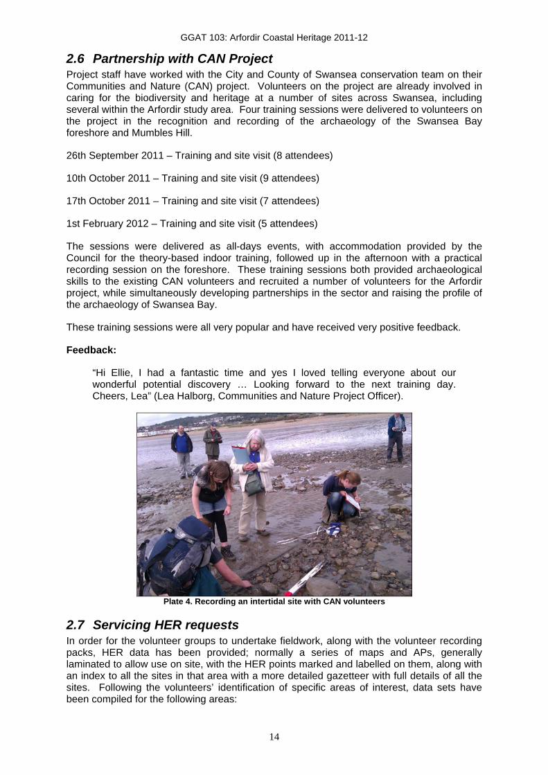
2.6 Partnership with CAN Project Project staff have worked with the City and County of Swansea conservation team on their Communities and Nature (CAN) project. Volunteers on the project are already involved in caring for the biodiversity and heritage at a number of sites across Swansea, including several within the Arfordir study area. Four training sessions were delivered to volunteers on the project in the recognition and recording of the archaeology of the Swansea Bay foreshore and Mumbles Hill.
26th September 2011 – Training and site visit (8 attendees)
10th October 2011 – Training and site visit (9 attendees)
17th October 2011 – Training and site visit (7 attendees)
1st February 2012 – Training and site visit (5 attendees)
The sessions were delivered as all-days events, with accommodation provided by the Council for the theory-based indoor training, followed up in the afternoon with a practical recording session on the foreshore. These training sessions both provided archaeological skills to the existing CAN volunteers and recruited a number of volunteers for the Arfordir project, while simultaneously developing partnerships in the sector and raising the profile of the archaeology of Swansea Bay.
These training sessions were all very popular and have received very positive feedback.
Feedback:
“Hi Ellie, I had a fantastic time and yes I loved telling everyone about our wonderful potential discovery … Looking forward to the next training day. Cheers, Lea” (Lea Halborg, Communities and Nature Project Officer).
Plate 4. Recording an intertidal site with CAN volunteers
2.7 Servicing HER requests In order for the volunteer groups to undertake fieldwork, along with the volunteer recording packs, HER data has been provided; normally a series of maps and APs, generally laminated to allow use on site, with the HER points marked and labelled on them, along with an index to all the sites in that area with a more detailed gazetteer with full details of all the sites. Following the volunteers’ identification of specific areas of interest, data sets have been compiled for the following areas:

GGAT 103: Arfordir Coastal Heritage 2011-12
15
Port Talbot to Porthcawl including Margam and Kenfig Burrows;
Loughor;
Burry Holms;
Cwm Ivy to Broughton;
Newton to Ogmore, including Merthyr Mawr;
Mumbles Hill;
Mumbles to Pwlldu;
Rhossili to Port Eynon, including Worms Head;
Swansea Bay.
2.8 Equipment packs In addition to the three equipment packs purchased and distributed to the Year 1 Arfordir volunteer groups (Swansea Bay, South Gower and North Gower) three further packs were purchased for the second year’s work. These consisted of the same items:
2 x 1m connecting ranging poles;
1:25,000 Ordnance Survey map of area;
Handheld Garmin GPS;
14 Megapixel camera;
16 GB SDHC Memory card;
50m Open reel tape measure.
Two of these packs were distributed to groups, to the Kenfig group and to the Porthcawl U3A group, the third is being kept at GGAT’s offices to lend to volunteers on request and for use during training events.
2.9 NAS Training events Following the identification of a number of previously unrecorded wreck sites on the foreshore of Swansea Bay, two Cadw-funded hulk recording training sessions were organised and delivered by the Nautical Archaeology Society for GGAT and Arfordir volunteers. The first ran on the weekend of 15th-16th October (12 attendees), the second on the weekend of 12th-13th November (6 attendees).
The sessions ran over two days and covered both the theory of recording and undertaking practical work on hulks on the Oystermouth foreshore. As well as providing a lot of specific background and information on shipping, hulks and wrecks, many of the recording skills taught in the course of these weekends are transferable to traditional dry archaeological sites which the volunteers are also involved in recording. Volunteer feedback on these events has been overwhelmingly positive.

GGAT 103: Arfordir Coastal Heritage 2011-12
16
Feedback:
“Hi Ellie and Tash, thanks for a great weekend really enjoyed all that recording, did me head in though. Thanks again, Maggie & John” (Maggie Cornelius and John Robertson)
“Thanks for organising the wreck recording it was really good!” (Sarahjayne Clements)
“Hi Ellie …. I had a good weekend and learnt a lot. I think I speak for all. Much appreciated, thanks for setting it up. Cheers, Paul.”
Plate 5. Recording a hulk site with the NAS
Further follow-up sessions have been planned for work on these hulks to complete the recording and compile a definitive record for them. A programme of hulk recording of the other identified sites on the Oystermouth foreshore is also being planned.
One issue identified during these events was that although the first weekend was very well-attended and the second weekend was fully booked, turn-out for the second weekend was disappointing, with a lot of last-minute cancellations. One solution which has been proposed for this is to make a small charge for the training, which could be used either be used to pay for refreshments, or as a refundable deposit paid in advance to be returned on attendance. A small token charge is deemed unlikely to dissuade volunteers from attending such events, indeed volunteers often express surprise that no charge is made at present.
2.10 Work placements on the project The project has benefited from a number of voluntary and externally-funded placements throughout the year in addition to the volunteer contribution in undertaking monitoring and survey work.
The project hosted a four-week work experience placement for a student undertaking a Masters course at the University of Wales: Trinity St David. As the student identified a particular interest in community engagement work, the tasks identified were focused on this aspect of the project and included:
• Creating a database of volunteers who had previously taken part in GGAT community projects;
• Drafting letters to these volunteers advertising the Arfordir project;

GGAT 103: Arfordir Coastal Heritage 2011-12
17
• Researching existing interest groups in the area who may be interested;
• Creating a database of these existing groups;
• Drafting letters to existing groups advertising the project;
• Drafting a press release for the extension of the project into the new study area;
• Researching suitable outlet points, community and heritage locations for leaflet drop;
• Producing promotional publicity material for the project;
• Researching suitable locations for initial meetings within study area;
• Creating distribution lists for volunteers;
• Assisting with the organisation of initial meetings;
• Altering and updating PowerPoint presentations and paperwork for the new study area;
• Creating additional volunteer information packs;
• Assisting with planning of guided walks for the groups in the extended eastern study area.
Two American students on exchange from University of North Carolina, Wilmington volunteered several days each on the Arfordir project as part of the assessment for a course on the prehistory of Gower. They undertook research and cross-referencing of records of prehistoric sites on Gower with known HER sites and sites previously recorded in the course of the project.
The Arfordir project has also benefited enormously in the course of 2011-12 from the GGAT-hosted CBA-funded Community Archaeology Trainee Placement scheme. The placement holder, Natasha Scullion, has worked closely on the project sporadically throughout the year as commitments to different projects and events dictated. Natasha has undertaken work on all aspects of the project, and her involvement has been particularly useful, allowing it to have a presence at a greater number of outreach and community events. She has also provided a number of the training events, both in partnership with the project coordinator and independently. Through her participation in project events, a higher level of supervision and guidance for the volunteers has been possible, while her involvement with a number of other community groups in the area has allowed informal advertising of the project which has aided recruitment and networking. Natasha’s presentation at the TAG conference, undertaken as part of her placement, also raised the profile of the project.
Furthermore, one volunteer has expressed an interest in involvement in office-based aspects of the project. He has become an established HER volunteer at GGAT and is currently digitising the results of the Swansea Bay group’s survey of peat exposures and submerged forest in the Oystermouth area of the bay. This will allow them to be viewed as interactive MapInfo layers which can be extended and edited as further exposures are recorded.
2.11 Use of social media The project has made extensive use of social media in advertising, volunteer recruitment, event organisation and raising awareness, and this aspect of the project has been particularly successful.

GGAT 103: Arfordir Coastal Heritage 2011-12
18
Two facebook groups for the different areas of the project have been established, one with 14 members, the other with 20 members. These pages have been particularly useful for advertising events such as the NAS recording weekends, and have also promoted an informal camaraderie amongst the group members which has aided the establishment of new groups of individuals and facilitated cooperation and team working amongst them. The Swansea Bay group is particularly active on facebook, and regularly use the site to organise group events and site visits, as well as uploading photos of sites.
A twitter account for the project has also been created and has attracted over 50 followers, including project volunteers, interested individuals, other heritage bodies and community groups. This has been particularly useful for spreading word of the work of the project, and advertising volunteering opportunities.
A project blog has also been established to publicise the project, releasing regular updates on its progress, and has been used for writing up training events, highlighting exciting new discoveries and raising the profile of the project’s work. The project has also benefited from the ‘Day of Archaeology’ blog, which allowed the project to be publicised to a wider audience, and attracted a significant amount of interest in the project from the archaeological community.
A flickr account has also been created for the project, though few volunteers have actually used it, and the facebook photo facility has proved more useful for the sharing of site photos amongst volunteers and groups.
2.12 Presentation of the project and results The project and its results to date have been presented at a number of events during the year.
A brief presentation on the project and some of its results was delivered at the GGAT National Archaeology Week ‘Archaeology For All’ event, and was attended by c30 people, two of whom were then recruited to the project as a result of the talk.
A 20 minute conference paper was delivered to c100 delegates at the SEACAMS cross-disciplinary Swansea Bay conference on 20th September 2011, which comprised representatives from a number of stakeholders in Swansea Bay. This was particularly important for raising the profile of the archaeology of Swansea Bay with other organisations, feeding into sustainable management of the bay, networking and providing the opportunity for consultation on the Swansea Bay Management Plan1.
Feedback
“Hi Elinor, just a short note to say a big thank you for giving such a fascinating presentation at our Swansea Bay conference last week , We have since received lots of really positive feedback, and your talk was definitely one of the highlights of the day. I hope that you too found it useful , and that you can continue to be involved in the management plan preparation. I will keep you informed of future meetings etc. Thanks again. Best Regards Deb”
“Dear Ellie, Thanks again for giving a great presentation at the Swansea Bay event. Your talk was probably the most surprising for us. We had no idea about the number of archaeological features in the Bay.”
GGAT also attended the Severn Estuary Forum, where a display on the Arfordir project was exhibited, and staff networked with other organisations and stakeholders.
1 This conference represented 7 hours of support for the project, provided by De-Minimis via SEACAMS and valued at £500

GGAT 103: Arfordir Coastal Heritage 2011-12
19
Plate 6. GGAT and Arfordir Project display at the Severn Estuary Forum
Natasha Scullion, the CBA-funded Community Archaeology Trainee Placement bursary holder delivered a presentation on her work at GGAT and on the Arfordir project at the TAG conference in December 2011, which included details of the project’s work and the display of an A1 size poster.
An illustrated hour-long talk on the project and recent archaeological discoveries made in coastal Gower and Swansea was also delivered to the Llwchwr Historical Society in November 2011, and was well-attended and very well-received.
In addition to an article in GGAT’s May 2011 newsletter, the project has also featured in Severn Tidings, the Severn Estuary Partnership Newsletter.
Plate 7. Arfordir Project article in the Severn Tidings
2.13 Data verification and entry The data and completed forms which have been returned by volunteers have been verified and entered into the project database by project staff. Some have been entered into the Historic Environment Record, the rest have been prepared for entry, with a database entry for each site, corresponding polygons in a MapInfo table, where mapping of a polygon has

GGAT 103: Arfordir Coastal Heritage 2011-12
20
been possible, and photographs of each site prepared with a photo catalogue to facilitate HER entry.
The Swansea Bay group, in addition to recording features revealed by tidal action on the foreshore, have been undertaking mapping of peat shelves and submerged forests. The scale drawings they have returned to the project coordinator are in the process of being digitised by another project volunteer to create polygons within a MapInfo table.
2.14 Identification of coastal sites A number of site visits have been undertaken in the course of the project, by project staff, with other professionals in the sector and with volunteer groups, either to specific sites or to areas identified as suffering from erosion. These site visits have often been used to highlight to the appropriate body or landowner, such as the National Trust, areas where specific threats and management issues have been identified and to discuss appropriate mitigation, such as altering the line of a footpath or managing vegetation to create access routes and manage desire lines to reduce the impact of visitors and the erosion one area of a site may suffer.
A list of new sites is included in Appendix 2. These are listed separately from known HER sites where the data held on them has been enhanced by the project: where a description has been expanded; threats identified; a misplaced NGR has been relocated etc (see Appendix 3). Where new sites have been identified, these will be entered into the regional HER and where possible polygons of new and existing sites have been created in a MapInfo table.
Several sites of specific note have been identified in the course of fieldwork as being of archaeological significance and at risk of erosion or other threat. Further details and full records for these are available in Appendix 3.
i) Shooting butt, Merthyr Mawr volunteer rifle range, ID OG01, within SAM GM432. This site was previously unrecorded. It is partially buried under a large dune and appears to be in use for barbeques and may be vulnerable to vandalism. Part of the stonework of the front wall is collapsing and would benefit from restoration.
Plate 8. Shooting butt, Merthyr Mawr, showing damage to walling. Photo: Ian Hutchinson
ii) Oystermouth trackway, PRN 06700w. This site was identified eroding out of the
Oystermouth peatshelf and is though to be part of the same feature as that investigated by GGAT in 2010 (Sherman 2010, 2011). The exposure of a new

GGAT 103: Arfordir Coastal Heritage 2011-12
21
part of the structure suggests it is vulnerable to damage from tidal action, and it has been the subject of emergency recording and recovery works by GGAT (see report Appendix 5).
Plate 9. Oystermouth trackway
iii) Burry Holms monastic site, PRN 00030w. This site has been previously identified and excavated, but a site visit under the Arfordir project identified ongoing damage to the stonework of several of the buildings. This site would also benefit from a detailed and modern topographic survey of the remains.
Plate 10. Damaged stonework, post-reformation building, Burry Holms monastic site
iv) Hut site with internal partitions, Rhossili Down, ID LB RD 03B. Following the
initial guided walks and reconnaissance field visits to Rhossili, it was noted that a recent brush fire had left the vegetation across much of the Down very low. One group of volunteers offered to take advantage of these conditions to undertake a survey of the area exposed, which identified, amongst many other sites, this possible hut site, which forms part of the prehistoric landscape of Rhossili Down.

GGAT 103: Arfordir Coastal Heritage 2011-12
22
Plate 11. Hut site, Rhossili Down. Photo: Pete Francis
v) Old Castle Fort, Rhossili, PRN 00139w. Volunteers identified erosion scars in the ramparts of this Iron Age promontory fort. These were reported to Cadw and the National Trust, the landowners, who had previously undertaken repair works on the site, and are planning more in response to this damage.
Plate 12. View to the east of Old Castle Fort showing erosion damage.
GGAT 103: Arfordir Coastal Heritage 2011-12
23
3 Conclusions The second year of work on this project has confirmed that it makes valuable contributions to our understanding of the coastal heritage of southeast Wales and is successfully engaging the community. It has built on the success of the pilot year by recruiting further volunteers who are actively engaged in monitoring coastal archaeological sites and by responding to some of the threats which have been identified, and has contributed to the development of further work in the future, both Cadw-funded under the ‘Arfordir’ project banner and on a sustainable basis for the future.
The methodologies both for identifying threatened coastal sites, and for volunteer recruitment have been proven to be successful and will be used as the project moves into its third year of work in an enlarged study area which extends to the east as far as Penarth.
The records of several existing sites have been updated, enhanced or expanded, with fuller and more accurate records created. A number of new sites have also been identified, including a number of possible prehistoric features which form part of the complex landscape of Rhossili Down, possible prehistoric intertidal features in the peat shelves of Swansea Bay and a complex of mining features. A number of sites have also been identified as suffering specific threats which can be addressed, and through working with bodies such as the National Trust, mitigation strategies to repair and prevent damage have been implemented, through the moving of footpaths eroding banks and through vegetation management.
As the project work in the pilot year commenced relatively late on in 2010-11, there was little time for volunteers to undertake independent survey work and return the results to GGAT. However, the groups were very active in the second year of the project, and have returned significant quantities of information on a variety of sites they have visited. This has demonstrated the degree of genuine engagement with the project by volunteers and the extent to which they are willing to organise and undertake fieldwork independently. Groups in all areas have returned the results of independent fieldwork, and all groups continue to undertake walks and field visits, illustrating the sustainability of their engagement with the project and its aims. The groups have gained confidence in undertaking survey work and in completing the recording forms, and are becoming increasingly independent, with the degree of professional input from project staff decreasing year-on-year.
The need for mitigation strategies to address threats identified for each site is addressed on a site by site basis, and issues are reported to the relevant body, while sites which would benefit from further investigative follow up work (such as that reported in Appendix 5) are individually assessed and appropriate work planned and undertaken.
It is anticipated that the extension of the project’s study area further east to encompass the coastline of the Vale of Glamorgan and the Heritage Coast, where severe coastal erosion is known to be ongoing and where GGAT have recently undertaken emergency recording works for eroding sites, will increase the number of sites identified as being under imminent threat from coastal erosion and will similarly increase the number of candidate sites for further work, with the probable result that more follow-up site investigation will be undertaken in the coming year.
While the erosion threat that sites in the eastern area face is potentially severely damaging, it may also expose further new sites which are can be best identified and recorded under the Arfordir project.
This issue is clearly long-term and ongoing, with the effects likely to be felt for years to come, but the Arfordir project and volunteers are in a position to mitigate this to some extent through a programme of regular monitoring. The work of the project to date has proven that devolving the organisation and survey/monitoring work to the volunteer groups has been successful and that the groups and individuals involved in the project have the skills and

GGAT 103: Arfordir Coastal Heritage 2011-12
24
confidence to continue the work in the future in perpetuity, undertaking long-term monitoring with progressively less professional input, allowing the project work to continue on a sustainable basis for the future, beyond the formal end of the project.
3.1 Outreach
The project has successfully engaged members of the public and encouraged involvement in, and awareness of, the archaeology of the coastal area. Feedback from volunteers who attended events and training has been very positive.
However, in some cases, the attrition rate amongst volunteers has been disappointing. After very enthusiastic responses to initial advertising, of the volunteers who initially expressed an interest, a majority then undertook the theoretical training, and a significant number then joined the guided walks and site visits. The independent monitoring which then followed on from this stage witnessed a significant drop in numbers as the planning and organisation of group visits then devolved to the volunteers. However, this attrition appears to have stabilised and a smaller but sustainable core of very enthusiastic volunteers has evolved in each area who regularly undertake independent work and return information to the project coordinators. From nearly 70 people expressing an interest and joining training events, perhaps a quarter to a third of them have genuinely engaged with the project. However, from discussions with other bodies who run groups of volunteers this is fairly standard, and is to be expected when working with volunteers.
The different means of advertising the project; a mail-shot, leaflet drop, press release and contact with societies have taken varying lengths of time to take effect, with volunteers expressing an interest and being recruited to the project throughout the year. This has been particularly due to the effect of the CATP and the informal networking and advertising of the project this role has allowed. Training events have therefore been held at a number of different times throughout the year to allow for this, while some new volunteers have become involved with existing active groups and learnt the skills while undertaking the monitoring and recording work, with more formal training being provided at a later date.
Training events have been offered in a number of different formats to suit different volunteers’ needs; some preferred a separation of the theoretical classroom-based training and the practical elements, each lasting for 2-3 hours, on different days, often in evenings or at weekends to suit volunteer availability, others preferred whole-day events, with the theory-based training in the morning followed by a guided walk and site visit in the afternoon. This approach depends on having a suitable training venue close to an area suitable for fieldwork, the GGAT offices are close to Swansea Bay, while in the extended study area, venues have been arranged which are located close to appropriate stretches of the coastline.
The provision of a set of recording equipment for each group appears to have acted as a motivational incentive for volunteers involved in the project, and has likely increased the degree of volunteer engagement and the quantity of survey data returned by volunteers.
The Archwilio website and the access to HER data it provides to the public has also been motivational for the volunteers, as it allows them to see the data they have contributed to the project and the information they have generated as part of the live record. This emphasises to them the importance of the work they are undertaking and highlights the use that is made of their work, demonstrating that it makes a contribution to the record and is made available to both professionals and the public after they have submitted it.
It has become clear in the course of the project that there is a significant body of local knowledge on the history and archaeology of the area, and that there is a strong appetite in the community to make use of this knowledge to add to existing datasets. The project provides a conduit through which such knowledge can be reported and added to the HER.

GGAT 103: Arfordir Coastal Heritage 2011-12
25
The number of groups currently undertaking fieldwork and the quantity of data they have returned highlights the enthusiasm for the project in the community.
3.2 Proposed work for 2012-13
In the next year, the study area for the project will be extended to the east, to include the coastline of the Vale of Glamorgan, an area which enjoys protection as designated Heritage Coast, though one which is known to suffer from severe erosion problems.
The methodology for volunteer recruitment and project advertising has been proven to be successful in the first two years of the project’s work, and will continue to be followed in the coming year. Contact will be made with existing history and local interest groups in next year’s study area, and a similar programme of advertising will be undertaken, with leaflet drops to appropriate venues, and local press releases. The project will also be advertised to all volunteers who took part in GGAT’s fieldwalking event in 2010, which took place in Monknash, which, although slightly inland of the study area, is very close. The strength of existing ties GGAT enjoys with community groups and societies in the proposed extension to the study area will, it is hoped, aid in the recruitment of volunteers. In the coming year, the project will also be included in the Current Archaeology archaeological digs supplement for volunteers who want to get involved in projects around the country.
Once volunteers have been recruited to the project, a similar programme of training events, workshops and guided walks will then be undertaken, to establish and strengthen a network of volunteers.
Contact has been made with the Heritage Coast Rangers and the Heritage Coast Centre at Southerndown, and the existing volunteers who work with the Rangers will be targeted for recruitment by the Arfordir project as they already undertake conservation work within the study area and are regular visitors to the coast. Likewise, the Rangers have themselves expressed an interest in receiving archaeological recording training as they are in a position to notice and report changes to a site’s condition. The Heritage Coast Centre at Southerndown has also been offered as a venue for training events, and is ideally located to act as a base for guided walks along the coastline.
Furthermore, contact has also been established with Maggie Knight of the Penarth Pavilion Project in advance of extending the study area to include Penarth.
Reconnaissance work on this section of the coastline to assess condition, threats and current erosion, as well as suitability for fieldwork with volunteer groups, will be undertaken in advance of the guided walks programme.
Concurrently, support will continue to be provided to existing groups undertaking work in the previous years’ study area, including monitoring and investigative work as well as verifying and entering data returned by volunteers.
The social media outlets including the facebook groups, the blogs and the twitter account will continue to be used to advertise the project and events and to disseminate the results of the project’s work, while volunteers will be encouraged to use them independently for networking, organisation of site visits and sharing the results of their work.
The tasks proposed for the second year of the project have all been completed and are largely unchanged moving into the third year of work on the project.

GGAT 103: Arfordir Coastal Heritage 2011-12
26
Bibliography Locock, M, 1996, GGAT 50: Coastal Survey (Glamorgan) Loughor, West Glamorgan to Sker Point, Mid Glamorgan. GGAT Report No. 96/015
Nayling, N, 1998, Swansea Bay Intertidal Survey. GGAT Report No. 98/059
Poucher, P, 2002-3, The National Trust Archaeological Survey: Pennard and Bishopston
Poucher, P, 2003, The National Trust Archaeological Survey: North Gower Properties: Whiteford Burrows, Llanrhidian Marsh, The Bulwark, Ryer’s Down & Welsh Moor
Poucher, P, 2003-4a, The National Trust Archaeological Survey: South-west Gower properties: Rhossili-Mewslade
Poucher, P, 2003-4b, The National Trust Archaeological Survey: South Gower coastal properties: Mewslade-Port Eynon, Pilton Green, Pilton Cross and Oxwich
Sherman, A, 2010, Wooden Structures on the Oystermouth foreshore, Swansea. GGAT Report No. 2010/062
Sherman, A, 2011, Recently discovered trackways in Swansea Bay. GGAT Report No. 2011/032
The Muckle Partnership, 2002, Archaeological Survey of Rhossili Down, Gower, West Glamorgan. For the National Trust

GGAT 103: Arfordir Coastal Heritage 2011-12
27
Appendix 1. Recording Forms – site condition recording form In response to issues with volunteers’ use of the existing site recording form, a specific Site Condition Form was created, for use when recording changes to a known site noted during a monitoring visit.
ARFORDIR – Coastal Heritage Site Condition Update Form Site Condition Update Form
SITE DETAILS This information identifies the site in the HER or earlier project work. Site Name.
PRN/ID Number:
LOCATION OF THE SITE Mark the site location on an OS map, if possible attach a photocopy of the location to this form. Record the National Grid Reference. National Grid Reference (NGR)
NGR taken from map? GPS?
Use the centre of the site area if possible, otherwise note where the grid reference has been taken from: SITE CONDITION This information will help to assess the condition of the site and threats to its survival Condition: Please use HER standard terms (delete as appropriate): Near Intact/Damaged/Destroyed/Near Destroyed/Restored/Intact/Moved/Not Known/Various/Converted/Not Applicable
Condition description: (describe the condition of the site more fully, note any visible damage or deterioration, vegetation growth, or well-preserved features of a site, areas in good condition. include extent of survival, damage)
Any threats to site? (please select HER standard terms and include descriptions)
YOUR RECORDS This will help to cross reference to other records and to things that you have found Have you taken photos? Produced any other drawings? Any Finds?
Pottery/Animal bone/Human bone/Wood/Metal/Bricks or tiles/Stonework/Flint /Glass/Shell/Other
FIELDWORK INFORMATION This will remind you and others about the actual survey Group name
Form recorded by Survey date

GGAT 103: Arfordir Coastal Heritage 2011-12
28
SKETCH LOCATION DRAWING: a drawing showing the location of the site in relation to other features, (with distances), the location of the coast edge (if relevant) and the approximate position of north (usually north is at the top of the drawing).
DETAILED SKETCH PLAN / SECTION: a more detailed drawing showing any damage to the site or areas of erosion etc.
Please return forms to: ARFORDIR, Glamorgan-Gwent Archaeological Trust, Heathfield House, Swansea SA1 6EL

GGAT 103: Arfordir Coastal Heritage 2011-12
29
Appendix 2. New sites identified by the project The list of new sites has been created from the data generated by the project to date, but more information is being added all the time.
These new sites will be added to the regional HER, as polygons where possible.
ID no PRN Site Name BH001 06639w Burry Holmes Lighthouse Base NGR From map? GPS? SS 39864 92605 No Yes Reference taken from Approx distance to coast edge Description Sub-circular concrete pad, c1.5m in diameter with a circular raised Fe ring and upright bolts protruding. Initially thought to be a WWII gun mount, but local knowledge suggests that this was the site of a temporary gas-powered lighthouse, built after the Whiteford lighthouse went out of use, and later replaced by a lightship. This cuts into the western side of cairn 00023w.
Form Condition Period Other Structure Damaged Modern Condition description Only the concrete pad now survives, the lighthouse itself has been removed. Threats
Photos? Drawings? Finds? Yes No Group name
Recorded by Date ELG 02/06/2011
ID no PRN Site Name BH003 06640w Limestone Quarry, Llangennith Burrows NGR From map? GPS? SS 41535 92645 Yes No Reference taken from Approx distance to coast edge 420m Description Large limestone quarry depicted on 1st edition OS maps. Linear quarry face facing SE, cutting is 55m long, face c20m high, spoil dumped to the SE. Access path along the base of the quarry face, exiting at the south end of the cutting and running south. May be associated with nearby limekiln 02277w.
Form Condition Period Earthworks Near Intact Post-Medieval Condition description Quarry face overgrown Threats
Photos? Drawings? Finds? Yes No Group name
Recorded by Date ELG 02/06/2011

GGAT 103: Arfordir Coastal Heritage 2011-12
30
ID no PRN Site Name BH004 06641w Area of burning, Burry Holms NGR From map? GPS? SS 39818 92591 Yes No Reference taken from Approx distance to coast edge 10m Description Small area of burnt material visible in the exposed eroded section on the north-facing slope of the cove on the northwest side of the island. Consists of a small (0.3m high and 0.2m long) patch of dense charcoal flecks and heat fractured stone. In the section, the burnt material has one straight edge on the west side, suggesting that it may have been deliberately deposited in a cut rather than representing a spread. Form Condition Period Other Structure Damaged Unknown Condition description Being eroded from the exposed eroded section of the slope. Under severe and imminent threat. Threats Coastal erosion
Photos? Drawings? Finds? No No Group name
Recorded by Date Ellie Graham 18/06/2011
ID no PRN Site Name BH005 06642w Fe ingot, Burry Holms NGR From map? GPS? SS 40209 92640 No Yes Reference taken from Approx distance to coast edge Description Large iron ingot, possibly pig iron, 1.36m long and 0.12m wide, tapered at both ends. Possibly an ingot from local works being transported on a ship wrecked in the area.
Form Condition Period Finds Not known Post-Medieval Condition description When located, was washed up on beach at Spaniard Rocks. By a second visit was covered by sand. Threats Tidal action
Photos? Drawings? Finds? Yes No Group name
Recorded by Date Carole Etherton 18/06/2011

GGAT 103: Arfordir Coastal Heritage 2011-12
31
ID no PRN Site Name BM001 06643w Ships Timbers NGR From map? GPS? SS 63805 91902 No Yes Reference taken from Approx distance to coast edge Intertidal Description Two large pieces of wood, one with large timber pegs and large Fe nails, attached to a large piece of Fe with concretions, the other with a square hole cut out of one side. Appeared to be ships timbers, probably the remains of a wreck
Form Condition Period Finds Damaged Post-Medieval Condition description
Threats Tidal action
Photos? Drawings? Finds? Yes No Group name Swansea Bay Recorded by Date ELG 01/08/2011
ID no PRN Site Name BM002 06644w Wooden posts, Brynmill, fish trap? NGR From map? GPS? SS 63777 91872 No Yes Reference taken from Apex of V Approx distance to coast edge Intertidal Description Three rectangular wooden posts forming a 'V' with the apex pointing offshore, in the typical formation of a fish trap. The NE arm is c40m and the NW arm c16m.
Form Condition Period Other Structure Damaged Post-Medieval Condition description Bases of wooden posts protrude from sand all that survive of structure Threats Coastal erosion, tidal action
Photos? Drawings? Finds? No No Group name Swansea Bay Recorded by Date ELG 01/08/2011

GGAT 103: Arfordir Coastal Heritage 2011-12
32
ID no PRN Site Name BM003 06645w Line of wooden posts, Brynmill NGR From map? GPS? SS 63655 91833 No Yes Reference taken from SW end of line Approx distance to coast edge Intertidal Description Three rectangular wooden posts forming a NE-SW aligned line c20m long
Form Condition Period Other Structure Damaged Post-Medieval Condition description Bases of wooden posts protrude from sand all that survive of structure Threats Coastal erosion, tidal action
Photos? Drawings? Finds? Yes No Group name Swansea Bay Recorded by Date ELG 01/08/2011
ID no PRN Site Name CG001 06646w Enclosure complex, Coety Green NGR From map? GPS? SS 42486 90697 No Yes Reference taken from Approx distance to coast edge Description A large complex of stone walls on the boundary between enclosed land and common at the western edge of White Moor, perhaps representing a failed attempt at enclosure of the common or a squatter settlement on the edge of the common. The north side is best preserved and consists of a series of stone walls up to 1.8m high defining the remains of two small adjoining buildings or enclosures with a large irregularly-shaped area enclosed to the south. Approximately 63m by 63m. Site CG002 lies approximately 20m to the north and is likely related. Form Condition Period Other Structure Damaged Unknown Condition description Walls stand to varying height, and are very heavily vegetated and overgrown. Threats Vegetation, tree growth, root action, tree throw/roots
Photos? Drawings? Finds? Yes Yes Group name South Gower Recorded by Date Pete Francis 20/05/2011

GGAT 103: Arfordir Coastal Heritage 2011-12
33
ID no PRN Site Name CG002 06647w Ditch and possible buildings, Coety Green NGR From map? GPS? SS 42447 90719 No Yes Reference taken from Approx distance to coast edge Description A sunken linear feature - possibly a ditch or sunken lane - with possible buildings to the south. The ditch runs parallel to the northeast- southwest aligned path running from Coety Green to White Moor, and is 75.2m long and up to 3.2m deep. On the south side of the ditch are two large stones, and a series of stone and earth mounds and banks which appear to form a linear feature or possibly a building. This site is c20m to the north of site CG001 and is likely related. Form Condition Period Earthworks Damaged Unknown Condition description Heavily vegetated and overgrown. Threats Vegetation
Photos? Drawings? Finds? Yes Yes Group name South Gower Recorded by Date Pete Francis 20/05/2011
ID no PRN Site Name CL001 06648w Castleage, Llanmadoc NGR From map? GPS? SS 44987 93438 Yes No Reference taken from Approx distance to coast edge Site extends to edge of marsh Description A large, steep-sided, flat-topped hill between Burry Pill and Llanrhidian Marsh. Modern field boundaries follow the contours, one field, known as 'Upper Castleage' delimiting the flat top of the hill, and several on the slopes following the curve of the base of the slope, one of which is known as 'Lower Castleage'. The south-facing field on the slopes of the hil is known as 'the Vineyard'. Its form is suggestive of the site having been used for defensive purposes, and the field names support this suggestion. Form Condition Period Place Name Not known Unknown Condition description
Threats
Photos? Drawings? Finds? No No Group name
Recorded by Date ELG 15/04/2011

GGAT 103: Arfordir Coastal Heritage 2011-12
34
ID no PRN Site Name CL002 06649w Chapel at Hills Farm NGR From map? GPS? SS 43153 93671 Yes No Reference taken from Approx distance to coast edge c500m Description A number of historic maps (Speed's map of Glamorgan 1610 and Johannes Blaeu Map of 1645) both show a chapel labelled St Kenet's Chapel in the approximate location of Hill's Farm, Llanmadoc. It has been suggested that this may also have served as a beacon or lighthouse for ships coming up the Burry Estuary at night.
Form Condition Period Documents Not known Medieval Condition description
Threats
Photos? Drawings? Finds? No No Group name
Recorded by Date ELG 15/04/2011
ID no PRN Site Name HD2 06650w Raised earth mound NGR From map? GPS? SS 43622 90632 No Yes Reference taken from Approx distance to coast edge Description Raised mound 1m high, long axis on north-south alignment 12.3m, next to a sunken pit area 1m deep. Total length of area of both mound and pit 50m (east-west).
Form Condition Period Earthworks Damaged Unknown Condition description
Threats Vegetation
Photos? Drawings? Finds? Yes No Group name South Gower Recorded by Date Pete Francis 03/06/2011

GGAT 103: Arfordir Coastal Heritage 2011-12
35
ID no PRN Site Name HD3 06651w ?Megalithic Tomb NGR From map? GPS? SS 43723 90729 No Yes Reference taken from Approx distance to coast edge Description Possible megalithic chambered tomb, with a large capstone 0.75m high, 1m wide resting on 2 orthostats. 1.5m total height, 3m long and 2.3m wide. Possible quarrying, outcropping in the area and large boulders scattered on the slope below.
Form Condition Period Other Structure Damaged Natural? Condition description
Threats Vegetation
Photos? Drawings? Finds? Yes Yes Group name South Gower Recorded by Date Pete Francis 03/06/2011
ID no PRN Site Name JSC001 Manganese Oxide deposit, Limeslade NGR From map? GPS? SS6255387149 Yes No Reference taken from Approx distance to coast edge Intertidal; Description The Iron Ore (Manganese Oxide) vein that outcrops at Limselade has been identified by chemical analysis as the most probable site of the Red Ochre associated with the Red Lady burial at Goat Hole Cave in Foxhole Slade, Paviland (See: Paviland Cave and the Red Lady, Tyler: Chapter 7, page 132) Apparently this vein of ore, which extends right through Mumbles Hill, was worked out in the 19th or early 20th century. Only a few traces of ore in a malleable and readily usable form remain in the exposed seams outcropping at Limeslade Bay. There are also a few beach pebbles containing mineralised ore. Form Condition Period Landform Near Destroyed Natural Condition description
Threats
Photos? Drawings? Finds? Yes No Group name
Recorded by Date John Cooper 16/02/2012

GGAT 103: Arfordir Coastal Heritage 2011-12
36
ID no PRN Site Name LB RD 01 06652w Rhossili Down- Pathmarkers (other feature) NGR From map? GPS? SS 42138 89188 No Yes Reference taken from Approx distance to coast edge Description Path markers-large conglomerate (quartz) stones/boulders. Eight (possibly more). Stones put up on end and embedded in soil. Average height 0.25m. Placed on east side of path.
Form Condition Period Other Structure Intact Unknown Condition description Intact, well formed, embedded sturdily in soil Threats Animal burrowing, peat desication, stone robbing, vegatation, root action, scrub growth, vehicle erosion
Photos? Drawings? Finds? Yes Yes No Group name South Gower Recorded by Date Lisa Bancroft 16/04/2011
ID no PRN Site Name LB RD 03A 06653w Stone Circle with large stone at centre NGR From map? GPS? SS 42246 89317 No Yes Reference taken from Approx distance to coast edge Description Circular feature with widely spread large kerb stones and a large triangular stone in the centre. A large conglomerate boulder scatter over surrounding area. S/N 14.8 m, E/W 12m
Form Condition Period Other Structure Damaged Unknown Condition description Damaged. Stable. Animal damage to base of ground around central stone and its packing stones. Threats Animal burrowing/rubbing, peat dessilation, stone rubbing, vegetation, root action, scrub growth
Photos? Drawings? Finds? Yes Yes No Group name South Gower Recorded by Date Lisa Bancroft 16/04/2011

GGAT 103: Arfordir Coastal Heritage 2011-12
37
ID no PRN Site Name LB RD 03B 06654w Circular hut with internal partitions NGR From map? GPS? SS 42270 89082 No Yes Reference taken from Approx distance to coast edge Description Circular hut: entrance to the SW. Dimensions: S-N 16m; E-W 16m. 5 possible stone dividing walls (internal) on eastern side. 2 possible stone dividing walls (internal) on western side. Possible oval enclosure S of entrance.
Form Condition Period Other Structure Damaged Unknown Condition description Damaged, stable; excellent differentiation of possible internal dividing walls. Threats Animal burrowing; peat dessication; stone robbing; vegitation; root action; scrub regrowth.
Photos? Drawings? Finds? Yes Yes No Group name South Gower Recorded by Date Lisa Bancroft 16/04/2011
ID no PRN Site Name LB RD 05B 06655w Rhosilli Down springhead. NGR From map? GPS? SS 42441 89321 No Yes Reference taken from Approx distance to coast edge Description Spring head with two run off channels. South east of LB RD 3B.
Form Condition Period Landform Intact Natural Condition description Silting. Threats Water drainage; peat dessication; vegetation.
Photos? Drawings? Finds? Yes No Group name South Gower Recorded by Date Lisa Bancroft 16/04/2011

GGAT 103: Arfordir Coastal Heritage 2011-12
38
ID no PRN Site Name LB RD 06 06656w Rhosilli Down trackway. NGR From map? GPS? SS 42044 89389 No Yes Reference taken from Approx distance to coast edge Description Trackway running south-north. Reaching towards WWII instalation.
Form Condition Period Other Structure Damaged Modern? Condition description Damaged. Erosion. Stone in fill in places. Threats Peat dessication; vehicle erosion; water drainage; stock trampling.
Photos? Drawings? Finds? Yes No Group name South Gower Recorded by Date Lisa Bancroft 16/04/2011
ID no PRN Site Name LB RD 07 06657w Rhosilli Down dry stream bed. NGR From map? GPS? SS 42112 89422 No Yes Reference taken from Approx distance to coast edge Description Dry steam bed alignment c60 degrees. In close proximity (S.W) of Sweynes House.
Form Condition Period Topography Not applicable Natural Condition description
Threats Water drainage; peat dessication.
Photos? Drawings? Finds? Yes No Group name South Gower Recorded by Date Lisa Bancroft 16/04/2011

GGAT 103: Arfordir Coastal Heritage 2011-12
39
ID no PRN Site Name LB RD 08 06658w Rhosilli Down Burnt Mound - dug out NGR From map? GPS? SS 42205 89525 No Yes Reference taken from Approx distance to coast edge Description Burnt mound. Centre dug out. Next to dried up stream bed (LB RD 07) on flattened platform. Disturbed ground.
Form Condition Period Earthworks Damaged Prehistoric Condition description Damaged. Semi-stable Threats Peat dessication; animal burrowing; root action; scrub regrowth; stone rubbing; vegetation; visitor damage; vistor erosion.
Photos? Drawings? Finds? Yes No Group name South Gower Recorded by Date Lisa Bancroft 16/04/2011
ID no PRN Site Name LB RD 09 06659w Rhosilli Down ovoid Stone. NGR From map? GPS? SS 42089 89790 No Yes Reference taken from Approx distance to coast edge Description Large ovoid stone embedded end in soil. Upturned. Long axis of stone 60 degrees.
Form Condition Period Other Structure Damaged Unknown Condition description Damaged. Threats peat dessication; animal rubbing; stone rubbing; root action; scrub regrowth.
Photos? Drawings? Finds? Yes No Group name South Gower Recorded by Date Lisa Bancroft 16/04/2011

GGAT 103: Arfordir Coastal Heritage 2011-12
40
ID no PRN Site Name LB RD 11 06660w Rhosilli Down Ring Cairn NGR From map? GPS? SS 42198 89792 No Yes Reference taken from Approx distance to coast edge Description Ring cairn with circular stone kerb. Large jumble of large stones in the central space. Due east of the ring cairn which lies to the west of the southern Sweynes House.
Form Condition Period Other Structure Damaged Prehistoric Condition description Damged but stable. Threats Stone rubbing; root action; scrub regrowth.
Photos? Drawings? Finds? Yes Yes Group name South Gower Recorded by Date Lisa Bancroft 16/04/2011
ID no PRN Site Name LB RD 12 06661w Rhosilli Down - two abutted ring cairns NGR From map? GPS? SS 42210 89865 No Yes Reference taken from Approx distance to coast edge Description Two kerbed ring cairns. Abutted. At SS 42210 89865 and SS 42210 89871
Form Condition Period Other Structure Damaged Prehistoric Condition description Damaged. Threats Root damage; scrub regrowth.
Photos? Drawings? Finds? Yes No Group name South Gower Recorded by Date Lisa Bancroft 16/04/2011

GGAT 103: Arfordir Coastal Heritage 2011-12
41
ID no PRN Site Name LB RD 13 06662w Rhosilli Down - henge NGR From map? GPS? SS 42313 89822 No Yes Reference taken from Approx distance to coast edge Description Circular henge 18.5m diameter. Kerb edge 3m to 3.4m wide, c0.5m high. Large stones scattered around outer edge.
Form Condition Period Earthworks Damaged Prehistoric Condition description Damaged. Threats Scrub regrowth; root damage
Photos? Drawings? Finds? Yes Yes Group name South Gower Recorded by Date Lisa Bancroft 16/04/2011
ID no PRN Site Name LB RD 14 06663w Rhosilli Down ring cairn and standing stone NGR From map? GPS? SS 42382 89500 No Yes Reference taken from Approx distance to coast edge Description Large kerb circle of stones 0.5m high. Possible double kerb. Standing stone in centre.
Form Condition Period Other Structure Damaged Prehistoric Condition description Damaged. Threats Scrub regrowth; root damage.
Photos? Drawings? Finds? Yes Yes Group name South Gower Recorded by Date Lisa Bancroft 16/04/2011

GGAT 103: Arfordir Coastal Heritage 2011-12
42
ID no PRN Site Name LB RD 15 06664w Rhosilli Down - monolith and possible stone circle NGR From map? GPS? SS 42397 89439 No Yes Reference taken from Approx distance to coast edge Description Monolith (triangular in shape). Within circle of stone kerb. Possible outer ring.
Form Condition Period Other Structure Damaged Prehistoric Condition description Damaged. Threats Peat dessication; root damage; scrub regrowth; stone robbing.
Photos? Drawings? Finds? Yes Yes Group name South Gower Recorded by Date Lisa Bancroft 16/04/2011
ID no PRN Site Name LC02 06689w Structural stonework - Loughor Castle NGR From map? GPS? SS 56460 98013 No Yes Reference taken from Approx distance to coast edge Description Area of exposed stonework visible in the eroding face of the slope to the east of Loughor Castle. Stone is dressed and roughly coursed, visible height c0.5m, exposed length c2m. May be the buried remains of former revetting.
Form Condition Period Other Structure Not known Unknown Condition description Visible in damaged section of slope Threats Erosion
Photos? Drawings? Finds? Yes Yes No Group name North Gower Recorded by Date M. Cornelius 20/08/2011

GGAT 103: Arfordir Coastal Heritage 2011-12
43
ID no PRN Site Name MB01 06759w The Dunns, Mumbles, Swansea NGR From map? GPS? SS 61614 88180 No Yes Reference taken from Approx distance to coast edge 30m Description A strip of 8-10 shops known as The Dunns in Mumbles, Swansea, which formerly occupied the south side of Mumbles Road. Removed in 1971 to widen the road to allow two vehicles to pass.
Form Condition Period Other Structure Destroyed Unknown Condition description No visible sign of shops. Area has been landscaped. Threats None
Photos? Drawings? Finds? Yes Yes Group name Swansea Bay Recorded by Date John Robertson 19/08/2011
ID no PRN Site Name MH 003 06665w Entrance to undergound mine workings. NGR From map? GPS? SS 62556 87193 No Yes Reference taken from Approx distance to coast edge c 20-30 M Description Blocked adit entrance to mine, in cliff opposite Limeslade Bay. Natural fissure exploited to form portal. Facing SW at base of cliff.
Form Condition Period Other Structure Near Intact Post-medieval Condition description Blocked off. Overgrown. Threats Vegetation
Photos? Drawings? Finds? Yes No Group name
Recorded by Date Ellie Graham 12/04/2011

GGAT 103: Arfordir Coastal Heritage 2011-12
44
ID no PRN Site Name NG001 Metal object, Swansea Bay, Brynmill Lane NGR From map? GPS? SS 63658 91771 No Yes Reference taken from Approx distance to coast edge Intertidal; 10m to MHW, 30m to sea wall Description Ferrous metal object, heavily corroded. Heavy encrustations of beach pebbles and oyster shells. Trapezoidal shape, open top, presumed solid base. Size: 0.90 x 0.50 x 0.75m.
Form Condition Period Finds Damaged Post-Medieval Condition description object uncovered by wave scour, could be re-covered by the same process Threats
Photos? Drawings? Finds? Yes No Group name
Recorded by Date John Cooper 28/01/2012
ID no PRN Site Name NR002 06528w Timber, Swansea Bay NGR From map? GPS? SS 6361291675 No Yes Reference taken from Approx distance to coast edge Intertidal Description Long wooden beam with tool marks, possibly ships timbers from a wreck.
Form Condition Period Finds Damaged Unknown Condition description Loose in intertidal zone Threats Tidal action
Photos? Drawings? Finds? No No Group name
Recorded by Date Natasha Scullion 28/01/2012

GGAT 103: Arfordir Coastal Heritage 2011-12
45
ID no PRN Site Name NR006 06523w Peat exposure, Swansea Bay NGR From map? GPS? SS 6362291860 No Yes Reference taken from Approx distance to coast edge Intertidal Description Exposed peat with wood inclusions
Form Condition Period Landform Damaged Unknown Condition description
Threats Coastal erosion
Photos? Drawings? Finds? No No Group name
Recorded by Date Natasha Scullion 28/01/2012
ID no PRN Site Name OG01 Shooting butt, Merthyr Mawr Warren rifle range NGR From map? GPS? SS 86591 77001 No Yes Reference taken from Approx distance to coast edge 0.8km to Ogmore river, due south Description Wall of building approx 8.22m long (external) made of rubble construction bonded with mortar, with ashlar alternating quoins at door/windows. The wall shown in the drawings and photographs is on a sand slope covered largely by grass. Much of the building appears to be buried. The opening on each side (door/windows) only have one jamb so part of the continuing wall going back into the dune appears to be missing. Walls predominantly built of stone rubble, but some early-looking, apparently handmade bricks used in the construction. A thin ledge is visible in the stonework on the interior side of the front wall. A number of small roughly square holes run through the walls. Fe loops and hooks protrude from the sides of the openings, possibly for a door or shutter. Depicted on the 1st edition OS maps of the area (1877) and may be related to the shooting targets depicted on this map as part of the volunteer rifle range. Apparently a shooting butt, part of the 'Porthcawl Rifle Range', a 19th century rifle range on Merthyr Mawr Warren, which was abandoned due to its proximity to an area which was increasing in popularity. A set of bye-laws for the rifle range dating to 1905 have been identified. It has been suggested that it was constructed with stone from the nearby Candleston Castle, as it incorporates a lot of good-quality dressed stone with ashlar blocks at the openings. Form Condition Period Building Damaged Post-Medieval Condition description Generally good, some missing stones from front wall. Most of building buried in the sand? Facing stone and internal stone missing on the east side of the central front elevation. Side continuing walls missing. Possibly only the upper floor is visible, with lower parts buried in the dune. Threats It is near to a footpath and in full view of passers by. Discarded disposable bbq inside shows use as a picnic site. No sign of cans/bottles or vandalism. Stone missing from the front to the right of the 'chimmney' like structure, may weaken the stone above and cause it to collapse.
Vandalism, visitor erosion, visitor damage
Photos? Drawings? Finds? Yes Yes Group name Porthcawl Recorded by Date Ian Hutchinson 25/10/2011
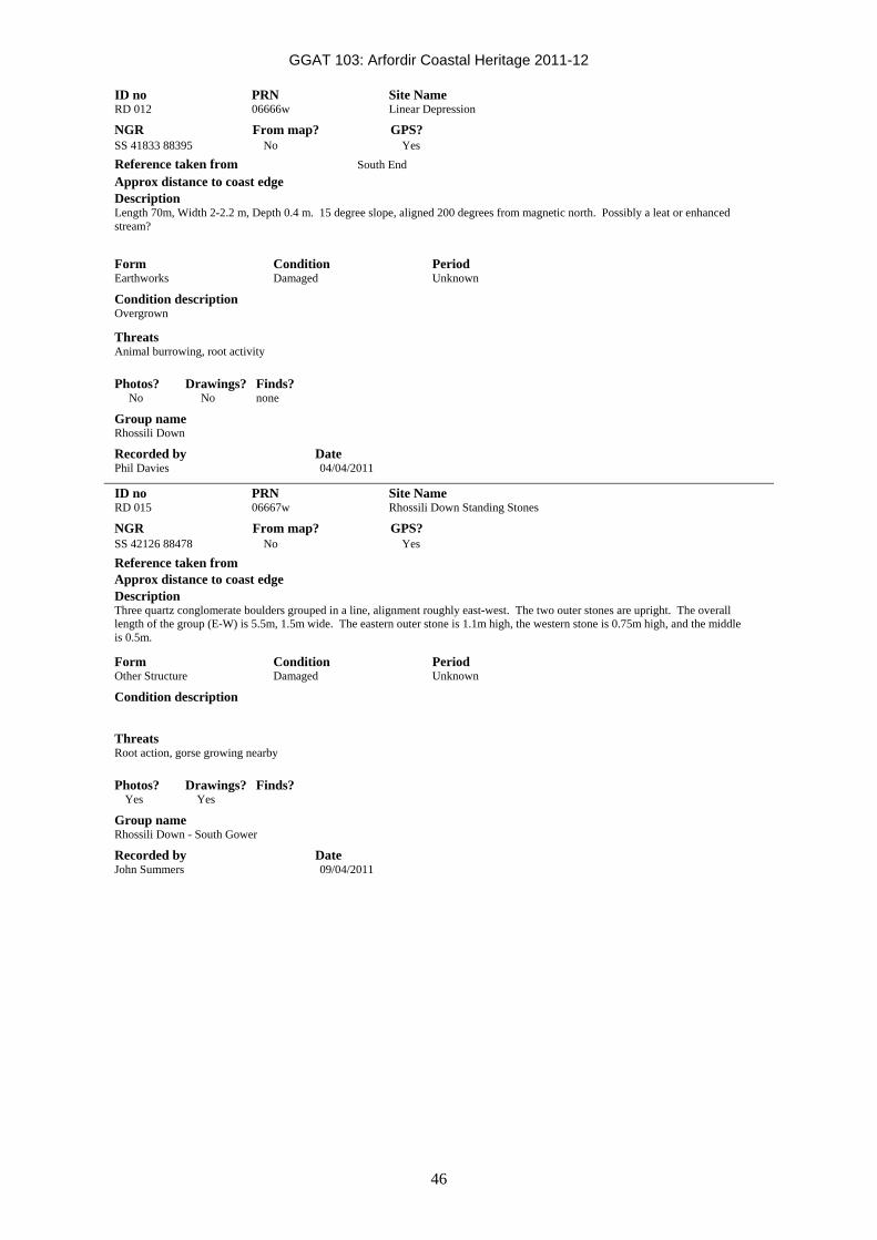
GGAT 103: Arfordir Coastal Heritage 2011-12
46
ID no PRN Site Name RD 012 06666w Linear Depression NGR From map? GPS? SS 41833 88395 No Yes Reference taken from South End Approx distance to coast edge Description Length 70m, Width 2-2.2 m, Depth 0.4 m. 15 degree slope, aligned 200 degrees from magnetic north. Possibly a leat or enhanced stream?
Form Condition Period Earthworks Damaged Unknown Condition description Overgrown Threats Animal burrowing, root activity
Photos? Drawings? Finds? No No none Group name Rhossili Down Recorded by Date Phil Davies 04/04/2011
ID no PRN Site Name RD 015 06667w Rhossili Down Standing Stones NGR From map? GPS? SS 42126 88478 No Yes Reference taken from Approx distance to coast edge Description Three quartz conglomerate boulders grouped in a line, alignment roughly east-west. The two outer stones are upright. The overall length of the group (E-W) is 5.5m, 1.5m wide. The eastern outer stone is 1.1m high, the western stone is 0.75m high, and the middle is 0.5m.
Form Condition Period Other Structure Damaged Unknown Condition description
Threats Root action, gorse growing nearby
Photos? Drawings? Finds? Yes Yes Group name Rhossili Down - South Gower Recorded by Date John Summers 09/04/2011

GGAT 103: Arfordir Coastal Heritage 2011-12
47
ID no PRN Site Name RD 016 06668w Parallel linear depressions NGR From map? GPS? SS 42187 88442 No Yes Reference taken from Upper end of leat Approx distance to coast edge Description Two parallel linear depressions aligned roughly north-south on the southern slope of Rhossili Down. The westernmost runs from SS 42191 88452 to SS 42135 88397, with a bowl-shaped depression 5m in diameter at the top end. This linear depression is approximately 1.8m wide at the top and 0.1-0.15m deep. The latter NGR at the southern end of this depression is where it is interrupted by the drystone wall boundary between the common land and the enclosed agricultural land to the south. The second depression is 6m to the east of this, 2.6m wide and 0.2-0.25m deep. The southern end of this depression is vague and poorly-defined. Form Condition Period Earthworks Damaged Post-Medieval? Condition description Overgrown but stable. Threats Animal Burrowing
Photos? Drawings? Finds? No No Group name Rhossili Down Recorded by Date Steve Campbell-Kelly 09/04/2011
ID no PRN Site Name RD 017 06669w Linear Depression NGR From map? GPS? SS 42076 88427 No Yes Reference taken from Approx distance to coast edge Description Linear depression running down south slope of Rhossili Down. Length 105 m, Width 6.3 m Top, 2.5 m Bottom, Depth 1.2m. Line is interrupted by drystone boundary wall between common land and enclosed agricultural land to the south.
Form Condition Period Earthworks Damaged Unknown Condition description Overgrown, but stable Threats Root Damage, Animal Damage
Photos? Drawings? Finds? Yes No None Group name Rhossili Recorded by Date Phil Davies 09/04/2011

GGAT 103: Arfordir Coastal Heritage 2011-12
48
ID no PRN Site Name RD 018 06670w Possible Burial Chamber NGR From map? GPS? SS 42222 88505 No Yes Reference taken from Approx distance to coast edge Description 3.5 m-NS, 3.6m -EW. Rectangular in shape, the edges are defined by large boulders up to 1 metre in size. The chamber is open to the east. The chamber is formed by 4 or 5 large blocks, though there is no visible capstone. The chamber is surrounded by a large area of scattered blocks covering an area of 17 meters east-west and 13m north-south.
Form Condition Period Other Structure Damaged Neolithic Condition description no capstone Threats No threats identified - stable.
Photos? Drawings? Finds? Yes Yes No Group name Rhossili Down Recorded by Date Angela Bunn 09/04/2011
ID no PRN Site Name RD 020 06671w Burnt Mound NGR From map? GPS? SS 41988 88625 No Yes Reference taken from Approx distance to coast edge Description Raised subcircular mound, comprised of earth and heat fractured stone, 4.8 m east-west, 5.7 m north-south. Height 0.3 m. Small depression in centre.
Form Condition Period Earthworks Damaged Prehistoric Condition description Only visible due to burning of vegetation Threats Animal erosion, root activity
Photos? Drawings? Finds? Yes No Group name Rhossilli Down Recorded by Date Anna Noel 09/04/2011

GGAT 103: Arfordir Coastal Heritage 2011-12
49
ID no PRN Site Name SB 001 06672w Recumbent timber, Swansea Bay NGR From map? GPS? SS 6192 8840 No Yes Reference taken from Approx distance to coast edge 1/4 mile seaward from quarry car pack Description A large recumbent timber eroding out of marine clay overlying peat shelf. Timber mostly straight with slight bend on one end. 2.5 meters in length. Date assigned due to presence in peat.
Form Condition Period Other Structure Near Intact Iron Age Condition description Exposed timber, mostly intact but open to air, tide and visitor damage. Threats Coastal erosion, metal detecting, natural decay, tourism, visitor damage.
Photos? Drawings? Finds? Yes No Group name Swansea Bay Recorded by Date Sian Charlton 10/04/2011
ID no PRN Site Name SB 002 06673w Footprint in peat, Swansea Bay NGR From map? GPS? SS 6193 8840 No Yes Reference taken from Approx distance to coast edge 1/4 mile seaward from quarry car park Description A possible footprint in section of eroded peat. Length approx 34 cm. Alignment N/S. Clearly visible heel and ball print, with ball print much deeper than heel print. Date assigned due to presence in peat.
Form Condition Period other structure Near Intact Iron Age Condition description Exposed in small, detatched pieces of soft peat Threats Coastal erosion, metal decaying, natural decay, tourism, visitor damage.
Photos? Drawings? Finds? Yes Yes Group name Swansea Bay Recorded by Date Sian Charlton 10/04/2011

GGAT 103: Arfordir Coastal Heritage 2011-12
50
ID no PRN Site Name SB 003 06674w Parallel timbers, Swansea Bay NGR From map? GPS? SS 61930 88390/ 61940 No Yes 88390 Reference taken from Approx distance to coast edge 1/4 mile seaward from quarry car park. Description 2 recumbent parallel stout wooden timbers 2m apart. SS 61930 8839 (timber a) 2.5 meters long. SS 61940 88390 (timber b) 2m long. Oriented NNE/SSW. Considerable number of similar and smaller timbers in the visible area. Date assigned due to presence in peat.
Form Condition Period Other Structure Near Intact Iron Age Condition description Exposed timber, mostly intact but open to air, tide and visitor damage. Threats Coastal erosion, metal detecting, natural decay, tourism, visitor damage.
Photos? Drawings? Finds? Yes Yes Group name Swansea Bay Recorded by Date Sian Charlton 10/04/2011
ID no PRN Site Name SB 004 06675w Possible tree bole, Swansea Bay NGR From map? GPS? SS 61950 88390 No Yes Reference taken from Approx distance to coast edge 1/4 mile seaward from quarry car park Description A possible section of tree roots. A fairly chaotic, unaligned series of wood eroding out of the peat shelf. There appears to be no patterning. Date assigned due to presence in peat.
Form Condition Period Landform Damaged Iron Age Condition description Exposed timber, mostly intact but open to air, tide and visitor damage. Threats Coastal erosion, metal detecting, natural decay, tourism, visitor damage.
Photos? Drawings? Finds? Yes Yes Group name Swansea Bay Recorded by Date Sian Charlton 10/04/2011

GGAT 103: Arfordir Coastal Heritage 2011-12
51
ID no PRN Site Name SB 005 06676w Hollowed log, Swansea Bay NGR From map? GPS? SS 61920 88420 No Yes Reference taken from Approx distance to coast edge 1/4 mile seaward from quarry car park Description A large, partially hollowed out recumbent log. Lying W/E. 2.04m in length. Date assigned due to presence in peat.
Form Condition Period Other Structure Near Intact Iron Age Condition description Exposed timber, mostly intact but open to air, tide and visitor damage. Threats Coastal erosion, metal detecting, natural decay, tourism, visitor damgae.
Photos? Drawings? Finds? Yes No Group name Swansea Bay Recorded by Date Sian Charlton 10/04/2011
ID no PRN Site Name SB 006 06677w Possible worked timber, Swansea Bay NGR From map? GPS? SS 61930 88420 No Yes Reference taken from Approx distance to coast edge 1/4 seaward from quarry car park Description A long section of split tree trunk (possibly worked as it is completely flat and plank-like). 0.9m north of this is a possible post hole in the peat. The split tree trunk measured 2.5m long by 0.23m, aligned NNE/SSW. Date assigned due to presence in peat.
Form Condition Period Other Structure Near Intact Iron Age Condition description Exposed timber, mostly intact but open to air, tide and visitor damage. Threats Coastal erosion, metal detecting, natural decay, tourism, visitor damage.
Photos? Drawings? Finds? Yes Yes Group name Swansea Bay Recorded by Date Sian Charlton 10/04/2011

GGAT 103: Arfordir Coastal Heritage 2011-12
52
ID no PRN Site Name SB 007 06678w Worked wood, Swansea Bay NGR From map? GPS? SS 61920 88420 No Yes Reference taken from Approx distance to coast edge 1/4 mile seaward from quarry car park. Description Arrangement of possibly worked wood embedded in peat shelf. Date assigned due to presence in peat.
Form Condition Period Other Structure Near Intact Iron Age Condition description Exposed timber, mostly intact but open to air, tide and visitor damage. Threats Coastal erosion, metal detecting, natural decay, tourism, visitor damage.
Photos? Drawings? Finds? Yes Yes Group name Swansea Bay Recorded by Date Sian Charlton 10/04/2011
ID no PRN Site Name TF001 06498w Parallel timbers, Swansea Bay NGR From map? GPS? SS 61834 88768 No Yes Reference taken from Approx distance to coast edge Intertidal Description Three straight parallel timbers embedded in the clay in the intertidal zone of Swansea Bay. The longest is c7m in length, another has a possible cut end, and gouge close to the possible cut end which may be a tool mark.
Form Condition Period Other Structure Damaged Unknown Condition description In intertidal zone, subject to tidal action Threats Tidal action, erosion
Photos? Drawings? Finds? No Yes Group name Swansea Bay Recorded by Date Ellie Graham 28/08/2011

GGAT 103: Arfordir Coastal Heritage 2011-12
53
ID no PRN Site Name TF002 06500w Fe Wreck fragment NGR From map? GPS? SS 61872 88762 No Yes Reference taken from Approx distance to coast edge Intertidal Description An Fe piece of ship wreckage, possibly part of the hull or superstructure. A rectangular Fe plate measuring 1m by 0.5m, with raised edges.
Form Condition Period Finds Damaged Post-Medieval Condition description Loose in intertidal zone, subject to tidal movement Threats Tidal action
Photos? Drawings? Finds? No Yes Group name Swansea Bay Recorded by Date Ellie Graham 28/08/2011
ID no PRN Site Name TF004 06429w Line of wooden stakes, possible fish trap NGR From map? GPS? SS 61984 88833 No Yes Reference taken from Approx distance to coast edge Intertidal Description A line of five low wooden stakes, aligned northwest-southeast, total length c10.5m. Possibly the remains of a wooden fish trap. The grouping is closer at the middle of the line, with the outer posts spaced further apart. The northernmost stake is 4m from the next stake to the south, which is 2.5m from the middle stake. To the south of the middle stake, the next one is 1m away, and the southernmost is 3m to the south of this. Form Condition Period Other Structure Near Destroyed Post-Medieval Condition description Low eroded wooden stakes surrounded by small scour pits. Threats Tidal action, erosion
Photos? Drawings? Finds? No Yes Group name Swansea Bay Recorded by Date Ellie Graham 28/08/2011

GGAT 103: Arfordir Coastal Heritage 2011-12
54
ID no PRN Site Name TF005 06760w Line of postholes, Swansea Bay NGR From map? GPS? SS 62002 88308 No Yes Reference taken from Approx distance to coast edge Intertidal Description A linear arrangement of three possible postholes in the clay, adjacent to an area of exposed peatshelf and tree stump.
Form Condition Period Other Structure Near Destroyed Unknown Condition description In exposed area of clay bed, eroding and under threat Threats Tidal action, erosion
Photos? Drawings? Finds? No Yes Group name Swansea Bay Recorded by Date Jonathan Davies 03/07/2011
ID no PRN Site Name TF006 06525w Wooden stake, Swansea Bay NGR From map? GPS? SS 62007 88311 No Yes Reference taken from Approx distance to coast edge Intertidal Description An upright wooden stake embedded in the clay at the edge of a peat shelf exposure.
Form Condition Period Other Structure Damaged Unknown Condition description A single small wooden stake exposed in the clay bed. Threats Tidal action, erosion
Photos? Drawings? Finds? No Yes Group name Swansea Bay Recorded by Date Jonathan Davies 03/07/2011

GGAT 103: Arfordir Coastal Heritage 2011-12
55
ID no PRN Site Name WH1 06679w Mooring point and landing stage, Kitchen Corner NGR From map? GPS? SS 40301 87577 No Yes Reference taken from Approx distance to coast edge 2m Description Wall, 1m high, running northeast-southwest at an angle to the cliffs, along a flat rock shelf, from the base of the cliffs above to edge of the cliffs below, where there is a sheer drop to the sea. 5.3m long and 0.7m wide. There is an iron ring on the cliff edge for mooring boats, and 21 iron post holes on the cliff edge.
Form Condition Period Other Structure Intact Post-Medieval Condition description
Threats Coastal erosion
Photos? Drawings? Finds? Yes No Group name South Gower Recorded by Date Pete Francis 09/05/2011
ID no PRN Site Name WH2 06680w Anchor, Worm's Head NGR From map? GPS? SS 40056 87362 No Yes Reference taken from Approx distance to coast edge Intertidal Description Large Fe anchor in the middle of the causeway to Worm's Head. It has recently been moved from its original position in an apparent attempt to remove it.
Form Condition Period Finds Near Intact Post-Medieval Condition description Prised free of original position Threats Vandalism
Photos? Drawings? Finds? Yes No Group name South Gower Recorded by Date Pete Francis 09/05/2011

GGAT 103: Arfordir Coastal Heritage 2011-12
56
ID no PRN Site Name WM001 06681w White Moor Standing Stones NGR From map? GPS? SS 42748 90762 Yes No Reference taken from Approx distance to coast edge Description Three large stones in second field past road at Coety Green, next to the stream that flows to Llangennith Moors. Two recumbent, one erect, 1m long stones of local quartz conglomerate. Also, some large stones in the old field boundary to the south, 100m away.
Form Condition Period Other Structure Damaged Unknown Condition description
Threats Scrub growth, animal damage (horses)
Photos? Drawings? Finds? Yes No Group name South Gower Recorded by Date Pete Francis 02/05/2011
ID no PRN Site Name WM002 06682w White Moor Stepping Stones NGR From map? GPS? SS 42777 90315 No Yes Reference taken from Approx distance to coast edge Description 9 stones over stream (and concrete pipe) rising in the west. Another set, 10m away, over another stream.
Form Condition Period Other Structure Intact Modern? Condition description
Threats Animal damage
Photos? Drawings? Finds? Yes No Group name South Gower Recorded by Date Pete Francis 02/05/2011

GGAT 103: Arfordir Coastal Heritage 2011-12
57
ID no PRN Site Name WM003 06683w White Moor Earth Mounds NGR From map? GPS? SS 42713 89972 No Yes Reference taken from Approx distance to coast edge Description Two (possibly three) large earth mounds, vegetated, immediately west of the stream at the moorland boundary. Mound to the west is very wet and boggy, as it lies in a stream loop, others are higher and drier.
Form Condition Period Earthworks Damaged Unknown Condition description Vegetated, partially boggy and waterlogged Threats
Photos? Drawings? Finds? Yes No Group name South Gower Recorded by Date Pete Francis 02/05/2011
ID no PRN Site Name WM005 06684w White Moor Semi-circular mound NGR From map? GPS? SS 42572 89997 No Yes Reference taken from Approx distance to coast edge Description Semi-circular mound at the break of slope of the hill. Completely covered in vegetation, 1m high on the east (downslope) side.
Form Condition Period Earthworks Damaged Unknown Condition description Vegetated Threats Animal damage
Photos? Drawings? Finds? Yes No Group name South Gower Recorded by Date Pete Francis 01/05/2011

GGAT 103: Arfordir Coastal Heritage 2011-12
58
ID no PRN Site Name WM006 06685w White Moor Ring Cairn NGR From map? GPS? SS 42261 90156 No Yes Reference taken from Approx distance to coast edge Description Possible ring-cairn. The north side is kerbed with large boulders in a straight line (running east-west) kerb stones on the other sides are concealed by the bracken, one central recumbent stone 1m long. Scatter of stones to the west.
Form Condition Period Other Structure Damaged Prehistoric? Condition description Required clearing of vegetation to gain full plan Threats Scrub growth
Photos? Drawings? Finds? Yes Yes Group name South Gower Recorded by Date Pete Francis 01/05/2011
ID no PRN Site Name WM007 06686w White Moor Semi-sunken structure NGR From map? GPS? SS 42367 90236 No Yes Reference taken from Approx distance to coast edge Description A semi-sunken structure with central large (0.7m high, 1m long) triangular capstone with other stones around the fringe of the depression.
Form Condition Period Other Structure Damaged Unknown Condition description Scrub growth in the area Threats Root action, animal damage
Photos? Drawings? Finds? Yes No Group name South Gower Recorded by Date Pete Francis 01/05/2011

GGAT 103: Arfordir Coastal Heritage 2011-12
59
ID no PRN Site Name WM008 06687w White Moor Standing Stone/Boundary Stone NGR From map? GPS? SS 42440 90318 No Yes Reference taken from Approx distance to coast edge Description A large stone, possibly a standing stone or a boundary stone, 0.5m high, 1m long, lying east-west. Other large stones continue the alignment to the east, with a stone scatter surrounding, particularly to the southwest.
Form Condition Period Other Structure Damaged Unknown Condition description
Threats Scrub growth
Photos? Drawings? Finds? Yes No Group name South Gower Recorded by Date Pete Francis 01/05/2011
ID no PRN Site Name WM009 06688w White Moor Stone Alignment NGR From map? GPS? SS 42475 90502 No Yes Reference taken from Approx distance to coast edge Description Stone alignment or possible boundary markers. Ten stones in an east-west line, some upright, running down the slope for 20m.
Form Condition Period Other Structure Damaged Prehistoric? Condition description Vegetated Threats Scrub growth/root action
Photos? Drawings? Finds? Yes No Group name South Gower Recorded by Date Pete Francis 01/05/2011

GGAT 103: Arfordir Coastal Heritage 2011-12
60
ID no PRN Site Name WM011 06690w Stone mound, White Moor NGR From map? GPS? SS 42133 90541 No Yes Reference taken from Approx distance to coast edge Description Mound of large boulders of cross conglomerate. Central boulder is 1m by 1m by 1m.
Form Condition Period Other Structure Damaged Prehistoric? Condition description
Threats
Photos? Drawings? Finds? No No Group name South Gower Recorded by Date Gillian Austin 20/05/2011

GGAT 103: Arfordir Coastal Heritage 2011-12
61
Appendix 3. Known HER sites with new data These sites have been visited under the project, and the records held have been enhanced through the creation of an extended description, a corrected NGR, an updated condition description or a list of identified threats. These alterations will be added to the HER records and where possible, polygons of these sites have been created as part of the Arfordir project.
PRN/ID no Site Name 00147w Wandering Wall, Rhossili Down Description Maximum width of 3.55m, inner width of 1.65m. Constructed of large sandstone conglomerate blocks up to c1m in size.
Threats Recorded by Date ELG 19/02/2011
PRN/ID no Site Name 00203w Loughor Castle Description
Condition
Condition description Erosion scars in bank to east of castle, caused by visitors walking/sliding down bank. Plastic sheeting visible at base of scars may indicate repairs to earlier damage.
Threats Continued mis-use, used as sliding area, pathway down stepe banking
Recorded by Date Maggie Cornelius 20/08/2011
PRN/ID no Site Name 01565w Rectangular cuttings in clay at Brynmill foreshore Description When visited by Arfordir volunteers on 6/11/11, 35 rectilinear pits were exposed over an area of c45m by 27m. The pits are cut into the marine clay and are arranged in a grid-pattern, and were all rectilinear in shape, though orientation and size varied across the site. One smaller example was recorded and found to measure 5.1m east-west by 2.3m north-south. Although size and orientation of the pits varies across the area, each row of the grid is generally composed of pits of the same size and shape. At the time of the visit, one wooden post was visible at SS 63575 91801. Recorded 28/01/2012 by John Cooper: Possible Oyster hatchery? Large area of rectangular areas or pits created by digging through the clay under the sand leaving the original clay as the walls of these areas. Sizes varied from approx 3x3m to 3x2m. Curved spade cut marks can be clearly seen along the edges of many of these areas. 14 rows are exposed; covering some 50 paces. The seaward end of each row disappears under sand. The deepest row exposed contained 9 areas, the average visible was 7. There is a separate area of smaller squares 50m to the west.
Threats Coastal erosion, tidal action Recorded by Date Sian Charlton 06/11/2011

GGAT 103: Arfordir Coastal Heritage 2011-12
62
PRN/ID no Site Name 02312w Quarries, Port Eynon Description
Threats Erosion, visitor damage, footpath Recorded by Date ELG 17/02/2011
PRN/ID no Site Name 02318w Mewslade Bay Limekiln Description This limekiln is depicted on the 1st edition OS map (1879) and is labelled as an 'Old Limekiln' at this date. Outcrops in the surrounding area have been extensively quarried for limestone, with particular examples of workings at SS 41951 87249 and SS 41773 87290.
Threats Recorded by Date ELG 07/05/2011
PRN/ID no Site Name 05728w ENCLOSURE ON PORT EYNON Description Rectangular enclosure, aligned NE-SW, defined by stone walls. The enclosure is c18m NE-SW, c14m NW-SE. Possible entrance facing SE. The best preserved section of walling is on the SE-facing elevation, standing to c0.7m high and constructed of random rubble, incorporating both weathered surface stone and quarried stone. The NW side of this enclosure continues to both the SW (PE007/06524w) and to the NE, as a low earth and stone bank. According to an article in 'Gower' this is 'Davy Chissel's house', allegedly built in the 18th C to counteract smuggling.
Threats Recorded by Date ELG 17/02/2011
PRN/ID no Site Name 05800w Wreck Description Large wreck, keel and ribs survive. Composite construction, including both timber and iron elements, with an iron rudder. Cleaned and recorded by the Arfordir group with the NAS October 2011, written records and drawings created.
Threats Coastal erosion, natural decay, other (beach-cleaning/clearance regime) Recorded by Date ELG 18/01/2012
PRN/ID no Site Name 06412w Old limekiln on Redley Cliff Description A semi-circular, stone-built limekiln. The chamber is open to the north, with the wall defining the semi-circle to the south. The walling is 1.15m in height and the chamber is 2.15m east-west and 2m north-south. Depicted on the 1st edition OS map (1878) (labelled 'Old' at this time).
Threats Root action, tree throw/roots, tree felling, tree growth. Recorded by Date ELG 18/01/2012

Recording of exposed stonework at Broughton Bay
Appendix 4. Recording of exposed stonework at Broughton Bay In December 2010, structural stone eroding out of the dunes at Broughton Bay was reported to GGAT by a local resident, Lyn Richards. A site visit was made on 16/12/10, and a written and photographic record was made:
PRN/ID no Site Name ELG001 Stone-built structures, Broughton dunes NGR Reference taken from From map? GPS? SS41979 92976 Edge of eroded dune No Yes Approx distance to coast edge Form Condition Period At extreme point of highest tides Building Damaged Unknown Description Several areas of stone and an associated dark soil band are visible eroding out of the edge of the dunes along a distance of c25m. These appear to represent the remains of stone-built structures and a buried land surface. There are three main groups of stonework visible, the southernmost, and largest at SS41979 92976. This group consists of two lengths of possible walling exposed in the eroding edge of the dune. One appears to be a northwest-facing elevation, with a corner at the northeast end, with a possible return (of which very little is visible) forming a northeast facing elevation and running back into the dune. The exposed section appears to stand to a height of around 0.7m, with 5 rough courses visible, and an exposed length of c0.5m. The uppermost course consists of large conglomerate blocks, while the lower courses appear to be of roughly hewn sandstone. Approximately 1m to the northeast of this is a further length of stonework c0.5m wide, which shows no signs of facing or forming a straight side. This may be a northwest-southeast aligned wall, the end of which has been destroyed by the action of erosion. Again with this wall, there appear to be some signs of rough coursing to the construction, and it appears to incorporate both sandstone and conglomerate blocks. A number of large loose blocks from the structure have tumbled down the dune as it has been eroded. At the time of the site visit (16.12.10), a band of soil was noted, varying in depth, but averaging c0.4m, located approximately 2m above the top of the clay bank which forms the base of the dunes. The structures appear to be sitting on top of this layer, which is visible as a continuous band running along the dunes to the northeast for a distance of in excess of 10m. Approximately 10m to the north of the first structure, at SS41981 92971, more stone is visible. Two large blocks have been exposed at the northeastern extent of the exposure here, one on top of the other, and there are several smaller stones lying haphazardly along the top of the soil band over a length of c1m. A number of large voids in the sand and soil were noted here, several large blocks are visible at the foot of the dune where they have tumbled down. Roughly 15m further north of this, two further short lengths of the soil layer visible: that to the south side is c1m long and 0.3m high, that to the north c0.3m long and 0.2m high. Both are associated with small jumbled stones which appear random and haphazard. A lot of stone lies at the base of the dune, most likely having been washed up by tides, along with a large amount of material dumped here in an attempt to consolidate the dune and prevent further erosion. Some of the larger blocks, however, and those further up the slopes of the dune, are probably part of the structures which have fallen due to the erosion of the dunes. Some of the blocks appear to have possibly been worked and faced. This is close to the site of 03043w lenses of slag and coal, which may be related.
Condition description This site is currently in a seriously damaged condition, some of the walling appears near intact, however, other parts have obviously already been badly eroded, and are very vulnerable to further damage. This site is under severe and imminent threat from a number of causes, the major one being coastal erosion. The site is at the upper limit of extreme high tides, but is in an area where there is active erosion and collapse of the dunes. Over the past few years there has been significant scouring of sand from beach, and the dunes have retreated by several metres. It is evident from the amount of stone and large blocks which have already tumbled down the dunes, and from the fresh scars visible, that significant damage has already been done, and is ongoing. It is likely that a single high tide coupled with a severe storm could do further major damage to the site, and possibly destroy it entirely.
Threats Coastal erosion, erosion, collapse, natural decay. Photos? Drawings? Finds? Group name Recorded by Date Yes No None N/A ELG 16/12/2010

N
GRID
0 1.00 2.00km
Area of Survey
Figure 1. 1:25000 Explorer 164 Ordnance Survey map showing area of survey (red spot)
Recording of exposed stonework at Broughton Bay
Reproduced by permission of Ordnance Survey on behalf of HMSO.© Crown copyright and database right (2011). All rights reserved. Welsh Government. Licence number (100017916).
Atgynhyrchu gyda chaniatâd o'r Arolwg Ordnans ar ran Rheolwr Llyfrfa Ei Mawrhydi. © Hawlfraint y Goron a fraint cronfa ddata (2011). Cedwir pob hawl. Llywodraeth Cymru. Rhif Trwydded (100017916).
64

Recording of exposed stonework at Broughton Bay
65
Plate 13. View to northwest of southernmost of stone structures. 16/12/2010
A programme of regular monitoring of the site was undertaken both by Arfordir project staff and by project volunteers, which demonstrated that the site was suffering from ongoing erosion damage. In March 2012, a field visit was undertaken to create a more detailed record of the site, including a photographic record of the site and scale drawings of the accessible areas.
A total of five contexts were recorded.
001 is a northwest-facing wall, three courses survive, of roughly dressed stone up to c0.5m by 0.2m in size, of both sandstone and conglomerate millstone grit types, with large quartz inclusions. No mortar is visible in the walls construction, and it appears to be of drystone construction. There is a possible foundation course of larger dressed conglomerate stone measuring approximately 0.5m by 0.5m by at least 0.3m. The uppermost surviving course is of larger dressed conglomerate, slightly overhanging the lower courses, though it is unclear whether this overhang is a deliberate aspect of construction, of due to later damage. The area of walling exposed in the eroding face of the dune is c0.95m north-south by 1.3m high. At the northeast end of the exposed elevation, the wall forms a corner and continues in a northwest-southeast aligned return (004).
002 is the light yellow sand which forms the dune, medium to fine-grained with frequent shells and shell fragments.
003 is a brown-red silty sand soil deposit with an exposed depth in the eroding edge of the dune of 0.5m, though this was not bottomed. This appeared to represent the buried land surface on which the stone structure had been built, and contained charcoal flecks, rootlets and moderate sub-angular stone up to 0.15m in size. This soil layer continues through the dunes and can be seen eroding out of the edges at several points to the north of the walling.
004 is the northeast-facing wall which forms the return of 001 which it meets at its northwest corner. Aligned northwest-southeast, continues to the southeast into the dune. Two courses are visible, plus the foundation course of the large conglomerate stone. Exposed length 0.3m.
005 is separate from the main structure (001 and 004), a northwest-southeast aligned wall, running parallel to wall 004, and continuing to the southeast into the dune. The northwest end of this wall is exposed in the edge of the dune and is being eroded. There is a gap of

Recording of exposed stonework at Broughton Bay
66
1.2m between this was 004. The wall is 0.7m wide and the exposed height is 1.3m. The construction incorporates dressed sandstone and larger conglomerate millstone grit stones up to 0.5m in size, forming two faces of dressed stone with a rubble core.
Plate 14. View to east, showing northern exposure of soil layer. 12/3/12
Plate 15. View to southeast, walls 001, 004 and 005. 12/3/12

Recording of exposed stonework at Broughton Bay
67
Plate 16. View to southeast of wall 001 and soil layer 003. 12/3/12
Plate 17. View to south of walls 001 and 004 and soil layer 003. 12/3/12
The three walls recorded in the area are thought to form part of a structure, one wall elevation in the face of the dune (001), forming a corner with the second (004) which runs back into the dune, and a third, (005) c1.2m to the north, running back into the dune parallel with 004, the gap between the walling possibly representing a doorway or threshold. The soil layer visible in the dune face both in this area and to the north appears to represent the land surface on which this structure was built. This structure appears to have been buried by encroaching sand. No material culture has been recovered from the site, and it has not been possible to date the structures, though the sand encroachment which buried them may be part of the same events as those which covered Kenfig and Penmaen.
This work has demonstrated that while the northwest facing wall 001 is surviving relatively well, the southeast-northwest aligned wall (005), which runs at right angles to 001 and across the edge of the dune, is being continually damaged and eroded by tidal action and natural erosion.

Key
Coarse conglomerate
Medium conglomerate
Dark sandstone
Light/medium sandstone
Sand
0 0.10 0.50 1.00metre
002
003
(001)
Northeast Southwest
Recording of exposed stonework at Broughton Bay
Figure 2. Elevation of wall at Broughton Bay
68

GGAT 116: Emergency recording and excavation of Oystermouth trackway
Supplement. GGAT 116: Emergency recording and excavation of a prehistoric trackway, Swansea Bay
Volunteers cleaning the trackway

GGAT 116: Emergency recording and excavation of Oystermouth trackway
70
Contents Page Summary...............................................................................................................................................71 1 Introduction....................................................................................................................................72
1.1 Project background and commission ....................................................................................72 1.2 Location and Topography .....................................................................................................72 1.3 Geology .................................................................................................................................72 1.4 Historical and Archaeological background............................................................................74
2 Methodology..................................................................................................................................76 2.2 Site visits ...............................................................................................................................76 2.3 Fieldwork ...............................................................................................................................76
3 Structural report (Appendix I, Figures 2-5, Plates 1 - 6) ...............................................................77 4 Wood analysis (Appendix II) .........................................................................................................88
4.1 Wood technology (Appendix II) .............................................................................................88 4.2 Radiocarbon dating ...............................................................................................................92
5 Conclusion.....................................................................................................................................93 Bibliography ..........................................................................................................................................98
Sources cited in text..........................................................................................................................98 Sources not cited in text....................................................................................................................99
Appendix I: Context Inventory.............................................................................................................100 Appendix II: Wood Index.....................................................................................................................101 Appendix III: Volunteer Satisfaction Survey and Generic Learning Outcomes ..................................113 1. Target Audience..........................................................................................................................113 2. Aims ............................................................................................................................................113 3. Process .......................................................................................................................................113 4. Number of Participants................................................................................................................114 5. Results ........................................................................................................................................114 6. Conclusion...................................................................................................................................116 Figures Figure 1. Outline location of excavation areas......................................................................................73 Figure 2. Plan of structure 1008 in east area........................................................................................84 Figure 3. Plan of structure 2003 in west area .......................................................................................85 Figure 4. Plan of structure 3003 in sondage.........................................................................................86 Figure 5. East-facing section through structure 2003 ...........................................................................87 Figure 6. Pie chart showing which GLOs came up most frequently in participants’ comments. ........115 Figure 7. Cumulative results from the Oystermouth Trackway volunteers (16 questionnaires given out,
13 returned).................................................................................................................................115 Plates Plate 1: View to the east of trackway (2003) in west area (1m scales in 0.5m segments)...................80 Plate 2: View to the east of trackway (1008) in east area (1m scales in 0.5m segments) ...................80 Plate 3: View to the west of trackway (3003) in sondage (1m scales in 0.5m segments)....................81 Plate 4: View to the west of trackway (1008) in east area showing incorporated tree bole (1006) (folding scale, 0.54m in 0.18m segments) ............................................................................................81 Plate 5: View to the west of east-facing section through trackway (2003) showing timber N159 (1m scales, in 0.5m segments). ...................................................................................................................82 Plate 6: View to the east of possible lap housing cut into timber S092 (0.35m scale). ........................82 Plate 7: View to the west of trackway identified during site visit (September 2009). Timber N040 with its distinctive damage is visible (1m scale, in 0.2m segments).............................................................83 Tables Table 1: Methods of timber conversion.................................................................................................89 Table 2: Context numbers in east area, with depth below current ground surface ............................100 Table 3: Context numbers in west area, with depth below current ground surface............................100 Table 4: Context numbers in sondage, with depth below current ground surface..............................100 Table 5: Timber index .........................................................................................................................101

GGAT 116: Emergency recording and excavation of Oystermouth trackway
71
Summary In summer 2009, John Player of Swansea Metal Detecting Club reported the discovery of a wooden structure, visible eroding from a previously unidentified area of the Oystermouth peatshelf, within the intertidal zone of Swansea Bay.
During the latter half of 2009, site visits were conducted and basic recording undertaken, with more detailed recording planned for January 2010. However, by this time the feature was found to have been besanded, and a search of the surrounding area revealed a second wooden structure which was considered likely to form part of the original feature This was briefly investigated and recorded, and a sample was taken for dating and sent to Beta Analytic Radiocarbon Laboratory in Florida for AMS dating. This sample was dated to Cal BC 1040 to 910 (Cal BP 2990 to 2860) with a 2 Sigma Calibration (Beta: 294872).
Survey and monitoring work undertaken in the course of the Arfordir project throughout 2011 demonstrated that a further area of wooden structure had been exposed by tidal action in the area.
During February 2012, emergency investigation and recording of the structure, funded by Cadw, was undertaken as a spin-off of the Arfordir project. As with the main project, this work was undertaken as a community project, with Arfordir volunteers working on site alongside GGAT staff to clean and record the structure. The aims of the project were therefore twofold; to further investigate the wooden structure and to provide training in archaeological excavation and recording techniques to project volunteers.
This report details the results of the fieldwork.
The fieldwork confirmed that the two areas of wooden structure revealed by tidal action are a section of trackway, constructed from a series of parallel roundwoods and larger worked timbers, overlain in places by a brushwood surface, consolidated by occasional short half-split pegs, driven through the structure into the underlying clay to anchor the wood in place. Samples sent for AMS dating have confirmed a date of Cal BC 1210 to 930 (Cal BP 3160 to 2880) with a 2 Sigma Calibration (Beta: 318152 & 318151) for this feature.

GGAT 116: Emergency recording and excavation of Oystermouth trackway
72
1 Introduction
1.1 Project background and commission In summer 2009, John Player, a member of the Swansea Metal Detecting Club (SMDC) reported the discovery of a wooden structure eroding out of the Oystermouth peatshelf to the Glamorgan-Gwent Archaeological Trust, Projects Division (GGAT Projects). A series of site visits were conducted in the following months, and in October 2009, limited basic recording was conducted.
In January 2010, fieldwork was organised to record the structure in more detail, however, it was discovered that the feature had been besanded by winter storms, and a search of the surrounding area revealed a second timber feature, which may have been part of the original feature. This feature was then investigated and recorded and was found to be a trackway constructed of roundwoods and a radial split timber aligned north-south, dated to Cal BC 1040 to 910.
Routine survey and monitoring visits to the Oystermouth foreshore by volunteers working on the Arfordir project showed that a further wooden structure had been uncovered by tidal action in the immediate area of the previously recorded features.
The extent of erosion noted throughout the year prompted an application for emergency funding to Cadw to enable recording of the feature and preservation by record while simultaneously engaging the community. A Cadw grant was duly made available, and the fieldwork was undertaken between the 22nd and the 27th February 2012.
1.2 Location and Topography The site is located on the foreshore of Swansea Bay, opposite Oystermouth, at NGR SS 61705 88512.
The area of interest is located on the gently sloping beach of Swansea Bay between the mean low water mark and the mean high water mark at an approximate height of 1.6m OD.
1.3 Geology The solid geology of Swansea Bay is predominantly made up of Millstone Grit and Coal Measures, above which are a series of alluvial deposits. Above this are the blue-grey estuarine and alluvial clays, which are overlain by peat formations. Areas of submerged forest are common within this peat, with roots, stumps and collapsed trunks frequently visible across the bay, with species including oak, hazel and birch, indicating that at this point, the environment of Swansea Bay must have been relatively dry. The conditions for peat growth are thought to have been the result of wind-blown sand forming dunes that impeded drainage, so that fresh water accumulated (Williams 1994, 6).
It is also noted that the peat is interbedded with silts, clays and muds. This is due to coastal drowning in post-glacial times caused by subsidence associated with the Flandrian transgression. This rise in sea level due to ice-melt was not, however, sustained and regular, but intermittent, with alternations of freshwater and even marine sediment (George 1970, 133-134).

N
GRID
0 1.00 2.00km
Reproduced by permission of Ordnance Survey on behalf of HMSO.© Crown copyright and database right (2011). All rights reserved. Ordnance Survey Licence number (100017916).
Atgynhyrchu gyda chaniatâd o'r Arolwg Ordnans ar ran Rheolwr Llyfrfa Ei Mawrhydi. © Hawlfraint y Goron a fraint cronfa ddata (2011). Cedwir pob hawl. Rhif Trwydded Arolwg Ordnans (100017916).
261696.27E188510.46N
261703.60E188512.25N
261698.13E188504.99N
261704.22E188505.49N
261711.482E188510.853N
261715.429E188511.576N
261714.715E188517.193N261711.632E
188516.593N
East Area
West Area
0 2.50 5.00m
Surveyed Position of Oystermouth Trackway Feature GGAT 116
GGAT 116: Emergency recording and excavation of Oystermouth trackway
Figure 1. Outline location of excavation areas
Oystermouth TrackwayGGAT 116
(see enlarged area map right)
Structure 2003
Structure 3003Structure 1008
Upper Brynmill Trackway02830.0w (1994)
Brynmill Trackway05952.0w (2009)
73

GGAT 116: Emergency recording and excavation of Oystermouth trackway
74
1.4 Historical and Archaeological background The results of previous investigations of trackways in Swansea Bay have been collated into a report and article for Studia Celtica (Sherman 2011). This work has identified Swansea Bay as having undergone a transition from deciduous woodland to salt marsh and ultimately foreshore as sea levels changed throughout the Holocene.
The wetland environment of the Bay known to have been in existence for much of later prehistory appears to have been routinely exploited, given the number of structures recorded there.
Two trackway structures have previously been recorded at Brynmill. The first (02830.0w) was identified during an evaluation of the upper Brynmill peatshelf in 1993, a brushwood structure which appears to have been constructed from bundles of brushwood placed on the ground, and which was dated to the late Iron Age/early Roman period (1980 +/-50 BP (Cal 103 BC-118 AD) (Beta 67930)). The relatively unsubstantial nature of this trackway’s construction, in comparison with others of similar date in the region such as trackways 1 and 8 at Goldcliff (Bell 1992) has led to the suggestion that it may have been a more temporary structure (Sherman 2011, 17). During this work, a further wooden structure was partially uncovered, formed of four pieces of interwoven roundwood, one one which had a side branch removed and may have been half split (Williams 1994). Though too little was revealed to make any judgement as to the structure’s function, there is a possibility that it may have been part of a trackway.
A further brushwood structure (05952.0w) located in the lower Brynmill peatshelf was investigated by GGAT in 2009, and was found to be significantly earlier in date than the upper Brynmill trackway, dating to the early Bronze Age (Cal BC 2140-1930 (Cal BP 4090-3880) (Beta 257022)). This small hurdle panel was constructed of timbers of varying size with two half-spilt timbers and several Y-shaped elements, which suggests that the wood may have been sourced from the immediate environment rather than having been imported from a managed environment or a stock of timbers. A worked wooden stake was also used in the structure as a peg to anchor the hurdle panel to the ground surface beneath. The identified ages of the timbers sampled varied, with three aged six to seven years and two aged around 13, and species analysis identified the timbers as oak and alder. This variation in age of timbers and the species used in the trackway’s construction further reinforces the suggestion that material from the local area was utilised for the structure. Comparison with other trackway structures of similar date in the region (Chapeltump in the Caldicot Levels) has highlighted that the Brynmill hurdle trackway is significantly less robust in its construction, leading to the suggestion that it was constructed in a less abrasive environment (Sherman 2011, 18).
The structures previously recorded at Oystermouth have thus far been recorded to a level which allows only limited conclusions to be drawn. The proximity of the different areas exposed by tidal action, along with the strong similarities in their construction, incorporating roundwoods, quarter-split and half-spilt timbers laid across the alignment of the trackway, strongly suggest that they are part of the same feature, though this has been only tentatively identified as a trackway, with the possibility they may represent a large platform highlighted (Sherman 2011, 18). Analysis of a peat sample taken from the deposit overlying the structure demonstrated that the environment immediately post-dating the trackway’s use was a freshwater swamp with areas of shallow water and drier fen in the vicinity.
The importance of Swansea Bay for understanding the prehistory of the area is demonstrated by the lack of evidence for activity of this date from elsewhere in Swansea. Ritual sites are lacking despite the apparent suitability of areas like Kilvey Hill and Townhill ridge, and occupation sites are similarly limited. A Bronze Age settlement site has been

GGAT 116: Emergency recording and excavation of Oystermouth trackway
75
identified on Coltshill, near Mumbles (Savory 1969) while Iron Age occupation is confined to the hillforts which lie to the east of Port Talbot.
This has led to the suggestion that the Bay itself was the focal point of activity at this time. Analogy with similar environments in South Wales, such as Goldcliff, Redwick and Greenmoor Arch, suggests that a similar model may be applicable here and that Bronze Age and Iron Age huts lay within the marshy environment of what is now foreshore on drier hummocks within the bog, possibly linked by trackways such as those known to have been constructed in the area.
The range of dates obtained for the structures in the Bay indicates that it was a heavily exploited landscape through prehistory, while environmental evidence suggests that the area around the Oystermouth structures was freshwater marsh interspersed with higher, drier areas which may have acted as focal points for activity, which the trackways may have been constructed to link.

GGAT 116: Emergency recording and excavation of Oystermouth trackway
76
2 Methodology
2.2 Site visits A photographic and written record of the exposed features was made during each site visit undertaken as part of the Arfordir project prior to the investigative work.
2.3 Fieldwork When the emergency recording work commenced, a walkover survey of the area was undertaken to locate the exact areas of exposure. Two separate areas of exposure approximately 20m apart were located, where exposed timbers were visible in areas where the peatshelf had been eroded. These areas were then cleaned by hand to expose the full width of the structure for the length of the exposed area.
In both areas, the structure was cleaned and a full written, drawn and photographic record was made, in accordance with the GGAT Manual of Excavation Recording Techniques (1986, revised 2002). Contexts in each area were recorded using a single continuous numbering system, and are summarised in Appendix I. All significant contexts were photographed. Large pegs were driven into the peat enclosing the areas of excavation and were used to provide a baseline for drawings, and were located on the British National Grid using a Leica GPS SmartRover. No finds were recovered from the site.
All timbers were drawn in situ to an appropriate scale before selected samples were manually lifted and stored in wet-tanks for post-excavation recording. Each piece of wood in each area was given an individual, sequential wood number. For timbers of interest, dimensions, morphology and woodworking information were recorded on wood record sheets.
A sondage was dug through the peat between the areas in order to verify the presence of the structure between the two areas of erosion exposure.
Two sections were excavated, one in each of the areas of exposure, located to examine details of the trackway’s construction.
An archive of records relating to the preparation of the report has been prepared to the specifications in Management of Archaeological Projects (English Heritage, 1991) Appendix 6 and UKIC’s Archaeological Archives: a guide to best practice in creation, compilation, transfer and curation (2007).
After an appropriate period has elapsed, copies of the report and archive index will be deposited with the regional Historic Environment Record. A copy of the report and archive index will also be deposited with the National Monuments Record, RCAHMW, Aberystwyth.

GGAT 116: Emergency recording and excavation of Oystermouth trackway
77
3 Structural report (Appendix I, Figures 2-5, Plates 1 - 6) The lowest deposit encountered across the area was a dark brown-black peat (context number 1007/2004) with an excavated depth of 0.6m. Overlying and partially contained by this was an east-north-east – west-south-west aligned linear timber structure (1008/2003). This was investigated in two separate areas following tidal exposure of two discrete areas of timbers. The similarity in construction and alignment between these two areas led to the conclusion that they represent two different stretches of the same linear feature.
In the west area, the structure (group number 2003) had an exposed length of 3.35m, and a width of 3.25m. It was constructed of parallel, large, worked transverse timbers (2005) underlying roundwoods (2007) which were laid laterally to the alignment of the trackway, with occasional vertical supports, possibly stakes. Most had their bark removed. The large worked timbers (N009 and N018) are significantly bigger than the roundwoods; N009 is 2400mm long and 120mm wide, while N018 is 2080mm by 210mmm and both had been half-split. The roundwoods were generally very straight with their side branches trimmed, some (N038 and N095) were tangentially split, some (N102) half-split, and some (N040) radially split. Timber N040 had a maximum width of 32mm and a minimum width of 24mm, and had distinctive splitting damage on its upper surface, thought to have been caused by wave action. This distinctive damage is also identifiable in site visit photos taken following the site’s initial identification in 2009, confirming that this feature is the same as the one originally reported (see plate 7).
One piece (N117) was a tangentially split roundwood, 236mm long, 89mm wide and 23mm in breadth, and very straight-grained. Where timbers were lifted for dating, it was revealed that the roundwoods had been laid at least two or three deep to form a foundation and substructure for the surface. One roundwood (N039) was 2250mm long and 100mm in width and its south end had been worked into a wedge point with clear tool marks. As well as the trimmed, long straight roundwoods, occasional elements of the trackway surface (2007) were curved or Y-shaped. These long lateral timbers and roundwoods were anchored to the underlying peat by occasional upright timbers, possibly stakes (N037, 059, 108, 159) driven into the surface to peg the structure down. Timber N159 was investigated by a section dug through the surface of the trackway in the west area (2003) and although not bottomed, was excavated to a depth of 560mm, with a maximum diameter at the base of the section of 130mm, tapering to 50mm on the surface of the trackway which had been half-split, then quarter-split and was shown to be a vertical support for the trackway, though it was unclear whether it is a stake.
The surface of the trackway formed by the roundwoods had a clear depression in the middle and was raised at its outer edges, the variation in the height of the surface of the west area was up to 0.193m, between 1.828mOD on its northern edge and 1.635mOD in the central depression.
Overlying the south side of the structure and forming the uppermost surface in this area was a thin deposit of small diameter roundwoods (2006) with a diameter of up to 40mm, covering an area of 1.62m by 2.12m, laid on the same alignment as the lateral larger roundwoods and timbers. The area of small diameter roundwoods overlay the only two longitudinal timbers (N042 and N117) noted in the structure. The former (N042) measured 235mm in length and was 110mm wide, and N117 was 280mm by 100mm. These appeared to underlie the roundwoods, and had been formed into planks.
On the north side of the structure was an alignment of vertical timber (2008; N048, 050, 051, 107, 108, 109, 110, 111, 112, 113, 114, 115, 116). These were linear, aligned parallel to the edge of the trackway and followed its north side, lying up to c0.22m beyond its edge. These were closely spaced, with as little as 0.03m between the closest. Associated with these stakes were two longitudinal roundwoods (N047 and N049). The former (N047) measured 280mm in length and 30mm in width; the latter (N049) measured 240mm by 40mm.

GGAT 116: Emergency recording and excavation of Oystermouth trackway
78
On the north side of the trackway, slightly offset from the main exposure, was a sub-circular group of vertical timbers (2009; N150-158) covering an area of 0.8m by 0.9m.
The trackway in the east area of exposure (1008) was on the same alignment as the west area and ran for a length of 2m, and was 3.22m wide. In this part of the structure, the lowest elements appeared to be two very large half-split transverse timbers (1002; S006 and S007) at the west edge of the exposure. Timber S006 measured 2700mm in length by 180mm, and S007 was exposed for 2250mm, with its south end continuing under roundwoods (1003), and was 180mm wide.
These two large timbers underlay roundwoods (1003) which formed most of the surface of the trackway. These were predominantly long and straight with side branches removed, though some (S011, S050, S058) were more curved. One piece (S092) had been worked, with a notch, possibly a lap housing, c120mm wide cut into its upper surface at an angle of roughly 45 degrees (see Plate 6). As with the west area, the middle of this structure was depressed and was at a lower level than its outer edges.
An area at the southeast corner of the exposure had no obvious structure, in contrast with the orderly parallel roundwoods appeared to be a tree stool (1006) which had possibly been incorporated into the trackway construction.
Both the roundwoods (1003) and the timbers (1002) were held in place with occasional irregularly placed vertical timbers, possibly stakes driven into the underlying peat to anchor the construction. At least one stake had also been used to support the tree root system (1006) S103, roundwood stake; 264mm in length and 83mm in diameter, this had been worked to a point and showed compression damage from having been driven into the ground.
Overlying the roundwoods on the south side of the structure was a deposit of small diameter roundwood (1004) laid parallel to the larger roundwoods and timbers, covering an irregular area c1m by 1m and 0.8m deep. This was comprised of small pieces up to c30mm width laid generally parallel to the roundwoods and timbers formed the uppermost surface on the south side of the trackway.
As in the west area, there was a distinct depression in the middle of the trackway, with a variation of up to 0.168m in the heights of its surface, between the highest points at the north and south edges of the structure, at 1.773mOD and 1.605mOD at the centre.
To the north of the north side of the trackway, a line of 15 closely spaced vertical timbers (1007) formed an alignment 1.53m long running parallel to the trackway’s edge at a distance of 0.67m beyond the edge of the its surface. These were at the same level as the trackway surface, surviving to a height of c0.07m above the level at which the trackway was located.
The wooden structure was mostly overlain with a compacted peat deposit (1001/2002) which in places had been eroded by tidal action, exposing some of the pieces of wood.
As the two areas of exposure appeared to form part of the same linear feature, a small sondage was dug between the two to establish the presence of the trackway in the intervening area.
A wooden structure (3003) was encountered in this trench, at a depth of c0.4m, however this was significantly deeper than either the eastern or western exposures investigated. The construction was very similar, with closely spaced parallel roundwoods laid lateral to the alignment of the trackway, and roughly parallel to the wood forming the surface in both the east and west areas. One roundwood (M011) was exposed for a length of 360mm and had a diameter of 120mm, and had been half-split. In addition to the straight, trimmed roundwoods, this area also had several Y-shaped pieces (M004, M007) which had been

GGAT 116: Emergency recording and excavation of Oystermouth trackway
79
used in the trackway structure without having been worked. This wooden structure was overlain by a peat deposit (3002) c0.4m deep.
The peat (1001/2002/3002) and the exposed areas of the trackway were overlain by the uppermost deposit (1000/2001/3001) of silty yellow-grey sand which contained frequent fragments of sea shell.

GGAT 116: Emergency recording and excavation of Oystermouth trackway
80
Plate 1: View to the east of trackway (2003) in west area (1m scales in 0.5m segments)
Plate 2: View to the east of trackway (1008) in east area (1m scales in 0.5m segments)
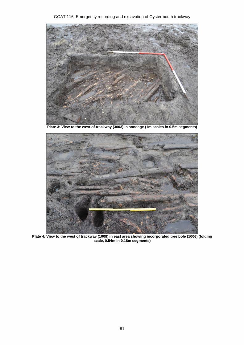
GGAT 116: Emergency recording and excavation of Oystermouth trackway
81
Plate 3: View to the west of trackway (3003) in sondage (1m scales in 0.5m segments)
Plate 4: View to the west of trackway (1008) in east area showing incorporated tree bole (1006) (folding
scale, 0.54m in 0.18m segments)

GGAT 116: Emergency recording and excavation of Oystermouth trackway
82
Plate 5: View to the west of east-facing section through trackway (2003) showing timber N159 (1m scales,
in 0.5m segments).
Plate 6: View to the east of possible lap housing cut into timber S092 (0.35m scale).

GGAT 116: Emergency recording and excavation of Oystermouth trackway
83
Plate 7: View to the west of trackway identified during site visit (September 2009). Timber N040 with its
distinctive damage is visible (1m scale, in 0.2m segments).

N
SITE
0 1.00 2.00m
N
GR
ID
Area of context 1002
Area of context 1003
Area of context 1004
Area of context 1006
Area of context 1005
S067
Timbers overlaying
Timbers underlaying
Delineation areas of specifictimber types
Position of cut marks
Key
Vertical timbers
Wood number
Peat
S002
S001
S003
S004
S005
S006
S007
S008
S009
S010
S011
S012S013 S014
S015
S016
S017
S018
S019
S020
S021
S022
S023
S026
S025
S027
S028
S029
S030
S031
S033
S034
S035
S036
S037
S038
S039
S040
S041
S042
S043
S044
S045
S046
S047
S048
S049
S050
S051
S052
S053
S054
S055
S056
S057
S060
S063
S064
S065
S066
S067S068
S069
S070S071
S072
S073
S074
S075S076S077S079S080S081
S082
S083
S085
S086
S087
S088
S090
S091
S089S092
S093S093
S094
S095
S096
S097
S098
S099
S100
S101
S062
S102
S103
S159
S158
S157
S156
S155
S154
S153
S024
S032
S152
S151
S150
S149
S148S146
S147
S145
S144
S143
S142
S140
S141
S139
S138
S137S136
S135
S134
S133
S132
S131
S130
S129
S128
S127
S126
S125
S124
S123
S122
S121
S120
84
Figure 2. Plan of structure 1008 in east area
GGAT 116: Emergency recording and excavation of Oystermouth trackway

N
GR
ID
0 1.00 2.00m
N114
N100
N115
N116
N115
N113
N112
N111
N110
N109
N107
N108
N102
N103
N104 N105 N185
N103
N106
N101N181
N122
N125
N186
N184
N123N124
N183
N182
N182
N170
N128N127
N168
N169
N171
N126
N165N166N172
N180
N173
N174 N176
N175
N179
N178
N177
N060
N089
N061N062
N067
N066N065
N064
N088
N130
N129
N121
N120
N119
N080
N081
N075
N074
N164
N163
N072
N117
N149
N093N092
N143
N073
N142N063
N144
N079
N146
N147
N076N140
N148
N086
N136N135
N131
N138
N136
N068
N069
N077
N078
N136
N145
N090
N091
N037
N134
N139N085 N084
N083
N070
N071N141
N132
N133
N040N042
N039
N041
N092
N038 N095
N035
N033
N087
N038
N049 N047
N046
N045N044
N052
N032
N034
N029
N031
N030
N023
N025N024
N026
N027 N021N022
N028
N019
N043
N016
N018
N020
N017
N015
N006
N012
N013N014
N011
N010
N159
N057
N055N056
N054N053
N008N005
N007
N009
N004
N001
N003N003
N002
N051
N050N048
N036
N037
85
Figure 3. Plan of structure 2003 in west area
GGAT 116: Emergency recording and excavation of Oystermouth trackway
Area of context 2006
Area of context 2008
Area of context 2007
Area of context 2005
Section (see Figure 5)
N
SITE
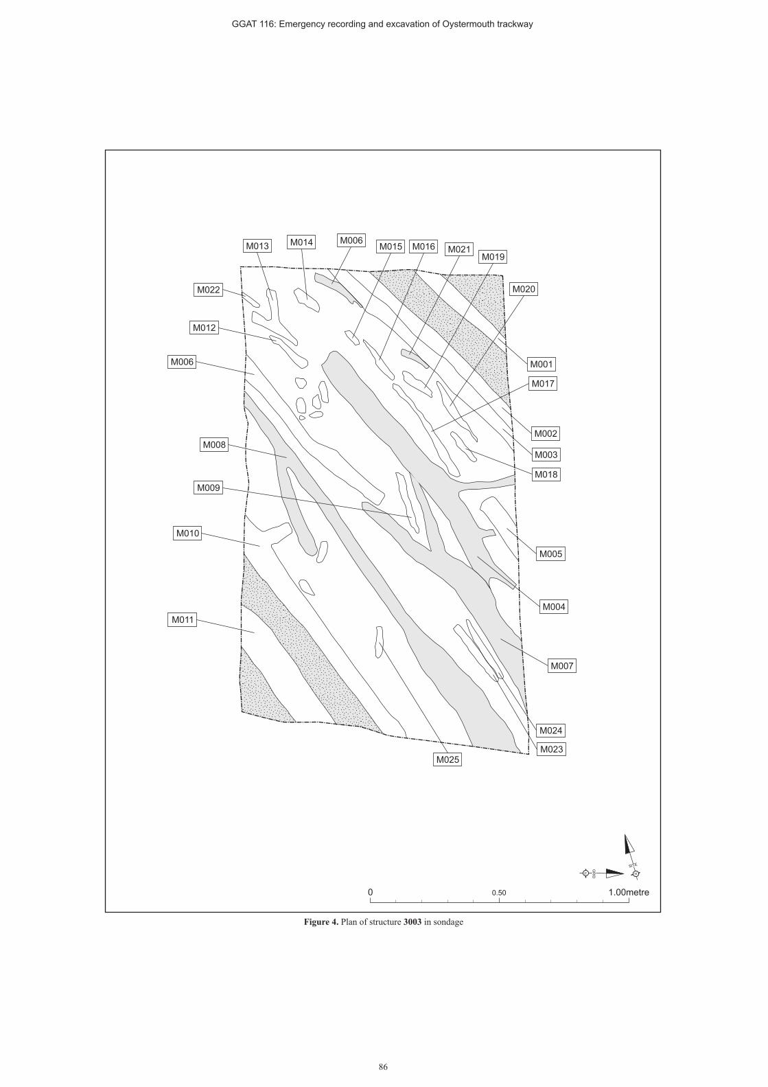
N
SITE
0 0.50 1.00metre
N
GR
ID
M008
M011
M010
M006
M007
M005
M004
M003
M002
M001
M023
M024
M025
M009
M022
M013 M014 M006M015 M016
M019
M020
M018
M017
M021
M012
86
Figure 4. Plan of structure 3003 in sondage
GGAT 116: Emergency recording and excavation of Oystermouth trackway

N009
N159
N162
N161
N159
N160
0 0.50 1.00metre
South North
GGAT 116: Emergency recording and excavation of Oystermouth trackway
Figure 5. East-facing section through structure 2003
87

GGAT 116: Emergency recording and excavation of Oystermouth trackway
88
4 Wood analysis (Appendix II) By Andy Sherman
4.1 Wood technology (Appendix II) Introduction A total of 374 timbers were recorded on the Oystermouth foreshore from two areas of probable trackway, separated by a distance of 10m and from a sondage excavated between these two areas (see Appendix II). Timbers recorded in the west area of trackway were given the prefix ‘N’ (being closer to site north), timbers recorded in the east area of trackway were given the prefix ‘S’, (site south) while timbers recorded in the sondage were given the designation ‘M’. In the west section of trackway 189 timbers were recorded, in the east section of trackway 159 timbers and a total of 26 timbers were recorded in the sondage.
Of these 374 timbers a total of 318 (86%) were thought to form part of the trackway, with the remaining 56 (N006, N022, N037, N043, N047-N051, N066-N077, N111-N116, N150-N158, N160, S003, S005, S066-S081 and S098) possibly forming part of the submarine forest previously recorded in the area (see Sherman 2010 and 2011). An area of timber located to the southeast of the trackway (Context 1006) was not issued with wood numbers as this was considered to be a natural feature.
The 318 timbers thought to form the probable trackway represent 294 horizontal timbers, forming the bed of the trackway. A single timber (S103) was identified as a stake and a second timber (N159) was thought to form a probable vertical support for the trackway. (Unfortunately it was not possible to fully excavate this timber and it is not known whether it was formed into a point). A further twenty-two vertical timbers (N15, N37, N59, N94, N96, N98 and N107-N110, along with timbers S18-S23, S25, S45, S51-S52, S90 and S96) are thought to form possible stakes or vertical supports for the trackway due to their structural location.
The vast majority of the timbers recorded (96%) were un-worked roundwoods, which showed no signs of wood-workings. Of the 4% (sixteen) of timbers that showed signs of wood-working, ten had been converted and seven demonstrated point production, signs of carpentry or felling.
A full list of timbers along with their orientation, lengths and widths can be found in Appendix II.
Methodology All timbers recorded on-site where measured for their length and width (in this context width is a timbers measurement on the X-axis and breadth the timbers measurement on the Y-axis). All horizontal timbers that showed signs of wood working (N038-N041, N061, N092, N103, M011, S006, S007, S010 and S092) were recovered for later analysis; while two vertical timbers were excavated with timber S103 lifted for further analysis.
Descriptions of the woodworking techniques given below follow established methods for the description of conversion methods, tool facets and point types (eg Coles and Orme 1985, Brunning and O’Sullivan 1997).
Analysis Of the fourteen timbers recovered from site for further analysis, ten timbers showed signs of conversion, five timbers were half-split, three were tangentially converted and two were radially converted (see table 1). The remaining five timbers were unconverted roundwoods.

GGAT 116: Emergency recording and excavation of Oystermouth trackway
89
Table 1: Methods of timber conversion Wood number Conversion method Notes
N038 Tangentially split Max width: 32mm, Min width: 18mm
N040 Radially split Max width: 32mm, Min width: 24mm
N095 Radially split Max width: 52mm, Min width: 28mm
N117 Tangentially split Breadth: 23mm
N159 Half-split Breadth: 200mm
M011 Half-split Breadth: 52mm
S006 Half-split Breadth: 97mm
S007 Half-split Breadth: 105mm
S010 Tangentially split Breadth: 76mm. Bark intact
S103 Half-split Breadth: 35mm
Timbers N159, S006 and S007 showed further signs of conversion; all three timbers had been primarily half-split, however they had then been further quarter-split at one end to form narrow tongues. N159 had a tongue which measured 50mm in width and 160mm in length, S006 had a tongue which measured 42mm in width and 162mm in length and S007 had a tongue which measured 93mm in width and 311mm in length. Timber S007 had a 2mm wide tool-mark running the length of the angle formed by the tongue and main-body of the timber.
A total of seven timbers showed signs of wood-working.
Timber N039 This timber was an unconverted roundwood worked to a wedge-point on opposite faces with nine and seven facets respectively. The largest of these facets measured 32mm by 43mm, had clean facet junctions, a slightly concave character and a cutting angle of 36°. A single jam curve was present on this timber with a length of 35mm.
Timber N041 This timber was an unconverted roundwood with a 60° curve. The timber had a single working facet at one end that measured 32mm by 35mm and had clean facet junctions, a slightly concave character and a cutting angle of 40°. This facet displayed a single jam curve with a length of 27mm. Timber N041 had its bark intact.
Timber N061 This was a Y-shaped roundwood that had been worked to a chisel-point, with four facets on one side of the timber. The largest of these facets measured 22mm by 41mm, had clean facet junctions, a slightly concave character and a cutting angle of 33°.

GGAT 116: Emergency recording and excavation of Oystermouth trackway
90
Timber N097 This timber was an unconverted roundwood that had been worked to a chisel-point that displayed four facets. The largest of these facets measured 32mm by 29mm, had clean facet junctions, a flat facet character and had a cutting angle of 40°.
Timber N103 Timber N103 was an unconverted roundwood that had been worked to a chisel-point, formed from four facets. The largest of these facets measured 54mm x 33mm, had clean facet junctions, a flat facet character and had a cutting angle of 32°. Timber N103 had its bark intact.
Timber S092 Timber S092 was an unconverted roundwood that had been stripped of bark and had a breadth of 45mm. 308mm from the timbers northern end a sub-rectangular slot had been cut into the timbers eastern side. This slot measured 120mm in length and 38mm in depth. The southern side of the slot had a width of 67mm, while the slots northern side had a width of 64mm.
Timber S103 This timber was a vertically orientated, half-split roundwood with a breadth of 35mm. The lower end of the timber had been converted into a pencil-point on three sides, which displayed five, two and three working facets respectively. The largest of these facets measured 43mm by 12mm, had ragged facet junctions and a slightly concave facet character with a cutting angle of 37°. The end of the timber showed vertical compression damage, suggesting that it had been forced into the ground vertically.
Conclusions Unfortunately timber N159 could not be excavated fully in the time available on site, so it is not possible to say whether this timber was worked to a point or whether it rounded-out to become an unconverted timber at the base. It is possible that this timber may represent a naturally occurring tree used to provide some lateral stability to the trackway. However, the presence of two similarly shaped pieces of wood (S006 and S007) used as horizontal timbers in the trackway-bed, suggests that it is more likely that timber N159 is a half-split post deliberately placed in the ground, with timbers S006 and S007 being reused when they were not needed for supports. Timber S103 had clearly been converted into a stake or peg and vertically forced into ground to anchor the trackway in place. The use of two different methods of anchoring could suggest that the environment which the trackway crossed was particularly unstable, or it could suggest that area of trackway around timber S103 was a later repair, anchored in place with a peg/stake. This question can only be fully resolved by dating.
The rectangular slot cut into the eastern side of timber S092 would appear to be a lap housing, as such it is out of place within the structure of the trackway. This would suggest that timber S092 was reused from an earlier structure.
Given the structural locations of timbers N041, N061 and N103 the chisel-point production on these three timbers probably represents felling or trimming marks. The wedge-point produced on timber N039 could be indicative of the deliberate production of a point to form a stake or peg; however, as these facets are produced on opposite sides of the timber they could easily represent felling marks. With the facets on one side representing cuts to weaken the strength of the tree and cuts on the opposite side used to control the direction of fall. Given the structural location of this timber it is likely that these tool-marks represent felling rather than point production.
With the exception of the four Y-shaped timbers (N061, M004, M007 and S115) were straight grained with few side branches rating either 1 or 2 on the ‘scale of straightness’. (A subjective grade is used to record the straightness of the grain, ranging from 1 to 4, using

GGAT 116: Emergency recording and excavation of Oystermouth trackway
91
the following equation: Straight grained < Knotty (Grade 1-4). This near universal straightness of grain suggests that the timber was selected for it shape and perhaps indicates that it was recovered from managed woodland.

GGAT 116: Emergency recording and excavation of Oystermouth trackway
92
4.2 Radiocarbon dating Two samples of timbers were sent to the Beta Analytic Radiocarbon Dating Laboratory in Florida, one from the east area (S006) and one from the west area (N039).
Sample S006 was dated to Cal BC 1120 to 930 (Cal BP 3070 to 2880) with a 2 Sigma Calibration (Beta: 318152) and sample N039 was dated to Cal BC 1210 to 1000 (Cal BP 3160 to 2950) with a 2 Sigma Calibration (Beta: 318151).
These dates correspond with the dates of Cal BC 1040 to 910 (Cal BP 2290 to 2860) (Beta: 294872) obtained from samples taken during the previous investigation of the structure (Sherman 2011) and confirm a late Bonze Age date for the structure.

GGAT 116: Emergency recording and excavation of Oystermouth trackway
93
5 Conclusion The wooden features excavated in the course of the fieldwork have been proven to be the same site as that previously investigated by GGAT, with the presence of timber N040 in both initial site visit photos and in the west area of the present investigation confirming this to be the site identified in September 2009 as “Oystermouth structure 1”.
The current fieldwork has shown the feature to be a substantial trackway structure dated by AMS analysis to the late Bronze Age. The dates overlap with those obtained from previous work on this structure (Sherman 2011).
Its construction is predominantly of long straight lateral roundwoods, overlying occasional larger timbers, also laid across the axis of the trackway, anchored to the underlying peat by irregularly placed vertical timbers, possibly stakes. One example (S103) was proven to be a sharpened stake with signs of impact damage from having been driven into the peat, illustrating its function of consolidating the structure. In patches, small diameter roundwoods form the uppermost surface of the trackway, laid parallel to the larger roundwoods. The structure is approximately 3.2m in width, and aligned roughly east-north-east to west-south-west. On the north side of the trackway, parallel to its northern edge but lying beyond the ends of the lateral timbers, is a closely-spaced alignment of vertical timbers. In at least one area, natural wood appears to have been incorporated into the structure, perhaps to stabilise and consolidate it.
The roundwoods which form the surface are generally straight, with side branches removed, fairly uniform in width and uniform in length. Though some are half split or radially split, most have been left in the round. The generally uniform nature of the roundwoods which form the greater part of the structure may suggest a relatively high level of woodworking craftsmanship in its construction.
The use of both roundwoods and larger timbers in specific stretches of the trackway’s length is also seen in the Neolithic Abbot’s Way trackway in the Somerset Levels, where wooden planks were placed side by side, and some stems and branches were also incorporated in the structure, with some areas of alternating grouped stems and planks, (Coles & Orme, 1976, 13) as seen in the Oystermouth trackway.
The surface of the trackway has a noticeable depression in the middle, perhaps indicating that it has seen heavy traffic. The consistency of this pattern across both areas investigated suggests that it is a reflection of the use the structure has undergone rather than being due to peat compaction or movement post-dating the trackway’s use. This pattern would seem to indicate that it saw heavy traffic during its usage, and its size at over 3m suggests that this was more than pedestrian usage, possibly including herds of cattle being taken to pasture in saltmarsh, as suggested for similar structures elsewhere (Van de Noort & O’Sullivan 2007).
Several of the elements of the trackway show signs of working, most of which is thought to represent felling or trimming marks, timber S092 however, includes a possible lap housing on its upper surface, suggesting that it may have been reused in the trackway from an earlier structure.
The trackway is constructed of lateral timbers and roundwoods with some vertical timbers, possibly stakes, the only possibly structural longitudinal timbers in the exposed were in the area of the small diameter roundwood deposit on the south side of the western exposure and appeared to underlie the small diameter roundwood surface. A possible explanation for this is that the small diameter roundwoods represent a repair to the original surface, with the longitudinal planks forming a base for this repair patch. This uppermost small diameter roundwood deposit was present in both the east and west areas excavation on the south side of the trackway. This is not thought to be an accident of survival; the pattern of erosion noted during site visits and at the start of fieldwork demonstrates that the area with this

GGAT 116: Emergency recording and excavation of Oystermouth trackway
94
uppermost deposit was being exposed by tidal action, while other parts of the trackway’s width had not been exposed, with the overlying peat intact, and when excavated, no similar surface was encountered. The existence of this deposit as the uppermost surface on only the south side of the trackway would therefore seem to be a genuine reflection of the structure rather than be due to differential survival.
An unusual aspect of the trackway’s construction is the inclusion of natural wood in the structure, the root system 1006 in the east area, and possibly the unusual vertical support N159 in the west area, a substantial timber which continues in the round well below the level of the trackway. Though this cannot be confirmed as an instance of the utilisation of in situ preserved trees to consolidate the structure, as it could not be bottomed during fieldwork, it may be another example of this practise, as in the east area. Though unusual, this is not unparalleled. The use of preserved trees to support a trackway is also seen at Derryfadda 13, in Ireland, a 0.7m wide trackway of roundwood, brushwood and timbers, roughly contemporary with the Oystermouth structure. The trackway had been built around the root systems of trees growing in the area (May et al 2005a, 231). The trackway published as Cooleeny 64, dated to 1420-1020 BC, constructed of longitudinal roundwood and brushwood, with some transverse timbers, 1.35m wide, was associated with 31 pieces alder root (May et al 2005a, 226), while trackway Derryfadda 206, dated to 785-375 BC, was constructed of longitudinally laid roundwood among alder roots (May et al 2005a, 237). Furthermore, during excavation of the Meare Heath track in the Somerset levels, natural timbers including the root system and trunk of a bog oak were revealed, which were in a position and alignment consistent with being trackway components, providing natural consolidation of the ground (Coles & Orme, 1978, 20-21). Later excavations of this trackway in 1985 altered its description little, though did add the information that stumps were used to consolidate it in wet or unstable areas (Coles et al 1988, 8), and that as it was built on an uneven and varying bog surface, with some wetter patches, construction techniques were changed in stretches, reflecting the varying local conditions and environments. The much earlier (c2800BC) Honeygore track in the Somerset Levels, a narrow footpath formed of brushwood bundles, with pegs along the edges and within the timbers, also utilised natural tree stumps in the structure; in places, trees growing on the proposed line of the track were felled, with the trunk and branches cut and used in the construction, while the stump was left as a substantial, rigid part of the trackway (Coles & Hibbert 1975, 11). It appears that a similar approach was used by the builders of the Oystermouth trackway when constructing it in an area of extant woodland, with pre-existing trees, stumps and root systems incorporated into the construction where the line of the track crossed them, in order to consolidate and strengthen the structure.
The use of wooden vertical timbers in the body of the trackway anchoring the wood which forms the surface is common in many examples of corduroy roads and less substantial brushwood trackways of all dates in the Britain and Europe, however, the line of vertical timbers running parallel with the north side of the track (2008, 1005), offset from its edge by up to 0.67m is less common, and has no structural function in the Oystermouth trackway. Though their straight alignment suggests they have been deliberately placed, there remains the possibility that they represent the remains of elements of the submerged forest in the area. The longitudinal timber (N047) in the area of these vertical timbers may be part of a root system. However, some similar trackways also include such features, including stake alignments that don’t appear to have any structural function. The trackway in Tinney’s Ground, known as TIN A, is broadly contemporary with the Oystermouth example, its earlier, lower, phase dating to c1500BC, and its rebuilt upper phase to c1100BC. This trackway also incorporates pegs and stakes along its edges, with an average diameter of 30mm, some at the track edge, but often set 0.2-0.3m away from the longitudinals (Coles et al 1978). The Abbot’s Way trackway also incorporates pegs, some of which define its edges and are not structurally essential, though they are generally equal on each side and paired. Possible functions for these have been suggested, as markers delimiting the line of the trackway, or to mark the line of the roadway for users during wet seasons (Coles & Orme 1976, 18). Alternatively, elsewhere, in Derryville Bog, it has been suggested that during the

GGAT 116: Emergency recording and excavation of Oystermouth trackway
95
medieval period, waterlogged and dangerous parts of the bog were demarcated by rows of stakes (Van de Noort & O’Sullivan, 2007). The presence of the pegs on only the north side of the Oystermouth trackway rather than on both may support this as an interpretation of their function. Conversely, reflecting the possibility that the trackway may have been used as a drove road giving access to saltmarsh grazing for cattle, these posts may represent the base of a fence line erected along the line of the trackway to keep the animals on its surface.
The existence of this line of vertical timbers on only the north side of the track is unusual, and is not thought to be an accident of survival or excavation, an equal distance was excavated from the south edge of the track, and though occasional pieces of wood were uncovered, these were wholly different from the closely spaced alignments to the north.
Though lines of stakes such as these are common in Swansea Bay, forming the arms of fish weirs, the proximity of these to the trackway suggests a relationship, while the location of the timbers relatively close to modern Mean High Water is unlikely to have been chosen for fishing.
The group of vertical timbers (2009) to the northwest of the trackway exposure forms an irregular sub-circular group, and is likely to remains of elements of the submerged forest.
The wooden feature uncovered in the sondage between the two areas excavated is very similar in construction and alignment to those in both the east and west areas, though was at a greater depth than either. It has been suggested that this may be due to the structure having been built on an undulating land surface; there is a slight slope downwards to the east in the stretch of trackway identified, despite the uneven nature of the trackway surface in each area. Alternatively the structure in the middle sondage area may be an earlier trackway, built on the same alignment as the one investigated in the east and west areas, buried by peat growth, as in the Irish examples (Van de Noort & O’Sullivan 2007). Slight differences in the alignments of the east, west and sondage areas may support this, but could also be explained by the route of the trackway making slight diversions to avoid wet or unstable patches, as is seen in, for example, the Abbot’s Way (Coles & Orme 1976, 12).
The trackway is rare in the region and unique in Swansea Bay; previous trackways discovered here have been of early Bronze Age date, or late Iron Age/early Roman date. The former is an interwoven timber hurdle and the latter a brushwood structure, 2.1m wide (Williams 1994, 14). The Oystermouth trackway is significantly more substantial than either.
The construction of the trackway is most closely parallel to the tradition of corduroy roads, (May et al 2005b, 211) with impressive dimensions and sophisticated woodworking technology, with transverses of timbers and roundwoods, though lacking the longitudinal substructure these structures sometimes exhibit. Its width of c3.2m is less than the typical Neolithic examples of Lower Saxony and the Netherlands which were used for heavy, slow, robust vehicles (IAWU 1996, 219). The early Bronze Age examples in Europe narrowed as technology progressed and the surfaces became more even, to allow for faster horse-drawn vehicles with more sophisticated steering mechanisms than the earlier vehicles pulled by oxen (IAWU 1996, 220). However, these increasingly sophisticated European trackways are unparalleled in Britain and Ireland. In 2005 (IAWU 1996, 222) it was stated that there were no contemporary corduroy roads in England, though several examples are known from Ireland, less sophisticated than the European trackways, including the 10th century BC Derryoghil 1, Baunaghra, Co Laois, with pegged transverse planks up to 3.2m long, and Dromard More, Co Tipperary constructed of pegged sleepers 2.8m long (IAWU 1996, 223). The Killoran 243 trackway, dated to c979BC is also similar in width, 3.5m wide, and is constructed of dumped roundwood transverse trunks among brushwood and cleft wood, with more brushwood on top (May et al 2005a, 270-1).
The Oystermouth trackway, therefore, is extremely rare in Britain as an example of a corduroy road of this date and constructional type, though paralleled in size and technology

GGAT 116: Emergency recording and excavation of Oystermouth trackway
96
by several examples of the middle Bronze Age to Iron Age in Ireland, indicating the similarity in local conditions that necessitated the development of building technology.
Although several similar structures are known in Ireland, contemporary trackways in Britain are generally different in character. The Eclipse Track in the Somerset Levels for example, dating to c1500BC, is of the hurdle type, constructed of pre-fabricated panels constructed elsewhere and brought to the site to form a path 1m wide (Coles, Orme & Hibbert 1975, 21). Elsewhere in the Somerset Levels, the Meare Heath Track, also late Bronze Age in date, was constructed of transverse beams staked down, with longitudinal planks laid on top to form a 1m wide walking surface (Coles et al 1988, 8), while the Bronze Age Godwin’s track is formed of bundles of branches and twigs pegged down to form a path c0.5m wide (Coles et al 1985, 69).
Within Wales, a variety of Bronze Age trackways roughly contemporary with the Oystermouth structure have been investigated, including an unusual example of 2750 BP at Caldicot, incorporating limestone blocks, log uprights, bundles of roundwood, woven panels and domestic debris (Parry 1990, 10). A brushwood structure at Collister Pill dating to between 1450 and 1100BC was built to cross a palaeochannel (Neumann, Bell & Woodward 2000, 309), while a trackway at Cold Harbour Pill has not been scientifically dated but is thought to be late Bronze Age, and was also built in a peat environment (Locock 1997). This is formed of obliquely driven stakes creating v-shaped supports for a fine layer of brushwood and brash, overlain by longitudinal brushwood bundles with some transverse roundwoods and an upper surface of compacted fine brushwood and brash, pegged on its inland side (Locock 1997).
Trackways of similar construction to the Oystermouth structure are attested both in Britain and elsewhere in Wales, though are not contemporary with it. The Abbot’s Way, in the Somerset Levels, is significantly earlier, dating to c2000BC, but is constructed of transverse timbers forming a corduroy road surface 1-2m wide, with some areas of alternating grouped stems and planks, and pegs, some defining edges, but not structurally essential (Coles & Orme 1976).
A trackway (1130) at Goldcliff is also of corduroy construction, 1m wide, of lateral planks and roundwoods with occasional pegs at irregular intervals, though it is later than the Oystermouth trackway, forming part of a Late Iron Age complex (Bell, Caseldine & Neumann 2000).
In the Irish midlands, many trackways link areas of dry ground across raised mires, and frequent rebuilding of trackways on the same alignment has been demonstrated, most likely in order to maintain contact during periods of increased wetness causing accelerating peat growth and burying trackways (Van de Noort & O’Sullivan 2007). The functions of some have been demonstrated by palaeoenvironmental evidence to include access to allow cattle on to saltmarshes for seasonal feeding, such as those dated to 1400 BC and 1400-900 BC in the Humber estuary (Van de Noort & Fletcher 2000, 52) or to allow access to wetlands for hunting, fowling or fishing (Van de Noort & O’Sullivan 2007). Elsewhere, in the Severn Estuary for example, some trackways (such as 1108) have been demonstrated to lead to a structure (Bell 1992, 17), and it has been suggested that they may also have provided safe passage between buildings and fish traps (Bell 1992, 26).
This trackway is significantly larger, more complex and more robustly constructed than many of the short, narrow, casually constructed contemporary brushwood structures excavated elsewhere in Britain and Ireland, which were built to act as bridges over small areas of unstable or watery ground used for brief periods. Though its length remains unknown, its width and the sophistication of its construction indicate that it is more than a casual surface laid down to facilitate the crossing of a small wetter patch such as those excavated at Goldcliff, constructed of brushwood, some pegged, and all but one 0.5-0.7m wide, one of which (Trackway 8) was built to cross a single feature; a narrow palaeochannel (Bell 1991,
GGAT 116: Emergency recording and excavation of Oystermouth trackway
97
19), or the short brushwood, woven panel and hurdle structures at Walton Heath in the Somerset Levels which were laid to cross shallow pools and marshy areas (Coles & Orme 1977, 11-13). Likewise, many of the Late Bronze Age trackways at Tinney’s Ground also appear to have been laid to consolidate small wet patches of ground, (TIN D, E, F, G, H, I, J) and are generally narrow, being only up to 1m wide (Coles et al 1978). As only short stretches of the feature have been excavated, its length is unknown and it is unclear whether it was intended to cross into a saltmarsh or link drier areas of fen; though this trackway is clearly more substantial than those examples above, its function also remains unknown.
Potential functions of this trackway are suggested by similar structures elsewhere, however, including linking to a building (as trackway 1108 at Goldcliff, Bell 1992, 17), giving access to a saltmarsh for feeding cattle (as in the Humber estuary, Van de Noort & Fletcher 2000, 52). The width of the structure and the apparent heavy use it has seen, support this theory, while human footprints and possible cattle footprints preserved in the peatshelf elsewhere in Swansea Bay demonstrate that cattle were being herded in the area at during the prehistoric period, though these footprints have not been definitely dated (Bennett 2010).
A ritual dimension to this feature should also be considered. Trackways elsewhere in Britain and Ireland have been shown to be associated with metal artefacts and fragments of human skulls, thought to be deliberately placed. It has been argued (Van de Noort & O’Sullivan 2007) that minerogenic wetlands are generally the centres for features and sites related to food production and daily life, in contrast with peat bogs, such as the environment in which the Oystermouth trackway was built, which were focal points of ritual activity, indicating a difference in perception of the different types of wetland environment. It is also stated that that votive depositions including gold and bronze artefacts and human remains are associated with water and wetland areas, specifically where they were crossed (Van de Noort & O’Sullivan 2007). Human skulls and fragments of skulls dating to the Late Bronze Age have been shown to have been deliberately (ritually) deposited at Goldcliff (Bell, Richards & Schulting 2000) in connection with a wooden structure, and at Flag Fen (Pryor 1991). Although no finds were recovered in the course of the recent fieldwork, a number of finds made in the vicinity of Swansea Bay could be argued to potentially fall into a ritual deposition category, including the tip of a bronze socketed spearhead dating to 1450-900BC (02963w) from Oystermouth, 0.9km to the east-north-east of the trackway, a leaf-shaped Bronze Age sword (00912w) of similar date from 0.18km to the south of the trackway, an Iron Age spear tip (02962w) and a human skull (00416w), estimated to be 2000 years old, both from the bay opposite Black Pill, 1.5km to the north-north-east of the trackway. Given proven associations of similar sites with deliberate deposition of comparable objects, these finds from the area of the trackway may also reflect votive placement, and a ritual aspect to the trackway should not be discounted.
Several of these issues could be resolved by future monitoring of the structure, and recording of further exposures. Any future fieldwork and investigation which may be undertaken in response to natural tidal erosion and exposure of the feature would benefit from further radiocarbon dates, further sections being excavated through the structure, and through the areas of vertical timbers to determine their nature, and, if possible, tree-ring analysis and species analysis, which may add to our understanding of the timber sources used for the trackway’s construction.

GGAT 116: Emergency recording and excavation of Oystermouth trackway
98
Bibliography Sources cited in text Bell, M, 1991, “Goldcliff Excavation 1991”, Severn Estuary Levels Research
Committee Annual Report 1991, 13-21. Bell, M, 1992, “Field survey and excavation at Goldcliff 1992”, Severn Estuary Levels
Research Committee Annual Report 1992, 15-29. Bell, M, Caseldine, A and Neumann, H (eds.), 2000, Prehistoric Intertidal
Archaeology in the Welsh Severn Estuary. CBA Research Report 120. York, Council for British Archaeology.
Bell, M, Richards, M and Schulting, R, 2000, “Skull deposition at Goldcliff and in the Severn Estuary”, in Bell, M, Caseldine, A and Neumann, H (eds.) Prehistoric Intertidal Archaeology in the Welsh Severn Estuary. CBA Research Report 120. York, Council for British Archaeology, 64-73.
Bennett, M R, et al, 2010, “Probable Neolithic footprints preserved in inter-tidal peat at Kenfig, South Wales (UK). Proc. Geol. Assoc. (2010), doi. 10.1016/j.pgeola.2010.01.002
Brunning R and O’Sullivan A, 1997, ‘Wood species selection and woodworking techniques’, in Nayling N and Caseldine A (eds), Excavations at Caldicot, Gwent: Bronze Age palaeochannels in The Lower Nedern Valley, CBA Research Report 108
Coles, J M and Hibbert, F A, 1975, “The Honeygore Complex”, Somerset Levels Papers 1, 11-19.
Coles, J M and Orme, B J, 1976, “The Abbot’s Way”, Somerset Levels Papers 2, 7-20.
Coles, J M and Orme, B J, 1977, “Neolithic hurdles from Walton Heath, Somerset”, Somerset Levels Papers, 3, 6-29.
Coles, J M and Orme, B J, 1978, “The Meare Heath Track”, Somerset Levels Papers 4, 11-39.
Coles J M and Orme B J, 1985, ‘Prehistoric woodworking from The Somerset Levels: 3. Roundwood’, Somerset Levels Papers 11
Coles, J M, Orme, B J and Hibbert, F A, 1975, “The Eclipse Track”, Somerset Levels Papers 1, 20-28.
Coles, J M et al, 1978, “Multiple Trackways from Tinney’s Ground”, Somerset Levels Papers 4, 47-81.
Coles, J M et al, 1985, “Godwin’s Track: A Bronze Age Structure at Sharpham”, Somerset Levels Papers 11, 69-74.
Coles, J M et al, 1988, “The Meare Heath Track 1985”, Somerset Levels Papers 14, 6-33.
George, T, 1970, British Regional Geology, South Wales, Third Edition, HMSO, London.
IAWU 1996, “The Wider Context” Transactions of the Irish Archaeological Wetland Unit 3. Dublin, Crannog Publications, 211-230.
Locock, M, 1997, “A Prehistoric Trackway at Cold Harbour Pill”, Archaeology in the Severn Estuary 8, 9-12.
May, S C, et al, 2005a, “Catalogue of Wetland Sites”, The Lisheen Mine Archaeological Project 1996-8, Wordwell, 223-282

GGAT 116: Emergency recording and excavation of Oystermouth trackway
99
May, S C, et al, 2005b, “Wetland Structures: Typologies and Parallels”, The Lisheen Mine Archaeological Project 1996-8, Wordwell, 209-221.
Neumann, H, Bell, M and Woodward, A, 2000, “The Intertidal Peat Survey”, in Bell, M, Caseldine, A and Neumann, H (eds.) Prehistoric Intertidal Archaeology in the Welsh Severn Estuary. CBA Research Report 120. York, Council for British Archaeology, 282-321.
Parry, S, 1990, “Caldicot: A Late Bronze Age Maritime Site in Gwent”, Severn Estuary Levels Research Committee Annual Report 1990, 5-11.
Pryor, F, 1991, Flag Fen prehistoric fenland centre. English Heritage. Savory, H N, 1969 ‘A forgotten round cairn at Newton, Mumbles, and its excavation’,
Gower 20, 66-71. Sherman A 2010 Wooden structures on the Oystermouth foreshore, Swansea GGAT
Report no. 2010/062 Sherman, A, 2011, “Recently discovered trackways in Swansea Bay”, Studia Celtica
45, 1-25. Van de Noort, R and Fletcher, W, 2000, “Bronze Age Human Ecodynamics in the
Humber Estuary”, in Bailey, G, Charles, R and Widner, N, (eds.) Human ecodynamics. Proceedings of the Association for Environmental Archaeology Conference 1988 held at the University of Newcastle upon Tyne. Oxford, Oxbow Books, 47-54.
Van de Noort, R, and O’Sullivan, A, 2007, Rethinking Wetland Archaeology (Duckworth Debates in Archaeology), Gerald Duckworth & Co.
Williams, D N, 1994, Archaeological Field Evaluation, Brynmill Peat Shelf, Swansea Bay, GGAT Report No. 94/004.
Sources not cited in text Bell, 1993, ‘Field survey and excavation at Goldcliff, Gwent, 1993’, Archaeology in
the Severn Estuary, volume 4, 83-101 Locock, M, 1996, GGAT 50: Coastal Survey (Glamorgan), Loughor, West
Glamorgan to Sker Point, Mid Glamorgan, Part one: Text, GGAT Report no. 96/015
Nayling, N, 1998, Swansea Bay Intertidal Survey, A report for Cadw: Welsh Historic Monuments, GGAT Report no. 98/059
Sell, S, H, 2008, Brynmill Peatshelf Structure, unpublished site notes 06/09/08

GGAT 116: Emergency recording and excavation of Oystermouth trackway
100
Appendix I: Context Inventory Table 2: Context numbers in east area, with depth below current ground surface
Context number
Context type
Context description Depth below ground surface
1000 Deposit Sand and beach sediment 0m – 0.1m 1001 Deposit Peat overlying trackway 0m – 0.2m 1002 Structure Large timbers 0.2m – 0.35m 1003 Structure Roundwoods 0.2m – 0.3m 1004 Structure Small diameter roundwood
surface 0.2m – 0.28m
1005 Group Post alignment 0.2m – 0.25m (NB)
1006 Object Tree bole 0.2m – 0.45m 1007 Deposit Peat underlying trackway 0.45m – 0.6m
(NB) 1008 Group Trackway group number 0m – 0.45m
Table 3: Context numbers in west area, with depth below current ground surface Context number
Context type
Context description Depth below ground surface
2001 Deposit Sand and beach sediment 0m – 0.1m 2002 Deposit Peat overlying trackway 0m – 0.2m 2003 Structure Trackway group number 0m-0.45m 2004 Deposit Peat underlying trackway 0.3m-0.6m
(NB) 2005 Structure Large timbers 0.2m-0.3m 2006 Structure Small diameter roundwood
surface 0.2m-0.28m
2007 Structure Roundwoods 0.2m-0.3m 2008 Group Vertical timber alignment 0.2m-0.25m
(NB) 2009 Group Vertical timber group 0.2m-0.25m
(NB) Table 4: Context numbers in sondage, with depth below current ground surface
Context number
Context type
Context description Depth below ground surface
3001 Deposit Sand and beach sediment 0m – 0.2m 3002 Deposit Peat overlying trackway 0.2m – 0.4m 3003 Structure Trackway group number 0.4m (NB) Note: (NB) = Not bottomed

GGAT 116: Emergency recording and excavation of Oystermouth trackway
101
Appendix II: Wood Index Table 5: Timber index
Wood number Length (mm) Width (mm) Orientation1 Further work
N001 780 50 Horizontal
N002 300 30 Horizontal
N003 640 40 Horizontal
N004 1640 80 Horizontal
N005 500 40 Horizontal
N006 70 80 Vertical (Upright)2
N007 400 85 Horizontal
N008 560 40 Horizontal
N009 2400 120 Horizontal
N010 1600 50 Horizontal
N011 1100 40 Horizontal
N012 70 20 Horizontal
N013 120 30 Horizontal
N014 160 30 Horizontal
N015 80 150 Vertical (Possible stake) 2
N016 110 30 Horizontal
N017 850 60 Horizontal
N018 2080 210 Horizontal
N019 400 40 Horizontal
N020 990 60 Horizontal
N021 1680 150 Horizontal
N022 XXX 185 Vertical (Upright) 2
N023 100 90 Horizontal
N024 200 40 Horizontal
N025 100 20 Horizontal
N026 110 20 Horizontal
N027 80 20 Horizontal
N028 120 10 Horizontal
N029 1520 180 Horizontal
N030 700 40 Horizontal

GGAT 116: Emergency recording and excavation of Oystermouth trackway
102
Wood number Length (mm) Width (mm) Orientation1 Further work
N031 400 30 Horizontal
N032 530 80 Horizontal
N033 370 95 Horizontal
N034 180 70 Horizontal
N035 870 60 Horizontal
N036 940 30 Horizontal
N037 80 40 Vertical (Possible stake) 2
N038 210 100 Horizontal
N039 2250 100 Horizontal
N040 230 140 Horizontal
N041 400 70 Horizontal
N042 35 25 Horizontal (E-W)
N043 60 50 Vertical (Upright) 2
N044 530 50 Horizontal
N045 180 30 Horizontal
N046 170 15 Horizontal
N047 280 30 Horizontal (E-W)
N048 110 50 Vertical (Upright) 2
N049 240 40 Horizontal (E-W)
N050 100 100 Vertical (Upright) 2
N051 130 90 Vertical (Upright) 2
N052 210 40 Horizontal
N053 230 100 Horizontal
N054 230 40 Horizontal
N055 130 30 Horizontal
N056 140 40 Horizontal
N057 170 20 Horizontal
N058 80 40 Horizontal
N059 100 60 Vertical (Possible stake) 2
N060 850 80 Horizontal
N061 726 (737) 19 (23) Horizontal

GGAT 116: Emergency recording and excavation of Oystermouth trackway
103
Wood number Length (mm) Width (mm) Orientation1 Further work
N062 340 70 Horizontal
N063 110 60 Horizontal
N064 300 40 Horizontal
N065 540 110 Horizontal
N066 220 20 Vertical (Upright) 2
N067 670 20 Vertical (Upright) 2
N068 300 30 Vertical (Upright) 2
N069 200 20 Vertical (Upright) 2
N070 60 25 Vertical (Upright) 2
N071 360 40 Vertical (Upright) 2
N072 1020 50 Vertical (Upright) 2
N073 650 50 Vertical (Upright) 2
N074 250 40 Vertical (Upright) 2
N075 540 45 Vertical (Upright) 2
N076 560 30 Vertical (Upright) 2
N077 400 30 Vertical (Upright) 2
N078 400 20 Horizontal
N079 720 50 Horizontal
N080 500 60 Horizontal
N081 900 60 Horizontal
N082 220 13 Horizontal
N083 208 4 Horizontal
N084 250 7 Horizontal
N085 190 12 Horizontal
N086 151 12 Horizontal
N087 460 85 Horizontal
N088 490 76 Horizontal
N089 260 1208 Horizontal
N090 200 100 Horizontal
N091 170 80 Horizontal
N092 135 50 Horizontal
N093 170 90 Horizontal

GGAT 116: Emergency recording and excavation of Oystermouth trackway
104
Wood number Length (mm) Width (mm) Orientation1 Further work
N094 90 50 Vertical (Possible stake) 2
N095 1320 110 Horizontal
N096 XXX 40 Vertical (Possible stake) 2
N097 283 38 Horizontal
N098 XXX 30 Vertical (Possible stake) 2
N100 950 90 Horizontal
N101 490 112 Horizontal
N102 1220 80 Horizontal
N103 530 180 Horizontal
N104 800 150 Horizontal
N105 350 40 Horizontal
N106 180 40 Horizontal
N107 50 50 Vertical (Possible stake) 2
N108 40 40 Vertical (Possible stake) 2
N109 60 40 Vertical (Possible stake) 2
N110 40 40 Vertical (Possible stake) 2
N111 60 66 Vertical (Upright) 2
N112 40 40 Vertical (Upright) 2
N113 60 40 Vertical (Upright) 2
N114 60 40 Vertical (Upright) 2
N115 70 60 Vertical (Upright) 2
N116 30 40 Vertical (Upright) 2
N117 280 100 Horizontal (E-W)
N118 620 40 Horizontal
N119 135 50 Horizontal
N120 260 70 Horizontal
N121 40 30 Horizontal
N122 250 60 Horizontal
N123 180 60 Horizontal
N124 150 45 Horizontal
N125 150 30 Horizontal

GGAT 116: Emergency recording and excavation of Oystermouth trackway
105
Wood number Length (mm) Width (mm) Orientation1 Further work
N126 160 30 Horizontal
N127 130 30 Horizontal
N128 100 250 Horizontal
N129 360 40 Horizontal
N130 150 20 Horizontal
N131 110 20 Horizontal
N132 120 20 Horizontal
N133 130 15 Horizontal
N134 180 25 Horizontal
N135 110 15 Horizontal
N136 95 15 Horizontal
N137 190 20 Horizontal
N138 100 30 Horizontal
N139 150 25 Horizontal
N140 90 20 Horizontal
N141 60 10 Horizontal
N142 170 15 Horizontal
N143 90 15 Horizontal
N144 160 10 Horizontal
N145 140 25 Horizontal
N146 55 20 Horizontal
N147 40 15 Horizontal
N148 75 10 Horizontal
N149 330 25 Horizontal
N150 50 50 Vertical (Upright) 2
N151 30 30 Vertical (Upright) 2
N152 15 15 Vertical (Upright) 2
N153 50 50 Vertical (Upright) 2
N154 40 40 Vertical (Upright) 2
N155 15 15 Vertical (Upright) 2
N156 20 15 Vertical (Upright) 2
N157 40 40 Vertical (Upright) 2

GGAT 116: Emergency recording and excavation of Oystermouth trackway
106
Wood number Length (mm) Width (mm) Orientation1 Further work
N158 60 40 Vertical (Upright) 2
N159 530 130 Vertical (Trackway support) 2
N160 390 50 Vertical (Upright) 2
N161 330 30 Horizontal
N162 310 40 Horizontal
N163 90 15 Horizontal
N164 110 20 Horizontal
N165 215 20 Horizontal
N166 130 30 Horizontal
N167 150 50 Horizontal
N168 70 20 Horizontal
N169 30 30 Horizontal
N170 120 15 Horizontal
N171 80 20 Horizontal
N172 80 15 Horizontal
N173 110 10 Horizontal
N174 120 20 Horizontal
N175 90 10 Horizontal
N176 60 10 Horizontal
N177 120 10 Horizontal
N178 120 10 Horizontal
N179 100 10 Horizontal
N180 95 10 Horizontal
N181 80 10 Horizontal
N182 80 10 Horizontal
N183 60 25 Horizontal
N184 80 20 Horizontal
N185 60 20 Horizontal
N186 55 10 Horizontal
M001 400 50 Horizontal
M002 700 70 Horizontal
M003 890 60 Horizontal

GGAT 116: Emergency recording and excavation of Oystermouth trackway
107
Wood number Length (mm) Width (mm) Orientation1 Further work
M004 600 150 Horizontal
M005 180 85 Horizontal
M006 400 60 Horizontal
M007 820 125 Horizontal
M008 1300 50 Horizontal
M009 260 25 Horizontal
M010 900 80 Horizontal
M011 360 120 Horizontal
M012 190 20 Horizontal
M013 250 35 Horizontal
M014 130 40 Horizontal
M015 70 20 Horizontal
M016 190 25 Horizontal
M017 450 35 Horizontal
M018 140 20 Horizontal
M019 150 25 Horizontal
M020 240 30 Horizontal
M021 90 15 Horizontal
M022 85 15 Horizontal
M023 260 30 Horizontal
M024 270 25 Horizontal
M025 120 25 Horizontal
M026 160 25 Horizontal
S001 1000 130 Horizontal
S002 240 35 Horizontal
S003 XXX 30 Vertical (Upright) 2
S004 800 75 Horizontal
S005 XXX 45 Vertical (Upright) 2
S006 2700 180 Horizontal
S007 2250 1950 Horizontal
S008 200 20 Horizontal
S009 240 30 Horizontal

GGAT 116: Emergency recording and excavation of Oystermouth trackway
108
Wood number Length (mm) Width (mm) Orientation1 Further work
S010 190 15 Horizontal
S011 680 60 Horizontal
S012 410 30 Horizontal
S013 575 80 Horizontal
S014 350 60 Horizontal
S015 360 35 Horizontal
S016 420 40 Horizontal
S017 330 40 Horizontal
S018 XXX 60 Vertical (Possible stake) 2
S019 340 50 Vertical (Possible stake) 2
S020 180 50 Vertical (Possible stake) 2
S021 160 30 Vertical (Possible stake) 2
S022 1600 60 Vertical (Possible stake) 2
S023 2200 50 Vertical (Possible stake) 2
S024 312 50 Horizontal
S025 XXX 20 Vertical (Possible stake) 2
S026 220 50 Horizontal
S027 320 50 Horizontal
S028 200 30 Horizontal
S029 190 25 Horizontal
S030 120 40 Horizontal
S031 730 100 Horizontal
S032 120 40 Horizontal
S033 80 30 Horizontal
S034 2600 50 Horizontal
S035 330 60 Horizontal
S036 120 20 Horizontal
S037 180 30 Horizontal
S038 320 30 Horizontal
S039 100 30 Horizontal
S040 290 25 Horizontal

GGAT 116: Emergency recording and excavation of Oystermouth trackway
109
Wood number Length (mm) Width (mm) Orientation1 Further work
S041 190 20 Horizontal
S042 370 30 Horizontal
S043 1530 60 Horizontal
S044 1700 100 Horizontal
S045 XXX 40 Vertical (Possible stake) 2
S046 1060 40 Horizontal
S047 520 100 Horizontal
S048 1400 40 Horizontal
S049 710 60 Horizontal
S050 590 40 Horizontal
S051 XXX 50 Vertical (Possible stake) 2
S052 XXX 60 Vertical (Possible stake) 2
S053 140 50 Horizontal (E-W)
S054 140 60 Horizontal (E-W)
S055 301 30 Horizontal
S056 170 30 Horizontal
S057 230 30 Horizontal
S058 Duplicate number discarded in post-ex
S060 1700 60 Horizontal
S061 Duplicate number discarded in post-ex
S062 160 20 Horizontal
S063 340 30 Horizontal
S064 2200 60 Horizontal
S065 900 30 Horizontal
S066 XXX 15 Vertical (Upright) 2
S067 XXX 70 Vertical (Upright) 2
S068 XXX 60 Vertical (Upright) 2
S069 XXX 40 Vertical (Upright) 2
S070 XXX 70 Vertical (Upright) 2
S071 XXX 80 Vertical (Upright) 2
S072 XXX 30 Vertical (Upright) 2

GGAT 116: Emergency recording and excavation of Oystermouth trackway
110
Wood number Length (mm) Width (mm) Orientation1 Further work
S073 XXX 30 Vertical (Upright) 2
S074 XXX 40 Vertical (Upright) 2
S075 XXX 100 Vertical (Upright) 2
S076 XXX 60 Vertical (Upright) 2
S077 XXX 40 Vertical (Upright) 2
S078 XXX 170 Vertical (Upright) 2
S079 XXX 100 Vertical (Upright) 2
S080 XXX 30 Vertical (Upright) 2
S081 XXX 40 Vertical (Upright) 2
S082 660 50 Horizontal
S083 730 100 Horizontal
S084 80 40 Horizontal
S085 660 120 Horizontal
S086 500 160 Horizontal
S087 200 50 Horizontal
S088 600 80 Horizontal
S089 1500 90 Horizontal
S090 XXX 30 Vertical (Possible stake) 2
S091 1060 40 Horizontal
S092 1018 86 Horizontal
S093 110 40 Horizontal (NW-SE)
S094 100 40 Horizontal (NW-SE)
S095 1335 60 Horizontal
S096 XXX 60 Vertical (Possible stake)
S097 240 30 Horizontal (E-W)
S098 XXX 60 Vertical (Upright) 2
S099 1300 40 Horizontal
S100 440 50 Horizontal
S101 230 30 Horizontal
S103 264 83 Vertical (Stake)
S104 250 50 Horizontal
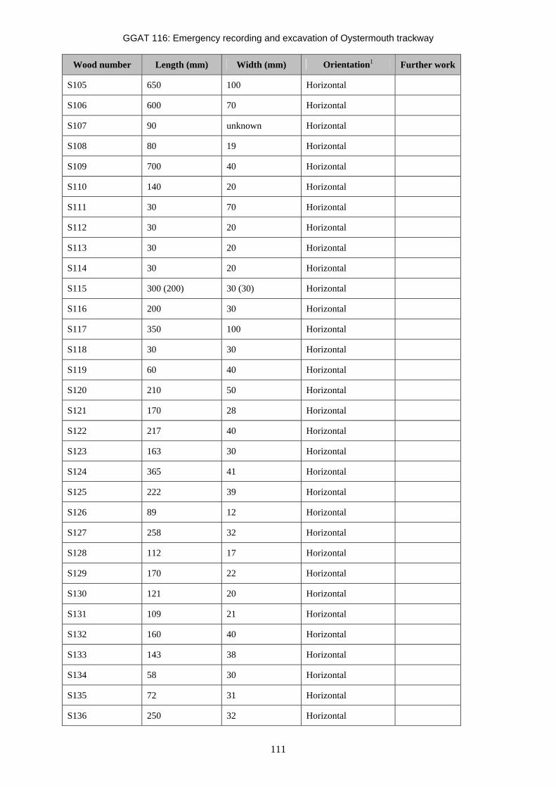
GGAT 116: Emergency recording and excavation of Oystermouth trackway
111
Wood number Length (mm) Width (mm) Orientation1 Further work
S105 650 100 Horizontal
S106 600 70 Horizontal
S107 90 unknown Horizontal
S108 80 19 Horizontal
S109 700 40 Horizontal
S110 140 20 Horizontal
S111 30 70 Horizontal
S112 30 20 Horizontal
S113 30 20 Horizontal
S114 30 20 Horizontal
S115 300 (200) 30 (30) Horizontal
S116 200 30 Horizontal
S117 350 100 Horizontal
S118 30 30 Horizontal
S119 60 40 Horizontal
S120 210 50 Horizontal
S121 170 28 Horizontal
S122 217 40 Horizontal
S123 163 30 Horizontal
S124 365 41 Horizontal
S125 222 39 Horizontal
S126 89 12 Horizontal
S127 258 32 Horizontal
S128 112 17 Horizontal
S129 170 22 Horizontal
S130 121 20 Horizontal
S131 109 21 Horizontal
S132 160 40 Horizontal
S133 143 38 Horizontal
S134 58 30 Horizontal
S135 72 31 Horizontal
S136 250 32 Horizontal

GGAT 116: Emergency recording and excavation of Oystermouth trackway
112
Wood number Length (mm) Width (mm) Orientation1 Further work
S137 79 25 Horizontal
S138 78 39 Horizontal
S139 176 28 Horizontal
S140 69 39 Horizontal
S141 191 19 Horizontal
S142 367 40 Horizontal
S143 154 13 Horizontal
S144 73 21 Horizontal
S145 91 30 Horizontal
S146 62 39 Horizontal
S147 109 28 Horizontal
S148 240 40 Horizontal
S149 161 32 Horizontal
S150 99 38 Horizontal
S151 95 37 Horizontal
S152 180 31 Horizontal
S153 100 45 Horizontal
S154 180 47 Horizontal
S155 243 50 Horizontal
S156 106 24 Horizontal
S157 211 29 Horizontal
S158 188 50 Horizontal
S159 172 11 Horizontal Notes:
1: Unless otherwise noted the orientation of all horizontal timbers is north-south.
2: Four categories of vertical timber were recorded – Possible stake: a vertical timber identified within the trackway (timber not excavated); Upright: a vertical timber identified outside of the trackway (timber not excavated); Trackway support: A vertical timber forming a structural part of the trackway which did not appear to be worked to a point (timber excavated); Stake: A vertical timber forming a structural part of the trackway worked to a point (timber excavated).
XXX: Vertical timber not excavated; depth unknown.
** (**): Y-Shaped timber **: length of left-hand element, (**): length of right-hand element.
Timber numbers N099, S59 and S102 where not issued on site.
GGAT 116: Emergency recording and excavation of Oystermouth trackway
113
Appendix III: Volunteer Satisfaction Survey and Generic Learning Outcomes By Natasha Scullion
1. Target Audience The community excavation of Oystermouth Trackway was funded by Cadw and managed and supervised by GGAT staff. Volunteers were recruited from those already involved in the Arfordir project. They gained experience in excavation and standard archaeological practice. The excavation project was made accessible to all existing project volunteers regardless of culture, background or ability and successfully attracted a broad cross-section of people. Visitors were welcome to view the excavation during the six-day dig. A total of 20 people took an active role in the excavation.
2. Aims • To give participants an understanding of basic excavation and recording techniques
• To provide training in survey techniques
• To enhance recognition of archaeological features
• To enhance recognition of archaeological finds
• To provide training in post-excavation work
• To give participants an understanding of the principles of dating techniques
• To provide the opportunity for members of the public to visit the excavation
• To provide volunteers and visitors with increased knowledge of the work of archaeologists
• To promote a sense of ownership to the volunteers
• Provide information during and after the event through reports, exhibitions, dig diary and website
3. Process The project aim was to record sections of a wooden feature that had been exposed by the tides on Swansea Bay. Previous work on the site had revealed that the wood dated from between 1040 to 910BC placing it in the late Bronze Age. Since this initial, very brief recording work, the site became covered with sand again, only recently being re-exposed. The project’s aim was to record this area of the feature whilst also offering the opportunity to teach archaeological skills and techniques to Arfordir project volunteers who were interested in learning more about archaeological practice.
The project took place over the course of six consecutive days Wednesday 22nd to Monday 27th February 2012. Work began with locating the site, and two different exposures of the feature were located, so the group was split into two working parties to cover them. The sites were cleaned back to establish an edge and define more of the timbers. Once this process was completed the volunteers were shown how to record by drawing the site using planning frames and numbering individual pieces of wood to give a comprehensive wood index for the site. Volunteers were also given the opportunity to lift some of the pieces for C14 dating and further detailed wood recording. The project taught the basic skills needed for excavation and recording work used by archaeologists in the field.

GGAT 116: Emergency recording and excavation of Oystermouth trackway
114
4. Number of Participants A total of 20 people volunteered on site. Their participation was spread over the course of the six-day project, which was designed and timed specifically to enable as many people as possible to participate. As such, it was run over the weekend as well as weekdays. Some volunteers attended for the duration of the dig whilst others were only able to attend on the weekend or odd days during the week.
5. Results Learning outcomes are defined as the result or consequence of some learning activity. The Inspiring Learning for All framework of Generic Learning Outcomes comprises five categories of results:
• Knowledge and Understanding
• Skills
• Attitudes and Values
• Enjoyment, Inspiration and Creativity
• Action, Behaviour and Progression
Each category relates to a different impact on the participant. For example, has the individual gained new understanding on a topic, have they learnt how to do something new, do they feel differently about something, have they had fun and will they do something differently in the future?
Results were obtained by asking the volunteers who were taking part in the excavation. The questionnaire was designed to act as both a simple ‘tick-box’ survey to answer five select questions in regards to GLOs followed with an ‘any other comments’ section below in order to gain a deeper insight to the volunteer experience. Examples of these statements follow below;
“The most exciting project I've been involved in over the last two or three years by far! It was a privilege to study people's handiwork from 3 millennia ago”
“Look forward to being involved in the future.”
“A very enjoyable couple of days a valuable insight into archaeological work, would like to get involved again. Many thanks
“Hope to be helpful again.”
“Really enjoyed it even when I was wet and cold – Ellie very patient-informative and caring.”
“We had fabulous training and were extremely well supported by the professional staff. Thanks!!!”
“Many thanks, a cracking dig.”
“Amazing experience – thoroughly enjoyed it and learned so much from the archaeologists who were so enthusiastic and had so much time for us. Could we have more sponges and buckets without holes next time please?”
“Fab. Many thanks Ellie and Tasha. More digs please.”
“Thank you Ellie for enabling us to join you. Thank you Natasha for all your help and advice on what to do – really learnt a lot from you, always wanted to use a trowel. Thank you both.”
“A happy crew – well done Ellie! Photos and panorama of site to follow!”

GGAT 116: Emergency recording and excavation of Oystermouth trackway
115
These statements can be considered qualitative data and have been categorised using the MLA tutorial for interpreting Generic Learning Outcomes.
Knowledge and understanding
Skills Attitudes and values Enjoyment, inspiration and creativity Action, behaviour, progression The diagram below presents the results of the ‘Any other comments’ as a pie chart, to show which GLO came up most frequently in participants’ comments:
GLOs at Q.11
1
3
12
3Knowledge and understanding
Skills
Attitudes and values
Enjoyment, inspiration andcreativity
Activity, behaviour, progression
Figure 6. Pie chart showing which GLOs came up most frequently in participants’ comments.
Strongly agree
Agree Neither agree nor disagree
Disagree Strongly disagree
1 I enjoyed my time working on the Oystermouth Trackway.
12 1 0 0 0
2 I have learnt more about the prehistory of Swansea Bay.
13 0 0 0 0
3 I have learnt something about how archaeological work is carried out.
11 2 0 0 0
4 Swansea Bay means more to me now.
7 5 1 0 0
5 I would be interested in volunteering on a similar project in the future
12 1 0 0 0
Figure 7. Cumulative results from the Oystermouth Trackway volunteers (16 questionnaires given out, 13 returned)

GGAT 116: Emergency recording and excavation of Oystermouth trackway
116
6. Conclusion All the ‘tick-box’ questions were answered by every respondent, which leads to the assumption that this is the preferred format for people to give feedback as it is both quick for them and informative for us. All five questions are geared to answering the 5 Cadw GLO standards.
11 out of 13 respondents answered the “any other comments”, indicating that this has been successful, and that people were happy enough to take the time to elaborate on their basic feedback. All the feedback has been positive, with many citing how much they enjoyed the dig and would enjoy the opportunity to participate in more community fieldwork, especially excavation projects.
Question 4 had the least positive response rate, however this could be due to the fact that many of the volunteers have so far spent a great deal of time on Swansea Bay as part of the Arfordir project, and it is therefore already important to them, so they may be less affected by this time spent on the foreshore.
Overall based on the feedback received, the dig was very much enjoyed by the volunteers, who felt that they had both contributed to the project and learned some valuable skills which they are now keen to put to good use in future projects.