arctic commercial shipping and the strategic significance ... · arctic commercial shipping and the...
TRANSCRIPT

Arctic Commercial Shipping and the Strategic
Significance of the Northern Sea Route
By Rupert Herbert-Burns, Consultant, Stimson Environmental Security Program
A container ship
transits Russia’s
Kola Bay in July
2009. Photo
courtesy flickr
user euno.
In early August
2013, the
general cargo
vessel M/V Yong
Sheng — a ship
operated by the
China Ocean
Shipping Group
Company and
weighing in at 19,150 deadweight tonnes — sailed from Dalian in northeastern China,
bound for Rotterdam in the Netherlands. Ordinarily this would be another unremarkable
voyage amongst thousands made by Chinese-flagged merchant vessels every year. On
this occasion, however, the Yong Sheng sailed via the Northern Sea Route (NSR) rather
than via the Indian Ocean and the Suez Canal, making it the first-ever Chinese vessel to
do so.1 Normally, the passage via Suez would take a vessel of this type some 48 days,
but her route across the top of the world reduced the transit time to 35 days. This
reduction of 13 days will translate into significant savings in fuel costs, canal fees and the
costs associated with embarkation of an armed security team to deter and defend against
the possibility of a pirate attack while transiting the high risk area in the Indian Ocean.
Due to the significant numbers of vessels that have transited the NSR in recent years, this
particular crossing would seem at first glance to be a relatively unremarkable event.
However, the voyage was very deliberately planned and timed, as it occurred just three
months after China secured ‘permanent observer’ status at the Arctic Council. This is the
international body that facilitates high-level intergovernmental exchanges between
member states to promote cooperation and coordination on matters pertaining to the

protection of the Arctic environment and sustainable economic development of this
unique and sensitive geo-space. In effect, by applying for, and being granted, permanent
observer status of the Arctic Council and then dispatching a vessel to transit the NSR at
the earliest opportunity (due to sufficient pack-ice retreat), China has made an
unmistakable statement – she has recognized the current and future geopolitical and
economic importance of the Arctic and regards the region and the NSR as strategically
important to its national interest.
1. Introduction
Following the establishment of the geographical and historical context of the NSR, the
aim of this paper is to provide an observational and analytical discussion of the vital
commercial, economic, geopolitical, strategic, security and environmental features that
are shaping what could become a key trading route between the eastern, western and
northern hemispheres. The NSR is a maritime passage that could also enable the faster
expansion of the exploration and production of oil and gas in the Arctic; significantly
shorten the east-west maritime trading belt between higher latitude European and Asian
ports; and dramatically alter the strategic value to, and utilization of, the Arctic Ocean by
the world’s established and emerging great powers.
Nevertheless, there remain important challenges and obstacles to the evolution of the
NSR into a major, high-volume intercontinental maritime trading route. Under current
climatic conditions, the NSR is only open to mainstream commercial shipping for a few
months during the Arctic summer, which limits transit windows and transit tonnage
capacity. Even then, icebreaker escort (of which there are limited numbers) is still
required. There is scant search and rescue coverage in these high latitudes in the event
ships get into trouble and declare an emergency. Special and expensive insurance
coverage is required due to the navigational hazards involved and, notwithstanding
existing security concerns in the form of piracy and armed robbery at sea in the Indian
Ocean and the embryonic threat of attacks against vessels transiting the Suez Canal by
Sinai-based extremists, the NSR traverses what is still Russia’s geopolitical and military
sphere of influence, which ensures that Moscow fundamentally controls this space and
can apply de facto (if not endemic de jure) military control over maritime trading
commerce should it become geo-strategically expedient to do so.
Northern Sea Route: A maritime trading
route across what is not a single clearly
defined passage, but a number of alternative
passages between Novaya Zemlya (which
sits astride the Barents & Kara Seas) and the
Bering Strait, which divides Alaska and the
eastern-most tip of the Russian mainland.
The route is some 2,500 nautical miles long
and has been transited by modern merchant
vessels in a little as 7.5 days.

A ship transits
through Arctic
sea ice. Photo
courtesy flickr
user ashatsea.
The NSR,
which used to
be known as
the Northeast
Passage prior
to the 20th
century (this
reference is
still used in
some of the
literature), is
the Arctic
Ocean maritime trading link between the North Atlantic Ocean and the northwestern
Pacific Ocean. It extends fundamentally from the Kara Gate between the Russian
mainland and the island of Novaya Zemlya and the northern entrance to the Bering Strait
separating Siberia from Alaska. As a result of steadily retreating summer ice margins in
the Kara Sea, the Laptev Sea and East Siberian Sea, increasing fuel costs for merchant
vessels, and the extant threat of piracy in the northern Indian Ocean, the NSR has in very
recent times become of clear commercial interest to global maritime trade. Additionally,
the steadily increasing, if controversial, oil and gas exploration projects underway in the
Arctic region are necessitating the expansion of support vessel and specialized offshore
vessel deployments to the region; some of which must use the NSR to get into operating
position.
2. Historical background of the NSR
Prior to the first successful single-voyage transit of the NSR, there were several
expeditions to the Arctic waters by European explorers in the 16th and 17th centuries –
notably those led by Willoughby and Burrough (which reached the eastern Barents Sea),
Brunel, Pet, Jackman (who sailed as far as the Kara Sea), and perhaps most famously, the
expeditions led by Willem Barents, who voyaged as far as Novaya Zemlya. Following
the European polar explorers, various Russian Cossack mariners had explored the entire
length of the north Eurasian coast by the middle of the 17th century, establishing
settlements along the way at the mouths to the great Siberian rivers – Olenek, Yana,
Indigirka and the Kolyma. As a result, technically speaking the credit for the earliest
successful and deliberate exploration of the NSR and the Eurasian Arctic littoral is
Russia’s. During the 18th century, several expeditions, including the Great Northern
Expedition and an attempt by Captain James Cook’s HMS Resolution in 1778, attempted
to traverse the NSR; however, all attempts were thwarted at various points due to heavy
pack ice.

It was not until the 19th century that the first successful single-transit would be made. In
1878, the Swedish explorer and scientist, Baron A.E. Nordenskjöld, departed eastwards
from the Kara Sea on the Vega. She made it as far as Kolyuchinskaya Bay, but was
eventually forced to remain there over the winter due to the impenetrable ice. The Vega
resumed her passage the following summer and passed through the Bearing Strait on 20
July 1879.
During the 20th century, the NSR was of pivotal strategic importance to the Soviet Union
during the aftermath of the Bolshevik Revolution, the Second World War and the Cold
War. After 1917, the USSR had effectively isolated herself from the Western powers and
their extensive sphere of control in the Atlantic, Indian and large parts of the Pacific
Oceans. This, added to the fact that the NSR is significantly shorter as a maritime
connector between the western and eastern parts of the Soviet Union, meant that the link
became critical for Soviet commercial shipping and naval maneuver between the
country’s Atlantic and Pacific bases. In 1932, as head of the Chief Directorate of the
Northern Sea Route, Otto Schmidt, led the first non-stop transit of the NSR, and in 1935,
following the official ‘opening’ of the route in the previous year, the NSR entered into
the era of its being utilized continuously for commercial and military utilization by the
USSR. Total transit tonnage fluctuated over the next 52 years, peaking in 1987 at with
the aggregate conveyance of 6.6 million tonnes.
Throughout the Soviet era, this maritime space remained, not surprisingly, inaccessible to
any foreign countries, with the exception of some permitted transits of German vessels
and warships during the very early part of WWII. The volume of shipping and tonnage
moved through the NSR declined sharply after the fall of the USSR. In 1991, the route
was officially opened to foreign-flagged and owned merchant vessels in an attempt to
boost trade. Despite the very recent resurgence in commercial interest and utilization of
the NSR by European and Asian shipping companies, however, aggregate annual usage is
still well below its 1987 peak. Commercial utilization of the NSR remained stagnant for
the last decade of the 20th century as Russia’s politico-economic fortunes faltered
following the break-up of the USSR, and east-west liquid bulk, break-bulk and liner
service shipping flows stuck to traditional routing via the Indian Ocean and western
Pacific.
3. NSR’s contemporary commercial status & significance
In contemplating the current literature and media reporting, it is clear that there is a great
deal of interest and fascination concerning the recent and on-going utilization of the NSR,
and there is acute excitement about the route’s future potential as an international
maritime trading route of global significance. Indeed, utilization of the passage has
increased significantly in the last three years in particular. In 2013, the Russian Federal
State Institution — the Northern Sea Route Administration (NSRA) — granted 372
permits for intention to transit. This contrasts starkly with the 46 granted in 2012 and the
mere four granted in 2011. By the beginning of the final quarter of 2013, some 630
vessels were listed as applicants in the NSRA’s ‘Consideration of Applications’ list.2

By the end of 2013, approximately 1.5 million tonnes of cargo of all types will have been
conveyed through the NSR. In comparison to the insignificant international utilization of
the NSR during the two decades between 1990 and the end of 2010, the advancing
figures over the last three years are encouraging indeed. However, the aggregate trade
volume figures listed above are tiny in comparison to the over 17,225 transits by
merchant vessels of the Suez Canal in 2012, which amounted to some 928 million tonnes
of cargo.3
This statistical contrast yields an unambiguous dialectic: though the practical utilization
of the NSR is evident and its attractiveness to shipping companies is growing,
particularly those with ports of loading and discharge in higher latitudes, the route’s
relevance compared to the traditional sea lines of communication (SLOC) remains
embryonic. This is evidenced in another way when a comparison is drawn of the numbers
of different flag states used by vessels that have applied in 2013 to transit the NSR. There
is an overwhelming preponderance of Russian-flagged vessels intending to operate in the
NSR (not all of which will be undertaking an end-to-end transit), and Russian vessels
operating in the NSR outnumber the combined total of non-Russian registered ships by
over 5.6 times.

4. NSR’s relevance to Arctic oil and gas exploration, development and production
In 2008, the U.S. Geological Survey estimated that the Arctic region could contain up to
13% and 30% of the Earth’s undiscovered oil and natural gas reserves, respectively. The
same report suggested that as many as 160 billion barrels of oil could exist in the region.4
Of these estimates, in terms of barrels of oil equivalent, Russia holds the great majority
— some 52% of the assessed total. However, while Russia holds by far the dominant
quantity of gas, the United States has the greater proportion of oil reserves.
Vital Russian hydrocarbon basins and systems are located (from east to west) in areas
including the East Barents, South Kara, Laptev, East Siberian and Chukchi basins, with
the first three being the most important. With regards to the offshore areas of these
basins, it can quickly be seen that the NSR is pivotal to the potential expansion of all
three phases of oil and gas exploration, development and production in these waters.
Exploration
The exploration phase is characterized by seismic surveys and exploratory ‘wild cat’
drilling. The first of these necessitates the ability for specialized 2-D and 3-D seismic
survey vessels and their support ships being able to access exploration blocs via relatively
ice-free navigation tracks. Support vessels need to ensure continuous supply links
between these vessels (that can spend up to several months continuously on station) and
ports on the mainland. Without sufficient seismic coverage, it is not possible to properly
ascertain the optimum locations to site exploration wells and proceed with the campaign.
Exploratory, wild cat wells require all of the components of specialized drilling rigs to be
towed into position and constructed over the well site, which will necessitate ice breaker
assistance and shore-side support at key ports along the Russian NSR coastal margin.
Once constructed and operational, drilling rigs (initially in the Kara Sea) require
continuous support from Platform Support Vessels (PSVs). Similar marine logistical

support is required for the ensuing appraisal drilling campaign, which determines if the
reservoir is commercially feasible.
Development and production
These phases require considerably more in the way of extraction and production
infrastructure and equipment, specialized offshore vessel involvement and support, and
eventually the means of conveyance (pipelines and/or tankers) and export terminals. In
these phases there could be a requirement to install offshore production platforms, access
for sub-sea construction and pipe-laying vessels, and continuous PSV support. In prolific
blocks that are distant from shore bases, the scale of support will be of enormous
proportions and will necessitate the uninterrupted deployment and of large fleets of PSVs
and shuttle tankers.
The following list indicates the sizable and expanding nature of key exploration and
production operations in areas accessed by the NSR:
Yamal LNG (Novatek + Total + one): This project is intended for the supply of
liquid natural gas (LNG) to China and Japan via the NSR. If this goes ahead, it
will significantly boost Russia’s drive to open up the NSR to increased LNG
carrier traffic.5
Kara Sea oil exploration: Exploratory seismic survey and drilling campaign in
the Prinovozemelsky blocks, led by Rosneft in partnership with Statoil,
ExxonMobil and ENI.6
Petchora Sea exploratory drilling (area is located to the west of the Kara
Gate): First commercial offshore development in the Arctic centered on the
Prirazlomnaya platform (which recently involved the high-profile Greenpeace
demonstration using the M/V Arctic Sunrise). The field license is held by
Gazprom Neft Shelf.
Yuzhnoe-Khykchuyu oil field: Production of 7.5 million tons of very high
quality crude oil per year. The field is operated by Lukoil and is linked by 158 km
export line to the Varandey Oil Export Terminal on the Siberian coast.
The continued viability and expansion of these projects will be predicated on the
increasing utilization, efficiency, safety and security of the NSR. For this reason, it comes
as no surprise that the Russian government is greatly increasing the logistical capacity
and security resources being deployed to the country’s northernmost littoral. This was
most recently characterized by a substantial and highly publicized military expansion and
deployment to reactivated bases in the NSR corridor.

The NSR, Northwest Passage and hydrocarbon basins in the Arctic
5. Wider geopolitical and security issues regarding the NSR
On 16 September 2013, Russia’s president, Vladimir Putin, announced that the
government was re-opening a military base on the west coast of Kotelny Island in the
Novosibirsk Island group, with the purpose of reinstating a permanent naval and air force
capability in the country’s Arctic maritime. This conspicuous policy development was
presented as a vital part of ensuring the security, safety, and commercial effectiveness of
the NSR as part of the country’s drive to fast-track the commercial exploitation of the
region between the Kara Gate and the Bering Strait.
During the preceding week, a task group of ten Russian warships (led by the guided
missile cruiser, Peter the Great) and the nuclear icebreakers — Yamal, Vaigach, Taimyr
and 50 Let Pobedy — arrived at Novosibirsk having sailed 2,000 nautical miles from
Severomorsk. Within 17 days, all of the equipment and forces had been brought ashore
using helicopters and support vessels. Currently, the former airbase – Temp – is being
brought back into operation, and flight operations for An-72, An-74, and Il-76 aircraft
commenced by the end of October. The Russian General Staff has stated that the new
base will ensure the security of petroleum resources and extraction projects in the
Russian Arctic littoral and boost the state’s ability to maintain security over the NSR.
However, there is currently no offshore production in the Laptev Sea or the East Siberian
Sea, and the number of vessels sailing via the NSR remains modest.7
In reality, the fundamental purpose of this very public policy decision by the Putin
government was two-fold: 1) to establish the means by which Russia could project
military power within, and from, its northernmost geo-space; and 2), by extension, to
send a clear message to other powers that want to use the NSR for their unhindered trade
and potentially for naval expedition and deployment. Russia wanted all public and private
actors engaged in the Arctic to know that the NSR falls firmly within Russia’s
geopolitical sphere of control and will remain so regardless of the region’s advancing
internationalization.
Though the United States and some of its northern NATO allies have long maintained the
capacity to deploy substantive military power into high latitudes, emerging great powers,
principally China, which attained permanent observer status at the Arctic Council in
2013, have now developed the capability to maintain expeditionary power projection far
from their mainland bases. Given China’s well-known concern over the vulnerability to
closure of its southern SLOCs connecting the Indian Ocean with the South China Sea, it
will view the NSR as a potential alternative trading route to its markets in Europe and the
US east coast. Furthermore, if the Arctic region becomes an important source of LNG,
crude oil and condensate for China’s expanding industrial base and domestic consumers,
the Chinese will want to ensure the security of this supply stream. In the eyes of the
Chinese government, this — like other maritime trading routes — will be best secured
via collective international security means and regimes. However, the leadership will also
want to ensure the ability to act militarily to protect strategic petroleum streams and
trading links if it were to become necessary.
6. Can usage be expanded and how?
As with virtually all complex economic-environmental geo-spaces, there are numerous
economic benefits and logical strategic reasons for developing them and promoting their
wider utilization. However, these arguments are always balanced with concerns over
potential environmental damage and habitat disruption, technical and operational
obstacles, safety concerns, and geopolitical and security challenges. Not only is the NSR
no exception to this, it arguably exemplifies this dynamic.
The NSR, and its expanded development as a trading route and as a means of access to
high-latitude offshore exploration and production, has clear utility for international trade
and increased access to hydrocarbon energy sources. These positives are manifested in
forms such as reduced transit times between the North Atlantic and north-western Pacific
ports and markets, potentially reduced transport costs, avoidance of insecure waters in the
Indian Ocean and South China Sea, and the development of valuable stranded oil and gas
deposits. Notwithstanding the environmental concerns surrounding greater exploitation of
the NSR, the expanded use of the NSR can only be realized if key technical, operational
and regulatory deficits are addressed.
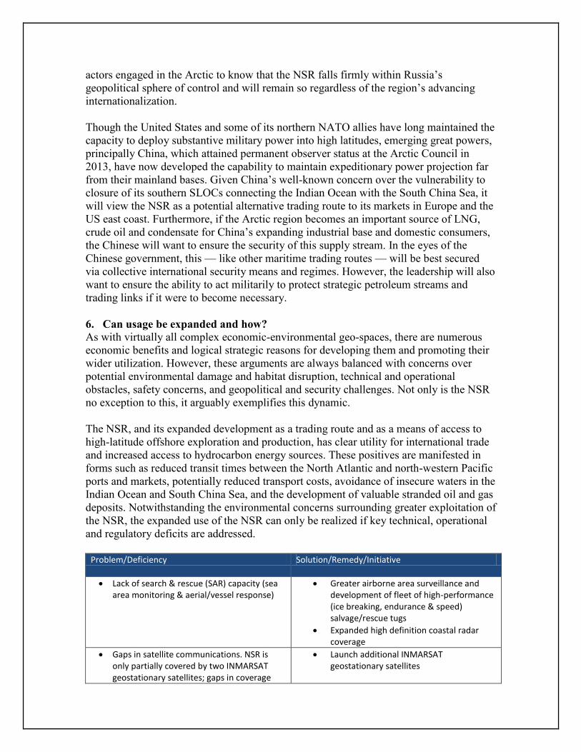
Problem/Deficiency Solution/Remedy/Initiative
Lack of search & rescue (SAR) capacity (sea area monitoring & aerial/vessel response)
Greater airborne area surveillance and development of fleet of high-performance (ice breaking, endurance & speed) salvage/rescue tugs
Expanded high definition coastal radar coverage
Gaps in satellite communications. NSR is only partially covered by two INMARSAT geostationary satellites; gaps in coverage
Launch additional INMARSAT geostationary satellites

occur in the Laptev Sea & north of Severnaya Zemlya. [INMARSAT is used to transmit digital ice data & forecasts to vessels]
2 satellite communication systems can support NSR operations: INMARSAT & Russia’s OCEAN system
Few INMARSAT receivers compatible with OCEAN system & critical communication gaps remain along NSR with these systems
Develop compatibility hardware/software upgrades to enable grater interoperability of INMARSAT & OCEAN systems
Insufficient numbers of icebreakers to accompany increasing number of transiting vessels
Expansion of internationally-flagged, operated and owned/funded modern icebreakers (these vessels could also double as SAR vessels)
Comparative lack of reliable charts Incentivise new polar hydrographic survey campaigns – oceanographic knowledge acquisition & UN funding
Insufficient aids to navigation Internationally funded expansion of installed aids to navigation - charting, radar, buoyage, Arctic region notice to mariners service
Lack of officers qualified to operate vessels in ice-covered waters
Modifications to/expansion of STCW and deck officer training to cover icebreaking and polar navigation/seamanship
Insufficient sea ice oil spill response technology and resources
Extensive scientifically-driven and oil company funded R & D to develop any and all necessary safeguards and response requirements for oil spills in ice covered waters
Lack of sufficient satellite-based synthetic aperture radar (SAR) [used in detection and monitoring of sea ice and pack ice]
Currently coverage by high definition SAR is not sufficient and there are particular gaps in the Laptev Sea
In order to provide endemic coverage, European Space Agency (ESA) is proposing to build new SAR receiving station in the Russian Arctic to cover gap
Launch of additional SAR satellites to monitor ice coverage patterns to enable short, medium and long-term forecasting
Lack of suitably equipped merchant vessels configured for operating in extreme polar conditions (deck machinery, sea water induction, hull strength, propulsion & manoeuvre)
This will only be addressed and driven by economic and trading imperatives. When and if the NSR is viewed as a mainstream viable trading route, then owners will order suitably configured vessels
Lack of holistic, internationally sanctioned regulations and best practices for polar shipping
IMO is currently developing a draft international code of safety for ships operating in polar waters, - The Polar Code
Code will cover design, construction, equipment, operational, training, SAR & environmental protection matters relevant to ships operating in high latitudes

7. Conclusion and outlook
This paper has attempted to provide a holistic snap-shot of the NSR through a series of
carefully chosen and informative lenses, including a review of key historical events
illustrating the exploration and eventual first complete transit of the NSR; an overview of
the NSR’s utilization by the USSR during the 20th century; a discussion of the
contemporary commercial status of the route; the NSR’s relevance to Arctic oil and gas
exploration, development and production; geopolitical and security issues effecting the
region; and an examination of the outstanding technical and operational challenges that
will determine if and how the NSR’s utilization can be expanded.
It is true to say that further net polar ice margin retreat in the decades to come (if indeed
this occurs) will have the obvious effect of making greater use of the NSR a practical
reality as it will greatly reduce the need for an expanded ice breaker fleet and specialized
merchant vessels and crew training. However, if the environment remains largely as it is
for the next 10 to 20 years, increased international use of the NSR will be contingent
upon the implementation of some of the improvements listed in the previous section, an
increasing awareness of its economic benefits to some shipping lines with northern
hemisphere hubs, routes and markets, and the expansion of offshore oil and gas
exploration and production.
With regards to the short and medium-term fortunes of the NSR, the jury is still out.
Valentin Davydants, the captain of Russia’s Atomflot fleet of nuclear-powered
icebreakers, argues that by 2021 some 15 million tonnes of cargo will be lifted via the
NSR, in addition to 15 million tonnes of LNG and over 10 million tonnes of crude oil.
According to this optimistic view, NSR utilization will continue to grow. However,
others are less convinced of the route’s comparative importance over the established east-
west liner belt via the Indian Ocean. AP Moller-Maersk CEO, Nils Anderson, remarks
that “The way global warming is going, of course there is the opportunity in a very far,
very distant future that the northern sea route will open up and it will be a major shipping
route. But it will definitely not be within the next 15 to 20 years in our opinion so it’s far
too early to start constructing vessels for it.”8 Environmentalists will very likely have
some impact upon the future commercial trajectory of the NSR, but in the end, the
expansion of the route as a maritime highway and offshore exploration region of global
significance will be driven fundamentally by economic variables, commercial drivers,
technology and funding.
Rupert Herbert-Burns is a Consultant with the Stimson Environmental Security Program.
1 “Chinese cargo ship sets sail for Arctic short-cut,” Financial Times, 11 August 2013,
http://www.ft.com/cms/s/2/05daa11e-0274-11e3-880d-00144feab7de.html#axzz2cnZvxsaT 2 Federal State Institution: The Northern Sea Route Administration.
3 IDSA Comment, “Northern Sea Route: Humming with Activity,” August 2013 at
http://www.idsa.in/node/13451/33576 4 “Arctic oil exploration: Potential riches and problems,” BBC News,
http://www.bbc.co.uk/news/business-14728856

5 “Yamal to Drive Northern Sea Route Development,” Interfax, http://interfaxenergy.com/natural-
gas-news-analysis/russia-and-the-caspian/yamal-to-drive-northern-sea-route-development/ 6 “Russia’s Arctic Seas,” Rosneft, http://www.rosneft.com/Upstream/Exploration/arctic_seas/
7 “In remotest Russian Arctic, a new Navy base,” Barents Observer,
http://barentsobserver.com/en/security/2013/09/remotest-russian-arctic-new-navy-base-17-09 8 “Arctic shipping routes still a long-term prospect,” Financial Times, 6 October 2012
http://www.ft.com/cms/s/0/f44bd53a-2e74-11e3-be22-00144feab7de.html#axzz2h7njR936