archaeological survey of springs - internet archive
TRANSCRIPT

BLM LIBRARY
88000452
BUREAU OF LAND MANAGEMENTNEVADA
CONTRIBUTIONS TO THE STUDY OF CULTURAL RESOURCES
ARCHAEOLOGICAL SURVEY OF SPRINGS
TONOPAH RESOURCE AREA
TECHNICAL REPORT-NUMBER 2
RENO, NEVADA FEBRUARY 1978

%tfOU&0\F
£V7
/V13t
-'
ARCHAEOLOGICAL SURVEY OF SPRINGS
IN THE
TONOPAH RESOURCE AREA
Roberta L. McGonagle
Lynda L. Waski
United States
Department of the Interior
Bureau of Land Management
Battle Mountain District
BUREAU OF LAND MANAGEMENT LIBRARYDenver, Colorado
88666452
PROPERTY OFBureau of Land Management
DSC LIBRARY

ABSTRACT
A cultural resource survey of springs was made for
input into an environmental impact statement on livestock
grazing. Although based on a non-random sample of less than
1/10 of 1% of the total acreage involved, enough data was
gathered to propose temporal phases and for some settlement
patterns to begin to emerge for periods prior to ca. 3,000
B.C. Also, the impact of livestock on spring-related cul-
tural resources was documented.

ACKNOWLEDGEMENTS
The authors would like to thank Gene Nodine, Battle
Mountain District Manager and Sheridan Hansen, Chief of
Resources for their support; Hugh G. Ball, a crew member;
Robert York and Nancy Botti, Nevada State Office Archae-
ologists; the Nevada State Museum, Carson City; and all
others who made this project possible.

TABLE OF CONTENTS
LIST OF FIGURES
CHAPTER I. Introduction 1
CHAPTER II. Setting 3
Geographic 3
Ethnohistory 3
European Exploration and Settlement ... 6
CHAPTER III. Summary of the Prehistory of CentralNevada 7
CHAPTER IV. Findings 10
Artifact Types 10
Temporal Phases 24
Summary and Conclusions 41
REFERENCES CITED 42
APPENDIX A 44
APPENDIX B .51

LIST OF FIGURES
1. Location of the Tonopah Resource Area. ..... 2
2. Cultural resource inventory status excluding theEIS Survey 8
3 Sites recorded by the EIS Survey 11
4. Chronology Chart 12
5. Projectile Points. Silver Lake, Lake Parman,Lake Moj ave , Black Rock Concave Base, HumboldtConcave Base, Humboldt Basal Notch 14
6. Projectile Points. Humboldt Side Notched,Humboldt Single Shoulder, Unnamed Type, Pinto,Northern Side Notched, Gypsum. . . 15
7. Projectile Points. Elko, Eastgate 17
8. Projectile Points and Bifaces. Rose SpringDesert Side Notched, Cottonwood, Biface Type 1,Biface Type 2
,
'
. 18
9. Bifaces. Biface Type 3, Biface Type 4, BifaceType 5 20
10. Bifaces and Miscellaneous Chipped Stone.Biface Type 6, Biface Type 7, Drills, LevelloisFlakes
g 21
11. Pottery 23
12. Black Spring Phase . 25
13. Nyala Phase„ . . 26
14. General view of the dune area in which sitesCrNV-06-221 through CrNV-06-224 are located. . . 28
15. General view of Andrew Spring 28
16. Morey Phase 29
17. Grant Phase 30
18. General view of Rattlesnake Spring 31
19. Liberty Phase 33

20. Occurrence of milling stones by phase 34
21. Blue Eagle Phase '.. . 35
22. Clifford Phase 36
23. Clifford Rock Shelters 37
24. Rock feature in CrNV-06-184 37
25. Point of Rock Spring 38
26. CrNV-06-194 39
27. CrNV-06-196 39
28. Tybo Charcoal Kilns 40

CHAPTER I.
Introduction
In May through September, 1976, the Bureau of LandManagement (BLM) , Battle Mountain District, conducted anarchaeological survey in the Tonopah Resource Area, 3,750,632acres of BLM administered land in northern Nye County, Nevada(Figure 1) . The purpose of this survey was to provide datafor input into an environmental impact statement (EIS) onthe Bureau's grazing program. The problem was to obtaindata pertinent to the impacts of livestock grazing with asmall field crew (3 people) and limited time (3% months).
The orignial plan was to survey proposed range improve-ments such as spring developments, fences and seedings. Inorder to establish a research strategy to do this survey,probabilities of occurrence of archaeological sites wereworked out using BLM data on vegetative types, degree ofslope and the presence of springs and other permanent sur-face waters. The following probability categories weredefined
:
1. Very High--presence of surface water, any vegeta-tive type or slope gradient.
2. High--near surface water, vegetative types ofpinyon/juniper, sage spp. or grass and slope lessthat 30%.
3. Medium- -not near surface water, vegetative typesof pinyon/juniper, sage spp. or grass and slopeless than 30%.
4. Low-other vegetative types not near surface wateror slope over 30%.
Those developments in very high probability areas wereto have been intensively surveyed; those in other probabilityareas were to have been extensively surveyed using a strati-fied random sampling design. The exact percentage of eachdevelopment (fence, seeding, etc.) surveyed in high, mediumand low probability areas would have been based on the totalnumber of acres involved for these developments ; thesepercentages had to be feasible given time and manpower.
Range improvement proposals are part of allotmentmanagement plans (AMPs) designed for each grazing allotment.When it became clear in April that the AMPs would not bewritten in time to begin a project-specific archaeologicalsurvey in May, an alternative research design was prepared.Given the restrictions of time and personnel, any randomsampling design that could yield usable and significant dataon such a large area was deemed unfeasible. Therefore, the
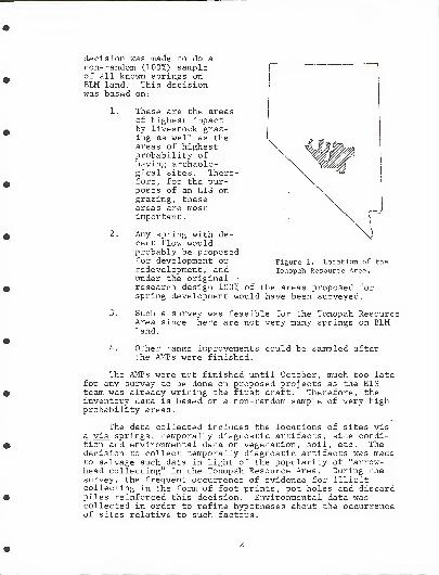
decision was made to do anon-random (100%) sampleof all known springs onBLM land. This decisionwas based on:
1. These are the areasof highest impactby livestock graz-ing as well as theareas of highestprobability ofhaving aretiolo-gical sites. There-fore, for the pur-poses of an EIS ongrazing, theseareas are mostimportant.
Any spring with de-cent flow wouldprobably be proposedfor development orredevelopment, andunder the original •
research design 100% of the areas proposed forspring development would have been surveyed.
Figure 1. Location of the
Tonopah Resource Area.
4.
Such a survey was feasible for the Tonopah ResourceArea since there are not very many springs on BLMland.
Other range improvements could be sampled afterthe AMPs were finished.
The AMPs were not finished until October, much too latefor any survey to be done on proposed projects as the EISteam was already writing the first draft. Therefore, theinventory data is based on a non-random sample of very highprobability areas
.
The data collected includes the locations of sites visa vis springs, temporally diagnostic artifacts, site condi-tion and environmental data on vegetation, soil, etc. Thedecision to collect temporally diagnostic artifacts was madeto salvage such data in light of the popularity of "arrow-head collecting" in the Tonopah Resource Area. During thesurvey, the frequent occurrence of evidence for illicitcollecting in the form of foot prints, pot holes and discardpiles reinforced this decision. Environmental data wascollected in order to refine hypotheses about the occurrenceof sites relative to such factors.

CHAPTER II.
Setting
Geographic
The Tonopah Resource Area lies within south centralNevada and exhibits typical Great Basin landscape. North-south trending mountain ranges alternate with deep alluvialvalleys. The mountain streams have a high infiltration rateas they emerge onto the coarse sands and gravels of thealluvial fans. Waters which reach the valley plains terminatein salty playas or alkali flats.
Pinyon and juniper cover the mountain ranges above6,500 feet and a sage, shrub and grass mixture is commonbelow that elevation. Greasewood and saltbrush predominatein the lowest points of the valleys.
Precipitation is scant, varying according to elevation;the majority of moisture is derived from summer thunder-storms and winter snow. The climate is temperate, theaverage summer temperature being in the mid- 90' s and in the30' s during the winter months.
Fauna native to the area include deer, antelope, bighorn sheep, cats, coyote, waterfowl, reptiles, rodents andbirds
.
Ethnographic Background
Those native Americans who lived in this region of theGreat Basin, were for the most part, Shoshone. In thevicinity of Tonopah there was a mixing of the Paiute andShoshone peoples. Evidence would indicate that they are thedescendents of those who roamed the area in prehistorictimes.
Economic Patterns
The original inhabitants were hunters and gathererswith a sparsely scattered population and a simple culture.The limited surplus-producing food resources was one of thevariables affecting the pattern of their social structure.The primary subsistence group consisted of a nuclear familyor minor extended family as a self-sufficient unit.

The men hunted the large game while the women foragedseeds, roots, and other plant foods. Both sexes wereinvolved in the harvesting of pinyon nuts. The womenprepared the foods, manufactured basketry, crude pottery andarticles of clothing. Men hunted, made the tools andimplements, built brush houses and shelters, and assistedthe women in gathering firewood, hunting small rodents andtransporting seeds. Several families and bands would co-operate in rabbit and antelope drives. Blinds, falls,corrals and net structures were built for these communalhunts. Deer were hunted by smaller groups or individually.Seeds and roots, however, were the most important foodsources
.
Trade was minimal; barter for tool making materials waspracticed, but few other items were exchanged. Tradingpresupposes a surplus and there was little excess in theirenvironment
.
Social Structure - Kinship
The nuclear family was the most stable unit. Relation-ships were reckoned bilaterally and marriage with any knownblood relative was forbidden. However, the preferredmarriage was with a step-child of mother's brother orfather's sister (pseudo cross-cousin marriage). Polygynywas practiced, usually sororal, and the levirate was alsopresent. There was a strong tradition of brother-in-lawjoking.
Spouses were obtained from other groups, often fromquite a distance. The parents of the couple agreed to theunion, presents were exchanged and the marriage contracted.Initial residence was with the girl's family and then theymoved to the vicinity of the boy's family. Sometimes,however, if the girl's parents did not agree to the union,forcible abduction was practiced. This accomplished thesame purpose and was commonly accepted.
Social Structure - Political
The nuclear family was the basic political unit duringthe major part of the year. When larger groups gathered,the people were under the direction of a leader who super-vised festivals, pinyon nut gathering trips, antelope andrabbit drives. The only true "specialist", an antelopeshaman, always directed these communal hunts. Until post-Caucasian times the leader's influence was limited to theseactivities. Later, however, the chief concept grew out ofthe necessity of interacting with white settlers and miners.This chieftainship extended the leader's influence over agreater portion of the Shoshone lifestyle. In general,there was not a very high degree of political organization.

Railroad Valley had a larger, more stable populationthan other areas and abundant resources allowed for theexistence of several permanent village sites persistinguntil historic times. The population density was highat approximately one person per nine square miles. (Steward1938 :49)
.
Religious - Ceremonial
Complicated ritual and mythology was lacking in mostareas. The infrequent band gatherings included a rounddance, which was thought to incident ly bring rain, fertilityand general harmony. The three major ceremonies concernedbirth, girl's puberty (boys had no puberty rites) anddeath. These were celebrated by the nuclear family.
When antelope drives were held, the leadership of anantelope shaman was sought. His special talents werethought to insure a successful and plentiful drive. Afestival was held in the fall after the pinyon nut harvestin connection with a rabbit drive.
Recreation
The majority of the time was usually concerned withobtaining sustinence, but during those brief periods whenlarge groups would gather annually, dances were held. Thiswas also an occasion to gamble, visit and acquire spouses.These festivals were generally held in the late summer orfall.
Cultural Items
The Shoshone built conical shelters of brush and willowcalled wickiups. These were small and impermanent. Whenavailable, they lived in dry caves and shelters.
A variety of fine basketry was manufactured by thewomen. The uses included cooking, storage, collecting,winnowing and transporting items.
Ceramics seem to appear late in the area and availablespecimens reveal a crude grey or brown utility ware.Corrugated ware occurs but is rare.
Clothing was sparse and simple. The rabbit skin blanketwas the finest product. Little is known about ornamentationand adornments. In historic times trade beads were commonand they adopted features of the white culture for adorn-ment, such as buttons, coins and other items they couldobtain. These often included cast-off clothing.

Tool manufacture during the contact period seems tohave declined as the Shoshone adopted the iron and steelknives, axes, guns and other implements of the white culture,
European Exploration and Settlement
Few records remain of early European contact. Mostwell- documented expeditions bypassed the area. During theperiod 1776 to 1840 fur trappers probably entered the area,but left no documents. Jedidiah Smith passed through thearea in 1826 but said little about the inhabitatns. Between1840 and 1860, imigrants on their way to California andOregon passed through the fringes of the area, but not untilthe 1860 's did actual settlement by miners and ranchersbegin. John C. Fremont did pass through the Big SmokyValley in 1845 on his way to California and stopped atDarrough Hot Springs. He wrote that the springs had longbeen used by the Indians. (Paher 1970:372)
In 1857 the Virginia City Comstock Lode discoverybrought prospectors into remote parts of the central Nevadaarea and boom towns sprang up everywhere. Supply and stagenetworks served the camps and mining communities. Isolatedstage stations were located along these routes.
The increasing number of settlers and their livestockdecimated the majority of the native food source, so theShoshone were forced to live near the white men's towns, andwork at odd jobs to support themselves. The mining town ofTybo in the Hot Creek Range is a good example of this pro-cess. Founded in 1874 to work the rich silver deposits, thesmelters required tremendous amounts of wood for charcoal,and both Shoshone and Chinese woodcutters were employed forthis purpose. There are still numerous historic Shoshonecamps in evidence.
This contact led to minor skirmishes in other areas ofNevada, but in general, the Shoshone of Central Nevadaavoided open conflict. They either chose to retreat farinto the canyons or to live in small colonies on the out-skirts of the white man's settlements.

CHAPTER III
Summary of the Prehistory of Central Nevada
Past archaeological work in the Tonopah Resource Areais minimal. The Campbells worked in the Big Smoky Valleyin the 1930 's (Campbell and Campbell 1940), the Nevada StateMuseum did some survey in the 1960's, R.H. Brooks (1969)surveyed the Central Nevada Test Site, and more recently,Gary Noyes (personal communication) has recorded sites inthe Ralston and Big Smoky Valleys. Prior to the initiationof BLM archaeology, there were only four locatable knownsites on BLM administered land (Nevada State Museum sitefiles) ; other sites had been recorded, but their locationswere not described accurately enough to relocate them. Inthe period from 1974 to the beginning of the EIS survey in1976, there were 54 archaeological sites recorded; two hadnon- aboriginal historic components. The Battle MountainDistrict Recreation Inventory System included 57 additionalhistoric sites and two petroglyph sites. Two of the historicsites, the Tybo Charcoal Kilns and the James Wild Horse Trapare on the National Register of Historic Places. Recently,28 sites recorded by Gary Noyes have been added to theinventory. (See Figure 2 for the cultural resource inventorystatus excluding the EIS survey.)
Because of the general lack of archaeological researchin the Tonopah Resource Area, a tenative, and hypothetical,cultural chronology for the area must be constructed fromdata obtained elsewhere in the Great Basin.
The earliest human occupation in the Great Basin issomewhat nebulous; there are scattered reports of Levellois-like tools from numerous locations, but since most of theseare surface finds , their age is unknown although they areusually presumed to be early. Fluted projectile points withClovis affinities have also been found throughout the GreatBasin; again they are primarily surface finds but are pre-sumed to be contemporaneous with dated Clovis materials fromelsewhere in the western United States. Fluted points havebeen reported from several sites in the Big Smoky and RalstonValleys.
The earliest well documented cultural material in theGreat Basin are artifacts associated with the "WesternPluvial Lakes Tradition," an adaptation usually associatedwith the lacustrine habitats of the shrinking pluviallakes. Diagnostic artifacts associated with this culturaltradition are Silver Lake and Lake Mojave projectile points(called Lake Parman and Cougar Mountain in the northwesternGreat Basin), Black Rock Concave Base projectile points andcresents (Great Basin Transverse projectile points).

CO
• Archaeological Sites
OHistoric Sites
©National Register Sites
miles
—1—""I-
10
kilometers
FIGURE 2 Cultural resource inventory status excluding the EIS Survey.
(See Appendix A for a list of sites.) rlm77

As the pluvial lakes dried up, adaptation shiftedto an increased dependence upon dry land resources Else-where in the Great Basin there is a heavy dependence on the™ng
°t lgB ^mmals such as deer, antelope and mountain
S"P- Thls hypothesised "Desert Hunting Tradition"(McGonagle 1974: 39,40) persisted about 5000 years. Duringthis time the diagnostic artifacts change from HumboldtkTTSTm t
e Pr°Jectile points to Pinto/Humboldt BasalNotch/Northern Side Notched projectile points to the Elko™16S PJ°J ecJi]-? Points. Milling stones become increasinglycommon through time and dependence upon large mammals appeirsto become less and less important. PP
By about 2300 years ago, a fairly dramatic culturalchange takes place in parts of the Great Basin; settlement
nSr^i Chf?ff<
P^icularly in the northwestern Nevada(McGonagle 1974), and smaller, lighter projectile pointswhich may represent the introduction on the bow and arrowbecome the domment types. However, these projectile pointsthe Eastgate/Rose Spring series, may more importantlyP°inCS '
S^? Sent a1
chan§f
in hunting patterns to procurement ofsmall mammals rather than the simple introduction of a newweapon; complex changes in adaptive patterns cannot be
h£ ™?ed-
b?
th?addition of single technological items tothe material culture.
mav K?i»n«
the^EnSfS
atei
/.
R??f
Spring Period >^e adaptation
SfLSli S / Culture '-like and based on a dependence on
?£5n, 1 S and sma11 mammals. This adaptation continuesthrough the protohistoric period. Diagnostic protohistoricartifacts are Desert Side Notched/CottSnwood series proJ6
S if ^±Utl
and P°ttery- The protohistoric peoples areundoubtedly the ancestors of the historic Western Shoshone.
The historic period begins with the incursion of Euro-Americans into the area. Jedediah Smith crossed the area inibZb, probably along a route that is approximated by U SHighway 6. John C Fremont traveled through the Big Smokyvalley in 1845 on his second mapping expedition. Howeverthese expeditions probably had no significant effect on thebhoshone The discovery of gold and silver in the 1860sbrought large numbers of whites into the area and probablymarks the true beginning of aboriginal cultural change

CHAPTER IV
Findings
During the EIS Survey, 168 springs were checked forcultural resources and a total of 167 archaeological andhistoric sites were recorded. Thirty-five springs (21%) hadno associated cultural remains and eight of the sitesrecorded were not spring associated. Figure 3 shows thetypes of sites recorded and their locations.
Temporally diagnostic artifacts collected include allof the major projectile point types except for flutedpoints and crescents. Levellois flake tools were alsocollected from two sites.
Artifact Types
Projectile Points (See Figure 4 for relative ages of pro-jectile point types.)
Silver Lake (Figure 5; a)Large, triangular blades; square or slopingshoulders; tongue- shaped, generally edge groundstems; flaking irregular. (Wormington 1957: 270)
Lake Parman (Figure 5; b)Large, triangular blades; square to slopingshoulders; square-shaped stems, rarely edgeground. This type corresponds to Layton's LakeParman #2(1970: 258)
.
Lake Mojave (Figure 5; c-e)Lanceolate; prominent sloping shoulders; straightsided, contracting stems--heavily edge ground;base convex; flake scars large and forming amedial ridge. (Wormington 1957: 270) Only stemswere found during the Tonopah EIS survey.
Black Rock Concave Base (Figure 5; f-h)Lanceolate; base broad, slightly concave and edgeground. (Layton 1970: 272; Clewlow 1968) Thosefound during the Tonopah EIS survey tend to beasymmetrical
.
10

• Archaeolog ica I Sites
OHistoric Sites
t-
—
r- H H- -r-
kikm-e-.
FIGURE 3. Sites recorded by the EIS Survey.
(See Appendix B for a list of sites.)

CLIMATIC CULTURALSEQUENCE SEQUENCE
PROJECTILEPOINTS
PROPOSEDPHASES
1863_i
<2<r
LU
X1-
oLU
z
HISTORIC TYBO
DESERT CULTURE
Desert Side NotchedCottonwood CLIFFORD
IOOO
AD-BC
Eastgate
Rose SpringBLUE EAGLE
IOOO
2000
zo1-
Q<or1-
toz
Z3X1-
KLU
(0
LU
O
Elko
GypsumLIBERTY
3000
4000
5000
6000
7000
8000
9000
<2CELUXy-
i-_j
<
Pinto
Humboldt Basal Notched
Northern Side Notched
GRANT
_i
<scc
LU
X1-
<z<
HumboldtConcave Base MOR EY
WESTERN PLUVIAL LAKESTRADITION
Si Iver Lake
Lake Mohave
Black RockConcave Base
Cresents
N YA LA
z<
>-
_i
tr.
<LU
Fluted Points TONOPAH
Levellois FlakeTools
BLACK SPRING
Figure 4. Chronology Chart,
12

Humboldt Concave Base (Figure 5; i-m)Lanceolate; greatest width at or slightly abovemidpoint; base narrow, indented to notched; thicklenticular to diamond- shaped cross-section- flakescars are sometimes sub-parallel, down-to-the-right and converge along a medial ridge. (Hesterand Heizer 1973: 16-17) These points correspondto Layton's Humboldt #1 (1970: 247).
Humboldt Basal Notch (Figure 5; n-q)Lanceolate to sub- triangular
; greatest width at ornear the base; base concave and broad; flakingirregular; cross-section lenticular. (Hester andHeizer 1973: 16-17)
.
Humboldt Side Notched (Figure 6; a,b)Lanceolate to sub- triangular ;' shallowly sidenotched; base straight or shallowly concave-flaking irregular. This type generally corres-ponds to Layton's Humboldt #4 (1970: 248).
Humboldt Single Shoulder (Figure 6; c)Lanceolate; asymmetrical with'one shoulder; basebroad; flaking irregular.
Unnamed Type (Figure 6; d,e)Lanceolate; small; blade serrated; stem contractingand straight sided; base concave. These pointsare of unknown age, but may be related to similarcentral California types dated about A D 500(McGonagle 1966: 8). Thomas (1971: 90) placessimilar specimens in the Humboldt series.
Pinto (Figure 6; f-j)Large triangular; shouldered to barbed; stemstraight and bifurcated; thick, lenticular cross
197310
3-5?lakinS irregular
-(Hester and Heizer
Northern Side Notched (Figure 6; k,e)Large triangular; side-notched; base broad andusually concave; corners generally squared-lenticular cross section; flaking irregular(Layton 1970: 244-246; Gruhn 1961).
Gypsum (Figure 6; m-o)Large, triangular; contracting stem; lenticularcross section; flaking irregular. (Hester andHeizer 1973; 26-27). This type is sometimescalled Elko Contracting Stem" (Thomas 1971- 93)
13

if k
m
L J Lcm
4
J
Figure 5. Projectile Points. a. Silver Lake; b. Lake Parman; c— e.
Lake Mojave; f—h. Black Rock Concave Base; i—m. Humboldt
Concave Base; n— q. Humboldt Basal Notch.
14

w4
I I I l_lcm
•
m
Figure 6. Projectile Points. a—b. Humboldt Side Notched; c. Humboldt
Single Shoulder; d—e. Unnamed Type; f—j. Pinto; k— 1.
Northern Side Notched; m—o. Gypsum.
15

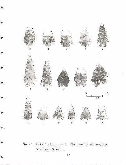
Elko Series
Elko Eared (Figure 7; a-d)Large, triangular; corner notched producingprominent barbs; expanding stem; base deeply-notched; lenticular cross section; flakingirregular. (Hester and Heizer 1973: 20-21;Heizer and Buamhoff 1961)
.
Elko Corner Notched (Figure 7; e-j)Large, triangular; corner notched producingprominent barbs; expending stem; base straightto slightly convex; lenticular cross section;flaking irregular. (Hester and Heizer 1973:20-21; Heizer and Baumhoff 1961).
Eastgate (Figure 7; k-p)Small, triangular; basally notched to producesquare barbs; stem may be basally notched (EastgateSplit-stem) or not (Eastgate Expanding -s tern)
.
(Hester and Heizer 1973: 22-23; Heizer andBaumhoff 1961)
.
Rose Spring (Figure 8; a-e)Small, triangular; corner nothced; base convex;may be basally notched (Rose Spring Split-stem)or not (Rose Spring Corner Notched). (Hester andHeizer 1973: 22-23; Heizer and Baumhoff 1961).
Desert Side Notched (Figure 8; f-j)Small, triangular; side notched; base straight,concave or notched. (Hester and Heizer 1973: 24-25;Baumhoff and Byrne 1959)
.
Cottonwood (Figure 8; k-n)Small, triangular; no stem; sides straight, convexor concave; base straight, concave, notched orconvex. (Hester and Heizer 1973: 22-23; Lanning1963).
Bifaces
Type 1 (Figure 8; o-r)Relatively small and thin; triangular; basesquare to subsquare; flaking irregular; finepressure retouch on the edge. (Layton 1970: 275-277) This type may be contemporaneous with Elkoor Eastgate/Rose Spring projectile points (McGonagle1974: 98-90).
16
V .. \
/ \
~j
*. _y^ J*
m
L J Lcm
4J I
Figure 7. Projectile Points. a—d. Elko Corner Notched; e—j. Elko
Eared/ k—p. Eastgate.
17

m
Figure 8. Projectile Points and Bifaces. a—e. Rose Spring; f—j.
Desert Side Notched; k—n. Cottonwood; o-r. Biface Type
1; s— t. Biface Type 2.
18

Type 2 (Figure 8; S , t)Leaf--shaped; thick, rounded base; broad inrelation to length; large percussion flake scars.(Layton 1970: 275-277) May be the same age asElko projectile points (McGonagle 1974: 89-90).
Type 3 (Figure 9, a,b)Large, asymmetrical; relatively thick; finepressure retouch on edges. This type probablycorresponds to Layton 's Knife Type 3 and may becontemporaneous with Pinto/Northern Side Notched/Humboldt Basal Notched projectile points (Layton1970: 276-277).
Type 4 (Figure 9; c-h)Triangular; square to sub- square or rounded base-larger and thicker than Type 1, but still rela-tively thin; fine pressure retouch on edges. Maybe the same age as Elko or Eastgate/Rose Springprojectile points (McGonagle 1974: 89-90).
Type 5 (Figure 9; i,j)Small, triangular; slightly basal notched: rela-tively thin. May be the same age as Elko or
1974Sa
89-90)6 Sprlng projectile P°ints (McGonagle
Type 6 (Figure 10; a-d)Triangular; square to sub-squate base; thickerthan Type 4 with larger, deeper percussion flakescars; lack of fine pressure retouch on edges
u\ tsl tSa?e age as Pinto/Northern Side Notched/
?974? 89-90)N° tched P^Jectile points (McGonagle
Type 7 (Figure 10; e,f)Ovoid, thick; large primary flake scars; steepworking edge. Artifacts of this type were probablyused as scrapers. J
Drills
IhLd;ills^r e collected during the survey; however,they do not fall into easily defined categories as eachseems to be one of a kind. Three of thesl artifactsare illustrated in Figure 10; g-i.
19

...'' * i
\I L
4J I
cm
$sW :
'a
Figure 9. Bifaces. a—b. Type 3; c—h. Type 4; i— j. Type 5.
20
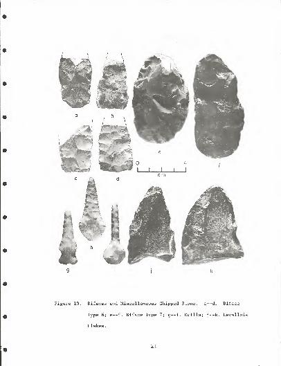
Figure 10. Bifaces and Miscellaneous Chipped Stone, a— d. Biface
Type 6; e—f. Biface Type 7; g— i. Drills; j—k. Levallois
Flakes
.
21

Levellois Flakes
Four artifacts were collected (2 from CrNV-06-233and 2 from CrNV-06-226) that appear to have beenproduced by Levellois techniques (Figure 10; j ,k)
.
Pottery
Pottery is quite common in the Tonopah ResourceArea and consists primarily of an undecorated utilityware commonly known as Shoshone Brown Ware. Corrugatedware occurs infrequently (Brooks 1969; 7). Figure 11illustrates a sample of sherds:
a. CrNV-06-184Rim sherd; no visible temper; reducingatmosphere with secondary oxidation; lightgrey brown exterior, dark grey interiorlens; surface finish shows striation--possible fibre rubbed; portion of coilon lip not removed; 60-90 mm thickness.
b. CrNV-06-208Rim sherd; 27o temper- -quartz , mica, rhyo-lite granules; reducing atmosphere, mediumgrey; surface rubbed, not finished smooth;45 mm thickness.
c. CrNV-06-277Temper shows 27 quartz, pyrite granules;reducing atmosphere; dark grey color; sur-face shows coils partially removed by rub-bing; hole in vessel; 65 mm thickness.
d. CrNV-06-209Temper shows 5% quartzite granules andash material; some vegetal material intemper; firing- -interior surface reduced/smudged, exterior surface oxidized; inte-rior grey/black, exterior red/brown; sur-face rubbed; hole in vessel; 60 mm thick-ness .
e. CrNV-06-239Temper shows 1% quartzite granules; re-ducing atmosphere; grey surface withmedium brown core; surface exteriorpunctated; interior brushed; 50 mm thick-ness .
22

Figure 11. Pottery,
23

CrNV-06-222Thick, round-bottomed pot; temper shows3% quartzite, mica granules; reducingatmosphere; grey color; plain smoothedfinish; 75 mm thickness.
Temporal Phases
From the occurrence of temporally diagnostic artifacts,nine temporal phases are postulated for the Tonopah ResourceArea:
Black Spring Phase . (Late Pleistocene?) The occurrence ofcultural material predating fluted points and otherEarly Man artifacts is postulated from the occurrenceof Levellois flake tools from two sites, Black Spring(CrNV-06-233) and an unnamed site, CrNV-06-226. (Figures10 and 12) In both cases, the artifacts were recoveredfrom disturbed contexts that indicated they were fromburied deposits. At Black Spring the tools were col-lected from earth removed from a back-hoe trench excavatedduring spring development. At CrNV-06-226, the toolswere found in an old gravel pit dug into a Pleistocenebeach terrace. Due to the lack of data, no adaptivepattern can be postulated as being associated with thistool tradition. Neither can any guess be made as tothe age of the Levellois artifacts. It is hypothesisedhere that they predate the fluted points found atPleistocene Lake Tonopah.
Tonopah Phase . (?--8,000 B.C.) The Tonopah Phase ishypothesised from the presence of fluted, Clovis-likepoints from the Big Smoky and Ralston valleys.Although no such artifacts were found during thesurvey, the documented occurrence of fluted pointsassociated with Pleistocene Lake Tonopah is wellknown. (Campbell and Campbell 1940; Gary Noyes
,
personal communication) Whether or not these artifactsrepresent a big-game hunting adaptation characteristicof elsewhere is uncertain; however, their occurrence ina pluvial lake context perhaps indicates they do not.Hopefully, the research planned in the Big Smoky Valleyby David H. Thomas of the American Museum of NaturalHistory will answer these questions.
Nyala Phase . (c.a. 8,000--6,000 B.C.) The Nyala Phase isthe postulated local manifestation of the WesternPluvial Lakes Tradition. The occurrence of artifactsassignable to this time period is sporadic, but theyare all limited geographically to the eastern portion
24

miles
-i—
"-T-10
i
20
20
kilometers
FIGURE 12. Black Spring Phase Im77

ON
miles10
10 20 30kilometers
FIGURE 13. Nyala Phase. rlm77

of the Resource Area (Figure 13). With one exception,Tobe Spring (CrNV-06-186) , all Nyala Phase artifactscome from the Grant Range and Railroad Valley. Includedare one Silver Lake point from CrNV-06-296, one Parmanpoint from CrNV-06-223, (Figure 14), 3 Lake Mojave pointsfrom Tobe Spring, Log Spring (CrNV-06-239) and MorganSpring (CrNV-06-293)
, and 3 Black Rock Concave Basepoints from Abel Spring (Ar27-06-38) , Blind Snring #1(CrNV-06-228) and Andrew Spring (CrNV-06-240)* (Figure 15).
An interesting note is that only 3 of the above8 artifacts were found in a pluvial lake shore context;5 were found at sites in mountainous terrain. Themajor concentration of sites of this age is in theGrant Range. Therefore, indications are that, at leastin central Nevada, the concept of the Western PluvialLakes Tradition will need to be revised; however, fewof the areas surveyed for this project were in a pluviallake shore context. Gary Noyes (personal communica-tion) reports Silver Lake and Lake Mojave points fromPleistocene Lake Tonopah.
Morey Phase . (c.a. 6,000--5,000 B.C.) The Morey Phasemarks the beginning of the hypothesised Desert HuntingTradition, an adaptation that continues for about5,000 years. Humboldt Concave Based points (Figure 16)are considered the time marker for this phase. Innorthwest Nevada, these artifacts occur earlier in timethan other Humboldt types (Layton 1970: 247-255; McGonagle1974: 89-90) . Whether or not this distinction willhold in central Nevada remains to be seen; however, thedistribution of Humboldt Concave Based points is almostentirely different from postulated later Humboldt types(Figure 17) , being confined primarily to the Hot CreekRange
.
Morey Phase sites are Antelope Spring #1 (CrNV-06-200), Rattlesnake Spring (CrNV-06-207) (Figure 18),Black Spring (CrNV-06-233) , an isolated find (CrNV-06-234), Trail Canyon (CrNV-06-264) , Italian Spring(CrNV-06-277)
, North Sixmile Canyon Spring (CrNV-06-301and Rawhide Spring (CrNV-06-314)
.
Grant Phase . (c.a. 5,000--3,000 B.C.) The 2nd phase ofthe Desert Hunting Tradition, the Grant Phase, ismarked by a diversification of projectile points. Timemarkers for this phase are Humboldt Basal Notched,
27
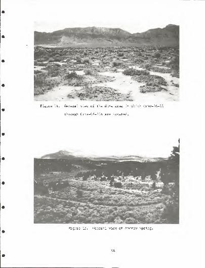
Figure 14. General view of the dune area in which CrNV-06-221
through CrNV-06-224 are located.
Figure 15. General view of Andrew Spring.
28

miles10
T—"T r1
1 "t r
10 20 30kilometers
FIGURE 16. Morey Phase.Im 77

o
miles10
10 20
kilometers
—
r
30
' 1 295«
/ 240«/ 239»
S~~~ K
/ 299»\
283«
^S »2I0 ^
V• 213 v .
/ */ *
¥ /j4 / *>
^*^
228 •/
1 <*
FIGURE 17. Grant Phase Im77

Figure 18. General view of Rattlesnake Spring, looking south-southeast.
Humboldt Side Notched, Humboldt Single Shoulder,Northern Side Notched and Pinto. The wide variety ofpoints associated with this time period seems to indi-cate a very complex cultural situation. whether or notthese points are of different relative ages is hard todetermine, but there is some indication the NorthernSide Notched are the oldest, the Humboldt types nextand the Pinto points the youngest (Hester and Heizer1973: 31; McGonagle 1974: 89).
Grant Phase materialsoccurrence in the Tonopahand Monitor Valleys in thethe Grant Range in the eassites are Warm Spring #1--find (CrNV-06-213) , BlindSpring (CrNV-06-239), AndrElkhorn Canyon (CrNV-06-26264), CrNV-06-265, CrNV-0606-295), Beaty Spring II (
and CrNV-06-413.
have two major areas ofResource Area-- the Ralstonwest and Railroad Valley and
t (Figure 17) . Grant PhaseII (CrNV-06-210) , an isolatedSpring #1 (CrNV-06-228) , Logew Spring (CrNV-06-240)
,
3), Trail Canyon (CrNV-06--283, Blind Spring #3 (CrNV-CrNV-06-299) , CrNV-06-367,
31

Liberty Phase . (c.a. 3,000--300 B.C.) The Liberty Phase isthe final period of the hypothesised Desert HuntingTradition. The primary time markers for this phase areElko series points. Gypsum points are also consideredas belonging to this time.
As elsewhere in the Great Basin, Elko points arethe most widespread type of artifact in the TonopahResource Area (Figure 19) . Whether or not huntingremains as important as during earlier times is aproblem for future research. Milling stones may bemore common, but the evidence is inconclusive sincemany of the sites with milling stones are multicom-ponent (Figure 20)
.
Liberty Phase sites are Abel Spring (CrNV-06-38)Coyote Hole Spring #2 (CrNV-06-138) , Muleshoe Spring(CrNV-06-188)
, Antelope Spring (CrNV-06-200) , LibertySpring (CrNV-06-203), Upper Blind Spring #2 (CrNV-06-235), Blind Spring #2 (CrNV-06-236) , Irwin Canyon(CrNV-06-237), Log Spring (CrNV-06-239) . Andrew Spring(CrNV-06-240), Alum Spring (CrNV-06-242) , an isolatedfind (CrNV-06-253), CrNV-06-257, Trail Canyon (CrNV-06-264), CrNV-06-270, Box Canyon Spring II (CrNV-06-282)
,
Beaty Spring I (CrNV-06-283) , CrNV-06-288, MorganSpring (CrNV-06-293), Blind Spring #3 (CrNV-06-295) , anisolated ifnd (CrNV-06-309) , Needles Spring (CrNV-06-405), Squaw Wells Spring (CrNV-06-406) , Red Spring I(CrNV-06-409) and CrNV-06-417.
Blue Eagle Phase . (c.a. 300 B.C.--A.D. 1,300) The BlueEagle Phase is postulated as marking the beginning ofthe Desert Culture adaptation in the Tonopah ResourceArea. Diagnostic artifacts are the Eastgate and RoseSprings projectile points. Blue Eagle Phase materialis fairly widespread (Figure 21) , being almost asuniversal to the area as earlier Liberty Phase arti-facts. Whether or not milling stones are important, isagain inconclusive for the same reasons stated underthe discussion of the Liberty Phase. However, it ishypothesised that during this phase, plant foods weremore important than during earlier periods and thatsmall mammals became the primary source of meat.
Blue Eagle Phase sites are (Ar27-06-109) , WarmSprings #I— li (CrNV-06-210), Trap Spring (CrNV-06-220), (CrNV-06-224), Blind Spring #1 (CrNV-06-228) OxSpring (CrNV-06-229), Log Spring (CrNV-06-239), AndrewSpring (CrNV-06-240), CrNV-06-257, CrNV-06-258, CrNV-06-262, Trail Canyon (CrNV-06-264) , CrNV-06-266
32

mileso 10
I r-H rJ—
r
-
r
10 20 30
kilometers
FIGURE 19 Liberty Phase. rlm77

Sidehill Spring (CrNV-06-271) , Box CanyonSpring I (CrNV-06-281)
,
CrNV-06-88, MorganSpring (CrNV-06-293),North Sixmile CanyonSpring (CrNV-06-301)
,
and Needles Spring(CrNV-06-405)
.
Clifford Phase. (c.a. A.D.1,300—1,863) Theprotohistoric CliffordPhase begins with thearrival of the Sho-shonian peoples in theTonopah Resource Area(Figure 19) . Adapta-tion is most likely"Desert Culture" --likeDiagnostic artifactsare Desert Side Notched
Ar27-06-38 X X X
Ar27-06-123 X
Cr»V-06-182 X
CrNV-06-189 X
CrNV-06-198 X
CrNV-06-2U0 X X
CrNV-06-207 X
CrNV-06-208 X
CrNV-06-21b X
CrNV-06-239 X X X X
CrNV-06-240 X X X X X
CrNV-06-257 •: X
urNV-06-258 X
CrNV-06-271 X
CrNV-06-277 X .<
~rNV-06-i82 X
CrNV-06-293 X X X X
CrKV-06-295 X X
CrNV-06-il7 X
Figure 20. Occurrence of
milling stones by phase.
Two other site
and Cottonwood pointsand pottery. The phase.Dame comes from thesites at Clifford Spring;(CrNV-06-183, 184 and185) , small rock shel-ters with stone fea-tures and pottery (Figures 23 and 24)complexes are almost identical, Point of Rock Spring(CrNV-06-268) (Figure 25) and McKinney Tanks on theNational Forest (26 Ny 76, 77, 78, 79, and 87).
Clifford Phase sites are Abel Spring (Ar27-06-38)
,
Ar27-06-108, Ar27-06-109, Ar27-06-123, Coyote HoleSpring #1 (CrNV-06-138) , the Clifford Spring sites(CrNV-06-182, 183, 184, and 185), Tobe Spring (CrNV-06-186), Muleshoe Spring (CrNV-06-188) , Willow Spring #2(CrNV-06-189) , Iceburg Spring (CrNV-06-208) , WarmSpring #1—1 (CrNV-06-209) , Coyote Hole Spring #2(CrNV-06-212) , Grant Canyon (CrNV-06-216) , Trap Spring(CrNV-06-220) , CrNV-06-222, Sandy Summit Spring (CrNV-06-232), Log Spring (CrNV-06-239), Andrew Spring (CrNV-06-240), Alum Spring (CrNV-06-242) , CrNV-06-254, CrNV-06-266, Italian Spring (CrNV-06-277), CrNV-06-288,Morgan Spring (CrNV-06-293), Blind Spring #3 (CrNV-06-295), CrNV-06-401, Needles Spring (CrNV-06-405), RedSpring I (CrNV-06-409) , CrNV-06-416, and CrNV-06-418.
34

mileso 10
I i-H ' ' H10 20 30
kilometers
240
2 88
FIGURE 21. Blue Eagle Phase. Im77

288
miles10
I1—
H
r11—h
—
10 20 30
kilometers
FIGURE 22. Clifford Phase

Figure 23. Clifford Rock Shelters, view north.
Figure 24. Rock feature in CrNV-06-184.
37

Figure 25. Point of Rock Spring.
Tybo Phase . (ca. A.D. 1863--1915) The historic period wasone of cultural disruption and change for the Shoshone.Tybo Phase sites are on the edges of Euro-Americancommunitites and show a mixture of aboriginal and historictraits
.
The sites upon which this phase is described areassociated with the mining town of Tybo in the HotCreek Range. They were originally described to us byVictor J. Barndt of Tybo who took the senior author tosee two that had yielded quanties of glass beads overthe years. They are leveled areas about ten feet indiameter on the steep slopes above the white settle-ment. Four such sites (CrNV-06-194, 196, 197, and 198)were discovered above Gilmore Springs south of TyboCanyon (Figures 26 and 27). Quantities of historicmaterials including clay pipe fragments, glass beads ofvarious kinds and metal objects were observed on thesesites. Two of the sites also had associated flakescatters and one had a granite metate.
38

Figure 26. CrNV-06-194.
Figure 27. CrNV-06-196. View south.
39

Non-aboriginal Historic . There are numerous sites repre-sentative of the early mining and ranching activitiesThose recorded on the RIS inventory (Figure 2) are forthe most part well documented in historic records.However, during the EIS Survey abundant sites, parti-cularly of mining activities, were recorded of non-aboriginal occupation.
The historic sites of the Tonopah Resource Areafall into four basic categories:
1. Mining towns and camps;2. Isolated mining activity, usually rock cabins;3. Ranches; and4. Charcoal Kilns (Figure 28)
.
Considerable archival research is needed beforeany interpretation can be made of these sites. Theyare numerous and many will probably always remainobscure as to who occupied them, for what reason andexactly when.
Figure 28. Tybo Charcoal Kilns,
40
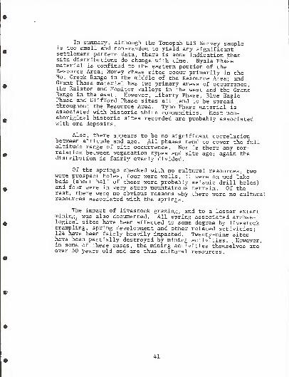
In summary, although the Tonopah EIS Survey sampleis too small and non-random to yield any significantsettlement pattern data, there is some indication thatsite distributions do change with time. Nyala Phasematerial is confined to the eastern portion of theResource Area; Morey Phase sites occur primarily in theHot Creek Range in the middle of the Resource Area; andGrant Phase material has two primary areas of occurrence,the Ralston and Monitor valleys in the west and the GrantRange in the east. However, Liberty Phase, Blue EaglePhase and Clifford Phase sites all tend to be spreadthroughout the Resource Area. Tybo Phase material isassociated with historic white communities. Most non-aboriginal historic sites recorded are probably associatedwith ore deposits.
Also, there appears to be no significant correlationbetween altitude and age. All phases tend to cover the fullaltitude range of site occurrence. Nor is there any cor-relation between vegetation types and site age; again thedistribution is fairly evenly divided.
Of the springs checked with no cultural resources, twowere prospect holes, four were wells, 11 were on mud lakebeds (about half of these were probably seismic drill holes)and four were in very steep mountainous terrain. Of therest, there were no obvious reasons why there were no culturalresources associated with the springs.
The impact of livestock grazing, and to a lesser extentmining, was also documented. All spring associated archae-logical sites have been affected to some degree by livestocktrampling, spring development and other related activities;124 have been fairly heavily impacted. Twenty-nine siteshave been partially destroyed by mining activities. , However,in some of these cases, the mining activities themselves areover 50 years old and are thus cultural resources.
41

REFERENCES CITED
Baumhoff, M.A. and J.S. Byrne1959 Desert Side Notched Points as a Time Marker in
California. University of California Archaeolog-ical Survey Reports 48: 32--65.
Brooks1969
R.H.Archaeological Report on the Central Nevada TestSite, Nye County, Nevada. Nevada ArchaeologicalSurvey, Desert Research Institute, University ofNevada, Las Vegas.
Campbell, E.W. and W.H. Campbell1940 A Folsom Complex in the Great Basin. The Masterkey,
Vol. 14, no. 1; 7--11, Southwest Museum, LosAngeles
.
Clewlow, C.W. Jr.1968 Surface Archaeology of the Black Rock Desert,
Nevada. University of California ArchaeologicalSurvey Report 73: 1--94.
Hester,1973
Heizer,1961
Lanning
,
1963
T.R. and R.F. HeizerReveiw and Discussion of Great Basin ProjectilePoints: Forms and Chronology. ArchaeologicalResearch Facility, University of California,Berkeley.
R.F. and M.A. BaumhoffThe Archaeology of Two Sites at Eastgate, Church-ill County, Nevada, I. Wagon Jack Shelter.University of California Archaeological SurveyReports 20, no. 4.
E.R.Archaeology of the Rose Spring Site, INY-372.University of California Publications in AmericanArchaeology and Ethnology, 49, no. 3: 237--336.
Layton, T.N.1970 High Rock Archaeology. PhD Thesis, Department of
Anthropology, Harvard University, Cambridge, Mass.
McGonagle, R.L.1966 The Cook Site: A Middle Horizon Site in Central
California. M.A. Thesis, Department of Anthropology,University of California, Davis.
42

1974 Time and Space Distributions of PrehistoricOccupation of the High Rock Lake Locality, North-west Nevada. PhD Dissertation, Department ofAnthropology, University of Missouri, Columbia.
Paher, Stanley W.1970 Nevada Ghost Towns and Mining Camps.
Books, Berkeley.Howell-North
Steward, J.H.1938 Basin-Plateau Aboriginal Sociopolitical Groups
Bureau of American Ethnology Bulletin 120.
Thomas1971
D.H.Prehistoric Subsistence—Settlement Patterns ofthe Reese River Valley. PhD Dissertation, Depart-ment of Anthropology, University of California,Davis
.
Wormington, H.M.1957 Ancient Man in North America. The Denver Museum
of Natural History, Popular Series no. 4.
43

Appendix A
Cultural Resource Inventory Prior to the EIS Survey
Ar27-06-12(26 Ny 529)
T. 11 N. , R. 49 E. , Sec. 32 DanvilleCreek
Ar27-06-13(26 Ny 530)
T. 11 N. , R. 49 E. , Sec. 29
Ar27-06-14(26 Ny 531)
T. 10 N. , R. 49 E. , Sec. 24 CloverSpring
Ar27-06-15 T. 10 N. , R. 49 E. , Sec. 10
Ar27-06-16 T. 10 N. , R. 49 E. , Sec. 20 & 21
Ar27-06-17 T. 10 N., R. 49 E. , Sec. 10
Ar27-06-18 T. 11 N. , R. 49 E. , Sec. 11
Ar27-06-19 T. 11 N. , R. 49 E. , Sec. 11
Ar27-06-20 T. 11 N. , R. 49 E. , Sec. 11
Ar27-06-21 T. 11 N. , R. 50 E. , Sec. 7
Ar27-06-22 T. 11 N., R. 49 E. , Sec. 1
Ar27-06-23(26 Ny 532)
T. 7 N.,
R. 47 E. , Sec. 11 & 14 McCannSpring
Ar27-06-24(26 Ny 533)
T. 8 N., R. 49 E. , Sec. 17,18,20
Ar27-06-25(26 Ny 258)
T. 10 N. , R. 39 E. , Sec. 32 BarrenSpring
Ar27-06-35(26 Ny 505)
T. 4 N. , R. 51 E. , Sec
.
15 & 16
Ar27-06-36(26 Ny 287)
T. 5 N.,
R. 53 E. , Sec. 21
Ar27-06-37(26 Ny 288)
T. 5 N., R. 54 E. , Sec. 34
T. 4 N. , R. 54 E. , Sec. 3
44

Ar27-06-38(26 Ny 289)
T. 6 N.,
R. 54 E.,Sec
.
23 Abel Spring
Ar27-06-39 T. 10 N., R. 49 E.
,Sec
.
20 & 21
Ar27-06-40 T. 10 N., R. 49 E.
, Sec. 16 & 17
Ar27-06-41 T. 10 N. , R. 49 E.,
Sec. 2 & .3
Ar27-06-42 T. 10 N.,
R. 49 E., Sec. 10
Ar27-06-43 T. 10 N., R. 49 E.
,Sec. 16
Ar27-06-44 T. 10 N. , R. 49 E., Sec. 16
Ar27-06-45 T. 10 N. , R. 49 E.,
Sec. 21 & 22
Ar27-06-46 T. 11 N. , R. 49 E.,
Sec. 14
Ar27-06-47 T. 11 N. R. 49 E., Sec
.
13 & 14
Ar27-06-48 T. 11 N. R. 49 E., Sec. 9,14, 15, 23
Ar27-06-49 T. 11 N. R. 49 E., Sec. 14,1! ,16
Ar27-06-50 T. 11 N. R. 49 E. , Sec. 2,3,12
Ar27-06-51 T. 11 N.,
R. 49 E., Sec. 1
Ar27-06-52 T. 12 N.,
R. 50 E.,
Sec. 31
T. 12 N.,
R. 49 E., Sec. 36
Ar27-06-53 T. 12 N.,
R. 49 E., Sec. 36
Ar27-06-54 T. 12 N.,
R. 49 E., Sec. 26 & 36
Ar27-06-55(26 Ny 534)
T. 8 N., R. 47 E.
, Sec. 35 Wild CatSpring
Ar27-06-69(26 Ny 535)
T. 9 N.,
R. 51 E. , Sec. 8 South CanyonSpring
Ar27-06-91 T. 11 N.,
R. 43 E.,
Sec. 32
Ar27-06-92 T. 11 N.,
R. 51 E., Sec. 15
Ar27-06-93 T. 3 N.,
R. 43 E., Sec. 19
Ar27-06-94 T. 10 N.,
R. 51 E.,
Sec. 36 Moores Sta-tion Petro-glyphs
45

Ar27-06-95
Ar27-06-96
Ar27-06-97
Ar27-06-98
Ar27-06-100
Ar27-06-101
Ar27-06-102(26 Ny 18)
Ar27-06-108(26 Ny 259)
Ar27-06-109(26 Ny 260)
Ar27-06-110(26 Ny 261)
Ar27-06-112
Ar27-06-113
Ar27-06-114
Ar27-06-115
Ar27-06-123
CrNV-06-125
CrNV-06-130*
CrNV-06-131*
CrNV-06-132
CrNV-06-134
CrNV-06-135
T. 10 N. , R. 52 E.
,
Sec. 29
T. 7 N. , R. 51 E.
,
Sec. 36
T. 11 N. , R. 43 E.
,
Sec. 19
T. 5 N. , R. 50 E.
,
Sec. 20
T. 8 N. , R. 57 E.
,
Sec. 1 & 12
T. 8 N. , R. 57 E.
,
Sec. 12
T. 4 N. , R. 51 E.
T. 6 N. , R. 49 E.
,
Sec. 17
T. 6 N. , R. 49 E.
,
Sec. 20
T. 7 N. , R. 49 E.
,
Sec. 27
T.
T.
T.
T.
T.
T.
2 N.
,
R. 42 E.
,
Sec. 12
2 N.
,
R. 42 E.
,
Sec. 12
2 N.
,
R. 42 E.
,
Sec. 12
2 N.
,
R. 42 E.
,
Sec. 12
6 N.
,
R. 49 E.
,
Sec. 23
IN., R. 49 E. , Sec. 4
T. 11 N. , R. 50 E. , Sec. 21
T. 6 N. , R. 49% E. , Sec. 23
T. 9 N. , R. 52 E. , Sec. 27
T. 9 N.. R. 56 E. , Sec. 35
T. 8 N. , R. 56 E. , Sec. 2
JumbledRock GulchPetroglyphs
Blue JayRockshelter
LongstreetsRanch
James WildHorse Trap
Tybo CharcoalKilns
'National Register Sites
46

CrNV-06-246 T. 10 N. , R. 37 E., Sec. 9
CrNV-06-315 T. 11 N. , R. 52 E., Sec. 19
CrNV-06-316 T. 11 N. , R. 51 E., Sec. 36
CrNV-06-317 T. 9 N., R. 51 E., Sec. 5
CrNV-06-318 T. 9 N. , R. 50 E., Sec. 27
CrNV-06-319 T. 9 N. , R. 50 E., Sec. 34
CrNV-06-320 T. 9 N. , R. 50 E. , Sec. 34
CrNV-06-321 T. 8 N. , R. 50 E., Sec. 2
CrNV-06-322 T. 8 N. , R. 50 E., Sec. 16
8 N.
,
R. 49 E.
,
Sec. 36
8 N.
,
R. 50 E.
,
Sec. 28
7 N.
,
R. 50 E.
,
Sec. 19
6 N.
,
R. 49 E.
,
Sec. 10
CrNV-06-327 T. 86 N. , R. 57 E., Sec. 11
CrNV-06-328 T. 6 N. , R. 49 E., Sec. 15
CrNV-06-320 T. 6 N. , R. 49 E., Sec. 22
CrNV-06--323 T.
CrNV-06-•324 T.
CrNV-06-325 T.
CrNV-06-326 T.
Golddyke
PritchardsStation
MooresStation
Morey
Sixmile Can-yon CharcoalKilns --upperset
WoodtickCanyon Char-coal Kilns
Sixmile Can-yon CharcoalKilns --middleset
Sixmile Can-yon CharcoalKilns- -lowerset
Fourmile Can-yon CharcoalKilns
Arrastra
Hot Creek
Keystone
Mclntyre Char-coal Kilns--N.set
Blue EagleState Station
Mclntyre Char-coal Kilns-middle set
Mclntyre Char-coal Kilns— S.set
47

CrNV-06-330 T. 8 N.,
R. 49 E. , Sec. 36 MountainView
CrNV-06-331 T. 6 N.,
R. 49-k e . , Sec . 24 Tybo
CrNV-06-332 T. 4 N.,
R. 50 E. , Sec. 20 WarmSprings
CrNV-06-333 T. 3 N.,
R. 49 E. , Sec. 3 Clifford
CrNV-06-334 T. 3 N.,
R. 49 E. Sec. 35 Bellehelen
CrNV-06-335 T. 2 N. R. 49 E. Sec. 28 GoldenArrow
CrNV-06-336 T. 11 N. R. 49 E. Sec. 30 Danville
CrNV-06-337 T. 1 N. R. 50 E. Sec. 3 & 4 Eden CreekRanch
CrNV-06-338 T. 1 N. R. 49 E. Sec. 22 & 23 Breen 1
s
Ranch
CrNV-06-339 T. 1 N. R. 49 E. Sec. 33 & 34 Silver Bow
CrNV-06-340 T. 11 N. R. 49 E. Sec. 3 & 4 Clear CreekRanch
CrNV-06-341 T. 6 N. R. 54 E. Sec. 11 Stone Corral
CrNV-06-342 T. 5 N. R. 54 E. Sec. 34 Stone Corral
CrNV-06-343 T. 2 N. R. 51% E , Sec . 1 Arrowhead
CrNV-06-344 T. 2 N. R. 52 E. Sec. 7 Old Reveille
CrNV-06-345 T. 6 N.,
R. 58 E.,
Sec. 6 & 7 Grant City-
T. 6 N.,
R. 57 E.,
Sec. 1
CrNV-06-346 T. 6 N.,
R. 57 E.,
Sec. 28 Troy
CrNV-06-347 T. 5 N.,
R. 57 E.,
Sec. 27 Ox Spring
CrNV-06-348 T. 13 N.,
R. 39 E.,
Sec. 34 lone
CrNV-06-349 T. 10 N.,
R. 37 E.,
Sec. 7 Atwood
CrNV-06-350 T. 10 N.,
R. 37 E.,
Sec. 36 Pactolus
CrNV-06-351 T. 11 N.,
R. 39 E. , Sec. 3 Grantsville
CrNV-06-352 T. 8 N.,
R. 39
48
E.,
Sec. 13 Cloverdale

CrNV-06-353 T. 7 N.,
R. 39 E. Roys ton
CrNV-06-354 T. 11 N.,
R. 43 E. , Sec. 17 Darrough'
s
CrNV-06-355 T. 10 N., R. 42 E. , Sec
.
14 Jett
CrNV-06-356 T. 7 N. , R. 42 E. , Sec. 18 San AntonioStage Sta-tion
CrNV-06-357 T. 6 N.,
R. 42 E. , Sec. 27 & 34 CimmarronMine
CrNV-06-358 T. 5 N., R. 42 E. , Sec. 7 & 8 Liberty Mine
CrNV-06-359 T. 4 N. , R. 42 E. , Sec. 14 Ray's
CrNV-06-360 T. 10 N.,
R. 44 E., Sec. 20 Round Moun-
tain
CrNV-06-361 T. 8 N.,
R. 43 E. , Sec. 24 Central City
CrNV-06-362 T. 8 N. R. 44 E. Sec. 20 Manhattan
CrNV-06-363 T. 7 N. R. 43 E. Sec. 25 BaxterSpring
CrNV-06-364 T. 7 N. R. 44 E. Sec. 14 SpanishSpring
CrNV-06-365 T. 8 N.
,
R. 45 E.,
Sec. 23 Monarch
CrNV-06-366 T. 3 N.,
R. 46 E. Ellendale
CrNV-06-526 T. 2 N.,
R. 51%E., Sec. 1 New Reveille
CrNV-06-528 T. 2 N. , R. 50 E., Sec. 23 & 24 Reveille Mill
CrNV-06-530 T. 1 N.,
R. 44 E., Sec. 28
CrNV-06-532 T. 1 N.,
R. 44 E.,
Sec. 29
CrNV-06-533 T. 1 N., R. 44 E. , Sec. 29
CrNV-06-534 T. 1 N.,
R. 44 E., Sec. 29
CrNV-06-535 T. 1 N., R. 44 E.
,Sec. 29
CrNV-06-536 T. IN., R. 44 E. , Sec. 30
CrNV-06-537 T. 1 N. , R. 43 E.,
Sec. 25
49

CrNV-06-538 T. 1 N. , R. 44 E. , Sec. 33
CrNV-06-539 T. 1 N. , R. 43 E. , Sec. 13
CrNV-06-540 T. 1 N., R. 43 E. , Sec. 13
CrNV-06-541 T. 1 N. , R. 45 E. , Sec. 7 & 8
CrNV-06-542 T. 1 N..
R. 45 E. , Sec. 4
CrNV-06-543 T. 1 N., R. 44 E. , Sec. 3
CrNV-06-544 T. 1 N.,
R. 44 E., Sec. 10
CrNV-06-545 T. 1 N.,
R. 44 E. , Sec. 15
CrNV-06-546 T. 1 N. R. 44 E. Sec. 17
CrNV-06-547 T. 1 N. R. 44 E. Sec. 20
CrNV-06-548 T. 1 N.,
R. 44 E., Sec. 21
CrNV-06-550 T. 5 N.,
R. 40 E.,
Sec. 25
CrNV-06-551 T. 6 N.,
R. 40 E.,
Sec. 14
CrNV-06-552 T. 6 N.,
R. 40 E., Sec. 23
CrNV-06-553 T. 6 N.,
R. 40 E., Sec. 11
CrNV-06-554 T. 6 N. , R. 40 E. , Sec. 2
CrNV-06-555 T. 6 N. , R. 40 E., Sec. 2
CrNV-06-556 T. 6 N.,
R. 40 E.,
Sec. 23
CrNV-06-557 T. 6 N.,
R. 40 E., Sec. 23
CrNV-06-558 T. 2 N.,
R. 43 E., Sec. 16
50

EEEHSU^SBBHI
Appendix B
Tonopah EIS Survey Cultural Resource Sites
CrNV-06-138(26 Ny 567)
CrNV-06-139(26 Ny 568)
CrNV-06-140(26 Ny 569)
CrNV-06-143(26 Ny 602)
CrNV-06-144(26 Ny 603)
CrNV-06-145(26 Ny 604)
CrNV-06-181(26 Ny 605)
CrNV-06-182(26 Ny 606)
CrNV-06-183(26 Ny 607)
CrNV-06-184(26 Ny 608)
CrNV-06-185(26 Ny 609)
CrNV-06-186(26 Ny 610)
CrNV-06-187(26 Ny 611)
CrNV-06-188(26 Ny 612)
CrNV-06-189(26 Ny 613)
CrNV-06-190(26 Ny 614)
T. 8 N. , R. 42 E. , Sec. 11
T. 3 N,
T. 3 N.
T. 9 N,
T. 9 N,
9 N,
T.
T.
T.
T,
T.
8 N.
3 N.
3 N.
3 N.
3 N.
2 N.
T. 4 N.
T. 6 N.
T. 6 N.
T. 6 N.
R. 43 E.
R. 43 E.
R. 39 E.
R. 42 E.
R. 42 E.
R. 38 E.
R. 49 E.
R. 49 E.
R. 49 E.
R. 49 E.
R. 49 E.
R. 49% E
R. 49 E.
R. 49 E.
R. 49 E.
Sec. 17
Sec. 9
Sec. 33
Sec. 11
Sec. 14
Sec. 11 & 12
Sec. 11
Sec. 11
Sec. 11
Sec. 11
Sec. 4
Coyote HoleSpring #1
Ice PlantSpring
SlaughterHouse Spring
Willow Spring#1
Warm Spring#2
CliffordSpring I
CliffordSpring II
CliffordSpring III
CliffordSpring IV
Tobe Spring
, Unsurveyed Milk Spring
Sec. 14
Sec. 15
MuleshoeSpring
WillowSpring #2
51

CrNV-06-191(26 Ny 615)
CrNV-06-192(26 Ny 616)
CrNV-06-193(26 Ny 617)
CrNV-06-194(26 Ny 618)
CrNV-06-195(26 Ny 619)
CrNV-06-196(26 Ny 620)
CrNV-06~197(26 Ny 621)
CrNV-06-198(26 Ny 622)
CrNV-06-199(26 Ny 623)
CrNV-06-200(26 Ny 571)
CrNV-06-201(26 Ny 572)
CrNV-06-202(26 Ny 573)
CrNV-06-203(26 Ny 574)
CrNV-06-204(26 Ny 575)
CrNV-06-205(26 Ny 576)
CrNV-06-206(26 Ny 577)
CrNV-06-207(26 Ny 578)
CrNV-06-208(26 Ny 579)
T. 6 N. , R. 49 E. , Sec. 23
T. 6 N,
T. 6 N.
T. 6 N,
T. 6 N.
T. 6 N.
T. 6 N.
T. 6 N.
T. 4 N.
T. 5 N.
T. 7 N.
T. 6 N.
T. 5 N.
T„ 5 N,
t. 5 N,
T. 8 N.
T. 7 N.
T. 7 N.
R. 49 E.
R. 49 E
R. 49 E.
R. 49 E,
R. 49 E
R. 49 E,
R. 49 E
R. 50 E
R. 45 E,
R. 43 E
R. 45 E,
R. 42 E.
R. 42 E.
R. 42 E,
R. 55 E
R. 52 E.
R. 52 E.
Sec. 23
Sec. 24
Sec. 24
Sec. 24
Sec. 24
Sec. 24
Sec. 24
Sec. 18
Sec. 21
Sec. 24
Sec. 22
Sec. 16
Sec. 16
Sec. 16 & 21
Sec. 15
Sec. 19
Sec. 31
Cave Spring
GilmoreSpring I
GilmoreSpring II
GilmoreSpring III
GilmoreSpring IV
GilmoreSpring V
AntelopeSpring #1
Mud Spring
LibertySpring
North Spring
RattlesnakeSpring
IceburgSpring
52

CrNV-06-209(26 Ny 580)
CrNV-06-210(26 Ny 581)
CrNV-06-211(26 Ny 582)
CrNV-06-212(26 Ny 583)
CrNV-06-213(26 Ny 584)
CrNV-06-214(26 Ny 585)
CrNV-06-215(26 Ny 586)
CrNV-06-216(26 Ny 587)
CrNV-06-217(26 Ny 588)
CrNV-06-218(26 Ny 589)
CrNV-06-219(26 Ny 590)
CrNV-06-220(26 Ny 624)
CrNV-06-221(26 Ny 625)
CrNV-06-222(26 Ny 626)
CrNV-06-223(26 Ny 627)
CrNV~06~224(26 Ny 628)
CrNv-06-225(26 Ny 629
CrNV-06-226(26 Ny 630)
T. 7 N. , R. 55 E. , Sec. 17
T. 7 N
T. 6 N,
T. 6 N,
T. 6 N,
T. 6 N.
T. 7 N.
T. 6 N,
T. 7 N.
T. 7 N,
T. 7 N.
T. 9 N.
T. 9 N,
T. 9 N,
T. 9 N,
T. 9 N,
T. 6 N,
R. 55 E.
R. 54 E
R. 54 E.
R. 54 E
R. 54 E.
R. 57 E.
R. 58 E,
R. 57 E.
R. 57 E.
R. 57 E.
R. 56 E,
R. 57 E
R. 57 E
R. 57 E.
R. 57 E.
R. 57 E
T. 9 N. , R. 57 E. , Sec. 20
Sec. 17
Sec. 2
Sec. 2
Sec. 3
Sec. 3
Sec. 28
Sec. 6 & 7
Sec. 33
Sec. 32
Sec. 28
Sec. 14
Sec. 25
Sec. 25
Sec. 25
Sec. 25
Sec. 5
Warm Spring#1--I
Warm Spring#1—11
StormSpring
Coyote HoleSpring #2
BullwhackerSpring #1
Grant Canyon
Thorn SpringI
Thorn SpringII
Trap Spring
WillowSpring #3
53

CrNV-06-227(26 Ny 631)
CrNV-06-228(26 Ny 632)
CrNV-06-229(26 Ny 633)
CrNV-06-230(26 Ny 634)
CrNV-06-231(26 Ny 635)
CrNV-06-232(26 Ny 636)
CrNV-06-233(26 Ny 637)
CrNV-06-234(26 Ny 638)
CrNV-06-235(26 Ny 639)
CrNV-06-236(26 Ny 640)
CrNV-06-237(26 Ny 641)
CrNV-06-238(26 Ny 642)
CrNV-06-239(26 Ny 643)
CrNV-06-240(26 Ny 644)
CrNV-06-241(26 Ny 645)
CrNV-06-242(26 Ny 646)
CrNV-06-243(26 Ny 647)
CrNV-06-244(26 Ny 648)
T. 6 N. , R. 56 E. , Sec. 14
T. 5 N.
T. 5 N.
T. 6 N.
T. 6 N.
T. 6 N
T. 3% N,
7 N,
T. 7 N.
T. 7 N.
T. 6 N.
T. 6 N.
T. 8 N.
T. 8 N.
T. 12 N.
T. 11 N.
T. 11 N.
T. 11 N.
R. 56 E.
R. 57 E,
R. 57 E.
R. 65 E.
R. 52 E.
R. 50 E
R. 58 E
R. 58 E,
R. 58 E.
R. 57 E
R. 57 E.
R. 58 E
R. 58 E
R. 38 E.
R. 37 E
R. 37 E,
R. 37 E
Sec . 4
Sec. 30
Sec. 7
Sec. 27
Sec. 4
Sec. 4
Sec
Sec. 7
Sec. 7
Sec. 9
Sec. 9
Sec. 11
Sec. 1
Sec. 31
Sec. 14
Sec. 31
Sec. 32
ChristianSpring
BlindSpring #1
Ox Spring
Sandy SummitSpring
Black Spring#1
Upper BlindSpring #2
BlindSpring #2
Irwin Can-yon
IrwinSprings
Log Springs
AndrewSpring
AntelopeSpring #2--I
Alum Spring
ParadiseSpring
54

CrNV-06-245(26 Ny 649)
CrNV-06-247(26 Ny 651)
CrNV-06-248(26 Ny 652)
CrNV-06-249(26 Ny 61)
CrNV-06-251(26 Ny 654)
CrNV-06-252(26 Ny 655)
CrNV-06-253(26 Ny 656)
CrNV-06-254(26 Ny 657)
CrNV-06-255(26 Ny 658)
CrNV-06-256(26 Ny 659)
CrNV-06-257(26 Ny 660)
CrNV-06-258(26 Ny 661)
CrNV-06-259(26 Ny 662)
CrNV-06-260(26 Ny 663)
CrNV-06-261(26 Ny 664)
CrNV-06-262(26 Ny 665)
CrNV-06-263(26 Ny 666)
CrNV-06-264(26 Ny 667)
T. 10 N., R. 37 E., Sec. 6
T. 8 N. , R. 38 E., Sec. 13
T. 9 N. , R. 39 E., Sec. 33
T. 12 N. , R. 38 E., Sec. 31
T. 10 N. , R. 39 E., Sec. 4
T. 13 N., R. 39 E., Sec. 27
T. 13 N. , R. 39 E. , Sec. 27
T. 13 N., R. 39 E., Sec. 27
T. 13 N., R. 39 E., Sec. 34
T. 8 N. , R. 41 E. , Sec. 20
T. 13 N., R. 44 E., Sec. 28
T. 13 N., R. 44 E., Sec. 28
T. 7 N. , R. 44 E. , Sec. 1
T. 10 N. , R. 46 E., Sec. 28
T. 9 N. , R. 47 E., Sec. 9
T. 9 N. , R. 47 E. , Sec. 28
T. 8 N. , R. 46 E. , Sec. 1
T. 11 N. , R. 46 E., Sec. 32
CoyoteSpring
BlackSpring #2
AntelopeSpring #2-11
StewartSpring
CorcoranSpring
Trail Canyon
55

CrNV-06-265(26 Ny 668)
T. 11 N. , R. 47 E. , Sec
.
5
CrNV-06-266(26 Ny 669)
T. 12 N., R. 47 E. , Sec
.
33
CrNV-06-267(26 Ny 601)
T. 7 N., R. 43 E. , Sec. 13 Mud Spring
CrNV-06-268(26 Ny 670)
T. 5 N.,
R. 47 E. , Sec. 13 Point ofRock Spring
CrNV-06-269(26 Ny 671)
T. 4 N.,
R. 42 E. , Sec. 35 Frazier '
s
Well
CrNV-06-270(26 Ny 672)
T. 4 N.,
R. 47 E. , Sec. 2 & 11
CrNV-06-271(26 Ny 673)
T. 5 N., R. 47 E. Sec. 26 SidehillSpring
CrNV-06-272(26 Ny 674)
T. 2 N. ( R. 47 E. Sec. 14
CrNV-06-273(26 Ny 675)
T. 1 N., R. 49 E. Sec. 31 StinkingSpring
CrNV-06-274(26 Ny 676)
T. 2 N., R. 49 E. Sec. 32
CrNV-06-275(26 Ny 677)
T. 2 N., R. 49E., Sec. 11 & 14 CraigCanyon
Cr'NV-06-276(26 Ny 678)
T. 3 N.,
R. 49E., Sec. 36 Cap HenrySpring
T. 3 N., R. 50 E.,
Sec. 31
CrNV-06-277(26 Ny 679)
T. 6 N. , R. 49 E., Sec. 4 & 5 Italian
Spring
CrNV-06-279(26 Ny 680)
T. 6 N.,
R. 49 E. , Sec. 29
CrNV-06-281(26 Ny 681)
T. 8 N.,
R. 58 E., Sec. 10 Box Canyon
Spring I
CrNV-06-282(26 Ny 682)
T. 8 N. ,R. 58 E.
, Sec. 10 Beaty CanyonSpring II
CrNV-06-283(26 Ny 683)
T. 8 N., R. 58 E., Sec. 26 Beaty Spring
I
56

BMHHWIHUlBMMnaMHI^MH gQ^^jgggig^l
CrNV-06-284(26 Ny 684)
CrNV-06-285(26 Ny 685)
CrNV-06-286(26 Ny 686)
CrNV-06-287(26 Ny 687)
CrNV-06-288(26 Ny 688)
CrNV-06-289(26 Ny 689)
CrNV-06-290(26 Ny 690)
CrNV-06-291(26 Ny 691)
CrNV-06-292(26 Ny 692)
CrNV-06-293(26 Ny 693)
CrNV-06-294(26 Ny 694)
CrNV-06-295(26 Ny 695)
CrNV-06-296(26 Ny 696)
CrNV-06-297(26 Ny 697)
CrNV-06-298(26 Ny 698)
CrNV-06-299(26 Ny 699)
CrNV-06-300(26 Ny 700)
CrNV-06-301(26 Ny 701)
T. 8 N. , R. 58 E. , Sec. 36
T. 8 N. , R. 58 E. , Sec. 36
T. 8 N. , R. 58 E. , Sec. 36
T. 2 N. , R. 54 E. , Sec. 10
T. 7 N. , R. 58 E. , Sec. 13
T. 6 N. , R. 54 E. , Sec. 6
T. 6 N. , R. 54 E. , Sec. 7
T. 6 N. , R. 51 E. , Sec. 5
T. 6 N. , R. 53 E. , Sec. 1
T. 8 N. , R. 58 E. , Sec. 23
T. 8 N. , R. 58 E. , Sec. 11 & 14
9 N. , R. 58 E. , Sec. 13
8 N. , R. 58 E. , Sec. 22
T. 8 N. , R. 58 E. , Sec. 22
T. 8 N. , R. 58 E. , Sec. 22
8 N. , R. 58 E. , Sec. 26
7 N. , R. 58 E. , Sec. 24
Cold Spring
Red BluffSpring
Butte Spring
BlindSpring #3
CazierSpring
BeatySpring II
T. 10 N. , R. 50 E., Sec. 35 & 36 North SixmileCanyon Spring
57

CrNV-06-302(26 Ny 702)
CrNV-06-303(26 Ny 703)
CrNV-06-304(26 Ny 704)
CrNV-06-305(26 Ny 705)
CrNV-06-306(26 Ny 706)
CrNV-06-307(26 Ny 707
CrNV-06-308(26 Ny 708)
CrNV--06-309(26 Ny 709)
CrNV-06-310(26 Ny 710)
CrNV-06-311(26 Ny 711)
CrNV-06-312(26 Ny 712)
CrNV-06-313(26 Ny 713)
CrNV-06-314(26 Ny 714)
CrNV-06-367(26 Ny 767)
CrNV-06-369
CrNV-06-370(26 Ny 768)
CrNV-06-371(26 Ny 769)
T. 8 N. , R. 50 E. , Sec. 8
T. 8 N. , R. 50 E. , Sec. 5
T. 8 N. , R. 50 E. , Sec. 5
T. 9 N. , R. 50 E. , Sec. 27
T. 9 N. , R. 50 E. , Sec. 15
T. 9 N. , R. 50 E. , Sec. 11
T. 9 N. , R. 50 E. , Sec. 27
T. 9 N. , R. 50 E. , Sec. 11
T. 9 N. , R. 51 E. , Sec. 5
T. 11 N. , R. 51 E. , Sec. 17
T. 11 N. , R. 51 E. , Sec. 7,8,17
T. 5 N. , R. 49 E. , Sec. 25
T. 5 N. , R. 49 E. , Sec. 24
T. 4 N. , R. 45 E. , Sec. 3 & 4
T. IN., R. 54 E. , Sec. 6 & 7
T. IS., R. 54 E. , Sec. 29
T. 4 N., R. 55 E., Sec. 23
BullwhackerSpring #2
SixmileSummit
LimestoneSpring
RawhideSpring
Ned's CacheSpring
Big CreekCanyonSpring
CrNV-06-372 T. 10 N. , R. 50 E., Sec. 23(26 Ny 770)
58

CrNV-06-373(26 Ny 771)
T. 9 N., R. 50 E. , Sec. 10 Cold Sprin
CrNV-06-374(26 Ny 772)
T. 10 N.,
R. 50 E. , Sec. 3 & 10i
CrNV-06-375(26 Ny 773)
T. 4 N. R. 45 E. , Sec. 6
CrNV-06-376(26 Ny 774)
T. 4 N. R. 47 E. , Sec. 10 & 11 FourmileSpring
CrNV-06-400(26 Ny 715)
T. 8 N. R. 50 E. , Sec. 29
CrNV-06-401(26 Ny 716)
T. 8 N. R. 50 E. , Sec. 9
CrNV-06-402(26 Ny 717)
T. 9 N.,
R. 51 E. , Sec. 32
CrNV-06-403(26 Ny 718)
T. 8 N.,
R. 51 E. , Sec. 5
CrNV-06-404(26 Ny 719)
T. 8 N.,
R. 51 E. , Sec. 5
CrNV-06-405(26 Ny 720)
T. 9 N.,
R. 52 E. Sec. 12 NeedlesSpring
CrNV-06-406(26 Ny 721)
T. 10 N.,
R. 52 E. Sec. 23 & 24 Squaw WellSpring
CrNV-06-407(26 Ny 722)
T. 10 N., R. 52 E. Sec. 22
CrNV-06-408(26 Ny 723)
T. 1 N. , R. 52 E.,
Sec. 22 Fang Ridge
CrNV-06-409(26 Ny 724)
T. 11 N., E. 50 E., Sec. 35 & 36 Red SpringI
CrNV-06-410(26 Ny 725)
T. 11 N.,
R. 50 E.,
Sec. 36 Red SpringII
CrNV-06-411(26 Ny 726)
T. 11 N. ,R. 50 E.
,Sec. 36 Red Spring
III
CrNV-06-412(26 Ny 727)
T. 10 N. , R. 50 E.,Sec. 14
CrNV-06-413 T. 1 N.,
R. 49 E., Sec. 4
59

CrNV-06-414 T. IN., R. 49 E., Sec. 4(26 Ny 776)
CrNV-06-415 T. IN., R. 49 E., Sec. 3
(26 Ny 777)
CrNV-06-416 T. 2 N. , R. 50 E., Sec. 16(26 Ny 778)
CrNV-06-417 T. 2 N. , R. 50 E. , Sec. 28(26 Ny 779)
CrNV-06-418 T. 11 N. , R. 52 E., Sec. 18(26 Ny 780)
CrNV-06-419 T. 10 N. , R. 36 E., Sec. 1 Derringer(26 Ny 781) Spring
CrNV-06-420 T. ION., R. 36 E. , Sec. 1 Arrastra(26 Ny 782)
CrNV-06-421 T. 10 N. , R. 37 E., Sec. 6(26 Ny 783)
60

•
•
•
PROPERS OF
Bureau of Land Man^ement
DSC LIBRARY
•
•
•
•
•
•
•
•