archaeological assessment of the northern …...redacted archaeological assessment of the northern...
TRANSCRIPT

REDACTED
ARCHAEOLOGICAL ASSESSMENT OF THE
NORTHERN PORTION OF THE CITY OF
VIRGINIA BEACH, VIRGINIA
by
Joseph R. Blondino,
Mike Klein, and Curtis McCoy
Prepared for
Commonwealth of Virginia
Department of Historic Resources
Prepared by
DOVETAIL CULTURAL RESOURCE GROUP
June 2018


REDACTED
Archaeological Assessment of the Northern Portion of the
City of Virginia Beach, Virginia
by
Joseph R. Blondino,
Mike Klein, and Curtis McCoy
Prepared for
Commonwealth of Virginia
Department of Historic Resources
2801 Kensington Avenue
Richmond, Virginia 23221
Prepared by
Dovetail Cultural Resource Group I, Inc. 11905 Bowman Drive, Suite 502
Fredericksburg, Virginia 22408
Dovetail Job #17-097
June 2018
June 13, 2018
D. Brad Hatch, Principal Investigator Date
Dovetail Cultural Resource Group

This page intentionally left blank

i
ABSTRACT
Dovetail Cultural Resource Group (Dovetail) conducted an archaeological assessment of the
northern part of the City of Virginia Beach, Virginia. The study area was bounded to the north
and east by the Chesapeake Bay and Atlantic Ocean, to the west by the city limits of Virginia
Beach, and to the south by North Landing Road, Princess Anne Road, and a line extending due
east from the intersection of Princess Anne Road and General Booth Boulevard to the Atlantic
Ocean. The assessment was performed on behalf of the Virginia Department of Historic
Resources as part of the Cost Share Survey and Planning Program. This work was completed
in February of 2018. This report includes a discussion of previously identified and potential
archaeological resources located within the study area.
The assessment included a review of previously identified resources, previously surveyed
areas, settlement patterns characteristic of precontact and historic archaeological sites, historic
maps, as-built maps, aerial photos, United States Geological Survey (USGS) topographic
maps, and vehicular and pedestrian survey. The field survey involved existing conditions
assessments of previously recorded sites and identification of areas where additional
archaeological deposits are likely to exist. A predictive model for archaeological site location
was also developed and used to inform the results of the assessment.
A total of 315 previously recorded sites were included as part of the survey. Of these, 203 were
surveyed. The remaining 112 sites were not surveyed because they were not visible from the
right-of-way or because other access problems, such as location on a military base, precluded
survey, or due to data on the sites having been compiled or updated within the last five years,
making existing conditions assessments unnecessary at this time. The Virginia Cultural
Resource Information System (VCRIS) database, maintained by the Virginia Department of
Historic Resources, was updated with regard to the surveyed sites to ensure that the information
on each site was current.

ii
This page intentionally left blank

iii
TABLE OF CONTENTS
ABSTRACT ......................................................................................................................... i
INTRODUCTION .............................................................................................................. 1 Archaeological Potential of the Study Area ........................................................................ 3
The Natural Environment ............................................................................................... 3 Geology ....................................................................................................................... 3 Soils ............................................................................................................................. 3
Topography and Hydrology of the Study Area ........................................................... 4 Existing Conditions within the Study Area .................................................................... 5 Previous Cultural Resource Surveys ............................................................................... 5
HISTORIC CONTEXT .................................................................................................... 13 Pre-Clovis Period (? to 14,950 B.P.)............................................................................. 13 Paleoindian Period (14,950 to 9950 B.P.)..................................................................... 14
Archaic Period (9950 to 3150 B.P.) .............................................................................. 15 Early Archaic Period (9950 to 8450 B.P.) ................................................................ 16 Middle Archaic Period (8450 to 4950 B.P.) ............................................................. 17
Late Archaic Period (4950 to 3150 B.P.) .................................................................. 17 Woodland Period (3150 to 350 B.P.) ............................................................................ 18
Early Woodland Period (3150 to 2450 B.P.) ............................................................ 18 Middle Woodland Period (2450 to 1050 B.P.) ......................................................... 19 Late Woodland Period (1050 to 350 B.P.) ................................................................ 22
Historic Period .............................................................................................................. 25 Settlement to Society (1607–1750) ........................................................................... 25
Colony to Nation (1750–1789) ................................................................................. 27 Early National Period (1789–1830) .......................................................................... 28
Antebellum Period and Civil War (1830–1865) ....................................................... 29 Reconstruction (1870–1916) ..................................................................................... 30
World War I to World War II (1917–1945) .............................................................. 30 BACKGROUND RESEARCH ........................................................................................ 33 SURVEY METHODOLOGY .......................................................................................... 35
Archival Research/Map Review ................................................................................... 35 Archaeological Survey .................................................................................................. 35
Predictive Model ........................................................................................................... 37 RESULTS OF THE STUDY ............................................................................................ 39
Predictive Model ........................................................................................................... 39
Archaeological Survey .................................................................................................. 41 Survey Results .......................................................................................................... 41
SUMMARY AND ASSESSMENT .................................................................................. 77 REFERENCES ................................................................................................................. 79
APPENDIX: SITE DATA TABLE ................................................................................ 103

iv
This page intentionally left blank
v
List of Figures
Figure 1: Location of Study Area within the Commonwealth of Virginia and the City of
Virginia Beach ............................................................................................................ 2 Figure 2: Detail from John Smith’s Virginia Discovered and DiscribedDepicting the
Settlements near the Mouth of the James River........................................................ 26 Figure 3: Locations of Survey Areas within Overall Study Area ..................................... 36 Figure 4: Results of Predictive Modeling for Prehistoric Site Location ........................... 42
Figure 5: Results of Predictive Modeling for Historic Site Location ............................... 43 Figure 6: Area A, Showing Previously Recorded Archaeological Sites .......................... 44 Figure 7: Area B, Showing Previously Recorded Archaeological Sites ........................... 46 Figure 8: Area C, Showing Previously Recorded Archaeological Sites and Area Which
May Contain Undiscovered Sites.............................................................................. 49
Figure 9: Area D, Showing Previously Recorded Archaeological Sites. ......................... 51 Figure 10: Area E, Showing Previously Recorded Archaeological Sites. ........................ 54
Figure 11: Area F, Showing Previously Recorded Archaeological Sites and Location of
Bellamy Manor House Site ....................................................................................... 57
Figure 12: Area G, Showing Previously Recorded Archaeological Sites. ....................... 60 Figure 13: Area H, Showing Previously Recorded Archaeological Sites ........................ 62
Figure 14: Area I, Showing Previously Recorded Archaeological Sites. ......................... 64 Figure 15: Area J, Showing Previously Recorded Archaeological Sites .......................... 66 Figure 16: Area K, Showing Previously Recorded Archaeological Sites ........................ 68
Figure 17: Area L, Showing Previously Recorded Archaeological Sites. ........................ 71 Figure 18: Area M, Showing Previously Recorded Archaeological Sites. ....................... 73
List of Photos
Photo 1: Site 44VB0358 in Area A, Facing Northeast. .................................................... 45 Photo 2: Site 44VB0048 (Chesopean Site) in Area B. ..................................................... 47
Photo 3: Site 44VB0241, Showing Typical Neighborhood in Area C. ............................ 50 Photo 4: Field in Area C Which May Contain Undiscovered Archaeological Sites. ....... 50 Photo 5: Site 44VB0055, Facing Northeast. ..................................................................... 52
Photo 6: Facing North across Edge of Broad Bay in Area D. .......................................... 52 Photo 7: Site 44VB0044, Facing Southwest. .................................................................... 55 Photo 8: Site 44VB0305 (Deep Branch Ditch) in Area E, Facing Southeast. .................. 55 Photo 9: Brick Clamp Area within Site 44VB0283 in Area E, Facing North. ................. 56 Photo 10: Site 44VB0046 in Area F, Facing South. ......................................................... 58
Photo 11: Bellamy Manor House Site in Area F, Facing Northeast. ................................ 59 Photo 12: Site 44VB0352 in Area G, Facing South. ........................................................ 61
Photo 13: Typical Field in Area H, Facing Southwest. .................................................... 63 Photo 14: Typical Forested Portion of Area H, Facing South. ......................................... 63 Photo 15: Site 44VB0227, Facing Northeast. ................................................................... 65 Photo 16: Site 44VB0288 in Area J, Facing South. .......................................................... 67 Photo 17: Site 44VB0172, Facing South. ......................................................................... 69 Photo 18: Site 44VB0290, Facing Northwest ................................................................... 69 Photo 19: Site 44VB0121, Showing Typical Neighborhood in Area L. .......................... 72 Photo 20: Site 44VB0291, Showing Commercial Area in Area L. .................................. 72

vi
Photo 21: Site 44VB0118, Facing Northwest. .................................................................. 74
Photo 22: Industrial Complex in Central Portion of Area M, Facing South..................... 74
Photo 23: Agricultural Field in South-Central Portion of Area M, Facing East............... 75
List of Tables
Table 1: Soil Classes within the Study Area. ...................................................................... 4 Table 2: Previous Archaeological Surveys in the Study Area ............................................ 5 Table 3: Summary of Temporal Components ................................................................... 33
Table 4: Summary of Site Types. ..................................................................................... 34 Table 5: Comparison of the Site Area and Study Area by Soil Class. .............................. 39 Table 6: Comparison of the Site Area and Study Area by Distance to Water. ................. 40 Table 7: Proportion of Prehistoric High, Moderate, and Low Probability Areas ............. 41 Table 8: Site Condition Assessments by Survey Area...................................................... 78

1
INTRODUCTION
Dovetail Cultural Resource Group (Dovetail) conducted an archaeological assessment of the
northern part of the City of Virginia Beach, Virginia (Figure 1, p. 2). The assessment was
performed on behalf of the Virginia Department of Historic Resources (DHR) as part of the
Cost Share Survey and Planning Program. This report includes a discussion of previously
identified and potential archaeological resources within the study area, including discussion of
existing conditions at previously recorded sites. The results of this study will aid the City of
Virginia Beach in better understanding their archaeological resources and planning for their
preservation.
As part of the assessment, a predictive model for archaeological site locations was also
developed. This model took several environmental factors into account to identify areas of low,
moderate, and high probability for containing as-yet unidentified archaeological resources.
Data collected during the field survey was used to update the VCRIS database with current
information on conditions within each of the surveyed sites.
The field survey was conducted by Dovetail field director Joseph Blondino and archaeological
field technician Ben Royster. Brad Hatch, Ph.D. served as Principal Investigator. Dr. Hatch
meets or exceeds the standards established for archaeologists by the Secretary of the Interior.

2
Figure 1: Location of Study Area within the Commonwealth of Virginia and the City of
Virginia Beach (Esri 2018).

3
ARCHAEOLOGICAL POTENTIAL OF THE STUDY AREA
The Natural Environment
Virginia Beach is located in the coastal region of far southeastern Virginia. This region was
one of the first to be colonized by English settlers in the Chesapeake region and has been
continuously occupied for the entirety of the historic period, as well as far into prehistory, due
in large part to the wealth of natural resources to be found there. As a result of its duration and
intensity of occupation since the seventeenth century, the area is now almost entirely
developed. However, rural and agricultural regions lie just to the west, farther inland.
Geology
Situated in extreme southeastern Virginia, Virginia Beach is bordered by Currituck County,
North Carolina to the south, the Atlantic Ocean to the east, the Chesapeake Bay to the north,
and the City of Chesapeake to the west. The study area is located in the Tidewater area of the
Coastal Plain physiographic region of Virginia.
The Coastal Plain in Virginia is divided into several sub-provinces, which include the Upland
sub-province (CU), the Lowland sub-province (CL), and the Barrier Islands and Salt Marshes
sub-province (BM). CU has an elevation range of 60 feet to 250 feet (18.3 m to 76.2 m) above
mean sea level (AMSL) and is characterized by broad uplands with low slopes and gentle
drainage divides. Steep slopes develop where dissected by stream erosion. CL has an elevation
range of 0 feet to 60 feet (0 m to 18.3 m) AMSL and is characterized by flat, low-relief regions
along major rivers and near the Chesapeake Bay. BM has an elevation range of 0 feet to 15
feet (0 m to 4.6 m) AMSL and is characterized by low, open areas covered with sediment and
vegetation in direct proximity to the Chesapeake Bay and Atlantic Ocean.
Deeply buried ancient igneous and metamorphic basement rocks underlie the more recent
marine and fluvial sediments of the Coastal Plain in Virginia. The surface of the basement dips
from the Piedmont to the subsided Coastal Plain. During the late Cretaceous, seawater invaded
and retreated across eastern Virginia. Maximum oceanic ingress reached the fall zone.
Subsidence and sedimentation continued through the Miocene Epoch. A sedimentary wedge
that thickens to the east was deposited during the Cretaceous and Miocene. Beach sands and
gravels deposited during the Pleistocene cap the Cretaceous and Miocene deposits (Dietrich
1990:175–177). As a consequence, unconsolidated and partly consolidated sediments
deposited along the coastline over eons underlie the Coastal Plain (Fichter and Baedke 2000).
A diverse fluvial-estuarine complex of cross-bedded medium to coarse sand, pebble gravel,
silty sand, and laminated silty clays underlies the upland terraces. Sandy fluvial deposits cover
the floodplains of the major drainages (McFarland and Bruce 2006:16–23; Thomas and Harper
2008). Gravel deposits are present in commercially exploitable levels.
Soils
Fertile, well-drained soils attracted both humans and game over millennia. Moreover, the wild
grasses, fruits, and seeds consumed by people both before and after the adoption of agriculture
4
flourished in such settings. As a consequence, numerous archaeologists have cited the
correlation between the distribution of level to gently sloping, well-drained, fertile soils and
archaeological sites (e.g., Lukezic 1990; Potter 1993; Turner 1976; Ward 1965). Soil scientists
classify soils according to natural and artificial fertility and the threat posed by erosion and
flooding, among other attributes. Soil classes 1 and 2 represent the most fertile soils, those best
suited for not only agriculture but for a wide range of uses. Of course, soil productivity must
be considered in relation to the productivity of the surrounding soils as well.
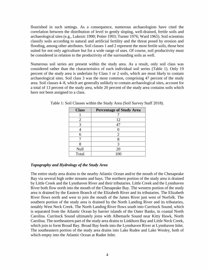
Numerous soil series are present within the study area. As a result, only soil class was
considered rather than the characteristics of each individual soil series (Table 1). Only 19
percent of the study area is underlain by Class 1 or 2 soils, which are most likely to contain
archaeological sites. Soil class 3 was the most common, comprising 47 percent of the study
area. Soil classes 4–8, which are generally unlikely to contain archaeological sites, account for
a total of 13 percent of the study area, while 20 percent of the study area contains soils which
have not been assigned to a class.
Table 1: Soil Classes within the Study Area (Soil Survey Staff 2018).
Class Percentage of Study Area
1 7
2 12
3 47
4 0
6 2
7 8
8 3
Null 20
Total 100
Topography and Hydrology of the Study Area
The entire study area drains to the nearby Atlantic Ocean and/or the mouth of the Chesapeake
Bay via several high order streams and bays. The northern portion of the study area is drained
by Little Creek and the Lynnhaven River and their tributaries. Little Creek and the Lynnhaven
River both flow north into the mouth of the Chesapeake Bay. The western portion of the study
area is drained by the Eastern Branch of the Elizabeth River and its tributaries. The Elizabeth
River flows north and west to join the mouth of the James River just west of Norfolk. The
southern portion of the study area is drained by the North Landing River and its tributaries,
notably West Neck Creek. The North Landing River flows south into Currituck Sound, which
is separated from the Atlantic Ocean by barrier islands of the Outer Banks, in coastal North
Carolina. Currituck Sound ultimately joins with Albemarle Sound near Kitty Hawk, North
Carolina. The northeastern part of the study area drains to Linkhorn Bay and Little Neck Creek,
which join to form Broad Bay. Broad Bay feeds into the Lynnhaven River at Lynnhaven Inlet.
The southeastern portion of the study area drains into Lake Rudee and Lake Wesley, both of
which empty into the Atlantic Ocean at Rudee Inlet.

5
The topography of the study area is generally low lying, characterized by little topographic
relief, as is typical of the outer Coastal Plain. Ephemeral and seasonal drainages in the study
area coalesce into larger (second and third order) tributaries over relatively short distances
before emptying into the major streams draining the area. Poorly drained wetland areas,
swamps, and marshes are common, and large bays exist near the mouths of the major streams.
Stream gradients in the area are low due to the nature of the underlying sediments and the tidal
influence of the region.
Existing Conditions within the Study Area
Existing conditions vary greatly within the study area. Current land use in the northern portion
of Virginia Beach ranges from residential to commercial and industrial, with small rural and
agricultural areas and several parks preserving natural or nearly natural environments.
Conditions in various portions of the overall study area are discussed in greater detail in a
subsequent section of this report.
Previous Cultural Resource Surveys
A total of 84 previous Phase I archaeological surveys have been undertaken within the present
study area. The surveys date from as early as 1976, and range from general cultural resource
surveys to surveys of transportation improvement projects, utility installations, and wetland
mitigation site locations. They are summarized in Table 2, below.
Table 2: Previous Archaeological Surveys in the Study Area.
DHR
Report
Number
Report Title Author(s)/
Organization Year
CS-019
Phase I Cultural Resource Survey of the
Proposed Build Alternatives for the
Southeastern Expressway in the Cities of
Chesapeake and Virginia Beach, Virginia
Jerome D. Traver,
Maryanna Ralph 1989
CS-034
Phase I Archeological Survey of
Approximately 2,000 Acres at Naval Air
Station Oceana, Virginia Beach, Virginia, and
Naval Auxiliary Landing Field Fentress,
Chesapeake City, Virginia
Michael B.
Hornum et al 1994
CS-044
Additional Phase I Cultural Resource Survey
of Revised Alignments for Proposed
Southeastern Expressway, Cities of
Chesapeake and Virginia Beach, Virginia
Thomas Higgins,
Anne Beckett,
Veronica Deitrick
1994
CS-045
Archaeological Survey Improvements to
Lynnhaven and Volvo Parkways, Cities of
Virginia Beach and Chesapeake, Virginia
Ellen Mayo,
Loretta
Lautzenheiser
1997

6
DHR
Report
Number
Report Title Author(s)/
Organization Year
CS-078
Archaeological Survey, Proposed Southeastern
Parkway and Greenbelt, Cities of Chesapeake
and Virginia Beach, Virginia
Daniel Baicy,
Loretta
Lautzenheiser,
Michael Scholl
2005
NH-003
Appendix B (Nonpublic) of the Draft
Environmental Impact Statement (DEIS) for
Alternative Location of a Landing Craft Air
Cushion (LCAC) Operational Base on the East
Coast of the United States
Martin F.
Dickinson, Lucy
B. Wayne
1983
NH-014
Marine Magnetometer Survey of The Parallel
Crossing of the Chesapeake Bay Project,
Virginia Beach-Northampton County, Virginia
Steven D. Hoyt et
al 1992
NH-016
Parallel Crossing of Chesapeake Bay, Phase I
Underwater Archaeology, Magnetic Anomaly
Ground Truthing
Steven D. Hoyt
and James S.
Schmidt
1993
NN-025
Phase I Archeological Survey for Fort Eustis
and Fort Story, Cities of Newport News and
Virginia Beach, Virginia
Antony F.
Opperman,
Harding Polk II
1989
NR-003
An Archaeological and Historical Survey of
the Cultural Resources at Newtown, Norfolk,
Virginia
J. Mark
Wittkofski,
Martha W.
McCartney,
Beverly Bogley
1979
NR-049
Phase I Cultural Resources Survey of the
Proposed Norfolk/Virginia Beach Light Rail,
Cities of Norfolk and Virginia Beach, Virginia
Bradley Bowden,
Ashley Neville,
Jerrell Blake
1998
NR-065
An Archaeological Survey of the Proposed I-
64/I-264 Interchange Project, Cities of Norfolk
and Virginia Beach, Virginia
Elizabeth Monroe 2008
NR-074
Supplemental Archaeological Survey of the
Proposed I-64/I-264 Interchange Project, Cities
of Norfolk and Virginia Beach, Virginia
Elizabeth Monroe 2009
VB-009 An Initial Archaeological Survey of Haygood
and Newtown Roads, City of Virginia Beach John Saunders 1976
VB-011
Draft Final Ecological Evaluation for the Fleet
Combat Training Center Atlantic, Dam Neck,
Virginia Beach, Virginia. Appendix A
EDAW, Inc. 1982
VB-012
Cultural Resources Survey of the Phase I
Wetlands Mitigation Site FCTC, Dam Neck,
Virginia
Water and Air
Research, Inc. 1984
VB-015
An Archaeological Survey of the Virginia
National Guard Camp Pendleton Training
Camp Site, City of Virginia Beach, Virginia
United States
Department of
Military Affairs
1987

7
DHR
Report
Number
Report Title Author(s)/
Organization Year
VB-017
A Phase I Archaeological Reconnaissance
Survey of the Proposed Improvements to the
Entrance to Oceana Naval Air Station, Virginia
Beach, Virginia
J. Mark
Wittkofski 1980
VB-018
Phase I Cultural Resources Survey of Highway
Improvements Along Dam Neck Road in the
City of Virginia Beach, Virginia
Douglas C.
McLearen 1987
VB-024
Review and Compliance Phase I
Reconnaissance Summary: Barberton Drive
Apartment Complex
Keith Bott 1980
VB-025
Review and Compliance Phase I
Reconnaissance Summary: North Landing
River Bridge Replacement
Keith Bott 1980
VB-032
Phase I Cultural Resource Survey, Old
Landstown Road Tract, Virginia Beach,
Virginia
Jerome D. Traver 1991
VB-033 A Phase I Cultural Resource Evaluation of a
Section of Route 165, Virginia Beach, Virginia
Earl E. Proper,
Martha
McCartney
1987
VB-034
A Cultural Resources Assessment of Two
Areas, U. S. Navy, Fleet Combat Training
Center Atlantic, Dam Neck Virginia Beach,
Virginia
United States
Army Corps of
Engineers 1987
VB-035
An Archeological Survey of the Naval
Amphibious Base Annex, Camp Pendleton,
Virginia Beach, Virginia
United States
Army Corps of
Engineers 1987
VB-036
A Cultural Resource Survey of a Proposed
Wetlands Mitigation Site, U. S. Navy Fleet
Combat Training Center Atlantic, Dam Neck
Virginia Beach, Virginia
United States
Army Corps of
Engineers 1987
VB-037
Phase I Cultural Resource Survey Along
Proposed Improvements to Oceana Boulevard
in Virginia Beach, Virginia
Christopher
Egghart and Luke
Boyd
1991
VB-038
Phase I Archaeological Survey of a Proposed
U. S. Navy Construction Project at Owl Creek
in Virginia Beach, Virginia
Stanley B.
Bussey, Jerome
D. Traver
1992
VB-039
A Phase I Cultural Resource Survey of Three
Proposed Alternate Routes for the Extension of
South Plaza Trail, Between Princess Anne and
Independence Roads, Virginia Beach, Virginia
Bruce A. Hunter 1989

8
DHR
Report
Number
Report Title Author(s)/
Organization Year
VB-043
Cultural Resources Assessment for the
Proposed Aircraft Fuel Storage Site (P-412),
Naval Air Station Oceana, Virginia Beach,
Virginia
Marie G. Cottrell 1993
VB-044
Phase I Cultural Resource Survey and Visual
Impact Assessment of the Interstate 64 HOV
Lanes (Median Strip), Virginia Beach and
Chesapeake, Virginia
Jerome D. Traver 1993
VB-045
Phase I Archeological Investigations for
Proposed Vegetation Maintenance/
Management Areas and a Proposed Wetlands
Restoration Project, Naval Air Station,
Oceana, Virginia Beach, Virginia
R. Christopher
Goodwin 1993
VB-046
Phase I Cultural Resource Survey Route 190,
Cities of Chesapeake and Virginia Beach,
Virginia
Virginia Busby
and Leslie
Bashman
1993
VB-047 Phase I Cultural Resource Survey, Birdneck
Road, City of Virginia Beach, Virginia
Virginia Busby
and Leslie
Bashman
1993
VB-050
Phase I Cultural Resources Survey of Proposed
Improvements to London Bridge Road in
Virginia Beach, Virginia
Robin L. Ryder et
al 1994
VB-051 Phase I Archaeological Survey of Bayville
Farms, Virginia Beach, Virginia Perry McSherry 1993
VB-054
Phase I Archaeological Survey of the
Corporate Woods Property, City of Virginia
Beach, Virginia
Bradley M.
McDonald and
Garrett R. Fesler
1994
VB-058
Phase I Archaeological Survey Improvements
to Laskin Road; Route 58, Virginia Beach,
Virginia
Mary Ann Holm
et. al 1995
VB-059
Phase I Archaeological Survey of Twelve
Acres and Phase II Archaeological
Significance Evaluation of 44VB240-241-242
at the Great Neck Point Disposal Area, City of
Virginia Beach, Virginia
Bradley M.
McDonald and
Matthew R. Laird
1996
VB-064
Phase I Archaeological Identification Survey
in Support of 1995 Base Realignment and
Closure, Naval Air Station Oceana, Virginia
Beach, Virginia
Leonid I.
Shmookler 1996
VB-066
An Addendum to Phase I Cultural Resource
Study of Proposed Improvements to Oceana
Boulevard and First Colonial Road in Virginia
Beach, Virginia
Mary Ellen
Hodges, Margaret
L. Stephenson
1997

9
DHR
Report
Number
Report Title Author(s)/
Organization Year
VB-069
Phase I Archaeological Survey of Proposed
Landstown-West Landing, 230 KV
Transmission Line, Virginia Beach, Virginia
Kenneth E. Stuck,
Thomas F.
Higgins
1997
VB-071
A Supplemental Identification Survey of
Proposed Oceana Boulevard-First Colonial
Road Project, Virginia Beach, An Addendum
to Phase I Cultural Resource Survey Along
Proposed Improvements to Oceana Boulevard
In Virginia Beach, Virginia
Kenneth E. Stuck 1997
VB-079 Archaeological Survey along a Portion of
Holland Road (Route 410)
Robert Clarke,
Bradley Bowden 2000
VB-082
Archaeological Identification Survey, Princess
Anne Road and Ferrell Parkway, City of
Virginia Beach, Virginia
Ellen M. Brady,
Loretta
Lautzenheiser
2000
VB-084
Phase I Archaeological Survey of Indian River
Road and Elbow Road, City of Virginia Beach,
Virginia
Carol D. Tyrer,
Martha
McCartney
1998
VB-086
Archaeological Survey Associated with the
Proposed Nimmo (Ferrell) Parkway Project,
City of Virginia Beach, Virginia
Stevan C. Pullins 2002
VB-087
Phase I Archaeological Survey of
Approximately 583 Acres at Naval Air Station
Oceana, Virginia Beach, Virginia
Christopher R.
Ploglase 1996
VB-088
Archaeological Survey of Route 165 (Princess
Anne Road) Between Dam Neck Road and
Judicial Boulevard, Virginia Beach, Virginia
Lee Tippett 2002
VB-091
Phase I Archaeological Identification Survey
in Support of 1995 Base Closure and
Realignment, Naval Air Station Oceana,
Virginia Beach, Virginia
Leonid I.
Shmookler 1996
VB-093
Cultural Resource Survey of the Proposed
Realignment of the Current Intersection of
Route 165 (Princess Anne Road) and Route
190 (Kempsville/Witchduck Road), City of
Virginia Beach, Virginia
Brad M.
Duplantis, Eric
Griffits
2003
VB-095
Archaeological Identification Survey and
Archaeological Evaluations of Nine Sites
Along the Proposed Landstown-West Landing
230 KV Transmission Line, City of Virginia
Beach, Virginia
Bradley
McDonald 2002
VB-097
Supplemental Archaeological Survey of Two
Canals within the Proposed Realignment of
Elbow Road, City of Virginia Beach, Virginia
Bruce R. Penner 2003

10
DHR
Report
Number
Report Title Author(s)/
Organization Year
VB-098
Phase I Archaeological Identification Survey
of the Proposed 3-Module Hangar and Parking
Apron Expansion, Naval Air Station Oceana,
Virginia Beach, Virginia
Leonid I.
Shmookler 1997
VB-099
Phase I Archaeological Identification Survey
of the Proposed Security Improvements (P-
445/P-509), NAS Oceana, Virginia Beach,
Virginia
Todd L. Jensen 2003
VB-100
Phase I Archaeological Survey of Portions of
the Highland Parish Tract, Virginia Beach,
Virginia
Clifton A.
Huston, Peter W.
O'Hara
2003
VB-102
Archaeological Survey of the Proposed Small
Arms Range (MILCON P-259), NAS Oceana
Annex Dam Neck, Virginia Beach, Virginia
Joe B. Jones,
Todd L. Jensen 2003
VB-104
Cultural Resources Survey, Proposed
Improvements, Sandbridge Road, City of
Virginia Beach, Virginia
Ellen M. Brady,
Joanna Carter
Jones, Loretta
Lautzenheiser
1998
VB-106
Cultural Resources Identification Survey
Atlantic Wastewater Treatment Plant, Virginia
Beach, Virginia
Keith T. Heinrich,
Loretta
Lautzenheiser
2005
VB-108 Archaeological Identification Survey, City
Line Interchange, Virginia Beach, Virginia
Tom Bailey,
Susan Bamann 2005
VB-110
Phase I Archaeological Survey of the Five
Forks Training Area and Phase II Evaluation
of Site 44VB89, Fort Story, Virginia
Fort Eustis
Environmental
Division 2005
VB-112
Archaeological Identification Survey,
Proposed Improvements to Shore Drive,
Virginia Beach, Virginia
Susan Bamann,
Bill Hall 2006
VB-118
Phase I Survey of the First Landing
Reenactment Site and a Brief Review of
Proposed Events, Fort Story, Virginia
Fort Eustis
Environmental
Division
2006
VB-122
Reconnaissance Archaeological Survey at
Various Navy Region Mid-Atlantic Family
Housing Complexes in Virginia
Bradley
McDonald 2003
VB-123
An Archaeological Survey of the Proposed I-
264/Lynnhaven and Great Neck Interchanges
Project, City of Virginia Beach, Virginia
Elizabeth
Monroe, Sean
Devlin
2007
VB-124
Phase I Cultural Resources Survey for the
Proposed Realignment of West Neck Road
Between North Landing Road and Indian
Ridge Road in the City of Virginia Beach,
Virginia
Garrett Fesler,
Matthew Laird 2006

11
DHR
Report
Number
Report Title Author(s)/
Organization Year
VB-125
Phase I Archaeological Survey of the State
Military Reservation, 83.81 ha (207 Acres) at
Camp Pendleton, Virginia Beach, Virginia
Wayne C.J.
Boyko, Beverly
Boyko
2008
VB-126
Construction of Two New Buildings, a Parking
Lot, and the Rehabilitation of Bunker 309, Fort
Story, Virginia
Fort Eustis
Environmental
Division
2006
VB-127
Archaeological Survey of Regional Health
Professions Center, Phase I, Virginia
Community College System, Tidewater
Community College, Virginia Beach Campus,
City of Virginia Beach, Virginia
Tracey Jones,
Blair Toombs,
Eric Voigt
2009
VB-128
Archaeological Survey of Learning Resource
Center, Phase I, Virginia Community College
System, Tidewater Community College,
Virginia Beach Campus, City of Virginia
Beach, Virginia
Tracey Jones,
Eric Voigt 2009
VB-129
Archaeological Characterization Study of Fleet
Training Center Dam Neck, Virginia Beach,
Virginia
Timothy Sara 2008
VB-130
Cultural Resources Survey Proposed Lesner
Bridge Replacement, City of Virginia Beach,
Virginia
Dennis Gosser,
Jennifer Stewart,
Bill Hall
2009
VB-132
Submerged Cultural Resource Remote-Sensing
Survey Lesner Bridge Replacement Corridor,
Lynnhaven Inlet, Virginia Beach, Virginia
Gordon Watts 2009
VB-133 Archaeological Survey of the Proposed Stone
Breakwater/Revetment, Fort Story, Virginia Courtney Birkett 2009
VB-135 Archaeological Survey of the Proposed Child
Development Center, Fort Story, Virginia Courtney Birkett 2009
VB-136
Cultural Resource Management of GMH
Military Housing RCI Undertakings at Fort
Story, Virginia
Fort Eustis
Environmental
Division
2006
VB-137
Archaeological Survey of South Parcel and
Evaluation of Archaeological Sites 44VB345
and 44VB346, Fleet Training Center Dam
Neck, Virginia Beach, Virginia
Debra Wells,
Bruce Nodine,
Robert Austin,
Nicholas Linville
2010
VB-143
Phase I Archaeological Investigation of
Approximately 170 Acres at Naval Air Station
Oceana, Virginia Beach, Virginia
Christopher
Clement 2011

12
DHR
Report
Number
Report Title Author(s)/
Organization Year
VB-145
Survey of the Architectural and Archaeological
Cultural Resources at the Virginia Air National
Guard Installations at the Richmond
International Airport, Henrico County and the
State Military Reservation, Camp Pendleton,
City of Virginia Beach, Virginia
Ann Markell,
Katherine
Kuranda,
Katherine
Grandine, Nathan
Workman
2007
VB-146
Phase I Cultural Resources Survey of Marine
Animal Care Facility Tract, City of Virginia
Beach
Amy Humphries,
Dawn M. Frost,
Carol D. Tyrer
2011
VB-147
A Phase I Cultural Resources Survey of 98.664
Acres at Marshview Park in the City of
Virginia Beach, Virginia
Garrett Fesler,
Matthew Laird 2011
VB-149
Phase I Archaeological Investigation of
Approximately 174 Acres at Naval Air Station
Oceana, Virginia Beach, Virginia
Christopher Ohm
Clement 2012
VB-150
Phase I Cultural Resource Survey of the
Centerville Turnpike Improvement Area,
Virginia Beach, Virginia
Kerri Barile, Earl
Proper, Danae
Peckler, Mike
Klein, Emily
Calhoun
2012
VB-151
A Phase I Cultural Resources Survey of
Approximately 13 Acres at 4081 Elbow Road
in the City of Virginia Beach, Virginia
Donald Sadler,
Sandra DeChard,
Aimee Leithoff,
Ellen Brady
2012

13
HISTORIC CONTEXT
Virginia’s Native American prehistory typically is divided into three main periods,
Paleoindian, Archaic, and Woodland, based on changes in material culture and settlement
systems. Recently, the possibility of a human presence in the region that pre-dates the
Paleoindian period has moved from remote to probable; for this reason, a Pre-Clovis discussion
precedes the traditional tripartite division of Virginia’s Native American history. All dates in
this section are presented as years before present (B.P.), with “present” defined by convention
as the year 1950. The seventeenth-through-twentieth-century historical overview follows the
Virginia Department of Historic Resources (2017) guidelines. The cultural context, as defined
by the Secretary of the Interior’s Standards and Guidelines for Archaeology and DHR’s 1992
How to Use Historic Contexts in Virginia: A Guide for Survey, Registration, Protection, and
Treatment Projects, provides the historic social and environmental information required for
evaluation of any archaeological and architectural resources present within the study area.
Pre-Clovis Period (? to 14,950 B.P.)
The 1927 discovery, at Folsom, New Mexico, of a fluted point in the ribs of an extinct species
of bison proved that ancient North Americans had immigrated during the Pleistocene. It did
not, however, establish the precise timing of the arrival of humans in the Americas, nor did it
adequately resolve questions about the lifestyle of those societies (Meltzer 1988:2–3). Both the
stratigraphic record and the radiocarbon assays from several sites, including the recently
excavated Cactus Hill site, suggest the possibility of human occupation of Virginia before the
fluted-point makers appeared on the scene (Boyd 2003; McAvoy and McAvoy 1997). Buried
strata at the Cactus Hill Site, in Sussex County, Virginia, have returned radiocarbon dates of
15,000 years ago from strata situated below levels containing fluted points (McAvoy and
McAvoy 1997:165).
McAvoy’s team encountered artifacts and charcoal separated from the Paleoindian period level
by 3.0 to 4.0 inches (7.6 to 10.2 cm) of sterile sands. Subsequent fieldwork confirmed the
presence of artifact-bearing strata located between 3.0 and 8.0 inches (7.6 and 20.3 cm) below
the fluted-point levels. The artifacts recovered from the pre-fluted-point levels present a
striking contrast with the tool kit typically used by Paleoindians. Rather than relying on
extensively finished chert knives, scraping tools, and spear points, the Pre-Clovis peoples used
a different but highly refined stone technology. Prismatic blade-like flakes of quartzite,
chipped from specially prepared cobbles and lightly worked along one side to produce a sharp
edge, constitute the majority of the stone cutting and scraping tools. Sandstone grinding and
abrading tools, possibly indicating production of wood and bone tools or ornaments, also
occurred in significant numbers in the deepest artifact-bearing strata (Boyd 2003; Carr 2018;
McAvoy and McAvoy 1997).
Because these tools do not possess unique characteristics which immediately identify them as
dating to the Pleistocene, archaeologists must recognize the possibility that Pre-Clovis period
sites have been overlooked for years. At present, only a handful of potential Pre-Clovis period
sites have been identified in North America (Boyd 2003; Carr 2018).

14
Paleoindian Period (14,950 to 9950 B.P.)
In the decades following the discovery at Folsom, New Mexico, the association of fluted points
with the bones of large, extinct mammals, in particular mastodons, on the western plains
coupled with the scarcity of other Paleoindian period sites, led to the inference that the
Paleoindian period subsistence strategy centered on the pursuit of big-game. This picture,
however, exaggerates the reliance of western Paleoindian groups on large game, and appears
to be of limited relevance to eastern Paleoindian life. The archaeological data from Virginia
compiled by Dr. Ben McCary records numerous discoveries of fluted points, but no
unambiguous association between extinct large game and fluted points (Boyd 1989:139). A
similar situation occurs throughout the eastern United States. For this reason, many
archaeologists now hold that eastern Paleoindians were generalized foragers (e.g., Gingerich
2011; Grayson and Meltzer 2003; but see Fiedel and Haynes 2004).
Most large Paleoindian period sites in the southeastern United States are quarry or quarry
related (Meltzer 1988:21), though multiple band aggregation sites also occur (McAvoy
1992:145). Recognizable sites most often result from long-term habitation or repeated use of
the same location. It follows from the presence of primarily quarry or quarry-related sites that
stone outcrops were regularly revisited. For example, the Thunderbird Site in the Shenandoah
Valley (Gardner 1974, 1977) and the Williamson Site in south-central Virginia (McCary 1951,
1975, 1983) rank among the most important Paleoindian period sites in Virginia, and in the
eastern U.S. as a whole. Both sites represent large camps associated with local sources of high-
grade cryptocrystalline lithic materials (Gardner 1981, 1989).
Though the full range of available lithic resources was used to manufacture fluted points (e.g.,
Phelps 1983), a number of studies have noted a focus on cryptocrystalline materials (e.g., chert,
jasper, chalcedony) (Gardner 1974, 1989; Goodyear 1979). The recovery of cryptocrystalline
materials at locations far removed from quarries indicates exchange, extensive group
movement, or both characterized the Paleoindian era. In addition, the very limited differences
between sites and within sites suggest that most people had access to all available resources,
while the small size of most Paleoindian period sites indicates group size generally was limited
to extended families.
In concert, the evidence suggests wide-ranging mobility and a social order involving low-level
inter- and intra-group exchange and limited, if any, status differences between and within
groups. Ethnographers have grouped such societies under the rubric of the “foraging mode of
production.” Such societies, notably the San of the Kalahari, are fiercely egalitarian, resisting
attempts to garner individual power through a combination of ridicule, sharing, and a fission-
fusion pattern of settlement. If all else fails, egalitarian hunter-gatherers “vote with their feet,”
moving away from the offending individuals (Lee 1979). The combination of high mobility,
the absence of domesticated crops, and an egalitarian ideology precludes construction of
elaborate housing, extensive storage facilities, and accumulation of non-portable goods.
Some researchers discuss the Paleoindian period as a single entity (Dent 1995) while others,
mostly in the Southeast, divide it into three sub-periods based on morphological differences in
projectile point manufacture and technology (e.g., Anderson 1990; Daniel 1998). Gardner
(1989:9) adopted an intermediate position, recognizing continuity within the stylistic changes

15
in Paleoindian point form that contrasts with “a definite break between unnotched lanceolate
and notched triangular form…at 8000 B.C.”
The DHR’s V-CRIS system lists Paleoindian period components for three archaeological sites
in Virginia Beach, and Turner (1989:80) reported no more than ten fluted points from any
Virginia Coastal Plain county near the James River, in his survey of Paleoindian Period
settlement in Virginia.
Archaic Period (9950 to 3150 B.P.)
The Archaic period began with the northward retreat of periglacial environments and the
appearance of archaeological assemblages lacking fluted points. In the Chesapeake Bay region,
a shift from moist, cool conditions to a warmer, drier climate accompanied the glacial retreat.
In response to changing climatic conditions, in particular the receding ice-sheets (Barber 2003;
Boyd 2003), Chesapeake Bay sea levels rose continuously from roughly 15,000 years ago to
the present. Simultaneously, local subsidence of the earth’s crust also may have contributed to
the formation of the Chesapeake Bay and Albemarle Sound. Between 15,000 and 14,000 years
ago, the waters of the Atlantic began to submerge portions of the continental shelf. For every
foot (30 cm) of sea level rise, approximately 1,675 feet (510 m) of the shelf were inundated.
Ten thousand years ago the sea began to flood the mouth of the ancestral Susquehanna River,
located near the present day mouth of Chesapeake Bay. Sea level rose at 0.1 inch (0.2 cm) per
year between 8,000 and 3,000 years ago. At 8,000 years ago, the head of the ancestral bay was
near Smith Island, at 5,000, near Annapolis, and by 3,000 years ago, it had reached the
Sassafras River (Brush 1986:149). Numerous archaeologists suggest that the stabilization of
water levels in the bay at this time provided the necessary conditions for the development of
extensive shellfish beds and habitats favorable for anadromous fish (e.g., Waselkov 1982).
After approximately 2950 B.P., sea level rise slowed to approximately 0.5 inch (0.12 cm) per
year, and the Chesapeake Bay approached its present contours (Brush 1986:149; Dent
1995:69–95). As sea levels stabilized, the region’s rivers also approximated the modern
configuration and, at a broad scale, essentially modern environments emerged (Barber 2003;
Blanton 2003; Tolley 2003).
In eastern Virginia, a more temperate climate characterized by greater seasonal variation in
temperatures emerged as the Chesapeake estuary formed (Dent 1995:147). Vegetation changed
from the patchy forest that lacked modern analogs to a mixed conifer-deciduous forest. An
essentially modern floral assemblage is inferred based on pollen data from contexts dating as
early as 6000–5000 B.P. (Brush 1986:151; Webb 1988:405), though relative abundances of
taxa fluctuated thereafter. During the Holocene, as paleoclimatologists term the post-
Pleistocene epoch, humans responded to emerging differences in the availability of resources
over the course of the year via increasing seasonal mobility.
In addition, in contrast with the broad similarity among Paleoindian period point forms, distinct
style zones developed during the Early and Middle Archaic periods (9950–5450 B.P.). The
Atlantic Coast/Southeastern stylistic sequence was not characteristic of the Midwest (Ford
1974:392). In addition, increased use of locally-available lithics occurred between 9,950–5,450
B.P. (Custer 1990:36; Sassaman et al. 1988:85–88). The reduction of the size of style zones

16
and the focus on local lithic materials implies contracting social networks and incipient
territories, possibly a reaction to population growth (Anderson and Hanson 1988:271).
Despite changes in patterns of mobility and point form, numerous archaeologists argue on
environmental (Custer 1990:2–8) and subsistence (Smith 1986) grounds for continuity in
social dynamics between 11,950 and 7950 B.P. From this point of view, Dalton through Lecroy
populations exhibit "general similarities and regional habitat-related variation in settlement-
subsistence patterns and material culture assemblages" (Smith 1986:10). Band-level social
organization involving seasonal movements corresponding to the seasonal availability of
resources and, in some instances, shorter-interval movement characterized Archaic period
societies.
Reliance on ground-stone technology increased during the Archaic period. New tool categories
associated with the Archaic period include celts, net sinkers, pestles, pecked stones, and axes.
Archaic period knappers produced chipped-stone versions of celts and axes and, near the end
of the Late Archaic period, labor-intensive vessels carved from soapstone quarried in the
Piedmont formed an important segment of assemblages (Geier 1990; McLearen 1991).
Underwood et al. (2003) and Gallivan et al. (2006) identified only low frequencies of Archaic
period material during large-scale surveys along the York River. Although a limited number
of Archaic sites occurred on the floodplain of the York River and near the mouth of the tidal
creeks, site density peaked in the interior of the Naval Weapons Station, Yorktown (NWSY).
Archaic period sites clustered on upland flats and ridges in two modes, 700–1,100 feet and
2,700–3,200 feet (231.3–335.3 m and 823.0–975.4 m) from the York River. Drowned and
reconfigured shorelines as a consequence of sea level rise throughout the Archaic period
undoubtedly explain at least part of the observed pattern. The data also imply that the
Chesapeake Region’s inhabitants lived in relatively small groups that ranged over broad
territories for most of the year (Underwood et al. 2003).
Early Archaic Period (9950 to 8450 B.P.)
Corner-and side-notched points with serrated blades predominate at the beginning of the Early
Archaic period, reflecting innovation in hafting technology and, possibly, the invention of the
atlatl. Notched point forms include Palmer and Kirk Corner-Notched and, in localized areas,
various side-notched types. Around 8,950 B.P., a variety of bifurcate base projectile point
forms appeared in the Middle Atlantic region. In eastern Virginia, Lecroy points constitute the
majority of bifurcate forms (Dent 1995; Justice 1995).
Some researchers portray the Early Archaic period as a continuation of the Paleoindian period,
characterized by reliance on cryptocrystalline lithic material and similar settlement and
subsistence patterns (Gardner 1989). Within the James River valley, there appears to have been
an increase in population that began during the Early Archaic period (Mouer 1990:24).
Elsewhere in the Middle Atlantic region, however, population growth perhaps began during
the Middle Archaic period (Dent 1995).

17
Middle Archaic Period (8450 to 4950 B.P.)
The appearance of stemmed projectile points and a shift towards more expedient use of stone
marks the beginning of the Middle Archaic period across much of the Atlantic Slope and
Southeast (Amick and Carr 1996:43–45; Justice 1995). In this area of Virginia, the most
common Middle Archaic period projectile point types are (from oldest to most recent) LeCroy,
Stanly, Morrow Mountain and Guilford, followed by the side-notched Halifax type sometime
after 5450 B.P. Informal modified flakes to some extent replaced formal unifacial tools, and
local materials constitute a greater percentage of Middle Archaic period assemblages than had
been true of earlier time periods. Sites occur throughout the landscape, including beneath the
now-inundated Chesapeake Bay (Blanton 1996; Dent 1995:173–178).
Late Archaic Period (4950 to 3150 B.P.)
Stemmed and notched knife and spear point forms, including various large, broad-bladed
stemmed knives and projectile points (e.g., Savannah River, Susquehanna, Perkiomen points),
rank among the most distinctive and securely dated Late Archaic period point forms (Coe
1964; Dent 1995; Justice 1995; Ritchie 1971). Marked increases in population, and, in some
areas, decreased mobility appear to characterize the Late Archaic period throughout eastern
North America. Locally, the increase in the number of Halifax and Savannah River
components and sites relative to the preceding periods suggests population rose in Virginia
between about 5450 B.P. and circa 3150 B.P.
Mouer (1991a:262) believes it likely that “at least intensive harvesting of wild seeds,” if not
the beginnings of domestication, characterized Transitional through Early Woodland period
times (circa 4000–2500 B.P.) in the Chesapeake Bay region, as it did in the Midwest. The
process, however, did not proceed at an even rate across the Eastern Woodlands or the Middle
Atlantic Region (Stewart 1995:184–185). Yarnell (1976:268), for example, states that
sunflower, sump weed, and possibly goosefoot may have been cultivated as early as 4000 B.P.
In the lower Little Tennessee River valley, the remains of squash have been found in Late
Archaic period Savannah River contexts (circa 4450 B.P.), with both squash and gourd
recovered from Iddins period contexts of slightly more recent date (Chapman and Shea
1981:70). Experiments with domestication in the Mid-Continent indicate the possibility, even
the likelihood, that the inhabitants of the Middle Atlantic cultivated small grains and other
plants (Hodges 1991:228–230; Mouer 1991b:259–263). “Scant” evidence for early cultivation
appears in the archaeological record from Virginia (Mouer 1991a:259; see also Blanton
2003:193; Gallivan and McKnight 2006).
Soapstone bowls are a well-known feature of Late Archaic period exchange systems
(McLearen 1991:107–108). In addition, Stewart (1989: 52) argues for broad-based exchange
of "artifacts made from jasper, argillite, rhyolite, ironstone, soapstone, midwestern lithics,
obsidian, marine shell and copper" throughout the Middle Atlantic region during the Late
Archaic period. Thus, Late Archaic period society clearly differed from that of earlier times.
The production and wide-spread exchange of utilitarian and ritually important, labor-intensive
goods does not fit the expected archaeological signature of highly egalitarian foragers. Rather,
a social order exhibiting some sort of status differences among individuals or groups (Mouer
1991a:265) and somewhat restricted group movement (Stewart 1989:57) likely existed.

18
Sites dating to the Late Archaic period occur frequently throughout Virginia and the Middle
Atlantic region. Late Archaic period sites occur in greater numbers and in a wider range of
environments than sites associated with the Early and Middle Archaic periods (Klein and
Klatka 1991). Blanton (2003) reports large numbers of Terminal Archaic period sites, many
including broadspears and soapstone bowl sherds in the assemblage, along the margins of the
Dismal Swamp.
Woodland Period (3150 to 350 B.P.)
Increasing use of ceramic technology, a growing dependence upon horticulture, and a shift
toward greater sedentism all characterize the Woodland period. Most researchers divide the
Woodland period into three sub-periods (the Early Woodland period, the Middle Woodland
period, and the Late Woodland period), based primarily on stylistic and technological changes
observed in ceramic wares and projectile points, as well as shifts in settlement patterning (e.g.,
Gardner 1982). Not all researchers agree with this tripartite subdivision, however (e.g., Custer
1989).
Early Woodland Period (3150 to 2450 B.P.)
The onset of the Woodland period traditionally correlates with the appearance of ceramics
(Willey and Phillips 1958:118). Early theorists linked ceramics with agriculture, though few
continue to support this position (cf. reviews in Egloff 1991; Hodges 1991). Rather, the
evolution of subsistence and technological systems (e.g., Gardner 1982) and various aspects
of pan-Eastern interaction (e.g., Egloff 1991; Klein 1997) currently are believed to underlie
the evolution of ceramic containers.
The steatite-tempered Marcey Creek type and variants containing other mineral inclusions
appear to date between 3200 and 2800 B.P. (Egloff 1991:244–5). However, though friable
sand-and-grit-tempered Accokeek Creek and Elk Island ceramics appear stratigraphically
subsequent to Marcey Creek, associated C-14 dates range from 3000 through 2500 B.P. Klein
and Stevens (1996) cite regional data to support the proposition that, while the thickness,
amount of temper, and size of temper in quartz/sand-tempered, cord-marked ceramics shifted
over time, similar pots continued in use into Middle Woodland times (Klein 2003).
Radiocarbon dates recommend placement of the Calvert and Fishtail points in the Early
Woodland (Inashima 2008). Ovoid to lozenge-shaped points, classified as Teardrop Points,
have been dated to 2900−2000 B.P. in the Northeast (Mounier and Martin 1994). However,
similar points have been recovered from Middle Archaic through Middle Woodland I contexts
in North Carolina and Virginia (Kirchen 2001:53–69). The Potts Corner-Notched point type,
the Vernon point type, and the Claggett point type have been dated only through stratigraphic
context and/or association with early ceramics (Inashima 2008; Stephenson 1963). Similarly,
a variety of small stemmed and side-notched forms of assumed association with the Early
Woodland period lack definitive temporal assignment (Dent 1995:227–228).
Small bifaces and expedient tools such as drills, perforators, scrapers and utilized flakes
regularly appear in Early Woodland period assemblages. Other lithic artifacts reported on Early
Woodland period sites in the Chesapeake region include bipolar flakes possibly used as knives

19
or scrapers, hammerstones, net sinkers, mortars, and pestles (McLearen 1991). Also noted on
sites in the region are tools of bone, and projectile points manufactured from antler, bone,
turkey spurs, and shark’s teeth (Painter 1988; Waselkov 1982).
The increased number of sites dating to the Early Woodland period, coupled with the
recognition of structures, features, and activity areas at some sites, suggests rising population
size in the Chesapeake region (e.g., Mouer 1991b:38–39; Stewart 1995:183). In contrast,
noting that the addition of pottery to stone adds temporally diagnostic artifacts to the
archaeological record, Fiedel (2001:106–107) observes that more sites are expected to appear
in the archaeological record during Woodland period times. Furthermore, the various
Broadspears, dating to the Terminal Archaic period (circa 3950–2950 B.P.), represent a curated
technology (Barber and Tolley 1984), while replication experiments suggest stemmed bifaces
similar to Early Woodland types rank among the easiest forms to produce using quartz
(Bourdeau 1981). Therefore, a shift from a curated, hence less commonly discarded biface
form, to points easily produced from a ubiquitous material accompanied the appearance of
ceramics. Thus, the absence of a dramatic swell in the number of sites, coupled with decreased
representation of diagnostic point forms, indicates a demographic trough or at best a flat
demographic curve characterized the Early Woodland period.
In general, sparse concentrations of artifacts characterize Early Woodland period sites (Mouer
1990:160–174; Stewart 1998a:2). At several sites in the central James River valley, however,
notably Scott # 2 (44GO0040), dense accumulations of artifacts and midden soils have been
described (Mouer 1990:160–164). The rare occurrence of similar sites, combined with the
extremely large, fragile pots recovered by Mouer (1990:162) and the diversity of points
identified (Mouer 1990:161), seemingly indexes multi-band aggregations near the falls of the
James River. Mouer (1990), however, interprets 44GO0040 as evidence for the appearance of
village life during Early Woodland period times. Regardless, the preservation of an extensive
accumulation of Early Woodland period artifacts suggests the existence of a unique
geomorphological, and probably social, setting. Overall, the data appears to indicate a return
to the mobile, egalitarian social organization characteristic of Early and Middle Archaic period
times (Klein 2003). Even at large Early Woodland period sites post-dating 1150 B.P., very
limited evidence of long-distance exchange or the manufacture of labor-intensive artifacts
comparable to the soapstone exchange of the Terminal Archaic period appears.
The use of subterranean features such as storage pits, refuse pits, and cooking hearths is also
associated with the Early Woodland period. At the White Oak Point site, in the Rappahannock
River Coastal Plain, remains of hickory nuts, and various species of shellfish, fish, and deer
were recovered (Waselkov 1982). During the preceding Late Archaic period, increased
exploitation of oysters as a food source began at White Oak Point (44WM0119). Surveys along
the York River found that Early Woodland period sites continued the Archaic period pattern
of low-density, interior settlement (Underwood et al. 2003:393).
Middle Woodland Period (2450 to 1050 B.P.)
Popes Creek net-impressed ceramics appear after roughly 2450 B.P., marking the beginning
of the Middle Woodland I period (2450–1750 B.P.) (Blanton 1992:72–73; Egloff and Potter
1982:99). However, cordmarked ceramics and stemmed points continued in use for some time

20
after 1450 B.P. (McLearen 1992:44–45). Custer (1989:141–146), for example, lumps the
period between 4950 and 950 B.P. under the rubric Woodland I based on the similarity in
adaptation and the presence of considerable variation in the form of contemporaneous stemmed
and notched points.
Net-impressed surface treatments occur on a variety of ceramic types manufactured during
Middle Woodland period times. Pope’s Creek ceramics first appear after 2,450 B.P., coinciding
with the start of the Middle Woodland (Blanton 1992:72–3; Egloff and Potter 1982:99). Early
Woodland period cord-marked ceramics and stemmed projectile points are found in Middle
Woodland period contexts, suggesting a continued use of Early Woodland period technologies
(McLearen 1992:44–5). The Prince George and Varina types appear to represent a continuum
of development in the technology used to produced Popes Creek sherds, rather than
dramatically different types (Mouer et al. 1986). After 1750 B.P., shell-tempered net-
impressed, cordmarked, and plain pottery classified as the Mockley type becomes predominant
in the outer Coastal Plain of Virginia and Maryland, though generally similar sherds tempered
with grit continued in production as well (Johnson 2001:100).
The appearance of assemblages containing significant amounts of durable ceramics after 2450
B.P. indicates a shift in the organization of production occurred during the Middle Woodland
periods (Brown 1986, 1989). In addition to the advantages of ceramic vessels as cooking pots,
ceramic production contrasts with the manufacture of baskets and wooden bowls in its embrace
of economies of scale. Rather than a start-and-stop process that fits well into odd bits of time,
ceramic production required greater scheduling and continued attention over an extended
period of time. Shifts in the scheduling of work, therefore, accompanied the transition from
Early to Middle Woodland period times.
Broad-spectrum hunting-fishing-gathering continued to characterize the region as a whole
throughout the Middle Woodland. Shellfish, anadromous and resident fishes, deer, waterfowl,
and turkey ranked high among the important fauna in the Middle Woodland diet. Various nuts,
amaranth, and chenopod seeds also appear to be important resources during this period. After
2300 B.P., large shell middens containing dense concentrations of artifacts become
increasingly common, indicating repeated use of at least one type of site. Middens and the
presence of houses at a number of sites indicate longer stays, though populations remained far
from sedentary (Gallivan 2003, 2016). People continued to reside for much of the year in
relatively small settlements, and interior storage features rarely occur on Middle Woodland
sites (Gallivan 2003:75–98). In short, small groups continued to live within relatively small
settlements for much of the year during the Middle Woodland. Periodic aggregations brought
together groups for feasting, gift exchange, and the opportunity for marriage ties with residents
of other communities (Gallivan 2016:94).
Nevertheless, Mouer (1991a:262) believes it likely that “at least intensive harvesting of wild
seeds,” if not the beginnings of domestication, characterized Transitional through Early
Woodland times (circa 4000–2500 B.P.) in the Chesapeake Region, as it did in the Midwest
(Smith 2007, 2011). For example, in eastern North America in general, changes in the relative
frequency of gray squirrels versus fox squirrels in Late Archaic assemblages have been cited
as evidence that Native Americans encouraged the growth of nut- and mast-bearing trees;
similarly, the increase in the range and frequency of undomesticated maygrass, knotweed, and

21
little barley in archaeological assemblages circa 3000–2000 B.P. indicates encouragement, and
perhaps incipient domestication, of these weedy invaders of disturbed ground (Smith
2007:192). This process, however, proceeded at an even rate across neither the Eastern
Woodlands nor the Middle Atlantic Region (Stewart 1995:184–185). Experiments with
domestication in the Midcontinent indicate the possibility, even the likelihood, that the
inhabitants of the Middle Atlantic at least encouraged the growth of small grains and other
plants (Hodges 1991:228–230; Mouer 1991:259–263). “Scant” evidence for early cultivation,
however, appears in the archaeological record from Virginia (Blanton 2003:193; Mouer
1991:259). Nevertheless, the possible presence of Late Archaic storage pits in western Virginia
perhaps indicates intensification of the type of environmental manipulation that eventually led
to the appearance of cultivars like chenopodium in the region (Blanton 2003:194–195).
Temporal shifts in cordage-twist direction over the course of the Woodland period, primarily
a reflection of learning networks (Carr and Maslowski 1995), indicate increasing regional
social distance. These data imply a reduction of regular movements between spatially discrete
groups and a consequent increasing localization of learning networks. To the extent that social
networks became bounded, differences between groups in the region would have been
amplified (Boehm 1997:S108–S109).
Throughout Virginia, the Middle Woodland period is marked by the presence of “interregional
interaction spheres, including the spread of religious and ritual behaviors which appear locally
in transformed ways; localized stylistic developments that sprang up independently alongside
interregional styles; increased sedentism; and evidence of ranked societies or incipient ranked
societies” (McLearen 1992:55). Around 2450 B.P., stone and earth burial cairns and cairn
clusters in the Shenandoah Valley of Virginia mark the first appearance of elaborate burial
ceremonialism in Virginia, though not in the wider world of Eastern North America (McLearan
1992; Stewart 1992). The major upsurge in ceremonial activity occurred during the 850–1450
B.P. period. Sites containing elaborately decorated zoned-incised ceramics (Stewart 1998b)
and indications of extended mortuary ceremonies have been identified in the Chesapeake
region (e.g., Knepper et al. 2006:99–144).
The underlying tension between a cultural emphasis on community and equality and the
historical trajectory toward “inequality and competition inherent in big-man systems”
produced, according to Hantman and Gold (2002:288), cyclical fluctuations in exchange, ritual
activity, and sociopolitical complexity between 4950 and 300 B.P. Mortuary rituals and labor-
intensive or exotic artifacts at times created and reflected social distinctions in the Middle
Atlantic, but “the trajectory for individual markers of status continually appears to move in the
opposite direction toward more egalitarian or even access to goods and ritual status” (Hantman
and Gold 2002:290). Taken together, the data indicate that individuals and groups struggled to
maintain a balance between personal autonomy and equality as pressures on individuals and
groups increasingly highlighted the problems of highly egalitarian societies. The conflict
continued well beyond the appearance of horticultural villages, as demonstrated by the
emphasis on community and similarity in Late Woodland period secondary burials.
Blanton’s (1992:82–86) review of Middle Woodland period settlement patterns in the Coastal
Plain identified two major site types: the base camp and the procurement site. Base camps
range in size from those occupied by extended families to major aggregation sites. Aggregation

22
sites refer to large sites inhabited by multiple groups from throughout the region for varied
periods of time. Procurement sites, characterized by limited suites of artifacts, occur
throughout the landscape. Base camps occupied by extended families, in contrast, primarily
occupy productive settings along the larger rivers. Aggregation sites occur in an even more
restricted range of settings, primarily adjacent to productive oyster grounds or marshes in the
Coastal Plain (Stewart 1998b:171).
Floodplain stability increased after 1750 B.P. throughout the region, creating a greater
likelihood for the preservation of intact sites dating to the Middle Woodland II and Late
Woodland periods (Klein 2003). Previous studies on the James River and nearby parts of the
Chickahominy River demonstrate intensive use of small tributary streams as well as major
river floodplains throughout Middle Woodland period times. Typical Middle Woodland period
sites consist of the remnants of one or a few encampments occupied at various times during
the Middle Woodland period (e.g., Gallivan and Blouet 2001; Johnson et al. 1989). Studies
along the York River also demonstrate a striking increase in the frequency of sites dating to
the Middle Woodland period (Gallivan et al. 2006; Underwood et al. 2003).
Late Woodland Period (1050 to 350 B.P.)
Enormous changes transformed the social landscape of eastern North America in the centuries
after 900 B.P. Archaeological research in the Middle Atlantic indicates that population growth,
increased sedentism, a focus of settlement on the major rivers, heightened frequency of
regional exchange, more varied mortuary activities, the introduction of maize agriculture, and
increasingly focal exploitation of marine resources characterized the centuries between 900
and 350 B.P (Curry 2015; Gallivan 2003, 2006; Gold 2004; Hodges 2003; Klein and Magoon
2017; Mahoney 2009; Shephard 2015). Triangular projectile points, ubiquitous by 900 B.P.,
may decrease in size between 900 and 300 B.P., coincidental perhaps with heightened reliance
on the bow and arrow. Albemarle and other fabric-impressed sherds appear around 1300 B.P.
in central Virginia (Evans 1955). After roughly 500 B.P., Gaston and Roanoke Simple Stamped
sherds and thin, plain and cord-marked sherds classified as the Potomac Creek type appear in
the James River Valley (Gallivan 2003:138–143). Elaborately decorated and unelaborated
ceramic smoking pipes also appear during the Late Woodland period (e.g., Magoon 1999;
Stephenson 1963). Bone was used for utilitarian and other items, including pins, fishhooks,
and flutes.
Intensified use of cultivated plants, particularly maize, beans, and squash, distinguished the
Late Woodland period adaptation from that of earlier periods. European accounts describe a
heavy reliance on slash-and-burn agricultural methods (Turner 1992:106). However, despite
this supposed dependence on cultigens, only 21 sites document the use of cultigens in Coastal
Virginia (McKnight and Gallivan 2007). The abundance of aquatic resources in estuarine
environments may account for the apparently limited reliance on maize implied by the
archaeological data, though the relatively recent use of flotation by Virginia’s archaeologists
and the often limited size of flotation samples may have biased earlier work against the
recovery of botanical remains. In addition to cultigens and shellfish, Late Woodland period
peoples throughout the region continued to rely on various mammals, fish, and birds for
sustenance (Dent 1995:251). Perhaps as a consequence of the greater importance of cultigens

23
in the diet, access to expanses of arable land ranks among the most important factors
influencing site selection (Dent 1995; Potter 1993).
Heightened diversity characterizes ceramic assemblages recovered from Late Woodland
period sites in the Virginia Coastal Plain (Gallivan 2003:131–154). North of the James River,
the shell-tempered, fabric-impressed Townsend ware is common in the Late Woodland period.
Potomac Creek ware, a sand- or quartz-tempered, cord-marked and plain ceramic, occurs
widely in the Coastal Plain north of the Rappahannock River (Turner 1992). Along the North
Carolina-Virginia border, the sand or quartz-tempered, simple-stamped Gaston ware
commonly appears in archaeological assemblages. In the coastal area and along the lower
James River Valley, shell-tempered, simple-stamped ceramics referred to as Roanoke ware
regularly constitutes a significant percentage of late prehistoric assemblages (Turner 1992:102-
104).
Small, triangular arrow points, generally believed to reflect the widespread use of the bow-
and-arrow, form the overwhelming majority of Late Woodland period projectile points.
Triangular points include the Levanna, Madison, Roanoke, and Clarksville types, which vary
in size and base form. Point size may also decrease over time (Coe 1964; Potter 1993; Ritchie
1971).
Shell beads and copper beads became important ornaments and symbols during the Late
Woodland period, primarily in the last few centuries prior to the arrival of European colonists.
Powhatan’s Mantle, a deerskin cloak decorated with thousands of small marginella beads sewn
into various patterns, reflects the use of shell beads as symbols of identity and status. Pendants
and gorgets made of shell were also common. Of note, five engraved shell masks, decorated
with a traditional Southeastern “forked/weeping eye” motif were found in a seventeenth-
century burial in Stafford County. Three of the five masks exhibit similarities to masks
recovered from sites in the Southeastern U.S. (Smith and Smith 1989), possibly an indication
of long-distance trade. Bone also was used to manufacture beads, as well as utilitarian items
such as pins, fishhooks, and points.
Chiefdom-level societies, based on hereditary inequality, developed in coastal Virginia during
this time (Gallivan 2003, 2016; Potter 1993). Oft-cited causes of the emergence of status
differences in the Middle Atlantic, regardless of the precise interpretation involved, emphasize
the entwined effects of climatic change, population growth, and the incorporation of maize in
the Amerindian diet after 1150 B.P. Potter (1993:143), for example, argues that the “dry
climatic interval of 950–750 B.P. may have provided additional impetus for adopting plant
husbandry as a supplement to the intensive gathering and hunting economy of the previous late
Middle Woodland period.” More recently, Gallivan (2003) has pointed to the interplay of
various factors subsumed under cycling models to explain the emergence of inequality in the
James River valley. Roughly 300 years after the 1050 B.P. introduction of maize horticulture,
James River households first congregated in clusters of six or more, indicating that maize alone
did not cause the emergence of villages. Rather, regional social processes, including exchange
of ornamental shell and feasting, may have led to the emergence of status differences. Storage
pit features shifted from external locations to house interiors, signaling increased household
control of surplus production. Concurrently, a small percentage of unusually large structures,
either homes of leaders or the setting for community-wide institutions like council houses,

24
appeared throughout the Chesapeake region. Simultaneously, large roasting pit features
occurred in villages, an indication of communal feasting (Gallivan 2003:73–125). Beyond the
village, large-scale secondary burials also occurred (Curry 1999:68; Hantman 1990; Hantman
and Klein 1992). Exchange, of copper in particular, expanded after 450 B.P., while historical
documents indicate that more complex chiefdoms of five to seven villages existed during the
1500s. By the seventeenth century, the charismatic leader Powhatan controlled the James and
York Rivers within the Coastal Plain region; meanwhile, the Chickahominy, residing on the
river of the same name, were ruled by elders rather than chiefs (Rountree 1989; Rountree et al.
2007; Turner 2003).
The Powhatan Chiefdom reportedly coalesced and expanded during the 1500s (Gallivan 2003,
2005, 2016; Rountree 1989, 2005; Turner 1976, 1982, 1992). According to the early colonists,
the chiefdom Powhatan inherited consisted of six districts centered on six main settlements:
Powhatan, located east of the falls of the James River; Arrohateck, also in the inner Coastal
Plain of the James River; Appamattuck, east of the fall zone along the Appomattox River;
Pamunkey, located along the eastern, downstream meanders of the Pamunkey River;
Youghtanund, the upper Pamunkey River to at least the South Anna River; and Mattaponi,
which encompassed the length of the Mattaponi River. Rountree (2005:39) surmises that
Powhatan could have assumed the position of Paramount Chief of the six districts by the late
1560s. By 1607 Powhatan led a chiefdom that approached or exceeded the maximum size of
stable Mississippian chiefdoms (Hally 1996; Klein and Gallivan 2001).
In addition to palisaded villages, Native American settlements included nucleated villages
lacking palisades, dispersed hamlets, and temporary camps. Recent work by Potter (1993),
Hodges (1993), Hodges and Hodges (1994), and Opperman and Turner (1989, 1990), suggest
that dispersed villages were common throughout the Coastal Plain of Virginia. The difficulty
in identifying them archaeologically may have contributed to the low number of
archaeologically identified Powhatan settlements known from the 1612 map by John Smith
(Turner 1992:110). Housing varied throughout this region: some sites show evidence of
longhouses located adjacent to the palisade (Callahan 1985; Egloff and Turner 1984:37–39),
while elsewhere, short, oval structures have been unearthed (Dent 1995; Gallivan 2003;
Hodges and Hodges 1994; Mouer et al. 1992; Potter 1993).
Rountree (2004) identifies prime agricultural soils, proximity to swamps, and access to
resources found in deciduous forests as the major determinants of Late Woodland period and
Contact-period settlement location. Nucleated villages and dispersed hamlets, recognized
primarily by the presence of houses, various types of features, and dense concentrations of
artifacts, generally cluster on the floodplains of the major rivers. Smaller seasonal camps and
special-purpose sites supporting nearby villages and hamlets occur along smaller streams
within the interior of the Coastal Plain. Limited spatial distributions and sparse scatters of
lithics and ceramics typically characterize camps and special-purpose sites.
Late Woodland period materials have been identified during archaeological surveys
throughout the James River drainage basin (e.g., Gallivan 2003, 2016). In addition, early
seventeenth-century maps depict villages lining the rivers of Coastal Virginia. Components
identified at site 44VB0007, located in the northeast part of the study area, included a Middle
Woodland period shell midden and a Late Woodland period settlement (Hodges 1998).

25
Historic Period
Europeans increasingly affected the North American landscape after 450 B.P. British, French,
and Spanish expeditions visited the Chesapeake Bay and its tributary rivers beginning in the
mid-to-late sixteenth century (Quinn 1977). Captain Vincente Gonzalez and Juan Menendez
Marques likely visited the Chesapeake Bay in 1588. These Spaniards, searching for Sir Walter
Raleigh’s colonists, “sailed along the western shore of the Chesapeake Bay to its head and then
traced the western coast of the Eastern Shore” and most likely encountered the region’s
inhabitants (Lewis and Loomie 1953:186–202). In the late-sixteenth century (circa 1570), a
Spanish Jesuit mission was established, most likely along the York River’s southern bank. It
failed, meeting a violent fate at the hands of local Indians. In 1585–1586, a small party of
English explorers from Roanoke Island in present-day North Carolina arrived in the Hampton
Roads region. The party, which camped near the mouth of the James River, had amiable
relations with local peoples residing along the Lynnhaven River (Quinn 1977; Rountree et al.
2007). Sustained contact between Native Americans and Europeans, however, began with the
construction of the English fort at Jamestown in 1607.
Settlement to Society (1607–1750)
In April of 1607, three small English ships, the Susan Constant, the Godspeed, and the
Discovery, made landfall at Cape Henry in a second attempt to establish an English colony in
Virginia. After exploring the Lynnhaven Inlet and various waterways in the southern
Chesapeake Bay, and engaging in hostile encounters with the inhabitants, the English colonists
proceeded upstream. In May of 1607, the colony of Jamestown was established, and the
newcomers began to explore the circum-Chesapeake Bay region (Mansfield 1989).
Virginia Discovered and Discribed (Smith 1624), by the Jamestown Colonist John Smith,
depicts “kings howse” settlements in present-day Hampton and Norfolk. “Chesapeack,”
represented by a “kings howse,” which appears in the interior of the landform near the study
vicinity, represents an anomaly at the regional level (Figure 2). The settlements depicted on
Smith’s Map hug the shorelines of the region’s rivers, a pattern mirrored by the archaeological
record. The settlement was probably located near or on the Elizabeth River, perhaps moved by
Smith or the cartographer to include the “X” depicting the extent of exploration up the
Elizabeth River. Tindall’s (1608) map locates all Native American settlements in the region in
the expected near-shore settings along the James River and its major tributaries, including
Nattamonge on a branch of the Elizabeth River (Turner and Opperman nd:2–5). Powhatan
reportedly eliminated the Chesapeack in 1607, perhaps preventing Smith from ascertaining the
former location of the settlement (Rountree et al. 2007:144–145).

26
Figure 2: Detail from John Smith’s Virginia Discovered and Discribed (Smith 1624)
Depicting the Settlements near the Mouth of the James River.
In 1609, the Jamestown settlers attempted to expand downstream by ransacking a Nansemond
settlement; the Nansemond quickly retaliated, slaying the remaining colonists “with their
mowthes stopped full of Bread…” (Percy 1922:265, cited in Turner and Opperman nd:2-11–
2-12). That same year Fort Algernon was erected on Point Comfort (Turner and Opperman
nd:6-1l). English settlement in Norfolk and Virginia Beach, however, did not occur until the
1630s (Mansfield 1989).
The lower Tidewater area, including Virginia Beach, was originally part of New Norfolk
County, which was formed in 1636 when an influx of settlers to the banks of the Lynnhaven
and Elizabeth Rivers prompted the division of Elizabeth City County, one of the original
Virginia counties (Parramore et al. 1994). In 1637 Lower Norfolk County was formed from
New Norfolk County; the 1637 county comprised the Tidewater area south of the James River.
Princess Anne County, which was later to become Virginia Beach, was formed in 1691 out of
Lower Norfolk County. Thomas Keeling and Adam Thoroughgood were two of the first
permanent residents of this area, and were responsible for bringing additional English settlers
to reside in the region (Mansfield 1989).
In 1615, John Rolfe had sent a tobacco sample to England. The ensuing tobacco boom soon
fueled immigration and the expansion of colonial settlement. The Norfolk area’s soils,

27
however, were ill-suited for tobacco (Wertenbaker and Schlegel 1962:27; see also Lukezic
1990). Nevertheless, tobacco eventually flowed through the ports of Hampton Roads. Early
on, however, every important planter owned a wharf and ships docked at individual
plantations. Even in the early-eighteenth century, however, the Reverend Hugh Jones
observed: “No country is better watered, for the conveniency of which most houses are built
near some landing place; so tht (sic) anything may be delivered to a gentleman there from
London, Bristol, etc., with [very little] trouble and cost” (Jones 1722, cited in Wertenbaker and
Schlegel 1962:3).
During the early period, turpentine, tar, and pitch extracted from the surrounding pine forests
were brought to the wharves for shipment. Tar-burners sailed flat-bottomed boats or shallops
from the inlets and streams surrounding Norfolk to the wharves (Wertenbaker and Schlegel
1962:28). Thus, many early economic activities were concentrated along waterways
throughout the Tidewater region.
Charles II, nonetheless, persisted in his demand that the assembly create towns. The assembly
responded in 1680 by passing an act requiring the counties to purchase 50 acres (20.2 ha) for
planned towns. Lower Norfolk County selected land at the mouth of the Eastern Branch of the
Elizabeth River. Although the king vetoed the act in 1681, the plans proceeded, lots were
granted. In 1691, when the legislature created Princess Anne County, warehouses and
dwellings stood in Norfolk, and work began on a courthouse (Wertenbaker and Schlegel
1962:4–5).
At the time that Princess Anne County was formed, the county contained 2,000 residents within
326 square miles (844 sq km) (Mansfield 1989). Settlements included large parcels owned by
planters and worked by tenant farmers, overseers, indentured servants, and enslaved Africans
that grew cash crops, as well as smaller farmsteads. On the plantations, the overseers
administered the general workings of the plantations and the activities of the indentured and
enslaved workforce. Enslaved Africans and African-Americans became the most prominent
portion of the labor force near the middle of the eighteenth century, as the developments in the
world economy that disrupted the influx of indentured servitude led planters to shift to enslaved
laborers (Morgan 1975).
Colony to Nation (1750–1789)
As Norfolk grew, Kempsville, Newtown, and other inland ports in Princess Anne County list
trade to the larger port. Farming, primarily on small farms, represented the most common
employment in the county. Princess Anne County remained primarily rural into the twentieth
century. Residents also found work harvesting the resources of the Dismal Swamp and the
region’s rivers and streams (Mansfield 1989).
The population of the region continued to grow, marked by the establishment of the county
seat in Newtown and town of Portsmouth in 1752, as well as the town of Kempsville in 1781.
Kempsville served as the county seat from 1778–1823. Centered in Portsmouth and Norfolk,
shipping became an integral part of the regional economy. The Lower Tidewater region was a
major producer of goods exported through the major ports, and, as such, there was a great
interest in developing navigable canals into and through the Dismal Swamp. It was hoped that

28
these canals would not only facilitate the transportation of goods but also provide access to
forests that could be harvested and then used for agricultural purposes. To this end the
Adventurers for Draining the Dismal Swamp was established in 1763 (Simpson 1990). This
company oversaw the excavation of two canals and many ditches in the swamp, however the
Revolutionary War decimated the enterprise (Simpson 1990).
Amidst colonial unrest the royal governor of Virginia, Lord Dunmore, fled the capitol at
Williamsburg in 1775 and established the seat of the colony on board a frigate in the Elizabeth
River. In that same year militias from Princess Anne County assembled at Kemp’s Landing to
counter British troops under the direction of Lord Dunmore, in what was to be known as the
Battle of Kemp’s Landing or the Skirmish of Kempsville. Dunmore ambushed the militia
groups to claim victory at Kemp’s Landing (Virginia Beach Historical Society 2001). It was
during this skirmish that John Ackiss of the Princess Anne militia was killed by Lord
Dunmore’s forces, marking the first Virginia casualty of the American Revolution (Virginia
Beach Historical Society 2001). Dunmore and his troops burned Norfolk in 1776, but later that
year fled the colony. Princess Anne County was subjected to sporadic British raids in 1781
(Mansfield 1989).
Early National Period (1789–1830)
Following the Revolutionary War, the newly formed United States Congress authorized the
construction of federal lighthouses. In 1792 a lighthouse at Cape Henry was built, purportedly
in the same location of a cross erected by the colonists after their landing in 1607 (Virginia
Beach Historical Society 2001). After its construction and in particular during the War of 1812,
this lighthouse served as a vital marker at the mouth of the Chesapeake Bay. During the war
the region was once again subjected to raiding by British troops (Mansfield 1989). More direct
attacks followed the arrival of British forces commanded by Rear Admiral George Cockburn
in the Chesapeake Bay during March of 1813. Cockburn hoped to lure American invaders back
from Canada by threatening the capital and vital seaports at Baltimore and the Hampton Roads-
Norfolk area. The American militia, aided by gunboats in the Elizabeth River, repulsed assaults
on Norfolk, notably the attack on Craney Island on June 22, 1813, though Hampton was
occupied briefly (Echelman et al. 2010).
Following the wars, what was to become the Norfolk Naval Shipyard was established via the
confiscation of the Gosport Shipyard, which was originally established in 1767 by Andrew
Sprowle, a British Loyalist (U.S. Navy Sea Systems Command 2017). This naval yard is
situated near Portsmouth on the Elizabeth River and was an important driver of commerce in
the region.
Ventures in the Dismal Swamp continued as the Adventurers for Draining the Dismal Swamp
was reorganized into the Dismal Swamp Company. The Dismal Swamp Company constructed
a 22.2-mile (35.6-km) canal from Deep Creek, Virginia to Joyce Creek in North Carolina, dug
primarily by slave labor (Simpson 1990). This canal allowed ship traffic into and through the
swamp and also provided timber and resources to the shipyards, in particular the Naval
Shipyard. The canal was also an important organizing factor for road networks in the region.
In 1805, a road that would later become U.S. Route 17 was constructed parallel to the canal.
A stagecoach route along this road further facilitated the movement of goods in the region.

29
By the early nineteenth century, a community of free African-Americans was established at
Seatack, in what is now the Beach District. Seatack is reported to be among the oldest African-
American communities in Virginia, and possibly in the United States (City of Virginia Beach
2016).
In 1823 the Princess Anne County seat was moved for the fifth and final time to the village of
Princess Anne Courthouse. The Princess Anne Courthouse was completed in January 1823, in
anticipation of the county court session (Virginia Beach Historical Society 2001).
Antebellum Period and Civil War (1830–1865)
Life in the Virginia Beach area remained largely unchanged in the years leading up to the Civil
War. Transportation networks grew with the population and settlements began to coalesce and
more closely resemble towns and villages, but overall, the area in and around what is now the
City of Virginia Beach remained largely rural, with a maritime economy continuing to thrive
in coastal and estuarine areas.
Life for Virginia Beach residents began to change at the outbreak of the Civil War. When
Union forces surrendered Fort Sumter to the Confederates on April 14, 1861, the aging General
Winfield Scott commanded the Federal Army. Scott, who had served in the War of 1812 and
the Mexican War, formulated the strategy of blockading the Southern ports and slowly
strangling the Confederacy known as the Anaconda Plan. On April 19, Lincoln ordered a
blockade on all ports from the Rio Grande to southern North Carolina. The blockade was soon
extended to North Carolina and Virginia.
In response, Confederate troops in Virginia lined the shores of the Potomac River with
batteries, seized from existing fortifications throughout the south. Federal troops, however,
remained in control of Fort Monroe, located on Point Comfort, throughout the war.
Confederates constructed fortifications on nearby points to protect Southern warships and
blockade runners. To disrupt the ongoing construction of fortifications at Sewell’s Point in
Norfolk, the USS Monticello opened fire on the unfinished battery during the late afternoon of
May 18, 1861, returning again in the evening. The naval battle proved inconclusive (Salmon
2001:67–68).
Federal sailors abandoned Norfolk on April 20, 1861, burning the buildings, wharves, and
vessels at Gosport Navy Yard, the nation’s major shipyard. The hull and engines of the
Merrimack, which was not completely consumed, were salvaged by the Confederates. Two-
inch-thick (5.1 cm) plates cast at the Tredegar Iron Works clad the refurbished vessel, including
a sharply pointed prow that served as a ram, and a casemate with sloping sides engineered to
deflect shot capped the vessel. Re-named the Virginia when launched on February 17, 1862,
the first ironclad of the war sported ten heavy guns. The U.S. Navy’s ironclad, the Monitor,
had launched on January 30, 1862. On the morning of March 9th the Virginia sailed toward the
Union fleet anchored at Fort Monroe. The Monitor prepared for battle. Shortly after 8 A.M.,
as the Virginia opened fire on the USS Minnesota, the Monitor moved into position near the
Confederate ironclad, rotated its turret, and opened fire. Over the next four hours, the two ships
circled each other, firing at close range and attempting to ram the other vessel, before both
ships retired from the battle (Salmon 2001:72–76).

30
After the Confederate troops abandoned Hampton Roads in 1862, Union forces again seized
control of Norfolk and Princess Anne County. Guerilla activity, however, remained intense.
The guerillas demolished bridges to prevent supplies from reaching federal troops garrisoned
in Norfolk and Princess Anne County. Federal garrisons were posted at various stations
throughout the county, including Pungo Ferry, Kempsville, and Pleasure House Beach (White
1924). The war left Princess Anne County with no civil government, little infrastructure or
money, and farms and land in disrepair (Mansfield 1989).
Reconstruction (1870–1916)
While Virginia bore the brunt of the war, the center of the conflict after 1862 had moved west,
leaving the Tidewater landscape comparatively intact. Nevertheless, roads were damaged,
hindering transportation of Princess Anne County’s crops to the port of Norfolk. Many
freedmen remained agricultural laborers after the war, some migrating to the war-devastated
lands of the piedmont where opportunities for ownership of small farms existed. Skilled
blacksmiths and other craftsmen often migrated to cities where better-paying jobs were
available. Many whites also moved west or sought factory work in cities. Others found work
with the federal government that controlled Princess Anne County through 1870 (Heinemann
et al. 2007:242; Mansfield 1989). Several African-American communities, consisting largely
of former slaves, were also established during this period, including Beechwood, Burton
Station, Doyletown, Gracetown, great Neck, and Lake Smith (Hawkins-Hendrix and Lucas
2017).
Proximity to the port of Norfolk provided ready access to the markets of the cities surrounding
the Chesapeake Bay, as well as farther-flung commerce. Truck farming proved important to
the regions renewal. Local farmers grew roughly half of the potatoes and other vegetables and
fruits consumed in the cities of the East Coast (Heinemann et al. 2007:283). Completion of the
region’s first successful post-bellum railroad line in 1883, coupled with opening of the Virginia
Beach Hotel in 1884 and the establishment of the forerunner of Camp Pendleton, the State
Rifle Range, presaged the shift to an economy based on shipping, tourism, and the military and
associated industries that occurred during the twentieth century (Mansfield 1989).
Expectations for the region rose upon Norfolk’s selection as the site of 1907 Jamestown
Tercentennial Exposition. The exposition, backed by federal, state, and local governments, was
to mark a new era of progress and prosperity for Virginia. The inadequately financed facility,
however, attracted far fewer visitors than hoped (Heinemann et al. 2007:283). Nevertheless,
development continued, spurred by the wars of the twentieth century.
World War I to World War II (1917–1945)
Men connected with the 1907 Jamestown Tercentennial Exposition, as well as many naval
officers, believed the exposition site was ideal for a naval base, though congress rejected the
idea in 1908. When the United States entered the World War I, however, a bill to purchase the
474-acre (191.8-ha) plot passed both houses of Congress; President Woodrow Wilson signed
the bill on June 15, 1917. During World War II the base expanded further through the addition

31
of made-land near Craney Island, and numerous other military bases were constructed in
Hampton Roads (Wertenbaker and Schelegel 1962:344–361).
Construction began on a highway linking Norfolk to Virginia Beach in 1916, but ceased with
the onset of war. The highway, completed in 1921, led to further expansion of the tourist
industry in Virginia Beach during the 1920s. The construction of a new concrete boardwalk in
1926 and the Cavalier Hotel in 1927 attest to Virginia Beach’s increasing popularity as a tourist
and vacation destination (City of Virginia Beach 2016). The depression of the 1930s, however,
slowed construction, leaving Princess Anne County primarily rural throughout the decade
(Mansfield 1989).
Drought during the depression compounded the drop in demand for agricultural products that
followed the war’s end, leading to falling prices and a depressed agricultural economy. New
Deal programs, notably the Civilian Conservation Corps mosquito-eradication program and
the 1936 creation of Seashore State Park provided some work (Mansfield 1989).
Renewed warfare in Europe led to population growth in Norfolk and Portsmouth, particularly
after the U. S. entered the conflict. The military acquired new tracts of land throughout the
region, and numerous bases were constructed. Soldiers and civilian workers came to the region,
many of whom stayed after the end of the war. Greater population density, combined with the
prosperity during 1950s and 1960s and the post-war expansion of the national highway system
spurred considerable growth in Virginia Beach. Virginia Beach became an independent city in
1963, and so annexed the rest of Princess Anne County (Heinemann et al. 1962:344–361;
Mansfield 1989).
The Military in Virginia Beach
Virginia Beach’s proximity to Washington D.C., central location along the east coast of the
United States, and access to natural harbors leading to the Atlantic Ocean and Chesapeake Bay
make it an ideal location for military installations.
The first military installation in the Virginia Beach area actually predates the United States. In
1767, the Gosport Shipyard was established in nearby Portsmouth and served both merchant
and military needs. The Commonwealth of Virginia took over control of the shipyard in 1775,
when its Loyalist owner, Andrew Sprowle, fled the Colonies for England. The shipyard was
burned by the British in 1779, but was soon rebuilt and, in 1794, was leased from Virginia by
the Federal government. By 1799, the shipyard was constructing ships for the U.S. Navy. In
1861, during the Civil War, the shipyard was again burned, but was soon rebuilt and renamed
the Norfolk Naval Shipyard. It continues to operate today and is the largest shipyard on the
east coast (U.S. Navy Sea Systems Command 2017).
Construction of the Virginia State Rifle Range, today known as the Camp Pendleton State
Military reservation, began in 1912. Additional major construction episodes in 1919 and during
World War II led to the development of the base in its current configuration. Today, the facility
is used for training, primarily by the Virginia National Guard (United States Department of the
Interior 2005).

32
In 1913, President William Howard Taft authorized the purchase of land at Cape Henry for the
establishment of the U.S. Army installation to be known as Fort Story. During World War I,
the fort was the most heavily armed position along the Atlantic Coast of North America.
Additional lands were obtained until Fort Story attained its current size around 1940. The base
continues to be used, primarily as a training site (Taylor 2006). Not far offshore of Fort Story,
the U.S. military conducted training exercises off the Virginia capes in 1921, when several
former German ships were bombed by U.S. aircraft (Naval History and Heritage Command
2015).
In 1940, the U.S. Navy began construction on what would become Naval Air Station Oceana,
and by the end of the following year, three runways were in use, with two more under
construction (U.S. Navy 2015). BY 1950, four runways were extended to 8,000 feet (2438.4
m) in length, and the facility became a Master Jet Base. In 1952, it became a Naval Air Station
and was officially dedicated as NAS Oceana in 1957 (Taylor 2006). Today, NAS Oceana is a
very active base, housing training facilities, F/A-18 Hornet squadrons, and a Fleet Support
Logistics Squadron. It is the largest employer in the City of Virginia Beach (U.S. Navy 2015).
In 1941, the Navy established and anti-aircraft gunnery range at Dam Neck. The facility was
greatly expanded in the 1950s, and the Fleet Anti-Air Warfare Training Center was established
there in 1960. It continues to operate primarily as a training center for electronic warfare as the
NAS Oceana Dam Neck Annex (U.S. Navy 2015).
Also in 1941, the Navy acquired land along Little Creek Cove for an Amphibious Training
Base, which was officially commissioned in 1942. A Naval Section Base was also developed
at Little Creek at the same time, and in 1942, A Construction Battalion Training Center was
established there. The following year, the Naval Armed Guard Training Center was established
to train gun crews for merchant vessels. The base was used for the remainder of the twentieth
century and, in 2009, became part of Joint Expeditionary Base Little Creek-Fort Story, still
heavily focused on amphibious operation training and support (U.S. Navy 2015).

33
BACKGROUND RESEARCH
Background research included a review of historic documents and maps, a search of regional
literature, an evaluation of DHR site file maps and records, and an examination of data drawn
from systematic surveys previously conducted in Virginia Beach. Examination of these data
generated expectations about the probable location of archaeological resources within the
northern portion of Virginia Beach.
A total of 315 previously identified sites are located in the study area. These sites represent
537 temporal components, ranging from the Paleoindian period to the twentieth century, as
summarized in Table 3. Full site data is presented in the Appendix. Thirty-five of the sites
contain both historic and prehistoric components. At least 27 different site types are
represented, although site type data is absent for 87 of the sites (Table 4, p. 34). Seven of the
sites in the study area have been evaluated by the DHR as eligible for the National Register of
Historic Places (NRHP), 34 as potentially eligible, and 90 as not eligible, with the remaining
184 sites not having been evaluated for eligibility. None of the sites in the study area are
currently listed in the NRHP.
Table 3: Summary of Temporal Components Represented in Previously
Recorded Sites in Study Area.
Time Period Number of Components
Prehistoric (unknown period) 30
Paleoindian 5
Archaic (unknown sub-period) 7
Early Archaic 5
Middle Archaic 12
Late Archaic 10
Woodland (unknown sub-period) 32
Early Woodland 11
Middle Woodland 17
Late Woodland 9
Contact period 3
17th century 7
18th century 52
19th century 182
20th century 113
Historic (unknown period) 7
Sites containing both historic and prehistoric components
(any period/sub-period) 35

34
Table 4: Summary of Site Types Represented by Components in Previously
Recorded Sites in Study Area.
Site Type Number of Components
Artifact scatter 8
Base camp 5
Boundary ditch 2
Camp 44
Canal 3
Cemetery 15
Church 2
Courthouse 1
Drainage ditch 1
Dwelling, multiple 1
Dwelling, single 51
Earthworks 1
Farmstead 30
General Store 1
Grave/burial 1
Hamlet 1
Lithic scatter 6
Military base/facility 12
Outbuilding 3
Railroad 2
Shell midden 8
Shipwreck 1
Trash pit 4
Trash scatter 50
Village/town 3
Well 1
Other 15
No data 87

35
SURVEY METHODOLOGY
The goals of the survey were to identify any previously recorded archaeological sites within
the study area, assess their current conditions, and locate areas within in the study area with
the potential to contain unrecorded archaeological sites. The survey methodology employed to
meet these goals was chosen with regard to the study’s scope and local field conditions. Based
on the topographic and environmental setting of the study area, as well as the antiquity of the
surrounding road system and length of historic occupation, it was judged to have high potential
for archaeological sites over 50 years in age, although many potential site locations have been
significantly disturbed by twentieth-century and later development.
Archival Research/Map Review
To complete the historic map review, Dovetail examined records at several repositories in the
Virginia Beach area and on the World Wide Web. Agencies and repositories that were visited
during the work included the Virginiana Room at the Rappahannock Regional Library in
Fredericksburg and the Virginia Beach Public Library. Because a plethora of archival
documents are now available on-line, extensive travel was not required to complete much of
the research. Online resources included the Library of Congress in Washington D.C., the
Library of Virginia in Richmond, the DHR, and several other historical research web pages.
This map review was primarily used in the creation of a predictive model for the locations of
historic period archaeological sites in the study area.
Archaeological Survey
To facilitate organization of the survey and resulting data, the study area was divided into 13
survey areas (Figure 3, p. 36). These survey areas, lettered A–M, were generally bounded by
major roads throughout the study area.
The fieldwork consisted of two Dovetail archaeologists conducting a “windshield survey” to
inspect previously recorded archaeological sites and potential locations of as-yet unrecorded
sites. Only sites visible from the right-of-way (ROW) of surface streets were surveyed.
Excluded from the survey were sites having site forms completed or updated within the last
five years, as indicated by consultation with DHR. Once the fieldwork was accomplished,
Dovetail archaeologists used the data collected during the survey to determine existing
conditions for each surveyed site and to assess the potential for various portions of the study
area to contain intact archaeological deposits related to both previously recorded sites and as-
yet undiscovered sites.

36
Figure 3: Locations of Survey Areas within Overall Study Area (Esri 2018).

37
Predictive Model
The background review for the archaeological predictive model consisted of searching the
Virginia Department of Historic Resources (DHR) site and survey file records, as well as
examining historic maps of the area to assess the potential of the study area to contain
significant cultural resources. This research included an investigation of records on previous
cultural resource investigations and previously recorded archaeological sites within all
subwatersheds in a 10-mile (16-km) radius of the study area within Virginia. This was done to
understand the previously recorded cultural context of the study area, specifically in relation
to environmental variables including soils, distance to water, and more. This research was
completed to aid in the creation of an archaeological predictive model for the study area.
Although the work did not include in-depth historical research on all of the parcels within the
study area, a historic map review provided information on historic land use and area occupation
prior to 1907. Maps from the nineteenth and twentieth centuries were consulted. This
information provided data on the potential for unrecorded historic resources in the study area.
Data obtained during the background review, historic map review, available environmental
data, and field survey was then used to craft the predictive model. The archaeological
predictive model maps were developed based on this model to note areas of high, moderate,
and low potential to contain sites. A description of the variables and ensuing results can be
found in the results section below.

38
This page intentionally left blank

39
RESULTS OF THE STUDY
Predictive Model
The background review and field results were used to generate a Geographic Information
System (GIS)-based model to predict the probability for intact archaeological deposits within
the study area. Probability ranking for the survey areas was generated utilizing variables
deduced from the existing prehistoric site data within all subwatersheds in a 10-mile (16-km)
radius of the study area within Virginia. This area is defined as the model area for this analysis.
Primarily using data derived by Potter (1993; also see Klein et al. 2012), only two variables
were found to have a high correlation with prehistoric archaeological sites; soil class (Table 5)
and distance to water (Table 6, p. 40). Due to the common factors in human occupational
choices of an area, the factors influencing prehistoric peoples often mimic early historic
settlement patterns. These two variables were ultimately utilized; however, several other
variables were also analyzed for their significance in relation to known prehistoric
archaeological site locations within the proposed model area. These additional variables
reviewed included elevation, aspect, and slope. These additional variables did not appear to
demonstrate a notable impact on site identification within the proposed model area due to a
lack of variability and were not used in the model. The two variables utilized for generating
the probability ranking were overlain on each other utilizing a frequency scale in order to
generate a combined Gain value (Kvamme 1988). These combined gain values were further
used to generate a probability scale of high, moderate, and low for the location of prehistoric
archaeological sites within the proposed model area.
Table 5: Comparison of the Site Area and Model Area by Soil Class.
Soil Class
Model
Area
(Acres)
Site
Area
(Acres)
Study
Area
(Acres)
Percentage
of Study
Area
Gain
Value
1 16,178.3 423.0 6,642.3 7 5.71
2 43,733.8 673.3 11,574.3 12 3.36
3 89,014.2 262.9 43,656.0 47 0.64
4 130,694.5 402.2 13.5 0 0.67
6 4,186.6 51.8 2,250.6 2 2.70
7 45,178.6 14.2 7,481.8 8 0.07
8 39,536.4 59.7 2,946.3 3 0.33
Null 83,950.5 186.3 19,192.4 20 0.48
Total 452,472.9 2,073.4 93,757.2 100 -
Soil class association appeared to have the greatest weight toward identifying prehistoric sites.
Soil classes, as defined by the U.S. Department of Agriculture, Natural Resource Conservation
Service (NRCS), range from 1 to 8 and generally indicate the degree of fertility and suitability
for planting crops/vegetation growth and/or development. Class 1 indicates the best suitability
and class 8 has the least favorable characteristics. Null class values are generally associated

40
with water or other non-soil areas. Class 1, 2, and 6 soils show the highest gain values
associated with known site locations. Soil classes 1 and 2 are generally associated with well
drained sandy soils well suited for farming and generally account for 14 percent of all soils in
the model area but represent a combined 52 percent of all site area. Class 6 soils appear to only
be found along shorelines and are usually susceptible to erosion and seasonal flooding, but
generally occur in close proximity to Class 1 and 2 soils. This may account for the higher than
normal percentage of sites found in this soil class.
Table 6: Comparison of the Site Area and Model Area by Distance to Water.
Distance to
Water
(Meters)
Model
Area
(Acres)
Site
Area
(Acres)
Study
Area
(Acres)
Percentage
of Study
Area
Gain
Value
0 - 333 138,731.5 828.1 38,988.8 41 1.31
334 - 649 83,652.8 680.1 24,517.6 26 1.78
650 - 1,052 96,512.8 380.7 17,724.1 19 0.86
1,053 - 1,703 67,931.6 82.9 9,554.7 10 0.27
>1,704 66,620.4 101.6 3,682.2 4 0.33
Total 453,449.1 2,073.4 94,467.4 100 -
The distance to water variable appeared to have the second highest weight towards identifying
prehistoric sites. Over the study area, 40 percent of prehistoric site area was identified within
1,092 feet (333 m) of water and a 2,129-foot (649-m) distance captured 73 percent of the site
area. Distances beyond 2,129 feet (649 m) and up to 29,363 feet (8,950 m) captured the
remaining site area. These distances were identified with a subset of high, moderate, and low
ranking within this variable.
The historic probability model was generated based on the locations of historic structures noted
on maps dating prior to 1907 and locations of historic archaeological sites. Historic research
has shown a large majority of historic archaeological sites as well as known historic structures
lie within close proximity of historic roadways (Anderson and Smith 2003; Wehner and
Holmberg 2003). These historic roads were mapped and given a 500-foot (152-m) buffer
classifying these areas as high probability for historic sites. Additionally, all structures noted
on maps dating prior to 1907 were given a 200-foot (61-m) buffer classifying this area as high
probability for historic sites. Because these data are based on known locations of buildings and
building practices, no areas were classified as moderate probability for the Historic model. All
remaining area was classified as low probability for containing historic archaeological sites.
In sum, the prehistoric predictive model variables identified 20,151 acres (8,155 ha) as high
probability, with 25,348 acres (10,258 ha) as moderate, and 48,969 acres (19,817 ha) as low
(Table 7, p. 41). The portions of the study area with the highest probability for prehistoric sites
are located along the uplands surrounding Lynnhaven Bay and Broad Bay, as well as the
Eastern Branch of the Elizabeth River (Figure 4, p. 42). These areas contain the highest
concentrations of soil Class 1 and 2 as well as having close proximity to multiple water sources.
Further study shows the four Paleoindian sites in the study area to be located in soil Classes 1,
2, and 3 and within 3,451 feet (1,052 m) of current water sources. Archaic period sites are

41
predominantly found in soil Classes 1, 2, 3, and 4 within 3,451 feet (1,052 m) of current water
sources. Combined Woodland period sites encompass 35 percent of all prehistoric site acreage
in the study area and are found primarily in soil Class 1 and 2 within 2,129 feet (649 m) of
current water sources. The historic predictive model focuses around the oldest roads in the
northern portion of Virginia Beach as well as several farms and plantations located at the backs
of long drives further from main roadways (Figure 5, p. 43).
Table 7: Proportion of Prehistoric High, Moderate, and Low Probability Areas within the
Study Area.
Probability High Moderate Low Total
Acreage 20,151 25,348 48,969 94,468
Percentage 21 27 52 100
Archaeological Survey
The Dovetail survey included a vehicular survey of previously recorded archaeological sites
in the Virginia Beach study area as well as of specific locations where the background review
indicated possible sites or areas having a high probability for containing archaeological sites.
Survey Results
The archaeological survey consisted of a vehicular reconnaissance of previously recorded
archaeological sites in the study area and other areas of interest identified during a background
review. While the survey did not involve 100 percent coverage of the land encompassed by the
study area, it included examination of large enough portions of the area to ascertain the
habitability of landscapes encompassed by the study area and their current conditions, and
therefore the probability that those landscapes could contain intact archaeological deposits.
In order to facilitate discussion, the study area was divided into 13 Survey Areas, lettered A–
M (see Figure 3, p. 36). The breaks between these sections are located along landmarks such
as major roads where possible.
At the request of United States Armed Forces personnel, mapping is not shown for sites located
on military bases. However, those sites are included in the total site counts presented in the
discussion.
Area A
Area A is located in the northwestern portion of the study area (see Figure 3, p. 36). It is
bounded to the north by the mouth of the Chesapeake Bay, to the west by the Virginia Beach
city limits, to the south by I-264, and to the east by Independence Boulevard and U.S. 13.
(Figure 6, p. 44) Joint Expeditionary Base Little Creek is located in the northwestern portion
of Area A.

42
Figure 4: Results of Predictive Modeling for Prehistoric Site Location (Esri 2018).

43
Figure 5: Results of Predictive Modeling for Historic Site Location (Esri 2018).

44
Figure 6: Area A, Showing Previously Recorded Archaeological Sites (Esri 2018).
Archaeological site locations have been redacted.

45
In addition to the military base in the northern part of Area A, the northeastern part of the area
is largely commercial and industrial, and the southern portion contains a great deal of
commercial development along Route 58. The remainder of the area is primarily residential,
with most of the houses dating to the late-twentieth century (Photo 1). Newer housing
developments are also present and continue to be built on undeveloped tracts.
Photo 1: Site 44VB0358 in Area A, Facing Northeast and Showing Typical
Neighborhood in Area A.
Eight archaeological sites are mapped within Area A and a portion of the Kempsville Canal
(44VB0060) also passes through the area. Prior to development, much of the area had a high
potential for containing both historic and prehistoric sites. Although undisturbed portions of
large sites may exist among the development- for example, in the yards of homes- much of the
archaeological record of Area A is likely destroyed. However, site 44VB0002 appears to be
intact, as does site 44VB0067, although pin flags at the latter site at the time of the survey
suggest imminent construction.
Area B
Area B is located in the northern portion of the study area (see Figure 3, p. 36). It is bounded
to the north by the mouth of the Chesapeake Bay, to the west by Independence Boulevard and
U.S. 13, to the south by I-264, and to the east by Little Neck Road, the northern part of West
Little Neck Road, and a line drawn from the northern terminus of West Little Neck Road to
the center of Lynnhaven Inlet (Figure 7, p. 46). The Western Branch of the Lynnhaven River
occupies much of Area B.
Photo Redacted

46
Figure 7: Area B, Showing Previously Recorded Archaeological Sites (Esri 2018).
Archaeological site locations have been redacted.

47
With the exception of the commercial development along Route 58 in the southern portion of
the area, Area B is almost entirely residential. As is the case with Area A, newer housing
developments continue to be built on undeveloped tracts. However, unlike Area A, where most
of the housing developments are fairly dense, relatively large yards are present in many
neighborhoods. As a result, minimal grading may have taken place during construction of these
homes except for in the immediate area of the buildings’ footprints, leaving some portions of
large archaeological sites potentially undisturbed.
Thirty-two archaeological sites are mapped within Area B, and a portion of the Kempsville
Canal (44VB0060) also passes through the area. Due in large part to the access to waterways
such as the Western Branch of the Lynnhaven River and its tributaries, and the resources
available in and near them, most of Area B had a high potential for containing both historic
and prehistoric sites prior to development. Although undisturbed portions of large sites may
exist in the yards of homes, much of the archaeological record of Area B is likely destroyed.
However, testing at the Chesopean Site (44VB0048) in 2005 (Luccketti et al. 2006) showed
that large portions of the site are intact and that subsurface disturbance related to residential
construction was limited primarily to house footprints (Photo 2). The naturally level
topography of Virginia Beach lends itself to construction with minimal grading necessary
outside of building footprints, utility installation trenches, and drainage features. Significant
portions of sites like 44VB0048 which are located in the yards of houses are likely preserved
in many of the older neighborhoods in which houses tended to be built one at a time rather than
as large development projects involving wholesale grading of areas.
Photo 2: Site 44VB0048 (Chesopean Site) in Area B, Facing Southwest and Showing Large
Yard Typical of the Neighborhood. Much of Site Survives in Rear Yards of This and
Neighboring Houses.
Photo Redacted

48
Area C
Area C is located in the northern portion of the study area (see Figure 3, p. 36). It is bounded
to the north by the mouth of the Chesapeake Bay, to the west by the eastern boundary of Area
B, to the south by I-264, and to the east by Great Neck Road. The Eastern Branch of the
Lynnhaven River occupies much of Area C (Figure 8, p. 49).
Area C is largely residential and is mostly similar in character to Areas A and B (Photo 3, p.
50), but with several resorts and hotels located in the far northern portion of the area along the
Chesapeake shore. Commercial development is present in association with this tourist-focused
area, as well as in the southern portion of the area along Route 58. Many of the homes in Area
C feature large yards where minimal grading likely took place during construction. As a result,
intact archaeological deposits are likely present even in the residential neighborhoods.
A total of 22 archaeological sites are recorded within Area C, with one additional site
(44VB0009) spanning across both Areas C and D. The Eastern Branch of the Lynnhaven River,
which flows through Area C, and resources associated with it, result in most of Area C having
had a high potential for containing both historic and prehistoric sites prior to development. As
is the case in Area B, much of the archaeological record in Area C has likely been destroyed
by development. However, as in Area B, many of the homes located in Area C have large yards
which have likely not been subjected to extensive grading. Thus, portions of many sites may
be preserved.
This field is modeled as having a
high probability for containing archaeological sites and, being undeveloped, has presumably
been minimally disturbed except for plowing.
Area D
Area D is located in the northeastern portion of the study area (see Figure 3, p. 36). It is
bounded to the north by the mouth of the Chesapeake Bay, to the west by Great Neck Road, to
the south by I-264, and to the east by the Atlantic Ocean (Figure 9, p. 51). Little Neck Creek
joins Linkhorn Bay in the southern portion of Area D, and these waters flow through The
Narrows to form Broad Bay in the northern part of the area. Fort Story is also located in the
northern part of Area D.
The western portion of Area D is largely residential and is similar in character to Areas A and
B (Photo 5, p. 52). The northeastern most portion of the area is occupied by Fort Story, with
Seashore State Park, a natural area with extensive wetlands, lying just to the south of it (Photo
6, p. 52). South and west of that lies Broad Bay and the streams feeding it. The eastern portion
of Area D is primarily residential in the northern part of the area along the Atlantic coast, but
transitions around 42nd Street to being dominated by hotels, resorts, and associated commercial
development.

49
Figure 8: Area C, Showing Previously Recorded Archaeological Sites and Area Which May
Contain Undiscovered Sites (Esri 2018). Archaeological site locations have been redacted.

50
Photo 3: Site 44VB0241, Showing Typical Neighborhood in Area C.
Photo 4: Field Southwest of Intersection of North Great Neck Road and Adam Keeling Road
in Area C Which May Contain Undiscovered Archaeological Sites, Facing South from Adam
Keeling Road.
Photo Redacted
Photo Redacted

51
Figure 9: Area D, Showing Previously Recorded Archaeological Sites (Esri 2018).
Archaeological site locations have been redacted.
52
Photo 5: Site 44VB0055, Facing Northeast and Showing Typical Neighborhood in Area D.
Photo 6: Facing North across Edge of Broad Bay in Area D toward Locations of Sites
44VB0359, 44VB0347, and 44VB0011.
Photo Redacted
Photo Redacted

53
Forty-six archaeological sites are located in Area D, as well as the site that spans across both
Areas C and D (44VB0009). The presence of large waterways such as Broad Bay and its
tributaries made Area D a resource-rich environment with a high probability for containing
sites, particularly those dating to the prehistoric period. The extensive wetlands in Seashore
State Park, while not necessarily suitable for habitation, would also have provided a trove of
resources for the area’s early inhabitants. The central and southern portions of Area D, though
primarily residential, contain houses with relatively large yards where some archaeological
deposits may remain intact. A golf course in this area may also contain intact deposits where
grading capped original surfaces rather than removing material. The southeastern portion of
Area D, where tourist-industry development thrives, has likely had most of its archaeological
sites destroyed. This is also likely true of the southern portion of the area along I-264 and Route
58 (Laskin Road), and the western portion of the area along First Colonial Road and Great
Neck Road.
Area E
Area E is located in the southwestern portion of the study area (see Figure 3, p. 36). It is
bounded to the north by I-264, to the west by the Virginia Beach city limits, and to the east by
Kempsville Road (Figure 10, p. 54). The Eastern Branch of the Elizabeth River flows through
the northern portion of Area E.
With the exception of commercial and industrial areas along U.S. 13, Indian River Road, and
Kempsville Road, Area E is primarily residential (Photo 7, p. 55). Residential neighborhoods
in the area are fairly dense and most houses have relatively small yards. Much of the original
landscape of Area D has likely been disturbed by construction, mainly in the latter part of the
twentieth century.
Twelve archaeological sites are recorded in Area E, and one additional site– 44VB0305, the
Deep Branch Ditch (Photo 8, p. 55)– crosses into Area F as well. Area E also contains a portion
of site 44VB0060, the Kempsville Canal. The northern part of Area E, along the Elizabeth
River and its tributaries, has a high potential for prehistoric and historic sites, while other
portions of the area have only a moderate to low potential for containing prehistoric sites,
mainly due to distance from water sources. Because of the relatively dense nature of both
residential and commercial development, much of the archaeological record of Area E has
likely been disturbed or destroyed.
Site 44VB0283, located in the northern part of the area along the Elizabeth River, was
inspected via pedestrian reconnaissance following coordination with Virginia Beach Historic
Preservation Planner, Mark Reed, who arranged access. The site was reported to contain the
remains of a brick clamp or, perhaps more likely, a series of brick clamps. The pedestrian
survey identified numerous brick fragments on the surface and eroding out into the banks of
the river (Photo 9, p. 56). Several of the fragments appeared to be over-fired or under-fired,
suggesting a brick manufacture location. As the site appears relatively undisturbed, subsurface
deposits, including archaeological features, are likely to be present.

54
Figure 10: Area E, Showing Previously Recorded Archaeological Sites (Esri 2018).
Archaeological site locations have been redacted.

55
Photo 7: Site 44VB0044, Facing Southwest and Showing Typical Neighborhood in Area E.
Photo 8: Site 44VB0305 (Deep Branch Ditch) in Area E, Facing Southeast.
Photo Redacted
Photo Redacted

56
Photo 9: Brick Clamp Area within Site 44VB0283 in Area E, Facing North.
Area F
Area F lies to the east of Area E (see Figure 3, p. 36) and is bounded to the north by I-264, to
the west by Kempsville Road, to the south by Indian River Road and Lynnhaven Parkway, and
to the east by South Rosemont Road (Figure 11, p. 57).
Area F is heavily developed, having virtually no green space except for that found in a golf
course in the northwestern portion of the area. Most of Area F is dense residential
neighborhoods (Photo 10, p. 58), with some areas of commercial and industrial development.
Only four sites are recorded in Area F, as well as one site that passes through both Areas E and
F (44VB0305, the Deep Branch Ditch). Area F also contains a portion of site 44VB0060, the
Kempsville Canal. A cemetery in the area (44VB0036) seems to be intact, and Deep Branch
ditch is largely intact. The other sites in Area F have been partially or totally destroyed,
although portions of 44VB0046 may remain intact in areas of the golf course where landscape
modifications have resulted in deposits being capped rather than removed. Undiscovered sites
in Area F are likely mostly destroyed or heavily disturbed by development, although most of
the area is modeled as having only a low to moderate probability of containing archaeological
sites.
Any sites in that area have likely been at least somewhat disturbed by residential development,
although many of the homes in the high-probability zone feature large yards that may contain
undisturbed deposits.
Photo Redacted
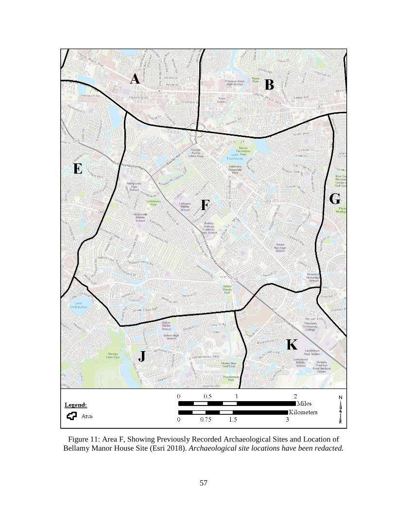
57
Figure 11: Area F, Showing Previously Recorded Archaeological Sites and Location of
Bellamy Manor House Site (Esri 2018). Archaeological site locations have been redacted.

58
Photo 10: Site 44VB0046 in Area F, Facing South.
Area G
Area G lies to the east of Area F (see Figure 3, p. 36) and is bounded to the north by I-264, to
the west by South Rosemont Road, to the south by Dam Neck Road, and to the east by London
Bridge Road (Figure 12, p. 60). The majority of Area G is drained by London Bridge Creek, a
tributary to the Eastern Branch of the Lynnhaven River, although West Neck Creek drains the
southern portion of the area.
The western portion of Area G is primarily residential and, like Area F, most neighborhoods
are rather dense, with small yards. The eastern part of Area G is mostly commercial and
industrial, with a mall and other retail shopping centers and business parks located along
Lynnhaven Parkway, and a large industrial area located north of International Parkway and
west of London Bridge Road. Some forested areas remain along London Bridge Road and Dam
Neck Road in the southern and eastern portions of Area G.
Photo Redacted

59
Photo 11: Bellamy Manor House Site in Area F, Facing Northeast.
Only three archaeological sites are recorded in Area G. Of these, two (44VB0350 and
44VB0352) appear to have been destroyed by road construction (Photo 12, p. 61). The third, a
boundary ditch (44VB0238) appears to be intact. Most of the area is considered to have only a
low to moderate probability for containing archaeological sites.
Unrecorded
sites which may have once existed in Area G are likely mostly or totally destroyed by
development, particularly in the eastern portion of the area. However, some intact sites may
exist in the wooded areas along London Bridge Road and Dam Neck Road, although these are
modeled as low-probability areas.
Area H
Area H lies to the east of Area G (see Figure 3, p. 36) and is bounded to the north by I-264, to
the west by London Bridge Road, to the south by Dam Neck Road, and to the east by Oceana
Boulevard (Figure 13, p. 62). Naval Air Station (NAS) Oceana occupies most of Area H.
Much of NAS Oceana is taken up by the air station’s four runways and the open fields lying at
each end of the runways. Most of the buildings at the facility are clustered near the center of
the base. The remainder of the air station is taken up mostly by open fields (Photo 13, p. 63),
forested areas (Photo 14, p. 63), and a golf course. Residential neighborhoods and an industrial
area lie north of NAS Oceana in Area H, and another industrial area lies outside of the air
station property in the southwest portion of Area H.
Photo Redacted

60
Figure 12: Area G, Showing Previously Recorded Archaeological Sites (Esri 2018).
Archaeological site locations have been redacted.

61
Photo 12: Site 44VB0352 in Area G, Facing South.
Sixty-three recorded sites are located in Area H and one additional site straddles the border
between Areas H and I. Many of the sites within the military base could not be evaluated
directly during the survey because of access issues; however, the general locations of many of
these sites could be observed from the roads around the base perimeter. The majority of Area
H has a low to moderate probability for containing archaeological sites, although a strip of
high-probability area is located along Oceana Boulevard on the eastern edge of the area. Many
of the previously recorded sites in Area H are likely mostly intact due to their location in
wooded areas or open fields that have been subjected to minimal disturbance. Due to the
naturally level nature of the landscape in Virginia Beach, unrecorded sites which may be
located beneath the airstrips at NAS Oceana may contain intact deposits due to minimal
grading being necessary during construction.
Area I
Area I is located in the eastern portion of the study area (see Figure 3, p. 36). It is bounded to
the north by I-264, to the west by Oceana Boulevard, to the south by Dam Neck Road, and to
the east by the Atlantic Ocean (Figure 14, p. 64). The NAS Oceana Dam Neck Annex and
Camp Pendleton State Military Reservation are located in Area I.
Photo Redacted

62
Figure 13: Area H, Showing Previously Recorded Archaeological Sites (Esri 2018).
Archaeological site locations have been redacted.

63
Photo 13: Typical Field in Area H, Facing Southwest.
Photo 14: Typical Forested Portion of Area H, Facing South.

64
Figure 14: Area I, Showing Previously Recorded Archaeological Sites (Esri 2018).
Archaeological site locations have been redacted.

65
Current land use varies within Area I. The northern portion of the area is mostly residential,
with many of the homes in the northwest part of the area having relatively large yards.
Residential housing becomes denser moving to the east, with commercial areas located along
I-264. The western portion of the area contains wooded tracts and a few agricultural fields
(Photo 15). The eastern part of the area, along the Atlantic Ocean, is characterized by hotels,
resorts, restaurants, and other commercial and tourism-centered development north of Rudee
Inlet, and residential neighborhoods south of Rudee Inlet. The NAS Oceana Dam Neck Annex
and Camp Pendleton State Military Reservation are located in the central and southern portions
of Area I. High-density residential neighborhoods, some of them military base housing, are
scattered through the central and southern portions of Area I, but much of the area is
undeveloped and wooded with the exception of a golf course north of Redwing Lake.
Photo 15: Site 44VB0227, Facing Northeast and Showing Typical Field and Forest in
Western Portion of Area I.
A total of 32 previously recorded sites are located entirely within Area I, as well as one site
(44VB0180) which lies partially in Area H. Many of the sites in Area I could not be surveyed
directly due to access issues related to the military bases. Much of Area I is modeled as having
only a low to moderate probability for containing archaeological sites; however, the network
of streams feeding Lake Rudee and other bodies of water near the coast creates significant
high-probability areas as well. Many of the sites which could be directly surveyed or indirectly
assessed through aerial imagery are likely to be largely intact due to locations in fields, forested
areas, or undeveloped portions of the military base. Although previously unrecorded sites in
the northern and eastern portions of Area I are probably heavily disturbed or destroyed, there
is potential for intact deposits throughout much of the central and southern parts of Area I.
Area J
Area J is located in the southwestern portion of the study area (see Figure 3, p. 36). It is
bounded to the north by Indian River Road and Lynnhaven Parkway, to the west by Kempsville
Road, to the south by the Virginia Beach city limits, and to the east by Elbow Road and Salem
Road (Figure 15, p. 66).
Photo Redacted

66
Figure 15: Area J, Showing Previously Recorded Archaeological Sites (Esri 2018).
Archaeological site locations have been redacted.

67
The western and eastern portions of Area J are characterized by fairly dense residential
neighborhoods, with four large school campuses and a golf course being present in the eastern
portion. Most houses in the area feature relatively small yards where any subsurface deposits
have likely been heavily impacted by construction. Stumpy Lake is located in the central part
of the area, and is bordered to the north and west by Stumpy Lake Park and Golf Course. The
park is primarily wooded and reflects a largely natural landscape.
Only one archaeological site is recorded in Area J. Site 44VB0288 is an archaic camp likely
completely destroyed by high-density residential development (Photo 16). The lack of other
recorded sites in the area is probably largely a function of lack of survey in this part of the City.
Area J is modeled as being mostly low to moderate probability for containing archaeological
sites, although small pockets of high-probability area exist, primarily along the margins of
Stumpy Lake and along Kempsville Road. As-yet undiscovered sites are likely to be located
in Stumpy Lake Park, where they may be mostly intact. Portions of the two golf courses in
Area J that have been relatively unmodified or filled rather than cut may also contain intact
deposits.
Photo 16: Site 44VB0288 in Area J, Facing South.
Area K
Area K is located in the southern portion of the study area (Figure 3, p. 36). It is bounded to
the north by Lynnhaven Parkway, South Rosemont Road, and Dam neck Road, to the west by
Elbow Road and Salem Road, to the south by the Virginia Beach city limits and North Landing
Road, and to the east by Holland Road (Figure 16, p. 68). The North Landing River flows
through Area K. A diverse range of land use is found within Area K. Much of the northern
portion of the area is characterized by dense residential neighborhoods (Photo 17, p. 69).
Commercial areas, a hospital complex, and the campus of Tidewater Community College are
also located in the northern part of the area. An amphitheater, athletic complex, and golf course
are located near the central portion of the area, while the southern part of the area remains
semi-rural in character with large wooded areas as well as agricultural fields (Photo 18, p. 69).
Photo Redacted

68
Figure 16: Area K, Showing Previously Recorded Archaeological Sites (Esri 2018).
Archaeological site locations have been redacted.

69
A total of 54 previously recorded archaeological sites are located in Area K. Most of Area K
is considered to have only a low to moderate probability for containing archaeological sites,
largely as a result of distance from streams and poorly-drained soils. Most of the sites that are
recorded in the area date to the historic period, when these obstacles to settlement could be
overcome. Unrecorded sites may exist in a relatively undisturbed state in the undeveloped
southern portion of the area, but sites dating to the historic period are more likely to occur in
this area than prehistoric sites.
Photo 17: Site 44VB0172, Facing South and Showing Typical Neighborhood in Area K.
Photo 18: Site 44VB0290, Facing Northwest and Showing Typical Wooded Area in Area K.
Photo Redacted
Photo Redacted

70
Area L
Area L is located in the southern portion of the study area (see Figure 3, p. 36). It is bounded
to the north by Dam Neck Road, to the west by Holland Road, to the south by Princess Anne
Road, and to the east by General Booth Boulevard (Figure 17, p. 71). West Neck Creek flows
through Area L.
The central portion of Area L and its western edge are mostly characterized by planned
neighborhoods with relatively dense housing and small yards. The eastern portion of the area
contains residential neighborhoods and commercial areas (Photo 19 and Photo 20, p. 72).
Agricultural fields are present in the northeast portion of the area. Much of the western part of
Area L comprises wetlands and poorly-drained areas along the margins of West Neck Creek
and one of its tributaries.
Only six archaeological sites are located in Area L, likely a result of lack of survey in this part
of the City. However, the low site density is not unexpected, as the area’s poor drainage results
in most of it being modeled as having a low probability for containing archaeological sites.
Area M
Area M is located in the southeastern portion of the study area (see Figure 3, p. 36). It is
bounded to the north by Dam Neck Road, to the west by General Booth Boulevard, to the south
by a line extending due east from near the intersection of General Booth Boulevard and
Princess Anne Road, and to the east by the Atlantic Ocean (Figure 18, p. 73).
The western portion of Area M is characterized by fairly dense residential neighborhoods with
small yards (Photo 21, p. 74). The south-central portion of the area contains a school campus,
industrial complex, and agricultural fields (Photo 22, p. 74; Photo 23, p. 75). The eastern part
of the area contains a portion of the NAS Oceana Dam Neck Annex, the northern part of Lake
Tecumseh, a wooded area characterized by poorly drained, swampy and wetland conditions,
and an undeveloped area of Atlantic shoreline.
Twenty-eight previously recorded archaeological sites are located in Area M. Most of Area K
is considered to have only a low probability for containing archaeological sites, largely as a
result of distance from streams and poorly-drained soils. All but three of the sites that are
recorded in the area date to the historic period, when these obstacles to settlement could be
overcome, and even those three sites contain only minor prehistoric components on other wise
historic-period sites. Unrecorded sites may exist in a relatively undisturbed state in the central
portion of the area where agricultural fields and wooded areas exist, but sites dating to the
historic period are more likely to occur in this area than prehistoric sites.

71
Figure 17: Area L, Showing Previously Recorded Archaeological Sites (Esri 2018).
Archaeological site locations have been redacted.

72
Photo 19: Site 44VB0121, Showing Typical Neighborhood in Area L.
Photo 20: Site 44VB0291, Showing Commercial Area in Area L.
Photo Redacted
Photo Redacted

73
Figure 18: Area M, Showing Previously Recorded Archaeological Sites (Esri 2018).
Archaeological site locations have been redacted.

74
Photo 21: Site 44VB0118, Facing Northwest and Showing Typical Neighborhood in Area M.
Photo 22: Industrial Complex in Central Portion of Area M, Facing South. This is the
location of sites 44VB0017 through 44VB0022 and 44VB330.
Photo Redacted
Photo Redacted

75
Photo 23: Agricultural Field in South-Central Portion of Area M, Facing East. This is the
location of sites 44VB0323, 44VB0328, and 44VB0329.
Photo Redacted

76
This page intentionally left blank

77
SUMMARY AND ASSESSMENT
The review of previously identified resources, previously surveyed areas, and known site
locations of precontact and historic site location indicates that preserved archaeological
resources, or portions of them, potentially exist throughout the Virginia Beach study area. The
development of a predictive model for site locations further showcases the potential for as-yet
undiscovered sites to exist within the study area. However, due to the long historic occupation
of the northern part of Virginia Beach and the City’s large residential population, all or part of
many archaeological sites have been destroyed by residential, commercial, industrial, and
transportation-related development, among other sources of disturbance.
Of the 315 previously recorded sites considered during the study, only 57 (18 percent) were
assessed as having high potential to contain intact cultural deposits (see Appendix for site data).
A total of 146 sites (46 percent) were partially or totally destroyed. An additional 112 sites (36
percent) were not evaluated due to access issues (93 sites) or because their site data was
recorded or updated within the past five years, making assessment of current conditions
unnecessary (19 sites).
The potential for intact archaeological deposits to be preserved in various areas of the study
area is highly dependent on location within the City. Not only are different areas of the City
developed, and therefore disturbed, in different ways and to different extents, but the amount
of disturbance to the archaeological record of an area is also a function of how and when it was
developed. Older neighborhoods tend to have houses with larger yards, where portions of
archaeological sites may be preserved outside of construction footprints. This is especially true
given the house-by-house nature of construction for much of the twentieth century and the
relatively flat natural topography of the area, making extensive grading unnecessary prior to
construction. Newer neighborhoods, on the other hand, often have smaller yard areas and are
more likely to be constructed as part of development projects in which large areas are graded
wholesale prior to the near-simultaneous construction of multiple homes. Nonetheless, with
regard to developed areas of the City, residential neighborhoods have the greatest potential for
preserved portions of sites in comparison to areas impacted by roads or industrial or
commercial development. Golf courses may also preserve portions of sites in areas where
landscape modification was restricted to filling rather than cutting, but the extent to which this
is true requires subsurface testing. Parks and military bases located in the City may also contain
undisturbed resources or portions of resources due to minimal development and landscape
modification.
The percentage of sites with intact deposits versus those which are partially or totally destroyed
varies by survey area for reasons outlined above (Table 8, p. 78). The northern, western, and
central portions of the study area (Survey Areas A–G) are the most developed and therefore
contain the fewest sites with intact deposits and, accordingly, the largest percentages of sites
which have been partially or totally destroyed. The highest percentages of sites with intact
deposits are found in the southern and eastern portions of the study area, specifically, Areas H
and M. This is a function of these areas being relatively undeveloped, except by military bases
such as NAS Oceana, which contains a great deal of undeveloped or minimally developed land.

78
The predictive model developed during the present study also greatly informs potential for as-
yet undiscovered sites to be present in various parts of the City. The northern part of the study
area, along the margins of the Lynnhaven River, Lynnhaven Bay, and Broad Bay, has the
greatest potential for prehistoric settlement, along with the western part of the study area along
the Elizabeth River. Unfortunately, these areas are also among the most desirable for modern
habitation and development, and are among the most heavily-impacted areas in the City of
Virginia Beach. The southern part of the study area has significantly less potential for
prehistoric settlement due to distance from major streams and often poorly-drained or
wetland/marsh conditions. However, the possibility for historic period sites, particularly those
dating to the nineteenth century and later, is still moderate to high in parts of these areas due
to the technological ability to overcome such obstacles to settlement.
Table 8: Site Condition Assessments by Survey Area.
Survey Area
Total
Number of
Sites
Sites with
Intact
Deposits
Sites
Partially
or Totally
Destroyed
Sites with
Conditions
Unknown
A 9 2 (22%) 6 (67%) 1 (11%)
B 33 0 15 (45%) 18 (55%)
C 23 1 (4%) 19 (83%) 3 (13%)
D 47 1 (2%) 25 (53%) 21 (45%)
E 14 0 12 (86%) 2 (14%)
F 6 1 (17%) 5 (83%) 0
G 3 1 (33%) 2 (67%) 0
H 64 29 (45%) 19 (30%) 16 (25%)
I 33 2 (6%) 7 (21%) 24 (73%)
J 1 0 1 (100%) 0
K 54 13 (24%) 19 (35%) 22 (41%)
L 6 0 6 (100%) 0
M 28 7 (25%) 16 (57%) 5 (18%)
Total 315 57 (18%) 146 (46%) 112 (36%)

79
REFERENCES
Amick, Daniel S., and Phillip J. Carr
1996 Changing Strategies of Lithic Technological Organization. In Archaeology of the
Mid-Holocene Southeast, edited by K. E. Sassaman and D. G. Anderson, pp. 41–
56. The University Press of Florida, Gainesville, Florida.
Anderson, David G.
1990 The Paleoindian Colonization of Eastern North America: A View from the
Southeastern United States. In Early Paleoindian Economics of Eastern North
America, edited by K. B. Tankersley and B. L. Isaac, pp. 163–216. Research in
Economic Anthropology, supplement 5. JAI Press, Greenwich, Connecticut.
Anderson, David G., and Glen T. Hanson
1988 Early Archaic Settlement in the Southeastern United States: A Case Study from the
Savannah River Valley. American Antiquity 53:262–286.
Anderson, David G. and Steven D. Smith
2003 Archaeology, History, and Predictive Modeling Research at Fort Polk, 1972–2002.
The University of Alabama Press, Tuscaloosa, Alabama.
Baicy, Daniel, Loretta Lautzenheiser, and Michael Scholl
2005 Archaeological Survey: Proposed Southeastern Parkway and Greenbelt: Cities of
Chesapeake and Virginia Beach, Virginia. Coastal Carolina Research, Inc.,
Tarboro, North Carolina.
Bailey, Tom and Susan Bamann
2005 Archaeological Identification Survey: City Line Interchange: Virginia Beach,
Virginia. Coastal Carolina Research, Inc., Tarboro, North Carolina.
Bamman, Susan and Bill Hall
2006 Archaeological Identification Survey, Proposed Improvements to Shore Drive,
Virginia Beach, Virginia. Coastal Carolina Research, Inc. Tarboro, North
Carolina.
Barber, Michael B.
2003 A Review of Early Archaic Research in Virginia: A Re-Synthesis a Decade Later.
Quarterly Bulletin, Archaeological Society of Virginia 58 (3)):121–134.
Barber, Michael B., and George A. Tolley
1984 The Savannah River Broadspear: A View from the Blue Ridge. In Upland
Archaeology in the East: Symposium 2, edited by C. R. Geier, M. B. Barber, and
G. A. Tolley, pp. 25–43. USDA, Forest Service, Southern Region.

80
Barile, Kerri, Earl Proper, Danae Peckler, Mike Klein, and Emily Calhoun
2012 Phase I Cultural Resource Survey of the Centerville Turnpike Improvement Area,
Virginia Beach, Virginia. Dovetail Cultural Resource Group. Fredericksburg,
Virginia.
Birkett, Courtney
2009a Archaeological Survey of the Proposed Stone Breakwater/Revetment, Fort Story,
Virginia. Fort Eustis Cultural Resources. Newport News, Virginia.
2009b Archaeological Survey of the Proposed Child Development Center, Fort Story,
Virginia. Fort Eustis Cultural Resources. Newport News, Virginia.
Blanton, Dennis B.
1992 Middle Woodland Settlement Systems in Virginia. In Middle and Late Woodland
Research in Virginia: A Synopsis, edited by T. R. Reinhart and M. E. N. Hodges,
pp. 65–96. Council of Virginia Archaeologists and the Archaeological Society of
Virginia. The Dietz Press, Richmond.
1996 Accounting for Submerged Mid-Holocene Archaeological Sites in the Southeast:
A Case from the Chesapeake Bay Estuary, Virginia, pp. 200-221. In Archaeology
of the Mid-Holocene Southeast, edited by K. E. Sassaman and D. G. Anderson, pp.
200–217. University Press of Florida, Gainesville.
2003 Late Archaic in Virginia: An Updated Overview. Quarterly Bulletin,
Archaeological Society of Virginia 58(4):177–206.
Boehm, Christopher
1997 Impact of Human Egalitarian Syndrome on Darwinian Selection Mechanics. The
American Naturalist 150 (Supplement):S100–S121.
Bott, Keith
1980a Review and Compliance Phase I Reconnaissance Summary: Barberton Drive
Apartment Complex. Virginia Research Center for Archaeology, Williamsburg,
Virginia.
1980b Review and Compliance Phase I Reconnaissance Summary: North Landing River
Bridge Replacement. Virginia Research Center for Archaeology, Williamsburg,
Virginia.
Bourdeau, J.
1981 Replicating Quartz Squibnocket Small Stemmed and Triangular Projectile Points.
Quartz Technology in Prehistoric New England, edited by R. Barber. Institute for
Conservation Archaeology, Peabody Museum, Harvard University, Cambridge,
Massachusetts.

81
Bowden, Bradley, Ashley Neville and Jerrell Blake
1998 Phase I Cultural Resources Survey of the Proposed Norfolk/Virginia Beach Light
Rail, Cities of Norfolk and Virginia Beach, Virginia. Gray and Pape, Inc.
Richmond, Virginia.
Boyd, C. Clifford
1989 Paleoindian Paleoecology and Subsistence in Virginia. In Paleoindian Research In
Virginia: A Synthesis, edited by T. M. Wittkofski and T. R. Reinhart, Special
Publication 19 of the Archeological Society of Virginia, pp. 139–156. The Dietz
Press, Richmond, Virginia.
2003 Paleoindian Research in Virginia and Beyond. Quarterly Bulletin, Archaeological
Society of Virginia 58 (2):58–93.
Boyko, Wayne C.J. and Beverly Boyko
2008 Phase I Archaeological Survey of the State Military Reservation, 83.81 ha (207
Acres) at Camp Pendleton, Virginia Beach, Virginia. Virginia Tech, Blacksburg,
Virginia.
Brady, Ellen M. and Loretta Lautzenheiser
2000 Archaeological Identification Survey, Princess Anne Road and Ferrell Parkway, City
of Virginia Beach, Virginia. Coastal Carolina Research, Inc. Tarboro, North
Carolina.
Brady, Ellen M., Joanna Carter Jones, and Loretta Lautzenheiser
1998 Cultural Resources Survey, Proposed Improvements, Sandbridge Road, City of
Virginia Beach, Virginia. Coastal Carolina Research, Inc. Tarboro, North
Carolina.
Brown, James A.
1986 Early Ceramics and Culture: A Review of Interpretations. In Early Woodland
Archaeology, edited by K. B. Farnsworth and T. E. Emerson, pp. 598–608. Center
for American Archaeology, Kampsville Seminars in Archaeology No. 2,
Kampsville, Illinois.
1989 The Origins of Pottery as an Economic Process. In What’s New: A Closer Look at
the Process of Innovation, edited by S. E. van der Leeuw and R. Torrence, pp. 203–
224. Unwin-Hyman, London, United Kingdom.
Brush, Grace
1986 Geology and Paleoecology of Chesapeake Estuaries. Journal of the Washington
Academy of Sciences 76(3):146–160.
Busby, Virginia, and Leslie Bashman
1993a Phase I Cultural Resource Survey: Route 190: Cities of Chesapeake and Virginia
Beach, Virginia. The Cultural Resource Group, Louis Berger and Associates, Inc,
Richmond, Virginia.

82
1993b Phase I Cultural Resource Survey, Birdneck Road, City of Virginia Beach, Virginia.
The Cultural Resource Group, Louis Berger and Associates, Inc, Richmond,
Virginia.
Bussey, Stanley B. and Jerome D. Traver
1992 Phase I Archaeological Survey of a Proposed U. S. Navy Construction Project at
Owl Creek in Virginia Beach, Virginia. Benham Group. Alexandria, Virginia.
Callahan, Errett
1985 The St. Mary’s Longhouse Experiment: The First Season. Quarterly Bulletin of the
Archaeological Society of Virginia 40:12–40.
Carr, Christopher, and Robert F. Maslowski
1995 Cordage and Fabrics: Relating Form, Technology, and Social Processes. In Style,
Society, and Person: Archaeological and Ethnological Perspectives, edited by C.
Carr and J. E. Neitzel, pp. 297–344. Plenum Press, New York.
Carr, Kurt
2018 Peopling of the Middle Atlantic: A Review of Paleoindian Research. In Middle
Atlantic Prehistory: Foundations and Practice, edited by Heather A. Wholey, and
Carole L. Nash, pp. 219–260. Rowman & Littlefield, Lanham, Maryland.
Chapman, Jefferson, and Andria Brewer Shea
1981 The Archaeobotanical Record: Early Archaic Period to Contact in the Lower Little
Tennessee River Valley. Tennessee Anthropologist VI(1):61–84.
City of Virginia Beach
2016 It’s Our Future: A Choice City. City of Virginia Beach Comprehensive Plan:
Technical Document. Adopted May 17, 2016.
Clark, Robert and Bradley Bowden
2000 Archaeological Survey along a Portion of Holland Road (Route 410). Gray and
Pape, Inc. Richmond, Virginia.
Clement, Christopher
2011 Phase I Archaeological Investigation of Approximately 170 Acres at Naval Air
Station Oceana, Virginia Beach, Virginia. Southeastern Archaeological Research.
Jacksonville, Florida.
2012 Phase I Archaeological Investigation of Approximately 174 Acres at Naval Air
Station Oceana, Virginia Beach, Virginia. Southeastern Archaeological Research.
Jacksonville, Florida.
Coe, Joffre S.
1964 The Formative Cultures of the Carolina Piedmont. Transactions of the American
Philosophical Society, 54, No. 5 Philadelphia.

83
Cottrell, Marie G.
1993 Cultural Resources Assessment for the Proposed Aircraft Fuel Storage Site (P-
412), Naval Air Station Oceana, Virginia Beach, Virginia. Atlantic Division, Naval
Facilities Command. Norfolk, Virginia.
Curry, Dennis
1999 Feast of the Dead: Aboriginal Ossuaries in Maryland. Maryland Historical Trust
Press, Cockysville, Maryland.
2015 Ossuary Burial in Middle Atlantic Landscapes. Archaeology of Eastern North
America 43:1–22.
Custer, Jay F.
1989 Prehistoric Cultures of the Delmarva Peninsula: An Archaeological Study.
University of Delaware Press, Newark.
1990 Early and Middle Archaic Cultures of Virginia: Culture Change and Continuity. In
Early and Middle Archaic Research in Virginia: A Synthesis, edited by T. R.
Reinhart and M. E. N. Hodges, pp. 1–60. The Dietz Press, Richmond, VA.
Daniel, I. Randolph, Jr.
1998 Hardaway Revisited: Early Archaic Settlement in the Southeast. University of
Alabama Press, Tuscaloosa.
Dent, Richard J., Jr.
1995 Chesapeake Prehistory: Old Traditions, New Directions. Plenum Press, New York.
Dickinson, Martin F. and Lucy B. Wayne
1983 Appendix B (Nonpublic) of the Draft Environmental Impact Statement (DEIS) for
Alternative Location of a Landing Craft Air Cushion (LCAC) Operational Base on
the East Coast of the United States. Water and Air Research. Gainesville, Florida.
Dietrich, Richard V.
1990 Geology and Virginia. University of Virginia Press, Charlottesville, Virginia.
Duplantis, Brad M. and Eric Griffits
2003 Cultural Resource Survey of the Proposed Realignment of the Current Intersection
of Route 165 (Princess Anne Road) and Route 190 (Kempsville/Witchduck Road),
City of Virginia Beach, Virginia. Louis Berger Group. Richmond, Virginia.
Echelman, Ralph E., Scott S. Sheads, and Donald Hickey
2010 The War of 1812 in the Chesapeake: A Reference Guide to Historic Sites in
Maryland, Virginia, and the District of Columbia. Johns Hopkins University Press,
Baltimore, Maryland.

84
EDAW, Inc.
1982 Draft Final Ecological Evaluation for the Fleet Combat Training Center Atlantic,
Dam Neck, Virginia Beach, Virginia. Appendix A. EDAW, Inc. Virginia Beach,
Virginia.
Egghart, Christopher and Luke Boyd
1991 Phase I Cultural Resource Survey Along Proposed Improvements to Oceana
Boulevard in Virginia Beach, Virginia. Virginia Commonwealth University
Archaeology Research Center, Richmond, Virginia.
Egloff, Keith
1991 Development and Impact of Ceramics in Virginia. In Late Archaic and Early
Woodland Research in Virginia: A Synthesis, edited by T.R. Reinhart and M.E.N.
Hodges, pp. 243–252. The Dietz Press, Richmond.
Egloff, Keith T., and Stephen R. Potter
1982 Indian Ceramics from Coastal Plan Virginia. In Archaeology of Eastern North
America 10:95–117.
Egloff, Keith T., and E. Randolph Turner III
1984 The Chesapeake Indians and Their Predecessors: Recent Excavations at Great
Neck. Notes on Virginia 24:36–39.
Esri
2018 World Topo. Electronic document, http://services.arcgisonline.com/
arcgis/services, accessed April 2018.
Evans, Clifford
1955 A Ceramic Study of Virginia Archaeology. Smithsonian Institution, Bureau of
American Ethnology, Bulletin No. 160.
Fesler, Garrett C. and Matthew Laird
2006 Phase I Cultural Resources Survey for the Proposed Realignment of West Neck
Road Between North Landing Road and Indian Ridge Road in the City of Virginia
Beach, Virginia. James River Institute for Archaeology. Williamsburg, Virginia.
2011 A Phase I Cultural Resources Survey of 98.664 Acres at Marshview Park in the
City of Virginia Beach, Virginia. James River Institute for Archaeology.
Williamsburg, Virginia.
Fichter, Lynn S., and Steve J. Baedke
2000 The Geoarchaeological Evolution of Virginia and the Mid-Atlantic Region.
Electronic document, http://csmres.jmu.edu/geollab/vageo/vahist/, accessed July
2015.
Fiedel, Stuart J.
2001 What Happened in the Early Woodland? Archaeology of Eastern North America
29:101–142.

85
Fiedel, Stuart J., and Gary Haynes
2004 A Premature Burial: Comments on Grayson and Meltzer’s “Requiem for Overkill.”
Journal of Archaeological Science 31:121–131.
Ford, Richard I.
1974 Northeastern Archaeology: Past and Future Directions. Annual Reviews in
Anthropology 3:385–413.
Fort Eustis Environmental Division
2005 Phase I Archaeological Survey of the Five Forks Training Area and Phase II
Evaluation of Site 44VB89, Fort Story, Virginia.
2006a Phase I Survey of the First Landing Reenactment Site and a Brief Review of
Proposed Events, Fort Story, Virginia.
2006b Cultural Resource Management of GMH Military Housing RCI Undertakings at
Fort Story, Virginia.
2006c Construction of Two New Buildings, a Parking Lot, and the Rehabilitation of
Bunker 309, Fort Story, Virginia.
Gallivan, Martin D.
2003 James River Chiefdoms: The Rise of Social Inequality in the Chesapeake.
University of Nebraska Press, Lincoln, Nebraska.
2005 Overview of the Powhatan Chiefdom. In A Study of Virginia’s Indians and
Jamestown: The First Century, edited by D. Moretti-Langholtz. Report Prepared
for the Colonial National Historical Park, Williamsburg, Virginia
(www.cr.nps.gov/ history/online_books/jame1/moretti-langholtz), accessed March
2018.
2016 Powhatan Landscape: The Rise of Social Inequality in the Chesapeake. University
of Florida Press, Gainesville.
Gallivan, Martin D., and Helen Blouet
2001 Middle Woodland Settlement in the Interior Coastal Plain: Excavations at
44JC1052 and 44JC1053. Quarterly Bulletin, Archeological Society of Virginia
56(3):127–145.
Gallivan, Martin D., and Justine McKnight
2006 Archaeobotanical Assessment of Chesapeake Horticulture: The View from
Werowocomoco. Paper Presented at the Middle Atlantic Archaeological
Conference, Virginia Beach, Virginia.

86
Gallivan, Martin D., Thane Harpole, David A. Brown, Danielle Moretti-Langholtz, and E.
Randolph Turner III
2006 The Werowocomoco (44GL32) Research Project: Background and 2003 Field
Season Results. College of William and Mary, Department of Anthropology,
Williamsburg, Virginia. Archaeological Research Report Series No. 1.
Gardner, William M.
1977 Flint Run Paleoindian Complex, its Implication for Eastern North American
Prehistory. In Amerinds and Their Paleoenvironment in Northeastern North
America, edited by W. S. Mewman and B. Salwen, pp. 257–263. Annals of the New
York Academy of Sciences, 288.
1981 Paleoindian Settlement Pattern and Site Distribution in the Middle Atlantic.
Anthropological Careers, edited by R. H. Landman, L. A. Bennett, A. Brooks, and
P. P. Chock, pp. 51–73. Anthropological Society of Washington, Washington, D.C.
1982 Early and Middle Woodland in the Middle Atlantic: An Overview. In Practicing
Environmental Archaeology: Methods and Interpretations, edited by R. W.
Moeller, pp. 53–86. American Indian Archaeological Institute Occasional Paper
No. 3, Washington, Connecticut.
1989 An Examination of Cultural Change in the Late Pleistocene and Early Holocene. In
Paleoindian Research in Virginia edited by J.M. Wittkofski and T.R. Reinhart, pp.
5–52. Special Publication No. 19 of the Archaeological Society of Virginia. Dietz
Press, Richmond.
Gardner, William M. (editor)
1974 The Flint Run Paleoindian Complex: Preliminary Report 1971-73 Seasons.
Occasional Publication No. 1, Department of Anthropology, The Catholic
University of America, Washington, D.C.
Geier, Clarence R.
1990 A Middle Woodland Bipolar Pebble Technology in the Lower Chesapeake Area of
Tidewater Virginia. Journal of Middle Atlantic Archaeology 6:55–74.
Gingerich, Joseph A. M.
2011 Down to Seeds and Stones: A New Look at the Subsistence Remains from
Shawnee-Minisink. American Antiquity 76(1):127–144.
Gold, Debra L.
2004 The Bioarchaeology of Virginia Burial Mounds. University of Alabama Press:
Tuscaloosa.
Goodwin, R. Christopher

87
1993 Phase I Archeological Investigations for Proposed Vegetation Maintenance/
Management Areas and a Proposed Wetlands Restoration Project, Naval Air
Station, Oceana, Virginia Beach, Virginia. R. Christopher Goodwin and
Associates, Frederick, Maryland.
Goodyear, Allen C.
1979 A Hypothesis for the Use of Cryptocrystalline Raw Materials among Paleoindian
Groups of North America. Research Manuscript Series No. 156. South Carolina
Institute of Archaeology and Anthropology, University of South Carolina,
Columbia.
Gosser, Dennis, Jennifer Stewart, and Bill Hall
2009 Cultural Resources Survey Proposed Lesner Bridge Replacement, City of Virginia
Beach, Virginia. Coastal Carolina Research. Tarboro, North Carolina.
Grayson, Donald K., and David J. Meltzer
2003 A Requiem for North American Overkill. Journal of Archaeological Science
30:585–593.
Hally, David J.
1996 Platform Mound Construction and the Instability of Mississippian Chiefdoms. In
Political Structure and Change in the Prehistoric Southeastern United States,
edited by J. F. Scarry, pp. 92–127. University Press of Florida, Gainesville, Florida.
Hantman, Jeffrey L.
1990 Between Powhatan and Quirank: Reconstructing Monacan Culture and History in
the Context of Jamestown. American Anthropologist 92:676–690.
Hantman, Jeffery. L., and Debra. L. Gold
2002 The Woodland in the Middle Atlantic: Ranking and Dynamic Political Stability. In
The Woodland Southeast, edited by D. G. Anderson and R. C. Mainfort, Jr., pp.
270–291. The University of Alabama Press, Tuscaloosa, Alabama.
Hantman, Jeff, and Michael Klein
1992 Middle and Late Woodland Archaeology in Piedmont Virginia. In Middle and Late
Woodland Research in Virginia: A Synthesis, edited by T.R. Reinhart and M.E.N.
Hodges, pp. 137–164. Special Publication No. 29 of the Archaeological Society of
Virginia. Dietz Press, Richmond.
Hawkins-Hendrix, Edna and Joanne H. Lucas
2017 History of African-American Communities in Princes Anne County/Virginia Beach.
Virginia Beach Historic Preservation Commission Historical research Paper. On
File at Virginia Beach Public Library.
Heinemann, Ronald L., John G. Kolp, Anthony S. Parent, Jr., and William G. Shade

88
2007 Old Dominion, New Commonwealth: A History of Virginia, 1607–2007. University
of Virginia Press, Charlottesville, Virginia.
Heinrich, Keith T. and Loretta Lautzenheiser
2005 Cultural Resources Identification Survey Atlantic Wastewater Treatment Plant,
Virginia Beach, Virginia. Coastal Carolina Research, Inc. Tarboro, North Carolina.
Higgins, Thomas, Anne Beckett and Veronica Deitrick
1994 Additional Phase I Cultural Resource Survey of Revised Alignments for Proposed
Southeastern Expressway, Cities of Chesapeake and Virginia Beach, Virginia.
William and Mary Center for Archaeological Research. Williamsburg, Virginia.
Hodges, Mary Ellen N.
1991 The Late Archaic and Early Woodland Periods in Virginia: Interpretation and
Explanation within an Eastern Context. In Late Archaic and Early Woodland
Research in Virginia, edited by T. R. Reinhart and M. E. N. Hodges, pp. 221–242.
The Dietz Press, Richmond, Virginia.
1993 The Archaeology of Native American Life in Virginia in the Context of European
Contact: Review of Past Research. In The Archaeology of 17th-Century Virginia,
edited by T. R. Reinhart and Dennis J. Pogue, pp. 1–66. The Dietz Press, Richmond,
Virginia.
1998 Native American Settlement at Great Neck: report on VDHR Archaeological
Investigations of Woodland Components at Site 44VB0007, Virginia Beach,
Virginia. Research Report Series, No. 9, Richmond, Virginia.
2003 Late Woodland Research in Virginia: Recent Trends and Contributions. Quarterly
Bulletin, Archaeological Society of Virginia 59 (1):1–13.
Hodges, Mary Ellen N., and Charles T. Hodges (editors)
1994 Paspahegh Archaeology: Data Recovery Investigations of Site 44JC308 at the
Governor’s Land at Two Rivers, James City County, Virginia. Reported submitted
to Governor’s Land Associates, Inc., Williamsburg, Virginia, by the James River
Institute for Archaeology, Inc., Williamsburg, Virginia.
Hodges, Mary Ellen and Margaret L. Stephenson
1997 An Addendum to Phase I Cultural Resource Study of Proposed Improvements to
Oceana Boulevard and First Colonial Road in Virginia Beach, Virginia. Virginia
Department of Transportation. Richmond, Virginia.
Holm, Mary Ann, Loretta Lautzenheiser, and Jane McManus Eastman
1995 Phase I Archaeological Survey Improvements to Laskin Road; Route 58, Virginia
Beach, Virginia. Coastal Carolina Research, Inc. Tarboro, North Carolina.
Hornum, Michael B.
1994 Phase I Archeological Survey of Approximately 2,000 Acres at Naval Air Station
Oceana, Virginia Beach, Virginia, and Naval Auxiliary Landing Field Fentress,

89
Chesapeake City, Virginia. R. Christopher Goodwin and Associates Inc. Frederick,
Maryland.
Hoyt, Steven D., Robert L. Gearhart, and Clell L. Bond
1992 Marine Magnetometer Survey of The Parallel Crossing of the Chesapeake Bay
Project, Virginia Beach-Northampton County, Virginia. Espey, Huston and
Associates, Inc. Austin Texas.
Hoyt, Steven D. and James Schmidt
1993 Parallel Crossing of Chesapeake Bay, Phase I Underwater Archaeology, Magnetic
Anomaly Ground Truthing. Espey, Hunton, and Associates, Inc. Austin, Texas.
Humphries, Amy, Dawn M. Frost, and Carol D. Tyrer
2011 Phase I Cultural Resources Survey of Marine Animal Care Facility Tract, City of
Virginia Beach. Circa-Cultural Resource Management. Williamsburg, Virginia.
Hunter, Bruce A.
1989 A Phase I Cultural Resource Survey of Three Proposed Alternate Routes for the
Extension of South Plaza Trail, Between Princess Anne and Independence Roads,
Virginia Beach, Virginia. James Madison University, Harrisonburg, Virginia.
Huston, Clifton A. and Peter W. O’Hara
2003 Phase I Archaeological Survey of Portions of the Highland Parish Tract, Virginia
Beach, Virginia. ECS Mid-Atlantic. Richmond, Virginia.
Inashima, Paul Y.
2008 Establishing a Radiocarbon Date Based Framework for Northeastern Virginia
Archaeology. Quarterly Bulletin, Archeological Society of Virginia 63 (4):187–
289.
Jensen, Todd L.
2003 Phase I Archaeological Identification Survey of the Proposed Security
Improvements (P-445/P-509), NAS Oceana, Virginia Beach, Virginia. William and
Mary Center for Archaeological Research. Williamsburg, Virginia.
Johnson, Michael F.
2001 Gulf Branch (44AR5): Prehistoric Interaction at the Potomac Fall Line. Quarterly
Bulletin, Archeological Society of Virginia 56(3):77–114.
Johnson, William C., Jeffrey P. Blick, and D. Scott Speedy
1989 Preliminary Report on the 1984 Archaeological Investigations at the Irwin Site
(44PG4), Prince George County, Virginia. Report prepared for the Virginia
Department of Historic Resources by the Virginia Commonwealth University
Center for Archaeological Research, Richmond, Virginia.
Jones, Joe B. and Todd L. Jensen
90
2003 Archaeological Survey of the Proposed Small Arms Range (MILCON P-259), NAS
Oceana Annex Dam Neck, Virginia Beach, Virginia. William and Mary Center for
Archaeological Research. Williamsburg, Virginia.
Jones, Tracey, Blair Toombs, and Eric Voigt
2009 Archaeological Survey of Regional Health Professions Center, Phase I, Virginia
Community College System, Tidewater Community College, Virginia Beach
Campus, City of Virginia Beach, Virginia. Louis Berger Group. Richmond,
Virginia.
Jones, Tracey, and Eric Voigt
2009 Archaeological Survey of Learning Resource Center, Phase I, Virginia Community
College System, Tidewater Community College, Virginia Beach Campus, City of
Virginia Beach, Virginia. Louis Berger Group. Richmond, Virginia.
Justice, Noel D.
1995 Stone Age Spear and Arrow Points of the Midcontinental and Eastern United
States. Indiana University Press, Bloomington, Indiana.
Kirchen, Roger
2001 The E. Davis Site: Technological Change at the Archaic-Woodland Transition.
M.A. Thesis, Department of Anthropology, Wake Forest University, Winston-
Salem, North Carolina.
Klein, Michael J.
1997 The Transition from Soapstone Bowls to Marcey Creek Ceramics in the Middle
Atlantic Region: Vessel Technology, Ethnographic Data, and Regional Exchange.
Archaeology of Eastern North America 25:143–158.
2003 Early Woodland Archaeology. Quarterly Bulletin, Archaeological Society of
Virginia 58(4):207–231.
Klein, Michael J., and Martin D. Gallivan
2001 Regional Systems and Social Ranking: An Analysis of John Smith’s Map of
Virginia. Paper presented at the annual meeting of the Society for American
Archaeology, New Orleans, Louisiana.
Klein, Mike, Marco A. Gonzalez, and Michael L. Carmody
2012 Archaeological Potential Assessment of the Interstate 64 Peninsula Study From
Interstate 664 in Hampton to Interstate 95 in Richmond, Virginia. Dovetail Cultural
Resource Group, Fredericksburg, Virginia.
Klein, Michael J., and Thomas Klatka
1991 Late Archaic and Early Woodland Demography and Settlement Patterns. In Late
Archaic and Early Woodland Research in Virginia: A Synthesis, edited by T. R.
Reinhart and M. E. N. Hodges, pp. 139–184. The Dietz Press, Richmond.
Klein, Mike, and Dane Magoon

91
2017 Tsenacomoco Before and After the Tassantasses: Documentary, Bioarchaeological,
and Archaeological Evidence of Population Size and Distribution during the Late
Prehistoric and Contact Era in the western Chesapeake Region. Journal of Middle
Atlantic Archaeology 33:79–98.
Klein, Michael J. and J. Sanderson Stevens
1996 Ceramic Attributes and Accokeek Creek Chronology: An Analysis of Sherds from
the Falcon’s Landing (18PR131) and the Accotink Meander (44FX1908) Sites.
North American Archaeologist 17(2):113-142.
Knepper, Dennis, John M. Rutherford, Daniel R. Hayes, Carter Shields, and Christopher L.
Bowen
2006 The Archaeology of an Urban Landscape: The Whitehurst Freeway Archaeological
Project, Volume I: Prehistoric Sites. 51NW103 (Peter House), 51NW117 (Ramp
3), and 51NW117W (Whitehurst West), Washington, D.C. Report prepared by
Parsons, Washington, D.C., and Versar, Inc., Springfield, VA, for the District of
Columbia Department of Transportation, Washington, D.C.
Kvamme, Kenneth L.
1988 Development and Testing of Quantitative Models. In Quantifying the Present and
Predicting the Past: Theory, Method, and Application of Archaeological Predictive
Modeling, edited by W. James Judge and Lynne Sebastian, pp. 325 – 428. U.S.
Department of the Interior, Bureau of Land Management Service Center. Denver,
Co.
Lee, Richard B.
1979 The !Kung San: Men, Women, and Work in a Foraging Society. Cambridge
University Press, Cambridge, United Kingdom.
Lewis, C. M., and A. J. Loomie
1953 The Spanish Jesuit Mission in Virginia, 1570-1571. University of North Carolina
Press, Chapel Hill, North Carolina.
Luccketti, Nicholas M., Robert Haas, and Matthew Laird
2006 Archaeological Assessment of the Chesopean Site, Virginia Beach, Virginia. James
River Institute for Archaeology, Inc., Williamsburg, Virginia.
Lukezic, Craig
1990 Soils and Settlement Location in 18th Century Colonial Tidewater Virginia.
Historical Archaeology 24(1):1—17.
Magoon, Dane T.
1999 “Chesapeake” Pipes and Uncritical Assumptions: A View from Northeastern North
Carolina. North Carolina Archaeology 48:107–126.

92
Mahoney, Shannon S.
2009 Mortuary Practices of the Chickahominy: Late Woodland Ceremonial Processes in
Tidewater Virginia. Journal of Middle Atlantic Archaeology 25: 133—140.
Mansfield, S. S.
1989 Princess Anne County and Virginia Beach. The Donning Company, Virginia
Beach, Virginia.
Markell, Ann, Katherine Kuranda, Katherine Grandine, and Nathan Workman
2007 Survey of the Architectural and Archaeological Cultural Resources at the Virginia
Air National Guard Installations at the Richmond International Airport, Henrico
County and the State Military Reservation, Camp Pendleton, City of Virginia
Beach, Virginia. R. Christopher Goodwin and Associates. Frederick Maryland.
Mayo, Ellen and Loretta Lautzenheiser
1997 Archaeological Survey Improvements to Lynnhaven and Volvo Parkways, Cities of
Virginia Beach and Chesapeake, Virginia. Coastal Carolina Research. Tarboro,
North Carolina.
McAvoy, Joseph M.
1992 Nottoway River Survey, Part I: Clovis Settlement Patterns. Archeological Society
of Virginia, Special Publication No. 28. The Dietz Press, Richmond, Virginia.
McAvoy, Joseph M., and Lynn D. McAvoy
1997 Archaeological Investigations of Site 44SX202, Cactus Hill, Sussex County,
Virginia. Research Report Series No. 8. Virginia Department of Historic Resources,
Richmond, Virginia.
McCary, Ben C.
1951 A Workshop of Early Man in Dinwiddie County, Virginia. American Antiquity
17(1):9–17.
1975 The Williamson Paleoindian Site, Dinwiddie County, Virginia. The Chesopiean
13(3–4):48–131.
1983 The Paleoindian in Virginia. Archeological Society of Virginia Quarterly Bulletin
38(1):43–70.
McDonald, Bradley
2002 Archaeological Identification Survey and Archaeological Evaluations of Nine Sites
Along the Proposed Landstown-West Landing 230 KV Transmission Line, City of
Virginia Beach, Virginia. Gray and Pape, Inc. Richmond, Virginia.
2003 Reconnaissance Archaeological Survey at Various Navy Region Mid-Atlantic
Family Housing Complexes in Virginia. Cultural Resources Inc. Fredericksburg,
Virginia.

93
McDonald, Bradley M. and Garrett R. Fesler
1994 Phase I Archaeological Survey of the Corporate Woods Property, City of Virginia
Beach, Virginia. James River Institute for Archaeology. Williamsburg, Virginia.
McDonald, Bradley M. and Matthew R. Laird
1996 Phase I Archaeological Survey of Twelve Acres and Phase II Archaeological
Significance Evaluation of 44VB240-241-242 at the Great Neck Point Disposal
Area, City of Virginia Beach, Virginia. James River Institute for Archaeology,
Williamsburg, Virginia.
McFarland, E. Randolph, and T. Scott Bruce
2006 The Virginia Coastal Plain Hydrogeological Framework. U.S. Dept. of the Interior,
U.S. Geological Survey, Reston, Virginia.
McKnight, Justine W., and Martin Gallivan
2007 The Virginia Archaeobotanical Database Project: A Preliminary Synthesis of
Chesapeake Ethnobotany. Quarterly Bulletin, Archeological Society of Virginia 62
(4):181–190.
McLearen, D.C.
1987 Phase I Cultural Resources Survey of Highway Improvements Along Dam Neck
Road in the City of Virginia Beach, Virginia. Virginia Commonwealth University
Archaeological Research Center. Richmond, Virginia.
1991 Late Archaic and Early Woodland Material Culture in Virginia. In Late Archaic
and Early Woodland Research in Virginia: A Synthesis, edited by T.R. Reinhart
and M.E.N. Hodges, pp. 89–138. Special Publication No. 23 of the Archaeological
Society of Virginia. Dietz Press, Richmond.
1992 Virginia’s Middle Woodland Period: A Regional Perspective. In Middle and Late
Woodland Research in Virginia: A Synthesis, edited by T.R. Reinhart and M.E.N.
Hodges, pp. 39–64. Special Publication No. 29 of the Archaeological Society of
Virginia. Dietz Press, Richmond.
McSherry, Perry
1993 Phase I Archaeological Survey of Bayville Farms, Virginia Beach, Virginia. James
River Institute For Archaeology. Williamsburg, Virginia.
Meltzer, David J.
1988 Late Pleistocene Human Adaptations in Eastern North America. Journal of World
Prehistory 2:1–52.
Monroe, Elizabeth
2008 An Archaeological Survey of the Proposed I-64/I-264 Interchange Project, Cities
of Norfolk and Virginia Beach, Virginia. William and Mary Center for
Archaeological Research. Williamsburg, Virginia.

94
2009 Supplemental Archaeological Survey of the Proposed I-64/I-264 Interchange
Project, Cities of Norfolk and Virginia Beach, Virginia. William and Mary Center
for Archaeological Research. Williamsburg, Virginia.
Monroe, Elizabeth, and Sean Devlin
2007 An Archaeological Survey of the Proposed I-264/Lynnhaven and Great Neck
Interchanges Project, City of Virginia Beach, Virginia. William and Mary Center
for Archaeological Research.
Morgan, Edmund S.
1975 American Slavery, American Freedom: The Ordeal of Colonial Virginia. W. W.
Norton and Company, New York.
Mouer, Daniel L.
1990 The Archaic to Woodland Transition on the Piedmont and Coastal Plain Sections
of the James River Valley, Virginia. Ph.D. Dissertation, University of Pittsburgh.
1991a Explaining the Formative Transition in Virginia: Concluding Remarks. In Late
Archaic and Early Woodland Research in Virginia, edited by T. R. Reinhart and
M. E. N. Hodges, pp. 259-274. The Dietz Press, Richmond.
1991b The Formative Transition in Virginia. In Late Archaic and Early Woodland
Research in Virginia: A Synthesis, edited by T.R. Reinhart and M.E.N. Hodges, pp.
89–138. Special Publication No. 23 of the Archaeological Society of Virginia.
Dietz Press, Richmond.
Mouer, L. D., D. C. McLearen, R. T. Kiser, C. P. Egghart, B. J. Binns, and D. T. Magoon
1992 Jordan’s Journey. Virginia Commonwealth University Archaeological Research
Center, Richmond, Virginia.
Mouer, L. D., F. W. Gleach, and D. C. McLearen
1986 A Ceramics Temporal Typology in Progress for Central Virginia. In Archaeology
in Henrico, Volume 2: Introduction to Phase 2 and Phase 3 Archaeological
Investigations of the Henrico County Regional Wastewater System, edited by L. D.
Mouer, pp. 119–149. Virginia Commonwealth University Archaeological Research
Center, Richmond. Submitted to Henrico County, Virginia. On file at the VDHR,
Richmond.
Mounier, R. Alan, and John W. Martin
1994 For Crying Out Loud!: News About Teardrops. Journal of Middle Atlantic
Archaeology 10:125–140.
Naval History and Heritage Command
2015 The Naval Bombing Experiments Off the Virginia Capes - June and July 1921. By
Vice Admiral Alfred W. Johnson. Electronic document,
https://www.history.navy.mil/research/library/online-reading-room/title-list-
alphabetically/n/the-naval-bombing-experiments.html#intro, accessed June 2018.

95
Opperman, Antony F. and Harding Polk, III
1989 Phase I Archeological Survey for Fort Eustis and Fort Story, Cities of Newport
News and Virginia Beach, Virginia. Mid-Atlantic Archaeological Research
Associates, Inc. Newark, Delaware.
Opperman Anthony F., and E. Randolph Turner
1989 Shelly Archaeological District, Gloucester County, Virginia, National Register of
Historic Places Nomination. Document on file, Virginia Department of Historic
Resources, Richmond, Virginia.
1990 Archaeology at Shelly, Gloucester County. Notes on Virginia 34:24–27.
Painter, Floyd
1988 Two Terminal Archaic Cultures of S.E. Virginia and N.E. North Carolina. Journal
of Middle Atlantic Archaeology 4:25–38.
Parramore, Thomas C., Peter C. Stewart, and Tommy L. Bogger
1994 Norfolk: The First Four Centuries. University of Virginia Press, Charlottesville,
Virginia.
Penner, Bruce R.
2003 Supplemental Archaeological Survey of Two Canals within the Proposed
Realignment of Elbow Road, City of Virginia Beach, Virginia. Virginia Department
of Transportation. Richmond, Virginia.
Phelps, David S.
1983 Archaeology of the North Carolina Coast and Coastal Plain: Problems and
Hypotheses. In The Prehistory of North Carolina: An Archaeological Symposium,
edited by M. A. Mathis and J. J. Crow, pp. 1–51. North Carolina Division of
Archives and History, Department of Cultural Resources, Raleigh.
Ploglase, Christopher R.
1996 Phase I Archaeological Survey of Approximately 583 Acres at Naval Air Station
Oceana, Virginia Beach, Virginia. R. Christopher Goodwin and Associates,
Frederick, Maryland.
Potter, Stephen R.
1993 Commoners, Tribute, and Chiefs: The Development of Algonquian Culture in the
Potomac Valley. University of Virginia Press, Charlottesville, Virginia.
Proper, Earl E. and Martha McCartney
1987 A Phase I Cultural Resource Evaluation of a Section of Route 165, Virginia Beach,
Virginia. James Madison University. Harrisonburg, Virginia.

96
Pullins, Stevan C.
2002 Archaeological Survey Associated with the Proposed Nimmo (Ferrell) Parkway
Project, City of Virginia Beach, Virginia. William and Mary Center for
Archaeological Research, Williamsburg, Virginia.
Quinn, David B.
1977 Set Fair for Roanoke: Voyages and Colonies, 1584–1606. University of North
Carolina Press, Chapel Hill.
Ritchie, William A.
1971 A Typology and Nomenclature for New York Projectile Points. New York State
Museum and Science Service, Bulletin 384, Albany.
Rountree, Helen C.
1989 The Powhatan Indians of Virginia: Their Traditional Culture. University of
Oklahoma Press: Norman, Oklahoma.
2004 Again, More Closely: 18th Century Indian Settlements in Swamps. Journal of
Middle Atlantic Archaeology 20:7–12.
2005 Pocahontas, Powhatan, Opechancanough: Three Indian Lives Changed by
Jamestown. University of Virginia Press, Charlottesville, Virginia.
Rountree, Helen C., Wayne E. Clark, and Kent Mountford
2007 John Smith’s Chesapeake Voyages, 1607–1609. University of Virginia Press,
Charlottesville, Virginia.
Ryder, Robin L., Luke Boyd and R. Taft Kiser.
1994 Phase I Cultural Resources Survey of Proposed Improvements to London Bridge
Road in Virginia Beach, Virginia. Virginia Commonwealth University
Archaeological Resarch Center.
Sadler, Donald, Sandra DeChard, Aimee Leithoff, and Ellen Brady
2012 A Phase I Cultural Resources Survey of Approximately 13 Acres at 4081 Elbow
Road in the City of Virginia Beach, Virginia. Cultural Resources Inc. Richmond,
Virginia.
Salmon, John S.
2001 The Official Virginia Civil War Battlefield Guide. Stackpole Books,
Mechanicsville, Pennsylvania.
Sara, Timothy
2008 Archaeological Characterization Study of Fleet Training Center Dam Neck,
Virginia Beach, Virginia. Southeastern Archaeological Research Inc. Jacksonville,
Florida.

97
Sassaman, Kenneth. E., Glen T. Hanson and Tommy Charles
1988 Raw Material Procurement and the Reduction of Hunter-Gatherer Range in the
Savannah River Valley. Southeastern Archaeology 7(2):79–94.
Saunders, John
1976 An Initial Archaeological Survey of Haygood and Newtown Roads, City of Virginia
Beach. Virginia Research Center for Archaeology. Williamsburg, Virginia.
Shephard, Christopher
2015 The Materiality of Politics: Tracking the Production and Circulation of Shell
Artifacts in the Algonquian Chesapeake (A.D. 900––1680). Journal of Middle
Atlantic Archaeology 31:39–52.
Shmookler, Leonid I.
1996 Phase I Archaeological Identification Survey in Support of 1995 Base Realignment
and Closure, Naval Air Station Oceana, Virginia Beach, Virginia. Ecology and
Environment, Inc. Lancaster, New York.
1996b Phase I Archaeological Identification Survey in Support of 1995 Base Closure and
Realignment, Naval Air Station Oceana, Virginia Beach, Virginia. Ecology and
Environment, Inc. Lancaster, New York.
1997 Phase I Archaeological Identification Survey of the Proposed 3-Module Hangar
and Parking Apron Expansion, Naval Air Station Oceana, Virginia Beach,
Virginia. Ecology and Environment Inc. Lancaster, New York.
Simpson, B.
1990 The Great Dismal: A Carolinian’s Swamp Memoir. University of North Carolina
Press, Chapel Hill, North Carolina.
Smith, Bruce D.
1986 The Archaeology of Southeastern United States: From Dalton to de Soto, 10,500–
500 B.P. In Advances in World Archaeology, edited by F. Wendorf and A. Close,
pp. 1–91. Academic Press, New York.
2007 Niche Construction and the Behavioral Context of Plant and Animal
Domestication. Evolutionary Anthropology 16:188–199.
2011 General Patterns of Niche Construction and the Management of ‘Wild’ Plant and
Animal Resources by Small-Scale Pre-Industrial Societies. Philosophical
Transections of the Royal Society, Biological Sciences 366:836–848.
Smith, John
1624 Virginia discovered and described by Captayn John Smith, 1606. Library of
Congress. Geography and Maps Division. Washington, D.C. (g3880 ct000377).
Smith, Marvin. T., and Julia. B. Smith
1989 Engraved Shell Masks in North America. Southeastern Archaeology 8(1): 9-18.

98
National Resources and Conservation Services, United States Department of Agriculture (Soil
Survey Staff)
2018 Web Soil Survey. http://websoilsurvey.nrcs.usda.gov/. Accessed March, 2018.
Stephenson, Robert L.
1963 The Accokeek Creek Site: A Middle Atlantic Seaboard Culture Sequence.
Anthropological Papers, Museum of Anthropology, University of Michigan, No.
20, Ann Arbor.
Stewart, Jennifer, and Loretta Lautzenheiser
2005 Architectural Survey: Proposed Southeastern Parkway and Greenbelt: Cities of
Chesapeake and Virginia Beach, Virginia. Coastal Carolina Research, Inc.,
Tarboro, North Carolina.
Stewart, R. Michael
1989 Trade and Exchange in Middle Atlantic Prehistory. Archaeology of Eastern North
America 17 47–78.
1992 Observations on the Middle Woodland Period of Virginia: A Middle Atlantic
Region Perspective. Middle and Late Woodland Research in Virginia: A Synthesis,
edited by T. R. Reinhart and M. E. N. Hodges, pp. 1–38. Council of Virginia
Archaeologists and the Archaeological Society of Virginia. The Dietz Press,
Richmond.
1995 The Status of Woodland Prehistory in the Middle Atlantic Region. Archaeology of
Eastern North America 23:177–206.
1998a Thoughts on the Origin of Ceramic Use and Variation. Journal of Middle Atlantic
Archaeology 14:1–12.
1998b Unraveling the Mystery of Zoned Decorated Pottery: Implications for Middle
Woodland Society in the Middle Atlantic Region. Journal of Middle Atlantic
Archaeology 14:161–182.
Stuck, Kenneth E.
1997 A Supplemental Identification Survey of Proposed Oceana Boulevard-First
Colonial Road Project, Virginia Beach, An Addendum to Phase I Cultural
Resource Survey Along Proposed Improvements to Oceana Boulevard In Virginia
Beach, Virginia. William and Mary Center for Archaeological Research.
Williamsburg, Virginia.
Stuck, Kenneth E. and Thomas F. Higgins
1997 Phase I Archaeological Survey of Proposed Landstown-West Landing, 230 KV
Transmission Line, Virginia Beach, Virginia. William and Mary Center for
Archaeological Research, Williamsburg, Virginia.

99
Taylor, Martha Lewis
2006 The Military. In The Beach: A History of Virginia Beach, Virginia. The Virginia
Beach Public Library.
Thomas, Pamela, and John D. Harper
2008 Soil Survey of the Tidewater Cities Area, Virginia. United States Department of
Agriculture, Soil Conservation Service, Washington, D.C.
Tindall, Robert
1608 "The draught by Robert Tindall of Virginia Anno: 1608." The British Museum,
London.
Tippett, Lee
2002 Archaeological Survey of Route 165 (Princess Anne Road) Between Dam Neck
Road and Judicial Boulevard, Virginia Beach, Virginia. Louis Berger Group,
Richmond, Virginia.
Tolley, George A.
2003 A Review of the Middle Archaic Period in Virginia. Quarterly Bulletin,
Archaeological Society of Virginia 58 (3):135–147.
Traver, Jerome, D.
1991 Phase I Cultural Resource Survey, Old Landstown Road Tract, Virginia Beach,
Virginia. Mid-Atlantic Archaeological Research Associates, Inc. Newark,
Delaware.
1993 Phase I Cultural Resource Survey and Visual Impact Assessment of the Interstate
64 HOV Lanes (Median Strip), Virginia Beach and Chesapeake, Virginia. Mid-
Atlantic Archaeological Research Associates, Inc. Newark, Delaware.
Traver, Jerome D. and Maryana Ralph
1989 Phase I Cultural Resource Survey of the Proposed Build Alternatives for the
Southeastern Expressway in the Cities of Chesapeake and Virginia Beach, Virginia.
Mid-Atlantic Archaeological Research (MAAR) Associates, Inc. Newark,
Delaware
Turner, E. Randolph
1976 An Archaeological and Ethnohistorical Study on the Evolution of Rank Societies in
the Virginia Coastal Plain. Ph.D. Dissertation, Department of Anthropology,
Pennsylvania State University, University Park, Pennsylvania.
1982 A Re-examination of Powhatan Territorial Boundaries and Population, ca A.D.
1607. Quarterly Bulletin, Archaeological Society of Virginia 37(2):45–64.
1989 Paleoindian Settlement Patterns and Population Distribution in Virginia. In
Paleoindian Research in Virginia: A Synthesis, edited by J. M. Wittkofski and T.
R. Reinhart, pp. 71–94. Council of Virginia Archaeologists and the Archaeological
Society of Virginia. The Dietz Press, Richmond.

100
1992 The Virginia Coastal Plain During the Late Woodland Period. In Middle and Late
Archaic Research in Virginia: A Synthesis, edited by T. R. Reinhart and M. E. N.
Hodges, pp. 97–136. Council of Virginia Archaeologists and the Archaeological
Society of Virginia. The Dietz Press, Richmond.
2003 Virginia Native Americans During the Contact Period: A Summary of Research
Over the Past Decade. Quarterly Bulletin, Archaeological Society of Virginia 59
(1):14–24.
Turner, E. Randolph, and Anthony F. Opperman
nd Searching for Virginia Company Period Sites: An Assessment of Surviving
Archaeological Manifestations of Powhatan-English Interactions, A.D. 1607–
1624. Draft Report on File, Virginia Department of Historic Resources, Richmond,
Virginia.
Tyrer, Carol D. and Martha McCartney
1998 Phase I Archaeological Survey of Indian River Road and Elbow Road, City of
Virginia Beach, Virginia. Cultural Resources Inc. Fredericksburg, Virginia.
Underwood, J. R., D. B. Blanton, W. J. Cline, D. W. Lewes, and W. H. Moore
2003 Archaeological Survey of 6,000 Acres, Naval Weapons Station, Yorktown,
Virginia. Report Prepared by the William and Mary Center for Archaeological
Research for the Atlantic Division, Naval Facilities Engineering Command,
Norfolk, Virginia.
United States Army Corps of Engineers
1987a A Cultural Resources Assessment of Two Areas, U. S. Navy, Fleet Combat Training
Center Atlantic, Dam Neck Virginia Beach, Virginia
1987b An Archeological Survey of the Naval Amphibious Base Annex, Camp Pendleton,
Virginia Beach, Virginia.
1987c A Cultural Resource Survey of a Proposed Wetlands Mitigation Site, U. S. Navy
Fleet Combat Training Center Atlantic, Dam Neck Virginia Beach, Virginia.
United States Department of Military Affairs
1987 An Archaeological Survey of the Virginia National Guard Camp Pendleton
Training Camp Site, City of Virginia Beach, Virginia.
United States Department of the Interior
2005 National Register of Historic Places Registration Form: Camp Pendleton/State
Military Reservation Historic District. United States Department of the Interior,
National Park Service.
United States Navy
2015 Regional Integrated Cultural Resources Management Plan for Naval Installations
in Hampton Roads, Virginia. Draft on file with U.S. Navy Cultural Resources
Program Manager.

101
United States Navy Sea Systems Command
2017 History. Electronic document, http://www.navsea.navy.mil/Home/Shipyards
/Norfolk/About-Us/History/, accessed December 2017.
Virginia Beach Historical Society
2001 Web Site. http://virginiabeachhistory.org, accessed March 2012.
Virginia Department of Historic Resources (DHR)
2017 Guidelines for Conducting Historic Resource Surveys in Virginia. Virginia
Department of Historical Resources, Richmond.
Ward, H. Trawick
1965 Correlation of Mississippian Sites and Soil Types. Southeastern Archaeological
Conference Bulletin 3:42–48.
Waselkov, Gregory A.
1982 Shellfish Gathering and Shell-Midden Archaeology. Ph.D. Dissertation,
Department of Anthropology, University of North Carolina at Chapel Hill.
Water and Air Research, Inc.
1984 Cultural Resources Survey of the Phase I Wetlands Mitigation Site FCTC, Dam
Neck, Virginia. Gainesville, Florida.
Watts, Gordon
2009 Submerged Cultural Resource Remote-Sensing Survey Lesner Bridge Replacement
Corridor, Lynnhaven Inlet, Virginia Beach, Virginia. Tidewater Atlantic Research.
Washington, North Carolina.
Weathersbee, Chris
1966 “At 93, He’s Still Developing Tidewater,” Virginia Pilot, September 4, 1966.
Webb, T. III
1988 Eastern North America. In Vegetation History, edited by B. Huntley and T. Webb
III, pp. 385–414. Kluwer Academic Publishers, Boston, Massachusetts.
Wehner, Karen B. and Karen G. Holmberg
2003 Analyzing the Settlement Pattern of the Burnt Hill Study Area. Northeast Historical
Archaeology 32:57–78.
Wells, Debra, Bruce Nodine, Robert Austin, and Nicholas Linville
2010 Archaeological Survey of South Parcel and Evaluation of Archaeological Sites
44VB345 and 44VB346, Fleet Training Center Dam Neck, Virginia Beach,
Virginia. Southeastern Archaeological Research, Inc. Jacksonville, Florida.
Wertenbaker, Thomas J., and Marvin W. Schlegel
1962 Norfolk: Historic Southern Port. Duke University Press, Durham, North Carolina.

102
White, Benjamin D.
1924 Gleanings in the History of Princess Anne County. In An Economic and Social
Survey of Princess Anne County, edited by E. E. Ferebee and J. P. Wilson, Jr., pp.
5–16. University of Virginia Record Extension Services, Charlottesville, Virginia.
Willey, Gordon R., and Philip Phillips
1958 Method and Theory in American Archaeology. University of Chicago Press,
Chicago, Illinois.
Wittkofski, J. Mark
1980 A Phase I Archaeological Reconnaissance Survey of the Proposed Improvements
to the Entrance to Oceana Naval Air Station, Virginia Beach, Virginia. Virginia
Research Center for Archaeology. Williamsburg, Virginia.
Wittkofksi, J. Mark, Martha W. McCartney, Beverly Bogley
1979 An Archaeological and Historical Survey of the Cultural Resources at Newtown,
Norfolk, Virginia. Virginia Research Center for Archaeology. Williamsburg,
Virginia.
Yarnell, Richard A.
1976 Early Plant Husbandry in Eastern North America. In Cultural Change and
Continuity: Essays in Honor of James Bennett Griffin, edited by C. E. Cleland,
Academic Press, New York.

103
APPENDIX: SITE DATA TABLE

104
This page intentionally left blank

105
DHR ID Area Site Name Site
Categories Site Types Time Periods
Evaluation
Status Field Notes
Surveyed?
Y or N VCRIS Condition Entry
44NR0035 A
Lake
Whitehurst
East
DSS Legacy Camp
Late Archaic (3000 -
1201 B.C.), Early/
Middle Woodland (1200
B.C. - 999 A.D.)
underwater N Site Totally Destroyed
44VB0002 A Woodland (1200 B.C. -
1606 A.D.) appears intact Y Intact Cultural Level
44VB0066 A Domestic Dwelling,
single
18th Century: 1st half
(1700 - 1749)
appears intact, although pin
flags suggest imminent
construction
Y Intact Cultural Level
44VB0284 A DSS Legacy Camp
Middle Archaic (6500 -
3001 B.C.), Early/
Middle Woodland (1200
B.C. - 999 A.D.)
apt. complex Y Site Totally Destroyed
44VB0355 A Ridgely
Manor DSS Legacy
Camp, Trash
scatter
Early Woodland (1200
B.C. - 299 A.D.), Middle
Woodland (300 - 999
A.D.), 17th Century
(1600 - 1699), 18th
Century (1700 - 1799)
developed, possibly some
intact at northern end, but it is
for sale and likely to be
developed soon
Y 50-74% of Site Destroyed
44VB0356 A SAJO Farm DSS Legacy Camp Early/ Middle Woodland
(1200 B.C. - 999 A.D.) developed, destroyed Y Site Totally Destroyed
44VB0358 A
DSS Legacy,
Industry/
Processing/
Extraction
Camp, Lithic
scatter
Woodland (1200 B.C. -
1606 A.D.) neighborhood, some portions
may be intact in woods Y 25-49% of Site Destroyed
44VB0397 A Domestic Dwelling,
single
Reconstruction and
Growth (1866 - 1916),
World War I to World
War II (1917 - 1945), The
New Dominion (1946 -
1991)
recently completed/updated
form N
Recent data, survey not
necessary
44VB0060 A, B,
E, F
Kempsville
Canal DSS Legacy Canal
18th Century: 3rd quarter
(1750 - 1774)
DHR Staff:
Not Eligible
intact at Princess Anne Road
crossing in Area E Y 25-49% of Site Destroyed
44VB0003 B DSS Legacy Grave/ burial Woodland (1200 B.C. -
1606 A.D.) possibly partially intact
behind building Y 75-99% of Site Destroyed
44VB0004 B Woodland (1200 B.C. -
1606 A.D.) under road/paths Y 75-99% of Site Destroyed

106
DHR ID Area Site Name Site
Categories Site Types Time Periods
Evaluation
Status Field Notes
Surveyed?
Y or N VCRIS Condition Entry
44VB0006 B Woodland (1200 B.C. -
1606 A.D.) not visible from right-of-way N Site Condition Unknown
44VB0048 B Chesopean
Site Domestic
Dwelling,
single
Woodland (1200 B.C. -
1606 A.D.), 17th Century
(1600 - 1699)
in neighborhood, but largely
intact in backyards (see JRIA
2006 report); site probably
somewhat larger than mapped
in VCRIS
Y Site Condition Unknown
44VB0062 B Lynnhaven
House Domestic
Dwelling,
single
Contact Period (1607 -
1750), Colony to Nation
(1751 - 1789), Early
National Period (1790 -
1829), Antebellum Period
(1830 - 1860), Civil War
(1861 - 1865),
Reconstruction and
Growth (1866 - 1916),
World War I to World
War II (1917 - 1945), The
New Dominion (1946 -
1988)
recently completed/updated
form N
Recent data, survey not
necessary
44VB0063 B Thoroughgoo
d House Domestic
Dwelling,
single,
Village/ Town
Middle Woodland (300 -
999 C.E), Late Woodland
(1000 - 1606), Contact
Period (1607 - 1750),
Colony to Nation (1751 -
1789), Early National
Period (1790 - 1829),
Antebellum Period (1830
- 1860), Civil War (1861
- 1865), Reconstruction
and Growth (1866 -
1916), World War I to
World War II (1917 -
1945), The New
Dominion (1946 - 1991)
DHR
Evaluation
Committee:
Eligible
recently completed/updated
form N
Recent data, survey not
necessary
44VB0064 B Late Woodland (1000 -
1606) not visible from right-of-way N Site Condition Unknown
44VB0067 B Woodland (1200 B.C. -
1606 A.D.) largely intact Y 0-24% of Site Destroyed
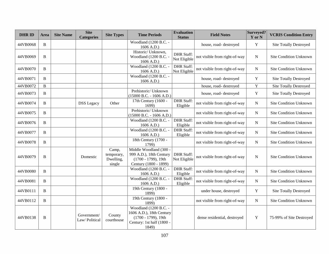
107
DHR ID Area Site Name Site
Categories Site Types Time Periods
Evaluation
Status Field Notes
Surveyed?
Y or N VCRIS Condition Entry
44VB0068 B Woodland (1200 B.C. -
1606 A.D.) house, road- destroyed Y Site Totally Destroyed
44VB0069 B Historic/ Unknown,
Woodland (1200 B.C. -
1606 A.D.)
DHR Staff:
Not Eligible not visible from right-of-way N Site Condition Unknown
44VB0070 B Woodland (1200 B.C. -
1606 A.D.)
DHR Staff:
Not Eligible not visible from right-of-way N Site Condition Unknown
44VB0071 B Woodland (1200 B.C. -
1606 A.D.) house, road- destroyed Y Site Totally Destroyed
44VB0072 B house, road- destroyed Y Site Totally Destroyed
44VB0073 B Prehistoric/ Unknown
(15000 B.C. - 1606 A.D.) house, road- destroyed Y Site Totally Destroyed
44VB0074 B DSS Legacy Other 17th Century (1600 -
1699)
DHR Staff:
Eligible not visible from right-of-way N Site Condition Unknown
44VB0075 B Prehistoric/ Unknown
(15000 B.C. - 1606 A.D.) not visible from right-of-way N Site Condition Unknown
44VB0076 B Woodland (1200 B.C. -
1606 A.D.)
DHR Staff:
Eligible not visible from right-of-way N Site Condition Unknown
44VB0077 B Woodland (1200 B.C. -
1606 A.D.)
DHR Staff:
Eligible not visible from right-of-way N Site Condition Unknown
44VB0078 B 18th Century (1700 -
1799) not visible from right-of-way N Site Condition Unknown
44VB0079 B Domestic
Camp,
temporary,
Dwelling,
single
Middle Woodland (300 -
999 A.D.), 18th Century
(1700 - 1799), 19th
Century (1800 - 1899)
DHR Staff:
Not Eligible not visible from right-of-way N Site Condition Unknown
44VB0080 B Woodland (1200 B.C. -
1606 A.D.)
DHR Staff:
Eligible not visible from right-of-way N Site Condition Unknown
44VB0081 B Woodland (1200 B.C. -
1606 A.D.)
DHR Staff:
Eligible not visible from right-of-way N Site Condition Unknown
44VB0111 B 19th Century (1800 -
1899) under house, destroyed Y Site Totally Destroyed
44VB0112 B 19th Century (1800 -
1899) not visible from right-of-way N Site Condition Unknown
44VB0138 B Government/
Law/ Political
County
courthouse
Woodland (1200 B.C. -
1606 A.D.), 18th Century
(1700 - 1799), 19th
Century: 1st half (1800 -
1849)
dense residential, destroyed Y 75-99% of Site Destroyed

108
DHR ID Area Site Name Site
Categories Site Types Time Periods
Evaluation
Status Field Notes
Surveyed?
Y or N VCRIS Condition Entry
44VB0139 B DSS Legacy Trash scatter
Prehistoric/ Unknown
(15000 B.C. - 1606
A.D.), 18th Century: 2nd
half (1750 - 1799), 19th
Century: 1st half (1800 -
1849)
some likely intact in backyard
of house Y 75-99% of Site Destroyed
44VB0140 B DSS Legacy Trash scatter 19th Century: 1st half
(1800 - 1849) some likely intact in backyard
of house Y 75-99% of Site Destroyed
44VB0202 B not visible from right-of-way N Site Condition Unknown
44VB0353 B Domestic,
DSS Legacy
Camp,
Dwelling,
single
Woodland (1200 B.C. -
1606 A.D.), 19th Century
(1800 - 1899), 20th
Century: 1st half (1900 -
1949)
under building, destroyed Y Site Totally Destroyed
44VB0354 B DSS Legacy Camp
Early Woodland (1200
B.C. - 299 A.D.), Early/
Middle Woodland (1200
B.C. - 999 A.D.), Middle
Woodland (300 - 999
A.D.)
destroyed or slated for
construction, some may
survive in woods along
shoreline
Y 75-99% of Site Destroyed
44VB0362 B
Church Point
Parish
(Spring
House Trail)
Religion Church
Prehistoric/ Unknown
(15000 B.C. - 1606
A.D.), 17th Century
(1600 - 1699), 19th
Century (1800 - 1899),
20th Century (1900 -
1999)
probably mostly intact Y 0-24% of Site Destroyed
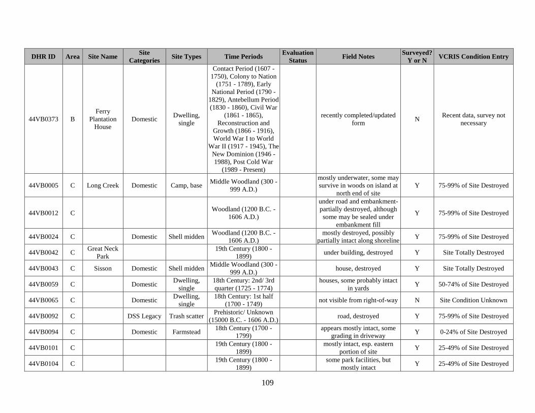
109
DHR ID Area Site Name Site
Categories Site Types Time Periods
Evaluation
Status Field Notes
Surveyed?
Y or N VCRIS Condition Entry
44VB0373 B
Ferry
Plantation
House
Domestic Dwelling,
single
Contact Period (1607 -
1750), Colony to Nation
(1751 - 1789), Early
National Period (1790 -
1829), Antebellum Period
(1830 - 1860), Civil War
(1861 - 1865),
Reconstruction and
Growth (1866 - 1916),
World War I to World
War II (1917 - 1945), The
New Dominion (1946 -
1988), Post Cold War
(1989 - Present)
recently completed/updated
form N
Recent data, survey not
necessary
44VB0005 C Long Creek Domestic Camp, base Middle Woodland (300 -
999 A.D.)
mostly underwater, some may
survive in woods on island at
north end of site
Y 75-99% of Site Destroyed
44VB0012 C Woodland (1200 B.C. -
1606 A.D.)
under road and embankment-
partially destroyed, although
some may be sealed under
embankment fill
Y 75-99% of Site Destroyed
44VB0024 C Domestic Shell midden Woodland (1200 B.C. -
1606 A.D.) mostly destroyed, possibly
partially intact along shoreline Y 75-99% of Site Destroyed
44VB0042 C Great Neck
Park 19th Century (1800 -
1899) under building, destroyed Y Site Totally Destroyed
44VB0043 C Sisson Domestic Shell midden Middle Woodland (300 -
999 A.D.) house, destroyed Y Site Totally Destroyed
44VB0059 C Domestic Dwelling,
single
18th Century: 2nd/ 3rd
quarter (1725 - 1774) houses, some probably intact
in yards Y 50-74% of Site Destroyed
44VB0065 C Domestic Dwelling,
single
18th Century: 1st half
(1700 - 1749) not visible from right-of-way N Site Condition Unknown
44VB0092 C DSS Legacy Trash scatter Prehistoric/ Unknown
(15000 B.C. - 1606 A.D.) road, destroyed Y 75-99% of Site Destroyed
44VB0094 C Domestic Farmstead 18th Century (1700 -
1799) appears mostly intact, some
grading in driveway Y 0-24% of Site Destroyed
44VB0101 C 19th Century (1800 -
1899) mostly intact, esp. eastern
portion of site Y 25-49% of Site Destroyed
44VB0104 C 19th Century (1800 -
1899) some park facilities, but
mostly intact Y 25-49% of Site Destroyed

110
DHR ID Area Site Name Site
Categories Site Types Time Periods
Evaluation
Status Field Notes
Surveyed?
Y or N VCRIS Condition Entry
44VB0105 C 19th Century (1800 -
1899) road and yards, but probably
largely intact Y 25-49% of Site Destroyed
44VB0106 C houses and road, mostly
destroyed Y 75-99% of Site Destroyed
44VB0107 C 19th Century (1800 -
1899) not visible from right-of-way N Site Condition Unknown
44VB0108 C 19th Century (1800 -
1899) not visible from right-of-way N Site Condition Unknown
44VB0109 C 19th Century (1800 -
1899) house, destroyed Y Site Totally Destroyed
44VB0132 C 19th Century (1800 -
1899) houses, small portions
possibly intact in yards Y 75-99% of Site Destroyed
44VB0137 C Funerary Cemetery
19th Century (1800 -
1899), 20th Century
(1900 - 1999)
intact Y Intact Cultural Level
44VB0240 C
Domestic,
DSS Legacy,
Subsistence/
Agriculture
Camp,
Dwelling,
single,
Hamlet,
Outbuilding,
Trash scatter
17th Century (1600 -
1699), 18th Century
(1700 - 1799)
houses, destroyed Y Site Totally Destroyed
44VB0241 C Domestic
Dwelling,
single,
Farmstead
17th Century (1600 -
1699), 18th Century
(1700 - 1799)
houses, destroyed Y Site Totally Destroyed
44VB0242 C DSS Legacy Camp houses, cul-de-sac, mostly
destroyed Y 75-99% of Site Destroyed
44VB0351 C Domestic Dwelling,
single
19th Century (1800 -
1899), 20th Century: 1st
half (1900 - 1949)
DHR Staff:
Not Eligible under I-264, destroyed N Site Totally Destroyed
44VB0009 C/ D Middle Woodland (300 -
999 A.D.)
central portion destroyed by
road, east and west ends
likely largely intact
Y 50-74% of Site Destroyed
44VB0011 D White Hill
Banks
Domestic,
Indeterminate
Artifact
scatter, Shell
midden
Pre-Contact, Woodland
(1200 B.C. - 1606 A.D.) not visible from right-of-way N Site Condition Unknown
44VB0013 D Waterfield Domestic,
Indeterminate
Artifact
scatter, Shell
midden
Pre-Contact, Woodland
(1200 B.C. - 1606 A.D.) not visible from right-of-way N Site Condition Unknown

111
DHR ID Area Site Name Site
Categories Site Types Time Periods
Evaluation
Status Field Notes
Surveyed?
Y or N VCRIS Condition Entry
44VB0014 D Domestic Shell midden Woodland (1200 B.C. -
1606 A.D.) not visible from right-of-way N Site Condition Unknown
44VB0015 D Domestic Shell midden Woodland (1200 B.C. -
1606 A.D.) not visible from right-of-way N Site Condition Unknown
44VB0016 D Domestic Shell midden Woodland (1200 B.C. -
1606 A.D.) not visible from right-of-way N Site Condition Unknown
44VB0025 D Little Neck
Creek DSS Legacy Camp
not visible from right-of-way,
but under house and probably
destroyed
N Site Condition Unknown
44VB0040 D DSS Legacy,
Indeterminate
Artifact
scatter, Camp
Woodland (1200 B.C. -
1606 A.D.), Middle
Woodland (300 - 999
A.D.), Late Woodland
(1000 - 1606)
mostly intact Y 0-24% of Site Destroyed
44VB0041 D Domestic,
DSS Legacy
Other, Shell
midden
Woodland (1200 B.C. -
1606 A.D.) intact Y Intact Cultural Level
44VB0049 D Domestic Camp, base Late Archaic (3000 -
1201 B.C.) golf course and residential,
mostly destroyed Y 75-99% of Site Destroyed
44VB0050 D Domestic Dwelling,
multiple
18th Century (1700 -
1799), 19th Century
(1800 - 1899)
houses, mostly destroyed Y 75-99% of Site Destroyed
44VB0051 D Domestic Dwelling,
single
17th Century: 2nd quarter
(1625 - 1649), 18th
Century: 3rd quarter
(1750 - 1774)
not visible from right-of-way,
but likely intact N Site Condition Unknown
44VB0052 D house, destroyed Y Site Totally Destroyed
44VB0053 D Middle Archaic (6500 -
3001 B.C.) houses, mostly destroyed Y 75-99% of Site Destroyed
44VB0054 D Prehistoric/ Unknown
(15000 B.C. - 1606 A.D.)
houses, some possibly intact
in western portion of site in
trees and gold course
Y 50-74% of Site Destroyed
44VB0055 D Domestic Camp, base
Middle Archaic (6500 -
3001 B.C.), Woodland
(1200 B.C. - 1606 A.D.)
houses, mostly destroyed Y 75-99% of Site Destroyed
44VB0056 D 18th Century (1700 -
1799)
DHR Staff:
Not Eligible
house, eastern portion in
backyard/golf course, may be
partially intact
Y 75-99% of Site Destroyed

112
DHR ID Area Site Name Site
Categories Site Types Time Periods
Evaluation
Status Field Notes
Surveyed?
Y or N VCRIS Condition Entry
44VB0057 D Prehistoric/ Unknown
(15000 B.C. - 1606 A.D.)
house, eastern portion in
backyard/golf course, may be
partially intact
Y 75-99% of Site Destroyed
44VB0058 D 18th Century (1700 -
1799) not visible from right-of-way,
golf course N Site Condition Unknown
44VB0061 D Domestic Camp,
temporary
Prehistoric/ Unknown
(15000 B.C. - 1606 A.D.) not visible from right-of-way N Site Condition Unknown
44VB0089 D DSS Legacy Other 19th Century: 4th quarter
(1875 - 1899)
DHR Staff:
Not Eligible not visible from right-of-way N Site Condition Unknown
44VB0090 D DSS Legacy Shipwreck Historic/ Unknown not visible from right-of-way N Site Condition Unknown
44VB0096 D 19th Century (1800 -
1899) houses, landscaping-
destroyed Y Site Totally Destroyed
44VB0097 D 19th Century (1800 -
1899)
houses, but large yards and
wooded portions, probably
partially intact
Y 50-74% of Site Destroyed
44VB0098 D 19th Century (1800 -
1899) not visible from right-of-way N Site Condition Unknown
44VB0099 D 19th Century (1800 -
1899) houses, but portions of site
likely intact in backyards Y 50-74% of Site Destroyed
44VB0100 D 19th Century (1800 -
1899) appears to be largely intact Y 0-24% of Site Destroyed
44VB0102 D 19th Century (1800 -
1899)
northern part of site destroyed
by houses, southern part may
be largely intact
Y 50-74% of Site Destroyed
44VB0103 D 19th Century (1800 -
1899) houses, portions likely intact
in yards Y 75-99% of Site Destroyed
44VB0110 D 19th Century (1800 -
1899) large yard, mostly intact Y 0-24% of Site Destroyed
44VB0113 D 19th Century (1800 -
1899) large yard, mostly intact Y 25-49% of Site Destroyed
44VB0114 D houses, but front yards look
filled- small portions of site
may be intact/sealed
Y 75-99% of Site Destroyed
44VB0128 D 19th Century (1800 -
1899) houses with large yards- site
probably largely intact Y 25-49% of Site Destroyed
44VB0129 D 19th Century (1800 -
1899)
houses, but southern part of
site in open field and likely
largely intact
Y 25-49% of Site Destroyed

113
DHR ID Area Site Name Site
Categories Site Types Time Periods
Evaluation
Status Field Notes
Surveyed?
Y or N VCRIS Condition Entry
44VB0130 D probably destroyed by houses
south of road, intact in woods
north of road
Y 25-49% of Site Destroyed
44VB0131 D 19th Century (1800 -
1899) houses, portions of site
possibly intact in backyards` Y 50-74% of Site Destroyed
44VB0133 D 19th Century (1800 -
1899) dense residential, probably
destroyed Y 75-99% of Site Destroyed
44VB0134 D 19th Century (1800 -
1899) shopping center, destroyed Y Site Totally Destroyed
44VB0332 D Gun Mount Military/
Defense
Military base/
facility
20th Century: 1st half
(1900 - 1949) not visible from right-of-way N Site Condition Unknown
44VB0333 D railway DSS Legacy Railroad 20th Century: 1st half
(1900 - 1949)
DHR Staff:
Potentially
Eligible
not visible from right-of-way N Site Condition Unknown
44VB0334 D RCI Site 2 DSS Legacy Other Historic/ Unknown
DHR Staff:
Potentially
Eligible
not visible from right-of-way N Site Condition Unknown
44VB0335 D Coal Shed Military/
Defense
Military
supply depot
20th Century: 1st quarter
(1900 - 1924)
DHR Staff:
Not Eligible not visible from right-of-way N Site Condition Unknown
44VB0336 D Emplacement Military/
Defense
Military base/
facility
20th Century: 2nd/ 3rd
quarter (1925 - 1974) not visible from right-of-way N Site Condition Unknown
44VB0337 D RCI Site 1 Domestic Dwelling,
single
18th Century (1700 -
1799), 19th Century
(1800 - 1899)
DHR Staff:
Not Eligible not visible from right-of-way N Site Condition Unknown
44VB0347 D Domestic,
DSS Legacy,
Indeterminate
Artifact
scatter, Camp,
Dwelling,
single
Early Woodland (1200
B.C. - 299 A.D.),
Woodland (1200 B.C. -
1606 A.D.), Middle
Woodland (300 - 999
A.D.), Late Woodland
(1000 - 1606), 19th
Century (1800 - 1899)
not visible from right-of-way N Site Condition Unknown
44VB0359 D
First Landing
State Park
Marsh Site
DSS Legacy,
Industry/
Processing/
Extraction
Lithic scatter,
Trash scatter
Prehistoric/ Unknown
(15000 B.C. - 1606
A.D.), 19th Century: 2nd
half (1850 - 1899), 20th
Century: 1st half (1900 -
1949)
not visible from right-of-way N Site Condition Unknown

114
DHR ID Area Site Name Site
Categories Site Types Time Periods
Evaluation
Status Field Notes
Surveyed?
Y or N VCRIS Condition Entry
44VB0371 D Cape Henry
Lighthouse DSS Legacy Other
18th Century: 4th quarter
(1775 - 1799), 19th
Century (1800 - 1899)
recently completed/updated
form N
Recent data, survey not
necessary
44VB0008 E Quail Springs Domestic Camp, base
Paleo-Indian (15000 -
8501 B.C.), Early
Archaic (8500 - 6501
B.C.), Middle Archaic
(6500 - 3001 B.C.),
Woodland (1200 B.C. -
1606 A.D.)
mostly under high-density
housing, partially under pond Y 75-99% of Site Destroyed
44VB0044 E DSS Legacy Camp Archaic (8500 - 1201
B.C.) under residential
development, destroyed Y Site Totally Destroyed
44VB0045 E DSS Legacy Village/ Town
18th Century (1700 -
1799), 19th Century
(1800 - 1899)
under residential
development, destroyed Y Site Totally Destroyed
44VB0093 E Domestic Farmstead 18th Century (1700 -
1799) western portion probably
mostly intact Y 50-74% of Site Destroyed
44VB0283 E DSS Legacy Other brick clamp, appears mostly
intact except for trails and
some erosion into river
Y 0-24% of Site Destroyed
44VB0285 E DSS Legacy Camp Woodland (1200 B.C. -
1606 A.D.)
houses, but southern portion
probably largely intact , esp.
on east end
Y 75-99% of Site Destroyed
44VB0286 E DSS Legacy Camp
Late Archaic (3000 -
1201 B.C.), Early
Woodland (1200 B.C. -
299 A.D.)
largely destroyed by housing,
eastern portion underwater Y 75-99% of Site Destroyed
44VB0287 E DSS Legacy Camp
Late Archaic (3000 -
1201 B.C.), Early
Woodland (1200 B.C. -
299 A.D.)
houses, destroyed Y Site Totally Destroyed
44VB0304 E
Norfolk
Southern
Railroad
Bypass Line
Grade and
Bridge
Foundations
DSS Legacy Railroad bed 19th Century: 1st half
(1800 - 1849) parking lot, roads, apt
buildings- destroyed Y Site Totally Destroyed

115
DHR ID Area Site Name Site
Categories Site Types Time Periods
Evaluation
Status Field Notes
Surveyed?
Y or N VCRIS Condition Entry
44VB0367 E Colonial
Kempsville DSS Legacy Village/ Town
18th Century: 3rd quarter
(1750 - 1774), 19th
Century: 1st half (1800 -
1849)
DHR Staff:
Potentially
Eligible
mapped boundaries entirely
under road and destroyed;
however, if site is a village/
town, portions may be intact
in empty lot to south or
recorded boundaries
Y 75-99% of Site Destroyed
44VB0375 E
Emmanuel
Episcopal
Church and
Rectory
Religion
Church,
Church-
related
residence
Colony to Nation (1751 -
1789), Early National
Period (1790 - 1829),
Antebellum Period (1830
- 1860), Civil War (1861
- 1865), Reconstruction
and Growth (1866 -
1916), World War I to
World War II (1917 -
1945), The New
Dominion (1946 - 1988),
Post-Cold War (1989 -
Present)
recently completed/updated
form N
Recent data, survey not
necessary
44VB0378 E Domestic Artifact
scatter
Reconstruction and
Growth (1866 - 1916),
World War I to World
War II (1917 - 1945)
recently completed/updated
form N
Recent data, survey not
necessary
44VB0036 F Funerary Cemetery
19th Century (1800 -
1899), 20th Century
(1900 - 1999)
intact Y Intact Cultural Level
44VB0037 F
Prehistoric/ Unknown
(15000 B.C. - 1606
A.D.), 19th Century
(1800 - 1899)
houses, mostly destroyed Y 75-99% of Site Destroyed
44VB0038 F 20th Century (1900 -
1999) under road and commercial
development, destroyed Y Site Totally Destroyed
44VB0046 F Archaic (8500 - 1201
B.C.)
golf course and residential,
partially destroyed, portions
may be intact under golf
course
Y 75-99% of Site Destroyed

116
DHR ID Area Site Name Site
Categories Site Types Time Periods
Evaluation
Status Field Notes
Surveyed?
Y or N VCRIS Condition Entry
44VB0305 F, E Deep Branch
Ditch
Technology/
Engineering
Ditch,
drainage
18th Century (1700 -
1799), 19th Century
(1800 - 1899), 20th
Century (1900 - 1999)
largely intact Y 0-24% of Site Destroyed
44VB0238 G Landscape Ditch,
boundary
18th Century (1700 -
1799), 19th Century
(1800 - 1899)
intact Y Intact Cultural Level
44VB0350 G Deary Site Domestic Dwelling,
single
18th Century (1700 -
1799), 19th Century
(1800 - 1899), 20th
Century: 1st half (1900 -
1949)
under road- destroyed Y Site Totally Destroyed
44VB0352 G Domestic Dwelling,
single
19th Century (1800 -
1899), 20th Century: 1st
half (1900 - 1949)
DHR Staff:
Not Eligible mostly under road- destroyed Y 75-99% of Site Destroyed
44VB0001 H Wolfshave 18th Century (1700 -
1799), 19th Century
(1800 - 1899)
not visible from right-of-way,
but probably intact N Site Condition Unknown
44VB0125 H 19th Century (1800 -
1899) parking lot and trailer park,
mostly destroyed Y 75-99% of Site Destroyed
44VB0127 H 19th Century (1800 -
1899) in field, probably mostly
intact Y Site Condition Unknown
44VB0161 H 19th Century: 2nd/ 3rd
quarter (1825 - 1874)
DHR Staff:
Not Eligible
in field, probably mostly
intact Y Site Condition Unknown
44VB0170 H Domestic Camp,
temporary
Prehistoric/ Unknown
(15000 B.C. - 1606
A.D.), 19th Century
(1800 - 1899)
DHR Staff:
Not Eligible
in field, probably mostly
intact Y Intact Cultural Level
44VB0171 H 19th Century (1800 -
1899), 20th Century
(1900 - 1999)
DHR Staff:
Not Eligible
in field, probably mostly
intact Y Intact Cultural Level
44VB0173 H Domestic Camp,
temporary
Middle Archaic (6500 -
3001 B.C.), 19th Century
(1800 - 1899)
DHR Staff:
Potentially
Eligible
mostly under
building/destroyed, northeast
portion in field may be intact
Y 75-99% of Site Destroyed
44VB0174 H Domestic,
Funerary
Camp,
temporary,
Cemetery
Middle Archaic (6500 -
3001 B.C.), 18th Century:
2nd half (1750 - 1799),
19th Century (1800 -
1899)
DHR Staff:
Potentially
Eligible
buildings, parking lot-
destroyed Y Site Totally Destroyed

117
DHR ID Area Site Name Site
Categories Site Types Time Periods
Evaluation
Status Field Notes
Surveyed?
Y or N VCRIS Condition Entry
44VB0187 H 20th Century (1900 -
1999)
DHR Staff:
Not Eligible in woods, probably intact Y 0-24% of Site Destroyed
44VB0188 H 19th Century: 2nd half
(1850 - 1899)
DHR Staff:
Not Eligible in woods, probably intact Y Intact Cultural Level
44VB0203 H 20th Century (1900 -
1999)
DHR Staff:
Not Eligible
in field, probably mostly
intact Y Intact Cultural Level
44VB0204 H DSS Legacy Trash scatter 19th Century: 2nd half
(1850 - 1899)
DHR Staff:
Not Eligible in woods, probably intact Y Intact Cultural Level
44VB0205 H DSS Legacy Trash scatter
19th Century: 2nd half
(1850 - 1899), 20th
Century (1900 - 1999)
DHR Staff:
Not Eligible in woods, probably intact Y Intact Cultural Level
44VB0206 H DSS Legacy Trash scatter 19th Century: 2nd half
(1850 - 1899)
DHR Staff:
Not Eligible not visible from right-of-way N Site Condition Unknown
44VB0207 H DSS Legacy Trash scatter
19th Century: 2nd half
(1850 - 1899), 20th
Century (1900 - 1999)
DHR Staff:
Not Eligible not visible from right-of-way N Site Condition Unknown
44VB0208 H Domestic,
DSS Legacy
Dwelling,
single, Trash
scatter
19th Century: 2nd half
(1850 - 1899), 20th
Century (1900 - 1999)
DHR Staff:
Not Eligible not visible from right-of-way N Site Condition Unknown
44VB0209 H DSS Legacy Trash scatter
19th Century: 2nd half
(1850 - 1899), 20th
Century (1900 - 1999)
DHR Staff:
Not Eligible not visible from right-of-way N Site Condition Unknown
44VB0210 H DSS Legacy Trash scatter 19th Century: 2nd half
(1850 - 1899) field/woods- probably mostly
intact Y Intact Cultural Level
44VB0211 H DSS Legacy Trash scatter
19th Century (1800 -
1899), 20th Century
(1900 - 1999)
DHR Staff:
Not Eligible solar farm, partially intact Y 0-24% of Site Destroyed
44VB0212 H DSS Legacy Trash scatter
19th Century: 2nd half
(1850 - 1899), 20th
Century (1900 - 1999)
road, solar farm, partially
intact Y 50-74% of Site Destroyed
44VB0213 H DSS Legacy Trash scatter 20th Century (1900 -
1999)
DHR Staff:
Not Eligible
in field, probably mostly
intact Y 0-24% of Site Destroyed
44VB0214 H DSS Legacy Trash scatter 20th Century (1900 -
1999) in field, probably mostly
intact Y Intact Cultural Level
44VB0215 H Domestic,
DSS Legacy
Camp,
Farmstead,
Trash scatter
19th Century: 2nd half
(1850 - 1899), 20th
Century: 1st half (1900 -
1949)
DHR Staff:
Not Eligible
in field, probably mostly
intact Y Intact Cultural Level

118
DHR ID Area Site Name Site
Categories Site Types Time Periods
Evaluation
Status Field Notes
Surveyed?
Y or N VCRIS Condition Entry
44VB0216 H DSS Legacy Trash scatter
18th Century: 4th quarter
(1775 - 1799), 19th
Century: 1st quarter
(1800 - 1825)
in field, probably mostly
intact Y Intact Cultural Level
44VB0217 H DSS Legacy Camp, Trash
scatter
Prehistoric/ Unknown
(15000 B.C. - 1606
A.D.), 19th Century
(1800 - 1899)
in field, probably mostly
intact Y Intact Cultural Level
44VB0218 H DSS Legacy Trash scatter
19th Century (1800 -
1899), 20th Century
(1900 - 1999)
in field, probably mostly
intact Y Intact Cultural Level
44VB0219 H DSS Legacy Trash scatter
19th Century: 2nd half
(1850 - 1899), 20th
Century (1900 - 1999)
DHR Staff:
Not Eligible
in field, probably mostly
intact Y Intact Cultural Level
44VB0220 H DSS Legacy Camp Prehistoric/ Unknown
(15000 B.C. - 1606 A.D.) in field, probably mostly
intact Y Intact Cultural Level
44VB0221 H DSS Legacy Camp, Trash
scatter
Prehistoric/ Unknown
(15000 B.C. - 1606
A.D.), 19th Century: 2nd
half (1850 - 1899), 20th
Century (1900 - 1999)
in field, probably mostly
intact Y Intact Cultural Level
44VB0222 H DSS Legacy Trash scatter
19th Century (1800 -
1899), 20th Century
(1900 - 1999)
in field, probably mostly
intact Y Intact Cultural Level
44VB0223 H DSS Legacy Camp Prehistoric/ Unknown
(15000 B.C. - 1606 A.D.) in field, probably mostly
intact Y Intact Cultural Level
44VB0224 H DSS Legacy Other Prehistoric/ Unknown
(15000 B.C. - 1606 A.D.) in field, probably mostly
intact Y Intact Cultural Level
44VB0225 H DSS Legacy Other Prehistoric/ Unknown
(15000 B.C. - 1606 A.D.) in field, probably mostly
intact Y Intact Cultural Level
44VB0226 H Funerary Cemetery Historic/ Unknown in field, probably mostly
intact Y 0-24% of Site Destroyed
44VB0228 H DSS Legacy Trash scatter
19th Century (1800 -
1899), 20th Century
(1900 - 1999)
in field, probably mostly
intact Y Intact Cultural Level
44VB0230 H DSS Legacy Trash scatter
19th Century: 2nd half
(1850 - 1899), 20th
Century (1900 - 1999)
in field, probably mostly
intact Y Intact Cultural Level

119
DHR ID Area Site Name Site
Categories Site Types Time Periods
Evaluation
Status Field Notes
Surveyed?
Y or N VCRIS Condition Entry
44VB0231 H DSS Legacy Trash scatter 20th Century (1900 -
1999) in field, probably mostly
intact Y Intact Cultural Level
44VB0232 H Domestic Dwelling,
single
19th Century (1800 -
1899), 20th Century
(1900 - 1999)
DHR Staff:
Not Eligible under roads, destroyed Y Site Totally Destroyed
44VB0233 H Commerce/
Trade,
Domestic
Dwelling,
single,
General store
20th Century: 1st half
(1900 - 1949) under road, destroyed Y Site Totally Destroyed
44VB0234 H 20th Century: 1st half
(1900 - 1949) road, utilities- destroyed Y Site Totally Destroyed
44VB0235 H Domestic Dwelling,
single
20th Century: 1st half
(1900 - 1949) road, utilities- destroyed Y Site Totally Destroyed
44VB0236 H
18th Century (1700 -
1799), 19th Century
(1800 - 1899), 20th
Century (1900 - 1999)
DHR Staff:
Not Eligible
mostly destroyed by road-
southern portion may be
partially intact in open lot, but
appears graded
Y 75-99% of Site Destroyed
44VB0237 H Landscape Ditch,
boundary
18th Century (1700 -
1799), 19th Century
(1800 - 1899)
DHR Staff:
Not Eligible road, utilities- destroyed Y Site Totally Destroyed
44VB0243 H Historic/ Unknown DHR Staff:
Not Eligible not visible from right-of-way N Site Condition Unknown
44VB0244 H Domestic Farmstead
18th Century (1700 -
1799), 19th Century: 1st
quarter (1800 - 1825)
DHR Staff:
Potentially
Eligible
not visible from right-of-way N Site Condition Unknown
44VB0245 H Domestic Farmstead 20th Century: 1st half
(1900 - 1949)
DHR Staff:
Not Eligible
mostly in woods and probably
intact Y 0-24% of Site Destroyed
44VB0246 H Domestic Farmstead
19th Century: 4th quarter
(1875 - 1899), 20th
Century: 1st half (1900 -
1949)
DHR Staff:
Not Eligible
mostly in woods and probably
intact Y 0-24% of Site Destroyed
44VB0247 H Domestic,
Subsistence/
Agriculture
Farmstead,
Outbuilding
20th Century: 1st half
(1900 - 1949)
DHR Staff:
Not Eligible
mostly in woods and probably
intact Y Intact Cultural Level
44VB0248 H DSS Legacy Trash scatter
19th Century: 4th quarter
(1875 - 1899), 20th
Century: 1st half (1900 -
1949)
DHR Staff:
Not Eligible
mostly in woods and probably
intact Y Intact Cultural Level

120
DHR ID Area Site Name Site
Categories Site Types Time Periods
Evaluation
Status Field Notes
Surveyed?
Y or N VCRIS Condition Entry
44VB0249 H Domestic Farmstead
19th Century: 4th quarter
(1875 - 1899), 20th
Century: 1st half (1900 -
1949)
DHR Staff:
Not Eligible not visible from right-of-way N Site Condition Unknown
44VB0250 H Domestic,
Subsistence/
Agriculture
Farmstead,
Outbuilding
20th Century: 1st half
(1900 - 1949)
DHR Staff:
Not Eligible not visible from right-of-way N Site Condition Unknown
44VB0251 H Domestic Farmstead
19th Century: 4th quarter
(1875 - 1899), 20th
Century: 1st half (1900 -
1949)
DHR Staff:
Not Eligible not visible from right-of-way N Site Condition Unknown
44VB0252 H Domestic Farmstead
19th Century: 4th quarter
(1875 - 1899), 20th
Century: 1st half (1900 -
1949)
DHR Staff:
Not Eligible not visible from right-of-way N Site Condition Unknown
44VB0253 H Domestic Farmstead
19th Century: 4th quarter
(1875 - 1899), 20th
Century: 1st half (1900 -
1949)
DHR Staff:
Not Eligible not visible from right-of-way N Site Condition Unknown
44VB0254 H Domestic Farmstead
19th Century: 4th quarter
(1875 - 1899), 20th
Century: 1st half (1900 -
1949)
DHR Staff:
Not Eligible not visible from right-of-way N Site Condition Unknown
44VB0255 H Domestic Farmstead
18th Century: 2nd half
(1750 - 1799), 19th
Century: 1st half (1800 -
1849)
DHR Staff:
Not Eligible in woods, probably intact Y Intact Cultural Level
44VB0300 H Oceana Fence
1
Industry/
Processing/
Extraction
Lithic scatter Prehistoric/ Unknown
(15000 B.C. - 1606 A.D.)
DHR Staff:
Not Eligible
mostly in woods and probably
intact Y Intact Cultural Level
44VB0301 H Oceana Fence
2 Domestic Farmstead
18th Century (1700 -
1799), 19th Century
(1800 - 1899), 20th
Century (1900 - 1999)
DHR Staff:
Not Eligible
in field, probably mostly
intact Y 0-24% of Site Destroyed
44VB0302 H Oceana Fence
3 Domestic Farmstead
19th Century (1800 -
1899), 20th Century
(1900 - 1999)
DHR Staff:
Not Eligible in woods, probably intact Y 0-24% of Site Destroyed

121
DHR ID Area Site Name Site
Categories Site Types Time Periods
Evaluation
Status Field Notes
Surveyed?
Y or N VCRIS Condition Entry
44VB0303 H Potter's
corner Domestic
Dwelling,
single
19th Century (1800 -
1899), 20th Century
(1900 - 1999)
DHR Staff:
Not Eligible in woods, probably intact Y Intact Cultural Level
44VB0321 H Domestic Dwelling,
single
19th Century: 1st half
(1800 - 1849)
DHR Staff:
Not Eligible
in field, probably mostly
intact Y Intact Cultural Level
44VB0361 H Domestic Farmstead 20th Century: 1st half
(1900 - 1949)
DHR Staff:
Not Eligible
in field, probably mostly
intact- maybe some utility
disturbance
Y Intact Cultural Level
44VB0379 H Domestic Farmstead World War I to World
War II (1917 - 1945) recently completed/updated
form N
Recent data, survey not
necessary
44VB0082 I Domestic Trash pit 20th Century (1900 -
1999) not visible from right-of-way N Site Condition Unknown
44VB0085 I Military/
Defense Earthworks Historic/ Unknown not visible from right-of-way N Site Condition Unknown
44VB0087 I DSS Legacy Other 19th Century (1800 -
1899) not visible from right-of-way N Site Condition Unknown
44VB0088 I Domestic Trash pit
19th Century: 4th quarter
(1875 - 1899), 20th
Century: 1st quarter
(1900 - 1924)
not visible from right-of-way N Site Condition Unknown
44VB0091 I Domestic Farmstead 19th Century: 1st quarter
(1800 - 1825) not visible from right-of-way N Site Condition Unknown
44VB0124 I Domestic Dwelling,
single
19th Century (1800 -
1899), 20th Century
(1900 - 1999)
DHR Staff:
Potentially
Eligible
mostly intact Y 0-24% of Site Destroyed
44VB0126 I 19th Century (1800 -
1899) mostly under houses, southern
portion may be partially intact Y 50-74% of Site Destroyed
44VB0178 I 19th Century (1800 -
1899)
DHR Staff:
Potentially
Eligible
not visible from right-of-way N Site Condition Unknown
44VB0179 I Domestic Camp,
temporary
Archaic (8500 - 1201
B.C.), 19th Century
(1800 - 1899)
DHR Staff:
Potentially
Eligible
pond, utilities, grading-
destroyed Y Site Totally Destroyed
44VB0196 I 20th Century: 1st half
(1900 - 1949) not visible from right-of-way,
but in woods and likely intact N Site Condition Unknown
44VB0200 I 19th Century (1800 -
1899)
partially destroyed by roads,
but mostly in woods and
probably intact
Y 25-49% of Site Destroyed

122
DHR ID Area Site Name Site
Categories Site Types Time Periods
Evaluation
Status Field Notes
Surveyed?
Y or N VCRIS Condition Entry
44VB0201 I 19th Century (1800 -
1899), 20th Century
(1900 - 1999)
road, utilities, grading, mostly
destroyed Y 75-99% of Site Destroyed
44VB0227 I Domestic,
DSS Legacy
Camp,
Farmstead,
Trash scatter
Middle Woodland (300 -
999 A.D.), 19th Century:
2nd half (1850 - 1899),
20th Century: 1st half
(1900 - 1949)
DHR Staff:
Not Eligible
in field, probably mostly
intact Y 0-24% of Site Destroyed
44VB0308 I Domestic Camp,
temporary
Late Woodland (1000 -
1606)
DHR Staff:
Eligible not visible from right-of-way N Site Condition Unknown
44VB0309 I Domestic Dwelling,
single
18th Century: 4th quarter
(1775 - 1799), 19th
Century: 1st quarter
(1800 - 1825)
not visible from right-of-way N Site Condition Unknown
44VB0310 I Funerary Cemetery 19th Century: 4th quarter
(1875 - 1899) intact Y Intact Cultural Level
44VB0343 I
Camp
Pendleton
ANG Site C-
1
DSS Legacy Trash scatter
19th Century (1800 -
1899), 20th Century
(1900 - 1999)
DHR Staff:
Not Eligible not visible from right-of-way N Site Condition Unknown
44VB0363 I Domestic Dwelling,
single
18th Century: 4th quarter
(1775 - 1799), 19th
Century: 1st quarter
(1800 - 1825)
DHR Staff:
Potentially
Eligible
recently completed/updated
form N
Recent data, survey not
necessary
44VB0364 I Domestic Dwelling,
single
19th Century: 2nd half
(1850 - 1899), 20th
Century: 1st half (1900 -
1949)
DHR Staff:
Not Eligible not visible from right-of-way N Site Condition Unknown
44VB0365 I Domestic Dwelling,
single
19th Century: 2nd half
(1850 - 1899), 20th
Century: 1st half (1900 -
1949)
DHR Staff:
Not Eligible mostly in woods/intact Y Intact Cultural Level
44VB0385 I Military/
Defense
Military base/
facility
World War I to World
War II (1917 - 1945), The
New Dominion (1946 -
1991)
not visible from right-of-way N Site Condition Unknown

123
DHR ID Area Site Name Site
Categories Site Types Time Periods
Evaluation
Status Field Notes
Surveyed?
Y or N VCRIS Condition Entry
44VB0386 I Military/
Defense
Military base/
facility
World War I to World
War II (1917 - 1945), The
New Dominion (1946 -
1991)
not visible from right-of-way N Site Condition Unknown
44VB0387 I Military/
Defense
Military base/
facility
World War I to World
War II (1917 - 1945), The
New Dominion (1946 -
1991)
not visible from right-of-way N Site Condition Unknown
44VB0388 I Military/
Defense
Military base/
facility
World War I to World
War II (1917 - 1945), The
New Dominion (1946 -
1991)
not visible from right-of-way N Site Condition Unknown
44VB0389 I
Industry/
Processing/
Extraction,
Military/
Defense
Lithic scatter,
Military base/
facility
Pre-Contact, World War I
to World War II (1917 -
1945), The New
Dominion (1946 - 1991)
not visible from right-of-way N Site Condition Unknown
44VB0390 I Military/
Defense
Military base/
facility
World War I to World
War II (1917 - 1945), The
New Dominion (1946 -
1991)
not visible from right-of-way N Site Condition Unknown
44VB0391 I Domestic Dwelling,
single
Reconstruction and
Growth (1866 - 1916) not visible from right-of-way N Site Condition Unknown
44VB0392 I Domestic Dwelling,
single
Antebellum Period (1830
- 1860), Civil War (1861
- 1865), Reconstruction
and Growth (1866 -
1916)
not visible from right-of-way N Site Condition Unknown
44VB0393 I Domestic Dwelling,
single
Colony to Nation (1751 -
1789), Early National
Period (1790 - 1829),
Antebellum Period (1830
- 1860), Civil War (1861
- 1865), Reconstruction
and Growth (1866 -
1916), World War I to
World War II (1917 -
1945), The New
Dominion (1946 - 1991)
not visible from right-of-way N Site Condition Unknown

124
DHR ID Area Site Name Site
Categories Site Types Time Periods
Evaluation
Status Field Notes
Surveyed?
Y or N VCRIS Condition Entry
44VB0394 I
Industry/
Processing/
Extraction,
Military/
Defense
Lithic scatter,
Military base/
facility
Pre-Contact, Middle
Woodland (300 - 999
C.E), Late Woodland
(1000 - 1606), World
War I to World War II
(1917 - 1945), The New
Dominion (1946 - 1991)
not visible from right-of-way N Site Condition Unknown
44VB0395 I
Industry/
Processing/
Extraction,
Military/
Defense
Lithic scatter,
Military base/
facility
Pre-Contact, Antebellum
Period (1830 - 1860),
Civil War (1861 - 1865),
Reconstruction and
Growth (1866 - 1916),
World War I to World
War II (1917 - 1945), The
New Dominion (1946 -
1991)
not visible from right-of-way N Site Condition Unknown
44VB0396 I Military/
Defense
Military base/
facility
World War I to World
War II (1917 - 1945), The
New Dominion (1946 -
1991)
not visible from right-of-way N Site Condition Unknown
44VB0180 I/ H DSS Legacy,
Funerary
Camp,
Cemetery,
Trash scatter
Paleo-Indian (15000 -
8501 B.C.), Archaic
(8500 - 1201 B.C.),
Woodland (1200 B.C. -
1606 A.D.), 18th Century
(1700 - 1799)
DHR Staff:
Potentially
Eligible
partially under road,
otherwise in fields- largely
intact
Y 0-24% of Site Destroyed
44VB0288 J DSS Legacy Camp Archaic (8500 - 1201
B.C.) dense residential- destroyed Y Site Totally Destroyed
44VB0095 K largely in woods- probably
mostly intact 0-24% of Site Destroyed

125
DHR ID Area Site Name Site
Categories Site Types Time Periods
Evaluation
Status Field Notes
Surveyed?
Y or N VCRIS Condition Entry
44VB0162 K Domestic,
Funerary
Camp,
temporary,
Cemetery
Early Archaic Period
(8500 - 6501 B.C.E),
Middle Archaic Period
(6500 - 3001 B.C.E),
Late Archaic Period
(3000 - 1201 B.C.E),
Early Woodland (1200
B.C.E - 299 C.E), Middle
Woodland (300 - 999
C.E), Late Woodland
(1000 - 1606), Early
National Period (1790 -
1829), Antebellum Period
(1830 - 1860), Civil War
(1861 - 1865),
Reconstruction and
Growth (1866 - 1916),
World War I to World
War II (1917 - 1945), The
New Dominion (1946 -
1991), Post-Cold War
(1992 - Present)
DHR Staff:
Potentially
Eligible
recently completed/updated
form N
Recent data, survey not
necessary
44VB0163 K
19th Century: 2nd half
(1850 - 1899), 20th
Century: 1st half (1900 -
1949)
DHR Staff:
Not Eligible not visible from right-of-way N Site Condition Unknown
44VB0165 K DSS Legacy Camp
Paleo-Indian (15000 -
8501 B.C.), Middle
Archaic (6500 - 3001
B.C.)
DHR Staff:
Potentially
Eligible
not visible from right-of-way N Site Condition Unknown
44VB0166 K Domestic,
Military/
Defense
Camp, Camp,
base,
Dwelling,
single
Middle Archaic Period
(6500 - 3001 B.C.E),
Early National Period
(1790 - 1829)
DHR Staff:
Potentially
Eligible
destroyed- construction in
progress Y Site Totally Destroyed
44VB0167 K Domestic Camp,
temporary
Prehistoric/ Unknown
(15000 B.C. - 1606 A.D.)
DHR Staff:
Not Eligible
house, western portion
possibly partially intact in
backyard
Y 50-74% of Site Destroyed
44VB0169 K Domestic Camp,
temporary
Prehistoric/ Unknown
(15000 B.C. - 1606 A.D.)
DHR Staff:
Not Eligible not visible from right-of-way N Site Condition Unknown

126
DHR ID Area Site Name Site
Categories Site Types Time Periods
Evaluation
Status Field Notes
Surveyed?
Y or N VCRIS Condition Entry
44VB0172 K Domestic
Camp,
temporary,
Dwelling,
single
Archaic (8500 - 1201
B.C.), 19th Century
(1800 - 1899)
DHR Staff:
Potentially
Eligible
dense residential, destroyed Y Site Totally Destroyed
44VB0175 K DSS Legacy Other
18th Century (1700 -
1799), 19th Century
(1800 - 1899)
DHR Staff:
Not Eligible
not visible from right-of-way,
but in woods and likely intact N Site Condition Unknown
44VB0176 K Domestic
Camp,
temporary,
Farmstead
Late Archaic (3000 -
1201 B.C.), 19th Century
(1800 - 1899), 20th
Century: 1st half (1900 -
1949)
DHR Staff:
Potentially
Eligible
in athletic field, possibly
largely intact if not heavily
graded
Y 0-24% of Site Destroyed
44VB0177 K Domestic,
DSS Legacy
Camp,
temporary,
Other
Prehistoric/ Unknown
(15000 B.C. - 1606
A.D.), 19th Century: 2nd
half (1850 - 1899), 20th
Century (1900 - 1999)
DHR Staff:
Not Eligible under building, destroyed Y Site Totally Destroyed
44VB0181 K 19th Century: 2nd half
(1850 - 1899)
DHR Staff:
Potentially
Eligible
not visible from right-of-way N Site Condition Unknown
44VB0182 K Funerary Cemetery
19th Century (1800 -
1899), 20th Century
(1900 - 1999)
DHR Staff:
Not Eligible intact Y Intact Cultural Level
44VB0183 K Funerary Cemetery
19th Century (1800 -
1899), 20th Century
(1900 - 1999)
DHR Staff:
Not Eligible intact Y Intact Cultural Level
44VB0184 K Funerary Cemetery Historic/ Unknown DHR Staff:
Not Eligible wooded, probably intact Y 0-24% of Site Destroyed
44VB0185 K Funerary Cemetery 20th Century (1900 -
1999)
DHR Staff:
Not Eligible intact Y Intact Cultural Level
44VB0189 K DSS Legacy,
Funerary
Cemetery,
Other
19th Century: 2nd half
(1850 - 1899), 20th
Century: 1st half (1900 -
1949)
DHR Staff:
Potentially
Eligible
not visible from right-of-way N Site Condition Unknown
44VB0190 K
18th Century: 2nd half
(1750 - 1799), 19th
Century: 1st half (1800 -
1849)
DHR Staff:
Potentially
Eligible
in field, probably mostly
intact Y Intact Cultural Level

127
DHR ID Area Site Name Site
Categories Site Types Time Periods
Evaluation
Status Field Notes
Surveyed?
Y or N VCRIS Condition Entry
44VB0191 K DSS Legacy Camp
Archaic (8500 - 1201
B.C.), 19th Century
(1800 - 1899), 20th
Century (1900 - 1999)
DHR Staff:
Potentially
Eligible
in field, probably mostly
intact Y Intact Cultural Level
44VB0193 K Domestic Farmstead
19th Century: 2nd quarter
(1825 - 1849), 20th
Century (1900 - 1999)
DHR Staff:
Potentially
Eligible
in field, probably mostly
intact Y Intact Cultural Level
44VB0194 K Domestic Farmstead
19th Century (1800 -
1899), 20th Century
(1900 - 1999)
DHR Staff:
Not Eligible
mostly in woods, probably
intact Y Intact Cultural Level
44VB0197 K Domestic Farmstead 20th Century (1900 -
1999) under road, destroyed Y Site Totally Destroyed
44VB0198 K
19th Century: 2nd half
(1850 - 1899), 20th
Century: 1st half (1900 -
1949)
stormwater retention pond-
destroyed Y Site Totally Destroyed
44VB0199 K 19th Century (1800 -
1899), 20th Century
(1900 - 1999)
parking lot and grading-
destroyed Y Site Totally Destroyed
44VB0257 K Domestic Farmstead
18th Century: 2nd half
(1750 - 1799), 19th
Century: 1st half (1800 -
1849)
DHR Staff:
Not Eligible
mostly in woods, probably
intact Y 0-24% of Site Destroyed
44VB0262 K Domestic Farmstead
18th Century: 2nd half
(1750 - 1799), 19th
Century: 1st half (1800 -
1849)
DHR Staff:
Not Eligible not visible from right-of-way N Site Condition Unknown
44VB0263 K DSS Legacy Trash scatter
19th Century: 2nd quarter
(1825 - 1849), 19th
Century: 2nd half (1850 -
1899)
DHR Staff:
Potentially
Eligible
not visible from right-of-way N Site Condition Unknown
44VB0264 K DSS Legacy Trash scatter
19th Century: 2nd half
(1850 - 1899), 20th
Century: 1st half (1900 -
1949)
DHR Staff:
Potentially
Eligible
not visible from right-of-way N Site Condition Unknown
44VB0265 K DSS Legacy Trash scatter DHR Staff:
Potentially
Eligible
not visible from right-of-way N Site Condition Unknown

128
DHR ID Area Site Name Site
Categories Site Types Time Periods
Evaluation
Status Field Notes
Surveyed?
Y or N VCRIS Condition Entry
44VB0266 K DSS Legacy Trash scatter
Prehistoric/ Unknown
(15000 B.C. - 1606
A.D.), 19th Century: 2nd
half (1850 - 1899)
DHR Staff:
Potentially
Eligible
not visible from right-of-way N Site Condition Unknown
44VB0269 K
Transportation
/
Communicatio
n
Trash scatter
Early National Period
(1790 - 1829),
Antebellum Period (1830
- 1860)
DHR Staff:
Potentially
Eligible
recently completed/updated
form N
Recent data, survey not
necessary
44VB0270 K Indeterminate Artifact
scatter
Paleo-Indian (15000 -
8501 B.C.E), Early
Archaic Period (8500 -
6501 B.C.E), Middle
Archaic Period (6500 -
3001 B.C.E), Late
Archaic Period (3000 -
1201 B.C.E), Early
Woodland (1200 B.C.E -
299 C.E), Middle
Woodland (300 - 999
C.E), Late Woodland
(1000 - 1606), Early
National Period (1790 -
1829), Antebellum Period
(1830 - 1860), Civil War
(1861 - 1865),
Reconstruction and
Growth (1866 - 1916)
DHR Staff:
Potentially
Eligible
recently completed/updated
form N
Recent data, survey not
necessary
44VB0271 K
Transportation
/
Communicatio
n
Trash scatter
Early National Period
(1790 - 1829),
Antebellum Period (1830
- 1860), Civil War (1861
- 1865), Reconstruction
and Growth (1866 -
1916)
DHR Staff:
Potentially
Eligible
recently completed/updated
form N
Recent data, survey not
necessary
44VB0272 K
Transportation
/
Communicatio
n
Trash scatter
Antebellum Period (1830
- 1860), Civil War (1861
- 1865), Reconstruction
and Growth (1866 -
1916)
DHR Staff:
Potentially
Eligible
recently completed/updated
form N
Recent data, survey not
necessary

129
DHR ID Area Site Name Site
Categories Site Types Time Periods
Evaluation
Status Field Notes
Surveyed?
Y or N VCRIS Condition Entry
44VB0273 K
Transportation
/
Communicatio
n
Trash scatter Reconstruction and
Growth (1866 - 1916)
DHR Staff:
Potentially
Eligible
recently completed/updated
form N
Recent data, survey not
necessary
44VB0274 K Domestic,
Indeterminate
Artifact
scatter,
Farmstead
Paleo-Indian (15000 -
8501 B.C.E), Early
Archaic Period (8500 -
6501 B.C.E), Middle
Archaic Period (6500 -
3001 B.C.E), Late
Archaic Period (3000 -
1201 B.C.E), Early
Woodland (1200 B.C.E -
299 C.E), Middle
Woodland (300 - 999
C.E), Late Woodland
(1000 - 1606),
Antebellum Period (1830
- 1860), Civil War (1861
- 1865), Reconstruction
and Growth (1866 -
1916)
DHR Staff:
Not Eligible
recently completed/updated
form N
Recent data, survey not
necessary
44VB0275 K
Transportation
/
Communicatio
n
Trash scatter
Antebellum Period (1830
- 1860), Civil War (1861
- 1865), Reconstruction
and Growth (1866 -
1916)
DHR Staff:
Potentially
Eligible
recently completed/updated
form N
Recent data, survey not
necessary
44VB0290 K DSS Legacy Camp Late Archaic (3000 -
1201 B.C.) mostly in woods, probably
largely intact Y 0-24% of Site Destroyed
44VB0293 K DHR Staff:
Not Eligible intact Y Intact Cultural Level
44VB0306 K
Salem Canal
(Channelized
Segment of
North
Landing
River)
DSS Legacy Canal
19th Century (1800 -
1899), 20th Century
(1900 - 1999)
DHR Staff:
Not Eligible
also VB172 (same
boundaries) Y Site Totally Destroyed

130
DHR ID Area Site Name Site
Categories Site Types Time Periods
Evaluation
Status Field Notes
Surveyed?
Y or N VCRIS Condition Entry
44VB0307 K Canal No. 4 DSS Legacy Canal
19th Century: 2nd half
(1850 - 1899), 20th
Century: 1st half (1900 -
1949)
DHR Staff:
Not Eligible intact at Dam Neck crossing Y Intact Cultural Level
44VB0311 K Domestic Dwelling,
single
20th Century (1900 -
1999)
DHR Staff:
Not Eligible
northwestern portion probably
largely intact, rest may be
partially destroyed by sheds
and other lightly-constructed
buildings
Y 25-49% of Site Destroyed
44VB0312 K Domestic Dwelling,
single
20th Century (1900 -
1999)
DHR Staff:
Not Eligible
northern, wooded portion
likely intact
Y,
nowhere to
pull over
for photo
25-49% of Site Destroyed
44VB0313 K Domestic Dwelling,
single
20th Century (1900 -
1999)
DHR Staff:
Not Eligible
southeastern, wooded portion
likely intact
Y,
nowhere to
pull over
for photo
25-49% of Site Destroyed
44VB0314 K Domestic Dwelling,
single
19th Century: 2nd half
(1850 - 1899)
DHR Staff:
Not Eligible not visible from right-of-way N Site Condition Unknown
44VB0315 K Domestic Dwelling,
single
20th Century (1900 -
1999)
DHR Staff:
Not Eligible
road cuts through, otherwise
largely intact Y 25-49% of Site Destroyed
44VB0316 K Domestic Dwelling,
single
20th Century (1900 -
1999)
DHR Staff:
Not Eligible appears mostly intact Y 0-24% of Site Destroyed
44VB0317 K Domestic Dwelling,
single
20th Century (1900 -
1999)
roads cuts through, but mostly
in field, probably largely
intact
Y 0-24% of Site Destroyed
44VB0318 K Domestic Dwelling,
single
19th Century (1800 -
1899)
DHR Staff:
Not Eligible
in field, probably mostly
intact Y Intact Cultural Level
44VB0319 K Domestic Dwelling,
single
19th Century (1800 -
1899)
DHR Staff:
Not Eligible
in field, probably mostly
intact Y Intact Cultural Level
44VB0320 K Domestic Dwelling,
single
19th Century: 1st half
(1800 - 1849)
DHR Staff:
Not Eligible
field/woods- probably mostly
intact Y Intact Cultural Level
44VB0342 K Murphy
Cemetery Funerary Cemetery
19th Century: 2nd half
(1850 - 1899)
mapped as partially under
road, but probably intact in
clump of trees north and east
of road
Y Intact Cultural Level

131
DHR ID Area Site Name Site
Categories Site Types Time Periods
Evaluation
Status Field Notes
Surveyed?
Y or N VCRIS Condition Entry
44VB0370 K Domestic Dwelling,
single
18th Century (1700 -
1799), 19th Century
(1800 - 1899), 20th
Century: 1st half (1900 -
1949)
DHR Staff:
Not Eligible
recently completed/updated
form N
Recent data, survey not
necessary
44VB0374 K Domestic Artifact
scatter
Reconstruction and
Growth (1866 - 1916),
World War I to World
War II (1917 - 1945), The
New Dominion (1946 -
1988)
recently completed/updated
form N
Recent data, survey not
necessary
44VB0121 L 19th Century (1800 -
1899) dense residential, destroyed Y Site Totally Destroyed
44VB0164 L Domestic,
DSS Legacy
Camp,
temporary,
Other
Late Archaic (3000 -
1201 B.C.), Woodland
(1200 B.C. - 1606 A.D.),
18th Century (1700 -
1799)
DHR Staff:
Potentially
Eligible
dense residential, destroyed Y Site Totally Destroyed
44VB0168 L 20th c. house
site
Domestic,
DSS Legacy
Dwelling,
single, Other
20th Century (1900 -
1999)
DHR Staff:
Not Eligible
southern portion under
houses, northern part in
woods and likely largely
intact
Y 25-49% of Site Destroyed
44VB0186 L Domestic Dwelling,
single
18th Century (1700 -
1799), 19th Century
(1800 - 1899)
DHR Staff:
Potentially
Eligible
largely intact, far eastern 1/3
destroyed by modern house Y 25-49% of Site Destroyed
44VB0291 L DSS Legacy Camp
Early Archaic (8500 -
6501 B.C.), Middle
Archaic (6500 - 3001
B.C.), Late Archaic (3000
- 1201 B.C.), Early
Woodland (1200 B.C. -
299 A.D.)
under shopping center,
destroyed Y Site Totally Destroyed
44VB0292 L DHR Staff:
Not Eligible under road, destroyed Y Site Totally Destroyed
44VB0017 M Lake
Tecumseh Domestic
Dwelling,
single
19th Century (1800 -
1899) under industrial complex,
destroyed Y Site Totally Destroyed
44VB0018 M Funerary Cemetery under industrial complex,
destroyed Y Site Totally Destroyed

132
DHR ID Area Site Name Site
Categories Site Types Time Periods
Evaluation
Status Field Notes
Surveyed?
Y or N VCRIS Condition Entry
44VB0019 M DSS Legacy Trash scatter
18th Century: 2nd half
(1750 - 1799), 19th
Century: 1st half (1800 -
1849)
under industrial complex,
destroyed Y Site Totally Destroyed
44VB0020 M Domestic Dwelling,
single
18th Century: 2nd half
(1750 - 1799), 19th
Century: 1st half (1800 -
1849)
under industrial complex,
destroyed Y Site Totally Destroyed
44VB0021 M Domestic Trash pit 19th Century: 1st half
(1800 - 1849) under industrial complex,
destroyed Y Site Totally Destroyed
44VB0022 M DSS Legacy Other
18th Century (1700 -
1799), 19th Century
(1800 - 1899)
under industrial complex,
destroyed Y Site Totally Destroyed
44VB0083 M Domestic Farmstead 19th Century (1800 -
1899) not visible from right-of-way N Site Condition Unknown
44VB0084 M Domestic Trash pit 20th Century (1900 -
1999)
not visible from right-of-way,
but under parking lot,
destroyed
N Site Condition Unknown
44VB0086 M Funerary Cemetery 19th Century (1800 -
1899) not visible from right-of-way N Site Condition Unknown
44VB0117 M 19th Century (1800 -
1899) wooded, probably intact Y 50-74% of Site Destroyed
44VB0118 M 19th Century (1800 -
1899) dense residential, mostly
destroyed Y 75-99% of Site Destroyed
44VB0119 M 19th Century (1800 -
1899) dense residential, mostly
destroyed Y Site Totally Destroyed
44VB0120 M 19th Century (1800 -
1899) dense residential, mostly
destroyed Y Site Totally Destroyed
44VB0122 M 19th Century (1800 -
1899) in church yard and woods,
probably largely intact Y 25-49% of Site Destroyed
44VB0123 M
Hickman House (ca. 1832),
appears intact except for
directly under house, where
construction taking place to
stabilize or move building
Y 25-49% of Site Destroyed
44VB0281 M Domestic Dwelling,
single
Prehistoric/ Unknown
(15000 B.C. - 1606
A.D.), 19th Century
(1800 - 1899)
road, parking lot- destroyed Y Site Totally Destroyed

133
DHR ID Area Site Name Site
Categories Site Types Time Periods
Evaluation
Status Field Notes
Surveyed?
Y or N VCRIS Condition Entry
44VB0322 M field scatter 1 DSS Legacy Trash scatter
19th Century: 2nd half
(1850 - 1899), 20th
Century: 1st quarter
(1900 - 1924)
DHR Staff:
Not Eligible
in field, probably mostly
intact Y Intact Cultural Level
44VB0323 M field scatter 2 DSS Legacy Trash scatter
19th Century: 2nd half
(1850 - 1899), 20th
Century: 1st half (1900 -
1949)
DHR Staff:
Not Eligible
in field, probably mostly
intact Y Intact Cultural Level
44VB0324 M field scatter 4 DSS Legacy Trash scatter
19th Century: 2nd half
(1850 - 1899), 20th
Century: 1st half (1900 -
1949)
DHR Staff:
Not Eligible
in field, probably mostly
intact Y Intact Cultural Level
44VB0325 M field scatter 5 DSS Legacy Trash scatter
Prehistoric/ Unknown
(15000 B.C. - 1606
A.D.), 19th Century: 2nd
half (1850 - 1899), 20th
Century: 1st quarter
(1900 - 1924)
DHR Staff:
Not Eligible
in field, probably mostly
intact Y Intact Cultural Level
44VB0326 M field scatter 7 Domestic,
DSS Legacy
Camp,
temporary,
Trash scatter
Prehistoric/ Unknown
(15000 B.C. - 1606
A.D.), 19th Century: 2nd
half (1850 - 1899), 20th
Century: 1st quarter
(1900 - 1924)
DHR Staff:
Not Eligible
in field, probably mostly
intact Y Intact Cultural Level
44VB0327 M field scatter 8 DSS Legacy Trash scatter
19th Century: 2nd half
(1850 - 1899), 20th
Century: 1st half (1900 -
1949)
DHR Staff:
Not Eligible
in field, probably mostly
intact Y Intact Cultural Level
44VB0328 M field scatter 9 DSS Legacy Trash scatter
19th Century: 2nd half
(1850 - 1899), 20th
Century: 1st half (1900 -
1949)
DHR Staff:
Not Eligible
southern portion in field,
probably mostly intact,
northern part may be
impacted by construction of
road and building
Y 25-49% of Site Destroyed
44VB0329 M field scatter
10 DSS Legacy Trash scatter
19th Century (1800 -
1899), 20th Century: 1st
quarter (1900 - 1924)
DHR Staff:
Potentially
Eligible
in field, probably mostly
intact Y 25-49% of Site Destroyed
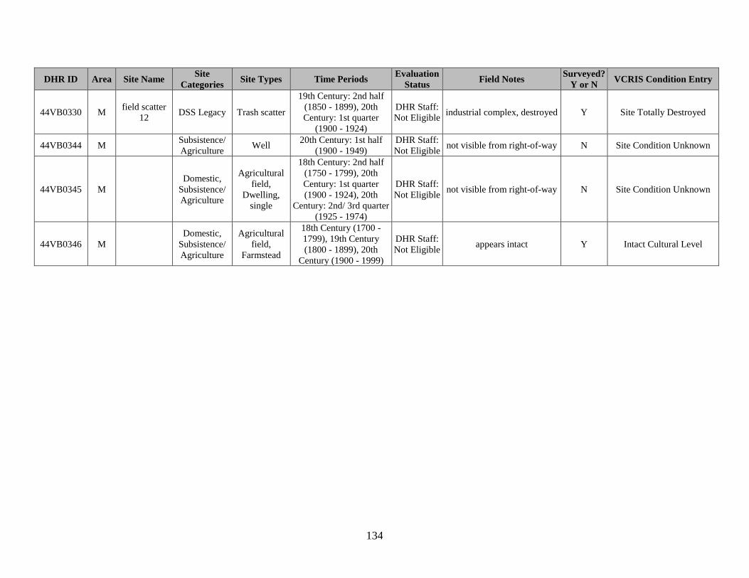
134
DHR ID Area Site Name Site
Categories Site Types Time Periods
Evaluation
Status Field Notes
Surveyed?
Y or N VCRIS Condition Entry
44VB0330 M field scatter
12 DSS Legacy Trash scatter
19th Century: 2nd half
(1850 - 1899), 20th
Century: 1st quarter
(1900 - 1924)
DHR Staff:
Not Eligible industrial complex, destroyed Y Site Totally Destroyed
44VB0344 M Subsistence/
Agriculture Well
20th Century: 1st half
(1900 - 1949)
DHR Staff:
Not Eligible not visible from right-of-way N Site Condition Unknown
44VB0345 M Domestic,
Subsistence/
Agriculture
Agricultural
field,
Dwelling,
single
18th Century: 2nd half
(1750 - 1799), 20th
Century: 1st quarter
(1900 - 1924), 20th
Century: 2nd/ 3rd quarter
(1925 - 1974)
DHR Staff:
Not Eligible not visible from right-of-way N Site Condition Unknown
44VB0346 M Domestic,
Subsistence/
Agriculture
Agricultural
field,
Farmstead
18th Century (1700 -
1799), 19th Century
(1800 - 1899), 20th
Century (1900 - 1999)
DHR Staff:
Not Eligible appears intact Y Intact Cultural Level