archaeological assessment at rialto cinema, south … · irish archaeological consultancy ltd i...
TRANSCRIPT
ARCHAEOLOGICAL ASSESSMENT
AT
RIALTO CINEMA,
SOUTH CIRCULAR ROAD, DUBLIN 8
ON BEHALF OF: MOLAGA CAPITAL
AUTHOR: GRACE CORBETT
JANUARY 2019
IAC PROJECT REF: J3321


Rialto Cinema, South Circular Road, Dublin 8 Archaeological Assessment
IRISH ARCHAEOLOGICAL CONSULTANCY LTD i
ABSTRACT
Irish Archaeological Consultancy Ltd has prepared this report on behalf of Molaga
Capital, to study the impact, if any, on the archaeological and historical resource of
the proposed development at the site of the former Rialto Cinema, South Circular
Road, Dublin 8 (ITM 713688, 732903). The report was undertaken by Grace Corbett of
IAC Ltd.
The site is occupied by Rialto Cinema and areas of hardstanding surrounding the
building. No features of archaeological potential were identified in the baseline data
or during field inspection of the site. Previous investigations in the surrounding area
have identified 17th and 18th century activity in the vicinity and although the site is
shown as an open area in the historic mapping it is possible that these activities
continued within the proposed development area.
While the site has been subject to significant ground disturbance in the 1930s, there
is some limited potential for previously unrecorded archaeological remains to survive
beneath the current ground surface. If present, ground disturbances associated with
the proposed development, specifically excavations associated with the insertion of a
basement level, may have an adverse impact on any such remains.
It is recommended that following demolition of the building, all ground disturbances
associated with the proposed development be monitored by a suitably qualified
archaeologist. If any features of archaeological potential are discovered during the
course of the works further archaeological mitigation may be required, such as
preservation in-situ or by record. Any further mitigation will require approval from the
National Monuments Service and Dublin City Council Archaeologist.
Rialto Cinema, South Circular Road, Dublin 8 Archaeological Assessment
IRISH ARCHAEOLOGICAL CONSULTANCY LTD ii
CONTENTS
ABSTRACT .................................................................................................................. I
CONTENTS ................................................................................................................ II
List of Figures ................................................................................................................. iii
List of Plates ................................................................................................................... iii
1 INTRODUCTION ................................................................................................ 1
1.1 General ................................................................................................................. 1
1.2 The Development ................................................................................................ 1
2 METHODOLOGY ............................................................................................... 2
2.1 Paper Survey ........................................................................................................ 2
2.2 Field Inspection .................................................................................................... 4
3 RESULTS OF DESKTOP STUDY ............................................................................. 5
3.1 Archaeological and Historical Background ......................................................... 5
3.2 Summary of Previous Archaeological Fieldwork ................................................ 8
3.3 Cartographic Analysis .......................................................................................... 9
3.4 City Development Plan ...................................................................................... 10
3.5 Aerial Photographic Analysis ............................................................................. 11
3.6 Results of Field Inspection ................................................................................ 11
4 CONCLUSIONS ............................................................................................... 12
5 IMPACT ASSESSMENT AND MITIGATION STRATEGY ...................................... 13
5.1 Impact Assessment ............................................................................................ 13
5.2 Mitigation ........................................................................................................... 13
6 REFERENCES .................................................................................................... 14
APPENDICES .............................................................................................................. I
Appendix 1 SMR/RMP Sites within the Surrounding Area ...................................... i
Appendix 2 Stray Finds within the Surrounding Area ............................................ ii
Appendix 3 Legislation Protecting the Archaeological Resource ......................... iii
Appendix 4 Impact Assessment and the Cultural Heritage Resource .................. vi
Appendix 5 Mitigation Measures and the Cultural Heritage Resource .............. viii
FIGURES
PLATES

Rialto Cinema, South Circular Road, Dublin 8 Archaeological Assessment
IRISH ARCHAEOLOGICAL CONSULTANCY LTD iii
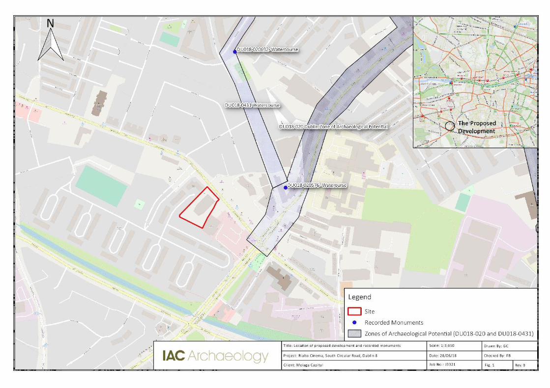
LIST OF FIGURES Figure 1 Location of proposed development and recorded monuments
Figure 2 Plan of proposed development
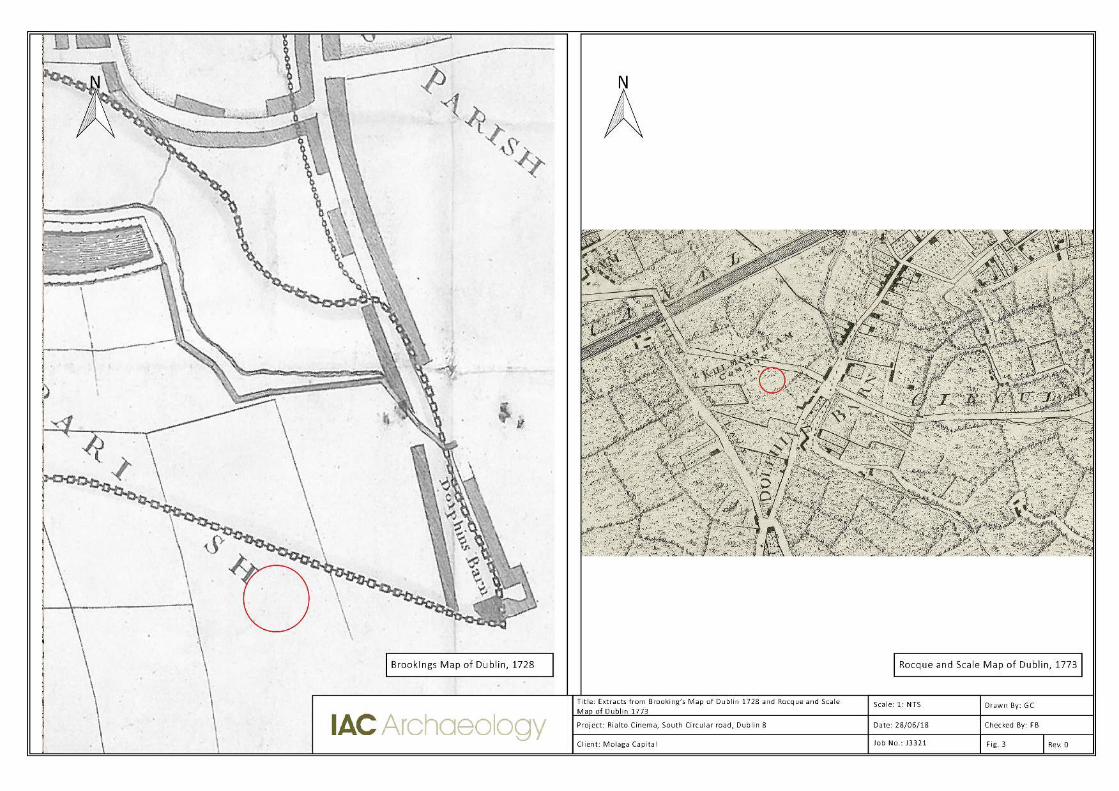
Figure 3 Extracts from Brooking’s Map of Dublin 1728 and Rocque and Scale Map of Dublin 1773
Figure 4 Extracts from Campbell’s Map of Dublin 1811 and Taylor’s Map of the
Environs of Dublin 1816
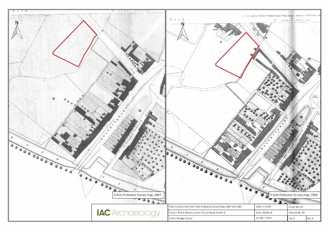
Figure 5 Extracts from the 1847 and 1864 Ordnance Survey Maps
Figure 6 Extracts from the 1888 and 1907 Ordnance Survey Maps
Figure 7 Extract from the 1840s Ordnance Survey Map
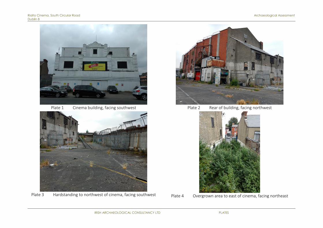
LIST OF PLATES Plate 1 Cinema building, facing southwest
Plate 2 Rear of Cinema, facing northwest
Plate 3 Overgrown area to east of Cinema, facing northeast
Plate 4 Hardstanding to northwest of Cinema, facing southwest

Rialto Cinema, South Circular Road, Dublin 8 Archaeological Assessment
IRISH ARCHAEOLOGICAL CONSULTANCY LTD 1
1 INTRODUCTION
1.1 GENERAL The following report details an archaeological assessment undertaken in advance of a
proposed development at the location of the former Rialto Cinema, South Circular
Road, Dublin 8 (Figure 1). This assessment has been carried out to ascertain the
potential impact of the proposed development on the archaeological and historical
resource that may exist within the site. The assessment was undertaken by Grace
Corbett of Irish Archaeological Consultancy Ltd (IAC), on behalf of Molaga Capital.
The archaeological assessment involved a detailed study of the archaeological and
historical background of the proposed development area and the surrounding area.
This included information from the Record of Monuments and Places of County
Dublin (Figure 1), the topographical files within the National Museum and all available
cartographic and documentary sources for the area. A field inspection has also been
carried out with the aim to identify any previously unrecorded features of
archaeological or historical interest.
1.2 THE DEVELOPMENT The proposal consists of 319 student beds contained in 314 bedrooms
with communal facilities on the ground floor and basement. The scheme is a mix
of a retained Art Deco element to the front (South Circular Road) and a new
build, 6 storeys over basement building to the rear in a cruciform shape. The
development requires the demolition of the rear former auditorium element of
the old cinema,
with the ‘head’ Deco element fully restored. This provides for 4 distinct courtyard areas for recreational uses. The development has no parking with c. 160 bikes spaces
provided for on site (Figure 2).
All access to the development is off South Circular Road, with occupant, service
and fire truck access points to the north façade. Plant and service/back of house
areas are contained within a partial basement section of the site.
Rialto Cinema, South Circular Road, Dublin 8 Archaeological Assessment
IRISH ARCHAEOLOGICAL CONSULTANCY LTD 2
2 METHODOLOGY
Research for this report was undertaken in two phases. The first phase comprised a
paper survey of all available archaeological, historical and cartographic sources. The
second phase involved a field inspection of the site.
2.1 PAPER SURVEY
• Record of Monuments and Places for County Dublin;
• Sites and Monuments Record for County Dublin;
• National Monuments in State Care Database;
• Preservation Orders List;
• Topographical files of the National Museum of Ireland;
• Cartographic and written sources relating to the study area;
• Dublin City Development Plan (2016–2022);
• Aerial photographs;
• Excavations Bulletin (1970-2018).
• National Inventory of Architectural Heritage.
Record of Monuments and Places (RMP) is a list of archaeological sites known to
the National Monuments Section, which are afforded legal protection under Section
12 of the 1994 National Monuments Act and are published as a record.
Sites and Monuments Record (SMR) holds documentary evidence and field
inspections of all known archaeological sites and monuments. Some information is
also held about archaeological sites and monuments whose precise location is not
known e.g. only a site type and townland are recorded. These are known to the
National Monuments Section as ‘un-located sites’ and cannot be afforded legal protection due to lack of locational information. As a result these are omitted from
the Record of Monuments and Places. SMR sites are also listed on a website
maintained by the Department of Culture, Heritage and the Gaeltacht (DoCHG) –
www.archaeology.ie.
National Monuments in State Care Database is a list of all the National Monuments
in State guardianship or ownership. Each is assigned a National Monument number
whether in guardianship or ownership and has a brief description of the remains of
each Monument.
The Minister for the DoCHG may acquire national monuments by agreement or by
compulsory order. The state or local authority may assume guardianship of any
national monument (other than dwellings). The owners of national monuments (other
than dwellings) may also appoint the Minister or the local authority as guardian of
that monument if the state or local authority agrees. Once the site is in ownership or
guardianship of the state, it may not be interfered with without the written consent
of the Minister.

Rialto Cinema, South Circular Road, Dublin 8 Archaeological Assessment
IRISH ARCHAEOLOGICAL CONSULTANCY LTD 3
Preservation Orders List contains information on Preservation Orders and/or
Temporary Preservation Orders, which have been assigned to a site or sites. Sites
deemed to be in danger of injury or destruction can be allocated Preservation Orders
under the 1930 Act. Preservation Orders make any interference with the site illegal.
Temporary Preservation Orders can be attached under the 1954 Act. These perform
the same function as a Preservation Order but have a time limit of six months, after
which the situation must be reviewed. Work may only be undertaken on or in the
vicinity of sites under Preservation Orders with the written consent, and at the
discretion, of the Minister.
Topographical files of the National Museum of Ireland is the national archive of
all known finds recorded by the National Museum. This archive relates primarily to
artefacts but also includes references to monuments and unique records of previous
excavations. The find spots of artefacts are important sources of information on the
discovery of sites of archaeological significance.
Cartographic sources are important in tracing land use development within the
development area as well as providing important topographical information on areas
of archaeological potential and the development of buildings. Cartographic analysis of
all relevant maps has been made to identify any topographical anomalies or
structures that no longer remain within the landscape.
• Charles Brooking, A Map of the City and Suburbs of Dublin, 1728
• Rocque’s A survey of the City, Harbour Bay and Environs of Dublin on the same scale as those of London, Paris & Rome, 1757
• Rocque’s An Actual Survey of the County of Dublin, 1760
• Rocque and Scale’s A survey of the City, Harbour Bay and Environs of Dublin…..with Improvements and Additions to the year 1773
• Campbell’s Map of Dublin City, 1811
• Taylor’s Map of the Environs of Dublin 1816
• Ordnance Survey maps of County Dublin, 1847, 1864, 1888, 1907 and 1940s
Documentary sources were consulted to gain background information on the
archaeological, architectural and cultural heritage landscape of the proposed
development area.
Development Plans contain a catalogue of all the Protected Structures and
archaeological sites within the county. The Dublin City Development Plan (2016-2022)
was consulted to obtain information on cultural heritage sites in and within the
immediate vicinity of the proposed development area.
Aerial photographic coverage is an important source of information regarding the
precise location of sites and their extent. It also provides initial information on the
terrain and its likely potential for archaeology. A number of sources were consulted
including aerial photographs held by the Ordnance Survey and Google Earth.

Rialto Cinema, South Circular Road, Dublin 8 Archaeological Assessment
IRISH ARCHAEOLOGICAL CONSULTANCY LTD 4
Excavations Bulletin is a summary publication that has been produced every year
since 1970. This summarises every archaeological excavation that has taken place in
Ireland during that year up until 2010 and since 1987 has been edited by Isabel
Bennett. This information is vital when examining the archaeological content of any
area, which may not have been recorded under the SMR and RMP files. This
information is also available online (www.excavations.ie) from 1970−2018.
2.2 FIELD INSPECTION Field inspection is necessary to determine the extent and nature of archaeological
and historical remains and can also lead to the identification of previously unrecorded
or suspected sites and portable finds through topographical observation and local
information.
The archaeological field inspection entailed -
• Walking the proposed development and its immediate environs.
• Noting and recording the terrain type and land usage.
• Noting and recording the presence of features of archaeological or historical
significance.
• Verifying the extent and condition of any recorded sites.
• Visually investigating any suspect landscape anomalies to determine the
possibility of their being anthropogenic in origin.

Rialto Cinema, South Circular Road, Dublin 8 Archaeological Assessment
IRISH ARCHAEOLOGICAL CONSULTANCY LTD 5
3 RESULTS OF DESKTOP STUDY
3.1 ARCHAEOLOGICAL AND HISTORICAL BACKGROUND The proposed development area is located at the site of the former Rialto Cinema,
South Circular Road, Dublin 8. The Site covers 0.3ha of land which is occupied by the
former cinema building and areas of hard standing. The wider area once formed the
periphery of the industrial heartland of Dublin, which was focused around the River
Poddle and the City Watercourse. These waterways were the major engine for
industry from the medieval period up until the 20th century. The development area is
located within 100m of the Zone of Notification for historic Dublin City DU018-020
which extends southwards to include the city watercourse DU018-043001.
3.1.1 Prehistoric Period
The Mesolithic Period (c. 7000–4000BC) is the earliest time for which there is clear
evidence for prehistoric activity in Ireland. During this period people hunted, foraged
and gathered food and appear to have had a mobile lifestyle. The nearest evidence
for Mesolithic activity to the proposed development area comprises of fish traps
excavated on the shores of the River Liffey at Spencer Dock, c. 3.8km to the
northeast.
The River Liffey and smaller water courses such as the Rivers Dodder and Poddle were
major resources to be exploited throughout the prehistoric period. However, there
are no recorded sites dating to the Mesolithic, Neolithic, Bronze Age or Iron Age
located within the vicinity of the proposed development area.
3.1.2 Early Medieval Period (AD 400–1169)
The name Dublin (Dubhlinn), meaning black pool, is generally taken to refer to the
pool or pond that was located directly southeast of the present Dublin Castle, on the
southern side of the River Liffey. However, it has been suggested that this name
refers to an early Christian monastic settlement south of the black pool and Clarke
(1990, 58) believes that this interpretation of Dubhlinn would explain why the town
has two names – Dubhlinn (for the enclosed ecclesiastical area) and Baile Ath Cliath –
a secular settlement that was developed to guard over the ‘ford of the hurdles’.
The closest significant site of early medieval origin to the proposed development area
is a large, probable early Christian ecclesiastical enclosure that has been fossilized
within the streetscape of Dublin, located c. 1.8km to the northeast of the site. It has
been argued that this enclosure formed the focus of pre-Viking Dublin (Stout & Stout
1992, 15). Geraldine and Matthew Stout pose that early Christian Dublin had no
particular significance as a population centre, border post or transport hub until the
Vikings arrived and took advantage of its position. Ecclesiastical foundations were
common across the county at this time and it is unlikely that any of the major route
ways would have passed through a settlement where travel was limited to the north
by a large tidal river. However, de Courcy (1996: xxviii) suggests that the Slighe
Midluachra (one of the great roads of early medieval Ireland), crossed the Liffey at the
location of the ‘ford of the hurdles’, which would have made Dublin a more important

Rialto Cinema, South Circular Road, Dublin 8 Archaeological Assessment
IRISH ARCHAEOLOGICAL CONSULTANCY LTD 6
settlement due to the traffic passing through. There are no Viking or early medieval
sites recorded within the vicinity of the proposed development area, although the
presence of the noted waterways within the landscape means that the area was likely
utilised by the population. Another major routeway, the Slighe Dála leads west from
the city, located 100m southeast of the proposed development area.
3.1.3 Medieval Period (AD 1169–1600)
Political unrest and power struggles at the beginning of the medieval period led to the
arrival of an Anglo-Norman contingent in 1169. By the end of the 12th century much
of the country had been conquered and Dublin was expanding. The Anglo-Norman
administration was responsible for reinforcing the town walls (located 1.6km
northeast of the proposed development) with defensive towers. Further
improvements to the defences involved erecting a number of gates on the built-up
streets outside the walls and supplementing the defensive gates already in place
along the town wall itself. Most of the extramural expansion of Hiberno-Norse Dublin
had taken place in the area between the Poddle and the Steine rivers, however the
Anglo-Normans established ‘Liberties’ or areas of private jurisdiction, outside the city walls which promoted the growth of suburbs. Housing extended along the main
routes out of Dublin to the north, south and west. The ‘Liberties’ refers to pre-
reformation law that stated these areas were administered by the abbeys and
monasteries instead of civil law. The district of Dolphin’s Barn formed part of the lands belonging to the Abbey of St. Thomas during the medieval period.
The proposed development area lies outside the line of Dublin’s medieval town wall. According to Somerville-Large (1979), in the years of medieval growth the town
extended beyond its walls with considerable suburban, monastic and industrial
development. The roads leading to the new suburbs were guarded by walls and
gateways as a defence system; St Thomas’s Gate, the Coombe Gate and St Francis’s Gate were erected in three positions along the Coombe.
In the medieval period the landscape surrounding Dublin still served predominantly as
farmland, part of a hinterland that helped to feed the city’s inhabitants. The ancient
Slighe Dhála (‘highway of the assemblies’; now Dolphins Barn Road, Cork Street and the Coombe, located 100m southeast of the proposed development), was flanked by
agricultural fields and abbey millstreams. It first passed St Thomas’ Gate (near the west end of the Coombe at Ardee Street), continued along the Upper Coombe and
across the Commons Water (near Ash Street), through Coombe Gate (at what is now
the junction with Hanover Street), and finally passed St Francis’ Gate (where Francis Street now joins Dean Street) near where the Slighe Dhála joined another ancient
routeway, the Slighe Chualann.
The proposed development area lies within the boundaries of the City Liberties
adjacent to Thomas Court and Donore Liberty, the most important liberties adjoining
the jurisdiction of the mayor of the city. These liberties are mentioned in Archbishop
Allen’s register of 1529 and originally belonged to the Abbey of St Thomas. However,
during the 16th century, when the dissolution of the monasteries by Henry VIII led to

Rialto Cinema, South Circular Road, Dublin 8 Archaeological Assessment
IRISH ARCHAEOLOGICAL CONSULTANCY LTD 7
the suppression of a large number of religious houses, the Liberties of Thomas Court
and Donore were granted to William Brabazon, ancestor of the earls of Meath.
The medieval River Poddle and two of the Liffey tributaries enclosed an area of high
ground from Ardee Street as far as New Row and from the Coombe to Mill Street.
Excavations along the course of the Poddle have produced evidence for extensive
archaeological remains dating from the 12th century to the 19th century. The Poddle
was re-routed in the 13th century to provide a water supply within the town. Water
mills were built on its banks to grind corn for the increasing population. The route of
the culverted ‘City Watercourse’ (DU018-0431, DU018-020576) is located to the
northeast of the proposed development area, leading northwards to the former city
basin on James Street. While work on the city watercourse began in the 13th century,
its path was formalised with stone revetments in 1605, and a section of watercourse
in Dolphins Barn was rebuilt in 1754. Sections of this watercourse and small
tributaries have been investigated in recent times in the vicinity of the proposed
development area by Hayden (2003, licence ref.: 03E1021; 2000, licence ref.:
00E0876) and Dennehy (2004, licence ref.: 04E0512). Late medieval gullies were also
excavated 130m east of the proposed development area in advance of development
(Dennehy 2004).
3.1.4 Post-Medieval Period (AD 1600–1900)
During the late 17th century Dolphin’s Barn developed as an industrial hub. The Earl
of Meath Liberties appealed to the new breed of entrepreneur: the availability of
undeveloped land and agricultural raw materials; the closeness to the city without
Corporation regulations; and a plentiful supply of water.
The Circular Road was constructed at this time directly north of the proposed
development site (Figure 3). It was also during this period that the Grand and Royal
Canals were excavated, essentially creating a boundary line around the expanding
city. John Rocque’s large-scale map of the city of 1756 shows nothing of the canal,
while his smaller scale map of county Dublin of 1760 shows the canal reaching the
canal basin at James’s Street, with a spur descending to the Liffey. This anticipated the
actual construction, however, as the basin shown on the map was not in the right
location, while the spur to the Liffey was never built. Rocque’s successor, Bernard Scalé, showed the canal on his map of 1773 (Figure 3), but without any basin at all. It
may have been under construction in Kilmainham area at the time. In 1780 Pool and
Cash showed exactly the same “line of the new canal” on their map of Dublin, with a dashed line indicating the intended line to the terminus at Grand Canal Harbour,
James’s Street. In fact, the canal opened to Dublin in 1779, though not necessarily all the way to James’s Street.
After ten years the canal company began to think of connecting the canal to the
Liffey. The original scheme, shown on Rocque’s map of 1760, had been to connect
from the James’s Street area to Old Kilmainham. The more ambitious proposal was to connect a new line around the southern perimeter of the city, outside the built-up
area, to bring the canal to Ringsend. This plan was adopted and began on site in 1790,
the same year that the Royal Canal began at Phibsborough. The new spur ran off the
Rialto Cinema, South Circular Road, Dublin 8 Archaeological Assessment
IRISH ARCHAEOLOGICAL CONSULTANCY LTD 8
original line at Kilmainham, later to be the site of Suir Road and its bridge. The first
bridge along the route is Griffith Bridge, immediately adjoining the canal junction, and
bearing the date 1791. The route ran from there to Harberton Bridge, named after
one of the directors, and carrying one of the local roads. Continuing on, the route
reached Dolphin’s Barn, where Camac Bridge carried the Crumlin Road over the canal
– named after Turner Camac, another of the directors. The proposed development
area is located c. 290m north of this section of the Grand Canal. To the east of this
bridge there was a small harbour, with a pair of canal docks a little further to the east.
Due to the relatively rural landscape and the easy access to water in the form of the
city watercourse and the associated weirs, Dolphin’s barn flourished in the 19th
century as an area of industry. While textile production, brewing and distilling were
the city’s dominant industries, tanning had a significant concentration in the Liberties, particularly at Dolphin’s Barn, Cork Street, Watling Street and James’s Street (Goodbody 2014, 6.). Both archaeological excavations and the Census Returns
indicate that by the end of the 19th century the Dublin tanning industry was in serious
decline (Corran 1973, 88). The 1841 census lists 319 tanners employed in the region
as compared to 37 in 1901. Hayden (2003; Licence Ref.: 03E1021) noted that the first
reference to tanneries in Dolphins Barn date to the 18th century when the death of
John Stevens an ‘eminent tanner and weaver’ from the area was recorded in 1791. A
substantial early 18th century tannery yard was identified during excavations 130m
east of the proposed development area (Hayden 2003; Licence Ref.: 93E0066) as part
of the Cork Street Realignment works. The tannery went out of use by the mid-18th
century and was replaced by a line of cottages shown on Rocque’s map of 1756 and
1757. Tanning pits or vats of black tanning liquor were constructed in which animal
hides were steeped for the manufacture of leather. Many of the properties on the
north side of Dolphins Barn Road were occupied by tanneries in the 19th century,
though none are illustrated on historic maps within the proposed development area.
An early 19th century water system comprising wooden pipes, drains, cisterns and a
capillary pump was also identified during later investigations c. 130m east of the site
(Dennehy 2004).
3.2 SUMMARY OF PREVIOUS ARCHAEOLOGICAL FIELDWORK A review of the Excavations Bulletin (1970–2018) has revealed that while no
investigations have been carried out within the proposed development area 15
archaeological assessments have been undertaken within the receiving environment.
Two test trenches were excavated 88m to the east of the site, in advance of the
development of the former Dolphin’s Barn Ice Rink (Hayden 2003; Licence Ref. 03E1021), however, no archaeological features were identified.
To the north of the Ice Rink site (80m northeast of the proposed development area), a
further site was investigated in advance of development, at Ruben Street (Hayden
2002; Licence Ref. 00E876). A watercourse was revealed during test trenching, with
the follow-on excavation revealing medieval pottery from the base of the feature. The
straight nature of the watercourse suggested it was manmade and its position and
orientation suggest that it took water from the city watercourse (Hayden 2002, 5).
Rialto Cinema, South Circular Road, Dublin 8 Archaeological Assessment
IRISH ARCHAEOLOGICAL CONSULTANCY LTD 9
Test trenching and follow-on excavation was undertaken in advance of development
at the junction of Ruben Street/Dolphins Barn Street in 2004 (Dennehy 2004; Licence
ref: 04E0512) 130m east of the proposed development. The testing identified the
remains of the City Watercourse, 55m of which was exposed within the development
site. The Watercourse was 2m in width externally, 1m internally and was composed of
two parallel stonewalls, thought to have been added to the watercourse in 1736
(Dennehy 2004, 15). The testing also identified the remains of 18th century houses
fronting on to Dolphins Barn Street (ibid. 16).
While a number of other archaeological investigations have been carried out within
the receiving environment, none identified archaeological remains of significance.
3.3 CARTOGRAPHIC ANALYSIS
Brooking’s Map of the City and Suburbs of Dublin, 1728 (Figure 3)
The proposed development area is shown within the southwest limit of the mapped
extent of the city, within enclosed fields to the west of Dolphin’s Barn Lane. The route
of the city watercourse is shown to the north and northwest leading north towards
the City Basin. The site is included in the City Liberties in St. James’s Parish.
Rocque’s A survey of the City, Harbour Bay and Environs of Dublin on the
same scale as those of London, Paris & Rome, 1757
The proposed development is shown within an area of enclosed land known as
‘Kilmainham Common’. The Circular Road has not yet been constructed to the north of the site, nor has the canal to the south. The City Watercourse can be seen flowing
north to south to the northeast of the proposed development area. The surrounding
landscape is characterized by open fields with some linear settlement along the main
road from Dublin.
Rocque’s An Actual Survey of the County of Dublin, 1760
This map shows the site in less detail than the 1757 edition however it provides
general information for the surrounding landscape. As discussed above this map
includes the ‘new canal’, harbour and conduit to the Liffey to the north, however,
these elements are all prospective at this time and not as built.
Rocque and Scale’s A survey of the City, Harbour Bay and Environs of
Dublin…..with Improvements and Additions to the year 1773 (Figure 3)
This map does not show any changes to the proposed development area, although it
is likely that only key elements of infrastructure and significant landholdings were
actually updated on this edition. The as built line of the Grand Canal is shown to the
north of site while the footprint of the Circular Road is shown circumnavigating the
city, directly to the north of the proposed development area.

Rialto Cinema, South Circular Road, Dublin 8 Archaeological Assessment
IRISH ARCHAEOLOGICAL CONSULTANCY LTD 10
Campbell’s Map of Dublin City, 1811 (Figure 4)
This map shows the extents of the city as delineated by the Circular roads. The
proposed development area is shown, as per previous mapping to the southeast of
the ‘City Water Course’ and the ‘Liberty Water’. No structures are shown within the
proposed development area, with structures only illustrated fronting on the Dolphin’s Barn Lane and one at the junction with the Circular Road.
5-Foot Ordnance Survey Map, 1847 (Figure 4)
This is the first accurate historic mapping coverage of the area. The scale of the map
allows detailing of the house plots fronting onto ‘Dolphins Barn Lane’ and show that,
as with the previous maps, no structures are located within the proposed
development area. The site is located within an enclosed field, with a field boundary
running along the eastern boundary. A school house is located 110m to the northwest
of the proposed development site, with the housing fronting on to Dolphin’s Barn Lane and their garden plots located c.38m to the southeast. Dolphin’s Barn Lane is
also annotated as forming the ‘County of the City Boundary’. The City Water Course is
shown in a formalized alignment, bordered by a walkway.
5-Foot Ordnance Survey Map, 1864 (Figure 5)
By this time landscape surrounding the proposed development area has been subject
to reorganisation, however, the site itself is still recorded as an open area of land. The
eastern boundary of the proposed development area is now shown as a double
boundary and may represent a laneway. Housing has been constructed to the
northwest of the site, while housing to the east and south indicates tan yards at
several points along Dolphin’s Barn Lane.
5-Foot Ordnance Survey Map, 1888 (Figure 5)
By the late 19th century the site is still unoccupied.
Cassini Map, 1940s, scale 1:2500 (Figure 6)
The Rialto Cinema building, which opened in 1963, is shown on this map within the
proposed development site. This map also shows a Tile and Brick factory has been
constructed to the south and southeast of the site, with further residential and
industrial development noted across the landscape.
3.4 CITY DEVELOPMENT PLAN The Dublin City Development Plan (2016–2022) recognises the statutory protection
afforded to all RMP sites under the National Monuments Legislation (1930–2004).
The development plan lists a number of aims and objectives in relation to
archaeological heritage (Appendix 3). It is a policy of the Development Plan to
promote the in-situ preservation of archaeology as the preferred option where
development would have an impact on buried artefacts. Where other alternatives are
acceptable or exceptional circumstances are determined by the relevant statutory
agencies. Where preservation in-situ is not feasible, sites of archaeological interest
shall be subject to archaeological investigations and recording according to best
practice, in advance of redevelopment.

Rialto Cinema, South Circular Road, Dublin 8 Archaeological Assessment
IRISH ARCHAEOLOGICAL CONSULTANCY LTD 11
The site does not contain any recorded monuments. It is however located within
100m of the zone of notification for the historic town DU018-020 where it extends
southwards along the City Watercourse DU018-043001/ DU018-020576.
TABLE 1: Recorded Archaeological Sites
RMP NO. LOCATION CLASSIFICATION DISTANCE TO SITE
DU018-020 Dublin South City Zone of Notification for
Historic Town
90m east
DU018-0431 Dublin South City Zone of Notification for City
Watercourse
110m northeast
DU018-020576 Reuben Street/ Dolphins
Barn Road
Watercourse 130m northeast
DU018-020692 Herberton Walk Watercourse 260m north
3.5 AERIAL PHOTOGRAPHIC ANALYSIS Inspection of the aerial photographic coverage of the proposed development area
held by the Ordnance Survey (1995, 2000, and 2005), Google Earth (2003-2018) and
Bing Maps (2011) did not reveal any previously unknown archaeological features due
to the urban nature of the landscape.
3.6 RESULTS OF FIELD INSPECTION The field inspection sought to assess the site, its previous and current land use, the
topography and any additional information relevant to the report. During the course
of the field investigation the proposed development area and its surrounding environs
were inspected.
The proposed development area is currently occupied by the former Rialto Cinema
building (Plate 1-2). The building is surrounded by concrete hard standing, with the
northeast area overgrown (Plates 3-4). The site is surrounded by a high wall topped
with security fencing and razor wire (Plate 4).
High rise apartment blocks and their associated car parking areas border the site to
the west and southwest, while the site fronts on to the South Circular Road to the
north. To the southeast is terraced housing and a large industrial building.
No archaeological features were identified during the site inspection.

Rialto Cinema, South Circular Road, Dublin 8 Archaeological Assessment
IRISH ARCHAEOLOGICAL CONSULTANCY LTD 12
4 CONCLUSIONS
The proposed development area comprises the former Rialto Cinema at South
Circular Road, Dublin 8. The site is completely built up, being occupied by the
upstanding remains of the cinema building and hardstanding.
No recorded monuments are located within the site with the nearest site, the city
watercourse (DU018-020576/ DU018-020692) extending within 100m. Historic
mapping indicates that the site remained open land until the construction of the
Rialto Cinema in 1936.
Previous archaeological investigations undertaken 80m to the northeast and 130m
east revealed evidence for medieval gullies, substantial post-medieval tanning activity
and the foundations of former 18th century buildings.
The proposed development area has been subject to disturbance and redevelopment
in the 1930s associated with the construction of the cinema. Historic maps indicate
that no pre-20th century development had taken place, however there is potential for
previously unknown archaeological remains to be present.

Rialto Cinema, South Circular Road, Dublin 8 Archaeological Assessment
IRISH ARCHAEOLOGICAL CONSULTANCY LTD 13
5 IMPACT ASSESSMENT AND MITIGATION STRATEGY
Impacts can be identified from detailed information about a project, the nature of the
area affected and the range of archaeological resources potentially affected.
Archaeological sites can be affected adversely in a number of ways: disturbance by
excavation, topsoil stripping; disturbance by vehicles working in unsuitable conditions;
and burial of sites, limiting access for future archaeological investigation. Upstanding
archaeology can be affected adversely by direct damage or destruction arising from
development, from inadvertent damage arising from vibration, undermining etc. and
also by indirect impacts to a building’s visual setting, view or curtilage.
5.1 IMPACT ASSESSMENT
• No features of archaeological potential were identified in the baseline data or
during field inspection of the site. Previous investigations in the surrounding
area have identified 17th and 18th century activity in the wider vicinity and
although the site is shown as an open area in the historic mapping it is
possible that these activities continued within the proposed development
area.
While the site has been subject to significant ground disturbance in the 1930s,
there is some limited potential for previously unrecorded archaeological
remains to survive beneath the current ground surface. If present, ground
disturbances associated with the proposed development, specifically
excavations associated with the insertion of a basement level, may have an
adverse impact on any such remains.
5.2 MITIGATION We recommend the following actions in mitigation of the impacts above.
• It is recommended that following demolition of the cinema, all ground
disturbances associated with the proposed development be monitored by a
suitably qualified archaeologist. If any features of archaeological potential are
discovered during the course of the works further archaeological mitigation
may be required, such as preservation in-situ or by record. Any further
mitigation will require approval from the National Monuments Service of the
DoCHG and Dublin City Council Archaeologist.
It is the developer’s responsibility to ensure full provision is made available for the resolution of any archaeological remains, both on site and during the post excavation
process, should that be deemed the appropriate manner in which to proceed.
Please note that all recommendations are subject to approval by the National
Monuments Service of the Heritage and Planning Division, Department of
Culture, Heritage and the Gaeltacht.
Rialto Cinema, South Circular Road, Dublin 8 Archaeological Assessment
IRISH ARCHAEOLOGICAL CONSULTANCY LTD 14
6 REFERENCES
Bennett, I. (ed.) 1987-2010 Excavations: Summary Accounts of Archaeological
Excavations in Ireland. Bray. Wordwell.
Chartered Institute for Archaeologists 2014a Standards & Guidance for Field
Evaluation.
Chartered Institute for Archaeologists 2014b Standards & Guidance for Archaeological
Excavation.
Chartered Institute for Archaeologists 2014c Standards & Guidance for an
Archaeological Watching Brief (Monitoring).
Clarke, H. (ed.) 1990 Medieval Dublin. The Living City. Dublin. Irish Academic Press.
Corran, H.S. 1973 Brewing, Malting and Distilling. In E. Gillespie, The Liberties of
Dublin. Dublin, E & T O’ Brien Ltd.
De Courcy, J. W. 1996 The Liffey in Dublin. Dublin. Gill & Macmillan.
Dennehy, E. 2004 Archaeological Assessment & Impact Statement at the Junction of
Reuben Street/ Doplhins Barn Street, Dolphins Barn, Dublin 8 (Licence Ref.: 04E0512).
Report prepared by Margaret Gowan & Co. Ltd for John Paul Construction.
Department of Arts, Heritage, Gaeltacht and the Islands. 1999a Framework and
Principles for the Protection of the Archaeological Heritage. Dublin. Government
Publications Office.
Department of Arts, Heritage, Gaeltacht and the Islands. 1999b Policy and Guidelines
on Archaeological Excavation. Dublin. Government Publications Office.
Environmental Protection Agency. 2015 Draft Advice Notes on Current Practice (in the
preparation of Environmental Impact Statements). Dublin. Government Publications
Office.
Environmental Protection Agency. 2015 Draft Guidelines on the Information to be
Contained in Environmental Impact Statements. Dublin. Government Publications
Office.
Goodbody, R. 2014 Irish Historic Towns Atlas Dublin Part III 1756 to 1847. Dublin.
Royal Irish Academy in association with Dublin City Council.
Hayden, A. 2003 Phase 1 of the Archaeological Excavations at Reuben Street, Dublin 8
(Licence No. 00E0876). Report prepared by Archaeological Projects Ltd fir Dublin
Corporation.

Rialto Cinema, South Circular Road, Dublin 8 Archaeological Assessment
IRISH ARCHAEOLOGICAL CONSULTANCY LTD 15
Hayden, A. 2004 Archaeological Assessment of a Proposed Development Site at the
former Dophin’s Barn Ice Rink, Dolphin’s Barn, Dublin 8. Report prepared by
Archaeological Projects Ltd fir Dublin Corporation.
National Monuments Service, Department of Culture, Heritage and the Gaeltacht.
Sites and Monuments Record, County Dublin.
National Museum of Ireland. Topographical Files, County Dublin.
Stout, S. & Stout, G. 1992 Patterns in the Past: County Dublin 5000CB to 1000AD. In
Aalen F.H.A. & Whelan K. (eds), 1992 Dublin City and County: From Prehistory to
Present Dublin, Geography Publications.
CARTOGRAPHIC SOURCES
Charles Brooking’s A Map of the City and Suburbs of Dublin, 1728
John Rocque’s A survey of the City, Harbour Bay and Environs of Dublin on the same scale as those of London, Paris & Rome, 1757
John Rocque’s An Actual Survey of the County of Dublin, 1760
John Rocque and Bernard Scalé, A survey of the City, Harbour Bay and Environs of
Dublin…..with Improvements and Additions to the year 1773
Thomas Campbell’s Map of the ‘City of Dublin’, 1811
John Taylor’s Map of the County of Dublin, 1816
Ordnance Survey maps of County Dublin, 1847, 1864, 1888 and 1907
Cassini Map, 1940s
ELECTRONIC SOURCES*
www.excavations.ie – Summary of archaeological excavation from 1970−2017.
www.archaeology.ie – DoCHG website listing all SMR sites.
www.osiemaps.ie – Ordnance Survey aerial photographs dating to 1995, 2000 & 2005
and 6-inch/25-inch OS maps.
www.heritagemaps.ie – The Heritage Council web-based spatial data viewer which
focuses on the built, cultural and natural heritage.
www.googleearth.com – Satellite imagery of the proposed development area.
www.booksulster.com/library/plnm/placenamesC.php - Contains the text from Irish
Local Names Explained by P.W Joyce (1870).

Rialto Cinema, South Circular Road, Dublin 8 Archaeological Assessment
IRISH ARCHAEOLOGICAL CONSULTANCY LTD i
APPENDICES
APPENDIX 1 SMR/RMP SITES WITHIN THE SURROUNDING AREA
SMR NO. DU018-0431/ DU018-020576, DU018-020692
RMP STATUS Yes
STREET Dolphin’s Barn Street
PARISH St. James
CLASSIFICATION Watercourse
DIST. FROM
DEVELOPMENT c.100m to 260m north and northeast
DESCRIPTION
The remains of the city watercourse were identified during excavations carried
out prior to a proposed development under licence 04E0512. The course crossed
the site in a north-east/southwest direction for a length of 55m. Though initially
constructed in the 13th century through the excavation of a large embanked
ditch, the watercourse was later formalised through the construction of retaining
walls. The Calendar of Ancient Records of Dublin illustrate that this construction of
retaining stone walls commenced in 1605, but it was in the early 18th century
(1736) that the complete restructuring of the watercourse was commissioned.
These walls later collapsed and were rebuilt in the Dolphin's Barn area in 1754. St
James' Walk is known to have run parallel to the city watercourse since at least
1756, when it is illustrated on Rocque's map of the city of Dublin as beaten track
way. On 19th-century cartographic courses, St James' Walk is a formalised route
accessed in Dolphin's Barn via a series of steps. This confirms literary sources that
speak of the watercourse as an 'elevated rampart'.
The remains of the watercourse, which measured 2m in width externally by 1m
internally, consisted of two parallel walls sloping from the north. The walls are
0.5m thick and faced with mortared limestone blocks; they contain a core of
bonded limestone and slate. The walls increase in height from 1m in the south to
1.4m in the north. The presence of mortar on the lower levels of the eastern wall
indicates that upon completion of construction the external faces of the
watercourse wall were mortared. The only evidence for the diversion of water
from the watercourse occurs on the eastern side. A feeder line through which
pipes, etc., could be inserted was identified by the presence of a linear alignment
of slate and mud on the eastern wall. This feeder point occurred at an average
height of 1.04m above the level of the subsoil. Only one such feeder drain was
identified in situ and it was lined with cattle horn cores.
The watercourse was severely damaged through the insertion of a 600mm
concrete sewer pipe by Dublin City Council. The sewer pipe predominantly rested
centrally within the walls of the watercourse. The structural damage caused by
the pipe at its time of insertion required the southern end of the watercourse
walls to be clad in concrete to avoid further collapse. The pipe could not be
removed and the interior of the watercourse could therefore not be investigated.
A further limitation on the excavation was caused by the presence of a large 1m-
wide concrete foundation associated with a former warehouse. This foundation
adhered to the western wall of the watercourse and could not be removed.
Identified at Herberton Walk, further north, recorded as DU018-020692
REFERENCE www.archaeology.ie/ SMR file
Rialto Cinema, South Circular Road, Dublin 8 Archaeological Assessment
IRISH ARCHAEOLOGICAL CONSULTANCY LTD ii
APPENDIX 2 STRAY FINDS WITHIN THE SURROUNDING AREA Information on artefact finds from the study area in County Dublin has been recorded
by the National Museum of Ireland since the late 18th century. Location information
relating to these finds is important in establishing prehistoric and historic activity in
the study area.
MUSEUM NO. 1959: 756–758
STREET 3 Mill Street
PARISH St. Luke’s
BARONY Dublin South City
FIND Wooden Water Piping (3 Lengths)
FIND PLACE Found during clearance works at a depth of 39cm below the surface on the
works site of Messrs E. O’ Keeffe Ltd, 3 Mill Street.
DESCRIPTION
It measures 123cm long, is lapsed at end & broken off at the other end. At
the lapsed end, the surface measures 17cm in diameter. The log is not
centrally bored as at the broken end, a thickness of 9.5cm lies on one side of
the hole whilst there is only 6cm of a thickness of timber on the opposite
side. The piping is tapered for a distance of 17cm from the tapered end.
REFERENCE Irish Antiquities Division, NMI (Brendan Ó’ Riordáin, 1959).
MUSEUM NO. Wk26
STREET Dublin South City
PARISH St. Catherine’s
BARONY Dublin South City
FIND Iron knife
FIND PLACE ‘Vicinity of Kilmainham’/ Ormond Street?
DESCRIPTION
A small iron knife is recorded in the record of stray finds in the NMI in the
‘vicinity of Kilmainham’ although the Heritage Council maps shows it located near Ormond Street.
REFERENCE Irish Antiquities Division, NMI.

Rialto Cinema, South Circular Road, Dublin 8 Archaeological Assessment
IRISH ARCHAEOLOGICAL CONSULTANCY LTD iii
APPENDIX 3 LEGISLATION PROTECTING THE ARCHAEOLOGICAL
RESOURCE
PROTECTION OF CULTURAL HERITAGE
The cultural heritage in Ireland is safeguarded through national and international
policy designed to secure the protection of the cultural heritage resource to the
fullest possible extent (Department of Arts, Heritage, Gaeltacht and the Islands 1999,
35). This is undertaken in accordance with the provisions of the European Convention
on the Protection of the Archaeological Heritage (Valletta Convention), ratified by
Ireland in 1997.
THE ARCHAEOLOGICAL RESOURCE
The National Monuments Act 1930 to 2014 and relevant provisions of the National
Cultural Institutions Act 1997 are the primary means of ensuring the satisfactory
protection of archaeological remains, which includes all man-made structures of
whatever form or date except buildings habitually used for ecclesiastical purposes. A
National Monument is described as ‘a monument or the remains of a monument the preservation of which is a matter of national importance by reason of the historical,
architectural, traditional, artistic or archaeological interest attaching thereto’ (National Monuments Act 1930 Section 2). A number of mechanisms under the
National Monuments Act are applied to secure the protection of archaeological
monuments. These include the Register of Historic Monuments, the Record of
Monuments and Places, and the placing of Preservation Orders and Temporary
Preservation Orders on endangered sites.
OWNERSHIP AND GUARDIANSHIP OF NATIONAL MONUMENTS
The Minister may acquire national monuments by agreement or by compulsory order.
The state or local authority may assume guardianship of any national monument
(other than dwellings). The owners of national monuments (other than dwellings)
may also appoint the Minister or the local authority as guardian of that monument if
the state or local authority agrees. Once the site is in ownership or guardianship of
the state, it may not be interfered with without the written consent of the Minister.
REGISTER OF HISTORIC MONUMENTS
Section 5 of the 1987 Act requires the Minister to establish and maintain a Register of
Historic Monuments. Historic monuments and archaeological areas present on the
register are afforded statutory protection under the 1987 Act. Any interference with
sites recorded on the register is illegal without the permission of the Minister. Two
months notice in writing is required prior to any work being undertaken on or in the
vicinity of a registered monument. The register also includes sites under Preservation
Orders and Temporary Preservation Orders. All registered monuments are included in
the Record of Monuments and Places.
PRESERVATION ORDERS AND TEMPORARY PRESERVATION ORDERS
Sites deemed to be in danger of injury or destruction can be allocated Preservation
Orders under the 1930 Act. Preservation Orders make any interference with the site

Rialto Cinema, South Circular Road, Dublin 8 Archaeological Assessment
IRISH ARCHAEOLOGICAL CONSULTANCY LTD iv
illegal. Temporary Preservation Orders can be attached under the 1954 Act. These
perform the same function as a Preservation Order but have a time limit of six
months, after which the situation must be reviewed. Work may only be undertaken
on or in the vicinity of sites under Preservation Orders with the written consent, and
at the discretion, of the Minister.
RECORD OF MONUMENTS AND PLACES
Section 12(1) of the 1994 Act requires the Minister for Arts, Heritage, Gaeltacht and
the Islands (now the Minister for the Department of Culture, Heritage and the
Gaeltacht) to establish and maintain a record of monuments and places where the
Minister believes that such monuments exist. The record comprises a list of
monuments and relevant places and a map/s showing each monument and relevant
place in respect of each county in the state. All sites recorded on the Record of
Monuments and Places receive statutory protection under the National Monuments
Act 1994. All recorded monuments on the proposed development site are
represented on the accompanying maps.
Section 12(3) of the 1994 Act provides that ‘where the owner or occupier (other than the Minister for Arts, Heritage, Gaeltacht and the Islands) of a monument or place
included in the Record, or any other person, proposes to carry out, or to cause or
permit the carrying out of, any work at or in relation to such a monument or place, he
or she shall give notice in writing to the Minister of Arts, Heritage, Gaeltacht and the
Islands to carry out work and shall not, except in case of urgent necessity and with the
consent of the Minister, commence the work until two months after giving of notice’.
Under the National Monuments (Amendment) Act 2004, anyone who demolishes or
in any way interferes with a recorded site is liable to a fine not exceeding €3,000 or imprisonment for up to 6 months. On summary conviction and on conviction of
indictment, a fine not exceeding €10,000 or imprisonment for up to 5 years is the penalty. In addition they are liable for costs for the repair of the damage caused.
In addition to this, under the European Communities (Environmental Impact
Assessment) Regulations 1989, Environmental Impact Statements (EIS) are required
for various classes and sizes of development project to assess the impact the
proposed development will have on the existing environment, which includes the
cultural, archaeological and built heritage resources. These document’s recommendations are typically incorporated into the conditions under which the
proposed development must proceed, and thus offer an additional layer of protection
for monuments which have not been listed on the RMP.
THE PLANNING AND DEVELOPMENT ACT 2000
Under planning legislation, each local authority is obliged to draw up a Development
Plan setting out their aims and policies with regard to the growth of the area over a
five-year period. They cover a range of issues including archaeology and built
heritage, setting out their policies and objectives with regard to the protection and
enhancement of both. These policies can vary from county to county. The Planning
and Development Act 2000 recognises that proper planning and sustainable

Rialto Cinema, South Circular Road, Dublin 8 Archaeological Assessment
IRISH ARCHAEOLOGICAL CONSULTANCY LTD v
development includes the protection of the archaeological heritage. Conditions
relating to archaeology may be attached to individual planning permissions.
Dublin City Development Plan 2016–2022
It is the Policy of Dublin City Council:
CHC9: To protect and preserve National Monuments.
1. To protect archaeological material in situ by ensuring that only minimal impact on
archaeological layers is allowed, by way of the re-use of buildings, light buildings,
foundation design or the omission of basements in the Zones of Archaeological
Interest.
2. That where preservation in situ is not feasible, sites of archaeological interest shall
be subject to ‘preservation by record’ according to best practice in advance of redevelopment.
3. That sites within Zones of Archaeological Interest will be subject to consultation
with the City Archaeologist and archaeological assessment prior to a planning
application being lodged.
4. That the National Monuments Service will be consulted in assessing proposals for
development which relate to Monuments and Zones of Archaeological Interest.
8. To have regard to DAHG policy documents and guidelines relating to archaeology.
It is an Objective of Dublin City Council:
CHCO10:
1. To implement the archaeological actions of the Dublin City Heritage Plan 2002-6 in
light of the Dublin City Heritage Plan Review 2012.
3. To maintain, develop and promote the Dublin City Archaeological Archive (DCAA) at
Pearse Street Library and Archives.
5. To develop a long-term management plan to promote the conservation,
management and interpretation of archaeological sites and monuments and to
identify areas for strategic research.
6. To have regard to the city’s industrial heritage and Dublin City Industrial Heritage Record (DCIHR) in the preparation of Local Area Plans (LAPs) and the assessment of
planning applications and to publish the DCIHR online. To review the DCIHR in
accordance with Ministerial recommendations arising from the national Inventory
of Architectural Heritage (NIAH) survey of Dublin City and in accordance with the
Strategic Approach set out in Section 11.1.4 of this Chapter
7. To promote awareness of, and access to, the city’s archaeological inheritance and foster high-quality public archaeology.
8. To promote archaeological best practice in Dublin city.
14. To implement and promote The Dublin Principles (ICOMOS, 2011) as guiding
principles to assist in the documentation, protection, conservation and
appreciation of industrial heritage as part of the heritage of Dublin and Ireland.
Rialto Cinema, South Circular Road, Dublin 8 Archaeological Assessment
IRISH ARCHAEOLOGICAL CONSULTANCY LTD vi
APPENDIX 4 IMPACT ASSESSMENT AND THE CULTURAL HERITAGE
RESOURCE
POTENTIAL IMPACTS ON ARCHAEOLOGICAL AND HISTORICAL REMAINS
Impacts are defined as ‘the degree of change in an environment resulting from a development’ (Environmental Protection Agency 2003: 31). They are described as
profound, significant or slight impacts on archaeological remains. They may be
negative, positive or neutral, direct, indirect or cumulative, temporary or permanent.
Impacts can be identified from detailed information about a project, the nature of the
area affected and the range of archaeological and historical resources potentially
affected. Development can affect the archaeological and historical resource of a given
landscape in a number of ways.
• Permanent and temporary land-take, associated structures, landscape
mounding, and their construction may result in damage to or loss of
archaeological remains and deposits, or physical loss to the setting of historic
monuments and to the physical coherence of the landscape.
• Archaeological sites can be affected adversely in a number of ways:
disturbance by excavation, topsoil stripping and the passage of heavy
machinery; disturbance by vehicles working in unsuitable conditions; or burial
of sites, limiting accessibility for future archaeological investigation.
• Hydrological changes in groundwater or surface water levels can result from
construction activities such as de-watering and spoil disposal, or longer-term
changes in drainage patterns. These may desiccate archaeological remains and
associated deposits.
• Visual impacts on the historic landscape sometimes arise from construction
traffic and facilities, built earthworks and structures, landscape mounding and
planting, noise, fences and associated works. These features can impinge
directly on historic monuments and historic landscape elements as well as
their visual amenity value.
• Landscape measures such as tree planting can damage sub-surface
archaeological features, due to topsoil stripping and through the root action of
trees and shrubs as they grow.
• Ground consolidation by construction activities or the weight of permanent
embankments can cause damage to buried archaeological remains, especially
in colluviums or peat deposits.

Rialto Cinema, South Circular Road, Dublin 8 Archaeological Assessment
IRISH ARCHAEOLOGICAL CONSULTANCY LTD vii
• Disruption due to construction also offers in general the potential for
adversely affecting archaeological remains. This can include machinery, site
offices, and service trenches.
Although not widely appreciated, positive impacts can accrue from developments.
These can include positive resource management policies, improved maintenance and
access to archaeological monuments, and the increased level of knowledge of a site or
historic landscape as a result of archaeological assessment and fieldwork.
PREDICTED IMPACTS
The severity of a given level of land-take or visual intrusion varies with the type of
monument, site or landscape features and its existing environment. Severity of impact
can be judged taking the following into account:
• The proportion of the feature affected and how far physical characteristics
fundamental to the understanding of the feature would be lost;
• Consideration of the type, date, survival/condition, fragility/vulnerability,
rarity, potential and amenity value of the feature affected;
• Assessment of the levels of noise, visual and hydrological impacts, either in
general or site specific terms, as may be provided by other specialists.

Rialto Cinema, South Circular Road, Dublin 8 Archaeological Assessment
IRISH ARCHAEOLOGICAL CONSULTANCY LTD viii
APPENDIX 5 MITIGATION MEASURES AND THE CULTURAL HERITAGE
RESOURCE
POTENTIAL MITIGATION STRATEGIES FOR CULTURAL HERITAGE REMAINS
Mitigation is defined as features of the design or other measures of the proposed
development that can be adopted to avoid, prevent, reduce or offset negative effects.
The best opportunities for avoiding damage to archaeological remains or intrusion on
their setting and amenity arise when the site options for the development are being
considered. Damage to the archaeological resource immediately adjacent to
developments may be prevented by the selection of appropriate construction
methods. Reducing adverse effects can be achieved by good design, for example by
screening historic buildings or upstanding archaeological monuments or by burying
archaeological sites undisturbed rather than destroying them. Offsetting adverse
effects is probably best illustrated by the full investigation and recording of
archaeological sites that cannot be preserved in situ.
DEFINITION OF MITIGATION STRATEGIES
ARCHAEOLOGICAL RESOURCE
The ideal mitigation for all archaeological sites is preservation in situ. This is not
always a practical solution, however. Therefore, a series of recommendations are
offered to provide ameliorative measures where avoidance and preservation in situ
are not possible.
Archaeological Test Trenching can be defined as ‘a limited programme of intrusive
fieldwork which determines the presence or absence of archaeological features,
structures, deposits, artefacts or ecofacts within a specified area or site on land, inter-
tidal zone or underwater. If such archaeological remains are present field evaluation
defines their character, extent, quality and preservation, and enables an assessment
of their worth in a local, regional, national or international context as appropriate’ (CIfA 2014a).
Full Archaeological Excavation can be defined as ‘a programme of controlled, intrusive fieldwork with defined research objectives which examines, records and interprets
archaeological deposits, features and structures and, as appropriate, retrieves
artefacts, ecofacts and other remains within a specified area or site on land, inter-
tidal zone or underwater. The records made and objects gathered during fieldwork
are studied and the results of that study published in detail appropriate to the project
design’ (CIfA 2014b).
Archaeological Monitoring can be defined as ‘a formal programme of observation and
investigation conducted during any operation carried out for non-archaeological
reasons. This will be within a specified area or site on land, inter-tidal zone or
underwater, where there is a possibility that archaeological deposits may be

Rialto Cinema, South Circular Road, Dublin 8 Archaeological Assessment
IRISH ARCHAEOLOGICAL CONSULTANCY LTD ix
disturbed or destroyed. The programme will result in the preparation of a report and
ordered archive (CIfA 2014c).
Underwater Archaeological Assessment consists of a programme of works carried out
by a specialist underwater archaeologist, which can involve wade surveys, metal
detection surveys and the excavation of test pits within the sea or riverbed. These
assessments are able to access and assess the potential of an underwater
environment to a much higher degree than terrestrial based assessments.


Rialto Cinema, South Circular Road Archaeological Assessment
Dublin 8
IRISH ARCHAEOLOGICAL CONSULTANCY LTD PLATES
Plate 1 Cinema building, facing southwest
Plate 2 Rear of building, facing northwest
Plate 3 Hardstanding to northwest of cinema, facing southwest
Plate 4 Overgrown area to east of cinema, facing northeast