arc test pit evaluation at - welcome to the oa library · test pit evaluation at swavesey priory,...
TRANSCRIPT

April 2015
Archaeological Test PitEvaluation Report
Arc
ha
eo
log
ica
l Evalu
atio
n Re
po
rt
OA East Report No: 1760
OASIS No: Oxfordar3-207324
NGR: TL36262 69429
Client: Jeremy Newsum
Test Pit Evaluation at
Swavesey Priory
Swavesey, Cambridgeshire
Test Pit Evaluation at Swavesey Priory, Swavesey, Cambridgeshire
Archaeological Test Pit Evaluation
By Daria Tsybaeva MA
With contributions by Carole Fletcher BA ACIfA and Anthony Haskins BSc PCIfA
Editor: Rachel Clarke BA MCIfA
Illustrator: Robin Webb BA MA
Report Date: April 2015
© Oxford Archaeology East Page 1 of 25 Report Number 1760


Table of Contents
Summary.......................................................................................................................................6
1 Introduction...............................................................................................................................8
1.1 Location and scope of work.........................................................................................8
1.2 Geology and topography..............................................................................................8
1.3 Archaeological and historical background...................................................................9
1.4 Acknowledgements....................................................................................................12
2 Aims and Methodology...........................................................................................................13
2.1 Aims...........................................................................................................................13
2.2 Methodology...............................................................................................................13
3 Results.....................................................................................................................................14
3.1 Introduction................................................................................................................14
3.2 Test Pit 1....................................................................................................................14
3.3 Test Pit 2....................................................................................................................14
3.4 Test Pit 3....................................................................................................................14
3.5 Test Pit 4....................................................................................................................14
3.6 Test Pit 5....................................................................................................................14
3.7 Finds Summary..........................................................................................................15
4 Discussion and Conclusions.................................................................................................16
4.1 Discussion..................................................................................................................16
4.2 Significance................................................................................................................16
4.3 Recommendations.....................................................................................................16
Appendix A. Trench Descriptions and Context Inventory.....................................................17
Appendix B. Finds Reports.......................................................................................................19
B.1 Flint............................................................................................................................19
B.2 Glass..........................................................................................................................19
B.3 Pottery.......................................................................................................................20
B.4 Ceramic Building Material..........................................................................................21
© Oxford Archaeology East Page 3 of 25 Report Number 1760

Appendix C. Bibliography.........................................................................................................22
Appendix D. OASIS Report Form.............................................................................................23
© Oxford Archaeology East Page 4 of 25 Report Number 1760
List of Figures
Fig. 1 Site location showing archaeological test pits
Fig. 2 Plan of archaeological test pits
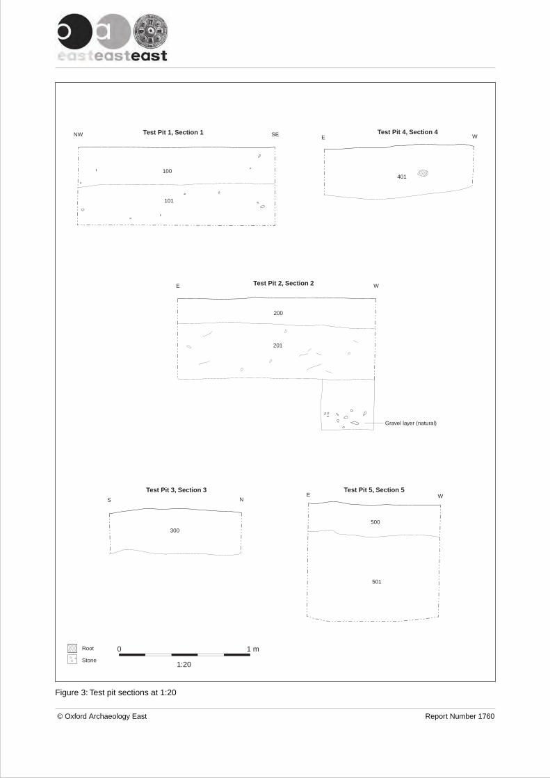
Fig. 3 Test pit sections at 1:20
List of Plates
Plate 1. View of St Andrews church and priory grounds, viewed from north-east
Plate 2. Test Pit 1, viewed from south
Plate 3. Test Pit 2, viewed from west
Plate 4. Test Pit 3, viewed from east
Plate 5. Test Pit 4, viewed from north
Plate 6. Test Pit 5, viewed from north
Plate 7. Perse Archaeology Group students excavating Test Pit 5, viewed from south
Plate 8. Perse Archaeology Group students, viewed from south-west
Plate 9. Perse Archaeology Group students excavating Test Pit 4, viewed from south-west
Plate 10. Test Pit 5 and St Andrews church, viewed from north-east
List of Tables
Table 1: Glass
Table 2: Pottery
Table 3: Ceramic Building Material
© Oxford Archaeology East Page 5 of 25 Report Number 1760

© Oxford Archaeology East Page 6 of 25 Report Number 1760
Summary
In March 2015 Oxford Archaeology East (OA East) undertook a test pit evaluation,on behalf of Jeremy Newsum and English Heritage, on the earthwork remains ofSwavesey Priory (SM 38; TL36262 69429) in advance of tree planting. Five test pitswere excavated: two 1.5m x 1.5m dug by OA East and a further three 1m x 1m testpits were excavated with the help of students and a teacher from Perse ArchaeologyGroup.
Test pits were excavated to a depth of between 0.3m and 0.9m and generallyencountered layers of topsoil overlying subsoil or similar deposits. The test pits wereexcavated and backfilled by hand. The natural was not reached during excavation(except possibly in Test Pit 2), and no definite archaeological features wereencountered. A few finds of mixed date (prehistoric, Roman, medieval and post-medieval) were retrieved. The thickness of some of the lower deposits and themixed date of the finds, notably in Test Pit 5, may indicate that the test pits werelocated within a large feature (or features) such as a ditch or quarry. Quarrying forsand and gravel is known to have occurred in the field during the 19th century, whenthe Swavesey to Over Road (Station Road) was constructed immediately adjacentto the site, and more recently during the early to mid 20th century.
The results indicate that the proposed tree planting is likely to have a minimumeffect on any buried archaeology in the area.
© Oxford Archaeology East Page 7 of 25 Report Number 1760

© Oxford Archaeology East Page 8 of 25 Report Number 1760

1 INTRODUCTION
1.1 Location and scope of work1.1.1 An archaeological test pit evaluation was conducted by OA East in March 2015 at the
site of Swavesey Priory (TL 36262 69429; Fig. 1 and Plate 1), a scheduled monumentcomprising a complex of earthworks in a pasture field north-east of St Andrews churchat the northern end of the village. Five test pits were excavated in the north-east cornerof the field, adjacent to the line of the Cambridgeshire Guided Busway.
1.1.2 This archaeological evaluation was commissioned by English Heritage (EH) and wasundertaken in accordance with a Written Scheme of Investigation (WSI) prepared byOA East (Lambert 2015).
1.1.3 Swavesey Priory is a Scheduled Monument (SM CB 38, HA 10006914). Any groundworks require Scheduled Monument Consent (SMC), which was granted 4/3/15 (CaseNo. S00102983) under the 1979 Ancient Monuments and Archaeological Areas Act.
1.1.4 The project arose due to the need to assess an area of the Scheduled Monument priorto tree planting and to determine the impact these trees might have on the survival ofany buried archaeology within the impact zone. The investigation was designed toassess the presence of any archaeological remains to the depth of proposed treeplanting. Two test pits were dug by OA East staff and an additional three wereexcavated by students from Perse Archaeology Group under OA East supervision.Once this was completed to the satisfaction of Cambridgeshire County Council (CCC)and EH, the test pits were then in-filled in order to make the site safe for horses, as thegrazing of the field forms part of the conservation management plan put in place toprotect the earthworks.
1.1.5 The site archive is currently held by OA East and will be deposited with the appropriatecounty stores in due course, although some of the artefacts may form part of a displaywithin the parish church of St Andrews, which lies adjacent to the site.
1.2 Geology and topographyThe following is based on the Geology and Topography section in Clarke (2014).
1.2.1 The parish of Swavesey lies in the south-western hinterland of the fens, c.16km to thenorth-west of Cambridge. The two-mile long village developed on two 'islands' ofterrace gravels which cap a peninsula of Ampthill clay (BGS 1975, sheet 187). These'uplands' extend into the fen where the Great Ouse valley joins the fen basin. Extensivealluvial deposits exist on either side of the peninsular and define the former extent ofthe fen prior to drainage. On the eastern side the fen would have formed a wide basinbetween the villages of Swavesey and Over to the north-east, which occupies a similartopographical position. This basin narrows from c.900m wide to around 100m where thecurrent Swavesey/Over road runs past the church, manor and the priory.
1.2.2 Swavesey Priory (and the current site) is located on the more northerly (and smaller) ofthe two islands in an area that would have been a prime fen-edge location foroccupation from prehistoric times onwards. A number of major water managementfeatures and drains around the village and priory are testament to the effects of floodingin this area. In the medieval period, Swavesey was an inland port served by a dock witha canal that linked to the River Great Ouse to the north.
1.2.3 The site lies at c.7.5m AOD and is currently a pasture field, adjacent and to the north-east of the parish church of St Andrews; the site of the manor is located to the south-
© Oxford Archaeology East Page 9 of 25 Report Number 1760

east on the other side of Station Road. Within the field there are many upstandingearthworks, which are the remains of the medieval Benedictine Priory and associatedfeatures. To the north the site is now bounded by the Guided Busway, while to the eastthe boundary is formed by Station Road and to the south and west by the parish churchand former vicarage.
1.3 Archaeological and historical backgroundNote: This background section was written by R. Clarke and formed the archaeologicaland historical background section in a previous report on an investigation undertaken atSwavesey Priory in 2012 (Clarke 2014). It was based on a number of published andunpublished sources, notably the Victoria County History (VCH; Salzman (ed) 1948;Wright and Lewis (eds) 1989), Swavesey Priory (The Remains) by M. Bousfield, thedraft Historic Towns of Cambridgeshire Extensive Urban Survey (CCC 2001) and theCambridgeshire Heritage Environment Record (CHER). More detailed accounts of thevillage, priory and manorial development can be found in these documents.
1.3.1 Despite its Anglo-Saxon name, derived from the prefix Swaef (a personal name whichoccurs again in Swaffham) and the suffix meaning 'landing-place' (Reaney 1943, 172),the first documented reference to Swavesey occurs in the Domesday Book.
1.3.2 At the Norman Conquest it appears that much of Swavesey was held by Edeva theFair, then passing to Count Alan of Brittany:
In Papworth Hundred, the Count holds Swavesey himself. 13hides. Land for 4 ploughs. In lordship 6 hides; 3 ploughs there;a fourth possible.10 villagers with 19 smallholders and 8 Freemen hold 3 hidesof this land. Together they have 10 ploughs.17 cottagers; 2 slaves1 mill at 40s; from fisheries 4,000 eels less 250;meadow for 14 ploughs; pasture for the village livestock.Total value £16; when acquired £8; before 1066 £18.
1.3.3 In addition to this central manor, two smaller holdings were recorded that were formerlythe lands of Robert Gernon and a thane named Ulf; afterwards passing to Picot theSheriff and Gilbert of Gand.
1.3.4 As well as being a port town, Swavesey was an administrative centre for a large estate;a weekly market was granted to the lord, Alan de la Zouche, and his heirs in 1244,which was extended to include an annual fair in 1261. It was probably at this time thatthe town defences and streets were laid out. A complex system of docks and a wharfstretching from Swan Pond into the middle of the village at Market Street (TownPond/dock) was also constructed, with a canal connecting the port to the Great Ouse,which in the medieval period was a major transportation route. Although no boroughcharter is known to have been granted to Swavesey, burgesses are mentioned in theHundred Rolls of 1278-9. Swavesey Castle is thought to have been built in the late 11thor early 12th century, although there are no documentary references before 1476; itssite (now represented by earthworks; CHER 1772) appears to have subsequently beenincorporated into the town defences.
1.3.5 There have been a number of archaeological investigations within and around themedieval village, notably at Black Horse Lane (MCB11949; Spoerry 1996 etc) where aconsiderable density of archaeological features, including settlement remains dating tothe Late Iron Age, Late Saxon, Saxo-Norman and medieval periods, was revealed.
© Oxford Archaeology East Page 10 of 25 Report Number 1760

Swavesey Priory
1.3.6 The priory (CHER 3488), which some believe may have replaced a Saxon minster as achurch was in existence on the site in 996, was founded by Alan of Brittany who gavethe church at Swavesey, along with other holdings, to the Benedictine Abbey of SaintsSergius and Bacchus at Angers in France. Buildings for the priory appear to have beenconstructed between 1080-1086. Further documentary references to the priory, whichwas never a large establishment housing just four or five brothers (although see below),include grants, suits and acquisitions during the 12th and early 13th centuries.However, after 1259, when the king of England abandoned claim to sovereignty ofAnjou following the Treaty of Paris, there is no evidence that a priory was evermaintained, instead just a single vicar, usually styled ‘prior’, appears to have been inresidence.
1.3.7 It has been suggested (Palmer and Parsons 1903, 29-31) that it is 'by no means certainthat there ever was a priory at Swavesey in the same sense as there was one at Ely',especially given the lack of specific documentary evidence. These authors suggest thatit is more probable that the French mother abbey instituted a monk as Rector atSwavesey to administer the estate, and that there never was a community of monksliving under the rule of a Prior here, but rather it was more a 'cell' to the French abbey.
1.3.8 Swavesey Priory estate is listed in 1279 and in a rental of 1467 but neither sourcethrows any light on the site. The house, along with other alien priories, was brieflyseized in the 1350s and again in 1369, when a survey was made that showed how poorthe priory was at that time. In 1393 Richard II licensed the abbot of SS Sergius andBacchus to alienate the manors of Swavesey and Dry Drayton and the advowson of thechurch of Swavesey to the Carthusian Priory, recently founded in Coventry. Theincumbent prior of Swavesey, John Thorndon, released his rights in the priory estatesto St Anne's in return for a pension of £10. By 1411 the priory or church of Swaveseywas finally appropriated, with the rest of its possessions, by the Carthusians atCoventry who ran the estate as a manor until the Dissolution. In 1539 the king grantedthe Swavesey and Drayton estates to the Bishop of Ely in exchange for the manor ofHatfield in Hertfordshire (Palmer and Parsons 1903, 31).
1.3.9 By 1200, the northern island of Swavesey, where the priory, church and manor werelocated, was known as 'The Eye'. Although the origin of this name is unclear, it mayalso derive from the word meaning 'landing-place' (see 1.3.1. above). In later centuriesthis area, which includes the manor to the east of Station Road, is shown as ChurchEnd on 19th century maps. The church of St Andrews (CHER 3419) lies to the south ofthe priory earthworks (Figs 1 and 3), in what may have been a central location withinthe moated enclosure/precinct. It is considered to have Saxon origins, with a Saxonnave and chancel visible in the south wall, thought to date to c.1000AD. The church isbuilt of field stones, ironstone conglomerate and coarse limestone rubble with ashlardressings. The nave was rebuilt in 1200 and the church was repeatedly enlarged duringthe 13th century.
1.3.10 Little is known of the fate of the priory after the Dissolution. A building on the north sideof the church is shown on the 1836 OS 1" map (see Clarke 2014, fig. 3), adjacent towhich is the legend 'ruins'. This building may have been the Priory House, mentioned in1401 when a complaint of theft was lodged by the Carthusians of Coventry. The VCH(1989, 384) indicates that in the 18th century a rectory may have stood to the north ofthe church and that in about 1800 there was still a fragment of a Gothic buildingsurviving on the north side of the church. No buildings were present in this location in1838. More recent research by Bousfield (1993), however, suggests that the rectory
© Oxford Archaeology East Page 11 of 25 Report Number 1760

may actually have been a building seen on the 1838 Enclosure maps, immediatelyadjacent to the intersection of the main road and the navigation channel to the south ofthe church. The rectory was mentioned in 1648 as a dwelling house with barn andouthouses attached; this was bounded along one side by a flood bank which still existstoday.
1.3.11 A local history private publication by J. Shepperson provides a transcript ofconversations with local residents recorded by Charles Wood in the early part of the20th century, relating their memories of Swavesey (many presumably from the 19thcentury) and includes a couple of points of interest for the current project. A tithe barn isrecorded as once standing near to the church tower: a former church warden, HarryWells, recalled that some of its foundations were revealed when a grave was being dugon that side of the church. A rickyard stood on the other side of the barn and timberfrom the 'old barn' was taken for use elsewhere by one of the well known 'villageworthies' at that time, Robinson Mitham (Wood 2009, 8; 18).
1.3.12 All that remains now (besides the church) are a series of fairly well-preservedearthworks within Priory Field, forming a large channel or moat with a northernentranceway, surrounding a central platform within which there are a number ofprobable building platforms and associated banks. Other more denuded earthworksexist within the garden of the Priory House (a Victorian vicarage) along with theremains of a former dock and canalised watercourse (Church Brook) leading aroundthe priory site to the south and west, linking to the River Ouse to the north. It is worthyof note that some of the earthworks in the Priory Field may be the result of quarrying,probably undertaken during the later part of the 19th century when the Swavesey-Overroad (Station Road) was constructed/improved, and possibly during World War 2. Anote provided by J. Shepperson records gravel being dug out of the field next to thechurch in the 1920s or 30s, on the site of the vanished priory. At a depth of one foot thediggers came across a cobbled flooring, a foot below which was another floor, belowwhich were what appeared to be cement tanks filled with ashes. A terracotta-colouredjug was found in amongst the ash; it is apparently now in one of the Cambridgemuseums.
Previous investigations and finds
1.3.13 As yet there has been no detailed survey or systematic analysis of the earthworks,(which are shown on the early editions of the Ordnance Survey and on the 1976 OS1:2500 map), however a geophysical survey undertaken in 1999 apparently indicatedthe presence of at least one rectangular building on the site, although the results of thissurvey are unpublished. There have been very few archaeological investigations withinthe scheduled area or its environs, making the current project all the more significant.One of these was located close to the vicarage (Priory House) and the other in advanceof the construction of the Guided Busway at the northern edge of the site. The PrioryHouse evaluation (CB15286; Cooper and Kenney 2001) revealed a bank likely to havebeen associated with the priory, perhaps relating to a canal and a docking area, inaddition to undated and post-medieval features; a fragment of architectural stone wasalso recovered. Work associated with the construction of the Guided Busway route(CB15757) revealed the undated remains of what may have been a timber building tothe north of the track; no archaeological features were identified to the south of thetrack.
1.3.14 In 2012 an investigation of the effect of rabbit burrowing (ECB 3813) was conducted byOA East in the Priory field to the north of St Andrews Church, which revealed an area of
© Oxford Archaeology East Page 12 of 25 Report Number 1760
possible medieval floor/hearth, post-Dissolution evidence of ditches and dumpeddeposits and an 18th century brick drain. A significant number of medieval and latemedieval finds associated with domestic/culinary and dairying activities was retrieved(Clarke 2014).
1.3.15 Related records in the CHER include analysis of aerial photographs which identifiedpossible enclosures, tracks, ponds and moats/ditches that may have been associatedwith the priory (CHERs 8897 and 9128), but are outside the scheduled area. An aerialphotograph taken by the Air Ministry and reproduced in Bousfield's account of the prioryapparently shows the remains of a 'circular base which supported an extern Calvarycross' to the immediate north of the church (CHER 3488; Bousfield 1993, 3).Photographs of two carved stone corbels or gargoyles thought to have come from thepriory which are now in private gardens in the village are also present within theCambridgeshire Collection; if these are from a priory building it must have had buildingsof some substance.
1.3.16 Other finds possibly associated with the priory are also documented. A bonespindlewhorl was found in the churchyard (CHER 3421), while stones known to havebeen taken from the priory site were re-used when the church was restored in 1867. Atthe time of the 1840 enclosure award the Swavesey-Over Road was made permanent,utilising the causeway from the village to the south and a track to the north of thebridge. These works formally separated the manor to the east (CHER 1289) and thechurch to the west, and also encroached upon the churchyard. As a result of theseworks, three stone coffins were uncovered; the most complete of which dates to theearly 13th century. Other reported finds include pottery, tile, stone and bone found in1993; the former includes a tubular spouted jug, probably Stamford Ware (late 12th-early 13th century), sherds of Orange Sandy ware (mid 14th-16th century), and parts ofa pancheon (medieval-post medieval) (CHER 3488).
1.4 Acknowledgements1.4.1 The excavation was conducted by OA East, under the supervision of English Heritage,
provided as part of the management agreement with the site owners, Mr and MrsNewsum. Thanks are due to the site owners for enabling access to the site andallowing use of an outbuilding for storage of equipment, and to Sarah Poppy (EH) forher advice and input during the test pitting. The project was managed by StephenMacaulay and directed by James Fairbairn and Daria Tsybaeva, assisted by RebeccaPridmore. Particular thanks are due to the students of Perse Archaeology Group andtheir teacher Adrian Roberts for their enthusiasm and help.
1.4.2 Various specialists warrant acknowledgement for their contributions, notably AnthonyHaskins (lithics) and Carole Fletcher (pottery).
© Oxford Archaeology East Page 13 of 25 Report Number 1760

2 AIMS AND METHODOLOGY
2.1 Aims2.1.1 The objective of this evaluation was to determine the extent and nature of
archaeological deposits in the north-eastern corner of the field (Figs 1 and 2) within thescheduled site of the priory in advance of tree planting.
2.2 Methodology2.2.1 Following a site meeting between EH And OA East the location of two 1.5m x 1.5m test
pits to be excavated by OA East staff and three 1m x 1m test pits to be dug by PerseArchaeology Group was agreed upon. These were to target the area of proposed treeholes.
2.2.2 All test pits were excavated and backfilled by hand to a maximum depth of 0.9m. Thespoil was stored on a layer of terram to protect the underlying grass. The cut turf wasstored on the grass next to the test pits to prevent it drying out and was replaced afterexcavation and backfilling was complete.
2.2.3 Spoil, exposed surfaces and features were scanned with a metal detector. All metal-detected and hand-collected finds were retained for inspection, other than those whichwere obviously modern.
2.2.4 All archaeological features and deposits were recorded using OA East's pro-formasheets. Trench locations, plans and sections were recorded at appropriate scales andcolour and monochrome photographs were taken of all relevant features and deposits.
2.2.5 As only topsoil and subsoil-type layers were encountered, no environmental sampleswere taken.
2.2.6 The test pit area was located within a pasture field covered with short grass. Weatherconditions were dry and sunny, slightly windy over the two days of excavations.
© Oxford Archaeology East Page 14 of 25 Report Number 1760

3 RESULTS
3.1 Introduction 3.1.1 The results of the evaluation are presented separately for each test pit below. Only
layers of topsoil and subsoil-like deposits were encountered; neither the natural (apartfrom a possible gravel layer in Test Pit 4) or any definite archaeological features ordeposits were revealed in any of the test pits (Figs 2-3; Plates 1-9). Further details ofthe test pits and finds recovered can be found in the Appendices.
3.2 Test Pit 1 3.2.1 Test Pit 1 (Figs 2 and 3, section 1, Plate 2), measuring 1.5m x 1.5m was excavated to a
total depth of 0.6m and contained two layers. Topsoil layer 100 was a 0.3m thick darkgreyish brown silty sand with very occasional small stones and contained no finds.Below, layer 101 was a mid orangey brown silty sand with occasional small andmedium stones and contained two sherds of Late Iron Age pottery. Layer 101 wasexcavated to a depth of 0.3m.
3.3 Test Pit 23.3.1 Test Pit 2 (Figs 2 and 3, section 2, Plate 3), measuring 1.5m x 1.5m, was excavated to
a total depth of 0.6m and contained two layers. Topsoil layer 200 was a 0.2m thickgreyish brown sandy silt with very occasional small stones and contained no finds.Layer 201 below was a brown silty sand with occasional small stones and roots andcontained small flints. Layer 201 was excavated to a depth of 0.4m, below which was agravelly layer (unnumbered) revealed in one corner that may have been natural.
3.4 Test Pit 33.4.1 Test Pit 3 (Figs 2 and 3, section 3, Plate 4), measuring 1m x 1m, was excavated to a
total depth of 0.3m and contained two layers. Topsoil layer 300 was a 0.3m thick darkgreyish brown silty sand with moderate small stones, occasional flecks of charcoal andcontained fragments of medieval pottery and bone. Below this a mid greyish brown siltysand layer (301) with moderate small stones was exposed but not excavated.
3.5 Test Pit 43.5.1 Test Pit 4 (Figs 2 and 3, section 4, Plate 5), measuring 1m x 1m was excavated to a
total depth of 0.38m and contained two layers. Topsoil layer 400 was a 0.2m thickgreyish brown sandy silt with occasional small stones that contained no finds. Below,this was layer 401, a dark yellowish brown silty sand with occasional small stones thatcontained fragments of post-medieval pottery. Layer 401 was excavated to a depth of0.18m.
3.6 Test Pit 53.6.1 Test Pit 5 (Figs 2 and 3, section 5, Plate 6), measuring 1m x 1m was excavated to a
total depth of 0.9m and contained two layers. Topsoil layer 500 was a 0.25m thick darkgreyish brown silty sand with occasional small stones and small fragments of charcoal.This layer contained post-medieval pottery, in addition to bone, flint, slag and afragment of a crucible. Below, layer 501 was a dark yellowish brown silty sand with veryoccasional small and medium stones that contained a mix of prehistoric finds alongsideRoman and medieval pottery. This deposit was excavated to a depth of 0.66m.
© Oxford Archaeology East Page 15 of 25 Report Number 1760

3.7 Finds Summary3.7.1 Seven struck flints were recovered that are likely to be of later prehistoric date; a
probable Mesolithic blade was retrieved from layer 501 in Test Pit 5. A total of 15 sherds(0.143kg) of pottery was found, the dates of which span the Neolithic/Early Bronze Ageto the 19th century. Two fragments of ceramic building material were retrieved, onebeing Roman in date with the other being medieval; shards of vessel glass of probablepost-medieval to modern date were also found in Test Pit 4.
© Oxford Archaeology East Page 16 of 25 Report Number 1760

4 DISCUSSION AND CONCLUSIONS
4.1 Discussion 4.1.1 A layer of topsoil sealing a subsoil-like layer was encountered in all five test pits; the
natural was not definitely reached although this may have been represented by agravelly deposit in the base of Test Pit 2. No definite archaeological features wereencountered.
4.1.2 It should be noted that, given the small size of the test pits, it is possible that the lowerlayers identified as probable subsoil in some of the test pits may in fact be the fill(s) of alarge feature (or features) such as a ditch or quarry. This is perhaps most likely in TestPit 5, where layer 501 was excavated to a depth of 0.66m (too thick to be a subsoil) butits full extent was not exposed. The field containing the priory remains has beenpasture for many centuries (hence the survival of the earthworks), and it is unlikely thatsuch a distinct and thick subsoil would have formed if the area had not been ploughed.It is possible that this particular part of the priory, which lay outside the main moatedenclosure, was cultivated in the past, but a more plausible explanation might be thatsome of the test pits (notably Test Pit 5) were located within a former quarry pit. Duringthe later part of the 19th century the site was heavily quarried for gravel during theconstruction and improvement of the Swavesey to Over road (Station Road)immediately adjacent to the current site. Local knowledge also suggests that the sitemay have been quarried again in the 1920s or 1930s and then possibly during WorldWar 2.
4.1.3 A relatively small quantity of finds was recovered, comprising flint, pottery and CBM inaddition to very modern bone, glass and iron nails (those finds that were obviouslymodern were recorded and discarded). The pottery recovered is a somewhat surprisingmix of Late Neolithic/Early Bronze Age, Roman, medieval and post-medieval/modernsherds. There is a known Roman settlement to the north and west of the priory,however prehistoric pottery is not known from the immediate vicinity. All of the earlierpottery was abraded and clearly redeposited or reworked. This broad range of potteryand other finds (most of which came from the lower layer in Test Pit 5) might beexpected if this part of the site had been quarried and subsequently infilled withmaterial from mixed sources. The construction of the adjacent road, and more recentlythe Guided Busway to the north, may also have caused further disturbance to this area.
4.1.4 Since this is a sensitive area within the Scheduled Monument, the tree planting shouldstill proceed with caution.
4.2 Significance4.2.1 The test pitting in the north-eastern corner of the field at Swavesey Priory has indicated
that the proposed planting of trees is unlikely to have a detrimental impact onarchaeological deposits in this area.
4.3 Recommendations4.3.1 Recommendations for any future work based upon this report will be made by English
Heritage and the County Archaeology Office.
© Oxford Archaeology East Page 17 of 25 Report Number 1760
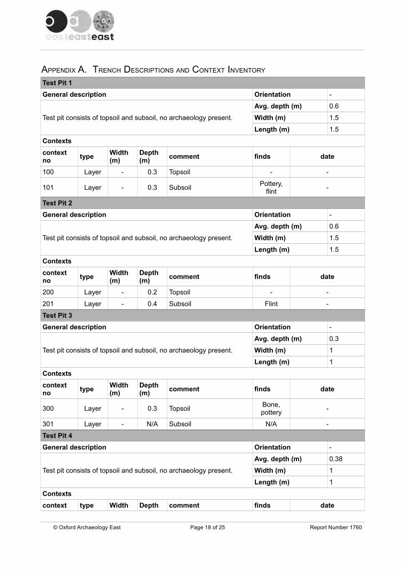
APPENDIX A. TRENCH DESCRIPTIONS AND CONTEXT INVENTORY
Test Pit 1
General description Orientation -
Test pit consists of topsoil and subsoil, no archaeology present.
Avg. depth (m) 0.6
Width (m) 1.5
Length (m) 1.5
Contexts
context no
typeWidth (m)
Depth (m)
comment finds date
100 Layer - 0.3 Topsoil - -
101 Layer - 0.3 SubsoilPottery,
flint-
Test Pit 2
General description Orientation -
Test pit consists of topsoil and subsoil, no archaeology present.
Avg. depth (m) 0.6
Width (m) 1.5
Length (m) 1.5
Contexts
context no
typeWidth (m)
Depth (m)
comment finds date
200 Layer - 0.2 Topsoil - -
201 Layer - 0.4 Subsoil Flint -
Test Pit 3
General description Orientation -
Test pit consists of topsoil and subsoil, no archaeology present.
Avg. depth (m) 0.3
Width (m) 1
Length (m) 1
Contexts
context no
typeWidth (m)
Depth (m)
comment finds date
300 Layer - 0.3 TopsoilBone,pottery
-
301 Layer - N/A Subsoil N/A -
Test Pit 4
General description Orientation -
Test pit consists of topsoil and subsoil, no archaeology present.
Avg. depth (m) 0.38
Width (m) 1
Length (m) 1
Contexts
context type Width Depth comment finds date
© Oxford Archaeology East Page 18 of 25 Report Number 1760

no (m) (m)
400 Layer - 0.2 TopsoilPottery,Glass
-
401 Layer - 0.18 Subsoil Pottery -
Test Pit 5
General description Orientation -
Test pit consists of topsoil and subsoil, no archaeology present.
Avg. depth (m) 0.9
Width (m) 1
Length (m) 1
Contexts
context no
typeWidth (m)
Depth (m)
comment finds date
500 Layer - 0.25 TopsoilPottery,
bone, flint,metal, slag
-
501 Layer - 0.66 SubsoilPottery,
metal, flintProbably Mesolithic
flint
© Oxford Archaeology East Page 19 of 25 Report Number 1760

APPENDIX B. FINDS REPORTS
B.1 Flint
By Anthony Haskins
Introduction and methodology
B.1.1 A small number of struck flints was recovered from several of the test pits. Test Pit 1,(context 101) produced a single yellow brown semi-translucent secondary flake with athin smooth cortex. Test Pit 2 (context 201) produced three small secondary flakesstruck from the same material as Test Pit 1. A further patinated/recortificated and moreheavily rolled secondary flake was also recovered from this deposit. Test pit 5 (context500) produced a thermally shattered flake of dark greenish-grey opaque flint withoccasional yellowish-grey inclusions and a dark brownish-grey heavily abraded cortexacross the majority of the dorsal surface. The flake has damage along both lateraledges and along the distal edge, this could be crude semi-abrupt retouch to create acrude scraper or may be the result of natural rolling, if the former it is likely to be a laterprehistoric tool of expedience. Context 501 also produced a single blade. The blade isstruck from a reddish-brown semi-translucent flint of good quality with a yellowish-whitechalky unabraded cortex. The blade is struck from an opposed platform core with bothplatforms present on the dorsal surface, use-damage is present down both lateraledges of the blade. The method of working and form would be indicative of a Mesolithicdate.
Discussion
B.1.1 This small assemblage is probably of mixed date with a single blade of probableMesolithic origin and a potential scraper of later Bronze Age or Early Iron Age date. Theremainder of the flakes are small and undiagnostic but probably fit with a laterprehistoric date.
B.2 Glass
by Carole Fletcher
B.2.1 The evaluation produced a single shard of bottle glass, weighing 0.010kg, from context401, Test Pit 4. Although not closely datable, the bottle is likely to be, at its earliest, late19th century.
Context Test Pit Weight(kg)
Description Date
401 4 0.010 Body shard from a clear, greenish tintedpress-moulded glass bottle.
Late19th century or later
Table 1: Glass
© Oxford Archaeology East Page 20 of 25 Report Number 1760

B.3 Pottery
by Carole Fletcher, with prehistoric and Roman pottery identified by Alice Lyons
Introduction
B.3.1 Archaeological works produced a pottery assemblage of 15 sherds, weighing 0.143kg.The assemblage spans the Neolithic-Early Bronze Age to the 19th century. Thecondition of the overall assemblage is abraded and the mean sherd weight is low atapproximately 0.009kg.
Methodology
B.3.2 Fabric classification has been carried out for all previously described prehistoric,Roman, medieval and post-medieval types. All sherds have been counted, classifiedand weighed on a context-by-context basis. The assemblage is recorded in thesummary catalogue. The pottery and archive are curated by Oxford Archaeology Eastuntil formal deposition.
B.3.3 Topsoil in Test Pit 1 produced a single abraded sherd of Late Iron Age grog-temperedware from a jar or bowl and a small fragment of what appears to be a crucible ofunknown date. Test Pit 3 produced a single sherd of medieval pottery, while topsoil inTest Pit 4 and 5 produced post-medieval material. The lower layer in Test Pit 5produced the widest range of material, including Neolithic-Early Bronze Age flint-tempered ware alongside Roman and medieval fabrics.
B.3.4 The assemblage is mainly domestic in nature, and indicates pottery deposition from abroad range of periods. All sherds except for those dating to the 17th-19th centuries areabraded, indicating significant reworking of the material, perhaps through ploughing orquarry-related activities.
Context Test pit
Fabric Basic Form SherdCount
Weight(kg)
Pottery Date Range
101 1 Grog-tempered handmade reduced ware with oxidised surfaces
Jar/bowl body sherd
1 0.012 4.3.2 Late Iron Age
(Low Iron) Oxidised Sandy ware
Crucible fragment 1 0.004 4.3.3 Not closely datable
300 3 Medieval Sandy ware
Jar body sherd 1 0.010 Mid 11th-end of 15th century
401 4 Post-medieval Black Glazed ware
Bowl body sherd 1 0.009 17th-18th century
500 5 Refined White Earthenware
Body sherd 3 0.006 19th-20th century
?Early Everton-type ware (oxidised)
Body sherd 1 0.012 14th-15th century
501 5 ?Early Everton-type ware (oxidised)
Body sherd 4 0.065 14th-15th century
© Oxford Archaeology East Page 21 of 25 Report Number 1760

Context Test pit
Fabric Basic Form SherdCount
Weight(kg)
Pottery Date Range
Flint-tempered coarseware
Body sherd 1 0.009 Neolithic-Early Bronze Age
Nene Valley Greyware
Dish rim sherd (type 6.19)
1 0.009 3rd-4th century
Shell-tempered ware(shell leached)
Jar body sherd 1 0.007 1st-2nd century
Total 15 0.143
Table 2: Pottery
B.4 Ceramic Building Material
by Carole Fletcher with identifications by Robert Atkins
B.4.1 Two fragments of ceramic building material were recovered, both from Test Pit 3. Thesehave been identified as a single fragment from a Roman imbrex and a piece ofmedieval roof tile.
B.4.2 The assemblage is abraded and the low level of material recovered is not enough toindicate buildings of any period within the area of archaeological works. The materialrepresents a low level rubbish scatter, most likely as the result of manuring orquarrying.
Context Test Pit Weight(kg)
Description Date
300 3 0.110 Fragment of Roman tile (imbrex).Hard fired oxidised surfaces and marginswith mid grey core, part of sandedsurface survives.
Roman
0.018 Fragment of hard fired sandy red brickwith what appear to be flint inclusions
Medieval
Table 3: Ceramic Building Material
© Oxford Archaeology East Page 22 of 25 Report Number 1760

APPENDIX C. BIBLIOGRAPHY
Bousfield, M.L., 1993, Swavesey Priory (The Remains). Unpublished document in CambridgeshireCollection
British Geological Survey,1993,Drift Edition 1:50000 Series, Huntingdon (England and Wales Sheet 187)
CCC, 2001, Cambridgeshire Extensive Urban Survey 2001 Swavesey. Draft Report
Clarke, R., 2014. Investigation of the effect of rabbit burrowing at the site of Swavesey Priory, Swavesey,Cambridgeshire. An Archaeological Investigation. OA East Report 1391 (Unpublished)
Cooper, S. and Kenney, S.. 2001. Medieval remains at Priory House, Swavesey. An archaeologicalevaluation.
Lambert, P., 2015, Swavesey Priory, Swavesey, Cambridgeshire, Written Scheme of Investigation,Archaeological Evaluation, OA East
Medieval Pottery Research Group,1998, A Guide to the Classification of Medieval Ceramic Forms, Medieval Pottery Research Group Occasional Paper
Medieval Pottery Research Group,2001, Minimum Standards for the Processing, Recording, Analysis and Publication of Post-Roman Ceramics, Medieval Pottery Research Group Occasional Paper 2
Macaulay, S., 2012 Specification for Archaeological Investigation: Swavesey Priory. OAE Report(unpublished)
Ravensdale, J.R., 1984 Swavesey, Cambridgeshire: a fortified planned market town Proc. CambridgeAntiq. Soc. 72, 55-59
Reaney, P.H, 1943, The Place-names of Cambridgeshire and the Isle of Ely Cambridge University Press
Salzman, P., (ed) 1948 'Alien houses: Priory of Swavesey' in A History of the County of Cambridge andthe Isle of Ely: Volume 2, 315-318
Skeat, W., 1901, The Place-names of Cambridgeshire Cambridge Antiquarian Society. OctavoPublication No. XXXVI (Cambridge)
Spoerry, P., 1996. Late Saxon and Medieval Activity, and Ditch Systems, between School Lane andBlackhorse Lane, Swavesey. Unpublished AFU report
Spoerry, P., 2001, 'Medieval Pottery' in Roberts, J., 2001 Post-excavation assessment of archaeologicalwork at Black Horse Lane, Swavesey, 1999 CCC AFU Report 31 (unpublished)
Spoerry, P., 2005, 'Town and Country in the Medieval Fenland', in Giles, K. and Dyer, C. (eds.)., Townand county in the Middle Ages; contrasts and interconnections, 1100-1150 Society for medievalarchaeology monograph 22, 85-110
Spoerry, P., forthcoming, The Production and Distribution of Medieval Pottery in Cambridgeshire East Anglian Archaeological Monograph
Wood, F.C., transcribed by Shepperson, J., 2009, 'Village Worthies Remembered' Private publication
Wright, A. P. M. & Lewis, C. P., (eds), 1989, 'Swavesey' in A History of the County of Cambridge and theIsle of Ely: Volume 9: Chesterton, Northstowe, and Papworth Hundreds, 374-381
© Oxford Archaeology East Page 23 of 25 Report Number 1760

APPENDIX D. OASIS REPORT FORM All fields are required unless they are not applicable.
Project DetailsOASIS Number
Project Name
Project Dates (fieldwork) Start Finish
Previous Work (by OA East) Future Work
Project Reference Codes
Site Code Planning App. No.
HER No. Related HER/OASIS No.
Type of Project/Techniques UsedPrompt
Development Type
Please select all techniques used:
Monument Types/Significant Finds & Their Periods List feature types using the NMR Monument Type Thesaurus and significant finds using the MDA Object type Thesaurus together with their respective periods. If no features/finds were found, please state “none”.
Monument Period Object Period
Project Location
County Site Address (including postcode if possible)
District
Parish
HER
Study Area National Grid Reference
© Oxford Archaeology East Page 24 of 25 Report Number 1760
Aerial Photography - interpretation
Aerial Photography - new
Annotated Sketch
Augering
Dendrochronological Survey
Documentary Search
Environmental Sampling
Fieldwalking
Geophysical Survey
Grab-Sampling
Gravity-Core
Laser Scanning
Measured Survey
Metal Detectors
Phosphate Survey
Photogrammetric Survey
Photographic Survey
Rectified Photography
Remote Operated Vehicle Survey
Sample Trenches
Survey/Recording Of Fabric/Structure
Targeted Trenches
Test Pits
Topographic Survey
Vibro-core
Visual Inspection (Initial Site Visit)

Project Originators
Organisation
Project Brief Originator
Project Design Originator
Project Manager
Supervisor
Project Archives
Physical Archive Digital Archive Paper Archive
Archive Contents/Media
PhysicalContents
DigitalContents
PaperContents
Digital Media Paper Media
Animal Bones
Ceramics
Environmental
Glass
Human Bones
Industrial
Leather
Metal
Stratigraphic
Survey
Textiles
Wood
Worked Bone
Worked Stone/Lithic
None
Other
Notes:
© Oxford Archaeology East Page 25 of 25 Report Number 1760
Database
GIS
Geophysics
Images
Illustrations
Moving Image
Spreadsheets
Survey
Text
Virtual Reality
Aerial Photos
Context Sheet
Correspondence
Diary
Drawing
Manuscript
Map
Matrices
Microfilm
Misc.
Research/Notes
Photos
Plans
Report
Sections
Survey

Site Site
Test pits

Figure 2: Plan of archaeological test pits.
© O
xford Archaeology E
astR
eport Num
ber 1760
269450 269450
5363
5053
6350
5363
7553
6375
N
1:150
0 5 m
SWASWP15 Key
Limit of excavation
Section
Root
Stone
Figure 3: Test pit sections at 1:20
© Oxford Archaeology East Report Number 1760
401
E WTest Pit 4, Section 4
300
S N
Test Pit 3, Section 3
200
201
Gravel layer (natural)
E WTest Pit 2, Section 2
100
101
NW SETest Pit 1, Section 1
500
501
E WTest Pit 5, Section 5
0 1 m
1:20
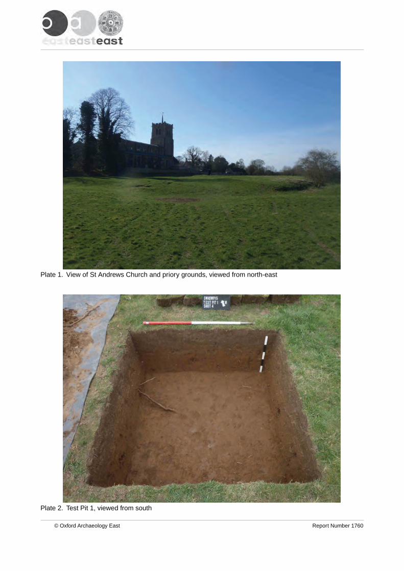
Plate 2. Test Pit 1, viewed from south
Plate 1. View of St Andrews Church and priory grounds, viewed from north-east
© Oxford Archaeology East Report Number 1760

Plate 4. Test Pit 3, viewed from east
Plate 3. Test Pit 2, viewed from west
© Oxford Archaeology East Report Number 1760
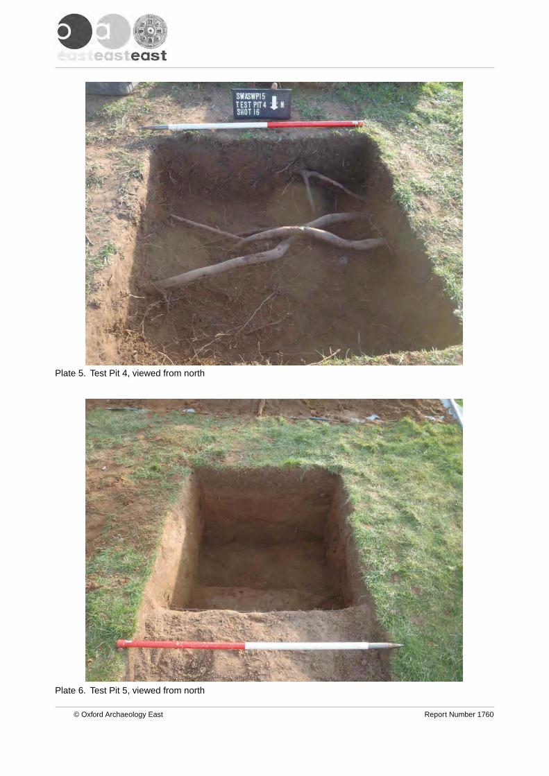
Plate 6. Test Pit 5, viewed from north
Plate 5. Test Pit 4, viewed from north
© Oxford Archaeology East Report Number 1760

Plate 8. Perse school students, viewed from south-west
Plate 7. Perse School students excavating Test Pit 5, viewed from south
© Oxford Archaeology East Report Number 1760

Plate 10. Test Pit 5 with St Andrews Church in the background, viewed from north-east
Plate 9. Perse School students excavating Test Pit 4, viewed from south-west
© Oxford Archaeology East Report Number 1760

Di rec to r : G i l l H e y , B A P h D F S A M I F A
Oxfo rd A rchaeo logy L td i s a
P r i va te L im i ted Company , N o : 1618597
and a Reg i s te red Char i t y , N o : 285627
OA Nor thMi l l 3Moor LaneLancas te r LA1 1GF
t : +44 ( 0 ) 1524 541 000f : +44 ( 0 ) 1524 848 606e : oanor th@ ox fo rdarchaeo logy .c omw:h t tp : / /ox fo rda rchaeo logy .com
Head Of f ice/Reg i s te red O f f ice/OA Sou th
Janus HouseOsney MeadOxfo rd OX2 0ES
t : +44 ( 0 ) 1865 263 800f : +44 ( 0 )1865 793 496e : i n fo@ ox fo rdarchaeo logy .comw:h t tp : / /ox fo rda rchaeo logy .com
OA Eas t
15 Tra f a lga r WayBar H i l lCam br id gesh i reCB23 8SQ
t : +44 (0 )1223 850500e : oaea s t @ ox fo rda rc haeo lo gy .co mw :h t tp : / / ox fo rda rch ae o lo gy .com